APPENDIX 1 PARTICIPANTS - Stockholm Environment...
66
31 APPENDIX 1 PARTICIPANTS
-
Upload
vuonghuong -
Category
Documents
-
view
214 -
download
0
Transcript of APPENDIX 1 PARTICIPANTS - Stockholm Environment...

31
APPENDIX 1
PARTICIPANTS

32

33
The Impact of El Niño and La Niña on Southeast Asia
Fortuna Hotel, Hanoi, Vietnam
21 - 23 February 2000
NAME COUNTRY ADDRESS TEL FAX EMAIL
ROGER C STONE Australia Principal Research Scientist,Queensland Center for ClimateApplications, Department ofPrimary Industries, PO Box 102,Toowoomba, Qld 4350, Australia
61-7-46881293 61-7-46881193 [email protected]
WILLIAM RKININMONTH
Australia Australasian Climate Research,23 Holroyd Street, Kew, Vic 3101,Australia
61-3-98539395 61-3-98539295 [email protected]
HJ SIDUP HJSIRABAHA
Brunei Brunei Meteorological Service,Department of Civil Aviation,Ministry of Communications,Brunei Darussalam, 261Kg.Bebatek, Jalan Bebatik Kilanas,Brunei Darussalam BF 2320Current address: ClimaticResearch Unit, School ofEnvironmental Sciences, Universityof East Anglia, Norwich NR4 7TJ,UK
6732-330142 6732-332735/331706
CHEA SINA Cambodia Deputy Director of PollutionControl Department, Ministry ofEnvironment, 48 Samdech PreahSihanouk, Tonle Basac, ChamkarMorn, Phnom Penh, Cambodia
855-23-427844 855-18-822134 [email protected],[email protected]
LONG RITHIRAK Cambodia Technical Advisor and Chief ofCoordination Unit, Ministry ofEnvironment, 48 Samdech PreahSihanouk, Tonle Basac, ChamkarMorn, Phnom Penh, Cambodia
855-23-720371/724901
855-23-427844 [email protected]
MAK SIDETH Cambodia Chief Office, EnvironmentalEducation and Training,Department of EnvironmentalEducation and Communication,Ministry of Environment, 48Samdech Preah Sihanouk, TonleBasac, Chamkar Morn, PhnomPenh, Cambodia
855-23-427844 855-23-427844 [email protected],[email protected]
WANG SHAO WU China Department of Geography, PekingUniversity, Beijing, 100871,People's Republic of China
86-10-62755568 86-10-62754294 [email protected]
GERHARDBREULMANN
Germany Programme Manager, APNSecretariat, 5th Fl, IHD CenterBldg., 1-5-1 Wakinohama KaiganDori, Chuo-ku, Kobe 651-0073,Japan
81-78-2308017 81 78 2308018 [email protected]
MIKIYASUNAKAYAMA
Japan United Graduate School ofAgricultural Science, TokyoUniversity of Agriculture andTechnology, 3-5-8 Saiwai-cho,Fuchuu-city, Tokyo 183-8509,Japan
81-42-3675667 81-42-3607167 [email protected]

34
NAME COUNTRY ADDRESS TEL FAX EMAIL
KHAMPAOHOMPANGNA
Lao PDR Project Manager of NationalDisaster Management Office,Ministry of Labor and SocialWelfare, PO Box 347, Vientiane,Lao PDR
856-21-219450 856-21-219525 [email protected]
PHETSAVANGSOUNNALATH
Lao PDR Deputy Director General, DirectorNational Disaster ManagementOffice, Pangkham Rd, PO Box347, Vientiane, Lao PDR
856-21-219450/222778/213005
856-21-219525 [email protected]
SENGDEUANEPHOMAVONGSA
Lao PDR Training Manager of NationalDisaster Management Office,Ministry of Labor and SocialWelfare, PO Box 347, Vientiane,Lao PDR
856-21-219450 856-21-219525 [email protected]
SITHAPHOUYAVONG
Lao PDR Acting Director General ofCabinet, Science, Technology andEnvironment Agency, PO Box2279, Vientiane, Lao PDR
856-21-218738/213470
856-21-213472 [email protected]
OOI SEE HAI Malaysia Malaysian Meteorological Service,Jalan Sultan, 46667 PetalangJaya, Selangor, Malaysia
60-3-7549462 60-3-7563621 [email protected]
U TUN LWIN Myanmar Director, Department ofMeteorology and Hydrology,Ministry of Communications, Postsand Telegraphs, Mayangon POBox 11061, Kaba-Aye PagodaRoad, Yangor, Myanmar
095-01-660526/660468
095-01-665944
AIDA M JOSE Philippines Chief, Climatology andAgrometeorology Branch, 7thFloor Asia Trust Bank Bldg., POBox 2277 Manila, Quezon City,Philippines
63-2-3733434 63-2-3733433 [email protected]
SANNY R JEGILLOS Philippines Director Asia Operations, AsiaPacific Disaster ManagementCentre, PO Box 1005, MakatiCentral Post Office, 1250 MakatiCity, Philippines
63-2-8260389 63-2-8209202 [email protected],[email protected]
PATIPATPATVIVATSIRI
Thailand Deputy Director General,Meteorological Department, 4353Sukumvit Road, Bangna,Prakanong, Bangkok 10260,Thailand
66-2-3992355 66-2-3989229 [email protected]
JOHN CAESAR UnitedKingdom
Climatic Research Unit, School ofEnvironmental Sciences,University of East Anglia, NorwichNR4 7TJ, UK
44-1603-593161
44-1603-507784
LOUISE BOHN UnitedKingdom
Climatic Research Unit, Universityof East Anglia, Norwich, Norfolk,NR47TJ, UK
44-1603-593161
44-1603-507784
MICK KELLY UnitedKingdom
Climatic Research Unit, School ofEnvironmental Sciences,University of East Anglia, NorwichNR4 7TJ, UK
44-1603-592091
44-1603-507784
SARAH GRANICH UnitedKingdom
Environmental Consultant, 7 AmesCourt, Cawston, Norwich NR104QD, UK
44-1603-870788
44-1603-870788
SIMON JAMESMASON
United States Scripps Institution ofOceanography, University ofCalifornia, San Diego, 9500Gilman Drive, La Jolla, CA 92093-0235, USA
1-619-8222574 1-619-5348087 [email protected]

35
NAME COUNTRY ADDRESS TEL FAX EMAIL
BUI KIM OANH Vietnam Center for Environment Research,Education and Development, A01,K40, Giangvo, Hanoi, Vietnam
84-4-515213 84-4-8515213 [email protected]
BUI THE GIANG Vietnam People International RelationshipDepartment, Hanoi, Vietnam
DANG DANH ANH Vietnam Vietnam Union of Science andTechnology Associations, 53 NguyenDu, Hanoi, Vietnam
84-4-8252821 84-4-4227593
DANG HUU HUNG Vietnam National Scientific Magazine, 53Nguyen Du, Hanoi, Vietnam
84-4-8264953 84-4-8264953
DO THI VAN Vietnam Vietnam Union of Science andTechnology Associations, 53 NguyenDu, Hanoi, Vietnam
84-4-8262108 84-4-4227593
DO TRONG KHUE Vietnam Vietnam Union of Science andTechnology Associations, 53 NguyenDu, Hanoi, Vietnam
84-4-8262108 84-4-4227593
DOAN NANG Vietnam Director, Department of Law, Ministryof Science, Technology andEnvironment, 39 Tran Hung Dao,Hanoi, Vietnam
84-4-8250 640
DUONG DUC DUNG Vietnam International RelationshipDepartment, Ministry of Science,Technology and Environment, 39Tran Hung Dao, Hanoi, Vietnam
84-4-8228751 84-4-8252733
DUONG LIEN CHAU Vietnam National Hydro-Meteorology Serviceof SR Vietnam, Hanoi, Vietnam
84-4-8254278 84-4-8254278 [email protected]
HA NGHIEP Vietnam Vietnam Union of Science andTechnology Associations, 53 NguyenDu, Hanoi, Vietnam
HOANG MINH HIEN Vietnam National Hydro-Meteorology Service,Hanoi, Vietnam, 4 Dang Thai Than,Hanoi, Vietnam
84-4-9330249 84-4-8254278 [email protected]
LE DINH QUANG Vietnam Institute of Meteorology, Center forResearch on the Tropical Meteorologyand Typhoon, 57 Nguyen Du, Hanoi,Vietnam
84-4-8263873 84-4-4430006 [email protected]
LE DUC NHUAN Vietnam Vietnam Union of Science andTechnology Associations, 53 NguyenDu, Hanoi, Vietnam
84-4-8262108 84-4-4227593
LE TUYET HANH Vietnam Science and Life Newspaper, 70 TranHung Dao, Hanoi, Vietnam
84-4-8253427,8251377
84-4-8220900
LUONG QUANG HUY Vietnam Center for Environment Research,Education and Development, A01,K40, Giangvo, Hanoi, Vietnam
84-4-515213 84-4-8515213 [email protected]
NGO CAM THANH Vietnam Center for Environment Research,Education and Development, A01,K40, Giangvo, Hanoi, Vietnam
84-4-8515213 84-4-8515213 [email protected]
NGUYEN DAI KHANH Vietnam International CooperationDepartment, National Hydro-Meteorology Service of SR Vietnam
84-4-8264087 84-4-8260779 [email protected]

36
NAME COUNTRY ADDRESS TEL FAX EMAIL
NGUYEN DUY HUU Vietnam National Scientific Magazine, 53Nguyen Du, Hanoi, Vietnam
84-4-8264953 84-4-8264953
NGUYEN HUU NINH Vietnam Center for Environment Research,Education and Development, A01,K40, Giangvo, Hanoi, Vietnam
84-4-8515213 84-4-8515213 [email protected]
NGUYEN LAM HOE Vietnam Center for Environment Research,Education and Development, A01,K40, Giangvo, Hanoi, Vietnam
84-4-8515213 84-4-8515213 [email protected]
NGUYEN MANH DON Vietnam Vietnam Union of Science andTechnology Associations, 53 NguyenDu, Hanoi, Vietnam
84-4-226435
NGUYEN THANH HA Vietnam Thanhha Investment Consultancyand International Trading CompanyLtd., 21 Nguyen Chi Thanh, Hanoi,Vietnam
84-4-7715655 84-4-7715661 [email protected]
NGUYEN THANHHUONG
Vietnam News Division-Vietnam Television,Giangvo, Hanoi, Vietnam
84-4-7715300
NGUYEN THANHVINH
Vietnam Vietnam Marine Science Association,Hanoi, Vietnam
84-4-7760752 84-4-8230915
NGUYEN THI DUOC Vietnam Vietnam Union of Science andTechnology Associations, 53 NguyenDu, Hanoi, Vietnam
84-4-8257785 84-4-4227593
NGUYEN THI HAI Vietnam Center for Environment Research,Education and Development, A01,K40, Giangvo, Hanoi, Vietnam
84-4-8515213 84-4-8515213 [email protected]
NGUYEN THUC NHU Vietnam Geographical Association, Hanoi,Vietnam
84-4-8351211
NGUYEN TRONGKHANH
Vietnam Vietnam Union of Science andTechnology Associations, 53 NguyenDu, Hanoi, Vietnam
84-4-8262108 84-4-4227593
NGUYEN TRONGTHANH
Vietnam Center for Environment Research,Education and Development, A01,K40, Giangvo, Hanoi, Vietnam
84-4-8515213 84-4-8515213 [email protected]
NGUYEN VAN HAI Vietnam Hydro-Meteorology Service of SRVietnam
84-4-8244120 84-4-8260779 [email protected]
NGUYEN VAN THANG Vietnam Deputy Director, Institute ofMeteorology and Hydrology, ClimateResearch Center, Lang, Dongda,Hanoi, Vietnam
84-4-8359415 84-4-8355993 [email protected]
NGUYEN VAN TUAN Vietnam Dean, Hydro-MeteorologyDepartment, Faculty of Geography,HUS. 334 Nguyen Trai, Hanoi,Vietnam
84-4-241016
NGUYEN VINH THU Vietnam National Hydro-Meteorology Service,Hanoi, Vietnam, 4 Dang Thai Than,Hanoi, Vietnam
84-4-261187 84-4-8254278
TO BA TRONG Vietnam Member of Presidium, Chairman ofThe Inspection Committee, VietnamUnion of Science and TechnologyAssociations, 53 Nguyen Du, Hanoi,Vietnam
84-4-8262108 84-4-4227593
TRAN BANG TAM Vietnam Department of Soil Information,Hanoi Agriculture University,Chauquy, Gialam, Hanoi, Vietnam
84-4-765588 [email protected]
TRAN DUC HAI Vietnam Deputy Director, International Co-operation Department,Hydrometeological Service of SRVietnam
84-4-8242603 84-4-8260779 [email protected]

37
NAME COUNTRY ADDRESS TEL FAX EMAIL
TRAN DUY BINH Vietnam Director, Institute of Meteorologyand Hydrology, Nguyen Chi Thanh,Hanoi, Vietnam
84-4-8359540 84-4-8355993 [email protected]
TRAN QUANG NGOC Vietnam National Hydro-MeteorologyService, Hanoi, Vietnam, 4 DangThai Than, Hanoi, Vietnam
84-4-261187 84-4-8254278
TRAN QUANG TUAN Vietnam Vietnam Economic Times, Hanoi,Vietnam
90445292 [email protected]
TRAN SY QUY Vietnam Vietnam Union of Science andTechnology Associations, 53Nguyen Du, Hanoi, Vietnam
84-4-8257785 84-4-4227593
TRAN TAN TIEN Vietnam Deputy Dean, Faculty of Hydro-Meteorology, Hanoi University ofSciences, Hanoi, Vietnam
TRAN THANH XUAN Vietnam Deputy Director, Institute ofMeteorology and Hydrology,Nguyen Chi Thanh, Hanoi, Vietnam
84-4-8343419,8343538
84-4-8355993
TRAN THI TY Vietnam International RelationshipDepartment, Vietnam Union ofScience and TechnologyAssociations, 53 Nguyen Du,Hanoi, Vietnam
84-4-8262108 84-4-4227593
TRAN THU TRANG Vietnam Center for Environment Research,Education and Development, A01,K40, Giangvo, Hanoi, Vietnam
84-4-8515213 84-4-8515213 [email protected]
TRAN THUC Vietnam Institute of Meteorology andHydrology, Water and AtmosphericEnvironment Research Center,Langtrung, Dongda, Hanoi,Vietnam
84-4-8359491 84-4-8355993 [email protected]
TRAN VO CHAU Vietnam Geological Association, 6 PhamNgu Lao, Hanoi, Vietnam
84-4-8260752 84-4-8260752
TRUONG QUANGHAI
Vietnam Faculty of Geography, VietnamNational University
84-4-581420 [email protected]
TRUONG QUANGCUONG
Vietnam People-to-people RelationsDepartment, 1C Hoang Van Thu,Hanoi, Vietnam
84-4-8453764 84-4-7330129
VU MINH MAO Vietnam MP Vice Chairman, Committee onScience, Technology andEnvironment, 35 Ngoquyen, Hanoi,Vietnam
84 80 42842 84 80 46997 [email protected]
VU TUYEN HOANG Vietnam President, Vietnam Union ofScience and TechnologyAssociations, 53 Nguyen Du,Hanoi, Vietnam
84-4-8262108 84-4-4227593

38

39
APPENDIX 2
WORKSHOP AGENDA

40
41
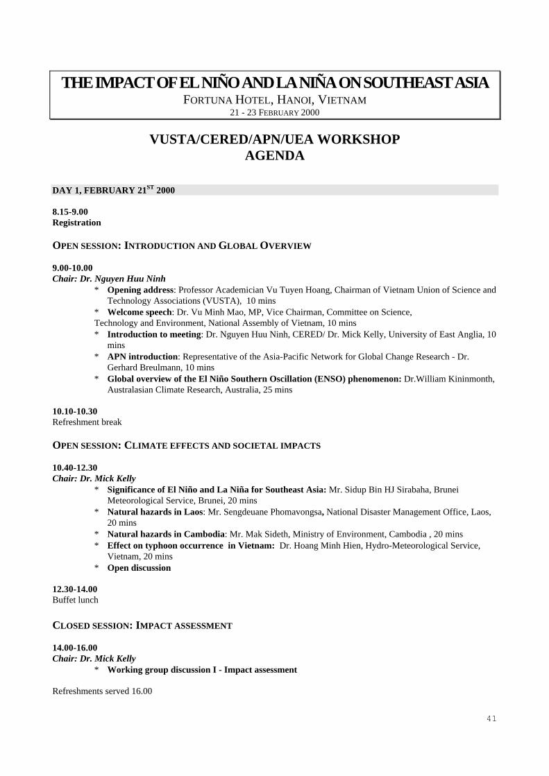
THE IMPACT OF EL NIÑO AND LA NIÑA ON SOUTHEAST ASIAFORTUNA HOTEL, HANOI, VIETNAM
21 - 23 FEBRUARY 2000
VUSTA/CERED/APN/UEA WORKSHOPAGENDA
DAY 1, FEBRUARY 21ST 2000
8.15-9.00 Registration
OPEN SESSION: INTRODUCTION AND GLOBAL OVERVIEW
9.00-10.00 Chair: Dr. Nguyen Huu Ninh
∗ Opening address: Professor Academician Vu Tuyen Hoang, Chairman of Vietnam Union of Science andTechnology Associations (VUSTA), 10 mins
∗ Welcome speech: Dr. Vu Minh Mao, MP, Vice Chairman, Committee on Science, Technology and Environment, National Assembly of Vietnam, 10 mins∗ Introduction to meeting: Dr. Nguyen Huu Ninh, CERED/ Dr. Mick Kelly, University of East Anglia, 10
mins∗ APN introduction: Representative of the Asia-Pacific Network for Global Change Research - Dr.
Gerhard Breulmann, 10 mins∗ Global overview of the El Niño Southern Oscillation (ENSO) phenomenon: Dr.William Kininmonth,
Australasian Climate Research, Australia, 25 mins
10.10-10.30Refreshment break
OPEN SESSION: CLIMATE EFFECTS AND SOCIETAL IMPACTS
10.40-12.30Chair: Dr. Mick Kelly
∗ Significance of El Niño and La Niña for Southeast Asia: Mr. Sidup Bin HJ Sirabaha, BruneiMeteorological Service, Brunei, 20 mins
∗ Natural hazards in Laos: Mr. Sengdeuane Phomavongsa, National Disaster Management Office, Laos,20 mins
∗ Natural hazards in Cambodia: Mr. Mak Sideth, Ministry of Environment, Cambodia , 20 mins∗ Effect on typhoon occurrence in Vietnam: Dr. Hoang Minh Hien, Hydro-Meteorological Service,
Vietnam, 20 mins∗ Open discussion
12.30-14.00Buffet lunch
CLOSED SESSION: IMPACT ASSESSMENT
14.00-16.00Chair: Dr. Mick Kelly
∗ Working group discussion I - Impact assessment
Refreshments served 16.00

42
16.30-17.00Chair: Dr. Nguyen Huu Ninh/Dr. Mick Kelly
∗ Summary of working group recommendations and general discussion
18.00-20.00Reception for international participants hosted by the Vice-Chairman of the Committee on Science, Technology andEnvironment of the National Assembly of Vietnam at the Office of the National Assembly of Vietnam.Followed by dinner at the Hilton Hanoi Opera Hotel.
DAY 2, TUESDAY, FEBRUARY 22ND 2000
OPEN SESSION: SEASONAL CLIMATE FORECASTING
9.00-10.40Chair Dr. William Kininmonth
∗ International forecasts of the ENSO phenomenon: Dr. Simon Mason, UCSD/IRI, United States, 20 mins∗ Practical aspects of forecasting rainfall in eastern Australia and Southeast Asia using ENSO indicators:
Dr. Roger Stone, Queensland Centre for Climate Applications, Australia, 20 mins∗ Climate forecasting in China: Prof. Wang Shaowu, Peking University, PR China, 20 mins∗ Climate forecasting in Vietnam: Dr. Nguyen Van Thang, Climate Research Center, Vietnam, 20 mins∗ Use of seasonal forecasts: Ms. Louise Bohn, University of East Anglia, UK, 20 mins∗ Open discussion
10.40-11.00Refreshment break
OPEN SESSION: RESPONSE STRATEGIES
11.00-12.20Chair: Prof. Mikiyasu Nakayama
∗ Responding to El Niño and La Niña: Priorities for the region, Dr. Sanny Jegillos, APDMC, Philippines, 20mins
∗ The response to the flooding in Central Vietnam in 1999: Dr.Tran Thanh Xuan, Institute of Hydro-Meteorology, Vietnam, 20 mins
∗ The lessons of Typhoon Linda, Vietnam – Ms. Duong Lien Chau, Hydro-Meteorological Service, Vietnam,20 mins
∗ The impacts of El Niño and La Niña on Myanmar – Mr. U Tun Lwin, Department of Meteorology andHydrology of Myanmar, 20 mins
∗ Open discussion
12.20-14.00 Buffet Lunch
Afternoon free
18.00-20.00Dinner at the Cha Ca La Vong restaurant
DAY 3, WEDNESDAY, FEBRUARY 23RD 2000
CLOSED SESSION: PROSPECTS FOR PREDICTION
9.00-11.45Chair: Dr. Mick Kelly
∗ Working group discussion II - Prospects for prediction

43
Refreshments served 10.30
11.45-12.30Chair: Dr. Nguyen Huu Ninh/Dr. Mick Kelly
∗ Summary of working group recommendations and general discussion
12.30-14.00Buffet lunch
CLOSED SESSION: RESPONDING TO EL NIÑO AND LA NIÑA
14.00-15.30 Chair: Dr. Mick Kelly
∗ Working group discussion II - Responding to El Niño and La Niña
15.30-16.00Refreshment break
OPEN SESSION: CONCLUSIONS AND CLOSE OF MEETING
16.00-17.00Chair: Dr. Nguyen Huu Ninh/Dr. Mick Kelly
∗ Summary of working group recommendations and general discussion∗ Workshop statement on latest assessment of La Niña breakdown∗ Evaluation of workshop outcome∗ The next stage of the Indochina Global Change Network∗ Close of meeting
18.00-20.00Dinner at the Lau Tu Xuyen restaurant
Additional presentationsDuring the course of the working group sessions, short presentations were made by Dr. Ooi See Hai (MalaysianMeteorological Service), Dr. Aida Jose (Climatology and Agrometeorology Branch, Philippines) and Dr. PatipatPatvivatsiri (Meteorological Department, Thailand) on the impact of El Niño and La Niña and associated research intheir respective countries. Dr. Nguyen Van Viet (Institute of Meteorology and Hydrology, Vietnam) described thesignificant impact of El Niño and La Niña on rice production in Vietnam. Dr. Aida Jose discussed work on monitoringand early warning in the Philippines and Dr. Le Van Sanh (Vietnam Committee for the International HydrologicalProgram) presented an account of the recommendations of the Vietnam Committee for the International HydrologicalProgram with respect to the El Niño-Southern Oscillation Phenomenon.

44

45
APPENDIX 3
THE INDOCHINA GLOBAL CHANGE NETWORK

46

47
THE INDOCHINA GLOBAL CHANGE NETWORK
The overall goal of the Indochina Global Change Network is to strengthen the scientific capacity of Cambodia, Laos and
Vietnam and hence the ability of these nations to respond to the threat posed by global environmental change and related
hazards. Network activities include policy-relevant information provision, training and research on global change issues.
The Network has three main aims:
• to foster and provide support for focused capacity-strengthening projects, directed at specific regional needs;
• to provide training in global change studies through workshops, studentships and fellowships and to promote the
development of relevant educational materials for the scientific community, policy makers and the general public;
and,
• to foster and, where appropriate, coordinate regional research on global environmental change, providing high-level
expertise in support of policy development.
The Network is pledged to interdisciplinary research and, in particular, the fusion of biophysical and socio-economic
methods. The Network is also committed to a long-term perspective since the problems of global change have
characteristic timescales of decades to centuries. The Network recognizes that an effective precautionary response to
long-term environmental change must be based on action to reduce present-day vulnerability and that this is, in many
cases, a more immediate development priority. Finally, the Network is dedicated to the ideal of sustainable
development, meeting present-day needs while ensuring environmental security across both space and time, through the
fostering and coordination of regional activities on global environmental change and related hazards.
Past Network activities have been supported by the Netherlands Foundation for the Advancement of Tropical Research
(WOTRO) and the Asia-Pacific Network for Global Change Research. Activities planned for the coming period include
training workshops on climate prediction and impact assessment and training, information provision and research on
land-cover change, coastal zone management and other issues.
The Indochina Global Change Network is coordinated by Dr. Nguyen Huu Ninh of the Center for Environment
Research Education and Development, Hanoi, Vietnam, with technical support from Dr. Mick Kelly and Ms. Sarah
Granich.
Secretariat Office:
Indochina Global Change Network
Center for Environment Research Education and Development
A01, K40, Giang Vo, Hanoi, Vietnam
Tel/fax: 84-4-8515213 Email: [email protected]

48

49
APPENDIX 4
SUMMARY PAPERS

50

51
CONTENTS
Global Overview of the El Nino Southern Oscillation PhenomenonWilliam Kininmonth .......................................................................................................................... 53
Significance of the El Nino Southern Oscillation for Southeast AsiaS. Sirabaha and J. Caesar ................................................................................................................... 55
ENSO’S Effects on Activity of Typhoons in Western North Pacific, Bien Dong Sea AndVietnamHoang Minh Hien............................................................................................................................... 57
Factors Contributing to Climate Change in CambodiaLong Rithirak, Mak Sideth and Chea Sina......................................................................................... 61
Effects of El Niño and La Niña on LaosKhampao Hompangna, Sengdeuane Phomavongsa, Sitha Phouvayongand Phetsavang Sounnalath................................................................................................................ 63
The Impacts of El Niño and La Niña Events on the Climate Of MyanmarU Tun Lwin........................................................................................................................................ 69
International Forecasts of the ENSO PhenomenonSimon J. Mason.................................................................................................................................. 71
Practical Aspects of Forecasting Rainfall in Eastern Australia and South East Asia Using ElNino/Southern Oscillation (ENSO) IndicatorsRoger C Stone .................................................................................................................................... 75
Overview of Climate Forecasting in VietnamNguyen Van Thang ............................................................................................................................ 81
Climate Forecasting in ChinaWang Shaowu .................................................................................................................................... 83
The Use of Seasonal ForecastsLouise Bohn ....................................................................................................................................... 85
Two Big Floods Occurred at the End of 1999 in Central VietnamTran Thanh Xuan and Tran Thuc....................................................................................................... 89
Lessons from Severe Tropical Storm LindaDuong Lien Chau ............................................................................................................................... 91
Managing Risks Associated with ENSO: Priorities for the RegionSanny Jegillos .................................................................................................................................... 95

52

53
GLOBAL OVERVIEW OF THE EL NIÑO SOUTHERN OSCILLATIONPHENOMENON
William KininmonthAustralasian Climate Research
Melbourne, Australia
Over the past two decades the term El Niño has become synonymous with social, economic andenvironmental crises in many parts of the globe. El Niño events signal major departures fromnormal seasonal climate patterns, particularly over tropical regions. For some countries an El Niñoevent is typically associated with abnormal heat and drought, for others it is persisting rain anddevastating flooding.
El Niño was originally the name given by local fishermen to the annual appearance of a warmsouthward flowing current in the surface waters off coastal Ecuador and northern Peru during theSouthern Hemisphere summer (December-February). The coastal communities also recognised thatin some years the offshore waters were warmer than usual and cold nutrient rich waters failed toreturn during the following year, giving a poor fish harvest and with disastrous consequences onlocal food stocks and community welfare. Flood rains that caused loss of life and severe damageoften accompanied the periods of abnormally warm coastal waters. Now it is the periods ofprolonged abnormal warming that are referred to as El Niño events. However, it was not until themid-1960s that the El Niño phenomenon was recognised as of more than local significance. Newglobal data sets have established linkages between the El Niño of the eastern equatorial PacificOcean and the Southern Oscillation that affects weather patterns across the tropical Pacific Ocean.
The fluctuating characteristics of the ocean and atmospheric circulations across the equatorialPacific Ocean arise because of the coupling of the ocean and atmosphere through wind stress andfrom the transfer of heat, moisture (latent energy) and momentum. Positive feedbacks assist inmaintaining the Walker Circulation of the atmosphere and surface layer characteristics across theequatorial Pacific Ocean. During an El Niño event, however, warm surface water spreads eastwardacross the equatorial Pacific Ocean towards South America and upwelling of cold water is reduced.The combined effect of the influx of warm water and the reduction of upwelling is to produce awarmer than normal surface layer over an extensive area of the central and eastern equatorial PacificOcean. The reduced equatorial cross-Pacific sea surface temperature gradient weakens both theoverlying surface atmospheric pressure gradient and the strength of the surface Trade Winds.
Studies associated with the TOGA project have identified that the positive anomalies of tropical seasurface temperature act as an abnormal source of heat, moisture and momentum to the atmosphereand force the tropical circulation in a direct sense. As an outcome of the improved climatemonitoring capability arising from the TOGA project many aspects of the forcing of theatmospheric circulation by the 1997-98 El Niño can be readily identified. Early in the event (June toAugust) there was enhanced deep atmospheric convection over the central equatorial Pacific Oceanand a reduction in deep atmospheric convection over the western Pacific. As the El Niño eventdeveloped (September to November) there was a strengthening of the intensity of abnormalconvection over the central equatorial Pacific Ocean. At the same time there was a continuingreduction in the intensity of deep atmospheric convection and cumulative regional rainfall over thewestern Pacific Ocean. During the mature phase of the El Niño event (December to February) theregion of anomalous deep atmospheric convection extended eastward to coastal South America. Atthis time there was also a reduction in the deep atmospheric convection associated with the

54
intertropical convergence zone (ITCZ) north of the equator across the Pacific Ocean. The islands ofthe equatorial western Pacific Ocean that generally receive high rainfall were drier than normal andmany experienced drought. The generally dry coastal regions of Ecuador and Peru received copiousrain that caused much damage. Also, seasonal tropical storms of the western Pacific Ocean tendedto form further east than usual over the abnormally warm ocean and made little contribution to theseasonal rainfall of the Philippines.
Empirical teleconnection patterns have been derived that imply physical/dynamical processesaccount for the simultaneous variation of weather patterns over various parts of the globe inresponse to distant ocean forcing. During El Niño events the patterns of anomalous deep tropicalconvection over the central and eastern equatorial Pacific Ocean are able to persist on seasonaltimescales and develop large-scale overturning circulations. Strong upper atmosphere divergenceover the regions of convection in the tropics and convergence in the subtropics act as a Rossby wavesource. (Rossby waves are large scale (planetary) waves in the horizontal flow of the atmospherethat grow in amplitude as a result of the change in relative spinning motion of the earth from lowerto higher latitudes.) The February 1998 upper atmosphere (250 hPa – about 10.5 km altitude)geopotential height anomalies had, over the eastern Pacific ocean, similarities to the forcingnecessary to generate Rossby waves. A persisting feature over East Asia was the strong anticycloniccirculation over northern China and the cyclonic circulation to its south.
In the comparison of different El Niño events there is a set of broadly repeating patterns ofsignificant anomalies in the occurrence of deep atmospheric convection and these indicate acharacteristic response to El Niño forcing in some regions of the globe. In other parts of the globethere are significant responses but the characteristics are not the same for each event.
For development of sectoral response strategies to mitigate the impacts and to take advantage of anyfavourable opportunities during El Niño events it is essential for each country to have access toglobal, regional and national climate monitoring products. The Global Climate Observing System(GCOS) based on the World Weather Watch (WWW) is an outcome of international cooperationand already provides an array of products accessible over the Internet. More detailed assessments ofthe scale and extent of climate anomalies affecting countries will require cooperation at the regionallevel and this would be assisted by the establishment of regional climate centres. National climatecentres are necessary to manage the essential climate data archives and provide a focus to ensurethat national needs for climate information and prediction services are met and that essentialproducts are available for other agency and industry needs.

55
SIGNIFICANCE OF THE EL NIÑO SOUTHERNOSCILLATION FOR SOUTHEAST ASIA
S. Sirabaha1
Brunei Meteorological ServiceJ. Caesar
Climatic Research Unit, School of Environmental SciencesUniversity of East Anglia
SUMMARY
The El Niño Southern Oscillation (ENSO) phenomenon is highly significant for the countries ofSoutheast Asia (SEA). On intraseasonal and interannual time-scales, ENSO forcing has a profoundimpact on climate and weather in this region. During El Niño and La Niña events the warming andcooling of the tropical Pacific Ocean causes large-scale changes in the atmospheric circulation in theregion. One of the contributors to drought conditions in SEA appears to be a major eastward shift ofthe upper anticyclonic at 200mb whose location is related to a major shift of the east-west WalkerCirculation. The velocity potential at the higher level (200mb) is used to diagnose the divergentoutflows with respect to monsoonal and ENSO forcing. Through the velocity potential,displacement of convective areas with respect to weakening of the Walker Circulation due to ElNiño can easily be determined, and vice-versa during La Niña events.
An El Niño event is associated with droughts in most parts of the region including Indonesia,Brunei, Malaysia, Philippines, Vietnam, Myanmar, Cambodia, Laos, Thailand and Papua NewGuinea. La Niña events are more likely to bring excessive monsoon rain and more likely to causeflooding, especially in low lying areas. Climatic anomalies associated with ENSO events areparticularly important to Southeast Asia because of the agrarian economies of the region.Agricultural outputs are severely affected if there is a serious deficit in water supply due to majordisplacement of the monsoon rain. Socio-economic losses to SEA countries attributed to majorENSO events can be enormous, due to prolonged drought, forest fires, environmental damage,wildlife deaths, tourism reduction, increased health hazards, loss of crops and floods.
ENSO-related precipitation is especially well indicated in Indonesia, East Malaysia, Papua NewGuinea, Philippines and Brunei. This area is one of the core tropical regions in the world whichhas strong ENSO related precipitation. Rainfall across Indonesia is strongly modulated by ENSO,with above (below) normal occuring during cold (warm) episodes. This ENSO-related interannualvariability is consistent with the suppressed (enhanced) equatorial Walker Circulation, typical ofPacific warm (cold) episodes. During El Niño, some countries experience an increase of surfacetemperature of around 0.25°C. During La Niña, there is not much cooling over the region exceptover northern Vietnam and northern Philippines, of around -0.25°C.
The monetary losses attributed to the 1997/98 El Niño for SEA were more than US$1.38 billion. InMalaysia and Singapore, the tourism industry was badly affected by migrant smog haze whichincurred losses of around US$360 million. While drought in Vietnam, which lasted about eightmonths, caused around 4,000 people in the mountains and central Vietnam to be close to starvation.In Papua New Guinea, about 80,000 to 300,000 people were at life threatening risk due to prolongeddrought. Conversely, in Burma there was flooding and landslides which caused thousands of peopleto die. About two million people were affected and 500,000 forced from their homes. The SEAtransboundary smoke haze problems are usually exacerbated during warm event years. The seasonalhaze causes many parts of the region to be shrouded with a prolonged thick layer of seemingly

56
threatening smog. The occurrence of haze is not uncommon in Indonesia, Brunei and Philippines,threatening the health of millions of people and closing airports due to poor visibility.
The La Niña impact in the region is manifest in the form of excessive monsoon rainfall. During thisperiod, the ITCZ and ascending Walker Circulation is far more active over the western Pacific,particularly over the maritime countries of SEA. This area experiences an increase of rainfall of upto 150%. Frequent flash floods have been reported in SEA countries related to La Niña events. Ithas been estimated that La Niña displaced many thousands of people and many casualties haveoccured within flood prone areas. In terms of general casualties, La Niña is still less documentedcompared with El Niño.
A regional climate outlook for SEA region is becoming a necessity in order to be able to assess inadvance on likely impact of climatic variability. The SEA countries should be given more access tolong range seasonal forecast products from the international centers in order to be more prepared infacing impending climatic events such as El Niño or La Niña. The scientific communities in theregion would then have a basis to convince or brief the policy makers within their respectivecountries on likely impact of adverse climatic conditions. At the same time, the region itself shouldbe encouraged to generate it own climate model either using simple coupled ocean-atmospheremodels or physically-based statistical models by pooling available resources from ASEAN membercountries. Such opportunity has been laid down by the establishment of the ASEAN SpecialisedMeteorological Center (ASMC) in Singapore. The regional-based product can be more sensitive toregional and national climate variability, spatial and temporal variability, as compared tointernational centers.
Bilateral and cross regional cooperation on mutual interests in the aspect of climatic variability iscrucial because climatic impacts do not recognize national boundaries as has been proven in therecent forest fires in Indonesia during 1997/98 El Niño. Information and data exchange amongst theSEA member countries should be further enhanced. This will help to provide a basic input for thecommon people to know about climatic events as well as to foster small scale research related toENSO. A better informed society and high accessibility of seasonal forecast products to users andpolicy makers could contribute more feedback on the need to establish proper policy and responsestrategies concerning the adverse impact of climatic events such as ENSO. Rapport among thescientific bodies, mitigation agencies, policy makers and the media could be the key factors inproviding an effective and precise information to different levels of users and general public atlarge.
In order to develop an appropriate response strategy for ENSO impacts on the socio economy of theSEA countries, research on the monsoon interaction with ENSO is particularly important. As such,the deep understanding of the physics of ENSO interaction with the monsoons systems onintraseasonal and interannual time-scale is needed. This can be unveiled through multidisciplinaryresearch involving all aspects of ENSO and monsoon mechanisms. The physical systems of theSEA monsoon, which involve ocean and atmosphere interaction, have yet to be fully understood.The mechanisms through which climate anomalies are connected to impacts on agriculture andwater supplies must be better understood.

57
ENSO’S EFFECTS ON ACTIVITY OF TYPHOONS IN WESTERN NORTHPACIFIC, BIEN DONG SEA AND VIETNAM
Hoang Minh Hien
National Center for Hydro-meteorological ForecastingHydro-meteorological service of Vietnam
The Western North Pacific region is one of the most productive and violent of tropical stormformations in the world accounting for 36% of the global average. The Vietnam and South Chinacoast are exposed to typhoons from two source regions, namely the North Pacific Ocean and theBien Dong Sea. This study aims to identify whether there is distinct relationship between ENSOand typhoon characteristics in Western North Pacific, Bien Dong Sea and Vietnam. The typhoontrack data used in this study is based on the information given by the Typhoon Center of Japan.This database contains details of all recorded tropical cyclones for the western North Pacific for the48-year period from 1951-1998.
The ENSO events have impacted to the different characteristics in typhoon’s activity in the WesternNorth Pacific, Bien Dong Sea and in Vietnam. The appearance of warm and cool sea surfaceanomalies in large area in central equatorial Pacific have caused the changes in the origin oftyphoon formation, frequency, intensity, track and in other characteristics of acted typhoons in theseregions.
In the time before most of people are concerned mainly only to the impacts of El Niño events,however the analysis in this study shows that the impacts of La Niña on typhoon’s activity areserious too. The impacts of La Niña on typhoons are very different than impacts of El Niño events,even more complicated than El Niño’s impacts. The analysis of typhoon’s activity in differentscenarios (El Niño, La Niña and Non-ENSO) gives us more completed view of ENSO’s impacts.
The analysis of ENSO in two different events El Niño and La Niña shows that their effects ontyphoons characteristics are very different and reveals more completed view of ENSO impacts. It isnecessary to establish separately protection plan of typhoon for different scenarios: El Niño, LaNiña and Non-ENSO.
Up to now there are many models for prediction of onset and intensity of ENSO event, so we canbuild the methods for prediction of ENSO’s effects on typhoon’s activity many months in advancebased on results of prediction for ENSO events.
According the limitations of short record of typhoon data, in this study we have not done moredetail analysis of ENSO’s effects on the characteristics of typhoons. The ENSO events havedifferent duration, different intensity, so probably their effects on typhoon’s activity are different.We can classify the El Niño and La Niña event in more groups, for example based on their intensityor their duration for more detail scenario analysis.
In ENSO year we have to pay attention on formation of typhoons in Bien Dong Sea. In ENSO yearsthe typhoons can be formatted at low latitudes, very near to the coastal zone of Vietnam and aftershort time of their formation make landfall in Vietnam. Those typhoons often cause the difficulties

58
to the monitoring, prediction and protection process. Almost of those typhoons have had no strongintensity however they often caused heavy damages to Vietnam.
It was very rarely the typhoons to make landfalls in the Nam Bo region, especially the most southernpart of Nam Bo, however the landfall in this region typhoons often caused heavy damages. It isimportant to pay a high attention to the typhoons probably make landfalls in this region.
In different months of the year, for different scenarios, the typhoons have a tendency to makelandfall in different latitude regions of Vietnam. The impacts of El Niño are different than impactsof La Niña events. We can build the climatic-analog methods for prediction of ENSO impacts ontyphoon’s activity in Vietnam based on different effects of El Niño and La Niña events in differentmonths for different regions of Vietnam.
In El Niño years:
The activity of typhoons has a tendency to shifts eastward. The activity of typhoons in BienDong Sea and in Vietnam is weaker than in La Niña years. The number of landfall inVietnam typhoons in El Niño years is less than in other years, however there exits theprobability that in some years there are many typhoons (including unseasoned typhoons) tomake landfalls in Vietnam. There were typhoons made landfall in most southern part ofVietnam.
To pay attention about landfall of typhoons in summer months, especially in September therate of landfall in Vietnam typhoons is very high. In September, almost of landfall inVietnam typhoons are formatted at the longitudes much closer to Vietnam than average.
The average intensity and the strongest intensity of typhoons in El Niño years are higher thanin other years. The typhoon’s intensity at the moment of landfall is higher than in otheryears too.
In El Niño years, the frequency of landfall in all regions of Vietnam typhoons is lower thanin other years.
In the late moths of year, the frequency of landfall in Vietnam typhoons is much lower thanaverage value. In October there were little typhoons made landfall in Vietnam however theyhave made landfall in higher latitudes than usual and caused impacts to Bac Bo region ofVietnam.
In La Niña years:
The activity of typhoons has a tendency to shifts westward. In La Niña years the annualnumber of landfall in Vietnam typhoons is higher than in El Niño years. For all scenarios,the activity of typhoon in Bien Dong Sea is most strong in La Niña years.
There exits probability that there are unseasoned typhoons to make landfall in Vietnam,however with lower frequency than in El Niño years. As a whole there were no typhoonsmade landfall in Vietnam in the first four months of year.
The typhoons are formatted in different regions of Western North Pacific, more difficult forprediction than in other years. In Bien Dong Sea the typhoons can be formatted at lower
59
latitudes than normal with higher probability to make landfall in Vietnam than in otheryears.
The intensity and the class of typhoons in La Niña years are quite weaker than in El Niñoyears.
In La Niña years the frequency of landfall in all regions is higher than in El Niño years.Especially for the southern Trung Bo the frequency of landfall typhoons is near two timeshigher than in El Niño years.
The activity of typhoons is strongly in the period from September to November; two monthslater than in El Niño years. The frequency of landfall in Vietnam typhoons is high inOctober and November. In La Niña scenario the November is the month with highestfrequency of landfall in Vietnam typhoons in comparison with all scenarios. In thosemonths Vietnam is under most dangerous threaten of typhoons in comparison with allregions in Western North Pacific. Probably in the short period of time in those months thereare many typhoons to make landfall to the same area in southern Trung Bo of Vietnam,causing serious flood for this area. It is important to pay high attention on landfall oftyphoons in those months in southern Trung Bo.
Up to now there was still low attention to the impacts of La Niña on the typhoon’s activity, howeverthe analysis in this study shows that just impacts of La Niña on activity of landfall in Vietnamtyphoons was very serious and more complicated than El Niño’s impacts. In La Niña years thenumber of landfall in Vietnam is higher than in El Niño year. The typhoons have made irregularlylandfalls in different regions of Vietnam. As a whole, in La Niña years, the monitoring, predictionand protection of typhoons in Vietnam will be more difficult than in El Niño years.

60

61
FACTORS CONTRIBUTING TO CLIMATE CHANGE IN CAMBODIA----------------------
Prepared by Long Rithirak, Mak Sideth and Chea Sina----------------------
Cambodia's climate is tropical monsoonal with a pronounced wet and dry season. Each season is sixmonths: the wet season starts from May until October and the dry season is from November toApril. The temperature is approximately from 20-32oC. The temperature rarely falls below 10oC.
Unfortunately, there is little data in Cambodia that relates specifically to climate change, makingthis a difficult topic to research. However, there are a number of factors that could contribute toclimate change in Cambodia.
ForestryThe forests are a priority resource that supports the livelihood of the Cambodian people and is themain natural resource that can regulate and maintain the quality of the environment in a sustainableway. At the present, almost 40% of the forest (from what was13,2 million ha) has been degradedand cut due to the increase in logging activities, uncontrolled forest fires, increase demand foragriculture land, and the collection of fuelwood for charcoal production and other domestic use. Theresult from the survey estimated 2 million hectares of forest have been lost (about 100,000 hectaresper year (MoE, 1994)). Therefore, the loss of forest in the country can cause a phenomenondisaster.
FloodingThe climate of Cambodia is determined by monsoons that can play a triggering role in the annualflooding of the Mekong-Tonle Sap Basin. A flash flood in central Cambodia, August 1991, causedan estimated US$ 150 million in damage to roads, reservoirs and irrigation structures in the centralprovinces of Cambodia (Dannis and Woodsworth, 1992).
In July 1994, the floods hit some provinces including Battambang, Kompong Speu, Kompot andKandal caused around US$ 200 million in damage to roads, reservoirs and irrigation structures.This estimate did not include the environmental and social costs.
Some provinces along the Mekong River and Tonlesap Basin were flooded in 1996. This floodcaused a lot of damage to houses, rice and livestock productions. Floods caused, again, damage insome provinces along the river and Tonle Sap Basin during 1997.
Flooding has been caused in Cambodia for a series of reasons including: deforestation, changes inweather patterns, soil erosion and sedimentation in the Tonle Sap Lake.
Changes in weatherAlthough no one is exactly sure if weather patterns are changing in Cambodia, it has been noticedby many people that the weather is less predictable then it once was. For example, last years (1999)rainy season was initially quite light yet lasted far longer than expected (into late October). This leftmany people’s rice fields flooded.

62
Carbon dioxideFrom year to year the number of vehicles in Cambodia are increasing. More and more cars aredriven on the road, and the number of motorbikes continues to increase.
Another issue is open burning that occurs in Cambodia. People burn their garbage, land is burnedfor agriculture and people often cook with charcoal.
It is difficult to say if industry is adding to carbon dioxide emissions.
The effects of climate change on CambodiaThere is no concrete data in Cambodia relating to climate change. However, should weatherpatterns remain unpredictable or should temperature’s rise, this will affect Cambodia greatly. It isquite possible that rice production would decrease, and coastal areas could become flooded. Thiswill significantly threaten the coastal population. Already in December of 1999 and January of2000 coastal communities in Kampot and Koh Kong province were seriously flooded.

63
EFFECTS OF EL NIÑO AND LA NIÑA ON LAOS
The Laos delegation: Khampao Hompangna, Sengdeuane Phomavongsa,Sitha Phouvayong and Phetsavang Sounnalath
BACKGROUND
The Lao People's Democratic Republic is landlocked country, situated in the center of the Indo-Chinese peninsula and sharing borders with China, Vietnam, Cambodia, Thailand and Myanmar.The country covers an area of 236,800 km2, much of which is mountainous, forested and covered byrivers. According to population census conducted in 1995, the population is 4,7 million people, theannual growth rate is 2.6 per cent, the average population density is only 20 persons per km2, theLao people are known for their considerable cultural and ethnic diversity, with more than 47different, distinct ethnic language groups live in Lao PDR. life expectancy is only 51 years. Thecountry, however, suffers from the widespread effects of poverty and natural disasters with anestimated GDP per capital of 333 USD, the Lao PDR. is classified as one of the least developedcountries in the world.
I. The Impact of El Niño and La Niña in Laos
1. In the past, El Niño events have occurred several times throughout the twentieth century andthey are not well known or familiar in Lao PDR. It is also rare to observe a normal year that meansno drought or no flood in recent years. Based on general concepts, El Niño have direct impact onweather conditions in Lao PDR, very dry in 1957-57, extreme low flow in 1965 and large flood in1966, alternatively drought and flood in 1972-3.
2. Strong ENSO events during 1982-83
Extremely heavy rainfall in Southern province (Pakse, Paksong). Daily rainfall of more than500 mm were observed on the 25-26 June 1983 during the mature stage of the event. Severeflooding conditions were reported between the lower Sedon and Pakse urban area. However,damages on rice crop were not important because it's happened in the beginning of thetransplantation season but delayed the planting period.
3. Drought during El Niño 1987-88
Severe drought occurred in northern region of Lao PDR during the 1987 monsoon while central andsouthern regions have precipitation above normal. Precipitation observed at Nape station was only1200 mm (normal annual rainfall 1943. 2 mm) this location is situated in a high forest coverage area64%. Yet no stress to the forest vegetation could be casually noted in this high coverage (note:based on multivariate ENSO index of the 1986-87 was in the positive phase and the effect wasprolonged to the end of 1988).
4. Drought during El Niño 1991-2
In 1991, annual precipitation was above normal and flooding condition was observed in southernprovince, but in 1992 the weather conditions was completely different, low rainfall and very lowriver runoff throughout the country some examples are given below:

64
Rainfall Luangnamtha province was only 500 mm/year compared with normal about 1500 mm/year.The peak flood staged of the Mekong river at Vientiane was only 6.67 m on 7th August 1992 (thelowest of this century was 7.34 in 1906). The annual discharge of the Mekong River in 1992 atPakse was 74% of the average.
5. Severe flooding episode from 1994-1997
In 1994 annual precipitation in central and southern provinces were above normal in someprovinces twice higher than normal as resulted severe flooding conditions in Borikhamxay,Khammuane provinces. In some districts of the northern provinces, landslide condition occurred inseveral section of the roads was impracticable during August-September.The 1995 flood was the most severe for Vientiane plain after the historic large flood occurred inAugust-September 1966.1996 flood in central and southern provinces affected and damages were important and there wereloss of lives. Provinces affected: Borikhaxay, Khammuane, Savanaket, Champasak, Saravanh,Attapei and Sekong. Special phenomenon was observed from unusual flooding condition inKhamkeuth district (more than 470 msl high) from flash flood and from Namcaking River.1997 flood again in central and southern provinces where Borikhamxay, Khammuane andChampasak were heavily affected in September damages were more severe than 1996 flood for thisprovinces. For Vientiane plain, flooding downstream of Nam Ngum Dam's powerhouse, houses,public offices, paddy field and orchards by the bank of NamNgum River were flooded.
1997. The recent El Niño 1997-98Dry condition prevails throughout the country in 1998 as resulted from the late stage of the 1997-98El Niño. In some areas precipitation was only 50% of normal. an extreme low flow conditionoccurred in several rivers. Annual discharge of the Mekong River at Pakse was only 72% of theaverage of 9651.5 m3 from period of 1961-1998).
Effects of El Niño and La Niña on:
From climate data is concluded the 1997-98 El Niño has serious impacts on weather condition, riverrunoff (extreme low flow), shortage of water supply especially for rice plantation in the dry season.It is noted that during the 1998 raining season no typhoon or tropical storm hit in Lao PDR andduring the dry season 1998-99 severe forest fires reported.Statistic of impact:
On environment issue: Climate changed and led to a much higher incident of forest fires nationwide- 1996 50,000 ha- 1997 40,000 ha
1998 134,995 haOn Agricultural production: Damages reported from flooding in Vientiane plain, 1995:- persons affected 153,398;- households 26,603;- villages affected 427;- Land use total flood area 102,912 ha- rice crop total area 61,142 ha- flood affected 34,471 ha- damaged area 30,962c ha and- other crops 17,167 ha.

65
II INSTITUTIONAL FRAMEWORK FOR CHALLENGES
a) National Disaster Management Office (NDMO) started in September 1997 and itsfunction and responsibility
- Provide of secretariat and expert services to National Disaster Management Committee.- Promotion of disaster prevention/mitigation and preparedness within all agencies and levels of
government and NGOs as well.- Providing guidelines, organizing disaster training and awareness, and promoting the preparation
of disaster action plan.- Operating the national Emergency Operations Center at time of Disaster.
b) National Disaster Management Committee (NDMC) has been formulated consisting ofkey Ministries:
- Ministry of Labor and Social Welfare Chairman- Ministry of Agriculture and Forestry Vice Chairman- Ministry of Foreign Affairs Vice Chairman- Ministry of Defense- Ministry of Interior- Ministry of Education- Ministry of Finance- Ministry of Communication, Transportation and Construction- Ministry of Industry- Ministry of Public Health- Ministry of Culture and Information- Department of Social Welfare MLSW- Lao Red Cross
with its roles and responsibilities:
- defines priorities and criteria for the allocation of resources- Implements policies and decisions on an inter-ministries basic- Co-ordination by all government consisted of representatives of the concerning government
ministries and agencies the roles and responsibilities- Establishes policies, including the national disaster management plan, and provides overall
direction for all aspects policies and has overall direction of the activities of the NDMO- Responsible for major operational decisions during an emergency- Decides on allocations of relief resources.
c) Counter Measures Taken:
Awareness and preparedness against the impacts of El Niño and La Niña is recently observed in1997-98 event. This event begins to draw attention from government and general public. At theSeminar on Hydrological work and Pumping irrigation in the Mekong River basin held in Vientiane23-27 February 1998. The Department of Meteorology and Hydrology has announced the weatherconditions during the first 3 months of 1998. The general outlook for the seasonal climate outlookforum conveyed in Bangkok on the 2 February 1998. the general tendency is dry for year 1998 thatcoincide with a return period of 50 years 1957-58 (extreme dry year). Consequently the Nam Ngum

66
Dam operation was reduced turbine generating to nearly 50% in order to keep the water level of thereservoir closely the previous year.In the agricultural sector, especially for farmers, advice or warning were frequently issued to beprepared against shortage of water for paddy rice during the growing season.Flood control activities have been implementing in the flood prone areas.Drought measures were taken with providing early warning to farmers and technical assistant,irrigation systems, water shortage with water pumps to dry season cropping.
III. CONCLUSION AND RECOMMENDATIONS
In Lao PDR the El Niño cycle of 4-5 years was frequently observed 1991-92, 1997-98, and affectedrainfall distributed, the rivers runoff. However, due to difference occurrences of the phenomenon,the variation in arrival times of the Southwest monsoon, is of major consequence to the agriculturalsector of the country. Rice production occupied over 80% of cultivated. For the foreseeable futurethe agricultural sector remain a key to providing food self-sufficiency at the national level andemployment to the majority of the population and to alleviating poverty. In additional the affordcan be minimized through the following measures:
- Create and effectively early warning and public awareness to communities of El Niño and LaNiña events;
- Project watersheds against environmental degradation;- Increase the flood control and irrigation systems to minimize flood and drought;- Design and locate specific water harvesting and management system;- Adopt after flood rice cropping followed by irrigated dry season rice cropping in flood prone
areas.
IV. THE WORKSHOP ON THE IMPACT OF EL NIÑO AND LA NIÑA ON SOUTHEASTASIA
The Lao delegation underscores the need for:
- Regional co-operation on the impact of El Niño and La Niña preparedness among the"Southeast Asia countries"
- Strengthen regional co-operation Information Systems in order to be well prepared against thesephenomenon including Warning Systems
- Wider use of training resources, development of training and public awareness modules- "Sharing experts": Rosters of Experts and establishment of Expert Groups.

67
Table 1: Areas affected by forest fires nationwide
Location 1996 1997 1998Luang Prabang* - - - 3.000 haBokeo* - - 4,200 ha along the Lao-Thai
borderOudomxay* 35.000 ha 25.000 ha 20.000 haLuang Namtha* - - 17 mountains along the Lao-
Chinese borderPhongsaly* - - -Saygnabuly* 15,000 ha
slash-and-burn15,000 haslash-and-burn
127,360 ha
Viengtiane** 710 haViengtiane Pre-fecture**
1,240 ha
Xieng Khouang** 10.000 haHouaphane**Saysomboune**Bolikhamsay**Khammouane** 58 haSavannakhet** 600 haSalavane** 100 haChampasack** 200 haSekong** 67.527 haAttapeu**TOTAL 50.000 ha 40.000 ha 134,995 ha
Source: * Provincial administration ** Ministry of Agriculture/Forestry, Dept. of Forestry

68
Table 2: Damage due to natural hazards.
YEAR TYPE OF DAMAGE DAMAGE COST (US$) LOCATION OF DAMAGE
1966 Large flood 13,800,000 Central1967 Drought 5,200,000 Central and Southern1968 Flood 2,830,000 Southern1969 Flood 1,020,000 Central1970 Flood 30,000 Central1971 Large flood 3,573,000 Central1972 Flood and Drought 40,0001973 Flood 3,700,000 Central1974 Flood 180,000 Southern1975 Drought not available1976 Flash flood 9,000,0001977 Severe Drought 15,000,0001978 Large flood 5,700,0001979 Drought and Flood 3,600,0001980 Flood 3,000,000 Central1981 Flood 682,000 Central1982 Drought not available1983 Drought 50% below normal production
levels1984 Flood 3,430,0001985 Flash Flood 1,000,000 Oudomsay1986 Flood and Drought 2,000,0001987 Drought 5,000,000 Central and Northern1988 Drought Crop losses of 40,000,000
Reduction in ElectricityProduction (Hydro) 10,500,000
Southern
1989 Drought 20,000,000 Southern1990 Flood 100,000 Central1991 Flood and Drought 3,650,000 Central1992 Flood, Forest Fires,
and Drought302,151,200 Central, Northern
1993 Flood and Drought 21,827,927 Central, Southern1994 Flood 21,152,400 Central, Southern1995 Large Flood 35,700,000 Central, Southern1996 Large Flood; Flash
floods and landslides34,400,000 Central & Southern
Northern

69
THE IMPACTS OF EL NIÑO AND LA NIÑA EVENTS ON THE CLIMATE OFMYANMAR
U Tun Lwin (Department of Meteorology and Hydrology of Myanmar)
The period between May 1997 and June 1998 was a major El Niño event. During this period manycountries around the world suffered, to some extent, from climatic calamities in terms of loss oflives, properties and economy. The impact on the climate of Myanmar was evident during 1997 and1998.
Out of the six major El Niño events, the mean annual temperature for Myanmar showed four eventswhich were above normal. Only a single episode in 1972 showed a below normal mean annualtemperature. Therefore, it could be suggested that the mean annual temperatures during El Niñoyears are generally above the normal.
Studies on the mean annual rainfalls in six episodes of the major El Niño events show that four(five) events have below normal rainfall occurring during the preceding (following) years of thepeak El Niño episode. Therefore, from this information, we can see that 70% (80%) of the El Niñoevents show below normal annual rainfall in Myanmar during the preceding years.
We can confidently say that the relation of monsoon rainfall to El Niño events clearly reveals thatthe monsoon rainfalls in Myanmar are below normal in most of the El Niño years. This isparticularly true in the preceding year of the peak episode. However, even in the following year thepossibility of below normal rainfall is still rather high with a statistic of five out of six events.
Studies on the drought index in relation to El Niño events show a good relationship. In most of theEl Niño events, four (five) out of the six events show a positive drought index in the preceding(following) years of the episode. Thus, it can be confidently stated that during El Niño years thedrought index in rainfall shows positive (dry) values.
Studies on the relationship between the frequency of storms and El Niño events have beencontroversial for a long time. The present study indicates that the annual storm frequency inpreceding years of the peak of El Niño events are below normal. However, during the followingyears of a peak El Niño event, the annual storm frequency is below normal to normal.
The relationship between early monsoon intensity and El Niño events does not perform very well,although one would expect below-normal intensity, especially during the second (following) year ofa peak El Niño period. The present study shows that only 16% (33%) of the events have below-normal intensity in the early monsoon period in preceding (post) years of the peak El Niño events.However, 67% (51%) of El Niño events show normal monsoon intensity in pre- and post peakperiods.
The noteworthy fact is that only 16% of the cases in pre- and post years of the peak El Niño eventsshow above normal monsoon intensity in early monsoon periods of the respective years. Therefore,it can be concluded that the monsoon intensity in the pre-monsoon periods of both the precedingand following years of the peak of major El Niño events could be below normal to normal.

70
To summarize this paper and to conclude, we can see that the impacts of El Niño events on weatherparameters such as annual temperature, annual precipitation and the drought index are evident.Moreover, the El Niño event also has an impact, to some extent, on monsoon climatology.
Myanmar benefits from the southwest monsoon and it is an agricultural country so, as almost 90%of the country’s annual rainfall is received from monsoon rains, Myanmar’s economy will beaffected.
El Niño events have been more frequent than ever during the 1990s. This definitely calls for a betterunderstanding of this phenomenon. Myanmar is also starting to notice that the reverse of El Niño,La Niña, is having a reverse effect on the climate of Myanmar. For example, the weather in 1998and the weather in 1999 was very different, with 1998 being an El Niño year and 1999 being a LaNiña year. It is obvious that more research and studies are needed in respect to El Niño and La Niña.

71
INTERNATIONAL FORECASTS OF THE ENSO PHENOMENON
S. J. MasonScripps Institution of Oceanography, University of California, San Diego
1. Introduction
In the mid-1960s, observational and diagnostic studies of the ocean and atmosphere began tomake it clear that certain behaviors of the coupled system might be predictable on seasonal time-scales, including in particular the El Niño–Southern Oscillation (ENSO) phenomenon (Latif et al.1998; Neelin et al. 1998). The aim in this paper are to describe how forecasts of the ENSOphenomenon are made, and how accurate they are.
2. Statistical models
a. Model designThe implicit assumption behind statistical models for predicting the future state of the ENSO
phenomenon is that antecedent or expected future values of predictor variables can be used topredict the future evolution of the predictand, based upon historical observations of mathematicalrelationships between the predictors and predictands. Most of these models involve prediction of afield of tropical Pacific sea-surface temperatures, or a simple area-average of representative regionsof the equatorial Pacific, such as the NIÑO3 (5°N-5°S, 150°-90°W) or NIÑO3.4 (5°N-5°S, 170°-120°W) areas. The predicted sea-surface temperature anomalies usually are derived from previouslyobserved sea temperatures, and/or wind stress anomalies over the equatorial Pacific, althoughrelationships with atmospheric anomalies further afield, particularly in the Indian Ocean and overEurasia, often are considered (Barnett et al. 1991). The most frequently used statistical modelsinclude:
• regression, involving a linear relationship between a single predictand (such as the NIÑO3index, and a set of precedent predictands (such as surface wind stress and/or sea-surfacetemperature anomalies throughout the tropical Pacific);
• canonical correlation analysis, involving linear relationships between a set of predictands (suchas tropical Pacific sea-surface temperatures) and a set of precedent predictands;
Although probabilistic methods of statistical prediction have been used in forecasts of precipitationanomalies (Ward and Folland 1991; Mason 1998), there are few examples of their application inforecasting the ENSO phenomenon per se. Many of the statistically based forecasts are published inthe Experimental Long-Lead Forecast Bulletin, which is available on the worldwide web athttp://grads.iges.org/ellfb/.
b. Strengths and weaknessesPositive attributes of statistical approaches to predicting ENSO (and to predicting climate
anomalies) mainly are based on the inherent relative simplicity of such models. In most casesstatistical models can be constructed, applied, interpreted and diagnosed, and run with ease. Thereare, however, a number of negative attributes. Perhaps the most serious problems with statisticalforecasting methods result from the fact that such models are not explicitly linked to physicalprocesses. The statistical relationships that are identified do not necessarily indicate causalrelationships, and so:

72
• model skill may be artificial;• it is difficult to get a true estimate of operational skill (most estimates of the skill of statistical
models over-estimate operational skill);• if background conditions change, the models may no longer give good forecasts;• different models are required for different seasons and regions.
An additional problem associated with most statistical models, is that the output is in the form of adeterministic prediction, and they thus provide little indication of forecast uncertainty. Whileconfidence intervals are sometimes provided, these are defined in terms of the mean-square error ofthe model over the training period (Wilks 1995) rather than being direct indications of the inherentuncertainty in the prediction of the current season (Mason 1998).
3. Dynamical models
Dynamical approaches to the prediction of the ENSO phenomenon involve a fundamentallydifferent approach to the problem, and are based upon attempts to model the physical processesresponsible for tropical Pacific variability using the first principals of the laws of physics. In manycases the physical processes involved, rather than being explicitly modelled, are parameterized inthe form of statistical or mathematical relationships. A hierarchy of dynamical models can bedefined based upon increasing levels of complexity.
a. Intermediate modelsIntermediate models involve a simple shallow water model, coupled to a simple atmospheric
model. Such models do not attempt to include all the physical processes involved in ocean andatmospheric circulation and coupling, but rather focus on attempting to model only those processesthat form key components of the ENSO system. In most cases intermediate models are consistentwith the delayed-oscillator model of ENSO variability (Neelin et al. 1998), which implies that themechanism for inter-annual variability is associated with the subsurface memory of the equatorialPacific. External forcing, from the Eurasian land mass for example (Barnett et al. 1991), therefore isexplicitly excluded.
Probably the best known example of an intermediate model of the ENSO phenomenon is theCane-Zebiak model (Cane and Zebiak 1985). This model involves a simple atmospheric model inwhich winds are driven by convective heating, which in turn is parameterized in terms of sea-surface temperatures and surface wind convergence. The ocean component to the model is morecomplex, and involves ocean waves and currents represented by physical laws that are consistentwith the delayed oscillator model. Variability in sea-surface temperatures is modelled as a functionof advection, heat fluxes, and thermocline depth. The Cane-Zebiak model is an anomaly model, andso biases in model climatology and errors in the representation of the seasonal cycle can be avoided.
b. Hybrid coupled modelsHybrid coupled models involve a more comprehensive physical ocean model than intermediate
models, but have an empirical atmospheric model. Because hybrid coupled models are confined tothe tropical Pacific, there is the assumption that ENSO physics is inherently rooted in the tropicalocean-atmosphere system (as is the case for intermediate models). Hybrid coupled model strengthsand weaknesses are very similar to those for Intermediate models, and are discussed below.

73
c. Fully coupled modelsFully coupled models involve a physical ocean model coupled to a physical atmosphere model.
The oceanic model may be global, as in the case of ECMWF (Stockdale et al. 1998), or confined tothe tropical Pacific, as in the case of the NCEP model (Ji et al. 1998). Such models are no longerconstrained by the assumption that the physics of ENSO variability are confined to the tropicalocean-atmosphere system. The ECMWF forecasts are available fromhttp://www.ecwmf.int/services/seasonal/forecast/.
b. Strengths and weaknessesPositive attributes of dynamical approaches to predicting ENSO (and to predicting climate
anomalies) include:
• less susceptibility to bias in skill estimates because the models are harder to tune, and theparameters generally are constrained by physical laws;
• ability to model the effects of the non-linear behaviour of the ocean-atmosphere system;• less affected by changes in the background state;• ability to provide probabilistic forecasts, and therefore to give better estimates of forecast
uncertainty (although in practice it is only the fully coupled models that are run operationally inensemble mode);
Negative attributes of dynamical models are based largely on the inherent relative complexity ofsuch models:
• they are difficult to build, maintain, and operate;• they are expensive to operate;• it can be difficult to understand their behaviour;
Although the dynamical models are harder to tune than the statistical models, in general the hindcastskill estimates, at least from the intermediate and hybrid coupled models, are over-estimatedbecause model parameterizations are fine-tuned to optimize model skill.
4. Skill Levels
In practice, the various model types perform approximately equally well. Despite the greatercomplexity of the dynamical models, although theoretically, the dynamical models hold greaterpromise for forecast improvement. For all types of models forecast skill is limited by:
• model flaws;• gaps in the observing system;• inherent limits to predictability.
However, the skill of the dynamical models additionally is restricted by data assimilation andinitialization problems. Improvements in data assimilation in both the Cane-Zebiak model and theNCEP coupled model have resulted in demonstrable improvements in forecast skill. There still isconsiderable scope for improving model initialization, which should contribute further to increasesin skill.

74
Although there have been claims of high skill in forecasting ENSO events with lead-times oftwelve months or more, operational skill estimates, which provide the only truly unbiasedindications of forecast skill, suggest that ENSO events can be forecast qualitatively only a fewmonths in advance (Barnston et al. 1999), and usually only after an event has begun. In addition tobe a function of the ENSO phase, skill levels have varied inter-decadally, with high skill levels inthe 1980s, but relative poor skill in the 1970s and 1990s (Balmaseda et al., 1995; Kirtman andSchopf, 1998). This low-frequency variability in the predictability of ENSO events may be areflection of changes in the role of the delayed-oscillator mechanism in equatorial Pacific ocean-atmosphere dynamics (Goddard and Graham 1997). Some evidence suggests that there may beseasonal variability in the predictability of the equatorial Pacific, involving a loss of predictability inabout March, and is referred to as the “springtime barrier” (Balmaseda et al., 1995; Webster, 1995;Latif et al., 1998). The spring barrier is most well defined during decades of relatively poorpredictability, but is not evident all ENSO-prediction models, and so may not be an inherent featureof the ENSO phenomenon (Chen et al. 1995).
ReferencesBalmaseda, M. A., M. K. Davey, and D. L. T. Anderson, 1995: Decadal and seasonal dependence of
ENSO prediction skill. J. Climate, 8, 2705−2715.Barnett, T. P., L. Dümenil, U. Schlese, E. Roeckner, and M. Latif, 1991: The Asian snow cover–
Monsoon–ENSO connection. Teleconnections Linking Worldwide Climate Anomalies: ScientificBasis and Societal Impact, M. H. Glantz, R. W. Katz, and N. Nicholls, Eds., Cambridge UniversityPress, 191−225.
Barnston, A. G., Y. He, and M. H. Glantz, 1999a: Predictive skill of statistical and dynamical climatemodels in forecasts of SST during the 1997−98 El Niño episode and the 1998 La Niña onset. Bull.Amer. Meteorol. Soc., 80, 217−244.
Cane, M. A., and S. E. Zebiak, 1985: A theory for El Niño and the Southern Oscillation. Science, 228,1085−1087.
Chen, D., S. E. Zebiak, A. J. Busalacchi, and M. A. Cane, 1995: An improved procedure for ElNiño forecasting: implications for predictability. Science, 269, 1699−1702.
Goddard, L., and N. E. Graham, 1997: El Niño in the 1990s. J. Geophys. Res., 102, 10423−10436.Ji, M., A. Leetmaa, and V. E. Kousky, 1998: An improved coupled model for ENSO prediction and
implications for ocean initialization. Part II: the coupled model. Mon. Wea. Rev., 126, 1022−1034.Kirtman, B. P., and P. S. Schopf, 1998: Decadal variability in ENSO predictability and prediction.
J. Climate, 11, 2804−2822.Latif, M., D. L. T. Anderson, T. P. Barnett, M. A. Cane, R. Kleeman, A. Leetmaa, J. O’Brien, A.
Rosati, and E. Schneider, 1998: A review of the predictability and prediction of ENSO. J.Geophys. Res., 103, 14375–14393.
Mason, S. J., 1998: Seasonal forecasting of South African rainfall using a non-linear discriminantanalysis model. Int. J. Climatol., 18, 147–164.
Moore, A. M., and R. Kleeman, 1996: The dynamics of error growth and predictability in a coupledmodel of ENSO. Quart. J. Roy. Meteor. Soc., 122, 1405–1446.
Neelin, J. D., D. S. Battisti, A. C. Hirst, F. F. Jin, Y. Wakata, T. Yamagata, and S. E. Zebiak, 1998:ENSO theory. J. Geophys. Res., 103, 14 261−14 290.
Stockdale, T. N., D. L. T. Anderson, J. O. S. Alves, and M. A. Balmaseda, 1998: Global seasonalrainfall forecasts using a coupled ocean−atmosphere model. Nature, 392, 370−373.
Ward, N. M., and C. K. Folland, 1991: Prediction of seasonal rainfall in the north Nordeste ofBrazil using eigenvectors of sea-surface temperatures. Int. J. Climatol., 11, 711–743.
Webster, P. J., 1995: The annual cycle and the predictability of the tropical coupled ocean-atmosphere system. Meteor. Atmos. Phys., 56, 33–55.
Wilks, D. S., 1995: Statistical Methods in the Atmospheric Sciences. Academic Press, 467 pp.

75
PRACTICAL ASPECTS OF FORECASTING RAINFALL IN EASTERNAUSTRALIA AND SOUTH EAST ASIA USING EL NINO/SOUTHERNOSCILLATION (ENSO) INDICATORS
ROGER C STONEQueensland Centre for Climate Applications, PO Box 102, Toowoomba, Queensland,AUSTRALIA 4350.
IntroductionENSO is often predicted with an aim that this prediction may then be used to estimate rainfall ortemperature on a seasonal time scale. However, while ENSO has a strong influence in the tropicalgenesis regions of the Pacific Ocean, the effects of ENSO in extra-tropical regions is less certain.Thus, in extra-tropical regions an ENSO event should be thought of as ‘putting a bias in the systemrather than as a certain cause’ (Cane, 2000).
Prediction of ENSO impacts is currently made with physical or statistical models or other empiricalmethods. Fully coupled global General Circulation Models (GCMs) may predict global impactsassociated with ENSO along with the prediction of the changes to ENSO itself in the tropicalPacific. Another method is to take a “two-tiered” approach whereby a more simple oceanic GCMpredicts tropical Pacific sea-surface temperatures. A global atmospheric GCM then uses thepredicted SSTs as boundary conditions to calculate variations in rainfall or temperature or othervariables of interest.(Cane, 2000; Barnett et al., 1994; Hunt et al., 1994). Forecasting ENSO usingempirical approaches may also be two-tiered. This may take the form of producing a forecast ofrainfall at a location or for a region by combining the prediction of the Southern Oscillation Index(SOI) or of the NINO3 SST anomaly pattern with the historical relationship with rainfall.
However, in this paper I am proposing a more efficient and practical approach is the do the entireprediction at once, using known, observed values of the SOI or SST to predict a future rainfall ortemperature. This approach also avoids the problem of compounding errors (a multiplicity of errorsassociated with the prediction of ENSO in the first place combined with the error in predicting theoutcome given that ENSO did in fact occur).
Examples of ENSO-based prediction methods used in Australia.
Two main approaches are employed in Australia to produce seasonal climate forecast output. Theseare:• a base ‘phase’ system that incorporates the SOI as predictor. 5 SOI phases based on a Principal
Components and Cluster Analysis of the time series of the SOI have been identified and theseare used as predictors (Stone and Auliciems, 1992; Stone et al, 1996a; Stone et al, 1996b). Theprediction of Australian and global rainfall of Stone et al. (1996a), based on the phase systemuses values of the SOI at 2 different times to predict rainfall a season or more ahead.
• an SST-based system that employs empirical orthogonal functions (EOFs) of Pacific and IndianOcean SSTs as predictors. These EOFs of SST are matched with principal components ofrainfall patterns in Australia using a 1 month and 3 month lag. (Drosdowsky, 1993; Nicholls etal, 1998).

76
The important point is that neither of these approaches is necessarily ‘concerned’ over whether an‘El Niño’ or La Niña’ is forecast or is even underway. Both of the above methods use lag-relationships between the SOI ‘phase’ or SST EOF and the predictand (e.g. rainfall, temperature,dates of first and last frost). Additionally an SST pattern system that incorporates 9 patterns of SSTin the Pacific and Indian Oceans is being developed (Drosdowsky, personal comm.).
The skill of both of the above climate forecast systems has been assessed using cross-validatedLEPS Scores (LEPS stands for Linear Error in Probability Space) (Potts, et al., 1996). Aninteresting issue is that both of these systems seem to have equivalent skill in forecasting rainfall inAustralia, although the SST-based system seems to have higher skill over southern Australia thanthe SOI-based system. Conversely, the SOI-based system appears to have higher skill over northernAustralia than the SST-based system, although direct comparison is not as simple as might firstseem apparent. We also know that the nature of the climate system does not allow unlimitedpredictability, so that even a perfect forecasting system would not be able to deliver preciseforecasts. Thus to be correct a forecast must be phrased as a probabilistic statement andconsiderable effort is made in Australia to always refer to climate forecasts in a probabilistic manner(also from Cane, 2000).
A further benefit of employing the above approaches (especially the 9-pattern SST system and the5-phase SOI phase system) is that each month for the last 100 years can be categorised into whichSOI phase or SST pattern it belongs. This result then allows analogue seasons or years to beextracted easily from the data. This result also allows for considerable transportability of theforecast systems across different variables (e.g. frost, number of raindays, streamflow, dam in-fillrates). This approach also allows the connection of the climate forecast system to crop and pastureand other simulation models that require input of analogue seasons for their use.
Indeed, one of the reasons for the modest success of climate forecasting in Australia is that themethods that have been developed have been directly able to produce outputs of key variables inagricultural risk management. These include the probability of pasture growth, probability ofattaining certain crop yield values for many crops grown in Australia (e.g. sugar, wheat, sorghum,cotton, peanuts, maize, chickpeas), the value of adding fertilzer inputs to a crop given the likelihoodof a certain type of season, the amount of irrigation water that will be available for a coming season,the amount of water likely to flow into a dam, and so on. They also include estimates of disease andwaterlogging.
In other words, the more direct approach of doing the entire prediction at once without necessarilyforecasting a major El Niño or La Niña has facilitated a particularly practical and useful climateforecasting industry to quickly become established in Australia. .
We have also applied these climate forecasting methods to many other world regions includingSouth-East Asia with interesting results.
Figure 1 shows rainfall probability distributions for Hanoi, Vietnam for the March-May periodassociated with SOI phases for the immediately preceding January/February. This type of analysisshows that the probability of exceeding 300mm total rain during March/May following aconsistently negative SOI phase is 30% while following a ‘rapid rise’ SOI phase the probability ofexceeding 300mm is 80%. This analysis simply extracts the rainfall records for Hanoi for the last 70years and determines the rainfall distributions associated with those seasons following therespective SOI phases.

77
Figure 1. Rainfall probability distributions for Hanoi, Vietnam, for the March-May periodassociated with two SOI phases (‘consistently negative’ and ‘rapid rise’ SOI phases). It is suggestedwe are currently (February 2000) in a ‘rapid rise’ SOI phase. Similar analyses have been completedfor a number of locations in South-East Asia and will be presented at the Conference.
However, a key point in applying this type of analysis in climate forecasting is that the analogueyears or seasons associated with these SST patterns or SOI phases can also be extracted. Thisenables crop simulation models to use the daily data associated with these analogue seasons to growcrops in the computer. Figure 2 provides an example from Queensland, Australia where this type ofmethod is currently applied successfully to predict not precipitation but crop yield. Figure 2 showsthe potential yield for a crop planted on the 1st of June according to the various SOI phases knownbefore planting. This analysis clearly shows the potential yield following a ‘consistently negative’SOI phase is comparatively low (just over 1 tonne/ha) compared, for example, with the potentialyield following a ‘rapid rise’ SOI phase where the potential yield is over 3 tonnes/ha (planted on ahalf-full profile of moisture.
It is suggested, there is some advantage in applying the type of seasonal climate forecastingprocedure outlined above over the type that aims for a precise forecast of an El Niño or La Niña.The type of analysis outlined above can also be applied across a large range of requirements rangingfrom ‘simple’ rainfall analysis to more complex crop yield analysis. The latter type of output isoften the type of information the user is actually seeking from climate forecast information. Asystems approach to climate forecasting appears to be the most rewarding. This certainly appliesfrom the users point of view where the climate forecast output directly applies to his decisionsystem. This approach also helps when seeking funds from Government. Government may often bemore predisposed to granting of funds for this type of climate forecasting research if it can clearlybe shown where the payoffs lie in rural or other industries. The type of systems analysis outlined

78
above using direct forecasts of precipitation or such as crop yield has greater capability in definingvalue (as opposed to forecast skill) in climate forecasting (Hammer, et. al, 1996).
Median wheat yields and standard deviations by April/May SOIphase (Dalby: half-full profile
)
0
1
2
3
4
5
Conneg
Conpos
Rapfall
Raprise
Near'0'
Yield(t /ha)
Figure 2. Potential yield values (median at the top of the bar, mean values the circle) for a wheatcrop planted at Dalby, Australia on the 1st of June. The respective values are those associated withthe data partitioned according the SOI phase known before planting.
Capacity building.
It is suggested there are some major requirements needed in capacity building before an effectivesystems approach to climate forecasting can be realised. The first is to do the climate researchwithin an overall systems framework so that the end-to-end requirements of the entire climateforecasting-user-output value can be addressed properly. It is not much use if the climateforecasting system is unable to interact with other vital biophysical models that can provideforecasts of crop or pasture growth or to interact with power demand models or dam-in-fill ratemodels (see Hammer, et al, 1996)
A major need in capacity building is to employ appropriate staff with the necessary statisticalmodelling and analytical skills in climatic analysis. Finally, continued user engagement is requiredfor this systems approach to gain user ownership from the outset of the climate forecasting researchand development work.
References:
Barnett, T.P., Bengtsson, L., Arpe, K., Flugel, M., Graham, N., Latif, M., Ritchie,J.,Roeckner, E.,Schlese, U., Schulzweida, U., and Tyree, M. (1994) Forecasting global ENSO-related climateanomalies. Tellus 46A, 381-397.
Cane, M. A (2000) ‘Understanding and predicting the world’s climate system’

79
in Hammer, G.L., Nicholls, N, and Mitchell, C (eds) The Symposium on Applications of SeasonalForecasting in Agricultural and Natural Ecosystems: The Australian Experience. Brisbane, 10-13November 1997. Kluwer Academic Press.
Drosdowsky, W., (1993) ‘An analysis of Australian seasonal rainfall anomalies: 1950-1987. II:Temporal Variability and teleconnection patterns. Int. J Climatol., 13, 111-149.
Hammer, G.L., Holzworth, D.P., and Stone, R.C. (1996) ‘The value of skill in seasonal climateforecasting to wheat crop management in a region with high climatic variability’ AustralianJournal of Agricultural Research, 47, 717-737.
Hunt, B.G., Zebiak, S.E., and Cane, M.A. (1994) Experimental predictions of climatic variabilityfor lead time of twelve months. International Journal of Climatology 14, 507-526.
Nicholls, N, Foster, I.,, and Stone, R. (1998) ‘Development of Improved Seasonal Climate ForecastSystems. LWRRDC Project report BOM1. Bureau of Meteorology Research Centre, Melbourne,Australia, January 1998.
Potts, J.M., Folland, C.K., Jolliffe, I.T., and Sexton, D. (1996) ‘ Revised “LEPS” scores forassessing climate model simulations and long-range forecasts’, Journal of. Climate, 9, 34-53.
Stone, R.C., Hammer, G.L., and Marcussen, T. (1996a) Prediction of global rainfall probabilitiesusing phases of the southern oscillation index. Nature 384, 252-255.
Stone, R.C., Nicholls, N., and Hammer, G.L. (1996b) ‘Frost in north-east Australia: trends andinfluences of phases of the Southern Oscillation’ Journal of Climate, 9, 8, 1896-1909.
Stone, R.C. and Auliciems, A. (1992) ‘SOI phase relationships with rainfall in eastern Australia’International Journal of Climatology, 12, 625-636.
Authors address;
Dr Roger C StonePrincipal Research ScientistQueensland Centre for Climate ApplicationsPO Box 102Toowoomba, Queensland, Australia 4350.
Email: [email protected]

80

81
OVERVIEW OF CLIMATE FORECASTING IN VIETNAM
Dr. Nguyen Van ThangDeputy Director, Climate Research Center, Hanoi, Vietnam
I/ IntroductionVietnam is located in the area affected by the transverse and lateral components of monsoon systemand the Walker circulation and the country is often threatened by storms, flood, inundation andsalinity intrusion. So we strongly support the research activities to predict and assess the impacts ofENSO on climate and socio-economic in Vietnam and Southeast Asia, and endorse a vigorousinternational programme of research to improve understanding and prediction of the climate systemand its variability.
Due to the importance of climate variability and climate change to Vietnam, the country paysmore attention to serving and monitoring the climate and atmosphere to provide the data for climateresearch, monitoring and prediction, supports applications of climate information such as seasonaland interannual prediction and has actively responded to the issues of climate change raised byscientific researchers throughout the world.
II/ climate predictability and prediction in vietnam
Upon on the grade of historical climate data, and by using the dynamical and statisticalmethodologies, there are series of studies had been published and applied to predict climatevariations and tendency in Vietnam such as
• The prediction of monthly and winter season average temperature (from December to February);
• Prediction of rainfall in Hanoi;
• Medium-range forecasting (10 days) processes on medium and heavy rainfall in the North ofVietnam;
• Establishing medium- and long- range forecast of winter and summer season temperatures inNorth regions of Vietnam;
• Predicting onset of the first severe cold of winter season;
• Tendency of summer rainfall;
• Forecasting trends of climatic change in Vietnam;...
But almost studies based on the computation of averages and particularly trends for each datatime series and the analysis of correlation coefficients, linear regression, or multi-regression,..., andthere is no climate specific prediction model (global or regional) applied in Vietnam.
Due to the insufficiency of the computerizing capacity including computer hardware andsoftware for model operations and shortages of skilled personnel and expertize in development ofnumerical modeling experimentation, and the Climate Research Center (CRC) has just beenestablished since 1995, so its ability to predict climate on the short and long time scales as well asfurther changes is still limited. The present research programme prepared by the Climate ResearchCenter (for 1999 - 2002) on establishing technology base for empirical study on climate prediction

82
and issue of climate bulletin (Initial Implementation Plan) in Vietnam had been approved toimplement.
III/ climate prediction empirical study
Climate prediction empirical study is an initial implementation plan, continues the development ofClimate Prediction Programme (CPP) and provides a necessary step towards its implementation.
The goals of programme are to:
1. foster the production and use of seasonal climate forecast information, thereby reducing societallosses due to climate variability and assisting to achieve sustainable development;
2. modernize the CRC and strengthen its capacity for research and application to provide seasonalclimate prediction and climate information.
The overall scientific objectives of the CPP are following:
1. Establishing climate data base (historical and real time data) to serve the climate predictionactivities and to issue the Climate Bulletin or Outlook Fora;
2. Experimenting in application of climate forecasts: monthly, seasonal, annual based on empiricalor statistical models. Forecast criteria are necessary for empirical methods:
• Predictors should be physically plausible and based on current scientific understanding;
• Assessing the skill in real - time is controversial, but some estimate of skill independent ofmodel training is needed;
• Satellite records are generally considered too short to be used in empirical models;
• A data set of 30 - 40 years is considered necessary to derive reliable skill estimates; and
• A number of methods for testing skill levels are available, including cross - validation andretroactive real - time validation.
3. Issuing the Climate Bulletin;
4. Education and training of scientists and decision makers skilled in the use and interpretation ofnew forecast capabilities and analysis techniques;
5. Considering and examining the regional climate simulations to understand and evaluate thestrengths and weaknesses of regional climate models through systematic comparativesimulations (Reg CM2, ECMWF Ensemble Simulation CD-ROMs,...).
However, we are waiting for benefits that will come from successful completion of theWorld Climate Research Programme (WCRP): especially CLIVAR, CLIPS; IRI - NOAA Proposalfor Capacity building in Seasonal Climate Prediction for ASEAN: Regional Modeling, Applicationsstudies, Training and others to develop the ability to predict the climate system on "seasonal,interannual, decadal, and centennial time scales", and to "predict the response of the climate systemto human influences.

83
CLIMATE FORECASTING IN CHINA
Wang ShaowuDepartment of Geophysics, Peking University
Statistics indicated that 70%� 80% of the annual loss of natural disaster in China can beattributed to the droughts and floods. The annual loss ranged from 1.0 to 2.0 hundred bullion ofChinese Dollar in 1990’s. Summer rainfall consists of about 60%-70% of annual precipitation innorth, and 40%-50% in south China. Therefore, forecast of summer rainfall anomaly pattern hascritical in service to the society. Operational forecast on summer drought and flood was firstlyissued in 1958 by the Section of Long Range Forecast, Central Meteorological Observatory,National Meteorological Administration, for severe flood along the Changjiang River in 1954 andalong the Hui River in 1956 had made significant lose in the economy. Development of seasonal forecast operations for the last 42 years (1958� 1999) has undergonethree stages. In the first stage, from late 1950’s to the middle 1960’s, statistical method of Namias(1953) was used in China in preparing prediction of monthly mean 500hPa level height. However,only monthly prediction was made in that time, so it is impassable to issue seasonal forecast byusing of this method. Then, a lot of statistical method was applied, for example, regression equationor periodicity analysis. The Second stage lasted nearly 30 years from middle 1960’s to middle 1990’s. Physicalmechanism responsible for the development of summer rainfall anomaly was extensively examinednot only in the Meteorological Observatories, but also in the Institutes and Universities. Experiencesin operational forecasting indicated that the following factors may used as precursor: ENSO, snowcorer over Tibet plateau, SST of kuroshio, solar activity. For example, it has been established thatsummer rainfall will greater than the normal along the middle reaches of the Changjiang River andsouth of it when snow fall was greater than the normal over the Tibet plateau and SST in equatorialeastern Pacific was higher than the normal in previous winter. 1997 was a year of El Niño, andsnow cover over the Tibet plateau was significantly greater than the normal in the winter of 1997-1998. Then, severe flood along the Changjiang River in summer of 1998 was successfully predicted.Unfortunately, it was only an example in operational prediction service rather than a rule, though ofsummer rainfall forecast has increased about 10% from 1980’s to 1990’s. Correlation coefficientbetween observed and predicted rainfall anomalies remained relatively low for the period of 1988-1997(Table 1). 0.1 of averaged correlation coefficient relates to about 55% of accuracy. Only in afew case accuracy can equal or greater than 60%. It infers that our knowledge is far from complete. Some times, the main reason of development ofsummer rainfall anomaly was not fairly understood even when the phenomena have been happened.Only half of the variance of seasonal rain fall anomaly can be interpreted by simultaneous seasonalmean 500hPa level heights. Table 2 illustrates clearly the limitation of our understanding on themechanism of development of summer rainfall anomaly.

84
Table 1 skill score and anomaly correlation coefficient of summer rainfall forecasts
Summer SS ACC1988198919901991199219931994199519961997
0.240.020.13-0.030.140.170.320.200.11-0.03
0.21-0.040.13-0.090.100.060.450.200.05-0.08
average 0.13 0.10
Table 2 Interpretation of summer rainfall along the middle and lower reaches of the ChangjiangRiver by the simultaneous circulation factors.
No Circulation factor SinglecorrelationCoefficient
VarianceInterpreted
1234
Subtropical HighTrough over east AsiaHigh over OkhotskHigh over Tibet Plateau
0.50-0.510.45-0.19
20.0%15.3%9.7%4.4%
Total
Complex correlationcoefficient
0.68 47.0%
Therefore, hope of improvement of seasonal prediction is placed to dynamic model. Atmosphericor Coupled General Circulation Model (AGCM or CGCM) have gradually inter the practice ofseasonal prediction. From this started the third stage of seasonal prediction studies. Probably, scientists of Institute of Atmospheric Physics (IAP) have made the first seasonalrainfall prediction experiment in China in the middle of 1980’s. Successful prediction on thesummer rainfall anomaly of 1985 proves the possibility of seasonal prediction by using of AGCM.Later, CGCM had developed in 1988 and used in making summer rainfall prediction. Prediction isusually made in middle of March, it ensures two and a half month lead time. The products ofprediction of IAP and other models were used in forecast synthesis in National Climate center(NCC). It shows that including the GCM products into operational prediction has great benefit. Atpresent time prediction products of eight models were joined into operational prediction, which ismade by NCC and other institutions, for example IAP.NCC has developed a series of AGCM,CGCM, regional GCM and CGCM used in making ENSO prediction.

85
THE USE OF SEASONAL FORECASTS
Louise Bohn,Climatic Research Unit, University of EastAnglia, UK.
The climate effects and societal impacts of climate variability such as those resulting from ENSO inthis region have already been covered. Seasonal forecasts are one way to decrease our vulnerabilityto, and help us deal with, climate variability. Increases in the availability and accuracy of seasonalclimate forecasts, such as those referred to previously, has resulted in a greater interest in their useand application. ENSO related climate forecasts are intended, and in many cases do, help us to copewith climate variability. Indeed there is no doubt that forecasts have the potential to help combatthe effects of climate variability but efficient use is essential.
There are a variety of applications of climate forecast. Some of the initial larger scale uses includedthe famine early warning system predicting food security status in vulnerable regions with climateforecasts as a major input. Other documented uses include power utilities who use temperatureforecasts to predict energy demand and water resource managers who can benefit from rainfallforecasts for a river catchment. The agricultural sector with its vulnerability to climate variability isan area for which forecast use potentially has great implications. Indeed in some regions, especiallynorth America and Australia (Stone this report) the application of climate forecasts to aid in farmmanagement decisions is well documented. This leads to the questions how are, and how could,climate forecasts be used?
Climate forecasts are often used as input into a decision making process. They can be the soledeciding factor but more commonly they are only one input, of many feeding, into the process.Because of the variety of inputs going into decision making and the very specific needs of the usersthe commonly made assumption that forecasts by default must be useful is not necessarily correct.In the past few decades research has concentrated on the climate science side of forecasting butmore recently attention has also turned towards a multidisciplinary approach that addresses the issueof the actual use of the forecast. For example the National Research Council (US) has noted that
“Scientific activities [e.g. forecasts] that are intended to be relevant to practical decision making aremore effective and useful when they are designed in a process that integrates the needs andperspectives of those who would use the scientific results…”
Research is necessary therefore not only for improving climate prediction methods but also inensuring that the intended recipients of this information can actually use it. If we want to determinehow forecasts can be effectively used we need to turn to the user.
In terms of agriculture users can range from government ministries down to the individual smallscale farmer. A case study can be used to illustrate the complexity of individuals needs and some ofthe major challenges to forecast use that can arise. Although this study is business and countryspecific (commercial agriculture in Swaziland) the findings have a much broader implication. Thefirst step in assessing users requirements is to determine how the users operations are affected byclimate variability, the sort of climate influenced decisions that the user makes, what climateinformation is used by the user and the climate information the users requires throughout theagricultural year. This can all be included in seasonal timelines, also known as seasonal calendars.As a tool in the field they provide a simple yet effective means of focusing interviews to gain thisinformation.
So what do these timelines tell us? Well, a three month subsection for example gives us anindication of the climate side of things but it should be noted that as with the rainfall the operations

86
change throughout the year. This can be seen from one 3 month profile to the next. If we comparetwo businesses for example, forestry and sugar the periods within the year that are busiest vary foreach operation. A number of points ca be illustrated through this case study. Namely that theinfluence of climate varies between users, the users needs are very specific and that these needs varybetween users.
After gaining an understanding of the role climate has on a sector – in this case commercialagriculture some of the limitations or constraints to the utilisation of forecasts can be assessed. It isthese constraints that complicate forecast use and create a barrier between the forecast and itsefficient use. These constraints can be divided into two classes – the human and the physicaldimension. The physical dimension relates to the actual forecast, its timing and scale for examplewhereas the human dimension relates more to economic and social factors that may influence use.
The fieldwork from the case studies mentioned highlighted a number of constraints which can besummarised as a list of questions that the farmer might ask:
q Is the forecast at the right time to act?
q Is the Temporal and spatial scale of the forecast sufficient?
q What is the forecast reliability?
q What event is being forecast - wet or dry?
q Is there enough certainty to risk acting on it?
q Are there other factors more important then the forecast?
q Where is the forecast available from ?
This is only one level of the agricultural sector. In theory commercial agriculture should have thegreatest access to resources and the greatest ability to cope with climate variability. This may bewhy the constraints listed mainly relate to problems with the forecast. This is not to say that theseconstraints are not applicable to say a small scale farmer but there may be other constraints that havea greater impact. Thus different sectors experience different constraints.
To enable the full utility value of a forecast to be met we need to consider how to overcomeconstraints. One of the most commonly cited constraints in this field of research for example is thelack of access to the forecast. Research can therefore be carried out in more detail to determine theaccess routes a user has to information and how these can be improved. In parts of Africa forexample research has shown the most common means of forecast communication is through theradio. Thus resources can be concentrated on developing suitable radio broadcasts.
Is there any actual value in this information? It only has some kind of value if people can changetheir actions in a beneficial way based on that information. A number of studies have addressed thisissue but in most cases, however, it is unlikely that these cover the full utility value. There is nodoubt that forecasts can be valuable in some sense to decision makers at any level but there areconstraints. To address this issue a thorough understanding of the users needs is necessary as wellas the potential role that forecasts may have. The utility of forecasts can be increased if the forecastsand the users needs are brought closer together. This includes identifying :
ü the climate parameters to which a sector or group is highly sensitive,
ü the forecast products available and their limitations,
ü the processes that encourage interaction between forecast producers and users,

87
ü the constraints – both human and physical which limit use,
ü a means of narrowing these constraints and maximising the use value.
In conclusion this presentation and those of the previous speaker have shown that there is a need toundertake interdisciplinary projects that integrate both forecasters and users to be able to fullybenefit from the application of such information.

88

89
TWO BIG FLOODS OCCURRED AT THE END OF 1999IN CENTRAL VIETNAM
Prof.Dr.Tran Thanh XuanDr.Tran Thuc
Institute of Meteorology and Hydrology
Within only one month, from the early November to the beginning of December 1999, therewere two special floods occurring successively in Central Vietnam. Historical flood appeared insome rivers, they were the biggest ones within recent 70-100 years. This report will describe generalcharacteristics of these two floods.
1. Characteristics of rainfall:At the beginning of November 1999, due to the influence of cold air combine with strong
activities of inter-tropical zone going through South Vietnam from 1st to 4th and tropical depressionlanded in South part of Central Vietnam on 5th evening, throughout provinces of Central Vietnamand Central Highlands of Vietnam, a heavy rainfall with high intensity occurred in a short time from1st to 6th of November 1999. Amount of rainfall unequally distributed from day to day, normally 50-100 mm at Thanh Hoa, Nghe An, Ninh Thuan, Binh Thuan, Kontum, Daklak provinces, 150-300mm at Ha Tinh, Phu Yen, Khanh Hoa, Gia Lai provinces, 300-800 mm at Quang Binh, Binh Dinh,500-2000 mm at provinces from Quang Tri to Quang Ngai, the center of rainfall is at Thua Thien-Hue province (A Luoi: 2770 mm, Hue: 2288 mm, Phu Oc: 1826 mm, …)
Subsequently, at the beginning of December 1999, with the impacts of cold air and rather strongactivities of Eastern wind zone combine with tropical depression moving though the sea of southpart of Ca Mau province, from 1st to 7th of December, there was an extreme rainfall widelyspreading in coastal provinces of Central Vietnam, focusing on 3rd- 5th of December. Precipitationand rainfall intensity in some places were extremely large.
Total amount of rainfall in days of 1st to 7th ranged from 200 to 2000mm. At region fromSouth Quang Nam to Quang Ngai: greater than 1000mm, at the center of rainfall in upstream TamKy river: greater than 2000 mm (Xuan Binh: 2192 mm), Ve river basin (Ba To: 2011 mm).Normally, at Thua Thien Hue, Binh Dinh, Phu Yen, Khanh Hoa provinces, rainfall is about 400-600mm. Exceptionally, at Hinh river (Phu Yen province): 600 -800 mm, at Quang Tri province: 150-250 mm.
These rainfall had a very large total amount of rainfall, widely affect and the rainfall intensityalso was very high. The maximum daily rainfall can attain to 500-1000 mm at some places.Especially, the maximum rainfall in 24 hours duration at Hue station was 1384 mm (7 o’clock on2nd-7 o’clock 3rd November 1999), at Son Giang station (Quang Ngai province): 1009 mm (13o’clock on 3rd - 13 o’clock on 4th November 1999, etc…). The maximum values of rainfall in 24hours duration is the biggest in Viet Nam and rarely recorded in the world (1870 mm at Cilaos,Renim Island, Pacific Ocean on 16th March 1952, and 1166 mm at Baguio, Luzon Island, Philippineon 5th July 1911).
2. Characteristics of floodThese rainfall mentioned above caused two special big floods rivers of Central Vietnam,
historical flood occurred in some places. The general characteristic are complex flood (having -5peaks), large amplitude, flood rising in a short time but falling very slowly. Water level on somerivers were over third alert level from 0.3 to 3 meters, approximately equal or higher than historicalflood. The high water level was maintaining in several days in almost rivers.
The flood on early November had many peaks. The largest peak happened on 2nd in Quang Tri,Thua Thien Hue provinces, on 3rd in Quang Ngai, Da Nang province, on 5th and 6th in Quang Ngai,

90
Binh Dinh provinces. The maximum water levels (Hmax) in almost rivers were greater than the thirdalert level, even 1.5 to 2m in some places (Huong, Thu Bon, Tra Khuc River). The maximum waterlevels on rivers of Quang Tri, Thua Thien Hue provinces were higher than Hmax in 1983 from 0,18to 1.06 m. Especially, Hmax at downstream of Huong river (Kim Long station) exceeded 0.46mcompared to Hmax of historical flood in 1953. On Thu Bon, Tra Khuc, Ve river, Hmax greater thanHmax in 1998, but lower than Hmax of historical of flood in 1964. Flood amplitude greatly oscillatedfrom 4-5m to 8-10m. Flood rose in a short time, it can be reached to 1 meter/hour at some places.However, due to rising tide, flood falls down very slowly; water levels which were greater than thirdalert level maintained 3 days at downstream of Thu Bon river, and 4 days at downstream of Huongriver (Table1, Fig1).
The flood occurred at the beginning of December 1999, was also a complex flood, amplitudewas large but flood rising intensity was in average range at Tra Khuc river. Hmax appeared mainly on4,5th ; but at some places appeared on 3rd . Floods on Tra Khuc, Ve and probably on Tra Bong riverwere greater than historical flood occurred in 1964. The maximum value of water level exceededHmax of historical flood (in 1964) 0.35 meters in Tra Khuc river (at Tra Khuc hydrological station)and 0,24 meter in Ve river (at Ve hydrological station). Also, because of rising ride, flood fallsdown very slowly; water levels maintained above third alert level, even 3-4 days at some locations.Moreover, flash flood occurred at the middle and upper part of some river basins.
Table 1 Maximum water level of two special big floods occurred at the end of 1999 in some rivers of Central Vietnam
Station River Flood in November Flood in DecemberHmax (cm) Duration Hmax (cm) Duration
Le Thuy Kien Giang 315 19h 3-11Quang Tri Thach Han 729 20h 2-11Phu Oc Bo 518 15h 2-11 409 2h 4-12Hue Huong 594 14h 2-11 373 23h 3-12Ai Nghia Vu Gia 1027 5h 3-11 943 11h 4-12Cau Lau Thu Bon 523 13h 3-11 454 15h 4-12Hoi An Thu Bon 320 12h 3-11 259 20h 4-12Tra Khuc Tra Khuc 777 3h 6-11 836 8h 4-12Song Ve Ve 541 24h 5-11 599 16h 5-12An Hoa An Lao 2388 13h 5-11 2508 10h 3-12Thach Hoa Con 836 8h 6-11 855 6h 4-12Phu Lam Da Rang 310 5h 6-11 383 15h 3-12
3. Damage situationTwo floods mentioned above caused serious damage for people and properties in Coastal
Provinces of Central Vietnam, especially in Thua Thien-Hue, Quang Nam, Quang Ngai, Quang Tri,Binh Dinh provinces and Da Nang city. According to preliminary estimation, there were 700 killedand missing people, hundreds of injured. Flood swept away and collapsed 48967 houses, 5914classrooms, and 50506 boats. There were 28779 hectares rice inundated, a lot of structures, bridges,culverts, roads destroyed. Total economic losses was estimated about 4.7 billion VND. On the otherhand, floods caused damage for natural environment, cracked and crumbled mountains, eroded riverbanks and thousands hectares of cultivation land were filled up with alluvia. Especially, big flood inHuong river made some new estuaries such as river mouth Hoa Duan (width: 600m), strongly affectto ecological environment of Tam Giang lagoon and Cai Hai bay.
These two floods left below bad consequences which will impact for a long time to human’s lifeas well as socio-economical development in provinces of Central Vietnam.

91
LESSONS FROM SEVERE TROPICAL STORM LINDA
Duong Lien Chau National Center for Hydrometeorological Forecasting
Formed in a relatively low latitude in the South China Sea at the beginning of November1997, developed rapidly into a severe tropical storm whose life lasted for only 30 hours from theformation to the landfall, Linda was an unusual event in the historical data set in this region. Landedon Ca Mau province (in the southern Vietnam) on 2 November 1997, Linda was the most disastroustropical storm in this century in Vietnam. Many years have passed since then, but what Lindabrought to us as lessons in the forecasting as well as in the disaster prevention and preparednessactivities is still worth to consider.
1. Overview of the tropical cyclones landfall in Vietnam
According to statistic data during the period from 1954 to 1989, 224 tropical cyclones(including tropical depressions) landed on Vietnam which indicated the average number of 6,22 T.Cper year (See Table 1).
Table 1: The landfall of tropical cyclones in Vietnam (Period 1954 - 1989).
Year Number Year Number Year Number Year Number1954 4 1964 11 1974 8 1984 71955 4 1965 8 1975 6 1985 51956 6 1966 2 1976 0 1986 51957 2 1967 5 1977 3 1987 51958 4 1968 7 1978 12 1988 41959 4 1969 3 1979 6 1989 121960 10 1970 8 1980 91961 7 1971 8 1981 6 Total 2241962 7 1972 6 1982 51963 6 1973 11 1983 8
It clearly showed a minimum of zero in 1976 and only 2 T.C in 1957 and 1966. A maximumof 10 dropped in 1960; 11 in 1964 and 1973 and even 12 T.C in 1978 and 1989.
According to Table 2, it can be said that the tropical storm season really began from June toNovember where an approximately of 1 T.C occurred per month. Although the landfall of T.C waspossible for the rest of months (except January), it rarely occurred : once for 30 years in Februaryand March and for 17 to 25 years in April, May or December.

92
Table 2: Monthly distribution of tropical cyclones landfall(Period 1954 - 1989)
Month I II III IV V VI VII VIII IX X XI XII Totalyear
Total 0 1 1 2 3 24 21 40 48 52 30 2 224
Average
0 0.03 0.03 0.06 0.08 0.67 0.58 1.11 1.33 1.44 0.83 0.06 6.22
2. Some features of 1997's tropical storm season
Tropical storms affected to Vietnam in 1997 relatively late and ended rather earlier thannormal. Although the number of T.C affecting to our country was small, but the damages brought bythem were very serious.
In overview, there were 28 tropical storms and 1 tropical depression having their activities inthe Northwest Pacific in 1997 which was approximately the average number. But in the SouthChina Sea, there were only 5 T.S and 1 T.D which were less than the average number. Unlike otheryears, all T.C in 1997 were originated in the South China Sea (normally only 50% of the total T.Chaving their activities in the South China Sea were formed in this region) and there was no typhoon(T.S with maximum sustained wind ≥ 64 Kts) in this year (normally typhoons accounts for 40% ofthe total T.S number).
3. Severe tropical storm Linda and its forecasting
Being the tropical storm No. 26 in the Northwest Pacific in 1997, Linda developed into a T.Cfrom a tropical depression in the southern part of the South China Sea, just about 50 km south ofTruong Sa station (48820) at noon of 1 November 1997. It initially took a westnorthwesterly trackat about 27 km/h and intensified gradually. Then it turned slightly to the westsouthwest and reachedintensity of minimum pressure of 985 mb and maximum sustained wind of 50 knots (force 10 on theBeaufort scale) on the morning of the next day just about 100 km of Con Dao (48819). Movingwestwards, by the noon of the same day, Linda passed very close to this station where maximumsustained winds of 30 m/s (force 11), gust 42 m/s (force 14) and minimum pressure of 989,1 mbwere recorded. Six hours later, it made landfall on Ca Mau province (the southern extreme ofVietnam) then continued its way in the Gulf of Thailand.
With the high resolution satellite images received hourly from GMS-5 (Japan) and thewarnings received from other foreign forecasting centers, together with synoptic maps and a skillfulforecaster team, Linda was watched from very early in her formation stage. Warnings were issuedtimely 4 times/day by the National Center for Hydrometeorological Forecasting as required by aDecree of the Government.
4. Damages caused by severe tropical storm Linda: See Table 3

93
Table 3: Damages caused by Linda on Southern provinces(Up to 15 January 1998 by CCFSC)
Category of damage Item Unit TotalPeople Killed
InjuredMissingAffected
Person 77812322123
495,495
Housing DestroyedSubmerged and
damaged
House 107892
204564
School DestroyedDamaged
Room 14245727
Clinic DestroyedDamaged
Room 76308
Agriculture Rice fieldsinundated
Rice fields washedaway
Farmlandinundated
ha
ha
ha
323,050
21,742
57,751
Transportation Bridges destroyedBridges damaged
unitunit
3021846
Fishery Shrimp and fishpond broken
Fishing ships sunkFishing ships
damaged
haunit
unit
136,3342897
1856 Total damage million VN dong 7179,615
5. Causes of damages
• Linda was a strong tropical storm rarely found landed in this region in this century.• It landed in the late afternoon when the tide was strongest (from 3.5 to 4.5 m).• It landed on a place where the people have little experiences in the disaster prevention and
preparedness activities.• Lack of effective means to communicate to the fishermen in the open sea of the danger of
approaching tropical storm.• Fishermen had no experiences on finding shelters and in anchoring their boats.• Limited means and experiences in relief and rescue activities.

94
6. Lessons from Linda
The WMO has recommended all nations that the tropical storm's accurate forecasts wouldbecome meaningless if necessary steps for prevention were not taken, and Linda was an example. Inthe case of Vietnam where the infrastructure is not good enough, the education for the people tohave knowledge for their own protection is very importance. It includes the knowledge aboutnatural phenomena, about how to find shelters in case of tropical cyclones especially when found inthe open sea, how to help other people in such case ... Providing fishermen with communicationmeans like radio or by other means to help fishermen to receive weather forecasts is also necessary.
Aware of the importance of the disaster prevention and preparedness activities, theGovernment of Vietnam has carried out a series of activities aimed to the reduction of damages andminimize human life loss such as promoting every form of education on the mass media to raiseawareness of the public on natural disaster and measures for reducing damages, establishment offunds for flood and storm control in provinces and cities in Vietnam.

95
MANAGING RISKS ASSOCIATED WITH ENSO: PRIORITIES FOR THEREGION
Sanny Jegillos, Asia Pacific Disaster Management Centre, Philippines
In Asia, natural and human-induced disasters have had a devastating effect on the region’s people,environment, and national economies. Global disaster statistics for 1998 are staggering yet, on anaverage, 60% of all disaster-related economic losses, deaths, injuries and displacement are absorbedby Asia. In Southeast Asia, emerging disaster-related issues are increasingly linked to growingenvironmental degradation, population growth, poverty and unplanned rapid industrialization. Theseare compounded by the impact of Asia’s economic slowdown and shrinking public budgetsresulting to competing investment priorities for these countries.
The dominant disaster management capacities in Southeast Asia have been focused on post-disasteractivities particularly emergency response. This can be traced to the association of disasters withsudden, violent and uncontrollable and natural phenomena such as earthquakes, typhoons, andvolcanic eruptions. In addition, the front-runners of disaster management (such as the Red Crossand Civil Defense Authorities) emerged largely in response to war and civil conflicts. As a result,disaster management was generally regarded as the responsibility of neutral and/or mandatedauthorities.
Since then, there has been a significant improvement in the emergency response systems inSoutheast Asian countries such as the Philippines; this has resulted in decreasing death and injuries.However, despite such progress, disaster-related economic losses are increasing dramatically whilethe efficiency of social services continues to decline.
In Southeast Asia, disaster occurrences often uncover and highlight unsustainable relationshipsbetween affected communities and their surrounding environment. This dynamic extends far beyondthe duration of a specific emergency, affecting the ability of communities to resist and recover fromnatural and other human-induced disasters.
In this context, research conducted in South America since the 1970s has closely associated thecauses of disasters with unsustainable development patterns. Flawed development increases the riskfaced by large sectors of the population. The fact that past emergency management practices havenot adequately addressed this relationship underlines the need for a new vision of disastermanagement. This is called disaster risk management.
This strategy focuses on the emergency itself and on actions carried before and after the emergencyincluding emergency preparedness and recovery. Its objectives are to reduce the losses, damage anddisruption when disasters occur and to facilitate a quick recovery. This approach assumes thatdisasters are recurring and inevitable. The concept of emergency management is often repeated ininternational and national training activities and this constitutes the prevailing thoughts and actionsamong professionals involved in disaster or humanitarian assistance.
It focuses on the underlying conditions of risk generated by unsustainable development which leadto disaster occurrence. Its objective is to increase capacity to identify, manage and reduce risk andhence the occurrence and magnitude of disasters. It recognizes that people have coping capabilitiesand expertise and aided with other stakeholders, they are in the best position to anticipate hazardsimpact and manage risks.

96
The regional situation with regard to an El Niño event, its associated fire and smoke haze disaster inIndonesia, and the host of emergency response and planning activities this generated in SoutheastAsia underlines several significant issues.
First, there is an urgent need to strengthen capabilities at national and regional levels for effectiveemergency preparedness, prevention, mitigation, response and recovery.
Second, regional cooperation is increasingly viewed by national governments as a key modality formobilizing assistance in weak areas and for sharing material and technical resources moreefficiently. This conclusion was reached by the ASEAN Regional Forum in Wellington, NewZealand, in January 1997, and was further reiterated in Bangkok, Thailand, in February 1998. Theregional importance of disaster management is further reflected by its placement on the priorityagenda of APEC, as well as ASEAN.
Third, in spite of the great advances made by the International decade for Natural DisasterReduction, there is a great need for accelerated human resource development, and technicalassistance for planning at the national, local and community levels. There is growing demand forgeneral and specialized training in natural and human-induced disaster management. This isaccompanied by increasing national investment in a sector previously dominated by theinternational humanitarian assistance community.
Professional and technical resources for training and technical assistance, on the other hand, remaineither scarce or largely uncoordinated. There are pressing needs for a mechanism to advocate, planfor, and engage countries in their own action plans, and for an institutionalized programme whichmobilizes the region’s existing professional capabilities.
Finally, the need has been identified for a regional focal point to assist in the facilitation of regionalcoordination between various regional (and international) organizations and institutions, Theprimary role for such a facilitator would be in the areas of research and information disseminationamong key stakeholders. Regional trends also include increased global and regional competition fora share of available opportunities in the disaster management sector. There are positive trendstowards regional and subregional cooperation, as well as new possibilities for strategic alliances andpartnerships. These developments, combined with improved access to new markets throughinformation technology, are generating a range of new risk reduction projects, products, andinnovative arrangements.
Major technological advances are now opening new frontiers in the area of information applicationsto training and education. This includes a wide range of new distance learning tools, such as videoand teleconferencing and virtual classrooms. The demand for distance education at the tertiary levelfor disaster management professionals is increasing and is a cost-effective training strategy for thepublic sectors of countries from Southeast Asia.
Overall, there is recognition among countries in the region that greater effort is needed to improvethe coordination and sharing of human, technical and material resources of better risk managementof impacts of El Niño and La Niña. Further, it is increasingly recognized that it is unaffordable toduplicate scientific and technical research. In the same way, there are pressing needs for closercooperation in areas of common interest such as early warning systems, and in exchanging valuableknowledge and information between countries. Disasters are truly cross border issues, and theirmanagement is a matter of concern for all countries situated in vulnerable areas and beyond.


![AIAA-2003-6732 MDOofaBlended-Wing-Body ...mason/Mason_f/AIAA2003-6732.pdfbeen receiving increased interest in the aerospace industry as a valuable tool in aircraft design[1],[2],[3].](https://static.fdocuments.us/doc/165x107/606d08acba0d1c060b122520/aiaa-2003-6732-mdoofablended-wing-body-masonmasonfaiaa2003-6732pdf-been.jpg)