Appendices - Welcome to SP Energy Networks - SP Energy ...
100
Appendices
Transcript of Appendices - Welcome to SP Energy Networks - SP Energy ...

Appendices


Appendix 4.1: Schedule of Mitigation


Black Law Windfarm Extension Grid Connection Environmental Statement - Appendix 4.1 1 October 2012
Appendix 4.1: Schedule of Mitigation
Topic Area Good Practice and Mitigation Measure Proposed
Landscape and Visual
Amenity
Measures to reduce landscape impacts were embedded in the design of the proposed grid connection including reinstatement, therefore no further mitigation measures are proposed.
The Water
Environment
Mitigation measures to attenuate surface runoff will be deployed such as filter trenches and attenuation ponds (where necessary) and drainage ditches and check dams along temporary access
tracks where necessary.
Existing flow pathways will be maintained during construction, details of which will be provided at the detailed design stage.
Working areas will be remediated as construction work progresses and should extreme weather events be forecast, removal of temporary crossings may be undertaken in advance of heavy rainfall.
Standard sediment and pollution management measures will be put in place during construction details of which will be provided in the Construction Method Statement.
All oil and fuel storage will comply with The Water Environment (Oil Storage) (Scotland) Regulations 2006 and no oil storage tanks will be located within 10m of a watercourse.
Measures to reduce impacts on water quality associated with storage of materials will be employed including minimising storage periods and the use of sheeting.
The EMP will comply with SEPA’s Pollution Prevention Guidelines and informed by best practice for management of sediment and pollution in linear construction projects including Forest and Water
Guidelines by the Forestry Commission.
Ecology An Ecological Clerk of Works (ECoW) will be appointed to supervise the duration of the construction phase.
Pre-Construction definition marking-out and walkover of the proposed grid connection route by the ECoW.
Tool-box talk and ECoW and/or the use of barrier fencing and signage around sensitive woodland features to protect ecologically sensitive areas. All trees and woodlands to be retained will be protected using the principles of BS5837: Trees and Development.
Fibrous peat layers (including vegetated turves) will be stored adjacent to each pole position or track edge, separately from the sterile, deeper layers of peat.
Extraneous disturbance of peatland habitats will be avoided through minimisation of working areas. With the exception of peat turfs and excavated deep peat (see above) materials will not be
stored on blanket bog vegetation.
The length of time excavations and cable trenches are open in which water can gather, collect silts, and hence become problematic to treat will be minimised.
The incorporation of silt control measures and techniques will be incorporated in tool-box talks delivered by an ECoW.
A licence to disturb badger and otter will be obtained where required prior to commencement of works within a minimum of 30m of mammal resting sites.
Site staff will be made aware of ecological sensitivities, potentially through a tool-box talk or through the presence of an ECoW. A highly visible buffer zone will be established around protected
mammal shelters to avoid unnecessary disturbance or damage.
Where temporary site lighting is necessary, e.g. throughout the winter months, it will be directed away from watercourses or known areas of mammal activity.
All open excavations will be covered during the night or ramped to enable easy exit by badger and otter. Additionally, culvert pipes stored onsite will be capped or if caps are not available, stored
vertically to prevent the entrapment of mammals.
Individual broad-leaved trees required to be removed for the cable will be assessed for their potential to support roosting bats and an inspection of the rock face in proximity to the area required for
the cable tray will be surveyed for its potential to support roosting bats following confirmation of working methods and alignment.
Ornithology A Bird Protection Plan (BPP) will be prepared in consultation with SNH prior to commencement of construction. The BPP will be overseen by the ECoW.
The OHL will be marked with appropriate diverters as shown on Figure 9.5: segments 9 to 11 (between poles 19 and 24), segments 14 to 18 (between poles 29 and 40), segments 22 to 29
(between poles 48 and 65) and segments 33 to 39 (between poles 72 and 86). The final marking method will be agreed in consultation with SNH.
Cultural Heritage A scope of archaeological works will be detailed in a Written Scheme of Investigation (WSI) and undertaken by a professional archaeological organisation. The WSI(s) will be subject to the approval
of the local authority archaeology service(s).
Guidance contained in the Forestry Commission’s UK Forestry Standard and the Forests and Historic Environment. UK Forestry Standard Guidelines will be followed.
Requirements for the archaeological monitoring of construction works through watching briefs will be agreed in consultation with the local authorities’ archaeological advisors. Potential locations for
archaeological monitoring and recording will include, but need not be restricted to: the location where the proposed grid connection crosses the eastern most part of an area of limestone quarrying
and limestone clamps (14); in the vicinity of the Roman road alignment (26) and St Diarmad’s Chapel (4); the location where the proposed grid connection crosses Craigenhill Limeworks (33).
If discoveries are made during archaeological monitoring, and preservation in situ of any sites or features is not possible, provision will be made for the further investigation and recording, where
necessary, of any archaeological remains. This provision will include the consequent production of written reports on the findings, with post-excavation analyses and publication of the results of the
work, where appropriate.
Written guidelines will be issued for use by all construction contractors, outlining the need to avoid causing unnecessary damage to known sites
Cultural heritage features to be either entirely fenced-off or visibly marked-out to prevent accidental damage occurring to the remains during construction activities
Reconnaissance field survey to be undertaken prior to any construction work being carried out near mill lade. Construction works to be designed wherever possible to preserve the mill-lade in situ
through micrositing of the poles and temporary access tracks in this area, and if necessary the fencing off of the mill lade.
Traffic and Transport Working hours on site would be restricted to 07:00-19:00 (April to September) and 07:30-17:00 (October to March). It is expected that the work will take place on weekdays only, however

Black Law Windfarm Extension Grid Connection Environmental Statement - Appendix 4.1 2 October 2012
Saturday working may be required. Work will not be carried out on Sundays.
Temporary traffic management will be required on all public highway excavations to ensure that the operation of each road is maintained or adequate diversions are provided, whilst the proposed
grid connection construction works are ongoing.
A Traffic Management Plan will be developed through consultation with Strathclyde Police and South Lanarkshire Council (Lanark Area Office) prior to commencement of construction.
Designated routes for construction vehicles and guidelines for utilising each route and access point will be included in the Construction Environmental Management Plan.
Land Use To reduce the impact on woodland management due to windblow, approximately 2.47ha in total of trees outwith a 50m wide corridor will be felled in two areas (OHL sections L and M).

Appendix 6.1: Computer Modelling Methodology


Black Law Windfarm Extension Grid Connection Environmental Statement - Appendix 6.1 1 October 2012
Appendix 6.1: Computer Modelling Methodology
Computer Modelling
6.1 This appendix sets out the methodology for the computer modelling used to produce the Zone of
Theoretical Visibility (ZTV), wireframe diagrams and photomontages that represent the appearance of
the overhead line (OHL) infrastructure (i.e. wood poles) in selected views. It is important to note that
the computer generated images, including the ZTVs, wireframes and photomontages are tools to provide
an illustration of the potential impacts of the OHL infrastructure and are not a substitute for the actual
review of likely visual changes in the field, which formed a key part of the assessment methodology.
Zone of Theoretical Visibility (ZTV)
6.2 Evaluation of the theoretical extent to which the proposed grid connection would be visible across the
study area was undertaken by establishing a ZTV, using specific computer software designed to calculate
the theoretical intervisibility between the OHL infrastructure and its surroundings. Arcmap GIS software
was used to generate the ZTV. This programme calculated areas from which the OHL infrastructure is
visible. This was performed on a ‘bare ground’ computer generated terrain model, which does not take
account of potential screening by buildings or vegetation. The model uses a 50m x 50m grid which
means that the computer calculated the number of wood poles visible from the centre point of each 50m
x 50m square. It should be noted that the programme uses point height data, rather than continuous
data, and assumes straight line topography between data points, and is not able therefore to take
account of small scale topographic features. As it uses a bare terrain ground model, it is considered to
over emphasise the extent of visibility of the OHL infrastructure and therefore represents a ‘maximum
potential visibility’ scenario.
6.3 Typically, ZTVs are based on a bare terrain model and therefore do not take account of vegetation or
buildings and show only a theoretical situation; a development is often not visible from all areas within
the ZTV due to localised screening which is not represented by the DTM. The ZTV for the OHL
infrastructure has been processed using a digital terrain model based on Ordnance Survey Landform
Panorama data and produced using ESRI ArcGIS Spatial Analyst.
6.4 The ZTV was generated from individual visibility of each wood pole to a radius of 5km, added together to
show the number of wood poles potentially visible within 5km of each location. The ZTV therefore
indicates the proportion of the OHL infrastructure theoretically visible from any location within the study
area with reference to the number of wood poles potentially visible.
Visualisations
6.5 Visualisations are illustrations that aim to represent an observer's view of a proposed development.
Visual Representation of Wind Farms: Good Practice Guidance (SNH 2006) stresses that “visualisations,
whether they are hand drawn sketches, photographs or photomontages would never appear „true to life‟.
Rather they are merely tools to inform an assessment of impacts, and like any tool, their application
requires careful use” (Page 10, paragraph 7). Scottish Natural Heritage’s Visual representation of
windfarms: good practice guidance states that the guidance may also be applicable to other forms of
development or within other locations (SNH 2006, Para 15).
6.6 The methodology for production of the visualisations was based on the Guidelines for Landscape and
Visual Impact Assessment and the Practice Advice Note, Photography and Photomontage in Landscape
and Visual Impact Assessment. The Landscape Institute endorses the Scottish Natural Heritage’s Visual
representation of windfarms: good practice guidance and “strongly advises members to follow this where
applicable in preference to any other guidance or methodology”. Further information about the approach
is provided below.
Locations of Viewpoints
6.7 The locations of viewpoints from which visualisations have been created have been recorded on site to
12 figures using a hand held GPS device in accordance with page 63, Para. 111, Table 8 of Visual
Representation of Windfarms: Good Practice Guidance (SNH, 2006).
Photography
6.8 The camera used by LUC for the photography was a Nikon D7000 digital SLR with a fixed at 35mm focal
length lens (equivalent to a 52.5mm focal length lens on a 35mm film camera). This focal length is in
accordance with recommendations contained in the Guidelines for Landscape and Visual Impact
Assessment (2002), Visual Analysis of Windfarms: Good Practice Guidance (SNH, 2006) and the
Landscape Institute‟s Advice Note 01/11 Photography and photomontage in landscape and visual impact
assessment.
6.9 A tripod with vertical and horizontal spirit levels was used to ensure a level set of adjoining images. The
tripod was set to hold the camera 1.65m above ground level. A panoramic head was used to ensure the
camera rotated about the no-parallax point of the lens, in order to eliminate parallax errors between the
successive images and enable accurate stitching of the images. The camera was moved through
increments of 15 degrees and rotated through a full 360 degrees at each viewpoint. Twenty four
photographs were taken for each 360 degree view. This enabled a minimum view angle of 90 degrees
centred on the view towards the OHL infrastructure to be cut from the overall 360 degrees in accordance
with page 63, Para. 121 of Visual Representation of Windfarms: Good Practice Guidance (SNH, 2006).
Weather Conditions
6.10 Weather conditions and visibility were considered an important aspect of the field visits for the
photography. Where possible, visits were planned around clear days with good visibility. Viewpoint
locations were visited at times of day to ensure, as far as possible, that the sun lit the scene from
behind, or to one side of the photographer. Photographs facing into the sun were avoided where
possible to prevent the OHL infrastructure appearing as silhouettes. Adjustments to lighting of OHL
infrastructure were made in the rendering software to make the OHL infrastructure appear realistic in the
view under the particular lighting and atmospheric conditions present at that time in accordance with
Visual Representation of Windfarms: Good Practice Guidance (SNH, 2006).
Photography Stitching
6.11 Photo stitching software (Panorama Factory V5) was used to piece together the adjoining frames to form
panoramic images. An image, or series of images, with a horizontal field of view of 90 degrees, up to a
total of 270 degrees and centred on the OHL infrastructure, was selected for each viewpoint to reveal the
key characteristics of the view.
Wireframes
6.12 Software (Topos (R2) by 43d) was used to view the OHL infrastrucuture from selected viewpoints in
wireline format. Ordnance Survey Landform Panorama DTM (with a 50m resolution, adapted for earth
curvature refraction) was used to provide the information that created the landform seen in the wireline
view. The OHL infrastructure and viewpoint location coordinates were entered. A wireframe view shows
the location and scale of the poles and/or terminal pole location on a wireline representation of the
topography. The wirelines have been constructed to show the Trident 43-50 wood pole design of typically
13-15m high above ground; however, where ground clearance circumstances dictate this may be up to
17-18m for some pole locations. The wireline views were taken from a set viewer height of 2 metres
above the terrain model (the terrain model has an accuracy of 3m at the grid points). Views with
cylindrical perspective are then generated from each selected viewpoint using the same OS grid
coordinates as recorded during the field photography.
Fully Rendered Photomontages
6.13 Once the pre-prepared 90-270 degree panorama images had been imported and the wireline views
overlaid onto the photographs, production of photomontages showing a realistic view of the proposed
grid connection involved a number of additional stages as follows.
Rendering: Topos (R2) software was used to render the OHL infrastructure material and colour,
taking account of the sunlight conditions and the position of the sun in the sky at the time the
photograph was taken. Fixed features on the ground, for example buildings and roads, were
located in the wireframe model and used as markers to help line up the wireframe ground model
with the photograph.
Blending: The final stage required the rendered OHL infrastructure to be blended into the actual
view. This was carried out using Photoshop software and allowed the OHL infrastructure to be
located behind foreground elements like buildings and vegetation that appear in the photograph.
Modelled Infrastructure
6.14 The OHL infrastructure modelled in the photomontages is outlined in Chapter 4: Development
Description. It is proposed that several sections of the OHL will be marked with appropriate bird
‘diverters’ located at regular intervals along the OHL to reduce potential bird collision rates. The sections

Black Law Windfarm Extension Grid Connection Environmental Statement - Appendix 6.1 2 October 2012
of the OHL where diverters are proposed are outlined in Chapter 9: Ornithology, however the type and
frequency of these proposed diverters have not been specified, and will be agreed through future
consultation. The inclusion of bird diverters has been considered in the viewpoint assessments albeit that
they are not shown in the photomontages.
6.15 In some instances where the OHL infrastructure is backclothed against the surrounding landscape or
skyline, techniques to adjust the sharpening, contrast and lighting of specific components have been
used to ensure that fine detail visible in the field is visible in the printed and digital images. The artificial
lighting of components has also been used to account for seasonal variations in lighting conditions and
the weathering of components which will take place over time, to ensure that the presence of
infrastructure is perceptible in the photomontages. The modelled infrastructure shown within the
photomontages therefore represents maximum potential visibility of the proposed infrastructure.
Presentation of Visualisations
6.16 Autodesk AutoCAD© software was used to present the figures. For each view, the first image shows a
location plan indicating the viewpoint, view direction and viewing angle. To provide context for the
actual photomontage, the second image presents an original photograph from the viewpoint above a
wireframe image, both above a photomontage, and all showing 90 degree included angle of view (NB:
although this arrangement is not able to meet to recommended image height and viewing distances set
out by Scottish Natural Heritage, it is included to inform the assessment and provide the context for the
more detailed images). The third image contains a 50 degree wireframe and 50 degree photograph, at
image heights and viewing distances above the minimum recommended by SNH (Page 72-75, Visual
Representation of Windfarms: Good Practice Guidance (SNH, 2006)). The final page shows a
photomontage only, at 50 degrees included angle of view. Where visibility of the proposed Development
is possible across a wider angle of view, a series of 90 degree and 50 degree photomontages are
included to illustrate the potential visibility of the linear Development from the specific viewpoint (up to a
maximum of 270 degrees).

Appendix 7.1: Watercourse Crossings


Black Law Windfarm Extension Grid Connection Environmental Statement - Appendix 7.1 1 October 2012
Appendix 7.1: Watercourse Crossings
No. Name NS Upstream Catchment Area
(km2)
Channel Width (m)
Comment and Justification for Crossing
Proposed Crossing Type Photograph (Appendix 7.2)
C1 Darmead Linn 291260 656749
6.1 1.6 No existing crossing. The OHL (OHL) goes over the river and no
poles are proposed in channel.
OHL. No temporary crossing proposed. Plate 7.1
C2 Craig Burn tributary 1 291511 656513
0.21 1 Same as above. OHL. No temporary crossing proposed. Plate 7.3
C3 Craig Burn tributary 2 291653 656377
0.08 1 Same as above. OHL. No temporary crossing proposed, although temporary access track will run alongside
watercourse.
Plate 7.4
C4 Craig Burn 291812 656225
0.83 1 Same as above. OHL. No temporary crossing proposed. Plate 7.2
C5 Road drains 292011
655544
0.20 <0.5 Same as above. OHL. No temporary crossing proposed. Plate 7.5
C6 Abbet Burn tributary 292084
655207
0.78 <0.5 Same as above. OHL, with temporary crossing during construction. Plate 7.7
C7 Abbet Burn 292194 654723
1.7 0.6 Same as above. OHL, with temporary crossing during construction. Plate 7.6
C8 Springfield Reservoir issues
290976 652333
1 1.7 Same as above. OHL. No temporary crossing proposed. Plate 7.9
C9 Unnamed Watercourse 1
290853 651835
0.17 0.5 Same as above. OHL. No temporary crossing proposed. Plate 7.10
C10 Netherton Burn 1 290634 651152
6.3 6b Same as above. OHL. No temporary crossing proposed. None, as no access
C11 Netherton Burn 2 290696 651009
6.6 4b Same as above. OHL. No temporary crossing proposed. None, as no access
C12 Netherton Burn 3 290956 650705
6.8 4b Same as above. OHL. No temporary crossing proposed. None, as no access
C13 Netherton Burn 4 290971 650490
9.6 4b Same as above. OHL. No temporary crossing proposed. None, as no access
C14 Netherton Burn tributary
290605 648842
0.2 <0.5 Same as above. OHL, with temporary crossing during construction. None, as no access
C15 Back Burn tributary 289575
647715
0.88 1 Same as above. OHL, with temporary crossing during construction. Plate 7.11
C16 Fulwood Burn tributary 1
289044 647471
0.35 0.75 Same as above. OHL, with temporary crossing during construction. Plate 7.13
C17 Fulwood Burn 288769
647329
2.3 1 Same as above. OHL. No temporary crossing proposed. Plate 7.12
C18 Fulwood Burn
tributary 2
288541
647074
0.14 2.5 Existing culvert crossing (750mm)
The OHL goes over the river and no poles are proposed in channel.
OHL, with temporary crossing during construction. Plate 7.14
C19 Fulwood Burn
tributary 3
287668
646949
0.64 0.4-1.4 No existing crossing. The OHL
goes over the river and no poles are proposed in channel.
OHL, with temporary crossing during construction. Plate 7.15
C20 Brocklinn Burn 1 287365 646920
0.06 2 Same as above. OHL, with temporary crossing during construction. Plate 7.16
C21 Brocklinn Burn tributary 1
287266 646900
0.16 2-2.5 Existing culvert crossing (1000mm). The OHL goes over the river and no poles are proposed in channel.
OHL, with temporary crossing during construction. Plate 7.17
C22 Unnamed watercourse 2
286759 646855
0.04 0.6 Exiting culvert crossing (unknown dimensions)
The OHL goes over the river and no poles are proposed in channel.
OHL, with temporary crossing during construction. Plate 7.19
C23 Brocklinn Burn tributary 2
286434 646394
0.11 0.4 No existing crossing. The OHL goes over the river and no poles are proposed in channel.
OHL. No temporary crossing proposed. Plate 7.18
C24 Brocklinn Burn 2 286233 1.3 4.5c Existing bridge crossing on A73 Underground cable, will be incorporated into the None

Black Law Windfarm Extension Grid Connection Environmental Statement - Appendix 7.1 2 October 2012
646188 existing road bridge, and will run buried alongside road.
C25 Unnamed Watercourse 3
286280 645786
0.41 0.5-1 Likely culvert under A73 road. Underground cable. None
C26 Unnamed Watercourse 4
286304 645532
0.15 0.5-1 Likely culvert under A73 road. Underground cable. None
C27 Unnamed Watercourse 5
286296 645444
0.15 0.5-1 Likely culvert under A73 road. Underground cable. None
C28 Unnamed Watercourse 6
286083 644244
0.031 <0.5 Cable will be constructed on the south side of the existing minor road.
Underground cable. None
C29 River Clyde 285508 644023
1080 42c Existing Weir (Stonebyres Weir) at Power station
Underground cable will be routed across the River Clyde utilising the existing ducts on Stonebyres Weir.
Plate 7.20

Appendix 7.2: Photographs of Watercourse Crossings

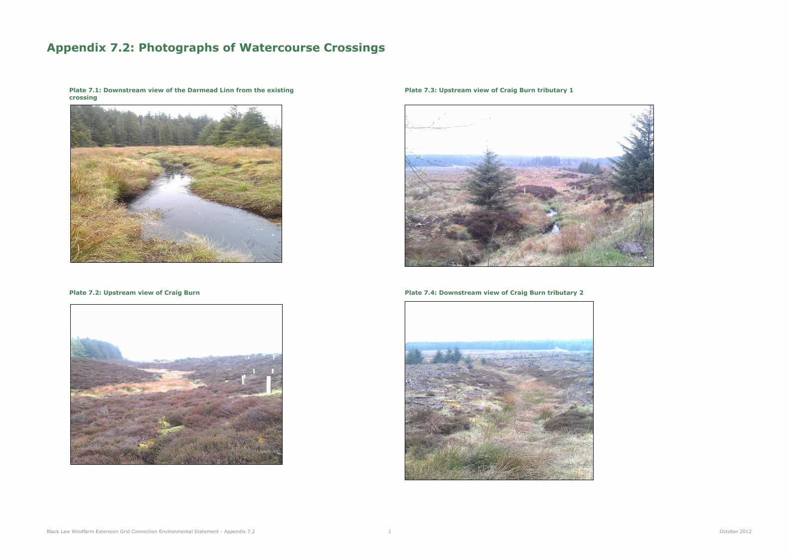
Black Law Windfarm Extension Grid Connection Environmental Statement - Appendix 7.2 1 October 2012
Appendix 7.2: Photographs of Watercourse Crossings
Plate 7.1: Downstream view of the Darmead Linn from the existing Plate 7.3: Upstream view of Craig Burn tributary 1
crossing
Plate 7.2: Upstream view of Craig Burn Plate 7.4: Downstream view of Craig Burn tributary 2

Black Law Windfarm Extension Grid Connection Environmental Statement - Appendix 7.2 2 October 2012
Plate 7.5: Road drains along the access track to the Black Law Windfarm. Plate 7.7: Abbett Burn tributary 1 looking downstream at the proposed crossing Photo is facing east.
Plate 7.6: Downstream view of Abbett Burn at the proposed crossing Plate 7.8: Disused mining ponds north of the Springfield Reservoir. Photo looking north.

Black Law Windfarm Extension Grid Connection Environmental Statement - Appendix 7.2 3 October 2012
Plate 7.9: View of the Springfield Reservoir looking south-west Plate 7.11: Upstream view of the Back Burn tributary at the proposed crossing
Plate 7.10: Unnamed Watercourse 1 at the proposed crossing. Plate 7.12: Downstream view of Fulwood Burn at the proposed crossing
Photo looking north.

Black Law Windfarm Extension Grid Connection Environmental Statement - Appendix 7.2 4 October 2012
Plate 7.13: Upstream view of Fulwood Burn tributary 1 at the crossing Plate 7.15: Upstream view of the Fulwood Burn tributary 3 at the proposed crossing
Plate 7.14: Downstream view of Fulwood Burn tributary 2 Plate 7.16: Upstream view of Brocklinn Burn at crossing 1
at the existing culvert crossing

Black Law Windfarm Extension Grid Connection Environmental Statement - Appendix 7.2 5 October 2012
Plate 7.17: Brocklinn Burn tributary 1 upstream of the existing Plate 7.19: Unnamed Watercourse 2 Upstream culvert crossing under the railway of the existing culvert crossing
Plate 7.18: Brocklinn Burn tributary 2 looking upstream Plate 7.20: River Clyde at the Stonebyres Power Station.
at the proposed crossing Photo taken on the left bank of the river


Appendix 8.1: Ecological Legislation and Policy


Black Law Windfarm Extension Grid Connection
Appendix 8.1
Ecological Legislation and Policy
Prepared by LUC
October 2012
Planning & EIA Design Landscape Planning Landscape Management Ecology Mapping & Visualisation
LUC GLASGOW 37 Otago Street Glasgow G12 8JJ Tel: 0141 334 9595 Fax: 0141 334 7789 [email protected]
Offices also in: London Bristol Edinburgh
FS 566056
EMS 566057
Land Use Consultants Ltd Registered in England
Registered number: 2549296 Registered Office: 43 Chalton Street London NW1 1JD
LUC uses 100% recycled paper

Black Law Windfarm Extension Grid Connection Environmental Statement - Appendix 8.1 October 2012
Contents
1 Introduction 1
2 Relevant Ecological Legislation and Policy 2
Tables
Table 8.1.1: Relevant Protected Species Legislation 2
Table 8.1.2: Relevant Designated Site Legislation and Policy 2

Black Law Windfarm Extension Grid Connection Environmental Statement - Appendix 8.1 1 October 2012
1 Introduction
1.1 The EcIA has taken into account all relevant legislation, policy and best practice advice, including
European and UK environmental legislation, UK nature conservation policy and local biodiversity guidance.

Black Law Windfarm Extension Grid Connection Environmental Statement - Appendix 8.1 2 October 2012
2 Relevant Ecological Legislation and Policy
2.1 Although the Ecological Value of any given site must be considered separately to the legal and policy
framework, a description of the relevant legislation and the species and habitats it protects can often
frame and inform the overall assessment process. The following tables provide details of relevant
legislation and policy.
Table 8.1.1: Relevant Protected Species Legislation
Species Legislation
(Scotland)
Offences
Bats
European protected
species
Conservation
(Natural Habitats
&c.) Regulations
1994 (as amended)
Reg.39
Deliberately1 or recklessly capture, injure or
kill a bat; deliberate or reckless
disturbance2 of bats; or damage or destroy
a breeding site or resting place used by a
bat.
[The protection of bat roosts is considered
to apply regardless of whether bats are
present.]
Otter
European protected
species
Conservation
(Natural Habitats
&c.) Regulations
1994 (as amended)
Reg.39
Deliberately1 or recklessly capture, injure or
kill an otter; deliberate or reckless
disturbance2 of otters; or damage or
destroy a breeding site or resting place
used by an otter.
Badger Protection of
Badgers Act 1992
Wilfully kill, injure, take, possess or cruelly
ill-treat a badger, or attempt to do so;
interfere with a sett by damaging or
destroying it; obstruct access to, or any
entrance of, a badger sett and/or disturb a
badger when it is occupying a sett.
Great crested newt
European protected
species
Conservation
(Natural Habitats
&c.) Regulations
1994 (as amended)
Reg.39
Deliberately1 or recklessly capture, injure or
kill a great crested newt; deliberate or
reckless disturbance2 of great crested
newts; or damage or destroy a breeding
site or resting place used by a great crested
newt.
It is also an offence to deliberately1 or
recklessly take or destroy the eggs of a
great crested newt
1 Deliberate capture or killing is taken to include “accepting the possibility” of such capture or killing.
2 Deliberate or reckless disturbance of animals includes in particular any disturbance which is likely to impair their ability to survive, to breed or
reproduce, or to rear or nurture their young; or to affect significantly the local distribution or abundance of the species to which they belong, or to
obstruct access to a breeding site or resting place or otherwise to deny the animal use of the breeding site or resting place. Disturbance also
includes disturbing an animal whilst it is occupying a structure or place which it uses for shelter or protection and disturbing an animal while it is
rearing or otherwise caring for its young.
Species Legislation
(Scotland)
Offences
Adder
Common lizard
Slow worm
Wildlife and
Countryside Act
1981 S.9(1) (part);
S.9(5)
Intentionally kill or injure any common
reptile species.
Table 8.1.2: Relevant Designated Site Legislation and Policy
Site Designation Legislation
(Scotland)
Protection
Special Area of
Conservation (SAC)
Special Protection
Area (SPA)
Wetland of
International
Importance (Ramsar
site)
Conservation
(Natural Habitats,
&c.) Regulations
1994.
EC Directive on the
conservation of
natural habitats and
of wild fauna and
flora (92/42/EEC).
EC Directive on the
conservation of wild
birds (79/409/EEC).
Convention on
Wetlands of
International
Importance
especially as
Waterfowl Habitat
1971 (the Ramsar
Convention).
Planning controls are affected through Part
IV of the Conservation (Natural Habitats,
&c.) Regulations 1994, in particular
Regulations 48 & 49.
The legislation for the Site of Special
Scientific Interest which will underpin each
designation also applies.
These sites are given protection through
policies in the Local Development Plan.
Site of Special
Scientific Interest
(SSSI)
Wildlife and
Countryside Act
1981 (as amended)
It is an offence to carry out or permit to be
carried out any potentially damaging
operation.
SSSIs are given protection through policies
in the Local Development Plan.
Biodiversity Action
Plan (BAP) Habitats
& Species
No specific
legislation, unless it
is also a species or
habitat of principal
importance as
described above.
The Biodiversity Action Plan (BAP) is the
UK's initiative to maintain and enhance
biodiversity in response to the Convention
on Biological Diversity signed in 1992.
The UK Biodiversity Action Plan (UK BAP) is
a tool for the prioritisation of species and
habitat conservation in the UK. For each
species or habitat a Plan is developed,
these are known as Species Action Plans
(SAPs) and Habitat Action Plans (HAPs).

Appendix 8.2: Habitat Survey Report


Black Law Windfarm Extension Grid Connection -
Appendix 8.2
Habitat Survey Report
Prepared by LUC
October 2012
Planning & EIA Design Landscape Planning Landscape Management Ecology Mapping & Visualisation
LUC GLASGOW 37 Otago Street Glasgow G12 8JJ Tel: 0141 334 9595 Fax: 0141 334 7789 [email protected]
Offices also in: London Bristol Edinburgh
FS 566056
EMS 566057
Land Use Consultants Ltd Registered in England
Registered number: 2549296 Registered Office: 43 Chalton Street London NW1 1JD
LUC uses 100% recycled paper

Black Law Windfarm Extension Grid Connection Environmental Statement - Appendix 8.2 October 2012
Contents
1 Introduction 1
2 Methodology 2 Phase 1 Habitat Survey 2 NVC Survey 2 Limitations 2
3 Results 3 Phase 1 Habitat Survey 3 NVC Survey 3
4 Summary of Habitats 7
5 Appendices 8 Appendix 8.3.1 Phase 1 Habitat Survey Target Notes 8
Tables
Table 8.2.1: Phase 1 Habitat Types Present within the Study Area 3
Table 8.2.2: Botanical Communities Recorded During the NVC Survey 4
Table 8.2.3: Phase 1 Habitat Survey Target Notes 8

Black Law Windfarm Extension Grid Connection Environmental Statement - Appendix 8.2 1 October 2012
1 Introduction
1.1 This report details the methods and findings of a Phase 1 Habitat Survey and National Vegetation
Classification Survey undertaken for the Black Law Wind Farm Extension Grid Connection (hereinafter
referred to as „the proposed grid connection‟) in South Lanarkshire.

Black Law Windfarm Extension Grid Connection Environmental Statement - Appendix 8.2 2 October 2012
2 Methodology
Phase 1 Habitat Survey
2.1 Phase 1 Habitat Survey is a standard survey technique, providing a nationally recognised means of
classifying and mapping broad habitat types. The method for Phase 1 Habitat Survey is described in JNCC
(2010)i.
2.2 The Phase 1 Habitat Survey was conducted undertaken between August and October 2011 and, as a result
of design iterations, finally completed in May 2012. The Study Area for the Phase 1 Habitat Survey is
displayed in Figure 8.2a-g. The Study Area consisted of the overhead line (OHL) and underground cable
route, plus a 150m buffer around this.
2.3 Habitats, and the key plant species associated with each of these, were recorded on a 1:10,000 Ordnance
Survey (OS) base map using the standard Phase 1 classification and mapping codes. The minimum
mappable unit was 40 x 40m. Aerial photography was used to help define habitat boundaries. Target
notes were recorded, describing evidence of protected species, or details of any UK Biodiversity Action
Plan or Habitats Directive habitats. Habitats which were less than the minimum MMU in extent, but were
of notable conservation interest were target noted.
2.4 Target notes were recorded using hand-held GPS to aid classification of habitats. Mapped habitats were
subsequently transferred to a digital map base within a Geographical Information System (GIS).
2.5 Where any rare, uncommon or locally important habitats or plants were present they were noted and grid
references taken. In terms of habitats, these consisted of habitats listed in Annex 1 of the Habitats
Directive, priority habitats identified in the UK BAP1 or specific local Council BAPs. In terms of plant
species, these consist of plants listed in Annex 2 and/or 4 of the Habitats Directive, a priority species listed
in the UK BAP and/or Schedule 8 of the Wildlife and Countryside Act.
NVC Survey
2.6 The NVC survey is one of the key common standards to mapping vegetation communities in the UK. The
methodology was developed by the statutory conservation agencies with the aim of comprehensively
describing and classifying plant communities in the British Isles, each of which are systematically named
and coded. In the NVC, classifying plant communities focuses on the identification of vascular plants,
bryophytes and macro-lichens and assessing their densities in a given stand.
2.7 A number of habitats of international or national value, or of local importance were identified during the
Phase 1 Habitat Survey, these included bog, heath, flush and marshy grassland. Where such habitats
were identified in proximity to the cabling route, they were classified, where appropriate, in terms of NVC
communities. Improved and semi-improved grasslands, the dominant habitat types in the Study Area, are
heavily modified and botanically impoverished. Consequently, detailed vegetation studies were not
undertaken in these ubiquitous habitats. Similarly, artificial man-made habitats, such as hardstandings
and access tracks, cannot be categorised in the NVC.
2.8 Principally, the NVC Survey was conducted in September and October 2011. Some additional NVC Survey
was required as a result of design iterations, these surveys were completed alongside the Phase 1 Habitat
Survey in May 2012.
2.9 The NVC habitat types were classified in accordance with the British Plant Community keys (Volumes 1-
V)2. Species distribution and abundance was assessed according to detailed DAFOR3 measurements,
undertaken during the Phase 1 Habitat survey. Subsequently, the indicative NVC categories were
1 The Biodiversity Action Plan identifies targets for improving and protecting biodiversity in an area to meet the UK‟s commitments under the Rio
Convention. 2 Rodwell, J.S. (ed.) (1991- 1995). British Plant Communities Volumes I-V. Cambridge University Press, Cambridge
3 D – dominant, A – abundant, F – frequent, O – occasional, R – rare.
allocated based on the detailed DAFOR scores for the principle habitat types in the study area and the
knowledge and experience of LUC surveyors, i.e. no botanical communities were sampled using quadrats.
Limitations
2.10 Ecological surveys are limited by a variety of factors which affect the presence of flora and fauna; for
example climatic variation, season and species behaviour. Evidence of protected species is not always
recorded during a survey. This does not mean that a species is absent; hence the surveys also record and
assess the ability of habitats to support species. The time frame in which the survey is implemented
provides a snapshot of activity within the Study Area and cannot necessarily detect all evidence of use by
a species.
2.11 Generally, the optimal timing for habitat and vegetation surveys is between April and September. A
proportion of the Phase 1 Habitat Survey and NVC Survey were completed in October. Despite this
narrowly falling out with the optimal survey „window‟, the timings of the habitat surveys did not present
any issues when classifying habitats. The surveyors undertaking the habitat surveys were suitably skilled
at classifying habitats and identifying plants outside of the core flowering season.
2.12 A significant proportion of the land in the Study Area, principally in the central and southern parts, was
utilised for agricultural production. Consequently, ecological surveys were reliant upon prior landowner
agreements and arrangements for access to the land. Generally, this did not prevent significant obstacles.
However, on a number of occasions access was refused. When such circumstances arose, surveyors
attempted to complete the habitat surveys through less conventional methods, i.e. aerial photographs, OS
maps and remote survey with binoculars from adjacent public land. Where the aforementioned methods
were insufficient for confidently classifying the habitats, a classification of „Not Surveyed‟ was assigned to
the habitat.

Black Law Windfarm Extension Grid Connection Environmental Statement - Appendix 8.2 3 October 2012
3 Results
3.1 The Study Area supports a variety of habitat types, ranging from semi-natural upland peat habitats to
lowland, heavily modified agricultural grassland. In an ecological context, the land types in the north and
south of the study area, which can be defined as north and south of the B7056, near Springfield Reservoir,
are, generally, distinctive, in terms of their altitudinal position, degree of agricultural management and the
associated botanical characteristics of the habitats. The habitats to the north were generally of a greater
ecological value and contained good examples of blanket bog and dry heath. The enclosed fields, in the
south of the route, were heavily modified for rearing livestock and growing arable crops.
3.2 The semi-natural broad-leaved woodland resource, located in the extreme south of the Study Area, was
notable in terms of its ecological value and inclusion in the Clyde Valley Woods SAC complex.
Phase 1 Habitat Survey
3.3 Phase 1 Habitats present in the Study Area are displayed in Figure 8.2a-g. Target notes recorded during
the Phase 1 Habitat Survey are detailed in Appendix 8.2.1, below. The target notes associated with the
Phase 1 Habitat Survey cover a wider area to that described as the Study Area above, i.e. the target notes
extend beyond 150m from the cabling route. Initially, the habitat survey extended approximately 250m
from the OHL to identify any sensitive, groundwater dependent habitats.
3.4 Table 8.2.1, below, lists habitat types, identified during the Phase 1 Habitat Survey, and details their
extent across the Study Area:
Table 8.2.1: Phase 1 Habitat Types Present within the Study Area
Habitat types Area (ha) Percentage Cover
in Study Area (%)
Access tracks and hard standings 42 7.14
Acid flush 6 1.02
Amenity grassland 6 1.02
Arable 42 7.14
Blanket bog 12 2.04
Blanket bog mosaics 6 1.02
Broad-leaved plantation woodland 3 0.51
Broad-leaved semi-natural woodland 27 4.59
Buildings and gardens 19 3.23
Coniferous plantation woodland 37 6.29
Dense and scattered scrub 8 1.36
Dry heath 3 0.51
Dry heath mosaics 13 2.21
Habitat types Area (ha) Percentage Cover
in Study Area (%)
Dry modified bog 16 2.72
Dry modified bog mosaic 3 0.51
Improved grassland and associated mosaics 93 15.82
Marshy grassland 93 15.82
Marshy grassland mosaics 34 5.78
Mixed plantation woodland 1 0.17
Not surveyed 3 0.51
Open water 5 0.85
Poor semi-improved grassland 39 6.63
Semi-improved acid grassland 4 0.68
Semi-improved acid grassland mosaics 15 2.55
Semi-improved neutral grassland 28 4.76
Semi-improved neutral grassland mosaics 4 0.68
Tall ruderal 5 0.85
Unimproved acid grassland 2 0.34
Wet modified bog 4 0.68
Wet modified bog mosaics 15 2.55
All habitats (total area) 588 100
3.5 In summary, a total of 30 habitats, including transitional habitats and mosaics, were identified within the
Study Area. Dominant habitats included improved and poor semi-improved pasture grasslands (combined
area of 132ha, 22.45% of the Study Area), fields containing arable crops (42, 7.14% of the Study Area),
coniferous plantation woodlands (37ha, 6.29% of the Study Area) and marshy grasslands, and its mosaics
(combined area of 127ha, 21.6% of the Study Area). The north of the Study Area supported habitats of
the greatest ecological interest and intrinsic value (excluding the semi-natural broad-leaved woodland in
the south), here blanket bog, modified bog, acid flushes and dry heaths were represented in the wider
mosaic.
NVC Survey
3.6 During the NVC survey a total of 28 NVC types were recorded (excluding variations in sub-community
types), of which four were woodland types, two scrubland types, nine grassland types, two tall ruderal
types, three heathland types and eight mire types. The results of the NVC survey are displayed in Figure
8.3.
3.7 Two rush pasture grassland habitat types were recorded in the Study Area which share affinities with the
MG10 Holcus lanatus – Juncus effusus rush-pasture NVC type, although the sward does not readily fit into
any of the published MG10 sub-communities. The first of the two habitat types contains a sward almost
Black Law Windfarm Extension Grid Connection Environmental Statement - Appendix 8.2 4 October 2012
completely dominated by Holcus lanatus and lacking any Juncus effusus, this was recorded as MG10hl.
The second variant of MG10 was a Juncus effusus dominated habitat with a notable acid ground flora,
containing Nardus stricta, Potentilla erecta and Gallium saxatile, as opposed to a community containing
mesotrophic herbs. This community was labelled as MG10ag, to indicate the presence of a ground flora
expected in an acid grassland.
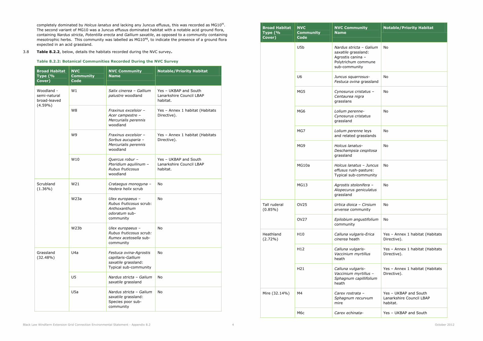
3.8 Table 8.2.2, below, details the habitats recorded during the NVC survey.
Table 8.2.2: Botanical Communities Recorded During the NVC Survey
Broad Habitat
Type (%
Cover)
NVC
Community
Code
NVC Community
Name
Notable/Priority Habitat
Woodland -
semi-natural
broad-leaved
(4.59%)
W1 Salix cinerea – Gallium
palustre woodland
Yes – UKBAP and South
Lanarkshire Council LBAP
habitat.
W8 Fraxinus excelsior –
Acer campestre –
Mercurialis perennis
woodland
Yes – Annex 1 habitat (Habitats
Directive).
W9 Fraxinus excelsior –
Sorbus aucuparia –
Mercurialis perennis
woodland
Yes – Annex 1 habitat (Habitats
Directive).
W10 Quercus robur –
Pteridium aquilinum –
Rubus fruticosus
woodland
Yes – UKBAP and South
Lanarkshire Council LBAP
habitat.
Scrubland
(1.36%)
W21 Crataegus monogyna –
Hedera helix scrub
No
W23a Ulex europaeus –
Rubus fruticosus scrub:
Anthoxanthum
odoratum sub-
community
No
W23b Ulex europaeus –
Rubus fruticosus scrub:
Rumex acetosella sub-
community
No
Grassland
(32.48%)
U4a Festuca ovina-Agrostis
capillaris-Gallium
saxatile grassland:
Typical sub-community
No
U5 Nardus stricta – Galium
saxatile grassland
No
U5a Nardus stricta – Galium
saxatile grassland:
Species poor sub-
community
No
Broad Habitat
Type (%
Cover)
NVC
Community
Code
NVC Community
Name
Notable/Priority Habitat
U5b Nardus stricta – Galium
saxatile grassland:
Agrostis canina –
Polytrichum commune
sub-community
No
U6 Juncus squarrosus-
Festuca ovina grassland
No
MG5 Cynosurus cristatus –
Centaurea nigra
grasslans
No
MG6 Lolium perenne-
Cynosurus cristatus
grassland
No
MG7 Lolium perenne leys
and related grasslands
No
MG9 Holcus lanatus-
Deschampsia cespitosa
grassland
No
MG10a Holcus lanatus – Juncus
effusus rush-pasture:
Typical sub-community
No
MG13 Agrostis stolonifera –
Alopecurus geniculatus
grassland
No
Tall ruderal
(0.85%)
OV25 Urtica dioica – Cirsium
arvense community
No
OV27 Epilobium angustifolium
community
No
Heathland
(2.72%)
H10 Calluna vulgaris-Erica
cinerea heath
Yes – Annex 1 habitat (Habitats
Directive).
H12 Calluna vulgaris-
Vaccinium myrtillus
heath
Yes – Annex 1 habitat (Habitats
Directive).
H21 Calluna vulgaris-
Vaccinium myrtillus –
Sphagnum capillifolium
heath
Yes – Annex 1 habitat (Habitats
Directive).
Mire (32.14%) M4 Carex rostrata –
Sphagnum recurvum
mire
Yes – UKBAP and South
Lanarkshire Council LBAP
habitat.
M6c Carex echinata- Yes – UKBAP and South

Black Law Windfarm Extension Grid Connection Environmental Statement - Appendix 8.2 5 October 2012
Broad Habitat
Type (%
Cover)
NVC
Community
Code
NVC Community
Name
Notable/Priority Habitat
Sphagnum
recurvum/auriculatum
mire: Juncus effusus
sub-community
Lanarkshire Council LBAP
habitat.
M6d Carex echinata-
Sphagnum
recurvum/auriculatum
mire: Juncus acutiflorus
sub-community
Yes – UKBAP and South
Lanarkshire Council LBAP
habitat.
M17 Trichophorum
cespitosum-Eriophorum
vaginatum blanket mire
Yes – Annex 1, Priority habitat
(Habitats directive).
M18 Erica tetralix –
Sphagnum papillosum
raised and blanket mire
Yes – Annex 1, Priority habitat
(Habitats directive).
M19 Calluna vulgaris-
Eriophorum vaginatum
blanket mire
Yes – Annex 1, Priority habitat
(Habitats directive).
M20 Eriophorum vaginatum
blanket and raised mire
Yes – Annex 1, Priority habitat
(Habitats directive).
M23a Juncus
effusus/acutiflorus-
Galium palustre rush-
pasture: Juncus
acutiflorus sub-
community
No
M23b Juncus
effusus/acutiflorus-
Galium palustre rush-
pasture: Juncus effusus
sub-community
No
M25 Molinia caerulea-
Potentilla erecta mire
No
N.B. Where derived from
burning blanket bog vegetation -
Annex 1, Priority habitat
(Habitats directive).
M25b Molinia caerulea-
Potentilla erecta mire:
Anthoxanthum
odoratum sub-
community
No
N.B. Where derived from
burning blanket bog vegetation -
Annex 1, Priority habitat
(Habitats directive).
Other habitat
types not
subject to NVC
survey, e.g.
N/A N/A No
Broad Habitat
Type (%
Cover)
NVC
Community
Code
NVC Community
Name
Notable/Priority Habitat
plantation
woodlands,
hardstandings
(25.85%)
3.9 A summary description of the main habitats found within the Study Area is provided below:
Woodlands
3.10 The woodlands in the Study Area are located in the north and south of the proposed grid connection route.
The woodlands in the north of the Study Area were of limited ecological value, in this area dense
coniferous plantation woodland, mainly Sitka spruce Picea sitchensis monoculture, was the dominate
habitat type. To the south of the site, immediately west of Lanark, semi-natural broad-leaved woodland
occupied a fragmented range, restricted to the Clyde River and Mouse Water valleys, covering an area of
27ha (4.59% of the Study Area). This woodland was predominately of the type, upland mixed ash gorge
woodland, dominated by ash Fraxinus excelsior, elm Ulmus sp and oak Quercus robur on drier valley side
slopes, and alder in the wetter riparian zones. The semi-natural broad-leaved woodlands in the Study
Area were represented by the following NVC communities:
W1 Salix cinerea – Gallium palustre woodland
W8 Fraxinus excelsior – Acer campestre – Mercurialis perennis woodland
W9 Fraxinus excelsior – Sorbus aucuparia – Mercurialis perennis woodland
W10 Quercus robur – Pteridium aquilinum – Rubus fruticosus woodland
Grasslands
3.11 Grassland habitats (and mosaics) account for 32.48% of the Study Area (191ha). A single patch of
unimproved acid grassland and numerous small patches of semi-improved acid grassland were recorded in
the central and northern end of the Study Area, at Springfield Reservoir and occupying a position on the
embankments of a disused railway track, west of Climpy. The acid grasslands in the Study Area are
represented by the following NVC communities:
U4a Festuca ovina-Agrostis capillaris-Gallium saxatile grassland: Typical sub-community
U5 Nardus stricta – Galium saxatile grassland
U5a Nardus stricta – Galium saxatile grassland: Agrostis canina – Polytrichum commune sub-
community
U6 Juncus squarrosus-Festuca ovina grassland
3.12 Furthermore, acid grassland is found as a mosaic with marshy grassland, semi-improved neutral grassland
and acid flush throughout the north of the Study Area. At all of these locations the acid grassland
component was principally of the U4 and/or U5 communities.
3.13 Semi-improved neutral grassland was a ubiquitous habitat type in the south of the Study Area, covering
an area of 28ha (4.76% of the Study Area). Generally, the sward was impoverished as a result of
agricultural nutrient enrichment and the habitats were positioned within enclosed fields, utilised for
livestock grazing. The semi-improved neutral grasslands in the Study Area were represented by the
following NVC communities:
MG5 Cynosurus cristatus – Centaurea nigra grassland
MG6 Lolium perenne-Cynosurus cristatus grassland
3.14 At a single location, north-east of Cartland, semi-improved neutral grassland was recorded in mosaic with
marshy grassland and, scattered and continuous scrub.
3.15 Marshy grassland (and mosaics of this habitat) account for 127ha (21.60% of the Study Area) and is
widespread throughout the Study Area. In the south, generally, the marshy grasslands occupy small

Black Law Windfarm Extension Grid Connection Environmental Statement - Appendix 8.2 6 October 2012
areas of ground between improved and semi-improved pasture fields, often associated with natural and
artificial drainage features. In the north, the habitat forms extensive areas of relatively species-poor,
rush-dominated vegetation. On the whole, the marshy grasslands in the Study Area were of poor quality.
Exceptionally, a small fragment of good quality marshy grassland, in mosaic with acid flush, was recorded
in a forestry ride to the north of Fullwood, with sharp-flowered rush Juncus acutiflorus, carnation sedge
Carex panacea, cuckoo flower Cardamine pratensis, marsh horsetail Equisetum palustre and lesser
spearwort Ranunculus flammula all featured in the sward. The marshy grassland NVC communities
include:
MG9 Holcus lanatus - Deschampsia cespitosa grassland
MG10 Holcus lanatus - Juncus effusus rush pasture
M23a Juncus acutiflorus - Galium palustre rush pasture
M23b Juncus effusus - Galium palustre rush pasture
3.16 Marshy grassland regularly formed mosaic and transitionary habitats in the Study Area. The other
habitats that marshy grassland was recorded with included dry and wet modified bog, scattered broad-
leaved trees, scrub, semi-improved neutral grassland and improved grassland.
Heathlands
3.17 Dry heath habitats and their associated mosaics were limited in their extent, accounting for 16ha (2.72%
of the Study Area). The only pure stand of dry heath (occurring out of mosaic) was located in the extreme
north of the Study Area and was positioned on steep sections on the north and south banks of the Craig
Burn, near Sergeants Law. At this location the dry heath is represented by a good example of the H21
Calluna vulgaris - Vaccinium myrtillus - Sphagnum capillifolium heath NVC community.
3.18 A further two dry heath communities were recorded in mosaic with acid grassland, dry modified bog and
scattered coniferous trees. All but one of these habitat mosaics were recorded in the north of the Study
Area. The single occurrence in the south was associated with the steep, south facing slopes of a disused
quarry, north-east of Cartland. These communities were representative of the following NVC
communities:
H10 Calluna vulgaris - Erica cinerea heath
H12 Calluna vulgaris - Vaccinium myrtillus heath
Mires
3.19 Generally, these habitat types dominated in the upland areas, i.e. in the north of the Study Area, where
peat depth was at its greatest.
3.20 Blanket bog and its associated mosaic habitats cover an area of 18ha (3.06% of the Study Area). These
habitats dominated the unplanted regions across the north of the Study Area, immediately east of the
existing Black Law Windfarm. The unmodified and pure stands of blanket bog were of high quality in
terms of species composition and “naturalness”, with a continuous carpet of Sphagnum mosses and
vascular plants. The largest area of high quality blanket bog was located immediately north of the existing
access track leading into the Black law Windfarm. To minimise the disturbance, only two wooden poles
have been proposed in this habitat. The blanket bog was typically co-dominated by hare's-tail cottongrass
Eriophorum vaginatum, cross-leaved heath Erica tetralix and heather Calluna vulgaris, and supported a
dense Sphagnum layer, including abundant Sphagnum magellanicum and Sphagnum papillosum. Other
plant species present in the sward included occasional cranberry Vaccinium oxycoccos and localised
patches of bog asphodel Narthecium ossifragum.
3.21 In terms of the NVC, the blanket bog areas within the Study Area are represented by the following NVC
communities:
M17 Trichophorum cespitosum-Eriophorum vaginatum blanket mire
M18 Erica tetralix - Sphagnum papillosum blanket mire
M19 Calluna vulgaris - Eriophorum vaginatum blanket mire
3.22 Dry modified bog is restricted to two locations, the first in the north of the Study Area and the second
immediately east of the Springfield Reservoir, near Easterseat. The habitat covers an area of 19ha
(3.23% of the Study Area). The largest of these areas were recorded in association with the large area of
high quality blanket bog in the north of the Study Area. In terms of the NVC, this habitat type is classified
as M20 Eriophorum vaginatum blanket mire.
3.23 Wet modified bog was recorded in small fragments within the wider mire habitat mosaic east of
Springfield Reservoir. In total this habitat type covered an area of 19ha (3.23% of Study Area). In terms
of the NVC, this habitat type is principally classified as M25 Molinia caerulea - Potentilla erecta mire.
Heather cover is reduced in this habitat type with the dominant species being purple moor-grass Molinia
caerulea, often forming homogenous stands and covering extensive areas, as well as frequent hare's-tail
cottongrass, with few other species. This habitat was likely derived from bog vegetation as a result of
management practices, such as grazing.
3.24 Acid flush habitats are limited in their extent across the Study Area, 6ha (1.02% of Study Area). Often
these areas of acid flush were associated with the surface waters, such as Springfield Reservoir and Craig
Burn, and were dominated by soft rush Juncus effusus over a thick layer of Sphagnum palustre. In terms
of the NVC, acid flushes within the site are representative of the flowing sub-communities:
M4 Carex rostrata – Sphagnum recurvum mire
M6a Carex echinata - Sphagnum recurvum/auriculatum mire Juncus effusus sub-community
M6b Carex echinata - Sphagnum recurvum/auriculatum mire Juncus acutiflorus sub-community
3.25 Acid flush habitats were recorded in mosaic with a number of other habitat types, including marshy
grassland, dry modified bog, wet modified bog, dry heath and scattered coniferous trees.
Tall Ruderal and Scrubland
3.26 Generally, tall ruderal and lowland scrub communities are associated with low levels of intrinsic ecological
value; this is especially true for the tall ruderal habitats recorded in the Study Area.
3.27 Tall ruderal habitats were limited in their extent and accounted for 5ha (0.85% of the Study Area). In the
extreme south of the Study Area, immediately south of where the proposed grid connection crosses the
River Clyde, there is an area of woodland with an open structure. Despite being classified as semi-natural
broad-leaved woodland, the open sections of this woodland, i.e. where the canopy is not enclosed, are
dominated by tall ruderal vegetation and specifically by rosebay willowherb Epilobium angustifolium.
Where possible, it will be through these open sections, of lesser ecological value, that the cabling route will
be aligned. The tall ruderal communities recorded within the Study Area are representative of the
following NVC communities:
OV25 Urtica dioica – Cirsium arvense community
OV27 Epilobium angustifolium community
3.28 Similarly, the scrublands in the Study Area were limited in their extent, covering an area of 8ha (1.36% of
the Study Area). The majority of the scrubland recorded in the Study Area was dominated by common
gorse Ulex europaeus with slight variations in the associated ground flora. At a single location, near the
disused quarry, north-east of Cartlands, hawthorn Crataegus monogyna scrub was recorded. The
scrubland in the Study Area was representative of the flowing NVC communities:
W21 Crataegus monogyna – Hedera helix scrub
W23a Ulex europaeus – Rubus fruticosus scrub: Anthoxanthum odoratum sub-community
W23b Ulex europaeus – Rubus fruticosus scrub: Rumex acetosella sub-community
3.29 In the Study Area, dense and scattered scrub regularly formed mosaics with the following habitat types,
marshy grassland and semi-improved neutral grassland.
Rare or Notable Plant Species
3.30 No rare or notable plant species were observed during the Phase 1 Habitat and NVC surveys.

Black Law Windfarm Extension Grid Connection Environmental Statement - Appendix 8.2 7 October 2012
4 Summary of Habitats
4.1 The vegetative communities occupying positions in the north of the Study Area are of the highest, intrinsic
ecological value. However, despite recording a number of mire habitat types, generally, the quality of the
habitats has been compromised by grazing pressures, remnant land drains and the encroachment of
coniferous plantation woodland. In terms of the blanket bog, a large fragment of bog exists, although the
Phase 1 habitat Survey suggests that the extent of this habitat is contracting through anthropogenic
pressures, evident to the north and the south. Modified bog communities were present to the south of the
blanket bog, these modifications were likely induced by livestock grazing and poaching, whist
encroachment of Sitka spruce was evident to the north.
4.2 The southern end of the Study Area, where the underground cable is proposed, supports semi-natural
broad-leaved woodlands with notable ecological value. These woodlands form a mosaic of upland mixed
ash gorge woodland, upland oak woodland and a wet grey willow dominated woodland type.
4.3 Notwithstanding the mire communities to the north and the semi-natural broad-leaved woodlands to the
south, the majority of the habitats in the Study Area were of minimal ecological value, often comprising
enclosed agricultural fields, predominately for sheep and cattle grazing and also for crop production.

Black Law Windfarm Extension Grid Connection Environmental Statement - Appendix 8.2 8 October 2012
5 Appendices
Appendix 8.2.1 Phase 1 Habitat Survey Target Notes
5.1 Whist conducting the Phase 1 Habitat Survey, LUC surveyors recorded brief notes relating to the habitat
structure and features, botanical species composition, habitats potential to support faunal species and any
species sightings observed across the wider Study Area.
5.2 Table 8.2.3, below, contains the target notes recorded during the Phase 1 Habitat Surveys.
Table 8.2.3: Phase 1 Habitat Survey Target Notes
Target Note
Number
Date Recorded Notes
T1 30/08/2011 Fenced boundary with several scattered hawthorn Crataegus monogyna, rowan Sorbus aucuparia, willow Salix cinerea and blackthorn Prunus spinosa. Low bat roost potential.
T2 30/08/2011 Wet ditch with marshy grassland. Fence surrounding ditch.
T3 30/08/2011 Semi-improved grassland with extensive clumps of soft rush Juncus effusus in mosaic with areas of improved
and poor-semi-improved grassland types.
T4 30/08/2011 Derelict farm building/store - no roof present. Gable end remains but is quite exposed. Corrugated iron
lead-to at other gable end. Low bat roost potential.
T5 30/08/2011 Grazed marshy grassland with occasional areas of semi-
improved neutral grassland.
T6 30/08/2011 Grazed improved/marshy grassland moasic.
T7 30/08/2011 Mature sycamore Acer pseudoplatanus tree.
T8 30/08/2011 Marshy grassland with sharp-flowered rush Juncus acutiflorus, tufted hair-grass Deschampsia cespitosa
and soft rush.
T9 30/08/2011 Clump of mature beech Fagus sylvatica trees.
T10 30/08/2011 Fence with several mature Scot's pine Pinus sylvestris.
T11 30/08/2011 Marshy grassland dominated by tufted hair-grass with frequent sharp-flowered rush and soft rush.
T12 30/08/2011 Mature Sitka spruce Picea stichensis plantation.
T13 30/08/2011 Ditch/burn with running water and marshy/aquatic vegetation. Semi-improved grassland/tall herb vegetation on banks of ditch.
T14 30/08/2011 Wet ditch/burn with running water and marshy/aquatic
vegetation.
T15 30/08/2011 Derelict stone building with no roof. Two sycamore trees noted.
T16 30/08/2011 Tree.
T17 30/08/2011 Mature sycamore.
T18 30/08/2011 Ditch with running water. Scattered trees noted including hawthorn, willow and beech.
T19 30/08/2011 House with garden.
T20 30/08/2011 Fence line with scattered hawthorn.
T21 30/08/2011 Mature beech.
T22 30/08/2011 Line of mature beech with gaps.
Target Note
Number
Date Recorded Notes
T23 30/08/2011 Semi-improved neutral grassland with abundant soft rush.
T24 31/08/2011 Neutral grassland dominated by marsh foxtail Alopecurus geniculatus. Looks as though area may
have formerly been an arable field as frequent barely showing through.
T25 31/08/2011 Occasional young hawthorn along fenceline.
T26 31/08/2011 Ditch with marshy vegetation.
T27 31/08/2011 Neutral grassland verge. False oat-grass
Arrhenatherum elatius, Yorshire fog Holcus lanatus, tufted hair-grass Deschampsia cespitosa, cock's foot Dactylis glomerata with black knapweed Centaurea nigra, meadow vetchling Lathyrus pratensis, yellow
rattle Rhinanthus minor and tufted vetch Vicia cracca.
T28 31/08/2011 Predominantly tall ruderal vegetation along
embankment/verge with frequent/abundant rosebay willowherb Chamerion angustifolium. Occasional scrub present including broom Cytisus scoparius, goat willow Salix caprea, sycamore with neutral grassland in mosaic with this vegetation.
T29 31/08/2011 Hawthorn scrub with rarely noted goat willow over netural grassland/tall ruderal vegetation.
T30 31/08/2011 Neutral grassland/tall ruderal vegetation with scattered hawthron, goat willow, rowan, gorse Ulex europaeus and ashFraxinus excelsior. False oat-grass with devil's-bit scabious Succisa pratensis, black knapweeed, red
clover Trifolium pratense, meadow vetchling, tormentil Potentilla erecta and rosebay willowherb locally
dominant in patches.
T31 31/08/2011 Semi-natural, broad-leaved woodland/scrub with downy birch Betula pubescens, hawthorn, wild cherry Prunus
avium, grey willow, beech making up 100% of canopy cover. Open areas present with neutral grassland/tall ruderal vegetation(predominantly common nettle Urtica dioicia) including black kanpweed, meadow vetchling, bitter vetch Lathyrus montanus and devil's-bit scabious. There is a small area of semi-improved acid grassland at the north west corner. Ash, blackthorn, rowan,
Norway spruce Picea abies, silver birch Betula pendula, goat willow, bird cherry Prunus padus, gorse. Ground flora comprised of: dog's mercury Mercurialis perennis, hedge woundwort Stachys sylvatica, herb robert Geranium Robertianum. Possible W8/W9 also W11 and
W7 present.
T32 31/08/2011 Marginal/marshy vegetation alongside watercourse. Neutral grasland (false oat-grass/Yorkshire fog type), tall ruderal (common nettle) on banks. Scattered trees and standing deadwood.
T33 31/08/2011 Patch of mature Scot's pine approximately 30% of
canopy cover. Also cherry species and hawthorn. Standing and fallen dead wood. Ground vegetation tall ruderal (common nettle)/neutral grassland (false oat-grass/Yorkshire fog)/marshy grassland along waterline.
T34 31/08/2011 Beech/hawthorn hedges along fence with trees (silver birch and goat willow).
T35 31/08/2011 Line of neutral grassland between two fences. Line of sitka spruce along one fence. Wet ditch with running water alongside other fence.
T36 31/08/2011 Hawthorn scrub with gorse. Marshy grassland in dip
along watercouse. Areas of neutral grassland.

Black Law Windfarm Extension Grid Connection Environmental Statement - Appendix 8.2 9 October 2012
Target Note
Number
Date Recorded Notes
T37 31/08/2011 Verge of unimproved grassland (mainly neutral grassland): False oat-grass, devil's-bit scabious, black knapweed, meadow vetchling, Yorkshire fog, harebell Campanula rotundifolia, white clover Trifolium repens, cock's foot, sheep's fescue Festuca ovina, common
bent.
T38 31/08/2011 Dry dwarf shrub heath on embankment with heather Calluna vulgaris and gorse, scattered broom and willow sp. scrub.
T39 31/08/2011 Small patch of purple moor-grass Molinia caerulea marsh.
T40 01/09/2011 Dry modified bog with drainage lines (dominated by soft rush) at various intervals and occasional small patches of acid grassland. Species included: Hare's-tail
cottongrass Eriphorum vagniatum (A), wavy hair-grass
Deschampsia flexuosa (F), heather (O to F), purple moor-grass and cross-leaved heath Erica tetralix and the mosses Sphagnum capillifolium, S. fallax, S. papillosum, Aulacomnium palustre, Pleurozium schreberii, Polytrichum commune.
T40a 01/09/2011 Small hummock of acid grassland at NS 92171, 55101.
Wavy hair-grass (F), sheep's fescue (F), heath bedstraw Galium saxatile (F), tormentil (F), heath rush Juncus squarrosus (R), black sedge Carex nigra (F), common bent Agrostis capillaris (O) and heather (R) and the mosses Pleurosium schreberii, Rhytidiadelphus squarrosus. Drainage lines present with soft rush (D)
and tufted hair-grass Deschampsia cespitosa(F).
T41 01/09/2011 Marsh with soft rush (D), tufted hair-grass (F to locally
A), marsh thistle Cirsium palustre (O), creeping buttercup Ranunculus repens, Yorkshire fog (O), colt's foot Tussilago farfara (O) and the moss Calliergonella cuspidata (O), white clover (O), creeping thistle Cirsium
arvense (O), willowherb sp. (O), Polytrichum commune (O), red fescue Festuca rubra (O), young willow sp. (O), rosebay willowherb (O). Species-poor vegetation and mainly dryish. Occasional dry patches with creeping thistle and other species indicative of disturbance.
T41a 01/09/2011 Marshy grassland with occasional patches of dry modified bog. Soft rush (D), tufted hair-grass (A to D) and, towards the south of this area, occasional patches of improved grassland with white clover, crested dog's tail Cynosurus cristatus and perennial rye grass Lolium perenne.
T41b 02/09/2011 Marhsy grassland with soft rush (D) and patches of dry modified bog.
T41c 02/09/2011 Marshy grassland in mosaic with occasional dry modified bog.
T42 01/09/2011 Slightly higher ground leading up from marsh. Mainly dry modified bog with hare's-tail cottongrass but with acid grassland and marshy (soft rush dominated) grassland types also.
T43 01/09/2011 Drier vegetation noted with red fescue (A), soft rush (F) and bare ground.
T44 01/09/2011 Sloping ground with grazed, neutral grassland including red fescue (A), Yorkshire fog (O), soft rush (A to F) and species which are indicative of disturbance including colt's foot and rosebay willowherb.
T45 01/09/2011 Widened banks of ditch. Emphemeral vegetation on
banks including colt's foot (F) and with bare ground. Water in ditch at time of survey.
Target Note
Number
Date Recorded Notes
T46 01/09/2011 Emphemeral vegetation along banks of burn (colt's foot and bare ground). Possible re-allingment of the watercourse which doesn't match up with the map.
T47 01/09/2011 Acid grassland/netural grassland mosaic. Wavy hair-
grass, common bent, mat-grass Nardus stricta, sheep's fescure, tormentil, heath bedstraw which merges into more tufted hair-grass/soft rush grassland.
T48 01/09/2011 Forestry wayleave. Species-poor marshy grassland with occasional patches of wet modified bog and acid
grassland. Soft rush (D), tufted hair-grass (A to D), rosebay willowherb (O), bog stichwort Stellaria uliginosa (O), purple moor-grass (O), marsh thistle (O), common nettle (O), Yorkshire fog and creeping thistle.
T49 01/09/2011 Neutral grassland with occasional acid grassland and
marshy grassland. Tufted hair-grass (O), soft rush (O to
F), heath bedstraw, tormentil, marsh thistle (O), common bent.
T50 01/09/2011 Small clump of mature tree planting.
T51 02/09/2011 Marshy grassland with soft rush (A), tufted hair-grass (F), sharp-flowered rush (locally A), marsh bedstraw
Galium palustre, creeping buttercup, marsh thistle, marsh violet Viola palustre, Sphaghnum fallax and Polytrichum commune. Line of swampy vegetation along water-line with bottle sedge Carex rostrata, soft rush and sharp-flowered rush.
T52 02/09/2011 Swamp vegetation with sharp-flowered rush (locally D),
soft rush (F), water horsetail Equisetum fluviatile, marsh cinquefoil Potentilla palustris, bottle sedge (A to
locally D), Glyceria sp., pond weed Potamogeton sp., star sedge Carex echinata, lesser spearwort Ranunuculus flammula, marsh marigold Caltha palustris. Mainly swamp with some flush areas. Margins mainly flush with some marshy vegetation: soft
rush (D), Sphagnum fallax, S. palustre, Polytrichum commune which merges into dry modified bog vegetation.
T53 02/09/2011 Flush/swamp mosaic (approximately 75% to 25%). Sphagnum palustre, S. fallax, bottle sedge, marsh
thistle, soft rush (F), Polytrichum commune, heath bedstraw, sharp-flowered rush, marsh cinquefoil, bog bean Menyanthes trifoliata, marsh marigold.
T54 02/09/2011 Wet modified bog. Purple moor-grass (A), wavy hair-grass (A), hare's-tail cottongrass and the mosses
Sphagnum fallax and Pleurosium schreberii.
T55 02/09/2011 Marshy grassland/dry modified bog mosaic. Dry modified bog: hare's-tail cottongrass (A), wavy hair-grass (A), heather (O), Sphagnum papillosum, S. fallax, purple moor-grass. Marshy grassland: soft rush (D), sorrel Rumex acetosella, marsh thistle, marshy
cinquefoil and Sphagnum palustre. Rosebay willowherb was recored in distrubed areas within marshy grassland.
T56 02/09/2011 Wet ditch containing marshy/aquatic vegetation.
T57 02/09/2011 Distrubed area with red fescue (D), bare ground and soft rush (O). Occasional patches of dry modified bog
noted with hare's-tail cottongrass and common cottongrass.
T58 02/09/2011 Dry modified bog: Hare's-tail cottongrass (A), common
cottongrass (O), soft rush (F), cross-leaved heath and bare peat (O to R). Scattered scrub of grey willow with
some goat willow.

Black Law Windfarm Extension Grid Connection Environmental Statement - Appendix 8.2 10 October 2012
Target Note
Number
Date Recorded Notes
T59 02/09/2011 Marshy grassland with soft rush (D) and with scatted willow sp. (mostly grey willow). Distubance indicator species including rosebay willowherb noted in mosaic with patches of dry modified bog noted.
T60 02/09/2011 Improved grassland: perennial rye-grass, white clover, common mouse ear Cerastium holosteoides, spear thistle Cirsium vulgare (O) and soft rush (O).
T61 02/09/2011 Improved grassland/marshy grassland mosaic (approximately 70%/30%). Improved grassland with
perennial rye-grass, white clover, common mouse-ear, creeping thistle (O), crested dogs-tail. Marshy grassland with soft rush (F) and tufted hair-grass.
T62 02/09/2011 Mosaic of acid grassland, neutral grassland and marshy grassland (approximately 60% - 15% - 25%). Acid
grassland: matt grass (F), white clover, heath
bedstraw, tormentil, common bent, wavy hair-grass (F to locally A). Marshy grassland: tufted hair-grass (locally D), Yorkshire fog, soft rush (F to locally A).
T63 02/09/2011 Dry modified bog/marshy grassland/acid grassland mosaic: Wavy hair-grass, soft rush, hair's-tail cottongrass, Sphagnum fallax, S.paillosum, tufted hair-
grass (F), matt-grass and Polytrichum commune.
T64 02/09/2011 Planted mixed woodland. 1 - 3 m high with approximately 20% confier cover. Species recorded include: silver birch, rowan, hawthorn, comon alder Alnus glutinosa, pedunculate oak Quercus robur, downy
birch, Scot's pine. Ground flora was acidophilous and included: tufted hair-grass, soft rush and purple moor-grass. Drainage channels were noted.
T65 02/09/2011 Acid grassland/neutral grassland mosaic (approximately 20% to 80%). Matt grass, sweet vernal-grass anthoxanthum odoratum, sheep's fescue, glaucous
sedge carex flacca, flea sedge Carex pulicaris, tufted hair-grass and tormentil.
T66 02/09/2011 See TN 47. Disturbed neutral grassland/acid grassland/marshy grassland mosaic mergining into more marshy vegetation: Matt-grass, purple moor-
grass, heather, cross-leaved heath, heath bedstraw, tormentil, tufted hair-grass and marshy thistle.
T67 02/09/2011 Mature, semi-natural broad-leaved woodland. Mainly NVC community W9 with some W8 in places. Tree/shrub species include: sycamore, ash, wych elm Ulmus glabra, pedunculate oak, silver birch, hawthorn,
elder Sambucus nigra, horse-chestnut Aesculus
hippocastanum, Norway maple Acer platanoides, Japanese larch Larix kaempferi and with some standing dead wood. Ground flora includes: dog's mercury, enhanter's nightshade Circaea lutetiana, red campion Silene dioica, woodruff Galium odoratum, bluebell
Hyacinthoides non-scripta, wood avens Geum urbanum, hedge woundwort, herb robert and ivy Hedera helix.
T68 02/09/2011 Mature, semi-natural broad-leaved woodland. Mainly NVC community W9 with some W8 in places. Tree/shrub species included ash, sycamore, wych elm, Norway maple, elder, Scot's pine, pedunculate oak,
hawthorn, beech and sessile oak Quercus petraea. Ground flora included sanicle Sanicula europaea.
T69 02/09/2011 Mature, semi-natural broad-leaved woodland. Non-native trees near house including: horse-chestnut,
wellingtonia, Douglas fir Pseudotsuga menziesii, sycamore, lime Tilia x europaea, Norway spruce, Scot's
pine and Norway maple. Ground flora indicative of
Target Note
Number
Date Recorded Notes
base-rich conditions were noted.
T70 02/09/2011 Fence and line of mature trees with beech (D).
T71 02/09/2011 Fence and mainly intact hedge (not recently managed).
T72 02/09/2011 Two lines of hedge and fence with intermediate young wild cherry and ash trees.
T73 02/09/2011 Fence and grown-out hedge which is now a line of young trees including ash, elm, hawthorn, sycamore and beech.
T74 02/09/2011 Fence and grown-out hedge (largely hawthorn with
elder).
T75 02/09/2011 Mature semi-natural, broad-leaved woodland. Trees/shrubs including ash, wych elm, hawthorn and elder with occasional broom, gorse, willow sp., sycamore, wild cherry, hazel, lime and bird cherry. Understorey much grassier with approximates W9/W8
NVC community types.
T76 02/09/2011 Semi-natural, broad-leaved woodland. Approximately W8/W10 NVC community. Sycamore dominated in the canopy with ivy dominant in the ground flora. Also noted were: Norway maple, hawthorn, turkey oak
Quercus cerris, yew Taxus baccata, rhododendron Rhodendron ponticum, wych elm, sitka spruce and ash.
T77 02/09/2011 Semi-natural mixed woodland. Ash and sitka spruce dominant.
T78 02/09/2011 Semi-natural, broad-leaved woodland - oak/ash woods.
NVC community W10/11 with some W8 and W9. The following tree/shrub species were present: peduculate oak, sessile oak, hybird oak, ash, Norway spruce, broom, lime, beech, sycamore, rowan, blackthorn, silver birch, wych elm, elder, larch and standing dead wood. Ground flora included: great wood-rush
Brachypodium pinatum and bracken Pteridium aquilinum dominated patches in different places.
T79 02/09/2011 Bare ground, dung heaps, ephemeral vegetation and common nettle.
T80 02/09/2011 Tall ruderal/semi-improved neutral grassland. Tall
ruderal comprised of common nettle and rosebay willowherb.
T81 (T1) 12/08/2011 Tufted hair-grass dominated marshy grassland.
T82 (T3) 12/08/2011 H22 dry heath on steep valley sides sloping down to stream. Dominated by tall woody heather over a carpet
of Sphagnum capillifolium .
T84 (T3) 12/08/2011 M19 blanket bog in a forestry wayleave. Heather and hare's-tail cottongrass co-dominant, Sphagnum capillifolium and S.fallax abundant on the ground with blaeberry Vaccinium myrtillus and common cottongrass Eriphorum angustifolium occassional to frequent.
T85 (T4) 12/08/2011 Felled coniferous plantation woodland with regenerating growth. Evidence of previous ploughing with a variety of substrates present. Vegetation comprised a mixture of dry heath (NVC type H12) with NVC type M19 where peat was deeper. Planted scot's pine and broad-leaved
trees were noted (approximate height 1.5 m).
T86 (T5) 12/08/2011 Large bottle sedge dominanted swamp.
T87 (T6) 12/08/2011 Area of felled forestry with regenerating habitat mosaic including dry heath, blanket bog, marshy grassland and frequent rosebay willowherb. Scattered broad-leaved

Black Law Windfarm Extension Grid Connection Environmental Statement - Appendix 8.2 11 October 2012
Target Note
Number
Date Recorded Notes
and coniferous trees present.
T88 (T7) 12/08/2011 Vegetation stripped from this area with hagged peat.
T89 (T8) 12/08/2011 Large expanse of blanket bog (NVC types M17, M18 and M19). Sward a intircate mosaic of different plants with hare's-tail cottongrass and cross-leaved heath
abundant, heather frequent and with abundant Sphagnum magellanicum, S. papillosum, S.capillifolium and occasional cranberry Vaccinium oxycoccos and locally frequen bog asphodel Narthecium ossifragum.
T90 (T9) 12/08/2011 An elevated hummock covered in semi-improved, acid
grassland (NVC type U4) co-dominanted by sweet vernal grass, wavy hair-grass, common bent Agrostis
capillaris, heath rush with tormentil and heath bedstraw.
T91 (T10) 12/08/2011 Dry modified bog but with small areas where cross-leaved heath is frequent in the sward. Habitat ranges
from wet in the lowest section with Sphagnum spp. amongst hare-tail cottongrass hummocks to drier areas with other moss species between the hummocks.
T92 (T11) 12/08/2011 Semi-natural coniferous woodland with Scot's pine and tufted hair-grass in the understorey.
T93 (T12) 12/08/2011 Soft rush dominanted marshy grassland in drainage ditch and also an area to the west of the ditch.
T94 (T13) 12/08/2011 A drainage ditch with soft rush dominated vegetation.
T95 (T14) 12/08/2011 A ditch with bottle sedge and soft rush.
T96 (Tx) September/
October 2011
Grassland which is intermediate between poor semi-
improved neutral grassland and marshy grassland. Used for sheep grazing with signs of improvement including abundant white clover and crested dog's-tail. However, the field is very wet, with floating sweet grass, creeping buttercup and scattered short tufts of soft rush.
T97 (Txi) September/ October 2011
Marshy grassland with MG9 communtiites on the edges and M23a in the central parts. The MG9 community is very species rich and includes plant species that indicate slightly acidic conditions. Species present include devel's bit scabious, marsh thistle, common marsh bedstraw, tormentil and sneezewort Achillea
ptarmica. The marshy grassland merges with a small area of flush (M6d) and blanket bog (M20).
T98 (Txii) September/
October 2011
Blanket bog which is intermediate between M20 and
M25 NVC communities. The bog is surround by a mosaic of acid grassland (predominantly U5) and
marshy grassland (predominantly M23b).
T99 (Txiii) September/ October 2011
Flushed ditchline with an M4 community dominated by bottle sedge.
T100 (Tiv) September/ October 2011
Marshy grassland dominated by M23b with occasional patches of M6d flush.
T101 (Tv) September/
October 2011
Marshy grassland - predominantly comprised of the
M23b soft rush community but with occassional richer patches of M23a sharp flowered rush community.
T102 (Tvi) September/ October 2011
Blanket bog dominated by purple moor-grass in some places (M25) but which then grades into a fairly dry M20 blanket bog community with abundant Polytrichum commune and hypnaceous mosses. At the most southerly point of this area there is an increased
dominance of heather, with frequent cross-leaved heath
and bog asphodel. However, the bog is still consistent with an M20 community.
Target Note
Number
Date Recorded Notes
T103 September/ October 2011
Line of mature beech trees. Semi-mature beech trees with medium bat roost potential.
T104 September/ October 2011
Poor semi-improved grassland with a mosaic of perennial rye-grass crested dog's-tail and annual
meadow grass Poa annua (MG6 NVC community), though in places perennial rey-grass is dominant (MG7 NVC community).
T105 September/ October 2011
Species poor marshy grassland dominated by soft rush. The most likely NVC community is M23b, though in
places there is standing water with a dominance of Glyceria spp.
T106 September/ October 2011
A ditch line with tall ruderals and marshy grassland alongside the length of the ditch.
T107 September/
October 2011
A fenced buffer strip with a mixture of wall barely,
wheat and Brassica spp. Likely to be part of the landowners agri-environment scheme.
T108 September/ October 2011
Poor semi-improved grassland dominated by perennial rye-grass, crested dog's-tail, white clover and occasional Timothy grass Phleum pratense.
T109 September/ October 2011
Course of the burn with several hawthorn bushes and young ash trees.
T110 September/ October 2011
Two mature sycamore trees.
T111 September/ October 2011
An abandoned building with scattered trees.
T112 September/ October 2011
A buffer strip of rank, unimproved, neutral grassland. Species include false-oat grass, Yorkshire fog, meadow buttercup Ranunculus acris and cuckoo flower Cardamin
pratense.
T113 September/ October 2011
A grassland dominated by Cat's-tail, perennial rye grass and common bent.
T114 September/ October 2011
Approximately twenty mature - semi-mature ashes along the fence-line.
T115 September/ October 2011
A recently sown semi-improved neutral grassland dominated by foxtail Alopecurus pratensis with few other species.
T116 September/ October 2011
An improved field dominated by perennial rye grass. However, in places the field is quite wet and the grassland develops into a community dominated by
creeping bent grass and creeping buttercup (MG13).
T117 September/ October 2011
A wet habitat with both MG9 and M23. A number of sedge species are present along with floating sweet-grass and creeping bent. Other species typical of
marshy grasslands are found within including cuckoo
flower, marsh thistle, and occasional soft rush and water forget-me-not Myosotis scorpioides.
T118 September/ October 2011
A grassland mainly comprising perennial rye grass, white clover and occasional fox tail.
T119 September/
October 2011
A line of low-growing semi-mature beech trees
alongside an artificial ditch.
T120 September/ October 2011
A wet grassland with Yorkshire fog, creeping buttercup, rough stalked meadow grass Poa trivialis, wild angelica Angleica sylvestris, sneezewort and abundant tufted hair grass. A very rich MG9 community.
T121 September/ October 2011
A field that is intermediate between an improved MG7 ley and a wet MG13 pasture in areas of poor drainage. In the wetter areas creeping bent grass, Yorkshire fog, creeping buttercup and soft and sharp flowered rush are
present.
T122 September/ October 2011
A wet ditch with abundant water parsnip Berula erecta.

Black Law Windfarm Extension Grid Connection Environmental Statement - Appendix 8.2 12 October 2012
Target Note
Number
Date Recorded Notes
T123 September/ October 2011
Grey willow scrub with an MG9 understory, although there are also small areas of swamp with reed canary-grass Phalaris arudinacea.
T124 14-May-12 Enclosed field to the south of the railway line containing
improved grassland, dominated by perennial rye-grass Lolium perenne.
T125 14-May-12 Enclosed field to the south of the railway line containing improved grassland, dominated by perennial rye-grass Lolium perenne.
T126 14-May-12 A patch of semi-improved neutral grassland/tall ruderal mosaic on a raised mount at the edge of an enclosed field south of the railway line. The raised mount was inaccessible for farm vehicles and therefore varied in land use from the surrounding arable field. The habitat
was co-dominated by Yorkshire fog Holcus lanatus and
cock's-foot Dactylis glomerata, which formed large tussocks amongst the Yorkshire fog, with locally abundant common nettle Urtica dioica and frequent herb Robert Geranium robertianum, creeping buttercup Ranunculus repens and common sorrel Rumex acetosa.
T127 14-May-12 Tall ruderal habitat (OV27a) on the steep roadside
verges, the sward was dominated by rose bay willowherb Chamerion angustifolium. The understory was dominated by Yorkshire fog with occasional heath bedstraw Gallium saxatile.
T128 14-May-12 A large patch of marshy grassland north of the train line
and west of the B-road heading north to Kilnkadzow. The structure and appearance of the habitat is variable and contains a number of different marshy grassland
communities, including MG9 (20), MG10a (30), M23b (10) and a variant of MG10hl (40) (dominated by Yorkshire fog but lacking soft rush Juncus effusus - not readily definable in the NVC).
T127 14-May-12 The MG9 component is dominated by tufted-hair grass Deschampsia cespitosa (7), cuckoo flower Cardamine pratenses (5), creeping buttercup (3), creeping thistle Cirsium arvense (4), common nettle Urtica dioica (3), Yorkshire fog (5), Rhytidiadelphus squarrosus (3),
Calliergonella cuspidata (2)
T129 14-May-12 The MG10a component is dominated by soft rush and positioned on the flatter areas and adjacent to the small burn running south towards the road. Sward comprises of soft rush (9), meadow buttercup Ranunculus acris (6), common sorrel (3), cuckoo flower (2),
Aulacomnium palustre (2), Yorkshire fog (8) and cock's foot (4).
T130 14-May-12 The majority of the grassland is dominated by Yorkshire fog (MG10hl) and is not readliy definable in the NVC. The sward most closely resembles a MG10a, although
completely lacking any rush components. Apart from Yorkshire fog the other species included: cuckoo flower (5) (the only other significant constituent), meadow buttercup (3) and white clover Trifolium repens (3).
T131 14-May-12 Small (less than the MMU) area of dry heath/acid grassland mosaic (NS 8767547016). The sward was a
mosaic of H12 and U4 with tormentil Potentila erecta(6), sheep‟s fescue Festuca ovina (4), wavy-hair grass Deschampsia flexuosus (4), heather Calluna vulgaris (7) and a hairy wood-rush Luzula pilosa (2).
Target Note
Number
Date Recorded Notes
T132 14-May-12 A small fragment of species rich marshy grassland to the east of the existing road heading north towards Kilncadzow. The habitat was adjoined by forestry on all of its edges. In NVC terms the habitat was a mosaic of M23a (a species-rich example), forming the majority of
the habitat (80%), and M9b (20%) located in the centre of the habitat. The patch of M9b contained marsh marigold Caltha palustris (4), bottle sedge Carex rostrata (7), marsh bedstraw Galium palustre (2), sharp-flowered rush Juncus acutifocus (3), marsh cinquefoil Comarum palustre (3), Aulacomnium palustre (5) and Calliergonella cupidata (4).
T133 14-May-12 A patch of unmanaged semi-improved neutral grassland and marshy grassland mosaic. The area adjoined
plantation woodland to the north. The habitat is co-dominated by Yorkshire fog and soft rush, although the two form discrete patches. In NVC terms the wider
habitat most closely resembles a MG10a - soft rush (5), Yorkshire fog (7) and sweet vernel grass Anthoxanthum ordatum (2).
T134 14-May-12 A M23a marshy grassand with sharp-flowered rush (7) carnation sedge Carex panicea (5), lesser spearwort Ranunculus. flammula (3), cuckoo flower (4), soft rush
(4), meadow buttercup (4), marsh foxtail Alopecurus geniculatus(2), marsh horsetail Equisetum palustre (2). The habitat formed a linkage between two fields, although it was gated and not obviously poached or grazed, and was adjoined on both sides by coniferous woodland. A pond was present adjacent to the habitat.
T135 14-May-12 A mosaic of dense scrub W23a (40%) and marshy grassland M23a (50%) and M25 (10%). The dense scrub was dominated by gorse Ulex europaeus with a grassy ground layer. The marshy grassland component comprised of (i) a M25 mire containing, purple moor-grass Molinia caerulea (8) and cuckoo flower (3), and
(ii) a species poor M23a mire with sharp-flowered rush (7), lesser spearwort (4), cuckoo flower (3), marsh thistle (3) and tuffted-hair grass (2).
T136 14-May-12 Immediately north of TN10 was a habitat mosaic of acid grassland, acid flush and marshy grassland. The acid grassland was of the U5a NVC community and covered
approx. 40% of the area. Mat grass Nardus stricta (8) was the dominant species within the sward and form conspicuous hummocks, other species included, R.
squrosus (7), Yorkshire fog (3) and C. cuspidata (4). The acid flush was of the type M6c and covered c.20% of the habitat, species included soft rush (5),
Sphagnum capillifolium (2), Sphagnum fallax (5), Sphagnum palustre(3), Sphagnum denticulatum (3), Polytrichum commune (3) and Eriophorum angustifolium (4). The habitat had a striped appearance with M6c and M23a (40%) (species composition similar to that detailed above) sharing localised patches in linear depressions and the U5a on
elevated, drier mounds.

Black Law Windfarm Extension Grid Connection Environmental Statement - Appendix 8.2 13 October 2012
Target Note
Number
Date Recorded Notes
T137 14-May-12 Small area of acid grassland/dry heath mosaic located in a sheltered pocket with steep side slopes (with some bare rock face). The grassland occupied a position in a large pocket surrounded, on the steeper side slopes by dry heath. Proportionally, the acid grassland (U4a)
represented 60% of the habitat and contained wavy-hair grass (6), Pleurozium schreberi (4), tormentil Potentila erecta (5), Calliergonella cuspidata (2), sweet vernal grass (3), R. squarossus (3), common sedge (4), and soft rush (1). The dry heath (H10c) covered 40% of the habitat. The habitat has a south facing aspect and contained, heather (8), wavy-hair grass (2),
Pleurozium schreberi (7), Hylocomium splendens (3), bell heather Erica cinerea (2), and Dicranum scoparium
(4). Despite the habitat having low densities of bell heather it most closely resembled a H10 with a rich pleurocarpous moss layer.
T138 14-May-12 Typical marshy grassland with MG10hl (20%) containing Yorkshire fog (7), ribwort plantain Plantago lanceolata (2), soft rush (3) and a species-poor M23b (80%) containing soft rush (8), lesser spearwort (4), marsh thistle (2) and Yorkshire fog (5).
T139 14-May-12 Semi-natural broad-leaved riparian woodland with the
following woody species, silver birch, ash, beech, and broad leaved lime. The ground flora included, greater wood-rush Luzula sylvatica (8) and bluebell Hyacinthoides non-scripta (4) .
T140 18-May-12 A large patch of marshy grassland adjoining the
northern side of the Springfield reservoir. There is little
variance within the habitat. The sward is dominated by soft rush with abundant, localised patches of mat grass. Where the ground is drier, tormentil, P.commune and R. squrrosus are frequent, tufted-hair grass is locally occasional, as is C. palustri. The habitat is not readily definable in terms of NVC, as it most closely resembles
an MG10, but with species indicating acid conditions, i.e. MG10-acid grassland. The sward also shows signs of nutrient enrichment with T. repens throughout. NVC (MG10) - soft rush (6),matt grass (4), tufted-hair grass (3), Yorkshire fog (4), tormentil (3), hairy wood rush (1), H. splendens (3), marsh thistle (2), P. commune (2).
T141 18-May-12 Small area of marginal vegetation at the edge of the reservoir. Habitat is a mosaic of the acid flush
communities M6c (90%) and M4 (10%) mire (bottle sedge (5), S. fallax (3) and S. palustri (5), common sorrel (3), marsh thistle (3)) .
T142 18-May-12 Area of flat wet modified bog. Habitat appears to have been modified by grazing pressures, ericoids are significantly reduced and the habitat is moderately poached. Appears to have been derived from M17 bog. NVC - E. vaginatum (7), T. cespitlsus (3), E. nigrum (4), P. strictum (4), S. capillifolium (3), A. palustre (3),
Molinia (3) .
T143 18-May-12 Small enclosed field with no grazing within. Contains mosaic of species poor M23b (soft rush (9), lesser spearwort (3), tufted-hair grass (2), marsh thistle (2), R. squrosus (3) and marsh bedstraw (1)) and M6c (soft
rush (9), S. palustri (7)). The flush component only
accounted for c. 10% of the habitat.
T144 18-May-12 See map
Target Note
Number
Date Recorded Notes
T145 18-May-12 Area of wet modified bog currently used for sheep grazing, derived from a M17 bog. Habitat contains E. vaginatum (4), T. cespitosus (5), molinia (5), P. commune (3), S. capillifolium (3) and G. saxatile (1).
T146 18-May-12 Large patch of marshy grassland (M23b, M25b, MG10-acid grassland)/acid flush (M6c)/semi-improved acid grassland mosaic(U4a). The M23b was species poor with soft rush (8), marsh willow herb (3), marsh thistle (2). The semi-improved acid grassland was positioned on the raised drier areas. The grassland was heavily grazed and had conspicuous hummocks of
pleurocarpus mosses. The sward resembled a U4a grassland with signs of neutrient enrichment. Species present included, F. ovina (2), H. splendens(4), P.
scheberi (3), N. stricta (3), L. perrene (5), G. saxatile (2), R. squarrrosus (4). M6 (10%), M23b (55%), U4a (20%), MG10 acid varient (10%), M25b (5%). A small
area (N9109352685) of S9 (<1%) was identified forming a linear flush through the marshy grasland, C. rostra was growing in standing water and was the only species present. Also a mosaic with a molinia dominated marsh grassland (M25).
T147 18-May-12 Broad leaved plantation woodland- silver birch
(immature)
T148 18-May-12 Open water - pond
T149 18-May-12 Enclosed fields used for sheep grazing, semi-improved neutral grassland/ marshy grassland mosaic of the NVC community MG10 and very closely cropped Yorkshire
fog grassland lacking the soft rush.
T150 18-May-12 Semi-improved acid grassland/ marshy grassland mosaic, the grassland was a mosaic of semi-improved, closely croped acid grassland (like that detailed earlier) and a marshy grassland dominated by soft rush with a ground flora that indicates acid conditions (not included
in the NVC).
T151 18-May-12 Semi-improved acid grassland. Sheep were grazing the habitat at the time of the survey. The habitat contained a N. stricta dominated component (U5a) containing N.stricta (7), R. squarrosus (5), J. sqarrosus (3), hairy
wood rush (2), L. perrene (4) and a species-poor J. squarrosusdominated component (U6) containing J. squarrosus (6), N. stricta (4), L. perrene (4), P. commune (3).
T152 18-May-12 Mosaic of species-poor marshy grassland/ acid flush/ semi-improved acid grassland. The marshy grassland
component of the sward accounted for 70% of the habitat and was typical of this area of the site, dominated by soft rush with a ground layer indicating acid conditions (MG10-acid grassland). The species included N. stricta, R. squarrosus and P. commune. The acid flush was of the M6d (20%) community on a small area of this next to the fence line near the
coniferous forestry block. Ground layer was dominated by S.palustre. The semi-improved acid grassland was of the U6b (10%) NVC community J. squarrosus (6) was dominant with frequent N. stricta (4) and abundant P. commune (5). R. squarrosus was occassional (3) as was A. palustre (2).
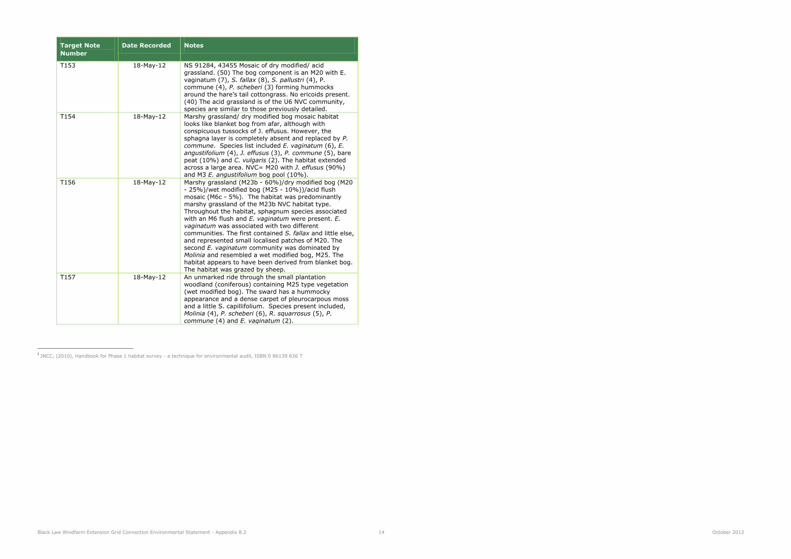
Black Law Windfarm Extension Grid Connection Environmental Statement - Appendix 8.2 14 October 2012
Target Note
Number
Date Recorded Notes
T153 18-May-12 NS 91284, 43455 Mosaic of dry modified/ acid grassland. (50) The bog component is an M20 with E. vaginatum (7), S. fallax (8), S. pallustri (4), P. commune (4), P. scheberi (3) forming hummocks around the hare‟s tail cottongrass. No ericoids present.
(40) The acid grassland is of the U6 NVC community, species are similar to those previously detailed.
T154 18-May-12 Marshy grassland/ dry modified bog mosaic habitat looks like blanket bog from afar, although with conspicuous tussocks of J. effusus. However, the sphagna layer is completely absent and replaced by P.
commune. Species list included E. vaginatum (6), E. angustifolium (4), J. effusus (3), P. commune (5), bare peat (10%) and C. vulgaris (2). The habitat extended
across a large area. NVC= M20 with J. effusus (90%) and M3 E. angustifolium bog pool (10%).
T156 18-May-12 Marshy grassland (M23b - 60%)/dry modified bog (M20 - 25%)/wet modified bog (M25 - 10%))/acid flush mosaic (M6c - 5%). The habitat was predominantly marshy grassland of the M23b NVC habitat type. Throughout the habitat, sphagnum species associated with an M6 flush and E. vaginatum were present. E. vaginatum was associated with two different
communities. The first contained S. fallax and little else, and represented small localised patches of M20. The second E. vaginatum community was dominated by Molinia and resembled a wet modified bog, M25. The habitat appears to have been derived from blanket bog. The habitat was grazed by sheep.
T157 18-May-12 An unmarked ride through the small plantation woodland (coniferous) containing M25 type vegetation (wet modified bog). The sward has a hummocky appearance and a dense carpet of pleurocarpous moss and a little S. capillifolium. Species present included, Molinia (4), P. scheberi (6), R. squarrosus (5), P.
commune (4) and E. vaginatum (2).
i JNCC, (2010), Handbook for Phase 1 habitat survey - a technique for environmental audit, ISBN 0 86139 636 7

Appendix 8.3: Protected Species Survey Report


Black Law Windfarm Extension Grid Connection
Appendix 8.3
Protected Species Survey Report
Prepared by LUC
October 2012
Planning & EIA Design Landscape Planning Landscape Management Ecology Mapping & Visualisation
LUC GLASGOW 37 Otago Street Glasgow G12 8JJ Tel: 0141 334 9595 Fax: 0141 334 7789 [email protected]
Offices also in: London Bristol Edinburgh
FS 566056
EMS 566057
Land Use Consultants Ltd Registered in England
Registered number: 2549296 Registered Office: 43 Chalton Street London NW1 1JD
LUC uses 100% recycled paper

Black Law Windfarm Extension Grid Connection Environmental Statement - Appendix 8.3 October 2012
Contents
1 Introduction 1
2 Methodology 2 Otter Survey 2 Water Vole Survey 2 Bat Survey 2 Great Crested Newt Survey 2 Limitations to Surveys 2
3 Results 3 Otter 3 Water Vole 3 Bat 3 Great Crested Newt 3
4 Summary of Protected Species Interest 4
Tables
Table 8.3.1: Assessment of Individual Trees Bat Roost Potential (BRP) 3

Black Law Windfarm Extension Grid Connection Environmental Statement – Appendix 8.3 1 October 2012
1 Introduction
1.1 This report details the methods and findings of the Protected Species Survey undertaken for the Black Law
Windfarm Extension Grid Connection (hereinafter referred to as ‘the proposed grid connection’) in South
Lanarkshire.
1.2 Badger activity was recorded in the Study Area. The Confidential Badger Annex has been sent to SNH
only.

Black Law Windfarm Extension Grid Connection Environmental Statement - Appendix 8.3 2 October 2012
2 Methodology
Otter Survey
2.1 All watercourses and waterbodies within 250m of the proposed grid connection route were surveyed
between August and October 2011 for evidence of otter. As a result of design iterations, additional
surveys within a 250m buffer of the proposed grid connection route were carried out in May and June
2012.
2.2 The otter survey complied with the methods detailed in SNH’s Guidance for Otter Survey from their online
publication, Otters and Development. The objective of the survey was to locate otter holts and resting
sites within 30m of the proposed working areas and breeding sites within 100-200m of proposed working
areas to identify if a European Protected Species (EPS) licence would be required undertake construction
works. The survey included a methodological search for signs of otters such as tracks, spraints (recording
whether fresh or old) resting sites (e.g. holts or couches), slides, runs, grooming hollows, sign heaps and
feeding remains. All signs of otter activity, including confirmed and potential shelters, were noted and their
location recorded using a hand-held GPS. Survey findings were subsequently transferred into GIS.
2.3 The otter surveys were carried out under optimal, dry weather conditions, with average water levels in the
burns, by surveyors with several years of experience of otter survey. Water Vole Survey
Water Vole Survey
2.4 A water vole survey was undertaken in parallel to the otter surveys in 2011 and 2012. All watercourses
within 50m of the proposed grid connection were surveyed for evidence of the species. Where water voles
were located the survey area extended further along burns to provide detailed population information.
2.5 The water vole survey followed the method described by Strachan and Moorhousei and involved searches
of the stream margins for water vole signs, including feeding stations, latrines, footprints, burrows and
runs. Surveys were carried out by surveyors with several years of experience of water vole survey in the
Scottish uplands.
2.6 All identified water vole signs were noted and their location was recorded using a hand-held GPS. Survey
findings were subsequently transferred into GIS.
Bat Survey
2.7 Habitats within 100m of the proposed grid connection area were assessed for their potential to support
roosting bats. A daytime inspection was carried out from ground-level of each tree, to identify features
which may be used by bats, such as holes, cracks and crevices. The trees were then graded according to
their bat roost potential as follows:
Low (very minor or no suitable features)
Medium (some suitable features)
High (many suitable features)
2.8 Any features identified as having a ‘High’ potential to support roosting bats, and that were likely to be
affected by the proposed grid connection, were subject to more detailed activity surveys.
Great Crested Newt Survey
2.9 Four ponds, within a 600m buffer of the proposed grid connection, were assessed, using a recognised
habitat suitability assessment described by Oldham et al (2000)ii, as having suitable habitat features to
support populations of great crested newt (GCN). These included three woodland ponds located within the
coniferous woodland between Cartland Muir Plantation and Fullwood Farm, all of which were located in
relatively open situations with the woodland and comprised a mixture of open water and vegetated
margins. The final pond was located in fields adjacent to Birnihall Farm, and appeared to be a man made
waterbody with abundant and diverse marginal vegetation.
2.10 All four ponds were subject to full GCN survey in spring 2011. Survey strategy and methodologies
followed Natural England Guidanceiii and involved four survey visits to each pond between 13 April and 10
June 2011 and employing at least three of the flowing survey methods, dependent upon individual pond
constraints:
bottle trapping (plastic bottles anchored to the pond bed overnight and retrieved in the morning)
netting (systematic sampling of pond edge habitats using a net)
torch searches (survey involving shinning a powerful torch beam into the pond at night)
egg searches (search of marginal vegetation for presence of GCN eggs)
2.11 Any ponds identified as supporting GCN were noted and their location was recorded using a hand-held
GPS. Survey findings were subsequently transferred into GIS.
Limitations to Surveys
2.12 Ecological surveys are limited by a variety of factors which affect the presence of flora and fauna; for
example climatic variation, season and species behaviour. Evidence of protected species is not always
recorded during a survey. This does not mean that a species is absent and as such the surveys also record
and assess the ability of habitats to support species. The time frame in which the survey is implemented
provides a snapshot of activity within the Study Area and cannot necessarily detect all evidence of use by
a species.
2.13 A significant proportion of the land in the Study Area, principally in the central and southern parts, was
utilised for agricultural production. Consequently, ecological surveys were reliant upon prior landowner
agreements and arrangements for access to the land. Generally, this did not prevent significant obstacles.
However, on a number of occasions access was refused. The access issues detailed above prevented the
survey of an area of land, south of Springfield Reservoir, and, approximately, a 100m reach of a tributary
of the Candymill Burn, which drains Springfield Reservoir.
2.14 At the southern end of the Study Area, the underground route crosses a footbridge over a weir in the River
Clyde, and owing to the depth and speed of the river, and the steepness of the banks, it was not possible
to survey thoroughly for riparian mammals. Elsewhere, high vegetation cover in some areas posed a
limitation. All areas of limited survey access have been given due consideration by accessing the
suitability of habitats to support species, are not therefore considered to pose a significant constraint to
the EcIA.

Black Law Windfarm Extension Grid Connection Environmental Statement - Appendix 8.3 3 October 2012
3 Results
Otter
3.1 Otter evidence was identified along the margins of Springfield Reservoir and on a watercourse draining
into the reservoir. At these locations numerous otter spraints were recorded, along with two resting sites
(one holt and one hover) (Figure 8.4). No other otter evidence was recorded within the Study Area.
3.2 Springfield Reservoir is stocked with trout as a recreational fishery and as such it provides a useful
foraging resource for the species. The otter holt identified is located immediately north of Springfield
Reservoir, approximately 30m south of a proposed wooden pole installation working area. The holt was
associated with a single fresh spraint at its entrance, demonstrating recent, but low levels of activity at the
shelter.
3.3 It is recommendable that an update survey of the holt is completed at a minimum of two months) prior to
the programmed commencement of construction works in proximity to the holt (this allows sufficient time
for SNH to process a licence application should it be required). The aims of this survey will be to
determine the level of otter activity immediately prior to construction and to establish if a licence to
disturb the species is required.
Water Vole
3.4 No evidence of water vole was identified during the survey.
3.5 At the northern end of the Study Area, some suitable habitat and vole burrows were identified, although,
the lack of water vole evidence and the size of the burrows suggested that these features were associated
with smaller vole species. Generally, as a consequence of the Study Area’s location and principal land
uses, i.e. in proximity to urban centres and much of the land being exploited for livestock grazing, many of
the riparian habitats are unsuitable for water vole.
Bat
3.6 The survey identified two tree belts (Wood A and Wood B, south of Castlehill Farm and north of
Newsteadings Farm respectively) that had the potential to supporting roosting bat species. The woody
component of both of these areas comprised of beech Fagus sylaticus, with occasional ash Fraxinus
excelsior. The assessment of individual trees, within each of the two woodland blocks, for their suitability
to support roosting bats is detailed in Table 8.3.1, below:
Table 8.3.1: Assessment of Individual Trees Bat Roost Potential (BRP)
Area Number of
trees
present
Classification of Individual Trees (BRP)
Low BRP Medium BRP High BRP
Wood A 61 35 25 1
Wood B 20 8 11 1
3.7 Overall, both woodlands were considered to have a low-medium potential to support roosting bats.
However, following design iterations, both of the woodland fragments are now over 700m from the
proposed grid connection and will not be affected by the proposals.
3.8 At the southern end of the Study Area, on the northern bank of the River Clyde, adjacent to the existing
Stonebyres Weir, two large oak trees were identified as having a high BRP. As a consequence of
engineering constraints associated with an exposed rock face, at this location the proposals are to encase
the cables in a ‘tray’ and run them overground. Therefore, the proposed grid connection is unlikely to
convey any negative impacts on potential bat roosts and neither tree will require removal.
3.9 No bat activity surveys were undertaken in the Study Area as no suitable habitats or buildings with
suitable features for roosting bats are to be removed.
Great Crested Newt
3.10 No great crested newts or great crested newt eggs were identified during the survey.
3.11 The ponds that were surveyed were found to support - palmate newts Lissotriton helveticus and smooth
newt Lissotriton vulgaris.
Black Law Windfarm Extension Grid Connection Environmental Statement - Appendix 8.3 4 October 2012
4 Summary of Protected Species Interest
4.1 Otter was recorded in the Study Area along the tributaries of Springfield Reservoir and the reservoir itself.
The reservoir is stocked as a commercial trout fishery and is likely to present a useful foraging resource.
No water vole or great crested newt activity was recorded during the field studies and no trees with bat
roost potential are to be felled.
i Strachan, R. and Moorhouse, T. (2006). Water Vole Conservation Handbook (2nd edition). Wildlife Conservation Research Unit, University of
Oxford. iiOldham, R. S., Keeble, J., Swan, M. J. S., Jeffcote, M. (2000) Evaluating the Suitability of Habitat for the Great Crested Newt. Herpetological
Journal, Vol. 10, pp.143 – 155. iii
English Nature (2001) Great Crested Newt Mitigation Guidelines.

Appendix 8.4: Ecological Impact Significance Assessment


Black Law Windfarm Extension Grid Connection
Appendix 8.4
Ecological Impact Significance Assessment
Prepared by LUC
October 2012
Planning & EIA Design Landscape Planning Landscape Management Ecology Mapping & Visualisation
LUC GLASGOW 37 Otago Street Glasgow G12 8JJ Tel: 0141 334 9595 Fax: 0141 334 7789 [email protected]
Offices also in: London Bristol Edinburgh
FS 566056
EMS 566057
Land Use Consultants Ltd Registered in England
Registered number: 2549296 Registered Office: 43 Chalton Street London NW1 1JD
LUC uses 100% recycled paper

Black Law Windfarm Extension Grid Connection Environmental Statement - Appendix 8.4 October 2012
Contents
1 Introduction 1
2 Methodology 2 Assessing Significance 2
3 Ecological Impact Assessment 4 Construction Impacts 4
Tables
Table 8.4.1: Ecological Value Geographical Context 4
Table 8.4.2: Direct Habitat Loss Anticipated from the Construction Phase 4
Table 8.4.3: Summary of Significant Ecological Impacts 7

Black Law Windfarm Extension Grid Connection Environmental Statement - Appendix 8.4 1 October 2012
1 Introduction
1.1 This report details the findings of the Ecological Impact Assessment (EcIA).

Black Law Windfarm Extension Grid Connection Environmental Statement - Appendix 8.4 2 October 2012
2 Methodology
Assessing Significance
2.1 The ecological assessment was undertaken following guidelines set out by IEEM. The guidelines
recommend that site sensitivity is best described as ‘Ecological Value’. The Ecological Value of any given
Study Area relates to its habitat assemblages and species populations and their importance to wider
ecological processes. The Ecological Value of the Study Area is determined for each of its component
habitats and species. The guidelines recommend that Ecological Value should be determined within a
defined geographical context. The levels of geographical value adopted in this assessment are set as
follows (and described further in Table 8.4.1):
International; UK/National; County;
Local; Site.
Table 8.4.1: Ecological Value Geographical Context
Ecological Value
Qualifying Criteria Relevant Context
International A Study Area is considered of international
ecological value when it supports:
An internationally designated site or candidate site (SPA1, pSPA2, SAC3, cSAC4, pSAC5, Ramsar site6, Biogenetic Reserve7) or an area
which SNH has determined meets the published selection criteria for such designations, irrespective of whether or not it has yet been notified.
A viable area of a habitat type listed in Annex 1 of the Habitats Directive, or smaller areas of such habitat which are essential to maintain
the viability of that ecological resource on an international scale.
>1% of the European resource of an internationally important species, i.e. those listed in Annex 1, 2 or 4 of the Habitats Directive.
Europe
UK/National A Study Area is considered of National ecological
value when it supports
A nationally designated site (SSSI8, NNR9, Marine Nature Reserve10) or a discrete area
UK/Scotland
1 Special Protection Area classified under the EU Birds Directive for importance to birds. This is considered further in Chapter 9: Ornithology.
2 Potential Special Protection Area.
3 Special Area of Conservation Area classified under the EU Habitats Directive for important habitat or non-bird species.
4 Candidate Special Area of Conservation.
5 Potential Special Area of Conservation.
6 Wetland of international importance desigated under the Ramsar Convention.
7 Sites deemed representative examples of particular habitats in Europe.
8 Site of Special Scientific Interest designated under UK law as being the best examples of the UK’s flora, fauna, geological or physiographical
features. 9 National Nature Reserve designated under UK law as containing the best examples of natural or semi-natural ecosystems in Britain.
10 Marine Nature Reserve designated under UK law to conserve marine flora, fauna and geological features.
Ecological Value
Qualifying Criteria Relevant Context
which SNH has determined meets the published selection criteria for national
designation irrespective of whether or not it has yet been notified.
A viable area of a priority habitat identified in the UK BAP11, or smaller areas of such habitat which are essential to maintain the viability of that ecological resource at a national scale.
>1% of the National Resource of a regularly
occurring population of a nationally important species, i.e. a priority species listed in the UK BAP and/or Schedules 1, 5 (S9 (1, 4a, 4b)) or 8 of the Wildlife and Countryside Act.
County A Study Area is considered of County ecological
value when it supports:
County sites and other sites which the
designating authority has determined meet the published ecological selection criteria for designation, e.g. Local Nature Reserves.
Viable areas of legally protected habitat/habitat identified in Council BAP or smaller areas of such habitats that are essential to maintaining the viability of the
resource at a county scale. Any regularly occurring population of an
internationally/nationally important species or a species in a relevant UK/Council BAP which is important for the maintenance of the
regional meta-population. Semi-natural ancient woodland smaller than
0.25ha. Networks of species-rich hedgerows.
South Lanarkshire12
Local A Study Area is considered of Local ecological
value when it supports:
Commonplace and widespread semi-natural habitats, e.g. scrub, poor semi-improved grassland, coniferous plantation woodland,
intensive arable farmland etc. which, despite their ubiquity, contribute to the ecological function of the local area (habitat networks etc);
Very small, but viable, populations of
internationally/nationally important species or a species in a relevant UK/Council BAP which
is important for the maintenance of the local meta-population.
Networks of linear features, including species-poor hedgerows
Study Area plus a 2km
radius.
Site A Study Area is considered of Study Area
ecological value when it supports:
Habitats of limited ecological value, e.g. amenity grassland, but which contribute to the
overall function of the application site’s
Study Area
11
The Biodiversity Action Plan identifies targets for improving and protecting biodiversity in an area to meet the UK’s commitments under the
Rio Convention. 12
The geographical context for a County level of ecological value has been defined at a local authority level. Despite spanning three local
authority districts, i.e. North and South Lanarkshire and West Lothian, the majority of the Study Area is located in South Lanarkshire.
Therefore, this local authority is used for a relevant County context.

Black Law Windfarm Extension Grid Connection Environmental Statement - Appendix 8.4 3 October 2012
Ecological Value
Qualifying Criteria Relevant Context
ecological function.
2.2 All potential impacts are assessed against standard parameters set out by IEEM. Via this approach, a
scientific and repeatable method is applied whereby all aspects of a potential impact are considered.
Impacts are considered with reference to the following parameters:
positive or negative; extent; duration; reversibility; frequency.
2.3 A degree of confidence is assigned to assess the likelihood of an impact occurring. The following scale is
referred to:
certain/near-certain: probability estimated at >95%;
probable: probability estimated at 50 – 95%;
unlikely: probability estimated at 5 – 49%; extremely unlikely: probability estimated at <5%.
2.4 Based on these parameters, an impact is then considered to be either significant or not significant and
likely to have either a positive or negative impact. An impact is considered to be significant if it has the
potential to affect the integrity of a habitat or the conservation status of a species. Technical definitions
of integrity and conservation status follow IEEM guidance (IEEM, 2006).
2.5 The significance of a potential impact is considered, using professional judgement, within the context of
the geographically-based ecological value of the feature. For example, the significance of a potential
impact on a habitat of Local ecological value is considered at a local level.
2.6 Note that best practice guidance does not recommend that significance is defined as ‘high’, ‘moderate’ or
‘low’ due to the complexities of ecological processes (IEEM, 2006). Therefore, impacts defined as
‘significant’ are considered to be significant in the context of the EIA regulations.
Black Law Windfarm Extension Grid Connection Environmental Statement - Appendix 8.4 4 October 2012
3 Ecological Impact Assessment
Construction Impacts
Designated Sites
3.1 The Study Area is considered to have ecological value at the National level for its broad-leaved woodland
designated sites. The remaining non-statutory designated sites, Fullwood Roadside/Craigenhill SINC, are
considered to have an ecological value at the County level. The relevant potential impacts are direct
habitat loss, severance and physical disturbance.
Direct Habitat Loss
3.2 The proposed grid connection has been designed so as to retain the majority of broad-leaved woodland
features within the Study Area that are considered to be of National ecological value, i.e. the Clyde
Valley Woods complex. In particular, the SAC, SSSI and ancient woodlands, forming part of the
complex, will be retained. No Direct Habitat Loss is proposed from the Clyde Valley Woods SAC and
NNR, the Cartland Craigs SSSI or the woodland blocks included on the Ancient Woodland Inventory.
3.3 The proposals are to underground all section of cabling route that passes through the sensitive woodland
areas (described above), within the confines of the existing road carriageway. Furthermore, there will
not be a requirement to remove any of the marginal features of the woodland, i.e. the clearance of
scrub, therefore the overall structural integrity or the woodland will be retained.
3.4 In the context of designated sites (excluding SINCs) the probability of direct habitat loss, severance
and/or physical disturbance is extremely unlikely/unlikely. Thus, the remaining impacts and impact
assessment parameters are not considered for this feature. Based on the above, in terms of statutory
designated sites, it is concluded that direct habitat loss, severance and physical disturbance will not be a
significant impact.
3.5 Direct habitat loss is proposed from the two areas designated as SINCs, i.e. non-statutory designated
sites. The overhead line (OHL) and underground cable route pass through the Fullwood
Roadside/Craigenhill SINC and the Stonebyres Woodland SINC, respectively. In both SINCs, the area of
direct habitat loss is small, i.e. 0.08ha from the Fullwood Roadside/Craigenhill SINC and 0.06ha from the
Stonebyres Woodland SINC, and focused in habitats of a lesser ecological value to those for which the
sites are primarily designated.
3.6 Direct habitat loss would be a negative impact and would have an extent limited to specific areas of the
SINC, generally the impact will be in habitats of a lesser ecological value, to those for which the site is
primarily designated. The extent of the impact would be limited to small areas within the SINCs, i.e. the
wood pole locations in the Fullwood Roadside/Craigenhill SINC and a 5m (1m trench plus 2m buffer
either side) band through the Stonebyres Woodland SINC. The duration of the impact would be limited
to construction and it would be reversible, through soil and vegetation management and reinstatement,
although regeneration, particularly in a woodland setting, may occur over long time-scales. The
frequency of the impact would be limited to a single event, however the probability would be
certain/near-certain.
3.7 In terms of non-statutory designated sites (SINCs), direct habitat loss will not be a significant
impact.
Severance
3.8 Severance of the Fullwood Roadside/Craigenhill SINC is unlikely to occur as the land-take associated with
the wood pole locations is relatively small, and discontinuous. Thus, the continuity of the SINC would be
retained. Similarly, the undergrounding works proposed through the Stonebyres Woodland SINC are
unlikely to result in severance of the SINC’s woodland features. The woodland is relatively open and has
areas of tall ruderal type habitats, through which the cabling trench (1m in width) will be aligned. In this
section of open woodland, a small number of trees will require removal, although, where possible, large
mature trees will be avoided. Due to the low level of tree removal, it is not perceived that the overall
connectivity of the woodland resource will be disrupted.
3.9 In terms of SINCs and based on the assertions described above, it is considered that severance will not
be a significant impact.
Physical Disturbance
3.10 Physical disturbance describes potential impacts arising from the construction phase of the proposed grid
connection that are likely to affect an ecological feature. The construction works necessary for the
excavation of the wood pole foundations and underground cable trench will be associated with a level of
physical disturbance. However, the level of disturbance anticipated is unlikely to significantly affect the
ecological integrity of the SINCs or sensitive ecological features which they support. The impacts
associated with physical disturbance would be reversible and short lived, i.e. plant communities and tree
limbs would regenerate and faunal species would recolonise areas once disturbance levels are reduced.
3.11 Based on the above, in terms of designated sites, it is concluded that physical disturbance will not be a
significant impact.
Habitats
3.12 The Study Area is considered to have an ecological value at the County level for its blanket bog resource.
The remaining upland habitat types were deemed to have a Local level of ecological value. The
agricultural, lowland habitats were considered to have an ecological value at the Site level. The relevant
potential impacts are direct habitat loss, severance and physical disturbance.
3.13 Additionally, this section gives specific consideration to the potential impacts of the proposed grid
connection upon the objectives outlined in the Habitat Management Plan (HMP) for the existing Black
Law Windfarm. The only impact likely to affect the delivery of the HMP objectives is direct habitat
loss, therefore this is the only impact considered.
Direct Habitat Loss
3.14 The proposed grid connection will result in a proportion of direct habitat loss.
3.15 In terms of the direct habitat loss associated with the installation of the wood poles, a precautionary
approach is adopted. The general working area around each wood pole location is proposed at 225m2,
although it is highly unlikely that all of the habitats contained within these areas will be lost. More
realistically, excluding the small area where the wood pole will be located, i.e. the diameter of the wood
pole, the habitats are likely to be subject to a degree of physical disturbance from vehicle movements,
after which they will regenerate following reinstatement. However, as a precaution, direct habitat loss
has been calculated using the total working area, i.e. an area of 225m2.
3.16 In terms of the underground cable, direct habitat loss was calculated using the width of the cabling
trench (1m) plus a 2m buffer either side, i.e. a 5m swath in total.
3.17 Finally, an area of habitat loss (0.05ha) is proposed to accommodate the extension to the Linnmill
substation (details relating to the proposed extension are provided in Chapter 4: Development
Description).
3.18 It is anticipated that 5.51ha (0.94% of the Study Area), comprising 30 different habitat types (and
associated mosaics), will be directly lost to construction.
3.19 Table 8.4.2 provides a summary of direct habitat loss.
Table 8.4.2: Direct Habitat Loss Anticipated from the Construction Phase
Habitat Ecological Value
of Study Area
for Habitat Type
Direct
Habitat
Loss (ha)
Proportional
Cover of Habitat
within Study Area
(%)
Direct Habitat Loss (%
Study Area)
Blanket bog County 0.07 2.68 0.01
Wet modified
bog/acid
flush/marshy
grassland
Local 0.10 0.57 0.02

Black Law Windfarm Extension Grid Connection Environmental Statement - Appendix 8.4 5 October 2012
Habitat Ecological Value
of Study Area
for Habitat Type
Direct
Habitat
Loss (ha)
Proportional
Cover of Habitat
within Study Area
(%)
Direct Habitat Loss (%
Study Area)
Dry modified bog Local 0.06 1.45 0.01
Blanket bog/wet
modified bog/dry
modified bog
Local 0.04 0.65 0.01
Marshy grassland/dry
modified bog
Local 0.04 1.09 0.01
Blanket
bog/scattered trees
Local 0.03 1.08 <0.01
Marshy
grassland/wet
modified bog
Local 0.04 0.37 0.01
Dry heath/acid
flush/dry modified
bog/scattered
coniferous trees
Local 0.02 0.51 <0.01
Dry heath/coniferous
plantation woodland
Local 0.02 0.55 <0.01
Dry heath/dry
modified bog/mixed
scattered trees
Local 0.02 0.29 <0.01
Dry heath Local 0.01 0.00 <0.01
Wet modified bog/dry
modified bog
Local <0.01 0.80 <0.01
Improved grassland Site 0.68 20.01 0.12
Marshy grassland Site 0.65 13.47 0.11
Poor semi-improved
grassland
Site 0.59 9.21 0.10
Arable Site 0.40 10.62 0.07
Semi-improved
neutral grassland
Site 0.40 4.70 0.07
Coniferous plantation
woodland
Site 0.21 9.82 0.04
Semi-improved acid
grassland/marshy
grassland
Site 0.18 1.39 0.03
Semi-natural broad- Site 0.13 5.90 0.02
Habitat Ecological Value
of Study Area
for Habitat Type
Direct
Habitat
Loss (ha)
Proportional
Cover of Habitat
within Study Area
(%)
Direct Habitat Loss (%
Study Area)
leaved woodland13
Improved
grassland/marshy
grassland
Site 0.10 1.10 0.02
Semi-improved acid
grassland/marshy
grassland
Site 0.07 1.34 0.01
Dense scrub Site 0.04 0.50 0.01
Marshy
grassland/poor semi-
improved grassland
Site 0.03 0.61 0.01
Tall ruderal Site 0.03 0.11 0.01
Marshy
grassland/semi-
improved neutral
grassland
Site 0.02 0.51 <0.01
Marshy
grassland/bare
ground/dry modified
bog
Site 0.02 0.08 <0.01
Semi-improved acid
grassland
Site
0.02 0.33 <0.01
Marshy
grassland/semi-
improved neutral
grassland/scattered
scrub/scattered
broad-leaved trees
Site 0.01 0.21 <0.01
Semi-improved
neutral
grassland/scattered
scrub
Site 0.01 0.20 <0.01
Not Surveyed Unknown 0.03 0.76 <0.01
All Habitats
(excluding access
tracks,
hardstanding,
N/A 5.51 90.9114 0.94
13
Small fragment of remnant semi-natural broad-leaved woodland retained as a shelter belt between agricultural fields, i.e. not affiliated with
the semi-natural broad-leaved woodland considered to be of a National level of ecological value. 14
The sum of the proportional representation of the habitats listed in Table 8.4.2 does not equate to 100%. This is due to the exclusion of
habitats with negligible ecological value, i.e. existing areas of access tracks, hardstandings, buildings and quarry.

Black Law Windfarm Extension Grid Connection Environmental Statement - Appendix 8.4 6 October 2012
Habitat Ecological Value
of Study Area
for Habitat Type
Direct
Habitat
Loss (ha)
Proportional
Cover of Habitat
within Study Area
(%)
Direct Habitat Loss (%
Study Area)
buildings and
quarry)
3.20 The area of direct habitat loss associated with the proposed grid connection is small, relative to the overall area of the Study Area. The total direct habitat loss, from habitats listed in Table 8.4.2, will be 5.51ha, representative of 0.94% of the Study Area.
3.21 The greatest habitat loss will be 0.68ha (0.12% of the Study Area) of improved grassland, a habitat considered to be of a Site level of ecological value.
3.22 In addition to improved grassland, a further area of 4.83ha of habitats will be lost. The most notable
habitat of these is blanket bog for which the Study Area is considered to be of County level of ecological
value due to its extent (15.23ha) and quality.
3.23 At the strategic routeing stage of the design process, specific consideration was given to the blanket bog habitats onsite. The wood pole locations and the alignment of the OHL were informed by the Phase 1 Habitat Survey with the intention of minimising the area of Direct Habitat Loss in this habitat type. Following the strategic routeing process, direct habitat loss from blanket bog is proposed at 0.07ha, equating to 0.01% of the Study Area and <0.01% of the overall Scottish resource (1.8 million hectares).
3.24 Direct habitat loss would affect those agricultural habitats considered to be of Site level of ecological value. In particular, development has been prioritised to occur in improved, semi-improved or species-poor marshy grassland; ubiquitous habitat types across the Study Area and, more widely, central Scotland.
3.25 In the north of the Study Area, between Sergeants Law and Springfield Reservoir, the OHL passes through land which is under the influence of the Black Law Windfarm HMP. The total area of HMP land
within the Study Area is 1407.61ha. Assuming direct habitat loss at 225m2 around wood pole locations, 0.87ha will be lost as a result of the proposed grid connection. However, the prescriptions of the HMP,
including blanket bog restoration techniques, will assist in the recovery and enhancement of the more sensitive habitats in the HMP area.
3.26 Direct habitat loss would be a negative impact and would occur across the Study Area, although the extent of the impact would be small, focused at wood pole locations (225m2) and along the underground cabling route (1m trench). Generally, the duration of the impact will be temporary, apart from the
areas lost under the wood poles. In the wood pole working area, a large proportion of the habitat loss will be reversible through management of peat/soil turves and appropriate reinstatement of construction working areas, and subsequent vegetative regeneration. The degree of recovery and rate of recolonisation will be influenced by the sensitivity of the habitat, i.e. agricultural fields will recover rapidly, whilst, conversely, peatland habitats will recover over longer time-scales. However, where active habitat management occurs in the wider area, i.e. in the Black Law HMP areas, recovery rates will be improved. The frequency of the impact will be limited to a single event, however the probability will
be certain.
3.27 Based on the above, and in the context of habitats, including the habitats managed under the Black Law
Windfarm HMP, it is concluded that direct habitat loss will not be a significant impact.
Severance
3.28 The nature of the proposed grid connection is such that severance is unlikely to occur given the habitat types supported in the Study Area and the construction methods. The majority of the habitats recorded are grassland and mire types (74.81%), which are not typically susceptible to severance impacts. Additionally, where the OHL is proposed, the impact will be discontinuous across the habitat and strong linkages between, and within, and habitats will be retained.
3.29 The construction of temporary access tracks presents a greater risk of severing habitats. However, the design process has sought to align temporary access tracks through habitats of the lowest ecological value. Additionally, the construction methodology proposes the utilisation of existing road networks in the area, the use of low ground pressure vehicles and, where access through semi-natural habitats is unavoidable, protective ground mats. Consequently, the proposed methodologies will preclude any requirements to construct temporary access tracks, minimising the likelihood of habitat severance.
3.30 Based on the construction methodologies detailed above, coupled with there being no requirement to
construct semi-permanent access tracks through habitats, it is concluded that severance will not be a
significant impact.
Physical Disturbance
3.31 Physical disturbance of the peatland habitats located in the north of the route could occur during the construction of wood pole foundations. To control vehicle movements and facilitate access of plant and machinery to construction zones, a network of temporary access tracks has been proposed. An effort
has been made to align these tracks through habitats identified as having a low ecological value, i.e. agricultural fields.
3.32 To minimise disturbance to the habitats through which the access tracks have been designed, the construction methodology proposes the use of low ground pressure vehicles and, where the design has been unable to avoid encroachment into habitats of a greater ecological value, i.e. blanket bog, protective ground mats. Despite these provisions, it is likely that some tracked plant will damage
agricultural grasslands and/or stray onto unprotected sections of peatland.
3.33 Physical disturbance would be a negative impact and would be limited to wood pole working areas and access routes. The duration of the impact would be permanent. However, where physical disturbance occurred it would be reversible through vegetative regeneration, although the recovery period could be long-term in the sensitive peatland habitats. The frequency of the impact would be ongoing during the
construction period. Despite specific construction methodologies to control plant movements and reduce the likelihood of physical disturbance, the probability would be probable.
3.34 Based on the above, it is considered that physical disturbance of habitats will be a significant impact.
However, considering the small areas that would be prone to physical disturbance, it is only considered
to be a significant impact at the Site level.
Mammals
3.35 The Study Area is considered to have ecological value at the County level for badger populations and at
the Local level for otter. The relevant potential impacts are direct habitat loss, severance, loss of
life, physical disturbance and noise disturbance.
Direct Habitat Loss
3.36 In terms of direct habitat loss and with regard to badger and otter, an interrogation of the proposed OHL and underground cabling route demonstrates that no mammal shelters will be lost as a result of the
proposed grid connection. Furthermore, considering the small area of land-take associated with each of the wood pole locations, the temporary nature of the access tracks and working zones and the proposals to span all watercourses in the Study Area (Chapter 7:The Water Environment), the overall foraging resource available to the species is unlikely to be depleted by the proposed grid connection.
3.37 With regards to otters, it is possible that construction activities will affect the water quality of the
tributaries feeding Springfield Reservoir. Deterioration in water quality is likely to influence densities and distributions of fish and other prey species present in the reservoir and its surrounding catchment, in turn affecting the foraging success of the resident otter population. However, no impacts on water quality are predicted around the otter shelters or at Springfield Reservoir (Chapter 7: The Water Environment).
3.38 Direct habitat loss would be a negative impact, although it would be limited to small areas where the
construction zone overlaps with mammal territories. This is not anticipated to reduce foraging opportunities at the Site level. A significant proportion of the affected habitat will be recoverable following reinstatement, i.e. the impact will be reversible. The frequency of the impact will be ongoing
during construction. However, considering the small areas of direct habitat loss, the probability of impact affecting mammal populations is unlikely.
3.39 In the context of mammals, and based on the above, it is concluded that direct habitat loss will not be a
significant impact.
Severance
3.40 Severance for mammals would occur when habitats are disrupted or fragmented by the removal or
obstruction of habitat features and networks. Consequently, severance impacts for mammals will relate
directly to direct habitat loss and it is subsequently concluded that severance is unlikely to affect badger,
given that the habitat loss associated with the proposed grid connection is relatively small. Additionally,
the access tracks proposed are of a temporary nature, consisting of, at most, metal sheeting placed on
top of vegetation. Therefore, the access tracks will not sever connectivity between woodland blocks
(where the badgers reside) and surrounding open habitats.
3.41 In terms of otter, a number of temporary watercourse crossings are proposed, including a crossing on the section of burn that supports the otter holt, albeit a significant distance from the shelter. The
watercourse crossings proposed are relatively unobtrusive, consisting of a mat of wood posts positioned

Black Law Windfarm Extension Grid Connection Environmental Statement - Appendix 8.4 7 October 2012
across the channel (Figure 7.1). It is anticipated that a section of bank habitat will be retained under the wood poles, to allow passage of otter under the structure. However, even if passage beneath the
structure is not possible, the crossing will not present a significant barrier to otter, individuals will simply
move around it to access sections of the burn beyond.
3.42 Thus, in terms of mammals, it is concluded that severance will not be a significant impact.
Loss of Life
3.43 Loss of life involves the death of an individual(s) as a consequence of the construction works. The
greatest risk of death to the mammal species supported in the Study Area relates to increased traffic
associated with the proposed grid connection. The construction of temporary access tracks allows
vehicles entry into areas that were previously inaccessible, increasing the risk of traffic collisions with
otter and badger. Additionally, loss of life may occur as a result of ingestion of construction related
chemicals or entrapment in trenches or inappropriately stored construction materials, e.g. culvert pipes.
3.44 The likelihood of a loss of life impact occurring is extremely unlikely. Notwithstanding the existing public road networks, which present a risk to the mammals in the Study Area irrespective of the
proposed grid connection, the access tracks proposed in the Study Area have been designed to facilitate 4x4 and tracked vehicle movements at low speeds. The duration of the impact will be limited to the construction phase and will be irreversible in terms of the individual animal, although in the context of
the population the impact could be considered reversible, albeit the recovery period will be variable dependent upon the individual, i.e. a lactating female or an immature male with no defined territory.
3.45 Based on the above, it is concluded that loss of life will not be a significant impact.
Physical and Noise Disturbance
3.46 Physical and noise disturbance of mammals are considered together. These impacts will occur when
sheltering and foraging is disturbed by construction activities. Construction works in proximity to badger
and otter resting places will cause physical and noise disturbance, particularly during periods when
crepuscular mammals are most active (i.e. dusk and dawn) and, therefore, more likely to be affected by
construction works. Furthermore, night-time working and artificial floodlighting are likely to causes
disturbance to badger and otter.
3.47 Both badger and otter resting sites have been recorded in proximity to proposed construction zones, 10m and 30m respectively. Therefore, it is likely that noise, associated with vehicle movements and construction works, will disturb the species whilst they occupy these sites. However, both otter and badger are transient species with large home ranges. Therefore, at worst, the construction works are likely to temporarily displace some of the resident individuals.
3.48 Physical and noise disturbance will be a negative impact and will be limited to construction zones near to protected mammal resting and foraging sites. The frequency of the impact will be limited to a single event, as the construction moves along the route and passes the mammal resting sites. The likelihood of the impact occurring is probable. It is anticipated that a single wood pole can be erected in approximately half a day, therefore the duration of the noise disturbance impact should be relatively short lived. The impact will be irreversible and the likelihood of the impact occurring is probable.
3.49 Based on the above, it is concluded that physical and noise disturbance impacts will be a significant
impact at the Site15 level.
3.50 Table 8.4.3 provides a summary of the significant ecological impacts associated with the proposed grid
connection.
15
The Study Area was valued at a County level of ecological value for its badger resource. However, as the disturbance will be limited to a
single badger sett, albeit a main sett, and the likelihood being that the works will be conducted under licence conditions, the impact is consider
to be significant at the Site level.
Table 8.4.3: Summary of Significant Ecological Impacts
Ecological Feature Impact Type (Negative) Level of Significant
Habitats Physical disturbance Site
Mammals Physical and noise disturbance Site


Appendix 9.1: Ornithology Technical Report


Black Law Windfarm Extension Grid Connection Environmental Statement - Appendix 9.1 1 October 2012
Appendix 9.1: Ornithology Technical Report
Birds Technical Report 2011 - 2012
Introduction
6.1 This report details the ornithological survey work undertaken at, and in the vicinity of, Black Law
Windfarm Extension Grid Connection (hereinafter referred to as „the proposed grid connection‟) by
Natural Research Projects Ltd (NRP) from March 2011 to May 2012.
6.2 The objectives of study were to:
Map the distributions of breeding birds, including species listed in Annex 1 of the EU Birds Directive
(79/409/EEC) on the Conservation of Wild Birds 1979 (the Birds Directive) or Schedule 1 of the
Wildlife and Countryside Act 1981 (WCA);
Quantify the level of bird flight activity by breeding, wintering, foraging and migratory birds of
nature conservation importance;
Record the presence and abundance of other birds of conservation importance (those listed in
Biodiversity Action Plans (BAP) or on the Red List of Birds of Conservation Concern (Eaton et. al
2009)) throughout the year.
Consultations
6.3 A considerable amount of bird data for the general area is already held by NRP as they have been
involved in ornithological surveys in the Black Law windfarm area since 2003. Consequently,
ornithological information for the area had been requested in previous years from Scottish Natural
Heritage (SNH), the Royal Society for the Protection of Birds (RSPB) and the South Scotland Raptor
Study Group (SSRSG) for surveys at Black Law Windfarm and Black Law Windfarm Extension Phases 1
and 2.
6.4 However, SNH were again contacted on 23 June 20111 and replied that they held no bird data for the
proposed survey area2.
6.5 RSPB had responded to a Scoping document3 sent by Land Use Consultants (LUC) stating that the only
section of route they had concerns about was in the vicinity of Springfield Reservoir. They advised that
lines in that vicinity be marked with bird diverters.
6.6 The SSRSG were again contacted by e-mail4 and responded
5 that two potential sites for peregrine in the
area were known but that no systematic monitoring was taking place.
6.7 In their letter to the Scottish Government6, following a request for scoping advice, SNH stated that they
were broadly satisfied with the proposed ornithological surveys. They stated that specific migration
period watches would not be required as long as winter period surveys included times representative of
dawn and dusk periods.
6.8 Following correspondence, between SNH and LUC7, concerning pink-footed geese, SNH agreed that there
will be no likely significant effect on the Westwater Special Protection Area (SPA), and as such there is no
requirement for an Appropriate Assessment.
1 Letter to SNH from NRP 23/06/11 2 Letter to NRP from SNH 30/06/11 3 E-mail to LUC from RSPB 4 Email to SSRSG (G Smith) from NRP 27/05/11 5 E-mail to NRP from SSRSG (G Smith) 01/07/11 6 Letter from SNH to Scottish Government 05/07/11 7 Letter to LUC from SNH 04/05/11
Field Survey Methods
6.9 Surveys commenced on 9 March 2011 and continued until 14 May 2012. Some birds range over large
areas and are therefore potentially vulnerable to the effects of wind farm grid connection developments
situated some distance away. Accordingly, the original line of the proposed overhead line (OHL) route
plus buffers of 500m, 1.0km, 1.5km and 2.0km around this, was surveyed between March 2011 and May
2012, with buffer size dependent on the expected sensitivity of different species (Fig. 9.1). For the
original underground section, only surveys for moorland and farmland breeding birds within the 500m
buffer were proposed.
6.10 For the purposes of reporting here, the final route is referred to as “the proposed grid
connection”. Field survey results are reported with respect to the buffers around the originally
advised route SA1. The proposed connector route incorporates an OHL section and an
underground section. However, the main focus of reporting will be based on survey results
within appropriate buffers around the proposed grid connection. For example, in respect of
collision risk, flight activity will be reported as “within the 100m buffer of the proposed grid
connection.
6.11 The field surveyors were D. Cameron, G. Connelly, K. Duffy and B. Stakim. Field surveyors received
extensive training prior to, and during, survey work. Training included aspects of navigation, the various
survey methods, techniques to minimise fieldworker effects on bird detection, and the classification of
bird behaviour. Training was provided irrespective of surveyors‟ previous experience. Emphasis was
placed on the importance of carrying out surveys in a systematic and standardised way to enable direct
comparison of data from different sites and survey periods.
Habitat Mapping
6.12 In February 2010 a map showing alternative route options was provided to NRP to allow assessment of
habitats for potential bird issues. Habitats within 2km of those route options were evaluated in respect of
their potential to support different bird species.
6.13 NRP has been surveying within the wider area since 2003 and hence the suitability of habitat for rare and
scarce breeding birds within 2km of the proposed grid connection was largely known. The predominance
of improved pasture means that there are only small areas of habitat suitable for rare and scarce birds.
Habitat within 500m of the originally proposed route was surveyed intensively and classified.
6.14 The classification was based on the cover-type and structure of the vegetation and has greater relevance
to bird distribution than Phase 1 or NVC mapping.
6.15 Heath/Bog. Wet and dry dwarf shrub heathland with >25% ericoids (characterised by species such as
Calluna vulgaris, Vaccinium myrtillus, and Molinia caerulea). Typically grazed by red deer and low
densities of sheep. Sub-class-
Heath/bog with stands of tall heather (>0.4m)
Heath/bog with short heather (<0.4 m)
6.16 Grass moor. Typically, unenclosed grass-dominated moor with <25% ericoids grazed by sheep.
Characterised by species such as Deschampsia flexuosa, Nardus stricta and Juncus squarrosus, plus
some fine grasses such as Agrostis tenuis and Festuca ovina. Stands of Juncus spp. and Pteridium
aquilinum may occur.
6.17 Grass pasture Typically, enclosed pastures that are more intensively managed than grass moors.
Generally grazed by sheep or cattle for at least part of the year. Characterised by species such as
Deschampsia cespitosa, Festuca spp., Lolium perenne. Sub-class –
6.18 Recently improved pastures Grasslands that have been apparently drained, fertilised or re-seeded in
recent times. Characterised by lush uniform green swards. Includes hay meadows.
Mixed broad leaved/coniferous woodland
Plantation forest. Sub-classes –
Thicket, pole or high forest
6.19 Closed-canopy forest plantations. Characterised by absence of herb or shrub layer, except in rides
between stands of trees and in small patches of unplanted ground or failed crop.

Black Law Windfarm Extension Grid Connection Environmental Statement - Appendix 9.1 2 October 2012
Developing pre-thicket
6.20 First rotation forest plantations (excluding NF) before canopy closure. Characterised by prolific herb layer
with varying shrub layer development. Trees >1m tall; much open space between lines of planting.
Clear-fell
6.21 Harvested plantation not yet restocked with trees. Characterised by limited development of herb and
shrub layer, and brash and tree root-plates from the previous crop.
Establishment phase
6.22 Newly established forest plantations, fenced less than three years previously. Characterised by prolific
herb layer. Planted trees <1m tall.
Flight Activity
6.23 Information on bird flight activity was collected during timed watches from strategic Generic Vantage
Points (GVPs) using the methods described by Band et al. (2007). GVP locations were selected according
to the original proposed route, using a mix of GIS analyses and field trials, with the aim of maximising
ground visibility within the flight activity survey area using the minimum number of points (Fig. 9.2).
The flight activity survey area used during the collection of baseline data, was defined by a 500m buffer
around the original OHL route (Fig. 9.1).
6.24 For the survey area (SA1), five GVPs were established in March 2011 (one other GVP was briefly trialled
but dropped in that month) and used until July 2011 (Fig. 9.2). Following access problems, GVP 3 was
dropped and a new GVP (GVP 6) was established to cover an area similar to that covered by GVP 3
previously and surveys were conducted at this and the remaining four GVPs between August 2011 and
March 2012 (Fig. 9.2).
6.25 Bird flight activity was recorded within a 500m buffer around the originally proposed route. This
encloses an area of 1517ha. Spatial coverage of this area from GVPs was 72% for the first set of five
GVPs (used in the period March – July 2011), and 75% for the second set of five GVPs (used in the
period August 2011 to March 2012) (Fig. 9.2; Tables 9.1 & 9.2).
6.26 In respect of the 500m buffer of the final proposed grid connection route (1519ha), spatial coverage
from GVPs was 67% for the first set of five GVPs (used in the period March – July 2011), and 69% for
the second set of five GVPs (used in the period August 2011 to March 2012) (Fig. 9.2). In respect of the
100m buffer of the final route (292ha), spatial coverage from GVPs was 77% for the first set of five
GVPs and 78% for the second set of five GVPs. For collision risk calculations, this latter buffer is the most
significant.
6.27 Observers at GVPs positioned themselves to minimise their effects on bird behaviour. A viewing arc not
exceeding 180 degrees was scanned. Watches were undertaken during daylight hours by a single
observer in a wide range of weather conditions, mainly in conditions of good ground visibility (> 2km)
and when the cloud base was higher than the most elevated parts of the survey area.
6.28 In the period May 2011 to August 2011 inclusive, three 2.5 hour watches per month were conducted
from GVPs (Table 9.3). In March and April 2011 and September 2011 to March 2012 inclusive, the aim
was to conduct an average of five hours survey per month per GVP, although survey effort was increased
in the autumn migration period September and October 2011 (Table 9.3). Overall, a total of 394.25
hours of observation was conducted from all GVPs during the period March 2011 to March 2012 inclusive
(173.5 hours Apr - Aug; 220.75 hours Sept – Mar). A wide range of meteorological conditions was
sampled, including rain and snow showers, cloud cover from 0-100% and wind speeds up to Beaufort F6.
Data on weather conditions recorded during GVP observations are available upon request.
6.29 Details of flight activity survey effort from GVPs for each 250m segment of the proposed OHL route are
shown in Table 9.4.
6.30 During each watch, three hierarchical recording methods were used, as follows:
6.31 Focal bird sampling - timed. The viewing arc was scanned constantly until a Target A Species8 was
detected in flight. Once detected, the bird was followed until it ceased flying or was lost to view. The
8 Target A species were drawn from those listed in Annex 1 of the Birds Directive and Schedule 1 of the WCA. See Appendix 9.1 for a full list.
time the bird was initially detected and the time it spent within the flight activity survey area (to the
nearest second) were recorded. The route followed by the bird was plotted in the field onto a 1:25,000
scale map, with the direction of flight indicated. Routes were plotted regardless of whether or not the
bird was within the survey area. The bird‟s flying elevation above the ground was estimated at the point
of detection and at 15 second intervals thereafter, using a countdown timer with an audible alarm. Flying
elevation was classified as <10m, 10-20m, 20-30m or >30m. These height bands were determined
based on an estimated transmission pole height of 8.0 -11.5m. Where simultaneous flight activity by a
number of birds was observed and it was not possible to plot individual flight lines, areas of flight activity
were plotted on the field maps.
6.32 Focal bird sampling – untimed. The same scanning procedure as described above was used, but when a
Target B Species9 was detected, the flight was not timed. Instead, the flight path was mapped and flying
elevation for sections of the flight was recorded, i.e. at the start and end of the flying bout and where
changes in height occurred during the flying bout. Flying elevation was classified as above.
6.33 Activity summaries. At the end of each 5-minute period, flight activity within the flight activity survey
area by species of lesser conservation importance (Secondary Species – see Appendix 1) was
summarised. The number of birds recorded in any one period was the minimum number of individuals
that could account for the activity observed. The height, direction and number of individuals involved in
notable bird movements (e.g. gull flights) were recorded.
6.34 Data were entered in the field onto recording sheets and later transferred to Excel spreadsheets. Maps
of flight activity by Target Species were compiled for each watch. Each flying bout was numbered
consecutively and cross-referenced to the relevant flight-path on the map. Summary maps were
compiled for each species at the end of the season.
Migratory Movements and Focal Vantage Point watches
6.35 In order to cover migratory and wintering movements by Target A & B Species, i.e. swans, geese and
waders, over the relevant survey area and in the wider landscape, watches were undertaken from
designated vantage points named Focal Vantage Points (FVPs). In spring 2011, survey effort was
conducted at three FVPs and in the period September to December 2011 one FVP was used. Each FVP
gave good broad spatial coverage in respect of birds moving on a predominantly north-south axis over
the proposed grid connection plus the wider countryside (Fig. 9.2).
6.36 Although in autumn, the main period for migratory movements by swans and geese is late September to
end October, observations were conducted until the end of December 2011 in order to ascertain the
pattern of goose flight activity for the post migration period.
6.37 FVPs covered the dawn and dusk periods to gather data during the main periods of goose flight activity
which tends to be greater at these times, when birds move between roost sites and feeding areas.
6.38 Overall, 56.5 hours survey effort was conducted from FVPs. During the spring period, observations
totalling 12.0 hours were undertaken in March and April 2011. During the autumn period, observations
totalling 44.5 hours were undertaken in Sept - Dec 2011. (Table 9.5) Some observations were
conducted during conditions of low cloud or mist, as birds will continue to fly in these conditions. Such VP
observations will primarily involve auditory records. A wide range of meteorological conditions were
sampled, including rain and snow showers, cloud cover from 0 to 100% and wind speeds up to Beaufort
F6. Data on weather conditions recorded during FVP observations are available on request.
6.39 Details of flight activity survey effort from FVPs for each 250m segment of the proposed OHL route are
shown in Table 9.6.
Scarce Breeding Raptors and Owls
6.40 Site reconnaissance, habitat mapping and consultations (see previous sections) identified areas suitable
for breeding by certain species of scarce raptor and owl and this information was used to focus effort
within the relevant survey areas. Priority was given to detecting the species considered most likely to
occur: goshawk (Accipiter gentilis) merlin (Falco columbarius), peregrine (Falco peregrinus), and barn
9 See Appendix 9.1 for a full list.

Black Law Windfarm Extension Grid Connection Environmental Statement - Appendix 9.1 3 October 2012
owl (Tyto alba). Surveys were undertaken in the spring/summer of 2011 and 2012. The methods used
are given below. These surveys complemented search effort accrued during the course of GVP watches of
flight activity (see section on Flight Activity, above).
6.41 Searches for merlin and peregrine were undertaken within the 2km buffer; for goshawk and barn owl,
searches were within the 1km survey buffer of SA1 (Fig. 9.1).
6.42 In addition to the GVP watches, 7.0 hours was spent searching for evidence of scarce breeding raptors in
2011 and 2012 (Table 9.7). Systematic searches for merlin signs were also conducted along suitable
forest edges during moorland bird surveys.
6.43 Goshawk. Survey methods devised by Dr M. Marquiss (NRP, unpublished) were followed. These methods
consisted of observing potential nesting habitat (woods > 3 ha with numerous large and well-spaced
mature trees, providing good canopy cover). Observers listened for calling birds and watched for display
flights. Areas were also searched for evidence of goshawk occupation (such as faeces, prey remains,
moulted feathers and nests). Particular emphasis was given to the following habitat types: stream sides,
where tree growth is faster and whorls of branches are further apart.
6.44 Merlin. Survey methods in Hardey et al. (2009) were followed. Emphasis was given to the following
habitat types:
edges of closed canopy forestry plantations;
old crow nests (which could be re-used by merlin), fence-posts, hummocks, grouse butts, boulders,
stone dykes, bushes and trees, which were checked for signs of occupation (e.g. plucked prey,
moulted feathers, pellets and faeces);
areas of heath/bog with stands > 0.4m tall.
6.45 Peregrine. Survey methods given in Hardey et al. (2009) were followed. Potential nest sites were
searched for in spring to look for the evidence of occupancy (presence of birds, faeces, fresh prey
remains).
6.46 Barn Owl. Surveys methods given in Hardey et al. (2009) were followed. Systematic searches for
potential nest and roost sites were undertaken in summer 2011. Emphasis was placed on searching for
birds, nests, pellets, feathers and faecal splash in potentially suitable buildings.
Moorland and Farmland Breeding Birds
6.47 Breeding bird territories were surveyed in 2011 within the original (SA1) 500m survey boundary (Fig.
9.1). Following notification of a revised route, a section of the lower part of the revised route was
surveyed in May 2012 (see Results Section). The Brown and Shepherd (1993) method for upland waders
was modified to also provide reliable estimates for some breeding moorland and farmland passerines by
undertaking some surveys during the first few hours of daylight. All bird species listed in Appendix 9.1
were recorded with the addition of skylark (Alauda arvensis) (but see recording method for skylark
below).
6.48 The surveys were conducted three times in the breeding season 2011 to allow for differences in detection
rates between early and late breeding species. Surveys took place on 20, 22 and 26 April (Visit 1); 2, 3,
18, 25 and 31 May (Visit 2); and 7, 8, 13 and 14 June (Visit 3). Due to access constraints a single survey
was conducted on one day (14 May) in 2012 to cover parts of the revised route not surveyed in 2011.
Fieldwork was not undertaken in conditions considered likely to affect bird detection, for example strong
winds (greater than Beaufort Scale Force 4), persistent precipitation, poor visibility (less than 300 m), or
in unusually hot or cold temperatures. Data on weather conditions recorded during moorland breeding
bird surveys are available upon request.
6.49 The survey aimed to cover the ground systematically with a constant search effort. All suitable ground
within the 500m survey boundary was approached closely, typically to within 100m. Water bodies and
isolated trees were examined carefully. Ditches and streams were followed. Surveyors paused at regular
intervals to scan and listen for calling and singing birds. For this survey, access to a limited number of
areas was restricted by land owners. However, the habitat involved was primarily improved pasture and
arable ground. Use of the many public roads and tracks meant that a very high level of coverage was
obtained. It is considered that all potentially important habitats for breeding birds were covered.
6.50 Careful attention was given to recording behaviour indicative of breeding and care was taken to avoid
counting the same individual more than once. Where necessary, surveyors retraced their steps in order
to check the continued presence of previously recorded birds.
6.51 The location of all singing skylarks was recorded during either Visit 1 or Visit 2 only. Skylarks are of
moderate conservation importance and are a key prey species for some raptors.
6.52 The location and activity of birds were mapped onto enlarged 1:25,000 scale OS maps using standard
BTO codes (Marchant 1983). The position of each bird was mapped at the point it was first detected. The
flight lines of birds seen flying over were recorded.
6.53 At the end of each visit, a summary map was compiled showing the location of each identified territory or
breeding pair. The following evidence was considered diagnostic of breeding:
Song, courtship or territorial display;
Territorial dispute;
Nest building and hole excavation;
Agitated behaviour by adult bird(s) indicating the presence of a nearby nest or young (e.g.
repetitive alarm calling, distraction display);
Adult(s) carrying food;
Presence of newly fledged young;
Adult(s) removing faecal sac.
6.54 Where a number of breeding individuals were present and it was not possible to determine the exact
number of breeding pairs, registrations of individual birds were deemed to represent discrete breeding
territories/pairs if the distance between them was more than 250m (500m in the case of curlew
(Numenius arquata); 200m in the case of small passerines). Whilst it is recognised that these distances
are arbitrary and the territory size varies both inter- and intra-specifically, this approach produces a
standardised index of abundance based on the distance that members of a breeding pair are likely to
move during the survey period. In cases where two individuals were considered to constitute a pair of
birds, the location of the pair was placed centrally by convention.
6.55 Population estimates in each year were derived by comparing the summary maps for the three survey
visits. Territories plotted during each period were considered to be separate from one another if they
were located more than 1000m apart (500m in the case of snipe (Gallinago gallinago), gamebirds, and
ducks; 300m in the case of passerines). These distances were chosen arbitrarily to reflect the distances
birds could plausibly move between survey dates. The locations of territories mapped in more than one
survey period were plotted centrally. These distance threshold were also used to separate territories
recorded in different survey years.
Woodland breeding birds
6.56 Woodland breeding birds were surveyed at a sample of 21 points stratified spatially across the forest
within the 500m buffer of SA1 during spring/summer 2011 (Fig. 9.3). The objectives were to describe
the species composition of the woodland bird community. All of the 21 points lie within the 500m buffer
of the proposed grid connection.
6.57 Each count point was surveyed twice, on 22, 28 and 29 April 2011 (Visit 1) and on 10 and 13 June (Visit
2). In order to cover woodland birds on the revised route section in 2012, these species were covered as
part of the moorland and farmland survey conducted on 14 May 2012 (see above). Visits were conducted
between sunrise and sunrise +6 hours on dry mornings with low winds which allowed for better detection
of bird songs and calls.
6.58 On arriving at a point the observer paused for five minutes to allow normal bird activity to resume.
Thereafter all birds seen and heard in a five minute period were noted.

Black Law Windfarm Extension Grid Connection Environmental Statement - Appendix 9.1 4 October 2012
Black grouse surveys
6.59 Suitable habitat within the 1.5km survey boundary was surveyed for displaying (lekking) male black
grouse (Tetrao tetrix) in April and May 2011 (Fig. 9.1). Survey methods were based on those in Gilbert
et al. (1998) and care was taken to avoid disturbing birds.
6.60 In areas which were identified as being potentially suitable for display by black grouse, two visits were
undertaken within two hours of dawn to locate leks. Visits were conducted in calm dry weather with good
visibility on 20, 29 April and 2, 3 and 18 May 2011 (Table 9.8). Observers watched and listened for
lekking birds from a number of suitable vantage points. Data on weather conditions recorded during
black grouse surveys are available upon request.
Field voles
6.61 Field voles (Microtus agrestis) are important prey species for some raptors and owls. Twenty-five
quadrats (each 25cm x 25cm) were located randomly in suitable rank grassland and searched, each
month, for evidence of field vole activity, during April to September 2011. The presence/absence of
runways in the vegetation along with fresh or old vegetation clippings and/or fresh or old faeces were
recorded.
Incidental records
6.62 If deemed to be of potential value, incidental information on bird activity, in and around the survey area,
is collected. Information on birds recorded outside the survey boundaries described above may be
significant and relevant to the reporting here. Other information may be gathered whilst driving or
walking around the survey area, although not during the course of a specific survey. Where considered
relevant, these incidental records are reported below.
Field Survey Results
6.63 Flight activity data was recorded within a 500m buffer of the original proposed OHL (SA1) as described
above and for reporting purposes flight activity will be detailed with respect to this area. In addition,
during analyses of flight activity to estimate collision risk, the overhead section of the proposed grid
connection was divided from south to north into 57 segments measuring 250m in length, plus one
segment measuring 196m at the northern end. The OHL route was buffered to 100m to effectively create
58 polygons. Descriptions of flight activity, and associated figures, also refer to these segments.
6.64 Flight activity for collision risk focuses on “transits” of the 100m buffer of the proposed grid connection. A
transit is counted when a flight crosses the line of the proposed grid connection and, in this instance the
transit is assigned to the segment within which the mapped flight line and the line of the proposed grid
connection intersect. In addition, in order to take account of potential spatial errors in mapping flight
lines, a transit is also counted when the flight line comes within 100m of the line of the proposed grid
connection but does not cross. In this instance, the transit is allocated to the segment that is entered by
the flight line. For flight lines which enter multiple segments but do not cross the line of the proposed
grid connection at any point, the segment which has the longest portion of the flight line is allocated the
transit. When a flight line is in multiple segments and does cross the line of the proposed grid
connection, only the segment where the flight line and line of the proposed grid connection intersect is
allocated a transit. A single transit as defined above refers to the flight by a single bird. For example, if a
flock of 50 birds transit the 100m buffer this is reported as 50 transits. On the flightline figures, single
lines may represent single birds or flocks.
6.65 For non-flight activity, results are presented in respect of appropriate buffers around the proposed grid
connection as described above. For moorland and farmland breeding birds, 500m for example.
Habitat Mapping
6.66 Areas being considered for potential connector routes were surveyed in February 2010. The survey
covered an area greater than that involved in the proposed grid connection route but the results of that
survey have been applied to the final proposed route (Fig. 9.4). The primary habitat is improved pasture
and is a mix of grass moor, heath/bog including areas of tall (>40cm) and low (< 40cm) heather, and
neglected and improved pastures. The wooded areas comprise thicket stage forest in the northern
section, a mix of broad-leaved woodland to the south and areas of establishment phase throughout the
route. One large reservoir (Springfield) is located close to the northern part of the route.
Wildfowl
Occurrence and status
6.67 Flight activity by whooper swan (Cygnus cygnus) was recorded in January 2012 and flocks were recorded
incidentally during spring 2011 and January 2012 (Tables 9.9 & 9.10). Pink-footed goose (Anser
brachyrhynchus) was recorded during spring (March/April) 2011 and throughout the non-breeding
season 2011/12 (Tables 9.9 – 9.11). Greylag goose (Anser anser) flights were seen once during the
breeding season of 2011 and twice during the autumn migration period 2011 (Tables 9.9 & 9.11).
Abundance and distribution
6.68 The two flights by whooper swan were recorded from GVPs in January 2012 (not mapped) and involved
flocks of two and 20 birds (Table 9.9; Appendix 9.2). One flight was in the vicinity of Springfield
Reservoir and the other to the east of Greenbank Farm. Two incidental records involved fourteen
whooper swan on Springfield Reservoir (NR 905520) in March 2012 and a flock of 20 birds feeding in
stubble near Greenbank Farm (NR 912486) in January 2012 (Table 9.10).
6.69 During the survey period, 127 pink-footed goose flights totalling 31,223 birds were recorded during GVP
watches and 86 flights totalling 23,119 birds were recorded during FVP watches (Appendices 9.2 &
9.3). The flight activity occurred primarily in the southern half of the proposed grid connection route
(Fig. 9.5). The majority of these flights were in a broadly E-W direction.
6.70 Three greylag goose flights totalling 19 birds were recorded during GVP and FVP watches (not mapped)
during the survey period. Of these flights, one was from a GVP involving a single bird and two were from
a single FVP watch involving flocks of eight and 10 birds (Appendices 9.2 & 9.3). The three flights were
in a broadly E-W direction and were distributed across the proposed grid connection route.
Flight activity within the 100m buffer of the Proposed Grid Connection
6.71 Flight activity – pink-footed goose GVP & FVP Sept - Nov 2011 (autumn migration period)
6.72 From GVP watches there were 4,361 transits of the proposed grid connection in this period. Of these,
899 were at <20m in height and 3,462 (79%) were at >20m (Fig. 9.6; Table 9.12).
6.73 From FVP watches, there were 6,177 transits across the proposed grid connection of which 1,462 were at
< 20m in height and 4,715 (76%) of which were at a height >20m (Fig. 9.6; Table 9.13).
6.74 Flight activity – pink-footed goose GVP watches Dec 2011 - Feb 2012 (winter period)
6.75 In this period, there were 9,431 transits of the proposed grid connection 9200 of which were at <20m in
height and the remaining 231 were at a height >20m (Table 9.14). Flight activity was concentrated on
areas of improved pasture in the central section of the proposed grid connection (Figs 9.5, 9.6).
6.76 Flight activity – pink-footed goose GVP watches Mar & Apr 2011 & Mar 2012 (spring migration period)
6.77 In this period there were 106 transits of the proposed grid connection, 20 of which were at <20m in
height, the remaining 86 flights (81%) being at > 20m (Fig.9.6; Table 9.15).
Flight activity – other wildfowl
6.78 One flight of whooper swan involving two birds flew across the proposed grid connection in January
2012. The flight crossed segment 34 and was at a height of > 20m throughout (Table 9.16).
6.79 One flight by greylag goose was recorded in September 2011 and involving 8 birds in total. The flight
transited segment 22 and was at a height of >20m (Table 9.16).

Black Law Windfarm Extension Grid Connection Environmental Statement - Appendix 9.1 5 October 2012
Incidental records of wildfowl
6.80 Two flocks of whooper swan were recorded incidentally during the survey period. A flock of 14 birds was
on Springfield Reservoir on 16 March 2011 and a flock of 20 was feeding on stubble near Greenbank
Farm on 6 January 2012 (Table 9.10).
6.81 Significant incidental records of pink-footed goose are shown in Table 9.10. For pink-footed goose, the
table shows that birds were regularly seen feeding to the east of the survey area and the proposed grid
connection in the vicinity of Greenbank and Muirhead Farms. Flooded fields there acted as a temporary
roost and geese sometimes appeared to remain there overnight.
Scarce Raptors and Owls
Occurrence and Status
6.82 Six species of scarce raptor and owl were recorded: hen harrier, goshawk, merlin, peregrine, short-eared
owl (Asio flammeus) (Table 9.9) and barn owl.
6.83 Hen harrier was recorded in the non-breeding season of 2011/12. No evidence of breeding within the
2km buffer of the survey route was found.
6.84 Goshawk flight activity was recorded in the non-breeding season (Tables 9.9, 9.17). No evidence of this
species breeding within the 2km buffer survey area was found, although a pair was seen in suitable
habitat in November 2011.
6.85 Merlin was recorded from GVPs and FVPs, once during the 2011 breeding season and once in the non-
breeding season of 2011/12 (Tables 9.9 & 9.11). In 2011, a nest site which had been monitored during
previous surveys of Black Law was checked. A nest with young was located and a pair of adult birds was
alarming close by (Confidential Fig. 9. A; Confidential Annex).
6.86 Peregrine was recorded from GVPs and FVPs during the breeding season 2011 and also in the non-
breeding season 2011/12 (Tables 9.9 & 9.11). No evidence of breeding within the 2km buffer of the
survey area was found.
6.87 A single short-eared owl was observed in November 2011 (Table 9.9). No evidence of breeding by this
species was found during the survey period.
6.88 Evidence of the presence of barn owl in the 1km buffer of SA1 was found at only one location during the
survey period (Confidential Fig. 9B; Confidential Annex). No flight activity was recorded throughout
the survey period.
Abundance and Distribution
6.89 Four flights by goshawk were recorded on two dates in December 2011. Three flights involved a single
immature male on the same day and all four flights were in the south of the survey area (Fig. 9.7;
Appendix 9.2). A pair was seen incidentally to the east of the 500m buffer survey area in November
2011 (Table 9.10).
6.90 Four flights by hen harrier, three of which involved males, were recorded during the non-breeding season
2011/12. The majority of flights were concentrated over open ground in the north of the survey area
(Fig. 9.7; Appendix 9.2).
6.91 A single merlin flight during the 2011 breeding season was in the northern section of the survey area
(Fig. 9.7; Appendix 9.2).
6.92 Thirteen flights by peregrine were recorded from GVPs during the survey period, of which four were
within the breeding season 2011 (Fig. 9.7; Appendix 9.2). In the 2011 breeding season, the four
flights were in the vicinity of Springfield Reservoir (Fig. 9.7). All but two flights in the non-breeding
season were located in the southern most part of the survey area (Fig. 9.7).
6.93 Four flights by short-eared owl were recorded near Springfield Reservoir on a single day in November
2011 (Fig. 9.7; Appendix 9.2).
6.94 Twenty-four locations were checked for evidence of barn owl, although only one location had evidence
of occupation (Confidential Fig. 9.B). No flight activity by barn owl was recorded.
Flight activity within the 100m buffer of the Proposed Grid Connection
GVP watches during the breeding season 2011
6.95 One merlin flight was within the 100m buffer of the proposed grid connection. The flight involved a single
transit of segment 52 at a height of <20m (Figure 9.7; Table 9.17).
6.96 Two peregrine flights transited the 100m buffer of the proposed grid connection (Fig. 9.7). One flight
made a single transit of segment 33 at a height of <20m and the other made a single transit of segment
35 at >20m (Table 9.17).
GVP watches during the non-breeding season 2011/12
6.97 Four flights by goshawk were recorded in December 2011. All were at <20m in height and involved two
transits of segment 8 and two transits of segment 9 (Fig. 9.7; Table 9.17).
6.98 Four hen harrier flights were recorded in this period. All were at <20m in height and involved single
transits of segments 31 and 50 and two transits of segment 48 (Fig. 9.7; Table 9.17).
6.99 Seven peregrine flights were recorded during this period within the 100m buffer of the proposed grid
connection. In segment 8, six transits were involved, five of which were at <20m in height and one
which was at >20m. A single transit in segment 24 was at <20m in height (Fig. 9.7; Table 9.17).
6.100 The short-eared owl flights by a single bird in November 2011 involved eight transits of the 100m buffer
of the proposed grid connection, all at <20m in height. Segment 35 was transited twice, segment 36 five
times and segment 37 was transited once (Fig. 9.7; Table 9.17).
Raptor Prey- Field Voles
6.101 During 2011, the percentage of vole runways which contained fresh signs of vole activity varied between
4% and 80%, and was relatively high when averaged across the breeding season (Table 9.18).
Waders
Occurrence and Status
6.102 Three species of wader of conservation concern were recorded during vantage point watches and
moorland breeding bird surveys. These were golden plover (Pluvialis apricaria), lapwing (Vanellus
vanellus) and curlew. Two other species, oystercatcher (Haemotopus ostralegus) and snipe were also
recorded.
6.103 Golden plover was recorded during GVP and FVP watches during the breeding season 2011 and non-
breeding season 2011/12 (Tables 9.9 & 9.11). No evidence of breeding was found.
6.104 Lapwing was recorded on seven dates from GVPs and FVPs during the survey period (Table 9.9). No
breeding territories were recorded.
6.105 Curlew was recorded in the breeding season 2011 and in the non-breeding season 2011/12 (Figs. 9.8,
9.9a, 9.9b; Tables 9.9 & 9.11). Three breeding territories were recorded during the moorland bird
survey.
6.106 Oystercatcher flights were recorded in the breeding season 2011 (Table 9.9) but no breeding territories
were located.
6.107 Flight activity by snipe was recorded twice (Table 9.9) in the non-breeding season 2011/12. Breeding
territories were recorded during the survey of moorland and farmland birds.
Abundance and Distribution
6.108 Sixteen flights by golden plover, on eight dates, were recorded during the survey period, of which five
were from GVPs and 11 from FVPs (Appendices 9.2 & 9.3). Seven flights were recorded on 16 October
2011 from a single FVP watch, involving a flock of up to 100 birds. Flocks estimated to be of between
three and fifty birds were recorded between September and November 2011. A single bird was recorded
in late August. All flight activity was concentrated in improved pasture fields in the central area of the
proposed grid connection route (Fig. 9.8).
6.109 Three breeding territories of curlew were located (Figs 9.9a, 9.9b; Table 9.19).
6.110 Flight activity by curlew was concentrated in three main areas; two areas of grass moor, to the north of
the proposed grid connection route and around Springfield Reservoir and in improved pasture around the
centre of the route (Fig. 9.8).
Black Law Windfarm Extension Grid Connection Environmental Statement - Appendix 9.1 6 October 2012
6.111 In total, sixty-nine flights by curlew were recorded from GVPs and FVPs during the survey period, all but
eleven of which were within the breeding season 2011. These eleven flights, however, were in the month
of March and probably relate to potential breeding birds (Appendices 9.2 & 9.3).
6.112 Sixteen flights by oystercatcher were recorded in the breeding season 2011 (Table 9.9).
6.113 Six snipe breeding territories were recorded during the survey of breeding birds in 2011 (Figs.9.9a,
9.9b; Table 9.19). Two flights by snipe were recorded in the non-breeding season (Table 9.9).
Flight activity within the 100m buffer of the Proposed Grid Connection
GVP watches during the breeding season 2011
6.114 One flight by a single golden plover was recorded within the 500m buffer of the proposed grid connection
on 30 August 2011 (Appendix 9.2). The flight made four transits of the 100m buffer of the proposed
grid connection, all at a height of >20m (Fig.9.8; Table 9.20).
6.115 During this period there were 955 transits by curlew within the 100m buffer of the proposed grid
connection, several of which involved flocks of birds (Table 9.20). The main concentration of transits
was in segments 21-23, involving 725 transits (76%) out of a season total of 955 (Fig. 9.5). In
segment 21, 450 transits were made which involved a single flock of 400 birds flying at a height of
>20m and a flock of 50 birds flying at <20m (Table 9.20). Approximately 57% (541/955) of all transits
were at >20m (Table 9.20).
GVP and FVP watches during the non-breeding season 2011/12
6.116 Flights by golden plover were recorded from GVPs and from FVPs during this period (Tables 9.20 &
9.21). From GVPs, there were 27 transits of which 18 were at <20m in height and the remainder were at
>20m (Table 9.20). From FVPs, there were 327 transits across the proposed grid connection, of which
120 were at <20m in height and the remaining 207 (63%) were at >20m (Table 9.21).
6.117 Flights by curlew during this period were centred around Springfield Reservoir (Figs. 9.5 & 9.8). Eleven
transits were made and involved segments 17 and 32-34. Of the 11 transits, four were <20m (Table
9.20).
Other Moorland and Farmland Birds
Occurrence and Status
6.118 During the moorland and farmland breeding bird survey in 2011, thirteen species considered of
conservation concern were recorded; quail (Coturnix coturnix), skylark, dunnock (Prunella modularis),
song thrush (Turdus philomelos), grasshopper warbler (Locustella naevia), spotted flycatcher (Muscicqpa
striata), starling (Sturnus vulgaris), house sparrow (Passer domesticus), linnet (Carduelis cannabina),
lesser redpoll (Carduelis cabaret), bullfinch (Pyrrhula pyrrhula), yellowhammer (Emberiza citrinella) and
reed bunting (Emberiza schoeniclus) (Figs. 9.a-c; Table 9.19).
Abundance and distribution
6.119 During the survey of SA1 in 2011 and the route revision 2012, species were recorded throughout the
survey area (Figs. 9.9a-c).
6.120 Within the 500m buffer of the proposed grid connection, a single quail territory was recorded, although
this species is migratory and unpredictable in its occurrence (Fig. 9.9c; Table 9.19).
6.121 Grasshopper warbler was one of the most commonly recorded species, with a high concentration of birds
in suitable habitat in the north of the route (Figs. 9.9a, 9.9b; Table 9.19).
6.122 Skylark was surveyed by counting singing males and forty-two were recorded (Table 9.19).
6.123 Starling and house sparrow were recorded mainly in small colonies associated with domestic and farm
buildings (Figs. 9.9a-c; Table 9.19).
6.124 The remaining species were recorded in generally low densities along the proposed grid connection route
(Figs. 9.9a-c; Table 9.19).
Woodland birds
Occurrence and Status
6.125 During the woodland point count survey for breeding woodland passerines in 2011, within the survey
area SA1, nine species considered of conservation concern were recorded; cuckoo, dunnock, song
thrush, grasshopper warbler, starling, linnet, lesser redpoll, crossbill (Loxia curvirostra) and bullfinch
(Table 9.22). All of these species, with the exception of cuckoo and crossbill were also recorded during
the moorland bird survey (Table 9.19).
Relative Abundance
6.126 Within the 500m buffer of the proposed grid connection, 19 of the 21 count points had birds recorded at
them.
6.127 The number of individuals of each species and the relative abundance at the WCPs recorded during the
woodland point count survey within SA1 in 2011 is shown in Table 9.22.
6.128 Within the 500m buffer of the proposed grid connection, lesser redpoll was recorded at 43% of the
WCPs, song thrush at 26%, crossbill at 24% and linnet at 19% (Table 9.22).
6.129 Cuckoo, dunnock, grasshopper warbler, starling and bullfinch were each recorded at less than 10% of
the WCPs, during the 2011 woodland point count survey (Table 9.22).
Black grouse
Occurrence and Status
6.130 No black grouse or signs of their presence were recorded during the survey period.
Other Specific Species
Occurrence and Status
6.131 During the survey period, herring gull (Larus argentatus) was the most commonly recorded species from
GVPs (Table 9.9). This species is on the BOCC red list.
6.132 Two breeding territories of buzzard (Buteo buteo) were located during the survey of moorland and
farmland breeding birds (Figs. 9.9a, 9.9b; Table 9.19). Buzzard, kestrel (Falco tinnunculus) and raven
(Corvus corax) were recorded frequently during GVP and FVP watches (Tables 9.9 & 9.11).
6.133 Four small colonies of sand martin were located during the moorland and farmland breeding bird surveys
2011, 2012 (Fig. 9.9b; Table 9.19).
References
Band, W., Madders, M., and Whitfield, D.P. (2007). Developing field and analytical methods to assess
avian collision risk at wind farms. In: de Lucas, M., Janss, G.F.E. & Ferrer, M. (eds.) Birds and Wind
Farms: Risk Assessment and Mitigation, pp. 259-275. Quercus, Madrid.
Brown, A.F. and Shepherd, K.B. (1993) A method for censusing upland breeding waders. Bird study 40: 3 pp189-195
Eaton, M.A., Brown, A.F., Noble, D.G., Musgrove A.J., Hearn, R., Aebischer, N.J., Gibbons, D.W., Evans, A. and
Gregory, R.D. (2009). Birds of Conservation Concern 3: the population status of birds in the United Kingdom, Channel
Islands and Isle of Man. British Birds 102: 296-341..
Hardey, J., Crick, H., Wernham, C., Riley, H., Etheridge, B. and Thompson, D. (2009). Raptors, a field
guide to survey and monitoring. The Stationery Office, Edinburgh.
Marchant, J.H. (1983). BTO Common Birds Census Instructions. British Trust for Ornithology, Thetford.

Black Law Windfarm Extension Grid Connection Environmental Statement - Appendix 9.1 7 October 2012
List of Tables
Table Title
9.1 Areas visible from Generic Vantage Points (GVPs) between March 2011 and July 2011, with visibility truncated at 2km
9.2 Areas visible from GVPs between August 2011 and March 2012, with visibility
truncated at 2km
9.3 GVP watch survey effort (hours) 2011-2012
9.4 GVP effort (hours) analysed by OHL segment
9.5 Focal vantage point (FVP) watch survey effort (hours) 2011
9.6 FVP effort (hours) analysed by OHL segment
9.7 Scarce breeding birds survey effort and results 2011-12
9.8 Black grouse survey effort and results April- May 2011
9.9 Percentage occurrence of species during GVP 2011-2012
9.10 Incidental records 2011-12
9.11 Percentage occurrence of species during FVP watch 2011-2012
9.12 Analysis of flight activity by pink-footed geese from GVPs (Sep- Nov)
9.13 Analysis of flight activity by pink-footed geese from FVPs (Sep-Nov)
9.14 Analysis of flight activity by pink-footed geese from GVPs (Dec-Feb)
9.15 Analysis of flight activity by pink-footed geese from GVPs (Mar- Apr)
9.16 Analysis of flight activity by greylag geese and whooper swans from GVPs
9.17 Analysis of flight activity by raptors and owls from GVPs
9.18 Field vole surveys and results 2011
9.19 Confirmed and probable breeding species within 500m buffer of the proposed grid connection and the survey area, 2011-12
9.20 Analysis of flight activity by waders from GVPs
9.21 Analysis of flight activity by waders from FVPs
9.22 Occurrence of species at Woodland Count Points (WCPs) 2011
List of Figures
Figure Title
9.1 Survey Area Boundaries
9.2 Generic Vantage Point Locations and Viewsheds and Location of Focal Vantage Points
9.3 Woodland Count Point Locations
9.4 Ornithological Habitat Map
9.5 Transit Rates for Pink-footed Goose and Curlew through 250m Segments
9.6 Pink- footed Goose Flight Activity from Generic and Focal Vantage Points
9.7 Raptor Flight Activity from Generic Vantage Points
9.8 Wader Flight Activity from Generic and Focal Vantage Points
9.9a-c Breeding Bird Territories
Confidential Figures
Figure Title
A Scarce Raptor Survey Breeding Results 2011
B Barn Owl Survey Results 2011
Appendix 9.1: Bird species to be recorded during surveys
SPECIES RECORDED FOR ASSESSMENT OF FLIGHT
ACTIVITY
Additional species (e.g. breeding
and/or wintering
Target A
species
Target B
species
Secondary
species
Diver species White-fronted
goose
Cormorant Tree pipit
Common Scoter Pink-footed goose Grey heron Dunnock
White-tailed
eagle
Greylag goose Kestrel Song thrush
Golden eagle Barnacle goose Buzzard Grasshopper warbler
Hen harrier Brent goose Sparrowhawk Wood warbler
Goshawk Bean goose Red grouse Spotted flycatcher
Red kite Golden plover Grey partridge Marsh tit
Osprey Dunlin Lapwing Willow tit
Merlin Greenshank Redshank Crested tit
Peregrine Whimbrel Common
sandpiper
Starling
Hobby Curlew Oystercatcher House sparrow
Barn owl Wood sandpiper Snipe Tree sparrow
Short-eared owl Tern species Woodcock Linnet
Black grouse Arctic skua Herring gull Twite
Capercaillie Great skua Cuckoo Lesser redpoll
Nightjar Ring ouzel Crossbill species
Chough Raven Bullfinch
Whooper swan (Any flocks >30) Hawfinch
(Other rare
raptors)
Yellow hammer
Reed bunting
Corn bunting
Mute swan
Mallard
Goosander
Teal

Black Law Windfarm Extension Grid Connection Environmental Statement - Appendix 9.1 8 October 2012
Appendix 9.2: Analysis of all flight activity within the 500m buffer of the Survey Area recorded
from GVPs
Flight activity for species recorded during Generic Vantage point watches 2011-2012
Species Season GVP no.
No. flights
No. birds
Duration
<10m
10-20m
20-30m
>30m
Whooper swan Sep-Mar GVP2 1 2 162 81.00 81.00
GVP6 1 20 55 18.3
3
36.66
Sep-Mar Total
2 22 217 18.33
117.66
81.00
Whooper swan
Total
2 22 217 18.3
3
117.6
6
81.00
Pink-footed goose Apr-Aug GVP1 1 90 *
Apr-Aug Total
1 90
Sep-Mar GVP1 1 170 *
GVP2 15 3279 * * * *
GVP4 38 7000 * * * *
GVP5 30 5507 * * * *
GVP6 42 15177 * * * *
Sep-Mar
Total
126 31133
Pink-footed goose Total
127 31223
Greylag goose Apr-Aug GVP1 1 1 *
Apr-Aug Total
1 1
Greylag goose Total
1 1
Hen harrier Sep-Mar GVP1 2 2 275 275.00
GVP2 2 2 598 277.32
30.54 61.08 229.05
Sep-Mar Total
4 4 873 552.32
30.54 61.08 229.05
Hen harrier Total
4 4 873 552.32
30.54 61.08 229.05
Goshawk Sep-Mar GVP5 4 4 454 28.33
425.66
Sep-Mar
Total
4 4 454 28.3
3
425.6
6
Goshawk Total 4 4 454 28.33
425.66
Merlin Apr-Aug GVP1 1 1 40 40.0
0
Apr-Aug
Total
1 1 40 40.0
0
Merlin Total 1 1 40 40.0
0
Peregrine Apr-Aug GVP2 3 3 577 60.93
30.66 135.94
349.44
Flight activity for species recorded during Generic Vantage point watches 2011-2012
GVP3 1 1 201 61.84
139.15
Apr-Aug Total
4 4 778 122.78
169.82
135.94
349.44
Sep-Mar GVP2 1 1 515 106.02
408.97
GVP4 1 1 55 55.00
GVP5 5 5 1031 79.2
0
731.8
4
184.7
6
35.1
8
GVP6 1 1 44 44.00
Sep-Mar Total
8 9 1645 79.20
830.84
290.79
487.15
Peregrine Total 13 13 2423 201.
99
1000.
66
426.7
4
793.
59
Golden plover Apr-Aug GVP6 1 1 *
Apr-Aug Total
1 1
Sep-Mar GVP4 2 27 * * * *
GVP6 2 43 *
Sep-Mar Total
4 70
Golden plover Total
5 71
Curlew Apr-Aug GVP1 20 21 * * *
GVP2 12 132 * * *
GVP3 18 538 * * * *
GVP4 5 71 * * *
Apr-Aug Total
55 762
Sep-Mar GVP2 7 40 * * * *
GVP2A 1 6 * * * *
GVP4 1 2 * * *
GVP5 1 1 *
Sep-Mar Total
10 49
Curlew Total 65 811
Short-eared owl
Sep-Mar GVP2 4 4 561 111.62
227.84
47.47 174.05
Sep-Mar Total
4 4 561 111.62
227.84
47.47 174.05
Short-eared owl Total
4 4 561 111.62
227.84
47.47 174.05
Birds listed in Annex 1 of the Birds Directive or Schedule 1 of the WCA are shown in bold. Red-listed birds of Conservation Concern and Biodiversity Action Plan (BAP) species are shown in italic.

Black Law Windfarm Extension Grid Connection Environmental Statement - Appendix 9.1 9 October 2012
Appendix 9.3: Analysis of all flight activity recorded within the 500m buffer of the Survey Area
from FVPs
Flight activity of species recorded during Focal Vantage point watches 2011-2012
Species Season FVP no.
No. flights
No. birds
Duration
<10m
10-20m
20-30m
>30m
Pink-footed goose
Sep-Mar FVPC 86 23119 * * * *
Sep-Mar Total
86 23119
Pink-footed goose Total
86 23119
Greylag goose Sep-Mar FVPC 2 18 * *
Sep-Mar
Total
2 18
Greylag goose
Total
2 18
Golden plover Sep-Mar FVPC 11 485 * * * *
Sep-Mar Total
11 485
Golden plover Total
11 485
Curlew Apr-Aug FVPA 3 3 *
Apr-Aug
Total
3 3
Sep-Mar FVPA1 1 1 *
Sep-Mar Total
1 1
Curlew Total 4 4
Birds listed in Annex 1 of the Birds Directive or Schedule 1 of the WCA are shown in bold. Red-listed birds of Conservation Concern and Biodiversity Action Plan (BAP) species are shown in italic.
Table 9.1 Areas visible from Generic Vantage Points (GVPs) between March 2011 and July
2011, with visibility truncated at 2km
GVP Location Total area visible
(ha)
Area visible within 500m buffer of proposed grid connection
(ha)
Area visible within 500m buffer of original
route
GVP1 NS 92361 55450
400.1 239.1 233.8
GVP2 NS 90892
52090
341.4 247.6 287.3
GVP3 NS 91328 49955
453.1 228.5 207.2
GVP4 NS 89903
47650
418.9 231.2 225.6
GVP5 NS 88126 46676
282.0 119.2 191.4
Combined Total
1832.6 1013.6 1106.7
Cumulative
Total
1895.5 1065.6 1145.3
Table 9.2 Areas visible from GVPs between August 2011 and March 2012, with visibility truncated at
2km
GVP Location Total area visible (ha)
Area visible within 500m buffer of Development
(ha)
Area visible within 500m buffer of original route
GVP1 NS 92361 55450
400.1 239.1 233.8
GVP2 NS 90892 52090
341.4 247.6 287.3
GVP4 NS 89903 47650
418.9 231.2 225.6
GVP5 NS 88126 46676
282.0 119.2 191.4
GVP6 NS 90204
49206
580.1 295.9 319.3
Combined Total
1920.3
1046.0 1161.4
Cumulative Total
2022.5 1133.0 1257.4
Table 9.3 GVP watch survey effort (hours) 2011-2012
2011 2012
GVP Mar
Apr May Jun Jul Aug Sep Oct Nov Dec Jan Feb Mar Total
GVP1 5.0
0
5.00 7.50 7.50 7.50 7.50 7.50 6.50 5.50 4.50 4.75 5.00 5.00 78.75
GVP2 5.00
5.00 7.50 7.50 7.50 7.50 7.50 6.50 5.00 4.50 5.00 5.00 5.00 78.50
GVP2A 5.00
- - - - - - - - - - - - 5.00
GVP3 5.00
5.00 7.50 7.50 7.50 - - - - - - - - 32.50
GVP4 5.00
5.00 7.50 7.50 7.50 7.50 7.50 6.00 5.00 4.50 5.00 5.00 5.00 78.00
GVP5 5.00
5.00 7.50 7.50 7.50 7.50 7.50 6.00 5.50 3.50 5.00 5.00 5.00 77.50
GVP6 - - - - - 6.00 7.50 6.00 5.00 4.50 5.00 5.00 5.00 44.00
Total 30.00
25.00
37.50
37.50
37.50
36.00
37.50
31.00
26.00
21.50
24.75
25.00
25.00
394.25
Table 9.4 GVP effort (hours) analysed by OHL segment
Segment
Hours watche
d - breedin
g
Hours watche
d - non-breedin
g
Hours watche
d - GVP Sep- Nov
Hours watched -
GVP dawn/dus
k
Hours watche
d - GVP daytim
e
Hours watche
d - Dec-Feb
Hours watche
d - Mar-Apr
Hours watche
d - Apr-mid-Jul
Hours watche
d - mid-July-Aug
1 0.00 0.00 0.00 0.00 0.00 0.00 0.00 0.00 0.00
2 0.00 0.00 0.00 0.00 0.00 0.00 0.00 0.00 0.00
3 0.00 0.00 0.00 0.00 0.00 0.00 0.00 0.00 0.00
4 35.00 42.50 16.50 3.75 12.75 13.50 15.00 20.00 15.00
5 35.00 42.50 16.50 3.75 12.75 13.50 15.00 20.00 15.00
6 35.00 42.50 16.50 3.75 12.75 13.50 15.00 20.00 15.00
7 35.00 42.50 16.50 3.75 12.75 13.50 15.00 20.00 15.00
8 35.00 42.50 16.50 3.75 12.75 13.50 15.00 20.00 15.00
9 70.00 85.50 30.00 5.50 24.50 28.00 30.00 40.00 30.00

Black Law Windfarm Extension Grid Connection Environmental Statement - Appendix 9.1 10 October 2012
Table 9.4 GVP effort (hours) analysed by OHL segment
10 35.00 43.00 13.50 1.75 11.75 14.50 15.00 20.00 15.00
11 35.00 43.00 13.50 1.75 11.75 14.50 15.00 20.00 15.00
12 35.00 43.00 13.50 1.75 11.75 14.50 15.00 20.00 15.00
13 35.00 43.00 13.50 1.75 11.75 14.50 15.00 20.00 15.00
14 35.00 43.00 13.50 1.75 11.75 14.50 15.00 20.00 15.00
15 35.00 43.00 13.50 1.75 11.75 14.50 15.00 20.00 15.00
16 41.00 43.00 13.50 1.75 11.75 14.50 15.00 20.00 15.00
17 41.00 81.00 24.50 4.50 20.00 29.00 20.00 20.00 21.00
18 6.00 38.00 11.00 2.75 8.25 14.50 5.00 0.00 6.00
19 3.00 38.00 11.00 2.75 8.25 14.50 5.00 0.00 6.00
20 33.50 43.00 11.00 2.75 8.25 14.50 15.00 20.00 13.50
21 33.50 43.00 11.00 2.75 8.25 14.50 15.00 20.00 13.50
22 33.50 43.00 11.00 2.75 8.25 14.50 15.00 20.00 13.50
23 33.50 43.00 11.00 2.75 8.25 14.50 15.00 20.00 13.50
24 33.50 43.00 11.00 2.75 8.25 14.50 15.00 20.00 13.50
25 33.50 43.00 11.00 2.75 8.25 14.50 15.00 20.00 13.50
26 33.50 43.00 11.00 2.75 8.25 14.50 15.00 20.00 13.50
27 27.50 5.00 11.00 2.75 8.25 14.50 15.00 20.00 13.50
28 62.50 48.50 20.00 3.75 16.25 29.00 30.00 40.00 28.50
29 35.00 43.50 9.00 1.00 8.00 14.50 15.00 20.00 15.00
30 35.00 43.50 9.00 1.00 8.00 14.50 15.00 20.00 15.00
31 35.00 43.50 9.00 1.00 8.00 14.50 15.00 20.00 15.00
32 35.00 43.50 9.00 1.00 8.00 14.50 15.00 20.00 15.00
33 35.00 43.50 9.00 1.00 8.00 14.50 15.00 20.00 15.00
34 35.00 43.50 9.00 1.00 8.00 14.50 15.00 20.00 15.00
35 35.00 43.50 9.00 1.00 8.00 14.50 15.00 20.00 15.00
36 35.00 43.50 9.00 1.00 8.00 14.50 15.00 20.00 15.00
37 35.00 43.50 9.00 1.00 8.00 14.50 15.00 20.00 15.00
38 0.00 0.00 0.00 0.00 0.00 0.00 0.00 0.00 0.00
39 0.00 0.00 0.00 0.00 0.00 0.00 0.00 0.00 0.00
40 0.00 0.00 0.00 0.00 0.00 0.00 0.00 0.00 0.00
41 0.00 0.00 0.00 0.00 0.00 0.00 0.00 0.00 0.00
42 35.00 43.50 9.00 1.00 8.00 14.50 15.00 20.00 15.00
43 35.00 87.25 9.00 1.00 8.00 14.50 15.00 20.00 15.00
44 70.00 87.25 21.00 4.00 17.00 28.75 30.00 40.00 30.00
45 35.00 43.75 12.00 3.00 9.00 14.25 15.00 20.00 15.00
46 35.00 43.75 12.00 3.00 9.00 14.25 15.00 20.00 15.00
47 35.00 43.75 12.00 3.00 9.00 14.25 15.00 20.00 15.00
48 35.00 43.75 12.00 3.00 9.00 14.25 15.00 20.00 15.00
49 35.00 43.75 12.00 3.00 9.00 14.25 15.00 20.00 15.00
50 35.00 43.75 12.00 3.00 9.00 14.25 15.00 20.00 15.00
51 35.00 43.75 12.00 3.00 9.00 14.25 15.00 20.00 15.00
52 35.00 43.75 12.00 3.00 9.00 14.25 15.00 20.00 15.00
53 35.00 43.75 12.00 3.00 9.00 14.25 15.00 20.00 15.00
54 35.00 43.75 12.00 3.00 9.00 14.25 15.00 20.00 15.00
55 35.00 43.75 12.00 3.00 9.00 14.25 15.00 20.00 15.00
Table 9.4 GVP effort (hours) analysed by OHL segment
56 0.00 0.00 0.00 0.00 0.00 0.00 0.00 0.00 0.00
57 0.00 0.00 0.00 0.00 0.00 0.00 0.00 0.00 0.00
58 0.00 0.00 0.00 0.00 0.00 0.00 0.00 0.00 0.00
Total 1710.5
0
2201.2
5
613.50 120.25 493.25 745.00 750.00 980.00 739.50
Table 9.5 Focal vantage point (FVP) watch survey effort (hours) 2011
2011
FVP Mar Apr Sep Oct Nov Dec Total
FVPA - 4.00 - - - - 4.00
FVPA1 4.00 - - - - - 4.00
FVPB - 4.00 - - - - 4.00
FVPC - - 8.50 18.00 12.00 6.00 44.50
Total 4.00 8.00 8.50 18.00 12.00 6.00 56.50
Table 9.6 FVP effort (hours) analysed by OHL segment*
Segment Hours watched - Autumn only
Hours watched - FVP Sep- Nov
Hours watched - FVP dawn/ dusk
Hours watched - FVP daytime
17 44.50 38.50 32.00 12.50
18 44.50 38.50 32.00 12.50
19 44.50 38.50 32.00 12.50
20 44.50 38.50 32.00 12.50
21 44.50 38.50 32.00 12.50
22 44.50 38.50 32.00 12.50
23 44.50 38.50 32.00 12.50
24 44.50 38.50 32.00 12.50
25 44.50 38.50 32.00 12.50
26 44.50 38.50 32.00 12.50
27 44.50 38.50 32.00 12.50
28 44.50 38.50 32.00 12.50
Total 534.00 462.00 384.00 150.00
*Segments with no hours recorded are not included
Table 9.7 Scarce breeding birds survey effort and results 2011-12
Date Observer Duration Target species Results
20/04/2011 RAS 1.00 Goshawk Nil
16/06/2011 RAS 2.00 Merlin Male and female adults and nest with young
01/03/2012 RAS 0.50 Goshawk 1 male territorial
01/03/2012 RAS 2.50 Goshawk Signs found (feathers, kill/prey, faeces)
05/03/2012 RAS 1.00 Peregrine and Goshawk
Nil
Total 7.00
Birds listed in Annex 1 of the Birds Directive or Schedule 1 of the WCA are shown in bold. Red-listed birds of Conservation Concern and Biodiversity Action Plan (BAP) species are shown in italic.

Black Law Windfarm Extension Grid Connection Environmental Statement - Appendix 9.1 11 October 2012
Table 9.8 Black grouse survey effort and results April- May 2011
Date Duration Observer Results
20/04/2011 1.00 RAS nil
29/04/2011 4.00 RAS nil
02/05/2011 0.50 RAS nil
03/05/2011 1.00 RAS nil
18/05/2011 0.50 RAS nil
Total 7.00
Table 9.9 Percentage occurrence of species during GVP watches 2011-2012
Species Target species GVP Total % Occurrence
Herring gull 268 5.66
Buzzard 266 5.62
Raven 214 4.52
Kestrel 143 3.02
Pink- footed goose 122 2.58
Curlew 57 1.20
Starling 32 0.68
Peregrine T 21 0.44
Oystercatcher 16 0.34
Wood pigeon 16 0.34
Sparrowhawk 14 0.30
Rook 10 0.21
Gull sp. 10 0.21
Lapwing 6 0.13
Hen harrier T 6 0.13
Golden plover 6 0.13
Goshawk T 4 0.08
Short- eared owl T 3 0.06
Cormorant 2 0.04
Snipe 2 0.04
Geese sp. 2 0.04
Whooper swan T 2 0.04
Greylag goose 1 0.02
Cuckoo 1 0.02
Merlin T 1 0.02
Heron 1 0.02
Birds listed in Annex 1 of the Birds Directive or Schedule 1 of the WCA are shown in bold. Red-listed birds of Conservation Concern and Biodiversity Action Plan (BAP) species are shown in italic.
The number of 5-min recording periods in which each species was encountered during watches from the GVPs (n=394.25) is shown. (394.25x12=4731)
Table 9.10 Incidental records 2011-12
Date Observer Species Number Activity
16/03/2011
RAS Whooper swan
14 Roosting at Springfield Reservoir
01/11/2011
RAS Pink-footed goose
600 Foraging- roost includes two pools and improved pasture near Muirfoot
14/11/2011
RAS Pink-footed goose
1800 Foraging on stubble north of Muirhead
Table 9.10 Incidental records 2011-12
28/11/2011
RAS Pink-footed goose
6000 Feeding on stubble north of Muirhead
08/11/2011
RAS Raven 15 Roost NNE of Greenbank Farm
Goshawk 2 Territorial
06/01/2012
RAS Whooper swan
20 Feeding on stubble at Greenbank
Pink-footed goose
500 Feeding on stubble 1km east of Greenbank Farm
Pink-footed goose
2000 Feeding on stubble 1km of Greenbank Farm
07/02/2012
RAS Pink-footed goose
1500 Foraging on improved pasture at Kilncadzow
Total 12451
Birds listed in Annex 1 of the Birds Directive or Schedule 1 of the WCA are shown in bold. Red-listed birds of Conservation Concern and Biodiversity Action Plan (BAP) species are shown in italic.
Table 9.11 Percentage occurrence of species during FVP watches 2011-2012
Species Target species FVP Total % Occurrence
Pink-footed goose 89 12.86
Golden plover 24 3.47
Herring gull 10 1.45
Curlew 4 0.58
Sparrowhawk 2 0.29
Greylag goose 2 0.29
Raven 1 0.14
Gull sp. 1 0.14
Lapwing 1 0.14
Peregrine T 1 0.14
Merlin T 1 0.14
Birds listed in Annex 1 of the Birds Directive or Schedule 1 of the WCA are shown in bold. Red-listed birds of
Conservation Concern and Biodiversity Action Plan (BAP) species are shown in italic. The number of 5-min recording periods in which each species was encountered during watches from the GVPs
(n=57.67) is shown. (57.67x12=692.04)
Table 9.12 Analysis of flight activity by pink-footed geese from GVPs (Sep- Nov)
Number of transits at height category (m) Sep- Nov
Species Season Segment no.
Total number of transits
<20m >20m
Pink- footed
geese
Sep-Nov 8 1 1
9 1966 526 1440
10 214 200 14
11 136 36 100
15 120 120
16 1600 1600
17 58 17 41
21 1 1
24 36 36
26 24 24
27 65 65

Black Law Windfarm Extension Grid Connection Environmental Statement - Appendix 9.1 12 October 2012
Table 9.12 Analysis of flight activity by pink-footed geese from GVPs (Sep- Nov)
28 140 140
Total 4361 899 3462
Table 9.13 Analysis of flight activity by pink-footed geese from FVPs (Sep-Nov)
Number of transits at height category (m)
Species Season
Segment no.
Total number of transits
<20m >20m
Pink- footed geese Sep-
Nov
17 843 600 243
19 50 50
20 19 19
21 25 25
22 30 30
23 56 56
24 1230 750 480
25 1270 1230 40
26 550 550
27 755 30 725
28 725 725
Pink-footed geese total
6177 1462 4715
Table 9.14 Analysis of flight activity by pink-footed geese from GVPs (Dec-Feb)
Number of transits at height category (m) Dec - Feb
Species Season
Segment no.
Total number of transits
<20m >20m
Pink- footed geese
Dec- Feb
8 90 90
14 40 40
19 50 50
23 300 300
24 1200 1200
25 2400 2400
26 1901 1900 1
27 1900 1900
28 1500 1500
34 50 50
Total 9431 9200 231
Table 9.15 Analysis of flight activity by pink-footed geese from GVPs (Mar- Apr)
Number of transits at height category (m) Mar- Apr
Species Season
Segment no.
Total number of transits
<20m >20m
Pink- footed geese
Mar- Apr
18 20 20
20 1 1
26 1 1
34 84 84
Table 9.15 Analysis of flight activity by pink-footed geese from GVPs (Mar- Apr)
Total 106 20 86
Table 9.16 Analysis of flight activity by greylag geese and whooper swans from GVPs
Number of transits at height category (m)
Species Season
Segment no.
Total number of transits
<20m >20m
Greylag geese Sep-Mar
22 8 8
Greylag geese Total
8 8
Whooper swan Sep-
Mar
34 2 2
Whooper swan Total
2 2
Table 9.17 Analysis of flight activity by raptors and owls from GVPs
Number of transits at height
category (m)
Species Season
Segment no.
Total number of transits
<20m >20m
Goshawk Sep-
Mar
8 2 2
9 2 2
Goshawk total 4 4
Hen harrier Sep-Mar
31 1 1
48 2 2
50 1 1
Hen harrier Total 4 4
Merlin Apr-Aug
52 1 1
Merlin Total 1 1
Peregrine Apr-Aug
33 1 1
35 1 1
Sep-Mar
8 6 5 1
24 1 1
Peregrine Total 9 7 2
Short eared owl Sep-Mar
35 2 2
36 5 5
37 1 1
Short eared owl
Total
8 8

Black Law Windfarm Extension Grid Connection Environmental Statement - Appendix 9.1 13 October 2012
Table 9.18 Field vole surveys and results 2011
Date Observer Samples Runways Fresh Signs Old Signs Runways with fresh signs (%)
28/04/2011
RAS 25.00 24.00 1.00 8.00 4.17
31/05/2011
RAS 25.00 25.00 17.00 23.00 68.00
14/06/2011
RAS 25.00 24.00 8.00 20.00 33.33
28/07/2011
RAS 25.00 25.00 15.00 21.00 60.00
29/08/2011
RAS 25.00 25.00 20.00 25.00 80.00
19/09/2011
GC 25.00 25.00 6.00 16.00 24.00
Table 9.19 Confirmed and probable breeding species within 500m buffer of the proposed grid connection and the survey area, 2011-12
Species Count of species- 500m buffer of Development
Count of species- 500m buffer survey area
Confirmed breeding
Probable breeding
Confirmed breeding
Probable breeding
Quail 1 1
Buzzard 2 2
Kestrel 3 3
Snipe 6 6
Curlew 3 3
Sand martin 4 colonies (28)* 4 colonies
Grasshopper warbler 21 20
Starling 12 colonies (18+)* 17 colonies
Song thrush 3 6
Spotted flycatcher - 1 - 1
Dunnock 8 8
House sparrow 4 colonies (9+)* 7 colonies
Linnet 4 5
Lesser redpoll 1 1 1 1
Bullfinch - 1 - 1
Yellowhammer 14 10
Reed bunting 11 10
Skylarks (42) recorded on site. *number of individuals. Birds listed in Annex 1 of the Birds Directive or Schedule 1 of the WCA are shown in bold. Red-listed birds of Conservation Concern and Biodiversity Action Plan (BAP)
species are shown in italic.
Table 9.20 Analysis of flight activity by waders from GVPs
Number of transits at height category (m)
Species Seaso
n
Segment
no.
Total number of
transits
<20m >20m
Curlew Apr-Aug
14 20 20
21 450 50 400
22 150 150
23 125 105 20
24 54 54
25 1 1
26 2 2
27 2 2
28 2 2
Table 9.20 Analysis of flight activity by waders from GVPs
34 121 1 120
36 1 1
37 5 5
49 1 1
50 2 2
51 5 5
52 10 10
53 2 2
54 2 1 1
Sep-Mar
17 2 2
32 3 3
33 4 4
34 2 2
Curlew total 966 418 548
Golden plover Apr-Aug
21 1 1
22 1 1
25 1 1
26 1 1
Sep-Mar
15 27 18 9
Golden plover
total
31 18 13
Table 9.21 Analysis of flight activity by waders from FVPs
Number of transits at height category (m)
Species Season
Segment no.
Total number of transits
<20m >20m
Golden plover Sep- Mar
22 60 60
24 17 17
25 130 130
26 120 120
Golden plover total
327 120 207
Table 9.22 Occurrence of species at Woodland Count Points (WCPs) 2011
Species Number of times species occurred*
Occurrence %
Lesser redpoll 18 42.85
Song thrush 11 26.19
Crossbill 10 23.80
Linnet 8 19.04
Buzzard 4 9.52
Dunnock 3 7.14
Grasshopper warbler 3 7.14
Kestrel 3 7.14

Black Law Windfarm Extension Grid Connection Environmental Statement - Appendix 9.1 14 October 2012
Table 9.22 Occurrence of species at Woodland Count Points (WCPs) 2011
Bullfinch 2 4.76
Starling 2 4.76
Cuckoo 1 2.38
*21 WPC x 2 visits = 42. Number of times species occurred ÷ 42 x 100. Birds listed in Annex 1 of the Birds Directive or Schedule 1 of the WCA are shown in bold. Red-listed birds of Conservation Concern and Biodiversity
Action Plan (BAP) species are shown in italic.

Appendix 10.1: Cultural Heritage Sites within the Core Study Area


Black Law Windfarm Extension Grid Connection Environmental Statement - Appendix 10.1 1 October 2012
Appendix 10.1 Cultural Heritage Sites and Features within the Core Study Area
Site No.
Site name and Type
SMR / NMRS No.
Easting Northing Source Site Description Value / Sensitivity
Type of
Impact before Mitigation
Magnitude of Impact
Significance
of Impact Prior to Mitigation
1 Darmead Linn,
Shaft, Spoil Heap
18495
(NS95NW 90)
291390
291330
656640
656650
SMR; NMRS;
Historic maps; Aerial Photographs; Field Survey
The SMR and NMRS record that a shaft, annotated as ‘Old Shaft’, and a
spoil heap are both depicted on the Ordnance Survey 2nd Edition mapi. The shaft at 291390 656640 is recorded as an irregular depression, about 4m long by 2m wide, surrounded by a wire fence bearing warning notices. A large multi-facetted spoil tip stands in a forestry clearing at 291330 656650. The spoil tip is clearly visible on aerial photographs dating to between 1949
and 1988.
Field survey identified the spoil tip and shaft as previously recorded by the NMRS. The spoil tip measures approximately 100m by 90m and is up to 4m high.
Low None N/A N/A
2 Muldron Forest; Tramways
18476 (NS95NW 16.01)
291820 656990 SMR; NMRS; Historic Maps; Field Survey
The SMR and NMRS record the layout of the system of tramways which is best depicted on the 2nd Edition Ordnance Survey mapsii. The tramway system is primarily located on the eastern side of the road now known as the B715. The tramways are visible on aerial photographs dating to 1949 and 1954, and the former courses of some are visible as forest tracks and rides on
aerial photographs dating to 1975 and 1988. However, field survey carried out in 2007iii noted that few remains of the tramway-system can be identified due to the dense afforestation which has occurred in the area.
The NMRS records that a survey by RCAHMS in 1995 identified an open drain cut across one of the tramways at approximately NS 930 576, which revealed that in section the trackbed comprised a layer of bing-material
(4.6m wide and 0.5m thick) laid directly on top of the peat. This section of tramway is not identified on the 2nd Edition Ordnance Survey map, and therefore the former existence of others additional to those noted by the OS must be assumed. Field survey recorded that the tramways themselves have been removed
but their alignments, running through the study area, remain now in use as forestry rides. It is possible that buried remains of the tramways survive.
Negligible None N/A N/A
3 Muldron Lodge; Mine
18480 (NS95NW 75)
291700 656720 SMR; NMRS; Historic Maps; Aerial Photographs;
Field Survey
The NMRS records that the Ordnance Survey 2nd Edition mapiv notes an 'Old Shaft' and associated bing to the south-east of the Darmead Linn. The mine is not indicated on the Ordnance Survey 1st Edition mapv and must, therefore, have been established and abandoned between 1853 and 1899.
The remains of the mine were apparently levelled in the 1970's, when the present forest was established, much of the bing material being used to form forest tracks. The bing is clearly visible on aerial photographs from 1949 and 1954 but is not visible on aerial photographs dating from 1975.
Field survey identified no surviving trace of this bing, confirming the evidence from aerial photographs and from the NMRS that the feature appears to have been levelled in the 1970s. The former site of the bing extends from the main forestry access track to the southeast at what is now a lay-by location.
Negligible None N/A N/A
4 Darmead Linn; ‘Chapel’ or Darmade Kirk
10810 (NS95NW 2)
291500 656500 SMR; NMRS; Historic Maps
The SMR and NMRS record that two sources make reference to a chapel on Auchterhead Muir. Scottvi alleges that there was a St Diarmad's Chapel or Diarmad Kirk at Darmead Linn. Brownvii however, states only that ‘this
isolated part of the parish was used by Covenanters for holding their services’.
Unknown / Low Unknown (potentially direct). Route
passes close to possible location of
Unknown Unknown

Black Law Windfarm Extension Grid Connection Environmental Statement - Appendix 10.1 2 October 2012
Forrest’s map of 1816viii shows Darmade Kirk (in ruin) standing on high ground to the south of a settlement at Causewayhill and to the ENE of a
settlement at Bught. Thomson’s map (1832)ix also depicts this site as Darmade Kirk (in ruin). Based on the mapped location it may be that the site lay to the west of the study area in the vicinity of 2905 6559.
No remains of the chapel were identified during the field survey.
chapel
5 Muldron Forest, Sheepfold
18471 (NS95NW 65)
291760 656250 SMR; NMRS; Historic maps; Aerial Photographs; Field Survey
The SMR and NMRS record that this sheepfold is first depicted on the Ordnance Survey 2nd Edition mapxxi. A circular sheepfold is visible on aerial photographs dating to between 1949 and 1975.
Field survey recorded the remains of a circular sheepfold measuring approximately 8m in diameter internally with a drystone wall up to 1.2m high, although the northern edge survives to only approximately 0.3m in height.
Low None N/A N/A
6 Muldron Forest; Quarry
18472 (NS95NW 66)
291790 656170 SMR; NMRS; Historic maps; Aerial Photographs; Field Survey
The SMR and NMRS record that an ‘Old Quarry’ is depicted at this location on the Ordnance Survey 1st Edition map. Field survey recorded a small quarry measuring approximately 5m by 7m by 2m deep cut into a south-facing slope beside the Craig Burn.
Negligible Direct. Access track and wooden pole (118) proposed in immediate vicinity of the quarry.
Medium Negligible
7 Muldron Forest; Quarry
18473 (NS95NW 67)
291700 656170 SMR; NMRS; Historic maps; Aerial photographs; Field Survey
The SMR and NMRS record that an ‘Old Quarry’ is depicted at this location on the Ordnance Survey 1st Edition map. A quarry is visible on aerial photographs dating to between 1949 and 1975.
Field survey identified a large quarry measuring approximately 25m by 30m and approximately 3m deep cut into a north-facing slope beside the Craig Burn.
Negligible None N/A N/A
8 Climpy; Colliery, Coal Mine, Shafts
15400 (NS95NW 105)
292311 655553 SMR; NMRS; Historic maps;
The SMR and NMRS record that the Ordnance Survey 1st Edition mapxii depicts two ‘Old Coal Pits’ in the semi-improved field to the west of Climpy. Nothing now remains of these two coal pits. The later Ordnance Survey 2nd
Edition mapxiii depicts the remains of two mines to the north and north-west of Climpy, annotated as Climpy Colliery Pit no.3 and Pit no.4. Climpy Pit no.3 is depicted as working on the Ordnance Survey 2nd Editionxiv . The 1941 Edition of the Ordnance Surveyxv annotates the mines as being disused.
Low None N/A N/A
9 Climpy; Coal
Mines, Tramways
19384
(NS95SW 11)
292450 654750 SMR; NMRS The SMR and NMRS record that in rough grassland to the south-west of
Climpy, two small conical bings and fragmentary remains of adjacent tramways, mark the locations of two coal pits, shown as ‘disused’ on the Ordnance Survey 1st Edition mapxvi. Nothing now remains of three further coal pits also depicted on the Ordnance Survey 1st Edition map; at least two of these lie under the line of an embanked trackway built to service the opencast pit (now reconstituted) to the southwest. This more recent private
mine is depicted on the 1991 Ordnance Survey map as ‘Works’, and included two brick and concrete buildings around what may have been the pithead.
Low None N/A N/A
10 Whaup Knowe, Abbey Burn, Climpy; Lithic
Scatter, Enclosure
22356 (NS95SW 45)
292290 654630 SMR; NMRS The SMR and NMRS record that a walk-over survey identified a pennannular turfed bank with an exterior diameter of approximately 14m with a slight mound at the centre. An archaeological evaluation of the feature recovered
a Mesolithic lithic scatter, several pits and stake-holes which may relate to a stone structure, and the collapsed remains of a circular turf bank (GUARD 1997). In 2000 GUARD undertook full excavation of the enclosure and lithic scatter, in advance of destruction by opencast mining. Over 500 chert artefacts including microliths, blades, flakes and waste material relating to on-site knapping activities were recoveredxvii.
Negligible None N/A N/A
11 Whaup Knowe; Shaft
19439 (NS95SW 15)
292220 654510 SMR; NMRS; Historic maps
The SMR and NMRS record that nothing now remains of a shaft, depicted on the Ordnance Survey 2nd Edition map, in an area of recently reinstated opencast shown on the 1978 Ordnance Survey map.
Examination of the Ordnance Survey maps indicates that the shaft is actually recorded on the 1913 Ordnance Survey mapxviii and not on the
1910 map as recorded by the NMRS and SMR.
Negligible None N/A N/A

Black Law Windfarm Extension Grid Connection Environmental Statement - Appendix 10.1 3 October 2012
12 Whitecleugh; Rig and furrow
22847 292000 653500 (centre)
SMR; Aerial Photographs
The SMR records that a survey by Entec in 2001 recorded extensive areas of rig and furrow visible on earlier aerial photographs but generally not
visible after c.1960. This area of rig and furrow is almost certainly related to Whitecleuch farmstead (WoSAS Pin 19505).
This area is now under forestry and it is highly unlikely any coherent remains of the rig and furrow survived pre-afforestation ploughing.
Negligible None N/A N/A
13 Birniehall; Farmstead, Field system,
Lime clamp(s), Quarry, Rig and furrow
19507 (NS95SW 22)
291200
653200 SMR; NMRS; Historic Maps' Field survey
The SMR and NMRS record this farmstead which is situated on a terrace to the ENE of Birniehall and comprises the robbed remains of at least two buildings set around a yard. The eastern building has two compartments
and measures 14.4m from north to south by 6m transversely over robbed stone footings 0.7m in thickness and 0.4m in height. The northern compartment is better preserved than the southern and may be the structure depicted on the 1st edition of the OS 6-inch map (Lanarkshire 1859, Sheet XIX) as a roofless building. A second robbed building lies along
the northern side of the yard, measuring 9.1m from east to west by 5.1m
transversely over a stony bank spread to 1.2m in thickness and up to 0.2m in height. This building impinges on what may be the fragmentary remains of a third building, aligned from north to south and forming the western side of the courtyard. The ridge to the west of the farmstead has been quarried for limestone and there are at least three clamp kilns amongst the spoil to the south of the
quarry. There are patches of rig, measuring up to 6m between furrows, to the south, north-west and north-east of the farmstead, parts of which are overlain by a system of earthen banks extending out of the network of Improvement-period (18th-19th century) fields to the south and west. Field survey found that the remains conform to the description provided by the SMR and NMRS. The rig and furrow remains appeared more like
drainage, although this may have been a false impression resulting from the wet nature of the land in the area. The south-eastern part of the area of rig and furrow as visible on aerial photography now lies beneath a modern recently established forestry plantation. It is unlikely that any coherent remains will have survived the pre-afforestation ploughing.
Low Direct. Access route, felling, and one
wooden pole (90) could have a direct impact upon the area of rig and
furrow, should
any remains survive within the plantation in which felling and construction are proposed.
Low Negligible
14 Birniehall Quarry and Clamps; Lime Clamps; Limestone Quarry
19327 (NS95SW 6)
291150 653150 SMR; NMRS; Field survey
The SMR and NMRS record that a limestone quarry lies to the ENE of Birniehall and is depicted on the current 1:10,000 map as two ponds. The quarry comprises an oval hollow about 180m in length (E-W) by up to 30m across with spoil dumped to the south. At least seventeen U-shaped clamp kilns have been excavated into the spoil, mostly along the S face of the dump.
The quarry is not shown on the 1st edition of the OS 6-inch mapxix, but is depicted on the 1911 revision of the 2nd edition map as two ponds.
Field survey identified the remains of the limestone quarry and clamp kilns surviving as turf-covered remains extending into the area which is now in use as a plantation.
Low Direct: felling, access route and one pole (89) would have a direct impact upon the eastern
edge of the site.
Medium Minor
15 Birniehall; Farmstead
17666, 40595
290800 652920 SMR; Historic Maps; Field survey
Two separate SMR records related to the farmstead of Birniehall. They record that a farmstead, comprising two roofed buildings, one unroofed building and three enclosures is depicted on the 1st edition of the OS 6-inch mapxx, and that three roofed buildings and two enclosures are shown on the 1978 edition of the OS 1:10000 map. The second record notes that the 1998 edition of the 1:10,000 Ordnance Survey map indicates some
unroofed buildings are present at Birniehall. Field survey noted that the farm continues to be occupied today. No unroofed buildings were evident.
Low None N/A N/A
16 Birniehall; Sheep ree
290915 652496 Historic maps A sheep ree is depicted at this location on the Ordnance Survey 1st Edition map. The site now lies within a small forestry plantation.
Low None N/A N/A
17 Birniehall; Footbridge(s)
291084 291028 290999
652421 652362 652334
Historic maps Three foot bridges are depicted on the Ordnance Survey 1st Edition map. They are located at 17a (291084 652421), 17b (291028 652362) and 17c (290999 652334). Field survey failed to identify the remains of any of these bridges.
Negligible None N/A N/A
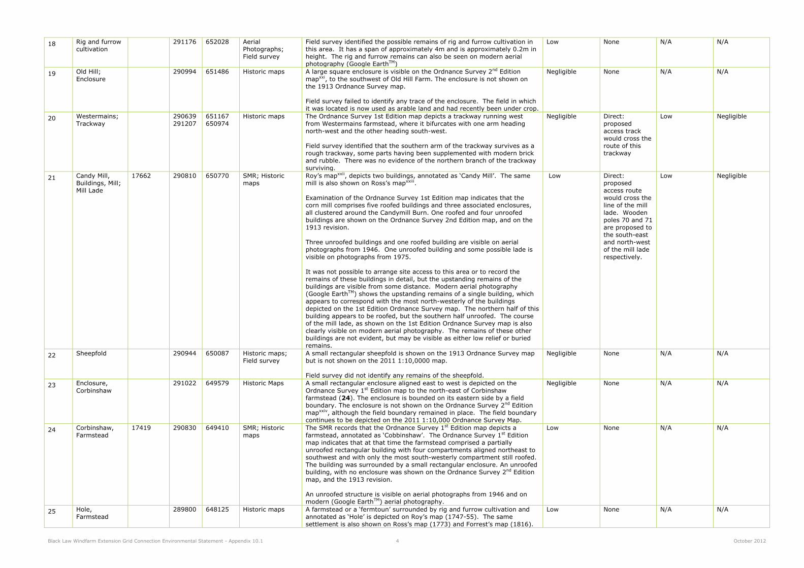
Black Law Windfarm Extension Grid Connection Environmental Statement - Appendix 10.1 4 October 2012
18 Rig and furrow cultivation
291176 652028 Aerial Photographs;
Field survey
Field survey identified the possible remains of rig and furrow cultivation in this area. It has a span of approximately 4m and is approximately 0.2m in
height. The rig and furrow remains can also be seen on modern aerial photography (Google EarthTM)
Low None N/A N/A
19 Old Hill;
Enclosure
290994 651486 Historic maps A large square enclosure is visible on the Ordnance Survey 2nd Edition
mapxxi, to the southwest of Old Hill Farm. The enclosure is not shown on the 1913 Ordnance Survey map. Field survey failed to identify any trace of the enclosure. The field in which it was located is now used as arable land and had recently been under crop.
Negligible None N/A N/A
20 Westermains;
Trackway
290639
291207
651167
650974
Historic maps The Ordnance Survey 1st Edition map depicts a trackway running west
from Westermains farmstead, where it bifurcates with one arm heading north-west and the other heading south-west. Field survey identified that the southern arm of the trackway survives as a rough trackway, some parts having been supplemented with modern brick and rubble. There was no evidence of the northern branch of the trackway
surviving.
Negligible Direct:
proposed access track would cross the route of this trackway
Low Negligible
21 Candy Mill, Buildings, Mill; Mill Lade
17662 290810 650770 SMR; Historic maps
Roy’s mapxxii, depicts two buildings, annotated as ‘Candy Mill’. The same mill is also shown on Ross’s mapxxiii. Examination of the Ordnance Survey 1st Edition map indicates that the corn mill comprises five roofed buildings and three associated enclosures,
all clustered around the Candymill Burn. One roofed and four unroofed buildings are shown on the Ordnance Survey 2nd Edition map, and on the 1913 revision. Three unroofed buildings and one roofed building are visible on aerial photographs from 1946. One unroofed building and some possible lade is
visible on photographs from 1975. It was not possible to arrange site access to this area or to record the
remains of these buildings in detail, but the upstanding remains of the buildings are visible from some distance. Modern aerial photography (Google EarthTM) shows the upstanding remains of a single building, which appears to correspond with the most north-westerly of the buildings
depicted on the 1st Edition Ordnance Survey map. The northern half of this building appears to be roofed, but the southern half unroofed. The course of the mill lade, as shown on the 1st Edition Ordnance Survey map is also clearly visible on modern aerial photography. The remains of these other buildings are not evident, but may be visible as either low relief or buried remains.
Low Direct: proposed access route would cross the line of the mill
lade. Wooden poles 70 and 71 are proposed to the south-east and north-west of the mill lade
respectively.
Low Negligible
22 Sheepfold 290944 650087 Historic maps; Field survey
A small rectangular sheepfold is shown on the 1913 Ordnance Survey map but is not shown on the 2011 1:10,0000 map. Field survey did not identify any remains of the sheepfold.
Negligible None N/A N/A
23 Enclosure,
Corbinshaw
291022 649579 Historic Maps A small rectangular enclosure aligned east to west is depicted on the
Ordnance Survey 1st Edition map to the north-east of Corbinshaw farmstead (24). The enclosure is bounded on its eastern side by a field boundary. The enclosure is not shown on the Ordnance Survey 2nd Edition mapxxiv, although the field boundary remained in place. The field boundary continues to be depicted on the 2011 1:10,000 Ordnance Survey Map.
Negligible None N/A N/A
24 Corbinshaw,
Farmstead
17419 290830 649410 SMR; Historic
maps
The SMR records that the Ordnance Survey 1st Edition map depicts a
farmstead, annotated as ‘Cobbinshaw’. The Ordnance Survey 1st Edition map indicates that at that time the farmstead comprised a partially unroofed rectangular building with four compartments aligned northeast to southwest and with only the most south-westerly compartment still roofed. The building was surrounded by a small rectangular enclosure. An unroofed building, with no enclosure was shown on the Ordnance Survey 2nd Edition
map, and the 1913 revision. An unroofed structure is visible on aerial photographs from 1946 and on
modern (Google EarthTM) aerial photography.
Low None N/A N/A
25 Hole, Farmstead
289800 648125 Historic maps A farmstead or a ‘fermtoun’ surrounded by rig and furrow cultivation and annotated as ‘Hole’ is depicted on Roy’s map (1747-55). The same
settlement is also shown on Ross’s map (1773) and Forrest’s map (1816).
Low None N/A N/A

Black Law Windfarm Extension Grid Connection Environmental Statement - Appendix 10.1 5 October 2012
A farmstead, annotated as ‘Hole’, is depicted on the Ordnance Survey 1st
Edition map and comprises a roofed rectangular steading, a second roofed building and an associated enclosure. The farmstead continues to be occupied today.
The position of the farmstead is taken from the 1st Edition Ordnance Survey map, and is the post improvement farmstead. The pre-improvement fermtoun may or may not have been located at the same or similar approximate location, but the less accurate surveying techniques used to produce the earlier cartographic sources makes it impossible to be certain about this.
26 Castledykes – Botwellhaugh – Balmuildy, Roman Road
12153 2897 6482 SMR The SMR records this section of the Roman road. The course of the road is marked on Roy’s Military Survey and annotated as ‘Roman Way’. The northerly alignment is maintained beyond Collielaw farm as far as Collielaw Cottage, where there is a slight change of course to the east; the modern road then takes up the line for about 300m and leaves it as the Roman
road ascends the southeast shoulder of Kilcadzow Law, passing through the
steading of Hole and crossing the Carluke-Carstairs highway (A721) about 75m east of its junction with the minor road leading from Cleghorn. Although now much spread by ploughing, slight traces of the agger appear in the first field north of the modern road, where the Roman road curves round to the WNW and, falling in with the line of a field-wall, proceeds along the crest of the Law through Hill of Kilcadzow farm.
Field survey noted that the modern road follows the same alignment as the former Roman road at this location. Without excavation in the area it is not possible to be certain that the modern road directly overlies the former course of the Roman road, or whether the course has been subject to deviations or amendments over time.
Medium Direct: Access tracks cross the assumed alignment of the Roman
road. One
wooden pole (37) will be erected to the immediate east of the assumed course of the Roman road.
Unknown (Potentially Low)
Unknown (Potentially Minor)
27 Collielaw
Cottage,
Building
41312
(NS84NE
18)
289920 647810 SMR; NMRS;
Historic maps
The SMR and NMRS record that a single unroofed building is depicted on
the Ordnance Survey 1st Edition map (1864) but is not shown on the 1993
OS 1:10,000 map. The earliest cartographic evidence for Collielaw comes from Roy’s Military Survey (1747-55) which depicts a farmstead or ‘fermtoun’ annotated as ‘Coly Law’. Forrest’s map (1816) also depicts the farmstead annotated as
‘Collylaw’. Examination of the Ordnance Survey 1st Edition map (1864) identified the single unroofed building recorded by the SMR, which is attached to the southwest corner of a large rectangular enclosure. Immediately south of the enclosure a larger farmstead is depicted comprising a T-shaped building, two rectangular buildings, a small square enclosure and a well.
The farmstead, including the single unroofed building, is annotated as ‘Collielaw’. On the Ordnance Survey 2nd Edition map (1898) the unroofed building is no longer depicted and the main farm buildings are only shown
as three unroofed structures attached to the square enclosure. On the 1913 Ordnance Survey map (1913) the farmstead now comprises one roofed building and two enclosures, and annotated as ‘Collie Law Cottage’.
The 2011 Ordnance Survey 1:10,000 map depicts Collie Law Cottage as an unroofed building.
Low None N/A N/A
28 Fullwood, Lime Kilns
17347 288490 647140 SMR; Historic Maps; Field survey
The SMR records that a number of limekilns are depicted on the Ordnance Survey 1st Edition mapxxv). The area is shown on the 2nd Edition Ordnance Survey map (1898) as an area of quarrying, amalgamated with Fulwood
limeworks (33). The limekilns are not shown on the 2011 Ordnance Survey 1:10,000 map. Field survey did not identify any remains relating to the limeworks, the location of which is now occupied by dense forestry.
Negligible None N/A N/A
29 Fulwoodhill,
Quarry (Limestone)
52483
(NS84NE 43)
288332 647166 SMR; NMRS;
Historic maps
The SMR and NMRS record that an extensive area of limestone quarrying is
depicted on the Ordnance Survey 1st Edition map (1864) and subsequent historic maps. The limestone quarrying is recorded as being largely in-filled and under forestry on the 2011 1:10,000 Ordnance Survey map.
Low None N/A N/A

Black Law Windfarm Extension Grid Connection Environmental Statement - Appendix 10.1 6 October 2012
30 Enclosure, Fullwood
288250 647278 Historic Maps; Field survey
A square enclosure is depicted on the Ordnance Survey 1st Edition map to the north of Fullwood Quarry (29). The enclosure is not shown on
subsequent maps, and field survey revealed that the area is now under forestry.
Negligible None N/A N/A
31 Fullwood,
Farmstead
41077
(NS84NE 35)
288453 646789 SMR; NMRS;
Historic maps
Fullwood is annotated as such on Roy’s map (1747-55). Two settlements
annotated ‘Old Fulwood’ and ‘New Fulwood’ are shown on Forrest’s (1816) and Thomson’s (1832) maps. Fullwood is depicted and annotated on the Ordnance Survey 1st Edition map (1864) and a triangular field boundary/enclosure is shown jutting out to the north-west of the farmstead. The farmstead but not the triangular enclosure are depicted on subsequent maps, and two wells are depicted
and annotated approximately 50m to the northwest of the farm on the 1913 Ordnance Survey Revisionxxvi. It is likely that the farmstead depicted from the Ordnance Survey 1st Edition map onwards is a more recent farmstead, thus accounting for the
annotations of ‘Old Fulwood’ and ‘New Fulwood’ as depicted on Forrest’s
(1816) and Thomson’s (1822) maps, Old Fulwood having been located further to the south.
Low None N/A N/A
32 Craigenhill Cottage
287663 646881 Historic maps; Field survey
The Ordnance Survey 2nd Edition map (1898) marks the location of Craigenhill Cottage to the immediate north of the Caledonian Railway. Field survey identified the remains of the building surviving in fair
condition. The building measures approximately 10m x 7m and has possible entrances on its eastern and western sides. The building was of stone construction with some brick construction evident at the northern end.
Low None N/A N/A
33 Craigenhill;
Lime Works, Lime Kilns, Clamp-kilns,
Quarry, Mine
22213,
52499
287450 647220 SMR; Historic
maps; Field survey
The current Ordnance Survey map marks this area as an area of disused
quarries. The 1st Edition Ordnance Survey map shows quarries, a mine, a double lime kiln, a possible single lime kiln, a structure and a series of 6 clamp kilns called Craigenhill Lime Works. There is also a mineral railway
depicted running through the eastern side of the Craigenhill Lime Works and connecting with the Caledonian Railway.. Field survey recorded the remains of the route of the mineral railway which
is visible as a hollow trackway approximately 2.5m deep and 6m wide. A large amount of disturbance in the area due to quarrying was clearly visible. The remains of lime kilns (a) as depicted on the 1st Edition Ordnance Survey map were found to survive as turf covered remains. In addition the remains of a further structure (b) were recorded further to the north, surviving as grass covered remains approximately 0.5m high and 1m wide with a hollowed out centre. This structure is likely to be the remains
of a further limekiln, but alternatively may be the turfed over remains of a building.
Low Direct: three
wooden poles (14 – 16) will be erected
within the area of the Craigenhill Lime Works. The
access route will pass through the southern part of the site.
Medium Minor
34 Craigenhill; Ring ditch
(possible)
40757 (NS84NE
14)
287270 647130 SMR; NMRS The SMR and NMRS record the location of a cropmark of a possible ring-ditch 12m in diameter which has been revealed by aerial photography on
the southern slope of Craigenhill overlooking an un-named burn.
Unknown / Low None N/A N/A
35 Loch Knowes, Loch house, New Green Towers Farm; Building
22217 286520 646630 SMR; Field survey The Ordnance Survey 1st Edition map (1864) depicts a house and garden at this location which are annotated as Loch Knowes. A building marked on Roy's Military Survey (1747-55) named as 'Loch house' may correspond with this site. Field survey failed to identify any upstanding remains of a building. The
area is now in use as improved pasture.
Low None N/A N/A
36 Cartland; Well 51316 286520 646280 SMR; Historic maps
The SMR noted that a well is marked at this location on the 1st Edition OS map of the area. It lies at the end of a track leading to it from the nearby settlement at Cartland; another branch of the track passes the well closely on the southern side and continues to the Brockland Burn. This track was
the main Lanark to Carluke road during the 19th century. The well is no longer marked on maps of the area.
Negligible None N/A N/A
37 Milestone 286265 646107 Historic maps; Field survey
A milestone is marked at this location on the Ordnance Survey 1st Edition map (1864). Field survey failed to locate the remains of the milestone which was
Negligible None N/A N/A

Black Law Windfarm Extension Grid Connection Environmental Statement - Appendix 10.1 7 October 2012
presumably removed when the Brooklinn Bridge was constructed.
38 Cartland;
Burgh
12665
(NS84NE9)
286590 645890 SMR The SMR note the location of the burgh of Cartland as recorded by
Prydexxvii. They record that the burgh at Cartland seems to have been at its most extensive around the mid-to late eighteenth century, at the beginning of which period it was mapped by Roy in his Military Survey of 1747-55.
However, it is not clear whether the village ever operated as a burgh, despite its charter of erection. Its economic fortunes may have suffered because of its proximity to the royal burgh of Lanark. The settlement shown on Roy's map is annotated "Kettland", and its form is a single street running south-west from a junction with what was at the time the main road between Lanark and Carluke. Five properties are shown fronting the south-western side of the main road on the Carluke side of the junction,
but the far larger part of the settlement runs along both sides of a roughly triangular area gradually broadening from the main road junction southwesterly towards the location of the present Cartland Mains Farm (WoSAS PIN 22392), where the open area narrows to a track. From there, the settlement follows the track's more westerly alignment for some
distance further. While the main Carluke to Lanark road passes the
northern end of the village, a smaller track is shown on Roy's map, branching off the western side of the main road at a bend and heading more directly towards the broadest part of the open space at the centre of the village, close to the present Mains Farm. The south-western end of the settlement is obscured on Roy's Survey by being at the junction of four map-sheets, but it is noticeable that the more modern main road cuts across the alignment of the burgh's main street near the location of
Cartland Smithy (WoSASPIN 17432), which is marked on the 1st Edition OS map of the area. By the time of that survey, the settlement had contracted towards its northern end, at the old road junction, with only Cartland Mains Farm surviving in occupation along the street-line. It is possible that the Mains Farm was laid out as a modern farm steading at the time of agricultural improvements in this area, and that the settlement contracted at the same time because its inhabitants were no longer needed to work
the land. The northern side of the village street between Cartland Mains and Cartland Smithy was planted with a belt of trees in the modern period.
Medium None N/A N/A
39 Cartland Smithy, Cartland
Mains; Smithy
17342 286290 645790 SMR, Historic Maps; Field survey
The SMR note the location of Cartland Smithy which is depicted on the 1st Edition OS map (1864) as a roofed building.
The field survey confirmed that there are no remains of this building upstanding at this location.
Low None N/A N/A
40 Old Quarry 286054 645661 Historic maps A quarry marked 'Old Quarry' is depicted on the 1913 edition of the Ordnance Survey map (1913).
Negligible None N/A N/A
41 Trough 286309 645449 Historic maps;
Field survey
A trough is depicted on the 1913 edition of the Ordnance Survey map
(1913). Field survey failed to identify any remains of the trough.
Negligible None N/A N/A
42 Sheepfold 286470 645459 Historic maps A sheepfold is depicted on the 1913 edition of the Ordnance Survey map (1913). Modern aerial photography (Google Earth TM) indicates that the
sheepfold is no longer present.
Negligible None N/A N/A
43 Enclosure 286692 645084 Aerial Photographs
A rectangular enclosure is visible on aerial photographs from 1946 to the northeast of Tintochland (46). Some ruins are evident on modern GoogleTM
aerial photography.
Low None N/A N/A
44 Old Quarry 286287 644941 Historic maps A quarry marked 'Old Quarry' is depicted on the 1913 edition of the
Ordnance Survey map (1913).
Negligible None N/A N/A
45 Trackway, Quarry Tintochland
Historic Maps The Ordnance Survey 1st Edition map (1864) depicts a trackway running north-east to south-west from Newsteadings farmstead at its northern end. At the south-western end of the track it turns and runs to the west for a short distance before running to the east of Tintochland (46) and a
woodland shelter belt, in a SSE to NNW direction to a quarry. The 2nd Edition Ordnance Survey Map (1898) marks the quarry as ‘old quarry’. It continues to be marked in this way on subsequent maps until the 1940-41 revision when it is no longer marked. The western part of the trackway is no longer depicted on the Ordnance Survey 2nd Edition Map, but the
eastern part of the trackway is depicted on all Ordnance Survey maps, continuing to be depicted on the current 2011 1:10,000 map. A quarry
marked 'Old Quarry' is depicted on the 1913 Ordnance Survey map (1913) at 286660 644895.
Negligible None N/A N/A

Black Law Windfarm Extension Grid Connection Environmental Statement - Appendix 10.1 8 October 2012
Field survey failed to identify any remains of the western part of the
trackway.
46 Buildings, trackway,
Tintochland
286605 647705 Historic maps Two rectangular buildings and one T-shaped building are depicted and annotated ‘Tintochland’ on the Ordnance Survey 1st Edition map (1864), to
the east of Chapel Knowe. The buildings are linked by a trackway going south-east towards the main road to the south. None of the buildings are shown on the Ordnance Survey 2nd Edition map (1898) but a rectangular enclosure is shown to the north of the three buildings within a shelterbelt, and a well is depicted, annotated as ‘W’. The 1913 Revision (1913) shows the rectangular enclosure as a dashed line and the well is now annotated as ‘spring’. Neither the enclosure, the well or the trackway are shown on the
2011 1:10,000 Ordnance Survey map, but a field boundary follows the alignment of the earlier trackway. Roy’s Military Survey (1747-55) annotates ‘Tinlock land’ as an area of cultivated fields, and ‘Tinlockland’ is annotated on both Forrest’s (1816)
and Thomson’s (1822) map. This site was not visited during the field
survey as it was not possible to arrange site access.
Low None N/A N/A
47 Lee Castle, Garden and Designed Landscape
285473 645994 Inventory of Garden and Designed Landscapes
The Inventory records that Lee Castle stands within some 910 acres (366ha) of designed landscape which extends north to a minor road linking the A73 with Birkhill Farm, south to West Nemphlar Road off the A73, west to the woodland ridge above the Auchenglen Burn, and east to the A73. The woodland, parkland and gardens make an impressive setting for the
Category B Listed Lee Castle. Also contained within the GDL are the Category B Listed Buildings of The Lee, South Lodge (48) and the Dovecote (Listed Building No. 13057). It is believed that the designed landscape as shown on the 1st Edition Ordnance Survey map was laid out in the first half of the 19th century, but at that time extended only as far south as the Lochartbank road. The south drive was extended during the latter half of the 19th century to its current form, and a new lodge (48) was erected at
the entrance to the policies.
High None N/A N/A
48 The Lee, South Lodge
NS84SE 240
286564 644477 Statutory List The Statutory List records the building as an early 19th century Gothic lodge. No further information is provided. The building continues to be occupied today.
The lodge is a Category B Listed Building (Index no. 13058).
High (as located in GDL)
None N/A N/A
49 Cartland, (Wallaces Cave); Cave
10205 (NS84SE 2)
286910 644540 NMRS; SMR; Historical maps
The NMRS and SMR record that a cave in the ravine known as ‘Cartland Craigs’ is traditionally said to have been used as a refuge by Sir William Wallace. The Ordnance Survey 1st Edition map (1864) marks the location of
‘Wallace’s Cave’. Field survey carried out by the Ordnance Survey in 1954 recorded that ‘Wallace’s Cave’ is a natural, inaccessible rock cleft.
Low None N/A N/A
50 Cartland
Bridge, Road Bridge
10262
(NS84SE 71.00)
286871 64480 NMRS; SMR The NMRS and SMR record that Cartland Bridge was built in 1822 to a
design by Thomas Telford. It is a 3-span, dressed stone bridge with semi circular archesxxviii. The bridge is located at a point where the River Mouse Water runs through a very deep narrow valley. The carriageway is supported by two soaring pillars of yellow, ashlar sandstone approximately 120m high, rising from the bed of the stream and two other columns abutting the sheer rock face.
The SMR records that a site visit by the Historic Scotland Monument Warden in 1993 reported that the bridge has been spoilt by widening works in the 1950s. A new cantilevered pavement with iron railings was added to the south-west side, and a solid concrete parapet was built on the northeast, both completely out of character with the original elegance of the bridge. The SMR also record the remains of the bridge’s medieval predecessor, a single arch bridge, approximately 4m wide and with remains
in a few sections up to 10cm in height.
The bridge is a Category B Listed Building (Index No. 13054).
Medium None N/A N/A
51 Turnpike, Cartland Bridge
286832 644466 Historic maps A small square building is depicted and annotated ‘Cartland bridge T.P’ on the Ordnance Survey 1st Edition map (1864 Lanarkshire, Sheet XXV), to the
Low None N/A N/A

Black Law Windfarm Extension Grid Connection Environmental Statement - Appendix 10.1 9 October 2012
west of Cartland Bridge itself (50).The building is shown on both the 2nd Edition Ordnance Survey map (1898), and the 1913 Revision (1913). The
field survey identified that the building which has been extended continues to be occupied today.
52 Lodge, building 286668 644365 Historic maps A rectangular building is depicted and annotated ‘lodge’ on the Ordnance
Survey 1st Edition map (1864). The building is still shown and annotated as ‘Lodge’ on the 2011 1:10,000 Ordnance Survey map. It is located at the northern end of the trackway leading to ‘Sunnyside’. Field survey identified the building which continues to be occupied today.
Low None N/A N/A
53 Mouse Mill; House
10231 (NS84SE
43)
286816 644246 NMRS; SMR; Historic Maps;
Statutory List
Mouse Mill is annotated as ‘Mouzemill’ on Ross’s map (1773), and the area is annotated as ‘Mousebank’ on Thomson’s map (1822). The Ordnance
Survey 1st Edition map (1864) depicts and annotates Mouse Mill. The Statutory List records the site as an early example of a grain mill surviving in good condition in a characterful setting with significant boundary walls and gatepiers contributing to a historic streetscape and grouping with other listed buildings in the immediate area. The mill is
significant historically to the region as the first and main grain mill to serve Lanark Burgh from 1795 onwards. The current building structure clearly shows the changes in its development and improvements over the years as a working mill. The two former cottages have some good architectural detailing with the pointed arch windows which are an unusual detail for this type of industrial building. The building is sited by the Mouse Water previously known as the `Moufs' and then `Mouss'.
The Mill forms a strong grouping with the adjacent `Sorisdale House´, Mousemill Bridge and Mousemill House which are all listed separately. Sorisdale House (Formerly Orchard Dell) also has characterful pointed arched windows as evident in the mill. The Mill is Category B Listed (Index No.13064)
Medium None N/A N/A
54 Orchard Dell,
Now Sorisdale
10230
(NS84SE 42)
286818 644294 SMR; NMRS;
Historic Maps; Statutory List
The Statutory List states that the building is of late 18th / early 19th century
date, with pointed Gothic fenestration. No further information is provided. Orchard Dell is annotated as ‘Orcharddell’ on both Forrest’s (1816) and Thomson’s (1832) maps, and is depicted and annotated as Orchard-dell on
the Ordnance Survey 1st Edition map (1864). The building is Category B Listed (Index no 13063).
Medium None N/A N/A
55 Orchard Dell; Sluice; Building
286897 644289 Historic maps A small rectangular building is depicted and a ‘Sluice’ is annotated on the Ordnance Survey 1st Edition map (1864), to the east of Orchard Dell (54), on the southwestern bank of the river. The building is shown on both the
2nd Edition Ordnance Survey map (1898), and the 1913 Revision (1913). The building is depicted on the 2011 1:10,000 Ordnance Survey map as unroofed.
Low None N/A N/A
56 Sunnyside; Tank
286488 644180 Historic maps A square feature annotated ‘Tank’ is shown on the 1913 Ordnance Survey map to the northwest of Sunnyside Lodge (57). It is no longer depicted on
the 2011 1:10,000 Ordnance Survey map.
Negligible None N/A N/A
57 Sunnyside Lodge; Building(s)
286388 644076 Historic maps Sunnyside Lodge is first annotated on Forrest’s Map (1816) as ‘Sunnyside Lodge Gillespie Esq’. Five rectangular buildings, one unroofed building and several areas of enclosed land, are depicted and annotated ‘Sunnyside Lodge’ on the 1st Edition Ordnance Survey map (1864). Six rectangular buildings and one unroofed building are shown on the Ordnance Survey 2nd
Edition map (1898) and on the 1913 revision (1913). Seven buildings are still shown on the current 2011 1:10,000 Ordnance Survey map and are annotated ‘Sunnyside’. The buildings continue to be occupied today.
Low None N/A N/A
58 Welldale; Settlement
285980 644368 Historic maps A settlement comprising three buildings is depicted and annotated ‘Welldale’ on both Forrest’s map (1816) and Thomson’s map (1832). A
farmstead consisting of an L-shaped building is depicted and annotated ‘Welldale’ on the Ordnance Survey 1st Edition map (1864). A well (59) is depicted to the north of this farmstead. Welldale is shown on subsequent maps until 1940. Only one small building is shown on the 1940-41
Ordnance Survey revisionxxix and the buildings are no longer shown on the 2011 1:10,000 map, having been replaced by more recent buildings.
Low None N/A N/A
59 Welldale; Well 285955 644382 Historic maps A well is depicted on the Ordnance Survey 1st Edition map (1864), to the southeast of East Town of Nemphlar (60), associated with a small road or
Negligible None N/A N/A

Black Law Windfarm Extension Grid Connection Environmental Statement - Appendix 10.1 10 October 2012
trackway. The well may have served the settlement of East-town of Nemphlar (60) and/or the farmstead of Welldale (56). The well is no longer
shown on the 1913 Ordnance Survey revision, and is not shown on 2011 1:10,000 Ordnance Survey mapping.
60 East-town of
Nemphlar; Burgh, Village, settlement
41321
(NS84SE 122)
285847 644420 SMR; NMRS:
Historic maps
East Town of Nemphlar is depicted as a township on Roy’s Military Survey
of Scotland (1747-55). It is depicted as a cluster of three buildings within a rectangular enclosure. The settlement is also depicted on Forrest’s map (1816) where it is annotated as ‘Nemphlar’. A village, comprising nineteen roofed buildings is depicted on the 1st edition of the OS 6-inch map (1864). The 2011 1:10,000 Ordnance Survey map depicts the area as ‘Halltown of Nemphlar’ and shows fourteen roofed
structures, which do not correspond with the buildings marked on the First Edition Ordnance Survey map.
Low None N/A N/A
61 Halltown of Nemphlar, settlement;
Trackway, Field boundaries
285618 644299 Historic maps A settlement consisting of several buildings and enclosures and annotated ‘Halltown’ is depicted on Roy’s Military Survey (1747-55). Several buildings are depicted and annotated as ‘Hall Town’ on Forrest’s map (1816). A
bastle (NS84SE 84) still extant within the settlement is thought to be of 16th to 17th century date. Seven rectangular buildings with enclosed land / garden plots are depicted on the Ordnance Survey 1st Edition map (1864), but lie outwith the study area. Several enclosed fields and a small trackway shown to the south of the settlement do extend to within the study area (and are depicted on Figure 10.1). The beginning of the amalgamation of these fields is evident from the 2nd Edition Ordnance Survey map onwards
(1898). The field boundaries and trackway are no longer shown on the 2011 1:10,000 Ordnance Survey map, and no trace of them was identified by the field survey.
Low None N/A N/A
62 Linnbank; Building
285407 644179 Historic maps A rectangular building set within an enclosure to the east of a trackway is depicted and annotated ‘Linnbank’ on the Ordnance Survey 1st Edition map
(1864). The building is not shown on the Ordnance Survey 2nd Edition map (1898). The field boundary to the south of Linnbank, and the track leading from Halltown of Nemphlar as far as Linnbank is still shown on the current
2011 Ordnance Survey 1:10,000 map. The southern portion of the trackway, leading to ‘Linnhead’ (66) is no longer depicted.
Low None N/A N/A
63 Hakespie Hill;
Enclosure,
285651 644084 Historic maps;
Field survey
An irregular shaped enclosure is depicted on the Ordnance Survey 1st
Edition map (1864) to the north of Hakespie Hill. It is shown defining an area of woodland. Only the north-western and southern end of the enclosure is still depicted on subsequent editions of the Ordnance Survey map. The current 2011 1:10,000 map depicts only a portion of the northwestern part of the enclosure. Field survey identified that this enclosure was located on a very steep
ravine on the riverside, and it was not therefore possible to survey this area in detail.
Low None N/A N/A
64 Number not used.
65 Stonebyres
Hydro-electric Power Station, Weir and Bridge
52563 285511 644022 SMR, Statutory
List supplementary information
The SMR record that the weir and bridge form part of the first large scale
hydro-electric scheme (Falls of Clyde) for public power supply in Britain. The weir and bridge were constructed in 1925 with some later alterations including replacement gates. The monument consists of a flat-arched white rendered reinforced concrete bridge and tilting weir with some original steel sluice gates by Ransomes and Rapier Ltd, Ipswich. It features square section cutwaters with chamfered edges at water level and three moveable
riveted steel gates with cross bracing, set in a reinforced concrete frame. A spillway is located on the eastern side of weir with trash screens. Original street lamps are located on the roadway of the bridge, and original gateposts and other ironwork by Ramage & Whitehead, Glasgow are also present. Alterations in the early 21st century included the addition of some new gates.
The weir and bridge are Category A Listed Buildings (Index no. 51720).
It was not possible to access the site during the field survey due to building works.
High Direct. The
cable will cross the weir in pre-existing ducts which are located on the underside of
the recently refurbished weir. No construction work will be necessary on
the monument of Stonebyres Weir. The
cables will be carried up and over the rock face adjacent to
Imperceptible Negligible

Black Law Windfarm Extension Grid Connection Environmental Statement - Appendix 10.1 11 October 2012
the weir using a cable tray; this
has the potential to cause operational
(indirect) impacts upon the setting of the monument.
66 Building, Linnhead
285357 644087 Historic maps A small square building set within an enclosure is depicted and annotated ‘Linnhead’ on the Ordnance Survey 1st Edition map (1864). It is associated
with a trackway (of which only the northern extent, as far as Linnbank (62) is shown on the current 2011 Ordnance Survey 1:10,000 map). The building is shown on the Ordnance Survey 2nd Edition map (1898) and the 1913 Revision, but is not shown on the 1940-41 Revision, or any later sources.
Low None N/A N/A
67 Stonebyres Falls, ‘Cairnie Castle’; Indeterminate Remains, Possible mill site
10238 285300 644020 SMR; Historic maps
The Statistical Account of Scotlandxxx records that there was at one time a castle or stronghold called ‘Cairnie Castle’ near the Fall of Stonebyres. It records that several narrow archways were discovered at Cairns Castle about 1794 in which were two querns, with deer's horns, and bones of animals. These archways were similar to those at Castle Qua (NS84SE 1) of which one was described as 7 to 8 feet long by 3 1/2 feet high, with a corbelled roof. An old man of 93 remembered the remains of a stone
building being on the site but did not remember the vaults. Field survey by the Ordnance Survey in 1954 found no trace of this structure in the area, which falls within the area of a hydro-electric power scheme. Cairnie Castle is not depicted on Roy's map, Herman Moll's map of 1745, or
the 1st Edition Ordnance Survey map (1864). The placename Upper Cairnie
does appear on modern maps, including the 2011 1:10,000 map. Stonebyres Linn Mill however may have been located near to the site of this claimed castle (at approximately 285308 643980). Linn Mill is depicted on the 1st Edition Ordnance Survey map to the south of the river as a rectangular farm steading type of building, but Roy's map depicts
Stonebyres Linn Mill as a single long rectangular building in a position apparently closer to the river, as might be expected of a mill building. No further details to explain the reference to Cairnie Castle in the Statistical Account have been found.
Low None N/A N/A
68 Stonebyres
Falls, Waterfall
61405
(NS84SE 236)
285295 644015 SMR; NMRS The NMRS and SMR record that the waterfall at Stonebyres is noted in the
‘Harnessing the Falls of Clyde’ by the Clyde Valley Electrical Supply Company.
Negligible None N/A N/A
69 Linnville; Settlement
285520 643826 Historic maps Linville is annotated on Forrest’s map (1816). The Ordnance Survey 1st Edition map (1864) depicts eight square or rectangular buildings and one
T-shaped building at this location, each set within a garden/small field plot,
and a well at the western end of the village. The buildings lie primarily on the south-western side of a road aligned approximately north-west to south-east, with two buildings located on the north-eastern side of the road. A similar layout is shown on the Ordnance Survey 2nd Edition map (1898) and on the 1913 revision (Lanarkshire Sheet XIX, SW). Additions to the Linnville settlement are shown on the 1940-41 revision. Linnville is visible on aerial photographs from 1954, and remains largely unchanged
from the depiction on the 1940-41 revision of the Ordnance Survey map. Twelve buildings on similar alignments, within garden plots of similar size and shape to those shown on the 1st Edition Ordnance Survey map, are also depicted on the current 2011 1:10,000 Ordnance Survey map. Some of these buildings may be those depicted on the 1864 1st Edition Ordnance Survey map. A T-shaped building which was formerly depicted on the
north-eastern side of the road is no longer depicted. The road continues to follow the same alignment as depicted on the Ordnance Survey First Edition Map, although the settlement of Linnville has extended to the south and southwest.
Low None N/A N/A

Black Law Windfarm Extension Grid Connection Environmental Statement - Appendix 10.1 12 October 2012
70 Linkmill; Well 285345 643935 Historic maps A well is depicted on the Ordnance Survey 1st Edition map (1864), to the north of Linkmill, at the southern terminus of a small trackway. Neither the
well nor the trackway are shown on the Ordnance Survey 2nd Edition map (1898) or any later cartographic sources.
Negligible None N/A N/A
71 Linnmill,
building
285274 643795 Historic maps A quadrangular building is depicted and annotated ‘Linnmill’ on the
Ordnance Survey 1st Edition map (1864). The building still appears on the current 2011 1:10,000 Ordnance Survey map.
Low None N/A N/A
i Ordnance Survey, Second Edition (1893) Lanarkshire Sheet XVI six inches to one mile. ii Ordnance Survey Second Edition (1893) Lanarkshire Sheets XII six inches to one mile.
iiiCFA Archaeology (2007) Black Law Extension Environmental Statement. Cultural Heritage.
ivOrdnance Survey Second Edition (1899) Lanarkshire Sheet XIII six inches to one mile.
v Ordnance Survey First Edition (1853) Edinburghshire Sheet XV six inches to one mile.
vi Scott, H et al. (Eds.) (1915). Fasti ecclesiae Scoticanae: the succession of ministers in the Church of Scotland from the Reformation. Edinburgh
vii Brown, P. (1859). Historical sketches of the parish of Cambusnethan. Wishaw.
viii Forrest, W. (1816) The County of Lanark from actual survey.
ix Thomson, J. (1832) ‘Northern Part of Lanarkshire, Southern Part’ In: Thomson’s Atlas of Scotland.
xOrdnance Survey, Second Edition (1899) Lanarkshire Sheet XIII SE six inches to one mile
xi Ordnance Survey Second Edition(1899) Edinburghshire parts of Sheets X and XVI six inches to one mile
xii Ordnance Survey First Edition (1859) Lanarkshire Sheet XX six inches to one mile
xiii Ordnance Survey Second Edition (1897) Lanarkshire Sheet XIX six inches to one mile
xiv Ordnance Survey (1910) Lanarkshire Sheet XIX six inches to one mile.
xv Ordnance Survey (1941) Lanarkshire Sheets XIX.4, XIV.13 & XII.16 six inches to one mile.
xvi Ordnance Survey (1859) Lanarkshire Sheet XIII six inches to one mile.
xvii Duncan, JS , (1997) 'Hare Hill/Climpy (Carnwath; Carstairs parishes), Mesolithic chert scatter, later enclosure', Discovery and Excavation in Scotland,, p.75.
xviii Ordnance Survey (1913) Lanarkshire Sheet XIX, NE six inches to one mile.
xix Ordnance Survey (1853) Lanarkshire Sheet XIX six inches to one mile.
xx Ordnance Survey (1864) Lanarkshire Sheet XIX six inches to one mile.
xxi Ordnance Survey (1898) Lanarkshire, Sheet XIX six inches to one mile.
xxii Roy, W.(1747-55), Military Survey of Scotland
xxiii Ross, C. (1773) A map of the Shire of Lanark
xxivOrdnance Survey Second Edition (1898) Lanarkshire, Sheet XXV six inches to one mile.
xxv Ordnance Survey First Edition (1864) Lanarkshire, Sheet XXV six inches to one mile.
xxvi Ordnance Survey 1913 Lanarkshire, Sheet XXV six inches to one mile.
xxvii Pryde, G S , (1965) The burghs of Scotland: a critical list. London.
xxviii Butt, J. (1967). The Industrial Archaeology of Scotland. The industrial archaeology of the British Isles Series, Newton Abbot. Hume, J.R. (1976). The industrial archaeology of Scotland, 1, Lowlands and Borders. London.
xxix Ordnance Survey (1940-41) Lanarkshire, Sheet XXV six inches to 1 mile.
xxx Sinclair, J. (1791). The statistical account of Scotland, drawn up from the communications of the ministers of the different parishes. OSA, Edinburgh

Appendix 10.2: External Receptors within the Outer Study Area


Black Law Windfarm Extension Grid Connection Environmental Statement - Appendix 10.2 1 October 2012
Appendix 10.2: External Receptors within the Outer Study Area
Site No.
Site Name Status Easting Northing Value /
Sensitivity of Receptor
Setting Predicted Impact Contribution of Setting
Sensitivity of Setting
Impact Magnitude
Significance
of Predicted Impact
2604 Castle Qua,fort 345m WSW of Mouse Bridge
Scheduled
Monument
287412 644893 High Castle Qua, which is believed to be of
medieval date, survives as an earthwork
and is largely surrounded by woodland.
The proposed overhead line (OHL) would
be visible only from the north-eastern
corner of the site. It would theoretically
be visible to the north of Castle Qua, but
would be visible only behind other modern
features including several farmsteads and
the railway.
Indirect (maximum of
15 wooden poles
theoretically visible)
Moderate High Imperceptible Negligible
11235 Auchenglen, cairn 450m SSE of
Scheduled
Monument
284856 646848 High Cairn located within the Lee Castle GDL.
The cairn lies on a tree-covered knoll. The
woodlands of the Lee Castle GDL will
screen views of the proposed OHL.
Indirect (maximum of
three wooden poles
theoretically visible)
Moderate High Imperceptible Negligible
11528 Collielaw Wood, Roman road SSE of Collielaw
Scheduled
Monument
290065 647061 High Length of Roman road passes through an
area which is now wooded. The road is
not visible on the surface. The more
recent buildings of Collielaw Farm overlie
the course of the Roman road to the
north-west and prevent views of the
course of the road in this direction.
Distant views of the proposed OHL beyond
the farm buildings would cause only a
barely distinguishable effect upon the
setting of the road.
Indirect (maximum of
22 wooden poles
theoretically visible)
Low Medium Imperceptible Negligible
12967 Baronald (Cartland Bridge
Hotel)
Category A
Listed
287348 644615 High Baronald is a large Scottish Baronial
mansion which is composed of an
asymmetrical arrangement of linked tower
house –like blocks of differing heights.
The building is largely surrounded by trees
and these would partly screen views of the
proposed OHL. The proposed OHL would
be partly visible in distant views
approximately 2km away.
Indirect (maximum of
eight wooden poles
theoretically visible)
High
(localised)
High Low Minor
13053 Jerviswood Category A
Listed
288376 645514 High Jerviswood is a late 16th or early 17th
century Laird’s house. Jerviswood is
surrounded by trees on its northern and
eastern sides and these would partly
screen views of the proposed OHL. The
proposed OHL would be partly visible in
distant views approximately 1.5km away.
Indirect (maximum of
nine wooden poles
theoretically visible)
High
(localised)
High Low Minor
Lee Castle GDL 285440 645977 High Lee Castle GDL provides the setting for
the Category B Listed Buildings of The Lee
(Index No. 13056) and The Lee, Dovecote
(Index No. 13057). The designed
landscape covers some 910 acres and lies
Indirect (maximum of
21 wooden poles
theoretically visible)
High
(localised)
High
(localised)
Low Minor

Black Law Windfarm Extension Grid Connection Environmental Statement - Appendix 10.2 2 October 2012
within the broad valley which was the
former course of the river Clyde before it
was diverted during the Ice Age. Key
views are from the northern end of the
GDL looking south, and these would be
unaffected by the proposed grid
connection.
671 Auchterhead Muir,
Covenanters Monument, Darmead-Linn
Category B
Listed
290116 655310 Medium Located within an area of moorland which
now lies within the Black Law windfarm.
Turbines are currently visible behind the
monument, and the proposed grid
connection poles would appear behind
these turbines.
Indirect (maximum of
26 wooden poles
theoretically visible)
Low Low Low Negligible
13054 Cartland Bridge Category B
Listed
286871 644480 Medium The bridge spans Mouse Water and it is
this valley which provides its setting.
None N/A N/A N/A N/A
13056 The Lee Category B Listed
285421 646518 Medium The setting of The Lee is its designated
GDL. The house itself stands on a series
of bold grass terraces, and the
combination of gardens, parkland and
woodland provide an impressive setting
for the house.
Indirect (maximum of
two wooden poles
theoretically visible)
High
(localised)
High Imperceptible Negligible
13057 The Lee, Dovecote
Category B Listed
285385 646349 Medium Set within the Lee Castle GDL and in
relation to The Lee (Index No. 13056).
The dovecote survives in a derelict
condition and has lost its pyramidal roof.
Indirect (maximum of
two wooden poles
theoretically visible)
High
(localised)
High Imperceptible Negligible
13058 The Lee, South Lodge Category B Listed
286564 644477 Medium Localised setting at the southern end of
southern drive leading to The Lee (Index
No. 13056).
None N/A N/A N/A N/A