Appendices - Springer978-3-540-27082-9/1.pdf · 246 A.Appendices Table A.1. ... Geochemistry:...
52
Appendices The study of mudstones, like the study of medicine, draws on a wide range of techniques Introduction Many different methodologies (Table A.1) are avail- able to study mudstones from diverse field observa- tions to both stable and radioactive isotopes. These methodologies range from a variety of coring meth- ods of muds to X-ray micro analysis (Figs. A.1A and B). In reality, descriptions of mudstones are the same as those of any sedimentary rocks, although some would say that we only need to look a little harder . . . Thus the variables are color, stratification, sedimen- Fig. A.1A,B. Flow charts for the standard analysis of mud- stones: (A) unconsolidated, and (B) consolidated (Pike and Kemp 1996, Figs. 1 and 2) (continued on next page). Pub- lished by permission of the authors and the Geological Society of London tary structures, grain size (most easily approximated by the proportion of clay to silt to sand), bioturba- tion and fossils, secondary minerals and structures (concretions and nodules and their composition), and most important of all, recognition of cycles de- fined by fining or coarsening upward plus low relief discontinuities (parasequence boundaries). Here we focus on only seven – field description, nomencla- ture, clay mineralogy, soils, petrology, organics, and isotopes. Each appendix includes references to facil- itate additional understanding. The Encyclopedia of
Transcript of Appendices - Springer978-3-540-27082-9/1.pdf · 246 A.Appendices Table A.1. ... Geochemistry:...

AppendicesThe study of mudstones, like the study of medicine, draws on a wide range of techniques
Introduction
Many different methodologies (Table A.1) are avail-able to study mudstones from diverse field observa-tions to both stable and radioactive isotopes. Thesemethodologies range from a variety of coring meth-ods of muds to X-ray micro analysis (Figs. A.1A andB). In reality, descriptions of mudstones are the sameas those of any sedimentary rocks, although somewould say that we only need to look a little harder . . .Thus the variables are color, stratification, sedimen-
Fig. A.1A,B. Flow charts for the standard analysis of mud-stones: (A) unconsolidated, and (B) consolidated (Pike andKemp 1996, Figs. 1 and 2) (continued on next page). Pub-
lished by permission of the authors and the GeologicalSociety of London
tary structures, grain size (most easily approximatedby the proportion of clay to silt to sand), bioturba-tion and fossils, secondary minerals and structures(concretions and nodules and their composition),and most important of all, recognition of cycles de-fined by fining or coarsening upward plus low reliefdiscontinuities (parasequence boundaries). Here wefocus on only seven – field description, nomencla-ture, clay mineralogy, soils, petrology, organics, andisotopes. Each appendix includes references to facil-itate additional understanding. The Encyclopedia of

246 A. Appendices
Table A.1. Techniques to study mudstones
Field Laboratory
Color Petrography/mineralogy – Thinsection, SEM, backscatter, TEM,X-ray diffraction
Texture/field name Texture – Pipette or Coulter counter,SEM
Stratification andstructures
Sedimentary structures – X-radio-graphy, polished slabs
Macro/trace fossils Micropaleontology/Palynology –Macerals; vitrinite reflectance
Sequences/cycles Statistical Analysis – Milankovitchand tidal cycles
Total gammaradiation
Geochemistry: Organic – TOC,H/C, Rock-Eval, biomarkers
Spectral gammaray – U, Th, K
Geochemistry: Inorganic – Majorand trace elements, REE, stableisotopes, radioactive isotopes
Weatheringfeatures
Engineering properties – Plasticand liquid limits, undrained shearstrength, unconfined compressivestrength, slake durability
Sediments and Sedimentary Rocks (Middleton 2003)provides information about many of the topics be-low, and we also recommend the Glossary of Geology(Jackson 1997) to help with terminology.
Fig. A.1. (continued)
References
Jackson JA (1997) Glossary of Geology, 4th edn. AmericanGeological Institute, Alexandria, VA, 769 p
Middleton GV (ed) (2003) Encyclopedia of Sediments andSedimentary Rocks. Kluwer Academic, Dordrecht, 821 p
A.1. Field and Core Description
Describing mud, clay and mudstone in outcrops andcores has long challenged many of us over the years,because it is all too easy to think, “Gosh, what ishere that I can usefully describe besides color?” To-day, fortunately, we have a good start on what tolook for and how to interpret what we see (Chaps.3, 4, and 5). A standard set of symbols is alwayshelpful (Fig. A.2) as are standard definitions of strat-ification, thickness and weathering terms (Fig. A.3).For some unconsolidated muddy sediments, reliefpeels provide much additional information abouttheir stratification and structures (Hattingh and Za-wadam 1996) and polished slabs are helpful for somemudstones.
In outcrop how mudstone weathers providesmuch helpful information about its stratificationand small-scale fabric (Fig. A.4), and to some de-gree, its clay mineral composition. Key terms aremassive, fissile (papery), blocky or concoidal, and pop-corn weathering and their equivalents that represent

A. Appendices 247
Fig. A.2. Symbols used by Scientific Ship-board Party (Ludwig et al. 1983, Fig. 6) tolog DSDP cores

248 A. Appendices
Fig. A.3. Terms to de-scribe stratification andits weathering expressionof fine-grained sedimen-tary rocks (Potter et al.,their Table 1-3)
end members (Fig. A.5): fissility and papery describewell-defined, fine laminations that separate into thinsheets upon weathering, whereas massive is just theopposite. The term blocky, like massive, also indi-cates an absence of fissility while its opposite is a veryporous, mud cracked, flaky surface texture calledpopcorn weathering, which forms when clays rich
Fig. A.4. Platy versus flaky fragmentation of a shale andcontrasts in fabric. After Grainger (1985, Fig. 2). Pub-lished by permission of the authors and the GeologistsAssociation
in smectites or mixed lattice minerals are exposed towater andexpand.Color also is auseful guide to somecompositions, especially pyrite content; for example,in wet climates a strong, rusty reddish brown colorindicates pyrite whereas some dark, organic-richshales acquire a silvery sheen on their fissile frag-ments. Fortunately, a rather small number of basicdescriptors suffice for most mudstones even thoughthere are many additional terms for minor compo-nents (Table A.2). Use of a color chart (Goddard et al.undated) is always recommended, but color descrip-tion can also be usefully automated, especially forrhythmically-stratified mudstones reducing severalcolors to a single color density log (Algeo et al. 1994;Schaaf and Thurow 1994). Such quantitative, contin-uous scans facilitate study by time series (see Box 8.2)to identify the different frequencies of cycles.
Another technique that is widely used is X-radiography of either individual pieces of thin slabsof cores or continuous images of a vibrocore or slicedcore using a traveling stage (Algeo et al. 1994).
Guides to field and core description are given byPotter et al. (1980, pp 87–119), and Ludwig et al. (1983)

A. Appendices 249
Fig. A.5A–D. Four endmembers of weathering:(A) massive mudrock ofthe Corumbatai Forma-tion (Permian) on SP 191near Rio Claro, Sao Paulo,Brazil; (B) total fissility ofthe Devonian-MississippianNew Albany Shale on theBluegrass Parkway in Nel-son Co., KY (Photographcourtesy of Brandon Nut-tal, Kentucky GeologicalSurvey); (C) blocky (con-coidal) weathering of theEocene Porters Creek Clayrich in smectite in MarshalCounty, KY; and (D) “Pop-corn” weathering developedon smectite-rich bed of Cre-taceous Mowry Shale alongCottonwood Creek, sec. 31T. 39 N, R 85 W, NatronaCo., WY. Photograph cour-tesy of Kevin Bohacs (turn topage 250)
plus several atlases and core books (see DiggingDeeper). Full attention to the trace and body fos-sils of mudstones and their interbedded lithologiesis also always recommended. See Brett and Allison(1998) in Digging Deeper for a thorough discussion.
A vibrocore (Fig. A.7) is essential to study mostmodern muds and is widely used; radiography andstudy by the scanning electron microscope of the re-sultant core is commonly helpful to observe manyof its primary and second features (Fig. A.6). Pol-ished sections of indurated samples also yield muchinformation.
A hand held gamma ray scintillometer (Fig. A.8) isuseful in the field (Ettensohn et al. 1979) and readilyindicates the proportion of mudstone in an outcropor core (Fig. A.9); it also gives an idea of silt content– the more silt, the lower the response of the scintil-lometer. Keep in mind, however, that three commonsedimentary minerals, illite, the potash feldspars,and detrital muscovite all have high radioactivity.Thus, an exceptionally high gamma ray count maynot always indicate a clay-rich (illitic rich) mud-stone. More information is provided by a hand heldspectrometer, which indicates the proportions of

250 A. Appendices
potassium, thorium and uranium. In mudstones clayminerals (chiefly illite and 2 M Micas) and feldspar(especially albite) both contain potassium, uraniumis associated with organic matter and phosphate,whereas volcanic ash and heavy minerals containthorium. Consequently, the spectrometer providesa better stratigraphic tool than the Geiger counterand at the same time gives some indication aboutthe provenance of the mudstone. Both instrumentsfacilitate quick correlation to nearby geophysicallogs obtained from wells, and, with experience,much environmental information can be obtainedfrom downhole geophysical logging (Fig. A.10). See
Cole and Crowley (2001) for applications and dis-cussion of best use. Both the spectrometer andthe Geiger counter should be routinely used inthe field and for core description. Recognition ofthe end member forms of a log is always helpful(Fig. A.11). In the subsurface spectral gamma logsandamplitude induction logs (permit almost centimeter-by-centimeter discrimination between thinly interbedded sandstones and mudstones) are becomingmore common in some basins.
Spectral gamma ray logging in wells (Albertin,Darling et al. 1996; Kumar and Kear 2003) in com-bination with an imaging device (Thompson 1999

A. Appendices 251
Table A.2. Terminology for mudstones (modified from Stow and Piper 1984, Table 3) [Published by permission of theGeological Society of London]
Basic Terms
Unlithified Lithified, Lithified, Proportions andnon-fissile fissile|laminated grain size
Silt Siltstone Silt-shale > 2|3 silt-sized(> 63 µm)
Mud Mudrock Shale Silt-clay mixture(4–62 µm)
Clay Claystone Clay-shale > 2|3 clay-sized(< 4 µm)
Textural Descriptors
Silty 10% silt-sizeMuddy 10% silt- or clay-size (applied to non-mudstones)Clayey > 10% clay-sizeSandy, pebbly, etc. > 10% sand-size, pebble-size, etc.
Compositional Descriptors
Calcareous > 10% CaCO3 (foraminiferal, nannofossil, etc.) Pyritiferous, ferruginous,micaneous phosphatic,etc. typically 1 to 5%
Siliceous > 10% SiO2 (diatomaceous, radiolarian, etc.)Carbonaceous > 1% organic carbon
Metamorphic Terms
Argillite Slightly metamorphosed, non-fissile Silt and clay mixtureSlate Metamorphosed, fissile Silt and clay mixture
Fig. A.6A–C. Insights to mudstonesfrom radiography: (A) thinly and “per-fectly” laminated Devonian BlocherShale with small scattered pyrite nod-ules along bedding planes (stronglyeuxinic) from Christian County, KY;(B) discontinuous, widely spaced lam-inations in Devonian Selmier Shalewith small pyrite nodules and somethin, curved subvertical, pyrite-filledburrows (dysaerobic?) from ChristianCounty, KY; and, (C) indistinctly lam-inated and bioturbated Selmier Shalewith many thin, pyrite-filled burrows(dysaerobic-oxic?). Scale is one cen-timeter (Cluff et al. 1981, Figs. 8, 14,and 18)

252 A. Appendices
Fig. A.7. Vibrocoring is a must for thestudy of modern muddy sediments asshown by a field exercise of studentsfrom the University of Cincinnati nearReelfoot Lake, Lake County, TN, USA
Fig. A.8. Using a scintillometer in thefield (After Schwalbach and Bohacs1992, Fig. 14). Because the reading de-pends on both the radioactivity of themudstone and the amount of mass, thegeometry of each sample point shouldbe held as constant as possible frompoint to point. Published by permis-sion of the authors and the PacificSection of the American Associationof Petroleum Geologists

A. Appendices 253
Fig. A.9. Handheld scintillometer pro-file of interbedded limestones andmudstones of an Upper Ordoviciancore from southwestern Ohio faith-fully reflects proportions of mudstonepresent in core (after Schumacher et al.1991, Fig. 5A). Published by permissionof the author and the Ohio Academy ofScience
Fig. A.10. Portable downhole gammarayprofileofWisconsinglacial depositsin northern Indiana demonstrates itsvalue for routine mapping of un-consolidated materials (Bleuer 2004,Fig. 14)

254 A. Appendices
Fig. A.11. Typical shapes of gammaray log profiles when clay alone de-termines their radiation response.After Serra and Sulpice (1975,Fig. 2.9) and Krassay (1998, Fig. 3).Recognition of these end memberforms on a log such as shown inFig. A-10 helps segregate it intosegments and thus identify moreeasily environments and cycles. Thesame method is also applied to self-potential, sonic and other downholelogs used in deep drilling. Arrowsindicate fining upward (left) andcoarsening upward (right)
Fig. A.12. Lithologic proportions es-timated from the combined use ofa spectra gamma ray and a bore-hole image log (after Albertin et al.1996, p 38). Published by permissionof the authors and SchlumbergerLimited
in Digging Deeper) provides continuous down-holeidentification of lithologies (Fig. A.12). In addition,most of the sedimentary structures of the intervalcan be identified to cm scales. Consequently, muchessential information for a sedimentological inter-pretation of the mudstones is in hand. Recognition ofend member log forms from geophysical logging (selfpotential, resistivity, sonic, etc.) goes far to identifymuddy environments.
References
Albertin I, Darling H et al. (1996) The many facets of pulsed case-hole logging. Oilfield Review 3:28–41
Algeo TJ, Phillips M, Jaminski J, Fenwick M (1994) High-resolutionX-radiography of laminated sediment cores. J Sediment ResA64:665–703
Bleuer N (2004) Slow logging, subtle sequences. IndianaGeological Survey Special Report 65:39
Clare AP, Crowley AJ (2001) Qualitative analysis of spectral gammaray data as a tool for field wide and regional stratigraphic cor-

A. Appendices 255
relation,EnderbyTerrace,CarnavonBasin,WesternAustralia.The APPEA Journal 41:449–462
Cluff RM, Reinbold ML, Lineback JA (1981) The New Albany ShaleGroup of Illinois. Illinois Geological Survey, Circular 518:81
Dunham RJ (1962) Classification of carbonate rocks according todepositional texture. In: Ham WE (ed) Classification of Car-bonate Rocks. American Association Petroleum GeologistsMemoir 1:108–121
Ettensohn FR, Fulton LD, Kepferle RC (1979) Use of scintillome-ter and gamma ray logs for correlation and stratigraphyin homogeneous black shales. Geol Soc America Bulletin90:828–849
Folk RL (1968) Petrology of Sedimentary Rocks. Hemphill’sBookstore, Austin, Texas, 170 p
Goddard EN, Trask PD, de Ford RK, Rove ON, Singlewald JT, Over-beck RM (Undated) Rock-Color Chart. Geol Soc America,Boulder, unpaged
Grainger P (1985) The microfabric of deformed mudrocks ofthe Cracking Formation, southwest England. ProceedingsGeologists Association 96:143–152
Hattingh J,ZawadaPK(1996)Relief peels in the studyofpaleofloodslack-writer sediments. Geomorphology 16:121–126
Krassay AA (1998) Outcrop and drill hole gamma-ray logging inte-grated with sequence stratigraphy: example from Proterozoicsedimentary successions of NorthernAustralia.AGSO JournalGeology, Geophysics 17:285–299
Kumar A, Kear GR (2003) Lithofacies classification based onspectral yields and borehole micro-resistivity images. GulfCoast Association Geological Societies/Gulf Coast SectionSEPM Transactions, 53rd Annual Convention Baton Rouge,pp 434–442
Leighton MW, Pendexter C (1962) Carbonate rock types. In:Ham WE (ed) Classification of Carbonate Rocks. AmericanAssociation Petroleum Geologists Memoir 1:33–61
Ludwig WJ, Krasheninnikov VA, Wise SA (1983) Introduction andexplanatory notes. In: Initial Reports of the Deep-sea DrillingProject, Vol. 71. US Government Printing Office, Washington,DC, pp 1–19
Pike J, Kemp AES (1996) Preparation and techniques for studiesof laminated sediments. In: Kemp AES (ed) Paleoclimatologyand Paleoceanography from Laminated Sediments. Geol Soc(Special Publication) 116:37–48
Potter PE, Maynard JB, Pryor WA (1980) Sedimentology of Shale.Springer, Berlin Heidelberg New York, 303 p
Schaaf M, Thurow J (1994) A fast and easy method to derivehigh-resolution time series data sets from drill cores and rocksamples. Sediment Geol 94:1–10
Schieber J, Zimmerle W (1998) Petrography of shales: a survey oftechniques. In: Schieber J, Zimmerle W, Sethi P (eds) Shalesand Mudstones, Vol. II. E. Schweizerbart’sche, Stuttgart, pp3–12
Schumacher G, Swinford EM, Shrake DL (1991) Lithostratigraphyof the Grant Lake Limestone and Grant Lake Formation (Up-per Ordovician) in southwestern Ohio. Ohio Journal Science91:56–68
Schwalbach JR, Bohacs KM (1992) Chapter III-Field investiga-tion techniques for analysis of the Monterey Formation. In:Schwalbach JR, Bohacs KM (eds) Sequence Stratigraphy inFine-Grained Rocks: Examples from the Monterey Formation.SEPM Pacific Section (Society Sediment Geol), 7 November1992, pp 21–30
Serra J, Sulpice L (1975) Apports des diagraphics aux étudessedimentologiques de séries argilo-sableuses traverses ensondage. In: Proceedings International SedimentologicalCongress No. 9, Vol. 3, pp 85–94
Shipboard Scientific Party (1984) Introduction and explanatorynotes. In: Hay WW, Sibuet J-C et al. Initial Reports of theDeep-sea Drilling Project. US Government Printing Office,Washington, DC, 75:3–25
Shipboard Scientific Party (1989) 2 Explanatory Notes. In: PrellWL, Niitisuma N et al. (eds) Proceedings Ocean DrillingProject. Ocean Drilling Program, College Station Texas117:11–42
Digging Deeper
Barnhill ML, Zhou H (1996) Corebook of Pennsylvanian Rocksin the Illinois Basin. Illinois Basin Studies 3 (Published by theIndiana Geological Survey, Bloomington, IN, for the Illinois BasinConsortium), various paging.
Paired colored photographs of polished cores, many of whichare mudstones and siltstones, plus a brief description and thegamma ray of the cored interval. Outstanding opportunity totake a trip to the core barn while at your desk.
Brett CW, Allison PA (1998) Paleontological approaches to theenvironmental interpretation of marine mudrocks. In: SchieberJ, Zimmerle W, Sethi P (eds) Shales and Mudstones. E.Schweizerbart’sche, Stuttgart, pp 301–349.
An extended, detailed discussion by two well-known experts ofan important, all-to-often understudied aspect of mudstones –their fossils and the many insights they provide. Body and tracefossils provide insights to water depth and light, current systems,temperature, salinity and oxygen content of the water column,firmness of the bottom plus sedimentation rates and turbidity.Their Fig. 14, a ternary classification of three major types oflife/feeding habitants of fossils, is most useful. Well referenced.
Ferm JC, Weisenfluh G (1981) Cored Rocks of the SouthernAppalachian Coal Fields. University of Kentucky DepartmentGeology, Lexington, 93 p.
Many mudstones and fire clays illustrated by excellent coloredplates each with a simple name.
Ferm JC, Smith GC (Undated) A Guide to the Cored Rocks in thePittsburg Basin. University of Kentucky Department of Geology,Lexington, 109 p.
Colored plates show fireclays and many mudstone types – greento red mudstones and every color in between! Most plates arevertical sections of cores, but some show broken surfaces parallelto bedding.
Ferm JC, Melton RA (1977) A Guide to Cored Rocks in the Poc-ahontas Basin. University South Carolina, Department Geology,Columbia, 90 p.
Short but effective descriptions of many diverse mudstones andfireclays. Beautiful colored plates.
Stow DAV, Piper DJW (1984) Deep-water fine-grained sediments;history, methodology, and terminology. In: Stow DAV, Piper DJW(eds) Fine-grained sediments: deep-water processes and facies.Geol Soc (Special Paper) 15:3–14.
Based on the ratio of information (much) to length (11 pages),this is one of the very best articles to start your study of fine-grained sediments.
Syvitski JPM (ed) (1991) Principles, Methods, and Application ofParticle Size Analysis. Cambridge University Press, Cambridge,368 p.
An in-depth, technical book for the advanced specialist, has 24articles arranged in five parts, is well referenced, and is the firstplace to look for the methodology of size.
Thompson LB (ed) (1999) Atlas of Borehole Imagery, Disks 1and2. American Association Petroleum Geologists, Tulsa, CD ROMs.

256 A. Appendices
Disk 1 has nine parts consisting principally of Tools (77 p.), Im-ages (48p.) andaBibliography (34p.). The electronically imageddownhole structures include faults, folds, fractures, fault-claysmears, stratification of different types, and bioturbation. Pa-per copies of these images are useful to have when logging core(to relate the images to rocks), and conversely, photos of struc-tures go far tohelpunderstand the images.Thewaveof the futureor too expensive for common use? Disk 2 is entitled “ImagerySoftware Demonstration and Data”.
A.2. Terminology
Different definitions of the terms clay, loam, shale,mudstone, mudrock, claystone, clay rock etc., havecreated confusion for over 50 years and more(Figs. A.13 and A.14 and Table A.3). Why? Becausemany termshavemultipleusesanddefinitions,whichhave changed with time. For example, the term shaleis used as a formation name such as Bright An-gel Shale; the term shale is also widely used as thegeneric, field term for any fine-grained argillaceousrock (think red shale, black shale or, “nothing butshale on the other side of the creek”, etc.), and itis used for a specific type of fine-grained argilla-ceous rock, a laminated argillaceous rock as definedby Hooson (1747). “Untidy” is a mild word to usehere.
Table A.3. Common terms used in the study of fine-grained sediments and sedimentary rocks
Part A TerrigenousMud, mudstone, mudshale and mudrock – Mud is a field term for any soft plastic, silt-clay mixture with more than 50%of its size fraction smaller than four micrometers. While there is little disagreement here, it is the naming of the “hardrock” equivalents of mud that have generated most of the nomenclature untidiness of fine-grained argillaceous rocks. Bothmudstone and mudrock have been proposed to replace shale as the general generic term for fine-grained argillaceous rocks.These terms arose because shale was originally defined as being laminated, so the problem became, “What shall we callnon-laminated, argillaceous rocks?”
Clay, claystone, and clayshale – The term clay has at least three uses: A field term for a clay-rich, fine-grained, plasticsediment with little or no silt; a size fraction, all of which is finer than 4 micrometers; and a formation name; e. g.,London Clay and Yazoo Clay formations. Three “hardrock” derivative terms are clayrock (broad field term proposed toreplace shale), claystone (massive or thickly bedded) and clayshale (fissile or thinly bedded)
Shale – A word of teutonic origin originally applied to an indurated, laminated, fine-grained argillaceous rock, but alsowidely used as a broad term for the entire class of such rocks, laminated or not, and as a formation name; e. g., theNolichucky, Exshaw, La Luna, Pilot, and Monterey Shales
Lutite and pelite – Both are old, general field terms for argillaceous, fine- grained rocks (lutites for sedimentary rocksand pelites for their low grade metamorphic equivalents); the term lutite is not widely used today whereas metamorphicgeologists use pelite
Silt and siltstone – Both need at least 50% silt-sized material which typically can be determined easily in the field; silts arenon-cohesive and non-plastic, but liquefy easily
Part B Non-terrigenousMarl and marlstone, ooze, sapropel, diatomite, micrite and micstone – All are fine grained sediments and rocks composedof 50% or more carbonate, biogenic silica or phosphate that either may be gradational to argillaceous, fine-grained rocksor interbedded with them. Consequently, they may be present, where terrigenous sedimentation was restricted, so we needknowledge of them
If one is a specialist studying ancient mudstones,it is fairly easy to live with this lack of standardizationsimply by consulting Fig. A.14, which summarizesfour of the most widely used classifications. Butrather than continue with this untidiness, we proposethat mudstone be the generic term for all fine-grainedargillaceous rocks and that shale be restricted to lam-inated fine-grained argillaceous rocks, following itsoriginal definition by Hooson. We offer two sup-porting arguments. First, mudstone would then takeits place along with sandstone, siltstone, limestone,micstone, dolostone, wackestone, etc., so that all theimportant sedimentary rock sub familieswouldall be“stones”. Secondly, we note that mudstone is becom-ing increasingly popular as the generic name. Andfinally, we note that our choice of mudstone as thegeneral term fine-grained for argillaceous rocks con-flicts with its use by Dunham (1962), who used it forfine-grained limestone. In the same year Leightonand Pendexter (1962, p 62) used micritic limestonefor fine-grained limestone. Shorten micritic lime-stone to micstone and much of the nomenclaturalconfusion of sedimentary rocks disappears. Thus, al-though we grew up with and like shale (only onesyllable is needed for pronunciation) as the gen-eral term for argillaceous rocks, here we restrict

A. Appendices 257
75 75
Shipboard Scientific Party, 1984
Fig. A.13. Two triangular diagrams describe mixtures ofclay, silt, and sand in unconsolidated sediments (Folk 1968andUSDepartmentofAgriculture, 1975) andanadaptationfor admixtures of biogenic carbonate and silica found in
marine sediments (Shipboard Scientific Party 1984, Fig. 9).Notice how even small quantities of clay are recognized inthese triangles. This shows its great importance
it to its original sense of a laminated, argillaceousrock.
Therefore we recommend the terminology shownin Table A.2, which mostly follows Stow and Piper(1984). Box 1.1 and Table A.3 give equivalents and ad-ditional definitions of commonly interbedded fine-grained rocks found in mudstones. Where we reporton the work of others, we try to use their terminologyand where we write, we use mudstone as the generalterm, and shale to refer to obviously fissile varieties.
See Macquaker and Adams (2003) for a clas-sification that emphasizes the many variations ofmudstones as proportions of silt clay, carbonate,organics, pyrite, etc., vary.
References
Blatt H, Middleton G, Murray R (1980) Origin of SedimentaryRocks, 2nd edn. Prentice Hall, Englewood Cliffs, NJ, 782 p
Folk RL (1968) Petrology of Sedimentary Rocks. Hemphill’sBookstore, Austin, TX, 170 p
Hooson W (1747) The Miners Dictionary. Wrexhem, England,unpaged
Ingram RL (1953) Fissility of mudrocks. Geol Soc America Bulletin65:869–878
Macquaker JHS, Adams AE (2003) Maximizing information fromfine-grained sedimentary rocks: an inclusive nomenclaturefor mudstones. J Sediment Res 73:735–744
Potter PE, Maynard JB, Pryor WA (1980) Sedimentology of Shale.Springer, Berlin Heidelberg New York, 310 p
Shipboard Scientific Party (1984) 1. Introduction and explanatorynotes. In: Hay WW, Sibuet J-C etc. Initial Reports Deep SeaDrilling Project Leg 75, Pt 1, pp 3–25

258 A. Appendices
Fig. A.14. Petrology: Four widely used classifications ofmudstones and their related definitions. Each uses some-what different terminology; Ingram, 1953 (upper left), Blatt
et al. 1980 (upper right), Folk; 1965 (lower left), and Potteret al. 1980 (lower right)
Stow DAV, Piper DJW (1984) Deep-water fine-grained sediments;history, methodology, and terminology. In: Stow DAV, PiperDJW (eds) Fine-grained sediments: deep-water processes andfacies: Geol Soc (Special Paper) 15:3–14
Digging Deeper
TourtelotHA(1960)Theuseof theword“shale.”American JournalScience, Bradley 258-A:335–343.
An in depth, scholarly examination of this primordial term thatdeserves your attention. Does such a paper exist in French,Italian, German, or Russian?
A.3. Clay Minerals
Clay minerals are a major product of weathering pro-cesses and the most characteristic components ofmud and mudstones.
It is the clayminerals thatmakemudscohesive andplastic in addition to supplying many diverse indus-
trial and technological applications. A small volumeof clays also comes from hydrothermal processes,mostly from water-rock interactions at temperaturesof 100–250 ◦C. The term clay is also used to denotea grain size of less than 4 µm. This size-class mayalso contain appreciable quartz, feldspar, iron oxides,and carbonates, although most clay-sized materialsin nature are clay minerals. In addition, some clayminerals, particularly the kaolinites and chlorites,when detrital, can be larger than 2 µm and a variablefraction of clay particles are even colloidal in nature(< 0.2 µm). Whereas cave deposits, deep oceanic sed-iments,many lacustrinemuds, andclaystonesconsistof particles dominantly smaller than 4 µm, most ofthe fluvial and tidal muds and many deltaic mudscontain much silt and are noticeably gritty to thetouch (try using the front teeth).
How are clay minerals used in the study of mud-stones? Without hesitation, we can say that their usesare vast – from pills to provenance to basins – and, of

A. Appendices 259
Fig. A.15. Generalized composition of four contrastingmudstones (redrawn from Brookins and Stow 1986)
all instrumental methods, X-ray identification of theclays is the most common. Why is this true?
Foremost is the fact that the clay minerals arealways either first or second in volume in everymudstone and, as we will see, many bulk mudstoneproperties such as shear strength, cation exchangecapacity, slaking or swelling in water, etc., are directlyrelated to clay mineral composition. Thus for land-fills, slope stability, absorbents, construction anda plethora of industrial uses knowledge of the typesof clay minerals in a mudstone is essential. Anotherreason for their popularity is the ease with whichthey can be determined today. And what about geo-logical problems? The clay mineralogy of differentmudstones is quite different and demands expla-nation (Fig. A.15). In addition, clay mineralogy canchange up section and can contribute significantly tothe interpretation of stratigraphic history (Fig. A.16).
Clay mineral composition in Mesozoic and Ter-tiary mudstones reflects mostly some combination ofclimate, relief, and source rocks (think of soil types)– just as does the composition of the sandstones,although there are also three additional factors toconsider. The first is differential transport in sus-pension while the second is differential sensitivity
of clay minerals to a change of fresh to saline wa-ter. The smectites are finest and travel farthest insuspension, whereas the kaolinites and micas arecoarser and settle sooner to the bottom. Thus there ismineral segregation by Stokes Law during transport,especially by weak currents (see Box 3.3 in Chap. 3).Sodiumandother cations in seawater andsaline lakescause flocculation of clay, which also produces seg-regation (because these ions attract other clay flakesto form aggregates which settle faster). And finally,the clay minerals change more during burial than thesandstones. Thus original mineralogy changes withtime. Nonetheless, once these factors are understood,there are many processes and problems in the geol-ogy of mudstones to which clay mineral compositioncontributes importantly.
Structurally, clay minerals are almost identical tothe mica group, but are generally less than 2 microm-eters (2 µm, 1 µm = 10−6 m) in grain size. Clays arehydrous phyllosilicates with continuous sheet struc-tures (Figs. A.17 and A.18), and they are classified onthe basis of the number of sheets making up theirbasic structure or unit cell (Bailey 1980; Moore andReynolds 1989; Velde 1992, pp 42–68). There are twotypes of sheets, tetrahedral and octahedral sheets.The tetrahedral sheets consist of linked silica tetra-hedra similar to the mica group of minerals, whereasoctahedral sheets are composed of linked octahe-dra, each consisting of oxygen and hydroxide ionsaround an aluminum or magnesium ion. When alu-minum ions are in the centers of the octahedra, onlytwo-thirds of the octahedral centers are filled (gibb-site sheet), but when magnesium ions are in thecenters, all the octahedra centers are filled (brucitesheet). Different clay minerals result from the dif-ferent kinds of cations and amount of OH that tiethe sheets together. Water is also held on both sur-faces and between layers and plays an important rolein the physical properties of clays such as swellingand dehydration. Cation substitution in the tetra-hedral and octahedral sheets may produce a residualchargedeficiency that is compensatedby the incorpo-ration of mono- and divalent cations in the interlayerposition.
The most common clay mineral groups in mudsand mudstones are kaolinite, illite, chlorite, smec-tite, and sepiolite-palygorskite. A further divisioninto subgroups and species is based on the octa-hedral sheet type, chemical composition, and thegeometry of layer and interlayer superposition. Allin all, there are over 35 different clay mineral species.The smectite group tends to have the finest grain-size distribution of all the clay mineral family.

260 A. Appendices
Fig. A.16.Clay mineral profileof Lower to Middle Missis-sippian rocks exposed alongInterstate 75 as it climbsthe Pine Mountain Over-thrust in Campbell Co.,Tennessee (SedimentationSeminar 1981, Fig. 20). Thelower part of the sectionconsists mostly of marinemudstones deposited be-yond the shelf edge (FortPayne Formation) followedby shelfal and tidal flat car-bonates and some sabkhaswhich are all illite domi-nated. Higher in the sectionin the Pennington Forma-tion, there are inner shelf anddeltaic terrigenous environ-ments and kaolinite becomesmore prominent (shorelinesegregation). Clearly, clayminerals help strengthenthe environmental interpre-tation based on evidencefrom sandstones and carbon-ates alone. Illite crystallinitychanges but little, however,because the depth of burialrange is too small. Totallength of section is slightlymore than 300 m. Is it nottime to resample this sec-tion for isotopic study of itscarbonate concretions as inFig. 6.20?
Sometimes, particularly in older literature, the termmontmorillonite – which in fact is a species of thesmectite group – is used as a synonym of smec-tite (Table A.4). Therefore, suspensions dominatedby smectite can be expected to travel farther thancoarser illite or kaolinite in the same suspension(Gibbs 1997). This characteristic also has a practicalimplication: smectite suspensions are much slower tofilter through very fine porous media (i. e., less than0.2 µm).
The term mixed-layer is used for clays that con-sist of random or regularly alternating layers of twoor more minerals. Because practically any combina-tion of minerals can occur, mixed-layer clays mayhave almost any composition between the end mem-bers represented by the individual clay minerals.The more common mixed layer clay minerals, how-
ever, are illite/smectite (alsoknownas rectorite,whenthe I/S ratio is 1:1) and smectite/chlorite (or corren-site, when the ratio S/C is also 1:1), both mostly ofdiagenetic origin.
Because clay minerals are very small, their iden-tification by means of the optical petrographicmicroscope is rarely effective. Powder X-ray diffrac-tion (XRD) is, instead, the method almost alwaysused, because it allows a rapid and precise deter-mination of the clay minerals present in a sampleas well as some other crystallographic attributessuch as the crystallinity of illite. Among severalkinds of applications of XRD, the determinationof the crystallinity of illite (as measured by thesharpness ratio of the 10-Å diffraction peak) ismost important because it increases with depthand temperature, and is a proxy for maximum

A. Appendices 261
Fig. A.17. Evolution of clays and clay minerals and fine-grained materials from mineral debris. After Velde (1992,Figs. 4.4 and 4.5)
Table A.4. Principal clay-mineral groups: structure, chemical composition and cation exchange capacity (CEC)
Sheets/Group Examples Ideal formula CEC, (meq|100 g)
TwoKaolin Kaolinite Al2Si2O5(OH)4 1–18Serpentine Chrysotile Mg3Si2O5(OH)4 0
ThreeSmectite Montmorillonite Al2Si4O10(OH)2 ·n H2O 60–150
Saponite Mg3Si4O10(OH)2 ·n H2O 60–150Three
Vermiculite di-Vermiculite Al2Si4O10(OH)2 ·n H2O 120–200tri-Vermiculite Mg3Si4O10(OH)2 ·n H2O 120–200
ThreeMica Illite KAl2(AlSi3)O10(OH)2 10–40
Phlogopite KMg3(AlSi3)O10(OH)2 0Three plus one
Chlorite Donbassite Al2Si4O10(OH)2 ·Mg3(OH)6 1–5Clinochlore Mg3Si4O10(OH)2 ·Mg3(OH)6 1–5
di, dioctahedral; tri, trioctahedral
Fig. A.18. Basicmodel of sheet-likeclay mineral struc-tures (Potter et al.,Fig. 1.22)

262 A. Appendices
burial temperature. See Frey and Robinson (1999)for a complete treatment of the many facets ofhow the mineralogy of mudstones changes with lowtemperature metamorphism.
Clay minerals are also classified as expandableand non-expandable, according to their capacity tochange volume by absorbing water molecules orother polar ions into their structure. Expandableclays swell when wet (as water is adsorbed within oron their outer surfaces) or decrease in volume as wa-ter is removed, perhaps during a long drought. Thischange in volume is unique to the clay mineral worldand among them, smectites and vermiculite are theonly minerals that exhibit this peculiar property.
Rarely do two natural clay samples have identi-cal composition. This chemical diversity results fromeither isomorphous substitution or ion exchange.Substitution may take place within either the octa-hedral or the tetrahedral layers or in interlayers byadding ions on the surface of the layer sheet of thetetrahedral-octahedral network. In contrast, ion ex-change proceeds at the solid-liquid interface betweenanions and cations held in unbalanced charges at ornear the surface of the solid material and ions in theaqueous medium. In addition to substitution of ionsin their structural units, most of the clay mineralshave the ability to exchange ions adsorbed on theirsurfaces, particularly cations, as for example, H+, K+,Ca2+, Mg2+, and Al3+. This exchange of ions is calledthe cation-exchange capacity, CEC, and varies greatlyamong the clay minerals (Table A.4). Exchange of ad-sorbed ions occurs when water flows past stationaryclay particles as in the passage of water through soilor when a clay particle moves into a new chemicalenvironment – when river-borne clays enter seawa-ter, for example. Cations that are adsorbed on thecharged surfaces of small particles in contact withdilute electrolyte solutions are exchangeable for ionsin the solution, as shown below
[COLLOID]Ca2+ +2 H+(aq.)
→ [COLLOID] 2 H+ +Ca2+(aq.) .
In this example, protons in acidic water replace ex-changeable Ca2+, releasing Ca2+ ions into the waterand attaching two H+ ions to the clay surface. Suchexchange reactions can achieve a state of equilib-rium that causes water-particle mixtures to respondto changes in water compositions in accordance withLe Châtelier’s principle. It is the clays with a highcation exchange capacity – highly sorbent clays, suchas palygorskite and sepiolite – that make a good con-tainment barrier for electrolytes, organics, or metalsleaking from a point source such as a land fill, tank,
or low level nuclear waste facility. Smectites are alsogood sorbents but are most valued for their sealingproperties – expansion in grouting or by collapseof their structure with the addition of sodium toperhaps seal a sludge pond.
Because of electrical charges on their surfaces,clay minerals and other small particles form colloidalsuspensions in dilute electrolyte solutions. Suspen-sions with these characteristics may be stable for longperiods of time but flocculate or coagulate as theconcentration of electrolytes increases (high ionicstrength), as happens when clay suspended in freshwater enters supersaline water. The polarity of theelectrical charges of colloidal particles of differentcompositions depends on the pH of the solution.Clay minerals are negatively charged except in acidicenvironments with pH less than 2.
Clay minerals in modern muds, as in mostfreshwater or saline lakes, alluvial deposits and inestuaries, are virtually all inherited (detrital) and re-sult entirely from the erosion of upstream drainagebasins. Exceptions to this generalization are the clayminerals formed at or very near the interface andin concentrated brines in playas, such as sepiolite-palygorskite. Conversely, outcropping mudstonesand those of the deep subsurface, which have beensubjected to deep burial, have a mixture of mineralsthat had been produced in situ (diagenetic) or hadbeen inherited from their source rocks. Diagenesisor very low-grade metamorphism is revealed by thetransformation of detrital minerals, such as smec-tites, which change to illite at depths on the order of3,000 m (90 ◦C).
The stable isotopic composition of oxygen (δ 18O)and hydrogen (δ D) in clay minerals depends primar-ily on the temperature and the composition of waterduring their formation (Faure 1998, p 311). Hence, thestable isotopic signature inherited during clay min-erals diagenesis, particularly the hydrogen isotopecomposition, has been related to the isotopic compo-sition and source of the coexisting formation waters(Masuda et al. 1992). In general, the δ 18O and δ Dvalues of clays formed on the continents in contactwith meteoric water (weathering or diagenetic envi-ronments), are generally different from those whereoceanic water is involved in their formation.
Certain authigenic K-bearing clay minerals aredateable by the K-Ar and Rb-Sr methods (Clauer andChaudhuri 1992, 1995) and therefore provide poten-tial todetermine the agesofmudstones.The resultingdates, however, tend to reflect a mixture of ages thatare inherited from both detrital and authigenic clays,and thus may depend on burial temperatures, time,
A. Appendices 263
and circulating solutions and possibly even struc-tural deformation as well as age of the detritus. It isclear, then, that the isotopic approach to determin-ing provenance of muds and mudstones will be mostdefinitive when multiple isotopic and mineralogicalsignatures are employed.
Clay minerals play a key role in many parts oftoday’s industrial world (Murray 1991), especially thekaolinite and smectite families. The principal uses ofthe stable and largely inert kaolinite family are in thepaper, paint, plastic, rubber, and catalytic crackingindustries (Murray et al. 1993; Murray 1999), whilethose of the expandable and reactive smectite familyare in drilling muds, as bonds for foundry sandsand iron pellets, as sealants, and as absorbents forpet litter, agricultural chemicals, and water, oil, andgasoline. From toothpaste to high-pressure complexchemical processes, to thermally resistant ceramicsin space, clay minerals serve well the many diversetechnological needs of modern society.
References
Bailey SW (1980) Summary and recommendations nomenclaturecommittee. Clays and Clay Minerals 22:73–78
Brookins DG, Stow SS (1986) Proceedings of the First Geochem-ical Workshop on Shale. Oak Ridge National Laboratory,Environmental Sciences Division, Publication 2845, 61 p
Clauer N, Chaudhuri S (1992) Isotopic Signatures and SedimentaryRecords. Lecture Notes in Earth Sciences 43, Springer, BerlinHeidelberg New York, 529 p
Clauer N, Chaudhuri S (1995) Clays in Crustal Environments: Iso-topic Dating and Tracing. Springer, Berlin Heidelberg NewYork, 359 p
Faure G (1998) Principles and Applications of Geochemistry, 2ndedn. Prentice Hall, Upper Saddle River, 600 p
Frey M, Robinson D (eds) (1999) Low-Grade metamorphism.Blackwell Science, Oxford, 313 p
Gibbs RJ (1977) Clay mineral segregation in the marineenvironment. J Sediment Petrol 47:237–243
Hughes RE, DeMaris PJ, White WA, Cowin DK (1987) Origin ofclay minerals in Pennsylvanian strata of the Illinois Basin.In: Proceedings of the International Clay Conference, Denver,1985 Clay Minerals Society, Bloomington, Indiana, pp 97–104
Masuda H, Kusakabe M, Sakai H (1992) Hydrogen and oxygenisotope ratios of shale and characteristics of formation wa-ters in sedimentary complexes accreted at different times,Kinki District, Southwest Japan. Geochim Cosmochim Acta56:3505–3511
Moore, D, Reynolds R (1989) X-ray diffraction and the identifica-tion and analysis of clay minerals. Oxford University Press,Oxford, 332 p
Murray HH (1991) Overview – Clay mineral applications. ApplClay Sci 5:379–395
Murray HH (1999) Applied clay mineralogy today and tomorrow.Clay Minerals 34:39–49
Murray HH, Bundy W, Harvey C (eds) (1993) Kaolin Genesis andUtilization. The Clay Minerals Society, Boulder, 341 p
Sedimentation Seminar (1981) Mississippian and Pennsylvaniansection on Interstate 75 south of Jellico, Campbell County,Tennessee. Tennessee Division Geology, Report Investigations38, 41 p
Terry BO, LaGarry HE, Wells WB (1995) The White River Grouprevisited; vertebrate track ways, ecosystems, and lithos-tratigraphic revisions. In: Diffendal RF, Flowerday C (eds)Geologic Field Trips in Nebraska and adjacent parts of Kansasand South Dakota, Guidebook #10. Conservation Survey Divi-sion/Institute Agriculture and Natural Resources/UniversityNebraska (29th Annual Meetings North and South CentralSections, Geol Soc America), pp 43–57
Velde B (1992) Introduction to Clay Minerals. Chapman and Hall,London, 195 p
Digging Deeper
Bouchet A, Meunier A, Sardini P (2000) Minéraux argileux: struc-ture crystalline, identification par diffraction de rayons X. BulletinCentre Recherche Elf, Exploration Production (Pau), Mémoir23:136.
This is the reference for anyone who wants to learn, step-by-step,about the structure of clay minerals and how that structure con-trols their many properties. To paraphrase the authors, “Thisbook offers simplified do-it-yourself exercises on clay mineralidentification.” Four chapters – structures, compositions andchemical properties, X-ray diffraction and identification plusfive appendices and many elegant colored illustrations anda CD-ROM. There is an introduction in English and the restof the text is in easy-to-read French. This is the most beau-tifully illustrated book on clay mineral identification that wehave seen.
A.4. Soils and Paleosols
There are countless reasons to study modern soilsand many reasons to study their ancient equiva-lents. Modern soils show us how the factors of soilformation change with variation of relief, slope,parent material, climate and vegetation and thusprovide a model for interpreting ancient soils. Inaddition, both modern and ancient soils are thesource of almost all clay minerals as weatheringconverts rock fragments and debris into secondaryminerals (Fig. A.17). Paleosols are of interest for twomajor reasons: the insights they give us to pale-oclimate and because paleosols provide importantstratigraphic markers both in Quaternary and olderdeposits (Figs. A.19 and A.20).
Paleosols are abundant and widely studied inQuaternary and Tertiary sediments, but are lesscommonly recognized in Mesozoic and Paleozoicdeposits with the important exception of under-clays in Coal Measures. In most of these studies,it is the climate record of the soil that is sought– did the paleosol develop under a humid or dryclimate, warm or cold (e. g. Koch et al. 2003)? Inaddition, paleosols also have great application incoastal deposits for sequence stratigraphy. Lowersea levels cause lower water tables and thus bet-ter oxidized paleosols, whereas rising water tables

264 A. Appendices
Fig. A.19. Alluvial soils:Multiple Holocene allu-vial soils along HainesBranch in Pioneers Park nearLincoln, Lancaster Co., Ne-braska (Photograph by BrianNicklen)
Fig. A.20. Paleosols as time lines(event beds) in the Miocene molassesediments of eastern Nebraska andsouthern South Dakota (after Terryet al. 1995, Fig. 5)
cause water logged (gley) soils possibly followed byswamps (peats) and finally transgressive bay fills andopen shelf deposits (Chap. 8). Thus recognition ofpaleosols is important for an understanding of basinfill. Precambrian paleosols also have received muchattention chiefly as witnesses to the changing oxy-gen content of the atmosphere in the Proterozoic(e. g., Rye and Holland 1998). However, the interpre-tation of these paleosols has been quite controversial,and more convincing evidence for a low oxygen at-mosphere before 2.2 to 2.3 Ga comes from sulfurisotope studies (e. g. Mojzsis et al. 2003). Good ex-amples of paleoclimate interpretations of paleosolsare provided by Joeckel (1999) and Mora and Driese(1999).
An outstanding study of soil and climate, usinga single, widespread Pennsylvanian underclay is Ce-cil et al. (2003). See especially their figures 22 and23. They correlated a Desmoinesian underclay fromthe Appalachian Basin across the United States asfar west as Arizona and Nevada. The characteristicsof the underclay (and its equivalent beds) systemat-ically change from wet and waterlogged in the eastto dry and arid in the west, parallel to present cli-mate. Recognition of the changing character of theunderclay as linked to climate is central to their argu-ment. Worldwide fall in sea level (lowstand systemstract position in the cycle) is responsible for the greatextent of this bed. In the same volume, Cecil and Du-Long, (2003) also emphasize the greater influence of

A. Appendices 265
Table A.5. Soil nomenclature and weathering (after Steila and Pond 1989, Table 5.3)
Soil Order Weathering Intensity Earlier Marbut Names
Entisols Very low Azonal soils, some Low Humic SoilsVertisols Low GrumusolsInceptisols Low Andosols, Sol Brun Acide, some Brown Forest Soils, Humic Gley Soils, and
Low Humic Gley SoilsAridisols Low-moderate Desert and Reddish Desert Soils, Serozem, Solonchak, Solonetz, plus some
Brown and Reddish Brown SoilsMollisols Moderate Chestnut Soils, Chernozem, Brunizem, Rendzina, plus some Brown, Brown
Forest, Humic Gley and Solonetz SoilsSpodosols Moderate Podzols, Brown Podzolic soils, and Groundwater PodzolsAlfisols Moderate-strong Gray-Brown Podzolic, Gray-Wooded, and Noncalcic Brown Soils, Degraded
Chernozem, and some Planosols and some Half-Bog SoilsUltisols Strong Red-Yellow Podzolic, Reddish-Brown Lateritic, plus some Planosols and
Half-Bog SoilsOxisols Very Strong Laterites, LatosolsHistosols Bog Soils
climate compared to other factors in the generationof coals and underclays.
Useful observations to make about soils and pa-leosols include color, soil structure, root and animaltraces, destruction and solution of bedrock miner-als and the precipitation of minerals such as calcite,silica, iron and dolomite to produce caliches, silicacrusts and laterites. In all these studies recognitionof zoning is essential.
Soils have been extensively studied, have a vastliterature, and a diverse nomenclature. We foundTable A.5 helpful to understand much of theterminology found in the literature.
References
Cecil CB, Dulong FT, West RR, Edgar NT (2003) Climatecontrols on the stratigraphy of a Middle Pennsylvaniancyclothem in North America. In: Cecil CB, Edgar NT(eds) Climate Controls on Stratigraphy. Tulsa, OK, Soci-ety of Economic Paleontologists and Mineralogists (SpecialPublication) 77:151–180
Cecil CB, Dulong FT (2003) Precipitation models for sedi-ment supply in warm climates. In: Cecil CB, Edgar NT(eds) Climate Controls on Stratigraphy. Tulsa, OK, Soci-ety of Economic Paleontologists and Mineralogists, (SpecialPublication) 77:21–27
Joeckel RM (1999) Paleosol in Galesburg Formation (KansasCity Group, Upper Pennsylvanian), northern Midcontinent,USA; evidence for climate change and mechanisms of marinetransgression. J Sediment Res 69:720–737
Koch PL, Clyde WC, Hepple RP, Fogel ML, Wing SL, Zachos JC(2003) Carbon and oxygen isotope records from paleosolsspanning the Paleocene-Eocene boundary, Bighorn Basin,Wyoming. In: Wing S L, Gingerich P D, Schmitz B, ThomasE (eds) Causes and Consequences of Globally Warm Climatesin the Early Paleogene. Geol Soc of America (Special Paper)369:49–64
Mora CI, Driese SG (1999) Palaeoenvironment, palaeoclimateand stable carbon isotopes of Palaeozoic red-bed palaeosols,Appalachian Basin, USA and Canada. In: Thiry, Médard,Simon-Coincon R (eds) Palaeoweathering, Palaeosurfaces,and Related Continental Deposits. Blackwell Science, Malden,MA, pp 61–86
Mojzsis SJ, Coath CD, Greenwood JP, Harrison TM, McKeegan KD(2003) Mass-independent isotope effects in Archean (2.5 to3.8 Ga) sedimentary sulfides determined by ion microprobeanalysis. Geochim Cosmochim Acta 67:1635–1658
Rye R, Holland HD (1998) Paleosols and the evolution ofatmospheric oxygen: A critical review. Am J Sci 298:621–672
Steila D, Pond TE (1989) The Geography of Soils, 2nd ed. Rowmanand Littleford, Savage, MD, 239 p
Terry DO, LaGarry HE, Wells WB (1995) The White River Group:Vertebrate trackways, ecosystems, and lithostratigraphic re-vision, redefinition, and redescription. In: Diffendal RF Jr,Flowerday CA (eds) Geologic Field Trips in Nebraska and Ad-jacent Parts of Kansas and South Dakota, Guidebook 10. 29thAnnual Meeting North Central – South Central Sections, GeolSoc of America (Conservation and Survey Division, Instituteof Agriculture and Natural Resources, University of Nebraska,Lincoln) pp 43–57
US Department Agriculture (1975) Soil Taxonomy: A Basic Sys-tem of Soil, Classification for Making and InterpretingSoil Surveys. US Department Agriculture, Washington, DC,Handbook 436, 750 pp
Digging Deeper
Fitzpatrick EA (1984) Micromorphology of Soils. Chapman andHall, London, 433 p.
A useful source of photomicrographs of soil thin sections plusmethods, detailed descriptions arranged by the major USDAsoil families and a helpful glossary. An excellent “how to” and“what it means” book.
Gardiner DT, Miller RW (2004) Soils in Our Environment, 10thedn. Pearson Education, Upper Saddle River, NJ, 641 p.
Twenty well-illustrated chapters (including 89 small coloredplates) many tables, and a helpful glossary. Strong emphasisthroughout on practical uses and problems. Ten editions provethe lasting value of this book.
266 A. Appendices
MeyerR(1997)Paleolaterites andPaleosoils.Balkemia,Rotterdam,151 p.
Subtitled, “Imprints of Terrestrial Processes in SedimentaryRocks”, this short book has six chapters, clear line drawings,and is unusual in that it has a special chapter devoted to theknowledge provided by paleosols and another to general con-clusions. References provide a good introduction to the Frenchliterature.
Retallack GJ (2001) Soils of the Past, 2nd edn. Blackwell Science,Cambridge, 404 p.
Three parts – “Soils and Paleosoils, Soil Formation, and the Fos-sil Record of Soils” – plus 21 short chapters, a glossary, and over1,325 references make this book an excellent one to understandpaleopedology. Start here.
Summer ME (ed) (1999) Handbook of Soil Science. CRC Press,Boca Raton, Various paging.
See “Geomorphology of Soil Landscapes, Pedogenic Processes,Soil Taxonomy, other Systems of Soil Classification and Alter-ation and Formation of Soil Minerals in Weathering.” In depthreviews, background required.
A.5. Petrographic Study
Petrographic study of mudstones has been basedon thin sections since Sorby in the 19th century
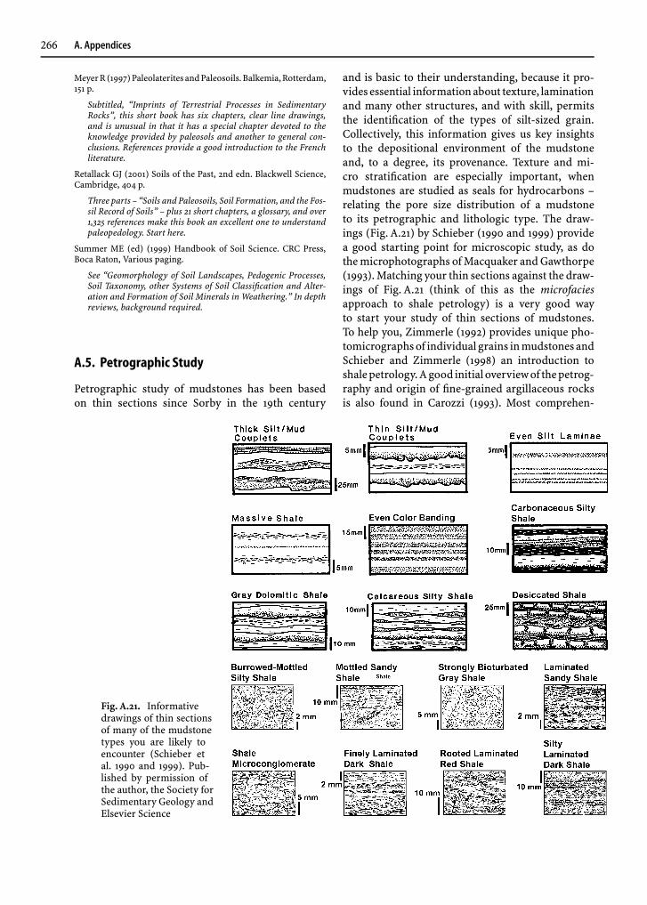
Fig. A.21. Informativedrawings of thin sectionsof many of the mudstonetypes you are likely toencounter (Schieber etal. 1990 and 1999). Pub-lished by permission ofthe author, the Society forSedimentary Geology andElsevier Science
and is basic to their understanding, because it pro-vides essential informationabout texture, laminationand many other structures, and with skill, permitsthe identification of the types of silt-sized grain.Collectively, this information gives us key insightsto the depositional environment of the mudstoneand, to a degree, its provenance. Texture and mi-cro stratification are especially important, whenmudstones are studied as seals for hydrocarbons –relating the pore size distribution of a mudstoneto its petrographic and lithologic type. The draw-ings (Fig. A.21) by Schieber (1990 and 1999) providea good starting point for microscopic study, as dothe microphotographs of Macquaker and Gawthorpe(1993). Matching your thin sections against the draw-ings of Fig. A.21 (think of this as the microfaciesapproach to shale petrology) is a very good wayto start your study of thin sections of mudstones.To help you, Zimmerle (1992) provides unique pho-tomicrographsof individual grains inmudstones andSchieber and Zimmerle (1998) an introduction toshalepetrology.Agood initial overviewof thepetrog-raphy and origin of fine-grained argillaceous rocksis also found in Carozzi (1993). Most comprehen-

A. Appendices 267
Fig. A.22A,B. Electronic imaging:(A) Clay fabric deformed about veryfine, scattered quartz silt grains in De-vonian Shale at Palmer Glenn nearRochester, NY (Image courtesy of NealO’Brien) and (B) back-scattered elec-tron images (BSEI) from a Cretaceousshale from offshore Brazil (Courtesy ofPETROBRAS)
sive, however, and very well illustrated, is the atlasof O’Brien and Slatt (1990) with its many coloredillustrations each accompanied by an extended in-terpretation. X-radiography of the rocks from thesampled interval always goes far to place the thinsection in its correct depositional setting. Ultra thin,wedge-shaped and polished sections of mudstonesaid study of thin sections with the petrographic mi-croscope (Newtwich and Yale 1991) and with many ofthe techniques of Fig. A.1.
Other techniques build upon insights obtainedfrom optical petrographic study. These include theScanning Electron Microscope (SEM) to define fine-scale clay fabrics (Fig. A.22A) and BackscatteredElectron Microscopy (BSE), which is becoming moreand more routine to identify the mineralogy of indi-
vidual particles. Back Scatter techniques also imagethe form, orientation, texture, and internal structureof single grains (Fig. A.22B).
Special mention needs to be made of heavy miner-als inmudstones.Rarely studied, theymaybe thebestprovenance indicator of a mudstone, because the lowpermeability of mudstones shields heavy mineralsfrom much, perhaps even most, solution after burial.See Totten et al. (1998) for a comprehensive studyand Commeau et al. (1992) for the methodology ofseparation.
Bulk techniques are commonly used to supple-ment information gained from the above petro-graphic ones, which focus on particles. These includebulk mineralogy determined by powder X-rays,diffraction, clay mineralogy (using oriented slides
268 A. Appendices
coated with <2 micrometers clay), major elementchemistry from X-ray fluorescence, and Rock-Evalanalysis to determine total organic carbon (TOC).Mineral composition from bulk chemical analyses isalso possible. See Tucker (1988) for a summary of theabove techniques.
References
Carozzi AV (1993) Sedimentary Petrography. PTR Prentice Hall,Englewood Cliffs, NJ, 263 p
Commeau JA, Poppe LJ, Commeau RF (1992) Separation and iden-tification of the silt-sized heavy mineral fraction in sediments.US Geological Survey Circular 1071:13
Macquaker JHS, Gawthorpe RL (1993) Mudstone lithofacies inthe Kimmeridge Clay Formation, Wessex Basin, SouthernEngland: Implications for the origin and controls of thedistribution of mudstones. J Sediment Petrol 63:1129–1143
O’Brien NR, Slatt RM (1990) Argillaceous Rock Atlas. Springer,Berlin Heidelberg New York, 141 p
Pike J, Kemp AES (1996) Preparation and analysis techniques forstudies of laminated sediments. In: Kemp AES (ed) Paleocli-matology and Paleoceanography from Laminated Sediments.Geol Soc (Special Publication) 116:37–48
Schieber J (1990) Significance of styles of epicontinental shalesedimentation in the Belt Basin, Mid-Proterozoic of Montana,USA. Sediment Geol 69:297–312
Schieber J (1999) Distribution and deposition of mudstone faciesin the Upper Devonian Sonyea Group of New York. J SedimentRes 69:909–925
Totten MW, Hanan MA (1998) The accessory-mineral fractionof mudrocks and its significance for whole-rock geochem-istry. In: Schieber J, Zimmerle W, Sethi P (eds) Shales andMudstones, Part II. E. Schweizerbart’sche, Stuttgart, pp 35–53
Tucker M (1988) Techniques in Sedimentology. Blackwell, Oxford,394 p
Zimmerle W (1992) Thin-section petrography of argillaceousrocks. Zentralablatt Geologie Paläontologie Part 1 5:365–390
Digging Deeper
Dawson WC (2000) Shale microfacies: Eagle Ford Group(Cenomanian-Turonian) North Central Texas outcrops and sub-surface equivalents. Gulf Coast Association Geological SocietiesTransactions 50:607–621.
Good example of what is needed for understanding seals. Seealso Schieber (1990 and 1999) in References Cited.
O’Brien, Neal, Slatt, Roger M (1990) Argillaceous Rock Atlas.Springer, Berlin Heidelberg New York, 141 p.
All who are going to describe mudstones petrographically andrelate their results to the geologic setting of the mudstone needto have this atlas. Why? Because its 10 chapters provide manycase histories with photomicrographs as well as methodology.Included are 40 colored photomicrographs, many black andwhite ones, plus SEM photomicrographs of mudstone fabricsand compositions of the studied units.
A.6. Organic Matter
The organic content of mudstones ranges from lessthan 0.2 to 0.5% (all maroon and red ones plus manygray ones) to more than 15 to 25% for some dark
gray to black shales. This organic matter has beenstudied extensively both chemically and optically tolearn about the initial conditions of its depositionand its later burial history (Table A.6). The terminol-ogy used in the study of organic matter is complex,in part because of the nature of the material, but alsobecause terminologies differ in different fields – geo-chemists use the term kerogen, organic petrologistsusing mostly reflected light employ the term maceral(Latin, macerare), and palynologists use biologicalterminology. Preparation methods also vary amongthese groups. Here we follow Tyson (1995, pp 15–16;see Digging Deeper) and use the term kerogen for allthe organic matter in sedimentary rocks that is insol-uble in organic solvents such as chloroform, carbondisulfide, etc. Kerogen is also defined chemically asall the high-oxygen pyrobitumens other than peatand coal that occurs in sediments and sedimentaryrocks (Killops and Killops 1993, pp 106–118).
In more detail, the types of organic matter, calledkerogen I, II, III or IV (Fig. A.23), provide informa-tion about its source: was the organic matter derivedfrom land plants or from the marine realm. The sed-imentology of this debris – its size, sorting, andabrasion – help us reconstruct its abrasion historyand thus better understand the final depositionalenvironment (Tyson 1995; see Digging Deeper). Inaddition, both the color and reflectance of the par-ticulate organic matter provide information aboutburial history, a key factor in petroleum exploration:will theorganic matter yieldmostly CO2 andH2O, gasor oil or is it already depleted in these volatiles? Theabundance of particulate organic matter in a mud-stone is also the prime determinant of its color. Insum, the preserved organic matter of a mudstonepermits us to fine-tune its environment of deposition(paleoxygen levels and source and sedimentology ofits organic particles). But even more useful to us, thestudy of kerogen provides insights to temperaturehistory during its burial and thus better appraise
Table A.6. Importance of organic matter in muds (Adaptedfrom Tyson, 1995, Table 1.1)
• Biochemical reactivity critical for bacterially controlled(affected) early diagenesis
• Major influence on Eh of both water and mud• Affects food quality for deposit feeders• Controls amount and type of potential hydrocarbons
and some sulfide deposits• Helps assess original depositional environment
including separation of marine from nonmarinemudstones

A. Appendices 269
Fig. A.23. Kerogen types de-fined by hydrogen index,H/C, and oxygen index O/C,(after Hunt 1996, Fig. 10–5)and as defined by contentsof hydrogen and oxygen (af-ter Cornford 1990, Fig 11.7).Published by permission ofthe authors, W.H. Freemanand Blackwell Scientific
a mudstone for its value as a source rock. Belowwe present the needed background to initially un-derstand and appreciate these techniques, becausetoday the comprehensive study of a mud or mudstonenearly always includes at least some of them.
Table A.7A. Types of kerogen (Waples 1985, Table 4.1).[Published by permission of the author and IHRDC]
Maceral Kerogen SourceType
Alginite I Fresh-water algaeExinite II Pollen, sporesCutinite II Land-plant cuticleResinite II Land-plant resinsLiptinite II Land-plant lipids; marine algaeVitrinite III Land-plants wood and celluloseInertinite IV Charcoal; oxidized material
Table A.7B. Kerogen maturation (after Hunt 1996, Fig. 10.38). Published by permission of W.H. Freeman
Tmax (◦C) Vitrinite Kerogen Wt.% C Coal Rankreflectance color
50 0.2–0.5 Yellow 65–75 Lignite-Subbituminous50–100 0.5–1.0 Orange 75–83 High-volatile bituminous
100–140 1.0–1.5 Light brown 83–87 Medium-volatile bituminous140–170 1.5–1.9 Brown 87–88 Low-volatile Bituminous170–200 1.5–2.5 Dark rown 88–90 Semianthracite200–250 2.5–4.0 Black 90–95 Anthracite
> 250 > 4. 0 Black > 95 Meta-anthracite
Background: All organic matter is mainly com-posed of carbon, oxygen, and hydrogen. Thismaterial is divided into five groups: carbohydrates,proteins, lipids, lignins, and pigments.
In continental water bodies and in marginal seas,organic matter covers a continuous size spectrumranging from free small molecules on one extremeto macromolecules, aggregates, and living organismson the other. By arbitrary convention, organic matteris separated into particulate (organic material re-tained on a 0.5–1.0 µm pore-size filter) and dissolved(organic material passing on to the filtrate) fractions.
Particulate organic matter, produced either in thewater column or on land, is divided into living (i. e.,bacteria, plankton)andnon-living,detrital fractions.Most of the living fraction is rapidly recycled alongwith some of the detritus that has not been subjectedto significant bacterial reworking. Carbohydrates,lipids, proteins, etc. make up this fraction, generallyidentified as labile organic matter in opposition to

270 A. Appendices
the refractory fraction, which resists chemical breakdown. Accordingly, particulate organic matter ina mud or mudstone can originate from either in situbiological production or be derived from a sourcearea.
Techniques: Organic solvents are used to sepa-rate the several kinds of organic matter present inmudsandmudstones.Thepart thatdissolves is calledbitumen, whereas the insoluble part is called pyrobi-tumen or kerogen. Kerogen is concentrated in coalsand oil shales, but is also present in virtually all fine-grained sedimentary rocks. It is the most commonorganic material on Earth and is present in mostmudstones, most abundantly in oil shales. Kerogenhas been divided into four types that are defined byboth chemical and microscopic study (Table A.7).
The total organic matter of a mudstone, TOC forshort, is determined by LECO combustion or byROCK-EVAL pyrolysis in the laboratory and alsois approximated by a gamma ray, density, or soniclog (if more than 4%) and very, very roughly bymudstone color (with much local experience!). TheRock-Eval procedure also is used to determine thekerogen types in terms of the hydrogen index, HI(mg hydrocarbons|g organic C) and the oxygen in-dex (mg CO2|g organic C). Determining total organicmatter is the first step in the study of the organicmatter of a mudstone followed by its kerogen types,reflectance, and the sedimentology of its particles.
Processes: The composition and physical proper-ties of kerogen change in a systematic way with timeand temperature during burial. During this process,known as kerogen maturation, lighter molecules arefirst driven off as gas and later, as heavier moleculesare liberated, to form oil and finally dry gas. Becausethe maturation process is not reversible, geologistscan map and study the thermal evolution of a mud-stone in a basin by using the downhole changes inthe chemical and physical properties of kerogen. Ingeneral, as kerogen matures with temperature, it be-comes darker just like a piece of toast (Table A.7).This evolution is made quantitative by a microscopictechnique called vitrinite reflectance (Waples 1985,pp 87–88; Taylor et al. 1998, pp 372–391). Reflectedlight and polished sections are standard to identifyand count the different proportions of particles, themacerals, in organic-rich shales and coals. Organicmatter is also profitably studied with the ordinarypetrographic microscope by noting its concentra-tion, size distribution, abrasion, biological affinities,and color in muds and mudstones, much as sedi-mentologists study and analyze individual particlesof terrigenous and carbonate silts and sands (See
Tyson 1995, Table 25-2 in Digging Deeper). Collec-tively, all of the above petrographic techniques arecalled organic petrology and rare is the mud or mud-stone whose understanding is not expanded by theiruse along with determination of total organic carbonand the hydrogen and oxygen indices.
The variations of both total organic carbon andits kinds in muds and mudstones are closely linkedto relative sea level (sequence stratigraphy), bottomoxygen levels, and rate of sedimentation in muddybasins (Creaney and Passey 1993). Porosity and re-sistivity logs provide initial information about theorganic content of mudstones, when cores are notavailable (Passey et al. 1990). See Wüst and Bustin(2003) for more details on maturation of organicmatter with burial.
References
Cornford C (1990) Source rocks and hydrocarbons of the NorthSea. In: Glennie KW (ed) Introduction to Petroleum Geologyof the North Sea, 3rd edn. Blackwell, Oxford, pp 291–361
Creaney S, Passey QR (1993) Recurring patterns of totalorganic carbon and source rock quality within a se-quence stratigraphic framework. Am Assoc Petrol Geol Bull77:386–401
Hunt JM (1996) Petroleum Geochemistry and Geology, 2nd edn.Freeman, San Francisco, 743 p
Killops SD, Killops VJ (1993) An Introduction to Organic Geo-chemistry. LongmanScientificandTechnical, Singapore, 265p
PasseyQR,CreaneyS,Kulla JB,Moretti FJ, Stroud JD(1990)Aprac-tical model of organic richness from porosity and resistivitylogs. Am Assoc Petrol Geol Bull 74:1777–1794
Taylor GH, Teichmüller M, Davis A, Diessel CFK, Littke R, Robert P(1998) Organic Petrology. Gebrüder Borntraeger, Berlin, 704 p
Wûst RAJ, Bustin RM (2003) Kerogen. In: Middleton GV (ed)Encyclopedia of Sediments and Sedimentary Rocks. KluwerAcademic, Dordrecht, pp 400–403
Waples DW (1985) Geochemistry in Petroleum Exploration.IHRDC, Boston, 232 p
Digging Deeper
Peters KE, Moldowan JM (1993) The Biomarker Guide. PrenticeHall Englewood Cliffs, NJ, 363 p.
We welcomed our discovery of this book, because it does justwhat we needed – it gave us insight to what biomarkers cando (learning mode) and provides the already knowledgeablewith detailed, technical information (selected access mode). Toachieve these goals the book has four parts: an introduction,procedures, guidelines to interpretations, and future problems.
Tyson RV (1995) Sedimentary Organic Matter. Chapman and Hall,London, 615 p.
Aided by a clearly written text plus many informative tablesand figures, the 25 chapters of this book provide one of the bestinsights to organic matter in sediments available. Especiallyvaluable are the Introduction with its many informative tables,the thorough integration of biology and sedimentology, and thefine set of color plates to guide identification of organic particles.The chapter on carbon isotopes is particularly helpful.

A. Appendices 271
A.7. Isotopes:The Stable Isotopes of C, O, H, S, and N
Isotopes are one, two or more species of a chemi-cal element that have slightly different chemical andphysical properties, because of small differences inmass related to different numbers of neutrons. Iso-topes may be stable (non-radioactive) or unstable(radioactive).
Five light elements with stable isotopes are widelyused for the study of muds and mudstones: C, O, H,S, and N. All of these isotopes vary sufficiently andhave been studied enough to provide fairly standardpatterns of interpretation. Hence, stable isotopes areone of the foremost geochemical methods of studyof mud and mudstones, particularly for their minorcarbonates. Two additional reasons for their studyare that they are relatively inexpensive to determineand that only a few grams are needed. The study ofstable isotopes in sedimentary geology only startedafter World War II.
In nature, chemical, physical, or biological pro-cesses cause some isotopes of C, O, H, S, and Nto change in their relative abundance thus causingsmall differences in their isotopic ratios. Althoughevaporation and diffusion are important in specificsituations, most significant fractionations are con-trolled by biological or chemical reactions. Typically,because of differences in mass, two isotopes of anelement will be fractionated during an exchange re-action between two phases as for example, air andwater or solid and water. Hence, their isotopic ratioswill be different in each phase. Another example isthe change of the carbonate 18O|16O ratio with tem-perature. This allows the determination of oceanicpaleotemperature differences of less than 1 ◦C in car-bonate material formed by inorganic or biological
Table A.8. δ 13C in various reservoirs (adapted from Degens1989, Fig. 11.19)
Reservoir/Material δ 13C (‰)
Atmospheric CO2 −6 to −10Freshwater H2CO3 −4 to −14Kerogen −22 to −27Marine carbonates (inorganic) +2 to +7Marine carbonates (biogenic) −4 to +3. 5Fresh water carbonates −2 to −12. 5Methane (Mesozoic) −32 to −54Methane (Quaternary) −56 to −82
precipitation. This was the first extended geologicuse of stable isotopes (Urey 1947).
Ratios of stable isotopes are expressed as δ values,in parts per thousand (‰) and are related to specificstandards:
δ(‰) =[
isotopic ratio of sampleisotopic ratio of standard
−1]
× 103 .
Ratios are expressed as the heavier to the lighterisotopes; e. g., 18O|16O, and the δ value is the rela-tive difference between a sample and an arbitrarystandard: a higher ratio in the sample comparedto the standard yields a positive (heavier) number,whereas a lower ratio yields a negative (lighter) num-ber (Fig. A.24). See Longstaffe (2003) for a recentconcise overview.
Carbon: Carbon is the major element in the bio-sphere, but it occurs also in the atmosphere, thelithosphere, and the hydrosphere of the Earth. Inmud and mudstones, carbon is the major compo-nent of organic matter and of carbonate minerals.Two stable isotopes of carbon, 12C and 13C are widelyemployed to differentiate carbon sources in mud andmudstones (Table A.8). The fractionation of carbonisotopes separates carbon with a biogenic origin (de-pleted in 13C) from carbon in equilibrium with theatmosphere (enriched in 13C). During photosynthe-sis, for example, plants utilize more of the lighter 12Cthan the heavier 13C; in other words, they discrimi-nate against 13C in favor of 12C. As a result, the 13C|12Cratio of biogenic material is lower than that of atmo-spheric CO2. Consistent with their derivation frombiogenic matter, fossil fuels are depleted in 13C.
Natural fractionation processes determine a vari-ation of almost 150‰ in the stable isotopicratio, heaviest being a carbonate from a me-teorite (δ 13C = +60‰), and lightest a bacterialmethane (δ 13C = −90‰). Numerous authors havedocumented the partitioning of carbon along its bio-geochemical pathways. The ranges of δ 13C rangesfor various carbon-bearing materials have beenextensively summarized (e. g., Degens 1989; Faure1986).
Stable carbon isotopes are currently used to studyboth ancient and modern organic matter in variedbiogeochemical systems (e. g., Gearing et al. 1984;MookandTan 1991;Altabet 1996). Suchdata ishelpfulin evaluating attempts to use stable isotopes to tracecarbon in systems having two or more isotopicallydistinguishable sources. An example is the use ofδ 13C variations to track the proportion of marineand terrestrial carbon or to track carbon from C4plants like grasses.
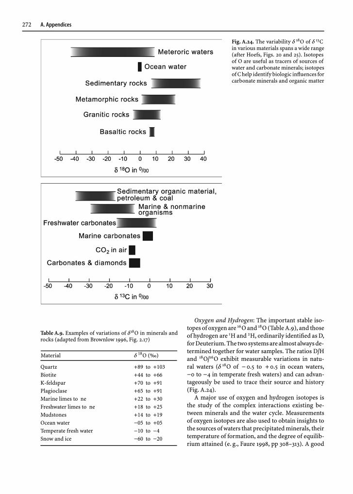
272 A. Appendices
Fig. A.24. The variability δ 18O of δ 13Cin various materials spans a wide range(after Hoefs, Figs. 20 and 25). Isotopesof O are useful as tracers of sources ofwater and carbonate minerals; isotopesof C help identify biologic influences forcarbonate minerals and organic matter
Table A.9. Examples of variations of δ18O in minerals androcks (adapted from Brownlow 1996, Fig. 2.17)
Material δ 18O (‰)
Quartz +89 to +103Biotite +44 to +66K-feldspar +70 to +91Plagioclase +65 to +91Marine limes to ne +22 to +30Freshwater limes to ne +18 to +25Mudstones +14 to +19Ocean water −05 to +05Temperate fresh water −10 to −4Snow and ice −60 to −20
Oxygen and Hydrogen: The important stable iso-topes of oxygen are 16O and 18O (Table A.9), and thoseof hydrogen are 1H and 2H, ordinarily identified as D,forDeuterium.The twosystemsarealmostalwaysde-termined together for water samples. The ratios D|Hand 18O|16O exhibit measurable variations in natu-ral waters (δ 18O of −0.5 to +0.5 in ocean waters,−0 to −4 in temperate fresh waters) and can advan-tageously be used to trace their source and history(Fig. A.24).
A major use of oxygen and hydrogen isotopes isthe study of the complex interactions existing be-tween minerals and the water cycle. Measurementsof oxygen isotopes are also used to obtain insights tothe sources of waters that precipitated minerals, theirtemperature of formation, and the degree of equilib-rium attained (e. g., Faure 1998, pp 308–313). A good

A. Appendices 273
Table A.10. Sulfur isotopes and sedimentation rates
Relationship from modern sediments: log ω = 1.33 − 0.042 ∆δ 34Swhere ω = sedimentation rate in cm|yr and ∆δ 34S = δ 34Ssulfate − δ 34Spyrite
δ 34S, permil ∆δ 34S, permil ω, cm|yr Ratio
Devonian-Mississippian mudstones of Appalachian Basin1
Seawater sulfate +17Pyrite in highstand gray mudstones +11.6 5.4 13Pyrite in transgressive black shales −8.9 26 1.8
Relative rate 7.3
Nearshore and offshore black shales of the Illinois Basin2
Seawater sulfate +15Pyrite in nearshore black shales −10.0 25 1.9Pyrite in offshore black shales −14.5 30 1.2
Relative rate 1.5
Cretaceous of western Canada3
Seawater sulfate +17Pyrite in highstand mudstones −16 0 33 0.88Pyrite in transgressive shales −27 0 44 0.30
Relative rate 2.9
Sources: 1Maynard, 1980; 2Coveney and Shaffer, 1988; 3Bloch et al. 1999; Seawater sulfate values from Holser et al. 1988,Fig. 4.7
example is the already mentioned development byHarold C. Urey (1947) of a paleo-thermometer basedon the isotope composition of oxygen in marinecalcite and aragonite. Another application is the re-action between feldspar and acidified meteoric waterto form clay minerals that takes place in the presenceof an excess of water. The water/rock ratio is large,and so clay minerals and hydroxides formed dur-ing weathering are normally in isotopic equilibriumwith local meteoric water (Faure 1986, pp 477–481).Clay minerals formed on land and redeposited inthe oceans – like other detrital minerals associ-ated with clays, for example, in marine mud – donot equilibrate isotopically at the time of deposi-tion. Instead they preserve the isotopic signatureacquired at their formation, although their oxygenisotope composition appears to be reset at 300 ◦Cor more (O’Neil and Kharaka 1976). On the otherhand, hydrogen may undergo retrograde exchangewith meteoric water at lower temperatures (Kyserand Kerrich 1991).
The original standard for oxygen and hydrogenisotopes (Craig 1961) was a hypothetical water sampleknown as SMOW (Standard Mean Ocean Water), butnew standards, such as V-SMOW and SLAP (Stan-dard Light Antarctic Precipitation) are currentlybeing used.
There is a linear relationship between δD and δ 18Ofor present-day meteoric waters
δD = 8δ 18O+10
which defines a line, known as the meteoric water line(MWL). The model that describes the condensationprocesses that defines the MWL is known as Rayleighisotopic fractionation. Because the isotopic composi-tions of clay minerals formed at surface temperaturesare controlled by the isotopic composition of mete-oric water, it follows that the isotopic compositionsof clay minerals formed at a particular temperatureshould be related by equations similar to the one forthe MWL.
Sulfur: There are four stable isotopes of sulfur, 32S,33S, 34S, and 36S. The most abundant isotopic species,with 95.02% and 4.21% respectively, are 32S and 34S.The 32S|34S ratio is usually measured, and the isotopiccompositionof sulfur is commonlyexpressedasδ 34S,in amanner similar toother stable isotopes.The stan-dard value (δ 34S = 0‰) of 32S|34S = 22. 22 has beenmeasured in the Cañón Diablo troilite. The troilitephase of other meteorites show only slight variationsfrom this standard value. Igneous rocks also tendto be close to this value, indicating derivation fromchondritic-type material with little fractionation byprocesses within the Earth’s mantle.

274 A. Appendices
Sulfur isotopic fractionation occurs primar-ily in oxidation-reduction reactions, which canbe either entirely inorganic or complex, multi-step biologically-mediated processes. Isotopic valuesof sulfides in sedimentary rocks range from−45‰ < δ 34S < +42‰ so there is ample varia-tion of isotopic composition. This probably reflectsa wide variety of processes and conditions. Sul-fides in igneous rocks show a much narrower rangeof values, −2‰ < δ 34S < +10‰ (Brownlow 1996,pp 101–109).
Because of bacterial sulfate reduction, hydrogensulfide and iron sulfide minerals in Recent marinemuds are depleted in 33S when compared to theheavier values of contemporary sulfate of overlyingwaters. Thus the sulfur that has passed through thesedimentary cycle shows increased variability inδ 34Sbecause of this separation into light sulfide and heavysulfate minerals. The degree of separation is a func-tion of the sedimentation rate of the mud: the fasterthe sedimentation rate, the faster the bacteria work,and the less they fractionate sulfur isotopically. Byapplying this relationship to ancient mudstones, therelative sedimentation rates of different facies can becalculated (Table A.10).
Nitrogen: Nitrogen plays an important role inthe biological world and has two stable isotopes,14N and 15N. These, as with carbon isotopes, havebeen used to trace the source of organic matter inmodern muds and in coal and petroleum. The at-mospheric relative abundance of these isotopes is99.64% and 0.36%, respectively. The isotopic compo-sition of samples is usually expressed as δ 15N. The N2
of the atmosphere is used as a standard with a valueof 0‰.
Marine organisms have δ 15N between +4‰ and+20‰; whereas terrestrial organisms have δ 15N be-tween −8‰ and +15‰. These differences have beenused, for instance, to determine the relative contri-butions of terrestrial and marine organic nitrogen tomarine mud (e. g., Schäfer and Ittekkot 1993). Like-wise, the isotopic composition of N in coal variesfrom −2.5‰ to +6.3‰, depending on the origin ofthe organic material and on the rank of the coal. Coalderived from terrestrial plants has lower δ 15N valuesthan coal formed from zooplankton and phytoplank-ton. Petroleum δ 15N values range from +0.7‰ to+8.3‰ indicating that N isotopes are not appre-ciably fractionated by denitrification, and that they
carry thesignatureof thebiogenic sourceofoil (Faure1986, pp 519).
References
Altabet MA (1996) Nitrogen and carbon isotopic tracers of thesource and transformation of particles in the deep sea. In:Ittekkot V, Schäfer P, Honjo S, Depetris PJ (eds) Particle Fluxin the Ocean, SCOPE 57. Wiley, New York, pp 155–184
Bloch JD, Schröder-Adams CJ, Leckie DA, Craig J, McIntyre DJ(1999) Sedimentology, micropaleontology, geochemistry, andhydrocarbon potential of shale from the Cretaceous LowerColorado Group in western Canada. Geological Survey ofCanada Bulletin 531:185
Brownlow AH (1996) Geochemistry, 2nd edn. Prentice-Hall,Englewood Cliffs, New Jersey, 580 p
Coveney RM, Shaffer NR (1988) Sulfur-isotope variations in Penn-sylvanian shales of the midwestern United States. Geology16:18–21
Craig H (1961) Standard for reporting concentrations of deuteriumand oxygen-18 in natural waters. Science 133:1833–1834
Degens ET (1989) Perspectives on Biogeochemistry. Springer,Berlin Heidelberg New York, 423 p
Drever JI (1997) The Geochemistry of Natural Waters, Sur-face and Groundwater Environments, 3rd edn. Prentice-Hall,Englewood Cliffs, New Jersey, 436 p
Faure G (1986) Principles of Isotope Geology, 2nd edn. Wiley, NewYork, 589 p
Faure G (1998) Principles and Applications of Geochemistry, 2ndedn. Prentice Hall, Englewood Cliffs, New Jersey, 600 p
Gearing JN, Gearing PJ, Rudnick DT, Requejo AG, Hutch-ings MJ (1984) Isotopic variability of organic carbonin a phytoplankton-based, temperate estuary. GeochimCosmochim Acta 48:1089–1098
Hoefs J (1997) Stable Isotope Geochemistry, 4th Edn. Springer,Berlin Heidelberg New York, 201 p
Holser WT, Schidlowski M, MacKenzie FT, Maynard JB (1988)Biogeochemical cycles of carbon and sulfur. In: Gregor CB,Garrels RM, MacKenzie FT, Maynard JB (eds) Chemical Cyclesin the History of the Earth. Wiley, New York, pp 105-174
Kyser TK, Kerrich R (1991) Retrograde exchange of hydrogenisotopes between hydrous minerals and water at low tempera-tures. In: Taylor HP, O’Neil JR, Kaplan IR (eds) Stable IsotopeGeochemistry. A Tribute to Samuel Epstein. The GeochemicalSociety (Special Publication) 3:409–422
Longstaffe F (2003) Isotopic Methods in Sedimentology. In: Mid-dleton GV (ed) Encyclopedia of Sediments and SedimentaryRocks. Kluwer Academic, Dordrecht, pp 385–397
Maynard JB (1980) Sulfur isotopes of iron sulfides in Devonian-Mississippian shales of the Appalachian Basin: Control by rateof sedimentation. Am J Sci 280:772–786
Mook WG, Tan FC (1991) Stable carbon isotopes in rivers andestuaries. In: Degens ET, Kempe S, Richey JE (eds) Biogeo-chemistry of Major World Rivers, SCOPE 42. Wiley, New York,pp 245–264
O’Neil JR, Kharaka YK (1976) Hydrogen and oxygen isotope ex-change reactions between clay minerals and water. GeochimCosmochim Acta 40:241–246
Schäfer P, Ittekkot V (1993) Seasonal variability of δ15N in set-tling particles in the Arabian Sea and its palaeogeochemicalsignificance. Naturwissenschaften 80:511–513
Urey HC (1947) The thermodynamic properties of isotopicsubstances. Journal Chemical Society 1947:562–581

GlossaryVocabulary is half the battle
Below are many terms useful in the study of muddysediments and rocks. Some terms are related to thetheory and study of sedimentary and burial pro-cesses, others are used for field, petrographic, orengineeringdescriptionsandsomeareused in indus-trial applications. For more terms and additional in-sights consult Jackson (1997) and Middleton (2003).
A-horizon Uppermost, organic-rich layer of soil.May have subdivisions. Transition to underlyingB-horizon may be abrupt, transitional, planar orirregular.
Abandonment facies Refers to the fill of an aban-doned chute, channel, or canyon, principally byfines deposited from suspension.
Absorption Uptake of a chemical substance intothe interior of a solid. Especially characteris-tic of 2:1 clay minerals and zeolites. Dominantlya physical process. Compare adsorption.
Abyssal Water depths in the ocean greater than1,000 m; depths with temperatures of 4 ◦C or less.
Accommodation Space available for deposition;depends on interaction of tectonic subsidence,terrigenous supply, compaction, submarine to-pography, and sea or lake level.
Adobe Widely used term for sun-dried brick madeof mud and silt.
Adsorption Trapping or adherence of ions or or-ganic molecules in solution to the broken bondsof a surface with which they are in contact.Dominantly a chemical process.
Advection The lateral flow of a fluid.Aerobic Biofacies representing normally oxy-
genated bottom water – no oxygen restrictionon fauna (Tyson and Pearson 1991, Table 2). Thecorresponding term for the environment is oxic.
Alum shale An old name for a fine-grained, car-bonaceous rock rich in alum, KAl(SO4)2 · 12 H2O,formed by the alteration of iron sulfides inorganic-rich shales. Also alum schist and slate.Cambrian Alum Shale Formation of Sweden isa famous example.
Anaerobic Lack of free oxygen. Also a biologiccommunity (mostly bacterial) that can live andgrow under these conditions (Tyson and Pearson1991, Table 2).
Anoxia Absence of dissolved oxygen in pore wateror bottom water.
Aquifer A permeable bed or formation thattransmits groundwater to wells or springs ineconomically significant quantities.
Aquitard A bed or layer that retards, but does nottotally block, the flow of water. Most mudstonesact as aquitards. Same as confining bed.
Argille scagliose An Italian term for a thick,slumped deposit of deformed, chaotic plastic clayor mudstone produced by a gravity slide.
Argillite Field term for a totally indurated mud-stone that no longer fractures or splits alongstratification.
Ash Volcanic debris finer than 2 mm and thusan important airborne contributor to manymudstones along active margins.
Attapulgite Industrial (trade name) for paly-gorskite.
B-horizon Intermediate zone of accumulation offine clays and colloids derived from downwardtransport from the A-horizon. Blocky, prismaticstructure is typical, as is a dense, tight tex-ture. Commonly leached. Many subdivisions. Seefragipan.
Backswamp Refers to the floodplain of a river thatis low-lying, swampy, frequentlyfloodedandcom-monly poorly drained. Major site of alluvial mudsand silts. Peats possible.
Ball clay A plastic clay mostly composed of kaoli-nite; used for its bonding properties in ceramicmaterials.
Basin floor deposits Distal fines deposited mostlyfrom suspension in the topographically lowestpart of a basin. Either subaerial or subaqueous.
Bathyal Water depths between 200 and 1,000 m.Bearing capacity The weight a soil can support be-
fore failure. The ultimate bearing capacity is the

276 Glossary
average load per unit area required to producefailure by rupture of the soil mass. The allowablebearing capacity is, on the other hand, the max-imum pressure that can be reasonably permittedon a soil.
Bed load Silt, sand and larger clasts that are pushedor pulled (rolled, slid, or saltated) along the bot-tom at a much lower velocity than the main bodyof the current. This detritus comes to rest as flatlamination, ripples, dunes, and bars. Also calledcontact load.
Beidellite A high aluminum smectite.Bentonite An altered ash fall. A fine-grained, soft
argillaceous sediment that is greasy and soap-likeand absorbs much water. Its dominant clay min-eral is smectite. Swelling bentonites are high in Na,whereas non-swelling varieties are high in Ca orK. Bentonites are deposited in the marine realmfrom volcanic ash clouds over very wide areas andthus commonly make good stratigraphic markers.Easily recognized on gamma-ray logs in carbonaterocks by their high radioactivity.
Biomarker A term applied to an organic moleculeor compound for which a biological origin canbe inferred, a molecular fossil. Biomarkers canbe used as fingerprints for depositional environ-ments (much as microfossils) and are routinelyused for typing oils and making oil-to-source rockcorrelations. Also used as thermal stress markers.Synonyms include geochemical fossils, biolog-ical markers and molecular fossils. See Philp(1985).
Biotite A trioctahedral mica whose ideal composi-tion is K(Mg, Fe)3 AlSi3O10(OH)2.
Bitumen Organic matter soluble in organic sol-vents. Principal chemical constituents are C andH, whereas O and S are minor.
Bituminous shale See oil shale.Black shale A field term for any argillaceous, fine-
grained (silt size or finer), dark-colored (black ordark gray), laminated rock rich in organic matter;e. g., an organic-rich (more than 0.5%) claystone,clay shale, etc. (See Huyck 1990). But also usedmore loosely to include fine-grained, organic-richargillaceous rocks that are not laminated; i. e.,dark, organic-rich mudstones. Many diverse ori-gins in both deep and shallow water, but all involveanoxia. The most studied of all mudstones.
Boulder clay Old name for a clay-rich glacial tillcontaining striated boulders.
Brown clay A fine-grained, oxidized, deep-oceanpelagic sediment with less than 30% microfos-sils.Totally lackscalcareous skeletals, because they
have been dissolved, but may contain siliceousones.
Brucite A Mg hydroxide that is a structuralcomponent of some trioctahedral micas and clays.
Burial curve See depth-subsidence curve.C-horizon Lowermost soil horizon consisting of
altered oxidized bedrock, somewhat leached.CIA index The Chemical Index of Alteration, an
index of chemical weathering based on the for-mula [Al2O3|(Al2O3 +CaO∗ +Na2O+K2O)]× 100,where CaO∗ equals total CaO minus that in calcite,dolomite, andapatite. Scale ranges from100 (com-plete weathering) to about 50 (depending on thesource rock).This formula emphasizes the conver-sion of feldspar to clays. See also the ICV index,Index of Compositional Variability.
Cannel coal An oil shale, dull black to brownishblack, that contains abundant liptinite derivedfrom spores and pollen.
Catagenesis The intermediate stage of alteration oforganic matter that thermally degrades kerogento produce oil and wet gas (Tissot and Welte 1984,pp 71–73).
Cation exchange capacity, CEC Number of chem-ical equivalents per unit weight of dry clay(milliequivalents per 100 grams). Measures theconcentration of unfixed cations in interior andsurface layers of a clay mineral. These unfixedions can exchange with a solution and thus CECis a measure of the “reactivity” of clay. A keyparameter for many environmental applications.
Chemical fossil See biomarker.China clay Industrial term for a residual Fe-poor
clay composed mostly of kaolin, is very inert, andgives a white color to both fired and non-firedmaterials.
Chlorite group A mica-like mineral with an addi-tional octahedral layer in the interlayer positionand therefore a somewhat variable chemistry.
Clay Three common usages. (1) A textural term fora fine-grained sediment with appreciable materialsmaller than 4 microns (sedimentology) in whichclay minerals and silt-sized quartz and feldsparpredominate. May or not be organic- or carbonaterich. (2) A fine-grained soil that exhibits plasticitywithin a range of water contents, but when dried,exhibits considerable strength (soil mechanics).(3) A fine-grained deposit consisting predomi-nantly of clay minerals such as illite, smectite,kaolinite, etc. (mineralogical viewpoint).
Clay belt A linear to ovate area, where clay-richsediment predominates at the surface. Diverseorigins glacial lake bottoms formed between

Glossary 277
a topographic barrier and an ice sheet, coastaldeposits of tidal origin, or the flood deposits ofa low-gradient stream.
Clay breccia A breccia with a clay matrix.Commonly results from overpressuring.
Clay curtain A thin sheet of clay draped over depo-sitional topography. Common in fluvial and tidalenvironments. Also clay or mud drape.
Clay dike A dike consisting of clay or mudstone;commonly associated with mud or mudstonediapirs.
Clay dune An eolian dune formed by grains orpellets of clay (Coffey 1909).
Clay factory Analogous to the carbonate factoryof carbonate sedimentology, the term clay fac-tory refers to the ultimate source of clay minerals,chemical weathering in soils.
Clay ironstone An iron-impregnated mudstone,argillaceous siltstone, or fine-grained sandstone;commonly consists of siderite when fresh, buthematitic when weathered. Typical as nodules,concretions, or thin beds.
Clay pebble conglomerate A conglomerate com-posed essentially of clasts of subrounded clayor mudstone locally eroded; common in fluvialdeposits and many proximal turbidites.
Clay plug An abandoned channel, straight orcurved, filled largely with clay or mudstone.Common in meandering stream deposits.
Clay skins Coats of clay-sized material that occuron grains, aggregates or peds mostly in soils, seealso cutans.
Clayshale An indurated, fine-grained rock com-posed of more than 66% clay-sized constituentswith stratification less than 10 mm. See also Folk(1954, Table 20) and Lewan (1978, Fig. 1).
Claystone An indurated, fine-grained rock com-posed of more than 66% clay-sized constituents.See also Folk (1954, Table 2).
Clinoform Subaqueous deposit with consistent,internal, inclined beds formed by deposition pro-grading into deeper water. This deposit, firstproposed by Rich (1951, Fig. 1), defines a pale-otopography and thus the direction of infillingof a basin. Recognition of clinoforms is essen-tial for understanding the architecture and historyof filling of muddy basins and for the studyof seismic stratigraphy. Many varieties recog-nized in seismic stratigraphy such as sigmoid,oblique, sigmoid-oblique, complex, shingled, andhummocky (Mitchum et al. 1977, Fig. 6).
Cohesion Technically defined as the shear strengthof soil or sediment inexcessof thatproducedby in-
terparticle friction. Less technically, the tendencyof any fine-grained material to stick together.
Condensed section Thin, time-rich, distal strati-graphic units deposited during slow sedimen-tation at maximum landward migration ofthe shoreline (maximumtransgression/maximumrelative sea level rise). Equivalent beds are thickerand closer to basin margin. Commonly identi-fied by high radioactivity and diverse pelagicfauna, but may also have hard grounds, fossillags, pyrite, etc. Key element when using sequencestratigraphy to study mudstones.
Confining bed (layer) Term used to describe a layerof low permeability sediment, commonly argilla-ceous, that restricts groundwater flow. Same asaquitard.
Conodont alteration index, CAI Color changes ofconodonts from light yellow to dark brown andblack reflect increasing burial temperatures. Mostuseful in Paleozoic sediments that have passed thepeak of oil generation (Epstein et al. 1977).
Consolidation (compaction) The gradual reduc-tion of the volume of a sediment resulting from anincrease in compressive stress and the expulsionof fluid from its pores and rotation of frameworkgrains into more stable configuration.
Corg content Shorthand for total organic carbon ina sediment.
Corrensite A regularly interstratified mixed-layerclay mineral containing chlorite and smectite.Named after a famous German petrologist.
Cutans Soil term for thin films of clay deposited onfree surfaces within a soil.
Cyclopel A name proposed by Mackiewicz et al.(1984, p. 129) for diurnal interlaminations of finesand or silt followed by clay produced by glacialdischarge. Base of silt or sand is sharp and over-lying mud poorly sorted. Lithified equivalent iscyclopelite.
Degree of pyritization, DOP A simple quantitativemeasure of pyrite abundance whose variation isrelatable to the oxygen level of the sediment; highvalues correspond to restricted and inhospitablebottoms (Berner 1970; Raiswell et al. 1988).
Depth-subsidence curve Plot of the burial historyof a formation, now an almost standard feature ofmudstone study, because it tracks burial throughtime. With this curve one can relate changes inmudstone properties to absolute ages and thus tofar distant events. Also called a geohistory curve.
Detached turbidity current A weak, low-densityturbidity current separated from the bottom bya denser body of water. The detached current trav-

278 Glossary
els along this interface to deposit a gentle rain offine silt or mud along the bottom. The resultinglaminationsarebelieved to lackgrading, tobeverycontinuous, may be as thin as a few grains of silt,and are commonly interlaminated with organic-rich facies (Stanley 1983; O’Brien 1989). See alsosuspension cascading.
Diagenesis All the secondary chemical and physi-cal changes from deposition up to metamorphismof both inorganic and organic constituents; Tis-sot and Welte (1984, p. 73), however, restricted theterm to those changes in organic matter that occurat shallow depths that transform organic matterinto methane and kerogen. See also catagenesis.
Diamicton A widely used descriptive term foran unconsolidated, poorly sorted sediment com-monly with appreciable fine-grained matrix;examples included clay-rich till, many landslidedeposits, colluvium, etc. If lithified, diamictite.
Diatomite A fine-grained, siliceous rock composeddominantly of diatoms with some admixed clays.Typical of many deep marine basins.
Dickite A member of the kaolinite group, but witha distinctive stacking (polytype) of units.
Digital sediment color analysis, DSCA A quanti-tative measure of color variation from black togray to white and thus very good to quantita-tively define rhythmically stratified, fine-grainedsediments and rocks. Also termed “gray valueanalysis”. See Milankovitch cycles.
Dispersive pressure Term used for fluid pressurein a grainflow or mudflow that support its solidswhile they are in motion. High dispersive pres-sures facilitate transport over long distances ongentle slopes andsupport large clasts andbouldersin mud and debris flows.
Downlap The convergence (pinch out) of theprograding front of a clinoform with an un-derlying surface composed of older sediments;also the “turn around” between transgressive andregressive deposits.
Dropstones Isolated or clustered clasts of diversecomposition that fell vertically or obliquely intoa fine-grained matrix; clasts rafted into deeperwater and thus dropped into fine-grained sedi-ment. The best indicator of a glacial marine orglacio-lacustrine origin of a mudstone.
Dysaerobic Impoverishedbiofacieswith someoxy-gen restriction. Develops between 0.2 to 2.0 ml|lof oxygen in bottom waters (Tyson and Pearson1991, Table 2).
Dysoxic Water low in dissolved oxygen between 0.2to 2.0 ml|l. (Tyson and Pearson 1991, Table 2)
Effective stress Difference between normal burialpressure and pore water pressure; when this pres-sure difference is zero, the sediment liquefies.Effective stress is a key parameter for under-standing soft sediment deformation and slopefailures.
Eh The oxidation potential, Eh provides a quan-titative measure of the oxidation state of anenvironment by determining the potential differ-ence between platinum and hydrogen electrodes;thus a quick and important field measurement.Also referred to as oxidation-reduction potentialor ORP.
Euxinic An environment or a basin with nomeasurable dissolved oxygen and free H2S.
Expandable clay or soil Any clay or soil thatexpands in the presence of water. See Gilgaimicrotopography.
Exaerobic A biofacies at the boundary betweenanaerobic and dysaerobic. Characterized by a fewopportunistic species proliferating in great abun-dance on bedding planes in otherwise barrenstrata or at the transition from laminated tobioturbated strata.
Facies Sum total of all observable properties ofa rock unit. Expressed another way, facies can bethought as rock units distinguished in the field bytheir origin, lithology, organic components, andstructure; e. g., the channel-fill mud facies, theoverbank facies, organic-rich facies, greenschistfacies, etc.
Fall-out or settling structures (deposits) Sedimen-tary structures or deposits made by depositionfrom suspension rather than traction; see also claydrape.
Fat clay A field term earlier much used for a claythat is plastic when wet (the CH clays of the SoilClassification System).
Fireclay Synonym for underclay.Fissility A secondary weathering property of mud-
stones that causes them to have many thin,paper-like laminations.
Flintclay Asmooth,hardkaolinitic clay thatbreakswith conchoidal fracture and slakes but little (SeeFig. 9.8B).
Floc Short for floccule.Flocculation A general term for the loose bonding
of individual flakes of clay and grains of silt insuspension to form loosely connected aggregatesor flocs. Flocs of clay-sized particles settle muchfaster than individual ones.
Floccule A cluster of loosely bound clay minerals inassociation with fine silt and organic debris held

Glossary 279
together by electrostatic forces or organic sheaths.Probably thedominantparticle that isdeposited toform most marine clays. Informally called a floc.
Fluff mud Soupy mud that absorbs wave energy(See fluid mud).
Fluidization Loss of strength sufficient to con-vert semi-consolidated deposits of mud or siltinto thick, soupy masses. Loss of strength re-sults from increase of pore water pressure orpresence of methane gas. Responsible for soft sed-iment deformation and mud flows (See effectivepressure).
Fluid mud A fine-grained, sediment-water mix-ture with a sediment concentration of more than104 mg|l. A bottom with fluid mud effectivelydampens wave energy and thus becomes a type ofenergy absorbing mud trap. Also known as slingmud (Surinam), fluff mud, and crème de vase.
Fragipan The hard, dense horizon of a soil withfine colloidal clays, clay films (cutans), blockystructure, and little organic matter. Commonlyoxidized and leached. Poor permeability im-pedes flow of water, root development, etc. Manypaleosols preserve only fragipans or C-horizons.
Fuller’s earth An industrial term for a fine-grained,non-plastic natural clay with high adsorbing ca-pacity (high surface area) commonly composedof calcium smectite as well as colloidal silicaand opal. Palygorskite may also be a component.Many industrial uses and much appreciated by petowners and those who work with grease.
Geohistory curve See depth-subsidence curve.Gibbsite An aluminum hydroxide that represents
thepenultimate stageofweathering.Amajor com-ponent of bauxite. Also a structural component ofdioctahedral micas and clay minerals.
Gilgai microtopography A characteristic weather-ing feature of expansive, smectitic clays caused bytheir high shrink-swell potential, which producesdisruptive cracks and microtopography. See Paton(1974).
Glauconite Fine grained, iron-rich dioctahedralclay mineral. Forms penecontemporaneouslyon the sea bottom during slow sedimenta-tion; distinct, greenish color is typical. Manymorphologies.
Grayness Informal expression for digital sedimentcolor analysis.
Gyttja A Swedish term for a freshwater, organic-rich mud.
Halocline A rapid downward increase in salinity ina body of water. See thermocline.
Halloysite A poorly ordered 1:1 clay mineral of thekaolinite group similar to kaolinite, but with a dif-ferent stacking pattern; has tubular morphologyin hydrated form.
Hemipelagic Fine terrigenous material carried insuspension by oceanic currents and depositedaround the continents. For a deposit to be termedhemipelagic, it should have more than 25% ter-rigenous material smaller than 5 microns (Jackson1997, p. 295).
Highstand The period of time when relative sealevel and shoreline are farthest cratonward. Max-imum retreat of the shoreline with terrigenousdeposition far inshore from the shelf break. See re-lated concepts of maximum flooding surface andcondensed section.
Hydraulic conductivity Term closely allied to per-meability, used by groundwater geologists toquantitatively describe the ability of a layer totransmit water.
Hydrogen index, HI The amount of hydrocarbonsthat may be generated from a rock or sediment(total hydrocarbons/organic carbon); thus used togive some indicationofpetroleumpotential.Com-monly plotted against the oxygen index. A highhydrogen index and low oxygen index indicatea good source rock for oil. One of the importantparameters determined by Rock-Eval analysis.
Hypoxia Dissolved oxygen less than 2 ml|l (ppm).ICV index The Index of Compositional Variability
is similar in purpose to the CIA index except thatweights of oxides are used rather than moles; also,Fe and Mg are included.
Illite/muscovite group A clay mineral group witha 2:1 structure and a 10 Å spacing. Members in-cludemuscovite,which isdioctahedral andhas theformula K Al2 (Al Si3)O10(OH)2. When the mus-covite mineral is very small, 4 microns or less,and has less than 1 Al in the tetrahedral sheet itis called illite. Glauconite is a greenish, iron-richvariety. Illite comes in 1 Md (diagenetic) and 2 M(greenschist metamorphic) varieties.
Illite crystallinity The sharpness of the illite peakat 10 Å. The better the crystallinity, for a givenoriginal value at deposition, the greater the degreeof burial metamorphism. The preferred way tomeasure is peak width at half height in degrees 2θ(Kubler 2000).
Illite-smectite The most common of the mixedlayer clay minerals; the proportion of smectiteinterlayers decreases with increasing depth ofburial.

280 Glossary
Illitization Increase of illite with temperature anddepth, generally at the expense of smectite andfeldspar.
Kaolinite group A clay mineral group with un-charged dioctahedral layers with a 1:1 structureand 7 Å spacing; includes kaolinite, nacrite,dickite, and halloysite. The kaolinite group ischemically stable at the Earth’s surface, but notat depth.
Kerogen Chemically altered sedimentary organicmatter that is insoluble in organic solvents andacids such as HF and HCl. Dead organisms, bothterrestrial and marine, are the source of kerogen.Three major types recognized. Kerogens derivedfrom higher plants (Type II) tend to yield gaswhereas kerogens derived from phytoplanktonand algae (Type I) tend to yield oil.
Kukersite Ordovician oil shale (up to 30% TOC) ofthe Baltic region with abundant benthic fossils.
Lama Portuguese word used as a general field termfor mud; limo is the Spanish equivalent.
Lamination Stratification thinner than one cen-timeter. Many different kinds.
Lamosite An olive-gray brown or brownish blackoil shale that consists mostly of lamalginitederived from lacustrine and planktonic algae(Hutton 1986, p. 86).
Lean clay A clay with a high silt content and onlysomewhat plastic, a CL type clay of the Soil Clas-sification System. Now less used than in earlieryears.
Lehm German field term for loam, clay, or mud.Level of organic metamorphism, LOM Defined
by Hood et al. (1975, p. 987–989) to establishthe equivalence of different maturity indicatorssuch as vitrinite reflectance, spore carbonization,thermal alteration index, etc.
Liquefaction Transformationof semi-consolidatedmud, silt, or sand into a slurry, which may thenflow down slope or be injected along a fracture up-ward into overlying beds as a dike. When injectedonto the sea floor or at the surface, small mud orsand volcanoes form. Overpressured pore water,commonly methane rich is responsible.
Liquid limit, LL The water content of a sedimentcorresponding to the arbitrary limit between theliquid and plastic states of consistency of a soil.More technically, it is the water content at whicha pot of soil, cut by a groove of standard di-mensions, will flow together for a distance ofone-halfinch under the impact of 25 blows ina standard liquid limit apparatus (Das 2000,p. 27–28). One of the Atterberg limits.
Limo Spanish term commonly used for a silty mud;textural term for silt. Limolita is used for siltstone.
Littoral Sea bottom between high and low tides.Loess A fine-grained, dominantly wind-blown de-
posit composed chiefly of silt-sized quartz andsome feldspar and calcite that covers preexistingtopography. Has two origins – glacial (dust blownfrom valley trains) and nonglacial (dry plains,deserts). The parent material of many rich soils.Widespread in Quaternary deposits.
Loop structure A group of laminae that pinch outabruptly, possibly by flow of intervening mud orby dewatering.
Lowstand Maximum lowering of relative sea level,possibly even below the shelf break, with gooddevelopment of shelf channels, deep sea fans andmuch hemipelagic mud carried to the deep sea.
Lutite An older name for a fine-grained, consoli-dated argillaceous rock.
Maceral Name originally applied to the compo-nents of a coal, but now also used for visuallydifferent organic components in fine-grainedsediments and rocks.
Marine snow Fine-grained, diverse aggregatessuch as fecal pellets, organic debris, and parti-cles bound by organic sheaths, surface tension,and Van der Wals forces. Collectively, these formloose, fragile, macroscopic aggregates that settleslowly to the bottom.
Marinite A grayish brown to dark brown oilshale containing lamalginite derived mostly frommarine algae and bituminite (Hutton l986, p. 86).
Maximum flooding surface Term used in sequencestratigraphy to describe the surface at the transi-tionbetween transgressiveandregressivedeposits– we think of this as the “turn around” surface.Highstand deposits downlap onto this surface.Recognized by maximum fossil diversity, highclay content and high gamma radiation. A keystratigraphic horizon for the study of mudstones.
Metabentonite A somewhat older term for a ben-tonite that has been buried and has had timeto alter mostly to illite and illite-smectite. Hence“metabentonite”. See potassium bentonite.
Metagenesis Final stage of alteration of organicmatter at greatdepth (vitrinite reflectanceof about2%) that occurs prior to mineral alteration (Tissotand Welte 1984, p. 73). Methane generated.
Metalliferous shale A shale rich in metals. Suchshales are nearly always black, are variously de-fined but one approach is the following: For a shaleto qualify as metalliferous, any given metal in itshould be enriched at least two times over the
Glossary 281
values reported in the U.S. Geological Survey Stan-dard Reference Material SDO-1, except for Be,Co, and U for which only equivalence is needed(Huyck 1990). Also known as metal-rich blackshales (MRBS).
Metashale Field term for a deformed and/orseverely metamorphosed shale.
Mica See Illite/muscovite group and Biotite.Microfabric Refers to the fine-scale arrangement
of clay-sized particles in a mud or mudstone asseen with a scanning or transmission electronmicroscope. Fabric includes the arrangement, ori-entation, and particle-to-particle contacts of thecomponents.Variationof fabric typesaffectsphys-ical properties of mud or mudstone and mayreflect initial conditions as well as bioturbation.
Micstone Short for micritic limestone (Leightonand Pendexter 1962, p. 62). A fine-grained car-bonate rock consisting of calcite or dolomite(dolomicstone). A lithified carbonate mud, ap-proximately equivalent to a mudstone, especiallyone with little or no silt.
Milankovitch cycles These cycles are increasinglyrecognized in argillaceous and other fine-grainedrocks deposited in lakes and in both deep andshallow (but protected) marine basins. Caused byvariations in solar energy with periodicities of19,000 to 403,000 years (see Box 8.2).
Mixed-layer (interstratified) clays Two differentclay minerals regularly or randomly interstrati-fied, usually with an expandable clay mineral; themost common examples are illite-smectite andchlorite-smectite.
Molecular fossil See biomarker.Montmorillonite Old group name for swelling
clays, now replaced by smectite, with montmo-rillonite reserved for dioctahedral varieties.
Mud Field term for an unconsolidated, fine-grained, sticky or slimy sediment of any origin.May be clay- or carbonate rich and normallycontains some silt-sized components and organicmaterial. Plastic when wet. The Oxford EnglishDictionary lists 57 other popular terms for mud!
Mud blanket A distinctive, relatively uniform andeasily mapped, widespread deposit of mud. Usefulas local markers and seals.
Mud coastal fringe Mud deposit along shore com-monly downstream from a muddy river (or maybe deposited by tides).
Mud delta Informal term for a low-energy, Mis-sissippi River-type delta rich in mud, becauseeither inshore wave energy is low or tidal rangesmall. Sand much subordinate to mud, which ac-
cumulates chiefly as prodelta marine muds and ininterdistributary bays.
Mud drape (curtain) A relatively thin and laterallyextensive sheet of mud deposited at slack waterover a surface formedby ripplemarks, sandwaves,the side of a riverine or turbidite bar in a channel,etc.
Mud flood A flowing mass of mud. Such floods oc-cur at the lower end of hyper-concentrated flows,have concentrations of mud between about 25 and45%, and have vertical size gradients (Liow 1989,p. 111–112). Common on alluvial and subsea fans.
Mudflow A flow intermediate between a mudflood and a landside; mud concentrations greaterthan 45% by volume (Liow 1989, p. 112). Looselyspeaking, a thick, viscous, muddy mass.
Mudflowgully Termused for regressive subsea fail-ure on a delta front consisting mostly of mud andsilt. Linear gullies terminate downdip in muddylobes. Once formed, these gullies are conduits forturbidity currents.
Mudline The line on a shelf that separates mudfrom silt, sand, or carbonate; i. e., the limit ofmud deposition (Stanley and Wear 1978) and thususeful to circumscribe the limits of a “muddybasin”.
Mud lump An extrusion of soft plastic mud thatreaches the surface to create a temporary obsta-cle or island. Essentially the same as a mudstonediapir.
Mudrock An indurated, terrigenous, fine-grainedrock composed of 33 to 65% clay-size constituentswith stratification greater than 10 mm. See Folk(1954, Table 2) and Lewan (1978, Fig. 1). Maybe siliceous, dolomitic or phosphatic. See alsomicstone, its carbonate equivalent.
Mudshale An indurated, fine-grained sedimentaryrock composed of 33 to 65% clay-sized con-stituents with stratification less than 10 mm. Seealso Folk (1954, Table 2).
Mudshale prism A wedge of mud or mudstone thatthickens downdip.
Mudstone Used by us as the general family namefor all fine-grained argillaceous rocks; parallel tosandstone, siltstone, limestone, and dolostone.
Mudstone diapir Intrusion of mudstone or clayinto overlying sediment. See overpressured mud-stone.
Mudstream A plume of river-derived, muddy wa-ter along a coast; also where a muddy river joinsa clear river.
Mudwave Alarge, lowridgeorwave-likebodyof lowviscosity mud on the sea floor or along the shore.

282 Glossary
Mud withdrawal Refers to overpressured mud ormudstone that migrates laterally into a verticallyrising mud or mudstone diapir.
Muscovite See Illite/muscovite group.Nepheloid layer A turbid layer in the ocean, usually
hundreds of meters thick, that contains apprecia-ble, fine suspended matter and thus has a densitycontrast with water above and below. Intermedi-ate nepheloid layers (INL) occur at the shelf edgeand on the slope. Bottom nepheloid layers (BNL)are widespread and thick, up to 2,000 m, in deeptrenches. Nepheloid layers have been suggestedas the origin of even, “single grain” laminationsobserved in mudstones. See overview by McCave(1986).
Neritic The bottom of the ocean from low tide to200 m, commonly to the shelf break.
Nontronite An iron-rich dioctahedral smectite,usually green.
Normally consolidated soil A soil that has neverbeen subjected to an effective pressure greaterthan the existing overburden pressure and onethat is also completely consolidated by the existingoverburden.
Obrution bed A mudstone bed formed by a slurrythat smothers and kills most benthic organisms inits path. Commonly the fossils of such organismsexhibit exceptional preservation, because theyescape both bottom scavengers and oxidation.
Oil Shale A widely accepted definition is that ofGavin (1922, p. 26), “Oil-shale is a compact, lam-inated rock of sedimentary origin, yielding over33 percent of ash and containing organic matterthat yields oil when distilled, but not apprecia-bly when extracted with the ordinary solvents forpetroleum”.
Ooze A mixture of fine, terrigenous mud plus atleast 30% siliceous or calcareous pelagic organ-isms. Many modifiers and mixtures possible; e. g.,calcareous, siliceous ooze, diatomaceous ooze,calcareous nannofossil ooze, etc.
Organic facies A sediment or rock, usually fine-grained, consisting of more than 5% organicmatter such as peats and coals, some lacustrineshales and many black shales.
Organic overloading Informal term used to de-scribe anoxia caused by more organic materialthan can be oxidized by available oxygen.
Overbanking Refers to the deposition of mostlyfine sediment during high flows outside of orbeyond normal channel limits. Can occur onfloodplains, in interdistributary bays, along themargins of tidal channels or on subsea fans be-
tween their distributary channels. Muds and siltspredominate.
Overconsolidated soil A soil that has been sub-jected to an effective pressure greater than thepresent overburden pressure.
Overloading Oxygen demand greater than oxygensupply – a key condition for anoxia.
Overpressured mud or mudstone A mechanicallyunstable mud or mudstone whose internal hydro-static pressure exceeds lithostatic pressure andthus is unstable and tends to move upward inthe section. See also mudstone diapir and mudlump.
Overturning The disruption by wind, storms orexceptional currents of a stratified body of wa-ter; poorly oxygenated bottom waters come to thesurface and may kill life in the photic zone.
Oxic Water with more than 2.0 ml|l of dissolvedoxygen. Supports a diverse, aerobic fauna.
Oxygen-minimum zone, OMZ A mass of water thatis lower in oxygen than the water above or belowit. Also known as oxygen minimum layer.
Oxygen Index A measure of the amount of oxy-gen (as carbon dioxide) released by the pyrolysisof kerogen. Used with the hydrogen index todetermine kerogen types.
Palygorskite A 2:1 clay mineral with an elongate,fibrous shape (commonly called attapulgite in in-dustry) is prized for its sorptive and bleachingqualities. A principal component of Fullers earth.
Palynofacies The detailed integration of palynol-ogy with depositional environments and sequencestratigraphy (changing proportions of continentaland marine palynomorphs, phytoclasts and theirsorting, degree of abrasion, weathering, etc.) asguides to the depositional environment.
Palynomorph Cellular acid-insoluble microfossilssuch as spores, acritarchs, and pollen thatare present in many mudstones. Useful forcorrelation, interpretation of the depositionalenvironment (via their sedimentology), burialhis-tory (coloration and vitrinite reflectance), andestablishing proximity to a shoreline.
Parasequence Described as the “key building blockof stratigraphy,” a parasequence is formally de-fined as “a relatively conformable succession ofgenetically related beds bounded by marine flood-ing surfaces (commonly mudstone zones) andtheir correlative beds.” Parasequences shoal orcoarsen upwards; thickness varies greatly fromtens of meters to decimeters or less in deep, muddybasins. Recognizable on logs, in cores, and in out-crops. Fromagenetic point of view,parasequences

Glossary 283
are a response to fourth or fifth order oscillationsof relative sea level.
Parasequence sets Two or more stacked parase-quences; the sets may prograde seaward, regress,or be static (stable shoreline position).
Parna An Australian term for loess.Pebbly mudstone An argillaceous sediment that
contains floating pebbles or cobbles; also diamic-tite.
Ped A soil term for an individual soil aggregateseparated from others by natural voids, planesof weakness or cutans. Peds may be hard, soft,irregular or blocky.
Pelagicdeposits Fine-grained sediments depositedfrom a dilute suspension of pelagic fossil debris inthe deep ocean. Skeletal debris consists mostly ofpelagic organisms such as diatoms, foraminifera,radiolarians, etc.
Pelite A fine-grained, argillaceous rock now meta-morphosed, but commonly with much originalstratification still recognizable. Used mostly bymetamorphic petrologists.
Pelletal sand A sand-sized sediment composedmostly of clay or carbonate pellets.
Permeability Broadly defined as the ability ofa rock to transmit a fluid (water, oil, naturalgas) through its pores and fractures. Petroleumgeologists favor permeability, whereas ground-water geologists use the related term hydraulicconductivity. These parameters vary over manyorders of magnitude and are commonly the mostsensitive term in equations of flow; hence thegreat emphasis placed on their measurement orestimation.
Phytoclast Term for a detrital clast of plant debris.Size, abrasion, and preservation of the clast giveclues to transport history.
Plastic index, PI A numerical index defined by thedifference between liquid and plastic limits; i. e.,PI = LL − PL.
Plastic limit, PL The water content correspondingto an arbitrary limit between the plastic and semi-solid states of consistency of a soil. The plasticlimit is determined by the water content at whicha soil will just begin to crumble, when rolled intoa thread approximately 1|8 inch in diameter (Das2000, p. 29)
Polytypism A special case of polymorphism foundin clay minerals that refers to C-axis stacking ofstructural units.
Porcellanite A siliceous fine-grained rock witha dull luster that may be somewhat argillaceous.
Commonly less dense, less vitreous and softerthan chert.
Porosity The ratio of void space to total volumeof a substance. Compare with void ratio. See alsosolidity.
Potassium bentonite Current usage for a bentonitethat has been diagenetically altered to an illite-rich,fine-grainedsedimentarydeposit,whichmaystill contain some volcanogenic minerals suchas biotite, zircon, plagioclase, etc. Volcanic ashbeds provide good correlation markers and arewell known in the marine sequences of manysedimentary basins. Also see tonstein.
Pozzolan Siliceous volcanic ash that, when mixedwithcalciumhydroxide,hardensunderwater.Firstused by the Romans from a locality at Puzzuoli,Italy.
Primary migration Movement of hydrocarbonsthrough and out of a maturing source rock.
Pycnocline An abrupt density discontinuity be-tween two water layers. May result from dif-ferences in salinity (halocline) or temperature(thermocline). The presence of a pycnocline andits relation to the bottom is a key control on theproperties of muds and mudstones.
Quickclay Aclay that suddenly loses strengthwhendisturbed, because of excess pore-water pres-sure or fresh water invasion. A clay that liquefiesreadily.
Rare-earth elements Trace elements from lan-thanum to lutetium on the periodic table. Theirchemical properties are very similar, and they arenot generally fractionated by sedimentary pro-cesses. Thus they make good tracers of originaligneous rocks.
Red clay A fine-grained, deep-sea deposit com-monly found below 3,500 m that was depositedslowly and thus oxidized either in transit to or atthe sea bottom. May be bright red, brownish red,or maroon.
Redox front Term used to describe the contact be-tween oxidizing and reducing water; front maybe above the sediment, at or below the sediment-water interface or localized within a mud arounda decaying fossil or plant. See Eh.
Remolded clay A clay that, while still soft, has beenextruded in a landslide, mud lump or mudstonediapir and thus lacks lamination. Commonly con-tains poorly sorted clasts of the country rock.A very special type of diamicton.
Residual organic matter A measure of the non-volatile organic matter in a rock.

284 Glossary
Runout Distance from point of failure that a de-bris flow travels downslope (the height-distanceratio is a rough measure of the potential distancea debris flow may be a hazard). As a first approx-imation, we found runout to be a useful concept,when thinking about the caliber of load on analluvial fan, large river, or subsea fan.
Rock-Eval A rapid, widely used screening tech-nique based on pyrolysis for the characterizationand evaluation of source rocks (Espitalié et al.1977). Now an oil industry standard.
Saponite A magnesium-rich, trioctahedral smec-tite.
Saprolite Aweathered, soft, rotten rock, commonlyred or brown in color and clay rich, in which relicstructures such as veins and even bedding can beseen as well as scattered rounded clasts of countryrock. Typically, saprolites are relics from Tertiaryand Mesozoic weathering.
Sapropel An unconsolidated, organic-rich sludgeor ooze composed of higher plant or algal materialformed in an anaerobic environment.
Sarl Proposed by Shipboard Scientific Party (1984,Fig. 9) for sediment consisting chiefly of clay andsiliceous ooze and having less than 15% calcareousooze.
Scanning Electron Microscopy (SEM) Imaging ofa surface using an electron beam scanned at a highrate. Provides lower resolution than TEM, butshows surface morphology better. Used to studymudstone fabric.
Schist A metamorphosed, fine-grained rock, nor-mally derived from a mudstone, with abundantmicas and strong foliation or cleavage.
Seat-earth See underclay.Secondary migration Movement of oil and gas
once it has been expelled from a source rock.Movement of oil and gas from one reservoir toanother is referred to as tertiary migration.
SEDEX deposits See shale-hosted massive sulfidesbelow.
Sensitivity A term used by engineers to describethe decrease in shear strength of a clay, at constantmoisture content, following remolding. A clay thatremolds or liquefies easily is called a sensitive clayand one that does not, non-sensitive.
Sequence A generally conformable succession ofgenetically related sedimentary rocks limited attheir top and bottom by unconformities or cor-relative conformities. One or more systems tractsform a sequence.
Shale A general field term for a fine-grainedindurated laminated sedimentary rock, which
mostly consists of clay minerals and appreciablequartz and feldspar silt. Commonly considered tohave at least 50% particles smaller than 0.062 mm.Many varieties such as calcareous, organic-rich,etc.; also used as a field term for any consoli-dated terrigenous fine-grained rock, laminated ornot.
Shale arenite A sandstone composed mostly ofshale fragments (Folk 1968, p. 124). Rare, but seeclay dunes and pelletal sand.
Shale baseline The reference line on a geophysicallog corresponding to shale. The exact value of thebaseline varies with the type of mudstone and theconditions under which the log was run.
Shale break A thin shale in a thick limestone orsandstone. Easily identifiable with gamma ray orsonic logs or when drilling.
Shale heave Field term for the swelling of a shaleor mudstone rich in expandable clays or gyp-sum into low mounds, folds, or buckles whenexposed to water (or reduced confining pressurein a mine). Common problem in the floors of minegalleries.
Shale-hosted massive sulfides Stratiform galenaand sphalerite mineralization mostly in dark,organic-rich, basinal shales, commonly with tur-bidites. Massive pyrite and barite are usuallyassociated. Also called by the more genetic nameSEDEX, sedimentary exhalative deposits. The par-allel deposit type in volcanic rocks is referred toas volcanic massive sulfide or VMS.
Shale out Informal but useful term to describe thechange from limestone or sandstone into mud-stone or the abrupt termination of beds againsta mudstone-filled channel. Significant in blockingfluid flow.
Shale ridge An elongate intrusion of mudstone ormud that formsa ridge.Aspecial typeofmudstonediapir that forms elongate, sub-parallel ridges.
Shale smear A mudstone that occurs along a faultplane. As a fault moves, the intercepted mud-stone bed may be stretched and distributed alongthe fault plane. In this way, it may becomea barrier to horizontal fluid flow. Also a tech-nique to make a rough size analysis of mud andsemi-consolidated mudstones.
Sharpness index See illite crystallinity.Shear strength The maximum resistance of a soil
or rock to applied shearing forces.Shelf-slope break On many modern continental
shelves this occurs at about 200 m of waterdepth. Beyond the break mass movements havea much greater role in sediment transport whereas

Glossary 285
between the break and the shoreline storms, in-truding oceanic currents, and tidal currents aremore important. Shelf-slopebreaks arewidely rec-ognized in ancient basins and, as in the modern,have a strong influence on sedimentary facies.
Shell pavement Concentrations of shells on bed-ding planes; can provide estimates of paleocurrentdirectionandadded insight to environmental con-ditions. Important for the interpretation of manymudstones. See exaerobic environment.
Siliceousmudstone Amudstone cementedby silicausually the result of diagenesis of original silica-rich debris such as volcanic glass, diatoms, spongespicules, or radiolarians.
Sill The lowest point in a basin through which wa-ter can enter or leave. Large reductions of inflowand outflow favor clay deposition, evaporates oranoxia.
Slaking The crumbling or disintegration of a fine-grained sediment or rock, when exposed to airor moisture. A most important engineering prop-erty of muds and mudstones. There are severalclosely related slake durability tests used in civilengineering.
Slate A metamorphosed mudstone with well-defined cleavage cutting stratification.
Slickensides Formed by ductile deformation in ex-pansive soils as well as in underclays and manymudrocks of varied clay mineralogy. Recognizedby shiny, commonly dipping, slightly undulatingsurfaces with many fine ridges and grooves. Brittleslickensides form after lithification.
Sling mud Local term used on the Surinam coastfor a gel-like marine mud. See fluid mud.
Smarl Proposed by Shipboard Scientific Party(1984, Fig. 9) for sediment consisting of aboutequal parts terrigenous mud, siliceous ooze, andcalcareous ooze.
Smectite group Fine-grained clays with a 2:1 struc-ture and with variable spacing from 10 to 15 Ådepending upon interlayer cations. Widespreadin many soils, in volcanics and in modernsediments; used in drilling fluids, as waterproof-ing agents, kitty litter, etc. Have high cationexchange capacity. Common group membersare montmorillonite, beidellite, nontronite andsaponite.
Soil A three-dimensional layer at the Earth’s sur-face capable of supporting plants. Formed bya combination of physical and chemical weath-ering. Soil types vary with parent material, time,slope, and climate. As used by engineers, soil isany solid material that weakens with water.
Soil horizon A layer of soil, parallel to the surface,with distinct characteristics such as a fragipan,A-horizon, C-horizon, etc.
Solum The combined A and B-horizons of soil ter-minology. The A- and B-horizons are where theprocesses of soil formation are most active.
Solidity The volume percent of solids in a mud ormudstone; the complement of porosity.
Spectral gamma ray log Made by a sonde loweredinto a well or by hand in the field, this log subdi-vides total gamma radiation into contributions byuranium (organic matter, some heavy minerals),potassium (K-feldspar, illite, glauconite, micas)and thorium (some heavy minerals, especiallymonazite and zircon, and phosphates). Ratiossuch as Th/K or U/K help distinguish a black shalefrom a bentonite, help identify maximum floodingsurfaces, etc.
Spore Small, heavy-walled reproductive part ofa plant. Outer wall very resistant and thus a “goodsurvivor” during transport and weathering.
Steinkern Mud infill of a fossil shell or mold.Stratified water body A water mass consisting of
two or more layers differing in density or temper-ature. Stratification inhibits or prevents mixingand thus insulates bottom sediment from oxy-genated surface waters. Stratification of a waterbody is far more important to the formation ofmuds and mudstones than it is to sandstones. Seepycnocline.
Structural clay Industrial term used for any claysuitable for brick or tile making.
Suboxic Between 0.0 and 0.2 ml|l of dissolved oxy-gen in bottom waters (Tyson and Pearson 1991,Table 2). Fauna inhabiting this zone are referredto as dysaerobic.
Suspended load Clay, silt, and fine sand supportedby turbulent eddies within the flow, which movedown current with the same velocity as thecurrent. Upon deposition these particles form“fall-out structures”.
Suspension cascading Progressive separation ofdifferent density portions of a turbidity currentas it encounters successively denser water massesflowing downslope. A “peeling off” of its differentwater densities on a submarine slope.
Swelling clays 2:1 clays such as the smectite familyand bentonites that absorb much water and thuscrack when subsequently dry.
System tract A linkage of genetically related de-positional systems. High stand, low stand, andtransgressive system tracts commonly recog-nized.

286 Glossary
Tasmanite A grayish-brown to black oil shalethat contains telalginite derived from Tasmanites(Hutton 1986, p. 86).
Tempestite A bed or lamina of silt or sand with dis-tinctive structure believed to have been formedby storm waves impinging on a sea or lakebottom. Common in the interbedded siltstonesand fine sandstones of most shelf and lacustrinemudstones.
Tephra A Greek word for ash, used collectively forall pyroclastic materials.
Terrestrial organic carbon That part of the to-tal organic carbon derived from land plants. Seephytoclast.
Thermal alteration index, TAI Pollen and sporecolorsas seenunder themicroscopeandcalibratedto stages of kerogen maturity.
Thermocline A layer of water having a rapid de-crease in temperature. See also halocline andpycnocline.
Tmax A laboratory parameter from Rock-Evalanalysis. The temperature at which maximum re-lease of hydrocarbons from pyrolysis of kerogenoccurs. Used to indicate the stage of maturation ofthe organic matter.
Tonstein A German term for a thin, kaolinite-rich,argillaceous band or bed deposited from vol-canic ash in a coal swamp. These can extend overwide areas in many coal beds. Several subtypesrecognized. See Williamson (1970) for details.
Torbanite A black to greenish-black oil shale thatcontains abundant telalginite derived from thecolonial alga Reinschia and Pila (Hutton 1986,p. 85).
Total organic carbon, TOC The weight percent oforganic carbon in a rock; used to estimate organiccontent. As a rock matures, H, O, and N are drivenoff so that C becomes the predominant organiccomponent.
Total organic matter, TOM The weight percent oforganic matter in a rock; included are C, H, N,O and S. Often approximated by total organiccarbon, which is easier to measure.
Transgressivesurface First importantfloodingsur-face above lowstand deposits or an unconformity.
Transformation ratio A laboratory parameter de-rived from Rock-Eval analysis used to estimate thestage of petroleum generation.
Transmission electron microscopy, TEM Anelectron-beam imaging system with resolution toa few tenths of a nanometer. Permits recognitionof the spacing planes of atoms in clay minerals.Compare SEM.
Tuffaceous mudstone A mudstone rich in fine vol-canic debris from either air or water transport,common along active margins, and likely to beunstable in construction.
Turbidity Broadly speaking, a measure of theopaqueness of water usually produced by finesuspended matter.
Turbidity current A bottom-flowing density cur-rent caused by sediment in suspension. Manydeepwater mudrocks were formed by distalturbidity currents. See unifite.
Underclay Soft, fairly plastic, lightly colored, siltyclay beneath a coal bed commonly with manyslickensides and plant rootlets; may be partiallycalcareous. Also called fireclay and seat earth.Resists high temperatures and thus good forrefractory products.
Unifite A descriptive term applied to a structure-less or faintly laminated, commonly thick mudlayer with a fining-upward trend believed to havebeen deposited by a low density gravity flow(Stanley 1981).
Upwelling The rising of cold, nutrient-rich oceanwater along a continent or landmass or in the openocean far from land. Upwelling currents, becauseof their nutrients, favor marine life of all kinds,help precipitate carbonates and phosphates, andalso produce black shales because of oxygen re-striction. See also oxygen minimum and organicoverloading.
Van Houten cycles Transgressive-regressive lacus-trine sedimentary sequences useful in correlation,named after Van Houten (1964). A variety ofMilankovitch cycles.
Varve Annual couplet, typically fine-grained, ofa summer (silt-fine sand) and winter (clay) de-posit, glacial or non-glacial. Commonly recordclimate signals.
Vermiculite group Has a 2:1 structure and 10 to 15 Åspacing depending on interlayer cations. The claymineral vermiculite is similar to smectite, but hasa higher layer charge. Strong swelling properties.The termvermiculite isusedboth foracoarsemicaof silt- and sand size as well as a clay mineral.
Vitrinite A kerogen material derived from woodyhigher plants.
Vitrinite reflectance, Ro A quantitative micro-scopic measure of the intensity of reflectanceof vitrinite. Used to assess both coal rank andhydrocarbon source rock maturity.
Voidratio Engineering term for the ratio of volumeof void space in a sediment to the volume of itssolids.

Glossary 287
Wadden A Dutch word for the muddy tidal flatsbordering the Wadden Sea, a shallow part ofthe North Sea, where important early studies ofmuddy tidal deposits were made. Many modernand ancient equivalents.
Weathering front The contact between weatheredandunweathered rock,whichcanbeeither regularor irregular following fractures, burrows, roots,etc. Engineering properties vary greatly above andbelow such fronts, hence their recognition is all-important.
References
Berner RA (1970) Sedimentary pyrite formation. Am J Sci 266:1–23Coffey GN (1909) Clay dunes. J Geol 17:754–755Das BM (2000) Principles of geotechnical engineering. PWS
Publishing, Boston, 571 pEpstein AG, Epstein JB, Harris LD (1977) Conodont color
alteration-an index to organic metamorphism. US GeologySurvey (Professional Paper) 995:27
Espitalié J and six others (1977) Méthode rapide de caractérisationdes roches méres, de leur potential pétrolier et de leur degréd’évolution. Revue Institut Francais de Pétrole 312:23–42
Folk RL (1954) The distinction between grain size and min-eral composition in sedimentary rock nomenclature. J Geol62:344–359
Folk RL (1968) The petrology of sedimentary rocks. Hemphill’sBook Store, Austin, Texas, p 170
Gavin MJ (1992) Oil-shale. An historical, technical and economicstudy. US Department Interior Bureau Mines Bulletin 210:201
Hood A,GutjahrCCM,HeacockRL (1975) Organic metamorphismand the generation of petroleum. Am Assoc Petrol Geol Bull59:986–996
Hutton AC (1986) Classification of Australian oil shales: EnergyExploration and Exploitation 4:61–93
Huyck HLO (1990) When is a metalliferous black shale not a blackshale? In: Grauch R, Huyck HLO (eds) Metalliferous blackshales and related ore deposits: Proceedings 1989 US WorkingGroup Meeting, International Geology Correlation ProgramProject 254, US Geological Survey (Washington, D.C.), pp 42–56
Jackson JA (ed) (1997) Glossary of Geology, 4th edn. AmericanGeological Institute, Alexandria, Virginia, 769 p
Kubler B, Jaboyedoff M (2000) Illite crystallinity: Compte RenduAcadémie Sciences Paris, Sciences de la Terre et des Planètes331:75–89
LeightonMW Jr, PendexterC (1962) Carbonate rock types, inHam,W.E (ed) Classification of Carbonate Rocks. Am Assoc PetrolGeol Memoir 1:33–61
Lewan MD (1978) Laboratory classification of very fine-grainedsedimentary rocks: Geology 6:745–748
Liow J (1989) Mud flood and mudflow mapping in Davis County,Utah, in Proceedings of the Conference on Arid West FloodPlain Management Issues, Las Vegas, Nevada, October 19–21, 1988: Association of Flood Plain Managers, Madison,Wisconsin, pp 111–146
Mackiewicz NE, Powell RD, Carlson PR, Moling BF (1984) Inter-laminated ice-proximal glaciomarine sediments in Muir Inlet,Alaska. Marine Geol 57:113–147
McCave IN(1986)Local andglobal aspectsof thebottomnepheloidlayers in the world ocean: Nederlands J Sea Res 20:167–181
Middleton GV (ed) (2003) Encyclopedia of Sediments andSedimentary Rocks. Kluwer Academic, Dordrecht, 821 p
Mitchum RM Jr, Vail PR, Sangree JB (1977) Seismic stratigraphyand global changes of sea level, Part 6: Stratigraphic interpre-tationof seismic reflectionpatterns indepositional sequences.In: Payton CE (ed) Seismic stratigraphy-applications tohydrocarbon exploration. Am Assoc Petrol Geol Memoir26:117–134
O’Brien N (1989) Origin of lamination in Middle and Upper De-vonian black shales, New York State. Northeastern Geology11:159–165
Paton TR (1974) Origin and terminology of gilgai in Australia.Geoderma 11:221–242
Philp RP (1985) Fossil fuel biomarkers: applications and spectra.Elsevier, Amsterdam, 294 p
Raiswell R, Buckley F, Berner RA, Anderson TF (1988) Degreeof pyritization as a paleoenvironmental indicator of bottom-water oxygenation. J Sediment Petrol 58:812–819
Rich JL (1951) Three critical environments of deposition, and cri-teria for recognition of rocks deposited in each of them. GeolSoc Am Bull 62:1–20
Shipboard Scientific Party (1984) 1. Introduction and explanatorynotes, Deep Sea Drilling Project Leg 75 in Amidei R, ED, InitialReports of the Deep Sea Drilling Project, v. LXXV, Part 1, USNational Science Foundation, Washington pp 3–25
Stanley DJ (1981) Unifites: structureless muds of gravity-floworigin in Mediterranean basins. Geo-Marine Lett 1:77–83
Stanley DJ (1983) Parallel laminated deep-sea muds and cou-pled gravity flow hemipelagic settling in the Mediterranean.Smithsonian Contributions to Marine Science 19:19
StanleyDJ,WearCM(1978)The“mud-line”: anerosion-depositionboundary on the upper continental slope. Marine Geol28:M19-M29
Tissot BP, Welte DH (1984) Petroleum formation and occurrence,2nd edn. Springer, Berlin Heidelberg New York, p 699
Tyson RV, Pearson TH (1991) Modern and ancient shelf anoxia: anoverview in Tyson RV. and Pearson TH., Eds., Modern and an-cient shelf anoxia shelf anoxia. Geol Soc (Special Publication)58:1–26
Van Houten FB (1964) Cyclic lacustrine sedimentation, Upper Tri-assic Lockatong Formation, central New Jersey and adjacentPennsylvania. Kansas Geology Survey Bulletin 169:497–531
Williamson IA (1970) Tonsteins: their nature, origin and uses.Mining Magazine 122:119–125 and 203–211
Subject Index
Accommodation 75,179, 185, 186, 191, 196, 205– and lake deposits 93, 216– and oxygen depletion 190. 201, 212Accretion 81, 90, 206Acid groundwater 228Aerobic biofacies 60–61Aggregates of clays 32–33Algae 211Algal productivity in lakes 140Alkalinity 139Alluvial deposits 79–86, 89– and climate 85– burial 141Amazon River 10, 101–102Anaerobic biofacies 60–61Anoxia 56–61, 64, 111, 137–139, 204, 212, 217– and black shales 113–114, 183, 194, 211, 229– and ice cover 59, 102, 208– in lakes 62, 93–95, 140– in oxygen minimum zone 120, 183, 204Anoxic environments 190,195, 197, 202, 207– in Baltic Sea 139– with H2S (see also Euxinic) 60, 67, 137–139, 142,
200Anoxic events 60, 183, 185, 189, 213Aprons 116, 117, 202Aquicludes 226Aquifers 129Archean-Proterozoic boundary 217Archeology, provenance in 170Arcs, continental margin 205Argillites 150, 152, 236– carbon-rich 151Ash beds (see also Bentonite, Tonstein) 141Ash falls 141, 180, 206
Back swamp 83–84Back-arc basins 206Backscatter Electron Images, BSEI 16, 266Bacterial respiration 9Ball and pillow (see also Seismites) 130, 131Ball clay 230, 232
Baltic Sea 139Barite 142, 229–230Basal transgressive unit 194Base level of deposition 185, 186Basin current regimes 178Basin geometry 62, 115Basin subsidence 92Basins 195–199, 202–206, 212, 28–229– rift basins and lakes 63, 86, 92, 94–96, 200– underfilled forelands 196Bay fills 99Bedding styles 100, 113Bedding cyclicity 214Benthic fauna 56, 61–62, 67–68, 190,Bentonite 13, 141, 169, 183, 193, 230, 232– volume change in 238Biogenic structures 44Biological productivity in lakes 93Biomarkers 63–64Bioturbation 34, 37, 44–45, 56, 60–61, 70, 84, 99,
106, 107, 109, 110, 131, 138–142, 190, 195, 198, 211, 217Bitumen 269Black shale deposition through time 213Black shales 95, 108, 113, 114, 183, 196– and fissility 193, 236, 249– as transgressive deposits 111, 193– emeralds in 208– in earth history 213– mineralized 211, 229, 238–240– organic-rich 140, 229, 232, 234– origin 58, 211–213– stratigraphy 207–214– transgressive 111, 193Block slides 115Bolsons 86Boulder till 28, 78, 206, 207Bounding levee 83Braided channels 180Brines 229Burial– sand characteristics during 128Burial history and organic matter 268

290 Subject Index
Burial, deep 128, 133–136, 147–150Burial, shallow 127, 128, 130–133, 137–147Burrowing (see also Bioturbation) 60, 130– and fecal pellets 84Bypassing in sediment transport 108, 176
Calcite 131, 139, 145Calcite Compensation Depth, CCD 67,120Calcium carbonate 121, 141Calcium content of mudstones 217Caliche 84–86Carbohydrates 268Carbon isotopes, δ 13C 240, 262Carbonate– basins 175– beds, pedogenic 86– cements 137– interbeds 115– pelagic 111– platforms 179– basins 175Cathodoluminescence 16Cation-exchange capacity, CEC 240, 262Chalk, pelagic deposits and 121Channel, sub-sea 181Channels, sand-filled 100Chemical Index of Alteration, CIA 13, 163–164Chemical Index of Weathering, CIW 163Chemical landscape 10Chemical trends, time-dependent 217Chenier plain 106Cherts 111, 148Chlorite 259– in metamorphosed mudstones 151Chronostratigraphic framework 186Clay, aggregates 238Clay, differential transport 259Clay, flocculation 30–34, 140, 259Clay, pelagic 120Clay, plasticity 225, 231Clay coats 238Clay curtains 79Clay drapes 180Clay dunes 86Clay minerals 256, 258–263– detrital 262– and climate 9–12, 161–162– and provenance 160–162– expandable 236, 260– in deep burial 147–149– industrial 230, 232, 262– structures 261Clay plugs 81–83
Clayshale 256Claystone 256Cleavage 151Climate 12,161–162, 212, 217Clinoform 100, 116, 190, 198– facies distribution 97, 99– geometry 185– structure 187, 193–195– thin 188Clinothems 97, 183CO2 reduction 140Coal, in alluvial deposits 141Coal, quality 240Coal, sulfur content 240- 241Coal, tonsteins 141Coastal mud transport 103Coccoliths 113, 120, 121, 211Colloids 258Colluvium 78–79– shear strength of 236Color 65, 66, 67, 248– and depositional environments 60, 71– and Milankovitch cycles 216Compaction 127, 130, 131,135, 136, 218Compaction and deformation 129–136Concretion factory 142, 143Concretions 147– burial of 142–147– calcium carbonate 146– carbon isotopes, δ 13C 144–145– flatness ratio in 144– sequence stratigraphy of 146–147– siderite 146– sulfur isotopes δ 34S 145Condensed section 186–189Confining layers 129Conodonts 211Construction and the environment 235–236Continental margins 38–42, 90Contour currents 40–41, 116, 119–121Contour drifts 40Contourites 40, 117, 119, 120Convergent margin 10, 204Coquinas 207Core description 246Cores, X-ray radiographs of 119Coriolis effect 108Correlation 182–185, 218Corrensite 260Cratons 192, 197Creep 24, 26, 78, 116Crevasse splay 83, 99, 100Cross lamination, hummocky 100

Subject Index 291
Cross-lamination 41Crystallinity, increase in silica 148Crystallinity, of illite 150, 260Cut-and-fill structures 100Cycles of basin fill, glacial 89Cyclicity 120– in contourites 120– Milankovitch 50, 95, 96, 120, 214, 215–217
Debris flow 78, 88Debrites 115, 117Deep ocean deposits 111Deflation 86Deformation, soft sediment 132Degree of pyritization, DOP 63Deltas 96–100– fan 202– funnel-shaped 100– Gilbert 202– high-energy 96– in lakes 94, 202– instability in 100– low-energy 96– lower delta plain 199– river-dominated 96, 99– subaerial 99– tide-dominated 96, 97– upper delta plain 199– wave-dominated 96, 99Density 136Density currents 38, 117Density log 248Depositional patterns, recurring 182Depositional systems 186Desiccation cracks 85Diagenesis 129, 137, 141, 142, 262– carbonate 150– volcanic ash 141Diamictite 28, 78, 206, 207Diapirs 100, 133–134, 180Diatomites 148, 256Diatoms 94, 120Dinoflagelates 211Dispersed clay 32Dispersion of fines 35–40– by turbidity currents 37–40– by waves 35–37– by wind 40– in rivers 35Dispersive pressure 25Dissolved oxygen 55, 57, 60Distributaries, levee-bounded 99Dolostones 96, 234
Drapes 79, 81, 180Dropstones 88Dropstones in laminites 207Durability of fine-grained materials 235Dust paths, major 18Dynamic bypassing of shelves 108Dynamic cyclic loading 25, 132, 236Dysaerobic 60, 114, 201Dysoxic bottoms and black shales 211Dysoxic conditions 60, 64, 102, 111, 112, 113, 139,
190, 197, 202
Earthquakes and liquefaction 237Effective pressure 25, 132Emeralds in black shales 208Epeiric seas 63, 96, 114Epeiric transition 113Erosion in muddy bottoms 34Esker 132Estuaries 100, 108– and cation exchange 140Estuarine deposits, burial of 140Eustasy 185Euxinic 58, 60, 63–65, 139, 251Euxinic conditions and pyrite framboid size 140Evaporative facies association 140Evaporites 91, 94, 201Event beds 13, 35–37, 108, 141–142Exaerobic 60
Facies, depth-related 109Fall velocity 31, 32Fan deltas 202Fireclay 230Flocculation 30–34, 140, 259Flow barriers, mudstones as 225–228Fluid muds 106Fossils (see also Paleontology, Trace fossils) 113
Gamma ray logging 80,250, 253, 254– of bentonites 183– of surface exposures 249–250Gamma ray-neutron log 189Garnet in greenschists 151Gas, natural 234Geiger counter 250Geochemistry 57, 165–167, 230, 269–274– and provenance 13, 158, 163–168, 170–171– biomarkers 63–64– in early burial 54, 58, 60, 127, 139, 140, 240– in late burial 127, 148, 183– radiogenic isotopes 166–168, 183, 185, 230, 262– stable isotopes 144–146, 168–169, 185, 241,
271–274
292 Subject Index
Geophysical logging (see also Gamma ray logging)254
Geostrophic currents 108, 109Geotechnical engineering 235–236Geothermal gradients 133, 230Gibbsite sheet 259Gilbert deltas 202Gilgai soils 238Glacial deposits and mud 86–90, 193Glacial sequences 89, 206–208Glaciation 193Glauconite 116, 146, 190Glei soils 86Grabens 201Graded lamination 40Graded shelf 179Grainstones 195Graphite in greenschist facies 151Graptolites 193, 211Gravitational settling 30Greenhouse effect 183Greenschist facies 151Greenstone belt 151Gulf Coast sediments– illite-smectite transition 148Gulf of Mexico 59, 139– mud volcanoes 134– storm waves 133Gypcretes 141Gypsum 86
H2S (see also Anoxia) 58, 60, 138–139, 142Hardgrounds 107, 116, 190, 195Heaving 238Heavy minerals in mudstones 267Hemipelagics 67, 117, 118Highstand 146, 186History of study of mudstones 4–5Hummocky bedding 36, 37, 40Hummocky cross-lamination 100Hydrates, methane gas 116Hydraulic segregation 177Hydraulics, comparative of clay, silt and sand 24Hydrocarbon reserves 233Hydrocarbon reservoirs 232Hydrocarbons 133, 230, 232–235– traps for 228– seals for 129Hydrogen Index, HI 95, 112, 190, 270Hydrogen|Carbon ratio 150Hyperpycnal flow 37Hypopycnal flow 38
Ignimbrites 14, 206Illite 151, 259–261– and provenance 161– burial changes 147–148, 150–151, 259–260– crystallinity of 150, 217, 260– morphology 147Illite-chlorite, I|C 147Illite-smectite, I|S 147–148, 150, 260Index of Compositional Variability, ICV 163Industrial minerals 230–231Infrared absorption spectroscopy 231Inner or outer shelf 110Interbeds, carbonate, 114Interbeds, hummocky 116Interflows 100Intramontane basins and lake deposits 92Ion exchange in estuaries 140Iron, effect on color 66Iron carbonates 140Iron phosphates 140Ironstones 116Isotopes, radioactive (see radioactive isotopes)Isotopes, stable (see stable isotopes)
Jarosite 240
Kaolin deposits 230–231Kaolinite 148, 259K-Ar dating of diagenesis 183K-bentonites 141Kerogen 68, 133, 137, 190, 211Kerogen maturation 236, 269, 270Kerogen types 150, 233, 268, 269
Labile organic matter 139Lacustrine deposits 200Lacustrine facies 95, 216Lacustrine source beds 197Lagoons 102, 107Lahars 14Lake deposits 88–89, 91–96, 200, 216, 234– intramontane basins 92– as hydrocarbon sources 234– glacial 87–88, 90Lakes– balanced filled 92–93– biological productivity 93– East African rift 94– ephemeral 91, 94– glacially scoured 91– low-salinity 140– organic-rich sediments 93– overfilled 92–93

Subject Index 293
– saline 93, 140, 201– turbidites in 91, 93– underfilled 92–93– upwelling in 93Lamination 41–43, 56, 88, 121, 208– clay rich 211– convolute 100– discontinuous 43– graded 41, 77– in Mississippi River sediments 84– organic-rich vs organic poor 184– parallel 41– “single-grain” 77– varve-like 87Laminites and dropstones 207Landfill design 226Landslide collapse 78, 237Landslides 236Lateral accretion 81Lateral extent 182–185Le Châtelier’s principle 262Lignins 268Limestone 121, 137Lipids 268Liquefaction 24–26, 237, 239–240Listric faults 26, 136, 200Loess 17–18, 87, 90–91Lowstands 186Lutite 256
Maceral (see also Kerogen) 268Manganese nodules 65, 142Marine flooding surface 187Marl 120, 256Marlstones 121, 143, 217, 234, 256Mass movement 78–79, 100Mass wasting on slopes 78–79Maturation process of organics (see also Kerogen)
150Meander loops 82–83Metal deposits in mudstones 228–230Metal-rich black shales 208, 229–230Metamorphic equivalents to mudstones, 150Metamorphism, low-grade 262Metamorphism, thermal 152Meteoric water 262Meteoric Water Line, MWL 273Methane 25, 100, 132, 133, 139, 150, 240– hydrates 116, 133– microbial 139, 140, 145– seismic whiteouts 236– thermogenic 150Mica, 1M and 2M (see also Illite) 147, 151
Micrite 18, 256Microbial activity and concretions 142Microbial mats 44, 45Microfacies approach 166Microfossils 68, 111, 115, 120Microscope, petrographic 266Micstone 256Milankovitch cycles 50, 95, 96, 120, 214, 215–217Mineralization of black shales 229Mineralogical changes in mudstones 137–150Mineralogical trends, time-dependent 217Mineralogy of zeolites, changes with burial 149Minerals, authigenic 116Minerals, industrial 193, 218, 230–232Mississippi delta 98, 106, 133, 141Mississippi River valley alluvium 81–82, 84, 162Mixed-layer clay 259Molybdenum isotopes 65Morainic dams 88Mossbauer spectroscopy 231Mottles in paleosols 85Mound-like geometries 180Mud bank 103, 104Mud belt 104, 110, 179Mud blanket 117, 180, 226Mud curls 86Mud flux 216Mud “lumps” 133Mud supply 176–178Mud transport 176–178Mud traps 78Mud volcanoes 133–134, 139, 240Mudcracks 107Mudflats 86, 107, 104, 107Mudlumps 100Mudrock, definition of 256Mudshale, definition of 256Mudstone, definition of 1, 256Multivariate statistical tests in pottery provenance
171Muscovite 151Mylonites 152
Neodymium isotopes 167Nepheloid layer 116Nepheloid layers 51Nitrogen isotopes, δ 15N 274Nodules 142– algal 84, 116, 142– anhydrite 201– calcium carbonate 84, 85– in paleosols 86– phosphatic 107, 11, 116, 146, 190, 204, 211

294 Subject Index
– pyritic 116, 211Nuées ardentes 13
Octahedral sheets 259Offlap point 186Oil shale 234Oil source 113Oil window 150Olistostrome 180Omission surfaces 107Onlap 186Oozes 120, 121, 256– calcareous 115, 120– siliceous 120Opal-A 148Orbital frequency spectra (see also Milankovitch
cycles) 215Ores in mudstones 218, 228–230Organic acids 137, 150Organic carbon (see Total organic carbon)Organic matter 46–47, 56, 70, 100, 111, 113, 120, 129,
150, 190– in deep burial 147– labile components 139, 269– land-derived 139– maturation 133, 150– offshore 211– refractory components 139, 269– transformations 137Organic petrology 270Organic-rich shales (see also Black shales) 146,
193, 208, 211, 212Outwash 88Overbank sedimentation 81Overburden pressure 136Overloading, in unconsolidated deltaic mud 132Overpressure 131–134, 139Oxbow 82Oxic sediments 60, 138Oxisols in alluvial deposits 141Oxygen 110– demand 56,137, 139– depletion 139– in bottom water 111, 115, 137– levels 107Oxygen isotopes (see Stable isotopes)Oxygen Minimum Zone 66, 120, 183, 204, 210Oxygenated bottom water 190Oxygenation and basin geometry 61–63
Paleoclimates 91, 263Paleocurrents 46–47Paleodip of ancient shelves 178
Paleoecologic reconstruction 210Paleoecology 115Paleogeography 212Paleontology (see also Trace fossils) 61–62, 95, 113,
190, 210, 249– chemical fossils (see Biomarkers)– microfossils 68, 94, 111, 113, 115, 120, 211– palynomorphs 160, 211Paleo-oxygen levels 61–62Paleoslopes 192Paleosols 85–86, 141, 264Paleovalley 102Palygorskite 231, 232Palynomorphs 211Paralic 186Parasequences 100, 187, 198, 227– fining upwards 100– stacking 186Particle sizes and shapes 225Passive margin 10, 90, 107Patagonia, dust source 18Patagonia, source of S Atlantic muds 167Peats 263Pebbly mudstone (see also Diamictite) 26, 78Peels 246Pelagic deposits 120Pelite 150, 256Pelletization 30, 34Pelloidal texture 95Periodograms, Milankovitch 215Permeability 128, 130Petrographic study 266–267Petroleum, reservoirs 129Petroleum, source beds 91, 197, 234Petroleum, traps (see Seals)Phosphate nodules 107, 11, 116, 146, 190, 204, 211Phosphatization in flooding surfaces 189Photomicrographs 266Photosynthesis 57Phytane 63, 64Phytoclast 160Phytoplankton 211Pigments 268Pillow lavas 206Platforms 108Playa basins 86Plumes 100, 108–109, 116Poikiloaerobic 60Pollen grains, and provenance 160Polymorph 148Porcellanite 148Pore waters 139, 240Porosity 128, 129, 130

Subject Index 295
– and pore pressure 133– and void ratio 130– changes with depth 129, 133– logs 270Potassium addition 217Potassium availability 147Pottery, provenance of 170–171Power spectrum 214, 215Pristane 63, 64Prodelta deposits 100, 199Proteins 268Pycnoclines 57Pyrite 44, 48, 57, 58, 63, 116, 145, 201, 241– framboids 60, 139–140, 211– in alluvium 141– in construction 240– in lakes 140Pyritization on flooding surfaces 189Pyrobitumen 269
Quartz, and provenance 162
Rabdoliths 113Radioactive isotopes, and provenance 166–168– in clays 262– lead 183– neodymium 167– potassium-argon 183– strontium 166, 185, 230Radiolarians 120Radionuclide migration 226, 227Ramps 107, 108Rare-earth elements, REE 165–166Ravinement surface 89Rayleigh isotopic fractionation 273Rectorite 260Recycled kerogen 150Recycling, in mud provenance 169Red bed sequences 70, 201, 213, 217Red clay 70, 120Red mudstones 193, 207–214Redox front 57, 142Refractory components in organic matter 139Reservoir seals 129Resistivity logs 270Resuspension 36Rhythmic deposition 215Rhythmites 206, 241– tidal 47–50Rift basins, lake deposits in 92Ripples, climbing 83Ripples, current 113Ripples, wave 113
River bars 75River cutbank 83Rivers (see also Alluvial deposits)– channel form 19– drainage areas 177– size 96– types 79–80Rock-Eval analysis 94, 177, 267, 270Rootlets in paleosols 86Run out distance 39
Sabkhas 70, 86, 93, 107, 201Saline lakes– anoxia in 140– burial of sediments 140– effect of aridity on 140Saline marshes 107Sand dunes in flood plains 85Sandstone, interbeds in mudstone 131, 179Sandy cycles in mud deposition 77Sapropels 67, 120, 256Scanning Electron Microscopy, SEM 231, 266Schist 151Scintillometer, gamma ray 249, 252, 253Sea level 107– and black shales 213– and sequence stratigraphy 185–191– eustatic 186– oscillations 186– relative 99, 185Sea-floor vents 134, 229Seals 218, 226SEDEX deposits 229, 230Sedimentary differentiation 8Sedimentary structures 34, 40–46Sedimentation rate 100, 111, 139– from 210Pb 145– in Appalachian Basin 145– in sequence stratigraphy 145–146– loess 90Seismic, reflections 139– shock 132– stratigraphy 182– velocities 136Seismite 26, 240Sensitive High Resolution Ion Micro-Probe
(SHRIMP) 159Sepiolite-palygorskite 259Septarian concretion 143Sequence, glacial 89– glacial marine 207– progradational 100Sequence boundaries 188

296 Subject Index
Sequence stratigraphy 110, 185–191, 198, 228, 270Sequence stratigraphy, and concretions 145– and seals 228– in deltaic deposits 99– sedimentation rate 145–146Settling 31, 32Shale hosted massive sulfides, SHMS 229Shales 1, 151, 256Shallow marine deposits, burial of 138–139Shear strength 29–30, 133Shear stress 30Sheets 180, 193Si|Al ratio, 216Siderite 139, 141Silcretes 141Silica 16, 148Silica and deep burial 148–149Sillimanite 151Sills 212Silt 77– definition 256– definition 256– origin 7–8, 14, 16– pedogenic 33– wind-blown 18, 90–91, 159–160Siltstone 86, 113, 256Sinkholes 180Size segregation 38–39, 176–177Skeletal organisms, pelagic 120Skeletal preservation, during burial 131Slake durability 236Slate 151Slickensides 134Slides and slumps 100, 117Slope, aprons 107– instability 133, 237– wash 78Slopes (see also Clinoforms) 236–237– construction on 235–237– failure 25, 110, 115, 116, 133– mud-rich 116– underwater 28–30Slumps 26–30, 100, 115, 117, 133Smectite 206, 231, 232, 259Smectite to chlorite transition 148Smectite|chlorite 260Smectite-illite transition 133Snowball Earth hypothesis 59Soft-sediment deformation 44Soil nomenclature 265Soil peds in paleosols 85Soil-forming processes and loess 91Soils, and climate 12, 161, 263
– evolution 19– expansive 231– formation 8–12, 19– gilgai 238, 240– gley 263– nomenclature 265– paleosols 85–86, 141, 263–265– pyritic as fill 231– saline 231– weathering 8–12, 265Sonic velocity 133Sorbents, smectites as 262Sorption of cations in estuaries 140Source beds 234Splay 83, 99, 100Stability of fine-grained materials 235Stable isotopes 270–274– carbon 144–146, 168–169, 185, 241, 271–273– delta notation 271– in clays 262– nitrogen 274– of concretions 144–146– oxygen 16, 120, 145, 271–273– sulfur 145–146, 273Stacking patterns 186, 198Standard Light Antarctic Precipitation, SLAP 273Standard Mean Ocean Water, SMOW 273Stokes’ law 30, 31Storm waves 108, 132–133, 236Storms 37, 106, 107, 109, 116, 132–133Stratification, hummocky 99, 108Stratigraphic correlation 183–184, 252–254, 263Stream channel deposition 79–80Strontium isotopes 185– and provenance 166– in sea water 166– in SEDEX deposits 230Submarine canyon 108Submarine slides 25, 29Subsidence history curves 136Subsidence, thermal 199Sulfate reduction 137–138, 140, 145Sulfides (see also Pyrite) 139, 208Sulfur isotopes, δ 34S (see Stable isotopes)Suspended load 75, 86Suspended sediment concentration 103Swamp deposits burial of 141Swamps 80, 107Swelling tests 236Syneresis 131Systems tracts 186
Taphonomy 115

Subject Index 297
Tectonic control of shelf width 108Tectonic influences on mudstones 191Tectonic settings 192Temperature in deep burial 147Tempestites (see also Hummocky stratification)
40, 113Tephra 13, 206Terpenoids 63Terra rosa 70–71, 141Tetrahedral sheets 259Thermal history 218Thermal subsidence 199Thrust faults 134Tidal, bars 75– currents 107– deposits 77– flats 103, 106Tidalites 81, 180Tide-dominated estuarine sedimentation 101Tidewater glacier 77Till (see also Diamictite) 87–89Time series analysis 214TOC, see Total organic carbonTonsteins 13, 141–142, 169Tonsteins, chemical signatures in, 183Total organic carbon, TOC 60, 106, 110–114, 201,
204, 230, 268–270– and color 66, 68–69– and sequence stratigraphy 145–146, 190– and sulfur isotopes 146– and water depth 63– in lakes 93–95– of source rocks 150, 208, 233Trace elements 64–65– and provenance 164–166Trace fossils (see also bioturbation) 45, 62Transform margin 204Transgressions 107, 146Transmission electron microscopy, TEM 231Transport-limited slopes 19Trees, appearance of 217Turbid plume 98Turbidite siltstones 113Turbidites 89, 100, 102, 113, 116, 118, 120, 195, 202– in lakes 91–94Turbidity currents 37–40, 115–117, 180, 211
Unconformities, “shale-on-shale” 86Underwater slopes, stability of 28–30Unifites 117Upwelling 62, 111, 120–121, 202, 212
Valley trains 89Van der Waals attractions 32Varves 47–48, 89, 180Vent, hydrothermal 206Vibrocores, X-ray radiographs of 106Vibrocoring 104, 249, 252Vitrinite reflectance 150, 151, 270Vivianite in alluvial deposits 141Void ratio (see also Porosity and permeability) 130Volcanic ash (see Bentonites and Tonsteins)Volcanic components in mudstones 13, 169–170Volcanic provenance 149Volume change in metamorphosed mudstones 151Volume changes, in soils or mudstone 238–239Volume reduction, in unconsolidated clays 238
Wackestones 114Wave base 25, 35–36, 106, 108–114Wave energy 106Wave-dominated estuaries 100–101Weathering 78, 86, 246– and clay minerals 9, 258–263– and climate 12, 161– and soils 265– and tectonics 9–12– popcorn 246, 248– rates 215, 217– shales 230– submarine 7, 116Weathering-limited slopes 19Wedge, clastic 180, 196Whiteouts from methane 236Wind, transport by 40
X-ray diffraction (XRD) 147, 260, 267X-ray radiography 83, 84, 106, 119, 121, 140, 183, 211,
248, 266
Zeolites 149, 161, 237Zircons, in provenance 164Zircons, Pb isotope dating 183