Apache Junction Comprehensive Transportation Study...
34
Apache Junction Comprehensive Transportation Study Executive Summary Prepared for the: Arizona Department of Transportation May 2012 Prepared by: Jacobs 101 N. 1 ST Ave. Suite 3100 Phoenix, AZ 85003 P: 602.253.1200 F: 602.253.1202 www.jacobs.com
Transcript of Apache Junction Comprehensive Transportation Study...
Apache Junction Comprehensive Transportation Study
Executive Summary
Prepared for the:Arizona Department
of Transportation
May 2012
Prepared by: Jacobs
101 N. 1ST Ave.Suite 3100
Phoenix, AZ 85003 P: 602.253.1200F: 602.253.1202
www.jacobs.com
ACKNOWLEDGEMENTS
City of Apache Junction Council Members Mayor John S. Insalaco Robin Barker Doug Coleman Rick Dietz Jeff Serdy Clark Smithson Chip Wilson
Technical Advisory Committee (TAC) Charla Glendening, Project Manager, ADOT Multimodal Planning Division Giao Pham, P.E, City Engineer/Interim Director, Public Works, City of Apache Junction Steve Filipowicz, Director Economic Development, City of Apache Junction Nick Blake, Parks Superintendent, City of Apache Junction Brett Jackson , Police Lieutenant, Apache Junction Police Department Dan Campbell, Fire Chief, Apache Junction Fire District Dave Montgomery, Chief Fire Marshall, Apache Junction Chad Wilson, Superintendent, Apache Junction Unified School District Bill Leister, Transportation Director, Central Arizona Association of Governments Michelle Green, Project Manager, Arizona State Land Department Doug Hansen, Planning Section Chief, Pinal County Greg Stanley, P.E., Director / County Engineer, Pinal County Alan Sanderson, Deputy Transportation Director, City of Mesa Ken Hall, AICP, Senior Planner, City of Mesa Tim Oliver, Systems Planning Manager, Maricopa County Department of Transportation Felicia Terry, Regional Planning Director, Maricopa County Flood Control District Pat Brenner, Community Relations Manager, City of Apache Junction Angelita Bulletts, District Manager, Bureau of Land Management - Phoenix District Troy White, Director / Public Works, Town of Queen Creek Tim Wolfe, District Engineer / Maintenance, Phoenix Maintenance District Rob Samour District Engineer / Construction, State Engineer Office Thor Anderson, Manager, ADOT Environmental Planning Group Julian Avila, Community Relations , ADOT Communication and Community Partnerships Sam Chavez, Transit, ADOT Multimodal Planning Division Marsha Miller, Public Involvement Consultant, KDA Creative
Apache Junction Comprehensive Transportation Study
i
TABLE OF CONTENTS
Page Purpose of the Study................................................................................................................. 1
Study Process ............................................................................................................................ 3
Transportation Issues ................................................................................................................ 4
Multimodal Transportation Plan............................................................................................... 4
Short-Term (Population Level 1 – 60K) Transportation Recommendations .................. 4
Mid-Term (Population Level 2 – 75K) Transportation Recommendations .................... 4
Long-Term (Population Level 3 – 130K) Transportation Recommendations ................. 4
Regional Roadway Improvements ............................................................................... 13
Portalis Area Roadway Improvements ......................................................................... 13
Transit Recommendations ........................................................................................... 14
Pedestrian, Bicycle, and Trails Facilities ....................................................................... 15
Functional Classification ............................................................................................... 24
Build-Out Roadway Network Recommendations ........................................................ 24
Funding Sources ........................................................................................................... 24
Implementation Actions ............................................................................................... 24
LIST OF TABLES Page
1: Short-Term (Population Level 1 – 60K) Improvements .............................................................. 6
2: Mid-Term (Population Level 2 – 75K) Improvements ................................................................ 9
3: Long-Term (Population Level 3 – 130K) Improvements ........................................................... 11
4: Regional Improvements ............................................................................................................ 13
5: Funding Sources ........................................................................................................................ 28
Apache Junction Comprehensive Transportation Study
ii
LIST OF FIGURES Page
1: Study Area and Project Influence Area ...................................................................................... 2
2: Study Process .............................................................................................................................. 3
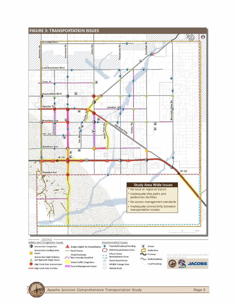
3: Transportation Issues .................................................................................................................. 5
4: Short-Term (Population Level 1 – 60K) Improvements .............................................................. 8
5: Mid-Term (Population Level 2 – 75K) Improvements .............................................................. 10
6: Long-Term (Population Level 3 – 130K) Improvements ........................................................... 12
7: Service Concept for Short-Term (Population Level 1 – 60K) .................................................... 16
8: Core Area Circulator Detail for Short-Term (Population Level 1 – 60K) ................................... 17
9: Service Concept for Mid-Term (Population Level 2 – 75K) ....................................................... 18
10: Service Concept for Long-Term (Population Level 3 – 130K) ................................................. 19
11: Proposed Pedestrian Facilities ................................................................................................ 20
12: Proposed Bicycle Facilities ...................................................................................................... 21
13: Proposed Equestrian Facilities ................................................................................................ 22
14: Proposed Multimodal Facilities .............................................................................................. 23
15: Recommended Roadway Functional Classification ................................................................ 26
16: Recommended Roadway Network for Build-Out Population Levels ...................................... 27
Apache Junction Comprehensive Transportation Study
Page 1
EXECUTIVE SUMMARY
PURPOSE OF THE STUDY The Apache Junction Comprehensive Transportation Study was a joint effort by the City of Apache Junction and the Arizona Department of Transportation (ADOT) to develop a long-range multimodal transportation plan to address the City’s most critical current and future transportation needs. The study was funded by Federal Highway Administration’s (FHWA) State Planning and Research Program and administered through ADOT’s Multimodal Planning Division. Significant growth anticipated in the Portalis area located in the southern portion of the City, could result in population growth, economic development, and increased traffic volumes. The principal focus of the transportation plan was to address the growing demands placed on the City’s local roads and streets by developments in study area, the Portalis area, and within the region. In addition, the plan examined public transportation, bicycle and pedestrian needs, and additional multimodal opportunities necessary to accommodate growth and development.
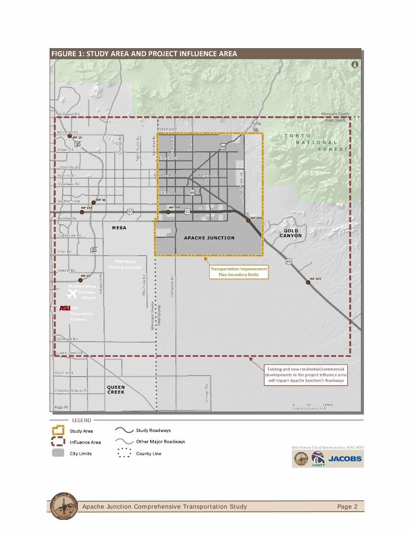
The City of Apache Junction is located on the eastern edge of the Phoenix Metropolitan area. The City is situated in the northwest portion of Pinal County and a small portion is located in eastern section of Maricopa County. Due to the City’s location, the Maricopa Association of Governments (MAG) and Central Arizona Association of Governments (CAAG) coordinate planning activities for Apache Junction. The study area is comprised of approximately 44 square miles and is bounded by Meridian Drive to the west, McKellips Road to the north, Elliot Road alignment to the south, and the Tonto National Forest on the east.
Figure 1 shows the study area boundary along with the project influence area. The study area represents the Transportation Improvements Plan boundary limits while the project influence area represents a geographic area beyond the study boundary that directly affects the study area. The project influence area is needed to identify and accurately quantify the impact of traffic generated outside the study area within the City’s transportation system.
Apache Junction Comprehensive Transportation Study
Page 2

Apache Junction Comprehensive Transportation Study
Page 3
STUDY PROCESS The study was guided by a Technical Advisory Committee (TAC) that included representatives from:
City of Apache Junction ADOT Pinal County CAAG City of Mesa Arizona State Land Department (ASLD)
Maricopa County Department of Transportation (MCDOT)
Bureau of Land Management (BLM) Town of Queen Creek Maricopa County Flood Control District
(MCFCD)
The role of the TAC was to provide guidance, support, advice, suggestions, and recommendations, and to perform document reviews throughout the study process. The First Public Open House was conducted in March 2011 to present existing and projected transportation conditions and issues. The second round of public input involved extensive outreach through online social media and a presentation was given to the City Council of recommended transportation improvements. The study process is illustrated in Figure 2
FIGURE 2: STUDY PROCESS
Inventory Current Conditions For All Travel Models Forecast Future Conditions
Obtain Stakeholder Input
Identify Deficiencies Forecast Future Needs
Present to Stakeholders and Public - Seek Input
Identify and Analyze Solutions
Recommend a Staged (Short, Mid, Long) Transportation Improvement Plan
Present to Stakeholders and Public - Seek Input
Final Implementation Plan
City
of A
pach
e Ju
nctio
n, A
DOT
Technical Advisory Comm
ittee
Apache Junction Comprehensive Transportation Study
Page 4
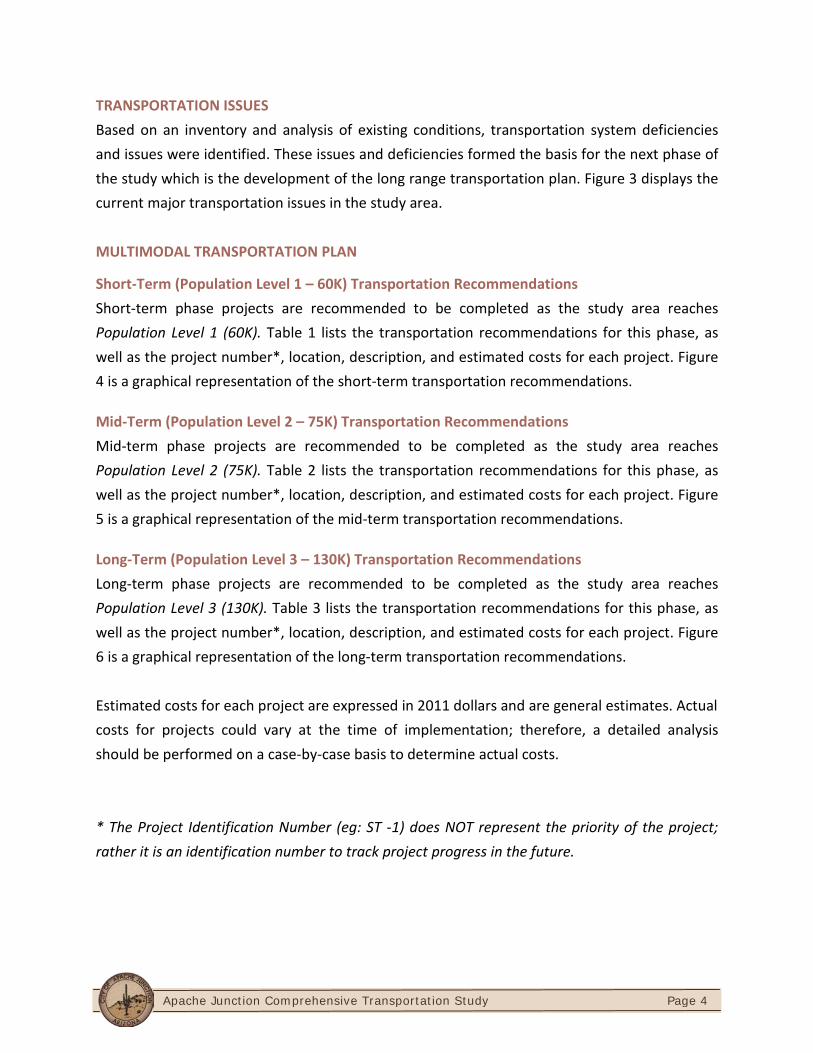
TRANSPORTATION ISSUES Based on an inventory and analysis of existing conditions, transportation system deficiencies and issues were identified. These issues and deficiencies formed the basis for the next phase of the study which is the development of the long range transportation plan. Figure 3 displays the current major transportation issues in the study area. MULTIMODAL TRANSPORTATION PLAN
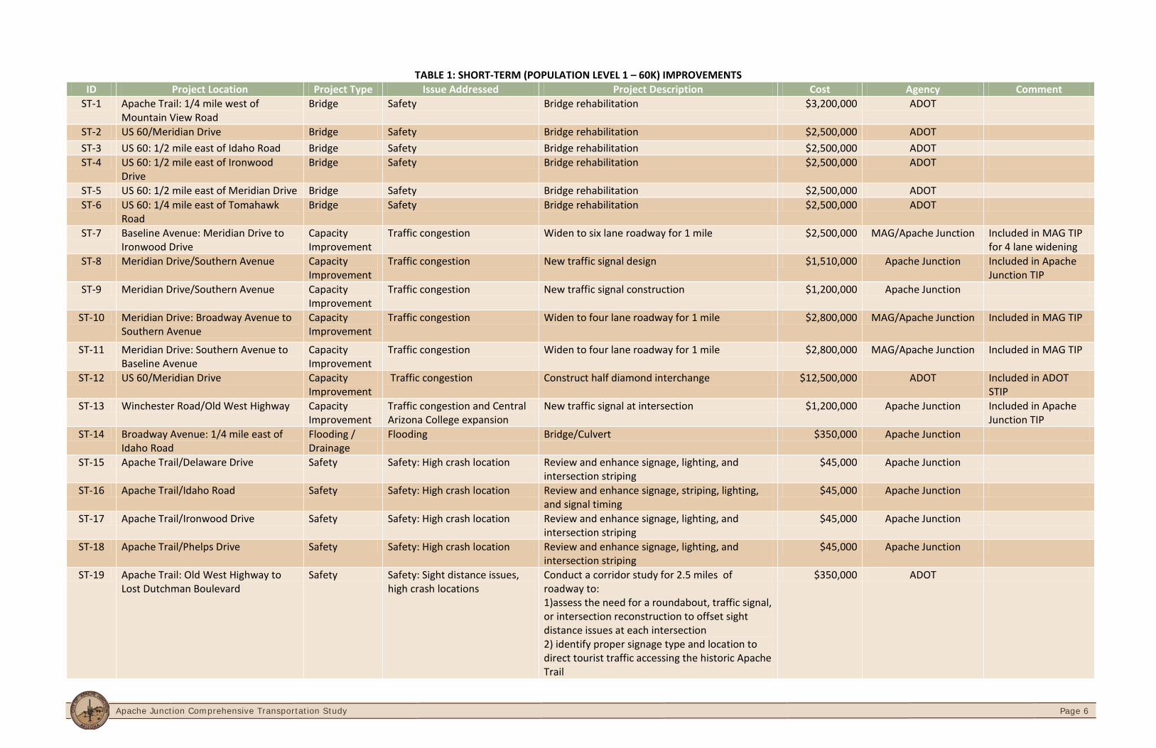
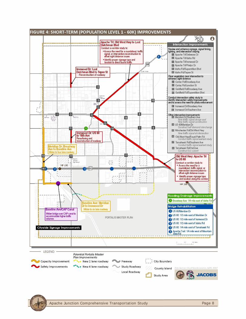
Short-Term (Population Level 1 – 60K) Transportation Recommendations Short-term phase projects are recommended to be completed as the study area reaches Population Level 1 (60K). Table 1 lists the transportation recommendations for this phase, as well as the project number*, location, description, and estimated costs for each project. Figure 4 is a graphical representation of the short-term transportation recommendations.
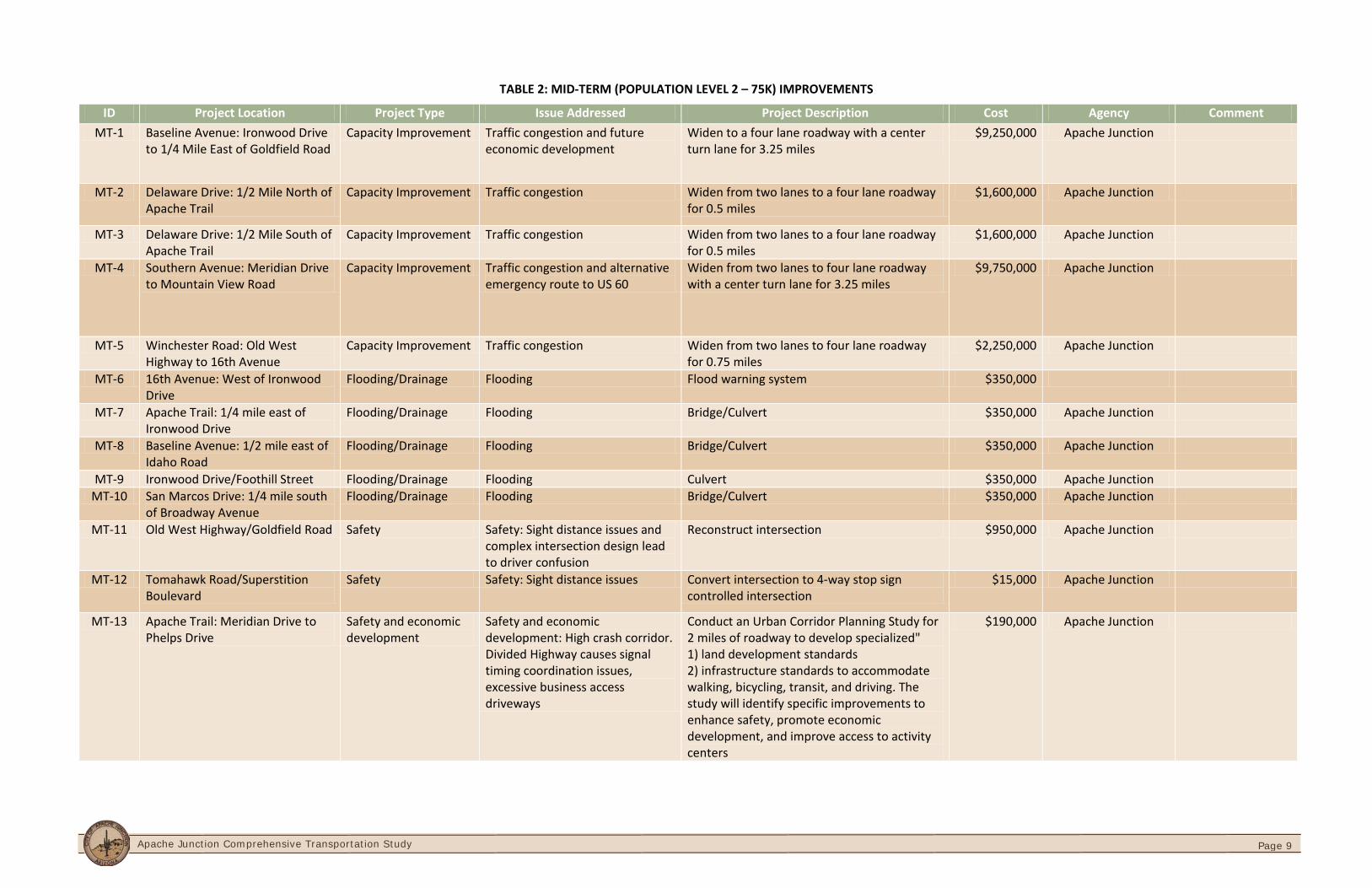
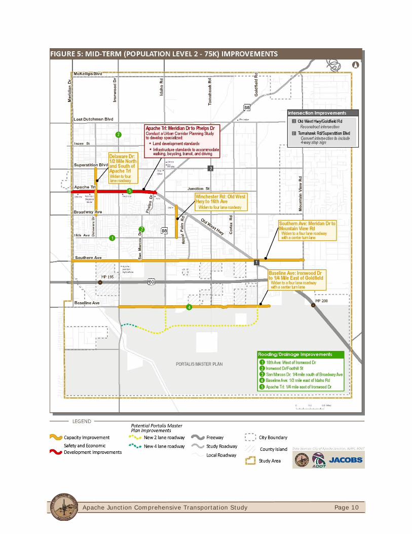
Mid-Term (Population Level 2 – 75K) Transportation Recommendations Mid-term phase projects are recommended to be completed as the study area reaches Population Level 2 (75K). Table 2 lists the transportation recommendations for this phase, as well as the project number*, location, description, and estimated costs for each project. Figure 5 is a graphical representation of the mid-term transportation recommendations.
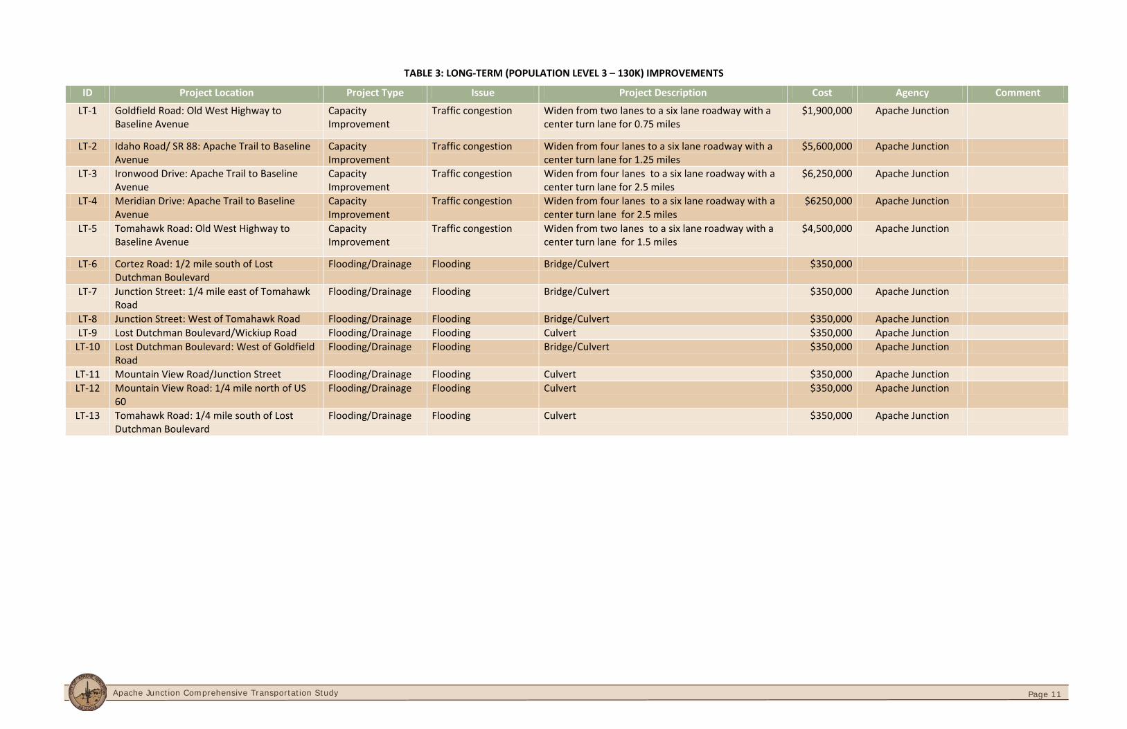
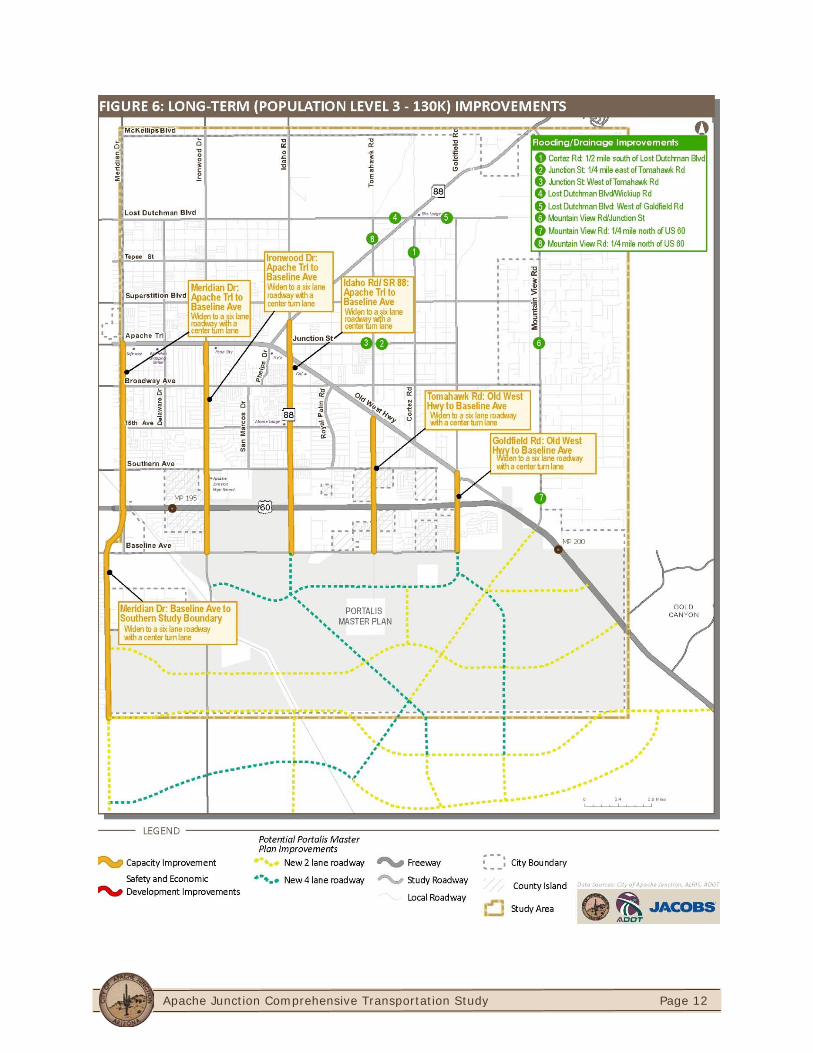
Long-Term (Population Level 3 – 130K) Transportation Recommendations Long-term phase projects are recommended to be completed as the study area reaches Population Level 3 (130K). Table 3 lists the transportation recommendations for this phase, as well as the project number*, location, description, and estimated costs for each project. Figure 6 is a graphical representation of the long-term transportation recommendations. Estimated costs for each project are expressed in 2011 dollars and are general estimates. Actual costs for projects could vary at the time of implementation; therefore, a detailed analysis should be performed on a case-by-case basis to determine actual costs. * The Project Identification Number (eg: ST -1) does NOT represent the priority of the project; rather it is an identification number to track project progress in the future.
Apache Junction Comprehensive Transportation Study
Page 5
Apache Junction Comprehensive Transportation Study
Page 6
TABLE 1: SHORT-TERM (POPULATION LEVEL 1 – 60K) IMPROVEMENTS ID Project Location Project Type Issue Addressed Project Description Cost Agency Comment
ST-1 Apache Trail: 1/4 mile west of Mountain View Road
Bridge Safety Bridge rehabilitation $3,200,000 ADOT
ST-2 US 60/Meridian Drive Bridge Safety Bridge rehabilitation $2,500,000 ADOT ST-3 US 60: 1/2 mile east of Idaho Road Bridge Safety Bridge rehabilitation $2,500,000 ADOT ST-4 US 60: 1/2 mile east of Ironwood
Drive Bridge Safety Bridge rehabilitation $2,500,000 ADOT
ST-5 US 60: 1/2 mile east of Meridian Drive Bridge Safety Bridge rehabilitation $2,500,000 ADOT ST-6 US 60: 1/4 mile east of Tomahawk
Road Bridge Safety Bridge rehabilitation $2,500,000 ADOT
ST-7 Baseline Avenue: Meridian Drive to Ironwood Drive
Capacity Improvement
Traffic congestion Widen to six lane roadway for 1 mile $2,500,000 MAG/Apache Junction Included in MAG TIP for 4 lane widening
ST-8 Meridian Drive/Southern Avenue Capacity Improvement
Traffic congestion New traffic signal design $1,510,000 Apache Junction Included in Apache Junction TIP
ST-9 Meridian Drive/Southern Avenue Capacity Improvement
Traffic congestion New traffic signal construction $1,200,000 Apache Junction
ST-10 Meridian Drive: Broadway Avenue to Southern Avenue
Capacity Improvement
Traffic congestion Widen to four lane roadway for 1 mile $2,800,000 MAG/Apache Junction Included in MAG TIP
ST-11 Meridian Drive: Southern Avenue to Baseline Avenue
Capacity Improvement
Traffic congestion Widen to four lane roadway for 1 mile $2,800,000 MAG/Apache Junction Included in MAG TIP
ST-12 US 60/Meridian Drive Capacity Improvement
Traffic congestion Construct half diamond interchange $12,500,000 ADOT Included in ADOT STIP
ST-13 Winchester Road/Old West Highway Capacity Improvement
Traffic congestion and Central Arizona College expansion
New traffic signal at intersection $1,200,000 Apache Junction Included in Apache Junction TIP
ST-14 Broadway Avenue: 1/4 mile east of Idaho Road
Flooding / Drainage
Flooding Bridge/Culvert $350,000 Apache Junction
ST-15 Apache Trail/Delaware Drive Safety Safety: High crash location Review and enhance signage, lighting, and intersection striping
$45,000 Apache Junction
ST-16 Apache Trail/Idaho Road Safety Safety: High crash location Review and enhance signage, striping, lighting, and signal timing
$45,000 Apache Junction
ST-17 Apache Trail/Ironwood Drive Safety Safety: High crash location Review and enhance signage, lighting, and intersection striping
$45,000 Apache Junction
ST-18 Apache Trail/Phelps Drive Safety Safety: High crash location Review and enhance signage, lighting, and intersection striping
$45,000 Apache Junction
ST-19 Apache Trail: Old West Highway to Lost Dutchman Boulevard
Safety Safety: Sight distance issues, high crash locations
Conduct a corridor study for 2.5 miles of roadway to: 1)assess the need for a roundabout, traffic signal, or intersection reconstruction to offset sight distance issues at each intersection 2) identify proper signage type and location to direct tourist traffic accessing the historic Apache Trail
$350,000 ADOT
Apache Junction Comprehensive Transportation Study
Page 7
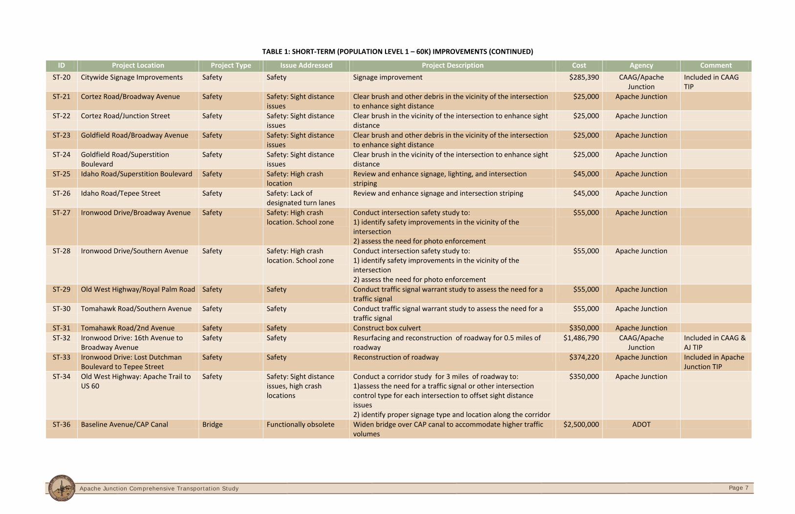
TABLE 1: SHORT-TERM (POPULATION LEVEL 1 – 60K) IMPROVEMENTS (CONTINUED)
ID Project Location Project Type Issue Addressed Project Description Cost Agency Comment ST-20 Citywide Signage Improvements Safety Safety Signage improvement $285,390 CAAG/Apache
Junction Included in CAAG TIP
ST-21 Cortez Road/Broadway Avenue Safety Safety: Sight distance issues
Clear brush and other debris in the vicinity of the intersection to enhance sight distance
$25,000 Apache Junction
ST-22 Cortez Road/Junction Street Safety Safety: Sight distance issues
Clear brush in the vicinity of the intersection to enhance sight distance
$25,000 Apache Junction
ST-23 Goldfield Road/Broadway Avenue Safety Safety: Sight distance issues
Clear brush and other debris in the vicinity of the intersection to enhance sight distance
$25,000 Apache Junction
ST-24 Goldfield Road/Superstition Boulevard
Safety Safety: Sight distance issues
Clear brush in the vicinity of the intersection to enhance sight distance
$25,000 Apache Junction
ST-25 Idaho Road/Superstition Boulevard Safety Safety: High crash location
Review and enhance signage, lighting, and intersection striping
$45,000 Apache Junction
ST-26 Idaho Road/Tepee Street Safety Safety: Lack of designated turn lanes
Review and enhance signage and intersection striping $45,000 Apache Junction
ST-27 Ironwood Drive/Broadway Avenue Safety Safety: High crash location. School zone
Conduct intersection safety study to: 1) identify safety improvements in the vicinity of the intersection 2) assess the need for photo enforcement
$55,000 Apache Junction
ST-28 Ironwood Drive/Southern Avenue Safety Safety: High crash location. School zone
Conduct intersection safety study to: 1) identify safety improvements in the vicinity of the intersection 2) assess the need for photo enforcement
$55,000 Apache Junction
ST-29 Old West Highway/Royal Palm Road Safety Safety Conduct traffic signal warrant study to assess the need for a traffic signal
$55,000 Apache Junction
ST-30 Tomahawk Road/Southern Avenue Safety Safety Conduct traffic signal warrant study to assess the need for a traffic signal
$55,000 Apache Junction
ST-31 Tomahawk Road/2nd Avenue Safety Safety Construct box culvert $350,000 Apache Junction ST-32 Ironwood Drive: 16th Avenue to
Broadway Avenue Safety Safety Resurfacing and reconstruction of roadway for 0.5 miles of
roadway $1,486,790 CAAG/Apache
Junction Included in CAAG & AJ TIP
ST-33 Ironwood Drive: Lost Dutchman Boulevard to Tepee Street
Safety Safety Reconstruction of roadway $374,220 Apache Junction Included in Apache Junction TIP
ST-34 Old West Highway: Apache Trail to US 60
Safety Safety: Sight distance issues, high crash locations
Conduct a corridor study for 3 miles of roadway to: 1)assess the need for a traffic signal or other intersection control type for each intersection to offset sight distance issues 2) identify proper signage type and location along the corridor
$350,000 Apache Junction
ST-36 Baseline Avenue/CAP Canal Bridge Functionally obsolete Widen bridge over CAP canal to accommodate higher traffic volumes
$2,500,000 ADOT
Apache Junction Comprehensive Transportation Study
Page 8
Apache Junction Comprehensive Transportation Study
Page 9
TABLE 2: MID-TERM (POPULATION LEVEL 2 – 75K) IMPROVEMENTS
ID Project Location Project Type Issue Addressed Project Description Cost Agency Comment MT-1 Baseline Avenue: Ironwood Drive
to 1/4 Mile East of Goldfield Road Capacity Improvement Traffic congestion and future
economic development Widen to a four lane roadway with a center turn lane for 3.25 miles
$9,250,000 Apache Junction
MT-2 Delaware Drive: 1/2 Mile North of Apache Trail
Capacity Improvement Traffic congestion Widen from two lanes to a four lane roadway for 0.5 miles
$1,600,000 Apache Junction
MT-3 Delaware Drive: 1/2 Mile South of Apache Trail
Capacity Improvement Traffic congestion Widen from two lanes to a four lane roadway for 0.5 miles
$1,600,000 Apache Junction
MT-4 Southern Avenue: Meridian Drive to Mountain View Road
Capacity Improvement Traffic congestion and alternative emergency route to US 60
Widen from two lanes to four lane roadway with a center turn lane for 3.25 miles
$9,750,000 Apache Junction
MT-5 Winchester Road: Old West Highway to 16th Avenue
Capacity Improvement Traffic congestion Widen from two lanes to four lane roadway for 0.75 miles
$2,250,000 Apache Junction
MT-6 16th Avenue: West of Ironwood Drive
Flooding/Drainage Flooding Flood warning system $350,000
MT-7 Apache Trail: 1/4 mile east of Ironwood Drive
Flooding/Drainage Flooding Bridge/Culvert $350,000 Apache Junction
MT-8 Baseline Avenue: 1/2 mile east of Idaho Road
Flooding/Drainage Flooding Bridge/Culvert $350,000 Apache Junction
MT-9 Ironwood Drive/Foothill Street Flooding/Drainage Flooding Culvert $350,000 Apache Junction MT-10 San Marcos Drive: 1/4 mile south
of Broadway Avenue Flooding/Drainage Flooding Bridge/Culvert $350,000 Apache Junction
MT-11 Old West Highway/Goldfield Road Safety Safety: Sight distance issues and complex intersection design lead to driver confusion
Reconstruct intersection $950,000 Apache Junction
MT-12 Tomahawk Road/Superstition Boulevard
Safety Safety: Sight distance issues Convert intersection to 4-way stop sign controlled intersection
$15,000 Apache Junction
MT-13 Apache Trail: Meridian Drive to Phelps Drive
Safety and economic development
Safety and economic development: High crash corridor. Divided Highway causes signal timing coordination issues, excessive business access driveways
Conduct an Urban Corridor Planning Study for 2 miles of roadway to develop specialized" 1) land development standards 2) infrastructure standards to accommodate walking, bicycling, transit, and driving. The study will identify specific improvements to enhance safety, promote economic development, and improve access to activity centers
$190,000 Apache Junction
Apache Junction Comprehensive Transportation Study
Page 10
Apache Junction Comprehensive Transportation Study
Page 11
TABLE 3: LONG-TERM (POPULATION LEVEL 3 – 130K) IMPROVEMENTS
ID Project Location Project Type Issue Project Description Cost Agency Comment
LT-1 Goldfield Road: Old West Highway to Baseline Avenue
Capacity Improvement
Traffic congestion Widen from two lanes to a six lane roadway with a center turn lane for 0.75 miles
$1,900,000 Apache Junction
LT-2 Idaho Road/ SR 88: Apache Trail to Baseline Avenue
Capacity Improvement
Traffic congestion Widen from four lanes to a six lane roadway with a center turn lane for 1.25 miles
$5,600,000 Apache Junction
LT-3 Ironwood Drive: Apache Trail to Baseline Avenue
Capacity Improvement
Traffic congestion Widen from four lanes to a six lane roadway with a center turn lane for 2.5 miles
$6,250,000 Apache Junction
LT-4 Meridian Drive: Apache Trail to Baseline Avenue
Capacity Improvement
Traffic congestion Widen from four lanes to a six lane roadway with a center turn lane for 2.5 miles
$6250,000 Apache Junction
LT-5 Tomahawk Road: Old West Highway to Baseline Avenue
Capacity Improvement
Traffic congestion Widen from two lanes to a six lane roadway with a center turn lane for 1.5 miles
$4,500,000 Apache Junction
LT-6 Cortez Road: 1/2 mile south of Lost Dutchman Boulevard
Flooding/Drainage Flooding Bridge/Culvert $350,000
LT-7 Junction Street: 1/4 mile east of Tomahawk Road
Flooding/Drainage Flooding Bridge/Culvert $350,000 Apache Junction
LT-8 Junction Street: West of Tomahawk Road Flooding/Drainage Flooding Bridge/Culvert $350,000 Apache Junction LT-9 Lost Dutchman Boulevard/Wickiup Road Flooding/Drainage Flooding Culvert $350,000 Apache Junction
LT-10 Lost Dutchman Boulevard: West of Goldfield Road
Flooding/Drainage Flooding Bridge/Culvert $350,000 Apache Junction
LT-11 Mountain View Road/Junction Street Flooding/Drainage Flooding Culvert $350,000 Apache Junction LT-12 Mountain View Road: 1/4 mile north of US
60 Flooding/Drainage Flooding Culvert $350,000 Apache Junction
LT-13 Tomahawk Road: 1/4 mile south of Lost Dutchman Boulevard
Flooding/Drainage Flooding Culvert $350,000 Apache Junction
Apache Junction Comprehensive Transportation Study
Page 12

Apache Junction Comprehensive Transportation Study
Page 13
Regional Roadway Improvements The transportation improvements recommended above are based on the implementation of additional regional improvements as outlined in Table 4.
TABLE 4: REGIONAL IMPROVEMENTS
Regional Improvements Project Location Project Description Phase
Meridian Drive: Southern Study Boundary Limits to SR 24 Alignment
Widen to a four lane roadway Mid
Idaho Road: Elliott Avenue to Warner Road
New 0.75 mile, four lane roadway Long
Goldfield Road: Elliott Avenue to Warner Road
New 1 mile, four lane roadway Long
Meridian Drive: Southern Study Boundary Limits to SR 24 Alignment
Widen to a six lane roadway Long
Warner Road: Meridian Drive to Elliott Avenue
New four lane roadway Long
Portalis Area Roadway Improvements As the Portalis area is developed in the future, several new roadways are needed to meet the traffic demand. The new roadways required in the Portalis area for the short, mid, and long term phases are illustrated in Figures 4, 5, and 6.
Apache Junction Comprehensive Transportation Study
Page 14
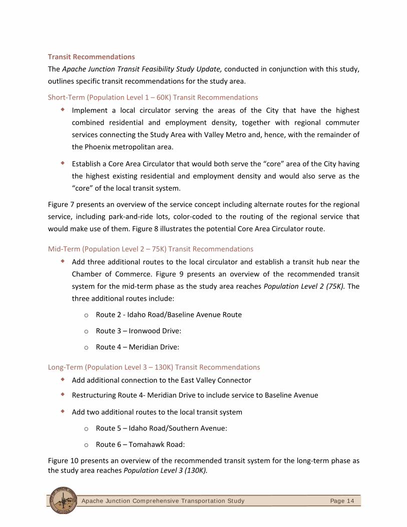
Transit Recommendations The Apache Junction Transit Feasibility Study Update, conducted in conjunction with this study, outlines specific transit recommendations for the study area.
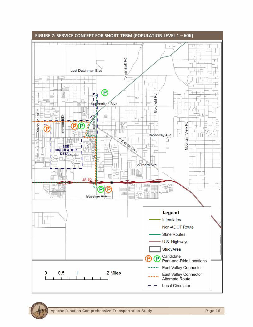
Short-Term (Population Level 1 – 60K) Transit Recommendations
Implement a local circulator serving the areas of the City that have the highest combined residential and employment density, together with regional commuter services connecting the Study Area with Valley Metro and, hence, with the remainder of the Phoenix metropolitan area.
Establish a Core Area Circulator that would both serve the “core” area of the City having the highest existing residential and employment density and would also serve as the “core” of the local transit system.
Figure 7 presents an overview of the service concept including alternate routes for the regional service, including park-and-ride lots, color-coded to the routing of the regional service that would make use of them. Figure 8 illustrates the potential Core Area Circulator route.
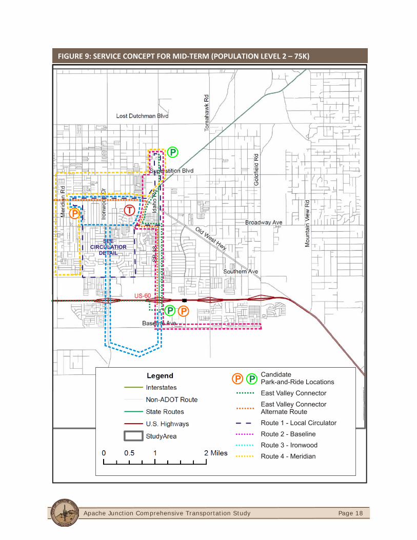
Mid-Term (Population Level 2 – 75K) Transit Recommendations
Add three additional routes to the local circulator and establish a transit hub near the Chamber of Commerce. Figure 9 presents an overview of the recommended transit system for the mid-term phase as the study area reaches Population Level 2 (75K). The three additional routes include:
o Route 2 - Idaho Road/Baseline Avenue Route
o Route 3 – Ironwood Drive:
o Route 4 – Meridian Drive:
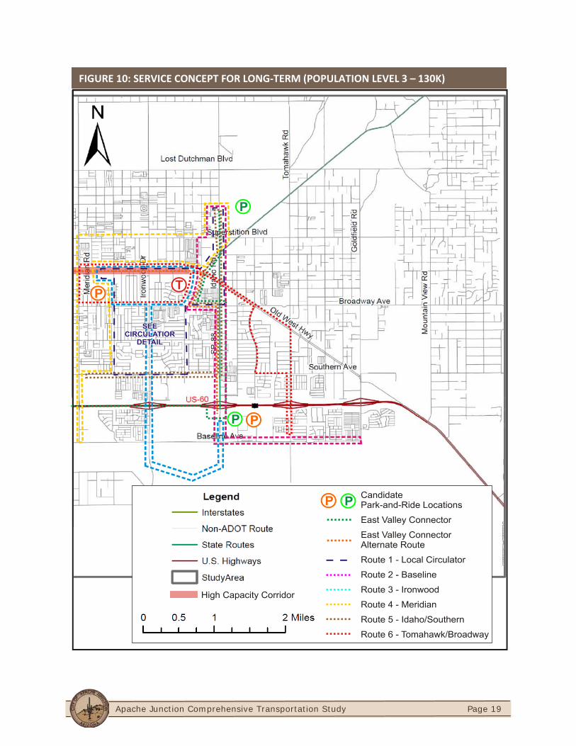
Long-Term (Population Level 3 – 130K) Transit Recommendations
Add additional connection to the East Valley Connector
Restructuring Route 4- Meridian Drive to include service to Baseline Avenue
Add two additional routes to the local transit system
o Route 5 – Idaho Road/Southern Avenue:
o Route 6 – Tomahawk Road:
Figure 10 presents an overview of the recommended transit system for the long-term phase as the study area reaches Population Level 3 (130K).
Apache Junction Comprehensive Transportation Study
Page 15
Regional Options
Extending service to newer areas, including but not limited to:
o Deviated fixed route service or dial-a-ride service can be extended east on US 60 toward Gold Canyon
o Peak period only “commuter bus” service can be extended to outlying areas while the core of the city receives service throughout the day
o Park-and-ride lots at the extents of fixed-route or high-capacity lines, can be complemented by dial-a-ride service into the newer neighborhoods to bring mobility-limited persons within reach of the other services
Provide rural transit services from the downtown Transit Hub to communities east of Apache Junction, communities in eastern Pinal County, and new developments in the Superstition Vistas area.
Market park and ride facilities located either downtown or on Idaho Road to motorists and carpools to utilize public transit to Mesa, Tempe, or Phoenix.
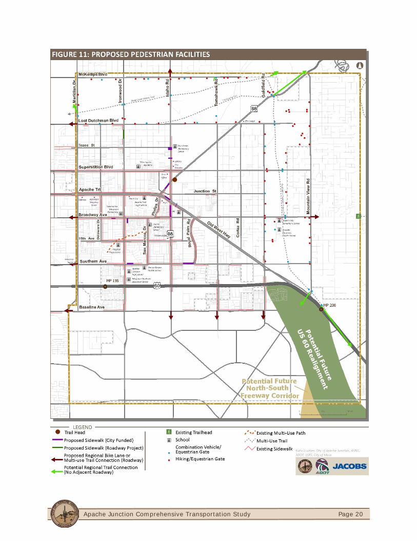
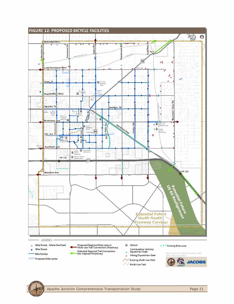
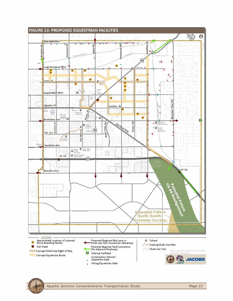
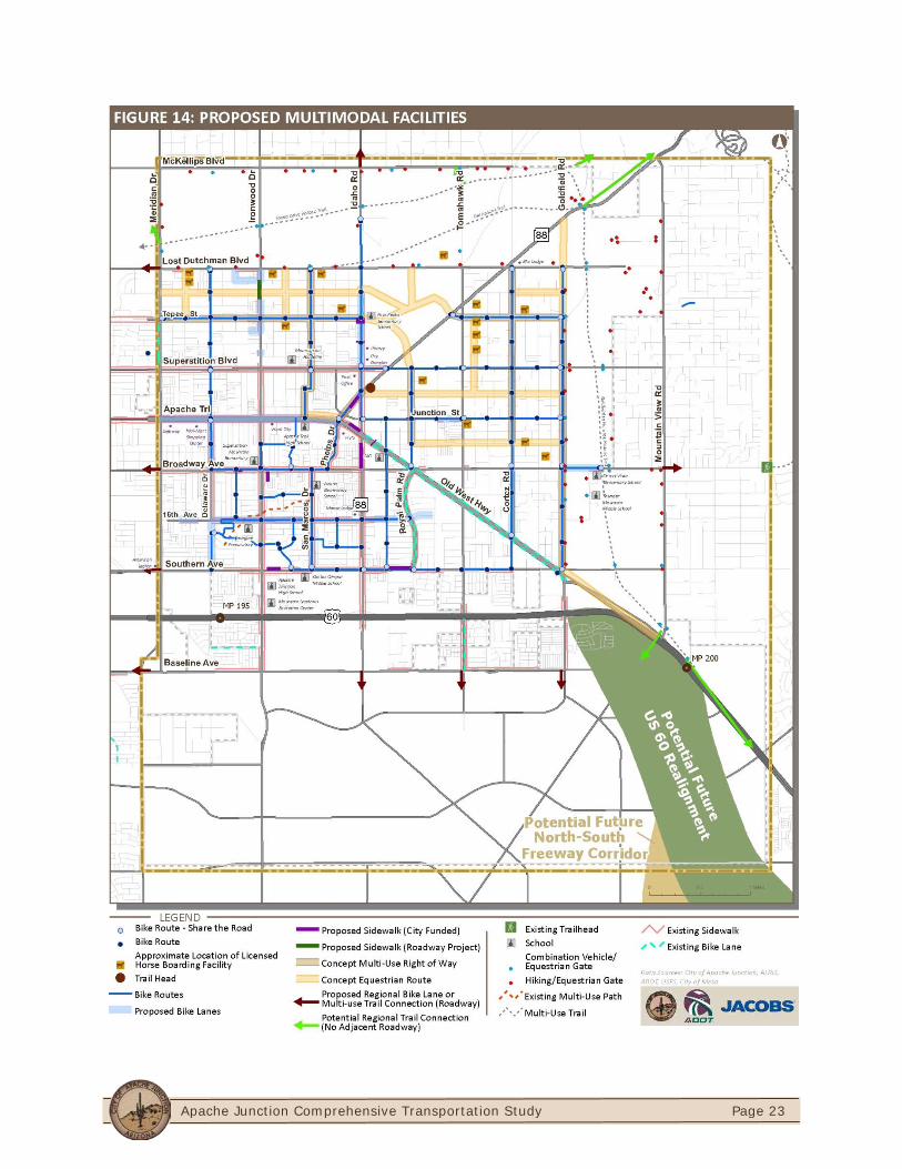
Pedestrian, Bicycle, and Trails Facilities The City of Apache Junction has already prepared preliminary plans to expand the pedestrian, bicycle, and trails (including equestrian) facilities throughout the study area and are illustrated in Figure 11 through 14.
Apache Junction Comprehensive Transportation Study
Page 16
FIGURE 7: SERVICE CONCEPT FOR SHORT-TERM (POPULATION LEVEL 1 – 60K)

Apache Junction Comprehensive Transportation Study
Page 17
FIGURE 8: CORE AREA CIRCULATOR DETAIL FOR SHORT-TERM (POPULATION LEVEL 1 - 60K)
Apache Junction Comprehensive Transportation Study
Page 18
FIGURE 9: SERVICE CONCEPT FOR MID-TERM (POPULATION LEVEL 2 – 75K)
Apache Junction Comprehensive Transportation Study
Page 19
FIGURE 10: SERVICE CONCEPT FOR LONG-TERM (POPULATION LEVEL 3 – 130K)
Apache Junction Comprehensive Transportation Study
Page 20
Apache Junction Comprehensive Transportation Study
Page 21
Apache Junction Comprehensive Transportation Study
Page 22
Apache Junction Comprehensive Transportation Study
Page 23
Apache Junction Comprehensive Transportation Study
Page 24
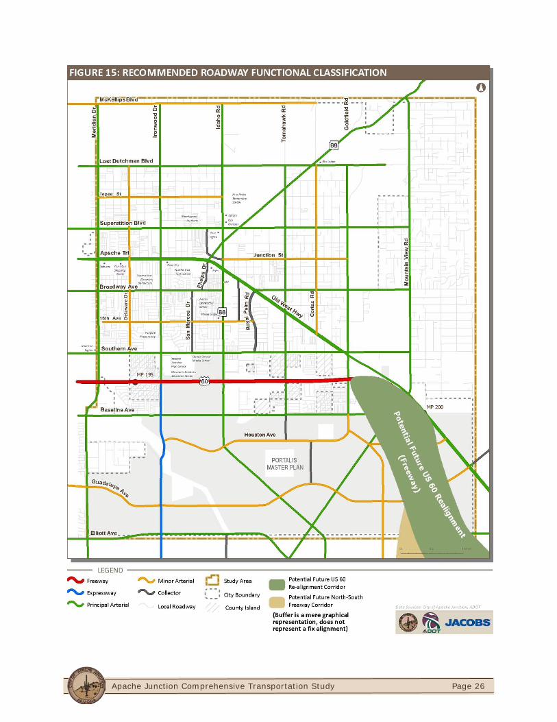
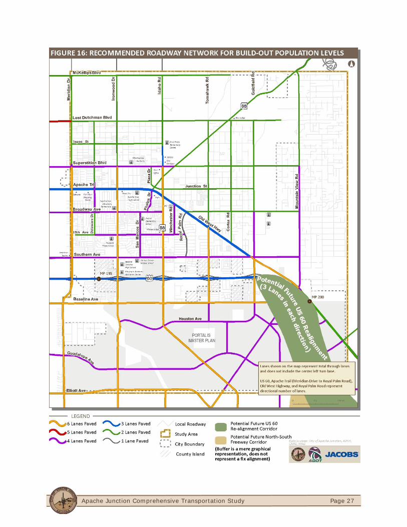
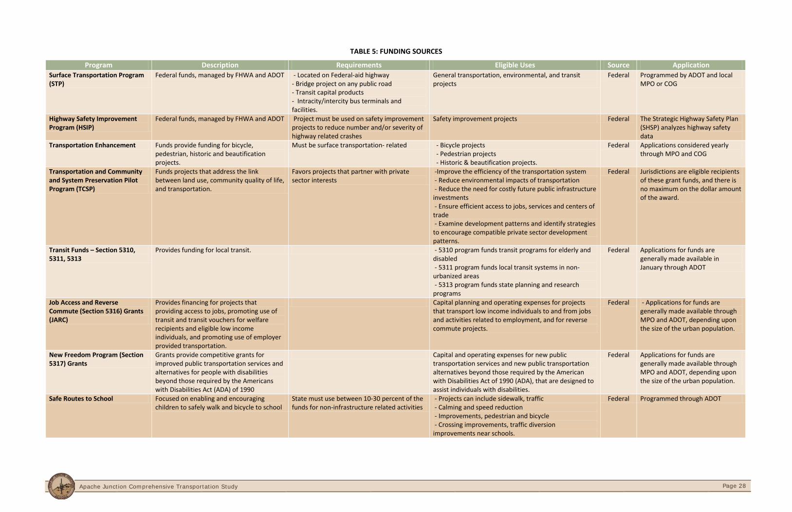
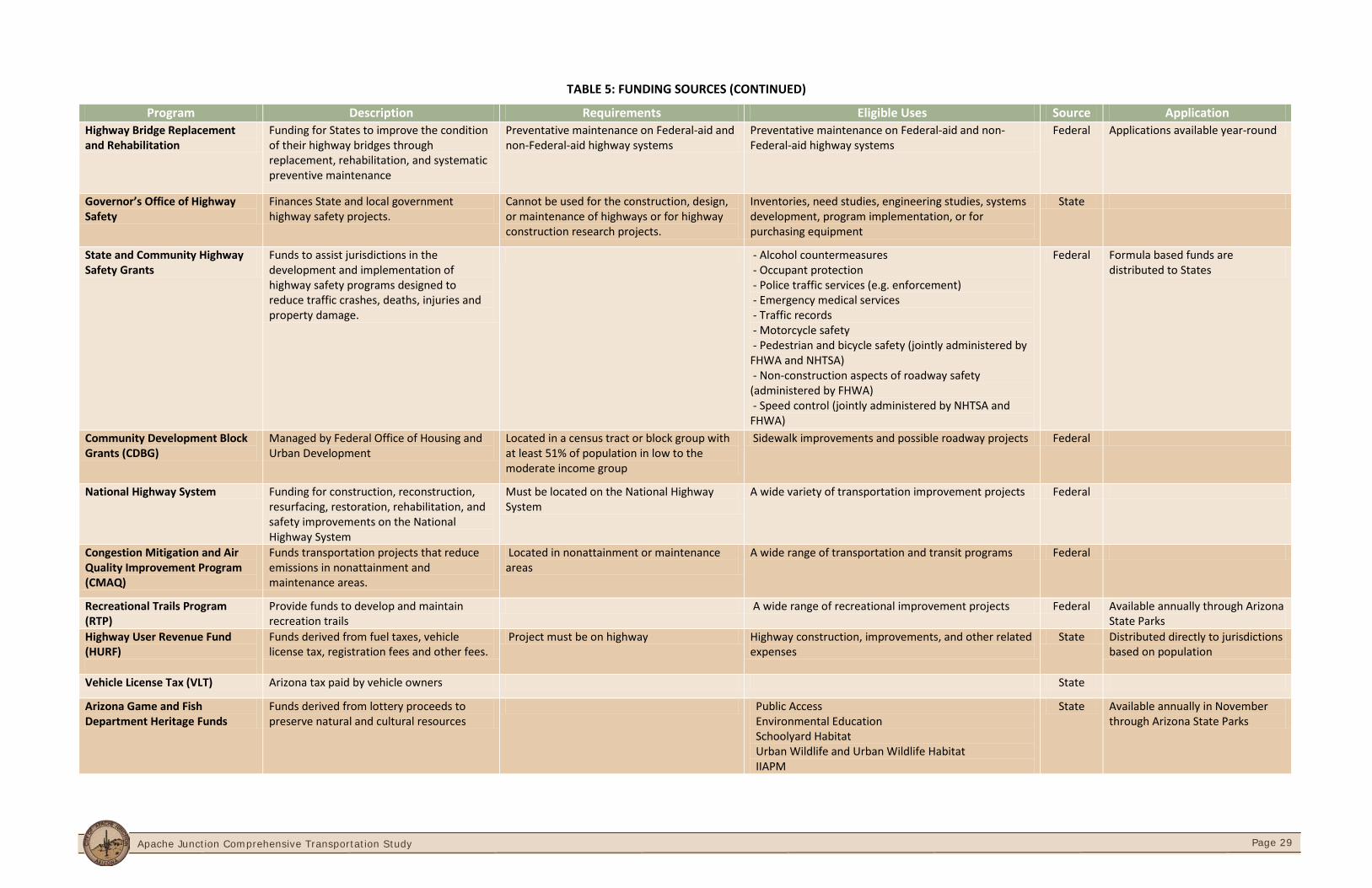
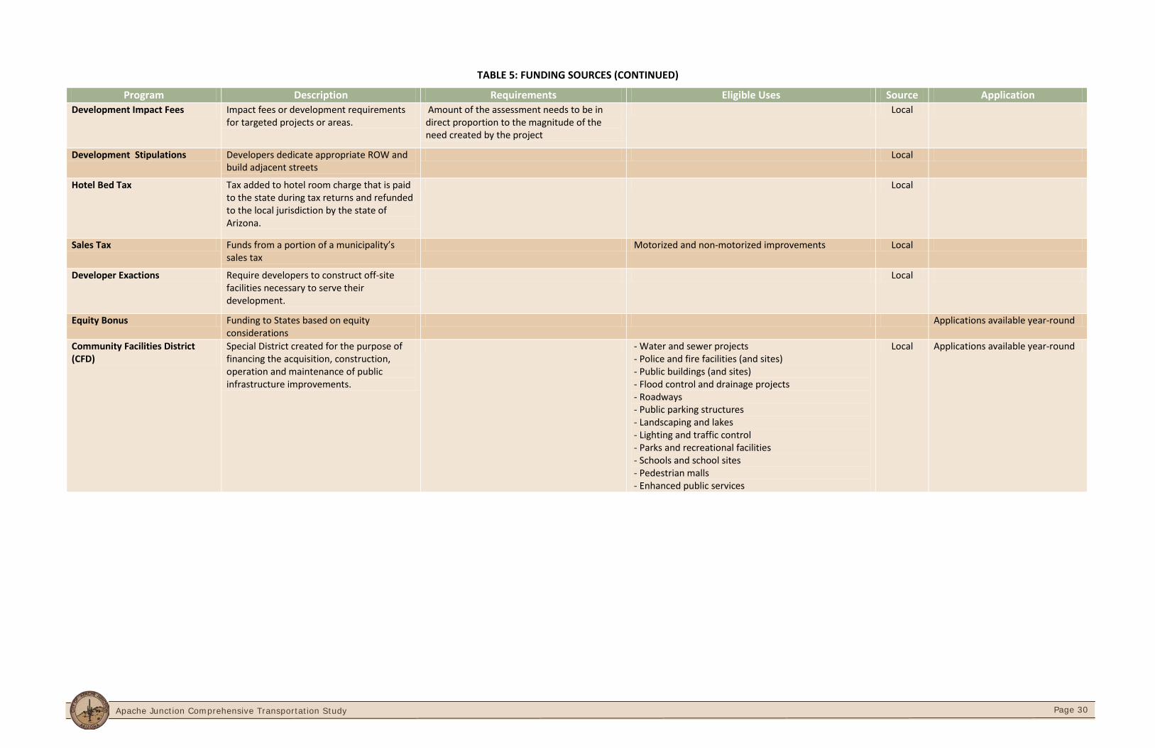
Functional Classification Figure 15 illustrates the recommended functional classification of the roadways in the study area. The City of Apache Junction should first coordinate with CAAG to prepare the appropriate applications to reclassify the roadways. Applications must be submitted to ADOT through CAAG. Final roadway classification will be forwarded to the FHWA for final approval. Build-Out Roadway Network Recommendations The Countywide TransCAD travel demand model was used to forecast traffic volumes for the build-out population scenario to subsequently develop the build-out roadway network. Figure 16 illustrates the proposed build-out roadway network for the study area. Funding Sources The successful implementation of the Apache Junction Comprehensive Transportation Plan is contingent upon the availability of funding for design and construction of the improvement projects. Primary funding sources for the Town include federal programs, ADOT, and other regional government agencies such as CAAG. Table 5 is a comprehensive funding matrix of funding sources that the City of Apache Junction can apply for funding of transportation projects identified in this study.
Implementation Actions The following action items are recommended for the City of Apache Junction to successfully implement the Multimodal Transportation Plan.
Present the Transportation Plan to the City Council for approval and adoption.
Coordinate with CAAG and ADOT to request change in functional classification of roadways identified in Figure 15
Apply for funding sources for each project in the transportation plan.
Include high-priority projects in the City's Transportation Improvement Program (TIP).
Establish a transit department.
Coordinate with ADOT to initiate a Transit Implementation Plan.
Develop policies and procedures to promote alternative modes of transportation. Review and update street design standards, develop comprehensive access management standards, and detailed traffic impact guidelines procedures.
Promote alternative modes of transportation through improved developer collaboration.
Create aesthetically appealing gateways into the City at key roadway entry points.
Apache Junction Comprehensive Transportation Study
Page 25
Increase communication, cooperation, and collaboration with ADOT, CAAG, the City Council, neighboring jurisdictions including the City of Mesa, MAG, Town of Queen Creek, and Pinal County. Work in partnership with each agency to address transportation needs and implement the plan.
Offer opportunities for public involvement throughout the plan implementation process.
Promote Public-Private partnerships between the City and the private sector.
Monitor progress on the transportation plan on a quarterly basis.
Update the transportation plan on a five year cycle.
Apache Junction Comprehensive Transportation Study
Page 26
Apache Junction Comprehensive Transportation Study
Page 27
Apache Junction Comprehensive Transportation Study
Page 28
TABLE 5: FUNDING SOURCES
Program Description Requirements Eligible Uses Source Application Surface Transportation Program (STP)
Federal funds, managed by FHWA and ADOT - Located on Federal-aid highway - Bridge project on any public road - Transit capital products - Intracity/intercity bus terminals and facilities.
General transportation, environmental, and transit projects
Federal Programmed by ADOT and local MPO or COG
Highway Safety Improvement Program (HSIP)
Federal funds, managed by FHWA and ADOT Project must be used on safety improvement projects to reduce number and/or severity of highway related crashes
Safety improvement projects Federal The Strategic Highway Safety Plan (SHSP) analyzes highway safety data
Transportation Enhancement Funds provide funding for bicycle, pedestrian, historic and beautification projects.
Must be surface transportation- related - Bicycle projects - Pedestrian projects - Historic & beautification projects.
Federal Applications considered yearly through MPO and COG
Transportation and Community and System Preservation Pilot Program (TCSP)
Funds projects that address the link between land use, community quality of life, and transportation.
Favors projects that partner with private sector interests
-Improve the efficiency of the transportation system - Reduce environmental impacts of transportation - Reduce the need for costly future public infrastructure investments - Ensure efficient access to jobs, services and centers of trade - Examine development patterns and identify strategies to encourage compatible private sector development patterns.
Federal Jurisdictions are eligible recipients of these grant funds, and there is no maximum on the dollar amount of the award.
Transit Funds – Section 5310, 5311, 5313
Provides funding for local transit. - 5310 program funds transit programs for elderly and disabled - 5311 program funds local transit systems in non-urbanized areas - 5313 program funds state planning and research programs
Federal Applications for funds are generally made available in January through ADOT
Job Access and Reverse Commute (Section 5316) Grants (JARC)
Provides financing for projects that providing access to jobs, promoting use of transit and transit vouchers for welfare recipients and eligible low income individuals, and promoting use of employer provided transportation.
Capital planning and operating expenses for projects that transport low income individuals to and from jobs and activities related to employment, and for reverse commute projects.
Federal - Applications for funds are generally made available through MPO and ADOT, depending upon the size of the urban population.
New Freedom Program (Section 5317) Grants
Grants provide competitive grants for improved public transportation services and alternatives for people with disabilities beyond those required by the Americans with Disabilities Act (ADA) of 1990
Capital and operating expenses for new public transportation services and new public transportation alternatives beyond those required by the American with Disabilities Act of 1990 (ADA), that are designed to assist individuals with disabilities.
Federal Applications for funds are generally made available through MPO and ADOT, depending upon the size of the urban population.
Safe Routes to School Focused on enabling and encouraging children to safely walk and bicycle to school
State must use between 10-30 percent of the funds for non-infrastructure related activities
- Projects can include sidewalk, traffic - Calming and speed reduction - Improvements, pedestrian and bicycle - Crossing improvements, traffic diversion improvements near schools.
Federal Programmed through ADOT
Apache Junction Comprehensive Transportation Study
Page 29
TABLE 5: FUNDING SOURCES (CONTINUED)
Program Description Requirements Eligible Uses Source Application Highway Bridge Replacement and Rehabilitation
Funding for States to improve the condition of their highway bridges through replacement, rehabilitation, and systematic preventive maintenance
Preventative maintenance on Federal-aid and non-Federal-aid highway systems
Preventative maintenance on Federal-aid and non-Federal-aid highway systems
Federal Applications available year-round
Governor’s Office of Highway Safety
Finances State and local government highway safety projects.
Cannot be used for the construction, design, or maintenance of highways or for highway construction research projects.
Inventories, need studies, engineering studies, systems development, program implementation, or for purchasing equipment
State
State and Community Highway Safety Grants
Funds to assist jurisdictions in the development and implementation of highway safety programs designed to reduce traffic crashes, deaths, injuries and property damage.
- Alcohol countermeasures - Occupant protection - Police traffic services (e.g. enforcement) - Emergency medical services - Traffic records - Motorcycle safety - Pedestrian and bicycle safety (jointly administered by FHWA and NHTSA) - Non-construction aspects of roadway safety (administered by FHWA) - Speed control (jointly administered by NHTSA and FHWA)
Federal Formula based funds are distributed to States
Community Development Block Grants (CDBG)
Managed by Federal Office of Housing and Urban Development
Located in a census tract or block group with at least 51% of population in low to the moderate income group
Sidewalk improvements and possible roadway projects Federal
National Highway System Funding for construction, reconstruction, resurfacing, restoration, rehabilitation, and safety improvements on the National Highway System
Must be located on the National Highway System
A wide variety of transportation improvement projects Federal
Congestion Mitigation and Air Quality Improvement Program (CMAQ)
Funds transportation projects that reduce emissions in nonattainment and maintenance areas.
Located in nonattainment or maintenance areas
A wide range of transportation and transit programs Federal
Recreational Trails Program (RTP)
Provide funds to develop and maintain recreation trails
A wide range of recreational improvement projects Federal Available annually through Arizona State Parks
Highway User Revenue Fund (HURF)
Funds derived from fuel taxes, vehicle license tax, registration fees and other fees.
Project must be on highway Highway construction, improvements, and other related expenses
State Distributed directly to jurisdictions based on population
Vehicle License Tax (VLT) Arizona tax paid by vehicle owners State
Arizona Game and Fish Department Heritage Funds
Funds derived from lottery proceeds to preserve natural and cultural resources
Public Access Environmental Education Schoolyard Habitat Urban Wildlife and Urban Wildlife Habitat IIAPM
State Available annually in November through Arizona State Parks
Apache Junction Comprehensive Transportation Study
Page 30
TABLE 5: FUNDING SOURCES (CONTINUED)
Program Description Requirements Eligible Uses Source Application Development Impact Fees Impact fees or development requirements
for targeted projects or areas. Amount of the assessment needs to be in direct proportion to the magnitude of the need created by the project
Local
Development Stipulations Developers dedicate appropriate ROW and build adjacent streets
Local
Hotel Bed Tax Tax added to hotel room charge that is paid to the state during tax returns and refunded to the local jurisdiction by the state of Arizona.
Local
Sales Tax Funds from a portion of a municipality’s sales tax
Motorized and non-motorized improvements Local
Developer Exactions Require developers to construct off-site facilities necessary to serve their development.
Local
Equity Bonus Funding to States based on equity considerations
Applications available year-round
Community Facilities District (CFD)
Special District created for the purpose of financing the acquisition, construction, operation and maintenance of public infrastructure improvements.
- Water and sewer projects - Police and fire facilities (and sites) - Public buildings (and sites) - Flood control and drainage projects - Roadways - Public parking structures - Landscaping and lakes - Lighting and traffic control - Parks and recreational facilities - Schools and school sites - Pedestrian malls - Enhanced public services
Local Applications available year-round