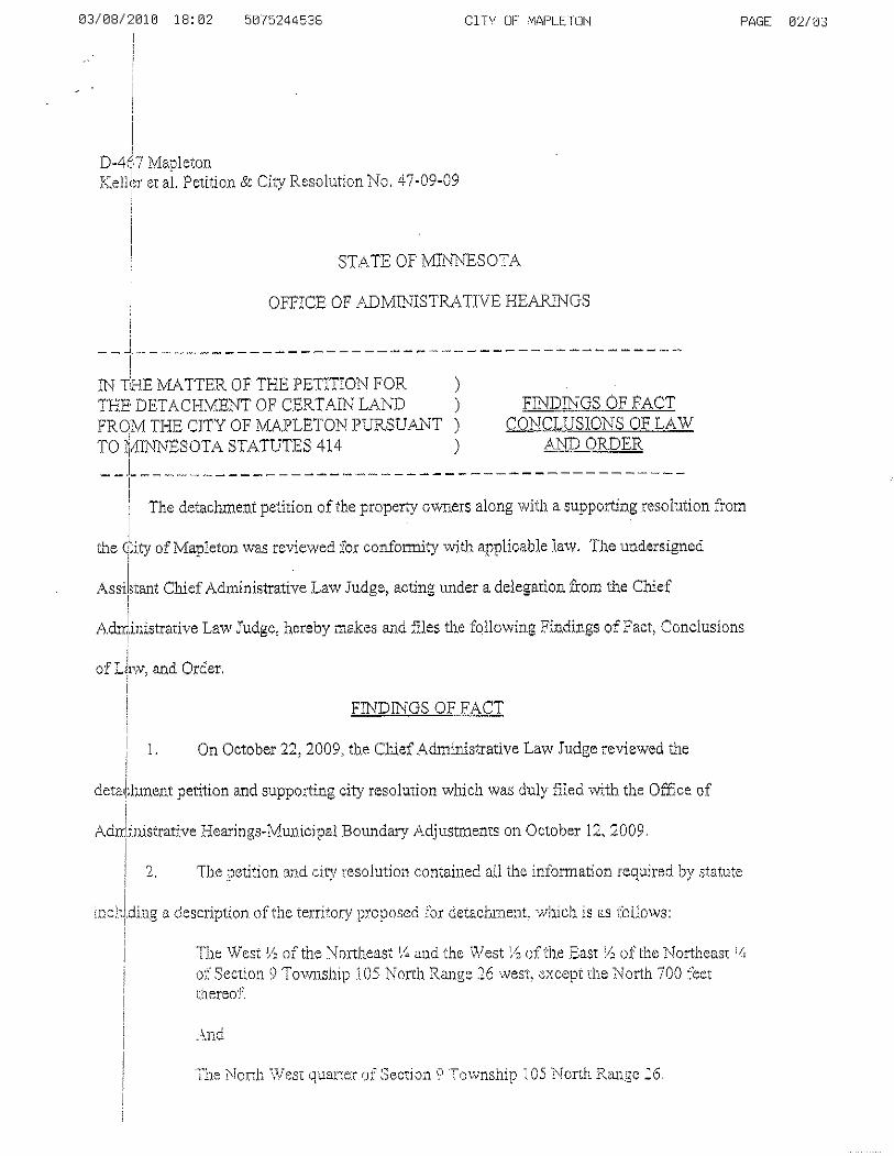
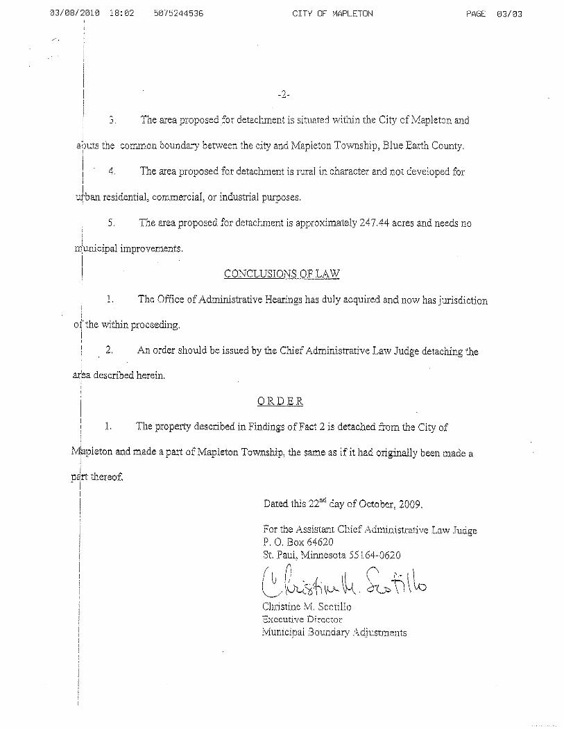
Any land detached from an incorporated municipality and ...
14
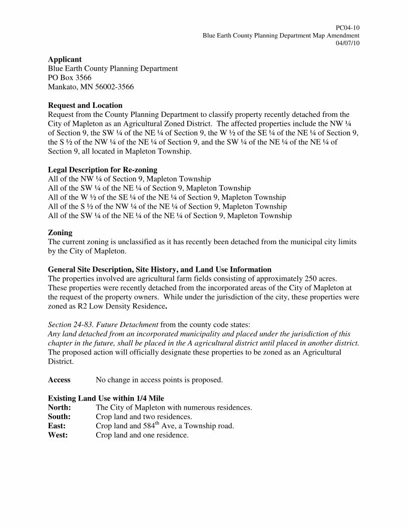
PC04-10 Blue Earth County Planning Department Map Amendment 04/07/10 Applicant Blue Earth County Planning Department PO Box 3566 Mankato, MN 56002-3566 Request and Location Request from the County Planning Department to classify property recently detached from the City of Mapleton as an Agricultural Zoned District. The affected properties include the NW ¼ of Section 9, the SW ¼ of the NE ¼ of Section 9, the W ½ of the SE ¼ of the NE ¼ of Section 9, the S ½ of the NW ¼ of the NE ¼ of Section 9, and the SW ¼ of the NE ¼ of the NE ¼ of Section 9, all located in Mapleton Township. Legal Description for Re-zoning All of the NW ¼ of Section 9, Mapleton Township All of the SW ¼ of the NE ¼ of Section 9, Mapleton Township All of the W ½ of the SE ¼ of the NE ¼ of Section 9, Mapleton Township All of the S ½ of the NW ¼ of the NE ¼ of Section 9, Mapleton Township All of the SW ¼ of the NE ¼ of the NE ¼ of Section 9, Mapleton Township Zoning The current zoning is unclassified as it has recently been detached from the municipal city limits by the City of Mapleton. General Site Description, Site History, and Land Use Information The properties involved are agricultural farm fields consisting of approximately 250 acres. These properties were recently detached from the incorporated areas of the City of Mapleton at the request of the property owners. While under the jurisdiction of the city, these properties were zoned as R2 Low Density Residence. Section 24-83. Future Detachment from the county code states: Any land detached from an incorporated municipality and placed under the jurisdiction of this chapter in the future, shall be placed in the A agricultural district until placed in another district. The proposed action will officially designate these properties to be zoned as an Agricultural District. Access No change in access points is proposed. Existing Land Use within 1/4 Mile North: The City of Mapleton with numerous residences. South: Crop land and two residences. East: Crop land and 584 th Ave, a Township road. West: Crop land and one residence.
Transcript of Any land detached from an incorporated municipality and ...
PC04-10
Blue Earth County Planning Department Map Amendment
04/07/10
Applicant Blue Earth County Planning Department
PO Box 3566
Mankato, MN 56002-3566
Request and Location Request from the County Planning Department to classify property recently detached from the
City of Mapleton as an Agricultural Zoned District. The affected properties include the NW ¼
of Section 9, the SW ¼ of the NE ¼ of Section 9, the W ½ of the SE ¼ of the NE ¼ of Section 9,
the S ½ of the NW ¼ of the NE ¼ of Section 9, and the SW ¼ of the NE ¼ of the NE ¼ of
Section 9, all located in Mapleton Township.
Legal Description for Re-zoning All of the NW ¼ of Section 9, Mapleton Township
All of the SW ¼ of the NE ¼ of Section 9, Mapleton Township
All of the W ½ of the SE ¼ of the NE ¼ of Section 9, Mapleton Township
All of the S ½ of the NW ¼ of the NE ¼ of Section 9, Mapleton Township
All of the SW ¼ of the NE ¼ of the NE ¼ of Section 9, Mapleton Township
Zoning The current zoning is unclassified as it has recently been detached from the municipal city limits
by the City of Mapleton.
General Site Description, Site History, and Land Use Information The properties involved are agricultural farm fields consisting of approximately 250 acres.
These properties were recently detached from the incorporated areas of the City of Mapleton at
the request of the property owners. While under the jurisdiction of the city, these properties were
zoned as R2 Low Density Residence.
Section 24-83. Future Detachment from the county code states:
Any land detached from an incorporated municipality and placed under the jurisdiction of this
chapter in the future, shall be placed in the A agricultural district until placed in another district.
The proposed action will officially designate these properties to be zoned as an Agricultural
District.
Access No change in access points is proposed.
Existing Land Use within 1/4 Mile North: The City of Mapleton with numerous residences.
South: Crop land and two residences.
East: Crop land and 584th
Ave, a Township road.
West: Crop land and one residence.
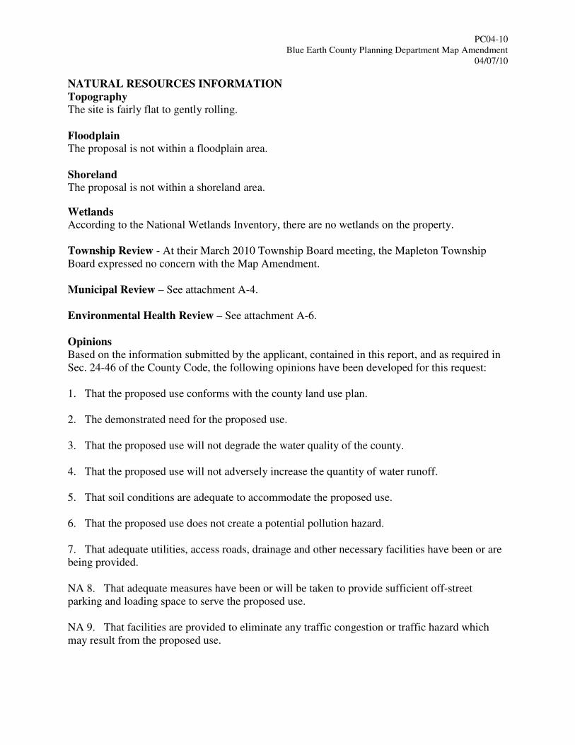
PC04-10
Blue Earth County Planning Department Map Amendment
04/07/10
NATURAL RESOURCES INFORMATION
Topography The site is fairly flat to gently rolling.
Floodplain
The proposal is not within a floodplain area.
Shoreland The proposal is not within a shoreland area. Wetlands
According to the National Wetlands Inventory, there are no wetlands on the property.
Township Review - At their March 2010 Township Board meeting, the Mapleton Township
Board expressed no concern with the Map Amendment.
Municipal Review – See attachment A-4.
Environmental Health Review – See attachment A-6.
Opinions Based on the information submitted by the applicant, contained in this report, and as required in
Sec. 24-46 of the County Code, the following opinions have been developed for this request:
1. That the proposed use conforms with the county land use plan.
2. The demonstrated need for the proposed use.
3. That the proposed use will not degrade the water quality of the county.
4. That the proposed use will not adversely increase the quantity of water runoff.
5. That soil conditions are adequate to accommodate the proposed use.
6. That the proposed use does not create a potential pollution hazard.
7. That adequate utilities, access roads, drainage and other necessary facilities have been or are
being provided.
NA 8. That adequate measures have been or will be taken to provide sufficient off-street
parking and loading space to serve the proposed use.
NA 9. That facilities are provided to eliminate any traffic congestion or traffic hazard which
may result from the proposed use.
PC04-10
Blue Earth County Planning Department Map Amendment
04/07/10
NA 10. That the conditional use will not be injurious to the use and enjoyment of other property
in the immediate vicinity for the purposes already permitted.
NA 11. That the establishment of the conditional use will not impede the normal and orderly
development and improvement of surrounding vacant property for predominant uses in the area.
NA 12. That adequate measures have been or will be taken to prevent or control offensive odor,
fumes, dust, noise and vibration, so that none of these will constitute a nuisance, and to control
lighted signs and other lights in such a manner that no disturbance to neighboring properties will
result.
NA 13. That the density of proposed residential development is not greater than the density of
the surrounding neighborhood or not greater than the density indicated by the applicable zoning
district.
NA 14. That site specific conditions and such other conditions are established as required for
the protection of the public's health, safety, morals and general welfare.
NA 15. That the intensity of the proposed residential development is not greater than the
intensity allowed in the Agricultural Zoning District. Section 24-111 of the Agricultural District
States: “Owners of property, residents, other users of property in the agricultural zone, and
neighboring properties adjacent to the agricultural zone may be subjected to inconvenience or
discomfort arising from normal and accepted agricultural practices and operations including, but
not limited to; noise, odors, dust, operation of aircraft and late night operation of farm
machinery, the storage and application of manure, fertilizers, soil amendments, herbicides, and
pesticides associated with normal agricultural operations.
Recommendations Staff recommends approval of the request to classify the properties referenced above that have
been detached from the City of Mapleton as Agricultural Zoned. Staff makes this
recommendation without any recommended conditions.
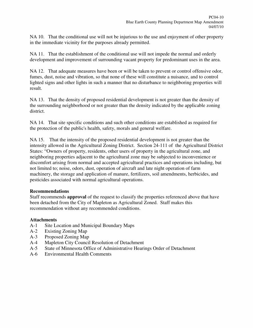
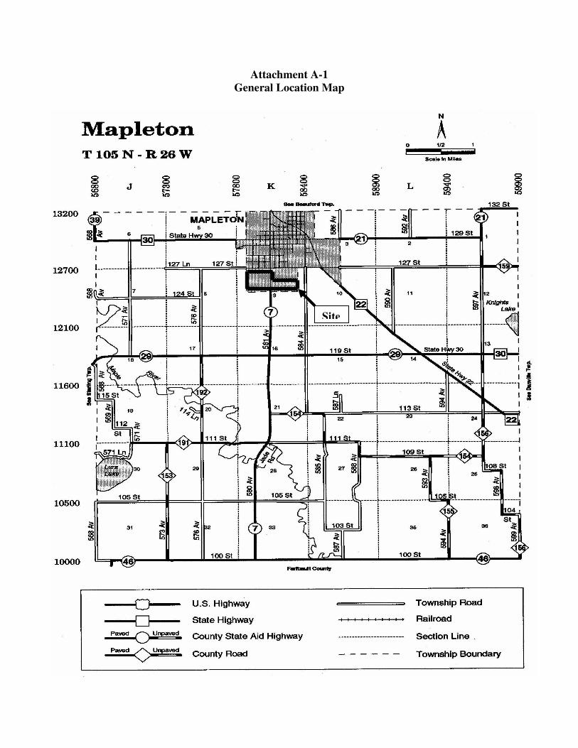
Attachments A-1 Site Location and Municipal Boundary Maps
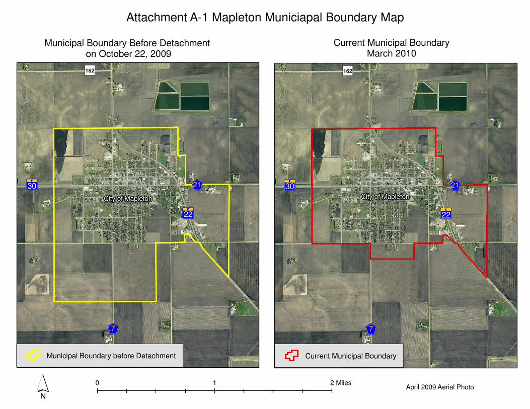
A-2 Existing Zoning Map
A-3 Proposed Zoning Map
A-4 Mapleton City Council Resolution of Detachment
A-5 State of Minnesota Office of Administrative Hearings Order of Detachment
A-6 Environmental Health Comments
Attachment A-1
General Location Map
Site
?A@22
?A@30
EF7
EF21
�)162
´0 1 2 Miles
Municipal Boundary Before Detachment
on October 22, 2009Current Municipal Boundary
March 2010
Attachment A-1 Mapleton Municiapal Boundary Map
?A@22
?A@30
EF7
EF21
�)162
Municipal Boundary before Detachment Current Municipal Boundary
April 2009 Aerial Photo
City of Mapleton City of Mapleton
±
SouthBend
Lyra Medo
Shelby
Judson Le Ray
Lincoln
Mankato
Sterling
Decoria
Danville
Ceresco
Rapidan
Lime
Beauford
Mapleton
Garden City Mc Pherson
Vernon Center
Cambria
ButternutValley
PleasantMound
JamestownT. 109 N.
R. 29W. R. 25W.R. 26W.R. 27W.R. 28W.
T. 105 N.
T. 106 N.
T. 107 N.
T. 108 N.
Attachment A-2Existing Zoning Map
EuGH
?»A@
") 156
?»A@
?»A@
EuGH?ÃA@
E«GH
EfGH
EfGH
?ÃA@E¡GH E¡GH
EGH EGH
") 159
") 154
") 154
") 156
") 155
") 153
") 191
") 192
KnightsLake(NE)
Maple River (AGR)
Unnamed Stream (TS)
Unnamed Stream (TS)
Unnamed Stream (TS)
Maple River (AGR)
Lura Lake(NE)
Mapleton
Unnamed Stream (TS)
1
98
2
7
6 35 4
26
35
30
12
13
23
28 2729
32 33
17
24
16
25
22
31
15
34 36
10 11
14
20 2119
18
0 10.5 Mile
ZONING DISTRICTS
General Business Railroad
Right of Way
Highway Business
Rural TownsiteRural ResidenceConservation
MunicipalityLakeProtected River or Stream
Shoreland Classifications - LakesRD = Recreational DevelopmentGD = General Development
NE = Natural EnvironmentShoreland Classifications - Rivers
AGR = Agricultural RiverTR = Transitional River TS = Tributary Stream
Agriculture
Light IndustryHeavy Industry
Approved: February 15, 2005Effective: March 17, 2005Prepared By: Blue Earth County Environmental ServicesRevised: April 24, 2007 Disclaimer: This map does not represent a survey of the land. The zoning districts on this mapreflect approved zoning changes through January 31, 2005. Zoning districts are subject toofficial amendments and the zoning designations shown on this map must be interpreted by the County Code and County Policy. Questions regarding zoning districts or interpretation of thismap should be directed to the County Planning Department. This map was prepared using the County's GIS and is based on the County's Parcel Data maintained by the County Mapping Department.While the County believes that the data is accurate, the County does not warrant that data in the GISis error free and the County does not represent that the GIS data can be used for purposes such as navigation or any other purpose requiring the exact measurement of distance and direction or the precise depiction of geographic features. This disclaimer is pursuant to Minnesota Statutes 466.03 Subd 21. The user of this map acknowledges that the County shall not be liable for any damages that that mayarise from this map or the information it contains.
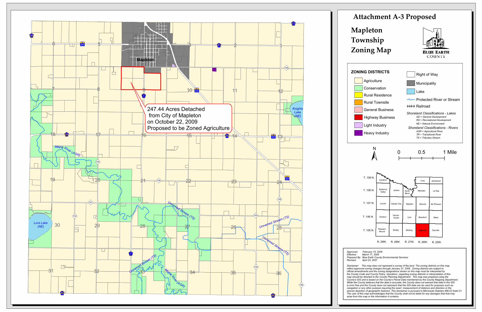
247.44 Acres Detached from City of Mapleton on October 22, 2009
±
SouthBend
Lyra Medo
Shelby
Judson Le Ray
Lincoln
Mankato
Sterling
Decoria
Danville
Ceresco
Rapidan
Lime
Beauford
Mapleton
Garden City Mc Pherson
Vernon Center
Cambria
ButternutValley
PleasantMound
JamestownT. 109 N.
R. 29W. R. 25W.R. 26W.R. 27W.R. 28W.
T. 105 N.
T. 106 N.
T. 107 N.
T. 108 N.
Attachment A-3 ProposedEuGH
?»A@
") 156
?»A@
?»A@
EuGH?ÃA@
E«GH
EfGH
EfGH
?ÃA@E¡GH E¡GH
EGH EGH
") 159
") 154
") 154
") 156
") 155
") 153
") 191
") 192
KnightsLake(NE)
Maple River (AGR)
Unnamed Stream (TS)
Unnamed Stream (TS)
Unnamed Stream (TS)
Maple River (AGR)
Lura Lake(NE)
Mapleton
Unnamed Stream (TS)
1
98
2
7
6 35 4
26
35
30
12
13
23
28 2729
32 33
17
24
16
25
22
31
15
34 36
10 11
14
20 2119
18
0 10.5 Mile
ZONING DISTRICTS
General Business Railroad
Right of Way
Highway Business
Rural TownsiteRural ResidenceConservation
MunicipalityLakeProtected River or Stream
Shoreland Classifications - LakesRD = Recreational DevelopmentGD = General Development
NE = Natural EnvironmentShoreland Classifications - Rivers
AGR = Agricultural RiverTR = Transitional River TS = Tributary Stream
Agriculture
Light IndustryHeavy Industry
Approved: February 15, 2005Effective: March 17, 2005Prepared By: Blue Earth County Environmental ServicesRevised: April 24, 2007 Disclaimer: This map does not represent a survey of the land. The zoning districts on this mapreflect approved zoning changes through January 31, 2005. Zoning districts are subject toofficial amendments and the zoning designations shown on this map must be interpreted by the County Code and County Policy. Questions regarding zoning districts or interpretation of thismap should be directed to the County Planning Department. This map was prepared using the County's GIS and is based on the County's Parcel Data maintained by the County Mapping Department.While the County believes that the data is accurate, the County does not warrant that data in the GISis error free and the County does not represent that the GIS data can be used for purposes such as navigation or any other purpose requiring the exact measurement of distance and direction or the precise depiction of geographic features. This disclaimer is pursuant to Minnesota Statutes 466.03 Subd 21. The user of this map acknowledges that the County shall not be liable for any damages that that mayarise from this map or the information it contains.
247.44 Acres Detached from City of Mapleton on October 22, 2009Proposed to be Zoned Agriculture
MapletonTownshipZoning Map

Blue Earth County Environmental Services Department
Land Use and Natural Resources Section
Post Office Box 3566
Mankato, Minnesota 56002-3566
Telephone: (507) 304-4381
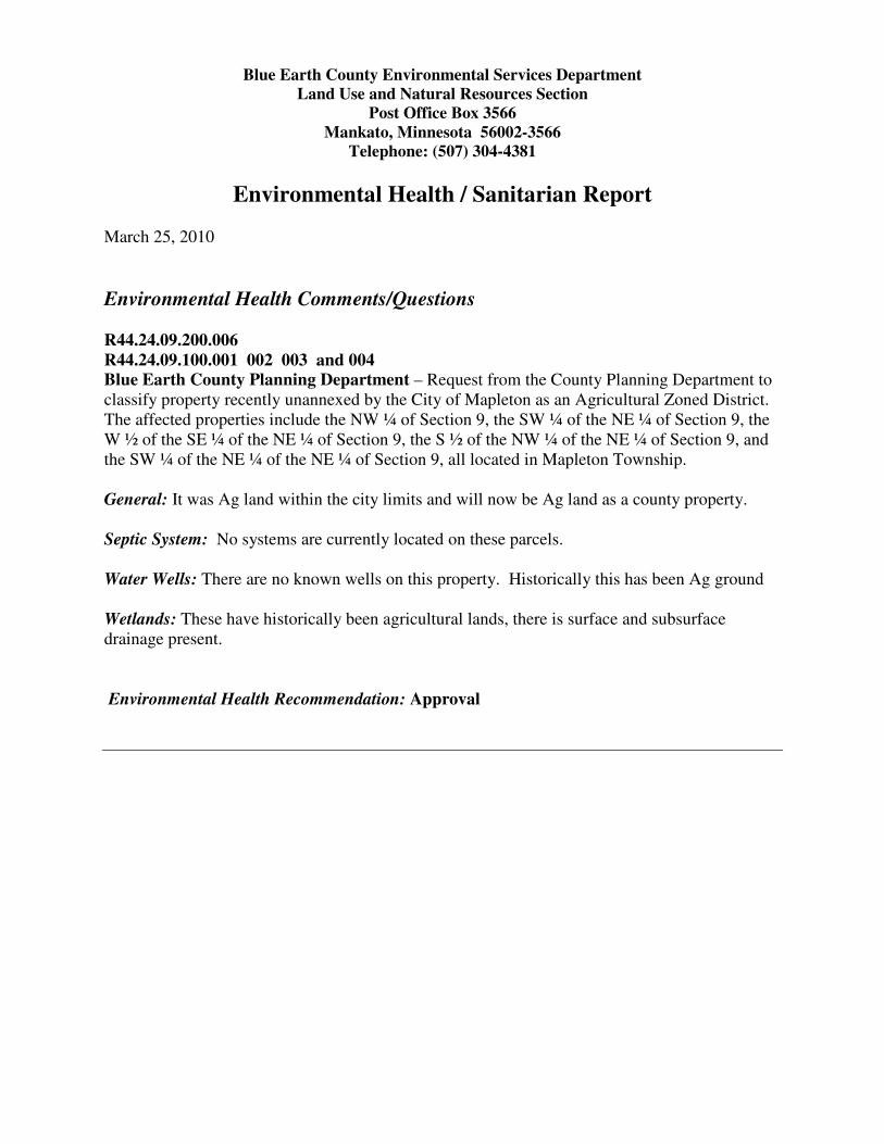
Environmental Health / Sanitarian Report
March 25, 2010
Environmental Health Comments/Questions
R44.24.09.200.006
R44.24.09.100.001 002 003 and 004
Blue Earth County Planning Department – Request from the County Planning Department to
classify property recently unannexed by the City of Mapleton as an Agricultural Zoned District.
The affected properties include the NW ¼ of Section 9, the SW ¼ of the NE ¼ of Section 9, the
W ½ of the SE ¼ of the NE ¼ of Section 9, the S ½ of the NW ¼ of the NE ¼ of Section 9, and
the SW ¼ of the NE ¼ of the NE ¼ of Section 9, all located in Mapleton Township.
General: It was Ag land within the city limits and will now be Ag land as a county property.
Septic System: No systems are currently located on these parcels.
Water Wells: There are no known wells on this property. Historically this has been Ag ground
Wetlands: These have historically been agricultural lands, there is surface and subsurface
drainage present.
Environmental Health Recommendation: Approval