Anorthosite and Associated Rocks of Oddanchatram, Dindigul Anna District, Tamil Nadu.
12
T. Subramani et al. Int. Journal of Engineering Research and Applications www.ijera.com ISSN : 2248-9622, Vol. 4, Issue 12( Part 5), December 2014, pp.100-111 www.ijera.com 100 | Page Anorthosite and Associated Rocks of Oddanchatram, Dindigul Anna District, Tamil Nadu. T. Subramani 1 , C.Kathirvel 2 , S.Sekar 3 , C.T.Sivakumar 4 1 Professor & Dean, Department Of Civil Engineering, VMKV Engineering College, Vinayaka Missions University, Salem, India. 2, 3 Assistant Professors, Department Of Civil Engineering, VMKV Engineering College, Vinayaka Missions University, Salem, India. 4 Associate Professor, Department Of Civil Engineering, Mahendra Engineering College, Mallasamudram, Namakkal District, Tamilnadu, India ABSTRACT This Project report pertains to the study of Anorthosites and Associated rocks of Oddanchatram, Palani Taluk, Dindigul Anna District of Tamil nadu The area is comprised of interesting and rare rock types namely Anorthosite, Pyroxenite, Norite, Charnockite, Garnet-Sillimanitegneiss,migmatite, pink granite, pegmatite, aplite and minor occurrences of molybdenite and iron ores.The area under investigation, Oddanchatram is located on the northern slope of kodai hills ( Palani Hills) which forms a part of western ghat range.It is represented in the portions of survey of India topographic sheets numbering 58 f/10, 58 F/11, 58 f/14 and 58 f/15 published in the year 1921. The area lies between North Latitude 10° 27' and 10° 32' and East Longitude 77° 40' and 77° 48'. The Total extent of the area is roughly 66 Sq.miles. The field work was conducted by using clinometer and Brunton compass. The area was traversed across and along foliation and strike directions in order to precisely demarcate the lithological boundaries and to note variations in structure, texture, and mineral characters. The structures of the study area is quite interesting with much contortion, folding, shearing, jointing and faulting which are normally anticipated in the Archaean terrain. KEYWORDS: Anorthosite, Associated rocks, Oddanchatram, pyroxenite, Archaean terrain, charnockite. I INTRODUCTION 1.1 Introduction This Project report pertains to the study of anorthosites and associated rocks of oddanchatram, Palani Taluk, Dindigul Anna district of Tamil nadu. The area is comprised of interesting and rare rock types namely anorthosite, pyroxenite, norite, charnockite, garnet- sillimanitegneiss, migmatite, pink granite, pegmatite, aplite and minor occurrences of molybdenite and iron ores. 1.2 Location of the study area The area under investigation, oddanchatram (Fig.1) is located on the northern slope of kodai hills ( Palani Hills) which forms a part of western ghat range.It is represented in the portions of survey of India topographic sheets numbering 58 f/10, 58 F/11, 58 f/14 and 58 f/15 published in the year 1921. The area lies between North Latitude 10° 27' and 10° 32' and East Longitude 77° 40' and 77° 48'. The Total extent of the area is roughly 66 Sq.miles. Oddanchatram is 35 km west of Dindigul, Headquarter of newly formed Anna district and 35km east of Palani, the famous pilgrimage centre and one of the abodas of Lord Muruga. The study area is well connected by State Highways and numerous metalled and non- metalled roads. The area is also connected by Southern Railway metre gauge line running between Dindigul and Pollachi. Almost all the Villages around the study area are connected by network of cart tracks and footpaths. 1.3 Previous work Vinayak (1960) Surveyed a part of the area and gave a good account of the Iithological association and paragenesis of Oddanchatram anorthosites. P.R.J .Naidu (1960) studied this area in detail and described the rocks as "anorthite gnesis" which occur as xeneliths.Narasimha Rao (1963, 1964) published a few papers peratining to the twin laws fo Plagiclase of anorthosites and their significance in the petrogenesis of the rock and also about the granitic rocks of the area.'De' (1969) suggested that it belonged to a belt of massive proterozoic, Adirandock type anorthosites.Saravanan and Lakshmi Narayanan (1972) discussed about the origin and development of garnet in the sheard contact zones of anorthosites basic granulites.Subsequently, Narasimha Rao (1974,1975) reported about the occurrece of " Block RESEARCH ARTICLE OPEN ACCESS
-
Upload
ijera-editor -
Category
Technology
-
view
52 -
download
1
Transcript of Anorthosite and Associated Rocks of Oddanchatram, Dindigul Anna District, Tamil Nadu.

T. Subramani et al. Int. Journal of Engineering Research and Applications www.ijera.com
ISSN : 2248-9622, Vol. 4, Issue 12( Part 5), December 2014, pp.100-111
www.ijera.com 100 | P a g e
Anorthosite and Associated Rocks of Oddanchatram, Dindigul
Anna District, Tamil Nadu.
T. Subramani1, C.Kathirvel
2, S.Sekar
3, C.T.Sivakumar
4
1Professor & Dean, Department Of Civil Engineering, VMKV Engineering College, Vinayaka Missions
University, Salem, India. 2, 3
Assistant Professors, Department Of Civil Engineering, VMKV Engineering College, Vinayaka Missions
University, Salem, India. 4Associate Professor, Department Of Civil Engineering, Mahendra Engineering College, Mallasamudram,
Namakkal District, Tamilnadu, India
ABSTRACT
This Project report pertains to the study of Anorthosites and Associated rocks of Oddanchatram, Palani Taluk,
Dindigul Anna District of Tamil nadu The area is comprised of interesting and rare rock types namely
Anorthosite, Pyroxenite, Norite, Charnockite, Garnet-Sillimanitegneiss,migmatite, pink granite, pegmatite,
aplite and minor occurrences of molybdenite and iron ores.The area under investigation, Oddanchatram is
located on the northern slope of kodai hills ( Palani Hills) which forms a part of western ghat range.It is
represented in the portions of survey of India topographic sheets numbering 58 f/10, 58 F/11, 58 f/14 and 58
f/15 published in the year 1921. The area lies between North Latitude 10° 27' and 10° 32' and East Longitude
77° 40' and 77° 48'. The Total extent of the area is roughly 66 Sq.miles. The field work was conducted by using
clinometer and Brunton compass. The area was traversed across and along foliation and strike directions in
order to precisely demarcate the lithological boundaries and to note variations in structure, texture, and mineral
characters. The structures of the study area is quite interesting with much contortion, folding, shearing, jointing
and faulting which are normally anticipated in the Archaean terrain.
KEYWORDS: Anorthosite, Associated rocks, Oddanchatram, pyroxenite, Archaean terrain, charnockite.
I INTRODUCTION
1.1 Introduction This Project report pertains to the study of
anorthosites and associated rocks of oddanchatram,
Palani Taluk, Dindigul Anna district of Tamil nadu.
The area is comprised of interesting and rare rock
types namely anorthosite, pyroxenite, norite,
charnockite, garnet- sillimanitegneiss, migmatite,
pink granite, pegmatite, aplite and minor
occurrences of molybdenite and iron ores.
1.2 Location of the study area
The area under investigation,
oddanchatram (Fig.1) is located on the northern
slope of kodai hills ( Palani Hills) which forms a
part of western ghat range.It is represented in the
portions of survey of India topographic sheets
numbering 58 f/10, 58 F/11, 58 f/14 and 58 f/15
published in the year 1921. The area lies between
North Latitude 10° 27' and 10° 32' and East
Longitude 77° 40' and 77° 48'. The Total extent of
the area is roughly 66 Sq.miles. Oddanchatram
is 35 km west of Dindigul, Headquarter of newly
formed Anna district and 35km east of Palani, the
famous pilgrimage centre and one of the abodas of
Lord Muruga. The study area is well connected by
State Highways and numerous metalled and non-
metalled roads. The area is also connected by
Southern Railway metre gauge line running between
Dindigul and Pollachi. Almost all the Villages
around the study area are connected by network of
cart tracks and footpaths.
1.3 Previous work
Vinayak (1960) Surveyed a part of the area
and gave a good account of the Iithological
association and paragenesis of Oddanchatram
anorthosites. P.R.J .Naidu (1960) studied this area in
detail and described the rocks as "anorthite gnesis"
which occur as xeneliths.Narasimha Rao (1963,
1964) published a few papers peratining to the twin
laws fo Plagiclase of anorthosites and their
significance in the petrogenesis of the rock and also
about the granitic rocks of the area.'De' (1969)
suggested that it belonged to a belt of massive
proterozoic, Adirandock type
anorthosites.Saravanan and Lakshmi Narayanan
(1972) discussed about the origin and development
of garnet in the sheard contact zones of anorthosites
basic granulites.Subsequently, Narasimha Rao
(1974,1975) reported about the occurrece of " Block
RESEARCH ARTICLE OPEN ACCESS

T. Subramani et al. Int. Journal of Engineering Research and Applications www.ijera.com
ISSN : 2248-9622, Vol. 4, Issue 12( Part 5), December 2014, pp.100-111
www.ijera.com 101 | P a g e
structures "and hornfelsic xenoliths in the
anorthosite. Windley and selvam (1975) made a
comparative study of anorthosites of Tamilnadu and
described them as deformed and isolated slices of
anorthosite bearing Archaean mafic stratiform
compex. Janardhan and Wiebe (1985) discussed the
petrology and geochemistry of this area and
mineralogical characters of oddachatram
anorthosites are similar to that of proterozoic massif
anorthosites.
1.4 Methods of study
The field work was conducted by using
clinometer and Bruton compass. The area was
traversed across and along foliation and strike
directions in order to precisely demarcate the
lithological boundaries and to note variations in
structure, texture, and mieneral characters. A base
map was prepared from Survey of India
topographical sheets numbering 58 F/10, 58 f/11, 58
f/14 and 58 f/15 published in the year 1921. The
portions of the above topographic sheets where
suitably enlarged for convenient field geological
mapping. The area is comprised of many hillocks of
considerable heights namely kuzhandaivelappan hill
(Δ1381), Ethilan malai (Δ 2000), vannan karadu, (Δ
1220), Anai karadu (Δ 1211), Ragaswami malai (Δ
1920),Veriyappur malai (Δ1723) etc., These hillocks
are visible from any part of the investigated area
and hence they were taken as reference points for
locating a place. Structural features like strike and
dip of the foliation, lineation, jointpattern, minor
folds, slickensides, shear planes and contact
relationships of various lithological units were
systematically studied in the field. In each ΔΔΔand
every locality, bearings were taken and specimen
were collected and numbered serially. Textural,
mineralogical , structural and other variations, were
carefully noted. All the above observations and
readings were plotted on the enlarged base map to
show distinctly the relationship among the rock
units. Interesting geological features were
photographed and neatly sketched and detailed
descriptions about them were noted down in the
field note book. Thin sections were prepared from
the hand specimens collected in the field. The
petrography of the various rock types were studied
in the laboratory by the examination of thin sections
under the petrological microscope. optical
characters like pleochroism extinction angle, 2V, of
a few constituent minerals and anorthite content of
plagioclase feldspars were determined.
II GEOMORPHOLOGY
2.1 Physiography and drainage
The area under investigation forms a
northern slope of kodai hills (Palani hills) Which is
an offshoot of western Ghats. The area is mainly an
undulating, rugged terrain surrounded by a number
of hillocks rising to about 1000 to 2000 feet from
mean sea level. The south and South - Western part
of the study area is occupied by the north-eastern
portion of Kodai Hills. The northern and north-
western part of the study area comprised of small
hillocks namely Anaikaradu (Δ 1277), Kollankaradu
(Δ 1262), Kurinchakaradu (Δ 1585), Vannankaradu
(Δ1220), etc. on the western part of the study area
prominent hillocks namely Ethilankaradu
(Vettilaimalai Δ 2000), Thandiyan karadu (Δ1350),
Kanavaimalai (Δ1300), Kuzhanthaivelappanmalai
(Δ1381), etc. In the eastern and north eastern part of
the study area there are two prominent hills namely
Rangaswami Malai (Δ1920), and Veriyappur karadu
(Δ 1793). The alignment of the above hillocks are
generally NE-SW direction which is roughly
parallel to the strike of the rock bodies(Figure.2.1
and 2.2).
The general drainage pattern of the area is
dentritic in the plains and sub-parallel in the
hillocks. The drainage is mainly controlled by
geological structures.(Figure.2.3) Nanganji Ar is the
only river that drains the area from south to north.
The river originates from the northern part of Kodai
Hills near the place Pachalur and flows towards
north through sirumalai and Aiyulur hills in the
name of parapalar. Near Vadakodu, a dam has been
costructed across parapalar river. Further north, this
river takes a steep fall of 120 feet. The it takes a
surface run-off from Virupakshi in the name of
Nanganji Ar. Further, it takes a north-eastern turn
and finally joins with Amaravathi river.
Figure.2.1 Panoromic view of the western part of
the study area as viewed from
kuzhandaivelappanmalai (∆ 1381)

T. Subramani et al. Int. Journal of Engineering Research and Applications www.ijera.com
ISSN : 2248-9622, Vol. 4, Issue 12( Part 5), December 2014, pp.100-111
www.ijera.com 102 | P a g e
Figure.2.2 The water falls Thalaikuthi formed by
the river parappalar. A set of joints are also seen on
the fault plane.
2.2 Weather and climate
The climate of the study area is tropical
mosoonal. The temperature of the hill range is
different from that of the plains. Temperature ranges
between 15oc to 38
°c on the lowland, while it is 10°
to 18° on the hillocks. The summer season prevails
during April and May. The strong wind from south-
West prevails during june. Jully and August.
Rainfall is scanty and the distribution of rainfall
shows bimodal. The first mode is centred around
August but the maximum rainfall occurs during
north-east Monsoon around November. The hilly
area, in addition, receives south-west Monsoon rain.
Generally the climate of the study area is arid and
that 50 to 60% of the total amount of rain falls
during the rainy season. The rainfall varies from 50
to 75 cm in the plains while, it is as high as 150 to
200 cm in the hillocks. Variability of rainfall is
about 20 to 30%, a characteristics of a semi-arid
region. Aridity is common in the lowland once in 3
to 5 years. The Nanganji Ar is noted for its seasonal
floods and the supply of water dwindles during
hotter periods.
Figure 2.3 Drainage Map of Oddanchatram, Palani
Taluk, Dindigul Anna District of Tamil nadu
2.3 Vegetation
Eventhough the hillocks, get higher rainfall
comparatively, they lie on the leeward-side of the
southern monsoon winds. Hence the vegetation on
the northern slopes of these hillocks is dry type. The
hillocks are clothed with dry monsoon forest. At
some places, on the hillocks medicinal shrubs are
noted as in the palani hills. The palani Hills are
having much open forest type and more barren soil.
Which is covered with coarse grasses while
sheltered valleys are wooded. The vegetation
of the plains comprises of scattered trees in the
fields, avenue trees and shrubs mostly cactus and
other nerophytic plants around hill range, all other
peaks and heights have little vegetatio and they
comprise of deciduous trees occasionally and throny
plants and shrubs mostly. Slopes of palani range
comprises of deciduous trees, like vegai, Vekkali,
White and Red cerdars, Some teak and black wood.
Gallnut trees are numerous. Lower and palani
plateaus are more valuable and contain evergreen
trees. The distribution of natural vegetation is
governed by a complex of environmental factors
including geology, soil, climate, ete. Natural
vegetation is considerably being damaged by
indiscriminate felling and burning. Hence, due
afforestation and soil conservation measures should
be taken up in the hill reserves to protect natural
vegetation cover and to check crosion hazard.
2.4 Weathering Anorthosites show evidences of greater of
greater weathering in comparision to the adjacent
country rocks like charnockite, gneiss and
migmatite. Since anorthosites are composed mostly
of felsic minerals, they are susceptible to easy
weathering. Because of this reason, the anorthosites
commonly occur in low-lying area surrounded by
resistant country rocks like charnockite, gneiss and
migmatite. Most of the cultivated lands are situated
on the weathered soils of anorthosite. As anorthosite
exposures are scarce on the surface, due to quick
weathering, and subsequent erosion, most of the
fresh samples of anorthosites were collected from
well cuttings.(Figure 2.4) Basic granulites show
mostly spheroidal weathering in a number of places
resulting in onion like spheroidal boulder (Figure
2.5). These spheroidal boulders prominently
displayed by the basic granulites were photographed
in the field.
2.5 Soil types:
The black and red soils are the two major
types found in the study area. The soil is classified
into three units namely, black clayey, black loamy
and the black sandy. These are confined to the
western parts of the study area. More than 85% is
red soil, in which red loamy ad red sandy and black

T. Subramani et al. Int. Journal of Engineering Research and Applications www.ijera.com
ISSN : 2248-9622, Vol. 4, Issue 12( Part 5), December 2014, pp.100-111
www.ijera.com 103 | P a g e
sandy soils contain gypsum and kankar in their
subsoil. Mostly these soils are derived through
weathering of anorthosites, charnockites and
gneisses. Alluvium is confined in a narrow zone
along Nanganji Ar. This acts as a good aquifer while
weathered charnockite and gneisses are poor
aquifers. Hence, shallow water bodies become dry
during summer. Water level from the surface
ranging from 3 to 20 mts. is a reflective factor for
dry semi-arid climatic condition and the presence of
poor aquifer in the study area. All the soils appear to
have been developed mostly on similar geology and
from one and the same parent material. Yet,
differences in soil properties are seen which might
be due to the differences in topography, drainage
and mineralogical composition of the rock types.
Figure.2.4 Ptymatically folded mafic bands within
anorthosites.
Fig.2.5 Spheroidal weathering displayed by basic
granulites
III OUTLIE OF THE GEOLOGY OF THE
STUDY AREA
3.1 Geological settings
Garnetiferous gneisses, basic granulites and
migmatites are the oldest group of rocks whcih are
presumably of Dharwarsia age,
Metasediments(Calcareous,ferruginous ad
pelitic)granite and pegmatite are associated with
them. The anorthosite body forms a narrow and
tabular sheet running parallal to the NE - SW
foliation of the pre-existing granulitic rocks. The
intrusive character of the anorthosite into the basic
granulitic terrainis maifested in the field. In basic
graulite is included as xenoliths, while in some other
cases, the anorthosite intruded the basic granulite
with sharp contact on either side. The area has been
affected by poly-phases of deformation and
metamorphism in which anorthosites and basic
granulites are participated. In consequence of these
deformation, new structural trends, mineral
lineations, foliation and minor fold axes have been
introduced locally in the area. Fracture zones
have been developed and shearing along this plane,
produce mylonite, cataclasitc fabric and slickensides
in the rocks. There are also narrow zones principally
in the directions of the newly imposed trends
showing thorough recrystallisation and introduction
of new minerals like garnet,sillimate,etc., in
equilibrium with attended P-T conditions. There are
certain contacts between anorthosites and basic
granulites which exhibit the above said characters.
3.2 Geological Sequence
The stratigraphic sequence established by
the present investigation is as follows:
Table 3.1Stratigraphic sequence
Stratigraphic Position Rock Types
Recent
Arcot granite
Anorthesites
Charnockites
Peninsular gneiss
Dharwars
Black and red soil
Alluvium
Kankar
Quartz veins
Aplite
Pegmatite
Pink granite
Garnetiferous
anorthosite
Pure anorthosite
Charnockite ( acid and
intermediate)
Proxenite
Norite
Garnetiferous mica
gnesis
Garnet – sillimanite
gnesis
Migmatite
Quartzite
Magnetite quartzite
3.3 Rock types and their field relationships
The main rock types of the area are
anorthosite and basic granulite of Archaean group.
In addition to the above rocks, the terrain consists
locally of charnockites, meta-sedimentary rocks and
calc-silicates. The contact between the various rock

T. Subramani et al. Int. Journal of Engineering Research and Applications www.ijera.com
ISSN : 2248-9622, Vol. 4, Issue 12( Part 5), December 2014, pp.100-111
www.ijera.com 104 | P a g e
types in most of the places are inferential as the
critical areas are under soil cover. The failed
relationship of the various rock types of the area are
described in the following order and not in the order
and not in the order of stratigraphic sequence.
3.3.1 Anorthosite
The anorthosite covers roughly an area of
about 12 Sq.miles. The main outcrops of the
anorthosite are observed.(Figure. 3.1) in ∆ 1223
hillock ( Near Oddanchatram railway station).
Kuzhanthaivelappan malai (∆ 1381), in ∆ 1194 hill
(half a mile South of Virupakshi), in Ehtilankaradu
(Vettiaimalai ∆ 2000), in Vannankaradu (∆1220), in
a ridge Kaveriammapatti, in the eastern slope of
Anaikaradu (∆ 1277), in the Erraiya Kavundanpudur
and Western foothill of Veriyappur karadu (∆1793).
The presence of the same rock in other places were
observed in several well sections, In most of the
above locations, the anorthosites are founded in a
highly weathered condition. The anorhtosite rocks
are partly covered by soil and Kankar cappings,
which attain a maxium thickness of about 40 feet.
3.3.2 Charnockite
These rock types are found in the form of
lenses, bands and patchy masses within gneisses.
The charnockite rocks ar foliated and they can be
observed on the weathered surfaces. The foliaton of
the rock is due to the parallel arrangement of planer
minerals. The mineral composition is variable due to
migmatitic nature of the rock. In the charnockites
xenoliths of basic granulites and quartz magnetite
occur as bands. The main outcrops of charnockite of
Pachalur: in the southern and eastern foothill of
Rangeswamyamalai: in the northern and western
flank of Kurichakaradu and in the hill 1507, one
mile south of Chatrapatti.(Figure. 3.2)
3.3.3 Norites
Norites do mot occur widely in the study
area. They are found only as lenses and intercaleted
bands within bodies of anorthosite and charnockite.
Number of norite bands are found on the western
slope of Kuzhanthaivelappanmalai
(Figure.2.6). These noritic bands are running in the
NE direction and also extend upto ∆ 1223 hillock.
The noritic bands are found parallel to that of
foliation planes of the country rock.
3.3.4 Proxenites
A the pyroxenite band occurs in a portion
of the eastern flank of Ethilankaradu (Vettilaimalai)
and Thandiyankaradu (∆ 1350). In this pyroxenite
band a zone of sulphide mineralization of 150 m.
long and 15 m which has been observed. Stringers
of pyrrhotite and chalcopyrite are also found within
this zone. Geological Survey of India has done a test
pit sampling of estimating the reserves of sulphide
ores.
Figure.3.1 Linear bands of norites within
anorthosites on the western slope of
kuzhandaivelappanmalai (∆ 1381)
Figure.3.2 Two directional joints in charnockite
along Oddanchatram - pachalur Road.
3.3.5 Peninsular gneiss
The northwestern and southeastern parts of
the study area is occupied by the Peninsular gneiss.
It includes different members such as garnet-
micagneiss, biotite gneiss and banded gneisses of
migmatitic nature. They display excellent banded
structure (Plate IV Fig.2) The foliation of the
gneisses trend NE – SE in the northwestern portion
an dips almost vertically. The extend however
changes from NE-SW to E-W in some parts of the
southeastern portion of the study area. These rocks
carry lenses, streaks and veins of charnockite and
norite.
3.3.6 Garnet –sillimanite-gnesis ( Khondalite)
These rocks are encountered at
Vannankaradu (∆ 1220) near Rangappanpudar. It
forms a narrow to broad band of 100 to 500 feet
thickness extending from Rangappanpudur to
Thangachiammapatti where in attains a maximum
thickness. The general trend of the khondalitic rocks
is NE-SE. Good outcrops of these rocks are found as
elongated ridges near kaveriammapatti and in
Anaikardu near Erraiyakavundanpudur. Since these
rocks are highly resistant to weathering they occur
an elongated ridges when compared with the
adjacent rock types.
3.3.7 Magnetite quartzite
Magnetite quartzite represents one of the
oldest rock unites of the study area and is invariably
seen all along the boundaries of basic granulite.
T. Subramani et al. Int. Journal of Engineering Research and Applications www.ijera.com
ISSN : 2248-9622, Vol. 4, Issue 12( Part 5), December 2014, pp.100-111
www.ijera.com 105 | P a g e
Magnetite and quartz are found as alternate thin
bands. The thickness of the body varies from place
to place. These rock types are found as very thin
bands on the western flank of Ehtilan karadu (∆
2000): on the western foothill of Anaikaradu (∆
1277) and also on the western sideo of
Veriyappurkaradu (∆ 1790)
3.3.8 Migmatite
Migmatites and granitic gneisses are
observed in the northwestern corner of the area and
extend towards south upto Chatrapatti. The hillock
(∆ 1477) near Reddiyapatti is composed of biotite
gneiss, hornblends-biotite gnesis and garnetiferous-
mica gneiss. Hornblende-biotite gneiss and
garnetiferous –mica gneiss. The general trend of
these rocks is NE-SE and tures of N-S near
Reddiyapatti. These rock types show minor
movements along certain weak planes and such
planes are mostly filled with pegmatitic veins. The
occurrences of hornblende-biotite gneiss is also
found along the road cutting between Oddanchatram
and Vadakadu.
3.3.9 Pink granite
Pink granite is the last phase of major
igneous activity of the study area. It pierces through
the foliation planes of the country rocks namely
charnockite,granitic gneisses and basic granulites.
The trend of the pink granite of pre-existing rocks.
The width of the pink granite varies from place to
place. The average width being roughly about 30
feet. The typical exposure of the pink granite is
observed in the southwestern part o
Rangaswamimalai and extend towards NE direction
through the entire peak of the same hillock. The
above granitic intrusion, while extending from
Rangaswamimalai towards S-W, it disappers along
the low lying cultivated lands. Further, the same
granitic intrusion reappears again on the
northeastern part of palani hills along
oddanchatram-pachalur road. Here, the grain size of
the pink granite becomes finer and assumes aplitic
character here and there.
3.3.10 Pegmatite and quartz vein
Minor occurrences of pegmatite and quartz
veins are found traversing through anorthosite, basic
granulites, charnockite and migmatites. A prominent
occurrence of pegmatite and quartz veins is
observed on the top of Rangaswamimalai where
commercial exploitation of quartz and feldspar
minerals is going on by private quarry owners.
3.4 Petrography
Thin sections were prepared from typical
rock specimens. On the basis of thin section studies,
the rock units were classified. The petrological and
petrographic studies were useful as a feed back
study for mapping the area. Carl zeiss petrological
microscope was used for petrographic studies. A
short account of the petrographical features of each
rock types is discussed below.
3.4.1 Magnetite quartzites
This hard and compact rock is composed of
alternate thin layers of quartz and magnetite. The
magnetite is steel – grey in colour and is readly
attrached by a magnet. In a few rock specimens, the
thickness of the magnetite layering is greater than
quarts. Under the microscope, the opaque magnetite
is isotropic and occurs as elongated grains. Quartz is
abundant and shows wavy extinction.It carries
inclusions of elongated and irregular magnetite
grains. Feebly pleochroic and pink coloured
orthopyroxene is also observed in this rock. Modal
percentage of magnetite varies between 10 to 30%.
3.4.2 Migmatite
According to Mehnert (1968) “ A
migmatite is a megascopically composite rock
consisting two or more petrographically different
parts, one of which is the country rock which is
generally plutonic appearance.” The above
definition excellently applies to the migmatites of
the study area. The parent rocks (Placement)
involved in the formation of migmatites are
charnockites and gneisses. The intruding rocks
(neosome) responsible for migmatization are mostly
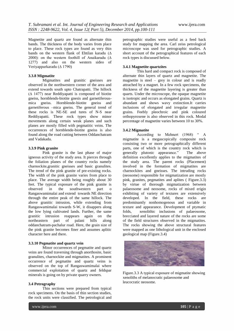
pink, granites, pegmatites and aplites ( Figure.3.3)
by virtue of thorough migmatization between
palaeosome and neosome, rocks of mixed erigin
exhibiting of variety of textures are extensively
developed. In the field, these rocks are
predominantly nonhomogenous and variable in
texture and appearance. Development of ptymatic
folds, xenolithic inclusions of palaeosome,
brecciated and layered nature of the rocks are some
of the field structures observed in the migmatites.
The rocks showing the above structural features
were mapped as one lithological unit in the enclosed
geological map (Figure.3.4)
Figure.3.3 A typical exposure of migmatite showing
xenoliths of melanocratic palaeosome and
leucocratic neosome.

T. Subramani et al. Int. Journal of Engineering Research and Applications www.ijera.com
ISSN : 2248-9622, Vol. 4, Issue 12( Part 5), December 2014, pp.100-111
www.ijera.com 106 | P a g e
Figure.3.4 Geological Map of Oddanchatram, Palani
Taluk, Dindigul Anna District of Tamil nadu
3.4.3 Garnet-sillimanite-Gneiss: (Khondalite)
It is a tough rock, composed of needles of
sillimanite, seales of biotite, potash fieldspar, pink
coloured garnet, Occasionally, graphite and
magnetite are also present, In a few specimens
presence of orhtopyroxene is also noted. Green
spinel is rarely seen. Silky luature and prismatic
habit are the typical characters for sillimanite.
Under the microscope, sillimanite occurs as
aggregate needles with transverse cracks and
occasional cleavages. The needles are not properly
distributed and their orientation is irregular.
Sillimanite is colourless and often occurs along with
quartz. Spinel is green is colour and is isotropic
under the microscope. Sillimanite needles show high
relief and irregular cracks. Biotite shows plechroism
from yellow to brown and occurs as scales.Feldspars
are orthoclase and oligoclase in composition.
Magnetite is black in colour and isotropie.
3.4.4 Peninsular gneiss
These rock types are repreented in the
study area by garnetiferous mica
gneiss.(Figure.3.5)The mineral components of this
rock are quartz, feldspar, biotite,hornblende and iron
ore. The percentage of mafics varies from section to
section. Quartz grains are elongated and occur as
aggregate and show wavy extinction. Potash
feldspars are represented by Orthoclane. The
plagioclase is oligoclass in composition and it shows
polysythetic twinning. Biotite si plechric from
yellow to brown. Hornblende is green in colour and
shows prismatic elevages and low extinction angle
ranging from 16° to 21°.Garnet is anhedral in shape
with numerous cracks and shows isotropic character.
Modal percentage of mieral components of this rock
are as follows: Quartz – 29%, K-feldspar –
26%,Plagioclase – 20%, Garnet – 10%, Hornblende
– 7% Garnet – 6%, and Iron orea – 2%.
Figure.3.5 Peninsular gnesis showing excellent
banded structure – oddanchatram to Pachalur road
3.4.5 Charnockite
Variants of charnockite are represented in
the field in the form of norite, pyroxenite and acid
charnockite. These three rocks altogether form as
most prevalent country rock in the field. Norites
are distributed in the field in the form of lenses and
intercalated bands within the anorthosite masses.
Norite is melanocratic, equigranular and medium
grained. In thin section it shows labradorite,
diopside, hypersthene and hornblende. Vermicular
intergrowth of prismatic grains of pyroxene within
plagioclases are occasionally noted. Pyroxene shows
alteration to hornblende. Apatite, garnet and
magnetite are the accossories. The palgioclasses are
sodic labradorite with polysynthetic twinning.
Orthopyroxene (hypersthene) is feebly pleochroic
from colourless to pink. Orthopyroxene shows
prismatic cleavages and straight extinction. Noritic
rocks are regarded as basic variety of charnockite
series.Pyroxenite is a hard, compact and
melanocratic rock with well developed prismatic
cleavages which are megascopically visible. Under
the microscope, the rock shows the presence of both
ortho and clinopyrexenes. Orthopyroxene is
represented by hypersthene which shows perfect
prismatic cleavages, feeble pleochroism and straight
extinction. Clinopyroxene is represented by augite,
which shows perfect prismatic cleavages. Colourless
and inclined extinction ranging from 45 – 45°.
Pyroxenite is regarded as ulterbasic variety of
charnockite.
The important mineral of acid and intermediate
charnockite group of rock is hypersthene. Generally,
these rocks are dark coloured and hence it is
difficult to distinguish the acid variety from the
intermediate variety in the hand specimen. Under
the microscopel, the acid variety is composed of
quartz, K-feldspar, sodic plagioclase, hypersthene
and iron ore. The intermediate variety is made up of
andesine plagioclase, orthopyroxene, augite and iron
ores with or without Quartz. Subparallel
arrangement of mafics is seen in both the varieties.
The optical properties of hypersthene in the acid

T. Subramani et al. Int. Journal of Engineering Research and Applications www.ijera.com
ISSN : 2248-9622, Vol. 4, Issue 12( Part 5), December 2014, pp.100-111
www.ijera.com 107 | P a g e
variety are as follows:Z∆C = 2-5°, Pleochroic
scheme; X = Pink., Z = light green. In the
intermediate variety, the optical properties of
hypersthene is similar to acid variety. Modal
percentage of acid Charnockite is as follows: Quartz
= 35%, K-feldspar = 40%, Plagioclase = 19%
Hypersthene = 4%, other accessories = 2%, Modal
percentage of intermediate charnockite is as follows:
Quratz 10 %, K-feldspar =5%, Plagioclase = 40%,
Clio and orthopyroxenes = 40% and other
accessories = 5%
3.4.6 Pink granite, pegmatite, aplite and quartz
veins
In hand specimen, pink granite is pink
coloured and shows crude gneissosity owing to the
planar parallelism of mafic minerals. Quartz is seen
to have lineated in hand specimen. Under the
microscope, perthitic intergrowth between quartz
and microline is observed. The grains are coarse and
irregular, Graphic texture is also common. The
study area is travered by the intrusion of
pergmatities, aplites and quartz veins. The intrusion
of these acidic rocks favour the distintegration and
feldspathization of pre-existing rocks. Pegmatites
are extraordinarily coarse grained and pink coloured
due to the abundant presence of orthoclase feldspar.
Under the microscope pegmatite shows coarse
grained and graphic texture between quartz and
microline. Mafic minerals are mostly muscovite.
Accessory minerals present in the pegmatite are
apatite, beryl and sphene. Aplite is fine grained,
equigranular and pink coloured rock. In hand
specima, and under microscope. It contains the same
minerals as in pegmatite under the microscope,
aplite shows holocrystalling and allotrimorphic
texture. Intergrowth texture is also common. Mafic
minerals are not common. Quartz veins are found
traversing the county rocks of the study area in
almost all the directions. The quartz veins contain
garnet in places and are also sometimes associated
with coarse hornblende crystals.
IV STRUCTURAL FEATURES OF THE
STUDY AREA
4.1 Introduction
The structures of the study area is quite
interesting with much contortion, folding,
shearing,jointing and faulting which are normally
anticipated in the Archaean terrain. The various
structural elements delineated and interpreted throw
light on the fact that the various lithological units
have been involved in a sequence of a few intrusive,
metamorphic and deformational episodes.
Generally, the rocks are characterised by a foliated
structure to which all joints and other structure are
geometrically related. The strike of the formations
in the area under investigation varies from N 40° E
to N80°E. The anorthosites are generally massive
and devoid of any foliation. However, along the
eastern and western margins, a crude foliation is
developed in these rocks, as revealed by the linear
disposition of the mafic constituents.
4.2 Folds:
The inconsistences observed in the
foliation direction of the various rock types of the
area prompted the author to make a few trips to
some parts of the area. Based on these observations ,
a few remarks of general nature applicable to whole
region are made here. All these data reveal the
existence of a major isoclinal fold, perhapa
overturned. The trend of the axial plane is NNE-SSE
and is in conformity with the regional strike of the
area. Infact, the various congruous foarces occurring
within the domain of the major fold have been of
immense value in fixing up the axial plane of the
latter. After assessing the shapes and symmetry of
such small scale at different positions occurring
within the major fold area and also the profile
pattern of the fold as viewed from it axis, the
direction of the fold axis has been determined. The
location of the axial plane by such graphical method
is further confirmed in the field by the presence of
such characteristic features as diallational structures
like Boudinage,pinching and swelling.
4.3 Minor Folds
In some Places, anorthosites show
extreme contortion and ptygmatic folds (Figure.4.1)
A careful study of the various minor folds, their
amplitude and wavelengths has been taken in order
to evaluate as far as possible, the sequence of the
fold them. Accordingly, several folds with
amplitudes to a few cms to several metres have been
identified in the area.
4.4 Joints:
Two directional jointing is well developed
in basic granuilte and charnockite of the study area
(Figure.4.2.) The strike joints trending NE-SW dip
at vertical angles generally towards NW while the
oblique joints striking NE-SE are almost vertical,
sometimes showing steep dips towards S-W. The
anorthosites are conspicuously unaffected by
jointing. Horizontal joints are commonly noted in
the charnockitses.
4.5 Shear Zones:
The eastern and western margins of the
anorthosite masses appear to be zones of shearing
and deformation. This is evidenced by
i) Extreme crushing, granulation and strike
variation in the basic granulites along the western
flank of Rangaswamimalai and in quartzite and in
garnet – sillimanite gneiss in Vannankaradu

T. Subramani et al. Int. Journal of Engineering Research and Applications www.ijera.com
ISSN : 2248-9622, Vol. 4, Issue 12( Part 5), December 2014, pp.100-111
www.ijera.com 108 | P a g e
ii) Prolific development of garnets along the
sheared contact zone of anorthosite – basic
granultie. Shear planes are seen developing along
the fold axial planes of minor folds. Two sets of
shears are prominent in the area and they trend N
45⁰E and 35⁰ W of which the former is older
and the latter is observed dislocating the former in
the field.
Figure.4.1 Extreme shearing folding contortion and
layering in migmatites.
Figure 4.2 Displacement of pegmatite vein due to
shearing movements.
4.6 Fault
The presence of the major zones of the
shear noticed in the area appear to be oblique
strikeslip fault. The fault zones are indicated in the
study area by the presence of slickensides and fault
gauge. The trends of the faults vary from N25⁰ to N
45⁰ E. These faults have affected anorthosites also.
Evidences for the strike-slip fault are seen in the
strike course of the shear zones, having steep angles
of dip and crushing of the rocks in the vicinity and
in the existence of small bent parallel faults. The
actual faulty plane is situated in the stream course of
Nanganji Ar.
4.7 Structural analysis and sequence of fold systems
in the area:
The area of planar clements such as
foliation planes, compositional planes and fold axial
planes were recorded, Linear elements measured
include oriented minerals, minor fold axes, and
lensoid bodies.
4.7.1 F1-Fold phases:
The earliest recongnizable deformation
noticed in this area belongs to F1 fold phases. The
hinges of these folds are defined by aggregate of
mafic minerals and their preservation and indentity
is due to the offering of resistance to later
migmatization. Type isoclinals flexural force are
recognized in such granular rock type like basic
granulite also with fold axial plane sub-parallel to its
foliation.
The linear elements characteristically
associated with F1 folding of the strong mineral
lineations (L1) exhibited by the oriented hornblende
crystals in the basic granulite and internal foliation.
The original direction of fold axis can no longer
been determined with any degree of certainity in the
area, as a they are immensely affected by later fold
phases.
4.7.2 F2-Fold Phases:
This is by far the dominating structural
fabric seen in this area. Early folding subsequent to
F1 is indicated by the presence of isoclinal folds.
The fabrics are representative from regional scale to
hand specimen and even micro section reveral
oriented arrangement of constituent minerals.
The major fault system which immediately
followed the fold systems F2. From the trend, it is
clear that the deformative forces that brought about
the F2 fold system is responsible to bring about the
major linear structure (L2) observed in this area are
also due to these deformative forces.
The analysis of structural data clearly
indicate the intrusion of the anorthsistic rock in the
area during these deformative episodes. The fault
planes and fold axis F2 of these deformative forces
are in cofirmity with the trend of anorthositc body
in the study area.
V ANORTHOSITES OF ODDANCHATRAM
5.1 Review on Anorthosites
The name “ Anorthosite” was proposed by
sterry Hunt in the year 1862, for a felsic rock,
essentially composed of andesine – labradorite
plagioclases the rock was referred to as
Labradorfels, Labradosite or Hypersthene rocks,
before the name anorthosite was given to this rock.
Anorthosite is defined as a rock consisting of 90%
or more plagioclase feldspar, Gabbroic, Noritic or
Troctolitic anorthosite contains 10-22% mafic
minerals.
Two principal types of anorthosites are
distinguished based on field occurrences.
1. Layered anorthosited instratified
complexes of Igneous rocks.
Eg:- Stillwater igneous
complex,Montana,U.S.A sittampundi
complex of Tamilnadu.
2. Large massif type anorthosite.
Eg:- Domical Adirandock massif, New
York,

T. Subramani et al. Int. Journal of Engineering Research and Applications www.ijera.com
ISSN : 2248-9622, Vol. 4, Issue 12( Part 5), December 2014, pp.100-111
www.ijera.com 109 | P a g e
U.S.A ., Irregular massif of Lake
St.John Quebec.
Among the massif type anorthosites, two
varieties are dinstinguished based on the
composition of Plagioclase and iron-ititanium
oxides. The labradorite type is characterized by
plagioclase in the range An 68-45% and titaniferous
magnetite. The “andesine-type is marked by the
plagioclase range An 48-25% antiperthite and
hemo-ilmenite.Important mafic minerals that
constitute the anorthosite are orhto and clino-
pyroxens,olivine is usually present in troctolite
varieties. Ores may be present as inclusions. Garnet
is always found as marginal metamorphic facies.
Hornblende and biotite are retrograde mafic
products. Though more than a hundred massif type
anorhtosite bodies have been reported throughout
the world with their field set-up, no general
consensus on the petrogenesis of anorthosites and its
relationship with orhtopyroxene bearing rocks have
been arrived.
5.2 Characteristic features of oddanchatram
anorhosites:
The anorthosite body is a tabular sheet of
six miles long and 2 miles wide and it elongation is
almost parallel to the foliation planes of the country
rock. This anorthosite pluton occurs within th
extensive granulite facies terrain of South India. It
occupies in a low-lying elliptical area surrounded by
resistant country rocks like gneisses and migmatites.
The contact relationships are excellently exposed at
many locations along the boundary (Plate VI.Fig.1).
Anorthosite body carries inclusions of older rocks
like norite,pyroxenite and gneisses.Occassionally it
show foliated appearance whenever mafic contents
are present in considerable amount. No
metamorphic aureole is observed around the body of
anorthosite.
Garnets are developed along the sheared
marginal contacts of anorthosited and basic
garnulites. Cataclastic fabric is also prevalent in the
anorthosite body. Secondary twinning and marginal
crushing around perphyroblasts of plagioclase
feldspars are common features. The plagioclase
feldspars constitute more than 90%of the rock and
the compositional range is between 45 – 60%
An.Saussurititsation is incipient along the deformed
palgioclases. The common mafic mineral present in
the anorthosite is green hornblende, and pyroxene is
generally absent. Pyroxene shows alteration ot
hornblende.Biotite in always been secondary after
hornblende. The mafic bands within the bodies of
Anorthosite shows, in certain places, contorted
foldings as is common in migmatitic terrain.This
indicates the possibility of intrusion of anorthositic
magma into the earlier nortic rocks. The
anorthosites shows a colour variation and tend to be
darker and brownish yellow in colour in the
proximity of contact zone while its colour becomes
lighter farther away from such contact zone.
5.3 Mineralogy and mode of occurrence:
The anorhtosites of Oddanchatram consist
of 95% plagioclase with little hornblende and iron
ores. It is coarse grained and often porphyritic with
variable colours ranging from grey, pink,purple and
occasionally brown. The play of colours of
plagioclase feldspar under sunlight is a
characteristic feature. In thin section, the rock is
hypidimorphic granular and shows conspicuously
the protoclasitc effects like granulation, bending and
wedging of plagioclase and undulose extinction, the
plagioclase is almost invariably twinned. It shows
alteration to calcite and chlorite. Pyroxene is
generally absent and the usual mafic constituent is
hornblende.However, thin sections of specimens
from the proximity of enclosed norite bands show
the presence of orhto and clinopyroxenes in minor
amounts. Hypersthene anhedra are also found
intergrown within plagioclase feldspars, the
pyroxenes shows alteration along the periphery,
cracks and cleavages to biotite, hornblende and
chlorite Garnet occurs embedded in anorhtosites as
ovoids and almond-shaped grains. There are
occurrences of garnet grains rimmed by a thin zone
of mafices of half millimeter width. The removal of
these garnets, due to weathering, imparts a pitted
appearance to the host rocks. The garnet has a
tendency to be developed along the deformed
narrow zones.magnetite grains occurring in
anorthosites show a linear disposition. Magnetite
occasionally includes grains of hypersthene. Biotite
has been formed at the contacts of ore and
plagioclase.
With regard to the mode of occurrence
anorthosite body forms a narrow and tubular sheet
running parallel to the NE-SE foliation planes of the
pre-exiting granulitic rocks.The intrusive character
of the anorthosite in the rocks granulite is
manifested in the field. In some cases, the basic
granulite is included as xenoliths while in some
other cases,the anorthosite intruded the basic
granulite with sharp contacts on either side (Plate
VI,Fig.1).
5.1 petrography
Based on field and laboratory evidences,
oddanchatram anorthosites can be broadly
classified into two divisions:
1. Pure anorthosites and
2. Garnetiferous anorthosites.
T. Subramani et al. Int. Journal of Engineering Research and Applications www.ijera.com
ISSN : 2248-9622, Vol. 4, Issue 12( Part 5), December 2014, pp.100-111
www.ijera.com 110 | P a g e
5.2 Pure anorthosites:
This is the most predominating type in the
study area. It is coarse grained, somewhat
porphyritic with plagioclase of variable colours
ranging from grey, pink, purple, and brown. It
consist of 95% plagioclase with little hornblende
and frequently shows play of colours. Under thin
section, the rock is hypidiomorphic granular and
shows protoclastic effects like crushing, granulation,
bending and wedging of twin lamellae of
plagioclase feldspar. The anorthite content of
plagioclase feldspar ranges from An 45-An 65. the
plagioclase is almost invariably twinned. it shows
alteration to calcite . It shows alteration to calcite
and chlorite. Pyroxene is generally absent and the
usual mafic mineral is hornblende. Prismatic grains
of hypersthenes are found intergrown within
plagioclase feldspars. The clino and orthopyroxenes
show alteration to hornblende, biotite and chlorite.
This rock type is free from garnet.
However, some thin sections show the presence of
euhedral garnet, crystals which are irregularly
distributed. An interesting feature is that these
garnet crystals have developed a mafic rim around
their margin. The plagioclase, feldspars show
occasional zoning in both twinned and untwined
crystals. Magnetite grains also show a linear
disposition.
5.3 Garnetiferous anorthosites:
This variety of anorthosite is distinguished
from pure anorthosites by the characteristic presence
of garnet. In the outcrops minute grains of garnets
can be observed. In hand specimens, the rock is dark
coloured, equigranular and medium grained.
This rock is found to consists of about 75%
plagioclase (An 65-An 75), 23% garnet and the rest
are green hornblende, magnetite and sphene. Under
thin section, the rock is hypidiomorphic granular.
Plagioclase is both twinned and untwined. It shows
alteration to scapolite. Garnet occurs as anhedral
grains in the interstitial spaces between plagioclase
crystals. There is an intergrowth formed between
hypersthenes and plagioclase.
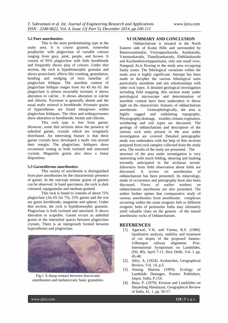
Fig.1 A sharp contact between leucocratic
anorthosites and melanocratic basic granulites.
VI SUMMARY AND CONCLUSION Oddanchatram is situated in the North
Eastern side of Kodai Hills and surrounded by
Ranaswamimalai, Veriyappurkaradu, Anaikaradu,
Vannnankaradu, Thandiyankaradu, Ehthilankaradu
and Kuzhanthaivelappanmalai, only one small river,
Nanganji Ar,is flowing in the study area occupying
faulty zones. The lithological variations within the
study area is highly significant. Attempt has been
made to decipher the various lithological units
particularly anorthsite and eits releationships with
other rock types. A detailed geological investigation
including field mapping, thin section study under
petrological microscope and determination of
anorthite content have been undertaken to throw
light on the characterstic features of oddanchatram
anorthosite. Gemorphologically, the area is
highly rugged and undulating topography,
Physiography,drainage, weather,climate,vegetation,
weathering and soil types are discussed. The
geology of oddanchatram and description of the
various rock units present in the area under
investigation are covered. Detailed petrographic
study was undertaken with the help of thin sections
prepared from rock samples collected from the study
area. The results of the study are presented. The
structure of the area under investigation is very
interesting with much folding, shearing and faulting
normally anticipated in the archaean terrain.
Inferences from field observation about folds are
discussed. A review on anorthosites of
oddanchatram has been presented. Its mineralogy,
made of occurrence and petrography have also been
discussed. Views of earlier workers on
oddanchatram anorthosite are also presented. The
author further opines that comeparative study of
various anorthosites from anorthositic complexes
occurring within the same orogenic belt or different
orogenic belts of peninsular India may ultimately
yield valuable clues on the genesis of the massif
anorthositic rocks of Oddanchatram.
REFERENCES
[1]. Agarwal, V.K. and Varma, R.S. (1980).
Qualitative analysis, stability and treatment
of cut slopes of the proposed Jammu-
Udhampur railway alignment. Proc.
International Symposium on Landslides,
(ISL 80). April 7-11, New Delhi. Vol. I. pp.
45-48.
[2]. Allix, A. (1924). Avalanches, Geographical
Review, Vol. 14, p.5.
[3]. Anurag Sharma (1993). Ecology of
Landslide Damages. Pointer Publishers,
Jaipur, India. P.154.
[4]. Basu, P. (1979). Erosion and Landslides on
Darjeeling Himalayas, Geographical Review
of India, 41, 1, pp. 50-57.

T. Subramani et al. Int. Journal of Engineering Research and Applications www.ijera.com
ISSN : 2248-9622, Vol. 4, Issue 12( Part 5), December 2014, pp.100-111
www.ijera.com 111 | P a g e
[5]. Beaty, C.B. (1950). Landslides and slope
exposure. Journal of Geology. Vol. 64, pp.
70-74.
[6]. Subramani.T, Manikandan.T, “Analysis Of
Urban Growth And Its Impact On
Groundwater Tanneries By Using Gis”,
International Journal of Engineering
Research and Applications, Vol. 4, Issue 6(
Version 2), pp.274-282, 2014.
[7]. Subramani, T “Assessment Of Potential
Impacts On NH7 – 4 Laning From Salem To
Karur”, International Journal of Modern
Engineering Research, Vol.2, No.3,pp 707-
715, 2012.
[8]. Subramani.T , Someswari.P, “Identification
And Analysis Of Pollution In Thirumani
Muthar River Using Remote Sensing”,
International Journal of Engineering
Research and Applications, Vol. 4, Issue 6(
Version 2), pp.198-207, 2014.
[9]. Subramani.T, Krishnamurthi.P, “Geostatical
Modelling For Ground Water Pollution in
Salem by Using Gis”, International Journal
of Engineering Research and Applications
,Vol. 4, Issue 6( Version 2), pp.165-172,
2014.
[10]. Subramani,T, Krishnan.S. And
Kumaresan.P.K., Study on Exixting Traffic
condition in Salem City and Identify the
transport facility improvement projects,
International Journal of Applied Engineering
Research IJAER, Vol.7,No.7, Pp 717 – 726,
2012
[11]. Subramani.T, Manikandan.T, “Analysis Of
Urban Growth And Its Impact On
Groundwater Tanneries By Using Gis”,
International Journal of Engineering
Research and Applications, Vol. 4, Issue 6(
Version 2), pp.274-282, 2014.
[12]. Subramani, T “Assessment Of Potential
Impacts On NH7 – 4 Laning From Salem To
Karur”, International Journal of Modern
Engineering Research, Vol.2, No.3,pp 707-
715, 2012.
[13]. Subramani.T , Someswari.P, “Identification
And Analysis Of Pollution In Thirumani
Muthar River Using Remote Sensing”,
International Journal of Engineering
Research and Applications, Vol. 4, Issue 6(
Version 2), pp.198-207, 2014.
[14]. Subramani.T, Krishnamurthi.P, “Geostatical
Modelling For Ground Water Pollution in
Salem by Using Gis”, International Journal
of Engineering Research and Applications
,Vol. 4, Issue 6( Version 2), pp.165-172,
2014.
[15]. Subramani,T, Krishnan.S. And
Kumaresan.P.K., Study on Exixting Traffic
condition in Salem City and Identify the
transport facility improvement projects,
International Journal of Applied Engineering
Research IJAER, Vol.7,No.7, Pp 717 – 726,
2012
[16]. T. Subramani, Sekar.S ,Kathirvel.C,
Sivakumar.C.T, “Geomatics Based
Landslide Vulnerability Zonation Mapping -
Parts Of Nilgiri District, Tamil Nadu,
India”, International Journal of Engineering
Research and Applications, Vol. 4, Issue 12(
Part 3), pp.139-149, 2014.
[17]. T. Subramani, Sekar.S ,Kathirvel.C,
Sivakumar.C.T, ”Identification Of Soil
Erosion Prone Zones Using Geomatics
Technology In Parts Of North Arcot And
Dharmapuri District” ”, International
Journal of Engineering Research and
Applications Vol. 4, Issue 12( Part 3),
pp.150-159, 2014.

![[XLS] · Web viewLATHA DINDIGUL Dindigul -Urban DUDLEY HSS,DINDIGUL SARAVANAN G GANESH M PARIMALA G GOKULAPRIYA S SENTHILKUMAR KRISHNAVENI S Edappadi GGHSS EDAPPADI PRIYADHARSHINI](https://static.fdocuments.us/doc/165x107/5afd67cd7f8b9a8b4d8d7e5b/xls-viewlatha-dindigul-dindigul-urban-dudley-hssdindigul-saravanan-g-ganesh.jpg)