ANNUAL REPORT FOR - Dundas Minerals
17
ANNUAL REPORT FOR E63/0953 - 955, over the period 1 st November 2009 to 31 st October 2010 (Group Report # C122/2009) & E63/0956, 957 & 1232 over the period 1 st November 2009 to 31 st October 2010 (Group Report # C171/2005) TO THE DEPARTMENT OF MINES AND PETROLEUM Compiled By: Exploration Department Date: 3 rd January 2011 Copies: Norseman Gold (1) Department of Mines & Petroleum (1)
Transcript of ANNUAL REPORT FOR - Dundas Minerals
ANNUAL REPORT
FOR
E63/0953 - 955, over the period 1st November 2009 to 31st October 2010
(Group Report # C122/2009)
&
E63/0956, 957 & 1232 over the period 1st November 2009 to 31st October 2010
(Group Report # C171/2005)
TO THE
DEPARTMENT OF MINES AND PETROLEUM
Compiled By: Exploration Department
Date: 3rd January 2011
Copies: Norseman Gold (1)
Department of Mines & Petroleum (1)

SUMMARY
This report details exploration conducted over E63/953, 954, 955, 956, 957 & 1232 (The
tenements) during the report periods 1st November 2009 to 31st October 2010. E63/956, 957
& 1232 are constituents of Group Report C171/2005 and E63/0953, 954 & 955 are
constituents of Group Report C122/2009.
During the report periods line clearing was commenced pursuant with the proposal presented
in the last annual report; unfortunately line clearing was left incomplete due to unseasonably
inclement weather during the report period.
i

Figure 1: Exploration Index Map
(Projection Longitude / Latitude (NAD 83)
ii
iii
Table of Contents
SUMMARY ............................................................................................................................... I
1. INTRODUCTION ............................................................................................................. 1
2. TENURE ........................................................................................................................... 3
3. EXPLORATION HISTORY ............................................................................................. 4 3.1 1996, Pecan Resources ............................................................................................. 4 3.2 1998, Pan Australian E63 / 453 ................................................................................ 4 3.3 BHP– Billiton – Discovery Nickel ........................................................................... 4 3.4 Exploration for the Period November 2008 to October 2009 .................................. 5
4. GEOLOGY ........................................................................................................................ 7 4.1 Regional Geology .................................................................................................... 7 4.2 Regolith Geology ..................................................................................................... 7 4.3 Style of Mineralisation ............................................................................................. 8
5. WORK CONDUCTED DURING THE REPORT PERIOD ............................................ 9
6. RECOMMENDATIONS .................................................................................................11
7. REFERENCES .................................................................................................................12
8. RELATED REPORTS .....................................................................................................13
List of Figures Figure 1: Exploration Index Map .............................................................................................. ii Figure 2, Tenement locations and access. ................................................................................. 2 Figure 3, Fraser Range work during the report period. ............................................................10
List of Tables Table 1, Tenement report periods. ............................................................................................. 1 Table 2, Tenement Schedule ..................................................................................................... 3
1. INTRODUCTION
This report details exploration conducted over E63/953, 954, 955, 956, 957 & 1232 (The
tenements) during the report period 1st November 2009 to 31st October 2010. E63/956, 957 &
1232 are constituents of Group Report C171/2005 and E63/0953, 954 & 955 are
constituents of Group Report C122/2009.
Report period for each tenement is listed in Table 1
Tenement Report
Period FromReport Period
To E63/0953 01-Nov-09 31-Oct-10 E63/0954 01-Nov-09 31-Oct-10 E63/0955 01-Nov-09 31-Oct-10 E63/0956 01-Nov-09 31-Oct-10 E63/0957 01-Nov-09 31-Oct-10 E63/1232 01-Nov-09 31-Oct-10
Table 1, Tenement report periods.
The tenements are centred approximately 130km southeast of the township of Norseman and
are accessed via dirt roads and tracks (Figure 2).
Page 1 of 13 X:\C171_2005_2009_2010A.doc
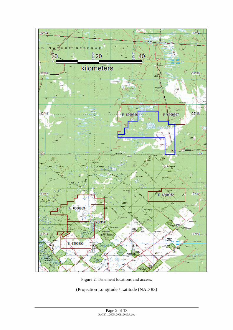
Figure 2, Tenement locations and access.
(Projection Longitude / Latitude (NAD 83)
Page 2 of 13 X:\C171_2005_2009_2010A.doc

2. TENURE
The tenements are held in the name of Central Norseman Gold Corporation, which is a wholly
owned subsidiary of Norseman Gold Plc. Table 2 lists for each tenement the area, grant date,
rent and the minimum expenditure commitment as noted on the 21 September 2010 tenement
schedule.
Table 2, Tenement Schedule
Tenement Area Area Unit Grant Date Rent Expenditure Commitment
E63/0953 70 Sub block 08-Feb-07 $13,190.10 $105,000.00 E63/0954 65 Sub block 08-Feb-07 $12,247.95 $97,000.00 E63/0955 27 Sub block 08-Feb-07 $5,087.61 $40,500.00 E63/0956 47 Sub block 05-Oct-05 $12,020.25 $70,500.00 E63/0957 45 Sub block 05-Oct-05 $11,508.75 $67,500.00 E63/1232 45 Sub block 05-Oct-05 $12,837.66 $106,000.00
Page 3 of 13 X:\C171_2005_2009_2010A.doc

3. EXPLORATION HISTORY
3.1 1996, Pecan Resources
Loam samples to the south of Fraser Range were found to contain gahnites in 30% of the
samples collected. There has also been significant mineral sands, bauxite, and coal
exploration in the general area.
3.2 1998, Pan Australian E63 / 453
Pan Australian exploration tested the southern extension of the Archaean Yilgarn Craton into
the formerly interpreted Albany-Fraser Province.
World Geoscience completed an aeromagnetic survey over the area on 400m spaced E-W
orientated lines at a flight height of 60m. 45 magnetic target areas were identified.
Local rock types include Meso-Proterozoic Coramup Gneiss, in faulted contact with Palaeo-
Proterozoic Dalyup complex. Both units consist of para and orthogneisses. Weak, magnetic
anomalies in the layered and faulted Proterozoic lithologies were not considered to be worthy
of follow up.
3.3 BHP– Billiton – Discovery Nickel
BHP– Billiton applied the Broken Hill type Ag-Pb-Zn Exploration model for the search for
polymetallic VMS type mineralisation.
Calcrete geochemical sampling highlighted an area of Cu-Au-Zn-Ni anomalism, called Zone
B, measuring 3km x 1km, centre on the contact between Archaean and Palaeo-Meso
Proterozoic Frazer Mobile belt followed by the drilling of 39 RAB holes drilled along two
lines to blade refusal. Depth of drilling ranged from 9 – 56m, for a total of 1,219m. Collar
spacing generally 50m, though up to 100m when depth to basement reached +50m. Holes
were orientated 60 degrees towards 90 magnetic.
A total of 218 composite samples were taken. Six metre composite samples were taken from
the overlying cover sequence and 4m composite samples from cover sequence/saprolite
Page 4 of 13 X:\C171_2005_2009_2010A.doc

interface. These samples were analysed for Au, Ag, As, Bi, Co, Cu, Mo, Ni, Pb, S, Sb and Zn
by ALS-Chemex Kalgoorlie.
This geochemical exploration identified a large 3km x 1km Cu + Au +/- Zn & Ni anomalism
on the contact between the Archaean domain and Palaeo-Meso Proterozoic Fraser Mobile
Belt.
Last year CSA Global was commissioned to undertake a desktop review of the tenements and
identified gold, base metal, mineral sand and uranium potential (Mattinson, P., 2008).
3.4 Exploration for the Period November 2008 to October 2009
During the 12 month period to October 2009 CSA Australia Pty Ltd undertook desk top study, Southern Geoscience Consultants (SGC) undertook an aeromagnetic interpretation and a reconnaissance visit over the tenements was completed. The detail of this has been reported to DMP in the 2008 – 2009 Annual Report previously lodged with DMP. Of particular note were recommendations arising from this work thus: Jeffress, September, 2009 recommends that:
• Infill and repeat calcrete sampling should be undertaken around the anomalous samples collected by BHP. The initial 1km spaced samples should be infilled with 200m spaced samples around the anomalous samples with two repeats taken at and near the original anomalous samples.
• This orientation work is designed to check the reliability of the calcrete sampling in this area and provide confidence in the suitability of this approach.
• If the follow-up samples repeat the anomalous results then calcrete sampling should be completed on 800m x 200m lines across the areas interpreted as shallow basement in E63/956 and E63/957.
• Complete a series of aircore traverses across the prospective units identified on the lithomagnetic interpretation – this will provide basement samples, information on lithologies to truth the interpretation and also geochemical samples and material for hyperspectrally assessing alteration assemblages present. Additionally, this approach will provide unequivocal evidence on the regolith upon which to base exploration decisions elsewhere in this area.
Jeffress, 4th November, 2009 recommends that:
• The desktop regolith interpretation is still considered to be valid.
• The underlying gold prospectivity of the project area (the northern ELs in particular) is considered to warrant evaluation.
• The access, whilst difficult, is not significantly more problematic that other regions were exploration is successfully undertaken, for example the tropical savannah woodlands of the Northern Territory or the jungles of Indonesia and PNG.
Page 5 of 13 X:\C171_2005_2009_2010A.doc

• Grid access using a front end loader is recommended – a loader is capable of fast traversing (compared to a dozer), enables a good view of the terrain, can “float” the bucket above the ground surface, removing stakes but leaving roots intact and the bucket can also deal with overhanging branches and trees above 2m, as well as clearing a vehicle track, and additionally, loaders are commonly available on farms reducing the potential mobilisation and operating costs.
• This approach is environmentally friendly and likely to facilitate POW approval compared to more “robust” approaches.
• Alternatively if you have a mechanically sound vehicle with body work that can be further damaged it could be fitted with solid tyres and maybe some additional scrub bars and used to undertake the sampling without requiring extensive track clearing.
• Tracks to areas of interest and “grid trees” in those areas can be cleared using this approach – either calcrete sampling or aircore drilling can use these access tracks – with only a minimal initial environmental ‘footprint”.
• The repeat and infill calcrete sampling around the BHP Au anomalous calcrete samples should be completed.
• Reconnaissance lines of aircore over prospective geology should also be planned together with calcrete sampling, as discussed in CSA’s previous memorandum.
• Geochemical sampling contractors such as Pathfinder or AusEx Exploration Services should be contacted for quotes on collecting calcrete samples.
• Possible contractors, including local farmers, Esperance based contractors or the contractors working on the Parmango road, able to clear the main access routes into the areas of interest should be identified and their rates and availability determined.
• The possible access routes should be planned and an estimate of the likely costs calculated.
• DMP’s environment group should be contacted to flag any issues that will need to be addressed by successful POW applications.
• Review of the BHP work suggests that the BHT potential of the Norseman ground has only been poorly tested by their work. Whilst an airborne EM survey would be a good tool to use to specifically target the massive sulphides of BHT systems, calcrete and aircore drilling are equally effective.
Page 6 of 13 X:\C171_2005_2009_2010A.doc
4. GEOLOGY
4.1 Regional Geology
The Albany-Fraser Terrane consists of two Proterozoic mobile belts that flank the southern
margins of the Archaean Southwest Gneiss Terrane and southern and eastern margins of the
Yilgarn block. The two Proterozoic mobile belts are Palaeo-Meso Proterozoic in age and are
characterised by high-grade gneisses and granulites, granitoid intrusions and polyphase
deformation.
Myers 1990, divided the Albany-Fraser Terrain into the Biranup Complex and Nornalup
Complex.
The Project lies in the Biranup Complex (1600-1700Ma) of the Fraser Mobile Belt and is
composed of strongly deformed Palaeo-Meso Proterozoic high-grade quartzo-feldspathic and
basic gneisses (para and orthogneisses) with localized granitoids and gneisses of 1130-
1350Ma.
The Biranup Complex is divided into two domains; the Western Fraser Domain and Dalyup
Domain. The Dalyup Domain is interpreted to sit stratigraphically below the Western Fraser
Domain and is believed to consist of early rift fill (as evident from the abundant felsic
gneisses and widespread amphibolites. The Western Fraser Domain has a higher meta-
sedimentary component (psammites and psammo-pelits) with only minor-moderate
amphibolites and this might reflect gradual cooling of the basin/rift.
The Nornalup Complex (1100-1300Ma) is less intensely deformed high-grade orthogneisses
and paragneisses intruded by sheets of granite-diorite.
4.2 Regolith Geology
The Fraser Project contains sub-cropping Proterozoic rocks occurring beneath a stripped
insitu laterite profile and overlying Tertiary sediments.
The regolith sequence consists of a truncated Proterozoic saprolite (formed in the Mesozoic),
which is variably overlain by sediments of post-Eocene age. These overlying Cainozoic
Page 7 of 13 X:\C171_2005_2009_2010A.doc
sediments have been modified by lateritic weathering processes during the Oligocene and
locally partially stripped due to uplift.
The soil profile reflects the relatively recent onset of aridity (Late Miocene) and formation of
an alkaline upper regolith.
The Fraser ELs are deeply weathered much like the Yilgarn Craton, and is covered by a
veneer of Eocene terrestrial marine sediments. Pedogenic carbonate is extensively developed
in soils overlying both Archaean and Proterozoic basement and Tertiary sediments.
4.3 Style of Mineralisation
Possible mineral styles include: • Yilgarn greenstone gold, nickel mineralisation
• Broken Hill Type lead-zinc, VMS polymetallic
• Tropicana style gold mineralisation
Page 8 of 13 X:\C171_2005_2009_2010A.doc

5. WORK CONDUCTED DURING THE REPORT PERIOD
Work conducted during the report period was based on recommendations offered in Jeffress, G. M., 4th November 2009 and Jeffress, G. M., 27th November 2009. Specifically, access roads and lines were cleared as shown on Figure 3 to permit access for reconnaissance regolith aircore drilling. Unfortunately, due to unseasonably wet conditions, access clearing was delayed, remains incomplete, and drilling was therefore delayed. Approximately 60km of roads and access lines were rehabilitated or cleared under supervision of Ngadju traditional claimants.
Page 9 of 13 X:\C171_2005_2009_2010A.doc

Maintenance clearing completed
Lines cleared
Figure 3, Fraser Range work during the report period.
Page 10 of 13 X:\C171_2005_2009_2010A.doc

6. RECOMMENDATIONS
It is recommended that work continue towards the objectives detailed in Section 3.4; that line clearing and drilling be completed as detailed in Jeffress, G. M., 27th November, 2009 and Jeffress, G. M., 4th November 2009 and Jeffress, G. M., September 2009.
Page 11 of 13 X:\C171_2005_2009_2010A.doc

7. REFERENCES
Jeffress, G. M., September 2009, Memorandum to David Thomas dated 25/9/2009, Re: Fraser
Range Project – Regolith/Landform interpretation and geochemical strategy.
Jeffress, G. M., 4th November 2009, Memorandum to David Thomas dated November 4,
2009, Re: Fraser Range South Project – Reconnaissance Visit Report.
Jeffress, G. M., 27th November, 2009, Memorandum to David Thomas dated November 27,
2009, Re: Next steps for exploration at Fraser Range project.
Isles, D., 2009, Technical Memorandum to CSA dated 22 September 2009.
Mattinson, P., 2008 Exploration Potential, Norseman Gold Plc, Fraser Province, Albany,
Western Australia, ELS63/952 – 957. Unpublished company report.
Norseman Gold, 2009, 2008 – 2009 Annual Report for 63/0952, E63/0953 – 955 & E63/0956, 957 to the DMP. Read J. 2004 Exploration Licences E63/706-746, Southern Fraser Project, Western
Australia; Combined Final Report For The Period Ended 29th January 2004,
Discovery Nickel Ltd
Robinson P. 1998 Yilgarn Extension Project, E63/453 Surrender Report; Pan Australian
Exploration P/L. DOIR Reference M9749/4, Item 10624A 54560
White M 2004 Exploration Licences E63/706-746, Southern Fraser Project, Western
Australia; Combined Final Report For The Period Ended 29th January 2003, Combined
Reporting number C33/2003, BHP Billiton Minerals P/L, DOIR Reference CR10650,
A66276
White M., 2004 Exploration Licences E63/706-746, Southern Fraser Project, Western
Australia; Combined Final Report for the Period Ended 20th December 2004, Combined
Reporting number C33/2003, BHP Billiton Minerals P/L, DOIR Reference CR10864.
Page 12 of 13 X:\C171_2005_2009_2010A.doc
Page 13 of 13 X:\C171_2005_2009_2010A.doc
8. RELATED REPORTS
The following report has been submitted to the DMP with this report:
Jeffress, G. M., 27th November, 2009, Memorandum to David Thomas dated November 27,
2009, Re: Next steps for exploration at Fraser Range project.