Annual Report 2007 - Mary River Catchment Coordinating ...mrccc.org.au/downloads/publications/Annual...
35
Annual Report 2007 Is this Queensland Lungfish looking to you to ensure the survival of the species?
Transcript of Annual Report 2007 - Mary River Catchment Coordinating ...mrccc.org.au/downloads/publications/Annual...
AnnualReport2007
Is this Queensland Lungfish looking to you to ensure the survival of the species?


Table of Contents Mary River Catchment coordinating Committee Delegates 2006-2007 1 MRCCC Staff 2006-2007 1 Chairman’s Report – 2007 2 Map showing the locations where the Northern Pipeline Interconnector intends to extract water for south east Queensland 3 Traveston Dam 3 Project Reports 5
Western Mary Catchments Sustainable Grazing Landscapes Project 5 National Landcare Program – Brad Wedlock 5 Mary Program of Rivercare (2006 & 2007) 8 Living with Threatened Species – Eva Ford 9 Mary Catchment Community Waterwatch Networks 11 Mary River Turtle Dissolved Oxygen Logging at nesting sites 14 Aquatic Weed observations in the Mary River Catchment - Steve Burgess 14 Teddington Weir Integrated Aquatic Weed Management Strategy 16 Community Water Grant – Kilcoy Creek 17 Elaman Creek Recreational Fishing Grants Program 18 South East Queensland Rainforest Recovery Program 19 MRCCC Website 19 Regional Liaison Officer 20 Resource Centre 20 Noosa Festival of Water 20 Educational Activities 21 Threatened Species Costume Workshop 21 Twitching for Mary 22 Biological Control and Ecology of Cabomba Progress 2006-2007. 22 Shon Schooler, CSIRO Entomology 22 Growing Sustainable Agricultural Precincts in the Middle Mary and Kin Kin 23 Property Management System Initiative of the DPIF 23 Mary River Catchment Coordinating Committee – Audited Financial Statement 2006-2007 24 Specific Comments on Referral Northern Pipeline Interconnector to the Federal Government 29
Mary River Catchment Coordinating Committee Resource Centre: 37 Nash St, Gympie Postal: PO Box 1027, Gympie, 4570 Phone: 07 5482 4766 Fax: 07 5482 5642 Email: [email protected]: www.mrccc.org.auDonations to the Mary Catchment Public Fund are tax deductible
Front cover photograph of the Queensland Lungfish courtesy of Gunther Schmida

Mary River Catchment coordinating Committee Delegates 2006-2007 Interest Sector Name Position
Beef/Grazing Harry Jamieson Chair
Dairying Michelle Anderson
Dept of Primary Industries & Fisheries Graeme Elphinstone
Dept of Natural Resources & Water Alan Key
Education Mark Cridland
Environment Vacant
Extractive Industries Vacant
Fishing Vince Collis
General Community Lower Mary Vacant
General Community Upper Mary Dave Sands
Horticulture Jim Buchanan Vice-Chair
Irrigation Brian Thomas
Landcare, Lower Mary Marilyn Connell
Landcare, Upper Mary Don Maskell
Local Government Lower Mary Cr Debbie Hawes
Local Government Middle Mary Cr Shane Jocumsen
Local Government Upper Mary Cr Ray Kelly
Rural Women Rosemary Burnett
Special Member Nai Nai Bird
Special Member Margaret Thompson Secretary
Special Member Lin Fairlie
Special Member Angus Hutton
Special Member Paul Marshall Treasurer
Sugar Trevor Crook
MRCCC Staff 2006-2007 Brad Wedlock Operations Manager
Eva Ford Catchment Officer Threatened Species
Dale Watson Catchment Officer to April 07
Steve Burgess Catchment Officer from April 07
Ruth Hutchison Noosa Festival of Water Coordinator
Glenda Pickersgill Water Quality Improvement Project Officer
Jane Eales Temporary Catchment Officer August/September 2007
Suellen Baxter Administration Assistant
Debbie Seal Administration
Winners of the 2007 Queensland Rivercare Award

Chairman’s Report – 2007 The Traveston Dam saga has occupied a large part of the past year’s activities. TV and radio presentations, numerous press releases, staff preparation of submissions opposing the dam and northern pipeline interconnector construction and attendance at anti-dam meetings have contributed to an input of much time and effort without any recompense. Our Future Water Options subcommittee recommendations, published in 2005, were visionary but tended to be dismissed and ignored by the dam builders within government. However, as the drought worsened and the water mismanagement continued unabated, it was pleasing to see that key recommendations of the sub-committee, namely water recycling, provision of rain water tanks and demand management coupled with an education campaign, were partially or wholly adopted by government. With the government encouraging an influx of 1000+ people to Queensland every week, greater emphasis must be placed on water recycling if we are to avoid a repeat of the mismanagement that has occurred during the last few years.
MRCCC Chair, Harry Jamieson
Late last year we vacated our office at the old railway complex situated in Tozer St and moved to more suitable rental accommodation in Nash Street, Gympie. My appreciation goes to our new landlord, Cooloola Family & Community Development for their support and assistance over the year. We have now been informed that the building has been sold and our tenure is uncertain. Last year I commented that long term accommodation for our Resource Centre and staff was imperative. It remains so and our search for a permanent premises has occupied the Executive’s deliberations throughout 2007. During the last three months we have been fortunate in receiving a significant donation to our Public Fund. This very generous donation has enabled the Executive and Staff to commence planning for a permanent home for the MRCCC. We recently submitted a proposal to the Commonwealth and State Department of Main Roads to acquire land on which we could construct a Resource and Environment Centre. This Centre, showcasing water and energy efficiency options, and green smart building technologies would be accessible to the wider community. The MRCCC has now been in operation for 14 years and during that time a highly successful working relationship has developed with various councils who have an interest in engaging the community to improve water quality and biodiversity in the Mary River Catchment. Over the past decade, local government has provided over $1 million to enable much needed environmental protection work to be undertaken. We would like to place on record our thanks to Cooloola, Noosa, Maroochy, Caloundra and Maryborough City Councils for their generous support over the years. Woocoo, Kilkivan, Tiaro and Hervey Bay Councils have previously made financial contributions and we thank them also. Council amalgamations, legislated by the government, will reduce the number of shires in the catchment to three. We will ensure that our activities are brought to the attention of the new administrators and councillors at the first opportunity and envision and anticipate that each of the three proposed local government authorities would appoint a Delegate to represent their interests on the MRCCC. During the year, our professional and personal relationship with the Burnett Mary Regional Group has matured and our partnership is bearing fruit in the form of a range of programs aimed at getting work done on the ground. I would like to thank BMRG Chairman, Russell Stewart, CEO David Brown, Programme Manager Mark Caswell and staff for their cooperation and assistance during the year. Our well known Catchment Officer, Dale Watson requested and was granted a year’s leave of absence earlier this year. He and his companion are undertaking a tour of South America. He found the beef and beer much to his liking in Argentina. Last news they were in earthquake prone Peru. We hope for his safe return. Meanwhile, Steve Burgess, whom most will know from his knowledgeable submissions opposing the Traveston Dam, has been recruited to undertake Dale’s role as Coordinator of the Upper Mary, Widgee/Wide Bay and Munna Waterwatch networks. Steve’s expertise has been invaluable in our discussions with the various agencies involved with the dam. Jane Eales also recently came on board on a temporary basis to progress Dale’s upper Mary Rivercare on-ground projects. Jane has a background at the Pioneer River Catchment Coordinating Committee and a family who have been water watching in the Kenilworth Waterwatch network for some years. The MRCCC was also fortunate to employ Glenda Pickersgill on a part time basis to undertake monitoring for the Mary Water Quality Improvement Project auspiced by the BMRG. Glenda also brings a wealth of knowledge and expertise to our organisation. Our thanks go, as always, to Operations Manager Brad Wedlock, Threatened Species Catchment Officer, Eva Ford, Noosa Festival of Water Coordinator, Ruth Hutchison and to Deb Seal who manages to keep the wheels turning with help from Sue Baxter and Ruth. The productivity and successful outcomes of our dedicated staff have recently resulted in the MRCCC winning the 2007 Queensland Rivercare Award. The award nomination focussed on the MRCCC’s holistic approach to catchment management, citing on-ground works carried out through the Rivercare Grants
2

Program, the Western Mary Catchments Sustainable Grazing Grants Program, the Living with Threatened Species Program and the six Community Waterwatch Networks throughout the catchment. To our Waterwatch volunteers, who are the backbone of our Waterwatch Program, a special thank you for a job well done during one of the worst droughts in 50 years. A particular thanks also to all our Rivercare and Sustainable Grazing Grant recipients who are actively involved in improving our landscape and waterways, often contributing years of their time and labour to the task. A true change in the environment would not take place without their commitment. I would like to record my appreciation to Bevly and Peter Hughes, rural reporters, for their unbiased reporting of most of our activities during the year. Their reporting has increased the profile of this organisation and has allowed us to convey, to a large diverse audience, the work we undertake to protect the Mary Catchment. To my fellow Committee members and to members of the Executive, Jim Buchanan, Margaret Thompson and Paul Marshall, I thank you for your advice and support. Harry Jamieson, Chair, MRCCC
Traveston Dam The proposed new water infrastructure plans for the Mary Valley have resulted in a very busy year for MRCCC staff in researching and writing detailed scientific submissions and meeting with government bodies involved with these proposals. During the year, the MRCCC has presented detailed written submissions to government on the following issues.
Referral of the Traveston Crossing Dam proposal to the Federal Department of Environment and Water Resources (DEW) as a controlled action under the Environmental Protection and Biodiversity Conservation (EPBC) Act 1999;
The Senate Enquiry
A submission to the Queensland Coordinator-General on the draft Terms of Reference (ToR) for an Environmental Impact Statement (EIS) for the dam proposal;
A written submission to the federal Senate enquiry on water supply options for South East Queensland and the proposed Traveston Crossing Dam;
A submission to the Federal Minister for the Environment on the assessment of the Northern Pipeline Interconnector (NPI) Stage 1 under the EPBC act;
A submission to the State Coordinator General’s department on the terms of reference for an EIS on NPI Stage 1;
A submission on the draft EIS for the NPI stage 1; A submission on the referral of the NPI stage 2 to the Federal DEW.
As part of the process of preparing and negotiating these submissions, MRCCC staff prepared presentations for and attended the following formal meetings
2 meetings with the Southern Regional Water Pipeline Alliance. 1 meeting with the assessment staff of the Coordinator-General’s department. 1 joint meeting with the EIS staff of Queensland Water Infrastructure and the assessors from the
CG department. 2 meetings in Canberra with the assessment staff of the Federal Department Environment and
Water. 1 full day tour of the Mary Valley with the Federal DEW assessment staff 1 meeting in Canberra with the Minister for Environment and Water and senior ministerial staff. 1 meeting in Canberra with junior staff of the shadow Minister for the Environment
MRCCC staff were also heavily involved in the Senate enquiry on the proposed Traveston Crossing Dam, giving verbal witness statements as well as preparing written submissions, and attending all four hearings. Staff were involved in showing the senators around the Mary Valley as part of their preparation for the enquiry and met with and discussed matters with all bar one of the senators on the enquiry. .
3

Map showing the locations where the Northern Pipeline Interconnector intends to extract water from the Mary Catchment
4

We have also continued to lobby State and Federal politicians as well as compiling and forwarding information to the RAMSAR Convention Secretariat to alert them to the potential negative impacts of the dam upon the Great Sandy Strait. During the year the following MRCCC staff attended and gave presentations at the following conferences:
Brad Wedlock and Glenda Pickersgill - Stream Management Conference in Albury – on community river restoration efforts.
Steve Burgess - State Waterwatch Conference in Townsville – on community based stream observation and reporting
Steve Burgess and Glenda Pickersgill - International River Symposium in Brisbane – on the implications of the proposed infrastructure developments and the environmental flow provisions in the Mary Basin Water Resource Plan.
A copy of the MRCCC’s submission in relation to the proposed Stage 2 of the Northern Pipeline Interconnector is included at the end of this report.
Project Reports Western Mary Catchments Sustainable Grazing Landscapes Project National Landcare Program – Brad Wedlock The Western Mary Catchments Sustainable Grazing Landscapes Project aims to assist grazing landholders to improve the productivity and sustainability of their grazing management systems, and to integrate the management of wetlands and riparian zones into their property management planning process. The project focuses on commercial grazing enterprises in the Munna, Wide Bay and Widgee Creek sub-catchments, and has expanded to include the Manumbar, Tansey and Glastonbury areas and the peri-urban grazing sub-catchments (Grahams, Myrtle, Ooramera, Tanyalba Creeks) on the western-side of the Tiaro Shire. These sub-catchments encompass approx. 40% of the land area of the Mary River catchment.
The Gympie District Beef Liaison Group is the major working partner with the MRCCC for this project. Other significant partners are the Tiaro District Landcare Group, DPI&F, Kilkivan, Woocoo and Tiaro Shire Councils, BMRG and AgForce. The project team has been working with local graziers to investigate ways to improve grazing land condition, sustainability and productivity of their grazing enterprises. Improved land condition has been recognised in National Programs, such as the Reef Water Quality Protection Plan, as a way to maximise productivity (and profits) and reduce sediment and nutrient losses from grazing land. During 2006-2007 the Western Mary Catchments has experienced continuing severe drought, with some cases of reliable watering points now completely dry.
In some situations this is unprecedented in the records of three generations of graziers on these properties.
Soil Health Workshop, Wonga
Workshops During 2006/2007 the Western Mary Catchments Sustainable Grazing Landscape Project has organised or assisted with the following workshops: Workshop Name Location Date No. of people Tiaro Landcare Field-day – Grazing Lands Tiaro June 2006 40 people Wide Bay – Widgee Waterwatch Network Widgee August 2006 15 people AgForests Fire Management for Native Timber Production
Teebar September 2006 35 people
Spotlight on Science, grazing component – Barambah Environmental Education Centre
Barambah September 2006 30 people
Lower Wonga Soils Information Night Lower Wonga January 2007 30 people Kilkivan Stocktake Workshop Kilkivan May 2007 10 people
5

Field-days During 2006/2007 the Western Mary Catchments Sustainable Grazing Landscape Project has organised or assisted with the following field-days:
Field-day Name Location When No. of attendees Sustainable Grazing Landscapes Field-day Widgee March 2006 70 people Grazing Lands Project Update & Munna Creek Waterwatch Training Field-day
Teebar April 2006 25 people
Wide Bay – Widgee Waterwatch Field-day Kilkivan July 2006 15 people Lower Wonga Soils Kit Field-day Lower Wonga February 2007 15 people Kilkivan Healthy Soils Group Field-day Sexton February 2007 8 people Cooloola Healthy Soils Group Field-day Mothar Mt February 2007 12 people Sustainable Grazing Landscapes Field-day Antigua May 2007 60 people Tiaro Landcare Field-day – grazing lands & wetlands field-walk
Tiaro June 2007 30 people
Property Extension Activities During 2006/2007 the Western Mary Catchments Sustainable Grazing Landscape Project has conducted the following property extension activities:
Western Mary Sub-catchment No. of property extension activities (property visits etc)
Munna Creek sub-catchment 18
Wide Bay Creek sub-catchment 13
Widgee Creek sub-catchment 9
Western Tiaro sub-catchments (Grahams, Myrtle, Ooramera, Tanyalba Creeks)
9
Sustainable Grazing Implementation Projects During 2006/2007 the Western Mary Catchments Sustainable Grazing Landscape Project has assisted landholders in the project area by providing grants to the following implementation projects:
Western Mary Sub-catchment Project Type No. of projects
Riparian fencing 2
Riparian fencing + watering point 1
Reducing erosion risk through improved evenness of grazing
4
Munna Creek sub-catchment
Reducing erosion risk through improved infiltration 1
Riparian fencing 1
Reducing erosion risk through improved evenness of grazing
3
Wide Bay Creek sub-catchment
Riparian revegetation 1
Widgee Creek sub-catchment Riparian fencing + watering point 1
Western Tiaro sub-catchments Riparian fencing 1
National Landcare Program On-ground Projects In-kind Contributions
In-kind contributions Grant funding Approved Total Multiplier
$117 485 $62 500 $179 985 1.88
6

Resource Assessment During 2006/2007, the Western Mary Catchments Sustainable Grazing Landscape Project has been conducting resource assessment activities for the project area. A key component of the project is the identification of Grazing Land Types for the Widgee – Wide Bay sub-catchments (East Kilkivan) graziers. A grazing land type booklet has been developed for the Munna Creek sub-catchment. Grazing land types are a combination of soil information, vegetation community and pasture composition.
Development of Grazing Land Type Sheets for Widgee – Wide Bay Sub-catchment
No. of sites assessed for Grazing Land Condition 45
No. of biophysical studies to develop draft Grazing Land Types 7
No. of draft Grazing Land Types identified 8
Widgee – Wide Bay Sub-catchments draft Grazing Land Types
1. Solodic soils on sandstones and granites – Open Forest (Spotted Gum)
2. Mixed (brown/red/yellow) prairie soils on volcanic rocks – Open Forest (Iron-bark)
3. Black soils on serpentine – Open Forest (Grass-trees)
4. Prairie soils on volcanic rocks / sand granites – Rainforest (Hoop Pine)
5. Loamy soils (leached / gravely) on shales – Open Forest (Gum-topped Box)
6. Sandy granitic soils – Open Forest (Quinine)
7. Duplex soils on volcanic rocks & boulder beds – Open Forest (Iron-bark)
8. Friable earths on floodplains & creekflats (Open Forest – Blue Gum)
Another key resource assessment item of the project is the identification and assessment of wetlands of the Western Mary Sub-catchments. A wetland health score-card has been developed to assist with the identification and assessment of the wetlands of the project area.
Western Mary Catchments Wetland Profiles 1. Billabong 2. In-stream Lagoon 3. Marshland (with gilgais) 4. Marshland (without gilgais) 5. Anabranch 6. Salt-pans
Development of Wetland Profiles for Western Mary Catchments
No. of wetlands assessed in Munna Creek sub-catchment
26
No. of wetlands assessed in Widgee Creek sub-catchment
3
No. of wetlands assessed in Wide Bay Creek sub-catchment
7
No. of wetlands assessed in Western Tiaro sub-catchments
1
No. of biophysical studies to develop wetland profiles
7
No. of draft wetland profiles identified 6
NLP Western Mary Catchments Contributions
65%
35%
In-kind
Grant
7
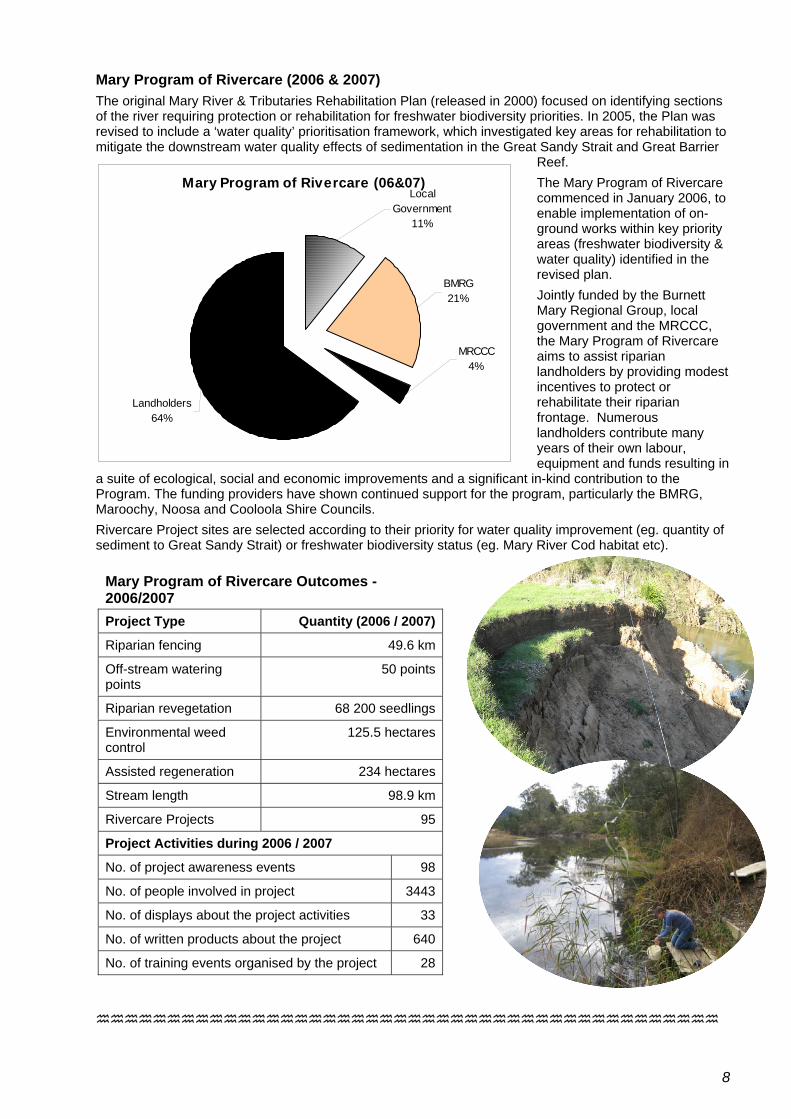
Mary Program of Rivercare (2006 & 2007) The original Mary River & Tributaries Rehabilitation Plan (released in 2000) focused on identifying sections of the river requiring protection or rehabilitation for freshwater biodiversity priorities. In 2005, the Plan was revised to include a ‘water quality’ prioritisation framework, which investigated key areas for rehabilitation to mitigate the downstream water quality effects of sedimentation in the Great Sandy Strait and Great Barrier
Reef. The Mary Program of Rivercare commenced in January 2006, to enable implementation of on-ground works within key priority areas (freshwater biodiversity & water quality) identified in the revised plan. Jointly funded by the Burnett Mary Regional Group, local government and the MRCCC, the Mary Program of Rivercare aims to assist riparian landholders by providing modest incentives to protect or rehabilitate their riparian frontage. Numerous landholders contribute many years of their own labour, equipment and funds resulting in
a suite of ecological, social and economic improvements and a significant in-kind contribution to the Program. The funding providers have shown continued support for the program, particularly the BMRG, Maroochy, Noosa and Cooloola Shire Councils.
Mary Program of Rivercare (06&07)Local
Government11%
BMRG21%
MRCCC4%
Landholders64%
Rivercare Project sites are selected according to their priority for water quality improvement (eg. quantity of sediment to Great Sandy Strait) or freshwater biodiversity status (eg. Mary River Cod habitat etc).
Mary Program of Rivercare Outcomes - 2006/2007 Project Type Quantity (2006 / 2007)
Riparian fencing 49.6 km
Off-stream watering points
50 points
Riparian revegetation 68 200 seedlings
Environmental weed control
125.5 hectares
Assisted regeneration 234 hectares
Stream length 98.9 km
Rivercare Projects 95
Project Activities during 2006 / 2007
No. of project awareness events 98
No. of people involved in project 3443
No. of displays about the project activities 33
No. of written products about the project 640
No. of training events organised by the project 28
8

Living with Threatened Species – Eva Ford It’s a frog’s life The frogging season could be summed up in one word – ‘DRY’! Water was a scarce commodity and consequently insect life (major food source for frogs) was noticeable in its absence. Normally there are nights when we dare not breathe, let alone talk, for fear of inhaling some of the millions of gnat-like night flyers. This season however we were safe throughout to carry on rambling conversation while scanning the night air for frog calls. During around 80 surveys, monitoring visits and spot visits this season, only a handful of frogs were found to be in full breeding mode. Calls were scarce and the call-playback CD was nearly worn out with use trying to locate individuals that were hunkered in during these less than favourable conditions.
Having said that over 1100 frog records were collected, 250 of which were the threatened stream frogs; Giant barred frog (Mixophyes iteratus, EPBC endangered), Cascade treefrog (Litoria pearsoniana, NCA vulnerable) and the Tusked frog (Adelotus brevis, NCA vulnerable). The target area for the season was the footprint of the proposed Traveston Dam. 21 sites within and several in the peripheral regions were surveyed. An Honours student from the University of Queensland, Courtney Moran, had chosen to do her thesis on this very area, and learnt the craft by joining in on many of our night-time escapades. Her very first introduction was to Kandanga Creek, which would normally involve a sedate jaunt along the creek-bank amongst the not-too-dense riparian vegetation. What wasn’t expected was a torrential downpour which firstly threatened to carry away our bags and equipment as large rivulets developed while we sheltered under unsubstantial trees, and then proceeded to render the creek banks non-negotiable. By the time we had decided to pull the pin we were trapped! An all-fours, muddy, root-clinging scramble of 10 paces forward and 9 paces back, finally saw us emerge from the jaws of frog territory to the safety of flat and grass-covered cow paddock. Who said it was a dry season? Courtney, to her credit, continued her surveys and came out with a fantastic report and High Distinction for her Honours! The dam footprint surveys brought us very far along some of the tributaries and it was surprising to find the Giant barred frog at locations
close to and along the Mary River. It showed us that the Mary River itself provides a vital link between sub-catchments for this species and is a conduit for species spread and genetic mixing. In the past the Mary River no doubt provided continuous habitat for this species, which now largely relies on the well-vegetated tributaries. The Mary River catchment is recognised as a stronghold for the Giant barred frog as it has declined within other catchments to the south and from high altitudes. Current threats still include habitat loss and Chytrid fungus which can kill frogs through disruption to skin and body functions.
Top: Jethro Reed and Eva Ford planting Birdwing Vines at Noosa Steiner school
A real highlight of the whole season was a chance visit to Yurol State Forest that lies between Pomona and Cooroy, just after a good amount of rain (Who said it was a dry season?). A temporary soak next to the road was the site of so much frog breeding that our ears were deafened and we were treated to a feast of frog spotting. Species included the rare Green-thighed frog (Litoria brevipalmata), the stunning Scarlet-sided pobblebonk (Limnodynastes terraereginae) and the very photogenic Graceful treefrog (Litoria gracilenta). It was amazing to see so many frogs sharing the same small area. How any of them found a mate amongst the cacophony of calls is an amazing feat of selective hearing. Funding from the BMRG brought an opportunity to expand our horizons to the Wallum country around Hervey Bay. MRCCC provided 2 workshops of frog identification and survey techniques to the Wildlife Preservation Society of Queensland Hervey Bay Branch members and other interested people. Training surveys were held at Arkara Lagoons and the Hervey Bay Botanic Gardens. It really was dry at this time and only a few frogs were found. Many of the wallum frog species depend on reedy swamps, and consequently seasonal rain to fill them. The group has since continued their surveys and have found some significant sites where the vulnerable Wallum froglet (Crinia tinula) occurs. A similar workshop was provided to the Cooloola Coastcare group at Rainbow Beach.
9
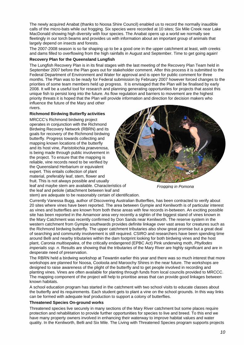
The newly acquired Anabat (thanks to Noosa Shire Council) enabled us to record the normally inaudible calls of the micro-bats while out frogging. Six species were recorded at 10 sites; Six Mile Creek near Lake MacDonald showing high diversity with four species. The Anabat opens up a world we normally see fleetingly in our torch beams and provides us with information about an important group of animals that largely depend on insects and forests. The 2007-2008 season is so far shaping up to be a good one in the upper catchment at least, with creeks and dams filled to overflowing from the high rainfalls in August and September. Time to get going again! Recovery Plan for the Queensland Lungfish The Lungfish Recovery Plan is in its final stages with the last meeting of the Recovery Plan Team held in September 2007 before the Plan goes out for stakeholder comment. After this process it is submitted to the Federal Department of Environment and Water for approval and is open for public comment for three months. The Plan was to be ready for Federal submission by February 2007 however forced changes to the priorities of some team members held up progress. It is envisaged that the Plan will be finalised by early 2008. It will be a useful tool for research and planning generating opportunities for projects that assist this unique fish to persist long into the future. As flow regulation and barriers to movement are the highest priority threats it is hoped that the Plan will provide information and direction for decision makers who influence the future of the Mary and other rivers. Richmond Birdwing Butterfly activities MRCCC’s Richmond birdwing project operates in conjunction with the Richmond Birdwing Recovery Network (RBRN) and its goals for recovery of the Richmond birdwing butterfly. Progress towards collecting and mapping known locations of the butterfly and its host vine, Paristolochia praevenosa, is being made through public involvement in the project. To ensure that the mapping is reliable, vine records need to be verified by the Queensland Herbarium or equivalent expert. This entails collection of plant material, preferably leaf, stem, flower and fruit. This is not always possible and usually leaf and maybe stem are available. Characteristics of the leaf and petiole (attachment between leaf and stem) are adequate to be reasonably certain of identification.
Frogging in Pomona
Currently Vanessa Bugg, author of Discovering Australian Butterflies, has been contracted to verify about 20 sites where vines have been reported. The area between Gympie and Kenilworth is of particular interest as vines and butterflies are known from both these areas with few records in-between. An exciting possible site has been reported in the Amamoor area very recently a sightin of the biggest stand of vines known in the Mary Catchment was recently confirmed by Don Sands near Kenilworth. The reserve system in the western catchment from Gympie southwards provides definite linkage over vast areas for creatures such as the Richmond birdwing butterfly. The upper catchment tributaries also show great promise but a great deal of searching and community involvement is still required. CSIRO and researchers have been spending time around Belli and nearby tributaries within the dam footprint looking for both birdwing vines and the host plant, Caronia multisepalea, of the critically endangered (EPBC Act) Pink underwing moth, Phyllodes imperialis ssp. n. Results are showing that the tributaries of the Mary River are highly significant and are in desperate need of preservation. The RBRN held a birdwing workshop at Tewantin earlier this year and there was so much interest that more workshops are planned for Noosa, Cooloola and Maroochy Shires in the near future. The workshops are designed to raise awareness of the plight of the butterfly and to get people involved in recording and planting vines. Vines are often available for planting through funds from local councils provided to MRCCC. The mapping component of the project will help to prioritise areas that can provide good linkages between known habitats. A school education program has started in the catchment with two school visits to educate classes about the butterfly and its requirements. Each student gets to plant a vine on the school grounds. In this way links can be formed with adequate leaf production to support a colony of butterflies. Threatened Species On-ground works Threatened species live securely in many sections of the Mary River catchment but some places require protection and rehabilitation to provide further opportunities for species to live and breed. To this end we have many property owners involved in enhancing their waterway to improve habitat values and water quality. In the Kenilworth, Belli and Six Mile. The Living with Threatened Species program supports projects
10

on more than 28 properties and 7 Council reserves. The projects are a combination of weed control, fencing, off-stream watering and rehabilitation through encouraged natural regeneration and/or revegetation. Approximately 12,000 trees have been planted along Belli, Gheerulla, Obi Obi, Walli, Six Mile Creeks and the Mary River with further stages planned on many of the properties along with some new ones. Newly planted seedlings and many older plantings were treated to the worst frost in about 40 years and suffered some losses. Trees that looked completely dead however are showing signs of re-shooting since the welcome rain in late August. Locals who have lived in the area for many decades talk of the frosts back in the 60’s that were severe every day for many weeks. What we experienced was not a surprise to them. One farmer also said that around the late 1960’s it frosted in December. Welcome cooperation and support has been received from the Department of Main Roads to expand the rehabilitation projects at Belli Creek Crossing Numbers 1, 2 and 3. Renewed working relationships between DMR environmental staff and MRCCC will no doubt open up further opportunities to work together on significant sites such as creek crossings. A recent on-site visit with DMR and MRCCC at Belli Crossing No.2, where road and bridge upgrades are planned in the very near future, provided an opportunity to explore construction alternatives that will hopefully minimise environmental damage. Work with Sunshine Coast Quarries has progressed to begin the first stage of river restoration along a section of the Mary River. A meeting involving a concerned local resident, the quarry manager and MRCCC provided a good basis for moving forward with some riverbank fencing and a revegetation project. Work is to commence late in 2007 with funding provided by the BMRG and the quarry. Major weed infestations along Walli Creek (Madeira vine) and Cedar Creek (Blue morning glory) have had large investments of funding provided to help bring the weeds under control. Riparian damage was very obvious at both these sites with very dense canopy invasion. The Cedar Creek site now looks like a new landscape and is ready for replanting. The site is partly Maroochy Council road reserve with 6 surrounding property owners involved in the project. Property clusters such as this, and in the Walli Creek area, provide excellent opportunity for neighbours to come together to work on a common problem. The Madeira vine at Walli Creek has been worked on over the past 12 months throughout its growing season; winter being a dormant period where control is not worthwhile. Madeira control is more painstaking than it is for many other weeds, and progress often seems slow. With the help of experienced contractors and property owner input it finally seems like work is having an effect. It will be sometime before this two-kilometre stretch of creek will be conducive to major tree planting though. In the meantime some property owners are starting to plant in areas where trees will not be under threat from weed invasion.
Mary Catchment Community Waterwatch Networks Kenilworth and Gympie/Amamoor Waterwatch – Eva Ford Workshops were held during August 2007 for the Kenilworth and the Gympie/Amamoor Waterwatch volunteer networks. Nearly all volunteers were able to attend, as well as some potential volunteers and interested members of the public. Topics covered in the workshops included water quality of the Mary River and its tributaries in these areas from 2002 to the present, the Northern Pipeline Interconnector to Baroon Pocket Dam and its effect on Obi Obi Creek (Steve Burgess, MRCCC), waterweed identification training (Phil Moran, Noosa and District Landcare) and the DPI&F/MRCCC Biopassage project description and questionnaire (Matt Johnson, DPI&F). Training with Waterwatch equipment and
waterweed identification at the nearest waterway (Mary River and Calico Creek) was also a component of the workshop. Water quality data over the years has been put into a report for each of the networks. Analysis of the data showed that overall water quality was good for the Mary and its tributaries. For some tributaries the EPA guidelines were not met most of the time indicating that new guidelines would be more suitable for these creeks. For instance dissolved oxygen levels in Belli, Cedar, Gheerulla, Deep and Pie Creeks, Commissioner’s Gully and parts of Amamoor and Six Mile Creeks were all consistently lower than the guideline level of between 85 and 110 % saturation. Besides Six Mile Creek the waterways are all ephemeral (temporary flow) and low dissolved oxygen levels are expected under these conditions. The guidelines are developed for freshwater, permanently flowing waterways.
11

Also of interest are the high Electrical Conductivity levels in some of the Gympie/Amamoor creeks compared to the Kenilworth district waterways. Eel, Pie, Scrubby, Kybong and Deep Creeks all show consistently high conductivity levels above the guideline level of less than 0.580mS/cm; another case for waterway-specific guideline development. With long-term data such as is being collected by the volunteers, this is a possibility in the near future for some waterways. Special appreciation is again extended to all Waterwatch volunteers who manage to fit regular water quality checks on the waterway/s in their area, often within a busy lifestyle. Upper Mary (Caloundra) Waterwatch : Mary River, Kilcoy, Obi Obi, Baxter Skenes, Walker, Fryers, Little Yabba, Booloumba, Gerhatys, Scrub Creeks – Steve Burgess Steve Burgess, our Waterwatch officer while Dale is off overseas, has gradually got to know the Upper Mary waterwatch crew over the last few months. The Upper Mary network is still using the tried-and-true Horiba U-10 multi meter, although lately there has been an occasional electrical problem with the oxygen probe that has resulted in a few oxygen observations not being reliable enough to record in our database. With the possible future inclusion of some new volunteers in the Lake Baroon Catchment, there may be the scope to upgrade this equipment in the coming year. The main current issue in the upper catchment is probably the greatly increased extraction planned from Baroon Pocket Dam via the Northern Pipeline Interconnector, which will significantly reduce the flushing flows and spills down Obi Obi creek if it proceeds. This is likely to have significant impacts on water quality and weed infestations (particularly dense water weed in the lower Obi Obi). The very welcome spillway overflows in August and September have showed how essential these flushing flows are for the health of that stream. With this in mind, the Upper Mary Waterwatchers have been trained in the recognition of a number of aquatic weeds, particularly Egeria densa, to enable the monitoring and reporting of infestations of these weeds through time. There has been at least one fishkill in Obi Obi Creek following the spillway overflow in September, the reasons for which are being investigated by the EPA. It is most likely that this has simply been the result of fish going over the spillway, but samples of fish were taken to search for any other possible causes. Poor water quality and weed infestations in the Obi Obi below the dam were issues earlier in the year. Wide Bay/Widgee & Munna Waterwatch - National Landcare Program - BMRG Landcare Consortium project – Steve Burgess
Recent fish kill below the Baroon Pocket Dam spillway
During 2006 the Widgee/Wide Bay Creek Waterwatch Group was formed as a consequence of the considerable concern amongst the communities of Kilkivan, Woolooga, Widgee areas regarding the quality of surface water (in particular the salinity level) in Wide Bay and Widgee Creeks. There has not been a lot of water in the Widgee and Wide Bay catchments lately but this situation will hopefully be remedied as the rains come over the next few months and monitoring starts up again. The Widgee/Wide Bay network get to use ‘Big Bertha’ the TPS FLT 90 multi-probe which seems to be performing pretty well (as long as there is water). Sixteen Waterwatch volunteers from dairying, grazing and horticultural backgrounds now monitor the water quality of the following creeks monthly:
• Wide Bay Creek • Fat Hen Creek • Widgee Creek • Wonga Creek • Glastonbury Creek
During 2006, MRCCC held 2 catchment crawls in the Widgee / Wide Bay Creek sub-catchments, to initiate interaction between MRCCC staff and the new Waterwatch volunteers. These crawls allow the volunteers more time with the equipment under the supervision of the MRCCC staff, which ensures questions that need to be asked can be, and monitoring techniques can be perfected. Waterwatch reports were prepared for the Widgee/Wide Bay Creek Waterwatch Network and the Munna Creek Waterwatch Network. These reports were prepared using the water quality data collected by the Waterwatch volunteers which was applied to a new reporting format utilising a Geographical Information System (GIS).
12

The Munna Creek Waterwatch Network, comprised of graziers and 1 dairy-farmer, continued throughout 2006. In early 2007 the lack of liquid also put the Munna network into remission for a while, although recent falls have put some water into the creek and the kit is up and running about again. Most waterwatchers in this network have recently undergone training , and particular attention has been paid to the identification of and monitoring of floating aquatic weeds which have really taken off in the low-flow conditions, and were not flushed out by the August flows that the eastern side of the Mary River Catchment received. The Munna network is still using the Hanna pH and EC probe, a turbidity tube and a TPS dissolved oxygen probe.
Nutrient & Pesticide Water Quality Sampling Project: a BMRG Partnership Project - Glenda Pickersgill
Within the Mary River catchment there is a considerable body of water quality data, however there are significant gaps in this data. At present there is virtually no data on the pesticide/chemical levels within the water column. The intention of this project is to determine if there are any chemical residues within the water column at a number of sites throughout the Mary River catchment. A suite of common chemicals will be analysed. In-depth analysis of nutrients (total phosphate and total nitrogen) will also be sampled and analysed at the Wide Bay Water laboratory as part of this project. Every month for the next year, samples will be taken at 15 sites throughout the catchment. This data-set will assist with the development of the Water Quality Improvement Plan for the Mary Catchment being developed by BMRG. The sites sampled are contained in the table below.
Site Occurrence Analysis
Glenda Pickersgill sampling the Mary River with Andrew Rickert, Wide Bay Water
1. Cambroon bridge – Mary River Monthly Nutrients
2. Little Yabba Picnic Area Bi-monthly Nutrients
3. Booloumba Creek – upstream of camping ground Bi-monthly Nutrients
4. Pickering bridge – Moy Pocket, Mary River Monthly Nutrients & chemicals
5. Traveston Crossing – Mary River Monthly Nutrients
6. Imbil bridge – Yabba Creek Monthly Nutrients
7. Cooran bridge – Six Mile Creek Monthly Nutrients & chemicals
8. Tagigan Rd, Goomborian – Tinana Creek Monthly Nutrients & chemicals
9. Missings bridge, Bauple – Tinana Creek Monthly Nutrients & chemicals
10. Wilson bridge, Sexton – Wide Bay Creek Bi-monthly Nutrients & chemicals
11. Glen Echo bridge – Munna Creek Bi-monthly Nutrients & chemicals
12. Widgee Crossing – Mary River Monthly Nutrients
13. Home Park – Mary River Monthly Nutrients & chemicals
14. Pioneers Rest bridge – Myrtle Creek Monthly Nutrients & chemicals
15. Mary River barrage – Mary River Monthly Nutrients & chemicals
13
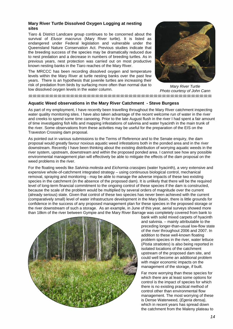
Mary River Turtle Dissolved Oxygen Logging at nesting sites Tiaro & District Landcare group continues to be concerned about the survival of Elusor macrurus (Mary River turtle). It is listed as endangered under Federal legislation and vulnerable under the Queensland Nature Conservation Act. Previous studies indicate that the breeding success of the species may be dramatically reduced due to nest predation and a decrease in numbers of breeding turtles. As in previous years, nest protection was carried out on most productive known nesting banks in the Tiaro reaches of the Mary River. The MRCCC has been recording dissolved oxygen and temperature levels within the Mary River at turtle nesting banks over the past few years. There is an hypothesis that juvenile turtles are increasing their risk of predation from birds by surfacing more often than normal due to low dissolved oxygen levels in the water column. Mary River Turtle
Photo courtesy of John Cann
Aquatic Weed observations in the Mary River Catchment - Steve Burgess As part of my employment, I have recently been travelling throughout the Mary River catchment inspecting water quality monitoring sites. I have also taken advantage of the recent welcome run of water in the river and creeks to spend some time canoeing. Prior to the late August flush in the river I had spent a fair amount of time investigating fish kills and mapping infestations of salvinia and water hyacinth in the main trunk of the river. Some observations from these activities may be useful for the preparation of the EIS on the Traveston Crossing dam proposal. As pointed out in various submissions to the Terms of Reference and to the Senate enquiry, the dam proposal would greatly favour noxious aquatic weed infestations both in the ponded area and in the river downstream. Recently I have been thinking about the existing distribution of worrying aquatic weeds in the river system, upstream, downstream and within the proposed ponded area. I cannot see how any possible environmental management plan will effectively be able to mitigate the effects of the dam proposal on the weed problems in the river. For the floating weeds like Salvinia molesta and Eichornia crassipes (water hyacinth), a very extensive and expensive whole-of-catchment integrated strategy – using continuous biological control, mechanical removal, spraying and monitoring - may be able to manage the adverse impacts of these two existing species in the catchment (in the absence of the proposed dam). It is unlikely that there will be the required level of long-term financial commitment to the ongoing control of these species if the dam is constructed, because the scale of the problem would be multiplied by several orders of magnitude over the current (already serious) state. Given that control of these two species has never been achieved with the current (comparatively small) level of water infrastructure development in the Mary Basin, there is little grounds for confidence in the success of any proposed management plan for these species in the proposed storage or the river downstream of such a storage. As an example, in June of this year, aerial surveys showed more than 18km of the river between Gympie and the Mary River Barrage was completely covered from bank to
bank with solid mixed carpets of hyacinth and salvinia. – mainly attributable to the preceding longer-than-usual low-flow state of the river throughout 2006 and 2007. In addition to these well-known floating problem species in the river, water lettuce (Pistia stratiotes) is also being reported in isolated locations of the catchment upstream of the proposed dam site, and could well become an additional problem with major economic impacts on the management of the storage, if built. Far more worrying than these species for which there are at least some options for control is the impact of species for which there is no existing practical method of control other than environmental flow management. The most worrying of these is Dense Waterweed, (Egeria densa), which in recent years has spread down the catchment from the Maleny plateau to
14

Obi Obi Creek. Major infestations in the lower Obi Obi Creek and Moy Pocket area have been greatly encouraged by the large reduction in flushing flows in Obi Obi Creek since the construction of Baroon Pocket dam. This species is now distributed down the river as far as Miva. The recent (late August 07) spill and flushing flow event in Obi Obi Creek has demonstrated how important flushing flows are for the management of weeds like Egeria, with areas of the creek and river that were densely infested now greatly thinned out. The worry is that the plants that have been flushed out are now distributed along the river further downstream. (If the dam had been constructed, they would have been collected by and re-established in the storage.)
Egeria densa is a major economic pest in storages and rivers throughout the world and elsewhere in Australia, and is 100% certain to colonize any storage built at Traveston Crossing, which would then provide the perfect growing conditions in terms of water depth, nutrient level, temperature and light for this species (as well as for salvinia, hyacinth and cabomba). There are many case studies of the disastrous effect this plant has on storages and water quality. The best documented Australian examples are probably in the Hawkebury-Nepean river system. The proposed storage on the Mary would provide a much more fertile environment for Egeria than the Hawkesbury-Nepean system. Two other notorious water weeds are Cabomba caroliniana and Hygrophila costata, which infest nearby Lake
Macdonald in the Mary Catchment. Although they are not yet in the main trunk of the river, the proposed storage and its swampy margins would provide the ideal conditions for both these species – and Australia’s largest infestations of both these species are only a short distance away from the proposed dam site.
Salvinia at Walker Rd Bridge, December 2006
Simply in terms of the economic effectiveness of management of these species in the proposed storage (without concern for the 200km of river downstream of Traveston Crossing affected by flow regime change), an effective management plan for these serious plants would need to start with the control of all existing infestations throughout the entire upstream catchment of the proposed dam, before any water is ponded in the storage. Even though the scale of this task seems daunting, the cost of this exercise would be far less than the cost of one year’s weed maintenance in the proposed storage area alone once these weeds become established. If this occurs, there will be no chance of economically viable control. In fact, if upstream control is not achieved first, attempted control in the storage is almost pointless. The water quality problems in the storage and in the water released downstream from the storage once these species are established are also likely to impose treatment and management costs that would seriously impair the economic viability of the storage as a drinking water supply. All of these weed species completely disrupt the dissolved oxygen regime of the water bodies that they infest. This is particularly of concern if the water from Traveston Crossing is to be used for human consumption. Because of the geological history of the catchment, the water and sediments in the storage will contain significant concentrations of manganese and mercury. The greatly fluctuating oxygen regime in the water induced by the growth, photosynthesis, respiration and decay of rampant weed infestations is likely (combined with bacterial action) to produce a range of undesirable or toxic oxides of manganese and mercury in the water. Treatment of the water thus affected is a large ongoing expense, and has required the installation of extensive de-stratification and aeration infrastructure in nearby North Pine Dam, as well the implementation of specific risk management plans for manganese, based on dissolved oxygen levels. Similarly, Baroon Pocket Dam (in the catchment of Traveston Crossing) already incurs considerable expense in chemically treating the water to specifically remove manganese oxides. The scale of the problem, in terms of the area of water needed to be oxygenated and de-stratified, the volume of water needing to be chemically treated and the quantities of these metals in the sediments, would be an order of magnitude greater in any storage positioned at Traveston Crossing.
15

Teddington Weir Integrated Aquatic Weed Management Strategy December 2006 Survey of Aquatic Weeds In December 2006 MRCCC Staff Brad Wedlock and Dale Watson, and Tinana Creek landholder, Jeff Weis, undertook the survey of aquatic weeds (situation analysis) at the Teddington Weir impoundment to determine the level of infestation. For the purposes of the survey the Teddington Weir impoundment was broken into 9 individual reaches and the Sandy Creek reach. Each of these reaches represents a change in the composition and abundance of aquatic weeds recorded at that time. Salvinia molesta (Salvinia) and Eichhornia crassipes (Water Hyacinth) were the dominant floating aquatic weeds present during this survey. The table below is a summary of the Water Hyacinth & Salvinia coverage and biomass for each of the reaches, observed during the aquatic weed survey on the Teddington Weir pondage, 1 December 2006.
Length of Reach
Hyacinth Cover (m2)
m2 of Hyacinth/m
Total Hyacinth Wet Weight (kg)
Salvinia Cover (m2)
m2 of Salvinia/m
Total Salvinia Wet Weight
(kg)
Reach
1 600 5400 9.0 36720 27000 45.0 54000
2 370 370 1.0 2516 1850 5.0 3700
3 380 114 0.3 775 570 1.5 1140
4 490 147 0.3 1000 735 1.5 1470
5 820 82 0.1 558 410 0.5 820
6 310 62 0.2 422 155 0.5 310
7 2050 971 0.5 6603 2050 1.0 4100
8 860 1193 1.4 8112 860 1.0 1720
9 3250 8125 2.5 55250 100 0.0 200
Sandy Creek
820 1640 2.0 11152 410 0.5 820
Totals 9950 18104 17 123107 34140 57 68280 2* Based on 1m of wet Hyacinth = 6.8kg and 1m2 of wet Salvinia = 2kg
The table illustrates the general trend that in the upper reaches of the Teddington Weir impoundment Salvinia was by far the most dominant of the aquatic weeds present. However at the lower reaches of the impoundment, closer to the Teddington Weir, Hyacinth becomes the dominant aquatic weed present. Integrated Aquatic Weed Management Strategy The control of the floating aquatic weeds (Salvinia and Water Hyacinth) on the Teddington Weir impoundment will require a multi-tiered approach, integrating several aquatic weed management techniques. The recommended aquatic weed management strategy will involve the following activities:
1. Monitoring Program o Strategic monitoring of the aquatic weed infestation at critical times in the season o Biological control agent monitoring o Water quality monitoring
2. Containment Strategy 3. Biological control agent rearing and release program, 4. Manual harvesting alternative 5. Herbicide application program,
16

Maryborough Aquatic Weed Surveillance Program An aquatic weed surveillance program for the Maryborough area is required, in light of the identification of Cabomba in the Ululah Lagoon. Due to the high level of public access to Ululah Lagoon it is highly likely that Cabomba is being spread by the public, mainly due to low level of awareness within the community of aquatic weeds. To be able to detect these small infestations of Cabomba is essential, as control actions are much more likely to be successful if identified in the early stages. The National Aquatic Weeds Group (NAWG) developed a surveillance protocol in 2004 which could be used as a framework for a surveillance program within the Maryborough area. The NAWG surveillance protocol is based on a risk of weed incursion, i.e. sites where there is a high level of public access are likely to also have a high risk of weed introduction.
The MRCCC has therefore recommended that sites (water bodies) with a high level of public access be investigated within a 10 km radius of Ululah Lagoon. These sites would be:
• Fay Smith Wetland • Queens Park ponds • Pioneer Country Park, Tinana • Prickett Aquatic Park, Lamington
Bridge • Schultz Park – Gympie Road • Original Township site, Baddow
These sites should be investigated on an annual basis, and records kept of when the sites were investigated and in particular if or not Cabomba, Salvinia, Hygrophilla or any other species was identified at the site.
If any of these species have been identified, an action plan needs to be developed to ensure the infestation is controlled, and if possible eradicated. The integrated aquatic weed control management strategy for the Teddington Weir impoundment should not be considered static. Evaluation of each step is required to ensure objectives are being achieved. An evaluation of each step also allows refinements to be identified and performed.. Many of the lessons learnt will result in a change in the management and techniques needed to control the aquatic weeds over time.
Community Water Grant – Kilcoy Creek The Kilcoy Creek subcatchment is now fully fenced as a result of this project, which targeted 3 Nature Refuge properties for on-ground work along Kilcoy Creek. These properties adjoin properties that have participated in previous riparian rehabilitation works, involving a dedicated group of landholders. On-ground outcomes included:
• 5000 seedlings planted (mulched and tree guards)
• Weed control • 1 km fencing • 2 off-stream watering points
The MRCCC commends this dedicated group of landholders who are producing excellent on-ground results.
Scott Woolbank, Kilcoy Ck
17

Elaman Creek Recreational Fishing Grants Program
The improvement of native freshwater fish habitat is an important issue in the Mary River Catchment where wood has become scarce as a result of de-snagging of local waterways and the lack of natural riparian timber inputs. Wood can be defined as any timber (trees or branches) that enter a stream, or lie along its banks and is now recognised worldwide for the crucial role it plays in aquatic life habitat and stream stability, providing a place for a wide range of animals to live and breed and as water flows over and around snags, helping shape the river.
Wood in streams of the Mary River Catchment is especially important for the endangered Mary River Cod, which relies on wood for protective cover and to spawn their adhesive eggs onto. Previous radio tagging of the Mary River Cod found that of 344 encounters, 325 (95%) of them were within 2 metres of wood (Simpson & Mapleston, 2002).
Wood is also an important element in the development and maintenance of riffle and pool sequences in streams, crucial for healthy functioning stream ecosystems and fish species habitat. Wood in our streams creates variations in flow, producing small local scour and deposition areas around the wood, providing a variation in water depths. This in turn creates crucial habitat for many aquatic species (Keller & Macdonald, 1995).
Wood is also viewed as crucial habitat structures for algae, micro-organisms and macroinvertebrates (food sources for many fish species), and provides structures for a range of animals to enter and exit the water.
The reintroduction of wood can also be used to combat stream stability problems such as bank erosion. Alternatively, wood can settle into the bed of streams and form hard or control structures, important in reducing potential bed scour and erosion. Reduction of sediment which can directly affect fish habitats and health is also a recognised benefit of the reintroduction of wood through stabilisation of the bank and bed.
The Recreational Fishing Grants Program involved the introduction of engineered log jams (ELJ), revetment logs and habitat logs at two degraded sites on Elaman Creek, near the township of Conondale in the Sunshine Coast Hinterland. Following the in-stream works, revegetation, fencing and off-stream watering were undertaken.
In-stream works, Garmany site – Elaman Creek
18

This project also included a strong educational component. Field days were held at Conondale State School, Maleny River School and Widgee State School. The field days linked with the QDPI&F Recreational Fishing Program which incorporates sustainable recreational fishing into the curriculum of Qld Environmental Education Centres. The field days allowed students to understand the many problems our native fish populations are encountering, such as sedimentation, lack of in-stream habitat and barriers to fish movement. The field days encouraged an interest in our native fish populations and demonstrated sustainable freshwater fishing practices to the students. Funding from this program was also provided to the Gerry Cook Fish Hatchery at Lake Macdonald to assist in the rearing of Mary River Cod Fingerlings. Fingerlings were released on and around the Elaman Creek wood reintroduction sites enhancing the existing freshwater fish stocks of the Mary River catchment. In time, this will increase recreational freshwater fishing opportunities for locals and visitors to the region.
Electrofishing with DPIF in Elaman Ck to determine fish stocks
South East Queensland Rainforest Recovery Program In 2007-8, the MRCCC is to be the conduit for funding to the Barung, Noosa and Gympie Landcare groups from the SEQ Rainforest Recovery Program and the BMRG’s Regional Investment Strategy. The SEQ Rainforest Recovery Plan is an innovative multi-ecosystem recovery plan which encompasses 21 threatened rainforest ecosystems in the SEQ bioregion and which will address threats to 67 associated threatened flora species, 19 of which are listed as endangered under the Environmental Protection and Biodiversity Conservation Act, 1999 and 40 threatened fauna species, 5 of which are listed as endangered under the EPBC Act, 1999. This project will focus on improving the condition of endangered rainforest ecosystems through implementation of a landholder incentive and education program, contributing to a much larger project which aims to improve the condition of 4,309 hectares of currently endangered rainforest in Qld. The project will also facilitate the production of landholder information kits on threatening processes and current best management practices for grazing, fire and pest management. In addition to the SEQ Rainforest Recovery Program and RIS funding, the MRCCC has recently received notification that the “Friends of the Mary” Envirofund application has been successful. Submitted by MRCCC on behalf of a consortium of groups including Gympie, Noosa and Barung Landcare, the funding will be provided to these groups to enable seedlings common to endangered regional ecosystems to be raised at the Landcare nurseries in Gympie, Maleny and Pomona.
MRCCC Website During the year, the MRCCC website was upgraded and is now hosted at our own account, at www.mrccc.org.au. Most of our major information resources are available to the on-line public from this site. One of the advantages of this is that we have attached an internet forum and database to the website which allows people in the community who are in a position to observe the river (such as waterwatch volunteers, riparian landholders, MRCCC staff, shire officers etc) to record interesting and useful observations about events in the river. The forum is called WWWWatch – (it stands for Who, What, Where and When) and anyone with internet access can look it up at www.mrccc.org.au/wwwwatch. People with a keen enough interest to record their own observations can apply on line to become a registered user (no cost) and add their observations to this community database of stream and river observations in the catchment. This idea was well received at the State Waterwatch Conference and we have received several enquiries from other groups interested in setting up similar systems. We are trying to steadily increase the use of this forum throughout the catchment as we learn a bit more about the most effective ways of using it..
19

Regional Liaison Officer The Burnett Mary Regional Group is currently contracting the MRCCC to undertake the duties of a Regional Liaison Officer for the Mary Catchment, in conjunction with John Muir, who is based at Maleny. The initial objective for RLO’s was to assist project proponents to submit applications for funding to the BMRG. Now that this has been achieved and the majority of BMRG funding allocated to June 2008, the RLO’s are moving into a project management phase, assisting proponents to stay on track with project milestones and reporting requirements. On behalf of BMRG, the MRCCC is currently helping to manage a range of on-ground weeds, biodiversity and coastal projects throughout the Mary. Project proponents include Gympie, Barung and Tiaro Landcare, Fraser Coast Wildlife Preservation Society, Friends of Akarra Lagoons, Cooloola Coastcare, Cooloola, Woocoo, Hervey Bay and Maryborough City Councils and the Mary Local Government Cluster Group. Collectively, these groups involve many hundreds of volunteers working in strategic areas for the improvement of catchment health. MRCCC Staff have shared the responsibility for this role, taking advantage of our extensive networks and contacts throughout the catchment, and each staff member’s area of expertise.
Resource Centre The Mary Catchment Resource Centre is currently located on the corner of Nash and Monkland Streets, Gympie within the Cooloola Family and Community Development complex. This central location has increased visitation to the Resource Centre and has helped to raise our profile with Gympie locals. The Resource Centre provides a range of information on natural resource management and staff have also fielded many a query about the proposed Traveston Dam. In addition, the scarcity of rural water supplies has exponentially increased the number of dam, bore and creek water samples brought in by landholders for water testing. Whilst this location is very central and the building certainly suits most of our needs, the building has now been sold and the location of our Resource Centre and staff offices is now uncertain. Investigations into finding a suitable block of land for construction of a facility that will showcase “green” building techniques including energy and water use efficiency and accommodate MRCCC staff and are now underway, fuelled by a substantial donation to the Mary Catchment Public Fund. Meanwhile, MRCCC is negotiating with Cooloola Shire Council for suitable short term premises at the former Council depot in Tozer Park Road, Gympie.
Cr Ray Kelly, Ian Jones, Noosa Mayor Bob Abbot and BMRG Chair Russell Stewart at the Festival
The Sisters of Mary doing good work at the Noosa Festival of Water
Noosa Festival of Water In 2007, the Noosa Festival of Water at Lake Macdonald was very successful despite rain falling in the afternoon. The Festival is gaining a reputation, attracting a diverse range of exhibitors all with a focus on sustainability, water use efficiency and protection of water quality. The picturesque Lake Macdonald Amphitheatre and Botanical Gardens are showcased every year to thousands of patrons who attend the festival for the entertainment, lectures, tours and displays. Vince Collis was kept busy all day taking people on tours of the Mary River Cod Hatchery as were the tour boat drivers who ferried passengers across the lake to the Water Treatment Plant, Hatchery and Canoe Tours.
rdHeld on Sunday 3 June 2007 to coincide with World Environment Day, the future of the Festival is now uncertain, as Lake Macdonald is proposed to be included in the state government’s SEQ Water Grid.
20
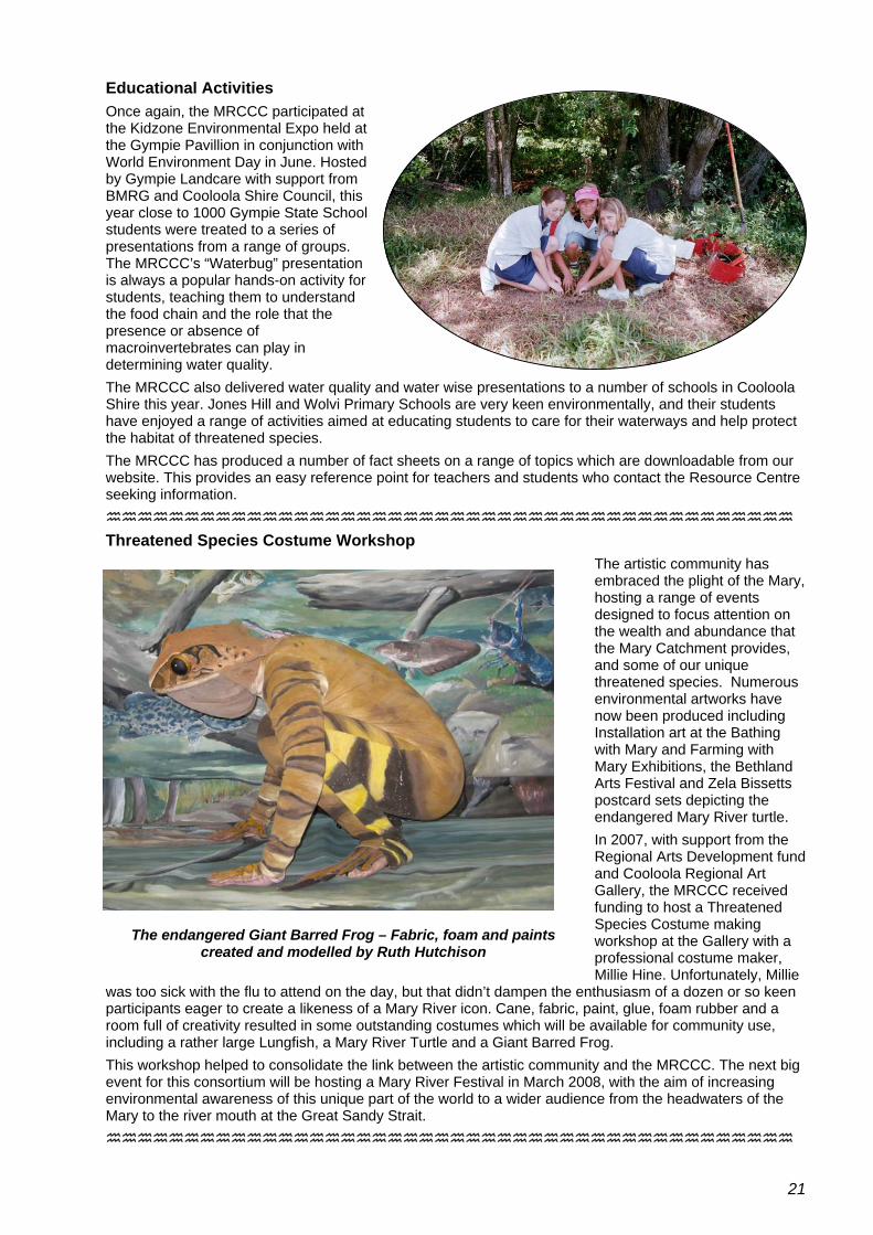
Educational Activities Once again, the MRCCC participated at the Kidzone Environmental Expo held at the Gympie Pavillion in conjunction with World Environment Day in June. Hosted by Gympie Landcare with support from BMRG and Cooloola Shire Council, this year close to 1000 Gympie State School students were treated to a series of presentations from a range of groups. The MRCCC’s “Waterbug” presentation is always a popular hands-on activity for students, teaching them to understand the food chain and the role that the presence or absence of macroinvertebrates can play in determining water quality. The MRCCC also delivered water quality and water wise presentations to a number of schools in Cooloola Shire this year. Jones Hill and Wolvi Primary Schools are very keen environmentally, and their students have enjoyed a range of activities aimed at educating students to care for their waterways and help protect the habitat of threatened species. The MRCCC has produced a number of fact sheets on a range of topics which are downloadable from our website. This provides an easy reference point for teachers and students who contact the Resource Centre seeking information.
Threatened Species Costume Workshop The artistic community has embraced the plight of the Mary, hosting a range of events designed to focus attention on the wealth and abundance that the Mary Catchment provides, and some of our unique threatened species. Numerous environmental artworks have now been produced including Installation art at the Bathing with Mary and Farming with Mary Exhibitions, the Bethland Arts Festival and Zela Bissetts postcard sets depicting the endangered Mary River turtle. In 2007, with support from the Regional Arts Development fund and Cooloola Regional Art Gallery, the MRCCC received funding to host a Threatened Species Costume making workshop at the Gallery with a professional costume maker, Millie Hine. Unfortunately, Millie
was too sick with the flu to attend on the day, but that didn’t dampen the enthusiasm of a dozen or so keen participants eager to create a likeness of a Mary River icon. Cane, fabric, paint, glue, foam rubber and a room full of creativity resulted in some outstanding costumes which will be available for community use, including a rather large Lungfish, a Mary River Turtle and a Giant Barred Frog.
The endangered Giant Barred Frog – Fabric, foam and paints created and modelled by Ruth Hutchison
This workshop helped to consolidate the link between the artistic community and the MRCCC. The next big event for this consortium will be hosting a Mary River Festival in March 2008, with the aim of increasing environmental awareness of this unique part of the world to a wider audience from the headwaters of the Mary to the river mouth at the Great Sandy Strait.
21

Twitching for Mary On Sunday 7th October, groups of Birdwatchers visited properties throughout the Mary Valley to gather records on the number and diversity of bird species. MRCCC staff Eva Ford and Steve & Elaine Burgess, together with EPA’s Mary Starky and Jones Hill Primary School teacher, Berry Doak, were up early, crashing through the bush to investigate a high ridge at the top of Dagun Gully, where they managed to record 43 species before retiring semi-exhausted at lunchtime. The afternoon shift included Ruth Hutchison, Steve Burgess, Berry Doak and Debbie Seal who recorded 56 species on a peaceful afternoon stroll down Dagun Gully. Collectively, these records will provide a snapshot of avian diversity in the Mary Valley and in particular the proposed Traveston dam footprint.
Ruth Hutchison, Steve Burgess, and Berry & Reg Doak, on a Sunday afternoon “twitching” along Dagun Gully
Biological Control and Ecology of Cabomba Progress 2006-2007. Shon Schooler, CSIRO Entomology One of the bigger ticket items on the agenda this year involved lobbying the federal government to reinstate funding to the CSIRO for the Cabomba Bio-control program. As the largest infestation of Cabomba caroliniana in Australia exists in the Mary Catchment in Lake Macdonald, it was certainly within the interests of the MRCCC to do so. On behalf of the Lake Macdonald Catchment Care Group and the CSIRO, the MRCCC contacted Federal and Queensland politicians, and were rewarded with a successful outcome in February 2007, when the Minister for Fisheries, Forestry and Conservation, Senator Eric Abetz , announced that over $510,000 would be allocated to finalising trials aimed at finding an effective bio-control agent for Cabomba. Vital research by the CSIRO is now able to continue. Biological control research: The first potential biological control agent (Hydrotimetes natans) has been imported into quarantine in Brisbane. Aquaria for the host specificity testing of H. natans have been developed. In addition, closely related native plants have been identified and acquired to grow these plants for the host specificity testing trials. Genetic analysis: CSIRO has met with Amy Weiss (PhD student at University of Connecticut) and discussed the genetic analysis of the cabomba project. A contract to expand her research to include assessing the origin of cabomba populations in Australia and possible genetic differences between seeding and non-seeding populations of cabomba is currently being finalised. Additional surveys for more potential agents: A meeting with Dr. Willie Cabrera discussed continuing surveys, preliminary host testing in Argentina, and providing herbivores for host specificity testing in Brisbane from the United States Department of Agriculture field station in Buenos Aires. He will also accept and process samples for the cabomba karyotype analysis (to determine if hybrid sterility is responsible for low production of viable seeds in Australia) to be done by Eduardo Greizerstein, (University of Buenos Aires). The contract for this work is also being finalised. Population fluctuation: Cabomba populations in three subtropical lakes in QLD have been regularly sampled revealing that cabomba is most abundant in 2-3 meters depth and that the population is relatively stable throughout the year. Affects of shading on cabomba: We have found that floating shade fabric (no light penetration) is effective at eliminating plants within 3 months. This applications will be tested at 3 ponds in 2007-2008 (collaboration with Noosa Landcare) to see if this technique can be used to locally eliminate cabomba. This will reduce potential to spread from these infestations.
22

Growing Sustainable Agricultural Precincts in the Middle Mary and Kin Kin Property Management System Initiative of the DPIF This project intends to focus on implementing best practice through “Area Wide Management” in the diverse high value Peri-urban Farming Systems of the Gympie District. This project is in the development phase, awaiting approval from the DPIF. The BMRG has committed funding to this project and other partners include MRCCC, Gympie Packhouse (on behalf of Gympie Pack-house group – Bundaberg Fruit & Vegetable Growers) Gympie QDO, Gympie Macadamia Best Practice Group, Gympie and District Beef Liaison Group and DPIF.
Background In the 2000/01 the Cooloola Shire had a total agricultural value of approximately $71 Million. Growcom has identified a 47% growth in horticulture in the broader Sunshine Coast-Cooloola region between 1992 and 2001. The area has extensive infrastructure supporting primary production including a large co-operative packhouse, one of the largest macadamia processing factories in the world and well-developed transport networks. However, the area is faced with pressures from a predicted 50% population growth between 2001 and 2026 and associated competing demands on land and water resources.
This project aims to address gaps in existing government, industry and Natural Resource Management group projects to meet the core targets of the following:
• Great Barrier Reef Water Quality Protection Plan, • QFF Farm Management System, • Mary/ Great Sandy Environmental Values and Water Quality Objectives and • BMRG Regional NRM Plan targets relating to the extension and uptake of best practice in coastal
agricultural systems. An area-wide management “FarmFLOW” extension approach is proposed to focus on areas of intensive high value production within the Gympie district featuring a mix of tree and small crops, as well as extensive and intensive grazing and dairying. It is critical that that the capacity of downstream producers is enhanced to drive economic development to offset the potential loss from impounded areas. The proposal covers four of the top ten priority water quality agricultural ‘hot spot’ subcatchments in the Mary. Within this context, consulted commercial producers have identified a key focus on soil health and a range of peri-urban issues which they consider are likely to produce the most significant NRM and Regional Economic Development outcomes. The preferred delivery model will build capacity through active links to industry based Property Management System and Farm Management System training workshops and issue based Best Management Practice extension, trials and demonstrations combined with incentives to promote uptake of recommended practices and property management systems development. Area-wide benchmarking and performance monitoring of the economics of interventions and the impact on land and water resources is also proposed. The project aims to implement the four steps below: Plan To develop/ enhance peri-urban grower led best practice groups and networks which actively develop Property Management Systems through coordinated delivery of relevant QFF industry body FMS products and tools, DPI&F/MLA GLM package and NRM Body programs. Do To design and implement a minimum of 4 trials and demonstration sites per annum focussing on grower priorities related to key soil health and water quality elements of relevant PMS packages. To enhance the level of uptake of best management practice relating to soil health and nutrient management by 10%* per annum through a targeted Area Wide Management approach in identified high risk, priority sub-catchments targeting both land condition and water quality outcomes. (*Compared to baseline rates of uptake at time of benchmark surveying) Check To monitor the productivity, soil health and water quality impacts of the project at a paddock (12 trial sites), property (45 properties) and subcatchment (3) scale, to provide feedback to farm planning and input into broader planning processes. Review To target extension and incentives to achieve the commitment of at least 135 producers (over 3 years) to a continuous improvement PMS cycle at paddock, property and sub-catchment scale.
23

Mary River Catchment Coordinating Committee – Audited Financial Statement 2006-2007
24
25

26

27

28

Specific Comments on Referral Northern Pipeline Interconnector to the Federal Government under the EPBC (1999) Act Impact on Matters of National Environmental Significance in the Mary River Catchment. The Role of the MRCCA
The Mary River Catchment Coordination Association (MRCCA) is a community association formed in 1993 as a representative body of community, industry and government interests involved in natural resource management in the Mary River Catchment. The MRCCA is composed of 21 interest sectors from across the Mary River Catchment.
The MRCCA prepared a Catchment Strategy, which was endorsed by the State Government in 1997, which provides strategic direction to improve the sustainability of the Mary River Catchment. In 2000 the MRCCA and the Queensland State Government conjointly prepared Australia’s first Catchment Rehabilitation Plan, the “Mary River & Tributaries Rehabilitation Plan” which provides the guiding framework for on-ground improvement of river health in the catchment.
The MRCCA received the Queensland Rivercare award in 1999, 2003 and 2007, the Catchment Landcare award in 2003, and the National Rivercare award in 2004 for the success in implementing these policies in an active partnership with landholders, community, industry and government in the catchment.
The MRCCA expects to maintain an ongoing role as a stakeholder body in the management of water resources and river health issues in the Mary River Catchment and seeks to assist in the appropriate assessment of EPBC-related matters in the Mary Catchment.
With respect to this referral, the MRCCA considers that the proposal as outlined in the Initial Advice Statement has clear potential for significant impacts on listed threatened species, and when viewed in the context of being an integral part of a suite of proposed actions impacting on the Mary River Catchment, has potential for significant impacts on threatened migratory species and the Ramsar wetlands of the Great Sandy Strait Marine Park.
The NPI stage 2 in context with a larger suite of proposed actions in the Mary Catchment
There are 4 intrinsically connected water resource development proposals (from 2 proponents) that the MRCCA believes have Federal implications under the EPBC Act in the Mary River Catchment. These are the NPI stage 1 and stage 2 and the proposed Traveston Crossing Dam Stages 1 and 2. The Commonwealth is responsible under the Act to ensure that the cumulative impacts of all these staged developments of the one over-arching action (building new infrastructure to facilitate a large new transfer of water out of the Mary Basin) are properly assessed in context with each other.
With respect to the NPI stage 2 – the Noosa Water Treatment Plant (WTP) at Lake Macdonald handles all the water that is abstracted from the Mary Catchment by Noosa Shire for urban water supply – either directly from the Lake Macdonald storage on Six Mile Creek or via the pipeline from the Mary River at the Goomong pump station (operated by Veolia). The Noosa WTP has a nominal capacity of around 45ML/day – which sets the upper limit on how much water can be supplied to the NPI stage 2 from current water infrastructure. Even if Noosa provided its total capacity to the NPI, the pipe would only need to be of sufficient diameter to handle a flow of 45ML/day. The NPI stage 2 proposes to put in place a pipe with a diameter of >1200mm –sufficient for a flow of many times this amount. This is clear evidence that the NPI stage 2 is not a discrete proposal, but an integral part of a larger proposal to transfer large quantities of additional water from the Mary Catchment.
Extending the NPI proposal as far as Lake Macdonald makes no economic sense if it is not intended to extract these significant new quantities of water from the Mary Catchment. The total impacts of this clearly intended new level of water abstraction and transfer need to be assessed under the EPBC Act.
Risks associated with pipeline works in the vicinity of Lake Macdonald
Lake Macdonald is home to Australia’s largest infestation of Cabomba caroliniana, an aquatic weed of National Significance, and the fringes of the lake and its tributaries also host Australia’s largest infestation of Hygrophila costata, a Class 1 pest plant. Both plants pose a significant risk to in-stream and riparian biodiversity, and are notoriously difficult to control once established.
The chance of transporting propagules of either of these plants to other streams along the pipeline route during construction and maintenance activities is high, and the adverse consequences for biodervisity in any infected habitats are severe and extraordinarily difficult and expensive to mitigate.
Lake Macdonald is also home to the Gerry Cook Fish Hatchery – the longest established Mary River Cod breeding facility, and a crucial component of the Mary River Cod Recovery Plan. The breeding stock at the hatchery are in a tenuous state following recent storm damage, and it is imperative that stock are not put at
29

risk through accidents or changes in water quality associated with the construction and operation of the pipeline and associated infrastructure, or changes to the management of Lake Macdonald.
Impacts on listed species in Six Mile Creek
The stretch of Six Mile Creek between Lake Macdonald and the Mary River has well documented high ecological values and provides significant habitat for Mary River Cod, Queensland Lungfish and the Giant Barred Frog. The importance of this area is specifically recognized in the Mary Basin Water Resource Plan, although there are no environmental flow schedules in the WRP to protect this important area.
The downstream effects of varying levels of water abstraction from Six Mile Creek have been extensively studied by Noosa Council and as part of the formulation of the Mary Basin WRP. The conclusion of these studies is that the maximum sustainable yield from Six Mile Creek at Lake Macdonald is 5000 ML/year, (Water Studies Pty Ltd 1998) although this level of extraction has been exceeded at times in the past. This is the level of allocation from Lake Macdonald currently written into the WRP, and any attempt to extract additional unallocated water from Six Mile Creek via Lake Macdonald beyond this level would have deleterious effects on MNES downstream.
Impacts on listed species in the Mary River
The Noosa WTP also accesses water directly from the Mary River via a pipeline from the Goomong pump station. Water allocations for this pipeline are delivered from Borumba Dam, on Yabba Creek, on the western side of the Mary Catchment.
Any additional water made available from Borumba Dam to the NPI via this existing pipeline involves an increase in the supplemented flow from Borumba Dam, down Yabba Creek and down the main trunk of the River as far as the pump station at Goomong pocket. Any increased abstraction from run-of-the river flows to service the NPI would also then result in reduced flows downstream of the pump-station. In any case, increased abstraction leads to a change in freshwater flows between Borumba Dam and the river mouth., with most impact being in Yabba Creek and the reach of the river between Goomong Pocket and the mouth of Amamoor Creek..
The area of the catchment in the vicinity of Goomong pocket currently provides breeding habitat for the Queensland Lungfish (DEW SPRAT database), important deep hole habitat for Mary River Cod (Mary River and Tributaries Rehabilitation Plan 2001) and recorded habitat for the Mary River Turtle (DEW SPRAT database). This part of the river may also be important for the recently identified (Thomson et al 2006) white-faced snapping turtle Elseya albagula . There are no environmental flow objectives or monitoring points of any kind relating to this section of the river or Yabba Creek in the Water Resource Plan.
The problem with increased supplemented flow from Borumba dam is related in part to water quality problems. Borumba dam does not have a multi-level offtake, and releases are often significantly colder and much lower in oxygen than ambient stream conditions in the river. There have been significant recent fish kills in Borumba dam and in the main trunk of the river downstream (August 2007) that may be attributed in part to these effects.
It may be possible to plan the abstraction of water from the river in such a way to reduce the adverse effects on flow regimes, such as maximizing the amount of water taken during high-flow events and minimizing the amount of water taken during low flow regimes. The extent to which this could reduce adverse impacts on the hydraulic and water quality requirements of the EPBC listed species in this part of the catchment would need detailed study – and the precautionary principle should prevail.
Cumulative impacts of the NPI and associated proposals on listed species, threatened migratory species and Ramsar wetlands.
The NPI can be viewed as an integral part of the combined suite of new water infrastructure plans for South East Queensland which is intended to significantly increase the amount of water transferred from the Mary Catchment.
The Mary Basin Water Resource Plan offers no protection at all to listed species against changes in flow regimes immediately downstream of any of the infrastructure from which the NPI sources water supply. Specifically, there are no environmental flow schedules for Six Mile Creek, Obi Obi Creek, Yabba Creek or for the Mary River upstream of Fisherman’s Pocket – all reaches that provide critical habitat for listed MNES species. Map 1 shows a map of the catchment illustrating the points where the NPI will draw water supply relative to Fisherman’s Pocket, the nearest point where any environmental flow objectives are set.
Catchment modelling during the formulation of the Mary Basin WRP indicated that these infrastructure plans would result in major changes in flow patterns in the river (such as significantly reducing the size and pattern of flushing flows). The effect of this is clearly seen in the woeful environmental flow objectives written into schedule 6 of the Mary Basin WRP legislation (pp62-65). As an example, at Fisherman’s
30
pocket (more than 30km downstream of any of the points where the NPI can draw water from the Mary), the schedule outlines an objective to ‘minimize the extent’ by which the Average Proportional Flow Deviation (APFD) statistic exceeds 2.1. The APFD is an integrative statistic measuring the disturbance in flow patterns from their natural state. An APFD of more than 2 represents a profoundly disturbed streamflow regime. It also states an objective to ‘minimize the extent’ by which the magnitude of ARI 1.5 flow events in the river (regular flushing flows) are reduced below 42% of their natural state. These flow patterns are a vital component of ecosystem function in the river, and are likely to be crucial to the survival of the unique threatened aquatic species that have survived in this river to date. Writing these sorts of damaging flow objectives into the legislation is clear evidence of planning for a level of abstraction that is clearly not environmentally sustainable under the definitions contained in the National Water Initiative.
It is also likely that the reduced flows and altered flow patterns in the river could further change the saltwater/freshwater regime in the Great Sandy Strait Marine Park Area from its natural state. Changes to the salinity regime in Hervey Bay have already been reported by Ribbe (in press) as a result of reduced freshwater inflows at the current level of water infrastructure development in the Burnett and Mary systems. If this is the case, then the NPI will also contribute to further impacts on threatened migratory species and on the Ramsar wetlands of the Great Sandy Strait. The impacts of this proposed level of flow disturbance in the Mary on estuarine conditions in the Great Sandy Strait have not yet been investigated
The legal scope of the plan also finishes at the Mary River Barrage (the tidal limit), and it does not in any way protect estuarine processes in the Great Sandy Marine Park beyond this point. As a consequence, compliance with the Mary Basin WRP is not sufficient of itself to protect MNES in the Mary River and the Great Sandy Strait potentially impacted by the suite of infrastructure developments of which the NPI is an integral part.
References Mary River Catchment Coordinating Committee (2001) Mary River and Tributaries Rehabilitation Plan – Implementation Edition. Queensland Government. Water Resource (Mary Basin) Plan 2006. SL192/2006 Ribbe, J (in press) A study into the export of saline water from Hervey Bay, Australia. Estuarine, Coastal and Shelf Science. Simpson R & Jackson P. The Mary River Cod Recovery Plan. Queensland Department of Primary Industries, Fisheries Group
Thomson, S., Georges, A. and C. Limpus, (2006). A New Species of Freshwater Turtle in the Genus Elseya (Testudines: Chelidae) from Central Coastal Queensland, Australia. Chelonian Conservation and Biology. 5(1):74-86.
Species Profile and Threats Database. Department of Environment and Water Resources Water Studies Pty Ltd (1998) Summary Report – Lake Macdonald Water Supply, Water Quality and Catchment Studies. Prepared for Noosa Council.
31

The MRCCC gratefully acknowledges the support of the following organisations:
32