Annex E City of Rocklin - Placer County, CA
53
Placer County City of Rocklin Annex E-1 Local Hazard Mitigation Plan Update March 2016 Annex E City of Rocklin E.1 Introduction This Annex details the hazard mitigation planning elements specific to the City of Rocklin, a participating jurisdiction to the Placer County Local Hazard Mitigation Plan (LHMP) Update. This Annex is not intended to be a standalone document, but appends to and supplements the information contained in the base plan document. As such, all sections of the base plan, including the planning process and other procedural requirements apply to and were met by the City. This Annex provides additional information specific to the City of Rocklin, with a focus on providing additional details on the risk assessment and mitigation strategy for this community. E.2 Planning Process As described above, the City of Rocklin followed the planning process detailed in Section 3 of the base plan. In addition to providing representation on the Placer County Hazard Mitigation Planning Committee (HMPC), the City formulated their own internal planning team to support the broader planning process requirements. Internal planning participants, their positions, and how they participated in the planning process are shown in Table E-1. Additional details on plan participation and City representatives are included in Appendix A. Table E-1 City of Rocklin Planning Team Name Position/Title How Participated David Mohlenbrok Environmental Services Manager Attended planning meetings. Provided edits and updates to past annex. Provided updated hazard identification, vulnerability and capability information. Provided updated mitigation projects. James Summers City of Rocklin Fire Chief (retired) Provided future development and capability information. Provided editing and review of draft work products. Attended planning meetings. Kurt Snyder City of Rocklin Fire Chief Provided future development and capability information. Provided editing and review of draft work products. Richard Holmes City of Rocklin Fire Battalion Chief Provided future development and capability information. Provided editing and review of draft work products. Coordination with other community planning efforts is paramount to the successful implementation of this plan. This Section provides information on how the City integrated the previously-approved 2010 Plan into existing planning mechanisms and programs. Specifically, the City incorporated into or implemented the 2010 LHMP through other plans and programs shown in Table E-2.
Transcript of Annex E City of Rocklin - Placer County, CA

Placer County City of Rocklin Annex E-1 Local Hazard Mitigation Plan Update March 2016
Annex E City of Rocklin
E.1 Introduction
This Annex details the hazard mitigation planning elements specific to the City of Rocklin, a participating jurisdiction to the Placer County Local Hazard Mitigation Plan (LHMP) Update. This Annex is not intended to be a standalone document, but appends to and supplements the information contained in the base plan document. As such, all sections of the base plan, including the planning process and other procedural requirements apply to and were met by the City. This Annex provides additional information specific to the City of Rocklin, with a focus on providing additional details on the risk assessment and mitigation strategy for this community.
E.2 Planning Process
As described above, the City of Rocklin followed the planning process detailed in Section 3 of the base plan. In addition to providing representation on the Placer County Hazard Mitigation Planning Committee (HMPC), the City formulated their own internal planning team to support the broader planning process requirements. Internal planning participants, their positions, and how they participated in the planning process are shown in Table E-1. Additional details on plan participation and City representatives are included in Appendix A.
Table E-1 City of Rocklin Planning Team
Name Position/Title How Participated
David Mohlenbrok Environmental Services Manager
Attended planning meetings. Provided edits and updates to past annex. Provided updated hazard identification, vulnerability and capability information. Provided updated mitigation projects.
James Summers City of Rocklin Fire Chief (retired)
Provided future development and capability information. Provided editing and review of draft work products. Attended planning meetings.
Kurt Snyder City of Rocklin Fire Chief
Provided future development and capability information. Provided editing and review of draft work products.
Richard Holmes City of Rocklin Fire Battalion Chief
Provided future development and capability information. Provided editing and review of draft work products.
Coordination with other community planning efforts is paramount to the successful implementation of this plan. This Section provides information on how the City integrated the previously-approved 2010 Plan into existing planning mechanisms and programs. Specifically, the City incorporated into or implemented the 2010 LHMP through other plans and programs shown in Table E-2.

Placer County City of Rocklin Annex E-2 Local Hazard Mitigation Plan Update March 2016
Table E-2 2010 LHMP Incorporation
Jurisdiction Planning Mechanism 2010 LHMP Was Incorporated/Implemented In. Details?
City of Rocklin The previous LHMP was adopted by City Council in May of 2011, but the City did not incorporate the plan into other documents. There were several reasons why this did not occur and included, financial constraints of the City resulting in limited planning activities over the last five years and lack of consistent and available staff responsible for plan implementation.
City of Rocklin Although not specifically part of City activities, implementation of regional planning efforts and associated projects, such as flood planning efforts and projects since 2010 provide a direct benefit to the City of Rocklin.
City of Rocklin The 2010 LHMP was not directly incorporated into 2012 General Plan Update. However, the LHMP is considered a supporting document to the General Plan that will be incorporated into the Safety Element during the next General Plan update.
E.3 Community Profile
Figure E-1 displays a map and the location of the City of Rocklin within Placer County. The Planning Team for the City noted that the City of Rocklin is in the process of incorporating the “island” of Placer County that is shown in green just south of I-80 into the City limits.

Placer County City of Rocklin Annex E-3 Local Hazard Mitigation Plan Update March 2016
Figure E-1 City of Rocklin Basemap

Placer County City of Rocklin Annex E-4 Local Hazard Mitigation Plan Update March 2016
E.3.1. Geography and Climate
The City of Rocklin is located in the rolling hills of southwestern Placer County at an elevation range of 150 to 525 feet above sea level. Rocklin encompasses 20 square miles in area and is situated at the junction of I-80 and Highway 65, 21 miles northeast of Sacramento and 80 miles northeast of San Francisco. The City is on the fringe of the California’s Central Valley, with productive agricultural lands to the west and Folsom Lake State Recreation Area and the Sierra Nevada Range to the east. Bordering Rocklin are the cities of Lincoln to the north, Roseville to the south, and Loomis to the east.
The climate in Rocklin is similar to other cities in the Central Valley region, with hot, dry summers and moderately wet winters. The average high temperature in July is 98°F and the average low temperature in January is 37°F. Average annual rainfall is 21 inches, with 96 percent of that total (19.7 inches) typically falling in the months of October-April.
E.3.2. History
Rocklin began as a railroad town with the Central Pacific moving to the area in 1864. In 1866, a major locomotive terminal was established in Rocklin because of its location at the “bottom of the hill.” Additionally, the town was a major granite producer for the Sacramento Valley. In 1893, Rocklin officially incorporated with a population of 1,050. The town bustled with granite production and the commercial fruit industries until about 1908 when the Central Pacific decided to move the railroad roundhouse terminal to Roseville.
With soils generally of poor quality, commercial agriculture activities were difficult to support with the exception of livestock grazing. The J.P. Whitney family, a major landholder in the Rocklin from the late 1850s to 1949, raised sheep and conducted other ranching activities. Ranching occurred well into the 1950s and 1960s in the Rocklin area when increased urbanization and expansion of suburban communities from Sacramento to the northeast, along I-80, led to growth of the housing market. Beginning in the 1980s, the low cost of land attracted industry to the region and the expansion of commercial and residential development in south Placer County began.
E.3.3. Economy
US Census estimates show economic characteristics for the City of Rocklin. These are shown in Table E-3.
Table E-3 City of Rocklin Civilian Employed Population 16 years and Over
Industry Estimated Employment
Percent
Agriculture, forestry, fishing and hunting, and mining 169 0.6%
Construction 1,042 3.9%
Manufacturing 1,741 6.5%
Wholesale trade 1,011 3.8%
Retail trade 3,424 12.8%

Placer County City of Rocklin Annex E-5 Local Hazard Mitigation Plan Update March 2016
Industry Estimated Employment
Percent
Transportation and warehousing, and utilities 1,087 4.1%
Information 782 2.9%
Finance and insurance, and real estate and rental and leasing 2,654 9.9%
Professional, scientific, and management, and administrative and waste management services
3,422 12.8%
Educational services, and health care and social assistance 5,955 22.2%
Arts, entertainment, and recreation, and accommodation and food services 2,269 8.5%
Other services, except public administration 1,130 4.2%
Public administration 2,139 8.0% Source: US Census Bureau American Community Survey 2009-2013 Estimates
E.3.4. Population
The California Department of Finance estimated the January 1, 2014 total population for the City of Rocklin was 59,672.
E.4 Hazard Identification and Summary
Rocklin’s planning team identified the hazards that affect the City and summarized their frequency of occurrence, spatial extent, potential magnitude, and significance specific to Rocklin (see Table E-4). In the context of the plan’s planning area, there are no hazards that are unique to Rocklin.

Placer County City of Rocklin Annex E-6 Local Hazard Mitigation Plan Update March 2016
Table E-4 City of Rocklin—Hazard Summaries
Hazard Geographic Extent
Probability of Future Occurrences
Magnitude/ Severity Significance
Agricultural Hazards Limited Unlikely Negligible Low
Avalanche Limited Unlikely Negligible Low
Dam Failure Limited Occasional Negligible Low
Drought and Water Shortage Extensive Highly Likely Critical Low
Earthquake Significant Occasional Limited Low
Flood: 100/500 year Significant Occasional Limited Low
Flood: Localized Stormwater Flooding Limited Likely Limited Medium
Landslides and Debris Flows Limited Unlikely Limited Low
Levee Failure Limited Unlikely Limited Low
Seiche (Lake Tsunami) Limited Unlikely Limited Low
Severe Weather: Extreme Heat Limited Likely Limited Medium
Severe Weather: Freeze and Snow Limited Likely Limited Medium
Severe Weather: Fog and Freezing Fog Extensive Likely Limited Low
Severe Weather: Heavy Rains and Storms (Thunderstorms/Hail, Lightning/Wind/Tornadoes)
Extensive Likely Critical Medium
Soil Bank Erosion Limited Unlikely Limited Low
Subsidence Limited Unlikely Limited Low
Volcano Limited Unlikely Negligible Low
Wildfire Significant Highly Likely Limited Medium
Hazardous Materials Transport Significant Likely Critical Medium
Geographic Extent Limited: Less than 10% of planning area Significant: 10-50% of planning area Extensive: 50-100% of planning area Probability of Future Occurrences Highly Likely: Near 100% chance of occurrence in next year, or happens every year. Likely: Between 10 and 100% chance of occurrence in next year, or has a recurrence interval of 10 years or less. Occasional: Between 1 and 10% chance of occurrence in the next year, or has a recurrence interval of 11 to 100 years. Unlikely: Less than 1% chance of occurrence in next 100 years, or has a recurrence interval of greater than every 100 years.
Magnitude/Severity Catastrophic—More than 50 percent of property severely damaged; shutdown of facilities for more than 30 days; and/or multiple deaths Critical—25-50 percent of property severely damaged; shutdown of facilities for at least two weeks; and/or injuries and/or illnesses result in permanent disability Limited—10-25 percent of property severely damaged; shutdown of facilities for more than a week; and/or injuries/illnesses treatable do not result in permanent disability Negligible—Less than 10 percent of property severely damaged, shutdown of facilities and services for less than 24 hours; and/or injuries/illnesses treatable with first aid Significance Low: minimal potential impact Medium: moderate potential impact High: widespread potential impact

Placer County City of Rocklin Annex E-7 Local Hazard Mitigation Plan Update March 2016
E.5 Vulnerability Assessment
The intent of this section is to assess Rocklin’s vulnerability separate from that of the planning area as a whole, which has already been assessed in Section 4.3 Vulnerability Assessment in the main plan. This vulnerability assessment analyzes the population, property, and other assets at risk to hazards ranked of medium or high significance that may vary from other parts of the planning area. In addition, although ranked as low significance by the community, the 100-year flood hazard is also included in the below analysis. For more information about how hazards affect the County as a whole, see Chapter 4 Risk Assessment in the main plan.
E.5.1. Assets at Risk
This section identifies Rocklin’s assets at risk, including values at risk, critical facilities and infrastructure, historic assets, and growth and development trends.
Values at Risk
The following data from the Placer County Assessor’s Office is based on the 2015 Assessor’s data. The methodology used to derive property values is the same as in Section 4.3.1 of the base plan. This data should only be used as a guideline to overall values in the County, as the information has some limitations. The most significant limitation is created by Proposition 13. Instead of adjusting property values annually, the values are not adjusted or assessed at fair market value until a property transfer occurs. As a result, overall value information is most likely low and does not reflect current market value of properties within the County. It is also important to note, in the event of a disaster, it is generally the value of the infrastructure or improvements to the land that is of concern or at risk. Generally, the land itself is not a loss. Table E-5 shows the 2015 Assessor’s values (e.g., the values at risk) broken down by property type for the City of Rocklin.
Table E-5 City of Rocklin – Total Assets at Risk by Property Use
Property Use Parcels Total Land Value
Improved Parcel Count
Improved Structure Value Total Value
Agricultural 4 $1,946,450 0 0 $1,946,450
Commercial 1513 $395,275,204 457 $523,142,972 $918,418,176
Industrial 240 $58,893,048 153 $125,689,906 $184,582,954
Institutional 67 $17,218,965 22 $72,982,008 $90,200,973
Natural/Open 102 $,2993,739 6 $3,123,464 $6,117,203
Residential 18024 $1,621,943,518 17,373 $4,323,097,708 $5,945,041,226
Total 19,950 $2,098,270,924 18,011 $5,048,036,058 $7,146,306,982 Source: Placer County 2015 Parcel/Assessor’s Data

Placer County City of Rocklin Annex E-8 Local Hazard Mitigation Plan Update March 2016
Critical Facilities and Infrastructure
For purposes of this plan, a critical facility is defined as:
Any facility, including without limitation, a structure, infrastructure, property, equipment or service, that if adversely affected during a hazard event may result in severe consequences to public health and safety or interrupt essential services and operations for the community at any time before, during and after the hazard event.
This definition was refined by separating out three classes of critical facilities as further described in Section 4.3.1 of the base plan.
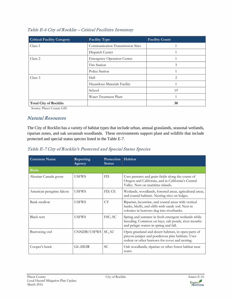
An inventory of critical facilities in the City of Rocklin from Placer County GIS is shown on Figure E-2 and detailed in Table E-6. Details of critical facility definition, type, name, address, and jurisdiction by hazard zone are listed in Appendix F.

Placer County City of Rocklin Annex E-9 Local Hazard Mitigation Plan Update March 2016
Figure E-2 City of Rocklin – Critical Facilities
Placer County City of Rocklin Annex E-10 Local Hazard Mitigation Plan Update March 2016
Table E-6 City of Rocklin – Critical Facilities Inventory
Critical Facility Category Facility Type Facility Count
Class 1 Communication Transmission Sites 1
Dispatch Center 1
Class 2 Emergency Operation Center 1
Fire Station 3
Police Station 1
Class 3 Hall 2
Hazardous Materials Facility 1
School 19
Water Treatment Plant 1
Total City of Rocklin 30 Source: Placer County GIS
Natural Resources
The City of Rocklin has a variety of habitat types that include urban, annual grasslands, seasonal wetlands, riparian zones, and oak savannah woodlands. These environments support plant and wildlife that include protected and special status species listed in the Table E-7.
Table E-7 City of Rocklin’s Protected and Special Status Species
Common Name Reporting Agency
Protection Status
Habitat
Birds
Aleutian Canada goose USFWS FD Uses pastures and grain fields along the coasts of Oregon and California, and in California’s Central Valley. Nest on maritime islands.
American peregrine falcon USFWS FD; CE Wetlands, woodlands, forested areas, agricultural areas, and coastal habitats. Nesting sites on ledges.
Bank swallow USFWS CT Riparian, lacustrine, and coastal areas with vertical banks, bluffs, and cliffs with sandy soil. Nest in colonies in burrows dug into riverbanks.
Black tern USFWS FSC; SC Spring and summer in fresh emergent wetlands while breeding. Common on bays, salt ponds, river mouths and pelagic waters in spring and fall.
Burrowing owl CNNDB/USFWS SC, S2 Open grassland and desert habitats, in open parts of pinyon-juniper and ponderosa pine habitats. Uses rodent or other burrows for cover and nesting.
Cooper’s hawk GL-DEIR SC Oak woodlands, riparian or other forest habitat near water

Placer County City of Rocklin Annex E-11 Local Hazard Mitigation Plan Update March 2016
Common Name Reporting Agency
Protection Status
Habitat
Ferruginous hawk USFWS FSC; SC Open grasslands, sagebrush flats, desert scrub, low foothills surrounding valleys and fringes of pinyon-juniper habitats. Roosts in open area, usually in a lone tree or pole.
Golden eagle GL-DEIR SC, Fully Protected
Rolling hills, mountain areas, sage-juniper flats and deserts.
Grasshopper sparrow USFWS FSC Tall and mixed grassland habitats including native prairies, hayfields, pastures, and fallow fields.
Greater sandhill crane USFWS CT Wet meadows. Tend to nest in open habitat or in the cover of bulrush and bur reed.
Lawrence’s goldfinch USFWS FSC Open oak woodlands, mesquite, and riparian thickets.
Lewis’ woodpecker USFWS FSC Open pine-oak woodlands, coniferous forests, and riparian woodlands. Associated with burned and logged woodlands.
Little willow flycatcher USFWS CE Wet meadows and montane riparian habitats with extensive willow thickets.
Loggerhead shrike USFWS FSC; SC Open habitats with scattered shrubs, trees, utility lines or other perches. Lowlands and foothills throughout California.
Long-billed curlew USFWS FSC; SC Wet meadow habitat, Coastal estuaries, upland herbaceous areas, and croplands.
Mountain plover USFWS FPT; SC Short grasslands and plowed fields of the Central Valley.
Sharp-shinned hawk GL-DEIR SC Deciduous riparian forest at mid-elevation, conifer forest, and oak woodlands.
Short-eared owl USFWS FSC; SC Grasslands, prairies, dunes, meadows, irrigated lands and saline and fresh emergent wetlands. Nests in depression in dry ground concealed in vegetation.
Swainson’s hawk CNNDB/USFWS CT Open desert, grassland, or cropland with scattered, large trees or small groves.
Tricolored blackbird CNNDB/USFWS SC; S3 Emergent wetland vegetation with cattails, tules, and/or thickets.
Vaux’s swift USFWS FSC; SC Redwood and Douglas-fir habitats with nests in large hollow trees and snags.
Western spadefoot CNNDB SC Primarily in grassland habitats, also found in valley-foothill hardwood woodlands.
White-faced ibis USFWS FSC; SC Fresh emergent wetlands, shallow lacustrine waters, and the muddy ground or wet meadows and irrigated/flooded pastures and croplands.
White-tailed kite CNNDB/USFWS S3, Fully Protected
Lowland grasslands, agriculture, wetlands, oak-woodlands, savannah, and riparian habitats associated with open areas.

Placer County City of Rocklin Annex E-12 Local Hazard Mitigation Plan Update March 2016
Common Name Reporting Agency
Protection Status
Habitat
Reptiles
California horned lizard USFWS FSC; SC Wide range of habitats from gravelly-sandy substrate containing scattered shrubs, to clearing in riparian woodlands.
Giant garter snake USFWS FT; CT Marshes, sloughs, and slow-moving creeks, with nocturnal retreats in holes and mammal burrows.
Northwestern Pond Turtle USFWS FSC; SC Pacific slope drainages from Washington to Baja California.
Amphibians
California red-legged frog GL-DEIR FT; SC Pools, ponds, slow streams, and marshes.
Fish
Central Valley fall/late fall-run Chinook salmon
USFWS FC; SC Wide range of habitats from gravelly-sandy substrate containing scattered shrubs, to clearing in riparian woodlands.
Central Valley steelhead USFWS FT Marshes, sloughs, and slow-moving creeks, with nocturnal retreats in holes and mammal burrows.
Green sturgeon USFWS FSC; SC Pacific slope drainages from Washington to Baja California.
Sacramento splittail USFWS FT; SC Primarily in the Sacramento-San Joaquin estuary.
Winter-run Chinook salmon
USFWS FE; CE The ocean and the Sacramento River and its tributaries.
Invertebrates
California Linderiella fairy shrimp
CNNDB/USFWS S2/S3 Seasonal pools in unplowed grasslands with old alluvial soils underlain by hardpan or in sandstone depressions.
Vernal Pool Tadpole Shrimp
CNNDB/USFWS FE; S2/S3 Vernal pools and swales in the Sacramento Valley containing clear to highly turbid water.
Valley Elderberry Longhorn Beetle
CNNDB/USFWS FT; S2 Only occurs in the Central Valley of California in association with Blue Elderberry (Sambucus mexicana).
Vernal Pool Fairy Shrimp CNNDB/USFWS FT; S2/S3 In a static rain-filled pools in the central valley grasslands and central and south coastal mountains.
Mammals
Fringed myotis bat USFWS FSC Roosts in caves, mines, and rock crevices within a variety of habitats.
Greater western mastiff-bat USFWS FSC; SC Open, semi-arid to arid habitats, including conifer and deciduous woodlands, annual and perennial grasslands, chaparral, and urban.
Long-eared myotis bat USFWS FSC Woodland and forest habitats, roosting in rock crevices, under bark, and tree snags.
Long-legged myotis bat USFWS FSC Woodlands and forest habitats generally over 4,000 feet. Roosts in rock crevices, under bark, in tree snags, and cliffs.

Placer County City of Rocklin Annex E-13 Local Hazard Mitigation Plan Update March 2016
Common Name Reporting Agency
Protection Status
Habitat
Pacific western big-eared bat
USFWS FSC; SC All but alpine and sub-alpine habitats.
San Joaquin pocket mouse USFWS FSC Dry, open grasslands or scrub area on fine textured soils in the Central and Salinas valleys.
Small-footed myotis bat USFWS FSC Occurs in a variety of habitats, roosting in caves, crevices, and buildings.
Spotted bat USFWS FSC Arid or ponderosa pine forests, and marshlands. Roosts in small cracks in cliffs and stony outcrops.
Yuma myotis bat USFWS FSC Variety of habitats from juniper and riparian woodlands to desert regions near open water. Associates with water and roosts in caves, attics, under bridges, mines, and similar places.
Habitats
Alkali Meadow CNNDB S2
Alkali Seep CNNDB S2
Northern Hardpan Vernal Pool
CNNDB S3
Northern Volcanic Mud Flow Vernal Pool
CNNDB S1
Plants
Big-scale Balsamroot CNNDB S2 Valley and foothill grassland, cismontane woodland.
Boggs Lake Hedge-hyssop CNNDB/USFWS CE, S3 Clay soils in marshes, swamps and vernal pools.
Dwarf Downingia CNNDB S3 Valley and foothill grassland and several types of vernal pools.
Hispid Bird’s-Beak CNNDB/USFWS FSC; S2 In damp alkaline soils in meadows, playas, and valley and foothill grassland.
Legenere CNNDB/USFWS FSC; S2 In beds of vernal pools.
Red Bluff Dwarf Rush CNNDB S2 Chaparral, valley and foothill grassland, cismontane woodlands, and vernal pools.
Source: Rocklin General Plan EIR, Appendix E, 2008
Historic and Cultural Resources
Numerous cultural and historic resources are located in the Rocklin area. Based on information from the Open Space, Conservation and Recreation Element of the Rocklin 2011 General Plan, these resources and historic sites include the following:
Prehistoric Resources Present in the Rocklin Area
Bedrock grinding mortars House pits (sites of prehistoric houses) Grinding stones Chipped stone tools Bone tools

Placer County City of Rocklin Annex E-14 Local Hazard Mitigation Plan Update March 2016
Historic Resources Present in the Rocklin Area
Historic foundations Rock walls Well pits Ditches Historic mines and mining artifacts
The Rocklin Historical Society (RHS) and Rocklin History Museum are key historic resources for the City.
Growth and Development Trends
Based on information from the Bureau of Census, from 2000-2010, the City of Rocklin’s population grew by 57 percent. Rocklin’s growth rate is significantly higher than Placer County’s growth rate for the same period, which was estimated to be 40 percent. Most of Rocklin’s population growth since 2000 can be attributed to development in Whitney Oaks, Stanford Ranch, and Southeast Rocklin along with annexation and subsequent development in the Northwest Rocklin Annexation Area (Whitney Ranch).
The number of housing units increased from 14,421 in 2000 to 20,800 in 2010. It is expected that the number of dwelling units will further increase to beyond 29,300 units at residential build-out of the city.
The majority of future growth in Rocklin is anticipated to be concentrated in four areas: Clover Valley, the mid- to eastern portion of the Northwest Rocklin Annexation Area (Whitney Ranch), the Sierra College area and the Croftwood area, as these areas represent the last portions of the city with large tracts of vacant lands (see Figure 3.0-9, Neighborhood Areas, of the 2012 Rocklin General Plan Draft EIR). Because the City of Rocklin is surrounded by other jurisdictions on all sides, it is likely that the city boundaries will not expand beyond their current locations. The primary hazard in these undeveloped areas is wildland fires, as the areas contain extensive grasslands and oak woodlands. As these areas develop the majority of the grasslands and oak woodlands will be replaced with urban development and some of the current wildland hazards will be mitigated as a result of the development, but the development will also include the preservation of grassland and oak woodland areas that will create an urban/wildland fire hazard interface.
Special Populations
There are 55 and older age-restricted subdivisions in Rocklin and there are numerous congregate care/ assisted living facilities that are built or are being proposed to be built that have, or will have, elderly populations. Hazard-related concerns or issues regarding the vulnerability of elderly populations primarily relate to the potential need for evacuation of elderly citizens in the event of a hazard that creates a need for evacuations.
Development since 2010 Plan
New development in the City of Rocklin since the 2010 plan includes development adjacent to 100-year floodplains and potential wildfire areas. With the exception of new retail commercial development located around the Sierra College Boulevard interchange with Interstate 80, the majority of development since 2010 has been residential in nature. As noted in this annex, the primary hazard in the City’s undeveloped areas

Placer County City of Rocklin Annex E-15 Local Hazard Mitigation Plan Update March 2016
is wildland fires, and with the preservation of grassland and oak woodland areas adjacent to newly developing residential uses, there has been an increase in the size and scope of urban/wildland fire hazard interfaces and a potential corresponding increase in vulnerability to wildland fires. This potential increase is addressed through the removal of grassland and oak woodland areas as a function of urban development; Fire Department review of new development proposals, the identification and establishment of any necessary fire break areas and/or emergency access points; and regular maintenance of open space areas for fire fuel load reduction purposes using prescribed grazing and mechanical means.
For any growth within flood hazard areas, the City enforces the permit and construction standards of their floodplain ordinance. If any development were to have occurred in the floodplain, it would have conformed to the development and construction standards of the ordinance, thus effectively mitigating any increased vulnerability and future flood losses in the City.
With continued population growth, the City’s vulnerability to natural hazards has a potential to increase. Continued enforcement of building codes and construction standards within the City will assist mitigating potential losses from any new development.
Future Development
The Sacramento Council on Governments (SACOG) modeled population projections for the City of Rocklin and other areas of the region in 2012 for a Metropolitan Transportation Plan/Sustainable Communities Strategy report. This forecast uses a 2008 base year estimate with projections to 2020 and 2035 for population, housing units, households and employment. SACOG estimated the City population in 2020 and 2035 to be 65,845 and 72,312 respectively.
As noted in the text above the basemap for the City, the City of Rocklin is in the process of incorporating the “island” of Placer County that is shown with crosshatches just south of I-80 into the City limits.
Figure E-3 shows the City of Rocklin’s land use. While the map does not specifically identify future growth areas but some understanding of future growth areas can be obtained from the map by seeing areas that lack road infrastructure and individual lots versus those areas that show those features.

Placer County City of Rocklin Annex E-16 Local Hazard Mitigation Plan Update March 2016
Figure E-3 City of Rocklin Future Development Map
Source: City of Rocklin General Plan
E.5.2. Estimating Potential Losses
This section provides the vulnerability assessment, including any quantifiable loss estimates, for those hazards identified above in Table E-4 as high or medium significance hazards. Impacts of past events and vulnerability of the City to specific hazards are further discussed below (see Section 4.1 Hazard Identification for more detailed information about these hazards and their impacts on the Placer County planning area). Methodologies for calculating loss estimates are the same as those described in Section 4.3 of the base plan. In general, the most vulnerable structures are those located within the floodplain, in the wildland urban interface, other priority hazard areas, unreinforced masonry buildings, and buildings built prior to the introduction of modern building codes.
An estimate of the vulnerability of the City to each identified priority hazard, in addition to the estimate of risk of future occurrence, is provided in each of the hazard-specific sections that follow. Vulnerability is measured in general, qualitative terms and is a summary of the potential impact based on past occurrences, spatial extent, and damage and casualty potential. It is categorized into the following classifications:

Placer County City of Rocklin Annex E-17 Local Hazard Mitigation Plan Update March 2016
Extremely Low—The occurrence and potential cost of damage to life and property is very minimal to nonexistent.
Low—Minimal potential impact. The occurrence and potential cost of damage to life and property is minimal.
Medium—Moderate potential impact. This ranking carries a moderate threat level to the general population and/or built environment. Here the potential damage is more isolated and less costly than a more widespread disaster.
High—Widespread potential impact. This ranking carries a high threat to the general population and/or built environment. The potential for damage is widespread. Hazards in this category may have occurred in the past.
Extremely High—Very widespread with catastrophic impact.
Flood: 100/500 year
Likelihood of Future Occurrence–Occasional Vulnerability–Low
Although rated as a low significance hazard, due to its importance in Placer County and in California, the flood hazard is included here. Rocklin is traversed by several stream systems and is at risk to both riverine flooding and localized stormwater flooding. As previously described in Section 4.2 of the main plan, the Placer County Planning Area and the City of Rocklin have been subject to previous occurrences of flooding. In the City of Rocklin, much of the flood damage occurs in the floodplains of Antelope Creek, Secret Ravine Creek, Clover Valley Creek, and Sucker Creek. Floodplains in the City are shown in Figure E-4.

Placer County City of Rocklin Annex E-18 Local Hazard Mitigation Plan Update March 2016
Figure E-4 City of Rocklin – FEMA DFIRM Floodzones

Placer County City of Rocklin Annex E-19 Local Hazard Mitigation Plan Update March 2016
Values at Risk
GIS was used to determine the possible impacts of flooding within the City of Rocklin. The methodology described in Section 4.3.7 of the base plan was followed in determining structures and values at risk to the 1% (100-year) and 0.2% (500-year) annual chance flood event. Table E-8 shows the property use, improved parcel count, improved values, estimated contents, total values and estimated loss of parcels that fall in a floodplain in the City.
Table E-8 City of Rocklin – Count and Improved Value by Property Use by Detailed Flood Zone
Flood Zone Property Use
Total Parcel Count
Total Land Value
Improved Parcel Count
Total Improved Value Total Value*
A
Agricultural 0 $0 0 $0 $0
Commercial 2 $850,145 1 $2,700,000 $3,550,145
Industrial 2 $1,041,231 2 $3,684,763 $4,725,994
Institutional 0 $0 0 $0 $0
Natural/Open 0 $0 0 $0 $0
Residential 0 $0 0 $0 $0
Total Zone A 4 $1,891,376 3 $6,384,763 $8,276,146
AE
Agricultural 0 $0 0 $0 $0
Commercial 43 $5,075,011 3 $1,025,141 $6,100,152
Industrial 14 $3,803,954 4 $4,204,090 $8,008,044
Institutional 1 $0 0 $0 $0
Natural / Open 12 $168,490 0 $0 $168,490
Residential 154 $17,622,695 149 $39,820,721 $57,443,416
Total Zone AE 224 $26,670,150 156 $45,049,952 $71,720,102
AO
Agricultural 0 $0 0 $0 $0
Commercial 1 $30,523 1 $71,232 $101,755
Industrial 7 $3,051,414 6 $11,329,996 $14,381,410
Institutional 0 $0 0 $0 $0
Natural / Open 0 $0 0 $0 $0
Residential 2 $175,853 2 $244,501 $420,354
Total Zone AO 10 $3,257,790 9 $11,645,729 $14,903,519
Shaded X
Agricultural 0 $0 0 $0 $0
Commercial 10 $1,265,544 3 $2,253,714 $3,519,258
Industrial 2 $0 0 $0 $0

Placer County City of Rocklin Annex E-20 Local Hazard Mitigation Plan Update March 2016
Flood Zone Property Use
Total Parcel Count
Total Land Value
Improved Parcel Count
Total Improved Value Total Value*
Institutional 1 $70,704 1 $88,383 $159,087
Natural / Open 0 $0 0 $0 $0
Residential 76 $4,616,865 75 $10,108,571 $14,725,436
Total Shaded X 89 $5,953,113 79 $12,450,668 $18,403,781
X
Agricultural 4 $1,946,450 0 $0 $1,946,450
Commercial 1,457 $388,053,981 449 $517,092,885 $905,146,866
Industrial 215 $50,996,449 141 $106,471,057 $157,467,506
Institutional 65 $17,148,261 21 $72,893,625 $90,041,886
Natural/Open 90 $2,825,249 6 $3,123,464 $5,948,713
Residential 17,792 $1,599,528,105 17,147 $4,272,923,915 $5,872,452,020
Total Zone X 19,623 $2,060,498,495 17,764 $4,972,504,946 $7,033,003,441
Grand Totals 19,950 $2,098,270,924 18,011 $5,048,036,058 $7,146,306,982 Source: FEMA DFIRM, Placer County 2015 Parcel/Assessor’s Data
Table E-9 summarizes Table E-8 above and shows City of Rocklin loss estimates and shows improved values at risk by FEMA 1% and 0.2% annual chance flood zones.
Table E-9 City of Rocklin – Flood Loss Summary
Jurisdiction Flood Zone
Improved Parcel Count
Total Improved Value
Estimated Contents Value
Total Improved/ Contents Value
Loss Estimate
Loss Ratio
Rocklin 1% 168 $63,080,444 $52,657,253 $115,737,697 $23,147,539 0.32%
0.2% 79 $12,450,668 $7,396,383 $19,847,051 $3,969,410 0.06% Source: FEMA DFIRM, Placer County 2015 Parcel/Assessor’s Data
According to Table E-8 and Table E-9, the City of Rocklin has 168 improved parcels and $115,737,697 of structure and contents value in the 1% annual chance floodplain. These values can be refined a step further. Applying the 20 percent damage factor as previously described in Section 4.3.7 of the base plan, there is a 1% chance in any given year of a flood event causing roughly $23,147,539 in damage in the City of Rocklin. A loss ratio of 0.32% indicates that losses in Rocklin to flood would be relatively minor, as less than an eighth of a percent of the total values in the City would be damaged.
Flooded Acres
Also of interest is the land area affected by the various flood zones. The following is an analysis of flooded acres in the City in comparison to total area within the City limits. The same methodology, as discussed in Section 4.3.7 of the base plan, was used for the City of Rocklin as well as for the County as a whole. Table

Placer County City of Rocklin Annex E-21 Local Hazard Mitigation Plan Update March 2016
E-10 represents a detailed and summary analysis of total acres for each FEMA DFIRM flood zone in the City.
Table E-10 City of Rocklin – Flooded Acres
Flood Zone Property Use Total Flooded Acres Improved Flooded Acres
% of Improved Flooded Acres
A
Agricultural 0 0 0.0%
Commercial 4.54 4.36 96.0%
Industrial 5.67 5.67 100.0%
Institutional 0 0 0.0%
Natural/Open 0 0 0.0%
Residential 0 0 0.0%
AE
Agricultural 0 0 0.0%
Commercial 338.38 2.17 0.6%
Industrial 58.92 4.63 7.9%
Institutional 21.68 0 0.0%
Natural/Open 95.31 0 0.0%
Residential 118.10 115.30 97.6%
AO
Agricultural 0 0 0.0%
Commercial 0.60 0.60 100.0%
Industrial 16.39 14.97 91.4%
Institutional 0 0 0.0%
Natural/Open 0 0 0.0%
Residential 2.08 2.08 100.0%
Total 1% 661.68 149.78 22.6%
Shaded X
Agricultural 0 0 0.0%
Commercial 12.95 3.06 23.7%
Industrial 0.03 0 0.0%
Institutional 0.29 0.29 100.0%
Natural/Open 0 0 0.0%
Residential 13.08 12.92 98.8%
Total 0.2% 26.34 16.27 61.8% Source: FEMA DFIRM, Placer County 2015 Parcel/Assessor’s Data
Population at Risk
The DFIRM flood zones were overlayed on the parcel layer. Those residential parcel centroids that intersect the severity zones were counted and multiplied by the 2010 Census Bureau average household factors for Rocklin. According to this analysis, there is a total population of 628 residents of the City at risk to flooding, 422 in the 1% chance, and 206 in the 0.2%. This is shown in Table E-11.

Placer County City of Rocklin Annex E-22 Local Hazard Mitigation Plan Update March 2016
Table E-11 City of Rocklin – Count of Improved Residential Parcels and Population by Flood Zone
Flood Zone Improved Residential Parcels Population*
A 0 0
AE 154 417
AO 2 5
Total 1% Annual Chance 156 422
Shaded X (0.2% Annual Chance) 76 206
D 0 0 Source: FEMA DFIRM, Placer County 2015 Parcel/Assessor’s Data, US Census Bureau * Average household populations from the 2010 US Census were used: Rocklin– 2.71.
Critical Facilities at Risk
There are no critical facilities at risk in the City of Rocklin in the flood zones.
Insurance Coverage, Claims Paid, and Repetitive Losses
The City of Rocklin joined the National Flood Insurance Program (NFIP) in 2001. The City does not participate in CRS. NFIP Insurance data indicates that as of September 30, 2015, there were 239 flood insurance policies in force in the City with $68,461,500 of coverage. Of the 239 policies, 226 were residential and 13 were nonresidential; 151 of the policies were in A zones (the other 88 were in B, C, and X zones). The GIS parcel analysis detailed above identified 168 improved parcels in the 100-year flood zone. 151 policies for 168 parcels in the 100-year floodplain equates to insurance coverage of 89.9 percent.
There have been 20 historical claims for flood losses totaling $252,514; although, details were only provided on 15 of the losses. Of the 15 losses, eight were in the A zones and seven were standard policies located in B, C, or X zones. Ten of these were for pre-FIRM structures; five were for post-FIRM structures. NFIP data further indicates that there are three repetitive loss (RL) buildings, with two RL buildings being insured. There have been a total of 5 RL losses, with 3 insured RL losses. There are no severe repetitive loss buildings within the City.
The Planning Team for the City did further research:
One of the 3 RL properties is located in another jurisdiction (community of Granite Bay in unincorporated Placer County).
The second of the 3 RL properties is on Cimerron Court. The property includes both X and AE zones. The final of the 3 RL properties is on Rocklin Road. It is a mobile home park in both the X and AE
Zone. This is a mobile home park. The City could not identify a particular property as FEMA provided only the generic address for the park. A small portion of this mobile home park was subject to a FEMA LOMR in 2015, but the majority of the park was not.

Placer County City of Rocklin Annex E-23 Local Hazard Mitigation Plan Update March 2016
California Department of Water Resources Best Available Maps (BAM)
The FEMA regulatory maps provide just one perspective on flood risks in Placer County. Senate Bill 5 (SB 5), enacted in 2007, authorized the California DWR to develop the Best Available Maps (BAM) displaying 100- and 200-year floodplains for areas located within the Sacramento-San Joaquin (SAC-SJ) Valley watershed. SB 5 requires that these maps contain the best available information on flood hazards and be provided to cities and counties in the SAC-SJ Valley watershed. This effort was completed by DWR in 2008. DWR has expanded the BAM to cover all counties in the State and to include 500-year floodplains.
Different than the FEMA DFIRMs which have been prepared to support the NFIP and reflect only the 100-year event risk, the BAMs are provided for informational purposes and are intended to reflect current 100-, 200-, and 500-year event risks using the best available data. The 100-year floodplain limits on the BAM are a composite of multiple 100-year floodplain mapping sources. It is intended to show all currently identified areas at risk for a 100-year flood event, including FEMA’s 100-year floodplains. The BAM are comprised of different engineering studies performed by FEMA, Corps, and DWR for assessment of potential 100-, 200-, and 500-year floodplain areas. These studies are used for different planning and/or regulatory applications. They are for the same flood frequency, however, they may use varied analytical and quality control criteria depending on the study type requirements.
The value in the BAMs is that they provide a bigger picture view of potential flood risk to the City than that provided in the FEMA DFIRMs. This provides the community and residents with an additional tool for understanding potential flood hazards not currently mapped as a regulated floodplain. Improved awareness of flood risk can reduce exposure to flooding for new structures and promote increased protection for existing development. Informed land use planning will also assist in identifying levee maintenance needs and levels of protection. By including the FEMA 100-year floodplain, it also supports identification of the need and requirement for flood insurance. The BAM map for Rocklin is shown in Figure E-5.

Placer County City of Rocklin Annex E-24 Local Hazard Mitigation Plan Update March 2016
Figure E-5 City of Rocklin Best Available Map
Source: California DWR
Future Development
The City evaluates each proposed development project to determine if it is in or near a floodplain. It if it is, the City requires that any structure by constructed out of the floodplain and have a first floor at least two feet above the 100-year floodplain elevation. The City also continues to explore ways to address floodplain issues through the use of drainage studies, drainage improvements, elevation certificates and other available strategies. The City has a GIS Division which assists in the development of GIS-based mapping of pertinent information. This data can be used by all departments and agencies for emergency pre-planning and during emergency incidents.
As noted in the text before the basemap, the City of Rocklin is in the process of incorporating the “island” of Placer County that is shown with crosshatches just south of I-80 into the City limits.
Flood: Localized Flooding
Likelihood of Future Occurrence–Likely Vulnerability–Medium
Localized/stormwater flood issues specific to the City of Rocklin have historically affected several locations throughout the City, typically older parts of the City that were developed with infrastructure that is inadequate to accommodate stormwater flows from heavy rain/severe weather events. In some locations improvements have been installed in an effort to add additional capacity to the storm drain system, but these

Placer County City of Rocklin Annex E-25 Local Hazard Mitigation Plan Update March 2016
improvements may not have completely resolved flooding occurrences. These locations are shown in Table E-13.
Table E-12 City of Rocklin – Localized Flooding Areas
Road Name Flooding Pavement Deterioration Washouts
High Water/ Creek Crossing
Landslides/ Mudslides Debris
Downed Trees
Second Street X
Cimerron Court X
Farrier Drive X
Paragon Court X
El Don Drive X X
Aguilar Road X X X X
Fleet Circle X
Bryce Court X Source: City of Rocklin
Future Development
Future development in the City will add more impervious surfaces and need to drain those waters. The City will need to be proactive to ensure that increased development has proper siting and drainage for stormwaters. The risk of localized flooding to future development can also be minimized by accurate recordkeeping of repetitive localized storm activity. Mitigating the root causes of the localized stormwater flooding will reduce future risks of losses. The City has a GIS Division which assists in the development of GIS-based mapping of pertinent information. This data can be used by all departments and agencies for emergency pre-planning and during emergency incidents.
Severe Weather: Extreme Heat
Likelihood of Future Occurrence–Likely Vulnerability–Medium
Extreme heat occurs on an annual basis, most commonly at the peak of the summer season. As Rocklin is located in the western portion of Placer County at relatively low elevation, extremely high temperatures are a more common occurrence than cold temperatures. From late spring through fall, it is not unusual for temperatures to exceed 90°F and higher. Provided by the Western Regional Climate Center, Table E-14 illustrates historical temperature patterns for Rocklin.
Table E-13 Rocklin Record High Temperatures and Days above 90 Degrees by Month
Month Temperature (F) Year Number of Days >= 90°F
May 107° 1910 5.4
June 115° 1961 14.7

Placer County City of Rocklin Annex E-26 Local Hazard Mitigation Plan Update March 2016
Month Temperature (F) Year Number of Days >= 90°F
July 115° 1933 26.0
August 118° 1933 24.6
September 114° 1950 15.4
October 105° 1910 3.4
Totals 89.5 Source: Western Regional Climate Center
Based on this historic data, there are typically 89 days per year in excess of 90 degrees Fahrenheit.
Future Development
Vulnerability to extreme heat will increase as the average age of the population in the City shifts. Greater numbers of future senior citizens will result from the large number of baby boomers in the City. The elderly are more at risk to the effects of extreme heat, especially those without proper air conditioning. However, many of the residents of the City are accustomed to living with extreme heat and take precautions to guard against the threat of extreme heat. The City has a GIS Division which assists in the development of GIS-based mapping of pertinent information. This data can be used by all departments and agencies for emergency pre-planning and during emergency incidents.
Severe Weather: Freeze and Snow
Likelihood of Future Occurrence–Likely Vulnerability–Medium
Freeze and snow occurs on an annual basis, most commonly at the peak of the winter season. The record low temperature in Rocklin is 14°F, recorded on January 21, 1937, though temperatures below freezing are not uncommon. Data for the following table were provided by the Rocklin Weather Station for the period of record from 1904 to 1976 illustrating historical temperature patterns in the Rocklin area. Table E-16 illustrates historical temperatures in Rocklin.
Table E-14 Rocklin Record Low Temperatures and Days below Freezing by Month
Month Temperature (F) Year Number of Days <= 32°F
January 14° 1937 12.7
February 20° 1929 6.7
March 23° 1944 3.6
April 27° 1929 1.0
May 19° 1928 0.1
October 25° 1917 0.7
November 20° 1921 5.6
December 14° 1932 12.1
Totals 42.5

Placer County City of Rocklin Annex E-27 Local Hazard Mitigation Plan Update March 2016
Source: Western Regional Climate Center
Future Development
Like extreme heat, vulnerability to freeze will increase as the average age of the population in the City shifts. Greater numbers of future senior citizens will result from the large number of baby boomers in the City. The elderly are more at risk to the effects of freeze. However, many of the residents of the City are accustomed to living with freeze and take precautions to guard against the threat of freeze. The City has a GIS Division which assists in the development of GIS-based mapping of pertinent information. This data can be used by all departments and agencies for emergency pre-planning and during emergency incidents.
Severe Weather: Heavy Rains and Storms (Thunderstorms/Hail, Lightning/Wind/Tornadoes)
Likelihood of Future Occurrence–Likely Vulnerability–Medium
Information is limited regarding the severe weather events that impact the City of Rocklin. In general, any severe storm that affects Placer County has local affects in Rocklin as well. Thunderstorms, high winds, hail, and lightning can each have localized impacts on infrastructure, properties, and public safety. Transportation and commerce are also affected in Rocklin when severe storms occur, mirroring impacts countywide as described in Section 4.2.5.
Future Development
The City enforces the state building code and other ordinances, which regulate construction techniques that minimize damage from heavy storms and rain. Future development in the City is subject to these building codes. New critical facilities such as communications towers should be built to withstand hail damage, lightning, and heavy rains. The City has a GIS Division which assists in the development of GIS-based mapping of pertinent information. This data can be used by all departments and agencies for emergency pre-planning and during emergency incidents.
Wildfire
Likelihood of Future Occurrence–Highly Likely Vulnerability–Medium
Wildfire is a present concern for all communities in California. According to the Community Safety Element of Rocklin’s General Plan, while the major fire threat in the city is related to urban development, annexations in recent decades incorporated large areas of grassland subject to wildfire. These areas include Clover Valley Lakes, the southern end of China Garden Road, portions of Whitney Oaks, the Croftwood/Dias Lane area, the Sunset Ranchos and various open-space easements and recreational properties. Following the methodology described in Section 4.3.2 Vulnerability of Placer County to Specific Hazards, a wildfire map for the City of Rocklin was created that shows areas of fire hazard risk by category (see Figure E-6).

Placer County City of Rocklin Annex E-28 Local Hazard Mitigation Plan Update March 2016
The Planning Team for the City noted that the large orange area (High Risk) located to the north of I-80 and to the east of Sierra College Boulevard has now been mostly developed with shopping centers. Updated mapping may not deem this a high risk area. Also, the Plannng Team noted that the City of Rocklin is in the process of incorporating the “island” of Placer County just south of I-80 into the City limits.

Placer County City of Rocklin Annex E-29 Local Hazard Mitigation Plan Update March 2016
Figure E-6 City of Rocklin’s Fire Severity Zones

Placer County City of Rocklin Annex E-30 Local Hazard Mitigation Plan Update March 2016
Values at Risk
Analysis results for Rocklin are shown in Table E-16, which summarizes total parcel counts, improved parcel counts and their structure values by occupancy type as well as the percentage of parcels affected by fire.
Table E-15 City of Rocklin – Count and Value of Parcels by Property Use and Fire Severity Zone
Fire Severity Zone Property Use
Total Parcel Count
Total Land Value
Improved Parcel Count
Improved Value Total Value*
% of Affected Parcels to Total
Very High
Agricultural 0 $0 0 $0 $0 0.0%
Commercial 0 $0 0 $0 $0 0.0%
Industrial 0 $0 0 $0 $0 0.0%
Institutional 0 $0 0 $0 $0 0.0%
Natural/Open Space
0 $0 0 $0 $0 0.0%
Residential 0 $0 0 $0 $0 0.0%
Total 0 $0 0 $0 $0 0.0%
High
Agricultural 0 $0 0 $0 $0 0.0%
Commercial 42 $15,198,603 8 $12,379,069 $27,577,672 1.8%
Industrial 0 $0 0 $0 $0 0.0%
Institutional 0 $0 0 $0 $0 0.0%
Natural/Open Space
0 $0 0 $0 $0 0.0%
Residential 4 $657,401 4 $528,147 $1,185,548 0.0%
Total 46 $15,856,004 12 $12,907,216 $28,763,220 0.1%
Moderate
Agricultural 4 $1,946,450 0 $0 $1,946,450 0.0%
Commercial 592 $197,326,613 116 $201,513,709 $398,840,322 25.4%
Industrial 95 $26,480,763 57 $41,221,645 $67,702,408 37.3%
Institutional 17 $2,826,714 3 $2,716,065 $5,542,779 13.6%
Natural/Open Space
50 $247,799 1 $225,418 $473,217 16.7%
Residential 4,439 $407,209,184 3,967 $1,157,812,163 $1,565,021,347 22.8%
Total 5,197 $636,037,523 4,144 $1,403,489,000 $2,039,526,523 23.0%
Urban Unzoned
Agricultural 0 $0 0 $0 $0 0.0%
Commercial 877 $182,749,988 333 $309,250,194 $492,000,182 72.9%

Placer County City of Rocklin Annex E-31 Local Hazard Mitigation Plan Update March 2016
Fire Severity Zone Property Use
Total Parcel Count
Total Land Value
Improved Parcel Count
Improved Value Total Value*
% of Affected Parcels to Total
Industrial 144 $32,412,285 96 $84,468,261 $116,880,546 62.7%
Institutional 50 $14,392,251 19 $70,265,943 $84,658,194 86.4%
Natural/Open Space
52 $2,745,940 5 $2,898,046 $5,643,986 83.3%
Residential 13,581 $1,214,076,933 13,402 $3,164,757,398 $4,378,834,331 77.1%
Total 14,704 $1,446,377,397 13,855 $3,631,639,842 $5,078,017,239 76.9%
Non-Wildland/Non-Urban
Agricultural 0 $0 0 $0 $0 0.0%
Commercial 2 $0 0 $0 $0 0.0%
Industrial 1 $0 0 $0 $0 0.0%
Institutional 0 $0 0 $0 $0 0.0%
Natural/Open Space
0 $0 0 $0 $0 0.0%
Residential 0 $0 0 $0 $0 0.0%
Total 3 $0 0 $0 $0 0.0%
Grand Total 19,950 $2,098,270,924 18,011 $5,048,036,058 $7,146,306,982 100.0% Source: Placer County 2015 Parcel/Assessor’s Data, CAL FIRE *Land and structure values
Population at Risk
The Fire Severity Zone dataset was overlayed on the parcel layer. Those residential parcel centroids that intersect the severity zones were counted and multiplied by the 2010 Census Bureau average household factors for each jurisdiction and unincorporated area. Results were tabulated by jurisdiction. According to this analysis, there is a total population of 10,762 residents of Rocklin at risk to moderate or higher wildfire risk. This is shown in Table E-17.

Placer County City of Rocklin Annex E-32 Local Hazard Mitigation Plan Update March 2016
Table E-16 City of Rocklin – Count of Improved Residential Parcels and Population by Fire Severity Zone
Fire Severity Zone Improved Residential Parcels Population*
Very High 0 0
High 4 11
Moderate 3,967 10,751
Urban Unzoned 13,402 36,319
Non-Wildland/Urban 0 0
None 0 0
Total 17,373 47,081 Source: Placer County 2015 Parcel/Assessor’s Data, CAL FIRE * Average household populations for Rocklin (2.71) from the 2010 US Census were used
Critical Facilities at Risk
Wildfire analysis was performed on the critical facility inventory in Placer County and all jurisdictions. GIS was used to determine whether the facility locations intersect a fire severity zone provided by CAL FIRE, and if so, which zone it intersects. There are 30 facilities in the moderate or higher fire severity zone in the City. These are shown in Figure E-7 and detailed in Table E-18. Details of critical facility definition, type, name and address and jurisdiction by fire zone are listed in Appendix F.

Placer County City of Rocklin Annex E-33 Local Hazard Mitigation Plan Update March 2016
Figure E-7 City of Rocklin – Critical Facilities in the Fire Severity Zones

Placer County City of Rocklin Annex E-34 Local Hazard Mitigation Plan Update March 2016
Table E-17 City of Rocklin – Critical Facilities in the Fire Severity Zones
Fire Hazard Severity Zone Critical Facility Class Facility Type Facility Count
Very High Class 1 - -
Class 2 - -
Class 3 - -
Total Very High 0
High Class 1 - -
Class 2 - -
Class 3 - -
Total High 0
Moderate Class 1 Communication Transmission Sites 1
Class 2 Fire Station 1
School 1
Class 3 Water Treatment Plant 1
Total Moderate 4
Non-Wildland/Non-Urban Class 1 - -
Class 2 - -
Class 3 - -
Total Non-Wildland/Non-Urban -
Urban Unzoned Class 1 Dispatch Center 1
Emergency Operation Center 1
Class 2 Fire Station 2
Police Station 1
Class 3 Hall 2
Hazardous Materials Facility 1
School 18
Total Urban Unzoned 26
Total 30 Source: CAL FIRE, Placer County GIS
Future Development
The City has implemented prescribed grazing, weed abatement and fire fuel load reduction efforts to help reduce the risks associated with potential wildfires. The City has a GIS Division which assists in the development of GIS-based mapping of pertinent information. This data can be used by all departments and agencies for emergency pre-planning and during emergency incidents.

Placer County City of Rocklin Annex E-35 Local Hazard Mitigation Plan Update March 2016
Hazardous Materials Transport
Likelihood of Future Occurrence–Likely Vulnerability–Medium
The Union Pacific Railroad line passes through the City of Rocklin. Hazardous materials are regularly shipped via the rail line and, while unlikely, an incident involving a rail accident within the City could have devastating effects.
The City has little control over the types of materials that are shipped via the rail line. With regard to government activities, the content of shipments may be confidential for reasons of security and/or is generally unknown to the City. While the City has little influence over the types of material transported via the rail line, the potential for rail incidents can be reduced by ensuring that at-grade crossings within the city are operating in a safe and effective manner.
State Route 65 and Interstate 80 pass through the City as well. These are designated Cal Trans hazardous materials routes. The HMPC also noted that petroleum distribution lines and storage tanks are located in the City.
Populations at Risk
To determine the populations at risk from a transportation-related hazardous materials release within identified transportation corridors, an analysis was performed using GIS. A one mile buffer was applied to both sides of Highways 20, 49, 65, 80, 89, 174, 193, and 267, as well as the BNSF and Union Pacific Railroads. The result is a two-mile buffer zone around each transportation corridor that is used for risk-analysis.
Analysis was done for jurisdictions found in Table E-19. This table shows total population that are within the proximity of this two-mile buffer of all the highway and railroad corridors. Using GIS, the buffered corridor was overlaid on the improved residential parcel data. Those parcel centroids that intersect the buffered corridor were counted and multiplied by the 2010 Census Bureau average household factors for the City. According to this analysis, there is a total population of 48,249 in the buffered corridors.
Table E-18 City of Rocklin – Populations at Risk in Haz-Mat Corridors
Jurisdiction Residential Parcels Population
Loomis 17,804 48,249 Source: Cal Trans, Placer County GIS, US Census Bureau * Average household populations from the 2010 US Census were used Rocklin– 2.71.
Critical Facilities at Risk
To determine the critical facilities at risk from a transportation-related hazardous materials release within identified transportation corridors, an analysis was performed using GIS. A one mile buffer was applied to both sides of Highways 20, 49, 65, 80, 89, 174, 193, and 267, as well as the BNSF and Union Pacific

Placer County City of Rocklin Annex E-36 Local Hazard Mitigation Plan Update March 2016
Railroads. The result is a two-mile buffer zone around each transportation corridor that is used for risk-analysis.
Analysis was done for jurisdictions found in Table E-19. This table shows critical facilities located within the proximity of this two-mile buffer of all the highway and railroad corridors. Some facilities fall in the highway routes, some in the rail routes, and some fall in both the highway and rail routes. According to this analysis, there are 25 critical facilities in the buffered corridors.

Placer County City of Rocklin Annex E-37 Local Hazard Mitigation Plan Update March 2016
Figure E-8 City of Rocklin– Critical Facilities at Risk in Haz-Mat Corridors

Placer County City of Rocklin Annex E-38 Local Hazard Mitigation Plan Update March 2016
Table E-19 City of Rocklin – Critical Facilities at Risk in Haz-Mat Corridors
Hazardous Materials Route
Critical Facility Class Facility Type Facility Count
Hazardous Materials Highway Route
Class 1 - -
Class 2 Fire Station 2
Class 3 Fairground 1
School 7
Total Hazardous Materials Highway Route
10
Hazardous Materials Railroad Route
Class 1 Communication Transmission Sites
1
Class 2 - -
Class 3 School 1
Water Treatment Plant 1
Total Hazardous Materials Railroad Route
3
Combined Hazardous Materials Highway and Railroad Route
Class 1 Dispatch Center 1
Emergency Operation Center
1
Class 2 Fire Station 1
Police Station 1
Class 3 Hall 2
School 6
Total Combined Routes 12
Total 25 Source: Cal Trans, Placer County GIS
Future Development
Development will continue to occur in hazardous materials affected areas. It is important that the City make residents who choose to live or develop in hazmat zones about the possibility of being affected by a hazardous materials spill.
E.6 Capability Assessment
Capabilities are the programs and policies currently in use to reduce hazard impacts or that could be used to implement hazard mitigation activities. This capabilities assessment is divided into five sections: regulatory mitigation capabilities, administrative and technical mitigation capabilities, fiscal mitigation capabilities, mitigation education, outreach, and partnerships, and other mitigation efforts.

Placer County City of Rocklin Annex E-39 Local Hazard Mitigation Plan Update March 2016
E.6.1. Regulatory Mitigation Capabilities
Table E-21 lists regulatory mitigation capabilities, including planning and land management tools, typically used by local jurisdictions to implement hazard mitigation activities and indicates those that are in place in the City of Rocklin.
Table E-20 City of Rocklin’s Regulatory Mitigation Capabilities
Plans Y/N Year
Does the plan/program address hazards? Does the plan identify projects to include in the mitigation strategy? Can the plan be used to implement mitigation actions?
Comprehensive/Master Plan Y 2012 City of Rocklin General Plan Update contains a Community Safety Element which addresses hazards through goals and policies but it does not identify specific projects. The Community Safety Element can be used to support mitigation actions provided they are consistent with the goals and policies.
Capital Improvements Plan Y Capital Improvement Plan last updated in 2007. The Plan identifies capital improvement projects such as street and roadway improvements but does not directly address hazards, although some projects when built will indirectly address hazards.
Economic Development Plan Y The Rocklin City Council includes a Strategic Plan as part of its annual budget adoption process, but it does not specifically address hazards or mitigation actions.
Local Emergency Operations Plan Y Emergency Operations Plan last updated in 2014. Addresses planned response to emergencies associated with disasters, technological incidents or other dangerous conditions created either by man or nature but does not identify specific mitigation projects.
Continuity of Operations Plan Y See Local Emergency Operations Plan above.
Transportation Plan Y See Capital Improvement Plan above.
Stormwater Management Plan/Program Y Conditions listed in City’s standard improvement requirements and standard list of conditions.
Engineering Studies for Streams Y Hydraulic analyses are required for new development projects
Community Wildfire Protection Plan Y Wildfire hazards included in City’s Emergency Operations Plan
Other special plans (e.g., brownfields redevelopment, disaster recovery, coastal zone management, climate change adaptation)
N
Building Code, Permitting, and Inspections Y/N Are codes adequately enforced?
Building Code Y Version/Year: 2013 CBC. The building code is adequately enforced.
Building Code Effectiveness Grading Schedule (BCEGS) Score
N Score:
Fire department ISO rating: Y Rating: 2

Placer County City of Rocklin Annex E-40 Local Hazard Mitigation Plan Update March 2016
Site plan review requirements Y Required prior to issuance of engineering, building, or planning permits. This is adequately enforced.
Land Use Planning and Ordinances Y/N
Is the ordinance an effective measure for reducing hazard impacts? Is the ordinance adequately administered and enforced?
Zoning ordinance Y Indirectly reduces hazard impacts through building setback, size and height requirements as well as lot coverage requirements. Adequately administered and enforced.
Subdivision ordinance Y Indirectly reduces hazard impacts through policies, standards, requirements and procedures that regulate the design and improvement of all subdivisions. Adequately administered and enforced.
Floodplain ordinance Y Reduces flooding hazards by applying regulations throughout the City for development within or near flood prone areas. Adequately administered and enforced.
Natural hazard specific ordinance (stormwater, steep slope, wildfire)
N
Flood insurance rate maps Y FEMA flood insurance rate maps (FIRM) are applicable and are an effective measure for reducing hazard impacts. Adequately administered and enforced.
Elevation Certificates Y Obtained by private property owners, does not directly reduce hazard impacts. Adequately administered and enforced.
Acquisition of land for open space and public recreation uses
Y Open space and recreation uses identified in City’s General Plan and created as part of development review process, assists in reduction of hazard impacts by preserving lands that may contain hazards. Adequately administered and enforced.
Erosion or sediment control program Y Erosion and Sediment Control Ordinance adopted, reduces hazard impacts related to water quality. Adequately administered and enforced.
Other
How can these capabilities be expanded and improved to reduce risk?
Source: City of Rocklin
As indicated above, the City has several programs, plans, policies, codes and ordinances in place and/or that they follow. The General Plan for the City of Rocklin is the most comprehensive. The following section provides an overview of the General Plan and identifies specific policies related to hazard mitigation that are included in the plan
The City of Rocklin General Plan (2012 General Plan Update)
The City of Rocklin General Plan provides a vision for the future of the City. The plan discusses existing conditions and creates a framework of policies that encourage progress toward the agreed upon goals for the community.
The general plan includes a Community Safety Element that focuses on potential natural and human-created hazards. It describes activities and services that provide protection from these hazards and considers the
Placer County City of Rocklin Annex E-41 Local Hazard Mitigation Plan Update March 2016
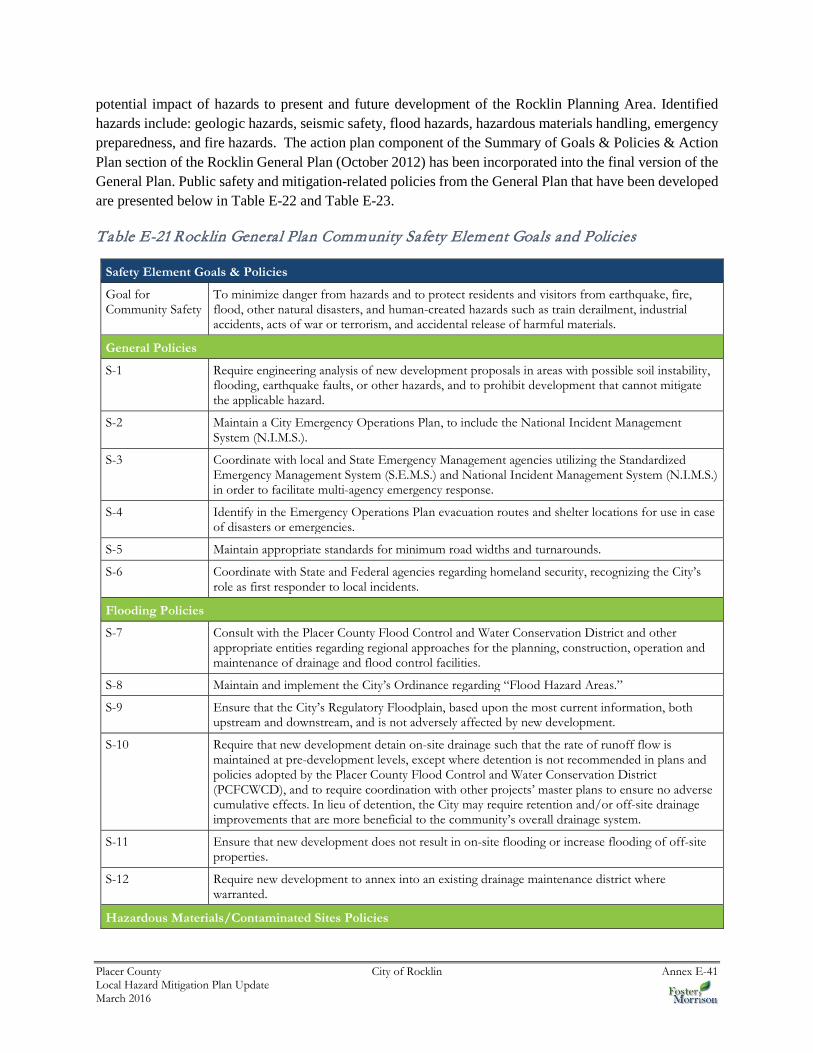
potential impact of hazards to present and future development of the Rocklin Planning Area. Identified hazards include: geologic hazards, seismic safety, flood hazards, hazardous materials handling, emergency preparedness, and fire hazards. The action plan component of the Summary of Goals & Policies & Action Plan section of the Rocklin General Plan (October 2012) has been incorporated into the final version of the General Plan. Public safety and mitigation-related policies from the General Plan that have been developed are presented below in Table E-22 and Table E-23.
Table E-21 Rocklin General Plan Community Safety Element Goals and Policies
Safety Element Goals & Policies
Goal for Community Safety
To minimize danger from hazards and to protect residents and visitors from earthquake, fire, flood, other natural disasters, and human-created hazards such as train derailment, industrial accidents, acts of war or terrorism, and accidental release of harmful materials.
General Policies
S-1 Require engineering analysis of new development proposals in areas with possible soil instability, flooding, earthquake faults, or other hazards, and to prohibit development that cannot mitigate the applicable hazard.
S-2 Maintain a City Emergency Operations Plan, to include the National Incident Management System (N.I.M.S.).
S-3 Coordinate with local and State Emergency Management agencies utilizing the Standardized Emergency Management System (S.E.M.S.) and National Incident Management System (N.I.M.S.) in order to facilitate multi-agency emergency response.
S-4 Identify in the Emergency Operations Plan evacuation routes and shelter locations for use in case of disasters or emergencies.
S-5 Maintain appropriate standards for minimum road widths and turnarounds.
S-6 Coordinate with State and Federal agencies regarding homeland security, recognizing the City’s role as first responder to local incidents.
Flooding Policies
S-7 Consult with the Placer County Flood Control and Water Conservation District and other appropriate entities regarding regional approaches for the planning, construction, operation and maintenance of drainage and flood control facilities.
S-8 Maintain and implement the City’s Ordinance regarding “Flood Hazard Areas.”
S-9 Ensure that the City’s Regulatory Floodplain, based upon the most current information, both upstream and downstream, and is not adversely affected by new development.
S-10 Require that new development detain on-site drainage such that the rate of runoff flow is maintained at pre-development levels, except where detention is not recommended in plans and policies adopted by the Placer County Flood Control and Water Conservation District (PCFCWCD), and to require coordination with other projects’ master plans to ensure no adverse cumulative effects. In lieu of detention, the City may require retention and/or off-site drainage improvements that are more beneficial to the community’s overall drainage system.
S-11 Ensure that new development does not result in on-site flooding or increase flooding of off-site properties.
S-12 Require new development to annex into an existing drainage maintenance district where warranted.
Hazardous Materials/Contaminated Sites Policies

Placer County City of Rocklin Annex E-42 Local Hazard Mitigation Plan Update March 2016
Safety Element Goals & Policies
S-13 Require existing and new commercial and industrial uses involving the use, handling, transport or disposal of hazardous materials within the City to disclose their activities in accordance with Placer County guidelines and the requirements of State law.
S-14 Require that construction activities cease if contamination is discovered on construction projects until the contamination is reported, and its extent is assessed, delineated, and isolated, as appropriate. Remediation shall occur to the satisfaction of the appropriate responsible agency (such as the Placer County Environmental Health Services, the Central Valley Regional Water Quality Control Board, the Department of Toxic Substances Control, or the City of Rocklin, depending on the type of contamination).
S-15 Require site-specific hazard investigations to be conducted, if determined to be necessary by the City, to confirm potentially contaminated soils prior to approval of new discretionary development projects.
Fire Hazards Policies
S-16 Require new development and projects proposing land use changes to annex into existing or new Community Facilities Districts for fire prevention/suppression and medical response, or to create other financing mechanisms as necessary.
S-17 Require substantially vacant newly annexed areas containing wildland fire potential to bear additional costs associated with contracting to CalFire for fire suppression or provide other means of mitigation approved by the Fire Department until such time as urban services become available.
S-18 Incorporate fuel modification/fire hazard reduction planning (e.g., weed abatement, open space management plans, firebreaks, planting restrictions) on lands (both public and private) that contain terrain and vegetative features such as grass, woodlands and severe slopes
S-19 Maintain inter-jurisdictional cooperation and coordination, including automatic aid agreements with fire protection/suppression agencies in Placer County.
Seismic and Geologic Hazards Policies
S-20 Provide for seismic safety and structural integrity in residential, commercial, industrial and public facilities through Building Code enforcement.
S-21 Require site-specific geotechnical studies of development proposals in areas subject to landslide potential, erosion, and/or slope instability.
Other Hazards Policies S-22 Require a risk analysis, as appropriate, when reviewing new projects located in close proximity to bulk hazardous material facilities, bulk petroleum transmission pipelines, and railroad travel routes. S-23 Require quarry safety protection measures prior to the development of any property containing or bordering on an existing quarry. The quarry safety protection measures shall identify public safety hazards associated with quarries and shall specify the protection methods that will be implemented to ensure public safety. S-24 Reduce the exposure of sensitive receptors to potential health risks from toxic air contaminants (TACs). Source: Rocklin Draft General Plan Update, Chapter 4D – Community Safety Element
Table E-22 Rocklin General Plan Mitigation Related Policies (Various Elements)
General Plan: Various Elements Goals & Policies
Land Use Policies
LU-19 Require projects that are approved on severe slopes (25 percent or greater) to establish grading design guidelines with their development application.
Conservation, Development, and Utilization of Natural Resources Policies

Placer County City of Rocklin Annex E-43 Local Hazard Mitigation Plan Update March 2016
General Plan: Various Elements Goals & Policies
OCR-46 Participate as appropriate in a regional approach to the management of drainage basins and flood plains with regional agencies such as the Placer County Flood Control and Water Conservation District.
OCR-47 Protect the designated City Regulatory Floodplains from encroachment by development that would impede flood flows or pose a hazard to occupants.
OCR-49 Minimize the degradation of water quality through use of erosion control plans and Best Management Practices.
OCR-50 Maintain a grading ordinance that minimizes erosion and siltation of creeks and other watercourses.
OCR-51 Evaluate development along stream channels to ensure that it does not create any of the following effects in a significant manner: reduced stream capacity, increased erosion or deterioration of the channel.
OCR-60 Work with the Placer County Water Agency to ensure that available methods and techniques to conserve potable water supplies are applied in Rocklin.
Public Facilities and Services Policies (Law Enforcement, Fire Protection, and Emergency Response)
PF-12 Identify certain types of development, such as assisted living facilities and group homes that may generate higher demand or special needs for emergency services and require developer participation to mitigate the needs/demands.
PF-15 Require City-approved automated entry access to gated communities for emergency vehicles
PF-23 Require special fire suppression mitigation (such as sprinklering) for any new residential development located more than two road miles from a fire station and for any new commercial development located more than one and one-half road miles from a fire station.
PF-24 Support public education concerning fire and life safety.
PF-25 Require new development to meet fire flow requirements based on standards codified in the Uniform Fire Code.
Public Facilities and Services Policies (Utilities)
PF-32 Request utility companies to expedite undergrounding of existing above ground utility lines.
PF-33 Require undergrounding of utility lines in new development, except where infeasible for financial and/or operational reasons.
PF-34 Coordinate with utility companies regarding the location of new high voltage transmission lines, seeking undergrounding wherever possible.
PF-41 Assist the Placer County Water Agency in implementing water conservation practices.
PF-43 Require that new development proposals include Drainage Master Plans unless waived by the City Engineer.
PF-44 Acquire easements to creeks and waterways to allow for maintenance, inspection, and construction of storm drainage facilities.
Source: 2012 City of Rocklin General Plan
City of Rocklin Emergency Operations Plan
The City of Rocklin Emergency Operations Plan (EOP) and Resources Guide addresses the planned response for the City of Rocklin to emergencies associated with disasters, technological incidents, or other dangerous conditions created by either man or nature. It provides an overview of operational concepts,

Placer County City of Rocklin Annex E-44 Local Hazard Mitigation Plan Update March 2016
identifies components of the City emergency management organization, and describes the overall responsibilities of local, state, and federal entities.
E.6.2. Administrative/Technical Mitigation Capabilities
Table E-24 identifies the City department(s) responsible for activities related to mitigation and loss prevention in Rocklin.
Table E-23 City of Rocklin’s Administrative and Technical Mitigation Capabilities
Administration Y/N Describe capability Is coordination effective?
Planning Commission Y Makes recommendations and/or final decisions on development proposals. Coordination is effective
Mitigation Planning Committee N
Maintenance programs to reduce risk (e.g., tree trimming, clearing drainage systems)
Y Public Services Department conducts tree trimming, weed abatement/grazing and drainage channel maintenance activities. Coordination is effective.
Mutual aid agreements Y Rocklin Fire Department belongs to statewide mutual aid system. Coordination is effective.
Other
Staff Y/N
FT/PT
Is staffing adequate to enforce regulations? Is staff trained on hazards and mitigation? Is coordination between agencies and staff effective?
Chief Building Official Y FT
Through a combination of City staff and contracting with outside firms, staffing is adequate to enforce regulations and staff is trained on hazards and mitigation. Coordination between agencies and staff is effective.
Floodplain Administrator Y FT
Economic and Community Development Department has Floodplain Administrator.
Emergency Manager Y FT
Fire Chief or Police Chief as designated by City Manager. Staffing is adequate to enforce regulations and staff is trained on hazards and mitigation. Coordination between agencies and staff is effective.
Community Planner Y FT
Planning staff in Economic and Community Development Department. Staffing is adequate to enforce regulations and staff is trained on hazards and mitigation. Coordination between agencies and staff is effective.
Civil Engineer Y FT
Engineering staff in Economic and Community Development Department. Staffing is adequate to enforce regulations and staff is trained on hazards and mitigation. Coordination between agencies and staff is effective.
GIS Coordinator Y GIS Division in Public Services Department. Staffing is adequate to enforce regulations and staff is trained on hazards and mitigation. Coordination between agencies and staff is effective.
Other

Placer County City of Rocklin Annex E-45 Local Hazard Mitigation Plan Update March 2016
Technical Y/N
Describe capability Has capability been used to assess/mitigate risk in the past?
Warning systems/services (Reverse 911, outdoor warning signals)
Y Police and Fire Departments
Hazard data and information Y Police, Fire, Economic and Community Development and Public Services Departments.
Grant writing N
Hazus analysis N
Other
How can these capabilities be expanded and improved to reduce risk?
Source: City of Rocklin
E.6.3. Fiscal Mitigation Capabilities
Table E-25 identifies financial tools or resources that the City could potentially use to help fund mitigation activities.
Table E-24 City of Rocklin’s Fiscal Mitigation Capabilities
Funding Resource
Access/ Eligibility
(Y/N)
Has the funding resource been used in past and for what type of activities? Could the resource be used to fund future mitigation actions?
Capital improvements project funding Y Has not been used in past for direct hazard mitigation activities, could be used to fund future mitigation actions.
Authority to levy taxes for specific purposes Y (requires 2/3 voter approval)
Has not been used in past for direct hazard mitigation activities, could be used to fund future mitigation actions.
Fees for water, sewer, gas, or electric services N Water, sewer, gas and electric services in Rocklin are provided by others (non-City).
Impact fees for new development Y Has not been used in past for direct hazard mitigation activities, could be used to fund future mitigation actions.
Storm water utility fee N
Incur debt through general obligation bonds and/or special tax bonds
Y Has not been used in past for direct hazard mitigation activities, could be used to fund future mitigation actions.
Incur debt through private activities N
Community Development Block Grant Y Has not been used in past for direct hazard mitigation activities, could be used to fund future mitigation actions.

Placer County City of Rocklin Annex E-46 Local Hazard Mitigation Plan Update March 2016
Funding Resource
Access/ Eligibility
(Y/N)
Has the funding resource been used in past and for what type of activities? Could the resource be used to fund future mitigation actions?
Other federal funding programs Y Has not been used in past for direct hazard mitigation activities, could be used to fund future mitigation actions.
State funding programs Y Has not been used in past for direct hazard mitigation activities, could be used to fund future mitigation actions.
Other
How can these capabilities be expanded and improved to reduce risk?
Source: City of Rocklin
E.6.4. Mitigation Education, Outreach, and Partnerships
Table E-26 identifies education and outreach programs and methods already in place that could be/or are used to implement mitigation activities and communicate hazard-related information. More information can be found below the table.
Table E-25 City of Rocklin’s Mitigation Education, Outreach, and Partnerships
Program/Organization Yes/No
Describe program/organization and how relates to disaster resilience and mitigation. Could the program/organization help implement future mitigation activities?
Local citizen groups or non-profit organizations focused on environmental protection, emergency preparedness, access and functional needs populations, etc.
Y Local citizen groups and non-profit organizations focused on environmental
protection are active in Rocklin and region, but rarely focus on disaster mitigation. City could seek their assistance in helping to implement
future mitigation activities.
Ongoing public education or information program (e.g., responsible water use, fire safety, household preparedness, environmental education)
Y The City staffs an environmental education outreach booth at some special events, could
assist with implementing future mitigation activities.
Natural disaster or safety related school programs N
StormReady certification N
Firewise Communities certification N?
Public-private partnership initiatives addressing disaster-related issues
N
Other
How can these capabilities be expanded and improved to reduce risk?

Placer County City of Rocklin Annex E-47 Local Hazard Mitigation Plan Update March 2016
The City of Rocklin works cooperatively with the State Regional Board, the Central Valley Regional Water Quality Control Board, the Placer County Flood Control and Water Conservation District, Cal Fire, and the neighboring jurisdictions of Colfax, Lincoln, Loomis, Roseville, Auburn, and Placer County.
E.6.5. Other Mitigation Efforts
The City of Rocklin has many other ongoing mitigation efforts that include the following:
Weed Abatement Program Annual Drainage Maintenance Program Managed Grazing Program (see Figure E-9)
Figure E-9 Managed Grazing Program
Source: City of Rocklin
E.7 Mitigation Strategy
E.7.1. Mitigation Goals and Objectives
The City of Rocklin adopts the hazard mitigation goals and objectives developed by the HMPC and described in Chapter 5 Mitigation Strategy.
E.7.2. NFIP Mitigation Strategy
The City of Rocklin joined the National Flood Insurance Program (NFIP) in 2001. As a participant of the National Flood Insurance Program (NFIP), the City of Rocklin has administered floodplain management regulations that meet the minimum requirements of the NFIP. The management program objective is to protect people and property within the City. The City of Rocklin will continue to comply with the requirements of the NFIP in the future.
In addition, the City of Rocklin actively participates with the County of Placer to address local NFIP issues through a regional approach. Many of the program activities are the same for the City of Rocklin as for

Placer County City of Rocklin Annex E-48 Local Hazard Mitigation Plan Update March 2016
Placer County since participation at the County level includes all local jurisdictions. An elected official of the City of Rocklin is a designated representative on the Placer County Flood Control District Board.
The City’s regulatory activities apply to existing and new development areas of the City; implementing flood protection measures for existing structures and new development and maintaining drainage systems. The goal of the program is to enhance public safety, and reduce impacts and losses while protecting the environment. The City has a Flood Damage Prevention Ordinance that regulates construction in the floodplain. The City intends to continue to implement the ordinance and participate at the regional level with Placer County implementing appropriate measures to mitigate exposure and damages within designated flood prone areas.
The NFIP’s Community Rating System (CRS) is a voluntary incentive program that recognizes and encourages community floodplain management activities that exceed the minimum NFIP requirements. As a result, flood insurance premium rates are discounted to reflect the reduced flood risk resulting from the community actions meeting the three goals of the CRS which are to reduce flood losses, facilitate accurate insurance rating, and promote the awareness of flood insurance. The City of Rocklin does not participate in the CRS.
E.7.3. Mitigation Actions
The planning team for the City of Rocklin identified and prioritized the following mitigation actions based on the risk assessment. Background information and information on how each action will be implemented and administered, such as ideas for implementation, responsible office, potential funding, estimated cost, and timeline are also included.
Action 1. Integrate Local Hazard Mitigation Plan into Safety Element of General Plan
Hazards Addressed: All hazards
Issue/Background: Local jurisdictional reimbursement for mitigation projects and cost recovery after a disaster is guided by Government Code Section 8685.9 (AB 2140). Specifically, this section requires that each jurisdiction adopt a local hazard mitigation plan (LHMP) in accordance with the federal Disaster Mitigation Act of 2000 as part of the Safety Element of its General Plan. Adoption of the LHMP into the Safety Element of the General Plan may be by reference or incorporation.
Other Alternatives: No action
Existing Planning Mechanisms through which Action will be Implemented: Safety Element of General Plan
Responsible Office: City of Rocklin Planning Department
Priority (H, M, L): High
Cost Estimate: Jurisdictional board/staff time

Placer County City of Rocklin Annex E-49 Local Hazard Mitigation Plan Update March 2016
Potential Funding: Local budgets
Benefits (avoided Losses): Incorporation of an adopted LHMP into the Safety Element of the General Plan will help jurisdictions maximize the cost recovery potential following a disaster.
Schedule: As soon as possible
Action 1. Federal Emergency Management Agency (FEMA) Floodplain/Community Rating System (CRS)
Hazards Addressed: Flood/Severe Weather (Heavy Rain)
Issue/Background: The City of Rocklin has been subject to previous occurrences of flooding and there are improved and un-improved parcels within the City that are located within the 100- and 500- year floodplains. The City is exploring ways to address floodplain issues through the use of drainage studies, drainage improvements, elevation certificates, consideration of participation the Community Rating System and other available strategies.
Other Alternatives: No action.
Existing Planning Mechanism(s) through which Action Will Be Implemented: See below.
Responsible Office/Partners: City of Rocklin Public Services Department and Economic and Community Development Department
Project Priority: Medium
Cost Estimate: It is estimated that the cost of drainage studies, drainage improvements, elevation certificates and consideration of participation in the Community Rating System and other available strategies ranges between $200,000.00 and $500,000.00, depending upon the costs of the selected method(s).
Benefits (Losses Avoided): Possible reductions in the number of properties impacted by the 100- and 500-year floodplains which can provide savings in potential property damage from flood events. Possible reductions in the cost and need for flood insurance by private property owners.
Potential Funding: Possible grant opportunities, public-private partnerships and possible General Fund monies. No grant funding has been utilized for this project to date.
Timeline: In process, dependent upon funding.
Action 2. Creek Channel and Drainage Way Clearing and Maintenance
Hazards Addressed: Flooding
Issue/Background: The City of Rocklin’s stormwater runoff is channeled through drainage ways and numerous small creeks throughout the City. These drainage ways and creeks require regular maintenance

Placer County City of Rocklin Annex E-50 Local Hazard Mitigation Plan Update March 2016
to remove vegetation (including invasive plant species) and debris which helps to provide additional drainage capacity and reduce localized flooding.
Other Alternatives: Continue creek channel and drainage way clearing and maintenance as funding becomes available.
Existing Planning Mechanism(s) through which Action Will Be Implemented: The City of Rocklin Public Services Department conducts creek channel and drainage way clearing and maintenance throughout the City on an annual basis. Locations of these efforts vary from year to year based on available funding, known problem areas and timing of last treatment.
Responsible Office/Partners: City of Rocklin Public Services Department
Project Priority: Medium
Cost Estimate: $50,000.00-100,000.00.
Benefits (Losses Avoided): Decreases in localized flooding and decreases in potential property damage and/or loss.
Potential Funding: Possible grant opportunities and General Fund monies. No grant funding has been utilized for this project to date.
Timeline: In process, dependent upon funding.
Action 3. High Water Use Landscape and Irrigation Retrofit
Hazards Addressed: Drought, Fire Risk
Issue/Background: The City of Rocklin has some park and open space areas and roadway landscaping that contain high water use plants and/irrigation systems that could be considered inefficient and wasteful from a water conservation standpoint. These areas are in need of retrofit to reduce water use.
Other Alternatives: Reduce or eliminate water use and allow landscaping to die.
Existing Planning Mechanism(s) through which Action Will Be Implemented: In response to mandated water restrictions in 2015 the City initiated a retrofit program that consisted of retrofitting existing irrigation systems with water efficient irrigation systems and replacing high water use landscape with low water use landscape. In addition the City identified areas of parks and open space that were not critical for public use and allowed these areas to “brown out”.
Responsible Office/Partners: City of Rocklin Public Services Department
Project Priority: Medium
Cost Estimate: Unknown.

Placer County City of Rocklin Annex E-51 Local Hazard Mitigation Plan Update March 2016
Benefits (Losses Avoided): Decreased water usage and fire risk reduction.
Potential Funding: Possible grant opportunities and General Fund monies. No grant funding has been utilized for this project to date.
Timeline: In process, dependent upon funding.
Action 4. Open Space Fire Prevention & Vegetation Management Prescribed Grazing
Hazards Addressed: Wildfire and Agriculture (Invasive Plant Species Removal)
Issue/Background: Historically, vegetation management in Rocklin was limited to partial hand and chemical perimeter treatment on parcels accessible with equipment, which does nothing to address the build-up of fire fuels in open space areas where terrain ranges from gentle slopes to steep, rocky hillsides. A large portion of the open space areas in the City are regulated by the U.S. Army Corps of Engineers and as such fuel load mitigation methods are very limited. Because most of Rocklin’s open space areas are adjacent to residential and commercial developments, wildfires can jeopardize life and property and limited natural resources. Additionally, many open space preserves contain invasive plant species that continue to spread and out-compete native plant species. Prescribed grazing represents a transition to a more area-wide, holistic management approach to hazard mitigation and invasive species removal in open space areas prone to wildfire and invasive plant species infestation. Additional open space areas are added to the City as development occurs.
Other Alternatives: No action or hand and small tool removal.
Existing Planning Mechanism(s) through which Action Will Be Implemented: See below.
Responsible Office/Partners: City of Rocklin Public Services Department, Environmental Services Division and City of Rocklin Fire Department
Project Priority: High
Cost Estimate: It is estimated that annual grazing costs for the City’s open space areas range between $100,000.00 - $150,000.00, depending upon the rate of growth, the length of the growing season and the number of passes that are necessary.
Benefits (Losses Avoided): The reduction of fire fuel loads which decreases the intensity of wildfires, which in turn can provide savings in potential property and natural resource damage. It also reduces the need for mechanical means of fuel reduction, is an environmentally friendly approach to fuel load management and helps to mitigate invasive plant species.
Potential Funding: The City has pursued grant opportunities in the past to help fund the transition that will serve as the catalyst that establishes a balanced, maintainable open space ecosystem so that vegetation can be controlled through routine, scheduled maintenance grazing. The grazing program is currently funded through Community Facilities Districts which are financing districts that allow for the collection of special

Placer County City of Rocklin Annex E-52 Local Hazard Mitigation Plan Update March 2016
taxes on individual properties; they are incurred annually and collected at the same time as property taxes. No grant funding has been utilized for this project to date.
Timeline: In process. Managed prescribed grazing begins in the early spring and is geared towards completion in June/July, prior to the onset of fire season. Weather and the condition of vegetation can influence grazing periods.
Action 5. GIS Based Mapping of Pertinent Information that can be used by All Agencies in the Development of Plans and During Emergency Incidents
Hazards Addressed: Multi-hazard
Issue/Background: The City of Rocklin is in the process of creating and continuously updating a GIS based mapping system that provides information of various infrastructure as well as systems and areas that are of benefit in pre-planning for emergencies or mitigation of such emergencies. Some of these obtained and desired data include: water system, sewer system, storm water system, fire hazard zones, emergency evacuation routes, fire response zones, fire hydrant locations and flow information, police beats and response times, street names and addresses, zoning information, property ownership and as-built improvement plans.
Other Alternatives: Continue to use existing technology and hard copy information that must be accessed through multiple locations and methods.
Existing Planning Mechanism(s) through which Action Will Be Implemented: See below.
Responsible Office/Partners: City of Rocklin Public Services Department, GIS Division
Project Priority: High
Cost Estimate: It is estimated that an additional $100,000.00 is needed. The funds will be used to add to City General Fund dollars to expand the GIS system and database, including infrastructure and pre-emergency data. On-going maintenance costs will be covered by the City of Rocklin.
Benefits (Losses Avoided): The City of Rocklin has been gathering infrastructure and pre-emergency related data for many years. Additional funding would allow the gathering of more data and the migration of such information into a GIS system sooner. It is difficult to put an exact cost benefit from such a project. Identification of critical infrastructure and use in pre-planning for emergencies would be the greatest benefit. A GIS system is more cost effective in maintenance and updating since it will only require data entry to an already established system. Such a system could also interface with other regional agencies and provide easy access for critical information sharing.
Potential Funding: The City’s General Fund has now funded a full-time GIS Analyst position and several part-time positions to expand its GIS system and database, including infrastructure and pre-emergency data. No grant funding has been utilized for this project to date.

Placer County City of Rocklin Annex E-53 Local Hazard Mitigation Plan Update March 2016
Timeline: In process. Multiple shape files/layers have been created since the implementation of this plan in 2005 for the Fire Department, Police Department and Public Services Department. As resources become available to create new layers, the system will continue to become more dynamic and comprehensive.