
0203 The System of Rice Intensification An Opportunity for Improving Food Security in Latin America
Annex 1: Opportunity Areas and Intensification Areas (Policy direction notes - working draft proformas) Opportunity Areas Bexley Riverside Charlton Riverside * City Fringe Colindale/Edgware Road Cricklewood/Brent Cross Croydon Deptford Creek/Greenwich Riverside Earls Court/Olympia * Elephant & Castle Euston Greenwich Peninsula Heathrow Ilford Isle of Dogs Kensal Canalside * King's Cross Lewisham/Catford/New Cross London Bridge/Bankside London Riverside Lower Lea Valley including Stratford Paddington Park Royal/Willesden Junction Royal Docks & Beckton Waterfront Southall * Thamesmead & Abbey Wood Tottenham Court Road Upper Lea Valley Vauxhall/Nine Elms/Battersea Victoria Waterloo Wembley White City Woolwich Intensification Areas Arsenal/Holloway Canada Water/Surrey Quays Dalston * Farringdon/Smithfield Haringey Heartlands/Wood Green Harrow & Wealdstone * Holborn Kidbrooke Mill Hill East South Wimbledon/Colliers Wood West Hampstead Interchange
* Potential new Opportunity Areas / Intensification Areas
Locations where parts may be suitable for tall buildings subject to London Plan design policies and criteria

OPPORTUNITY AREA Bexley Riverside Borough: Bexley
Area (Hectares)
Indicative Employment Capacity 2009-2031
Minimum Homes 2009-2031
1,645 7,000 4,000
Description/Strategic Policy Objectives
• A series of centres Erith, Crayford, Slade Green and Belvedere - with scope for intensification, regeneration and renewal – supported through improvements in accessibility through Crossrail 1.
• In appropriate locations within the Opportunity Area there is scope for residential renewal and, in Erith, improvements to the town centre environment, public realm and retail and leisure offer.
• Potential for employment generating development through several large, vacant sites.
• Management of this land needs to take account of the continuing needs of industrial type activities such as waste and logistics and the scope to promote wind turbines as well as the potential to release surplus land to other priority uses, especially housing.
• Large sites and location away from sensitive uses enable industrial uses to operate with maximum flexibility including availability of Safeguarded wharves.
• plan for long term flood risk management • Good rail and road access and linkages to the South east and central London
including areas outside London and with Europe, with strategically important contribution to meeting London’s logistics requirements including inter-modal freight transfer facilities at Howbury Park (approved 2008)
• Development potential needs to be steered through integrated masterplanning. • There is particular scope for ongoing environmental and public realm
improvement across the Opportunity Area with several key East London Green Grid projects, such as Belvedere Links, making significant contribution to the improvement of landscape and green infrastructure.
• Establish and nurture cross-agency collaborations, such as those with the Environment Agency around the restorative work to the dykes and canals.
• Decentralised energy - there is potential to work with developers of the waste incinerator to capture heat energy to connect into the grid
• Build on spatial frameworks already developed with the borough and partners for the Opportunity Area and continue to review plans for the less developed areas like Slade Green.
Notes/comments
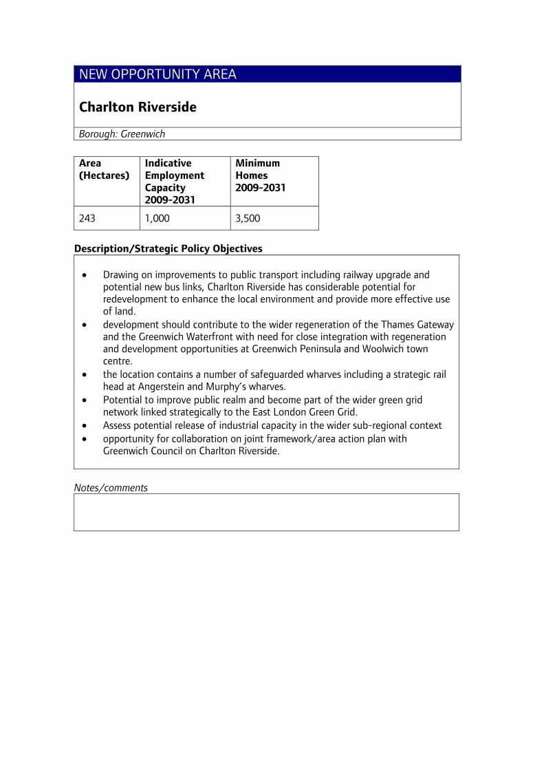
NEW OPPORTUNITY AREA Charlton Riverside Borough: Greenwich
Area (Hectares)
Indicative Employment Capacity 2009-2031
Minimum Homes 2009-2031
243 1,000 3,500
Description/Strategic Policy Objectives • Drawing on improvements to public transport including railway upgrade and
potential new bus links, Charlton Riverside has considerable potential for redevelopment to enhance the local environment and provide more effective use of land.
• development should contribute to the wider regeneration of the Thames Gateway and the Greenwich Waterfront with need for close integration with regeneration and development opportunities at Greenwich Peninsula and Woolwich town centre.
• the location contains a number of safeguarded wharves including a strategic rail head at Angerstein and Murphy’s wharves.
• Potential to improve public realm and become part of the wider green grid network linked strategically to the East London Green Grid.
• Assess potential release of industrial capacity in the wider sub-regional context • opportunity for collaboration on joint framework/area action plan with
Greenwich Council on Charlton Riverside.
Notes/comments

OPPORTUNITY AREA City Fringe Boroughs: City of London, Hackney, Islington, Tower Hamlets
Area (Hectares)
Indicative Employment Capacity 2009-2031
Minimum Homes 2009-2031
518 40,000 7,000
Description/Strategic Policy Objectives • contains a number of accessible, relatively central sites with significant
development capacity • area includes Bishopsgate/South Shoreditch and Whitechapel/Aldgate. • area provides particular scope to support London’s critical mass of financial and
business services and clusters of other economic activity, such as creative industries.
• as part of the general encouragement of growth towards the east of London minor extensions of the CAZ are proposed to realise development capacity and exploit good public transport accessibility around Old Street station, the East London Line extension and Crossrail 1 around Aldgate and Bishopsgate.
• development process will be managed sensitively through the City Fringe Opportunity Area Planning Framework coordinating action across four boroughs
• Parts of the area may be suitable for tall buildings subject to London Plan design policies and criteria.
• The relationship of development to the Tower of London World Heritage site needs to be carefully considered.
• contains some of London’s most deprived inner city communities as well as affluent new quarters and London’s largest Bangladeshi neighbourhood.
• Interspersed with affordable business premises, some serving the local communities, others meeting the needs of national and international business
• others developed into important commercial and cultural attractions in their own right, such as Spitalfields, Shoreditch and Brick Lane
• A joint SPG for Bishopsgate Goodsyard is being prepared by Tower Hamlets, Hackney and GLA.
Notes/comments
• OAPF boundary used as basis for OA • Opportunity Area Planning Framework Public consultation undertaken in
February 2008. Looking to report a revised document to the Mayor in Summer 2009 for further consultation. This identifies emerging clusters of tall buildings at Aldgate, Old Street roundabout and Bishopsgate Goodsyard
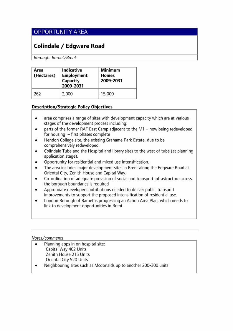
OPPORTUNITY AREA Colindale / Edgware Road Borough: Barnet/Brent
Area (Hectares)
Indicative Employment Capacity 2009-2031
Minimum Homes 2009-2031
262 2,000 15,000
Description/Strategic Policy Objectives
• area comprises a range of sites with development capacity which are at various
stages of the development process including: • parts of the former RAF East Camp adjacent to the M1 – now being redeveloped
for housing – first phases complete • Hendon College site, the existing Grahame Park Estate, due to be
comprehensively redeveloped, • Colindale Tube and the Hospital and library sites to the west of tube (at planning
application stage). • Opportunity for residential and mixed use intensification. • The area includes major development sites in Brent along the Edgware Road at
Oriental City, Zenith House and Capital Way. • Co-ordination of adequate provision of social and transport infrastructure across
the borough boundaries is required • Appropriate developer contributions needed to deliver public transport
improvements to support the proposed intensification of residential use. • London Borough of Barnet is progressing an Action Area Plan, which needs to
link to development opportunities in Brent.
Notes/comments
• Planning apps in on hospital site: Capital Way 462 Units Zenith House 215 Units Oriental City 520 Units
• Neighbouring sites such as Mcdonalds up to another 200-300 units

OPPORTUNITY AREA Cricklewood / Brent Cross Borough: Barnet
Area (Hectares)
Indicative Employment Capacity 2009-2031
Minimum Homes 2009-2031
324 20,000 10,000
Description/Strategic Policy Objectives • Strategic significance for supporting the development of Outer London. • Area combines the former railway land to the north, and the industrial land to the
east of Cricklewood Station, together with Brent Cross regional shopping centre across the A406 North Circular Road and its wider hinterland.
• A specific chapter in the Barnet UDP forms the Opportunity Area Framework which seeks the redevelopment of Brent Cross as a town centre complementing the roles of other centres nearby - an extended mix of town centre activities including housing.
• Site identified for major waste facility to form a key role in North London Waste Strategy.
• Existing planning framework makes provision for at least 5,000 additional homes together with local ancillary services and a rail station on the Cricklewood site.
• New development should be phased with improved public transport and accessibility
• Restoration of river Brent • Future use of the railway lands to be confirmed
Notes/comments Implementation update: Planning application has been submitted in November 2008 and will go to Barnet committee in April 2009
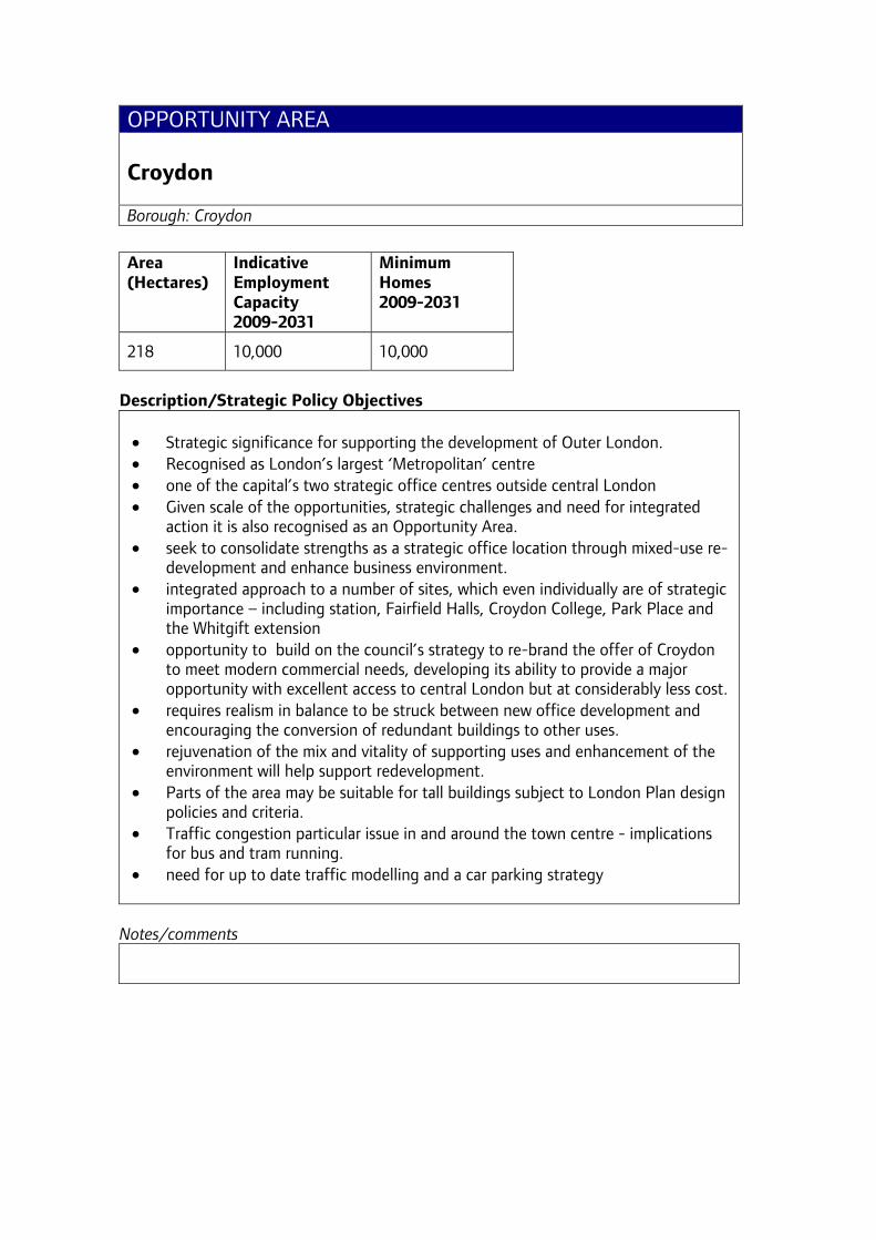
OPPORTUNITY AREA Croydon Borough: Croydon
Area (Hectares)
Indicative Employment Capacity 2009-2031
Minimum Homes 2009-2031
218 10,000 10,000
Description/Strategic Policy Objectives • Strategic significance for supporting the development of Outer London. • Recognised as London’s largest ‘Metropolitan’ centre • one of the capital’s two strategic office centres outside central London • Given scale of the opportunities, strategic challenges and need for integrated
action it is also recognised as an Opportunity Area. • seek to consolidate strengths as a strategic office location through mixed-use re-
development and enhance business environment. • integrated approach to a number of sites, which even individually are of strategic
importance – including station, Fairfield Halls, Croydon College, Park Place and the Whitgift extension
• opportunity to build on the council’s strategy to re-brand the offer of Croydon to meet modern commercial needs, developing its ability to provide a major opportunity with excellent access to central London but at considerably less cost.
• requires realism in balance to be struck between new office development and encouraging the conversion of redundant buildings to other uses.
• rejuvenation of the mix and vitality of supporting uses and enhancement of the environment will help support redevelopment.
• Parts of the area may be suitable for tall buildings subject to London Plan design policies and criteria.
• Traffic congestion particular issue in and around the town centre - implications for bus and tram running.
• need for up to date traffic modelling and a car parking strategy
Notes/comments

OPPORTUNITY AREA Deptford Creek / Greenwich Riverside Boroughs: Greenwich, Lewisham
Area (Hectares)
Indicative Employment Capacity 2009-2031
Minimum Homes 2009-2031
189 4,000 5,000
Description/Strategic Policy Objectives • waterside and heritage character with new creative activities • considerable regeneration potential • regeneration would benefit major concentrations of deprived communities across
the two boroughs. • large-scale regeneration opportunities, including parts of Convoys Wharf, as well
as harnessing potential for a cultural quarter, for smaller scale leisure and tourism-related provision, affordable workspaces and additional housing.
• recent public transport improvements including new railway station for Deptford in development
• Road congestion, for example on the A2 and A200, is a particular issue in this area
• Improvements to the public realm in the area has already been initiated however the public realm requires further investment and improvement. Key areas include junction of A2 and Deptford Church Street and East-West connections across Deptford Creek,
• The Waterlink Way project is a key green grid initiative and will help improve the natural environment of the creek and access
• Deptford Creek is one of the primary assets of the area. As such development should frame the Creek, improve its character and allow for views of water space.
• Regeneration should be sensitive to the rich industrial heritage of the area. • LB Greenwich and LB Lewisham have agreed to produce a joint planning
framework for Creekside.
Notes/comments Implementation update: A report documenting the Deptford Creekside Charrette, which took place in June 08, outlines a vision for the area and should help assist the process.
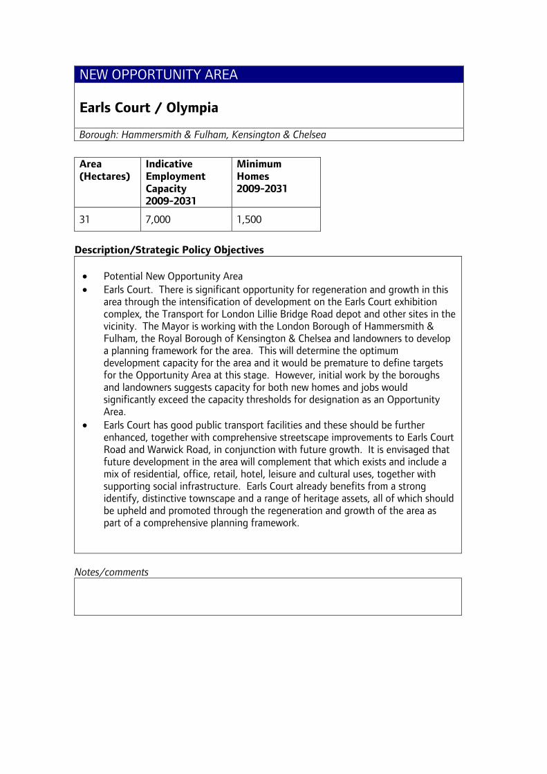
NEW OPPORTUNITY AREA Earls Court / Olympia Borough: Hammersmith & Fulham, Kensington & Chelsea
Area (Hectares)
Indicative Employment Capacity 2009-2031
Minimum Homes 2009-2031
31 7,000 1,500
Description/Strategic Policy Objectives • Potential New Opportunity Area • Earls Court. There is significant opportunity for regeneration and growth in this
area through the intensification of development on the Earls Court exhibition complex, the Transport for London Lillie Bridge Road depot and other sites in the vicinity. The Mayor is working with the London Borough of Hammersmith & Fulham, the Royal Borough of Kensington & Chelsea and landowners to develop a planning framework for the area. This will determine the optimum development capacity for the area and it would be premature to define targets for the Opportunity Area at this stage. However, initial work by the boroughs and landowners suggests capacity for both new homes and jobs would significantly exceed the capacity thresholds for designation as an Opportunity Area.
• Earls Court has good public transport facilities and these should be further enhanced, together with comprehensive streetscape improvements to Earls Court Road and Warwick Road, in conjunction with future growth. It is envisaged that future development in the area will complement that which exists and include a mix of residential, office, retail, hotel, leisure and cultural uses, together with supporting social infrastructure. Earls Court already benefits from a strong identify, distinctive townscape and a range of heritage assets, all of which should be upheld and promoted through the regeneration and growth of the area as part of a comprehensive planning framework.
Notes/comments
OPPORTUNITY AREA Elephant & Castle Borough: Southwark
Area (Hectares)
Indicative Employment Capacity 2009-2031
Minimum Homes 2009-2031
88 5,000 7,000
Description/Strategic Policy Objectives • Planning framework prepared for the area around the Elephant and Castle. • Good public transport accessibility, relatively affordable land and potential for
closer integration with Central Activities Zone. • Framework promotes area as a suitable location to meet some of central
London’s longer-term needs for extra office space. • Framework promotes a series of connected public open spaces. • Seeks a significant increase in housing and retail provision and its integration
with a more efficient transport interchange. • Environmental and traffic management improvements and resolution of rail
related issues are crucial to the successful redevelopment of this southern gateway to central London
• Parts of the area may be suitable for tall buildings subject to London Plan design policies and criteria.
• The redevelopments coming forward are all designed to link up to an area-wide heat and power system
Notes/comments Implementation update: There are now a number consented major redevelopment schemes in the area and some are under construction including the 42 storey ‘Strata’ redevelopment

OPPORTUNITY AREA Euston Borough: Camden
Area (Hectares)
Indicative Employment Capacity 2009-2031
Minimum Homes 2009-2031
16 7,000 1,000
Description/Strategic Policy Objectives • major national and commuter rail terminal with good links to the rest of CAZ. • station airspace and adjacent areas are underused and have considerable
potential for intensification given location and accessibility • scope to re-configure Euston Square Gardens and the bus station to improve this
space and the transport interchange and also to develop the relationship with the adjacent university quarter. There are proposals to re-instate Euston Arch.
• LB Camden have produced a planning brief. • Steering group set up by Transport for London and includes discussions with
Network Rail
Notes/comments
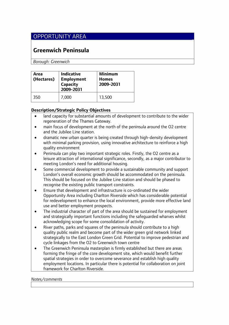
OPPORTUNITY AREA Greenwich Peninsula Borough: Greenwich
Area (Hectares)
Indicative Employment Capacity 2009-2031
Minimum Homes 2009-2031
350 7,000 13,500
Description/Strategic Policy Objectives
• land capacity for substantial amounts of development to contribute to the wider regeneration of the Thames Gateway.
• main focus of development at the north of the peninsula around the O2 centre and the Jubilee Line station.
• dramatic new urban quarter is being created through high-density development with minimal parking provision, using innovative architecture to reinforce a high quality environment
• Peninsula can play two important strategic roles. Firstly, the O2 centre as a leisure attraction of international significance, secondly, as a major contributor to meeting London’s need for additional housing.
• Some commercial development to provide a sustainable community and support London’s overall economic growth should be accommodated on the peninsula. This should be focused on the Jubilee Line station and should be phased to recognise the existing public transport constraints.
• Ensure that development and infrastructure is co-ordinated the wider Opportunity Area including Charlton Riverside which has considerable potential for redevelopment to enhance the local environment, provide more effective land use and better employment prospects.
• The industrial character of part of the area should be sustained for employment and strategically important functions including the safeguarded wharves whilst acknowledging scope for some consolidation of activity.
• River paths, parks and squares of the peninsula should contribute to a high quality public realm and become part of the wider green grid network linked strategically to the East London Green Grid. Potential to improve pedestrian and cycle linkages from the O2 to Greenwich town centre
• The Greenwich Peninsula masterplan is firmly established but there are areas forming the fringe of the core development site, which would benefit further spatial strategies in order to overcome severance and establish high quality employment locations. In particular there is potential for collaboration on joint framework for Charlton Riverside.
Notes/comments
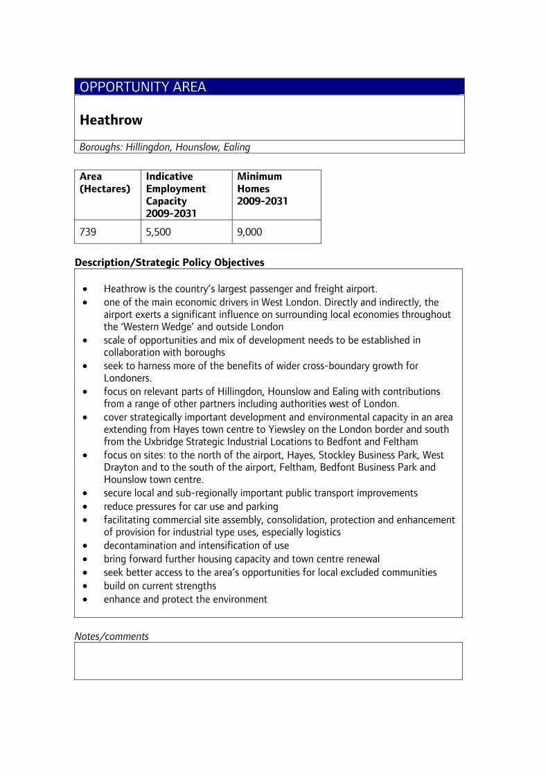
OPPORTUNITY AREA Heathrow Boroughs: Hillingdon, Hounslow, Ealing
Area (Hectares)
Indicative Employment Capacity 2009-2031
Minimum Homes 2009-2031
739 5,500 9,000
Description/Strategic Policy Objectives • Heathrow is the country’s largest passenger and freight airport. • one of the main economic drivers in West London. Directly and indirectly, the
airport exerts a significant influence on surrounding local economies throughout the ‘Western Wedge’ and outside London
• scale of opportunities and mix of development needs to be established in collaboration with boroughs
• seek to harness more of the benefits of wider cross-boundary growth for Londoners.
• focus on relevant parts of Hillingdon, Hounslow and Ealing with contributions from a range of other partners including authorities west of London.
• cover strategically important development and environmental capacity in an area extending from Hayes town centre to Yiewsley on the London border and south from the Uxbridge Strategic Industrial Locations to Bedfont and Feltham
• focus on sites: to the north of the airport, Hayes, Stockley Business Park, West Drayton and to the south of the airport, Feltham, Bedfont Business Park and Hounslow town centre.
• secure local and sub-regionally important public transport improvements • reduce pressures for car use and parking • facilitating commercial site assembly, consolidation, protection and enhancement
of provision for industrial type uses, especially logistics • decontamination and intensification of use • bring forward further housing capacity and town centre renewal • seek better access to the area’s opportunities for local excluded communities • build on current strengths • enhance and protect the environment
Notes/comments
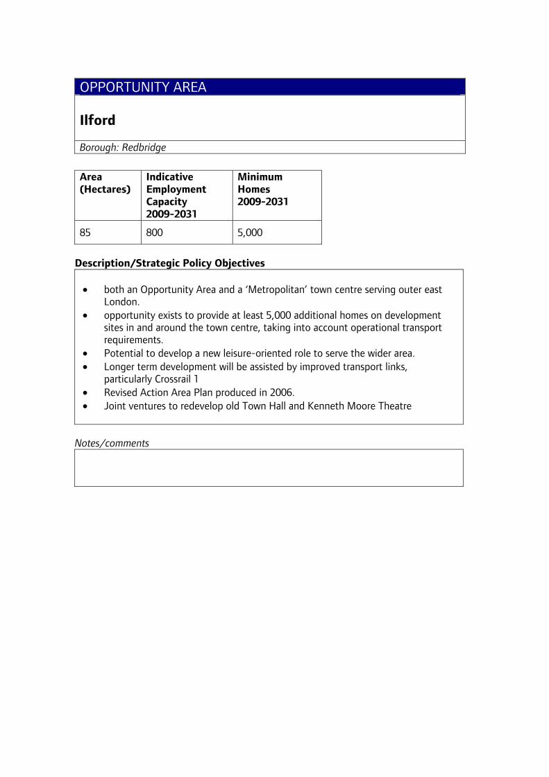
OPPORTUNITY AREA Ilford Borough: Redbridge
Area (Hectares)
Indicative Employment Capacity 2009-2031
Minimum Homes 2009-2031
85 800 5,000
Description/Strategic Policy Objectives • both an Opportunity Area and a ‘Metropolitan’ town centre serving outer east
London. • opportunity exists to provide at least 5,000 additional homes on development
sites in and around the town centre, taking into account operational transport requirements.
• Potential to develop a new leisure-oriented role to serve the wider area. • Longer term development will be assisted by improved transport links,
particularly Crossrail 1 • Revised Action Area Plan produced in 2006. • Joint ventures to redevelop old Town Hall and Kenneth Moore Theatre
Notes/comments
OPPORTUNITY AREA Isle of Dogs Borough: Tower Hamlets
Area (Hectares)
Indicative Employment Capacity 2009-2031
Minimum Homes 2009-2031
518 110,000 10,000
Description/Strategic Policy Objectives • Canary Wharf prime focus for banking headquarters, as well as for media,
financial and business services - many of the future activities on the Isle of Dogs are interdependent with central London.
• Development densities and mixed use policy should reflect this and the planning framework should consolidate and expand this role.
• Proposed transport investment including Crossrail will allow it to accommodate an additional 110,000 jobs by 2031 focused on the area with particularly good and improving public transport accessibility and capacity in and around Canary Wharf.
• Requires both partnership working to bring forward adequate land and a significant enhancement to transport capacity.
• Development should complement the international offer of the CAZ and support a globally competitive business cluster.
• Parts of the area may be suitable for tall buildings subject to London Plan design policies and criteria.
• Planning framework should also make provision for at least 10,000 additional dwellings. NB Potential conversion of surplus business capacity south of Canary Wharf to housing plus support a wider mix of services for residents, workers and nearby communities. Complemented by a wider range of civic, leisure and other town centre facilities, the new retail provision in Canary Wharf has the potential to develop and serve a wider catchment area.
• Current retail provision in Crossharbour District centre has potential for less car dependent, more sustainable development providing a wider range of uses.
Notes/comments
• Tower Hamlets has restored their LDF Core Strategy that includes a detailed framework for development on the Isle of Dogs.
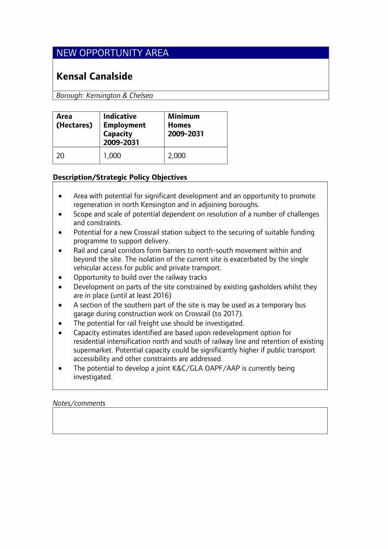
NEW OPPORTUNITY AREA Kensal Canalside Borough: Kensington & Chelsea
Area (Hectares)
Indicative Employment Capacity 2009-2031
Minimum Homes 2009-2031
20 1,000 2,000
Description/Strategic Policy Objectives • Area with potential for significant development and an opportunity to promote
regeneration in north Kensington and in adjoining boroughs. • Scope and scale of potential dependent on resolution of a number of challenges
and constraints. • Potential for a new Crossrail station subject to the securing of suitable funding
programme to support delivery. • Rail and canal corridors form barriers to north-south movement within and
beyond the site. The isolation of the current site is exacerbated by the single vehicular access for public and private transport.
• Opportunity to build over the railway tracks • Development on parts of the site constrained by existing gasholders whilst they
are in place (until at least 2016) • A section of the southern part of the site is may be used as a temporary bus
garage during construction work on Crossrail (to 2017). • The potential for rail freight use should be investigated. • Capacity estimates identified are based upon redevelopment option for
residential intensification north and south of railway line and retention of existing supermarket. Potential capacity could be significantly higher if public transport accessibility and other constraints are addressed.
• The potential to develop a joint K&C/GLA OAPF/AAP is currently being investigated.
Notes/comments
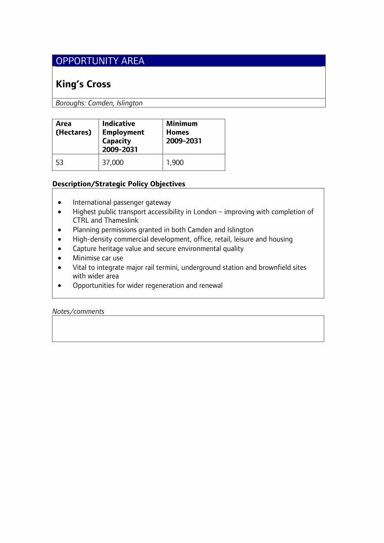
OPPORTUNITY AREA King’s Cross Boroughs: Camden, Islington
Area (Hectares)
Indicative Employment Capacity 2009-2031
Minimum Homes 2009-2031
53 37,000 1,900
Description/Strategic Policy Objectives • International passenger gateway • Highest public transport accessibility in London – improving with completion of
CTRL and Thameslink • Planning permissions granted in both Camden and Islington • High-density commercial development, office, retail, leisure and housing • Capture heritage value and secure environmental quality • Minimise car use • Vital to integrate major rail termini, underground station and brownfield sites
with wider area • Opportunities for wider regeneration and renewal
Notes/comments
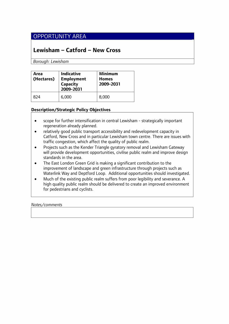
OPPORTUNITY AREA Lewisham – Catford – New Cross Borough: Lewisham
Area (Hectares)
Indicative Employment Capacity 2009-2031
Minimum Homes 2009-2031
824 6,000 8,000
Description/Strategic Policy Objectives • scope for further intensification in central Lewisham - strategically important
regeneration already planned. • relatively good public transport accessibility and redevelopment capacity in
Catford, New Cross and in particular Lewisham town centre. There are issues with traffic congestion, which affect the quality of public realm.
• Projects such as the Kender Triangle gyratory removal and Lewisham Gateway will provide development opportunities, civilise public realm and improve design standards in the area.
• The East London Green Grid is making a significant contribution to the improvement of landscape and green infrastructure through projects such as Waterlink Way and Deptford Loop. Additional opportunities should investigated.
• Much of the existing public realm suffers from poor legibility and severance. A high quality public realm should be delivered to create an improved environment for pedestrians and cyclists.
Notes/comments
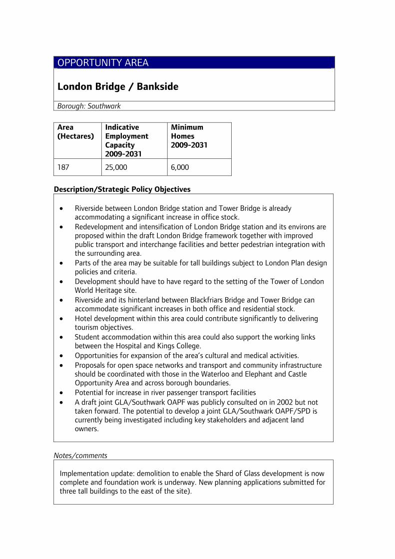
OPPORTUNITY AREA London Bridge / Bankside Borough: Southwark
Area (Hectares)
Indicative Employment Capacity 2009-2031
Minimum Homes 2009-2031
187 25,000 6,000
Description/Strategic Policy Objectives • Riverside between London Bridge station and Tower Bridge is already
accommodating a significant increase in office stock. • Redevelopment and intensification of London Bridge station and its environs are
proposed within the draft London Bridge framework together with improved public transport and interchange facilities and better pedestrian integration with the surrounding area.
• Parts of the area may be suitable for tall buildings subject to London Plan design policies and criteria.
• Development should have to have regard to the setting of the Tower of London World Heritage site.
• Riverside and its hinterland between Blackfriars Bridge and Tower Bridge can accommodate significant increases in both office and residential stock.
• Hotel development within this area could contribute significantly to delivering tourism objectives.
• Student accommodation within this area could also support the working links between the Hospital and Kings College.
• Opportunities for expansion of the area’s cultural and medical activities. • Proposals for open space networks and transport and community infrastructure
should be coordinated with those in the Waterloo and Elephant and Castle Opportunity Area and across borough boundaries.
• Potential for increase in river passenger transport facilities • A draft joint GLA/Southwark OAPF was publicly consulted on in 2002 but not
taken forward. The potential to develop a joint GLA/Southwark OAPF/SPD is currently being investigated including key stakeholders and adjacent land owners.
Notes/comments Implementation update: demolition to enable the Shard of Glass development is now complete and foundation work is underway. New planning applications submitted for three tall buildings to the east of the site).
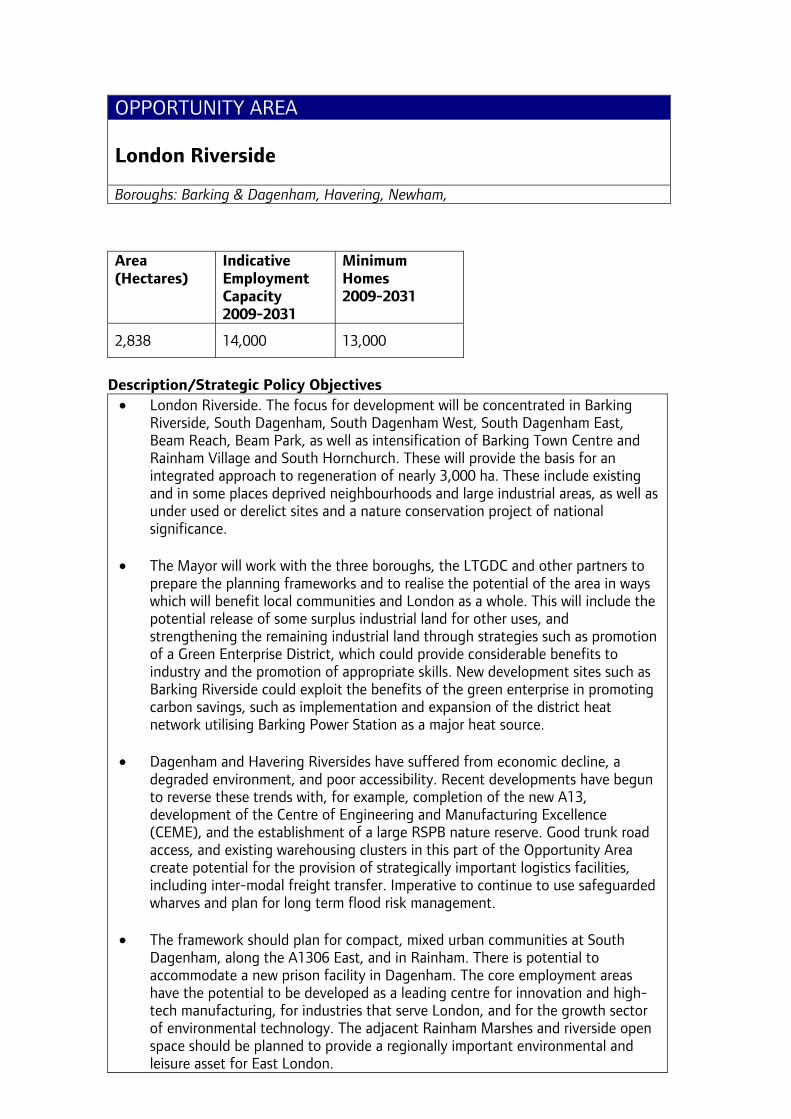
OPPORTUNITY AREA London Riverside Boroughs: Barking & Dagenham, Havering, Newham,
Area (Hectares)
Indicative Employment Capacity 2009-2031
Minimum Homes 2009-2031
2,838 14,000 13,000
Description/Strategic Policy Objectives
• London Riverside. The focus for development will be concentrated in Barking Riverside, South Dagenham, South Dagenham West, South Dagenham East, Beam Reach, Beam Park, as well as intensification of Barking Town Centre and Rainham Village and South Hornchurch. These will provide the basis for an integrated approach to regeneration of nearly 3,000 ha. These include existing and in some places deprived neighbourhoods and large industrial areas, as well as under used or derelict sites and a nature conservation project of national significance.
• The Mayor will work with the three boroughs, the LTGDC and other partners to
prepare the planning frameworks and to realise the potential of the area in ways which will benefit local communities and London as a whole. This will include the potential release of some surplus industrial land for other uses, and strengthening the remaining industrial land through strategies such as promotion of a Green Enterprise District, which could provide considerable benefits to industry and the promotion of appropriate skills. New development sites such as Barking Riverside could exploit the benefits of the green enterprise in promoting carbon savings, such as implementation and expansion of the district heat network utilising Barking Power Station as a major heat source.
• Dagenham and Havering Riversides have suffered from economic decline, a
degraded environment, and poor accessibility. Recent developments have begun to reverse these trends with, for example, completion of the new A13, development of the Centre of Engineering and Manufacturing Excellence (CEME), and the establishment of a large RSPB nature reserve. Good trunk road access, and existing warehousing clusters in this part of the Opportunity Area create potential for the provision of strategically important logistics facilities, including inter-modal freight transfer. Imperative to continue to use safeguarded wharves and plan for long term flood risk management.
• The framework should plan for compact, mixed urban communities at South
Dagenham, along the A1306 East, and in Rainham. There is potential to accommodate a new prison facility in Dagenham. The core employment areas have the potential to be developed as a leading centre for innovation and high-tech manufacturing, for industries that serve London, and for the growth sector of environmental technology. The adjacent Rainham Marshes and riverside open space should be planned to provide a regionally important environmental and leisure asset for East London.
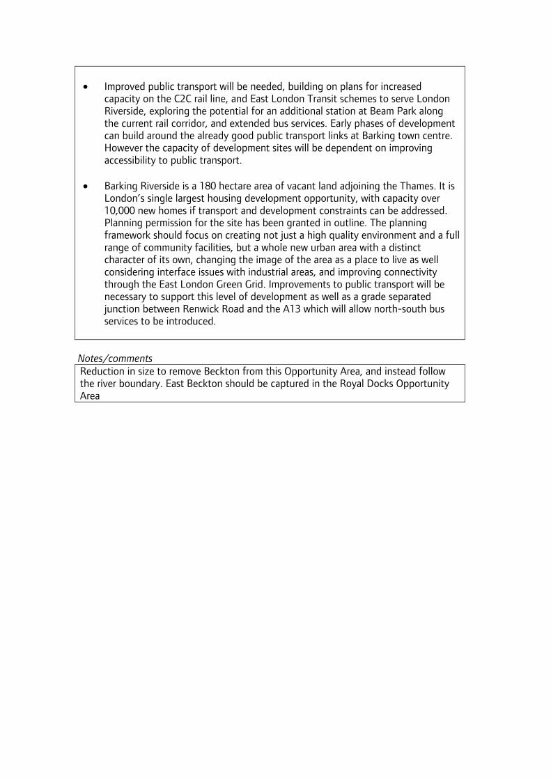
• Improved public transport will be needed, building on plans for increased
capacity on the C2C rail line, and East London Transit schemes to serve London Riverside, exploring the potential for an additional station at Beam Park along the current rail corridor, and extended bus services. Early phases of development can build around the already good public transport links at Barking town centre. However the capacity of development sites will be dependent on improving accessibility to public transport.
• Barking Riverside is a 180 hectare area of vacant land adjoining the Thames. It is
London’s single largest housing development opportunity, with capacity over 10,000 new homes if transport and development constraints can be addressed. Planning permission for the site has been granted in outline. The planning framework should focus on creating not just a high quality environment and a full range of community facilities, but a whole new urban area with a distinct character of its own, changing the image of the area as a place to live as well considering interface issues with industrial areas, and improving connectivity through the East London Green Grid. Improvements to public transport will be necessary to support this level of development as well as a grade separated junction between Renwick Road and the A13 which will allow north-south bus services to be introduced.
Notes/comments Reduction in size to remove Beckton from this Opportunity Area, and instead follow the river boundary. East Beckton should be captured in the Royal Docks Opportunity Area
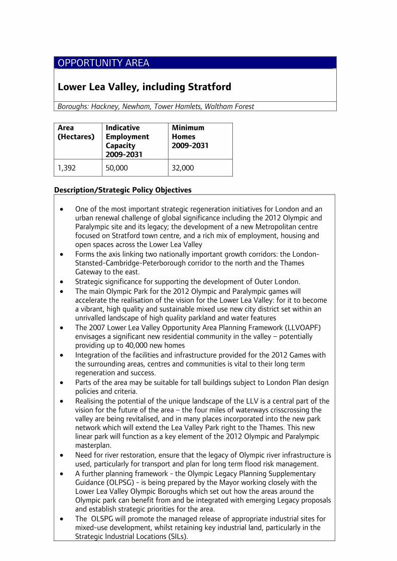
OPPORTUNITY AREA Lower Lea Valley, including Stratford Boroughs: Hackney, Newham, Tower Hamlets, Waltham Forest
Area (Hectares)
Indicative Employment Capacity 2009-2031
Minimum Homes 2009-2031
1,392 50,000 32,000
Description/Strategic Policy Objectives • One of the most important strategic regeneration initiatives for London and an
urban renewal challenge of global significance including the 2012 Olympic and Paralympic site and its legacy; the development of a new Metropolitan centre focused on Stratford town centre, and a rich mix of employment, housing and open spaces across the Lower Lea Valley
• Forms the axis linking two nationally important growth corridors: the London-Stansted-Cambridge-Peterborough corridor to the north and the Thames Gateway to the east.
• Strategic significance for supporting the development of Outer London. • The main Olympic Park for the 2012 Olympic and Paralympic games will
accelerate the realisation of the vision for the Lower Lea Valley: for it to become a vibrant, high quality and sustainable mixed use new city district set within an unrivalled landscape of high quality parkland and water features
• The 2007 Lower Lea Valley Opportunity Area Planning Framework (LLVOAPF) envisages a significant new residential community in the valley – potentially providing up to 40,000 new homes
• Integration of the facilities and infrastructure provided for the 2012 Games with the surrounding areas, centres and communities is vital to their long term regeneration and success.
• Parts of the area may be suitable for tall buildings subject to London Plan design policies and criteria.
• Realising the potential of the unique landscape of the LLV is a central part of the vision for the future of the area – the four miles of waterways crisscrossing the valley are being revitalised, and in many places incorporated into the new park network which will extend the Lea Valley Park right to the Thames. This new linear park will function as a key element of the 2012 Olympic and Paralympic masterplan.
• Need for river restoration, ensure that the legacy of Olympic river infrastructure is used, particularly for transport and plan for long term flood risk management.
• A further planning framework - the Olympic Legacy Planning Supplementary Guidance (OLPSG) - is being prepared by the Mayor working closely with the Lower Lea Valley Olympic Boroughs which set out how the areas around the Olympic park can benefit from and be integrated with emerging Legacy proposals and establish strategic priorities for the area.
• The OLSPG will promote the managed release of appropriate industrial sites for mixed-use development, whilst retaining key industrial land, particularly in the Strategic Industrial Locations (SILs).

• The 2007 LLV OAPF identified the potential for up to 50,000 new jobs to be generated; including over 30,000 predominantly office based jobs at Stratford City. This is in addition to the 7,000 temporary jobs that are expected from construction of the 2012 Olympic and Paralympic Games facilities.
Notes/comments Thameside West moved to the Royals OA; retain Canning Town in LLV. Note: The OLPSG is a sub set of the LLV OAPF area
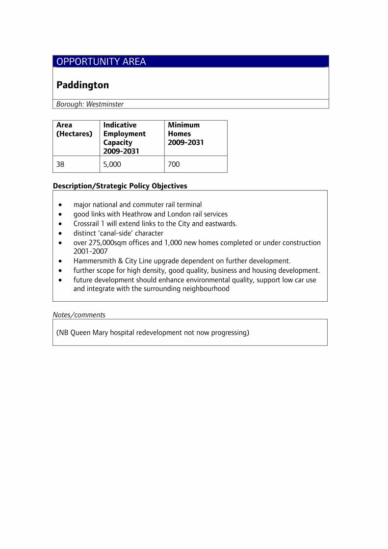
OPPORTUNITY AREA Paddington Borough: Westminster
Area (Hectares)
Indicative Employment Capacity 2009-2031
Minimum Homes 2009-2031
38 5,000 700
Description/Strategic Policy Objectives • major national and commuter rail terminal • good links with Heathrow and London rail services • Crossrail 1 will extend links to the City and eastwards. • distinct ‘canal-side’ character • over 275,000sqm offices and 1,000 new homes completed or under construction
2001-2007 • Hammersmith & City Line upgrade dependent on further development. • further scope for high density, good quality, business and housing development. • future development should enhance environmental quality, support low car use
and integrate with the surrounding neighbourhood
Notes/comments (NB Queen Mary hospital redevelopment not now progressing)
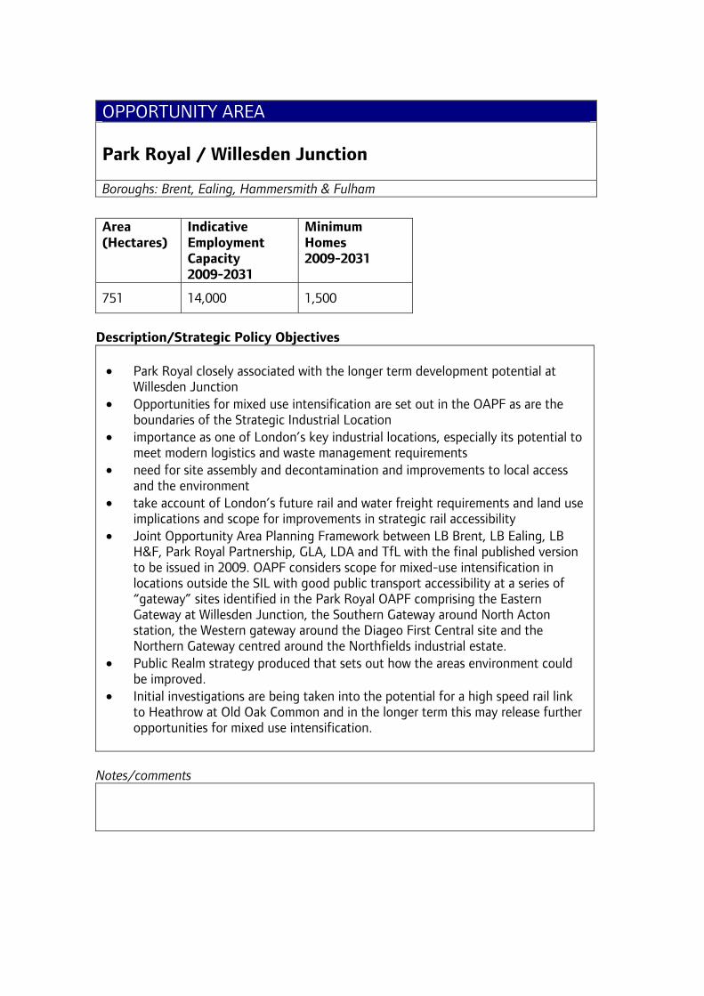
OPPORTUNITY AREA Park Royal / Willesden Junction Boroughs: Brent, Ealing, Hammersmith & Fulham
Area (Hectares)
Indicative Employment Capacity 2009-2031
Minimum Homes 2009-2031
751 14,000 1,500
Description/Strategic Policy Objectives • Park Royal closely associated with the longer term development potential at
Willesden Junction • Opportunities for mixed use intensification are set out in the OAPF as are the
boundaries of the Strategic Industrial Location • importance as one of London’s key industrial locations, especially its potential to
meet modern logistics and waste management requirements • need for site assembly and decontamination and improvements to local access
and the environment • take account of London’s future rail and water freight requirements and land use
implications and scope for improvements in strategic rail accessibility • Joint Opportunity Area Planning Framework between LB Brent, LB Ealing, LB
H&F, Park Royal Partnership, GLA, LDA and TfL with the final published version to be issued in 2009. OAPF considers scope for mixed-use intensification in locations outside the SIL with good public transport accessibility at a series of “gateway” sites identified in the Park Royal OAPF comprising the Eastern Gateway at Willesden Junction, the Southern Gateway around North Acton station, the Western gateway around the Diageo First Central site and the Northern Gateway centred around the Northfields industrial estate.
• Public Realm strategy produced that sets out how the areas environment could be improved.
• Initial investigations are being taken into the potential for a high speed rail link to Heathrow at Old Oak Common and in the longer term this may release further opportunities for mixed use intensification.
Notes/comments
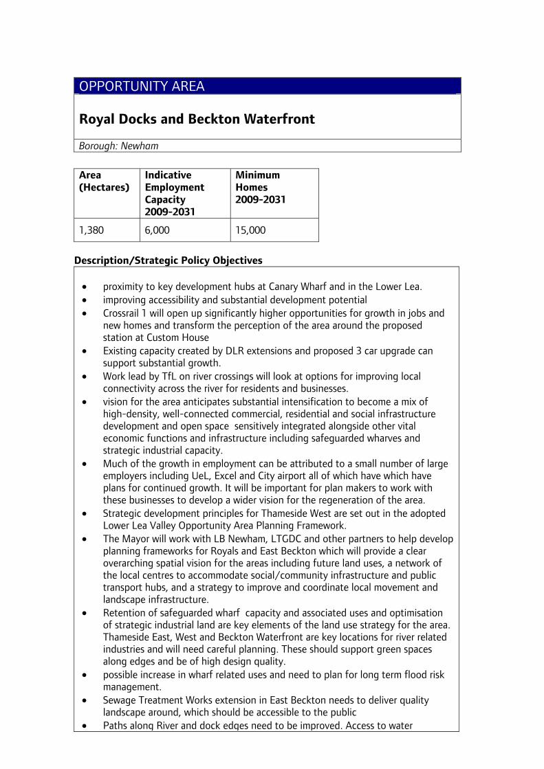
OPPORTUNITY AREA Royal Docks and Beckton Waterfront Borough: Newham
Area (Hectares)
Indicative Employment Capacity 2009-2031
Minimum Homes 2009-2031
1,380 6,000 15,000
Description/Strategic Policy Objectives • proximity to key development hubs at Canary Wharf and in the Lower Lea. • improving accessibility and substantial development potential • Crossrail 1 will open up significantly higher opportunities for growth in jobs and
new homes and transform the perception of the area around the proposed station at Custom House
• Existing capacity created by DLR extensions and proposed 3 car upgrade can support substantial growth.
• Work lead by TfL on river crossings will look at options for improving local connectivity across the river for residents and businesses.
• vision for the area anticipates substantial intensification to become a mix of high-density, well-connected commercial, residential and social infrastructure development and open space sensitively integrated alongside other vital economic functions and infrastructure including safeguarded wharves and strategic industrial capacity.
• Much of the growth in employment can be attributed to a small number of large employers including UeL, Excel and City airport all of which have which have plans for continued growth. It will be important for plan makers to work with these businesses to develop a wider vision for the regeneration of the area.
• Strategic development principles for Thameside West are set out in the adopted Lower Lea Valley Opportunity Area Planning Framework.
• The Mayor will work with LB Newham, LTGDC and other partners to help develop planning frameworks for Royals and East Beckton which will provide a clear overarching spatial vision for the areas including future land uses, a network of the local centres to accommodate social/community infrastructure and public transport hubs, and a strategy to improve and coordinate local movement and landscape infrastructure.
• Retention of safeguarded wharf capacity and associated uses and optimisation of strategic industrial land are key elements of the land use strategy for the area. Thameside East, West and Beckton Waterfront are key locations for river related industries and will need careful planning. These should support green spaces along edges and be of high design quality.
• possible increase in wharf related uses and need to plan for long term flood risk management.
• Sewage Treatment Works extension in East Beckton needs to deliver quality landscape around, which should be accessible to the public
• Paths along River and dock edges need to be improved. Access to water
including recreational uses in the docks should be promoted • Beckton park landscape and Cross River Park along Barking Creek are key green
grid projects and important assets of the area and need to be strengthened. Vital links need to be established
• Connections to strategic green grid projects including Lower Lea Valley Park, Greenway and River Roding corridor need to be enhanced
• London City Airport continues to provide important access to international markets
• Better pedestrian/ cycle links should be developed to maximise access to strategic transport infrastructure and improve local access
• The new planning frameworks will address perceived fragmentation of the area which is reinforced by existing road and rail severances - act as barriers to local movement, creating a hostile environment, weakening effective links between new and existing communities and compromising development aspirations
• Key issues to be addressed include maximising the benefits of Crossrail, future growth of London City Airport, capitalising on the success of ExCel and its potential as a focus for further visitor/business related growth
Notes/comments
Boundary revised to include east Beckton and Thameside West
NEW OPPORTUNITY AREA Southall Boroughs: Ealing, Hillingdon
Area (Hectares)
Indicative Employment Capacity 2009-2031
Minimum Homes 2009-2031
46 2,000 4,000
Description/Strategic Policy Objectives • significant potential to bring forward further housing capacity and mixed use
development and to contribute to town centre renewal • seek better access to the area’s opportunities for local excluded communities • build on current strengths, such as Southall’s ethnic identity and links with the
Indian sub-continent • secure genuine linkages with existing Southall town centre and support its
regeneration and ensure integration with the wider area including with Hillingdon to the west
• significant potential to enhance and protect the environment
Notes/comments new Opportunity Area in Ealing and subject to agreement with Hillingdon

OPPORTUNITY AREA Thamesmead and Abbey Wood Borough: Greenwich, Bexley
Area (Hectares)
Indicative Employment Capacity 2009-2031
Minimum Homes 2009-2031
972 4,000 3,000
Description/Strategic Policy Objectives
• large potential development area with opportunity to secure strategic and local regeneration objectives
• maximise benefits from the new Crossrail station at Abbey Wood in terms of development opportunities, new bus routes, improved interchange and local links.
• work lead by TfL on river crossings will look at options for improving local connectivity across the river for residents and businesses.
• attractive riverside setting lies to the west of Thamesmead centre at Tripcock Point but requires public transport access
• strategic housing opportunity - new community and recreation facilities together with improved open space and Metropolitan Open Land.
• Residential environment and capacity of Thamesmead should also be enhanced through estate renewal.
• scope to improve and expand employment capacity in the White Hart Triangle and other industrial sites, including waste management and logistics provision.
• Build on spatial frameworks including the joint Greenwich and Bexley Supplementary Planning Document for Thamesmead and Abbey Wood
• continue support for the boroughs and partners in achieving their vision and developing these spatial strategies.
• Potential to improve links with the East London Green Chain and communities to the south, especially those which experience deprivation, and to coordinate increases in local development capacity and the need for environmental improvements
• enhance access to the riverside and adjacent spaces in Tripcock Park part of the wider Cross River Park concept
• plan for long term flood risk management • Promote better use of landscape assets such as the Ridgeway
Notes/comments

OPPORTUNITY AREA Tottenham Court Road Boroughs: Camden, Westminster
Area (Hectares)
Indicative Employment Capacity 2009-2031
Minimum Homes 2009-2031
19 5,000 1,000
Description/Strategic Policy Objectives
• substantially enhanced public transport accessibility associated with Crossrail 1 • potential to enhance the attractions of the Tottenham Court Road/ Eastern
Oxford Street Area • significant development potential • recognise strategic role as well as more local concerns • potential for integrated renewal across borough boundaries • key component of the wider West End Special Retail Policy Area • significant opportunities to improve the public realm of the area and provide for
better connection between Covent Garden, Oxford Street and Bloomsbury • urban design framework produced
Notes/comments
OPPORTUNITY AREA Upper Lea Valley (including Tottenham Hale) Boroughs: Enfield, Haringey, Waltham Forest
Area (Hectares)
Indicative Employment Capacity 2009-2031
Minimum Homes 2009-2031
3,884 15,000 12,000
Description/Strategic Policy Objectives • six-mile corridor extending north from the Lea Bridge Road through Tottenham
Hale to the M25, focused around a regional park. • comprises one of the largest clusters of manufacturing and technology-led
industry in London (with leisure/sports-based activities at Picketts Lock). • linked to the Lower Lea Valley Opportunity Area. • mixed-use development, especially intensification at tube and rail stations • need to retain sufficient industrial land for continuing industrial purposes at
Brimsdown, Freezywater/Innova Park and parts of Central Leaside including waste management and strategic logistics functions away from key public transport hubs.
• location, construction and design of new development and infrastructure should avoid significant and cumulative impacts on European biodiversity sites
• several development sites within the area - main requirement is for high quality renewal, including modernising estates and improving transport.
• Innova Park - proposed extension to SIL in northern part of Innova Park with greater flexibility of uses in the southern part including residential, educational and other commercial uses such as hotels - providing vital support infrastructure to the business community (check).
• Lee Valley Regional Park Authority and water utilities should collaborate with relevant boroughs in relating industrial and housing renewal to the environmental assets of the Lee Valley Park and the green belt.
• Opening of the reservoirs to the public would enhance connections east to west across the valley and increase use of the Regional Park.
• Plan for long term flood risk management and active use of water spaces • London’s largest waste facility is located at Edmonton Eco Park and the potential
of this facility to become a hub for the development of Green industries and to provide heat and power to neighbouring developments
• Parts of the area have good public transport accessibility with mainline rail/underground services. Four tracking of the London Stansted line would be an essential element to unlock development capacity, particularly at Central Leeside.
• Tottenham Hale - local road network requires reorganisation to enable more efficient use of the land. Improvements to capacity of underground station, new bus infrastructure and services needed to deliver higher density, mixed-use development. It is proposed to undertake a strategic transport capacity study as part of the OA framework to investigate how this can be achieved.
• Tottenham Hale would be revitalised through higher density development,
particularly close to the station. Strong pedestrian connection needed across sites and better links over the railway and canals between the station and the regional park.
• Parts of the area around the growth points at Tottenham Hale, Blackhorse Lane, Central Leeside and Ponders End are considered suitable for higher density development.
• a draft OAPF being produced by the GLA, LDA and 3 boroughs and NLSA in partnership to guide its significant redevelopment opportunities.
Notes/comments Implementation update: a draft OAPF being produced by the GLA, LDA and 3 boroughs and NLSA in partnership for discussion June to December 2009
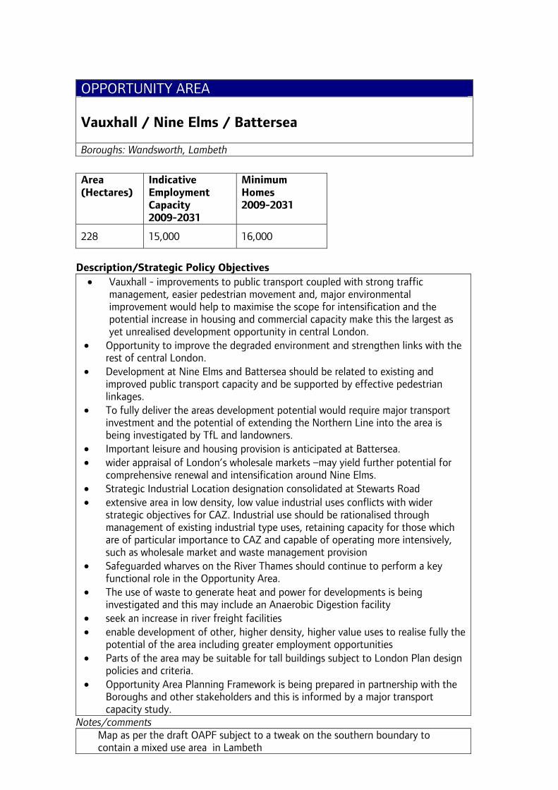
OPPORTUNITY AREA Vauxhall / Nine Elms / Battersea Boroughs: Wandsworth, Lambeth
Area (Hectares)
Indicative Employment Capacity 2009-2031
Minimum Homes 2009-2031
228 15,000 16,000
Description/Strategic Policy Objectives
• Vauxhall - improvements to public transport coupled with strong traffic management, easier pedestrian movement and, major environmental improvement would help to maximise the scope for intensification and the potential increase in housing and commercial capacity make this the largest as yet unrealised development opportunity in central London.
• Opportunity to improve the degraded environment and strengthen links with the rest of central London.
• Development at Nine Elms and Battersea should be related to existing and improved public transport capacity and be supported by effective pedestrian linkages.
• To fully deliver the areas development potential would require major transport investment and the potential of extending the Northern Line into the area is being investigated by TfL and landowners.
• Important leisure and housing provision is anticipated at Battersea. • wider appraisal of London’s wholesale markets –may yield further potential for
comprehensive renewal and intensification around Nine Elms. • Strategic Industrial Location designation consolidated at Stewarts Road • extensive area in low density, low value industrial uses conflicts with wider
strategic objectives for CAZ. Industrial use should be rationalised through management of existing industrial type uses, retaining capacity for those which are of particular importance to CAZ and capable of operating more intensively, such as wholesale market and waste management provision
• Safeguarded wharves on the River Thames should continue to perform a key functional role in the Opportunity Area.
• The use of waste to generate heat and power for developments is being investigated and this may include an Anaerobic Digestion facility
• seek an increase in river freight facilities • enable development of other, higher density, higher value uses to realise fully the
potential of the area including greater employment opportunities • Parts of the area may be suitable for tall buildings subject to London Plan design
policies and criteria. • Opportunity Area Planning Framework is being prepared in partnership with the
Boroughs and other stakeholders and this is informed by a major transport capacity study.
Notes/comments Map as per the draft OAPF subject to a tweak on the southern boundary to contain a mixed use area in Lambeth

OPPORTUNITY AREA Victoria Borough: Westminster
Area (Hectares)
Indicative Employment Capacity 2009-2031
Minimum Homes 2009-2031
54 4,000 1,500
Description/Strategic Policy Objectives • major transport interchange – in need of substantial upgrade/enhancement • public realm in need of improvement • station and nearby sites have significant capacity for intensification • sustain heritage features • parts of the area may be suitable for tall buildings subject to London Plan design
policies and criteria. • potential for closer synergy with the Vauxhall/Nine Elms/Battersea Opportunity
Area south of the river
Notes/comments
OPPORTUNITY AREA Waterloo Borough: Lambeth
Area (Hectares)
Indicative Employment Capacity 2009-2031
Minimum Homes 2009-2031
106 15,000 1,800
Description/Strategic Policy Objectives • opportunities for commercial, residential and cultural intensification associated
with a major rail terminal • improved access offered by the Jubilee Line and the riverside Strategic Cultural
Area • seek to extend the area’s entertainment offer and capacity to support local
regeneration and wider strategic objectives, carefully managed to take account of local residential and other needs.
• build on strengths as a world-class cultural facility seeking to consolidate theatre, music, gallery space and cinema in one location.
• remove barriers to pedestrian movement, establishing links with the rest of central London and creating a more attractive and safe environment.
• increase river passenger transport facilities • New “Town Square” proposals being developed with the borough, TfL, LDA /DfL
and other stakeholders adjacent to the IMAX site • Parts of the area may be suitable for tall buildings subject to London Plan design
policies and criteria. • Withdrawal of Eurostar services from Waterloo will allow for an expansion of
suburban services and possibly for more flexible redevelopment opportunities • Planning framework published and Lambeth developing an Area Action Plan.
Notes/comments Map as per OAPF
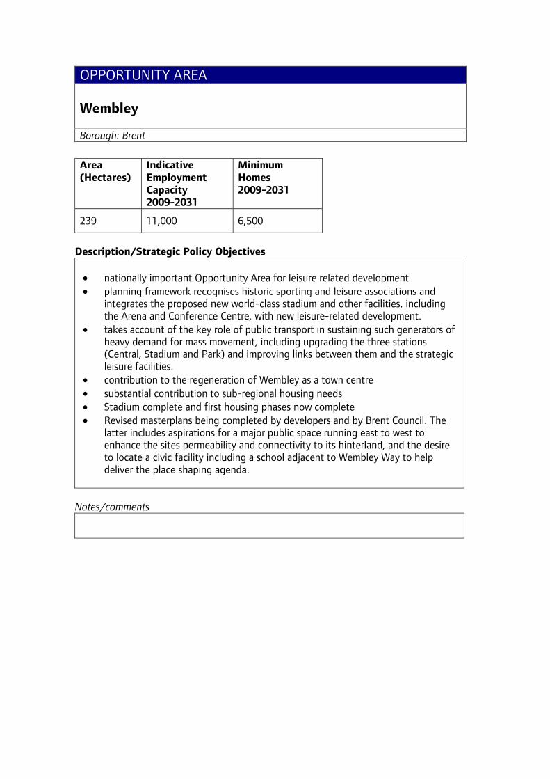
OPPORTUNITY AREA Wembley Borough: Brent
Area (Hectares)
Indicative Employment Capacity 2009-2031
Minimum Homes 2009-2031
239 11,000 6,500
Description/Strategic Policy Objectives • nationally important Opportunity Area for leisure related development • planning framework recognises historic sporting and leisure associations and
integrates the proposed new world-class stadium and other facilities, including the Arena and Conference Centre, with new leisure-related development.
• takes account of the key role of public transport in sustaining such generators of heavy demand for mass movement, including upgrading the three stations (Central, Stadium and Park) and improving links between them and the strategic leisure facilities.
• contribution to the regeneration of Wembley as a town centre • substantial contribution to sub-regional housing needs • Stadium complete and first housing phases now complete • Revised masterplans being completed by developers and by Brent Council. The
latter includes aspirations for a major public space running east to west to enhance the sites permeability and connectivity to its hinterland, and the desire to locate a civic facility including a school adjacent to Wembley Way to help deliver the place shaping agenda.
Notes/comments

OPPORTUNITY AREA White City Borough: Hammersmith & Fulham
Area (Hectares)
Indicative Employment Capacity 2009-2031
Minimum Homes 2009-2031
107 11,000 7,000
Description/Strategic Policy Objectives • Construction of strategically significant new retail provision on part of the
Opportunity Area is complete. • scope significantly to exceed the minimum housing target • masterplan for only part of the area estimated capacity for 3,500 more homes
together with what may be optimistic provision for employment. • work to assess the realistic capacity • will entail revision to strategic industrial designations to enable housing and
mixed commercial development to come forward • encourage strategically significant, public transport based business and
residential development • co-ordinated strategically to support the viability of other west and central
London centres and not lead to more intensive use of already planned parking provision
• Joint borough, developer, GLA framework adopted as SPG by LBHF and endorsed by Mayor. LBHF extending the scope to the White City Estate. Funding secured for a joint GLA/LBHF revised Planning Framework from property owners, that includes development capacity and transport capacity study.
Notes/comments
Map: OAPF and Core Strategy map Implementation update: Funding secured for a joint GLA/LBHF revised Planning Framework from property owners, that includes development capacity and transport capacity study to be completed mid 2010.
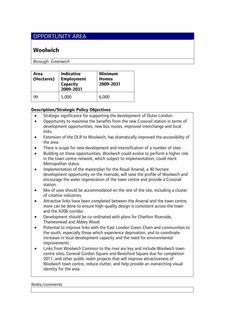
OPPORTUNITY AREA Woolwich Borough: Greenwich
Area (Hectares)
Indicative Employment Capacity 2009-2031
Minimum Homes 2009-2031
99 5,000 6,000
Description/Strategic Policy Objectives
• Strategic significance for supporting the development of Outer London. • Opportunity to maximise the benefits from the new Crossrail station in terms of
development opportunities, new bus routes, improved interchange and local links.
• Extension of the DLR to Woolwich, has dramatically improved the accessibility of the area.
• There is scope for new development and intensification of a number of sites • Building on these opportunities, Woolwich could evolve to perform a higher role
in the town centre network, which subject to implementation, could merit Metropolitan status.
• Implementation of the masterplan for the Royal Arsenal, a 40 hectare development opportunity on the riverside, will raise the profile of Woolwich and encourage the wider regeneration of the town centre and provide a Crossrail station.
• Mix of uses should be accommodated on the rest of the site, including a cluster of creative industries.
• Attractive links have been completed between the Arsenal and the town centre, more can be done to ensure high-quality design is consistent across the town and the A206 corridor.
• Development should be co-ordinated with plans for Charlton Riverside, Thamesmead and Abbey Wood.
• Potential to improve links with the East London Green Chain and communities to the south, especially those which experience deprivation, and to coordinate increases in local development capacity and the need for environmental improvements
• Links from Woolwich Common to the river are key and include Woolwich town centre sites; General Gordon Square and Beresford Square due for completion 2011, and other public realm projects that will improve attractiveness of Woolwich town centre, reduce clutter, and help provide an overarching visual identity for the area.
Notes/comments
AREA FOR INTENSIFICATION Arsenal / Holloway Borough: Islington
Area (Hectares)
Indicative Employment Capacity 2009-2031
Minimum Homes 2009-2031
38 2,000 1,500
Description/Strategic Policy Objectives • major regeneration scheme including new stadium for Arsenal FC, a new waste
recycling facility, around 3000 homes and associated community development. • Last stages Highbury Stadium conversion being built out. Planning application
approved for last phase of residential development • Should be complemented by measures to improve the A1 corridor, including
Highbury Corner.
Notes/comments Suggest review the inclusion of this as an AFI as the majority of major sites (i.e. the Arsenal FC Scheme) have now gone (built out / received planning permission(s)). Suggest that, in consultation with LBI, we consider declaring this one ‘done’.

AREA FOR INTENSIFICATION Canada Water / Surrey Quays Borough: Southwark
Area (Hectares)
Indicative Employment Capacity 2009-2031
Minimum Homes 2009-2031
46 2000 4,000
Description/Strategic Policy Objectives • Area with good public transport accessibility including stations on the Jubilee
and East London Line • focus on a transport interchange and district shopping centre with significant
potential for development on infill sites and intensification of existing commercial sites including the existing shopping centre.
• local area framework has been produced - series of development proposals coming through
• transport issues in the area include road congestion - need to be addressed through a multi-modal study which takes into account development proposals in Lewisham and Greenwich
Notes/comments
NEW AREA FOR INTENSIFICATION Dalston Borough: Hackney
Area (Hectares)
Indicative Employment Capacity 2009-2031
Minimum Homes 2009-2031
20 1,000 1,700
Description/Strategic Policy Objectives • Potential New Intensification Area with improved public transport accessibility
from 2010 with the opening of the East London Line and a station at Dalston Junction.
• A range of opportunity development sites for new development and intensification through redevelopment.
• Strategy is to promote a mix of well-integrated uses including employment, housing, retail, leisure and community uses to support the regeneration of Dalston town centre.
• Opportunity to redevelop Kingsland Shopping Centre, better integrated with its surroundings, and with scope for residential accommodation on upper levels.
• Expansion of creative and cultural industries can contribute to wider employment offer.
• Ridley Road Market is an important asset and there is scope to improve the overall environment and operation of the market and linkages with the High Street.
• Potential for higher densities of development in the town centre and improvements to the public realm and open spaces.
• Capacity for around 1,700 residential units within Dalston town centre with additional potential capacity in the immediate surroundings.
• Potential further improvements to accessibility in the longer term with proposed station on Crossrail 2 line
Notes/comments Area based on AAP boundary
AREA FOR INTENSIFICATION Farringdon / Smithfield Boroughs: City of London, Camden, Islington
Area (Hectares)
Indicative Employment Capacity 2009-2031
Minimum Homes 2009-2031
25 2,500 1,000
Description/Strategic Policy Objectives • scale of additional development capacity dependent on operational rail
requirements and degree of station renewal and improvements to transport and interchange capacity.
• Farringdon Urban Design Study commissioned by LDA/Design for London, (in partnership with the three local authorities, GLA, TfL, Crossrail and English Heritage), will set out a long-term development and public space framework for the area, which will be supported by the stakeholders.
• Development should be set in the context of the review of London’s wholesale markets. A future change of use of some or the whole of Smithfield Market should provide publicly accessible large scale spaces as a destination of regional significance.
• substantial development opportunities exist at Mount Pleasant and scope for change of use and regeneration of the area east of St Barts Hospital
• Development should respect strategic and local view policies and Farringdon’s specific urban structure and character
• public space provision should be expanded by considering opportunities for bridging over the railway cutting while maintaining the historical layered quality to provide a new public space within the railway corridor space and by improving access, permeability and quality of existing open spaces.
Notes/comments Capacity studies conducted as part of the Farringdon Urban Design Study indicate that current London Plan targets cannot be met within the designated Area of Intensification given the constraints on development including existing building character and view policies relating to St Paul’s Cathedral. Increasing the designated area to include a wider area of potential development sites would develop the framework for integrating and raising aspirations for development as well as allow current targets to be met or increased, offering opportunities for significant improvements to the area, in local terms as well as within a London wide context, both in terms of mix of uses, build quality and public space provision. Any intensification in Farringdon would need to be balanced with an increase in public space provision to counter the existing deficiency as well as new pressures. Hence, the proposed amended boundary includes Farringdon Road; Cowcross Street, Greville Street and Turnmill Street; Charterhouse Street and West Smithfield; and Clerkenwell

Green and the railway cuttings north of Farringdon Station as key opportunities for provision of diverse high quality public spaces. Should the boundary be extended as proposed targets could increase significantly reflecting the substantial development opportunities at Mount Pleasant and the change of use and regeneration of the area east of St Barts Hospital. Provisional figures (subject to further testing as part of the Farringdon Urban Design Study, especially with regards to the opportunities at Mount Pleasant) would be in the range of 2000-3000 additional jobs and minimum 600 residential units.
AREA FOR INTENSIFICATION Haringey Heartlands / Wood Green Borough: Haringey
Area (Hectares)
Indicative Employment Capacity 2009-2031
Minimum Homes 2009-2031
50 2,000 1,000
Description/Strategic Policy Objectives • Borough Supplementary Planning Document designed to coordinate the range of
development opportunities on the railway and industrial lands to the south-west of Wood Green town centre.
• Phases of residential and mixed use development at Hornsey waterworks sites completed.
• Other key sites with development potential include the Clarendon Road gas works and adjacent Coburg Road industrial area.
• significant potential for improvement of these areas, building on the area’s industrial heritage.
• Strategic Industrial Location consolidated to facilitate mixed-use regeneration of sites adjacent to Wood Green town centre.
• Site assembly and provision of better links with the town centre is key to a comprehensive development.
• sustainable high-density mixed-use development for housing, leisure, retail, employment, cultural activities, social infrastructure and open space
• opportunities to redevelop parts of Wood Green town centre for high-density, mixed-use schemes and reinforce pedestrian connections to the town centre and library.
• Spine road has been completed.
Notes/comments Implementation update: Planning application for development across the remainder of the site expected mid 2009
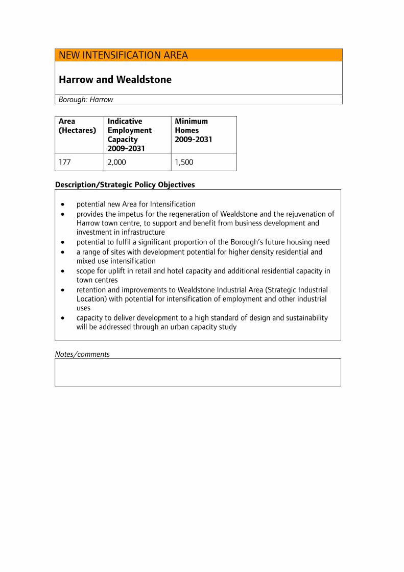
NEW INTENSIFICATION AREA Harrow and Wealdstone Borough: Harrow
Area (Hectares)
Indicative Employment Capacity 2009-2031
Minimum Homes 2009-2031
177 2,000 1,500
Description/Strategic Policy Objectives • potential new Area for Intensification • provides the impetus for the regeneration of Wealdstone and the rejuvenation of
Harrow town centre, to support and benefit from business development and investment in infrastructure
• potential to fulfil a significant proportion of the Borough’s future housing need • a range of sites with development potential for higher density residential and
mixed use intensification • scope for uplift in retail and hotel capacity and additional residential capacity in
town centres • retention and improvements to Wealdstone Industrial Area (Strategic Industrial
Location) with potential for intensification of employment and other industrial uses
• capacity to deliver development to a high standard of design and sustainability will be addressed through an urban capacity study
Notes/comments
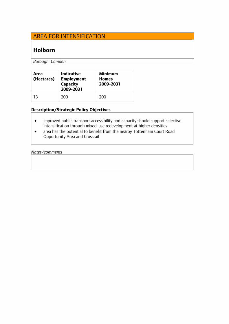
AREA FOR INTENSIFICATION Holborn Borough: Camden
Area (Hectares)
Indicative Employment Capacity 2009-2031
Minimum Homes 2009-2031
13 200 200
Description/Strategic Policy Objectives • improved public transport accessibility and capacity should support selective
intensification through mixed-use redevelopment at higher densities • area has the potential to benefit from the nearby Tottenham Court Road
Opportunity Area and Crossrail
Notes/comments
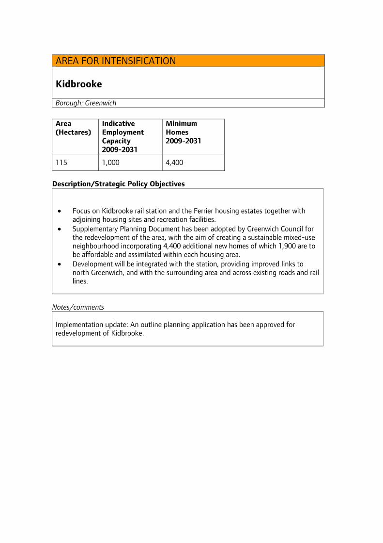
AREA FOR INTENSIFICATION Kidbrooke Borough: Greenwich
Area (Hectares)
Indicative Employment Capacity 2009-2031
Minimum Homes 2009-2031
115 1,000 4,400
Description/Strategic Policy Objectives • Focus on Kidbrooke rail station and the Ferrier housing estates together with
adjoining housing sites and recreation facilities. • Supplementary Planning Document has been adopted by Greenwich Council for
the redevelopment of the area, with the aim of creating a sustainable mixed-use neighbourhood incorporating 4,400 additional new homes of which 1,900 are to be affordable and assimilated within each housing area.
• Development will be integrated with the station, providing improved links to north Greenwich, and with the surrounding area and across existing roads and rail lines.
Notes/comments Implementation update: An outline planning application has been approved for redevelopment of Kidbrooke.
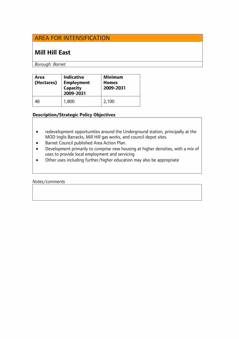
AREA FOR INTENSIFICATION Mill Hill East Borough: Barnet
Area (Hectares)
Indicative Employment Capacity 2009-2031
Minimum Homes 2009-2031
48 1,800 2,100
Description/Strategic Policy Objectives • redevelopment opportunities around the Underground station, principally at the
MOD Inglis Barracks, Mill Hill gas works, and council depot sites. • Barnet Council published Area Action Plan. • Development primarily to comprise new housing at higher densities, with a mix of
uses to provide local employment and servicing • Other uses including further/higher education may also be appropriate
Notes/comments
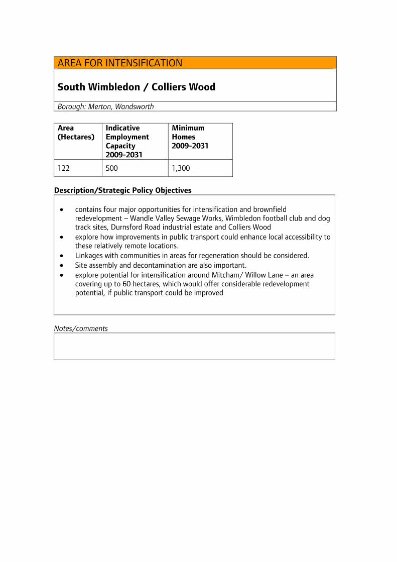
AREA FOR INTENSIFICATION South Wimbledon / Colliers Wood Borough: Merton, Wandsworth
Area (Hectares)
Indicative Employment Capacity 2009-2031
Minimum Homes 2009-2031
122 500 1,300
Description/Strategic Policy Objectives • contains four major opportunities for intensification and brownfield
redevelopment – Wandle Valley Sewage Works, Wimbledon football club and dog track sites, Durnsford Road industrial estate and Colliers Wood
• explore how improvements in public transport could enhance local accessibility to these relatively remote locations.
• Linkages with communities in areas for regeneration should be considered. • Site assembly and decontamination are also important. • explore potential for intensification around Mitcham/ Willow Lane – an area
covering up to 60 hectares, which would offer considerable redevelopment potential, if public transport could be improved
Notes/comments
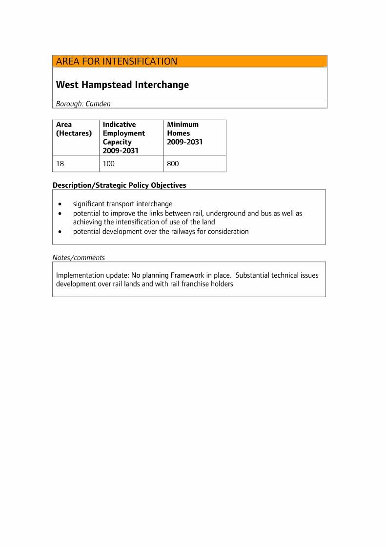
AREA FOR INTENSIFICATION West Hampstead Interchange Borough: Camden
Area (Hectares)
Indicative Employment Capacity 2009-2031
Minimum Homes 2009-2031
18 100 800
Description/Strategic Policy Objectives • significant transport interchange • potential to improve the links between rail, underground and bus as well as
achieving the intensification of use of the land • potential development over the railways for consideration
Notes/comments Implementation update: No planning Framework in place. Substantial technical issues development over rail lands and with rail franchise holders
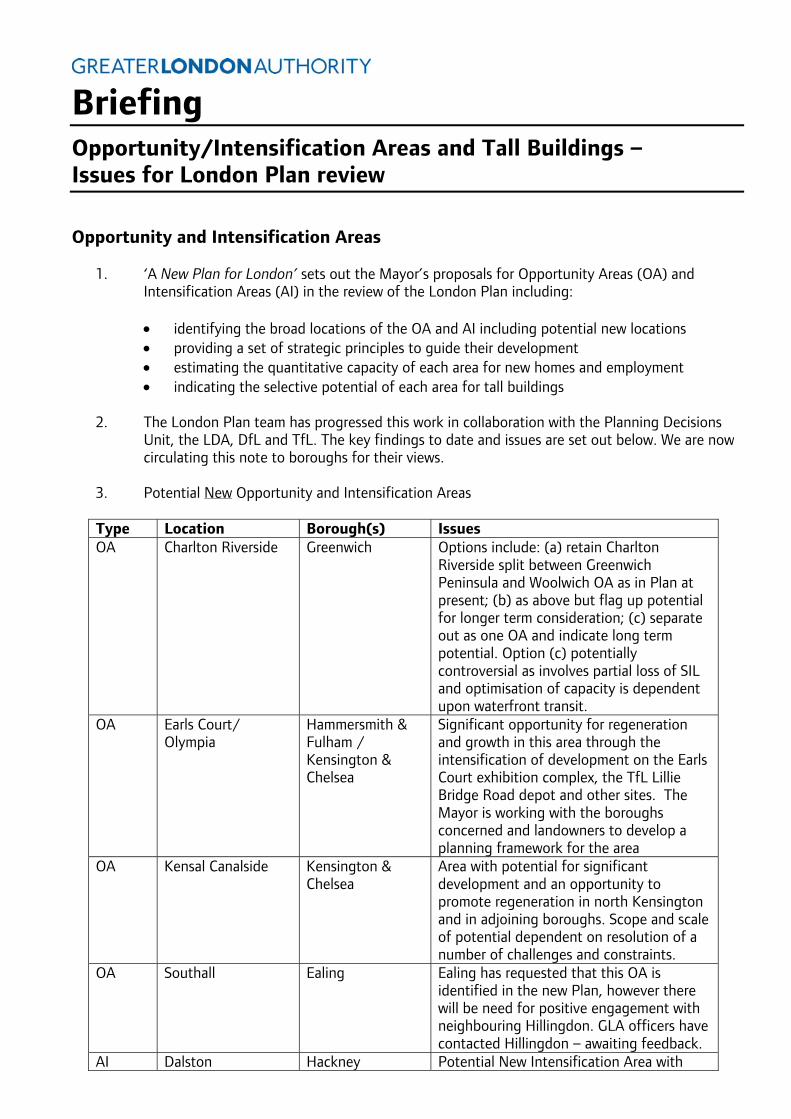
Briefing Opportunity/Intensification Areas and Tall Buildings – Issues for London Plan review
Opportunity and Intensification Areas
1. ‘A New Plan for London’ sets out the Mayor’s proposals for Opportunity Areas (OA) and Intensification Areas (AI) in the review of the London Plan including:
• identifying the broad locations of the OA and AI including potential new locations • providing a set of strategic principles to guide their development • estimating the quantitative capacity of each area for new homes and employment • indicating the selective potential of each area for tall buildings
2. The London Plan team has progressed this work in collaboration with the Planning Decisions
Unit, the LDA, DfL and TfL. The key findings to date and issues are set out below. We are now circulating this note to boroughs for their views.
3. Potential New Opportunity and Intensification Areas
Type Location Borough(s) Issues OA Charlton Riverside Greenwich Options include: (a) retain Charlton
Riverside split between Greenwich Peninsula and Woolwich OA as in Plan at present; (b) as above but flag up potential for longer term consideration; (c) separate out as one OA and indicate long term potential. Option (c) potentially controversial as involves partial loss of SIL and optimisation of capacity is dependent upon waterfront transit.
OA Earls Court/ Olympia
Hammersmith & Fulham / Kensington & Chelsea
Significant opportunity for regeneration and growth in this area through the intensification of development on the Earls Court exhibition complex, the TfL Lillie Bridge Road depot and other sites. The Mayor is working with the boroughs concerned and landowners to develop a planning framework for the area
OA Kensal Canalside Kensington & Chelsea
Area with potential for significant development and an opportunity to promote regeneration in north Kensington and in adjoining boroughs. Scope and scale of potential dependent on resolution of a number of challenges and constraints.
OA Southall Ealing Ealing has requested that this OA is identified in the new Plan, however there will be need for positive engagement with neighbouring Hillingdon. GLA officers have contacted Hillingdon – awaiting feedback.
AI Dalston Hackney Potential New Intensification Area with
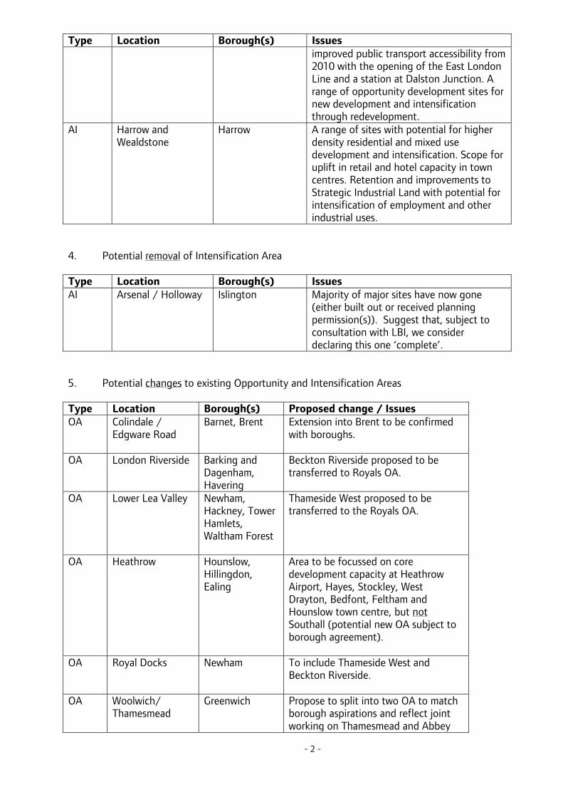
- 2 -
Type Location Borough(s) Issues improved public transport accessibility from 2010 with the opening of the East London Line and a station at Dalston Junction. A range of opportunity development sites for new development and intensification through redevelopment.
AI Harrow and Wealdstone
Harrow
A range of sites with potential for higher density residential and mixed use development and intensification. Scope for uplift in retail and hotel capacity in town centres. Retention and improvements to Strategic Industrial Land with potential for intensification of employment and other industrial uses.
4. Potential removal of Intensification Area Type Location Borough(s) Issues AI Arsenal / Holloway
Islington Majority of major sites have now gone
(either built out or received planning permission(s)). Suggest that, subject to consultation with LBI, we consider declaring this one ‘complete’.
5. Potential changes to existing Opportunity and Intensification Areas Type Location Borough(s) Proposed change / Issues OA Colindale /
Edgware Road
Barnet, Brent Extension into Brent to be confirmed with boroughs.
OA London Riverside Barking and Dagenham, Havering
Beckton Riverside proposed to be transferred to Royals OA.
OA Lower Lea Valley Newham, Hackney, Tower Hamlets, Waltham Forest
Thameside West proposed to be transferred to the Royals OA.
OA Heathrow Hounslow, Hillingdon, Ealing
Area to be focussed on core development capacity at Heathrow Airport, Hayes, Stockley, West Drayton, Bedfont, Feltham and Hounslow town centre, but not Southall (potential new OA subject to borough agreement).
OA Royal Docks Newham To include Thameside West and Beckton Riverside.
OA Woolwich/ Thamesmead
Greenwich Propose to split into two OA to match borough aspirations and reflect joint working on Thamesmead and Abbey
- 3 -
Type Location Borough(s) Proposed change / Issues Wood. To be confirmed with Greenwich and Bexley.
AI Farringdon/ Smithfield
City, Islington, Camden
Potential extension of area to include capacity at Mount Pleasant and the area east of St.Barts Hospital. To be confirmed with boroughs.
6. The London Plan team has mapped the geographical extent of each Opportunity and
Intensification Area (see Map on page 5). The map is used to facilitate discussion with boroughs and other stakeholders and to provide the basis for further analysis of capacity for employment and new homes (see below).
7. Employment Capacity estimates for each area have been derived (see Table 1 on pages 6-7)
from a range of sources including the London Employment Sites Database, the London Development Database and specific analysis in Opportunity Area Planning Frameworks where available. The estimates would be identified in the draft new London Plan as ‘indicative’ rather than a target. The estimates will be checked against the provisional employment projections, expected by the end of July, to ensure that they are robust and realistic.
8. Capacity estimates for New Homes in each Opportunity and Intensification Area have been
tested against emerging work on OAPFs and the outputs of the Housing Capacity Study / Strategic Housing Land Availability Assessment. These estimates (see Table 1 on pages 6-7) will be subject to the informal consultation with the boroughs. It is proposed that these estimates are included in the new draft Plan as a minimum target to be exceeded where feasible.
9. Borough views are sought on the provisional findings for the Opportunity Areas and
Intensification Areas and in particular:
1. Views on the draft potential new Opportunity Areas (para 3) 2. Feedback on the removal of one Intensification Area (para 4) 3. Feedback on the potential changes to existing Opportunity Areas (para 5) 4. Feedback on the employment capacity and minimum new homes estimates (paras 7 and 8
and Table 1). 5. Feedback on the descriptions/strategic policy objectives set out Annex 1.
Tall Buildings
10. The revised London Plan will make provision for tall buildings, but its emphasis will be substantially different to the current "Policy 4B.9 Tall Buildings - Location". Our intention is to draft a set of policies that place greater weight on the value of existing physical context, character and broader townscape composition when deciding where tall buildings might be appropriate. The policy will seek to limit tall buildings to areas designated by boroughs in partnership with the Mayor - and possibly in accordance with a set of criteria laid out in the London Plan.
11. Ideally, we would like to nominate, in the London Plan, locations where boroughs will wish to
support tall buildings. These locations should be supported by sufficient evidence to demonstrate that the existing physical context and character can support tall buildings.
12. Borough views are sought on:

- 4 -
(1). Locations where your borough might wish to support tall buildings (NB these locations need not necessarily be an Opportunity / Intensification Area) (2). Details of the evidence that you have already (or will soon) compile to demonstrate the nominated area is appropriate for tall buildings. This evidence would ideally include an analysis of local physical character, townscape composition, local and strategic views and heritage landmarks (including World Heritage Sites) (3) Feedback on the Opportunity Area locations where parts may be suitable for tall buildings subject to London Plan design policies and criteria as indicated in Annex 1 (front page).
Attachments: Annex 1
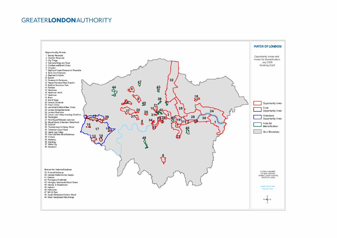
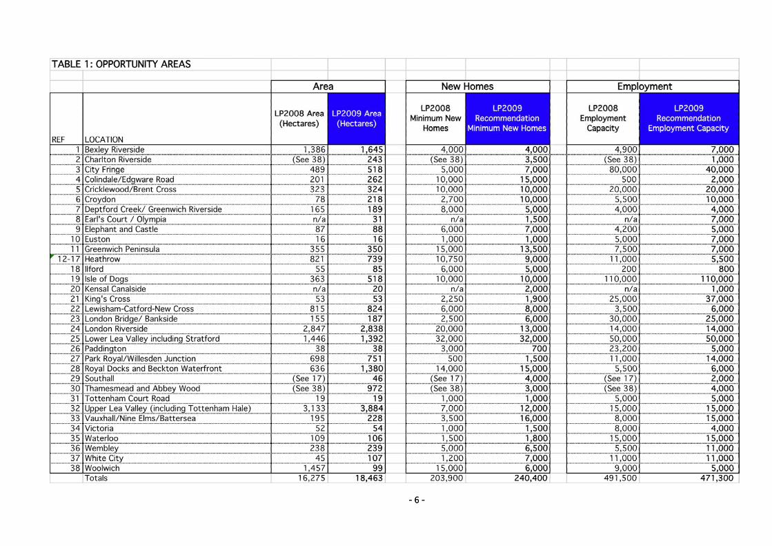
- 6 - - 6 -
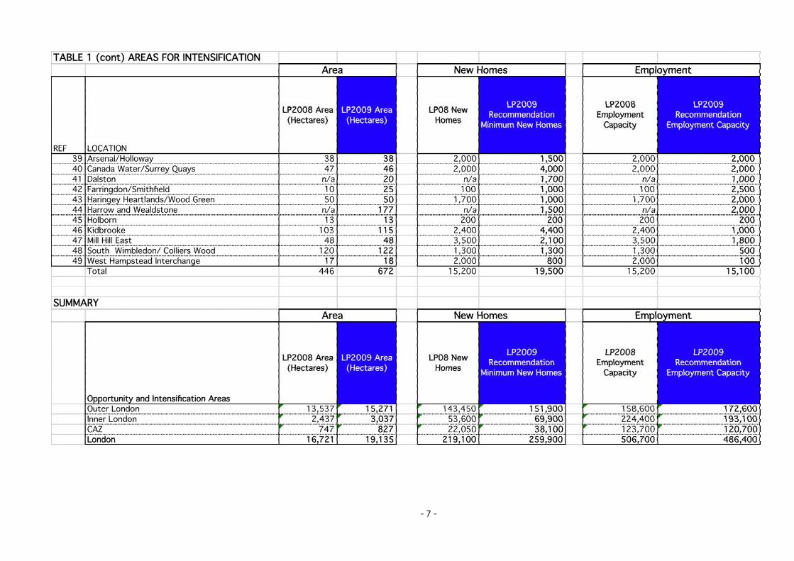
- 7 -


![0428 An Opportunity for Africa: The System of Rice Intensification (SRI) [ le Systéme de Riziculture Intensive ]](https://static.fdocuments.us/doc/165x107/54b83bf84a7959b8658b4597/0428-an-opportunity-for-africa-the-system-of-rice-intensification-sri-le-systeme-de-riziculture-intensive-.jpg)