ANKARA SPATIAL HISTORY - METUcrp.metu.edu.tr/sites/crp.metu.edu.tr/files/Ankara spatial...
13
Hacıbayram Mosque (1427) and Augustus Temple (2 nd Century B.C.) ANKARA SPATIAL HISTORY Baykan Günay
Transcript of ANKARA SPATIAL HISTORY - METUcrp.metu.edu.tr/sites/crp.metu.edu.tr/files/Ankara spatial...

Hacıbayram Mosque (1427) and Augustus Temple (2nd Century B.C.)
ANKARA SPATIAL HISTORY Baykan Günay

2
ANKARA SPATIAL HISTORY Quite a number of artificial settlements have been constructed in the 20th century, of which some have attained the role of capital city. Together with Canberra, Brasilia, Chandigarh and Islamabad; the fate of Ankara was determined through the will of prevailing political ideologies. In all cases the basic idea was to create an alternative pole of growth to compete with the existing primate cities in order to provide for a new equilibrium in the spatial organization of the respective countries. It is not surprising that all of these cities are non-coastal, which may be attributed to the fact that they reflect a reaction to the 19th century harbour towns which provided for the external integration of newly emerging nations. Ankara is an attempt of the new society to rid itself of the symbolic values of a disintegrating empire and the institution of the Caliphate, and transform itself from a semi-colonial economic structure into a nation with an independent economy. Ankara: Location and Geomorphology Geographically, Ankara lies in the transition zone between the coastal regions and the Central Anatolian Plateau. There are quite a number of cities in this Central Anatolian region that have survived thanks to the possibilities offered by this zone. At a geographical level, Ankara is in the zone of urban areas encircling Central Anatolia. Opportunities provided by the water resources of the mountains, the moderate summer climate and accessibility to agricultural lands have all been factors generating this system of urban areas. The existence of Ankara is a function of its location on the Anatolian Peninsula; however, its importance and size would become the functions of its place within the ever changing road system on the peninsula and the prevailing political boundaries. Its urban form, on the other hand, has been shaped by the geomorphological structure of the surrounding terrain. A closer look at Ankara's location and the geomorphological outline of the urban area allows an understanding of the many problems the city would encounter as it began to grow as a modern centre. The Ankara plain, extending from west to east, is defined by a parallel ridge of mountains open at the western end but closed at the eastern edge where the Citadel is located. The hill on which the Citadel is constructed has a pertinent role in the location of the city. This eruptive hill, ascending from a plain of average 850 metres to an elevation of 980 meters, offered advantageous defence opportunities. Today the Citadel is considered to be a basic landmark of the city.
Ankara in Turkey and Central Anatolia
Geomorphology of Ankara
The Citadel from East
The Citadel from West
3
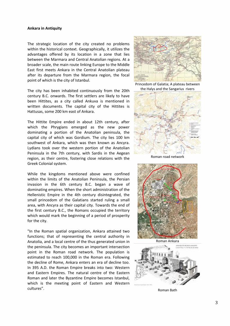
Ankara in Antiquity The strategic location of the city created no problems within the historical context. Geographically, it utilizes the advantages offered by its location in a zone that lies between the Marmara and Central Anatolian regions. At a broader scale, the main route linking Europe to the Middle East first meets Ankara in the Central Anatolian plateau after its departure from the Marmara region, the focal point of which is the city of Istanbul. The city has been inhabited continuously from the 20th century B.C. onwards. The first settlers are likely to have been Hittites, as a city called Ankuva is mentioned in written documents. The capital city of the Hittites is Hattusas, some 200 km east of Ankara. The Hittite Empire ended in about 12th century, after which the Phrygians emerged as the new power dominating a portion of the Anatolian peninsula, the capital city of which was Gordium. The city lies 100 km southwest of Ankara, which was then known as Ancyra. Lydians took over the western portion of the Anatolian Peninsula in the 7th century, with Sardis in the Aegean region, as their centre, fostering close relations with the Greek Colonial system. While the kingdoms mentioned above were confined within the limits of the Anatolian Peninsula, the Persian invasion in the 6th century B.C. began a wave of dominating empires. When the short administration of the Hellenistic Empire in the 4th century disintegrated, the small princedom of the Galatians started ruling a small area, with Ancyra as their capital city. Towards the end of the first century B.C., the Romans occupied the territory which would mark the beginning of a period of prosperity for the city. "In the Roman spatial organization, Ankara attained two functions; that of representing the central authority in Anatolia, and a local centre of the thus generated union in the peninsula. The city becomes an important intersection point in the Roman road network. The population is estimated to reach 100,000 in the Roman era. Following the decline of Rome, Ankara enters an era of decline too. In 395 A.D. the Roman Empire breaks into two: Western and Eastern Empires. The natural centre of the Eastern Roman and later the Byzantine Empire becomes Istanbul, which is the meeting point of Eastern and Western cultures”.
Princedom of Galatia; A plateau between
the Halys and the Sangarius rivers
Roman road network
Roman Ankara
Roman Bath

4
Ottoman Ankara Ankara survived in this period, but not as glittering as in the Roman era. It was subjected to numerous invasions from east, by Arabs, Sassanids and Turks, and so would spend most of its time as a military centre. From the 11th century onwards, the city first fell under the Seljuks, and then from the 14th century onwards it was under Ottoman rule. The Ottoman Empire displaced the Byzantines, and so the centre of the east once again became Istanbul, but this time under the domination of an eastern culture. Once political stability was established on the Anatolian Peninsula and the road networks revitalized, Ankara entered a new period of limited prosperity, but always under the control of Istanbul. From the 16th to the 18th centuries the city thrived on the production and processing of mohair and angora. The population is estimated to have been around 50,000 by the end of the 18th century. In around 1800, the more developed and industrialized West met with Anatolian society to import raw materials and export finished products. In this new process, first social and then spatial organization of the Anatolian peninsula began to occur, while local production disintegrated and a railroad system was created to integrate especially the western regions of Anatolia. The Istanbul-Baghdad railroad bypassed Ankara in its first era of construction. In the mid-19th century, the old walls of the outer city still survived. The western terrain of Ankara however was entirely marshland, offering no opportunity for urban development. When the need to extend the railroad system deep into the Anatolian peninsula emerged, Ankara became the first centre of this extension in 1892. In the 19th century the economic and political structure of the Anatolian peninsula began to change. Consequently, while the Ottoman Empire was disintegrating, the structure of its settlements was transforming into a system in which traditional production was dissolving with the penetration of industrial goods, and harbour towns began growing as centres of import-export firms and financial institutions. These were concentrated mainly in Istanbul under the control of minority groups, who provided for the integration of the Anatolian market and resources with Western industries.
Aslanhane (Ahi Şerafettin): 13
th century
Seljuk Mosque and Tomb
More prosperous Ankara
Ankara declining
Ankara mid-19
th century
Ottoman road network and the railway

5
Republican Ankara In the beginning of the 20th century a new nation emerged out of the ashes of the Ottoman Empire. The Anatolian Peninsula was at the time subject to a territorial occupation by Western countries. A national resistance movement evolved, with Ankara at its centre. A National Pact signed in 1920 determined the boundaries of this nation, which comprised the entire Anatolian Peninsula and a portion of Thrace, with Istanbul at the north western edge of the new political entity. The strategic location of Ankara allowed the resistance movement to control and create a front against the invading Greek forces at the approximate geometric centre of the newly determined boundaries, 200 km northwest of the actual centre point. When the War of Independence was over, the new regime sought a capital city. On the one side there was Istanbul, the capital city of the region for the last 1500 years, and on the other was Ankara, which had been the centre of the resistance movement and a new ideology that was attempting to negate the symbolic semi-colonial centre of the Ottoman Empire. In this period, Ankara had a very poor physical appearance, having inherited a desolate Ottoman urban structure – the streets were dusty in summer and muddy in winter. The decision to select Ankara was based on the need for the new society to break its ties with the semi-colonial Ottoman image, to negate the cosmopolitan cultural values of Istanbul, to push economic development into the heart of Anatolia, and to build an exemplary town as a symbol of contemporary living environment. The first modern municipality in the Ottoman administrative system had been established in Istanbul in 1854 under the control of minority groups, and in Republican Turkey, Ankara would be the first city to have a municipal organization in 1924. The first plan, drawn up by Berlin architect Carl Christoph Lörcher, proposed a compact city, whereby a new centre was proposed around the central station, and the foundations of the New City were laid. The plan’s immediate contribution was the arrangement of lands for the new public buildings required by the government. Popular Western architects such as Giulio Mongeri, Clemens Holzmeister and Ernst Egli were commissioned by the state to design the public buildings, as well as Turkish architects Mimar Kemal and Vedat Tek.
Istanbul, Ankara and gravity centre of
Turkey
Ankara 1924
Carl Christoph Lörcher plan (1924-1931)
The public buildings in the old town
The new town

6
Herman Jansen’s Ankara: Building the Core For 15 centuries the city of Istanbul had administered the entire Balkans and Middle East, but it was in the 20th century that a new nation provided for the unity of the Anatolian Peninsula, putting Istanbul in an off-centric position. Within the newly established political boundaries the geometrically strategic Ankara became the seat of government, and was the testing ground for the republican administration’s experiments to develop a new society and its city in conformity with the rules of the modernism. Under these circumstances the administration decided to develop the city according to a master plan, for which a competition was held in 1928, with proposals requested from three European urbanists. At the time, Ankara's population was 75,000 and it was stipulated that the plan should be considered for a period of 50 years and an estimated population of 300,000. Although the estimated population might seem modest by today's standards, it foresaw a quadrupling of population. Jansen’s design for the city was selected following the international competition, with the aim being to create an occidental city out of an oriental society. The idea was to build an exemplary town that would generate a modern and contemporary living environment, to develop a new set of social norms which could be used in other urban centres, and to symbolize the achievements of the Republic in the creation of this new town. In a period in which there was no pressure of population, the model worked, and Ankara acquired a Western flavour. The city reflected the modesty of Republican regime, in that there was no monumentality, but offered impressions of a culturalist modest city. The basic fear with the plan was speculation, and as the city developed it encountered such pressures that started to change the primary assumptions of the plans. However this was also an indication that natural forces were starting to play a role. In the master plan, Jansen hoped to develop the central functions of the city with reference to the central station and the old town as an archetype of European city development. In practice however, due to the existence of marshland in the area foreseen for the development of the town centre, an ecological corridor and sports facilities were created, leaving the central station as a free standing element. On the other hand, with the transfer of government buildings, the new town would further develop a new architecture under the influence of the design approaches of Clemens Holzmeister, Bruno Taut and Ernst Egli.
Jansen’s master plan
Jansen’s regulatory plan
The old town (Ulus)
The New Town (Yenişehir)
Government quarters in the new
town

7
Uybadin-Yücel Plan: Consolidating the Core The Jansen plan started with high hopes and enthusiasm, and created a Western-style city. It feared speculation, but the compact finished form of the city plan was not able to cope with the natural changes that would later emerge. By 1955 the population of Ankara had reached 450,000, and was expected to reach 750,000 by 2000. Consequently, in 1955 a competition for a new master plan was held, for which the jury was more technical in character than that which had selected Jansen's plan in 1928. Besides Turkish architects and engineers, three well-known names from the Western world were invited to take part in the jury: Sir Patrick Abercrombie of England, Prof. Gustav Oelsner of Germany and Prof. Luigi Piccinato of Italy. The chairman of the jury was Sir Patrick Abercrombie, who had been responsible for the planning of the London Greenbelt. The third plan aspired to perpetuate the culturalist city of the first plan. It aimed to prevent further growth and density, and eventually faced the destruction of the city by ignoring the natural forces of society. Consequently the dual structures of society in the city started to leave their mark on the urban form. The apartment blocks in the regular housing zones and low-rise low-density squatter housing became the basic textures of the city, reflecting the socio-economic status of society. Hence, the garden city transformed into an apartment city, and the green belts into a squatter city, launching a process of planned versus spontaneous development. The process led eventually to a total replacement of the urban fabric, where the model contemporary city lost its values in favour of a more chaotic order.
Uybadin-Yücel Plan
Uybadin-Yücel plan in the geomorphologic setting
Reconstruction in the new town
Squatting in the periphery

8
Towards a Metropolitan City: Fringe Development along One Corridor The fourth plan was somewhat discrete, in that it departed from the idea of the Master Plan and introduced a structure plan. The intention of the plan was to create new residential and employment possibilities at the fringe of the city in favour of the middle classes, and again feared speculation. The plan foresaw a mono-directional growth along the western corridor and initiated the expropriation of large tracts of land in this direction. The plan initiated the growth of the city towards the fringe, leaving the core to the power of the previous plans. At the end of the 1960s the Turkish planning environment was much better equipped due to the experience gained in previous planning studies, and there were now schools teaching the discipline. In this context, the newly established Ankara Metropolitan Office began a continuously developing study, starting in 1969. The Office devoted a great deal of time to the collection of data and the conducting of surveys. Objectives were formulated, data was analysed, and alternative proposals were produced, all of which were to be evaluated. Consequently, an outline of future Ankara was drawn up for a 20-year perspective. The final document was called the Ankara Master Plan 1990. However, in fact it was much more than a master plan, in that it developed a new planning understanding and process that should be considered as a Structure Plan In this regard it tried to give the town a new shape, and for the first time dealt with many of the problems that had been ignored in the previous plans. After an analysis of many alternatives, growth along the Western Corridor was considered to be the most feasible solution. In the subsequent implementation process the local government would take a leading role in putting the planning decisions into effect, instigating huge housing development projects along the western corridor, supported further with new industrial zones. Eventually the plan has also initiated policies to develop the city into fringe.
Fringe developments; industrial and residential sprawl
Batıkent housing development initiated by the public
sector (western corridor)
Batıkent housing development (western corridor)
Private sector in housing development (South-
western corridor)

9
Towards a Metropolitan City: Fringe Development along Many Corridors The fourth plan is considered as a success in its definition of the centre, its acceptance of the squatter areas, its initiation of policies in this respect and its provision of urban land for the middle class. The Metropolitan Office Plan hoped to serve the middle- and lower-income groups by balancing employment and residential development. It was a mono-directional plan and in this respect fell into the same trap as the previous plan, in that it was not flexible. After 1980 the administrative system of the city changed. First, a metropolitan administration was established, under which the city was divided into five district units, each conducting its own municipal functions; while the metropolitan administration was the leading authority in matters concerning the city as a whole. Secondly, the local units were given the right to control their own planning activities, which were supervised by the central government until 1985. These actions were further consolidated with the transfer of many financial resources to the budgets of the municipalities. Needless to say, these new measures encouraged the local administrations to enter many new investments, and the construction of an underground system once again became a major issue. The team which was commissioned to carry out the survey for the transport system of the city stipulated that first a land use plan of the city had to be drawn up. Once the local administrations gained the freedom to organize their own planning programme, a group in the City and Regional Planning Department of the Middle East Technical University was entrusted with the duty of drawing up a planning study for Ankara. The METU planning group decided to formulate the planning objectives for a 30-year period, with the produced document, being the 'Structure Plan,’ being the first of its kind in Turkey. The studies utilized many state-of-the-art quantitative techniques, which may be grouped under a title of system approach planning. The plan proposed the development of further corridors into the fringe of the city. Furthermore, it initiated a new outlook to the old town, and transferred the obtained data to the transportation team for use in the selection of an appropriate underground network.
Ankara 2015
Old centre improvement
Fringe development by the private sector
Metro to the Batıkent housing development
10
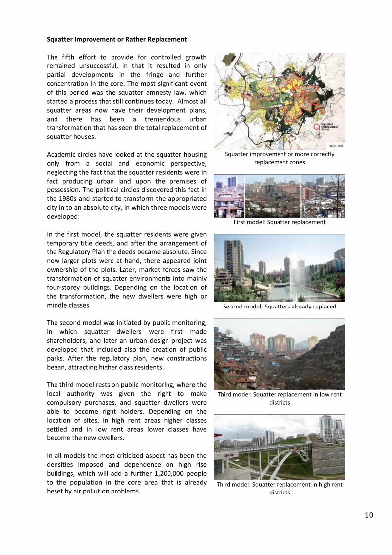
Squatter Improvement or Rather Replacement The fifth effort to provide for controlled growth remained unsuccessful, in that it resulted in only partial developments in the fringe and further concentration in the core. The most significant event of this period was the squatter amnesty law, which started a process that still continues today. Almost all squatter areas now have their development plans, and there has been a tremendous urban transformation that has seen the total replacement of squatter houses. Academic circles have looked at the squatter housing only from a social and economic perspective, neglecting the fact that the squatter residents were in fact producing urban land upon the premises of possession. The political circles discovered this fact in the 1980s and started to transform the appropriated city in to an absolute city, in which three models were developed: In the first model, the squatter residents were given temporary title deeds, and after the arrangement of the Regulatory Plan the deeds became absolute. Since now larger plots were at hand, there appeared joint ownership of the plots. Later, market forces saw the transformation of squatter environments into mainly four-storey buildings. Depending on the location of the transformation, the new dwellers were high or middle classes. The second model was initiated by public monitoring, in which squatter dwellers were first made shareholders, and later an urban design project was developed that included also the creation of public parks. After the regulatory plan, new constructions began, attracting higher class residents. The third model rests on public monitoring, where the local authority was given the right to make compulsory purchases, and squatter dwellers were able to become right holders. Depending on the location of sites, in high rent areas higher classes settled and in low rent areas lower classes have become the new dwellers. In all models the most criticized aspect has been the densities imposed and dependence on high rise buildings, which will add a further 1,200,000 people to the population in the core area that is already beset by air pollution problems.
Squatter improvement or more correctly
replacement zones
First model: Squatter replacement
Second model: Squatters already replaced
Third model: Squatter replacement in low rent
districts
Third model: Squatter replacement in high rent
districts
11
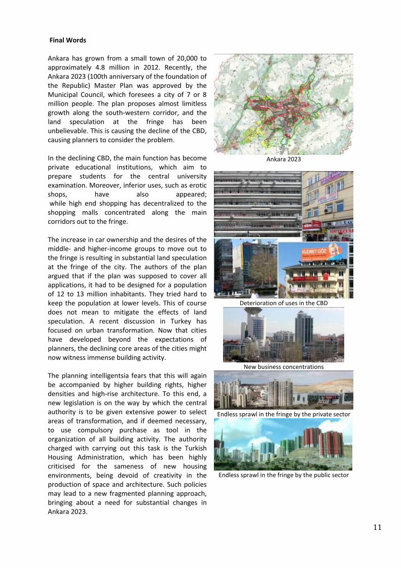
Final Words Ankara has grown from a small town of 20,000 to approximately 4.8 million in 2012. Recently, the Ankara 2023 (100th anniversary of the foundation of the Republic) Master Plan was approved by the Municipal Council, which foresees a city of 7 or 8 million people. The plan proposes almost limitless growth along the south-western corridor, and the land speculation at the fringe has been unbelievable. This is causing the decline of the CBD, causing planners to consider the problem. In the declining CBD, the main function has become private educational institutions, which aim to prepare students for the central university examination. Moreover, inferior uses, such as erotic shops, have also appeared; while high end shopping has decentralized to the shopping malls concentrated along the main corridors out to the fringe. The increase in car ownership and the desires of the middle- and higher-income groups to move out to the fringe is resulting in substantial land speculation at the fringe of the city. The authors of the plan argued that if the plan was supposed to cover all applications, it had to be designed for a population of 12 to 13 million inhabitants. They tried hard to keep the population at lower levels. This of course does not mean to mitigate the effects of land speculation. A recent discussion in Turkey has focused on urban transformation. Now that cities have developed beyond the expectations of planners, the declining core areas of the cities might now witness immense building activity. The planning intelligentsia fears that this will again be accompanied by higher building rights, higher densities and high-rise architecture. To this end, a new legislation is on the way by which the central authority is to be given extensive power to select areas of transformation, and if deemed necessary, to use compulsory purchase as tool in the organization of all building activity. The authority charged with carrying out this task is the Turkish Housing Administration, which has been highly criticised for the sameness of new housing environments, being devoid of creativity in the production of space and architecture. Such policies may lead to a new fragmented planning approach, bringing about a need for substantial changes in Ankara 2023.
Ankara 2023
Deterioration of uses in the CBD
New business concentrations
Endless sprawl in the fringe by the private sector
Endless sprawl in the fringe by the public sector

12
New business concentration
Dali in Ankara Cer Modern
Reproduction of space: Prison house as museum
Reproduction of space: Old town
reconstructed
Reproduction of space: Railway repair
workshops as Cer Modern

13
Sources Akçura, T. (1971); “Ankara: Türkiye Cumhuriyetinin Başkenti Hakkında Monografik Bir Araştırma”, Middle East Technical University Publication, Ankara. Aydın, S., Emiroğlu, K., Türkoğlu, Ö., Özsoy, E. (2005); “Küçük Asya’nın Bin Yüzü: Ankara”, Dost Kitabevi, Ankara. Bademli, R. (1987); “Ankara’da Kent Planlama Deneyi ve Ulaşılan Sonuçlar”, Ankara 1985’ten 2015’e, Ankara Büyükşehir Belediyesi yayını, Ajans İletim, Ankara. Günay, B. (1988); "Our Generation of Planners; The Hopes, The Fears, The Facts: Ankara", SCUPAD meeting in Salzburg, npublished presentation and text. Günay, B. (2006); “Ankara Çekirdek Alanının Oluşumu ve 1990 Nazım Planı Hakkında Bir Değerlendirme”, Cumhuriyet’in Ankara’sı, Derleyen: T.Şenyapılı, ODTÜ Yayıncılık Ankara. Günay, B. (2009); “Gecekonduya Ne Oldu? Zilyetliğe Dayalı Kentten – Sahipli Kente”, Gecekondu, Dönüşüm, Kent, Tansı Şenyapılı’ya Armağan, Derleyenler; S. Kayasü, Oğuz Işık, Nil Uzun, Ebru Kamacı, ODTÜ Mimarlık Fakültesi Yayını. Günay, B. (2010); “Ankara: Duality of the Core and the Fringe”, Urban Transformation: Controversies, Contrasts and Challenges, 14th International Planning History Society Conference, presentation and abstract, 12-15 July Istanbul. Rivkin, M. (1964); “Creation of Growth Regions, Some Experience from Turkey”, Ekistics, V. 18, September, Athens. Tankut, G. (1984); "Jansen Planı Uygulama Sorunları", Tarih içinde Ankara, Middle East Technical University Publication, Ankara. Tekeli, İ. (1984); “Ankara’nın Başkentlik Kararı”, Tarih içinde Ankara, Middle East Technical University Publication, Ankara.