1 Group No 7 Vinodhini Patil:9419 Meenakshi Seetharaman:9412 Tejal Shringarpure:9424 NEWSPAPERS.
Upload
thomasine-imogen-bruceCategory
view
220download
0
Anish Bhattacharya Shen Ge
Neha SatakTejal Thakore
Sensors to map pollution for the Danube River using GNSS

The Team
Shen GeM.S., Aerospace
B.S., Aerospace and Physics
Neha SatakPhD Student, Aerospace
M.S., AerospaceB.E., Electronics
Tejal ThakoreSGAC MAA Technical Lead
Member of YGNSSB.S., Aerospace
Anish BhattacharyaMBA Student
IBM Software EngineerB.E., Electronics

Introduction to Project SWIPSSpherical Water In-situ Pollution Sensors
Application:
Detects differential change in pollution concentration along the length of the river when deployed in a network
Monitors a specific location along the length for water pollution levels.
Can be used by government to enforce water pollution laws or by individuals and industry planning to utilize the river water.
Description:
A submersible, wireless water pollution sensor using GNSS
Measures PAHs and charged molecules in water
Can submerge and float for mobile or stationary applications
Carries a GNSS sensor to localize itself
Uploads data to remote computer through a wireless link

Civilizations and cities have flourished around rivers. They are a valued resource as a foundation for agriculture transportation and industry.
Two major types of pollutants in water affecting life:◦ Polycyclic Aromatic Hydrocarbons (PAH) ◦ Ions : pH, fluoride, chloride, ammonium, total hardness and some
metallic ions.
Danube River is a good case due to two reasons:◦ Its the second longest river in Europe, is a waterway that affects the
lives of millions.◦ Nations and their governments through which the river passes are
committed to protect it.
To track its state of pollution at different parts of the river at any given time is of critical importance to identify the source of pollution and track its concentration and distribution.
Motivation

Value Proposition
Autonomous Data Collection
Mobile
and
Subm
ersib
le
Senso
rWireless link to sensors up to 20-30 km
Multip
le
senso
rs
net
wor
k
Features:
SWIPS sensors are fully autonomous.
Multiple sensors can communicate with each other and provide differential data
Data collection is wireless at a distance of <10 km
Each sensor is capable of floating and drifting at different depths to detect pollution at various levels.
Lifetime of each SWIPS sensor is designed to be 6 months.
Software to process data collected from a network of SWIPS sensors will be provided.

Technical Design

SWIPS Schematic
Water Pollutant Sensors
Water Intakemechanism
Rechargeable Battery
GNSS Receiver
Water Pressure sensor
Data Link/Memory
Module
Outflow mechanism area

Preliminary Spherical Outer Shell 3D Design – Material and Shape
SHAPE According to the ICPDR*,
Danube River has a current velocity of 8-9 km/hr. To maintain a regular course for the sensor to float using the river current, it would be ideal to have a spherical shell. This will also provide better access for the water to enter the shell and the outflow mechanism to pump out the water in the shell.
MATERIALRequirements: Light weight,
water-resistance, robust structure, highly corrosion resistance, weather resistance, high tensile strength and low specific gravity.
Proposed materials: Carbon-fibre with epoxy resin or fibre-glass with epoxy resin.
Due to being readily available and inexpensive bulk order – fibre glass with epoxy resin was chosen.
*ICPDR – International Cooperation for the protection of Danube River

The sensor will float or submerge depending on its area/mass ratio.
Submersing System
Change Area
Change Mass

Main Board
GNSS Sensor
Water Pollution Sensor
Data Link Card
Sinking-Floating
Mechanism
Main Board

Water Pollution Sensors
EnviroFlu-HC UV fluorometer
Ion-selective microelectrodes
• Commercially available submersible UV fluorometer detect PAHs commonly found in oil, coal, and tar deposits.
• Ion-selective microelectrodes detect inorganic charged pollutants.
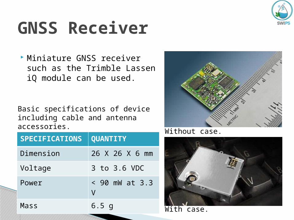
Miniature GNSS receiver such as the Trimble Lassen iQ module can be used.
GNSS Receiver
SPECIFICATIONS
QUANTITY
Dimension 26 X 26 X 6 mm
Voltage 3 to 3.6 VDC
Power < 90 mW at 3.3 V
Mass 6.5 g
Basic specifications of device including cable and antenna accessories.
Without case.
With case.

XStream® OEM RF Modules
Data Link Board
Relevant Specifications:
1. Outdoor/RF line-of-sight range: 32 km
2. Weight : 24g3. Data upload rate : 9.6 kbps4. Estimated total time for uploading
data for one day : 0.2 to 1 sec

DEVICE VOLTS (V) CAPACITY (mAh)
SIZE (mm) MASS (g)
Enviro-flu HC
12 86.3 311 X Ø 68 1850
Electrodes Negligible Negligible 80 X Ø 30 5
Lassen iQ 3.3 7.77 127 X 102 X 51
285
Data Card 5 64 40 X 70 X 10
24
Main Board 3.3 166 100 X 100 40
Shell N/A N/A Ø 315 1995
Ballast Tank N/A N/A Ø 300 21
TOTAL 324.07 Ø 360 3937
Power and Mass Budget

Target Market
Bavaria Government
Companies along the Danube
NGOs and Other
Governments along the Danube

STRENGTH- Trackability allows pollution to be tracked along the waterway- Autonomous nature requires little human maintenance once implemented- High data frequency gives reliable new data
WEAKNESS- Cost compared to remote sensing for
large-scale detection- Submersing mechanism may be prone
to failure
OPPORTUNITY- EU’s interest in cleaning up
waterways.- Companies along the rivers are
increasingly focusing on reducing pollution output
- NGOs like WWF and Greenpeace are looking for innovative proposition to tackle environmental problems.
THREATS- Biological sensors used for tracking
water pollution- Remote Sensing Satellites or UAVs
which can monitor water pollution- Successful execution is dependent on
willingness of the authorities to implement the project properly
SWOT Analysis

DEVICE COST (EUR)
Enviro-flu HC 54
Electrodes 50
Lassen iQ 35
Data Card 100
Main Board 300
Shell 500
Ballast Tank 500
TOTAL 1539
Development CostOTHER QUANTITY COST
(EUR)Software Engineer
2 80000
Electronic Engineer
2 80000
Environmental Scientist
1 40000
Computer 3 3000
TOTAL 203000

OverheadCOMPONENT QUANTITY COST/YR (EUR)
Product Dev. 100 27900
Manpower 4 160000
Consulting N/A 15000Market Research N/A 15000Promotion & Advertising N/A 20000
Office Space 1 12000
Utility N/A 1200
Internet N/A 2400
Website N/A 60
TOTAL 253560
DEVICE MANUFACTURE
COST (EUR)
Enviro-flu HC 54
Electrodes 50
Lassen iQ 35
Data Card 100
Main Board 40
Shell 50
Ballast Tank 50
TOTAL 279

Marketing & Collaboration
We will collaborate with local authorities, NGOs and green institutions
Focus on local governments and NGOs to convince them to pilot the technology along with their existing effort of water bodies conservation
Promote the product by partnering with the local authorities / NGOs to train the people about the usage of the devices and their key benefits
Marketing and promotional vehicle will be website and social media which will have both B2G and B2B content

Development Timeline
2011.10 Initialize prototype development.
2012.10 Finish developing prototype and start marketing.
2013.04 Finish initial marketing.

Legal Directives
2000. Water Framework Directive commits EU member states to achieve good qualitative and quantitative water status. 2008. Directive 105/EC
listed broad range of environmental quality standards in water policy, notably long-term trend analysis of priority substances be conducted regularly by member states.
2006. Directive 11/EC indicated what substances and what quantities can be discharged into European waters.

With a development time of just 1 year, SWIPS provides an efficient autonomous system providing water pollution data to any interested party.
Marketing and collaboration with governments, companies, and NGOs will lead to the widespread use of the SWIPS sensor system.
Conclusion