AN ORDINANCE 2 0 1 7 -0 8 - 3 1 -0 6 2 2 PROVIDING FOR THE ...
44
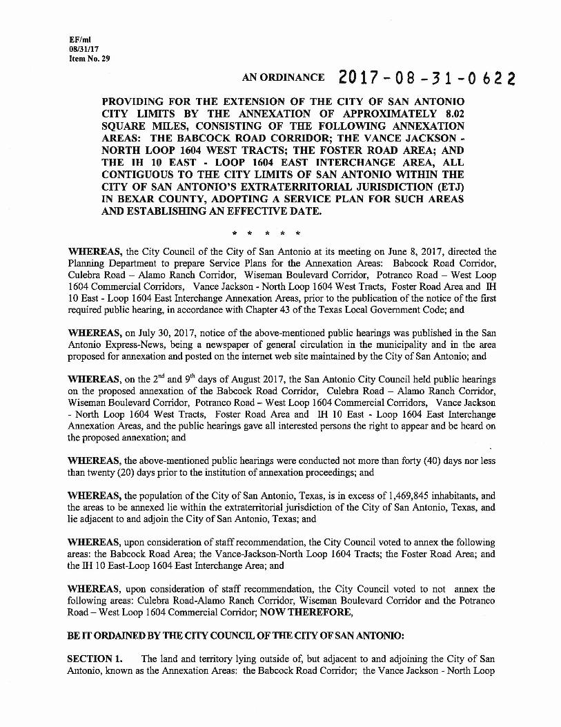
EF/ml 08/31117 Item No. 29 AN ORDINANCE 20 17 - 0 8 - 3 1 - 0 6 2 2 PROVIDING FOR THE EXTENSION OF THE CITY OF SAN ANTONIO CITY LIMITS BY THE ANNEXATION OF APPROXIMATELY 8.02 SQUARE MILES, CONSISTING OF THE FOLLOWING ANNEXATION AREAS: THE BABCOCK ROAD CORRIDOR; THE VANCE JACKSON- NORTH LOOP 1604 WEST TRACTS; THE FOSTER ROAD AREA; AND THE IH 10 EAST - LOOP 1604 EAST INTERCHANGE AREA, ALL CONTIGUOUS TO THE CITY LIMITS OF SAN ANTONIO WITHIN THE CITY OF SAN ANTONIO'S EXTRATERRITORIAL JURISDICTION (ETJ) IN BEXAR COUNTY, ADOPTING A SERVICE PLAN FOR SUCH AREAS AND ESTABLISHING AN EFFECTIVE DATE. * * * * * WHEREAS, the City Council of the City of San Antonio at its meeting on June 8, 2017, directed the Planning Department to prepare Service Plans for the Annexation Areas: Babcock Road Corridor, Culebra Road- Alamo Ranch Corridor, Wiseman Boulevard Corridor, Potranco Road- West Loop 1604 Commercial Corridors, Vance Jackson- North Loop 1604 West Tracts, Foster Road Area and lli 10 East - Loop 1604 East Interchange Annexation Areas, prior to the publication of the notice of the first required public hearing, in accordance with Chapter 43 of the Texas Local Government Code; and WHEREAS, on July 30, 2017, notice of the above-mentioned public hearings was published in the San Antonio Express-News, being a newspaper of general circulation in the municipality and in the area proposed for annexation and posted on the internet web site maintained by the City of San Antonio; and WHEREAS, on the 2"d and 9th days of August 2017, the San Antonio City Council held public hearings on the proposed annexation of the Babcock Road Corridor, Culebra Road - Alamo Ranch Corridor, Wiseman Boulevard Corridor, Potranco Road- West Loop 1604 Commercial Corridors, Vance Jackson - North Loop 1604 West Tracts, Foster Road Area and lli 10 East - Loop 1604 East Interchange Annexation Areas, and the public hearings gave all interested persons the right to appear and be heard on the proposed annexation; and WHEREAS, the above-mentioned public hearings were conducted not more than forty (40) days nor less than twenty (20) days prior to the institution of annexation proceedings; and WHEREAS, the population ofthe City of San Antonio, Texas, is in excess of 1,469,845 inhabitants, and the areas to be annexed lie within the extraterritorial jurisdiction of the City of San Antonio, Texas, and lie adjacent to and adjoin the City of San Antonio, Texas; and WHEREAS, upon consideration of staff recommendation, the City Council voted to annex the following areas: the Babcock Road Area; the Vance-Jackson-North Loop 1604 Tracts; the Foster Road Area; and the lli 10 East-Loop 1604 East Interchange Area; and WHEREAS, upon consideration of staff recommendation, the City Council voted to not annex the following areas: Culebra Road-Alamo Ranch Corridor, Wiseman Boulevard Corridor and the Potranco Road- West Loop 1604 Commercial Corridor; NOW THEREFORE, BE IT ORDAINED BY THE CITY COUNCIL OF THE CITY OF SAN ANTONIO: SECTION 1. The land and territory lying outside of, but adjacent to and adjoining the City of San Antonio, known as the Annexation Areas: the Babcock Road Corridor; the Vance Jackson- North Loop
Transcript of AN ORDINANCE 2 0 1 7 -0 8 - 3 1 -0 6 2 2 PROVIDING FOR THE ...
EF/ml 08/31117 Item No. 29
AN ORDINANCE 2 0 1 7 - 0 8 - 3 1 - 0 6 2 2 PROVIDING FOR THE EXTENSION OF THE CITY OF SAN ANTONIO CITY LIMITS BY THE ANNEXATION OF APPROXIMATELY 8.02 SQUARE MILES, CONSISTING OF THE FOLLOWING ANNEXATION AREAS: THE BABCOCK ROAD CORRIDOR; THE VANCE JACKSONNORTH LOOP 1604 WEST TRACTS; THE FOSTER ROAD AREA; AND THE IH 10 EAST - LOOP 1604 EAST INTERCHANGE AREA, ALL CONTIGUOUS TO THE CITY LIMITS OF SAN ANTONIO WITHIN THE CITY OF SAN ANTONIO'S EXTRATERRITORIAL JURISDICTION (ETJ) IN BEXAR COUNTY, ADOPTING A SERVICE PLAN FOR SUCH AREAS AND ESTABLISHING AN EFFECTIVE DATE.
* * * * * WHEREAS, the City Council of the City of San Antonio at its meeting on June 8, 2017, directed the Planning Department to prepare Service Plans for the Annexation Areas: Babcock Road Corridor, Culebra Road- Alamo Ranch Corridor, Wiseman Boulevard Corridor, Potranco Road- West Loop 1604 Commercial Corridors, Vance Jackson- North Loop 1604 West Tracts, Foster Road Area and lli 10 East - Loop 1604 East Interchange Annexation Areas, prior to the publication of the notice of the first required public hearing, in accordance with Chapter 43 of the Texas Local Government Code; and
WHEREAS, on July 30, 2017, notice of the above-mentioned public hearings was published in the San Antonio Express-News, being a newspaper of general circulation in the municipality and in the area proposed for annexation and posted on the internet web site maintained by the City of San Antonio; and
WHEREAS, on the 2"d and 9th days of August 2017, the San Antonio City Council held public hearings on the proposed annexation of the Babcock Road Corridor, Culebra Road - Alamo Ranch Corridor, Wiseman Boulevard Corridor, Potranco Road- West Loop 1604 Commercial Corridors, Vance Jackson - North Loop 1604 West Tracts, Foster Road Area and lli 10 East - Loop 1604 East Interchange Annexation Areas, and the public hearings gave all interested persons the right to appear and be heard on the proposed annexation; and
WHEREAS, the above-mentioned public hearings were conducted not more than forty ( 40) days nor less than twenty (20) days prior to the institution of annexation proceedings; and
WHEREAS, the population ofthe City of San Antonio, Texas, is in excess of 1,469,845 inhabitants, and the areas to be annexed lie within the extraterritorial jurisdiction of the City of San Antonio, Texas, and lie adjacent to and adjoin the City of San Antonio, Texas; and
WHEREAS, upon consideration of staff recommendation, the City Council voted to annex the following areas: the Babcock Road Area; the Vance-Jackson-North Loop 1604 Tracts; the Foster Road Area; and the lli 10 East-Loop 1604 East Interchange Area; and
WHEREAS, upon consideration of staff recommendation, the City Council voted to not annex the following areas: Culebra Road-Alamo Ranch Corridor, Wiseman Boulevard Corridor and the Potranco Road- West Loop 1604 Commercial Corridor; NOW THEREFORE,
BE IT ORDAINED BY THE CITY COUNCIL OF THE CITY OF SAN ANTONIO:
SECTION 1. The land and territory lying outside of, but adjacent to and adjoining the City of San Antonio, known as the Annexation Areas: the Babcock Road Corridor; the Vance Jackson- North Loop

Page2 Item No. 29
1604 West Tracts; the Foster Road Area; and the lli 10 East -Loop 1604 East Interchange Area, more generally described in the map in EXHffiiT "A," attached hereto and incorporated herein verbatim for all purposes, is hereby added and annexed to the City of San Antonio, Texas, and said territory as described shall hereafter be included within the boundary limits of said city, and the present boundary limits of said city, at the various points contiguous to the area described in EXHffiiT "B," are altered and amended so as to include said area within the corporate limits ofthe City of San Antonio, Texas.
SECTION 2. The land and territory, known as the Annexation Areas: the Babcock Road Corridor; the Vance Jackson- North Loop 1604 West Tracts; the Foster Road Area; and the lli 10 East- Loop 1604 East Interchange Area, save and except those properties that are the subject of a development agreement between the City of San Antonio and property owners incorporated herein for all purposes described in EXHffiiTS "C," "C-1" and "C-2" shall be a part of the City of San Antonio, Texas and the property, the residents and landowners thereof shall be subject to and enjoy the rights conferred by Chapter 43 of the Texas Local Government Code and the provisions of this ordinance.
SECTION 3. Service plans applicable to the properties described in EXHffiiT "A," are hereby adopted and the implementation of said plans are hereby authorized. Such plans are attached hereto and incorporated herein verbatim for all purposes as EXHffiiT "D."
SECTION 4. In accordance with Section 35-307(a) of the City of San Antonio Unified Development Code, the subject properties shall be zoned by separate ordinance and the assigned zoning districts will become effective upon annexation. The City Council hereby directs its staff to conduct a more in depth analysis and review of the subject area in order to determine if a more particularized zoning designation should apply to certain properties within the subject annexation area.
SECTION 5. The City Council hereby waives for a period of 90 days from the effective date of this ordinance, planning and zoning application fees as well as the fees and costs authorized in the San Antonio City Code, Chapter 35, Appendix C, Section 35-C-1 02 for the registration of legal nonconforming rights for properties within the newly annexed area listed and depicted in EXHffiiT "A."
SECTION6. This Ordinance shall be effective November 27, 2017.
PASSED AND APPROVED on this 31st day of August, 2017.
M A Y 0 R Ron Nirenberg
APPROVE~S TO FORM·:
) L~l£0 drew Segovia, City Attorney

Page 3 Item No. 29
Exhibit A Map

Page 4 Item No. 29

Page 5 Item No. 29

Page 6 Item No. 29

Page 7 Item No. 29

Page 8 Item No. 29
Exhibit B Metes and Bounds
Babcock Road Corridor Beginning at the intersection of the northern city limit line and its intersection with northwest property line of CB 4726 P-14 ABS: 177 for a Point of Beginning; Thence, following in an easterly direction the northern city limit property line of CB 4726 P-14 ABS: 177 to its intersection with the northwestern property line of CB 4726 P-3C (5.93 AC) & P-15 (3.682 AC) ABS 177; Thence, following in an easterly direction the northern city limit property line of CB 4726 P-3C (5.93 AC) & P-15 (3.682 AC) ABS 177 to its intersection with the northwestern property line of CB 4726 P-15C (3.682 AC) & P-15D (2.757 AC) ABS 177; Thence, following in an easterly direction the northern city limit property line of CB 4726 P-15C (3.682 AC) & P-15D (2.757 AC) ABS 177 to its intersection with the northwestern property line of CB 4726 P-3 ABS 177; Thence, following in an easterly direction the northern city limit property line of CB 4726 P-3 ABS 177 to its intersection with the northwestern property line of CB 4726 P-4C ABS 177; Thence, following in an easterly direction the northern city limit line along CB 4726 P-4C ABS 177 to its intersection with the northwestern property line of NCB 18334 LOT P-3A 4.7111 CB 4727 P-3A ABS 672 4.2289 CB 4726 P-4A ABS 177 1.5370; Thence, following in an easterly direction the northern city limit line along through NCB 18334 LOT P-3A 4.7111 CB 4727 P-3A ABS 672 4.2289 CB 4726 P-4A ABS 177 1.5370 to its northeastern corner of property line; Thence, following in a southerly direction the east city limit line along NCB 18334 LOT P-3A 4.7111 CB 4727 P-3A ABS 672 4.2289 CB 4726 P-4A ABS 177 1.5370 to its intersection with the northeastern property line along NCB 18334 (& CB 4726) BLK 1 LOT 2 (OCHO RIOS); Thence, following in a southerly direction the east city limit line through NCB 18334 (& CB 4726) BLK 1 LOT 2 (OCHO RIOS) to its intersection directly across to the north right-of-way Heuermann Road; Thence, following in a southwesterly direction along the north right-of-way city limit line of Heuermann Road to its intersection with the north right-of-way intersection with Babcock Road; Thence, following in a southerly direction along the north right-of-way city limit line of Babcock Road to its intersection with the southeastern city limit line along the property line of NCB 14736 BLK LOT TR-D3 & E1, CB 4548 P-1C, P-5E, P-6A P-7B, P-8A & CB 4722 P-2;

Page 9 Item No. 29
Thence, following in a westerly direction along the city limit line along the south property line of NCB 14736 BLK LOT TR-D3 & E1, CB 4548 P-1C, P-5E, P-6A P-7B, P-8A & CB 4722 P-2 to its southeastern corner of property line; Thence, following in a northerly direction along the city limit line along the west property line of NCB 14736 BLK LOT TR-D3 & E1, CB 4548 P-1C, P-5E, P-6A P-7B, P-8A & CB 4722 P-2 to its northeastern corner of property line; Thence, following in a westerly direction the city limit line along the south property line of CB 4548 P-5A ABS 1226 to its intersection with the southeastern property line along the city limit line of CB 4565 P-3A (17.5255), P-3B(.552), P-3C (11.14), CB 4547 P-1A (3.84), CB 4549 P-1E (20.803), P-4 (45.8693),CB 4552 P-2J (76.0282), CB 4550 P-1C (3.8); Thence, following in a southwesterly direction the city limit line along the south property line of CB 4565 P-3A (17.5255), P-3B(.552), P-3C (11.14), CB 4547 P-1A (3.84), CB 4549 P-1E (20.803), P-4 (45.8693),CB 4552 P-2J (76.0282), CB 4550 P-1C (3.8) to the southwest corner; Thence, following the south property line of CB 4565 P-3A (17.5255), P-3B(.552), P-3C (11.14), CB 4547 P-1A (3.84), CB 4549 P-1E (20.803), P-4 (45.8693),CB 4552 P-2J (76.0282), CB 4550 P-1C (3.8) in a westerly direction to its intersection with the city limit line and its intersection with the north right-of-way of Kyle Seale Road; Thence, following in a northeasterly direction the city limit line along the north property line of CB 4565 P-3A (17.5255), P-3B(.552), P-3C (11.14), CB 4547 P-1A (3.84), CB 4549 P-1E (20.803), P-4 (45.8693),CB 4552 P-2J (76.0282), CB 4550 P-1C (3.8) in a northern direction to its intersection with the city limit line along the west property line of CB 4552 P-2A (NON ADJ REMAINS); Thence, following in a northerly direction the city limit line along the west property line of CB 4552 P-2A (NON ADJ REMAINS) in a northerly direction to its intersection with the west property line CB 4565 P-3A (17.5255), P-3B(.552), P-3C (11.14), CB 4547 P-1A (3.84), CB 4549 P-1E (20.803), P-4 (45.8693),CB 4552 P-2J (76.0282), CB 4550 P-1C (3.8); Thence, following in a northerly direction the city limit line along the west property line of CB 4565 P-3A (17.5255), P-3B (.552), P-3C (11.14), CB 4547 P-1A (3.84), CB 4549 P-1E (20.803), P-4 (45.8693), CB 4552 P-2J (76.0282), CB 4550 P-1C (3.8) to its intersection with the southwest corner of property line CB 4549C (SONOMA VERDE UT-4), BLOCK 18 LOT 53; Thence, following the south property line of CB 4549C (SONOMA VERDE UT-4), BLOCK 18 LOT 53 in a easterly direction to its intersection with the southwest corner of property line of CB 4549C (SONOMA VERDE UT-4), BLOCK 18 LOT 54; Thence, following the south property line of CB 4549C (SONOMA VERDE UT-4), BLOCK 18 LOT 54 in a easterly direction to its intersection with the southwest corner of property line of CB 4549C (SONOMA VERDE UT-4), BLOCK 22 LOT 100 (PRIVATE STREET); Thence, following the south property line of CB 4549C (SONOMA VERDE UT-4), BLOCK 22 LOT 100 (PRIVATE STREET) in a easterly direction to its intersection with the southwest

Page 10 Item No. 29
corner of property line of CB 4549C (SONOMA VERDE UT-4), BLOCK 16 LOT NE IRR 80.32 FT OF 121(GREEN SPACE); Thence, following the south property line of CB 4549C (SONOMA VERDE UT-4), BLOCK 16 LOT NE IRR 80.32 FT OF 121(GREEN SPACE) in a easterly direction to its intersection with the west property line of CB 4548 P-5A ABS 1226; Thence, following the west property line of CB 4548 P-5A ABS 1226 in a northerly direction to its intersection with the southwest corner of property line NCB 14736 BLK LOT TR-D3 & E1, CB 4548 P-1C, P-5E, P-6A P-7B, P-8A & CB 4722 P-2; Thence, following the west property line of NCB 14736 BLK LOT TR-D3 & E1, CB 4548 P-1C, P-5E, P-6A P-7B, P-8A & CB 4722 P-2 in a northerly direction to its intersection with the south corner of property line CB 4548 P-5B ABS 1226 (31.15) & P-7 (39.42) NON-ADJ RMS, GIS 70.57 AC; Thence, following the west property line of CB 4548 P-5B ABS 1226 (31.15) & P-7 (39.42) NON-ADJ RMS, GIS 70.57 AC in a northerly direction to its intersection with the west of property line CB 4719 P-1F (27.9911 AC), P-3 (4.9739 AC) ABS 521& CB 4720 P-1J (1.903 AC), P-1K (1.41 AC) ABS 521; Thence, following the west property line of CB 4719 P-1F (27.9911 AC), P-3 (4.9739 AC) ABS 521& CB 4720 P-1J (1.903 AC), P-1K (1.41 AC) ABS 521 in a northerly direction to its intersection with the west of property line CB 4719 P-1E (.5225 AC), P-3B (20.7475 C); Thence, following the west property line of CB 4719 P-1E (.5225 AC), P-3B (20.7475 C) in a northwesterly direction to its intersection with the west of property line CB 4718 P-2A EXC NE 364.58 FT X 324.28 FT (NON ADJ REMAINS); Thence, following the west property line of CB 4718 P-2A EXC NE 364.58 FT X 324.28 FT (NON ADJ REMAINS) in a northerly direction to the city limit line along to its intersection with the CB 4721A (CST STORE # 1088), BLOCK 1 LOT 2; Thence, following the west property line of CB 4721A (CST STORE # 1088), BLOCK 1 LOT 2 in a northerly direction to its intersection with the south right-of-way of Babcock Road; Thence, following the west property line of NCB 18335 P-3 (14.471AC), P-3A (17.632AC), P-10A (5.054AC), CB 4716 P-1 (9.325 AC), P-3 (17.476AC), P-5 (22.729AC) ABS 947, CB 4717 P-3 (26.52AC) ABS 728, CB 4718 P-1 (12.653) ABS 215, CB 4719 P-5 (12.306AC) ABS 521, CB 4726 P-5B (19.457AC) ABS 177 in a northwesterly direction along the south right-of-way of Babcock Road; Thence, following in a northwesterly direction along the south right-of-way of Babcock Road to its intersection with the southwest corner of NCB 18335 LOT P-1C (14.283AC) P-1D (40.316AC), P-1E (.011AC) P-3B (.249), P-3C;
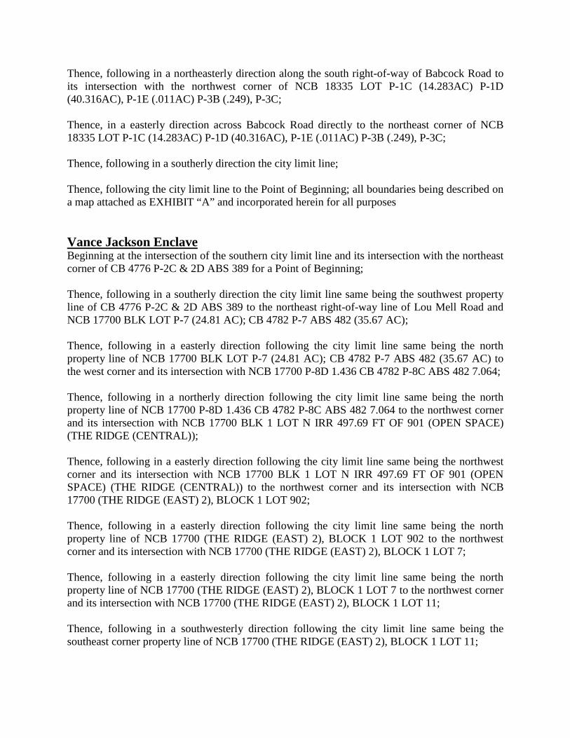
Page 11 Item No. 29
Thence, following in a northeasterly direction along the south right-of-way of Babcock Road to its intersection with the northwest corner of NCB 18335 LOT P-1C (14.283AC) P-1D (40.316AC), P-1E (.011AC) P-3B (.249), P-3C; Thence, in a easterly direction across Babcock Road directly to the northeast corner of NCB 18335 LOT P-1C (14.283AC) P-1D (40.316AC), P-1E (.011AC) P-3B (.249), P-3C; Thence, following in a southerly direction the city limit line; Thence, following the city limit line to the Point of Beginning; all boundaries being described on a map attached as EXHIBIT “A” and incorporated herein for all purposes Vance Jackson Enclave Beginning at the intersection of the southern city limit line and its intersection with the northeast corner of CB 4776 P-2C & 2D ABS 389 for a Point of Beginning; Thence, following in a southerly direction the city limit line same being the southwest property line of CB 4776 P-2C & 2D ABS 389 to the northeast right-of-way line of Lou Mell Road and NCB 17700 BLK LOT P-7 (24.81 AC); CB 4782 P-7 ABS 482 (35.67 AC); Thence, following in a easterly direction following the city limit line same being the north property line of NCB 17700 BLK LOT P-7 (24.81 AC); CB 4782 P-7 ABS 482 (35.67 AC) to the west corner and its intersection with NCB 17700 P-8D 1.436 CB 4782 P-8C ABS 482 7.064; Thence, following in a northerly direction following the city limit line same being the north property line of NCB 17700 P-8D 1.436 CB 4782 P-8C ABS 482 7.064 to the northwest corner and its intersection with NCB 17700 BLK 1 LOT N IRR 497.69 FT OF 901 (OPEN SPACE) (THE RIDGE (CENTRAL)); Thence, following in a easterly direction following the city limit line same being the northwest corner and its intersection with NCB 17700 BLK 1 LOT N IRR 497.69 FT OF 901 (OPEN SPACE) (THE RIDGE (CENTRAL)) to the northwest corner and its intersection with NCB 17700 (THE RIDGE (EAST) 2), BLOCK 1 LOT 902; Thence, following in a easterly direction following the city limit line same being the north property line of NCB 17700 (THE RIDGE (EAST) 2), BLOCK 1 LOT 902 to the northwest corner and its intersection with NCB 17700 (THE RIDGE (EAST) 2), BLOCK 1 LOT 7; Thence, following in a easterly direction following the city limit line same being the north property line of NCB 17700 (THE RIDGE (EAST) 2), BLOCK 1 LOT 7 to the northwest corner and its intersection with NCB 17700 (THE RIDGE (EAST) 2), BLOCK 1 LOT 11; Thence, following in a southwesterly direction following the city limit line same being the southeast corner property line of NCB 17700 (THE RIDGE (EAST) 2), BLOCK 1 LOT 11;

Page 12 Item No. 29
Thence, following in a southwesterly direction following the city limit line same being the south property line of NCB 17700 (THE RIDGE (EAST) 2), BLOCK 1 LOT 11 to the southeast corner and its intersection with NCB 17700 (THE RIDGE (EAST) 2), BLOCK 1 LOT 7; Thence, following in a southwesterly direction following the city limit line same being the south property line of NCB 17700 (THE RIDGE (EAST) 2), BLOCK 1 LOT 7 to the southeast corner and its intersection with NCB 17700 (THE RIDGE (EAST) 2), BLOCK 1 LOT 902; Thence, following in a southwesterly direction following the city limit line same being the south property line of NCB 17700 (THE RIDGE (EAST) 2), BLOCK 1 LOT 902 to the southeast corner and its intersection with NCB 17700 BLK 1 LOT N IRR 497.69 FT OF 901 (OPEN SPACE) (THE RIDGE (CENTRAL)); Thence, following in a southwesterly direction following the city limit line same being the south property line of NCB 17700 BLK 1 LOT N IRR 497.69 FT OF 901 (OPEN SPACE) (THE RIDGE (CENTRAL)) to the southeast corner and its intersection with NCB 17700 P-8D 1.436 CB 4782 P-8C ABS 482 7.064; Thence, following in a southwesterly direction following the city limit line same being the south property line of NCB 17700 P-8D 1.436 CB 4782 P-8C ABS 482 7.064 to the southeast corner and its intersection with NCB 17700 BLK LOT P-7 (24.81 AC); CB 4782 P-7 ABS 482 (35.67 AC); Thence, following in a southwesterly direction following the city limit line same being the south property line of NCB 17700 BLK LOT P-7 (24.81 AC); CB 4782 P-7 ABS 482 (35.67 AC) to the southeast corner and its intersection with CB 4782 P-7G ABS 482; Thence, following in a southwesterly direction following the city limit line to the southwest corner of NCB 14852 BLK 1 LOT 2 (SCHOENFELD COM'L SUBD) **S IRR 500 FT INSIDE CITY SA **; Thence, following in a southwesterly direction following the city limit line to the southeast corner of NCB 14852 BLK 1 LOT 2 (SCHOENFELD COM'L SUBD) **S IRR 500 FT INSIDE CITY SA **; Thence, following the city limit line to the Point of Beginning; all boundaries being described on a map attached as EXHIBIT “A” and incorporated herein for all purposes. ****************************************************************************** Beginning at the intersection of the southern city limit line and its intersection with the northwest corner of NCB 14852 P-4(4.695AC), P-4B (.212 AC), P-4D (1.625AC), P-4E (.255AC), CB 4776 P-4 (.301 AC) & P-4C (4.042AC) ABS 398 LABEL#TEX0203705 for a Point of Beginning; Thence, following the city limit line same being the property line of NCB 14852 P-4(4.695AC), P-4B (.212 AC), P-4D (1.625AC), P-4E (.255AC), CB 4776 P-4 (.301 AC) & P-4C (4.042AC) ABS 398 LABEL#TEX0203705;

Page 13 Item No. 29
Thence, following the city limit line to the Point of Beginning; all boundaries being described on a map attached as EXHIBIT “A” and incorporated herein for all purposes. Foster Road Enclave Beginning at the intersection of the southern city limit line and its intersection with east right-of-way line of Darker-Converse Road for a Point of Beginning; Thence, following in a southerly direction the east right-of-way line of NCB 17995 P-4, 6A, 7, 7A, 7B, 7C, 7D, 7E, 7F, 13, 13A, 13B, 13C, 20 NCB 17994 BLK TR-A, B, C,C1, P-11, 11A, & LOT 36 CB 5100 P-3, 4, 13, 13A, 20, 24A, 25D, & 26A ABS 665 to its intersection with the eastern property line of CB 5973A BLK 1 LOT 1 (BEXAR COUNTY JR LIVESTOCK SHOW) & P-100; Thence, following in a southerly direction the east right-of-way line of CB 5973A BLK 1 LOT 1 (BEXAR COUNTY JR LIVESTOCK SHOW) & P-100 to its intersection with the eastern property line of CB 5100 BLK 665 LOT P 14 & P 14A; Thence, following in a southerly direction the east right-of-way line of CB 5100 BLK 665 LOT P 14 & P 14A to its intersection with the eastern property line of CB 5100 P-15 ABS 665; Thence, following in a westerly direction the south right-of-way line of CB 5100 P-15 ABS 665 to its intersection with the western property line of CB 5100 BLK 665 LOT P 14 & P 14A; Thence, following in a westerly direction the south right-of-way line of CB 5100 BLK 665 LOT P 14 & P 14A to its intersection with the western property line of CB 5973A BLK 1 LOT 1 (BEXAR COUNTY JR LIVESTOCK SHOW) & P-100 Thence, following in a westerly direction the south right-of-way line of CB 5973A BLK 1 LOT 1 (BEXAR COUNTY JR LIVESTOCK SHOW) & P-100 to its intersection with the southwestern property line of NCB 17995 P-4, 6A, 7, 7A, 7B, 7C, 7D, 7E, 7F, 13, 13A, 13B, 13C, 20 NCB 17994 BLK TR-A, B, C,C1, P-11, 11A, & LOT 36 CB 5100 P-3, 4, 13, 13A, 20, 24A, 25D, & 26A ABS 665 Thence, following in a northerly direction the west property line of NCB 17995 P-4, 6A, 7, 7A, 7B, 7C, 7D, 7E, 7F, 13, 13A, 13B, 13C, 20 NCB 17994 BLK TR-A, B, C,C1, P-11, 11A, & LOT 36 CB 5100 P-3, 4, 13, 13A, 20, 24A, 25D, & 26A ABS 665 to its northeast corner Thence, following in a westerly direction the south property line of NCB 17995 P-4, 6A, 7, 7A, 7B, 7C, 7D, 7E, 7F, 13, 13A, 13B, 13C, 20 NCB 17994 BLK TR-A, B, C,C1, P-11, 11A, & LOT 36 CB 5100 P-3, 4, 13, 13A, 20, 24A, 25D, & 26A ABS 665 to its intersection with the to the north right-of-way line of Kiefer Road; Thence, following in a westerly direction across the south right-of-way line of CB 5973 BLK LOT 59 (GARDENDALE COMMUNITY CNTR) across the intersection of Kiefer Road to the southeast intersection of CB 5100 P-27A ABS 665 PT OF RAILROAD;

Page 14 Item No. 29
Thence, following in a westerly direction the south right-of-way line of CB 5100 P-27A ABS 665 PT OF RAILROAD to its intersection with the western property line of NCB 5875 BLK LOT E TRI 649 FT OF 24 ARB 24C; Thence, following in a westerly direction the south right-of-way line of NCB 5875 BLK LOT E TRI 649 FT OF 24 ARB 24C to its intersection with the western property line of NCB 5875 BLK LOT E IRR 904.34FT OF W 954.34FT OF 24 ARB 24E; Thence, following in a westerly direction the south right-of-way line of NCB 5875 BLK LOT E IRR 904.34FT OF W 954.34FT OF 24 ARB 24E to its intersection with the western property line of NCB 5875 BLK LOT SW 50 X 118 OF 24 ARB 24D; Thence, following in a westerly direction the south right-of-way line of NCB 5875 BLK LOT SW 50 X 118 OF 24 ARB 24D to its intersection with the eastern property line of CB 5875 BLK LOT 23A AND 21A; Thence, following in a westerly direction the south right-of-way line of CB 5875 BLK LOT 23A AND 21A to its intersection with the eastern property line of CB 5875 BLK LOT S IRR 137.54 FT OF 21A & S 100 FT OF W 59 FT OF 23A; Thence, following in a westerly direction the south right-of-way line of CB 5875 BLK LOT S IRR 137.54 FT OF 21A & S 100 FT OF W 59 FT OF 23A to its intersection with the eastern property line of CB 5875 BLK LOT PT, OF 20, 21 AND 23; Thence, following in a westerly direction the south right-of-way line of CB 5875 BLK LOT PT, OF 20, 21 AND 23 to its intersection with the eastern property line of CB 5875 BLK LOT S TRI 248.74FT OF 21 P-5A; Thence, following in a westerly direction the south right-of-way line of CB 5875 BLK LOT S TRI 248.74FT OF 21 P-5A to its intersection with the eastern property line of CB 5875 BLK LOT 20A P-5; Thence, following in a westerly direction the south right-of-way line of CB 5875 BLK LOT 20A P-5 to its intersection with the eastern property line of CB 5875 BLK LOT W 100 FT OF S PT OF 20 (P-6); Thence, following in a westerly direction the south right-of-way line of CB 5875 BLK LOT W 100 FT OF S PT OF 20 (P-6) to its intersection with the eastern property line of CB 5875 BLK LOT P-100; Thence, following in a northwesterly direction the south right-of-way line of CB 5875 BLK LOT P-100 to its intersection with the southeastern right-of-way property line of CB 5875 BLK LOT 17; Thence, following in a northwesterly direction the southwest right-of-way line of CB 5875 BLK LOT 17 to its intersection with the southwestern property line of CB 5875 BLK LOT 14A 15A 16A;

Page 15 Item No. 29
Thence, following in a northwesterly direction the southwest right-of-way line of CB 5875 BLK LOT 14A 15A 16A to its intersection with the southeastern property line of CB 5875 BLK LOT 13 NO LABEL# OR SERIAL#; Thence, following in a northerly direction the southwest right-of-way line of CB 5875 BLK LOT 13 NO LABEL# OR SERIAL# to its intersection with the southwestern property line of CB 5875 BLK LOT 12 NO LABEL# OR SERIAL#; Thence, following in a northerly direction the southwest right-of-way line of CB 5875 BLK LOT 12 NO LABEL# OR SERIAL# to its intersection with the southwestern property line of CB 5875 BLK LOT 10 AND 11; Thence, following in a northwesterly direction the southwest right-of-way line of CB 5875 BLK LOT 10 AND 11 to its intersection with the southeastern property line of CB 5875 BLK LOT 9, & E 40.26 FT OF 8; Thence, following in a northwesterly direction the southwest right-of-way line of CB 5875 BLK LOT 9, & E 40.26 FT OF 8 to its intersection with the southeastern property line of CB 5875 BLK LOT S 616.6 FT OF W 80 FT OF 8; Thence, following in a northwesterly direction the southwest right-of-way line of CB 5875 BLK LOT S 616.6 FT OF W 80 FT OF 8 to its intersection with the southeastern property line of CB 5875 LOTS 6 & 7 NO LABEL# OR SERIAL#; Thence, following in a northwesterly direction the southwest right-of-way line of CB 5875 LOTS 6 & 7 NO LABEL# OR SERIAL# to its intersection with the southeastern property line of CB 5875 BLK LOT S IRR 18.9FT OF 5; Thence, following in a northwesterly direction the southwest right-of-way line of CB 5875 BLK LOT S IRR 18.9FT OF 5 to its intersection with the southeastern property line of CB 5875 BLK LOT SW IRR 478.16 FT OF 5 LABEL#PFS0805746/7; Thence, following in a northwesterly direction the southwest right-of-way line of CB 5875 BLK LOT SW IRR 478.16 FT OF 5 LABEL#PFS0805746/7 to its intersection with the southeastern property line of CB 5875 BLK LOT N IRR 15FT OF 5; Thence, following in a northwesterly direction the southwest right-of-way line of CB 5875 BLK LOT N IRR 15FT OF 5 to its intersection with the southeastern property line of CB 5875B BLK LOT 25 (FOSTER PLACE SUBD); Thence, following in a southerly direction the east right-of-way line of CB 5098 P-47 ABS 743 to its intersection with the northeastern property line of CB 5097 P-34 ABS 190 42.049 CB 5128 P-2 ABS 489-27.48 AC; Thence, following in a southerly direction the east right-of-way line of CB 5097 P-34 ABS 190 42.049 CB 5128 P-2 ABS 489-27.48 AC to its intersection with the northeastern property line of CB 5128 P-4 ABS 489;

Page 16 Item No. 29
Thence, following in a southerly direction the east right-of-way line of CB 5128 P-4 ABS 489 to its intersection with the northeastern property line of CB 5128 P-7 ABS 489; Thence, following in a southerly direction the east right-of-way line of CB 5128 P-7 ABS 489 to its intersection with the northeastern property line of CB 5132F LOT 1 CB 5132J LOT 3-5,& 9-11,W 50'OF 1,& N IRR 79.97'OF 2,S 80'OF 6 ETC; Thence, following in a southerly direction the east right-of-way line of CB 5132F LOT 1 CB 5132J LOT 3-5, & 9-11, W 50'OF 1, & N IRR 79.97'OF 2, S 80'OF 6 ETC to its intersection with the northeastern property line of CB 5132J LOT 7, & N 80' OF 6, & S 69.35 FT OF 8; Thence, following in a southerly direction the east right-of-way line of CB 5132J LOT 7, & N 80' OF 6, & S 69.35 FT OF 8 to its intersection with the northeastern property line of CB 5132F LOT 1 CB 5132J LOT 3-5,& 9-11,W 50'OF 1,& N IRR 79.97'OF 2,S 80'OF 6 ETC; Thence, following in a southerly direction the east right-of-way line of CB 5132F LOT 1 CB 5132J LOT 3-5,& 9-11,W 50'OF 1,& N IRR 79.97'OF 2,S 80'OF 6 ETC to its intersection with the northeastern property line of CB 5132J BLK LOT E 320.16 FT OF S 80.3 FT OF 2 HIGH POINT UNIT -1; Thence, following in a southerly direction the east right-of-way line of CB 5132J BLK LOT E 320.16 FT OF S 80.3 FT OF 2 HIGH POINT UNIT-1 to its intersection with the northeastern property line of CB 5132J BLK LOT E 494.55 FT OF 1 HIGH POINT UNIT-1; Thence, following in a southerly direction the east right-of-way line of CB 5132J BLK LOT E 494.55 FT OF 1 HIGH POINT UNIT-1 to its intersection with the northeastern property line of CB 5132G BLK 1 LOT 1 REDI-STRIP SUBD; Thence, following in a southerly direction the east right-of-way line of CB 5132G BLK 1 LOT 1 REDI-STRIP SUBD to its intersection with the northeastern property line of CB 5132G BLK 1 LOT 1 REDI-STRIP SUBD; Thence, following in a southerly direction the east right-of-way line of CB 5132G BLK 1 LOT 1 REDI-STRIP SUBD to the north right-of-way line of US Hwy 87; Thence, following in a westerly direction the north right-of-way line of US Hwy 87 to its intersection with the city limit line; Thence, following the city limit line to the Point of Beginning; all boundaries being described on a map attached as EXHIBIT “A” and incorporated herein for all purposes. IH 10 East-Loop 1604 East Interchange Area Beginning at the intersection of the southern city limit line and its intersection with southeast property line of NCB 18226 TR-10 (4.932AC) CB 5934A TR-10 (.239AC) for a Point of Beginning; Thence, following in a southwesterly direction the southeastern property line of NCB 18226 TR-10 (4.932AC) CB 5934A TR-10 (.239AC) to the intersection with the southeast property line of

Page 17 Item No. 29
NCB 18226 P-9(3.47AC), P-22(2.171AC) & CB 5083 P-9(3.861AC), P-21 ABS 828 NON-ADJACENT REMAINS REFER TO: 05083-000-0090, & P-22(9.829AC); Thence, following in a southwesterly direction the southwest property line of NCB 18226 P-9(3.47AC), P-22(2.171AC) & CB 5083 P-9(3.861AC), P-21 ABS 828 NON-ADJACENT REMAINS REFER TO: 05083-000-0090, & P-22(9.829AC) to its intersection with the northeast property line of CB 5083A (MOODY GRAYTOWN), BLOCK 1 LOT 4 & CB 5083 P-2G ABS 828; Thence, following in a southwesterly direction the southwest property line of CB 5083A (MOODY GRAYTOWN), BLOCK 1 LOT 4 & CB 5083 P-2G ABS 828 to its intersection with the southeast property line of CB 5083 P-10 ABS 828; Thence, following in a southwesterly direction the southwest property line of CB 5083 P-10 ABS 828 to its intersection with the southeast property line of CB 5083 P-11 ABS 828; Thence, following in a southwesterly direction the southwest property line of CB 5083 P-11 ABS 828 to its intersection with the southeast property line of CB 5083 P-19A ABS 828 NON-ADJACENT; Thence, following in a southwesterly direction the southwest property line of CB 5083 P-19A ABS 828 NON-ADJACENT to its intersection with the east property line of CB 5083 P-12F ABS 828; Thence, following in a southwesterly direction the southeast property line of CB 5083 P-12F ABS 828 to its intersection with the southeast property line of CB 5083 P-12E ABS 828; Thence, following in a southwesterly direction the southwest property line of CB 5083 P-12E ABS 828 to its intersection with the southeast property line of CB 5083 P-19A ABS 828 NON-ADJACENT; Thence, following in a southwesterly direction the southwest property line of CB 5083 P-19A ABS 828 NON-ADJACENT to its intersection with the southeast property line of CB 5088 P-22 ABS 308; Thence, following in a southwesterly direction the southwest property line of CB 5088 P-22 ABS 308 to its intersection with the southeast property line of CB 5088 P-21A ABS 308; Thence, following in a southwesterly direction the southwest property line of CB 5088 P-21A ABS 308 to its intersection with the southeast property line of CB 5088 P-21 ABS 308 (FORMERLY P-6A REASSIGNED); Thence, following in a southwesterly direction the southwest property line of CB 5088 P-21 ABS 308 (FORMERLY P-6A REASSIGNED) to its intersection with the southeast property line of CB 5088 P-6C (0.434 AC) & P-21C (0.276 AC) ABS 308;

Page 18 Item No. 29
Thence, following in a southwesterly direction the southwest property line of CB 5088 P-6C (0.434 AC) & P-21C (0.276 AC) ABS 308 to its intersection with the southeast property line of CB 5088 P-6D ABS 308 LABEL #RAD0901294/RAD0901293; Thence, following in a southwesterly direction the southwest property line of CB 5088 P-6D ABS 308 LABEL #RAD0901294/RAD0901293 to its intersection with the southeast property line of CB 5088A BLK LOT 1 RADTKE SUBD; Thence, following in a southwesterly direction the southwest property line of CB 5088A BLK LOT 1 RADTKE SUBD to its intersection with the southeast property line of CB 5088 P-28 ABS 308 (FORMERLY P-6); Thence, following in a southwesterly direction the southwest property line of CB 5088 P-28 ABS 308 (FORMERLY P-6) to its intersection with the southeast property line of CB 5088 P-7 ABS 308 TITLE #84788700; Thence, following in a southwesterly direction the southwest property line of CB 5088 P-7 ABS 308 TITLE #84788700 to its intersection with the southeast property line of CB 5088 P-7A ABS 308 NON ADJ RMNS; Thence, following in a northwesterly direction the west property line of CB 5088 P-7A ABS 308 NON ADJ RMNS to its intersection with the southwest property line of CB 5088 P-6B (TR-2) ABS 308; Thence, following in a northwesterly direction the west property line of CB 5088 P-6B (TR-2) ABS 308 to its intersection with the southeast property line of NCB 18225 LOT P-13 1.529 CB 5083 P-13 ABS 828 63.571 CB 5088 P-5 ABS 308 86.81; Thence, following in a northwesterly direction the west property line of NCB 18225 LOT P-13 1.529 CB 5083 P-13 ABS 828 63.571 CB 5088 P-5 ABS 308 86.81 to its intersection with the southeast property line of CB 5088 P-8A ABS 308 CB 5107 P-3A ABS 580 NON ADJ RMNS; Thence, following in a southerly direction the southwest property line of CB 5088 P-8A ABS 308 CB 5107 P-3A ABS 580 NON ADJ RMNS to its intersection with the southeast property line of CB 5088 P-10 (98.469 AC), P-11B (0.425 AC) & P-12E (0.73 AC) ABS 308; Thence, following in a northwesterly direction the southwest property line of CB 5088 P-10 (98.469 AC), P-11B (0.425 AC) & P-12E (0.73 AC) ABS 308 to its intersection with the southeast property line of CB 5088 P-12D ABS 308; Thence, following in a northwesterly direction the southwest property line of CB 5088 P-12D ABS 308 to its intersection with the northeast property line of CB 5089 P-22L, 22M, 40A, 41, 42 ABS 45 & NCB 16567 P-22M; Thence, following in a southerly direction the east property line of CB 5089 P-22L, 22M, 40A, 41, 42 ABS 45 & NCB 16567 P-22M to its intersection with the northeast property line of CB 5089 P-22A & P-40 ABS 45;

Page 19 Item No. 29
Thence, following in a southerly direction the east property line of CB 5089 P-22A & P-40 ABS 45 to its intersection with the northeast property line of CB 5089 P-22J ABS 45; Thence, following in a southerly direction the southeast property line of CB 5089 P-22J ABS 45 to its intersection with the southeast property line of CB 5089 P-22K ABS 45; Thence, following in a northwesterly direction the southeast property line of CB 5089 P-22K ABS 45 to its intersection with the southeast property line of CB 5089 P-22L, 22M, 40A, 41, 42 ABS 45 & NCB 16567 P-22M; Thence, following in a northwesterly direction the southeast property line of CB 5089 P-22L, 22M, 40A, 41, 42 ABS 45 & NCB 16567 P-22M to its intersection with the southeast property line of NCB 16567 P-21 (17.56AC) CB 5089 P-21 (66.6172AC) REFER TO: 05089-000-0210; Thence, following in a northwesterly direction the southeast property line of NCB 16567 P-21 (17.56AC) CB 5089 P-21 (66.6172AC) REFER TO: 05089-000-0210 to its intersection with the southeast property line of CB 5089 P21A ABS: 45; Thence, following in a northwesterly direction the southeast property line of CB 5089 P21A ABS: 45 to its intersection with the southeast property line of CB 5089 P-21B ABS: 45; Thence, following in a northwesterly direction the southeast property line of CB 5089 P-21B ABS: 45 to its intersection with the southeast property line of NCB 16564(5089) BLK 7 LOT 4 (RUSH ENTERPRISES SERVICE CENTER SUBD); Thence, following in a northwesterly direction the southeast property line of NCB 16564(5089) BLK 7 LOT 4 (RUSH ENTERPRISES SERVICE CENTER SUBD) to its intersection with the southeast property line of NCB 16567 P-20 (.43) CB 5089 P-20 (4.499) ABS 45; Thence, following in a northwesterly direction the southeast property line of NCB 16567 P-20 (.43) CB 5089 P-20 (4.499) ABS 45 to its intersection with the with the city limit line; Thence, following the city limit line to the Point of Beginning; all boundaries being described on a map attached as EXHIBIT “A” and incorporated herein for all purposes.

Page 20 Item No. 29
Exhibit C Annexation Area Development Agreements,
Development Agreement List and Map of Development Agreements
NOTICE OF CONFIDENTIALITY RIGHTS: IF YOU ARE A NATURAL PERSON, YOU MAY
REMOVE OR STRIKE ANY OF THE FOLLOWING INFORMATION FROM THIS INSTRUMENT BEFORE IT IS FILED FOR RECORD IN THE REAL PROPERTY RECORDS: YOUR SOCIAL
SECURITY NUMBER OR YOUR DRIVER'S LICENSE NUMBER
DEVELOPMENT AGREEMENT TEXAS LOCAL GOVERNMENT CODE §§ 43.035 & 212.172
THIS AGREEMENT is made and effective upon approval and passage of an Ordinance by City Council by and between the City of San Antonio, Texas, a home rule municipal corporation of the State of Texas located within Bexar County, Texas (hereinafter referred to as “City”) and, _____________________________ hereinafter called "the Owner(s)," whether one or more natural persons or other legal entities, and is as follows: WHEREAS, the Owner’s property, hereinafter called "the Property," is located within the extraterritorial jurisdiction of the City and is subject to municipal annexation; and WHEREAS, the Property is appraised for ad valorem tax purposes as land for agricultural or wildlife management use under Subchapter C or D, Chapter 23, Texas Tax Code, or as timber land under Subchapter E of that chapter; WHEREAS, the Texas Local Government Code § 43.035 provides that the City may not annex property appraised for such purposes unless it first offers to make a development agreement with the Owner pursuant to such section; and WHEREAS, the City has notified the Owner of its intent to annex the Property and has offered to enter into an agreement guaranteeing the continued extraterritorial status of the Property upon the terms and conditions hereinafter provided; and WHEREAS, the City requires that any development of the property be in conformance with the City’s Comprehensive plan; and WHEREAS, the Owner desires to enter into this Agreement to secure the continued extraterritorial status of the Property: NOW THEREFORE, in exchange for the mutual covenants, conditions and promises contained herein, City and Owner agree as follows: 1. Identification of the Property. The Property, the subject of this agreement, is described as the property owned by the owner within the boundaries of the area, more particularly described as ______________________________which is appraised for ad valorem tax purposes as land for agricultural, wildlife management, or timber use. 2. Continuation of Extraterritorial Status. The Property shall not be annexed and shall remain in the extraterritorial jurisdiction of the City as long as this agreement is effective, the Property is not

Page 21 Item No. 29
subdivided, the Property continues to be appraised for ad valorem tax purposes as land for agricultural or wildlife management use under Subchapter C or D, Chapter 23, Texas Tax Code, or as timber land under Subchapter E of that chapter and the Owner is not in violation of this agreement. This provision does not prohibit annexation with the consent of the Owner.
3. Annexation Upon Subdivision or Change of Use. This agreement is void if the Owner fails to continue to use the Property solely for agricultural, wildlife management or timber use and/or subdivides or develops the Property in any manner that would require a plat of the subdivision or a related development document including any permit required by Chapter 34 or Chapter 35 of the San Antonio City Code or any permit required by SAWS or CPS Energy to be filed with any governmental entity having jurisdiction over the Property.
Existing legal residential uses may continue. No new residential development shall be permitted,
except for the addition of living space to an existing legal residence, the addition of accessory residential structures such as garages and carports where the total combined floor area of all accessory structures does not exceed 2,500 square feet, and an accessory dwelling (either attached or detached) that does not exceed 1,200 square feet in living area.
If the Property ceases to be appraised for agricultural, wildlife management or timber use or if the Owner subdivides the Property, then the City may annex the Property, either in whole or in part, and such annexation shall be deemed to be with the consent of the Owner. Any plat or related development document shall be consistent with the City of San Antonio’s adopted Land Use Plan.
Owner agrees that any subdivision plat or related development document for the area filed with a
governmental entity having jurisdiction over the property will be in conformance with the City’s adopted Comprehensive Plan.
The Owner hereby waives any and all vested rights and claims that they may have under Section
43.002(a)(2) and Chapter 245 of the Texas Local Government Code that would otherwise exist by virtue of any actions the Owner has taken in the development of the property under the provisions of Chapter 212 of the Texas Local Government Code by virtue of any construction that would require a construction or a construction related permit under City Code Chapter 6 or Chapter 11 if that permit would be required within the municipal boundaries of the City of San Antonio, Bexar County, Texas.
4. Term. This Agreement shall terminate 10 years after the effective date of this Agreement or upon annexation of the Property in conformance with this agreement and/or Section 43.035 of the Texas Local Government Code, whichever comes first. Upon termination the City may annex the Property, either in whole or in part or for full or limited purposes, and such annexation shall be deemed to be with the consent of the Owner.
City and owner may extend the term of this agreement by mutual consent, in writing, and subject to approval by the City Council, as evidenced by passage of an ordinance. 5. Agreement a Covenant Running With the Land. This Agreement shall be recorded in the Real Property Records of the applicable county and shall be a covenant running with the land binding upon all parties having any right, title or interest in the Property or any part thereof, including their heirs, successors and assigns, and shall inure to the benefit of the owners of the Property and to the City. This Agreement may not be revised or amended without the written consent of both parties.
6. Notice of Sale of the Property. Prior to the sale or conveyance of any portion of the Property, the Owner shall give written notice and a copy of this Agreement to the prospective purchaser or grantee and shall provide a copy of such disclosure to the City.

Page 22 Item No. 29
7. Form and Delivery of Notice. Any notice required or permitted under this Agreement shall be in writing and shall be delivered by facsimile or by registered or certified US mail. Notice to the Owner may be addressed to Owner at the address indicated on the most recent applicable county property tax roll for the Property. If more than one entity is named in this Agreement, service of any notice on any one of the entities shall be deemed service on all entities. Any notice so given shall be deemed to have been received when deposited in the United States mail so addressed with postage prepaid: CITY:
Bridgett White AICP, Director Department of Planning & Community Development City of San Antonio PO Box 839966 San Antonio, Texas 78283-3966
OWNERS’ CONTACT:
Print Name:______________________________________________________________
Address: ________________________________________________________________
City/State/Zip Code: ______________________________________________________
Telephone Number: _______________________________________________________
Email Address: _______________________________________________________
8. Enforcement. This Agreement may be enforced by Owner or City by any proceeding at law or in equity. Failure to do so shall not be deemed a waiver to enforce the Agreement thereafter. 9. This Agreement is not a permit for purposes of Chapter 43.035 (e) or Chapter 245 of the Texas Local Government Code. 10. Provisions Severable. If any provision contained in this Agreement is held unconstitutional, invalid or unenforceable, then the remaining provisions shall be deemed severable and shall remain in full force and effect.
11. Governmental Powers. It is understood that by execution of this Agreement, the City does not waive or surrender any of its governmental powers.
12. Captions. Captions and headings used in this Agreement are for reference purposes only and shall not be deemed a part of this Agreement. 13. Modification of Agreement. This Agreement cannot be modified or amended without the written consent of all the parties hereto and attached and made a part of this Agreement.
14. Governing Law and Venue. Venue shall be in the state courts located in Bexar County, Texas and construed in conformity with the laws of the State of Texas.

Page 23 Item No. 29
IN WITNESS WHEREOF, the parties have signed and executed this Agreement effective as of the date first set forth above. CITY OF SAN ANTONIO The Owner(s)
After Recording Return to: Sidra Schimelpfening, Senior Planner City of San Antonio Department of Planning and Community Development P.O. Box 839966 San Antonio, TX 78283-3966
By: _________________________________
Date: ________________________________
By: ___________________________________
(signature)
Name: Bridgett White AICP, Director Print Name: _____________________________ Dept. of Planning and Community Development Title:___________________________________
Date: __________________________________
State of Texas County of Bexar
State of Texas County of ___________
This instrument was acknowledged before me on the _____ day of ________________, by Bridgett White, Director, Department of Planning & Community Development with the City of San Antonio, a Texas municipal corporation, on behalf of said corporation.
This instrument was acknowledged before me on the _____ day of ____________, _______, by ______________________________________, the Owner within the District.
_______________________________________ Notary Public, State of Texas Personalized Seal)
_______________________________________ Notary Public, State of Texas Personalized Seal)
_______________________________________ (Print Name of Notary Public here)
_______________________________________ (Print Name of Notary Public here)
My commission expires the ____ day of ____, _____. My commission expires the ____ day of ____, _____.

Page 24 Item No. 29
Exhibit C-1 Development Agreement Maps
Babcock Road Development Agreement Map

Page 25 Item No. 29
Foster Road and IH 10 East Loop 1604 East Interchange Development Agreement Map
Page 26 Item No. 29
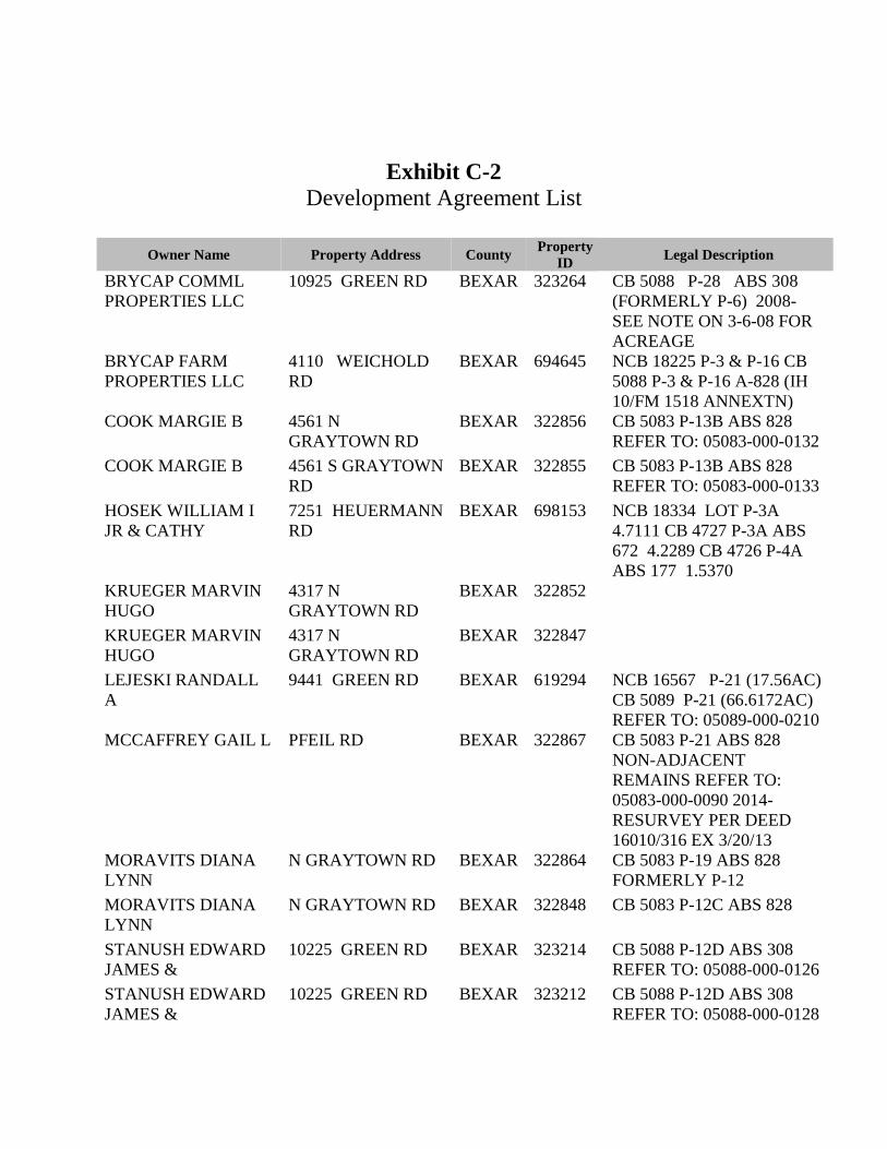
Exhibit C-2 Development Agreement List
Owner Name Property Address County Property
ID Legal Description
BRYCAP COMML PROPERTIES LLC
10925 GREEN RD BEXAR 323264 CB 5088 P-28 ABS 308 (FORMERLY P-6) 2008-SEE NOTE ON 3-6-08 FOR ACREAGE
BRYCAP FARM PROPERTIES LLC
4110 WEICHOLD RD
BEXAR 694645 NCB 18225 P-3 & P-16 CB 5088 P-3 & P-16 A-828 (IH 10/FM 1518 ANNEXTN)
COOK MARGIE B 4561 N GRAYTOWN RD
BEXAR 322856 CB 5083 P-13B ABS 828 REFER TO: 05083-000-0132
COOK MARGIE B 4561 S GRAYTOWN RD
BEXAR 322855 CB 5083 P-13B ABS 828 REFER TO: 05083-000-0133
HOSEK WILLIAM I JR & CATHY
7251 HEUERMANN RD
BEXAR 698153 NCB 18334 LOT P-3A 4.7111 CB 4727 P-3A ABS 672 4.2289 CB 4726 P-4A ABS 177 1.5370
KRUEGER MARVIN HUGO
4317 N GRAYTOWN RD
BEXAR 322852
KRUEGER MARVIN HUGO
4317 N GRAYTOWN RD
BEXAR 322847
LEJESKI RANDALL A
9441 GREEN RD BEXAR 619294 NCB 16567 P-21 (17.56AC) CB 5089 P-21 (66.6172AC) REFER TO: 05089-000-0210
MCCAFFREY GAIL L PFEIL RD BEXAR 322867 CB 5083 P-21 ABS 828 NON-ADJACENT REMAINS REFER TO: 05083-000-0090 2014-RESURVEY PER DEED 16010/316 EX 3/20/13
MORAVITS DIANA LYNN
N GRAYTOWN RD BEXAR 322864 CB 5083 P-19 ABS 828 FORMERLY P-12
MORAVITS DIANA LYNN
N GRAYTOWN RD BEXAR 322848 CB 5083 P-12C ABS 828
STANUSH EDWARD JAMES &
10225 GREEN RD BEXAR 323214 CB 5088 P-12D ABS 308 REFER TO: 05088-000-0126
STANUSH EDWARD JAMES &
10225 GREEN RD BEXAR 323212 CB 5088 P-12D ABS 308 REFER TO: 05088-000-0128

Page 27 Item No. 29
THOMAS DUANE C & EVELYN R
N GRAYTOWN RD BEXAR 323254 CB 5088 P-21A ABS 308
THOMAS DUANE C & EVELYN R
3219 N GRAYTOWN RD
BEXAR 323256 CB 5088 P-21B ABS 308 2011-SPLIT PER DEED 14548/1332 EX 6/30/2010
THOMAS DUANE C & EVELYN R
N GRAYTOWN RD BEXAR 323258 CB 5088 P-23 ABS 308
THOMAS DUANE C & EVELYN R
3355 N GRAYTOWN RD
BEXAR 323257 CB 5088 P-22 ABS 308
VETTER MARK W & LOIS L
9227 GREEN RD BEXAR 323315 CB 5089 P-21B ABS: 45

Page 28 Item No. 29
Exhibit D SERVICE PLANS
CITY OF SAN ANTONIO SERVICE PLAN FOR THE FOSTER ROAD/IH 10 E LOOP 1604 EAST INTERCHANGE ANNEXATION AREAS Introduction The City ("City") of San Antonio, Texas, is making this Service Plan ("Plan") available pursuant to Chapter 43 of the Texas Local Government Code. This Plan relates to the annexation by the City of an "Annexation Area" known as the Foster Road/IH 10 East Loop 1604 East Interchange Annexation Area, consisting of approximately 6.1 combined square miles in East Bexar County. This area consists of 67 parcels residential dwellings.
Effective Term This Plan shall be in effect for a ten-year period commencing on the effective date of the annexation, unless otherwise stated in this Plan. Renewal of the Plan shall be at the option of the City. Such option may be exercised by the adoption of an ordinance by the City Council, which refers to this Plan and specifically renews this Plan for a stated period of time. Residents of the Annexation Areas may request extension of the service plan, and the plan may be extended upon the mutual agreement of the City and the residents.
Intent It is the intent of the City that services under this Plan shall provide full municipal services as required and defined by the Texas Local Government Code. The City reserves the right guaranteed to it by the Texas Local Government Code, to amend this Plan if the City Council determines that changed conditions or subsequent occurrence or any other legally sufficient circumstances exist under the Local Government Code, or other Texas laws to make this Plan unworkable or obsolete or unlawful. Service Components In general this Plan includes three service components: (1) Annexation Service Requirements, (2) Additional Services and (3) a Capital Improvement Program. As used in this Plan, providing services includes having services provided by any method or means by which the City extends municipal services to any other area of the City. This may include causing or allowing private utilities, governmental entities and other public and private non-profit service organizations to provide such services by contract in whole or in part. It may also include separate agreements with associations or similar entities. Services are provided and fees are assessed in accordance with City of San Antonio Municipal Code, as may be amended.
1. ANNEXATION SERVICE REQUIREMENTS − The following will be provided in the Annexation Area commencing on the effective date of the annexation for full purposes, unless otherwise noted.
A. Police Protection The San Antonio Police Department (SAPD) will provide protection and law enforcement services in the newly annexed area upon the effective date of annexation. These services include: Routine patrols and responses; Handling of complaints and incident reports; Special units, such as traffic enforcement, criminal investigations, covert operations, K-9 Unit, Family
Assistance Crisis Teams, Bomb Squad, and Special Weapons and Tactics Team (SWAT); and Any other services or programs provided to the citizens of San Antonio at the time of annexation.
The newly annexed area will either become a new patrol district or part of an existing one based upon factors such as the size of the area, population, and the expected number of calls for service. These factors will also determine the need for hiring additional patrol officers to ensure all patrol districts are adequately staffed 24 hours a day, seven days a week, and to maintain an average response time comparable to other areas of the city. SAPD San Antonio Fear Free Environment Unit (SAFFE) officers will be available to meet with residents as requested to discuss police issues in the neighborhoods.

Page 29 Item No. 29
The City currently has six Police Substations. Each Substation is responsible for a Patrol "Service Area," under the command of a Captain. These Service Areas are divided into Patrol Sections. The Patrol Sections, with supervisory responsibilities assigned to Sergeants, are divided into "Patrol Districts." The "Patrol Districts" are geographically defined areas established for several reasons, including but not limited to:
Serving as a manpower distribution tool based on call volume, population, area size, and geographic variables;
Providing a means of establishing primary responsibility to individual officers, during their tour of duty, for various activities within a specific geographic area; and
Providing an efficient and effective means of assigning, identifying, and locating officers, within a generalized area, using currently available technology.
The Annexation Area will be served by the East Patrol Substation, located at 3635 E Houston St, San Antonio TX. 78219. There is no specific number of officers that can be assigned to a patrol district. Patrol districts are staffed with at least one officer, 24 hours a day, 7 days a week. Many times multiple officers are assigned to single districts.
Police services are initiated by on-sight officer activity, citizen requests, and any other means available. The most common means by which officers receive their assignments is through direct supervisory command and radio/computer transmissions by police dispatchers.
B. Fire Protection and Emergency Medical Service (EMS) − The San Antonio Fire Department (SAFD) will provide fire and medical emergency services to the Annexation Area consistent with the provision of services in like areas of San Antonio. Service will be provided through the use of fire engines, ladder trucks, full-time and peak period EMS ambulances, Medical Officers and Chief Officers. SAFD will be providing fire protection and EMS from Fire Station #18 located at 1463 S WW White Rd, San Antonio, TX 78220 and Fire Station #30 located at 919 Gembler Rd, San Antonio, TX 78219.
C. Solid Waste Collection Services − The San Antonio Solid Waste Management Department will provide
residential solid waste collection services in the newly annexed area. Collection services will be provided by City personnel or by solid waste service providers under contract with the City. Services provided will be at a level equivalent to those provided to residents within the current City limits. Services are provided and fees are assessed in accordance with Chapter 14 of the City Municipal Code, as may be amended. Fees for services are assessed monthly on CPS Energy Utility bills.
Upon annexation, residents may choose to either retain their present private service provider or use City-provided service for a period of two years. If residents elect to retain private service, City solid waste service fees will not be assessed. Two years after the effective date of annexation, all residents, except those living on a property with private streets as outlined below, must use and will be billed for City-provided service.
Residents living within gated communities or on properties with private streets, without public road access, may elect to either contract with private service providers or use City-provided services. If private collection services are used, the City solid waste fees will not be assessed at these locations. If City-provided collection services are desired, the private street community or property must consent to an indemnity agreement allowing the City or its contractor entry onto private streets and exempting the City from liability. In addition, the pavement condition of the privately owned street, road or driveway must safely support collection trucks.
Residential Solid Waste Services – Garbage, recycling and organics collection is provided once per week using an automated collection system. All materials must be inside the container for collection. The City retains ownership of the containers. Customers are required to safeguard the containers and to maintain them in a sanitary condition. For an additional monthly fee, additional garbage containers can be requested.
Garbage Collection – Each residential unit is provided one (brown) garbage container. Monthly fees will be assessed in accordance with the garbage container size. Residents will have the option to select a small, medium or large size container for garbage. [See Table I for “Pay-as-You-Throw” fees.]
Recycling Collection - Each residential unit is provided with one (blue) container in which to place specified items defined as recyclable materials. Acceptable recyclable materials shall be designated by the city and

Page 30 Item No. 29
include: newspaper, mixed office paper, magazines, corrugated cardboard, paper bags, aluminum and tin cans, steel aerosol cans, plastic bottles, tops and containers, glass bottles and jars; and single-use plastic bags bundled (soccer ball-size).
Organics Collection – Each residential unit is provided one (green) organics collection container to place specific items defined as organic materials. Acceptable green container materials shall be designated by the city and include the following: leaves, tree trimmings (no taller than height of cart), yard trimmings, small branches, food scraps, food-soiled paper and cardboard, and other organic materials may be added to the program at the discretion of the director or his designee.
Bagged Leaf Collection – Residential customers may request up to two free special collections of grass clippings, leaves, and weeds, per fiscal year. Each collection request should not exceed eight cubic yards and fifty paper bags /cardboard boxes. Additionally, bags and boxes should not exceed 0.16 cubic yards. Each bag or box must not weigh more than forty (40) pounds. Paper bags must be composed of two-ply Kraft/sack paper capable of containing the contents when handled. Cardboard boxes must be made of brown bio-degradable cardboard that contains no deleterious substances.
Brush and Bulky Item Collection is provided in accordance with an annual schedule. Residents receive a notice prior to each collection cycle. For an additional fee, residents may schedule special collections.
Dead Animal Collection within the City’s right-of-way is available, upon request.
Drop-off Sites are available for brush recycling, bulky trash and household hazardous waste. Special collection events, such as Free Disposal Days and Dial-A-Trailer neighborhood cleanups are available to all Solid Waste ratepayers.
Commercial Solid Waste Services– Commercial garbage collection is available for qualifying businesses in a manner similar to residential services. Bulky item, brush and bagged leaf collections are not provided to businesses. If City-provided commercial service is not desired, businesses may utilize private service providers.
Monthly Solid Waste Fees are set annually by City Council as described below: Environmental Services Fee – All residential and non-residential properties shall be assessed a monthly Environmental Service Fee of $3.24 per unit. The Environmental Fee is comprised of a $2.24 Solid Waste Environmental Fee and a $1.00 Parks Environmental Fee. This fee is intended to defray municipal expenses necessary to cleaning up illegally dumped waste, collecting and disposing of dead animals, performing regulatory maintenance on closed landfills, providing environmental services to the City's park system, and equitably sharing costs for neighborhood clean-ups benefiting residents and businesses that do not pay a monthly solid waste processing fee.
Solid Waste Service Fees – Residents (single-or multi-family residential units) will be assessed monthly fees on their CPS Energy utility statement. Pay-as-You-Throw is a volume-based program wherein residents may choose the size brown garbage container based on the amount of garbage thrown away. Fees are assessed in accordance with the size selected. Commercial/Non-residential Solid Waste Service Fees are the same as the residential monthly fees but only garbage and recycling collection services are provided. Miscellaneous one-time fees may be assessed for damaged containers, exchanges for larger size garbage containers and special collections. The current monthly fees are:
Table1: Pay- as-You-Throw Solid Waste Containers and Fees
The Pay-as-You-Throw Garbage Container Sizes Fees per Month (without the Environmental Fee)
Small (48 gallon) container $18.19 Medium (64 gallon) container $18.69 Large (96 gallon) container $19.94
D. Operation and Maintenance of Water and Wastewater Facilities − San Antonio Water System (SAWS) will maintain and operate the public water and wastewater facilities that are within its certified service area.

Page 31 Item No. 29
Routine standard maintenance of the facilities is performed on a scheduled basis. Emergency maintenance and repairs receive immediate attention, and are available 24 hours a day, 7 days a week. The facilities will be maintained and operated in accordance with standard SAWS policies and procedures, and under the provisions of the SAWS Utility Service Regulations for the extension of facilities. SAWS Monthly Rates – The average residential customer's bill for water, wastewater, and water supply fee is $62.24 (Inside City Limits) and $73.82 (Outside City Limits) (based on a winter average consumption of 7,092 gallons of water per month, and 5,668 gallons of sewer use per month). The SAWS rate structure is designed to provide balance between residential and business rates and to encourage conservation with rates that increase at higher levels of consumption. The current rates were approved by City Council to be effective as of the beginning of January 2017. SAWS customers, after annexation, will pay the lower Inside City Limit rate as opposed to the Outside City Limit rate. For the average residential customer, this will amount a cost reduction in combined monthly water/sewer charges of 15.7%. The rates are set by City Council and can be amended in the future.
SAWS Water Conservation Programs & Rebates –SAWS water conservation education programs and rebates are available to SAWS residential and commercial customers. SAWS residential customers can access other water saving programs including WaterSaver Landscape Coupons to replace lawn-dominated landscape areas with attractive drought tolerant garden beds and or permeable patio). Educational resources regarding drought-tolerant plants are available at www.GardenStyleSA.com.
With commercial customers accounting for 6.0% of the customer base and 35.1% of SAWS' annual water sales, there is great potential for water savings through commercial conservation programs. Commercial customers also have access to water conservation education and incentives. There are programs to make irrigation systems more efficient and customer rebates for big projects that address operational efficiencies. Detailed information on these and other programs can be found on the SAWS website at www.saws.org.
E. Operation and Maintenance of Roads and Streets, including Street Lighting − The Transportation and Capital Improvements Department (TCI) will maintain public streets over which the City has jurisdiction. TCI is responsible for the maintenance and repair of the City street, bridge and alley infrastructure. Curbs, sidewalks, driveways approaches, curb ramps and other street infrastructures are constructed in accordance with the City and the Americans with Disability Act (ADA) standards. Service requests or community concerns for TCI’s response, such as pothole and base and pavement repairs are initiated by contacting the City's 311 call center or online services. These services include:
Emergency Pavement Repair – Potholes are collapsed areas within the roadway that do not exceed 3 feet by 3 feet. The City's goal is to repair reported potholes within 48 hours or two business days.
Street Base and Pavement Repair – Areas of collapsed pavement that exceed 3 feet by 3 feet in need of a base and pavement repair, which require different maintenance equipment and has a 90-day service window.
Preventative Street Maintenance activities are conducted upon approval and identification of funding by City Council to include crack seal, chip seal coat, slurry seal, asphalt overlay and other structural treatments.
Guard Post and Guard Rail Maintenance –TCI's goal is to repair damaged guard posts and guard rails within 60 days of being reported. The Adopted Goal for FY 2015/2016 is 99% of flex beam service requests will be repaired within 45 days.
De-icing and Snow Removal Services – TCI also monitors ice and snow on public right of ways including bridge infrastructures, major thoroughfares, public facilities, and downtown sidewalks.
Neighborhood Access and Mobility Program (NAMP) – Street projects are selected and funded by the City Council on a citywide basis upon availability of funding and scheduled based on workforce capacity under NAMP as approved by City Council. Current base funding for NAMP is $200,000 per Council District in FY 2016-2017. NAMP was designed to help neighborhoods control traffic speed and provide mobility for pedestrians. NAMP Projects include the following: sidewalks for pedestrian traffic, speed humps for vehicular traffic, traffic improvements and school flashers.

Page 32 Item No. 29
Emergency Street Closure Services –TCI performs barricading service for emergency situations, twenty-four (24) hours a day, and 365 days a year. Vehicular and pedestrian hazards are barricaded immediately. Requests for service and/or necessary action is reported and monitored through the 311 call center system.
Street Re-striping and Marking Services – For major arterials and collectors, the repainting of street markings is on an 11 year frequency. All improved intersections and roadways are striped in conformance with the Texas Manual on Uniform Traffic Control Devices. All roadways are re-striped and remarked as needed.
Infrastructure Management Program (IMP) is a five-year rolling program which focuses on the maintenance of San Antonio’s infrastructure. Services needs are identified city-wide and are scheduled for street maintenance, alley maintenance, drainage maintenance, sidewalks, traffic signals, pavement marking and Advance Transportation District (ATD) projects. The IMP provides the City a structured program schedule, potential for additional multiple year contract awards and improved utility coordination. During the budget process for each City fiscal year, the IMP is presented to City Council for approval. Amendments may occur throughout the year due to coordination with utilities or unforeseen conditions, such as inclement weather. The goal of the IMP is to provide the best possible maintenance for the City.
Traffic Management is responsible for the development and monitoring of the City's traffic signal system. This includes responding to community concerns for various signal maintenance needs. If necessary, TCI will provide regulatory signage services in the Annexation Area. Traffic signal, stop and all other regulatory studies are conducted in conjunction with growth of traffic volumes. Traffic signs, signals, and markings are installed in conformance with the Texas Manual on Uniform Traffic Control Devices. Faded, vandalized, or missing signs are replaced as needed. "Call back" service is provided 24 hours a day, 365 days a year for emergency repair of critical regulatory signs. The current goal for critical regulatory signs is repaired within 72 hours of being reported to TCI. Requests for signage should be called into the 311 call center. On average, regulatory signs are replaced within 48 hours.
Storm Water Utility – The Storm Water Utility is housed within TCI. The Storm Water Utility is responsible for drainage services as well as the installation, operation, and maintenance of drainage infrastructure throughout San Antonio.
The Storm Water Utility Fee is intended to cover capital and maintenance expenses associated with drainage projects and fund operational services related to the Municipal Separate Storm Sewer System (MS4) Permit as required by Federal regulations. On September 10, 2015, the San Antonio City Council approved revisions to the Storm Water Fee structure using an impervious cover approach and adopted a five-year rate plan. The revised Storm Water Fee rates became effective January 1, 2016. The rates each year after 2016 shall be effective on the October 1 date occurring prior to the start of the succeeding calendar year (e.g. October 1, 2016 for new rates shown for FY 2017, October 1, 2017 for new rates shown for FY 2018, etc.). More information about the storm water rate plan is available at http://www.saws.org/service/rates/stormwater_fee.cfm.
The storm water utility fee is billed by SAWS on behalf of the City. Services are currently provided by the SAWS, in accordance with the SAWS’s approved business plan and as limited by applicable codes, laws, ordinances and special agreements. The fee will be assessed for the subject property as the storm water will drain into the exiting City facilities. Examples of services funded by the Storm Water Utility fee include but are not limited to the following:
Street Sweeping consists of sweeping residential streets two times per year and arterial and collector streets four times per year;
Channel Mowing/Restoration consists of inspection and maintenance of rivers, creekways and improved drainage channels and mowing improved channels in public rights-of-ways six (6) times per fiscal year;
Drainage Infrastructure Maintenance includes replacing and cleaning underground drainage pipes, repairing and cleaning storm drainage inlets and maintaining and operating high water detection system and flood control structures; and
Natural Creekway Debris Removal consists of de-silting and re-grading of improved channels, natural waterways and creeks and removal of debris from drainage ways and low water crossings.

Page 33 Item No. 29
Street lighting – The planning of public street lights is coordinated by the City’s Development Services Department (DSD). CPS Energy will maintain public street lighting in accordance with Sec. 43.056 (b) (6) of the Texas Local Government Code and the City's policies. The City assumes the cost of electricity for public street lights.
F. Operation and Maintenance of Parks, Playgrounds and Swimming Pools − Maintenance responsibilities for municipally owned parks in annexed area are the responsibility of the City. Any proposed or existing privately owned parks, playgrounds, swimming pools, recreational facilities and common spaces in the subject property are the responsibility of the property owner(s).
G. Operation and Maintenance of Any Other Publicly Owned Facility, Building, or Service − Should the City acquire any other facilities, buildings, or services necessary for municipal services located within the subject property, an appropriate City department will provide maintenance services for them.
2. ADDITIONAL SERVICES − Certain services, in addition to the above services, will be provided within the Annexation Area. They are as follows:
A. Code Compliance − The Code Compliance Division of DSD enforces City codes and regulations to protect the health, safety and general welfare of the community. Current enforcement is provided to the following and is not limited to: Vacant dangerous premises and structures, Junked vehicles, Weeded vacant lots, Zoning (Unified Development Code), Property maintenance, Minimum housing, including unsanitary premises, Front yard parking, Alley and right-of-way violations, Monthly inspections of salvage/junk yards, Monitoring and enforcing materials received at salvage/junk yards, and Enforcement of Garage sale permits.
The Code and ordinances enforced by DSD are subject to changes by the City Council.
B. Zoning − City staff will initiate the zoning process for a permanent zoning classification. The Zoning Commission will conduct at least one public hearing and make a recommendation to the City Council regarding the proposed zoning. The City Council will consider the proposed zoning district concurrently with the annexation of the area at a public hearing. Zoning will be effective upon the effective date of annexation.
C. Building Permits − Incomplete construction must obtain building permits from the DSD in accordance with City codes. Incomplete construction implies that final inspections have not been conducted and approved. For new residential construction, incomplete construction indicates approved final inspections for building, mechanical, plumbing, and electric field inspections have not been obtained. For new commercial construction, incomplete construction indicates, approved final inspections for building, mechanical, plumbing, electric, fire, traffic, drainage, sidewalks, irrigation, tree, and landscape field inspections have not been obtained. Other field inspections may be applicable for new commercial construction depending on the specific use and/or location of the project. Building permits may be applied for at Cliff Morton Development and Business Services Center located at 1901 South Alamo Street, San Antonio, TX. In addition, as part of the permitting process, applicant(s) will be required to adhere to the City’s Tree and Landscape requirements. A one-stop development service counter has been created to assist the public with any development questions that relate to building, planning and TCI issues.
D. Certificate of Occupancy − New and existing businesses must obtain a Certificate of Occupancy and related licenses required by City code from the DSD, San Antonio Metropolitan Health District, and/or City Tax Office. In accordance with the 2015 International Building Code, no person may occupy a building or a space without

Page 34 Item No. 29
first obtaining a Certificate of Occupancy. Certificates of Occupancy may be applied for at the Cliff Morton Development and Business Services Center located at 1901 South Alamo Street, San Antonio, TX.
E. Nonconforming Rights − To establish nonconforming rights for zoning, property owners with existing land uses are encouraged to register within 90 days of the annexation date with the DSD. Uses that existed legally prior to annexation, generally become nonconforming after annexation because of the new zoning classification placed on the land.
Registration of legal nonconforming uses allows property owners to apply for a Certificate of Occupancy. Upon the issuance of the Certificate of Occupancy, property owners may continue the legal nonconforming uses that existed prior to annexation. A Certificate of Occupancy will be issued certifying only those uses required by applicable City and State codes.
F. Library Services − Residents in the annexation area may choose to go to any library branch. • The nearest library to the Foster Road and IH 10 East – Loop 1604 East Interchange annexation area is
the Schaefer branch location.
The San Antonio Public Library locations provide the following services: Library materials for adults, young adults and children including books, periodicals, compact disks, DVD,
videos, audio books, and electronic books; Programming for adults, young adults and children such as regularly scheduled story time; Book discussion groups and other topics of interest to the community; and Access to the Internet, databases and other computer programs, which is available 24/7 through the web
address www.mysapl.org/digital.
Professional staff is available to assist library customers with reference and reader's advisory questions and public meeting room space are available. More information is available at the San Antonio Public Library Website: www.mysapl.org.
G. Health Department Services − The San Antonio Metropolitan Health District (SAMHD) currently provides certain public health services, including dental screening and treatment, communicable disease control, emergency preparedness and response, and health education to person residing in the Annexation Area through an interlocal agreement with Bexar County-University Health Systems. Upon full purpose annexation the following additional services will become available: Investigation of public health related complaints including food borne illness, recreational water quality,
and public swimming pools and spas, and investigation of toxic exposures; Permitting and routine sanitation inspections of food establishments, schools, day cares, swimming pools
and mobile living parks; Enforcement of the City's smoking ordinance in public places; Investigation of reported elevated Blood Lead Levels (BLL) in children; Access to community health clinics; and Medical Assistance Program benefits.
SAMHD would provide additional services for oversight of day care centers, semi-public swimming pools, air quality permits and livestock issues.
H. Animal Care Services − Newly annexed area will receive the same level of service as within the current San Antonio City Limits. These services include, but may not be limited to, animal enforcement and control, educational and public outreach, low cost animal related resources as microchips and spay/neuter services, and community cat program services.
I. Other Services − City Departments with jurisdiction in the area will provide services according to City policy and procedure.
3. CAPITAL IMPROVEMENTS PROGRAM − The City will initiate the construction of capital improvements as may be necessary for providing municipal services to the Annexation Area. The timing for the construction of capital projects that may be necessary for the delivery of municipal services will be done in accordance with the requirements of Subchapter C of Chapter 43, Local Government Code.

Page 35 Item No. 29
Each component of the Capital Improvement Program is subject to the City providing the related service directly. In the event that the related service is provided through a contract service provider, the capital improvement may not be constructed or acquired by the City but may be provided by the contract provider. The City may also lease buildings in lieu of construction of any necessary buildings.
A. Police Protection – No capital improvements are necessary at this time to provide Police services.
B. Fire Protection – SAFD will be providing fire protection from Fire Station #18 located at 1463 S WW White Rd, San Antonio, TX 78220 and Fire Station #30 located at 919 Gembler Rd, San Antonio, TX 78219.
C. Emergency Medical Service – No capital improvements are necessary at this time to provide EMS services.
D. Solid Waste Collection – No capital improvements are necessary at this time to provide solid waste collection services.
E. Roads and Streets – No newly constructed road or street related capital improvements are necessary at this time to provide services. The City will assume maintenance responsibilities for all public streets.
F. Parks, Playgrounds and Swimming Pools – No capital improvements are necessary at this time to provide parks and recreation services.
G. Library Services – No capital improvements are necessary at this time.
H. Capital Improvements Planning – The Annexation Area will be included with other territory within the municipality in connection with planning for new or expanded facilities and/or services. All other capital improvements will be considered through the 6-Year Capital Budget that represents the City's long-range physical infrastructure development and improve plan. Major funding sources are General Obligation Bonds, Certificates of Obligation, Storm Water Revenue Bonds, and Community Development Block Grants as applicable. Capital projects are placed in inventory by the City Council representative through input from community plans, existing neighborhood plans, community associations, neighborhood requests and other community processes.
AMENDMENT: GOVERNING LAW – This Plan may not be amended or repealed except as provided by the Texas Local Government Code or other controlling law. Neither changes in the methods or means of implementing any part of the service programs nor changes in the responsibilities of the various departments of the City shall constitute amendments to this Plan, and the City reserves the right to make such changes. This Plan is subject to and shall be interpreted in accordance with the Constitution and laws of the United States of America and the State of Texas, the Texas Local Government Code, and the orders, rules and regulations of governmental bodies and officers having jurisdiction. FORCE MAJEURE – In case of an emergency, such as Force Majeure as that term is defined in this Plan, in which the City is forced to temporarily divert its personnel and resources away from the Annexation Area for humanitarian purposes or protection of the general public, the City obligates itself to take all reasonable measures to restore services to the Annexation Area of the level described in this Plan as soon as possible. Force Majeure shall include, but not be limited to, acts of God, acts of the public enemy, war, blockages, insurrection, riots, epidemics, landslides, lightning, earthquakes, fires, storms, floods, washouts, droughts, tornadoes, hurricanes, arrest and restraint of government, explosions, collisions and other inability of the City, whether similar to those enumerated or otherwise, which is not within the control of the City. Unavailability or shortage of funds shall not constitute Force Majeure for purposes of this Plan.
SUMMARY OF THE WATER AND WASTE WATER UTILITY SERVICE REGULATIONS 2016 The following information is a summary of the SAWS Utility Service Regulations for the extension of water and/or waste water facilities as incorporated by reference in the latest version of the Unified Development Code, in conformance with the Texas Local Government Code requirement that the Plan have a summary of the service extension policy.
Water and waste water service is only provided to lots that have been properly subdivided and platted or are a legal lot. For property that is required by subdivision regulations to construct water or waste water facilities

Page 36 Item No. 29
connecting to the SAWS system, funding and construction of those facilities will remain the responsibility of the developer. If the specific undeveloped property does not have SAWS water or wastewater service fronting the property, the owner may make an application for an extension of service to SAWS Director of Infrastructure Development Department for review. If the Director determines that adequate capacity is available, or will be and if the project does not include SAWS cost participation or reimbursement, and if the proposed facilities are a logical extension of SAWS water and/or wastewater system and the requested extension meets the requirements of SAWS Utility Service Regulations, the extension size, capacity, and routing may be approved by the Director. Funding and construction of the facilities will be the responsibility of the developer.
Depending on the size of the new facilities and other conditions, with SAWS Board of Trustees approval, SAWS may reimburse the developer for a portion of the cost of constructing certain facilities. With Board approval, SAWS may reimburse costs associated with the oversize capacity of water and wastewater mains. The actual calculation of the cost participation and reimbursement amounts, including limits and the schedules for the payments, are included in SAWS Utility Service Regulations as incorporated by reference in the UDC.
For lots that have water or wastewater lines in the street fronting the lot, the owner may receive water or wastewater service by applying for a tap permit and paying any required fees. The new customers will be required to pay the impact fees and all connection fees.
For property(s) served by a septic system, the property owner(s) remains responsible for the operation and maintenance of the septic system. If the septic system fails, the property owner must repair the system or pay to extend SAWS wastewater facilities to the property, if unavailable. Under certain circumstances the City Health Department and/or applicable regulatory agency for septic tanks may require the property owner to connect to SAWS public waste water facilities.
This policy is set by the City Council and can be amended in the future by ordinance.
CITY OF SAN ANTONIO SERVICE PLAN FOR THE BABCOCK ROAD AND VANCE JACKSON-NORTH LOOP 1604 CORRIDORS ANNEXATION AREAS Introduction The City ("City") of San Antonio, Texas, is making this Service Plan ("Plan") available pursuant to Chapter 43 of the Texas Local Government Code. This Plan relates to the annexation by the City of an "Annexation Area" known as the Babcock Road and Vance Jackson North Loop 1604 Corridor Annexation Areas, consisting of approximately 1.92 combined square miles in North Bexar County. This area consists of 18 residential dwelling parcels.
Effective Term This Plan shall be in effect for a ten-year period commencing on the effective date of the annexation, unless otherwise stated in this Plan. Renewal of the Plan shall be at the option of the City. Such option may be exercised by the adoption of an ordinance by the City Council, which refers to this Plan and specifically renews this Plan for a stated period of time. Residents of the Annexation Area may request extension of the service plan, and the plan may be extended upon the mutual agreement of the City and the residents.
Intent It is the intent of the City that services under this Plan shall provide full municipal services as required and defined by the Texas Local Government Code. The City reserves the right guaranteed to it by the Texas Local Government Code, to amend this Plan if the City Council determines that changed conditions or subsequent occurrence or any other legally sufficient circumstances exist under the Local Government Code, or other Texas laws to make this Plan unworkable or obsolete or unlawful. Service Components In general this Plan includes three service components: (1) Annexation Service Requirements, (2) Additional Services and (3) a Capital Improvement Program. As used in this Plan, providing services includes having services provided by any method or means by which the City extends municipal services to any other area of the City. This

Page 37 Item No. 29
may include causing or allowing private utilities, governmental entities and other public and private non-profit service organizations to provide such services by contract in whole or in part. It may also include separate agreements with associations or similar entities. Services are provided and fees are assessed in accordance with City of San Antonio Municipal Code, as may be amended.
1. ANNEXATION SERVICE REQUIREMENTS − The following will be provided in the Annexation Area commencing on the effective date of the annexation for full purposes, unless otherwise noted.
A. Police Protection The San Antonio Police Department (SAPD) will provide protection and law enforcement services in the newly annexed area upon the effective date of annexation. These services include: Routine patrols and responses; Handling of complaints and incident reports; Special units, such as traffic enforcement, criminal investigations, covert operations, K-9 Unit, Family
Assistance Crisis Teams, Bomb Squad, and Special Weapons and Tactics Team (SWAT); and Any other services or programs provided to the citizens of San Antonio at the time of annexation.
The newly annexed area will either become a new patrol district or part of an existing one based upon factors such as the size of the area, population, and the expected number of calls for service. These factors will also determine the need for hiring additional patrol officers to ensure all patrol districts are adequately staffed 24 hours a day, seven days a week, and to maintain an average response time comparable to other areas of the city. SAPD San Antonio Fear Free Environment Unit (SAFFE) officers will be available to meet with residents as requested to discuss police issues in the neighborhoods. The City currently has six Police Substations. Each Substation is responsible for a Patrol "Service Area," under the command of a Captain. These Service Areas are divided into Patrol Sections. The Patrol Sections, with supervisory responsibilities assigned to Sergeants, are divided into "Patrol Districts." The "Patrol Districts" are geographically defined areas established for several reasons, including but not limited to:
Serving as a manpower distribution tool based on call volume, population, area size, and geographic variables;
Providing a means of establishing primary responsibility to individual officers, during their tour of duty, for various activities within a specific geographic area; and
Providing an efficient and effective means of assigning, identifying, and locating officers, within a generalized area, using currently available technology.
The Annexation Area will be served by the North Patrol Substation, located at 5020 Prue Rd, San Antonio, TX 78240. There is no specific number of officers that can be assigned to a patrol district. Patrol districts are staffed with at least one officer, 24 hours a day, 7 days a week. Many times multiple officers are assigned to single districts.
Police services are initiated by on-sight officer activity, citizen requests, and any other means available. The most common means by which officers receive their assignments is through direct supervisory command and radio/computer transmissions by police dispatchers.
B. Fire Protection and Emergency Medical Service (EMS) − The San Antonio Fire Department (SAFD) will provide fire and medical emergency services to the Annexation Area consistent with the provision of services in like areas of San Antonio. Service will be provided through the use of fire engines, ladder trucks, full-time and peak period EMS ambulances, Medical Officers and Chief Officers. SAFD will be providing fire protection and EMS from Fire Station #47 located at 7240, Stonewall Bend, San Antonio, TX 78256, Fire Station #34 located at 15300 Babcock Rd, San Antonio, TX 78249 and Fire Station #51 located at 5040 Beckwith Blvd, San Antonio, TX 78249.
C. Solid Waste Collection Services − The San Antonio Solid Waste Management Department will provide
residential solid waste collection services in the newly annexed area. Collection services will be provided by City personnel or by solid waste service providers under contract with the City. Services provided will be at a level equivalent to those provided to residents within the current City limits. Services are provided and fees are assessed in accordance with Chapter 14 of the City Municipal Code, as may be amended. Fees for services

Page 38 Item No. 29
are assessed monthly on CPS Energy Utility bills.
Upon annexation, residents may choose to either retain their present private service provider or use City-provided service for a period of two years. If residents elect to retain private service, City solid waste service fees will not be assessed. Two years after the effective date of annexation, all residents, except those living on a property with private streets as outlined below, must use and will be billed for City-provided service.
Residents living within gated communities or on properties with private streets, without public road access, may elect to either contract with private service providers or use City-provided services. If private collection services are used, the City solid waste fees will not be assessed at these locations. If City-provided collection services are desired, the private street community or property must consent to an indemnity agreement allowing the City or its contractor entry onto private streets and exempting the City from liability. In addition, the pavement condition of the privately owned street, road or driveway must safely support collection trucks.
Residential Solid Waste Services – Garbage, recycling and organics collection is provided once per week using an automated collection system. All materials must be inside the container for collection. The City retains ownership of the containers. Customers are required to safeguard the containers and to maintain them in a sanitary condition. For an additional monthly fee, additional garbage containers can be requested.
Garbage Collection – Each residential unit is provided one (brown) garbage container. Monthly fees will be assessed in accordance with the garbage container size. Residents will have the option to select a small, medium or large size container for garbage. [See Table I for “Pay-as-You-Throw” fees.]
Recycling Collection - Each residential unit is provided with one (blue) container in which to place specified items defined as recyclable materials. Acceptable recyclable materials shall be designated by the city and include: newspaper, mixed office paper, magazines, corrugated cardboard, paper bags, aluminum and tin cans, steel aerosol cans, plastic bottles, tops and containers, glass bottles and jars; and single-use plastic bags bundled (soccer ball-size).
Organics Collection – Each residential unit is provided one (green) organics collection container to place specific items defined as organic materials. Acceptable green container materials shall be designated by the city and include the following: leaves, tree trimmings (no taller than height of cart), yard trimmings, small branches, food scraps, food-soiled paper and cardboard, and other organic materials may be added to the program at the discretion of the director or his designee.
Bagged Leaf Collection – Residential customers may request up to two free special collections of grass clippings, leaves, and weeds, per fiscal year. Each collection request should not exceed eight cubic yards and fifty paper bags /cardboard boxes. Additionally, bags and boxes should not exceed 0.16 cubic yards. Each bag or box must not weigh more than forty (40) pounds. Paper bags must be composed of two-ply Kraft/sack paper capable of containing the contents when handled. Cardboard boxes must be made of brown bio-degradable cardboard that contains no deleterious substances.
Brush and Bulky Item Collection is provided in accordance with an annual schedule. Residents receive a notice prior to each collection cycle. For an additional fee, residents may schedule special collections.
Dead Animal Collection within the City’s right-of-way is available, upon request.
Drop-off Sites are available for brush recycling, bulky trash and household hazardous waste. Special collection events, such as Free Disposal Days and Dial-A-Trailer neighborhood cleanups are available to all Solid Waste ratepayers.
Commercial Solid Waste Services– Commercial garbage collection is available for qualifying businesses in a manner similar to residential services. Bulky item, brush and bagged leaf collections are not provided to businesses. If City-provided commercial service is not desired, businesses may utilize private service providers.
Monthly Solid Waste Fees are set annually by City Council as described below: Environmental Services Fee – All residential and non-residential properties shall be assessed a monthly Environmental Service Fee of $3.24 per unit. The Environmental Fee is comprised of a $2.24 Solid Waste Environmental Fee and a $1.00 Parks Environmental Fee. This fee is intended to defray municipal expenses

Page 39 Item No. 29
necessary to cleaning up illegally dumped waste, collecting and disposing of dead animals, performing regulatory maintenance on closed landfills, providing environmental services to the City's park system, and equitably sharing costs for neighborhood clean-ups benefiting residents and businesses that do not pay a monthly solid waste processing fee.
Solid Waste Service Fees – Residents (single-or multi-family residential units) will be assessed monthly fees on their CPS Energy utility statement. Pay-as-You-Throw is a volume-based program wherein residents may choose the size brown garbage container based on the amount of garbage thrown away. Fees are assessed in accordance with the size selected. Commercial/Non-residential Solid Waste Service Fees are the same as the residential monthly fees but only garbage and recycling collection services are provided. Miscellaneous one-time fees may be assessed for damaged containers, exchanges for larger size garbage containers and special collections. The current monthly fees are:
Table1: Pay- as-You-Throw Solid Waste Containers and Fees
The Pay-as-You-Throw Garbage Container Sizes Fees per Month (without the Environmental Fee)
Small (48 gallon) container $18.19 Medium (64 gallon) container $18.69 Large (96 gallon) container $19.94
D. Operation and Maintenance of Water and Wastewater Facilities − San Antonio Water System (SAWS) will
maintain and operate the public water and wastewater facilities that are within its certified service area. Routine standard maintenance of the facilities is performed on a scheduled basis. Emergency maintenance and repairs receive immediate attention, and are available 24 hours a day, 7 days a week. The facilities will be maintained and operated in accordance with standard SAWS policies and procedures, and under the provisions of the SAWS Utility Service Regulations for the extension of facilities. SAWS Monthly Rates – The average residential customer's bill for water, wastewater, and water supply fee is $62.24 (Inside City Limits) and $73.82 (Outside City Limits) (based on a winter average consumption of 7,092 gallons of water per month, and 5,668 gallons of sewer use per month). The SAWS rate structure is designed to provide balance between residential and business rates and to encourage conservation with rates that increase at higher levels of consumption. The current rates were approved by City Council to be effective as of the beginning of January 2017. SAWS customers, after annexation, will pay the lower Inside City Limit rate as opposed to the Outside City Limit rate. For the average residential customer, this will amount to a cost reduction in combined monthly water/sewer charges of 15.7%. The rates are set by City Council and can be amended in the future.
SAWS Water Conservation Programs & Rebates –SAWS water conservation education programs and rebates are available to SAWS residential and commercial customers. SAWS residential customers can access other water saving programs including WaterSaver Landscape Coupons to replace lawn-dominated landscape areas with attractive drought tolerant garden beds and or permeable patio). Educational resources regarding drought-tolerant plants are available at www.GardenStyleSA.com.
With commercial customers accounting for 6.0% of the customer base and 35.1% of SAWS' annual water sales, there is great potential for water savings through commercial conservation programs. Commercial customers also have access to water conservation education and incentives. There are programs to make irrigation systems more efficient and customer rebates for big projects that address operational efficiencies. Detailed information on these and other programs can be found on the SAWS website at www.saws.org.
E. Operation and Maintenance of Roads and Streets, including Street Lighting − The Transportation and Capital Improvements Department (TCI) will maintain public streets over which the City has jurisdiction. TCI is responsible for the maintenance and repair of the City street, bridge and alley infrastructure. Curbs, sidewalks, driveways approaches, curb ramps and other street infrastructures are constructed in accordance with the City and the Americans with Disability Act (ADA) standards. Service requests or community concerns for TCI’s response, such as pothole and base and pavement repairs are initiated by contacting the City's 311 call center or online services. These services include:

Page 40 Item No. 29
Emergency Pavement Repair – Potholes are collapsed areas within the roadway that do not exceed 3 feet by 3 feet. The City's goal is to repair reported potholes within 48 hours or two business days.
Street Base and Pavement Repair – Areas of collapsed pavement that exceed 3 feet by 3 feet in need of a base and pavement repair, which require different maintenance equipment and has a 90-day service window.
Preventative Street Maintenance activities are conducted upon approval and identification of funding by City Council to include crack seal, chip seal coat, slurry seal, asphalt overlay and other structural treatments.
Guard Post and Guard Rail Maintenance –TCI's goal is to repair damaged guard posts and guard rails within 60 days of being reported. The Adopted Goal for FY 2015/2016 is 99% of flex beam service requests will be repaired within 45 days.
De-icing and Snow Removal Services – TCI also monitors ice and snow on public right of ways including bridge infrastructures, major thoroughfares, public facilities, and downtown sidewalks.
Neighborhood Access and Mobility Program (NAMP) – Street projects are selected and funded by the City Council on a citywide basis upon availability of funding and scheduled based on workforce capacity under NAMP as approved by City Council. Current base funding for NAMP is $200,000 per Council District in FY 2016-2017. NAMP was designed to help neighborhoods control traffic speed and provide mobility for pedestrians. NAMP Projects include the following: sidewalks for pedestrian traffic, speed humps for vehicular traffic, traffic improvements and school flashers.
Emergency Street Closure Services –TCI performs barricading service for emergency situations, twenty-four (24) hours a day, and 365 days a year. Vehicular and pedestrian hazards are barricaded immediately. Requests for service and/or necessary action is reported and monitored through the 311 call center system.
Street Re-striping and Marking Services – For major arterials and collectors, the repainting of street markings is on an 11 year frequency. All improved intersections and roadways are striped in conformance with the Texas Manual on Uniform Traffic Control Devices. All roadways are re-striped and remarked as needed.
Infrastructure Management Program (IMP) is a five-year rolling program which focuses on the maintenance of San Antonio’s infrastructure. Services needs are identified city-wide and are scheduled for street maintenance, alley maintenance, drainage maintenance, sidewalks, traffic signals, pavement marking and Advance Transportation District (ATD) projects. The IMP provides the City a structured program schedule, potential for additional multiple year contract awards and improved utility coordination. During the budget process for each City fiscal year, the IMP is presented to City Council for approval. Amendments may occur throughout the year due to coordination with utilities or unforeseen conditions, such as inclement weather. The goal of the IMP is to provide the best possible maintenance for the City.
Traffic Management is responsible for the development and monitoring of the City's traffic signal system. This includes responding to community concerns for various signal maintenance needs. If necessary, TCI will provide regulatory signage services in the Annexation Area. Traffic signal, stop and all other regulatory studies are conducted in conjunction with growth of traffic volumes. Traffic signs, signals, and markings are installed in conformance with the Texas Manual on Uniform Traffic Control Devices. Faded, vandalized, or missing signs are replaced as needed. "Call back" service is provided 24 hours a day, 365 days a year for emergency repair of critical regulatory signs. The current goal for critical regulatory signs is repaired within 72 hours of being reported to TCI. Requests for signage should be called into the 311 call center. On average, regulatory signs are replaced within 48 hours.
Storm Water Utility – The Storm Water Utility is housed within TCI. The Storm Water Utility is responsible for drainage services as well as the installation, operation, and maintenance of drainage infrastructure throughout San Antonio.
The Storm Water Utility Fee is intended to cover capital and maintenance expenses associated with drainage projects and fund operational services related to the Municipal Separate Storm Sewer System (MS4) Permit as required by Federal regulations. On September 10, 2015, the San Antonio City Council approved revisions to the Storm Water Fee structure using an impervious cover approach and adopted a five-year rate plan. The revised Storm Water Fee rates became effective January 1, 2016. The rates each year after 2016 shall be effective on the October 1 date occurring prior to the start of the succeeding calendar year (e.g. October 1,

Page 41 Item No. 29
2016 for new rates shown for FY 2017, October 1, 2017 for new rates shown for FY 2018, etc.). More information about the storm water rate plan is available at http://www.saws.org/service/rates/stormwater_fee.cfm.
The storm water utility fee is billed by SAWS on behalf of the City. Services are currently provided by the SAWS, in accordance with the SAWS’s approved business plan and as limited by applicable codes, laws, ordinances and special agreements. The fee will be assessed for the subject property as the storm water will drain into the exiting City facilities. Examples of services funded by the Storm Water Utility fee include but are not limited to the following:
Street Sweeping consists of sweeping residential streets two times per year and arterial and collector streets four times per year;
Channel Mowing/Restoration consists of inspection and maintenance of rivers, creekways and improved drainage channels and mowing improved channels in public rights-of-ways six (6) times per fiscal year;
Drainage Infrastructure Maintenance includes replacing and cleaning underground drainage pipes, repairing and cleaning storm drainage inlets and maintaining and operating high water detection system and flood control structures; and
Natural Creekway Debris Removal consists of de-silting and re-grading of improved channels, natural waterways and creeks and removal of debris from drainage ways and low water crossings.
Street lighting – The planning of public street lights is coordinated by the City’s Development Services Department (DSD). CPS Energy will maintain public street lighting in accordance with Sec. 43.056 (b) (6) of the Texas Local Government Code and the City's policies. The City assumes the cost of electricity for public street lights.
F. Operation and Maintenance of Parks, Playgrounds and Swimming Pools − Maintenance responsibilities for municipally owned parks in annexed area are the responsibility of the City. Any proposed or existing privately owned parks, playgrounds, swimming pools, recreational facilities and common spaces in the subject property are the responsibility of the property owner(s).
G. Operation and Maintenance of Any Other Publicly Owned Facility, Building, or Service − Should the City acquire any other facilities, buildings, or services necessary for municipal services located within the subject property, an appropriate City department will provide maintenance services for them.
2. ADDITIONAL SERVICES − Certain services, in addition to the above services, will be provided within the Annexation Area. They are as follows:
A. Code Compliance − The Code Compliance Division of DSD enforces City codes and regulations to protect the health, safety and general welfare of the community. Current enforcement is provided to the following and is not limited to: Vacant dangerous premises and structures, Junked vehicles, Weeded vacant lots, Zoning (Unified Development Code), Property maintenance, Minimum housing, including unsanitary premises, Front yard parking, Alley and right-of-way violations, Monthly inspections of salvage/junk yards, Monitoring and enforcing materials received at salvage/junk yards, and Enforcement of Garage sale permits.
The Code and ordinances enforced by DSD are subject to changes by the City Council.
B. Zoning − City staff will initiate the zoning process for a permanent zoning classification. The Zoning Commission will conduct at least one public hearing and make a recommendation to the City Council

Page 42 Item No. 29
regarding the proposed zoning. The City Council will consider the proposed zoning district concurrently with the annexation of the area at a public hearing. Zoning will be effective upon the effective date of annexation.
C. Building Permits − Incomplete construction must obtain building permits from the DSD in accordance with City codes. Incomplete construction implies that final inspections have not been conducted and approved. For new residential construction, incomplete construction indicates approved final inspections for building, mechanical, plumbing, and electric field inspections have not been obtained. For new commercial construction, incomplete construction indicates, approved final inspections for building, mechanical, plumbing, electric, fire, traffic, drainage, sidewalks, irrigation, tree, and landscape field inspections have not been obtained. Other field inspections may be applicable for new commercial construction depending on the specific use and/or location of the project. Building permits may be applied for at Cliff Morton Development and Business Services Center located at 1901 South Alamo Street, San Antonio, TX. In addition, as part of the permitting process, applicant(s) will be required to adhere to the City’s Tree and Landscape requirements. A one-stop development service counter has been created to assist the public with any development questions that relate to building, planning and TCI issues.
D. Certificate of Occupancy − New and existing businesses must obtain a Certificate of Occupancy and related licenses required by City code from the DSD, San Antonio Metropolitan Health District, and/or City Tax Office. In accordance with the 2015 International Building Code, no person may occupy a building or a space without first obtaining a Certificate of Occupancy. Certificates of Occupancy may be applied for at the Cliff Morton Development and Business Services Center located at 1901 South Alamo Street, San Antonio, TX.
E. Nonconforming Rights − To establish nonconforming rights for zoning, property owners with existing land uses are encouraged to register within 90 days of the annexation date with the DSD. Uses that existed legally prior to annexation, generally become nonconforming after annexation because of the new zoning classification placed on the land.
Registration of legal nonconforming uses allows property owners to apply for a Certificate of Occupancy. Upon the issuance of the Certificate of Occupancy, property owners may continue the legal nonconforming uses that existed prior to annexation. A Certificate of Occupancy will be issued certifying only those uses required by applicable City and State codes.
F. Library Services − Residents in the annexation area may choose to go to any library branch. • The nearest library to annexation areas is the Igo branch location.
The San Antonio Public Library locations provide the following services: Library materials for adults, young adults and children including books, periodicals, compact disks, DVD,
videos, audio books, and electronic books; Programming for adults, young adults and children such as regularly scheduled story time; Book discussion groups and other topics of interest to the community; and Access to the Internet, databases and other computer programs, which is available 24/7 through the web
address www.mysapl.org/digital.
Professional staff is available to assist library customers with reference and reader's advisory questions and public meeting room space are available. More information is available at the San Antonio Public Library Website: www.mysapl.org.
G. Health Department Services − The San Antonio Metropolitan Health District (SAMHD) currently provides certain public health services, including dental screening and treatment, communicable disease control, emergency preparedness and response, and health education to person residing in the Annexation Area through an interlocal agreement with Bexar County-University Health Systems. Upon full purpose annexation the following additional services will become available: Investigation of public health related complaints including food borne illness, recreational water quality,
and public swimming pools and spas, and investigation of toxic exposures; Permitting and routine sanitation inspections of food establishments, schools, day cares, swimming pools
and mobile living parks; Enforcement of the City's smoking ordinance in public places;

Page 43 Item No. 29
Investigation of reported elevated Blood Lead Levels (BLL) in children; Access to community health clinics; and Medical Assistance Program benefits.
SAMHD would provide additional services for oversight of day care centers, semi-public swimming pools, air quality permits and livestock issues.
H. Animal Care Services − Newly annexed area will receive the same level of service as within the current San Antonio City Limits. These services include, but may not be limited to, animal enforcement and control, educational and public outreach, low cost animal related resources as microchips and spay/neuter services, and community cat program services.
I. Other Services − City Departments with jurisdiction in the area will provide services according to City policy and procedure.
3. CAPITAL IMPROVEMENTS PROGRAM − The City will initiate the construction of capital improvements as may be necessary for providing municipal services to the Annexation Area. The timing for the construction of capital projects that may be necessary for the delivery of municipal services will be done in accordance with the requirements of Subchapter C of Chapter 43, Local Government Code. Each component of the Capital Improvement Program is subject to the City providing the related service directly. In the event that the related service is provided through a contract service provider, the capital improvement may not be constructed or acquired by the City but may be provided by the contract provider. The City may also lease buildings in lieu of construction of any necessary buildings.
A. Police Protection – No capital improvements are necessary at this time to provide Police services.
B. Fire Protection – SAFD will be providing fire protection from Fire Station #47 located at 7240, Stonewall Bend, San Antonio, TX 78256, Fire Station #34 located at 15300 Babcock Rd, San Antonio, TX 78249 and Fire Station #51 located at 5040 Beckwith Blvd, San Antonio, TX 78249.
C. Emergency Medical Service – No capital improvements are necessary at this time to provide EMS services.
D. Solid Waste Collection – No capital improvements are necessary at this time to provide solid waste collection services.
E. Roads and Streets – No newly constructed road or street related capital improvements are necessary at this time to provide services. The City will assume maintenance responsibilities for all public streets.
F. Parks, Playgrounds and Swimming Pools – No capital improvements are necessary at this time to provide parks and recreation services.
G. Library Services – No capital improvements are necessary at this time.
H. Capital Improvements Planning – The Annexation Area will be included with other territory within the municipality in connection with planning for new or expanded facilities and/or services. All other capital improvements will be considered through the 6-Year Capital Budget that represents the City's long-range physical infrastructure development and improve plan. Major funding sources are General Obligation Bonds, Certificates of Obligation, Storm Water Revenue Bonds, and Community Development Block Grants as applicable. Capital projects are placed in inventory by the City Council representative through input from community plans, existing neighborhood plans, community associations, neighborhood requests and other community processes.
AMENDMENT: GOVERNING LAW – This Plan may not be amended or repealed except as provided by the Texas Local Government Code or other controlling law. Neither changes in the methods or means of implementing any part of the service programs nor changes in the responsibilities of the various departments of the City shall constitute amendments to this Plan, and the City reserves the right to make such changes. This Plan is subject to and shall be interpreted in accordance with the Constitution and laws of the United States of America and the State of Texas, the Texas Local Government Code, and the orders, rules and regulations of governmental bodies and officers having jurisdiction.

Page 44 Item No. 29
FORCE MAJEURE – In case of an emergency, such as Force Majeure as that term is defined in this Plan, in which the City is forced to temporarily divert its personnel and resources away from the Annexation Area for humanitarian purposes or protection of the general public, the City obligates itself to take all reasonable measures to restore services to the Annexation Area of the level described in this Plan as soon as possible. Force Majeure shall include, but not be limited to, acts of God, acts of the public enemy, war, blockages, insurrection, riots, epidemics, landslides, lightning, earthquakes, fires, storms, floods, washouts, droughts, tornadoes, hurricanes, arrest and restraint of government, explosions, collisions and other inability of the City, whether similar to those enumerated or otherwise, which is not within the control of the City. Unavailability or shortage of funds shall not constitute Force Majeure for purposes of this Plan.
SUMMARY OF THE WATER AND WASTE WATER UTILITY SERVICE REGULATIONS 2016 The following information is a summary of the SAWS Utility Service Regulations for the extension of water and/or waste water facilities as incorporated by reference in the latest version of the Unified Development Code, in conformance with the Texas Local Government Code requirement that the Plan have a summary of the service extension policy.
Water and waste water service is only provided to lots that have been properly subdivided and platted or are a legal lot. For property that is required by subdivision regulations to construct water or waste water facilities connecting to the SAWS system, funding and construction of those facilities will remain the responsibility of the developer. If the specific undeveloped property does not have SAWS water or wastewater service fronting the property, the owner may make an application for an extension of service to SAWS Director of Infrastructure Development Department for review. If the Director determines that adequate capacity is available, or will be and if the project does not include SAWS cost participation or reimbursement, and if the proposed facilities are a logical extension of SAWS water and/or wastewater system and the requested extension meets the requirements of SAWS Utility Service Regulations, the extension size, capacity, and routing may be approved by the Director. Funding and construction of the facilities will be the responsibility of the developer.
Depending on the size of the new facilities and other conditions, with SAWS Board of Trustees approval, SAWS may reimburse the developer for a portion of the cost of constructing certain facilities. With Board approval, SAWS may reimburse costs associated with the oversize capacity of water and wastewater mains. The actual calculation of the cost participation and reimbursement amounts, including limits and the schedules for the payments, are included in SAWS Utility Service Regulations as incorporated by reference in the UDC.
For lots that have water or wastewater lines in the street fronting the lot, the owner may receive water or wastewater service by applying for a tap permit and paying any required fees. The new customers will be required to pay the impact fees and all connection fees.
For property(s) served by a septic system, the property owner(s) remains responsible for the operation and maintenance of the septic system. If the septic system fails, the property owner must repair the system or pay to extend SAWS wastewater facilities to the property, if unavailable. Under certain circumstances the City Health Department and/or applicable regulatory agency for septic tanks may require the property owner to connect to SAWS public waste water facilities.
This policy is set by the City Council and can be amended in the future by ordinance.