An opportunity to re-evaluate the petroleum … of the Douala/Kribi-Campo Basin, Cameroon...
10
SPECIAL TOPIC: PETROLEUM GEOLOGY FIRST BREAK I VOLUME 36 I MARCH 2018 61 Block, although sands in the latter well were thinner than initially postulated. Strong oil shows were encountered in turbidite sands in well CM-1A in the Elombo Block. Beyond the shelf, deepwater wells Eboni-1 and Bamboo-1 (Elombo and Ntem Blocks) also targeted Upper Cretaceous sands but were water wet. Tertiary sands have been penetrated by a number of wells in the Tilapia Block, including Coco Marine-1 which flowed 34 o API oil at a rate of 3000 bopd from the Paleocene. Oil, gas and condensate have all been recovered from various Miocene channel and fan sands across the basin, most notably from Noble’s successful YoYo discovery. This is an extension of the play behind the Yolanda-1 discovery and the producing Alen and Aseng Fields in Equatorial Guinea (Figure 2). Despite evidence for more than one working petroleum system (Tertiary and Cretaceous), hydrocarbons flowed to the surface in only a handful of wells outside the Kribi-Campo Sub-basin and the YoYo discovery looks on course to be put into production. The next phase of exploration in the Doula Sub-basin undoubtedly requires an understanding of the reasons behind this limited exploration drilling success. Previous operators have all suspected that there are challenges with source rock, timing of migration, and presence of reservoir, seal and trap but never consistently across all wells. Deciphering reasons for the apparent low well success requires a review of all exploration data in a regional geological context beyond the limits of individual blocks. Data review, enhancement and interpretation As a first step in facilitating this review, CGG Multi-Client & New Ventures (GeoSpec), in collaboration with the National Hydrocarbons Corporation (SNH), have produced a regionally matched 3D seismic data set, TerraCube REGRID , integrated with a 2D seismic data set for the DKC Basin (see outlines on inset map on Figure 4). The 3D survey covers an area of 7500 km 2 intersecting with an additional 28,000 km of 2D seismic data. Utilizing the latest stratal slicing and seismic interpretation techniques, TerraCube REGRID was sliced parallel to bedding to enable navigation of the seismic data in the Stratal Domain. A An opportunity to re-evaluate the petroleum potential of the Douala/Kribi-Campo Basin, Cameroon Jean-Pierre Loule 1 , Francis Jifon 1 , Serge Edouard Angoua Biouele 1 , Ponce Nguema 1 , David Spofforth 2* , Daniel Carruthers 2 , Carl Watkins 3 and Joe Johnston 3 decipher the reasons for the apparent low well success as they review exploration data in a regional geological context beyond the limits of individual blocks. Introduction The recently announced Cameroon licence round running until 29 June 2018 provides oil companies with a significant opportunity to acquire large swathes of acreage in the Douala/Kribi-Campo (DKC) and Rio Del Rey (RDR) Basins. The DKC Basin is divided into two sub-basins, the Douala Sub-basin in the north and the Kribi-Campo Sub-basin in the south. The RDR basin, situated at the toe of the Niger Delta (Figure 1), is a mature basin with significant infrastructure and production. In contrast, the DKC Basin, which is the focus of this paper, is relatively underexplored, yet there are marked grounds for optimism in its petroleum potential. The DKC Basin is separated from the RDR Basin by the Cameroon Volcanic Line (Figure 1) and is the northernmost basin formed during rifting and separation of the South Atlantic conjugate margins, a province harbouring prolific hydrocarbon accumulations. Exploration in the offshore Douala Sub-basin began in the 1960s but the first well drilled, Nyong Marine-1, was dry. It was not until the late 1970s, with the drilling of Sanaga Sud A-1 and the discovery of gas-condensate within the Aptian-Albian-aged Mundeck Formation, that exploration accelerated with the drilling of 11 discoveries in the Cretaceous, two with second- ary Tertiary reservoirs. This exploration phase was primarily focused in the shallow water Kribi-Campo Sub-basin, targeting Cretaceous tilted fault-block plays, which also extend onshore, where oil is currently produced from the overlying Cretaceous Logbadjeck Formation in the Mvia Field (Figure 2). Despite the early success, production was not established until 1997 in the Ebome Field. Today, more than 1 million bbls of oil is produced annually from the Kribi-Campo Sub-basin (SNH Production Figures, 2016). The rest of the offshore DKC Basin is relatively underexplored with only 23 wells drilled in an area larger than 10,000 km 2 . Wells have targeted a range of reservoir intervals from the Miocene to Upper Cretaceous across a variety of stratigraphic, structural and combination traps (Figure 3). Upper Cretaceous reservoir-quality sands were penetrated by the hydrocarbon-bearing Sapele-1 well in the Etinde Exploration Block and Cheetah-1 in the Tilapia 1 Société Nationale des Hydrocarbures | 2 CGG Multi-Client & New Ventures (GeoSpec) | 3 CGG GeoConsulting * Corresponding author, E-mail: [email protected]
-
Upload
truongdang -
Category
Documents
-
view
217 -
download
0
Transcript of An opportunity to re-evaluate the petroleum … of the Douala/Kribi-Campo Basin, Cameroon...
SPECIAL TOPIC: PETROLEUM GEOLOGY
F I R S T B R E A K I V O L U M E 3 6 I M A R C H 2 0 1 8 6 1
Block, although sands in the latter well were thinner than initially postulated. Strong oil shows were encountered in turbidite sands in well CM-1A in the Elombo Block. Beyond the shelf, deepwater wells Eboni-1 and Bamboo-1 (Elombo and Ntem Blocks) also targeted Upper Cretaceous sands but were water wet.
Tertiary sands have been penetrated by a number of wells in the Tilapia Block, including Coco Marine-1 which flowed 34oAPI oil at a rate of 3000 bopd from the Paleocene. Oil, gas and condensate have all been recovered from various Miocene channel and fan sands across the basin, most notably from Noble’s successful YoYo discovery. This is an extension of the play behind the Yolanda-1 discovery and the producing Alen and Aseng Fields in Equatorial Guinea (Figure 2).
Despite evidence for more than one working petroleum system (Tertiary and Cretaceous), hydrocarbons flowed to the surface in only a handful of wells outside the Kribi-Campo Sub-basin and the YoYo discovery looks on course to be put into production. The next phase of exploration in the Doula Sub-basin undoubtedly requires an understanding of the reasons behind this limited exploration drilling success.
Previous operators have all suspected that there are challenges with source rock, timing of migration, and presence of reservoir, seal and trap but never consistently across all wells. Deciphering reasons for the apparent low well success requires a review of all exploration data in a regional geological context beyond the limits of individual blocks.
Data review, enhancement and interpretationAs a first step in facilitating this review, CGG Multi-Client & New Ventures (GeoSpec), in collaboration with the National Hydrocarbons Corporation (SNH), have produced a regionally matched 3D seismic data set, TerraCubeREGRID, integrated with a 2D seismic data set for the DKC Basin (see outlines on inset map on Figure 4). The 3D survey covers an area of 7500 km2
intersecting with an additional 28,000 km of 2D seismic data.Utilizing the latest stratal slicing and seismic interpretation
techniques, TerraCubeREGRID was sliced parallel to bedding to enable navigation of the seismic data in the Stratal Domain. A
An opportunity to re-evaluate the petroleum potential of the Douala/Kribi-Campo Basin, CameroonJean-Pierre Loule1, Francis Jifon1, Serge Edouard Angoua Biouele1, Ponce Nguema1, David Spofforth2*, Daniel Carruthers2, Carl Watkins3 and Joe Johnston3 decipher the reasons for the apparent low well success as they review exploration data in a regional geological context beyond the limits of individual blocks.
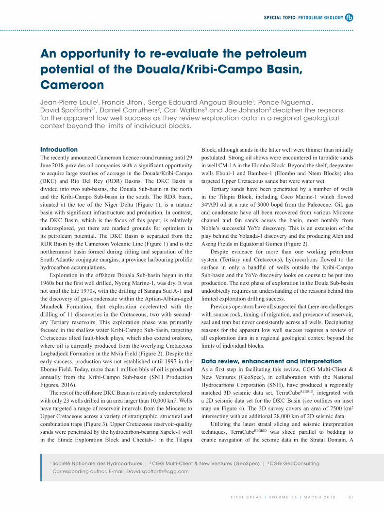
IntroductionThe recently announced Cameroon licence round running until 29 June 2018 provides oil companies with a significant opportunity to acquire large swathes of acreage in the Douala/Kribi-Campo (DKC) and Rio Del Rey (RDR) Basins. The DKC Basin is divided into two sub-basins, the Douala Sub-basin in the north and the Kribi-Campo Sub-basin in the south. The RDR basin, situated at the toe of the Niger Delta (Figure 1), is a mature basin with significant infrastructure and production. In contrast, the DKC Basin, which is the focus of this paper, is relatively underexplored, yet there are marked grounds for optimism in its petroleum potential. The DKC Basin is separated from the RDR Basin by the Cameroon Volcanic Line (Figure 1) and is the northernmost basin formed during rifting and separation of the South Atlantic conjugate margins, a province harbouring prolific hydrocarbon accumulations.
Exploration in the offshore Douala Sub-basin began in the 1960s but the first well drilled, Nyong Marine-1, was dry. It was not until the late 1970s, with the drilling of Sanaga Sud A-1 and the discovery of gas-condensate within the Aptian-Albian-aged Mundeck Formation, that exploration accelerated with the drilling of 11 discoveries in the Cretaceous, two with second-ary Tertiary reservoirs. This exploration phase was primarily focused in the shallow water Kribi-Campo Sub-basin, targeting Cretaceous tilted fault-block plays, which also extend onshore, where oil is currently produced from the overlying Cretaceous Logbadjeck Formation in the Mvia Field (Figure 2). Despite the early success, production was not established until 1997 in the Ebome Field. Today, more than 1 million bbls of oil is produced annually from the Kribi-Campo Sub-basin (SNH Production Figures, 2016).
The rest of the offshore DKC Basin is relatively underexplored with only 23 wells drilled in an area larger than 10,000 km2. Wells have targeted a range of reservoir intervals from the Miocene to Upper Cretaceous across a variety of stratigraphic, structural and combination traps (Figure 3). Upper Cretaceous reservoir-quality sands were penetrated by the hydrocarbon-bearing Sapele-1 well in the Etinde Exploration Block and Cheetah-1 in the Tilapia
1 Société Nationale des Hydrocarbures | 2 CGG Multi-Client & New Ventures (GeoSpec) | 3 CGG GeoConsulting* Corresponding author, E-mail: [email protected]
SPECIAL TOPIC: PETROLEUM GEOLOGY
6 2 F I R S T B R E A K I V O L U M E 3 6 I M A R C H 2 0 1 8
generate more discoveries. In the next section we show some highlights of this approach and how it can get the most out of the available well and seismic data to generate new ideas, leads and prospects for the next phase of exploration in the Douala Sub-basin.
Evidence of source, maturation and chargeGeochemical fingerprinting of biomarkers from both onshore seeps and recovered oil from offshore wells provide evidence of both Tertiary and Cretaceous source rocks across the DKC Basin. The oldest source rock is the Aptian-Albian Mundeck Formation, deposited in lacustrine to marine conditions within the Kribi-Campo Sub-basin. Here, source rocks within the Mundeck Formation are oil-prone, contain Types I and II kerogens and pro-vide the source for the Kribi-Campo discoveries (see Figure 2).
Oil-prone marine source rocks, predominantly Types II-III, deposited farther offshore throughout the Albian to Maastrichtian periods are significant for the Upper Cretaceous and Lower
regional horizon interpretation, conducted as part of a reconnais-sance exploration of the area, was used to constrain a full-volume auto-interpretation of every trough, peak and zero-crossing in the seismic data. An advanced numerical model (GeoModel) of the auto-interpreted events in chronological order produces a compre-hensive stack of stratigraphically-sophisticated stratal slices (see Pauget et al., 2009; Hoyes and Cheret, 2011, for a more detailed account of the interpretation workflow). The stratigraphic accuracy in stratal slices generated through this approach far exceeds those generated through more conventional iso-proportional slicing methods (Zeng, 2010). A frequency decomposition overlain on stratal slices (Chakraborty and Akaya, 1995; Partyka et al., 1999) reveals depositional systems and structural elements in extraordi-nary detail.
A review of exploration data associated with more than 25 wells tied to the Douala Sub-basin GeoModel has been conducted to understand in a more regional context why wells have failed to
Figure 1 Structural configuration of the DKC Basin.

SPECIAL TOPIC: PETROLEUM GEOLOGY
F I R S T B R E A K I V O L U M E 3 6 I M A R C H 2 0 1 8 6 3
(Figure 2). The Paleocene-probable Eocene N’kapa Formation has also been postulated as a source rock. However, where this has been penetrated, the source quality is poor to average.
Rapid sediment burial in the Late Cretaceous matured the Cretaceous source rocks by the end of the Cretaceous (Maas-trichtian) period, and burial in the Neogene matured the Tertiary by the Miocene, with expulsion still continuing. Critically, this timing means that for both the Cretaceous and Tertiary plays all the other elements of the petroleum system (reservoir, trap, and seal) were in place prior to the main phases of hydrocarbon migration. With this in mind, more successful drilling may stem from a greater understanding of the distribution of reservoir, trap geometry and compartmentalisation of prospects.
Stratal slice interpretation of depositional systemsA review of the stratal slices throughout the Douala Sub-basin TerraCubeREGRID indicates a range of features associated with the
Tertiary play fairways (Figure 5a-b). Biomarker analysis of the Paleocene Coco Marine-1 discovery, situated near the proximal boundary of the Tilapia Block (Figures 2 and 5a), indicates mixing of fluids from Cretaceous marine source rock and Tertiary source rocks. These results also indicate that the reservoir is not in juxtaposition with the source rock and that oil has migrated through the basin, across stratigraphy from source. Likely routes for this migration include the Upper Cretaceous reservoir inter-vals and steep strike slip faults extending from basement through the Cretaceous and possibly Tertiary units (Figure 5a-b).
Within the Tertiary sequence there are two main intervals with source potential. The Miocene-Oligocene Souellaba Formation contains deep marine, oil-prone source rock intervals with mixed, Type II and Type III kerogens. The formation is mature in the northern part of the DKC Basin and is considered to have charged the YoYo-1 discovery and equivalent fields, down-dip, in Equato-rial Guinea. It is also considered to be the source of the Miocene D-1R and Sapele discoveries within the Etinde Exploration Block
Figure 2 Overview of hydrocarbon exploration, key shows and discoveries in the DKC Basin.

SPECIAL TOPIC: PETROLEUM GEOLOGY
6 4 F I R S T B R E A K I V O L U M E 3 6 I M A R C H 2 0 1 8
with sediment ultimately derived from a hinterland in what is now northern Cameroon, through drainage systems with outfalls near the current location of the Wouri and Sanaga river systems (Figure 1). In contrast, in the Elombo and Ntem Blocks, there are a range of point-sourced depositional systems (Figure 6), with a steep, structurally controlled boundary to the east associated with the Kribi-Campo High (Figure 5b).
While the northern systems have sediment dispersal direc-tions broadly orthogonal to the palaeoshelf edge, in the south the slope system is short and steep, with most of the sediment dispersal occurring in a basin floor or slope-apron setting with
depositional systems. Firstly, there is a fundamental geographic segmentation of the deepwater domain of the offshore Douala Sub-basin in the post-rift interval, consisting of a northern ramp domain and a southern depositional trough (compare sections in Figure 5a-b). The depositional systems and potential reservoir characteristics differ significantly between these domains.
In the Tilapia and Etinde Blocks in the northern Douala Sub-basin, deepwater sediments have a broadly linear arrange-ment and are dominated by relatively low sinuosity channel systems with no obvious point source (Figure 6). It is likely that this system was fed by shelf edge cascades over a wide interval,
Figure 3 Tectono-stratigraphic framework of the DKC Basin showing the distribution of source and reservoir intervals with respect to key discoveries and shows.
Figure 4 Example seismic line through the DKC TerraCubeREGRID. Inset map shows the seismic database across the DKC Basin.
SPECIAL TOPIC: PETROLEUM GEOLOGY
F I R S T B R E A K I V O L U M E 3 6 I M A R C H 2 0 1 8 6 5
Sinuosity Index of <1.2 that extends through the Upper Creta-ceous and up into the Palaeogene and Neogene slope deposits. Variations in submarine channel sinuosity can provide indicators of slope, sediment load, flow type and channel evolution (Kane et al., 2008). Channel widths vary considerably, but are commonly in the range of 1000 m to 1500 m wide on individual stratal slices. These channel systems are interpreted as slope-channel systems with palaeobathymetry likely controlling their overall geometry. Clear stratigraphic variation in slope channel orientation may reflect progressive changes in palaeobathymetry that are in part controlled by structurally-influenced differential subsidence. Good examples of structural control on local channel geometry have been clearly documented and indicate potential for reservoir stacking and trap formation (see next section). An influence from both NE-SW oriented structures, parallel to the major oceanic transforms, and WNW-ESE transverse structures can be iden-tified, with evidence for movement consistent with the overall dextral transtensional stress regime of Atlantic opening.
In southern parts of the survey area (Ntem and Elombo Blocks) relatively low sinuosity channel systems more commonly
sediment dispersal primarily towards the south or south-south-west and sub-parallel to the palaeoshelf edge (Figure 6). In the southern area, the provenance of potential reservoir systems changes significantly through the stratigraphic pile and can include point-sourced systems derived from near to the present outfall of the Ntem and Rio Benito drainages (see labelled on Figure 1), overspill from southern parts of the northern ramp systems and episodic local supply direct from the Kribi-Campo High. It is likely that reservoir properties have been influenced by provenance differences and these various sediment supply routes may have important implications for prospectivity. To illustrate the range of potential reservoirs we briefly describe a series of end-member depositional styles that are clearly illustrated in the seismic data.
Low-sinuosity slope channel systemsDeepwater channel systems are common through much of the Upper Cretaceous and Tertiary and have a wide variety of geom-etries. In northern parts of the Douala Sub-basin the channels have a distinctive low sinuosity form (Figure 6) with an average
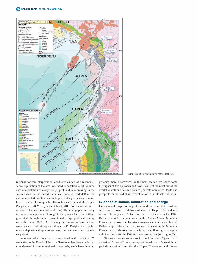
Figure 5 Conceptual play cartoons for a) Tilapia Block, and b) Elombo-Ntem Blocks. Diamond symbols (S) represent known or inferred source intervals. Red arrows define potential hydrocarbon migration pathways into known reservoir intervals (compare with Figure 3). Channel lobes and incisions are shown by yellow and orange line interpretations. Polygonal Fault Systems, labelled (PFS) on the figure, are ubiquitous with very fine-grained sediments and probably define a regional top seal.

SPECIAL TOPIC: PETROLEUM GEOLOGY
6 6 F I R S T B R E A K I V O L U M E 3 6 I M A R C H 2 0 1 8
on channel form is locally evident. Amplitude contrasts between the channel fills and surrounding sediment suggest a marked lithological contrast and significant stratigraphic traps may be associated with these well-developed geobodies.
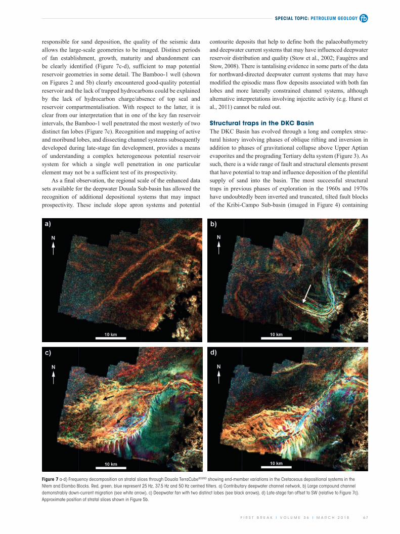
Submarine fansOne of the most striking features in the survey area is the devel-opment of deepwater fan deposits in the Ntem Block, distal of the Kribi-Campo High. These fans occur at multiple stratigraphic levels but are most clearly developed in the Upper Cretaceous (Campanian) interval (Figure 7c). The Bamboo-1 well proves the presence of medium and locally coarse-grained sandstones with stacked net thicknesses in excess of 80 m. Fans are demonstrably point-sourced, derived from short, steep feeder-slope channel sys-tems that cut the shelf edge of the Kribi-Campo High. The sands are texturally immature but are weakly cemented and dominated by quartz with good inferred porosity.
Additional feeder systems from the northern margin of the Kribi-Campo High and associated with overspill from the northern slope system can also be identified, with potential implications for sediment provenance and reservoir quality. While the absence of conventional core material through these fans limits the detailed sedimentological investigations that would be required to fully constrain the depositional process
occur as isolated channels, either as parts of an integrated deep-water system or as the feeders for deepwater fan deposits. Con-tributive network forms have been identified (Figure 7a) and the balance between contributive and distributive forms can support models of palaeobathymetric evolution and have implications for potential migration pathways for hydrocarbon charge.
Compound channels systemsIn the southern parts of the survey area there are also a number of distinctive large, compound channel systems (Figure 7b). The quality of the TerraCubeREGRID and enhancements from the frequency decomposition allow detailed mapping of these systems, including clear evidence for down-slope migration of the channels and the development of compound geobodies formed from the superposition of separate channel-fill phases. Individual channels have similar widths to the low sinuosity channels described above (typically 1000-1500 m), but sit within significantly wider channel belts 3000-5000 m wide. Channel widths can be compared with analogous data sets to derive estimates of likely channel and geobody thickness for estimating reservoir potential. Thalweg and potential in-channel barforms can be recognized and the channel systems can be shown to occupy aggradationally constrained wider geobodies. As with the lower sinuosity channels described above, a structural control
Figure 6 a) Frequency decomposition on Base Tertiary stratal slice through Douala TerraCubeREGRID. Red, green, blue represent 25 Hz, 37.5 Hz and 50 Hz centred filters respectively. Approximate position of stratal slice shown on Fig 5a-b. Inset Figure 6b) 3D block diagram showing Paleocene channel geometry influenced by en-echelon faulting (see black line interpretation). Line location shown in Figure 6a.
SPECIAL TOPIC: PETROLEUM GEOLOGY
F I R S T B R E A K I V O L U M E 3 6 I M A R C H 2 0 1 8 6 7
contourite deposits that help to define both the palaeobathymetry and deepwater current systems that may have influenced deepwater reservoir distribution and quality (Stow et al., 2002; Faugères and Stow, 2008). There is tantalising evidence in some parts of the data for northward-directed deepwater current systems that may have modified the episodic mass flow deposits associated with both fan lobes and more laterally constrained channel systems, although alternative interpretations involving injectite activity (e.g. Hurst et al., 2011) cannot be ruled out.
Structural traps in the DKC BasinThe DKC Basin has evolved through a long and complex struc-tural history involving phases of oblique rifting and inversion in addition to phases of gravitational collapse above Upper Aptian evaporites and the prograding Tertiary delta system (Figure 3). As such, there is a wide range of fault and structural elements present that have potential to trap and influence deposition of the plentiful supply of sand into the basin. The most successful structural traps in previous phases of exploration in the 1960s and 1970s have undoubtedly been inverted and truncated, tilted fault blocks of the Kribi-Campo Sub-basin (imaged in Figure 4) containing
responsible for sand deposition, the quality of the seismic data allows the large-scale geometries to be imaged. Distinct periods of fan establishment, growth, maturity and abandonment can be clearly identified (Figure 7c-d), sufficient to map potential reservoir geometries in some detail. The Bamboo-1 well (shown on Figures 2 and 5b) clearly encountered good-quality potential reservoir and the lack of trapped hydrocarbons could be explained by the lack of hydrocarbon charge/absence of top seal and reservoir compartmentalisation. With respect to the latter, it is clear from our interpretation that in one of the key fan reservoir intervals, the Bamboo-1 well penetrated the most westerly of two distinct fan lobes (Figure 7c). Recognition and mapping of active and moribund lobes, and dissecting channel systems subsequently developed during late-stage fan development, provides a means of understanding a complex heterogeneous potential reservoir system for which a single well penetration in one particular element may not be a sufficient test of its prospectivity.
As a final observation, the regional scale of the enhanced data sets available for the deepwater Douala Sub-basin has allowed the recognition of additional depositional systems that may impact prospectivity. These include slope apron systems and potential
Figure 7 a-d) Frequency decomposition on stratal slices through Douala TerraCubeREGRID showing end-member variations in the Cretaceous depositional systems in the Ntem and Elombo Blocks. Red, green, blue represent 25 Hz, 37.5 Hz and 50 Hz centred filters. a) Contributary deepwater channel network, b) Large compound channel demonstrably down-current migration (see white arrow), c) Deepwater fan with two distinct lobes (see black arrows), d) Late-stage fan offset to SW (relative to Figure 7c). Approximate position of stratal slices shown in Figure 5b.
SPECIAL TOPIC: PETROLEUM GEOLOGY
6 8 F I R S T B R E A K I V O L U M E 3 6 I M A R C H 2 0 1 8
deformed by a series of strike slip faults which are poorly imaged owing to their steep dips and small offsets? These attributes make determining the timing of traps difficult although the dextral offsets in the Upper Miocene shoreface intervals give at least an indication of post-Miocene dextral shear. It is also likely as a result of the overall geodynamic setting that during each phase of reactivation (see Figure 3) the margin has been deformed in similar ways.
One of the main phases of inversion took place at the onset of the Tertiary, expressed stratigraphically by the Base Tertiary Unconformity (as labelled on Figure 5a). This phase of inversion led to the input of channelized sands into the Douala Sub-basin. Close inspection of the Paleocene stratal slices indicates that channels have a unique geometry in that they are parallel to, or deflect toward, the predicted geometry of en-echelon fault patterns and flower structures (Figure 6). The 3D block diagram in Figure 6b shows channels that appear to be confined to the gra-bens of the bounding faults of steep en-echelon strike slip faults.
In conclusion, it appears that structural traps may be more prevalent than previously thought and that the structural develop-ment of the margin has played an important role in the morphol-ogy and location of channels and thus the distribution of sand. Positive inversion along these shear zones may have subsequently inverted channel sand bodies, creating closures which may derisk substantial areas of acreage in the deep water.
Exploring missed pay at sub-seismic resolutionIn reviewing the pre-drill geological models, it is evident that wells targeted significant channels or fan systems, commonly on the basis of seismic attribute interpretation. Subsequently, the
Aptian-Albian sandstones of the Upper and Lower Mundeck For-mation (see Kribi wells in Figure 2). These inversion structures have additionally provided traps for Upper Cretaceous and Pale-ocene channels which are now inclined against and onlap them.
In the contractional toe of the Upper Aptian evaporites, salt pillows and diapirs have provided traps for Albian, Upper Cretaceous and Paleocene sandstones. The only well to test this play is Kribi Marine-1, but questions remain as to whether well design and position were optimized to sufficiently test it. Across the eastern portion of the Elombo Block (see Figure 2) there are a variety of these trap types which have not been drilled.
In the offshore, below the present-day shelf and upper slope, structural trapping occurs in the form of gravitational extensional collapse faults which developed in the palaeo-slope of the prograding shoreface, and mild roll-over structures at the palaeo-base of slope (Figure 5a-b). Stratal slices at Upper Miocene levels show the generally slope-parallel fault pattern to be dextrally offset at numerous locations across the Douala Sub-basin. This is most likely attributed to repeated phases of oblique inversion and reactivation of deep strike slip faults during the basin’s evolution.
Beyond the palaeo-slope many leads and prospects have been documented as entirely stratigraphic traps and are associated with higher risk. Although, structuration in the deepwater appears limited, the outline of the only deepwater discovery to date (YoYo-1 – see Figure 2) bears a striking resemblance to the main shear zones demarcated on the structural elements map in Figure 1. This poses an interesting question relating to the role of structure in offshore prospectivity. Could it be that the margin is in fact more deformed than is initially evident, having been
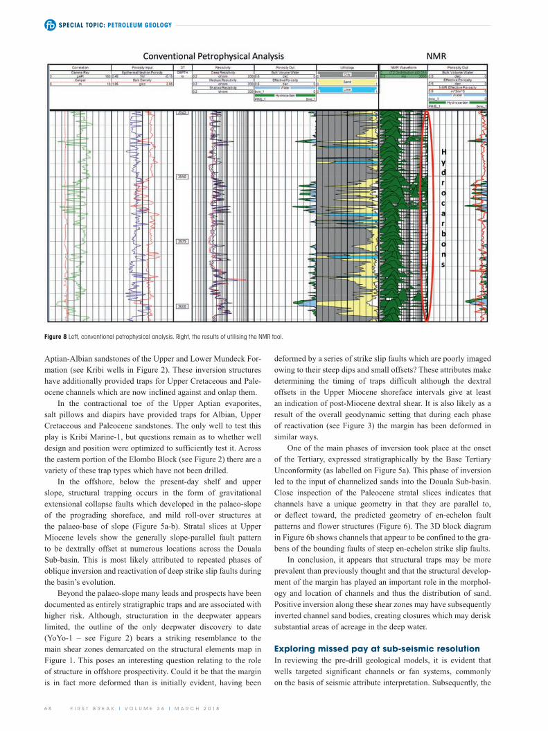
Figure 8 Left, conventional petrophysical analysis. Right, the results of utilising the NMR tool.

SPECIAL TOPIC: PETROLEUM GEOLOGY
F I R S T B R E A K I V O L U M E 3 6 I M A R C H 2 0 1 8 6 9
are thick enough to be correctly resolved by standard analysis and are considered to be hydrocarbon-bearing, as is the lower zone from 3595-3600 m. The NMR porosity between these two main intervals shows an effective porosity throughout, considered to occur in the form of thin beds, which are likely to contain hydrocarbons.
D-1R, illustrated here, is one example of many wells analysed in the DKC Basin, the vast majority of which exhibited similar characteristics, thin hydrocarbon-bearing beds, at the key stratigraphic intervals of the Miocene, Paleocene, Upper and Lower Cretaceous. In such a depositional system, where the bed thickness is significantly less than seismic resolution, the use of seismic attributes to identify targets is problematic. Instead, understanding the depositional architecture and environment in a sub-regional setting is paramount as this allows specific targeting of more reservoir-prone intervals within the stratigraphy. Under this thin-bedded reservoir scenario, any testing and future drilling and completion programmes can be carefully designed and adapted to evaluate all potential pay intervals. What testing programme should be used? How should perforation be planned or should slotted liners be used to achieve maximum opening of the formation layers to flow? Vertical wells or high angle wells? The latter is much preferred as more beds are intersected by the wellbore and perhaps sub-commercial discoveries can be converted to commercial.
Concluding remarksThis paper has shown the merits of a regionally integrated and coherent well and seismic database, tied to the geology. This is particularly relevant when it comes to learning the lessons from previous exploration. By applying the latest technology and interpretation workflows to these enhanced and integrated data sets, new petroleum play concepts can be generated to drive future exploration strategies. For example, the ability to explore regional 3D seismic data sets in the Stratal Domain offers a unique and cost-effective method to understand the depositional, structural and petroleum systems beyond the block and prospect scale. In addition, it is possible to review previous drilling results with the benefit of a more complete regional picture than may have been available at the time the wells were drilled. A better understanding of the morphology and provenance of depositional systems within this wider geological context is a good starting point to tackle some of the exploration challenges facing the DKC Basin. In particular, the ability to predict reservoir sweet spots and trap geometries. The seismic geomorphology may also allow the identification of sub-seismic resolution features by matching to modern-day analogues. This, in turn, may offer greater insight when considering well design and location, therefore unlocking the true petroleum potential of the DKC Basin.
AcknowledgementsThe authors wish to thank CGG and SNH for permission to publish this paper. We would also like to thank SNH for allowing legacy seismic, well and other ancillary data that form the back-bone of the work to be presented in this paper. Finally, we wish to thank our colleagues for their assistance in this project.
wells were found to have penetrated intervals of thinly-bedded sands and shales, albeit with hydrocarbon shows, which are below seismic resolution.
Typical examples of ‘thin-bedded’ depositional sand systems within the DKC Basin are evident from recent results in the Etinde Exploration Block. Multiple sand intervals of less than 2-3 m thick occur within the penetrated Cretaceous-to-Miocene stratigraphy. However, wireline log analysis indicates that many of these shaly sandstone reservoirs are hydrocarbon-bearing and are considered to be hidden assets in the form of thin beds, offering missed pay opportunities.
Standard logging tools have a resolution of the order of 60 cm so anything less than this is averaged with the surrounding beds. If, as is usual, the surrounding beds are shales, petrophys-ical analysis can suggest that the thin-bedded sandstone interval contains a high proportion of shale. If the shales are dispersed through the matrix, permeability and, consequently, reservoir quality would be expected to be very low, leading to a non-pro-ducible reservoir. If, however, the shale occurs in the form of discreet thin beds and laminae, the interbedded sandstones can retain significant reservoir quality and a very different prospect emerges. Hence, there is a need to identify and quantify these potential thin-bed reservoirs.
The D-1R well (see Figure 2 for location) offers an excellent example of this type of problem and potential solutions using some of the modern logging tools available. On the left of Figure 8 a conventional petrophysical analysis is shown. Hydrocarbons are clearly identified in the larger sand bodies. Shales interpreted above and below bear no hydrocarbons. Fortunately, the data set also contains a very useful modern tool, Nuclear Magnetic Resonance (NMR), which measures the Hydrogen Index (HI) of the formation. Unlike other HI tools, it is completely unaffected by lithology, although it does respond to pore size. The porosity is split (using a set of cut-offs) into small pore porosity, irreducible water and free fluids.
The NMR tool has a vertical resolution of about a metre, which might normally limit its value in the search for thin beds. However, it reacts differently to dispersed shaly sandstones and laminated formations. The former is measured as shale with the latter split into clean and shale portions. Not only are thin beds identified but a key parameter, the porosity, is also measured for each portion.
The right-hand side of Figure 8 shows the resulting picture in which the NMR waveform (green peaks) is the key indicator. Small pore porosity is demarcated by the peaks to the left of the track, while free fluids are indicated by peaks to the right. There is a clear bimodal distribution.
The sandstones on the lithology analysis are generally associated with the free fluids, and the shales with the small pore signature. However, it is clear there are also free fluids in some zones initially interpreted as shale. These are likely to represent thin beds of sandstone within the shale sequence. Their porosity is computed and shown on the right of Figure 8 as the red curve in the porosity output track.
As a result of this analysis effective porosities can be com-puted in zones otherwise interpreted as shale by standard tool analysis. The zone from 3550-3563 m contains sandstones that
SPECIAL TOPIC: PETROLEUM GEOLOGY
7 0 F I R S T B R E A K I V O L U M E 3 6 I M A R C H 2 0 1 8
Hurst, A., Scott, A. and Vigorito, M. [2011]. Physical characteristics of sand injectites. Earth Science Review, 106, 215-246.
Kane, I.A., McCaffrey, W.D. and Peakall, J. [2008]. Controls on sinuosity evolution within submarine channels. Geology, 36 (4), 287-290.
Partyka, G., Gridley, J. and Lopez, J. [1999]. Interpretational applications of spectral decomposition in reservoir characterization. The Leading Edge, 18 (3), 353-360.
Pauget, F., Lacaze, S. and Valding, T. [2009]. A global interpretation based on cost function minimization. 79th Annual International Meeting, SEG, Expanded Abstracts, 2592-96.
Stow, D.A.V., Faugéres, J.-C., Howe, J.A., Pudsey, C.J. and Viana, A.R. [2002]. Bottom currents, contourites and deep-sea sediment drifts: cur-rent state of the art. Geological Society, London, Memoirs, 22, 7-20.
Zeng, H., [2010]. Stratal slicing: Benefits and challenges. The Leading Edge, 29 (9), 1040-1047.
ReferencesCGG Robertson [2004]. Cameroon to Congo: An Integrated Play
Fairway Analysis. CGG Robertson multiclient Report, No. AM062.CGG Robertson [2015]. Petroleum Geological Evaluation: Niger Delta
to the Congo Fan. CGG Robertson Multiclient, Report No. AM086.Chakraborty, A. and Akaya, D. [1995]. Frequency-time decomposition
of seismic data using wavelet-based methods. Geophysics, 60 (6), 1906-1916.
Faugéres, J.-C. and Stow, D.A.V. [2008]. Contourite drifts: Nature, evolution and controls. In: Rebesco, M. and Camerlenghi, A. (Eds.), Contourites. Developments in Sedimentology, 60, 259-288.
Hoyes, J. and Cheret, T. [2011]. A Review of “Global” Interpretation Methods for Automated 3D Horizon Picking. The Leading Edge, 30 (1), 38-47.