Congestion Management Process for the Mid- Hudson Valley ...

An Interim Guidebook on the CongestionManagement Process in Metropolitan
Transportation Planning
U.S. Department of TransportationFederal Highway AdministrationFederal Transit Administration

Section Name | x-x
Notice
This document is disseminated under the sponsorship of the U.S. Department of Transportation in the
interest of information exchange. The U.S. Government assumes no liability for the use of the information
contained in this document. This report does not constitute a standard, specification, or regulation.
The U.S. Government does not endorse products or manufacturers. Trademarks or manufacturers’ names
may appear in this report only because they are considered essential to the objective of the document.
Quality Assurance Statement
The Federal Highway Administration (FHWA) provides high-quality information to serve Government,
industry, and the public in a manner that promotes public understanding. Standards and policies are used to
ensure and maximize the quality, objectivity, utility, and integrity of its information. FHWA periodically
reviews quality issues and adjusts its programs and processes to ensure continuous quality improvement.

x-x | Section Name

Section Name | x-x
1. Report No.
FHWA-HOP-08-008
2. Government Accession No. 3. Recipient’s Catalog No.
4. Title and Subtitle
An Interim Guidebook on the Congestion Management Process
in Metropolitan Transportation Planning
5. Report Date
February 2008
6. Performing Organization Code
7. Author(s)
Erin Flanigan and Mark Howard
8. Performing Organization Report No.
9. Performing Organization Name and Address
Cambridge Systematics, Inc.
4800 Hampden Lane, Suite 800
Bethesda, Maryland 20814
10. Work Unit No.
11. Contract or Grant No.
DTFH61-06-D-00004
12. Sponsoring Agency Name and Address
Federal Highway Administration
U.S. Department of Transportation
1200 New Jersey Avenue, SE
Washington, DC 20590
13. Type of Report and Period
Covered
Final Report
July 2006 - December 2007
14. Sponsoring Agency Code
HOP
15. Supplementary Notes
Mr. Wayne Berman, Contracting Officer’s Task Manager
16. Abstract
The Congestion Management Process (CMP), which has evolved from what was previously known as the Congestion Management
System (CMS), is a systematic approach, collaboratively developed and implemented throughout a metropolitan region, that provides for
the safe and effective management and operation of new and existing transportation facilities through the use of demand reduction and
operational management strategies. The CMP is required to be developed and implemented as an integral part of the metropolitan plan-
ning process in Transportation Management Areas (TMAs) – urbanized areas with a population over 200,000, or any area where designa-
tion as a TMA has been requested. Although the CMP is not required in non-TMAs, the CMP represents the state-of-the-practice in
addressing congestion, and should be considered in metropolitan areas that are facing current and future congestion challenges.
This guidebook provides information on how to create an objectives-driven, performance-based congestion management process. While
the focus of this guidebook is on the CMP, the principles of objectives-driven, performance-based planning can also be applied to other
aspects of regional concern (safety, economic development, environment, etc.) in an MTP. The CMP represents the “state-of-the-practice”
in responding to the growing challenge of congestion on urban transportation networks.
17. Key Words
congestion management process, transportation operations, performance-
based, objectives-driven, performance measures, planning for operations,
regional goals and objectives, operations data, regional ITS architecture
18. Distribution Statement
No restrictions. This document is available to the public
from: The National Technical Information Service,
Springfield, VA 22161
19. Security Classif. (of this report)
Unclassified
20. Security Classif. (of this page)
Unclassified
21. No of Pages
62
22. Price
na
Form DOT F1700.7 (8-72) Reproduction of completed pages authorized
Technical Report Documentation Page


1.0 Preface . . . . . . . . . . . . . . . . . . . . . . . . . . . . . . . . . . . . . . . . . . . . . . . . . . . . . . . . . . . . . . . . . . . . . . . . . . . . . . . . . . . . . . . . . . . . .1-1
2.0 Introduction . . . . . . . . . . . . . . . . . . . . . . . . . . . . . . . . . . . . . . . . . . . . . . . . . . . . . . . . . . . . . . . . . . . . . . . . . . . . . . . . . . . . . . . .2-1
2.1 Purpose . . . . . . . . . . . . . . . . . . . . . . . . . . . . . . . . . . . . . . . . . . . . . . . . . . . . . . . . . . . . . . . . . . . . . . . . . . . . . . . .2-12.2 Changes in Statute and Planning Regulations . . . . . . . . . . . . . . . . . . . . . . . . . . . . . . . . . . . . . . . . . . . . . .2-12.3 Relating CMP to Elements of the Metropolitan Transportation Plan . . . . . . . . . . . . . . . . . . . . . . . . . .2-32.4 An Objectives-Driven, Performance-Based Approach to Addressing Congestion . . . . . . . . . . . . . . .2-32.5 Definition – What is a CMP? . . . . . . . . . . . . . . . . . . . . . . . . . . . . . . . . . . . . . . . . . . . . . . . . . . . . . . . . . . . . .2-42.6 Benefits of the CMP . . . . . . . . . . . . . . . . . . . . . . . . . . . . . . . . . . . . . . . . . . . . . . . . . . . . . . . . . . . . . . . . . . . . .2-52.7 Making the Link to Operations Objectives in the MTP . . . . . . . . . . . . . . . . . . . . . . . . . . . . . . . . . . . . . .2-52.8 Roadmap to the CMP Guidebook . . . . . . . . . . . . . . . . . . . . . . . . . . . . . . . . . . . . . . . . . . . . . . . . . . . . . . . . .2-6
3.0 Basics of the CMP . . . . . . . . . . . . . . . . . . . . . . . . . . . . . . . . . . . . . . . . . . . . . . . . . . . . . . . . . . . . . . . . . . . . . . . . . . . . . . . . . . .3-1
3.1 What We Learned from CMS . . . . . . . . . . . . . . . . . . . . . . . . . . . . . . . . . . . . . . . . . . . . . . . . . . . . . . . . . . . . .3-13.2 CMP Content . . . . . . . . . . . . . . . . . . . . . . . . . . . . . . . . . . . . . . . . . . . . . . . . . . . . . . . . . . . . . . . . . . . . . . . . . . .3-23.3 Getting Started and Developing the CMP (“8 Steps”) . . . . . . . . . . . . . . . . . . . . . . . . . . . . . . . . . . . . . . .3-33.4 Lessons Learned from Current Practice . . . . . . . . . . . . . . . . . . . . . . . . . . . . . . . . . . . . . . . . . . . . . . . . . . . .3-83.5 Challenges and Opportunities . . . . . . . . . . . . . . . . . . . . . . . . . . . . . . . . . . . . . . . . . . . . . . . . . . . . . . . . . . .3-10
4.0 Development and Implementation of an Objectives-Driven CMP . . . . . . . . . . . . . . . . . . . . . . . . . . . . . . . . . . . . . . . .4-1
4.1 Developing a CMP . . . . . . . . . . . . . . . . . . . . . . . . . . . . . . . . . . . . . . . . . . . . . . . . . . . . . . . . . . . . . . . . . . . . . .4-14.2 Beyond the “8 Steps” – A Sustainable CMP . . . . . . . . . . . . . . . . . . . . . . . . . . . . . . . . . . . . . . . . . . . . . . . .4-14.3 Developing Congestion Management Objectives . . . . . . . . . . . . . . . . . . . . . . . . . . . . . . . . . . . . . . . . . . .4-34.4 Applying the CMP . . . . . . . . . . . . . . . . . . . . . . . . . . . . . . . . . . . . . . . . . . . . . . . . . . . . . . . . . . . . . . . . . . . . . .4-34.5 The CMP as a Linkage between Planning and NEPA . . . . . . . . . . . . . . . . . . . . . . . . . . . . . . . . . . . . . . . .4-64.6 Other Potential Applications of CMP Approach . . . . . . . . . . . . . . . . . . . . . . . . . . . . . . . . . . . . . . . . . . . .4-9
4.6.1 Freight Planning . . . . . . . . . . . . . . . . . . . . . . . . . . . . . . . . . . . . . . . . . . . . . . . . . . . . . . . . . . . . . . . . . . .4-94.6.2 Safety Planning . . . . . . . . . . . . . . . . . . . . . . . . . . . . . . . . . . . . . . . . . . . . . . . . . . . . . . . . . . . . . . . . . . . .4-94.6.3 Land Use . . . . . . . . . . . . . . . . . . . . . . . . . . . . . . . . . . . . . . . . . . . . . . . . . . . . . . . . . . . . . . . . . . . . . . . . . .4-94.6.4 Nonmotorized Transport (Bicycle/Pedestrian) . . . . . . . . . . . . . . . . . . . . . . . . . . . . . . . . . . . . . . . .4-104.6.5 Public Transportation . . . . . . . . . . . . . . . . . . . . . . . . . . . . . . . . . . . . . . . . . . . . . . . . . . . . . . . . . . . . .4-10
5.0 What Does an Objectives-Driven CMP Look Like? . . . . . . . . . . . . . . . . . . . . . . . . . . . . . . . . . . . . . . . . . . . . . . . . . . . . .5-15.1 Characteristics of the CMP . . . . . . . . . . . . . . . . . . . . . . . . . . . . . . . . . . . . . . . . . . . . . . . . . . . . . . . . . . . . . . .5-15.2 Documenting the CMP . . . . . . . . . . . . . . . . . . . . . . . . . . . . . . . . . . . . . . . . . . . . . . . . . . . . . . . . . . . . . . . . . . .5-1
5.2.1 Stand-Alone CMP Report . . . . . . . . . . . . . . . . . . . . . . . . . . . . . . . . . . . . . . . . . . . . . . . . . . . . . . . . . . .5-15.2.2 CMP as Part of the Metropolitan Transportation Plan . . . . . . . . . . . . . . . . . . . . . . . . . . . . . . . . . .5-1
CONTENTS

5.2.3 CMP and NEPA Documents . . . . . . . . . . . . . . . . . . . . . . . . . . . . . . . . . . . . . . . . . . . . . . . . . . . . . . . .5-25.2.4 “State of the System” CMP Reporting . . . . . . . . . . . . . . . . . . . . . . . . . . . . . . . . . . . . . . . . . . . . . . . .5-2
5.3 Using Congestion Objectives and Performance Measures for the CMP . . . . . . . . . . . . . . . . . . . . . . . .5-25.4 Applications of ITS Regional Architectures . . . . . . . . . . . . . . . . . . . . . . . . . . . . . . . . . . . . . . . . . . . . . . . .5-35.5 Use of Archived Operations Data . . . . . . . . . . . . . . . . . . . . . . . . . . . . . . . . . . . . . . . . . . . . . . . . . . . . . . . . .5-45.6 Scenarios (Hypothetical/Typical) . . . . . . . . . . . . . . . . . . . . . . . . . . . . . . . . . . . . . . . . . . . . . . . . . . . . . . . . . .5-4
6.0 CMP Checklist/Self-Assessment . . . . . . . . . . . . . . . . . . . . . . . . . . . . . . . . . . . . . . . . . . . . . . . . . . . . . . . . . . . . . . . . . . . . . .6-1
7.0 Conclusion . . . . . . . . . . . . . . . . . . . . . . . . . . . . . . . . . . . . . . . . . . . . . . . . . . . . . . . . . . . . . . . . . . . . . . . . . . . . . . . . . . . . . . . . .7-1
Appendix A. Legislative Language . . . . . . . . . . . . . . . . . . . . . . . . . . . . . . . . . . . . . . . . . . . . . . . . . . . . . . . . . . . . . . . . . . . . . . .A-1
Appendix B. Performance Measures and Analysis Tools . . . . . . . . . . . . . . . . . . . . . . . . . . . . . . . . . . . . . . . . . . . . . . . . . . . .B-1
Appendix C. Glossary . . . . . . . . . . . . . . . . . . . . . . . . . . . . . . . . . . . . . . . . . . . . . . . . . . . . . . . . . . . . . . . . . . . . . . . . . . . . . . . . . .C-1
Appendix D. References . . . . . . . . . . . . . . . . . . . . . . . . . . . . . . . . . . . . . . . . . . . . . . . . . . . . . . . . . . . . . . . . . . . . . . . . . . . . . . . .D-1
Table 1. Performance Measures from NTOC Performance Measures Initiative Final Report . . . . . . . . . . . . . . . . . . . .3-4
TABLES
Figure 1. An Objectives-Driven CMP in the Planning Process . . . . . . . . . . . . . . . . . . . . . . . . . . . . . . . . . . . . . . . . . . . . . . .2-3
Figure 2. Metropolitan Planning in Context . . . . . . . . . . . . . . . . . . . . . . . . . . . . . . . . . . . . . . . . . . . . . . . . . . . . . . . . . . . . . . .2-4
Figure 3. CMP Framework (the “8 Steps”) . . . . . . . . . . . . . . . . . . . . . . . . . . . . . . . . . . . . . . . . . . . . . . . . . . . . . . . . . . . . . . . . .3-1
Figure 4. CMP: An Iterative Process . . . . . . . . . . . . . . . . . . . . . . . . . . . . . . . . . . . . . . . . . . . . . . . . . . . . . . . . . . . . . . . . . . . . . .4-1
Figure 5. CMP Framework . . . . . . . . . . . . . . . . . . . . . . . . . . . . . . . . . . . . . . . . . . . . . . . . . . . . . . . . . . . . . . . . . . . . . . . . . . . . . .5-1
FIGURES

The Congestion Management Process (CMP), which has
evolved from what was previously known as the
Congestion Management System (CMS), is a systematic
approach, collaboratively developed and implemented
throughout a metropolitan region, that provides for the
safe and effective management and operation of new and
existing transportation facilities through the use of
demand reduction and operational management strategies.
The CMP is required to be developed and implemented as
an integral part of the metropolitan planning process in
Transportation Management Areas (TMAs) – urbanized
areas with a population over 200,000, or any area where
designation as a TMA has been requested. Although the
CMP is not required in non-TMAs, the CMP represents
the state-of-the-practice in addressing congestion, and
should be considered in metropolitan areas that are facing
current and future congestion challenges.
The Congestion Management System has been described
as a “7 Step” process; with the addition of a new “first
step,” the Congestion Management Process is an “8 Step”
process, as follows:
1. Develop Congestion Management Objectives;
2. Identify Area of Application;
3. Define System or Network of Interest;
4. Develop Performance Measures;
5. Institute System Performance
Monitoring Plan;
6. Identify and Evaluate Strategies;
7. Implement Selected Strategies and Manage
Transportation System; and
8. Monitor Strategy Effectiveness.
This guidebook provides an overview of the Congestion
Management Process. Together with a companion volume,
Management and Operations in the MetropolitanTransportation Plan, the reader will find useful information
about implementing an objectives-driven, performance-
based approach to the metropolitan planning process.
These guidebooks build upon over a decade of experience
in effective congestion management, and emphasize a
regional approach to transportation systems management
and operations that has evolved in recent years. The output
of several recent research efforts and workshops involving
leaders in metropolitan planning, congestion management,
and performance-based planning have informed this guide-
book, and several additional, related projects are currently
underway. We encourage readers to follow up on the links
and references included in this document. This guidebook
is intended as guidance only and does not create any new
requirements. You may use an alternative approach if the
approach satisfies the requirements of the applicable
statutes and regulations.
(References to related guidance materials and useful web
sites, as well as examples of good practices, are included
throughout this guidebook and in Appendix D.)
1.0 PREFACE
Preface | 1-1

2.1 PURPOSE
The Safe Accountable Flexible Efficient Transportation
Equity Act – A Legacy for Users (SAFETEA-LU), the
most recent reauthorization of the nation’s surface trans-
portation program, made several changes to metropolitan
and statewide transportation planning provisions, ranging
from an increase in the percentage of funding available for
metropolitan planning, to modifications of the transporta-
tion planning factors to be considered in long-range plan-
ning. Among the most significant changes was the updated
requirement for a “congestion management process”
(CMP) in Transportation Management Areas (TMAs –
urban areas over 200,000 in population), as opposed to
“congestion management systems” (CMS). The change in
name (and acronym) is intended to be a substantive
change in perspective and practice, to address congestion
management through a process that provides for effective
management and operations, an enhanced linkage to the
planning process, and to the environmental review
process, based on cooperatively developed travel demand
reduction and operational management strategies as well
as capacity increases.
The Congestion Management Process is consistent with
the increased emphasis on management and operations in
SAFETEA-LU. Both are part of an emerging concept
focused on regional objectives that drive performance-
based planning for responding to congestion. This new
focus retains the traditional role of the metropolitan plan-
ning organization (MPO) in long-range transportation
planning, but empowers the MPO and its partners in plan-
ning for the ongoing operations and management of the
transportation system. The CMP builds upon more than a
decade of experience with planning for congestion man-
agement, including the Congestion Management Systems
first introduced in the Intermodal Surface Transportation
Efficiency Act of 1991 (ISTEA), as well as the accumulated
knowledge of how greater availability of data, enhanced
tools for data management and modeling, expanded use of
intelligent transportation systems, and opportunities for
regional cooperation and collaboration can improve the
active management of the regional transportation system.
A well-designed CMP should help the MPO to:
• Identify congested locations;
• Determine the causes of congestion;
• Develop alternative strategies to mitigate congestion;
• Evaluate the potential of different strategies;
• Propose alternative strategies that best address the
causes and impacts of congestion; and
• Track and evaluate the impact of previously imple-
mented congestion management strategies.
Once congestion management strategies have been identi-
fied and selected as part of the Metropolitan Transportation
Plan (MTP), the CMP can also be used to:
• Set priorities among projects for incorporation into
the Transportation Improvement Program;
• Provide information for environmental analysis of
proposed projects;
• Develop more detailed assessments of the potential
for congestion, reduction at the corridor or activity-
center level; and
• Assist in the ongoing monitoring and evaluation
of projects and programs implemented throughout
the region.
This guidebook provides information on how to create an
objectives-driven, performance-based congestion manage-
ment process. While the focus of this guidebook is on the
CMP, the principles of objectives-driven, performance-
based planning can also be applied to other aspects of
regional concern (safety, economic development, environ-
ment, etc.) in an MTP. The CMP represents the “state-of-
the-practice” in responding to the growing challenge of
congestion on urban transportation networks.
This guidebook will enable the user to develop a conges-
tion management process that will build upon the basic
concepts of the CMS to develop a CMP that is:
• Objectives-driven; and
• Draws upon performance measures, operations data,
and existing processes such as the regional
Intelligent Transportation Systems (ITS) architecture.
2.2 CHANGES IN STATUTE AND
PLANNING REGULATIONS
Titles III and VI of SAFETEA-LU, Sections 3005 and
6001, updated the requirement for addressing congestion
in Transportation Management Areas (TMAs), mandating
the incorporation of CMP within the metropolitan plan-
ning process. (See Appendix A for specific changes to the
United States Code.)
2.0 INTRODUCTION
2-1 | Purpose

In TMAs, SAFETEA-LU requires that the MPO “shall
address congestion management through a process that
provides for effective management and operation, based on
a cooperatively developed and implemented metropolitan-
wide strategy, of new and existing transportation facili-
ties... through the use of travel demand reduction and
operational management strategies.” The Final Rule on
Statewide and Metropolitan Transportation Planning,
published on February 14, 2007, states that “The devel-
opment of a congestion management process should
result in multimodal system performance measures and
strategies that can be reflected in the metropolitan trans-
portation plan and the Transportation Improvement
Program (TIP).”
TMAs are defined as metropolitan areas with a popula-
tion greater than 200,000, but metropolitan areas can be
designated TMAs at the request of the Governor and the
MPO responsible for that region. TMAs account for 182
of the 385 MPOs nationwide; about 20 of these TMAs
have populations under 200,000. Congestion represents a
serious challenge for many MPOs, even those not desig-
nated as TMAs.
Congress also made specific reference to the treatment of
state-mandated congestion management systems or pro-
grams. Such systems or programs were deemed to be con-
sistent with the CMP, depending upon a finding by the
Secretary of Transportation. In other words, the FHWA/
FTA may determine that an existing congestion management
system or program required under state law is, for all intents
and purposes, a Congestion Management Process. This
would depend on whether the existing process is consistent
with the requirements set forth in the statute and in the
Metropolitan Transportation Planning Final Rule.
Congestion exacts a heavy price on all elements of society,
from the economy to individual quality of life. Whether it
takes the form of trucks stalled in traffic, cargo stuck at
overwhelmed seaports, or airplanes circling over crowded
airports, congestion costs America an estimated $200 billion
a year. In 2003, Americans lost 3.7 billion hours and 2.3 bil-
lion gallons of fuel sitting in traffic jams.1 Congestion also
affects quality of life by trapping people in traffic, taking
up time that could be spent with families and friends
and in participation in civic activities. Congestion in all
of its forms is the target of a major U.S. DOT initiative,
the National Strategy to Reduce Congestion onAmerica’s Transportation Network (also known as the
“Congestion Initiative”).
The Congestion Management Process is intended to be an
integral part of the metropolitan planning process, rather
than a stand-alone program or system. The CMP also
applies a new way of thinking about regional transporta-
tion systems management and operations (M&O). M&O
is an integrated approach that seeks to optimize the per-
formance of existing infrastructure through the implementa-
tion of multimodal, intermodal, and often cross-jurisdictional
systems, services and projects. This includes regional
operations collaboration and coordination activities
between transportation and public safety agencies. M&O
strategies aim at improving service efficiency, enhancing
public safety and security, reducing traveler delays, and
improving access to information for travelers. M&O
strategies can include a broad range of activities, including
Purpose | 2-2
1 http://www.fightgridlocknow.gov/.
The CMP can potentially support three of the six areas of empha-
sis set forth in the National Strategy to Reduce Congestion on
America’s Transportation Network, released in May 2006.
(CMP may also contribute to development of congestion-reduction
projects in the “Corridors of the Future” program.)
• Relieve urban congestion
• Unleash private sector investment resources
• Promote operational and technological improvements
• Establish a “Corridors of the Future” competition
• Target major freight bottlenecks and expand freight
policy outreach
• Accelerate major aviation capacity projects and provide a
future funding framework
The Conference Report accompanying SAFETEA-LU provides
some insight into the intent of Congress in requiring a CMP:
“Subsection (i) involves transportation management areas,
which are defined as urbanized areas with a population over
200,000. The transportation plans in these areas are based on
a continuing and comprehensive planning process carried out
by the MPO. Congestion management is achieved through the
use of travel demand reduction and operational management
strategies. Congestion relief activities under section 139 of title
23 are also to be used. The Secretary must certify that the
planning process for each transportation management area is
being carried out in accordance with Federal law no less often
than every 4 years. This is a change from current law, which
mandates certification every 3 years. The Secretary has the
authority to withhold up to 20 percent of the funds attributable
to the MPO if the metropolitan planning process of an MPO
serving a transportation management area is not certified.”
“Subsection (k) is consistent with subsection 134(l) of current
law and states that a metropolitan planning area classified as
non-attainment for ozone and carbon monoxide under the
Clean Air Act may not receive funds for any highway project
that will result in a significant increase in single-occupant vehi-
cles. The only exception would be if the project were addressed
through a congestion management process.”

incident management, travel demand management, free-
way and arterial management, transit priority strategies,
traveler information, and activities that support emergency
preparedness and response. While M&O strategies can
enable transportation operators to improve service without
costly infrastructure projects, M&O is also built into many
capital improvement programs to maintain efficient use of
new capacity over the long-term.
Use of the CMP, while required for TMAs, represents
good practice for planning in any urbanized area, particu-
larly in fast-growing metropolitan areas and those with
complex transportation networks. The CMP can be used
to identify specific strategies that make the best use of
new or existing transportation facilities, including but not
limited to travel demand management, such as changes to
land use, mode shifts, or changes to the time of day for
travel; transportation systems management and operations,
including approaches such as incident management
through improved response to crashes, freeway manage-
ment systems like ramp metering, improvements to arterial
management such as traffic signal coordination, and
improvements to transit operations; better travel informa-
tion to help system users plan their trips in advance or
respond to changing conditions; or capacity expansion
through existing or new facilities as appropriate.
The new planning regulations relate the changes in law to
current and evolving practice. The statute and regulations
determine the scope of the CMP.
• The CMP is required in metropolitan areas with a
population greater than 200,000 (TMAs), as well as
in urbanized areas that have requested designation
as a TMA.
• In TMAs in nonattainment of national ambient air
quality standards for carbon monoxide or ozone, no
Federal funds may be spent for capacity-expanding
projects unless they come from a CMP.
Even if a metropolitan area is not a TMA or in nonattainmentstatus, the CMP represents good practice in monitoring,assessing, and resolving congestion issues in any MPO.For a variety of reasons, the CMP offers a robust tool foridentifying and evaluating transportation improvementstrategies, including both operations and capital projects.
The Congestion Management Process is very closelyaligned with the integration of transportation systemsmanagement and operations into the metropolitan plan-ning process. Management and operations (M&O), whichis discussed more extensively in a companion guidebook,has emerged as a vitally important approach to addressingboth short-range and long-term transportation challenges.
2.3 RELATING CMP TO ELEMENTS
OF THE METROPOLITAN
TRANSPORTATION PLAN
“Management and Operations in the Metropolitan
Transportation Plan: A Guidebook for Creating anObjectives-Driven, Performance-Based Plan,” presents
information about M&O that complements the material in
this Guidebook on the Congestion Management Process in
Metropolitan Transportation Planning. The M&O
Guidebook provides an overall perspective on how man-
agement and operations can contribute to the development
of the MTP. The M&O guidebook and the CMP guide-
book were developed in tandem to ensure consistency of
message and content.
SAFETEA-LU specifically requires consideration of
M&O in the metropolitan transportation planning process;
“Promote efficient system management and operation” is
specifically identified as one of eight planning factors that
must be taken into account in the development of the
MTP (see Section 6001(h)). MPOs must also include
“operational and management strategies to improve the
performance of existing transportation facilities to relieve
vehicular congestion and maximize the safety and mobility
of people and goods.”
The intent of this document is to offer information on cur-
rent best practice and emerging approaches in addressing
congestion through a systematic, objectives-driven,
performance-based process (as shown in Figure 1). The
congestion management process, highlighted and represented
in the shaded boxes of Figure 1, provides a useful tool for
realizing plan objectives relating to congestion through sys-
tem operations and management, travel demand strategies,
and new capacity where appropriate. The suggested
approach is consistent with the Final Rule on Statewide and
Metropolitan Transportation Planning, published on
February 14, 2007.
2.4 AN OBJECTIVES-DRIVEN,
PERFORMANCE-BASED
APPROACH TO ADDRESSING
CONGESTION
Today the public expects and demands an effective trans-
portation system that fosters mobility, safety, and security,
while protecting environmental resources and enhancing
economic development, community resources, and quality
of life. Meeting this multitude of challenges requires a
new way of thinking about how we plan for transportation
in the nation’s metropolitan regions. This new way of
thinking embraces objectives-driven, performance-based
2-3 | Purpose

planning and emphasizes management and operations as a
new focus for metropolitan transportation planning.
Historically, MPOs have developed long-range plans with a
20 to 25 year horizon, focused on the capital investments
(highways, transit, bicycle, and pedestrian facilities) needed to
satisfy the anticipated demand. While these demands remain
important and must be considered, the reality is that, in most
metropolitan areas, this traditional approach is constrained by
limited funding, environmental and quality of life considera-
tions, and land use considerations. Additionally, given the
long lead times for the capital investments to be constructed,
the public remains frustrated by the lack of mobility improve-
ments within a shorter timeframe. It is time for metropolitan
transportation planning to provide a mix of long-term capital
investment and both long-term and near-term operational
enhancements to the regional transportation system.
The objectives that particularly concern developers of the
congestion management process derive from the vision and
goals articulated in the metropolitan transportation plan.
Participants in the planning process engage in the develop-
ment of a long-range vision of the transportation system, pre-
senting a shared view of how the region’s highways, transit
system, and other facilities contribute to achieving generally
agreed-upon goals for mobility, access to jobs and other
opportunities, economic development, environmental
integrity, equity and environmental justice, and others. These
goals are then used to derive regional objectives in each goal
area. The objectives that will be most closely linked to the
CMP address the management and operation of the region’s
transportation system as shown in Figure 2. These include
objectives related to efficiency, reliability, and effective
response to incidents. These regional operations objectives
are specific and quantifiable, but are established at a regional
scale as opposed to the corridor or facility level. (While
objectives are set at the regional level, nothing precludes
MPOs from establishing different performance targets for
specific corridors or activity areas.) Figure 2 illustrates vari-
ous statutory requirements and planning factors representing
the metropolitan planning process, including the need for
involvement of various participants in the process.
2.5 DEFINITION – WHAT IS A CMP?
The CMP is as much a way of thinking about congestion-
related issues as it is a set of technical tools. To put it
another way, the CMP uses a number of analytic tools to
define and identify congestion within a region, corridor,
activity center or project area, and to develop and select
appropriate strategies to reduce congestion or mitigate the
impacts of congestion. There are several common charac-
teristics of “state-of-the-practice” congestion management
processes, including:
• Links to operations objectives, driven by the goals
expressed in the MTP;
• Defines systematic methods to monitor and evaluate
system performance;
• Focuses comprehensively on management and
operations, demand management, land use, and
new capacity as ways to manage congestion;
Purpose | 2-4
*Required for TMAs+Required for nonattainment and maintenance areas
Con
sulta
tion
with
Fed
eral
,
Stat
e &
Tri
bal a
genc
ies
ADA, Title VI,
Environmental Justice
MetropolitanTransportation
Plan
IncreaseSecurity
Increase Safety
Support EconomicVitality
IncreaseAccessibilityand Mobility
EnhanceEnvironment,
Energy Conservation,Quality of Life,
Consistency withPlanned Growth
Enhance Integrationand Connectivity
across andbetween Modes
Promote EfficientSystem Management
and Operation (M&O)
EmphasizePreservation of
ExistingTransportation
System
Eight Planning Factors
Congestion M
anagement
Process (CM
P) *
Coordination with State andlocal transportation agencies
Coordination with local
elected officials
Air Quality Conformity+
Consis
tency
with
ITS ar
chite
cture
Part
icip
atio
n Pl
an
Fiscal Constraint
Figure 2. Metropolitan Planning in Context

• Uses performance measures to identify, evaluate,
and monitor congestion and congestion manage-
ment strategies;
• Defines a program of data collection and manage-
ment, preferably incorporating existing data sources
(including archived ITS data if available), and coor-
dinated with system operations managers through-
out the metropolitan area;
• Details technical capabilities for evaluating the
potential effectiveness of demand management and
operational strategies;
• Defines implementation schedules or timetables for
delivery of M&O strategies, including assignment
of resources and responsibilities;
• Defines procedures for periodic review of the effec-
tiveness of strategies selected for implementation,
as well as assessments of the usefulness of per-
formance measures and supporting data; and
• Considers congestion, its causes, and possible
remedies in a holistic way, encompassing a broad
range of multimodal transportation and nontrans-
portation elements.
As noted above under section 1.2, the CMP can be linked
to state requirements for congestion management systems
and plans. This approach is intended not only to ensure
continuity with congestion management approaches devel-
oped prior to SAFETEA-LU, but also to reinforce the
CMP as an element of the overall planning process.
The CMP benefits greatly from a systematic approach
to collecting and managing data for performance
measurement. Such a “congestion management system”
is necessary, but not sufficient for the purposes of the
CMP. The Congestion Management Process also requires
analysis and strategy development components.
• The CMP may yield reports on congested locations,
congestion mitigation strategies, and system per-
formance, but such stand-alone “congestion manage-
ment plans” are not the focus of the Congestion
Management Process. The CMP is intended to pro-
vide strategies for inclusion in the metropolitan long-
range transportation plan, and may also be used for
intermediate and short-term planning purposes.
2.6 BENEFITS OF THE CMP
The congestion management process contributes to
achievement of regional congestion management objec-
tives, and can deliver a number of collateral benefits as
well. By addressing congestion through a comprehensive
process, the CMP provides a framework for responding to
congestion and other operational issues in a consistent,
coordinated fashion. The CMP enables MPOs and their
operating agency partners to measure performance, man-
age data, and analyze alternative strategies in a manner
consistent with Federal requirements for environmental
analyses under the National Environmental Policy Act of
1969 (NEPA) therefore, perhaps reducing redundant
efforts. The CMP also enables MPOs to bring an objec-
tive basis to the process to pinpoint those congestion man-
agement strategies that will allow the region to target the
most congested areas and achieve the greatest benefit by
targeting the investment. As discussed below, Federal
policy encourages integration of the metropolitan trans-
portation planning process with NEPA, particularly with
respect to the use of data and analysis of alternatives.
The CMP has the potential to help MPOs and the operating
agencies involved in the process to create a credible,
defensible planning process that yields effective conges-
tion management projects. By providing continuity in the
application of data and analysis techniques throughout the
development and analysis of congestion management
strategies, the CMP offers the opportunity for effectively
integrating previously disparate, “stove-piped” elements
into a coherent planning process.
Some congestion management strategies can have positive
impacts on air quality in a number of ways. For example,
by reducing delay and stop-and-go traffic, congestion man-
agement strategies that aim at smoothing traffic flow could
save fuel that would otherwise be wasted in congested con-
ditions. This not only saves travelers, transit operators,
and freight carriers money, kit also reduces the amount of
emissions produces form idling. Furthermore, application
of some travel demand reduction and operational manage-
ment strategies, coupled with transit service improvements,
can either reduce or defer the need for adding new capacity
in congested corridors, as well as facilitate the manage-
ment of new capacity now and in the future.
2.7 MAKING THE LINK TO
OPERATIONS OBJECTIVES
IN THE MTP
As noted in the accompanying Guidebook, Management
and Operations in the Metropolitan Transportation Plan,
integrating M&O into the metropolitan transportation
planning process has benefits for transportation planners
and operators, and the traveling public. By working
toward optimizing the transportation system with manage-
ment and operations strategies, transportation planners are
better able to demonstrate to the public and elected offi-
cials that progress is being made on reducing congestion
in the short-term with lower cost techniques. Similarly,
2-5 | Purpose

operators are able to make their limited staff time and
other resources go farther by collaborating with planners
and other operators to address operations from a regional
perspective. Transportation operations improvements
made in one jurisdiction are reinforced by coordinated
improvements in neighboring areas enabling travelers to
move seamlessly across the region without encountering
inconsistent traveler information, toll collection technolo-
gies, or traffic signal timing.
Given that the fundamental purpose of management and
operations improvements is to better serve the transporta-
tion system user through improved system performance,
operations objectives are preferably described in terms of
system performance outcomes as experienced by users.
Objectives focused on outcomes to the user address issues
such as travel times, travel time reliability, and access to
traveler information.
If outcome-based objectives are not feasible due to factors
such as lack of operations data or lack of consensus
among decision makers around an appropriate system-
level performance objective, the partners may develop
operations objectives in terms of the performance of the
system managers or operators. These objectives refer to
indicators such as percentage of traffic signals retimed,
number of variable message signs deployed, or incident
response time. Although these objectives tend to focus on
specific strategies or techniques and are not as ideal as
outcome-based objectives for inclusion in the MTP, they
may be the best interim objective until more outcome-
based objectives can be developed. Operations objectives,
and the performance measures derived from these objec-
tives, are discussed in more detail below.
Moreover, the act of defining an M&O goal and regional
operations objectives in the MTP will place increased
attention on the operational performance of the transporta-
tion system. By including operations objectives that
address system performance issues, such as recurring and
nonrecurring congestion, emergency response times, con-
nectivity among modes, and access to traveler informa-
tion, the MTP will yield programs and strategies that more
effectively address these concerns. Rather than focusing
primarily on long-range system capacity needs, the MTP
will encourage operations to play a more important role in
transportation investment planning, and address both
short- and long-range needs.
2.8 ROADMAP TO THE CMP
GUIDEBOOK
This guide is designed to help MPO to create an objectives-
driven, performance-based congestion management process
that meets SAFETEA-LU requirements for Transportation
Management Areas.
The guidebook includes:
• A discussion of objectives-driven, performance-
based planning and the characteristics of the CMP
(Section 2);
• The Basics of CMP, including defining eight steps
to developing a CMP (Section 3);
• “Development and Implementation of an
Objectives-Driven CMP,” which provides informa-
tion about getting started in the development of the
CMP, either building such a process from the
ground up, or adapting existing systems and proce-
dures (Section 4); and
• Information about how the CMP can provide a
link to the environmental review process, as well
as other potential applications of the CMP
approach (Section 4).
Also included is a self-assessment tool that can provide a
perspective on where an MPO stands in implementing the
CMP (Section 6). Appendices provide a glossary of use-
ful terms and references to other resources.
Purpose | 2-6

2-7 | Section Name
Planning Factors
Regional Vision and G oals
O bjectives (including Regional O perations)
Process• Area of Application• System Definition• Perform ance M easures• Perform ance M onitoring• ID/Evaluate Strategies
Strategy Selection
M etropolitan Transportation Plan
Transportation Im provem ent Program
R egion alIT S
Architecture
Safety
(Oth er)
M onitoringand
Evaluation
Im plem entation
Congestion M anagem ent
Figure 1. An Objectives-Driven CMP in the Planning Process

Basics of the CMP | 3-1
3.1 WHAT WE LEARNED FROM CMS
This section presents the foundation of the CMP based on
over a decade of experience developing Congestion
Management Systems (CMS). The CMP, while it builds
upon previous practice and on the congestion management
system first required under ISTEA, differs in significant
ways from the CMS and from congestion management
“plans.” The CMP is intended to be an integral part of the
planning process together with to the metropolitan trans-
portation plan. The goals and objectives from the MTP
feed directly into the beginning steps of the CMP. The
CMP also has an increase emphasis on incorporating man-
agement and operations in the process. Figure 3 presents
the framework on which the CMP is formed.
“Congestion Management objectives” relate specifically to
the Congestion Management Process, but other objectives –
focused on operations, land use, system preservation, and
other regional priorities – can be derived from the vision
and goals articulated in the metropolitan transportation
plan. The essential elements of getting from Goals to
Strategies are described below with illustrative examples
specific to congestion management objectives.
Goals
Goals describe in broad terms what the region wants to
accomplish, focused on outcomes.
Example: Reduce congestion by improving transportationsystem reliability and reducing unexpected traveler delay.
Congestion Management Objectives
Objectives are specific steps that help to accomplish the
goal, and include outcome- or output-oriented measures.
Objectives should be stated such in a way that perform-
ance measures (see below) can be derived from the
objectives. Congestion management objectives may be
related to other, operations-oriented objectives, such as
making transit more attractive to commuters, or to
objectives aligned with regional land use goals.
Examples may include:
• Reduce incident-based delay (so that by 2010…);
• Reduce traveler delay associated with work zones,
weather conditions, and special events (so that…);
• Improve access to travel information (so that…); and
• Improve transit system reliability (so that…)
Performance Measures
Performance measures provide metrics that can be used at
a regional basis to track systemwide performance (used in
developing a regional objective), or at a corridor, roadway,
or intersection level to identify specific deficiencies within
the system. Examples may include:
• Incident duration (mean minutes per incident);
• Vehicle hours of nonrecurring delay due to incidents;
• Total vehicle hours of nonrecurring delay;
• Buffer time (additional time to ensure travelers
arrive at destination by intended time 95 percent of
the time);
• Person throughput (number of persons traversing a
corridor, summed across all travel modes, over a
specified period of time);
• Public awareness of traveler information
(through surveys);
• Public satisfaction with level of information avail-
able (through surveys);
• Public satisfaction with regional/corridor travel
speeds and times (through surveys);
3.0 BASICS OF THE CMP
Congestion Management Process (CMP) Framework
Inte
grat
e w
ith M
TP, T
IP, o
ther
eff
orts
Apply at scale of region, corridor, or activity area
Institute System Performance Monitoring Plan
Implement Selected Strategies/Manage System
Monitor Strategy Effectiveness
Identify/ Evaluate Strategies
Develop Performance Measures
Develop Congestion Management Objectives
Identify Area of Application
Define System/Network of Interest
Figure 3. CMP Framework (the “8 Steps”)

3-2 | Basics of the CMP
• Percentage of buses more than five minutes off
schedule; and
• Number of rail system breakdowns/delays.
Strategies
Selected projects and programs are implemented in order
to achieve objectives. These strategies may include
capacity enhancement, safety projects, management and
operations system preservation. Examples specific to the
objective of improving system reliability and reducing
traveler delay include:
• Roving incident response teams;
• Work zone information campaign;
• Variable message signs to alert about
alternative routes;
• Traveler alert system;
• 511;
• Electronic real-time “next bus” information at
bus stops;
• Increased rail inspections and maintenance;
• GPS systems to track transit buses; and
• Strategic combinations of any or all of the above.
3.2 CMP CONTENT
The CMP comprises a number of different elements that
add up to a coherent, objectives-driven, performance-
based approach to solving congestion problems. These
components are described in the Final Rule on Statewide
and Metropolitan Transportation Planning. The Rule
states that the CMP shall include:
1. Methods to monitor and evaluate the performance
of the multimodal transportation system, identify
the causes of recurring and nonrecurring conges-
tion, identify and evaluate alternative strategies,
provide information supporting the implementation
of actions, and evaluate the effectiveness of imple-
mented actions;
2. Definition of congestion management objectives
and appropriate performance measures to assess the
extent of congestion and support the evaluation of
the effectiveness of congestion reduction and
mobility enhancement strategies for the movement
of people and goods. Since levels of acceptable
system performance may vary among local commu-
nities, performance measures should be tailored to
the specific needs of the area and established coop-
eratively by the state(s), affected MPO(s), and local
officials in consultation with the operators of major
modes of transportation in the coverage area;
3. Establishment of a coordinated program for data
collection and system performance monitoring to
define the extent and duration of congestion, to
contribute in determining the causes of congestion,
and evaluate the efficiency and effectiveness of
implemented actions. To the extent possible, this
data collection program should be coordinated with
existing data sources (including archived opera-
tional/ITS data) and coordinated with operations
managers in the metropolitan area;
4. Identification and evaluation of the anticipated per-
formance and expected benefits of appropriate con-
gestion management strategies that will contribute
to the more effective use and improved safety of
existing and future transportation systems based on
the established performance measures. The fol-
lowing categories of strategies, or combinations of
strategies, are some examples of what should be
appropriately considered for each area:
a. Demand management measures, including
growth management and congestion pricing;
b. Traffic operational improvements;
c. Public transportation improvements;
d. ITS technologies as related to the regional ITS
architecture; and
e. Where necessary, additional system capacity.
5. Identification of an implementation schedule,
implementation responsibilities, and possible
funding sources for each strategy (or combination
of strategies) proposed for implementation; and
6. Implementation of a process for periodic assessment
of the effectiveness of implemented strategies, in
terms of the area’s established performance meas-
ures. The results of this evaluation shall be provided
to decision-makers and the public to provide
guidance on selection of effective strategies for
future implementation.2
2 23 CFR 450.320(c).

Basics of the CMP | 3-3
3.3 GETTING STARTED AND
DEVELOPING THE CMP
(“8 STEPS”)
Step 1 – Develop Congestion ManagementObjectives
As noted in Section 3.1, congestion management objec-
tives derive from the vision and goals articulated in the
MTP. The vision and goals are likely to be developed
early in the planning process, but the development of con-
gestion management objectives may help to sharpen and
focus the goals established in the MTP.
While the goals in the MTP may be couched in general
terms, congestion management objectives should be
defined in terms that enable participants in the process to
focus on specific aspects of congestion, and to advance a
timeframe within which the objectives would be attained.
For example, congestion management objectives may be
different for commute trips than for other travel purposes.
Alternatively, objectives may be established for peak period
travel as opposed to off-peak travel.
Specific congestion management objectives might also be
developed for freight movement, and may be focused on
activity areas or corridors where the movement of goods is
particularly important, such as a port, terminal and ware-
housing district, or freight corridor. Such objectives could
refer to achievement of the goals by a certain date, or in
more general terms, such as “by the end of the decade.”
Step 2 – Area of Application
A congestion management process should be applied to a
specific geographic area and network of surface transporta-
tion facilities. Often an area of application may align with
the same geographic area contained in the Regional ITS
Architecture. This alignment would allow system invento-
ries and network descriptions to directly link to the CMP to
the Regional ITS Architecture. As previously noted,
“acceptable” levels of system performance may vary by
type of transportation facility, geographic location, and
time, including time of day and weekday/weekend patterns.
In TMAs, the geographic limits of the CMP must encom-
pass at least the TMA boundary. It would be advanta-
geous to include the entire metropolitan area boundary,
which is the TMA boundary plus the area that will
become urbanized within twenty years, or some other
rational criteria, such as the limits of an air-quality non-
attainment area. In non-TMA MPOs, the preferential
CMP boundary would most likely be the MPO planning
area boundary. In areas where significant facilities or
activity centers border the limits of a given metropolitan
area, it may be appropriate to expand the CMP boundaries
to include a broader analysis area.
Step 3 – System DefinitionWhatever the geo-political boundaries of the CMP, the
CMP network should identify the characteristics of the
surface transportation network under consideration. The
CMP should be multimodal, so the network should
include both highway and transit facilities. Depending
upon the nature of the region, and the congestion prob-
lems experienced by system operators, it may be appro-
priate to incorporate freight facilities such as marine or
airport facilities, as well as rail transportation assets
(commuter or intercity passenger as well as freight) that
may be subject to congested conditions.
The CMP could consider particular corridors or activity
centers, in addition to encompassing an entire metropoli-
tan area. A CMP may also comprise a combination of
regional, corridor, and activity area definitions, with each
component serving different, specific purposes.
Step 4 – Developing and UsingPerformance MeasuresThe use of performance measures to assess the effectiveness
and efficiency of the transportation network and of opera-
tions has greatly increased in recent years. Many of these
measures are designed for more effective communication
both with members of the public and with appointed and
elected officials. Rather than using highly technical meas-
ures such as level of service, measures such as speed, travel
time, and delay are employed to describe mobility and
access at various levels, from the entire regional system to
particular corridors, and even at the route or intersection
Characteristics of Good Performance Measures:
• Clarity and simplicity (e.g., simple to present and
interpret, unambiguous, quantifiable units, profes-
sional credibility).
• Descriptive and predictive ability (e.g., describes
existing conditions, can be used to identify prob-
lems and to predict changes).
• Analysis capability (e.g., can be calculated easily and
with existing field data, techniques available for esti-
mating the measure, achieves consistent results).
• Accuracy and precision (e.g., sensitive to signifi-
cant changes in assumptions, precision is consis-
tent with planning applications and with an opera-
tion analysis).
• Flexibility (e.g., applies to multiple modes, mean-
ingful at varying scales and settings).

3-4 | Basics of the CMP
level. A number of recent reports provide useful informa-
tion on performance measures, including the Final Report of
the National Transportation Operations Coalition (NTOC)
Performance Measurement Initiative (July 2005), which
identified a handful of performance measures commonly
accepted by Federal, state, and local transportation officials.
Measure Definition Sample Units of Measurement
Customer Satisfaction A qualitative measure of customers’ opinions related to the
roadway management and operations services provided in a
specified region.
Very satisfied/Somewhat
satisfied/Neutral/Somewhat dissatisfied/Very
dissatisfied/Don’t know/Not applicable.
Extent of Congestion –
Spatial
Miles of roadway within a predefined area and time period
for which average travel times are 30 percent longer than
unconstrained travel times.
Lane miles of congested conditions or percent
of congested roadways. Calculated as a ratio =
100 percent x (Congested Lane Miles)/(Total
Lane Miles).
Extent of Congestion –
Temporal
The time duration during which more than 20 percent of the
roadway sections in a predefined area are congested as
defined by the “Extent of Congestion – Spatial” perform-
ance measure.
Hours of congestion.
Incident Duration The time elapsed from the notification of an incident until
all evidence of the incident has been removed from the inci-
dent scene.
Median minutes per incident.
Non-Recurring Delay Vehicle delays in excess of recurring delay for the current
time-of-day, day-of-week, and day type.
Vehicle-hours.
Recurring Delay Vehicle delays that are repeatable for the current time-of-day,
day-of-week, and day type.
Vehicle-hours.
Speed The average speed of vehicles measured in a single lane, for
a single direction of flow, at a specific location on a roadway.
Miles per hour, feet per second, or kilometers
per hour.
Throughput – Person Number of persons including private vehicle occupants, tran-
sit riders, pedestrians, and bicyclists traversing a roadway
section in one direction per unit time – by mode. May also
be the number of persons traversing a screen line in one
direction per unit time.
Persons per hour.
Throughput – Vehicle Number of vehicles traversing a roadway section in one
direction per unit time. May also be number of vehicles tra-
versing a screen line per unit time.
Vehicles per hour.
Travel Time – Link The average time required to traverse a section of roadway in
a given direction.
Minutes per trip.
Travel Time – Reliability
(Buffer Index)
The Buffer Time is the additional time that must be added to a
trip (measured as defined by Travel Time – Trip) to ensure
that travelers making the trip will arrive at their destination
at, or before, the intended time 95 percent of the time.
Minutes. This measure may also be expressed
as a percent of total trip time or as an index.
Travel Time – Trip The average time required to travel from an origin to a desti-
nation on a trip that might include multiple modes of travel.
Minutes per trip.
Table 1. Performance Measures from NTOC Performance Measures Initiative Final Report

Basics of the CMP | 3-5
• CMP performance measures should be derived
from the vision, goals, and objectives established
for the region during the metropolitan transporta-
tion planning process. The CMP itself is designed
to put into action the vision and goals defined in
the planning process by transforming goals into
specific objectives, identifying where goals are not
being achieved, and coming up with strategies that
will help to achieve these goals. The CMP also
provides ways to follow up and determine whether
the strategies are contributing to success.
• Define for the region what congestion means, and
what indicators best illustrate the impact of conges-
tion on travelers and on economic activity. Recog-
nize also that the best indicators or criteria may
change over time.
• Review the most commonly used performance
measures, and consider those that have been identi-
fied as the most useful. Appendix B lists a number
of measures, including measures particularly suited
to performance-based planning.
• Adopt key performance measures relevant to the
operations objectives and to the congestion prob-
lems facing the region. Most regions use a variety
of measures to identify congested locations and to
track system performance over time.
• Include multimodal measures. For example, meas-
ures related to highway congestion should be
accompanied by those related to transit, goods
movement, and nonmotorized modes.
• Recognize that performance measures can be
applied flexibly. Different levels of congestion, for
instance, may be acceptable in different places and
at different times.
Development of performance measures based on regional
operations objectives is discussed in more detail in section
4.3 below, and in the accompanying Guidebook,
Management and Operations in the Metropolitan
Transportation Plan. Performance measures and analytical
tools are also discussed in Appendix B of this document.
Step 5 – Developing a PerformanceMonitoring Plan
Historically, the availability of data has been one of the
greatest challenges facing planners and system operators.
With the advent of ITS technology for freeway and arterial
management, detector data is increasingly available for
major facilities in many metropolitan areas. Transit data
is also increasingly available from advanced public
transportation systems applications such as automatic
vehicle location systems, which can provide information
about schedule delay and on-time performance for transit.
Even greater quantities of information are likely to be
available as next-generation systems utilizing Vehicle-
Infrastructure Integration (VII) come on line over the next
decade. Full deployment of VII depends upon a mutual
decision of the public and private sectors, expected before
2010, but the deployment process will take some time to
reach a critical mass. Nevertheless it is worthwhile to
consider the potential impacts on transportation data avail-
ability of ubiquitous data collection from individual vehi-
cles through a nationwide communications network. An
unprecedented level of data on vehicle location and trajec-
tories could be available in near-real time for both opera-
tional and planning purposes.
The Final Rule on Metropolitan Transportation Planning
calls for “a coordinated program for data collection and
system performance monitoring to assess the extent of
congestion, to contribute in determining the causes of con-
gestion, and evaluate the efficiency and effectiveness of
implemented actions.” Data collection needs are based on
the selected performance measures and appropriate analyt-
ical methods. The selected data elements should be rele-
vant to the area, readily available, timely, reliable, consis-
tent, and susceptible to forecasting. The Final Rule also
directs that “To the extent possible, this data collection
program should be coordinated with existing data sources
(including archived operational/ITS data) and coordinated
with operations managers in the metropolitan area.” If
data required to track system performance is unavailable,
either on a regional or local level, the data collection and
system monitoring program should indicate how data col-
lection capabilities will be enhanced over time.
Common sources of data include traditional methods such
as travel surveys and screenline counts; traffic counts,
whether from temporary or permanent count stations for
the Highway Performance Monitoring System; ITS traffic
detection devices; aerial surveys; and speed studies. ITS
components may collect useful data for operational pur-
poses, so it would be advisable to make use of the ITS
Regional Architecture to identify sources of such data.
Since data may be made available from a number of dif-
ferent agencies in a given region, it is important to either
establish common data formats or to establish a process
for converting data from disparate sources into a single
dataset for use in the CMP. This process may already be
underway in regions where archived ITS data is in use for
operational or planning purposes.

3-6 | Basics of the CMP
Step 6 – Identifying and Evaluating Strategies
Identifying Congested Locations
Selection of the appropriate performance measures, ana-
lytical tools, and available data enables the identification
of congested locations. Congestion may be recurring or
nonrecurring; the CMP should be capable of analyzing
both types of congestion. Recurring congestion, which
takes place at predictable intervals at particular locations,
can generally be traced to a specific cause, such as a phys-
ical bottleneck or to conditions such as sun glare. Causes
of nonrecurring congestion may be more difficult to iso-
late, and solutions may require non-traditional strategies.
In addressing recurring or nonrecurring congestion, the
CMP might incorporate different levels of analysis,
whether at the regional, corridor, or activity area scale.
Ongoing data collection and monitoring is helpful in
determining the effectiveness of strategies and the utility
of the CMP itself. This issue will be visited again when
we discuss the need for monitoring and evaluating the
congestion management process.
Selecting Appropriate Analytical Tools
A variety of traffic analysis tools have been developed for
different purposes. These tools are intended for applica-
tion at different geographic scales, for different facility
types, by travel mode, and according to the type of man-
agement strategy under consideration. Therefore, it is
important to select analysis tools that are sensitive both to
the congestion measures to be used and the types of con-
gestion management strategies under consideration. The
traffic analysis tools may also assess different traveler
responses, according to different performance measures,
and with different levels of resources required. The
FHWA provides information about the characteristics of
these tools and guidelines for selecting the appropriate
tools on its Traffic Analysis Tools web site.3 Traffic analy-
sis tools can be grouped into the following categories:
• Sketch-Planning Tools – Sketch-planning method-
ologies and tools produce general order-of-magnitude
estimates of travel demand and traffic operations in
response to transportation improvements. They
allow for the evaluation of specific projects or
alternatives without conducting an in-depth engi-
neering analysis. Therefore, sketch-planning
approaches are typically the simplest and least costly
of the traffic analysis techniques.
• Travel Demand Models – These are mathematical
models that forecast long-term future travel demand
based on current conditions and future projections
of household and employment characteristics.
Travel demand models were originally developed to
determine the benefits and impact of major highway
improvements in metropolitan areas. Travel demand
models only have limited capabilities to accurately
estimate changes in operational characteristics (such
as speed, delay, and queuing) resulting from imple-
mentation of ITS/operational strategies.
• Analytical/Deterministic Tools (HCM-Based) –
Most analytical/deterministic tools implement the
procedures of the Highway Capacity Manual
(HCM). As such, these tools quickly predict capacity,
density, speed, delay, and queuing on a variety of
transportation facilities. These tools are good for
analyzing the performance of isolated or small-scale
transportation facilities; however, they are limited in
their ability to analyze network or system effects.
• Traffic Signal Optimization Tools – Similar to the
analytical/deterministic tools, traffic optimization
tool methodologies are mostly based on the HCM
procedures. However, traffic optimization tools
are primarily designed to develop optimal signal
phasing and timing plans for isolated signal inter-
sections, arterial streets, or signal networks. This
may include capacity calculations; cycle length;
splits optimization, including left turns; and coordi-
nation/offset plans.
• Macroscopic Simulation Models – Macroscopic
simulation models are based on the deterministic
relationships of the flow, speed, and density of the
traffic stream. The simulation in a macroscopic
model takes place on a section-by-section basis
rather than by tracking individual vehicles.
Macroscopic simulation models were originally
developed to model traffic in distinct transportation
subnetworks, such as freeways, corridors (including
freeways and parallel arterials), surface-street grid
networks, and rural highways.
• Mesoscopic Simulation Models – Mesoscopic
models combine the properties of both microscopic
(discussed below) and macroscopic simulation
models. As such, mesoscopic models provide less
fidelity than microsimulation tools, but are superior
to the typical planning analysis techniques.
3 http://ops.fhwa.dot.gov/trafficanalysistools/index.htm.

Basics of the CMP | 3-7
• Microscopic Simulation Models – Microscopic
simulation models simulate the movement of indi-
vidual vehicles based on car-following and lane-
changing theories. These models are effective in
evaluating heavily congested conditions, complex
geometric configurations, and system-level impacts
of proposed transportation improvements that are
beyond the limitations of other tool types.
However, these models are time consuming, costly,
and can be difficult to calibrate.4
CMP Strategies
The managers of the congestion management process should
consider the full range of potential strategies. Strategies can
be grouped into the following broad categories:
1. Adding More Base Capacity – Increasing the
number and size of highways and providing more
transit and freight rail service. This can include
expanding the base capacity (by adding additional
lanes or building new highways) as well as
redesigning specific bottlenecks such as inter-
changes and intersections to increase their capacity.
This approach is not always possible due to con-
straints both physical and fiscal, but it remains an
important approach to addressing congestion, alone
and in combination with other strategies. It should
also be noted that, in TMAs designated as nonat-
tainment for ozone or carbon monoxide, expansion
of facilities that would provide significant additional
capacity for single occupancy vehicles (SOVs) can-
not proceed using Federal funds unless “analysis
demonstrates that travel demand reduction and
operational management strategies cannot fully sat-
isfy the need for additional capacity in the corridor
and additional SOV capacity is warranted.”5 Given
the expense and possible adverse environmental
impacts of adding new SOV capacity, due consid-
eration should be given to travel demand manage-
ment and operational measures before electing to
add capacity, rather than improving the utilization
of existing capacity.
– Key Strategies:
» Adding travel lanes on major freeways
and streets (including truck climbing lanes
on grades);
» Adding capacity to the transit system (buses,
urban rail or commuter rail systems);
» Closing gaps in the street network;
» Removing bottlenecks;
» Overpasses or underpasses at congested
intersections;
» High-occupancy vehicle (HOV) lanes; and
» Increasing intercity freight rail capacity to
reduce truck use of highways.
2. Operating Existing Capacity More Efficiently –
Getting more out of what we have. Rather than
building new infrastructure, many transportation
agencies have embraced strategies that deal with
the operation of the exiting network of highways
transit systems, and freight services. Many of these
operations-based strategies are enhanced by the use
of enhanced technologies or ITS. (It should be
noted that ITS projects must come from a regional
ITS architecture. The relationship between the
CMP and the regional ITS architecture is discussed
in more detail in Section 4.4.)
– Key Strategies:
» Metering traffic onto freeways;
» Optimizing the timing of traffic signals;
» Faster and anticipatory responses to
traffic incidents;
» Reserved travel lanes or rights-of-way for tran-
sit operation;
» Realigned transit service schedules and
stop locations;
» Providing travelers with information on travel
conditions as well as alternative routes
and modes;
» Improved management of work zones;
» Identifying weather and road surface problems
and rapidly targeting responses;
» Providing real-time information on transit
schedules and arrivals;
» Monitoring the security of transit patrons, sta-
tions, and vehicles;
4 From FHWA Office of Operations web site,
http://ops.fhwa.dot.gov/trafficanalysistools/type_tools.htm.
5 23 U.S.C. §450.320 (e).
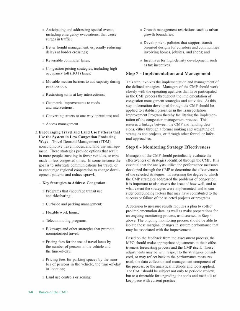
3-8 | Basics of the CMP
» Anticipating and addressing special events,
including emergency evacuations, that cause
surges in traffic;
» Better freight management, especially reducing
delays at border crossings;
» Reversible commuter lanes;
» Congestion pricing strategies, including high
occupancy toll (HOT) lanes;
» Movable median barriers to add capacity during
peak periods;
» Restricting turns at key intersections;
» Geometric improvements to roads
and intersections;
» Converting streets to one-way operations; and
» Access management.
3. Encouraging Travel and Land Use Patterns that
Use the System in Less Congestion Producing
Ways – Travel Demand Management (TDM),
nonautomotive travel modes, and land use manage-
ment. These strategies provide options that result
in more people traveling in fewer vehicles, or trips
made in less congested times. In some instance the
goal is to substitute communications for travel, or
to encourage regional cooperation to change devel-
opment patterns and reduce sprawl.
– Key Strategies to Address Congestion:
» Programs that encourage transit use
and ridesharing;
» Curbside and parking management;
» Flexible work hours;
» Telecommuting programs;
» Bikeways and other strategies that promote
nonmotorized travel;
» Pricing fees for the use of travel lanes by
the number of persons in the vehicle and
the time-of-day;
» Pricing fees for parking spaces by the num-
ber of persons in the vehicle, the time-of-day
or location;
» Land use controls or zoning;
» Growth management restrictions such as urban
growth boundaries;
» Development policies that support transit-
oriented designs for corridors and communities
involving homes, jobsites, and shops; and
» Incentives for high-density development, such
as tax incentives.
Step 7 – Implementation and Management
This step involves the implementation and management of
the defined strategies. Managers of the CMP should work
closely with the operating agencies that have participated
in the CMP process throughout the implementation of
congestion management strategies and activities. At this
step information developed through the CMP should be
applied to establish priorities in the Transportation
Improvement Program thereby facilitating the implemen-
tation of the congestion management process. This
ensures a linkage between the CMP and funding deci-
sions, either through a formal ranking and weighting of
strategies and projects, or through other formal or infor-
mal approaches.
Step 8 – Monitoring Strategy Effectiveness
Managers of the CMP should periodically evaluate the
effectiveness of strategies identified through the CMP. It is
essential that the analysts utilize the performance measures
developed through the CMP to determine the effectiveness
of the selected strategies. In assessing the degree to which
the CMP strategies addressed the problems of congestion,
it is important to also assess the issue of how well, and to
what extent the strategies were implemented, and to con-
sider confounding factors that may have contributed to the
success or failure of the selected projects or programs.
A decision to measure results requires a plan to collect
pre-implementation data, as well as make preparations for
an ongoing monitoring process, as discussed in Step 4
above. The ongoing monitoring process should be able to
isolate those marginal changes in system performance that
may be associated with the improvement.
Based on the feedback from the assessment process, the
MPO should make appropriate adjustments to their effec-
tiveness forecasting process and the CMP itself. These
adjustments may be with respect to the strategies consid-
ered, or may reflect back to the performance measures
used; the data collection and management component of
the process; or the analytical methods and tools applied.
The CMP should be subject not only to periodic review,
but to a timetable for upgrading the tools and methods to
keep pace with current practice.

Basics of the CMP | 3-9
3.4 LESSONS LEARNED FROM
CURRENT PRACTICE
The FHWA and FTA continue to work with their partners in
the metropolitan planning community to provide informa-
tion and obtain feedback on the emerging planning prac-
tices. In preparation of publication of the Rule on
Statewide Transportation Planning: Metropolitan
Transportation Planning, FHWA had sponsored a series of
workshops designed to inform stakeholders about emerging
requirements and to gauge the reactions of practitioners to
the new playing field.
In February 2006, FHWA sponsored a Peer Exchange
workshop involving MPOs and state DOTs in a review of
their experiences with congestion management systems
and processes as currently configured. This workshop
evolved into the “Congestion Management Processes
Peer Exchange and Case Studies” project (July 2006).
The workshop examined several key topics, including
linkage of CMP with NEPA documentation, operations,
and performance measures; coordination of the CMP with
transit agencies; interagency coordination; and the use of
CMP for setting priorities and evaluating project impacts.
The consensus of the planning practitioners involved in
the Peer Exchange was that a transition from congestion
management “systems” to a congestion management
“process” makes sense – but none of the participants
thought that the transition would be easy. Even in
regions where congestion management has been an inte-
gral part of the process for years, there is still skepticism
about what a CMS or CMP can contribute to solving a
region’s congestion problems.
Still other projects have focused on the challenges inherent
in measuring, monitoring, and responding to congestion in
metropolitan regions. One such study, “Traffic Congestion
and Reliability – Trends and Advanced Strategies for
Congestion Mitigation” (Cambridge Systematics, Inc. and
Texas Transportation Institute, September 1, 2005) offered
insight into how the causes, measurement, and monitoring
of congestion vary in different settings, and focused on con-
gestion trends and implications for the future. This report
Current Practice: Developed congestion management systems anticipate the evolution of the CMP, congestion man-
agement processes as part of the long-range metropolitan planning process.
The Atlanta Regional Commission (ARC) has established a CMP designed to manage congestion throughout the Atlanta,
Georgia region and to maximize the safety and mobility of people and goods. The process involves four steps:
• Identification,
• Understanding and Priority,
• Implementation; and
• Data and Monitoring.
The ARC analysis framework uses a Congestion Management System Network that covers the 13-county Atlanta
region, as well as major facilities in 5 adjacent counties, incorporating interstate highways, HOV facilities, major
roadways and select minor roads. Congested locations are identified both through outputs of regional transportation
models, using the Travel Time Index (TTI), and through field data collection in travel time studies.
Congested locations are identified according to TTI, where moderate congestion is indicated by TTI levels of 1.35 to
1.80, and severe congestion is indicated by a travel time index greater than 1.80. Once congested locations are iden-
tified, the CMP is used to help develop low-cost, high-impact solutions to congestion on the basis of regional priori-
ties. Different locations can have different thresholds for “tolerable” levels of congestion, based on activity and travel
patterns; priorities are also determined in the context of the intensity, extent, and duration of congestion. Analyses
are undertaken in the form of corridor studies, focusing on the movement to and from activity centers from both
facility and travelshed perspectives; and activity center analysis, which focuses on destination corridors and move-
ment within activity centers.
Data is obtained from a variety of sources, including Advanced Traffic Management System (ATMS) data obtained
from the regional Traffic Management Center; aerial photography data; and information from studies such as the Metro
Atlanta Signal Timing Project, corridor studies, and information retained from the region’s pre-existing congestion man-
agement system. The ARC is currently in the process of enhancing their analysis tools, including incorporating the
impact of crashes and weather on non-recurring congestion. ARC planners are also establishing processes to track
success through before and after studies where CMP mitigation strategies have been implemented. For further infor-
mation on ARC’s work please go to http://www.atlantaregional.com/cps/rde/xchg/arc/hs.xsl/605_ENU_HTML.htm.

3-10 | Basics of the CMP
emphasized the need for linking the planning process and
the practice of transportation systems management and
operations, and the need to make effective use of the data
and analytical tools now available for assessing patterns
of congestion.
In the wake of SAFETEA-LU and the new transportation
planning requirements ushered in by that legislation, the
FHWA sponsored workshops to review the new require-
ments and to focus on congestion management processes.
The “SAFETEA-LU Planning Provisions Workshop” (pre-
pared for FHWA and the American Association of State
Highway and Transportation Officials (AASHTO)
Standing Committee on Planning by Cambridge
Systematics, May, 2006) covered the spectrum of planning
requirements at the statewide level and a number of
requirements at the metropolitan level, emphasizing areas
of continuity and topics where new thinking has emerged.
The Congestion Management Process was among the
areas that both draw upon existing practice, and seek new
approaches and greater integration with the rest of the
metropolitan transportation planning process.
Many of the findings of the studies referred to above have
been incorporated into this guidebook. It is also important
to recognize the connections between the development of
this guidebook and other, concurrent efforts. FHWA/FTA
is also currently undertaking the development of a guide-
book for management and operations in the planning
process; documenting and assessing various analysis tools
with applications to transportation systems management
and operations; and cataloguing resources available for
statewide transportation planning.
Other MPOs have incorporated innovative elements into
their congestion management processes. The Delaware
Valley Regional Planning Commission (DVRPC), the
MPO for the Philadelphia, PA region, has tightened the
linkage between their CMP and their TIP by integrating
their CMP database with the TIP database. DVRPC
expects to make it easy for users of their web site “to easily
switch between the TIP and CMP pages to enhance under-
standing and planning.” CMP pages of the web site will
incorporate clickable maps to allow users to access data,
appropriate strategies, relevant adopted reports, and links to
TIP projects for each congested subcorridor.” CMP corri-
dors have been used in the development of the current MTP
for the region, and the MPO plans an update of the CMP
“to provide [a] technical basis for the next Plan.”6
3.5 CHALLENGES AND
OPPORTUNITIES
Ultimately, the CMP is intended to be a flexible approach
to transportation problem solving that builds upon years of
experience in congestion management. Congestion man-
agement systems were first advanced in ISTEA. Even the
ISTEA requirements built upon earlier efforts to focus on
congestion, including research projects and such practical
products as the Institute for Transportation Engineers’
(ITE) “A Toolbox for Alleviating Traffic Congestion.”
The intent of the move to a “congestion management
process” is evolutionary: to incorporate congestion man-
agement into the planning process, while retaining the
flexibility to apply the CMP approach at all levels of the
project and program development and delivery process. The
CMP should enable transportation planners and decision-
makers to apply the most appropriate and effective tools
and strategies to address congestion from the regional-
level to location-specific improvement projects.
It is important to emphasize that the CMP is intended to
support transportation decision making, as an integral
part of the planning process. While the process may be
supported by a program or system of data collection,
monitoring, and analysis (a “congestion management sys-
tem”), and may produce reports detailing alternative
strategies and projects designed to address specific con-
gestion problems (a “congestion management plan”), the
CMP is a set of tools for identifying and addressing con-
gestion throughout the long-range planning and project
development cycle. MPOs that have long-standing con-
gestion management programs or systems may be chal-
lenged in the transition to a fully integrated long-range
transportation process that makes congestion management
a “core” activity, as opposed to an isolated, stand-alone
process. Even MPOs that have done an exemplary job of
breaking down the “silos” that can separate elements of the
planning process may face institutional barriers to fully
integrating the CMP into the project development process,
using CMP studies and products as part of the NEPA
process. (This issue is discussed in more detail below.)
While there are many available technical methods that can
assist in assessing the state of congestion in a given
region, MPOs may be challenged in developing and main-
taining these tools for their own regions. The ability to
acquire and maintain the level of data collection and man-
agement is also a significant hurdle in many areas.
6 Neaderland, Zoe “System-Wide Analysis for Congestion Management:
Lessons Learned from Preparing the Congestion Management Process for
Delaware Valley Regional Planning Commission,” TRB 2007 Annual Meeting
CD-ROM, Transportation Research Board, The National Academies,
Washington, D.C.

Basics of the CMP | 3-11
Different operating agencies may have quite different and
distinct data collection and management systems. Even if
data is collected into a regional data archive, many of
these differences in how each agency collects, processes,
and formats data may remain. MPOs may encounter sig-
nificant barriers in consolidating information and recon-
ciling these different data management practices.
The difficulties inherent in understanding and using data
from multiple agencies underscores the need to involve the
appropriate players from transportation system operating
agencies, both at the policy and technical level. These
challenges apply as well to attracting and retaining profes-
sional staff to manage the CMP. While obtaining the nec-
essary level of commitment and continuity of involvement
from agency staff is a formidable challenge, bringing
together operations personnel and policy level representa-
tives from multiple operating agencies can also offer
tremendous opportunities for creating formal and informal
networks and working relationships. Creating a CMP
“team” can deliver real benefits by transforming “stake-
holders” into partners in pursuing effective congestion
management strategies.
Notwithstanding these challenges, the CMP offers an
opportunity to institutionalize a new and strategic mind-
set toward transportation issues. The objectives-driven,
performance-based approach to metropolitan transporta-
tion planning embodied in the CMP, and in the new
emphasis on management and operations, can strengthen
the planning process by directing attention to short- and
medium-term measures to mitigate congestion, as well as
to measures that will maintain the safety and efficiency of
new and expanded transportation facilities into the future.
The CMP approach can also be a template for approaching
other regional objectives that are established through the
planning and visioning process.
The challenges and opportunities outlined above may pres-
ent themselves to an MPO and the other participants in the
CMP at any stage in the development of the congestion
management process. Whether adapting an existing sys-
tem or starting from scratch, the architects of the CMP will
be implementing a process that builds on past experiences
while incorporating an objectives-driven, performance-
based approach to addressing congestion.

4-1 | Development and Implementation of an Objectives-Driven CMP
4.0 DEVELOPMENT AND IMPLEMENTATION OF ANOBJECTIVES-DRIVEN CMP
4.1 DEVELOPING A CMP
Many MPOs already have existing systems or processes for
congestion management, based on metropolitan planning
rules and guidance developed under ISTEA and the
Transportation Equity Act for the 21st Century (TEA 21), the
successor authorization act for surface transportation. The
statewide planning requirements spelled out in SAFETEA-
LU also stipulate that “For purposes of this section... State
laws, rules, or regulations pertaining to congestion manage-
ment systems or programs may constitute the congestion
management process under this section... if the Secretary
finds that the State laws, rules, or regulations are consistent
with, and fulfill the intent of, the purposes of this section...”
If no existing plan, program, system, or process can serve
as the basis for the CMP, MPOs can look to several excel-
lent models from across the country, and many resources
from FHWA/FTA, the Association of Metropolitan
Planning Organizations (AMPO), and other sources to
help them get started.
As noted above, the CMP is based upon regional opera-
tions objectives articulated in the metropolitan transporta-
tion plan. The congestion management process incorpo-
rates specific, measurable, achievable, realistic, and time-
bound (“SMART”) objectives that reflect regional goals.
4.2 BEYOND THE “8 STEPS” –
A SUSTAINABLE CMP
The CMP for any given region should be tailored to
address the most critical needs of that region. The trans-
portation planning process should already have provided
input on the regional vision, goals, and objectives to
which the CMP must respond. To gain an understanding
of the needs of various stakeholders in the planning
process with respect to congestion, it is important to reach
out to operating agencies, advocacy groups, commercial
interests, and members of the public.
• Decide on what you want to accomplish.
There should be general agreement on how the regional
goals and objectives expressed in the MTP should be articu-
lated in the context of the CMP. Different stakeholders will
have different objectives, which must be accommodated in
the overall process. An important place to begin this is
through the public participation process of the MPO, where
community visions are transformed into goals, objectives,
and measurable performance indicators. And, the intent for
the CMP to feed projects and strategies into the metropoli-
tan transportation plan and TIP should be made clear.
• Develop a work team within the MPO and other
necessary organizational arrangements such as a
Steering Committee.
Existing organizational arrangements may be appropriate, or
new committees can be formed. But, it is important for the
groups to have broad membership of planning and operations
staffs from the member organizations of the MPO – local
jurisdictions, state DOTs, and public transportation operators.
• Prepare a timeline for developing the CMP.
While the application of the CMP to particular issues
should be open-ended, there should be a strict timetable
for developing the process. As with any plan strategy, it is
good practice to have an implementation plan that
includes specific tasks, schedules, levels of effort, and
responsibilities for carrying out the CMP. Again, if the
CMP is part of the MTP, CMP strategies can be treated
just like the other implementation measures. But, whether
or not the CMP is prepared as an element of the MTP, the
timeline ought to allow time for the CMP to “feed” proj-
ects and strategies to the MTP development process. The
timeline also should identify an update schedule, as well
as data collection and analysis activities to support the
periodic assessment of the effectiveness of implemented
congestion management strategies.
• Conduct a CMP self assessment.
• Regional Operations• Land Use• Travel Demand• Transit Improvement
Congestion ManagementObjectives
• Define area of application, system (network)• Define performance measures• Develop monitoring plan• Identify and evaluate strategies
Congestion Management Process
Incorporate Strategies into MTP
• Implement strategies• Monitor strategy effectiveness
Figure 4. CMP – An Iterative Process

Development and Implementation of an Objectives-Driven CMP | 4-2
The purpose of the self-assessment is to determine where
your MPO stands in adapting an existing congestion man-
agement system or plan into a CMP (that is, which ele-
ments of your CMP meet “best practice” levels), or what
remains to be done in developing the CMP from square
one. The self-assessment will require you to review and
assess what you are doing now to address congestion, not
only in terms of long-range planning, but the efforts of
operating agencies to institute short-range programs to
manage congestion.
In the course of the self-assessment, you will identify
strengths and weaknesses of current efforts, in terms of
establishing a collaborative, regional process; developing
operations objectives; deriving appropriate measures of
performance; instituting data collection and data manage-
ment systems; identifying current congested locations and
forecasting future congestion; and selecting and analyzing
potential congestion management strategies. Ultimately,
the self assessment process will help you to identify areas
where you wish to make improvements improvement as
you implement the CMP.
CMP Reflects Scenario Planning andVisioning Leading to MTP
By institutionalizing an objective-driven, performance-
based planning process incorporating a range of stake-
holders, the planning process will continue to evolve in
response to the growing challenges of metropolitan trans-
portation planning. The MTP that results from this
process will clearly address management and operations
of the transportation system. It should include:
• A vision, goals, and objectives that address man-
agement and operations;
• Measurable objectives that allow the region to track
progress toward achieving its goals;
• Clear strategies for management and operations,
backed by specific performance measures for
evaluation; and
• A congestion management process that responds to
regional priorities and to the interests and concerns
of all of the region’s stakeholders – including
system operators.
Since the CMP is an integral part of the planning
process, rather than a stand-alone effort, it incorporates
the knowledge and understanding of all of the players
who contribute to the development of the MTP. It also
reflects the insight achieved through the process of
establishing a regional vision and goals, and exercises
such as scenario planning, which enable participants in
the process to gain a richer understanding of possible
futures and potential responses.
MPO/State Roles Should be Clearly Defined
While MPOs generally welcome, and benefit from the
involvement of the state DOT in the metropolitan planning
process, the active participation of the DOTs in the conges-
tion management process is particularly important. Not
only is the perspective of the DOT as an operator important
in the sharing of data and developing congestion mitigation
strategies, it is important that the state DOT appreciate the
perspective and priorities of other participants in the con-
gestion management process. “Acceptable” levels of con-
gestion may differ according to transportation facility, geo-
graphic location (metropolitan area or subarea), and/or
time-of-day. For instance, a higher level of congestion may
be acceptable in a transit-oriented development (TOD) area,
where planners hope to encourage the use of public trans-
portation, while system operators may wish to maintain a
higher level of service in areas poorly served by transit. In
any case, the operators of facilities – including the state
DOT – should be sensitive to the priorities of various stake-
holders in the congestion management process. Participants
in the CMP, including the MPO, state DOTs, transit opera-
tors, and other public or quasi-public operators should be
flexible in selecting appropriate levels of service for critical
components of the regional transportation network.
“Performance measures,” according to the Final Rule on
metropolitan and statewide planning, “should be established
cooperatively by the state(s), affected MPO(s), and local
officials in consultation with the operators of major modes
of transportation in the coverage area.”7
Regional Collaboration and Cooperation
Collaboration on regional operations, including the develop-
ment and implementation of the congestion management
process, is essential. Collaboration enables regional, strate-
gic development of projects and policies that have a regional
effect on users, including activities such as incident manage-
ment, advanced traveler information services, public safety
and security, management of the impacts of special events,
and implementation of electronic payment measures. A
common thread in all of these activities is agreement upon
7 Statewide Transportation Planning; Metropolitan Transportation
Planning; Final Rule, Federal Register, Vol. 72, No. 30; February 14, 2007;
Section 450.320 (pp. 7274 to 7275).

4-3 | Development and Implementation of an Objectives-Driven CMP
objectives and performance measures, so that projects can
be evaluated on the same footing. Furthermore, collabora-
tion among operators, service providers, and planners for all
surface modes affecting, or affected by, congestion, helps to
answer questions about the long-term operation, integration,
and evolution of facilities and services.
Appropriate levels of collaboration and cooperation also
help to identify the many stakeholders and interested par-
ties who should be at the table sharing information and
making operations decisions. This is also one of the
objectives of the process that leads to the creation and
ongoing maintenance of a Regional ITS Architecture,
where the requirements of the various affected actors are
accommodated through the development of a regional
concept of operations. Finally, an understanding of how
each participant perceives the individual agency’s roles
and responsibilities helps to improve accountability for
improved system performance.
While a measure of collaboration and cooperation can be
achieved through ad hoc or informal channels, an ongoing
process that yields lasting value depends upon a consistent
structure or framework for action, collaboratively devel-
oped and accepted policies, and resources for sustaining
and implementing plans and programs. If no existing
mechanisms, such as MPO committees that can assume
responsibility for a collaborative CMP, are available, some
forum for perpetuating the process should be established.
Policy and technical committees can be used to get the
word out to implementing agencies on the merits of the
CMP measures. The local government representatives can
make sure that strategies get reflected in their capital pro-
grams and operating budgets. Also, the state DOT is usually
represented on these committees and their representatives
can be asked to include the appropriate CMP measures in
the state capital programs and operations budgets for the
state system. Transit operator(s) represented on those com-
mittees can assist in proposing CMP measures and strate-
gies, as well as include agreed upon strategies in their proj-
ect and strategy submittals for inclusion in the plan and TIP.
• Identify and engage other key stakeholders.
– Obvious stakeholders include system operators,
commuter advocacy groups; reach out also to
commercial vehicle operators, shippers,
Chambers of Commerce, service industries.
• Describe the purpose and value in achieving
collaboration.
– Be prepared to answer question, “What’s in it for
me?” Use local data or national averages to cal-
culate costs in fuel, productivity, air quality, etc.
• Get buy-in from decision-makers.
– Make sure that CMP is aligned with goals and
objectives of local elected and appointed officials.
• Commonly used methods of collaboration.
– Engage interest groups by going to them, rather
than inviting them to your turf; “surface the dis-
content”; make them vital elements in solution,
rather than observers or passive beneficiaries.
4.3 DEVELOPING CONGESTION
MANAGEMENT OBJECTIVES
Objectives are specific, measurable statements relating to
the attainment of goals. In the MTP, congestion objec-
tives should be regional or multi-jurisdictional in nature
and cannot be achieved by a single entity or jurisdiction.
In conjunction with selecting congestion objectives, per-
formance measures are developed to assess whether or not
the objective has been met.
In all cases, objectives should have “SMART” characteris-
tics, as defined below:
• Specific – It provides sufficient specificity to guide
formulation of viable approaches to achieving the
objective without dictating the approach.
• Measurable – It includes quantitative measurements,
saying how many or how much should be accom-
plished. Tracking progress against the objective
enables an assessment of effectiveness of actions.
• Achievable – Objectives should be realistic and
within the reach of the various participants in the
CMP. Objectives should not represent a “wish
list,” but should take into consideration projections
and trends used elsewhere in the metropolitan
transportation planning process.
• Realistic – The objective can reasonably be accom-
plished within the limitations of resources and other
demands. Still, the objective may be a “stretch” and
require substantial coordination, collaboration, and
investment to achieve. Since a judgment on how
realistic the objective is cannot be fully evaluated
until after strategies and approaches are defined, the
objective may need to be adjusted iteratively.
• Time-bound – The objective identifies a time-
frame within which it will be achieved (e.g., “by
the year 2020”).
By developing “SMART” objectives, system performance
can be examined and monitored over time.

Development and Implementation of an Objectives-Driven CMP | 4-4
4.4 APPLYING THE CMP
As discussed before, the CMP is an integral element of the
metropolitan transportation planning process. By applying
the principles of objectives-based, performance-driven
planning, the CMP actualizes the vision and goals defined
for the region through the planning process.
Following the development of the Congestion
Management Process, the MPO will want to focus on
developing an implementation strategy. The MPO can
implement the CMP in a number of different ways, or in a
combination of different ways. Strategies, projects, or
programs identified through the CMP can be realized:
• Directly, through the MTP and TIP;
• Indirectly, by working with the state DOT or local
government members;
• By encouraging government agencies to include
CMP activities in their operating budgets; and
• By encouraging that state or local agencies sponsoring
congestion mitigation strategies incorporate CMP
alternatives analyses during project development.
Applying the CMP in developing the MTP
The congestion management process provides a mecha-
nism for identifying short-, medium-, and long-term
strategies for addressing congestion on a systemwide,
corridor-level, or site-specific basis. Once operations
objectives relevant to the area in question have been estab-
lished, the CMP draws upon appropriate performance
measures to identify specific congestion problems. Data
from the MPO’s resources or from the appropriate operating
agency is used to characterize the nature of the congestion
problems, and technical tools are applied to help identify
appropriate strategies.
The CMP uses a cooperative approach to involve both
affected operators and the public in a consideration of strate-
gies, both in terms of the effectiveness of proposed solutions
and the acceptability to various stakeholders. Together,
affected parties and system operators determine the avail-
ability of resources and the timing for implementation of
proposed strategies. The actions identified through the CMP
then become part of the alternatives analysis process, in
which proposed solutions to the broad array of regional
problems are considered in context. Actions offered through
the CMP are then incorporated into the MTP, based on how
they compete with projects and programs proposed by other
interests during the planning process.
Identifying and selecting strategies throughthe CMP
The CMP may ultimately offer a single project or program
to address congestion in a particular circumstance, but it is
more likely that an array of alternatives will be put for-
ward that can individually or collectively contribute to a
reduction in congestion or a mitigation of the problems
caused by congestion. The CMP continues to be relevant
once these broad-brushed alternatives are laid out in the
MTP. Products from the CMP will continue to be used in
subsequent analyses, including the use of data and study
results in the project development process.
The CMP might also be employed in selecting projects for
incorporation in the TIP. Capital and non-capital projects
from the MTP proposed to be funded under 23 U.S.C. and
49 U.S.C. Chapter 53, or requiring action from FHWA or
FTA, are included in the TIP. The CMP offers a way to
prioritize projects in the event that funds for implementa-
tion are limited, or to establish the “agreed to” list of proj-
ects to be included in the first year of the TIP.
Relationship of the CMP to the ITS RegionalArchitecture
The CMP and the Regional ITS Architecture are both
technical tools that assist planners and system operators in
developing and selecting strategies for improving the
movement of people and goods in a region. The Regional
ITS Architecture focuses on the application of information
and communications technology to transportation prob-
lems in a technologically coordinated way. It is a com-
mon framework that guides practitioners in establishing
communications (and, ideally, integration) across technol-
ogy applications and helps them to choose the most appro-
priate strategies for processing transportation information.
The Regional ITS Architecture defines the system compo-
nents, key functions, organizations involved in developing
an architecture, and the type of information to be shared
between organizations and between parts of the system.
While the CMP is not focused on any particular set of
strategies, an understanding of the Regional ITS
Architecture is crucial in appreciating the existing and
future interconnections, or even the simple ability to com-
municate, between agencies and systems. The ITS
Architecture, which is by design a living document, to be
updated on a periodic basis, provides an institutional
framework as well as a vision of the interconnectedness
among technologies, systems, and subsystems.

4-5 | Development and Implementation of an Objectives-Driven CMP
Applying the CMP in Nonattainment TMAs
SAFETEA-LU requires that “for transportation manage-
ment areas classified as nonattainment for ozone or carbon
monoxide pursuant to the Clean Air Act, Federal funds
may not be advanced in such area for any highway project
that will result in a significant increase in the carrying
capacity for single-occupant vehicles unless the project is
addressed through a congestion management process.”
While capacity-expanding projects are not prohibited, the
CMP requirement means that the MPO must consider
alternatives to capacity increases, and that measures would
be incorporated into the project to make the most efficient
use of the new capacity once it has been constructed. In
all TMAs, attainment or non-attainment, the CMPs should
identify strategies that complement proposed improve-
ments. These may be measures such as ramp meters for
new freeway lanes or access management on a parallel
arterial. These complementary strategies extend the life of
the SOV capacity in which we invest.
In ozone and CO non-attainment TMAs, MPOs must
establish a congestion management process that gives pri-
ority to strategies that reduce congestion and improve
the movement of people and goods without requiring
the construction of new highway capacity. The decision
process in dealing with this restriction on SOV capacity-
expanding projects must be documented as part of the
CMP in these areas.
Addressing Recurringand Nonrecurring Congestion
The CMP should enable the MPO to address both recur-
ring congestion (usually caused by “bottlenecks” where
capacity is constricted or where merging and weaving pat-
terns cause conflicts) and non-recurring congestion
(resulting from incidents, special events, or other phenom-
ena like adverse weather). Either type of congestion may
require analysis at the corridor or facility level in order to
pinpoint problem locations or to identify and evaluate
potential mitigation strategies.
The CMP should also be designed to enable assessment of
activities that may not apply to a particular location, such
as incident response strategies. Incident-related delay
accounts for a large and growing proportion of travel
delay, particularly in regions where travel demand is
already stressing an over-burdened system.
Linkages to the Statewide Planning Processand STIP
The Final Rule on Statewide and Metropolitan
Transportation Planning makes it clear that coordination
and consultation between the state Department of
Transportation and the MPO is required; state DOTs are
“encouraged to rely on information, studies, or analyses
provided by the MPOs for portions of the transportation
system located in metropolitan planning areas” (§450.208).
Furthermore, the statewide planning process “shall (to the
maximum extent practicable) be consistent with the devel-
opment of applicable regional intelligent transportation
systems (ITS) architectures...” The Final Rule also encour-
ages “consultation with, or joint efforts among, the
State(s), MPO(s), and/or public transportation operators
(§450.212). The States should be partners in the develop-
ment and application of the CMP, particularly for portions
The Puget Sound Regional Council (PSRC) has demonstrated
that by providing better processes to understand the conges-
tion data, a greater success has been realized in stakeholders’
understanding of projects.
The PSRC has used innovative methods of presenting con-
gestion data so that stakeholders better understand the
region’s transportation policy and planning related to CMP.
This data has also proven very useful in educating stakehold-
ers and helping stakeholders prioritize projects within a corri-
dor given fiscal limitations and competing fiscal demands of
multiple jurisdictions. The clear presentation of data helps
them ensure that projects are selected that address the most
severe congestion.
PSRC has partnered with WSDOT both to obtain and analyze
data. The agency has developed innovative visuals to commu-
nicate the complexities of congestion. These include “brain
scan” visual using colors to show the level of congestion
based on lane occupancy throughout the 24-hour period along
a corridor. Other visuals used are three-dimensional images
that show the greatest level of delay as bars of varying heights
on a regional map. These tools have been so successful that
they are being shown widely throughout the region and helping
to advance understanding of traffic congestion. These tools
that have been used through the region on corridor studies will
also be used in PSRC’s stand-along CMP report, which is
under development.

Development and Implementation of an Objectives-Driven CMP | 4-6
of the transportation network within the MPO that are
operated by the state DOT. The development and content
of the Statewide Transportation Improvement Program
(STIP) can similarly be enabled through application of
the CMP.
Tying funding to the CMP
Some CMP projects and strategies can be implemented by
the MPO through inclusion in the TIP. It may be neces-
sary to convince the TIP committee or decision making
body on the merits of the CMP projects by ranking proj-
ects relative to their benefits. Other CMP projects/strate-
gies may need to be included in state or local programs to
accomplish implementation.
(Those projects that support the goals and objectives of
the plan should be implemented; projects should be
ranked according to how well they meet the goals and
objectives of the plan.)
4.5 THE CMP AS A LINKAGE
BETWEEN PLANNING
AND NEPA
The Appendix to Part 450 referred to above points out the
close links between the metropolitan transportation plan-
ning process as practiced by MPOs and the environmental
analysis undertaken by project sponsors. Legal guidance
previously distributed to planning agencies8 notes that
“much of the data and decision-making undertaken by
state and local officials during the planning process carry
forward into the project development activities that follow
the TIP or STIP. This means that the planning process and
the environmental assessment required during project
development by NEPA (42 U.S.C. 4231 et seq.) should
work in tandem, with the results of the transportation
planning process feeding into the NEPA process.”
The memorandum goes on to point out that this close link-
age is not always observed in the course of project devel-
opment. “In practice,” note the authors of the memo, “the
environmental analyses produced during the NEPA
process are sometimes disconnected from the analyses
used to prepare transportation plans, transportation
improvement programs, and supporting corridor or sub-
area studies. Analyses and decisions occurring during
transportation planning can be ignored or redone in the
NEPA process, resulting in a duplication of work and
delays in implementation of transportation projects. The
sharp separation between the work done during the trans-
portation planning process and the NEPA analysis and
documentation process is not necessary.” In other words,
planning information can and should be incorporated into
the environmental review process, rather than starting
with a blank page for every project.
As further discussed in the memo, “NEPA and the govern-
ment-wide regulations that carry out NEPA (40 C.F.R.
Parts 1500 et seq.) clearly contemplate the integration of
the NEPA process with planning processes...
• 40 C.F.R. 1501.2 requires that Federal agencies
“integrate the NEPA process with other planning atthe earliest possible time to ensure that planning and
(agency) decisions reflect environmental values…”
Sections of the Final Rule referring to “Transportation
planning studies and project development (§450.318, p.
7274) discuss the high standards that must be met for
incorporation of planning studies into the NEPA process.
The Rule notes that “Publicly available documents or other
source material produced by, or in support of, the trans-
portation planning process described in this subpart may be
incorporated directly or by reference into subsequent
NEPA documents, in accordance with 40 CFR 1502.21, if:
1. The NEPA lead agencies agree that such incorpora-
tion will aid in establishing or evaluating the pur-
pose and need for the Federal action, reasonable
alternatives, cumulative or other impacts on the
human and natural environment, or mitigation of
these impacts; and
8 Memorandum: Integration of Planning and NEPA Processes, February
22, 2005; D.J. Gribbin, Chief Counsel, FHWA and Judith S. Kaleta, Acting
Chief Counsel, FTA to Cindy Burbank, Associate Administrator, Office of
Planning, Environment and Realty, FHWA and David A Vozzolo, Deputy
Associate Administrator, Office of Planning and Environment, FTA.
The Southeast Michigan Council of Governments (SEMCOG)
shows the close integration of the CMP and the LRTP for ranking
projects and realizing system improvements through clearly
defined performance measures.
The SEMCOG developed a stand-alone CMP but knew that for
any congestion mitigation strategies to be implemented, they
needed to be part of the LRTP. During development of its 2030
LRTP, SEMCOG provided congestion analysis results and mitiga-
tion strategy recommendations developed in the CMP report to
state and local agencies. This information, along with public
input, was used by state and local road and transit agencies to
propose projects for the LRTP.
In the LRTP, SEMCOG uses a weighting process to prioritize
regional corridors and ensure that investment occurs in the
areas with greatest need. One of the eleven performance
measures used to weight corridors is congestion, and a num-
ber of other factors have congestion implications, such as
improvements to corridors with high transit ridership and non-
motorized transportation. Therefore, the corridor prioritization
process is analytically driven and integrated with the CMP.

4-7 | Development and Implementation of an Objectives-Driven CMP
2. The systems-level, corridor, or subarea planning
study is conducted with:
a. Involvement of interested state, local, tribal, and
Federal agencies;
b. Public review;
c. Reasonable opportunity to comment during the
metropolitan transportation planning process
and development of the corridor or subarea
planning study;
d. Documentation of relevant decisions in a form
that is identifiable and available for review during
the NEPA scoping process and can be appended
to or referenced in the NEPA document; and
e. The review of the FHWA and the FTA, as
appropriate.9
Appendix A to 23 CFR 450 (p. 7281), while addressing
the level of detail appropriate for incorporation of plan-
ning analysis in project development studies, the Rule
Current Practice: Linking NEPA studies with the CMS Toolbox was a logical approach given that alternatives defined with congestion
relief potential would be developed, screened, and evaluated for any NEPA study underway in the region.
The Mid-America Regional Council (MARC) serves eight counties and 116 cities in the greater Kansas City bi-state (Missouri and
Kansas) region. In 2001, MARC developed an enhanced congestion management system (CMS) designed to integrate with the
Regional Transportation Plan (RTP), Transportation Improvement Program (TIP), and corridor evaluations, including the Major
Investment Study (MIS) planning processes. In developing its CMS, MARC identified a “CMS Toolbox” that incorporated a broad
catalog of potential strategies under the following headings:
1. Highway projects;
2. Transit projects;
3. Bicycle and pedestrian projects;
4. Transportation Demand Management (TDM) strategies;
5. Intelligent Transportation Systems (ITS) and Transportation Systems Management (TSM) strategies;,
6. Access management strategies;
7. Land development strategies; and
8. Parking management strategies.
MARC adopted a policy that its CMS Toolbox of strategies would be considered when the purpose and need for an environmental
study includes congestion management. The agency wanted to directly demonstrate how any suggested capacity improvements
had been evaluated using the congestion management process.
At the time MARC was developing its CMS, the agency had established a network of facilities on which it collected data, including
travel time studies and traffic counts, but was only using CMS methods to support the regional planning process by providing data to
potential project sponsors for the RTP and TIP. Because the system is less congested than most other metropolitan regions of com-
parable size, the CMS has been less of a planning focus than in other locations.
MARC wanted to develop a transparent process to show how a capacity improvement had gone through the congestion manage-
ment process. Linking NEPA studies with the CMS Toolbox was a logical approach given that alternatives defined with congestion
relief potential would be developed, screened, and evaluated for any NEPA study underway in the region. The MARC CMS Policy
adopted the following language on the integration of major investment studies to the metropolitan planning process:
The CMS Toolbox provides alternative congestion management strategies for consideration in MIS and Corridor Studies. When traffic
congestion is referenced in the Purpose and Need Statement for an MIS, the MIS shall consider the congestion management strategies
included in the MARC CMS Toolbox as a starting point for the development of alternative strategies. This does not preclude the MIS from
considering other strategies that may not be in the CMS Toolbox, nor does it require that the MIS select a strategy from the CMS Toolbox
be the preferred alternative, however, the MIS document must include a discussion of how the CMS Toolbox strategies were addressed.
Currently, there is no NEPA requirement that the CMS be incorporated into the NEPA process. Furthermore, MARC’s policy that NEPA
studies incorporate the CMS Toolbox is not codified in any agreements with implementing agencies, but instead is implemented on a
voluntary and cooperative basis. However, MARC and the Missouri Department of Transportation (MoDOT) have worked closely in
a number of instances to incorporate CMS Toolbox strategies into relevant projects.
A major benefit is that by coordinating planning and NEPA through the CMP, duplication or redoing the planning work in the NEPA
process is avoided. This helps to “streamline” the NEPA process. Since adoption of the Policy, MARC has not been challenged
about any projects in the TIP. MARC feels the region is accomplishing the goals that Congress had set for CMS when it was estab-
lished, since transportation is being approached from a multimodal perspective. Overall, MARC feels that the partnerships among
state, Federal, and regional government agencies are working well, with MARC staff continually involved in a significant number of
projects. For more information on MARC’s work go to:
http://www.marc.org/transportation/congestionmanagementsystem.htm.
9 See 23 CFR 450.318 (b).
Development and Implementation of an Objectives-Driven CMP | 4-8
10 http://ostpxweb.dot.gov/freight_policy_framework.html (accessed 03/29/07).
notes that “For purposes of transportation planning alone,
a planning-level analysis does not need to rise to the level
of detail required in the NEPA process. Rather, it needs to
be accurate and up-to-date, and should adequately support
recommended improvements in the statewide or metropol-
itan long-range transportation plan. The SAFETEA-LU
requires transportation planning processes to focus on set-
ting a context and following acceptable procedures. For
example, the SAFETEA-LU requires a “discussion of the
types of potential environmental mitigation activities’’ and
potential areas for their implementation, rather than details
on specific strategies. The SAFETEA-LU also empha-
sizes consultation with Federal, State, and Tribal land
management, wildlife, and regulatory agencies.
However, the Environmental Assessment (EA) or
Environmental Impact Statement (EIS) ultimately will be
judged by the standards applicable under the NEPA regu-
lations and guidance from the Council on Environmental
Quality (CEQ). To the extent the information incorporated
from the transportation planning process, standing alone,
does not contain all of the information or analysis required
by NEPA, then it will need to be supplemented by other
information contained in the EIS or EA that would, in
conjunction with the information from the plan, collec-
tively meet the requirements of NEPA.”
In this context, the CMP, if appropriately developed, can
provide at a minimum a valuable starting point for the
NEPA process, and ideally, could give the agency a “run-
ning start” on critical components of the NEPA process
such as purpose and need, alternatives screening, among
others (see section 5.2.3 for more information).
4.6 OTHER POTENTIAL APPLICA-
TIONS OF CMP APPROACH
The Congestion Management Process is one of many ele-
ments feeding into the metropolitan transportation plan-
ning process. Along with requirements for coordination
with state and local officials, consultation with Federal
and tribal agencies, and consistency with the regional or
statewide ITS Architecture, the CMP provides a mecha-
nism for addressing regional, corridor-wide, and spot con-
gestion issues in a comprehensive fashion. At the same
time, the CMP works with the eight planning factors that
should be considered in preparing long-range plans – and
especially with promoting efficient and effective trans-
portation system management and operations.
The CMP is not intended to replace any of the existing ele-
ments of the planning process, but instead to complement
and efficiently organize existing methods and techniques,
focusing on management and operations strategies as
potential means for mitigating or offsetting existing and
future congestion. By emphasizing system performance
measures, and on the data needs derived from such meas-
ures, the CMP helps system planners to identify ways to
maximize the use of existing capacity, and to extend the
usefulness of proposed improvements by enhancing opera-
tional efficiency and effectiveness.
4.6.1 FREIGHT PLANNING
Most metropolitan areas face challenges in transportation
planning for freight interests. Dramatically increasing
freight flows in the metropolitan areas have contributed to
increased congestion in the transportation system, imposing
costs on shippers, consumers, and the environment. Using
the congestion management process tools, processes, and
data to support these tools and processes assist in addressing
freight planning to address freight movement.
The United States Department of Transportation has
developed a “Framework for a National Freight Policy”.10
This framework contains a vision of freight transportation
systems that will ensure the efficient, reliable, safe and
secure movement of goods and support the nation’s eco-
nomic growth while improving environmental quality. The
“Framework” offers potential strategies that can be con-
sidered when assessing goods movement through the con-
gestion management process.
The CMP can assist in addressing freight-specific conges-
tion, and that congestion impacting freight movement, by
incorporating specific freight-related strategies and by
including freight in the development of an objectives-driven,
performance based approach to resolving congestion
issues. Freight-specific strategies might include truck-
only lanes; infrastructure improvements to remove freight
bottlenecks; and designated truck routes.
4.6.2 SAFETY PLANNING
Incorporating safety as a regional priority, and establishing
specific safety-related performance objectives, is an impor-
tant first step toward having safety considerations included
in the metropolitan transportation planning process.
When safety objectives are included in the MTP, this
drives the development of safety-related performance
measures in the CMP. An emphasis on safety becomes
integral to the collection of crash and injury data, which
further supports the analysis of safety during the planning
process. As local jurisdictions develop and maintain crash
information databases and conduct independent safety

4-9 | Development and Implementation of an Objectives-Driven CMP
analyses, such data can further support the identification of
locations and types of safety improvements that are needed.
Involving local public safety officials as CMP stakehold-
ers is key to identifying safety concerns and can provide
useful input on key transportation safety issues. Planners
can work with traffic, engineering, and public works staff
to develop safety-related objectives in the CMP. These
measures allow safety countermeasures to be incorporated
into highway rehabilitation or improvement projects.
Stand-alone projects to address critical safety issues also
can be incorporated into the planning process.
4.6.3 LAND USE
The planning and management of urban land use greatly
impacts transportation demand on the surface transportation
system. Land use decisions are generally made at the local
level, so considerations with respect to jurisdictional control
should be kept in mind when advancing land use strategies.
Including operational objectives dealing with land use in
the metropolitan transportation plan highlights the impor-
tance of transportation investment for land development,
regional demographic growth, and economic development.
Land development strategies have been used in some areas
to manage transportation demand on the system, and to
help agencies meet air quality conformity standards. Such
land use strategies can include limits on the amount and
location of development until certain service standards are
met, or policies that encourage development patterns bet-
ter served by public transportation and nonmotorized
modes. Examples of land use strategies include transit-
oriented development, densification and infill strategies,
and encouragement of mixed-use development.
4.6.4 NONMOTORIZED TRANSPORT(BICYCLE/PEDESTRIAN)
Incorporating nonmotorized transportation modes into the
objectives of a regional transportation program adds an
additional dimension in alleviating traffic congestion.
nonmotorized modes of transportation, such as biking and
walking, are sometimes overlooked by transportation pro-
fessionals. Investments in these modes can increase safety
and mobility in a cost-efficient manner, while providing a
zero-emission alternative to motorized modes. Strategies
focused on non-motorized modes can be implemented
with relatively little cost, but tend to have local rather than
systemwide impacts. The effectiveness of an investment
in non-motorized travel depends heavily on coordination
with local land use policies and connections with other
modes, such as transit, for longer distance travel. Safety
and aesthetics should also be emphasized in the design of
bicycle and pedestrian facilities in order to increase their
attractiveness. Representative strategies include sidewalks
and bike lanes for local streets; improved bicycle facilities
at transit stations and other destination locations; design
guidelines for pedestrian-oriented development; improved
safety and security for existing bicycle and pedestrian
facilities; and exclusive non-motorized rights-of-way (i.e.,
rails-to-trails strategies).
4.6.5 PUBLIC TRANSPORTATION
Public transportation is an integral component of a region’s
transportation program, and transit operators join MPOs
and state DOTs in making up the three the key planning
and decision-making partners in metropolitan and statewide
planning processes. Transit systems and services play
important parts in measuring, responding, and managing
both recurring and non-recurring congestion. However,
because congestion typically is regarded only as “high-
way” congestion, the many roles and influential aspects of
public transit are sometimes overlooked by transportation
professionals in planning for congestion management.
Transit addresses congestion in a number of ways, over both
the near- and longer-term timeframes. First, transit services,
if time and cost competitive to driving, offer alternatives to
single occupant vehicle usage. As such, transit can affects
congestion as a vehicle-reduction strategy. But, transit opera-
tions themselves are vulnerable to congestion, with deterio-
rated travel times on buses limiting transit’s ability to attract
new riders. Over a longer-term, transit service, fixed route or
guideway in particular, can be a catalyst for smart growth
and transit-supportive land development/redevelopment.
These development patterns, in turn, can provide a sustain-
able longer-term strategy for congestion management by
strengthening the market for transit, as well as by shortening
the lengths of trips that continue to be by auto.
Finally, transit operations may have significant impacts –
positive and negative – on corridor congestion. Transit pull-
outs can significantly improve traffic flow by freeing capac-
ity in curb lanes. Similarly, effective schedule adherence
can ease rider connections and transfers, thereby improving
transit system performance and attracting new riders.
These considerations and many others illustrate the impor-
tance of involving transit operators in CMP development
and implementation – as “customers” of congestion man-
agement, beneficiaries of improved system performance,
and as an effective congestion management strategy group.

What Does an Objectives-Driven CMP Look Like? | 5-1
5.1 CHARACTERISTICS OF
THE CMP
The Congestion Management Process should be viewed,
not as something separate from or outside of, the planning
process, but as an integral part of the planning activity.
Just as travel demand forecasting and modeling enable
planners to estimate future needs and analyze the impact
of alternative capital investments, the CMP assists in iden-
tifying system deficiencies, and in analyzing and selecting
alternative strategies to address congestion for inclusion in
the MTP. Figure 5 (below) details the framework for
stepping through the CMP starting with the application of
the goals and objectives from the MTP.
5.2 DOCUMENTING THE CMP
Several different approaches are available for documenting
the CMP process and its outputs. The MPO could
develop a communications plan to inform and educate
stakeholders on the purpose and content of the CMP. It is
important to educate the stakeholders on the purpose for
developing the CMP and the kinds of impacts the MPO is
anticipating from implementation of the strategies. The
communications should be in plain language. Simply
informing stakeholders about the process is important, but
not sufficient; ideally, the CMP should be incorporated
into the region’s plans for public participation and
involvement in the transportation planning process.
The CMP, as part of the metropolitan planning process,
should be incorporated in the final Metropolitan
Transportation Plan, either through a discussion of the con-
gestion management process and its elements or by refer-
ence. If the CMP is incorporated by reference, it is impor-
tant that the CMP documentation be readily accessible to
the community that the process itself is open to participa-
tion and review through the MPO’s public participation
plan. Strong linkages to the MTP, and opportunities for
public participation in the process, are particularly impor-
tant if CMP outputs are to be used during subsequent proj-
ect development stages and documentation under NEPA.
Some MPOs will choose to issue a separate report or
series of reports on the CMP. While the production of a
“stand-alone” report can provide a means to focus on con-
gestion challenges and proposed solutions, the document
should be prepared in such a way that the CMP can be
clearly understood to be an integral part of the planning
process. The performance measures developed earlier in
the congestion management process should be used to
report on the success of implementing the CMP strategies.
5.2.1 STAND-ALONE CMP REPORT
To ensure that the CMP is accessible and well understood
by stakeholders, the MPO might consider special reports
or brochures advertising the process, including perform-
ance measures, strategies, and linkages to other aspects of
the planning program. It is particularly important that
decision-makers are aware of the CMP strategies and their
potential benefits. Each of the governmental units, at the
executive level and the business level, need to understand
the importance of implementing CMP strategies.
If a stand alone CMP is done then the MPO should con-
sider how to connect it to the MTP and TIP. Mention a
number of MPOs have prioritization process to add proj-
ects that reward strategies that have been identified as
congestion helpful.
5.2.2 CMP AS PART OF THEMETROPOLITANTRANSPORTATION PLAN
The CMP can be documented in the Metropolitan
Transportation Plan through a discussion of the process
5.0 WHAT DOES AN OBJECTIVES-DRIVEN CMPLOOK LIKE?
Congestion Management Process (CMP) Framework
Inte
grat
e w
ith M
TP, T
IP, o
ther
eff
orts
Apply at scale of region, corridor, or activity area
Institute System Performance Monitoring Plan
Implement Selected Strategies/Manage System
Monitor Strategy Effectiveness
Identify/ Evaluate Strategies
Develop Performance Measures
Develop Congestion Management Objectives
Identify Area of Application
Define System/Network of Interest
Figure 5. CMP Framework
5-2 | What Does an Objectives-Driven CMP Look Like?
and identification of strategies, projects, or programs that
were generated through the congestion management
process. The “8 Steps” of developing the CMP (described
in Section 3.3 above) should be documented as part of the
MTP, or incorporated by reference. Discussion of the
CMP and its outputs can provide a bridge in the MTP
between transportation challenges currently facing resi-
dents of the metropolitan area, and the proposals for proj-
ects that will be accomplished in the out years of the plan.
5.2.3 CMP AND NEPA DOCUMENTS
The Final Rule on Statewide and Metropolitan Planning
issued in February, 200711 provides specific reference to
the use of the CMP. The Rule notes that “...the results of
analyses from management systems (e.g., congestion,
pavement, bridge, and/or safety) may shape the purpose
and need statement.” (Appendix A, Part II Substantive
Issues; Purpose and Need, 8.d.)
The Rule also notes that “MPO(s), state(s), or public
transportation operator(s) may undertake a multimodal,
systems-level corridor or subarea planning study as part of
the metropolitan transportation planning process... The
results or decisions of these transportation planning studies
may be used as part of the overall project development
process consistent with NEPA (42 U.S.C. 4321 et seq.) and
associated implementing regulations (23 CFR part 771
and 40 CFR parts 1500-1508). Specifically, these corridor
or subarea studies may result in producing any of the fol-
lowing for a proposed transportation project:
1. Purpose and need or goals and objective statement(s);
2. General travel corridor and/or general mode(s)
definition (e.g., highway, transit, or a highway/
transit combination);
3. Preliminary screening of alternatives and elimina-
tion of unreasonable alternatives;
4. Basic description of the environmental setting;
and/or
5. Preliminary identification of environmental impacts
and environmental mitigation.”
These planning studies may be produced as part of the
CMP and incorporated into the MTP. Both the findings
and the supporting documentation can feed directly into
the NEPA process.
To fully utilize the authority to link the transportation
planning process with the NEPA process under 23 CFR
450, the planning studies and work (such as the CMP)
must meet certain consultation, public involvement, and
documentation requirements. See 23 CFR 450.318 (b) for
more information. Any agency planning to use CMP
results in NEPA should contact FHWA or FTA for assis-
tance (see section 4.5 for more information).
5.2.4 “STATE OF THE SYSTEM” CMPREPORTING
MPOs typically have Annual Reports that report on plan
successes and implementation. Some also issue quarterly
reports or summary reports that focus on particular topics.
These reports can serve as report cards and should be
made available to appropriate decision-makers such as the
local governmental agencies, state DOT’s, the division
offices of FHWA, and the Regional Office of FTA. The
greater the extent to which CMP success stories can be
shared with key stakeholders, the easier it will be to
develop and implement strategies in the future.
If the MPO chooses to use the CMP outputs as part of a
“state of the system” report, it is important to think about
the format to be used and the appropriate level of detail.
One should decide on the target audience and make sure
the results are reported in a way that is understandable.
Executives need to receive more general reports of suc-
cess at the aggregate level while staff agencies should get
the more detailed information. For instance, a report card
or “dashboard”-style report aimed at elected officials can
show how improvements such as ramp meters and mes-
sage sign installations have spread out the traffic flow and
prevented bottlenecks from occurring. This should help
expand and continue funding for these kind of strategies.
5.3 USING CONGESTION
OBJECTIVES AND
PERFORMANCE MEASURES
FOR THE CMP
Regional operations objectives derived from a regional
vision and goals should drive the Congestion
Management Process. The CMP will provide a frame-
work for implementing operations objectives related to
the effective and efficient management of the transporta-
tion system from the perspective of reducing or mitigating
the impacts of congestion, whether such congestion
affects the movement of people or goods. Through the
CMP, transportation system operators and planners inte-
grate the work of the CMP with M&O as part of the over-
all regional planning environment.
11 23 CFR 450.212, 450.318, and Appendix A to Part 450.

What Does an Objectives-Driven CMP Look Like? | 5-3
As noted previously, operations objectives derived from
regional goals should be “SMART” – specific, measurable,
achievable, realistic, and time-bound. SMART objectives
lead to performance measures that can be tracked at different
geographic scales (regional, corridor-level, site-specific), by
mode or facility (passenger or freight, highway or transit,
freeway or arterial), and over time (peak period, 24-hour,
annual). While traditional transportation planning practice
relied upon measures that relate to capital improvements,
such as volume-to-capacity ratio and level of service,
operations-oriented measures generally focus on the expe-
rience of system users. Such operations-oriented measures
also address non-recurring, as well as recurring conges-
tion. This shift in focus also implies a transition from
facility-oriented point measures, such as flow or speed, to
trip-related, customer-oriented measures such as reliability.
System managers will strive to improve system perform-
ance with respect to:
Mobility
Mobility describes how well the system (usually defined
at the corridor level) moves people and freight. Measures
that can be derived from readily-available data, and can be
modeled using currently-available tools, include:
• Travel Time – The average travel time for a corridor (or
segment of a corridor) by facility type, by direction; and
• Delay – Total observed travel time less travel time
under non-congested conditions (reported either as
vehicle-hours or person-hours of delay).
Other measures of mobility include volume-based measures
derived from distance and travel time include vehicle-miles
traveled (VMT) and person-miles traveled (PMT); vehicle-
hours traveled (VHT) and person-hours traveled (PHT); and
derived measures such as person-hours of delay (PHD).
Reliability
Measures of reliability capture the relative predictability of
travel times. Reliability measures focus, not on how many
people are moving at what rate, but how much mobility
varies from day to day. The “buffer index” is preferred,
since it is more understandable and transparent than other
measures, such as the standard deviation of travel time or
percentile measures (e.g., the 85th percentile travel time).
The buffer index is defined as the extra time (or time cush-
ion) that travelers must add to their typical travel time when
planning trips to ensure on-time arrival. Several analysis
techniques can be applied to forecast travel time reliability,
including microsimulation models and the ITS Deployment
Analysis System (IDAS) methodology.
Productivity
Productivity, a measure of system efficiency, is generally
defined as the ratio of output (or service) per unit of input.
The input measures for transportation are based on capacity,
including number of seats available for transit, or highway
capacity (generally based on a typical capacity of 2000
vehicles per lane per hour). High levels of vehicle demand
(volume), when combined with merging and weaving pat-
terns, can result in significant reductions in capacity uti-
lization. As traffic flows increase to the capacity limits of
the roadway, speeds decline rapidly and throughput drops
dramatically. One measure of this lost productivity (char-
acterized as a percentage of threshold capacity) for a given
facility or corridor is “equivalent lost lane-miles.”
Regardless of the measure used, however, productivity cal-
culations require reliable automatic detection or significant
field data collection (for volumes) at congested locations.
Safety
While safety performance can be considered as a separate
area for analysis, the relationship of highway operational
performance and safety (particularly in the context of
incident-related delay) makes it appropriate to track certain
safety measures in the service of operational objectives. In
particular, the number and location of crashes, as well as the
severity of crashes and time required to clear the incident,
can contribute to an understanding of non-recurring delay.
5.4 APPLICATIONS OF ITS
REGIONAL ARCHITECTURES
ITS strategies are likely to be a particularly significant
component of CMP strategies in most TMAs. This
implies that the CMP will have important links to docu-
ments and processes crucial to ITS implementation,
including the ITS Regional Architecture.12
An architecture defines a framework within which a system
can be built. It functionally defines what the pieces of the
system are and the information that is exchanged between
them. An architecture is important because it allows inte-
gration options to be considered prior to investment in the
design and development of the pieces of the system.
Intelligent Transportation Systems are interrelated systems
that work together to deliver transportation services.
Integration of these systems requires an architecture to
12 The discussion that follows is derived from “Regional ITS Architecture
Guidance: Developing, Using, and Maintaining an ITS Architecture for
Your Region” (FHWA-OP-02-024), developed by the National ITS
Architecture Team, as well as “FHWA’s Final Rule and FTA’s Policy for
Applying the National ITS Architecture at the Regional Level” (FHWA-OP-
01-029) (2001).

5-4 | What Does an Objectives-Driven CMP Look Like?
illustrate and gain consensus on the approach to be taken by
a group of stakeholders regarding their particular systems.
An ITS Architecture defines the systems and the intercon-
nections and information exchanges between these systems.
A regional ITS architecture is a specific regional frame-
work for ensuring institutional agreement and technical
integration for the implementation of ITS projects in a
particular region. The purpose of developing a regional
ITS architecture is to illustrate and document regional
integration so that planning and deployment can take place
in an organized and coordinated fashion. It is a common
framework that guides practitioners in establishing ITS
interoperability, and helps them choose the most appropri-
ate strategies for processing transportation information. It
defines the system components, key functions, organiza-
tions involved in developing an architecture, and the type
of information to be shared between organizations and
between parts of the system.
In transportation planning, a regional ITS architecture has
its greatest impact on institutional integration. It provides
a structure around which discussions can take place
among regional stakeholders to gain consensus on the
direction of ITS. It implies roles and responsibilities for
each stakeholder involved to realize the benefits of ITS
within the region.
One of the clearest differences between ITS and conven-
tional transportation solutions is the level of interdepend-
ency that exists between projects and the degree to which
information, facilities, and infrastructure can be shared
with mutual benefit. A regional ITS architecture provides
the framework for analyzing how ITS elements (e.g.,
management centers, roadside elements, vehicles, and
travelers) are related and thereby, identify the areas for
potential cooperation. Since opportunities for system inte-
gration and operational coordination extend beyond juris-
dictional boundaries, development and ongoing mainte-
nance of a regional ITS architecture can serve to promote
both system and inter-jurisdictional integration.
5.5 USE OF ARCHIVED
OPERATIONS DATA
A major benefit of the deployment of ITS is the availability
of data collected for use in systems operations, but stored
for use in other applications. ITS collect a vast amount of
data for use in real-time control strategies such as incident
management, traffic signal control, and traveler information
services. These data can also be extremely valuable for
many other purposes if they are saved and made accessible.
For example, roadway surveillance data, such as traffic vol-
umes and speeds measured at specific locations, have many
potential applications in many fields of transportation.
ITS data is available continuously, and depending upon
the extent of the ITS system, available for facilities of par-
ticular interest for congestion management. Since data
collection is automated, use of this data is often more
cost-effective than traditional sources of planning data,
which can be resource-intensive and infrequently collected.
Data collected for traditional planning purposes is likely
to be focused on a particular time period, and samples are
collected either for project-specific purposes, or over
broad geographic areas. ITS data covers specific facilities
and locations across an extended period of time.
While data collected for a particular agency offers bene-
fits for operations and planning for that entity, many
planning organizations have implemented regional
archives that consolidate available data from a number of
cooperating agencies. Such regional archives provide
information about multiple, often interrelated elements of
the regional transportation network that can be applied to
the region as a whole, or to particular corridors and activ-
ity areas. This data can contribute to an effective, inter-
jurisdictional, interagency, and multimodal approach to
congestion management.
Some caveats are necessary with respect to archived ITS
data, particularly with respect to the need for quality
checking; data collected from traffic detectors and other
ITS technology requires careful screening to identify data
gaps or errors introduced through equipment failure or
calibration issues. Data collection not only needs to be
Hampton Roads Planning District Commission (HRPDC)
provides an excellent example of partnering to increase data
collection and archiving capacity thereby increasing the value
of the CMP.
HRPDC had an opportunity to enhance its CMP and opera-
tions planning via a partnership with the Virginia DOT’s Smart
Traffic Center (STC). The STC operations data is archived at
the Smart Travel Lab at the University of Virginia. An Archived
Data Management System (ADMS) was put in place in 2003
that is administered by the Smart Travel Lab. The system
includes loop data from the Interstates that is available nearly
in real time – it can be accessed the day after collection. Other
archived data that can be accessed via the ADMS includes inci-
dent data, weather-related information, and signal system data
from localities. Hampton Roads is working with localities, some
of which have their own smart traffic centers, to coordinate data
collection and archive it at the Smart Travel Lab.
HRPDC’s primary measure of congestion is segment LOS
based on travel volumes and Highway Capacity Manual meth-
ods. Additionally, HRPDC conducts travel time/speed runs
every five years for the entire thoroughfare system for a.m. and
p.m. peak periods. Using this data HRPDC staff are able to
create 20 minute contour maps for select activity centers
throughout the region. The agency has also been testing the
use of cellular phone wireless data. In the future HRPDC
would like to use data on delay and travel times and speeds,
which would relate better to operations.

What Does an Objectives-Driven CMP Look Like? | 5-5
coordinated with operational data but also the real time
system management information programs (required by
Section 1201 of SAFETEA-LU) as they are developed.
Even so, archived ITS data offers opportunities for in-
depth analysis of particular locations that may be of inter-
est in the CMP.
5.6 SCENARIOS
(HYPOTHETICAL/TYPICAL)
In order to provide a perspective on the elements of a CMP,
the following scenarios are offered. Each scenario presents
the characteristics of a hypothetical metropolitan area, drawn
from representative regions across the nation. The scenarios
are intended to illustrate different aspects of the implementa-
tion process and uses of a congestion management process
Scenario A: The CMP in a LargeUrbanized Area
MPO-A is a large and growing TMA with population over
one million. The agency had developed a stand-alone
congestion management system about six years ago. Cur-
rently the program has been revised into a CMP and is
now a contributing element of, and updated on the same
cycle as, the MTP and is consistent with MTP vision and
goals. MPO-A is still working to better integrate their
CMP with the long-range planning process. They have
put in place a “CMP Committee” comprised of a range of
stakeholders (including the state DOT, several municipali-
ties, several counties, the transit agency, a bike/pedestrian
representative, an environmentalist, a member of the
trucking association, and a representative of the Chamber
of Commerce) to facilitate regional coordination that
guides updates and improvements to the CMP.
Initially, MPO-A collected data on corridor level travel
times and average speeds, but found this to limit their
ability to accurately measure the performance of the corri-
dor. At the same time the Regional ITS Architecture was
being developed for the area and “archive data” was iden-
tified as a key user service in the Regional ITS
Architecture. Working together with the architecture
group and data experts, a plan for collecting operations
and planning data was defined.
Beginning about two years ago, the MPO began to collect
segment specific data including LOS, percent under posted
speed, travel time index, person throughput, and transit
load factors. MPO-A based their new data collection
approach on the multiple performance measures based on
the regional operations objectives. The agency also used
data generated by the travel demand model and archived
operations data. As the Agency refined the use of the data
being collected, they were able to begin analyzing the
effects of nonrecurring congestion using interstate sensor
data and freeway courtesy patrol data – this improvement
to the CMP took place in more recent years of the pro-
gram. This year the MPO-A began a successful program
with collecting data annually from GPS units in vehicles
at peak hours to determine travel times.
In order to align with the regional goal of reducing con-
gestion on major corridors within the MPO boundaries,
MPO-A identified eight “critical congested corridors” via
a composite ranking using multiple performance measures
identified above. This evaluation also identified possible
causes of congestion, which assisted in identification of
potential mitigation strategies.
During the past year the agency developed a “toolbox” of
congestion management strategies in various categories,
including operations, travel demand management (TDM),
transit, nonmotorized transportation, land use, and capacity
expansion. For each of the identified congested corridors,
the most appropriate strategies were identified based on the
characteristics of the corridor. Using the toolbox, a package
of candidate alternatives was then defined to best meet the
specific needs of each location. The agency has learned
that in most cases, implementing strategies addressing more
than one mode is most effective. MPO-A has now defined
a program of fifteen projects that all tie back to the regional
operations goal of reducing congestion.
From the inception of the CMP, MPO-A has monitored and
evaluated the programmed improvements. MPO-A used the
travel demand model, cost/benefit analysis, and microsimu-
lation methods to evaluate the potential results of congestion
mitigation strategies against performance measures. The
strategies with the most beneficial expected results have
been proposed for inclusion in the MTP and TIP.
MPO-A currently conducts evaluation of strategies on a
case-by-case basis and tries to include evaluation costs as
part of the overall project costs. The agency has found
success in including evaluation costs in the project budget,
and is using this technique as part of developing a more
robust program of project evaluation.
Scenario A – Applying the Eight Steps
Drilling down on one specific objective for MPO-A and
by using the eight steps detailed in Section 2.3 more infor-
mation is applied to the process. Using the objective
“reduce travel delay caused by incidents”, the eight steps
are applied as follows:

5-6 | What Does an Objectives-Driven CMP Look Like?
Step 1: Congestion Management Objectives
• MPO-A incorporates objectives derived from regional
goals pertaining to managing or minimizing the
impacts of congestion. In this case, the objective is
to “reduce travel delay caused by incidents.”
Step 2: Area of Application
• MPO-A aligns the area of application of this objec-
tive with the same regional boundaries defined in the
Regional ITS Architecture and the MPO boundaries.
Step 3: System Definition
• MPO-A works with the regional operating and tran-
sit agencies to define the system specific to this
objective. It is determined to apply this objective
to the eight corridors identified in the congestion
management process. The “reduce travel delay
caused by incidents” objective will be applied to
the eight critically congested corridors.
Step 4: Developing and Using Performance Measures
• Performance measures to assess the effectiveness
and efficiency of the network specific to the
defined objective include:
- Incident Duration – the time elapsed from the noti-
fication of an incident until all evidence of the inci-
dent has been removed from the incident scene,
possibly measured in median minutes per incident;
- Speed – average travel speed; and
- Safety – accident risk index.
Step 5: Develop a Performance Monitoring Plan
• To the extent possible, data will be collected on
incidents to establish a baseline for current incident
management performance. MPO-A will work with
operating and transit agencies so that when incidents
occur on any of the eight identified corridors,
detailed and specific data is collected during the
response. Using the area’s traffic management sys-
tem and transit data systems, real-time data will be
collected. This data will comply with the collection
schemes developed as part of the Regional ITS
architecture, specific to the data archiving emphasis.
Step 6: Identifying and Evaluating Strategies
• The eight corridors are clearly identifiable and
the analytical tools that have potential for use
include real-time traffic signal optimization
tools. From this key strategies are developed,
such as deploying roving incident response teams
and incorporating GPS systems to track transit
buses. Key strategies include faster and anticipa-
tory responses to traffic incidents, optimizing the
timing of traffic signals, and monitoring real-time
information on transit schedules and arrivals.
MPO-A together with the regional operating and
transit agencies have established evaluation strate-
gies for improved operations to target “reduce
travel delay caused by incidents.”
Step 7: Implementation and Management
• MPO-A together with the operating and transit
agencies work closely in implementing the strate-
gies thereby addressing travel time delay due to
incidents in the eight corridors.
Step 8: Monitoring Strategy Effectiveness
• Using the systems set up and detailed in the regional
ITS architecture MPO-A periodically evaluate the
effectiveness of the strategies by analyzing before
and after data on travel times in the corridors as
well as response times and durations of incidents.
The transit agency also monitors the strategies to
measure the effectiveness.
Scenario B: The CMP in a GrowingMetropolitan Area
MPO-B has recently grown to a size where it is a trans-
portation management area (TMA) that requires develop-
ment of a CMP. Due to the timing in the development of
this region’s first CMP, the agency developed its CMP as
a stand-alone study outside of the long-range plan. This
initial CMP was linked to the MTP by reference only. As
the process is implemented and the MTP is updated,
MPO-B will fully integrate the CMP into the regional
planning process and maintain the same update cycle as
the rest of the regional planning activities.
The first step in the CMP was for MPO-B to develop a
vision for how the region wanted to address congestion.
This vision was linked back to the vision and goals devel-
oped for the existing metropolitan transportation plan.
Information was solicited through the MPO’s public partic-
ipation process on priorities for both commuter and freight
needs. The next step was to define five goals for its CMP.
These goals included: reduce congestion, improve mobility,
increase accessibility, promote travel options, and support
economic growth. From these goals, regional operations
objectives, focused on congestion, were developed.
To evaluate levels of congestion in the region, MPO-B ini-
tially chose a performance measure of LOS defined as vol-
ume-to-capacity ratio. However, at the outset of the process
MPO-B had explicitly stated that it would seek to refine this
definition and develop additional performance measures such
as average speeds at peak and off-peak hours, VMT, transit

What Does an Objectives-Driven CMP Look Like? | 5-7
load factors, and patterns of delay to identify recurring and
nonrecurring congestion. As a smaller agency with limited
technical capabilities, MPO-B largely depends on data collect-
ed by the state DOT. Because this data is not collected specif-
ically for the MPO’s needs, they found it to be difficult to get
into a useful form for congestion analysis. Processing the
data into a useful form ended up being one of the agency’s
primary challenges. As additional data collection means are
identified, MPO-B will develop a data collection and
analysis process to work with the other identified per-
formance measures.
Following identification of congested areas, MPO-B identi-
fied potential mitigation strategies. A public input process
was used to gauge levels of public and political support for
the strategies, including transportation systems management
(e.g., traffic signal coordination, freeway incident manage-
ment systems), transportation demand management (e.g.,
alternate work hours, tolling), system expansion (e.g., tran-
sit and roadway capacity) and land use strategies (e.g.,
development of transit-oriented neighborhoods). A process
was developed to analyze the alternatives and select the
appropriate strategy for implementation. It was at this point
in the process where information was fed back to the MTP
and TIP for inclusion in the next revision cycles.
To implement the CMP, MPO-B relies on the CMP com-
mittee made up of key stakeholders. This committee fully
developed the CMP and is charged with monitoring and
evaluating the key CMP activities. Strategies will initially
be evaluated using professional judgment based on how
effective they will be at achieving outcomes including:
• Reduction in person trips during peak periods;
• Reduction in VMT during peak periods;
• Shift from SOV to other modes; and
• Desired capacity increases.
Quantitative methods for evaluating strategies will be
developed once additional performance measures are
finalized. Moving forward, MPO-B plans to use the CMP
as a framework for establishing local and regional trans-
portation policies and priorities that will feed into the met-
ropolitan transportation plan. MPO-B will review the
CMP to identify as priorities for funding those projects in
the MTP that address the CMP goals. Projects selected
for inclusion in the Transportation Improvement Program
are consistent with both the region’s MTP and the state’s
long-range, statewide, transportation plan.
Both of the scenarios of MPO-A and MPO-B show the
important linkage of the regional vision and goals and
how the two MPOs worked over given time periods to
align the work and procedures of the CMP with the larger
regional goals and objectives. Each MPO worked with
regional agencies and incorporated operational objectives
into the CMP. Also, each MPO developed performance
measures based on work of the MTP. The scenarios also
show how comprehensive evaluation programs that moni-
tored and revised are important to allowing the CMP to
remain integrated with other planning programs.
Scenario B – Applying the Eight StepsDrilling down on one specific objective for MPO-B and
by using the eight steps detailed in Section 3.3 more infor-
mation is applied to the process. Using the objective
“improve access to travel information,” the eight steps are
applied as follows:
Step 1: Congestion Management Objectives
• “Improve access to travel information” is identified
as a key objective, based on regional congestion
mitigation goals that call for encouraging travel
behavior changes such as mode changes, travel
time changes, or diversion from congested routes.
Step 2: Area of Application
• MPO-B aligns the area of application of this objec-
tive with the MPO boundary taking a regional
approach to traveler information.
Step 3: System Definition
• MPO-B works with state DOT to define the free-
way system as that area where increased travel
information would benefit traveling public.
Step 4: Developing and Using Performance Measures
• Performance measures to assess the effectiveness
and efficiency of providing improved access to
travel information include:
- Buffer times travelers generally apply to their
trips and public awareness of traveler informa-
tion programs.
Step 5: Develop a Performance Monitoring Plan
• MPO-B anticipates conducting a survey of travelers
to gauge awareness and use of improved access to
travel information.
Step 6: Identifying and Evaluating Strategies
• The MPO works with the state DOT to deploy vari-
able message signs on the freeway system and a
traveler alert system using e-mail messages.
Step 7: Implementation and Management
• MPO-B together with the state DOT work closely
in implementing the strategies to increase the avail-
ability of travel information.
Step 8: Monitoring Strategy Effectiveness
• MPO-B conduct traveler surveys to determine pub-
lic awareness of the increase travel information.

6-1 | CMP Checklist/Self-Assessment
Key findings from the guidebook presented above were
used in preparing the following questions for Metropolitan
Planning Organizations to use in assessing their conges-
tion management activities. The indicators are generic and
not exhaustive. As such, these questions should be regarded
as only the starting point for subsequent discussion
focused on local issues.
While answering these questions may illuminate issues
and opportunities, perhaps the greatest value of this work
is in the resulting discussion among planning partners.
The checklist may be applied effectively in facilitated
group settings, as a useful catalyst to discussion, and with
less attention to scores. “Yes” responses generally suggest
progress toward implementation of a conforming
Congestion Management Process.
6.0 CMP CHECKLIST/SELF-ASSESSMENT
1. Getting Ready: Creating or Adapting a Congestion Management Process YES NO
Do you have a plan for putting a new or revised CMP in place?
Is there an existing congestion management system or plan?
Have you identified the strengths and weaknesses of existing congestion management efforts?
Is there a schedule for implementation?
Are potential partners in congestion management activities involved in the process?
Have you identified agencies, system operators, and other stakeholders in the region who stand to gain from tackling
congestion problems?
Have you identified compelling reasons for these potential partners and other stakeholders to get involved?
Have you considered the best institutional model for keeping partners at the table (MPO committee, task force, MOU,
Blue Ribbon Panel)?
Are key decision-makers aware of the CMP and supportive of its role in plan and program development?
Have you identified a “champion” for congestion management efforts?
Are partners willing to commit time and resources to the effort?
2. Aligning the CMP with the Metropolitan long-range Transportation Plan YES NO
Do the vision and goals articulated in the MTP support congestion management?
Are the vision and goals supported by relevant, measurable objectives?
Are transportation system management and operations strategies part of the region’s long-range planning approach?

CMP Checklist/Self-Assessment | 6-2
3. Developing Technical Capacity for Managing the CMP YES NO
Have performance measures been identified to track progress toward achieving goals and objectives?
Is there a data collection program in place that enables performance tracking?
Is data collected to support performance measures?
Are the data collected relevant to the area, readily available, timely, reliable, consistent, and capable of being fore-
cast or projected?
Are technical tools in place to identify congestion at various levels (regional, corridor, spot)?
Is the regional travel demand forecasting model capable of identifying locations subject to recurring congestion?
Are planning tools in place capable of assessing non-recurring congestion (e.g., microsimulation models, sketch plan-
ning tools, etc.)?
Have you identified potential congestion management strategies that could address regional, corridor-level, or spot con-
gestion problems in your region?
Are strategies based not only on capital projects, but also transportation system management and operations measures?
Are all modes of transportation (single occupancy vehicle, shared ride, transit, intermodal connections, non-motorized
means such as bicycling and walking) considered in developing appropriate congestion management strategies? Has the
analysis of congestion included the movement of both people and goods?
Are appropriate analysis tools available to assess the potential of different strategies in addressing congestion?
4. Implementing the CMP YES NO
Have CMP activities been incorporated into the MPO’s public participation plan?
Are partner agencies and system operators of all modes directly involved in the development and analysis of potential
congestion mitigation strategies?
Are CMP activities fully documented, either through direct incorporation into the MTP or by reference, as
supporting documentation?
Are studies, analyses, and supporting documentation maintained for subsequent use in the project development process,
if appropriate?
Does the CMP address both recurring and non-recurring congestion?
Have ITS strategies proposed for congested locations been reviewed in the context of the Regional ITS Architecture?
For TMAs in nonattainment status for ozone or carbon monoxide: Does the CMP give priority to strategies that reduce
congestion and improve the movement of people and goods without requiring the construction of new SOV capacity?
If new capacity is warranted, have management and operations measures been incorporated into the capacity-expanding
projects that will manage the SOV facility safely and efficiently (or facilitate its management in the future)?
If other travel demand reduction and operational management strategies have been identified for the corridor in which new
SOV capacity is proposed, but are not appropriate for the SOV facility itself, have these measures been incorporated into
the proposed project, or committed to by the state or MPO for implementation?

6-3 | CMP Checklist/Self-Assessment
5. Monitoring and Feedback YES NO
Are systems in place for monitoring the effectiveness of congestion management strategies in your region?
Are the performance measures multimodal, thereby enabling tracking of both direct and indirect contributing factors and
impacts?
Are performance measures used to track the effectiveness of strategies implemented to reduce congestion or
mitigate impacts?
Does the evaluation of strategies include possible unintended consequences or unanticipated costs?
Does the CMP incorporate procedures for periodic monitoring, evaluation, and enhancement of the congestion manage-
ment process itself?
Are performance measures periodically reviewed for usefulness and applicability?
Are data collection and analysis procedures, and methods used to analyze and select potential strategies, routinely
reviewed for possible improvements?
6. Certification Review YES NO
Is the CMP documented so that consistency with CMP requirements (for TMAs and in nonattainment areas only) can
be demonstrated?

Conclusion | 7-1
The Congestion Management Process provides a flexi-
ble, rational system for addressing congestion challenges
across modal lines, and at different geographic scales
and time spans. It shares with other transportation sys-
tems management and operations concepts an objectives-
driven, performance-based approach to metropolitan
transportation planning, and represents the leading edge
of systems management practice for urban areas. While
required only for Transportation Management Areas, the
CMP offers a useful methodology for addressing trans-
portation problems in growing metropolitan areas and
those urban areas with complex transportation networks
and multiple jurisdictions and operating agencies.
The CMP also incorporates mechanisms for ongoing mon-
itoring and reporting on transportation system perform-
ance, and offers a framework for data collection and man-
agement that can support a variety of related project
development activities. By using the CMP data and
analysis throughout project development, planners and
system managers can streamline the environmental review
process. Integration of CMP analysis means that alterna-
tives analysis does not have to start from square one, but
instead can make use of information generated during the
evaluation of system performance and the comparison of
alternatives performed during development of the metro-
politan transportation plan.
7.0 CONCLUSION

A-1 | Legislative Language
SAFETEA-LU modified Title 23, Section 134 of the U.S.
Code to include the following (corresponding changes
were made to Title 49, the Public Transportation portion
of the Code, under Section 5303):
‘’(k) TRANSPORTATION MANAGEMENT AREAS
(TMA).
‘’(1) IDENTIFICATION AND DESIGNATION.
‘’(A) REQUIRED IDENTIFICATION. – The Secretary
shall identify as a transportation management area each
urbanized area (as defined by the Bureau of the Census)
with a population of over 200,000 individuals.
‘’(B) DESIGNATIONS ON REQUEST. – The Secretary
shall designate any additional area as a transportation man-
agement area on the request of the Governor and the met-
ropolitan planning organization designated for the area.
‘’(2) TRANSPORTATION PLANS. – In a metropolitan
planning area serving a transportation management area,
transportation plans shall be based on a continuing and
comprehensive transportation planning process carried out
by the metropolitan planning organization in cooperation
with the State and public transportation operators.
‘’(3) CONGESTION MANAGEMENT PROCESS. –
Within a metropolitan planning area serving a transporta-
tion management area, the transportation planning process
under this section shall address congestion management
through a process that provides for effective management
and operation, based on a cooperatively developed and
implemented metropolitan-wide strategy, of new and
existing transportation facilities eligible for funding under
this chapter and chapter 53 of title 49 through the use of
travel demand reduction and operational management
strategies. The Secretary shall establish an appropriate
phase-in schedule for compliance with the requirements of
this section but no sooner than one year after the identifi-
cation of a transportation management area....
‘’(m) ADDITIONAL REQUIREMENTS FOR CERTAIN
NONATTAINMENT AREAS.
‘’(1) IN GENERAL. – Notwithstanding any other provi-
sions of this chapter or Chapter 53 of Title 49, for trans-
portation management areas classified as nonattainment
for ozone or carbon monoxide pursuant to the Clean Air
Act, Federal funds may not be advanced in such area for
any highway project that will result in a significant
increase in the carrying capacity for single-occupant vehi-
cles unless the project is addressed through a congestion
management process.
‘’(2) APPLICABILITY. – This subsection applies to a
nonattainment area within the metropolitan planning area
boundaries determined under subsection (e).
In addition, under the Statewide Planning Requirements,
SAFETEA-LU added the following language to Title 23,
Section 135 (and Title 49, Section 5304):
‘’(i) TREATMENT OF CERTAIN STATE LAWS AS
CONGESTION MANAGEMENT PROCESSES. – For
purposes of this section and Section 134, and Sections
5303 and 5304 of Title 49, State laws, rules, or regulations
pertaining to congestion management systems or pro-
grams may constitute the congestion management process
under this section and Section 134, and Sections 5303 and
5304 of Title 49, if the Secretary finds that the state laws,
rules, or regulations are consistent with, and fulfill the
intent of, the purposes of this section, Section 134, and
Sections 5303 and 5304 of Title 49, as appropriate.”
A. LEGISLATIVE LANGUAGE

Performance Measures and Analysis Tools | B-1
Measures for
Performance-Based Planning
Accessibility• Average travel time from origin to destination.
• Average trip length.
• Percentage of employment sites within x miles of
major highway.
• Number of bridges with vertical clearance less than
x feet.
Mobility• Origin-destination travel times.
• Average speed or travel time.
• Vehicle miles traveled (VMT) by congestion level.
• Lost time or delay due to congestion.
• Level of service or volume-to-capacity ratios.
• Vehicle-hours traveled or VMT per capita.
• Person-miles traveled (PMT) per VMT.
• Customer perceptions on travel times.
• Delay per ton-mile.
• PMT per capita or worker.
• Person-hours traveled.
• Passenger trips per household.
Economic Development• Economic cost of crashes.
• Economic cost of lost time.
• Percentage of wholesale, retail, and commercial cen-
ters served with unrestricted (vehicle) weight roads.
Quality of Life• Lost time due to congestion.
• Accidents per VMT or PMT.
• Tons of pollution generated.
• Customer perception of safety and urban quality.
• Average number of hours spent traveling.
• Percentage of population exposed to noise above
certain threshold.
Environmental and Resource Consumption• Tons of pollution.
• Number of days in air quality noncompliance.
• Fuel consumption per VMT or PMT.
• Number of accidents involving hazardous waste.
Safety• Number of accidents per VMT, year, trip, ton mile,
and capita.
• Number of high accident locations.
• Response time to accidents.
• Accident risk index.
• Customer perception of safety.
• Percentage of roadway pavement rated good
or better.
• Construction-related fatalities.
Operating Efficiency(System and Organizational)
• Cost for transportation system services.
• Cost-benefit measures.
• Average cost per lane-mile constructed.
• Origin-destination travel times.
• Average speed.
• Percentage of projects rated good to excellent.
• Volume-to-capacity ratios.
• Cost per ton-mile.
• Customer satisfaction.
System Preservation• Percentage of VMT on roads with deficient
ride quality.
• Percentage of roads and bridges below
standard condition.
• Remaining service life.
• Maintenance costs.
• Roughness index for pavement.
B. PERFORMANCE MEASURESAND ANALYSIS TOOLS

B-2 | Performance Measures and Analysis Tools
Outcomes (Operational)Performance Measures
• Quantity of travel (users’ perspectives).
- Person-miles traveled.
- Truck-miles traveled.
- VMT.
- Persons moved.
- Trucks moved.
- Vehicles moved.
• Quality of travel (users’ perspectives).
- Average speed weighted by person-miles traveled.
- Average door-to-door travel time.
- Travel time predictability.
- Travel time reliability (percent of trips that arrive
in acceptable time).
- Average delay (total, recurring,
and incident-based).
- Level of Service (LOS).
• Utilization of the system (agency’s perspective).
- Percent of system heavily congested (LOS E or f).
- Density (passenger cars per hour per lane).
- Percentage of travel heavily congested.
- V/C ratio.
- Queuing (frequency and length).
- Percent of miles operating in desired speed-range.
- Vehicle occupancy (persons per vehicle).
- Duration of congestion (lane-mile-hours at LOS
E or f).
• Safety.
- Incident rate by severity (e.g., fatal, injury)
and type (e.g., crash, weather).
• Incidents.
- Incident-induced delay.
- Evacuation clearance time.
Outputs (agency performance)• Incident response time by type of incident.
• Toll revenue.
• Bridge condition.
• Pavement condition.
• Percent of ITS equipment operational.
The Puget Sound Regional Council has produced a set of
performance measures of particular interest because of its
multimodal character. A summary of these measures is
presented in the table below.
Analytical MethodsCurrent methods of data collection in widespread use
which could support development of multimodal perform-
ance measures include:
• Manual Traffic and Transit Surveillance. On the
highway side, this category includes traffic volume
counts, spot speed observations, classification
counts, aerial photography, videography, and
license plate matching. For transit, this category
includes boarding and alighting counts, peak load
counts, and Section 15 reporting.
• Manual Vehicle Surveillance. This category
includes floating car studies and the use of instru-
mented vehicles.
• Manual Freight and Goods Movement Surveillance.
This category includes weight measurements, ship-
ment records, average fuel consumption rate
reports, travel logs, vehicle registration data and
inspection records, Census of Transportation,
Commodity Flow Survey, National Transportation
Statistics Annual Report, Truck Inventory and Use
Survey, and shipper logs.
• User Surveys. This category includes home travel
surveys, roadside interviews and origin-destination
surveys, onboard transit surveys, panel surveys,
travel diaries, focus groups, and customer surveys.
The following data collection methods are emerging and
will be increasingly available in the future:
• Advanced Traffic Management Systems(ATMS)/Traffic Surveillance Technologies. These
ITS technologies collect information about the sta-
tus of the traffic stream. Technologies in this cate-
gory include loop detectors, infrared sensors, radar
and microwave sensors, machine vision, aerial sur-
veillance, closed circuit television, and acoustic,
in-pavement magnetic, and vehicle probes.
12 Buffer Index is a measure of system reliability related to the additional travel
time (compared to the average) necessary to complete a trips based on the
95th percentile.

Performance Measures and Analysis Tools | B-3
Advanced Traveler Information Systems (ATIS)/VehicleNavigation and Surveillance Technologies. These ITS
technologies include vehicle navigation technologies,
which determine the vehicle position in real time (GPS,
LORAN, dead reckoning, localized beacons, map data-
base matching and cellular triangulation); and vehicle
surveillance technologies, which collect a variety of
information about specified vehicles (weigh-in-motion
devices, vehicle identification, vehicle classification, and
vehicle location).
Measure Ferries Freight Nonmotorized
Travel Time
Reliability
Schedule Reliability (Percent on-time Departures
and Percent on-time Arrivals
Standard Deviation of peak
Travel Time
Not Applicable
System Access Percent of Park and Ride Capacity used
Percent of Peak-Period Transit Access
Capacity Used
Percent of Trips Require a Ferry-to-Ferry Transfer
Not Applicable Sidewalk Completeness
Bicycle Route Completeness
Throughput Peak Hour Person Movement Not Applicable Regional Trail Segments At or
Over Capacity
Crowding Boat Wait Time
Percent of Terminal Capacity Used
Lane Occupancy or Occupancy
Percent of Terminal Capacity Used
Not Applicable
Safety Accident Rate Accident Rate Pedestrian or Bicycle Accidents
or Crimes
•Measure Highway HOV Transit
Travel Time
and Delay
Point-to-Point Peak Travel Time
Point-to-Point Peak Congestion Delay
Congestion Duration
Point-to-Point Peak Travel Time
Point-to-Point Peak
Congestion Delay
Congestion Duration
Point-to-Point Peak Travel Time
Point-to-Point Peak
Congestion Delay
Congestion Duration
Travel Time
Reliability
Standard Deviation of Peak Travel Time
“Buffer Index”12
Standard Deviation of Peak
Travel Time
On-time Performance
System Access Not Applicable Percent of Park and Ride
Capacity Used
Percent of Park and Ride
Capacity Used
Percent of Population within x
Distance of Transit
Percent of Ridership with two or
more Transfers
Throughput Peak Hour Person Movement Peak Hour Person Movement Peak Hour Person Movement
Crowding Lane Density or Occupancy Lane Density or Occupancy Peak Hour Load Factor
Lane Density (HOV or Bus
Lanes)
Percent of Terminal Capacity Used
Safety Accident Rate Accident Rate Transit Accidents and Crimes
Travel Time
and Delay
Point-to-Point Peak Travel Time
Point-to-Point Congestion Delay
Point-to-Point Midday (?)
Travel Time
Point-to-Point Congestion Delay
Not Applicable

B-4 | Performance Measures and Analysis Tools
• Payment Systems Technologies. These ITS technolo-
gies not only allow electronic fund transfer between
the traveler and the service provider, but also enable
vehicle recognition. They include Automatic Vehicle
Identification (AVI), smart cards, and electronic funds
management systems.
Current data storage, manipulation, and dissemination
methods include:
• Highway Performance Monitoring System (HPMS)and Highway Economic Requirements System(HERS). These methods are statewide and urban
area databases of a stratified sample of roadways.
They are used to summarize highway conditions;
select a set of needed improvements to highways
based on minimum tolerable conditions specified by
the program user (HPMS) or economic criteria
based on benefit-cost analysis (HERS); and estimate
the costs and consequences of these improvements.
• Computerized Databases. These databases could
include information relative to highway, transit,
freight, or other transportation system information.
They are developed by Federal, state, and local
agencies for the purpose of planning, budgeting,
monitoring, and evaluating the transportation system.
• Geographic Information Systems (GIS) andComputerized Mapping. These methods are used to
store, organize, display, and analyze geographically-
referenced transportation-related data.
The following data storage and manipulation methods are
emerging and will be increasingly available in the future:
• Advanced Traveler Information Systems(ATIS)/Communications Technologies. ITS commu-
nications technologies transmit and receive informa-
tion from mobile and stationary sources (highway
advisory radio, FM subcarrier, spread spectrum,
microwave, infrared, commercial broadcasts,
infrared or microwave beacons, cellular phones,
two-way radio, and two-way satellites).
• Interagency Coordination Technologies. These
ITS technologies connect traveler-related facilities
to other agencies such as police, emergency service
providers, weather forecasters and observers, traffic
management centers (TMS), transit operators, etc.
• Database Processing Technologies. These ITS tech-
nologies manipulate, configure, or format trans-
portation-related data for sharing among various
platforms. General purpose database software is
currently being adapted to transportation needs
such as data fusion, maps, and travel services.
• Work Scheduling, Reporting, and InspectionTechnologies. With these technologies, can combine
the data collection and data storage processes into
one. These technologies include palm-sized and
notebook computers, hand-held portable data entry
terminals, bar-code scanners, electronic clipboards,
and voice recognition systems.
Current data analysis and forecasting methods include:
• Sketch Planning Techniques. These techniques
include sketch planning demand models, systematic
analysis and transfer of empirical data, quick-
response travel estimation techniques, level of serv-
ice (LOS), V/C ratio, and vehicle volume and speed
estimation procedures. Some examples include the
ITS Deployment Analysis System (IDAS) for deter-
mining the potential impacts of ITS applications,
and EPA’s COMMUTER Model, based on the
FHWA TDM Evaluation Model, which can be used
to estimate emission reduction potential for travel
demand management strategies.
• Macroscopic Simulation Models. These traffic models
are based on deterministic relationships developed
through research on highway capacity and traffic flow.
The simulation for a macroscopic model takes place
on a highway section-by-section basis rather than on
an individual vehicle basis. Typical software pack-
ages include TRANSYT.7F, CORFLO, and FREQ.
• Mesoscopic Simulation Models. Mesoscopic simula-
tion models combine the properties of both micro-
scopic (discussed below) and macroscopic simulation
models. As in microscopic models, the mesoscopic
models’ unit of traffic flow is the individual vehicle.
Their movement, however, follows the approach of
the macroscopic models and is governed by the aver-
age speed on the travel link. Mesoscopic model trav-
el simulation takes place on an aggregate level and
does not consider dynamic speed/volume relation-
ships. As such, mesoscopic models provide less
fidelity than the microsimulation tools, but are supe-
rior to the typical planning analysis techniques.
Examples of mesoscopic simulation models include
CONTRAM, DynaMIT, and DYNASMART.
• Microscopic Simulation Models. These traffic
models simulate the movement of individual vehi-
cles, based on theories of car-following and lane-
changing. Typically, the model simulates a statistical
distribution of vehicles that enter the transportation
network and then tracks them through the network on
a second-by-second basis. Typical software packages
include NETSIM, FRESIM, and INTEGRATION.

Performance Measures and Analysis Tools | B-5
• Land Use Allocation Models. These models
reflect the effects of the transportation system
(i.e., effects on accessibility, economic develop-
ment potential, etc.) on the type spatial distribu-
tion of future development.
• Travel Demand Models. Traditional travel demand
models follow a four-step process, including trip gen-
eration, trip distribution, mode choice, trip assign-
ment, and activity-based models. A number of soft-
ware packages can be used to implement this process,
including TRANPLAN, MINUTP, and EMME/2.
• Freight and Goods Movement Models. These
methods include trend analysis, freight network
models, and freight transportation demand models.
Trend analysis uses historical growth rates for cer-
tain key markets, and projects these growth rates
into the future, modified by correction factors
reflecting competitive conditions, macroeconomic
environments, and projections of technological effi-
ciency improvements. Freight network models can
handle a large number of freight modes, network
links, and nodes, and can contain explicit mode
choice algorithms-based on minimization of cost
and time by mode and route. Freight transportation
demand models are similar to network models,
although they differ in that demand models explic-
itly estimate behavioral relationships such as mode
and route choice.
• Impact Models. These models are used to estimate
emissions, fuel consumption, and safety impacts of
transportation improvements. Typical software
packages include MOBILE and EMFAC.
Decision Support Methodology for Selecting Traffic
Analysis Tools13 presents step-by-step guidance for the
tool selection process, along with a list of recommended
readings. An automated tool that implements the guidance
can be found at the FHWA Traffic Analysis Tools web site at:
http://ops.fhwa.dot.gov/Travel/Traffic_Analysis_Tools/
traffic_analysis_toolbox.htm.
The following data analysis and forecasting methods are
emerging and will be increasingly available in the future:
• Traffic Prediction Models. These ITS technologies
can be used to predict future traffic characteristics
based on real-time information. Algorithms under
development include real-time traffic prediction
and traffic assignment.
• Traffic Control Models. These ITS-related models
relate to the real-time control of traffic. Algorithms
under development include optimal control and
incident detection, and the mutual effects of these
processes on one another.
• Routing Models. These ITS-related models relate
to the routing of vehicles, including the generating
of step-by-step driving instructions to a specified
destination. Algorithms under development
include the scheduling of drivers, vehicles, and
cargo; route selection; commercial vehicle sched-
uling; and route guidance.14
13 http://ops.fhwa.dot.gov/trafficanalysistools/tat_vol2/Vol2_Methodology.pdf.
14 NCHRP Web Document 26: Multimodal Transportation: Development
of a Performance-Based Transportation Planning Process;
http://onlinepubs.trb.org/onlinepubs/nchrp/nchrp_w26-a.pdf.

C-1 | Glossary
SELECTED GLOSSARY OF
REGIONAL TRANSPORTATION
PLANNING TERMS
Administrative modification. A minor revision to a long-
range statewide or metropolitan transportation plan, trans-
portation improvement program (TIP), or statewide trans-
portation improvement program (STIP) that includes minor
changes to project/project phase costs, minor changes to
funding sources of previously-included projects, and minor
changes to project/project phase initiation dates.
An administrative modification is a revision that does
not require public review and comment, re-demon-
stration of fiscal constraint, or a conformity determi-
nation (in nonattainment and maintenance areas).
[23 CFR 450.104.]
Amendment [to plan or STIP/TIP]. A revision to a
long-range statewide or metropolitan transportation plan,
TIP, or STIP that involves a major change to a project
included in a metropolitan transportation plan, TIP, or
STIP, including the addition or deletion of a project or a
major change in project cost, project/project phase initia-
tion dates, or a major change in design concept or design
scope (e.g., changing project termini or the number of
through traffic lanes).
Changes to projects that are included only for illustra-
tive purposes do not require an amendment. An
amendment is a revision that requires public review
and comment, re-demonstration of fiscal constraint,
or a conformity determination (for metropolitan trans-
portation plans and TIPs involving ‘’non-exempt’’
projects in nonattainment and maintenance areas). In
the context of a long-range statewide transportation
plan, an amendment is a revision approved by the
state in accordance with its public involvement
process. [23 CFR 450.104.]
Annual listing of obligated projects. A required listing
of all projects and strategies listed in the transportation
improvement program (TIP) for which Federal funds were
obligated during the immediately preceding program year.
The development of the annual listing “shall be a coop-
erative effort of the state, transit operator, and MPO.”
SAFETEA-LU gave special emphasis to listing two
project types – investments in pedestrian walkways
and bicycle transportation facilities, to ensure they are
not overlooked. The listing shall be consistent with
the funding categories identified in each metropolitan
transportation improvement program (TIP).
[SAFETEA-LU, 23 U.S.C. 134(j)(7)(B), 23 U.S.C.
135(g)(4)(B), 49 U.S.C. 5303(j)(7)(B), and 49 U.S.C.
5304(g)(4)(B) as described in FTA/FHWA
Preliminary Guidance on Annual Listing of Obligated
Projects, February 28, 2006,
http://www.fhwa.dot.gov/HEP/annuallistatt.htm.]
Attainment area. Any geographic area in which levels of
a given criteria air pollutant (e.g., ozone, carbon monox-
ide, PM10, PM2.5, and nitrogen dioxide) meet the health-
based National Ambient Air Quality Standards (NAAQS)
for that pollutant.
An area may be an attainment area for one pollutant
and a nonattainment area for others. A ‘’maintenance
area’’ (see definition below) is not considered an
attainment area for transportation planning purposes.
[23 CFR 450.104.]
Collaboration. Any cooperative effort between and
among governmental entities (as well as with private part-
ners) through which the partners work together to achieve
common goals.
Such collaboration can range from very informal, ad
hoc activities to more planned, organized and formal-
ized ways of working together. The collaborative
parties work toward mutual advantage and common
goals. They share a sense of public purpose, leverage
resources to yield improved outcomes, and bridge tra-
ditional geographic, institutional, and functional
boundaries. Collaboration leads to improved under-
standing of the ways various levels of government
interact and carry out their roles and responsibilities.
The resulting effect frequently streamlines operations
and enhances quality of life for residents of the locali-
ties involved. [Public Technology, Inc., January
2003, Crossing Boundaries – On the Road to Public-
Private Partnerships. Note: Inserted phrase “through
which the partners work together to achieve common
goals” for clarity.]
Conformity. A Clean Air Act (42 U.S.C. 7506(c))
requirement that ensures that Federal funding and
approval are given to transportation plans, programs and
projects that are consistent with the air quality goals estab-
lished by a State Implementation Plan (SIP).
Conformity, to the purpose of the SIP, means that
transportation activities will not cause new air quality
C. GLOSSARY

Glossary | C-2
violations, worsen existing violations, or delay timely
attainment of the NAAQS. The transportation con-
formity rule (40 CFR part 93) sets forth policy, criteria,
and procedures for demonstrating and assuring con-
formity of transportation activities. [23 CFR 450.104.]
Congestion management process (CMP). A systematic
approach to addressing congestion through effective man-
agement and operation.
A systematic approach required in transportation
management areas (TMAs) that provides for effective
management and operation, based on a cooperatively
developed and implemented metropolitan-wide strategy,
of new and existing transportation facilities eligible
for funding under title 23 U.S.C., and title 49 U.S.C.,
through the use of operational management strategies.
[23 CFR 450.104.]
Congestion management system (CMS). A systematic
and regionally accepted approach for managing conges-
tion that provides accurate, up-to-date information on
transportation system operations and performance and
assesses alternative strategies for congestion management
that meet state and local needs.
[23 CFR 500.109.]
Through SAFETEA-LU, the congestion management
system has been replaced by the congestion manage-
ment process. According to SAFETEA-LU, under
certain conditions the congestion management system
may constitute the congestion management process.
[23 U.S.C. 135 (i).]
Consideration. One or more parties takes into account the
opinions, action, and relevant information from other par-
ties in making a decision or determining a course of action.
[23 CFR 450.104.]
Consultation. One or more parties confer with other
identified parties in accordance with an established
process and, prior to taking action(s), considers the views
of the other parties and periodically informs them about
action(s) taken.
This definition does not apply to the ‘’consultation’’
performed by the States and the MPOs in comparing
the long-range statewide transportation plan and the
metropolitan transportation plan, respectively, to State
and Tribal conservation plans or maps or inventories
of natural or historic resources (see §450.214(i) and
§450.322(g)(1) and (g)(2)). [23 CFR 450.104.]
Cooperation. The parties involved in carrying out the
transportation planning and programming processes work
together to achieve a common goal or objective.
[23 CFR 450.104.]
Coordinated public transit-human services transporta-
tion plan. Locally developed, coordinated transportation
plan that identifies the transportation needs of individuals
with disabilities, older adults, and people with low incomes,
provides strategies for meeting those local needs, and priori-
tizes transportation services for funding and implementation.
[23 CFR 450.104.]
Proposed projects under three separate FTA formula
funding programs (Special Needs of Elderly
Individuals and Individuals with Disabilities, Job
Access and Reverse Commute, and New Freedom)
must be derived from a locally developed public
transit-human services transportation plan. This plan
must be developed through a process that includes
representatives of public, private, and non-profit trans-
portation and human services providers, as well as the
public. An areawide solicitation for applications for
grants under the latter two programs above shall be
made in cooperation with the appropriate MPO.
[SAFETEA-LU, Sections 3012, 3018, and 3019.]
Coordination. Cooperative development of plans, pro-
grams, and schedules among agencies and entities with
legal standing and adjustment of such plans, programs, and
schedules to achieve general consistency, as appropriate.
[23 CFR 450.104.]
Financially constrained or fiscal constraint. The metro-
politan transportation plan, TIP, and STIP includes suffi-
cient financial information for demonstrating that projects
in the metropolitan transportation plan, TIP, and STIP can
be implemented using committed, available, or reasonably
available revenue sources, with reasonable assurance that
the Federally supported transportation system is being
adequately operated and maintained.
For the TIP and the STIP, financial constraint/fiscal
constraint applies to each program year. Additionally,
projects in air quality nonattainment and maintenance
areas can be included in the first two years of the TIP
and STIP only if funds are “available’’ or “commit-
ted.’’ [23 CFR 450.104.]
Goals. Generalized statements that broadly relate the
physical environment to values.
[FHWA/FTA Transportation Planning Capacity Building
Glossary. http://www.planning.dot.gov/glossary.asp.]

C-3 | Glossary
Intelligent transportation system (ITS). Electronics,
communications, and information processing used singly
or integrated to improve the efficiency or safety of sur-
face transportation.
[U.S. Department of Transportation, Regional ITSArchitecture Guidance – Developing, Using, andMaintaining an ITS Architecture for Your Region,
Version 2.0, July 6, 2006.]
Intermodal. The ability to connect, and the connections
between, modes of transportation.
[http://www.planning.dot.gov/glossary.asp.]
ITS architecture. Defines a framework within which
interrelated systems can be built that work together to
deliver transportation services.
An ITS architecture defines a framework within
which interrelated systems can be built that work
together to deliver transportation services. It defines
how systems functionally operate and the intercon-
nection of information exchanges that must take place
between these systems to accomplish transportation
services. [U.S. Department of Transportation,
Regional ITS Architecture Guidance – Developing,Using, and Maintaining an ITS Architecture for YourRegion, Version 2.0, July 6, 2006. Combines defini-
tions of “architecture” and “ITS architecture.”]
Long-range transportation plan (LRTP).15 A document
resulting from regional or statewide collaboration and
consensus on a region or state’s transportation system, and
serving as the defining vision for the region’s or state’s
transportation systems and services.
A document resulting from regional or statewide col-
laboration and consensus on a region or state’s trans-
portation system, and serving as the defining vision
for the region’s or state’s transportation systems and
services. In metropolitan areas, the plan indicates all
of the transportation improvements scheduled for
funding over the next 20 years. It is fiscally con-
strained, i.e., a given program or project can reason-
ably expect to receive funding within the time allotted
for its implementation. [FHWA/FTA Transportation
Planning Capacity Building Glossary.
http://www.planning.dot.gov/glossary.asp.]
Maintenance. In general, the preservation (scheduled and
corrective) of infrastructure.
The preservation of the entire highway/transit line,
including surface, shoulders, roadsides, structures, and
such traffic-control devices as are necessary for safe
and efficient utilization of the highway/transit line.
[23 U.S.C. 101(a). Added transit line to the definition.]
Maintenance area. Any geographic region of the United
States that the EPA previously designated as a nonattain-
ment area for one or more pollutants pursuant to the Clean
Air Act Amendments of 1990, and subsequently redesig-
nated as an attainment area subject to the requirement to
develop a maintenance plan under section 175A of the
Clean Air Act, as amended.
[23 CFR 450.104.]
Management and operations (M&O). See transporta-
tion systems management and operations.
Management system. A systematic process, designed to
assist decision-makers in selecting cost effective
strategies/actions to improve the efficiency or safety of,
and protect the investment in the nation’s infrastructure.
A management system can include: Identification of
performance measures; data collection and analysis;
determination of needs; evaluation and selection of
appropriate strategies/actions to address the needs; and
evaluation of the effectiveness of the implemented
strategies/actions. [23 CFR 450.104.]
Metropolitan planning area. The geographic area in
which the metropolitan transportation planning process
required by 23 U.S.C. 134 and Section 8 of the Federal
Transit Act (49 U.S.C. app. 1607) must be carried out.
[FHWA/FTA Transportation Planning Capacity Building
Glossary. http://www.planning.dot.gov/glossary.asp.]
Metropolitan planning organization (MPO). The policy
board of an organization created and designated to carry
out the metropolitan transportation planning process.
[23 CFR 450.104.]
Regional planning body, required in urbanized areas
with a population over 50,000, and designated by
local officials and the governor of the state.
15 Sometimes referred to as Long-Range Plan (LRP), Constrained Long-
Range Plan (CLRP), or Regional Transportation Plan. Historically, many
MPOs and States have used the “long-range” terminology; however, the
current regulation uses the term “metropolitan transportation planning”
and “metropolitan transportation plans.”

Glossary | C-4
Responsible, in cooperation with the state and other
transportation providers, for carrying out the metro-
politan transportation planning requirements of
Federal highway and transit legislation. Formed in
cooperation with the state, develops transportation
plans and programs for the metropolitan area. For
each urbanized area, a Metropolitan Planning
Organization (MPO) must be designated by agree-
ment between the governor and local units of govern-
ment representing 75% of the affected population (in
the metropolitan area), including the central city or
cities as defined by the Bureau of Census, or in accor-
dance with procedures established by applicable state
or local law. [23 U.S.C. 134(b)(1) and Federal
Transit Act of 1991 Sec. 8(b)(1).]
Metropolitan transportation plan (MTP). The official
multimodal transportation plan addressing no less than a
20-year planning horizon that is developed, adopted, and
updated by the MPO through the metropolitan transporta-
tion planning process.
[23 CFR 450.104.]
Multimodal. The availability of transportation options
using different modes within a system or corridor.
[FHWA/FTA Transportation Planning Capacity Building
Glossary. http://www.planning.dot.gov/glossary.asp.]
National ITS Architecture (also “national architec-
ture”). A common framework for ITS interoperability.
The term “national architecture” means the common
framework for interoperability that defines – (a) the
functions associated with intelligent transportation
system user services; b) the physical entities or sub-
systems within which the functions reside; c) the data
interfaces and information flows between physical
subsystems; and d) the communications requirements
associated with the information flows. [SAFETEA-
LU Section 5310.] The National ITS Architecture is
maintained by the United States Department of
Transportation (DOT) and is available on the DOT
web site at http://www.its.dot.gov.
Nonattainment area. Any geographic region of the
United States that has been designated by the EPA as a
nonattainment area under Section 107 of the Clean Air Act
for any pollutants for which a National Ambient Air
Quality Standard exists.
[23 CFR 450.104.]
Areas of the country where air pollution levels persist-
ently exceed the National Ambient Air Quality
Standards may be designated nonattainment. EPA uses
six criteria pollutants [ozone, carbon monoxide, nitro-
gen dioxide, sulfur dioxide, particulate matter, and
lead] as indicators of air quality, and has established
for each of them a maximum concentration above
which adverse effects on human health may occur.
These threshold concentrations are called National
Ambient Air Quality Standards (NAAQS). [The
Environmental Protection Agency, The Green Book,
http://www.epa.gov/air/oaqps/greenbk/. March 15,
2006. Names of the pollutants added to definition.]
Objectives. Specific, measurable statements related to the
attainment of goals.
[FHWA/FTA Transportation Planning Capacity Building
Glossary. http://www.planning.dot.gov/glossary.asp.]
Obligated projects. Strategies and projects funded under
title 23 U.S.C. and title 49 U.S. C. Chapter 53 for which
the supporting Federal funds were authorized and commit-
ted by the State or designated recipient in the preceding
program year, and authorized by FHWA or awarded as a
grant by the FTA.
[23 CFR 450.104.]
Operational and management strategies. Actions and
strategies aimed at improving the performance of existing
and planned transportation facilities to relieve congestion and
maximizing the safety and mobility of people and goods.
[23 CFR 450.104.]
Operational concept [in ITS architecture]. An opera-
tional concept identifies the roles and responsibilities of
participating agencies and stakeholders.
It defines the institutional and technical vision for the
region and describes how the system will work at
very high-level, frequently using operational scenar-
ios as a basis. [U.S. Department of Transportation,
Regional ITS Architecture Guidance – Developing,Using, and Maintaining an ITS Architecture for YourRegion, Version 2.0, July 6, 2006.]
Operations. See Transportation Systems Management
and Operations.
Operations and maintenance (O&M). The range of
activities and services provided by a transportation agency
and the upkeep and preservation of the existing system.
Specifically, operations includes the range of activities/
services provided by transportation system agencies or
operators (routine traffic and transit operations,

C-5 | Glossary
response to incidents/accidents, special events manage-
ment, work zone traffic management, etc; see “Oper-
ations”). Maintenance relates to the upkeep and preser-
vation of the existing system (road, rail and signal
repair, right-of-way upkeep, etc.; see “Maintenance”).
Operations objective. The operations objective express-
es the desired outcome that can be achieved by the part-
ners through operations strategies.
In the context of an RCTO, it is multi-jurisdictional in
nature. It should be specific, measurable, achievable,
realistic, and time-bound. [U.S. Department of
Transportation, Regional Concept for Transportation
Operations: A Management Tool for Effective
Collaboration, Draft Version, January 5, 2007.]
Participation plan. MPOs must develop and utilize a
“Participation Plan” that provides reasonable opportunities
for interested parties to comment on the content of the
metropolitan transportation plan and metropolitan TIP.
This “Participation Plan” must be developed “in consulta-
tion with all interested parties.”
[23 U.S.C. 134(j)(5)(B) and 49 U.S.C. 5303(I)(5)(B).]
Performance measurement. A process of assessing
progress toward achieving predetermined goals.
Performance measurement is a process of assessing
progress toward achieving predetermined goals,
including information on the efficiency with which
resources are transformed into goods and services, the
quality of those outputs (how well they are delivered
to clients and the extent to which clients are satisfied)
and outcomes (the results of a program activity com-
pared to its intended purpose), and the effectiveness
of government operations in terms of their specific
contribution to program objectives. [Transportation
Research Board, Performance Measures ofOperational Effectiveness for Highway Segments andSystems – A Synthesis of Highway Practice, NCHRP
Synthesis 311; Washington, D.C.; 2003.]
Performance measures. Indicators of transportation sys-
tem outcomes with regard to such things as average speed,
reliability of travel, and accident rates.
Used as feedback in the decision-making process.
[FHWA/FTA Transportation Planning Capacity Building
Glossary. http://www.planning.dot.gov/glossary.asp.
Substituted the word “outcomes” for “performing.”]
Planning factors. A set of broad objectives defined in
Federal legislation to be considered in both the metropoli-
tan and statewide planning process.
Both SAFETEA-LU and its predecessors, TEA 21
and ISTEA, identify specific factors that must be con-
sidered in the planning process. TEA 21 consolidated
what were previously 16 metropolitan and 23
statewide planning “factors” into seven broad “areas”
to be considered in the planning process, both at the
metropolitan and statewide level. SAFETEA-LU
increased the number of planning factors to eight by
creating separate planning factors for safety and secu-
rity. SAFETEA-LU added language to emphasize the
correspondence between transportation improvements
and economic development and growth plans.
Below are the planning factors for the metropolitan
planning process. SAFETEA-LU specifies identical
factors for the stateside planning process with the
exception that the emphasis is on the state instead of
the metropolitan area.
SAFETEA-LU states that in general the metropolitan
planning process for a metropolitan planning area
under this section shall provide for consideration of
projects and strategies that will:
A. Support the economic vitality of the metropolitan
area, especially by enabling global competitive-
ness, productivity, and efficiency;
B. Increase the safety of the transportation system
for motorized and nonmotorized users;
C. Increase the security of the transportation system
for motorized and nonmotorized users;
D. Increase the accessibility and mobility of people
and for freight;
E. Protect and enhance the environment, promote
energy conservation, improve the quality of life,
and promote consistency between transportation
improvements and State and local planned
growth and economic development patterns;
F. Enhance the integration and connectivity of the
transportation system, across and between modes,
for people and freight;
G. Promote efficient system management and opera-
tion; and
H. Emphasize the preservation of the existing trans-
portation system.
[SAFETEA-LU Section 6001(a) and 23 U.S.C. 134
(h)(1) and 49 U.S.C. 5303(h)(1)(E).]

Glossary | C-6
Planning for operations. Coordination of activities
among transportation planners and managers with respon-
sibility for day-to-day transportation operations.
These activities when conducted in harmony enhance
the planning process and result in improved system
performance – a more flexible, reliable, and efficient
system – cheaper, faster, better. [FHWA/FTA,
Planning for Operations Fact Sheet, January 2006.]
Programming. Prioritizing proposed projects and match-
ing those projects with available funds to accomplish
agreed upon, stated needs.
[FHWA/FTA Transportation Planning Capacity
Building Glossary. http://www.planning.dot.gov/
glossary.asp.]
Project selection. The procedures followed by MPOs,
states, and public transportation operators to advance
projects from the first four years of an approved TIP
and/or STIP to implementation, in accordance with
agreed upon procedures.
[23 CFR 450.104.]
1Region. A metropolitan or other multi-jurisdictional area.
2Region. The geographical area that identifies the bound-
aries of the regional ITS architecture and is defined by
and based on the needs of the participating agencies and
other stakeholders.
In metropolitan areas, a region should be no less than
the boundaries of the metropolitan planning area.
[23 CFR Part 940.3.]
Regional concept for transportation operations. A
management tool to assist in planning and implementing
management and operations strategies in a collaborative
and sustained manner.
[FHWA, Draft Regional Concept for TransportationOperations Primer, December 18, 2006.]
A Regional Concept for Transportation Operations
(RCTO) serves as a guide for partners in thinking
through what they want to achieve in the next 3-5
years and how they are going to get there. The pri-
mary components of an RCTO are a shared objective
for transportation operations and a description of
what is needed to achieve that objective.
[FHWA, Fact Sheet: A Regional Concept forTransportation Operations – At a Glance,
August 2, 2006.]
Regional ITS architecture. A regional framework for
ensuring institutional agreement and technical integration for
the implementation of ITS projects or groups of projects.
[23 CFR 450.104, 23 CFR Part 940.3.]
The regional ITS architecture shall include, at a mini-
mum, the following: 1) A description of the region;
2) Identification of participating agencies and other
stakeholders; 3) An operational concept that identifies
the roles and responsibilities of participating agencies
and stakeholders in the operation and implementation
of the systems included in the regional ITS archi-
tecture; 4) Any agreements (existing or new)
required for operations, including at a minimum
those affecting ITS project interoperability, utiliza-
tion of ITS related standards, and the operation of the
projects identified in the regional ITS architecture; 5)
System functional requirements; 6) Interface require-
ments and information exchanges with planned and
existing systems and subsystems (for example, sub-
systems and architecture flows as defined in the
National ITS Architecture); 7) Identification of ITS
standards supporting regional and national interoper-
ability; and 8) The sequence of projects required for
implementation. [23 CFR 940.9.]
Development of the regional ITS architecture should
be consistent with the transportation planning process
for Statewide and Metropolitan Transportation
Planning. [23 CFP 940.5.]
Regional planning organization (RPO). An organization
that performs planning for multi-jurisdictional areas. MPOs,
regional councils, economic development associations, rural
transportation associations are examples of RPOs.
[FHWA/FTA Transportation Planning Capacity
Building Glossary. http://www.planning.dot.gov/
glossary.asp.]
Regional transportation operations collaboration and
coordination. Working together in a sustained manner to
address regional transportation operations.
Regional transportation operations collaboration and
coordination is working together in a sustained man-
ner to address regional transportation operations.
Regional operations collaboration and coordination is
a deliberate, continuous, and sustained activity that
takes place when transportation agency managers and
officials responsible for day-to-day operations work
together at a regional level to solve operational prob-
lems, improve system performance, and communicate
better with one another.

C-7 | Glossary
[FHWA, Regional Transportation OperationsCollaboration and Coordination: A Primer forWorking Together to Improve Transportation Safety,Reliability, and Security, 2003.]
Regionally significant project. A transportation project
that is on a facility which serves regional transportation
needs and would normally be included in the modeling of
the metropolitan area’s transportation network.
A transportation project (other than projects that may
be grouped in the TIP and/or STIP or exempt proj-
ects as defined in EPA’s transportation conformity
regulation (40 CFR part 93)) that is on a facility
which serves regional transportation needs (such as
access to and from the area outside the region; major
activity centers in the region; major planned develop-
ments such as new retail malls, sports complexes, or
employment centers; or transportation terminals) and
would normally be included in the modeling of the
metropolitan area’s transportation network. At a min-
imum, this includes all principal arterial highways
and all fixed guideway transit facilities that offer a
significant alternative to regional highway travel.
[23 CFR 450.104.]
Revision. A change to a long-range statewide or metro-
politan transportation plan, TIP or STIP that occurs
between scheduled periodic updates.
Note also: A major revision is an “amendment,’’ while
a minor revision is an “administrative modification.’’
[23 CFR 450.104.]
Stakeholder. Person or group affected by a transportation
plan, program or project. Person or group believing that
they are affected by a transportation plan, program or
project. Residents of affected geographical areas.
[FHWA/FTA Transportation Planning Capacity
Building Glossary. http://www.planning.dot.gov/
glossary.asp.]
State transportation improvement program (STIP). A
statewide prioritized listing/program of transportation
projects covering a period of four years.
Must be consistent with the long-range statewide trans-
portation plan, MPO plans, and TIPs; required for proj-
ects to be eligible for funding under Title 23 U.S.C.
and Title 49 U.S.C. Chapter 53. [23 CFR 450.104.]
Strategic highway safety plan (SHSP). A statewide-
coordinated safety plan that provides a comprehensive
framework, and specific goals and objectives, for reducing
highway fatalities and serious injuries on all public roads.
OR a plan developed by the State DOT in accordance
with U.S.C. 148(a)(6).
[23 CFR 450.104.]
This statewide document, developed by the state DOT in a
collaborative process, includes input from public and private
safety stakeholders. The SHSP is a data-driven, four to five
year comprehensive plan that integrates the 4Es: engineering,
education, enforcement and emergency medical services
(EMS). The SHSP strategically establishes statewide goals,
objectives, and key emphasis areas developed in consulta-
tion with Federal, state, local, and private sector safety
stakeholders. [FHWA, Strategic Highway Safety Plans: AChampion’s Guide To Saving Lives, Guidance to
Supplement SAFETEA-LU Requirements, April 5, 2006,
http://safety.fhwa.dot.gov/safetealu/shspguidance.htm.]
Transportation demand management (TDM).
Programs designed to reduce demand for transportation
through various means, such as the use of transit and of
alternative work hours.
[FHWA/FTA Transportation Planning Capacity Building
Glossary. http://www.planning.dot.gov/glossary.asp.]
Transportation improvement program (TIP). A priori-
tized listing/program of transportation projects covering a
period of four years that is developed and formally adopted
by an MPO as part of the metropolitan transportation
planning process.
Must be consistent with the metropolitan transporta-
tion plan; required for projects to be eligible for
funding under Title 23 U.S.C.and Title 49 U.S.C.
Chapter 53. [23 CFR 450.104.]
Transportation management area (TMA). An urban-
ized area with a population over 200,000, as defined by
the Bureau of Census and designated by the Secretary of
Transportation, or any additional area where TMA desig-
nation is requested by the Governor and the MPO and
designated by the Secretary of Transportation.
[23 CFR 450.104.]
Transportation planning. A continuing, comprehensive,
and cooperative process to encourage and promote the
development of a multimodal transportation system to
ensure safe and efficient movement of people and goods
while balancing environmental and community needs.
Statewide and metropolitan transportation planning
processes are governed by Federal law and applicable
state and local laws. [Based on language found in 23
U.S.C. Sections 134 and 135.]
Glossary | C-8
Transportation systems management and operations
(TSM&O). An integrated program to optimize the per-
formance of existing infrastructure through the implemen-
tation of systems, services, and projects designed to pre-
serve capacity and improve security, safety, and reliability
of the transportation system.
The term includes i) regional operations collaboration
and coordination activities between transportation and
public safety agencies; and ii) improvements to the
transportation system such as traffic detection and
surveillance, arterial management, freeway manage-
ment, demand management, work zone management,
emergency management, electronic toll collection,
automated enforcement, traffic incident management,
roadway weather management, traveler information
services, commercial vehicle operations, traffic con-
trol, freight management, and coordination of high-
way, rail, transit, bicycle, and pedestrian operations.
[H.R. 5689, proposed technical corrections to
SAFETEA-LU.]
Unified planning work program (UPWP). A statement
of work identifying the planning priorities and activities to
be carried out within a metropolitan planning area.
At a minimum, the UPWP includes a description of
the planning work and resulting products, who will
perform the work, timeframes for completing the
work, the cost of the work, and the source(s) of funds.
[23 CFR 450.104.]
Update. Making current a long-range statewide trans-
portation plan, MPO, TIP, or STIP through a comprehen-
sive review.
Updates require public review and comment, a 20-
year horizon year for the MTPs and long-range
statewide transportation plans, a four-year program
period for TIPs and STIPs, demonstration of fiscal
constraint (except for long-range statewide transporta-
tion plans), and a conformity determination (for
MTPs and TIPs in nonattainment and maintenance
areas). [23 CFR 450.104.]
Vision. An agreed statement of the overall aims of a
transportation plan.
A vision is an agreed statement of the overall aims of
a transportation plan. In the context of regional trans-
portation, a vision is the regionally-agreed statement
of the overall aims of the regional transportation plan;
describes the target end-state. Typically, a regional
transportation vision will drive its goals (policy state-
ments – the ends toward which effort is directed),
objectives (measurable results), and strategies
(ways/means to achieve objectives). Note also that the
definition of long-range Transportation Plan reflects
that the LRTP serves “as the defining vision...”
[While no specific FHWA/FTA source has been iden-
tified for this definition, it is useful to have a common
understanding of the term “vision” such as offered
here. For further perspective, below is a selected
regional comment on vision.]
“The vision statement reflects what the organization
is striving for at the regional (external) and organiza-
tional (internal) levels. Everything we do at MPC
should meet our vision for the future.” [Metropolitan
Planning Council [Chicago] Board of Governors
2005-2008 Strategic Plan –
http://www.metroplanning.org/about/strategicplan.asp.]
Visualization techniques. Methods used to present
information in a format that will promote the under-
standing of transportation plans and programs during the
development process.
Methods used by states and MPOs in the development
of transportation plans and programs with the public,
elected and appointed officials, and other stakeholders
in a clear and easily accessible format such as maps,
pictures, and/or displays, to promote improved under-
standing of existing or proposed transportation plans
and programs. [23 CFR 450.104.]

Publications
Getting More by Working Together: Opportunities forLinking Planning and Operations – A Reference Manual,
Publication No.: FHWA-HOP-05-016, Electronic
Document Library (EDL) No.: 14071, Federal Highway
Administration, Washington, D.C., 2005.
Regional Transportation Operations Collaboration andCoordination: A Primer for Working Together to ImproveTransportation Safety, Reliability, and Security,Publication No. FHWA-OP-03-008, EDL No. 13686,
Federal Highway Administration, Washington, D.C., 2003.
Congestion Management Process (CMP) Innovations: AMenu of Options, Prepared for: New York State Association
of Metropolitan Transportation Organizations (NYSMPOs),
February 24, 2006 URL:
http://www.nysmpos.org/pdf/CMS_FINAL_REPORT.pdf.
ITS/Operations Resource Guide 2007, Publication No.
FHWA-JPO-07-17, EDL No. 14353, Research and
Innovation Technology Administration, Washington, D.C.
An electronic version of this document is available at
URL: http://www.resourceguide.its.dot.gov/.
Web Sites
FHWA: Systems Management and Operations
Planner’s Resource
www.plan4operations.dot.gov
FHWA: Regional Transportation
Collaboration and Coordination
http://ops.fhwa.dot.gov/RegionalTransOpsCollaboration/
note.htm
FHWA: Office of Operations
http://ops.fhwa.dot.gov/index.asp
FHWA: Office of Planning
http://www.fhwa.dot.gov/planning/index.htm
ITS Joint Planning Office Electronic Documents Library
http://www.its.dot.gov/itsweb/welcome.htm
D. REFERENCES
D-1 | References

U.S. Department of TransportationFederal Highway Administration
Federal Highway Administration
U.S. Department of Transportation
1200 New Jersey Avenue SE
Washington, DC 20590
Toll Free HelpLine 866-367-7487
www.ops.fhwa.dot.gov
Publication Number: FHWA-HOP-08-008