An integrated approach for visual analysis of a multi … Prolog semantic web and spatial indexing,...
16
August 9, 2010 21:53 International Journal of Geographical Information Science IJGIS2010 International Journal of Geographical Information Science Vol. 24, No. 9, September 2010, 1–16 An integrated approach for visual analysis of a multi-source moving objects knowledge base Niels Willems a ∗ , Willem Robert van Hage b , Gerben de Vries c , Jeroen H.M. Janssens d , V´ eronique Malais´ e b a Department of Mathematics and Computer Science, Eindhoven University of Technology, Eindhoven, The Netherlands; b Web & Media Group, VU University Amsterdam, Amsterdam, The Netherlands; c Informatics Institute, University of Amsterdam, Amsterdam, The Netherlands; d Tilburg centre for Creative Computing, Tilburg University, Tilburg, The Netherlands (Received 23 April 2010; final version received 6 August 2010) We present an integrated and multi-disciplinary approach for analyzing be- havior of moving objects. The results originate from ongoing research of four different partners from the Dutch Poseidon project (Embedded Systems Insti- tute (2007)), which aims to develop new methods for Maritime Safety and Security (MSS) systems to monitor vessel traffic in coastal areas. Our ar- chitecture enables an operator to visually test hypotheses about vessels with time-dependent sensor data and on-demand external knowledge. The system includes the following components: abstraction and simulation of trajectory sensor data, fusion of multiple heterogeneous data sources, reasoning, and vi- sual analysis of the combined data sources. We start by extracting segments of consistent movement from simulated or real-world trajectory data, which we store as instances of the Simple Event Model (SEM), an event ontology rep- resented in the Resource Description Framework (RDF). Next, we add data from the web about vessels and geography to enrich the sensor data. This additional information is integrated with the representation of the vessels (ac- tors) and places in SEM. The enriched trajectory data is stored in a knowledge base, which can be further annotated by reasoning and is queried by a visual analytics tool to search for spatio-temporal patterns. Although our approach is dedicated to MSS systems, we expect it to be useful in other domains. Keywords: Trajectory Generation, Trajectory Generalization, Event Modeling, Semantic Web, Visual Analytics ∗ Corresponding author. Email: [email protected] ISSN: 1365-8816 print/ISSN 1362-3087 online c 2010 Taylor & Francis DOI: 10.1080/1365881YYxxxxxxxx http://www.informaworld.com
Transcript of An integrated approach for visual analysis of a multi … Prolog semantic web and spatial indexing,...

August 9, 2010 21:53 International Journal of Geographical Information Science IJGIS2010
International Journal of Geographical Information ScienceVol. 24, No. 9, September 2010, 1–16
An integrated approach for visual analysis of a
multi-source moving objects knowledge base
Niels Willemsa ∗, Willem Robert van Hageb, Gerben de Vriesc,
Jeroen H.M. Janssensd, Veronique Malaiseb
aDepartment of Mathematics and Computer Science, Eindhoven University of
Technology, Eindhoven, The Netherlands; bWeb & Media Group, VU University
Amsterdam, Amsterdam, The Netherlands; cInformatics Institute, University of
Amsterdam, Amsterdam, The Netherlands; dTilburg centre for Creative
Computing, Tilburg University, Tilburg, The Netherlands
(Received 23 April 2010; final version received 6 August 2010)
We present an integrated and multi-disciplinary approach for analyzing be-havior of moving objects. The results originate from ongoing research of fourdifferent partners from the Dutch Poseidon project (Embedded Systems Insti-tute (2007)), which aims to develop new methods for Maritime Safety andSecurity (MSS) systems to monitor vessel traffic in coastal areas. Our ar-chitecture enables an operator to visually test hypotheses about vessels withtime-dependent sensor data and on-demand external knowledge. The systemincludes the following components: abstraction and simulation of trajectorysensor data, fusion of multiple heterogeneous data sources, reasoning, and vi-sual analysis of the combined data sources. We start by extracting segments ofconsistent movement from simulated or real-world trajectory data, which westore as instances of the Simple Event Model (SEM), an event ontology rep-resented in the Resource Description Framework (RDF). Next, we add datafrom the web about vessels and geography to enrich the sensor data. Thisadditional information is integrated with the representation of the vessels (ac-tors) and places in SEM. The enriched trajectory data is stored in a knowledgebase, which can be further annotated by reasoning and is queried by a visualanalytics tool to search for spatio-temporal patterns. Although our approachis dedicated to MSS systems, we expect it to be useful in other domains.
Keywords: Trajectory Generation, Trajectory Generalization, Event Modeling, Semantic
Web, Visual Analytics
∗Corresponding author. Email: [email protected]
ISSN: 1365-8816 print/ISSN 1362-3087 onlinec© 2010 Taylor & FrancisDOI: 10.1080/1365881YYxxxxxxxxhttp://www.informaworld.com

August 9, 2010 21:53 International Journal of Geographical Information Science IJGIS2010
2 N. Willems et al.
1. Introduction
Since Hagerstrand (1952) in the early fifties, trajectories of moving objects have beenstudied by searching for spatio-temporal patterns (or simply patterns), such as the onesstructured by Dodge et al. (2008). Current technology can be used to register behavior ona large scale: the movements of many objects are captured in extensive time-series, whichrequires semi-automatical analysis. Examples of approaches to visually analyze movingobjects are: clustering as proposed by Andrienko et al. (2009), density by Willems et al.(2009), and glyphs as described by Bak et al. (2009).
Today’s tracking devices lack the capabilities to capture semantically-rich data relatedto the patterns we are searching for. Often, only the geometry of the trajectory is cap-tured, which makes finding patterns complex. Different useful patterns may be foundby using additional data, which is obtained by extra sensors, manual labeling, or resultsfrom computational methods as suggested by Andrienko and Andrienko (2007). We fo-cus on visually detecting patterns for testing hypotheses about the behavior of movingobjects using multiple heterogeneous data sources containing derived data and existingknowledge about the objects and their context; one of the visual analytics challengesas identified by Thomas and Kielman (2009). For instance, in aviation, an analyst maywant to test whether civil airplanes landed on a military airport, which requires sensordata from the airplanes and a geographical context to determine the type of airport.
Our approach is demonstrated in the maritime domain for monitoring vessels in coastalareas and is a prototype for a part of a so called Maritime Safety and Security (MSS)system. Figure 1 displays the architecture containing an overview of the tools and inter-faces. Three types of low-level data sources are aggregated in our knowledge base (seeSec. 4): vessel trajectories obtained by means of the Automatic Identification System(AIS) or simulated with Presto (see Sec. 3) and web data from various sources aboutvessels and their (geographical) context. The trajectories are converted into meaning-ful Simple Event Model (SEM) instances (see Sec. 4.1) after having been preprocessedwith Piecewise Linear Segmentation (see Sec. 3.2) to generalize over the massive amountof sensor data and obtain a smaller, but semantically equivalent data set that can beprocessed more efficiently. The web data are added to these SEM event instances in anSWI-Prolog based RDF store (see Sec. 4.2). Prolog is ideally suited for reasoning overlogical knowledge facts, such as RDF, because it is a declarative logic programming lan-guage. Deduction rules can be used to define behavior on top of the movement eventsand by reasoning we build up knowledge, for instance by adding new attributes to atrajectory. The visual interface is an interactive trajectory contingency table enabling auser to find patterns, such as correlations between attributes, in the knowledge base (seeSec. 5). The trajectories generated with Presto allow us to evaluate the performance ofthe system with scenarios containing ground truth (see Sec. 6). The last two sectionselaborate on the system as a whole and make suggestions for future works.
2. Related work
There are some integrated frameworks for analyzing spatio-temporal data sets. However,these applications focus on one aspect at a time: Chen et al. (2010) focus on combiningheterogeneous data sources, Wood et al. (2007) investigate visualization of patterns, orBertolotto et al. (2007) focus on mining patterns. We combine these three aspects.

August 9, 2010 21:53 International Journal of Geographical Information Science IJGIS2010
International Journal of Geographical Information Science 3
AIS sensors
NMEAPiecewise linear
segmentationDatabase
MySQL
Data wrapper
D2RQ platform Maritime knowledge base
SWI Prolog semantic web
and spatial indexing,
SEM in RDF
Visualization
PrestoShip descriptions
on the web HTMLSemi-structured
data wrapper
GeoNames RDF
SPARQL
RDF
RDF
NMEA
SQLSQL
Figure 1. The architecture of our approach for the analysis of a multi-source moving objectknowledge base as a flowchart. Straight boxes are processes, curved bottom boxes are documents,and cylinders are databases. Interfaces and platforms are shown in light grey.
Sanchez et al. (2009) reason about moving objects in a knowledge base, but its reason-ing serves the construction of the actual trajectories, and is not involved in any furtheranalysis. Yan et al. (2008) proposed a trajectory ontology that allows for querying andreasoning with homogeneous trajectory data, but it is limited by not incorporating otherdata sources. A knowledge base has been used in only a few visual analytic systems, andnone of these focus on spatio-temporal data. Xiao et al. (2006) visually analyze networktraffic with a knowledge representation. The HARVEST system by Gotz et al. (2006) isbased on the principle to synthesize knowledge for progressive analysis.
Semantic analysis work comparable to our analysis of moving objects has been reportedby Orellana and Renso (2010). This work mainly focuses on describing collective behaviorin OWL, whereas we describe an entire integrated workflow from the level of sensor datato the level of behavior semantics. Also, we choose to use Prolog as our reasoning toolas opposed to an OWL reasoner. A methodology for modeling faceted who, what, where,when data with the CIDOC-CRM event model has been proposed by Hiebel et al. (2010).The ontology we use, SEM, is much smaller than CIDOC-CRM. SEM provides a mappingof all its constructs to CIDOC-CRM. A survey of semantic approaches for the integrationof geospatial data has been undertaken by Buccella et al. (2009). An approach to combinespatial and temporal semantics of objects that could be applied to the Place and Time
facets of SEM Events is described by Hornsby and Joshi (2010).
3. Trajectory data
The continuous movement of an object is captured by sampling its trajectory at variousmoments in time. A sample contains all information about the object and its movement.We model a trajectory T as a sequence α0, . . . ,αN−1 of n-tuples αi = (αi
0, αi1, . . . , α
in−1),
where the j-th element of the i-th tuple contains attribute αij . Each tuple includes the
attributes time ti, position pi, velocity vi, and object identifier oi.The moving objects we observe are vessels with an Automatic Identification System
(AIS) device on board, which are mainly large and commercial vessels. AIS is an ad-vanced Global Positioning System (GPS) device that frequently broadcasts messageswith data from the vessel and its movement according to a protocol specified by the ITU(2001). The data contains many attributes; for vessels we have identification numbers, aname, dimensions, and a (broad) type, e.g. passenger ship or tanker. The attributes forthe movement are, for instance, position, time, velocity, destination, draught, and nav-igational status, e.g. at anchor, moored, or fishing. The latter comes from a controlled

August 9, 2010 21:53 International Journal of Geographical Information Science IJGIS2010
4 N. Willems et al.
a
b
c
d
e
f
Figure 2. The screenshot illustrates the user interface elements and concepts of Presto: (a) theworld map, (b) the timeline showing the trajectory in the scenario, (c) the property editor showingthe trajectory properties, (d) the current location of the artificial vessel displayed as an orangetriangle along the created trajectory, (e) one waypoint of the artificial trajectory as a dot, and(f) the background data at the current moment displayed with a green triangle for each vessel.
vocabulary in the AIS protocol. Captains use AIS to receive the status of neighboringvessels to prevent collisions, but using a sensor network connected to an MSS system,AIS can also be used for real-time monitoring and long-term analysis.
3.1. Creating artificial vessel trajectories with Presto
An MSS system aims at guiding an operator in finding maritime anomalies, such as vesseltraffic violations, illegal fishing activities, and drug smuggling. In real-world data, seriousmaritime anomalies rarely occur, therefore trajectories with ground truth are needed toevaluate whether arbitrary anomalies can be detected properly. To this end, we havedeveloped an application, called Presto, which enables maritime domain-experts to easilycreate anomalies, including the ones mentioned in Janssens et al. (2010). In contrast toexisting simulation applications, such as VR-Forces1, which impose restrictive behaviormodels, our application gives the expert full control over the vessel trajectories.
Figure 2 shows the concepts and user interface elements of Presto. The main conceptin Presto is a scenario, which can contain one or more trajectories. Each trajectory isdefined by several waypoints , which is a location with additional parameters: velocity,time, and curvature. The user interface of Presto consists of the following main elements:a world map (Fig. 2(a)) based on NASA World Wind2 to position the trajectories andtheir waypoints, the timeline (Fig. 2(b)) to navigate through time, and the propertyeditor (Fig. 2(c)) to edit specific parameters (e.g., for a scenario: name, author, anddescription; for a trajectory: name, call sign, and flag; and for a waypoint: location, time,
1VR-Forces: http://mak.com/products/vrforces.php2NASA World Wind: http://worldwind.arc.nasa.gov

August 9, 2010 21:53 International Journal of Geographical Information Science IJGIS2010
International Journal of Geographical Information Science 5
αstart
εmax
α’max
αmax
αend
Figure 3. A compressed trajectory after one step with the PLS algorithm.
velocity, and curvature). We can load existing, real AIS data as so-called backgrounddata (Fig. 2(f)) , which serves as a reference when creating new artificial trajectories, sothat, for instance, collisions can be avoided or enforced.
A trajectory is generated from the waypoints using the following iterative procedure.Given a location, velocity, and time as provided by the current waypoint, the vesselstarts sailing towards the next waypoint for a user-defined time step, after which thelocation, velocity, and bearing of the vessel are updated. This is repeated until the vesselreaches the next waypoint. When the vessel passes the waypoint within the time step,all variables are adjusted such that the vessel continues exactly at the waypoint. Ratherthan using a linear interpolation for the position between two waypoints, which resultin unnaturally sharp turns, we employ Bezier interpolation with control points placed ata location defined by the curvature variable. A lower curvature value causes the controlpoints to be placed further away from the waypoints, resulting in a smoother and largerturn of the vessel. The velocity between waypoints is interpolated using exponentialeasing. The generated data is converted to data according to the AIS protocol and fusedwith real-world AIS data, such that the artificial data cannot be distinguished up frontfrom the original data by the system in the subsequent processing.
For the use cases in Section 6, we have created a trajectory of a passenger ship that goesto an anchorage area for cargo storage in Rotterdam harbor (see Fig. 2). After integrationwith the other six hundred ship trajectories in the knowledge base, our movement patternrecognition rules can be tested. This should lead to a conflict, since a passenger shipshould anchor at a passenger terminal.
3.2. Piecewise linear segmentation
Vessels are constrained in their movement and, consequently, they often sail along pre-dictable courses. However, AIS messages are broadcasted frequently, hence many subse-quent messages do not differ semantically. Therefore, we compress these messages intosegments of consistent behavior, which has the advantage that we drastically reducecomputation time for the higher level reasoning (Sec. 6).
The basis for our trajectory compression is a Piecewise Linear Segmentation (PLS)method, such as studied in Gudmundsson et al. (2009), and Cao et al. (2006) . Thesealgorithms are based on a well-known efficient compression algorithm for polylines in-troduced by Douglas and Peucker (1973), but have been adapted to take the temporalcomponent of a trajectory into account. Figure 3 illustrates a generic version of the PLS-algorithm. This algorithm compresses a sequence of tuples αstart, . . . ,αend by findingthe tuple αmax that has the largest error ǫmax = E(αmax, α′
max) with respect to thereconstructed tuple α
′
max = R(αstart, αmax, αend), for some error function E and recon-struction function R. If ǫmax is larger than some given error ǫ, then we select αmax andrecursively compress the sequences αstart, . . . ,αmax and αmax, . . . ,αend, otherwise thealgorithm stops and accepts αstart, αend.
The concepts of stop and move have been argued to be important semantic movementprimitives by Spaccapietra et al. (2008). A big part of the higher level reasoning in Section
August 9, 2010 21:53 International Journal of Geographical Information Science IJGIS2010
6 N. Willems et al.
6 is based on these concepts. To better preserve stops and moves we have investigatedand created a two-stage variant of the PLS-algorithm. In the first stage, tuples αi areselected, using the PLS-algorithm, based on the velocity of the vessel. The velocity v′max
is reconstructed with R being the linear interpolation between vstart and vend at tmax andthe error E is the absolute difference between v′max and vmax. Then, in the second stage,the positions between each pair of points selected in the first stage are compressed, withPLS, as a polyline, where E is the Euclidian distance between pmax and p
′
max, which isreconstructed by R, the projection of pmax on the line pstartpend.
To test whether the two-stage variant retains more stops at the same compression rate(i.e., the amount of ignored data) than other variants of PLS-based trajectory compres-sion techniques, we created a data set of vessel trajectories with 281 manually labelledstops. We define a vessel to be stopped between two consecutive tuples αi and αj if:
||pj − pi||/(tj − ti) ≤ θ , (1)
where θ is a threshold velocity. From experience, we noticed that in the maritime domainθ = 0.05 knots (≈ 0.093kmh−1) is a good threshold for retaining stops.
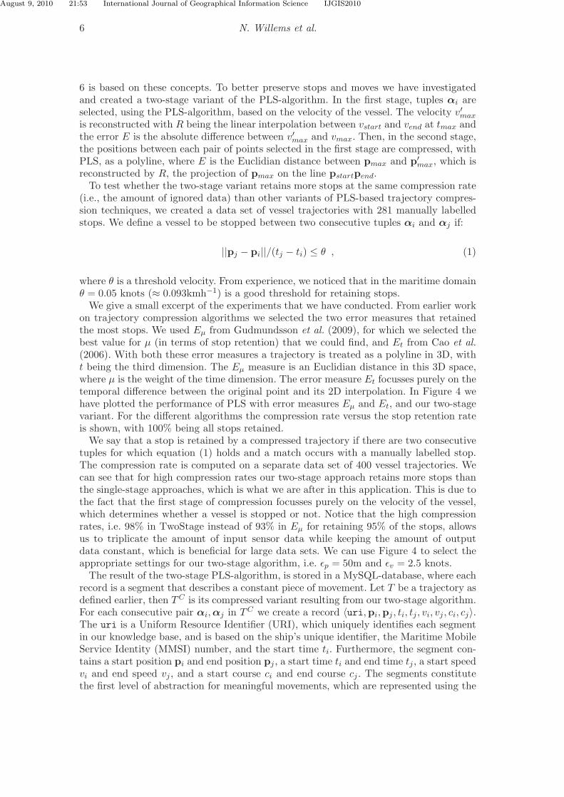
We give a small excerpt of the experiments that we have conducted. From earlier workon trajectory compression algorithms we selected the two error measures that retainedthe most stops. We used Eµ from Gudmundsson et al. (2009), for which we selected thebest value for µ (in terms of stop retention) that we could find, and Et from Cao et al.(2006). With both these error measures a trajectory is treated as a polyline in 3D, witht being the third dimension. The Eµ measure is an Euclidian distance in this 3D space,where µ is the weight of the time dimension. The error measure Et focusses purely on thetemporal difference between the original point and its 2D interpolation. In Figure 4 wehave plotted the performance of PLS with error measures Eµ and Et, and our two-stagevariant. For the different algorithms the compression rate versus the stop retention rateis shown, with 100% being all stops retained.
We say that a stop is retained by a compressed trajectory if there are two consecutivetuples for which equation (1) holds and a match occurs with a manually labelled stop.The compression rate is computed on a separate data set of 400 vessel trajectories. Wecan see that for high compression rates our two-stage approach retains more stops thanthe single-stage approaches, which is what we are after in this application. This is due tothe fact that the first stage of compression focusses purely on the velocity of the vessel,which determines whether a vessel is stopped or not. Notice that the high compressionrates, i.e. 98% in TwoStage instead of 93% in Eµ for retaining 95% of the stops, allowsus to triplicate the amount of input sensor data while keeping the amount of outputdata constant, which is beneficial for large data sets. We can use Figure 4 to select theappropriate settings for our two-stage algorithm, i.e. ǫp = 50m and ǫv = 2.5 knots.
The result of the two-stage PLS-algorithm, is stored in a MySQL-database, where eachrecord is a segment that describes a constant piece of movement. Let T be a trajectory asdefined earlier, then TC is its compressed variant resulting from our two-stage algorithm.For each consecutive pair αi, αj in TC we create a record 〈uri,pi,pj , ti, tj , vi, vj , ci, cj〉.The uri is a Uniform Resource Identifier (URI), which uniquely identifies each segmentin our knowledge base, and is based on the ship’s unique identifier, the Maritime MobileService Identity (MMSI) number, and the start time ti. Furthermore, the segment con-tains a start position pi and end position pj , a start time ti and end time tj , a start speedvi and end speed vj , and a start course ci and end course cj . The segments constitutethe first level of abstraction for meaningful movements, which are represented using the

August 9, 2010 21:53 International Journal of Geographical Information Science IJGIS2010
International Journal of Geographical Information Science 7
93 94 95 96 97 98 99
55
60
65
70
75
80
85
90
95
100
compression rate (%)
sto
p r
ete
nti
on
(%
)
Eµ
Et
TwoStage
εp=10
εp=80
εt=90
εt=720
(εp,εv)=(10,1)
(εp,εv)=(10,4)
(εp,εv)=(80,1)
(εp,εv)=(80,4)
......
Figure 4. Results of stop retention experiment. For Eµ we used ǫp = 10, 20, 30, 40, 50, 60, 70, 80mand for Et we used ǫt = 90, 180, 270, 360, 450, 540, 630, 720s. For our two-stage variant we usedthe same ǫp and conduct the experiment for velocity parameters ǫv = 1, 2, 3, 4 knots, resulting ina graph for each velocity with four knots the lowest graph.
Simple Event Model (see Sec. 4.1) and can be agglomerated (and combined with otherresources) into complex behavior definitions.
The movement primitives stop and move are added by attaching a property with valueex:stopped to each segment with an average speed below the threshold θ and the valueex:move to all other segments. By looking at the acceleration, computed by (vj −vi)/(tj −ti), we also assign the values ex:speeding up and ex:slowing down to the sem:eventType (seeSec. 4.1) property of a segment. Additionally, the set of movement primitives can beextended with more semantic classes, like ex:fast move, or other features, such as direction,i.e. ex:to North. While direction can be obtained by thresholding, the ex:fast move needsreasoning, since the notion of fast is related to ship type and weather conditions.
4. Semantic web technology
Only a limited number of movement patterns and useful vessel behavior can be detectedon the sole basis of the segments. Richer behavior definition and hypothesis testing aboutsingle vessel movement requires the combined knowledge about the vessel’s position, thisposition’s characteristics (e.g. geographic type), movement characteristics and the vessel’stype: the same movement pattern may have different implications across object types.For instance, if a vessel shuttles between two locations, it may be a dredger or a ferry.Without further knowledge, it is not possible to disambiguate between these two. Butweb-based information can fill in some missing data, and help enrich the event descriptionfurther. If we know that a vessel is a dredger, then we can determine that one of thelocations is a dredging place. Equally, if one of the locations is a dredging place, then thevessel is a dredger. In order to reason about information coming from different sources,integration is needed, and therefore we have developed the Simple Event Model.

August 9, 2010 21:53 International Journal of Geographical Information Science IJGIS2010
8 N. Willems et al.
sem:hasSubEvent
sem:hasTimeStamp
sem:hasTimeStamp
sem:hasTime
sem:Event sem:Actor sem:Place sem:Time
sem:hasTime
sem:hasActor
sem:hasPlace
sem:PlaceType
sem:placeType
sem:EventType
sem:eventType
sem:ActorType
sem:actorType
sem:TimeType
sem:Type
sem:timeType
sem:Core
sem:Role
sem:Temporary
sem:Constraint
sem:View
sem:accordingTo
sem:RoleType sem:roleType
Literal
sem:Authority
sem:hasSubType
Core Classes
(Foreign) Type System
Property Constraints
the Simple Event Model (SEM)
Figure 5. Simple Event Model. Ellipses represent classes, arrows represent properties betweenthem and square boxes represent datatypes. Open-ended arrows represent subclass properties,dotted arrows are typing properties and the regular arrows’ semantics are given by their labels.
4.1. Simple event model
The Simple Event Model (SEM) is introduced by van Hage et al. (2009) and provides a setof classes and properties to define events and their context. The segments are representedas instances of SEM events. SEM’s classes are organized in three groups (see Fig. 5).SEM Core classes describe the classic parts of an event: What is happening? (sem:Event,e.g., anchoring, fishing), Who participates? (sem:Actor, e.g., a vessel), Where? (sem:Place,e.g., in Rotterdam), and When? (sem:Time, e.g., during year 2008). SEM Types can belinked to each of the Core instances, which typically come from existing domain-specificvocabularies. For example, sem:ActorTypes can be selected from vessel classifications1.GeoNames can be used for the sem:Places and sem:PlaceTypes. SEM Constraints expressTemporary, Authoritative and Role constraints on the validity of properties betweenSEM Classes. Time and Place can have symbolic (URIs) or concrete values, to fit therepresentation of most data on the web. It is possible to use complex time representationsuch as the ISO 8601 standard and the TIMEX3 format for representing time interval,dates and reoccurring time expressions (e.g., ‘two times a week’). All the classes andproperties of SEM are optional and duplicable: SEM can integrate the partial informationprovided by different sources as different aspects of an event.
SEM is based on and informally linked to other event models such as the Event Ontol-ogy by Raimond and Abdallah (2007), LODE by Shaw et al. (2009) and the F model byScherp et al. (2009). The main differences with them are (1) loosened constraints to bemore flexible with the unpredictable syntax and inherent messiness of web data and (2)a linking to domain ontologies via sem:Types instead of a direct usage of other model’sclasses, making us more independent from changes in vocabularies we can not control.
4.2. Moving object knowledge base
The instances of SEM are either segment events (see Section 3.2), or events extractedand converted from the web. They are simply extracted if they are exposed as RDF(e.g., DBpedia and GeoNames), and converted to RDF if they are exposed as HTML
1Such as vessel types defined in the AIS protocol (see ITU (2001)) or on webpages like http://vesseltracker.com

August 9, 2010 21:53 International Journal of Geographical Information Science IJGIS2010
International Journal of Geographical Information Science 9
(e.g., VesselTracker). The former are accessed from the MySQL database via the D2RQplatform1 and the latter two are accessed directly with the SWI-Prolog2 based triplestore. Rules defining ship types and ship behavior enrich them. The rules are written inSWI-Prolog and the triple store is a knowledge base that enables us to link the differentparts of an event represented in SEM with semantic web and spatial reasoning. In thisway, rich movement patterns, vessel behavior and hypotheses can be defined and checkedagainst trajectory data. Various web sources provide us with interesting information, butthey can have different names for the same concepts. We align them to a single local iden-tifier using the SKOS vocabularys skos:{exact|close|broad|narrow|related}Match properties asdefined by Miles and Bechhofer (2009). The current knowledge base consists of two areasin front of the Dutch coast: a circular area of 5, 000km2 around Rotterdam harbor and acircular area of 1, 250km2 around the Dutch island Texel. In total about 600 vessels aretracked for a single week, resulting in 92, 000 segments with about 30 attributes, given byAIS or looked up from the web. We have annotated these areas with 225 new GeoNamesfeatures, such as harbors to be able to reason with geographic locations. In Figure 8 wegive an example of how different attributes of a single SEM event that were collectedfrom the web can be used together, in a Prolog predicate that defines the notion of aship arriving at an appropriate harbor. Figure 9 shows another example of a rule: a shipbanned from European waters close to a European harbor. The vessel behavior for bothof these examples cannot be derived from the trajectory itself, and would not be obviousto a human operator, but they are nonetheless important events to be brought to hisattention while monitoring vessels. In section 6 we explain these use cases in more detail.
In this set up, SEM is the central piece for aggregating knowledge and resources atdifferent levels of abstraction into event representations. These events can be used incomplex, multi-step rules defining ship behavior. The behavior examples that have beendescribed here are taken from the MSS domain, but they can be related to more genericmovement patterns, like the ones defined by Dodge et al. (2008). For example, the succes-sive segments can be classified as a Spatio-Temporal sequence: ‘an ordered subsequenceof locations with their timestamps’. Daily movements of migrating birds belong to thesame generic pattern description. Complex events are multidimensional data, aggregat-ing low-level tracks and semantic information. They can be visually explored by humans,to find computationally expensive patterns relevant to a certain domain or situation andto check detected anomalies. A visualization tool is needed to take advantage of therichness of the knowledge and present it in a useful way to a human user.
5. Visualization with trajectory contingency tables
An interactive Trajectory Contingency Table (TCT) can be used to browse the knowledgebase and is suitable for expert users, who want to discover relations between attributes asspatial patterns, such as the change over time for different vessel types. We do not knowup front which attributes are available a in the knowledge base, therefore the visualizationneeds to be generic. The TCT can deal with the most common types of attributes, suchas time, geographical locations, numbers, and derived predicates, like ship arriving at anappropriate harbor from the previous section. With the TCT we can show temporal andspatial patterns, or correlation between attributes in terms of these patterns.
1D2RQ platform: http://www4.wiwiss.fu-berlin.de/bizer/d2rq2SWI-Prolog for the semantic web: http://www.swi-prolog.org/web

August 9, 2010 21:53 International Journal of Geographical Information Science IJGIS2010
10 N. Willems et al.
Brushed area as new attribute
Focus
Context
Trajectory Contingency TableAttributes Overview
Amazonehaven
Drag attribute
Brushed area
Passenger ships only
Figure 6. A Trajectory Contingency Table (TCT) with an Attribute view (left) and an Overview(right). All vessel trajectories in the knowledge base in the neighborhood of Rotterdam harborduring a single week are shown. In the Attributes view, attributes are divided in bins and listedwith two histograms: chosen bins and hidden bins. Trajectories are annotated with a vessel typeattribute obtained from the web, and only the trajectories of passenger ships are shown in theTCT and highlighted in the overview by choosing this bin. The TCT is displayed with time andday attributes on the axes, with only Thursday until Saturday selected from the day attribute.Each cell contains a map with parts of trajectories that satisfy the accompanying row and columnlabels. In the Overview, chosen trajectories (focus) are highlighted in dark gray on top of thecontext containing all data as thin, light gray lines and a map with a contour of The Netherlandsin green and a solid shape for the harbors in the port of Rotterdam. By brushing we select areasto define new attributes. From the visualization we notice a strong pattern towards two mooringareas, given by the dark trajectories in the overview. A single trajectory on Friday morning showspossible anomalous behavior, by mooring in the ‘Amazonehaven’. By means of reasoning withcontextual information in Section 6.1, we can determine more precisely whether or not this is ananomalous behaving passenger ship.
L
LL
LL
G
General cargo
D ODry bulk
DB
GAmazonehav
en
P
Figure 7. Map of Rotterdam harbor with a trajectory of a passenger ship created withPresto, GeoNames features as placemarks, and polygons with harbor types (L=Liquid bulk,D=Distribution, G=General Cargo, DB=Dry bulk, O=Other cargo, and P=Passenger).

August 9, 2010 21:53 International Journal of Geographical Information Science IJGIS2010
International Journal of Geographical Information Science 11
The visualization retrieves trajectories by querying the knowledge base with SPARQLqueries1, which convert segments to trajectories. First, we determine for tuples αi whichattributes are available, by searching for owl:DatatypeProperty properties. The data typeof the attribute is specified by the accompanying rdfs:range property and is encoded withpredefined XML schema types, such as xsd:integer and xsd:string. Then, for each vessel , atrajectory α0, . . . ,αN−1 is reconstructed by gathering all values of the queried attributesof the vessel’s Actor and the Events related.
Pearson (1904) introduced a contingency table where two categorical or binned at-tributes are put on the axes of a table by assigning (groups of) outcomes to a row (orcolumn). In a cell, the number of data items are shown that contain the outcomes of thecorresponding row and column for the attributes assigned to the axes. Furthermore, eachaxis has an additional row that shows for each column the sum of the items. Becker et al.(1996) generalized the contingency table to a Trellis display, which is an arrangementof small multiples of basic graphics. Brunsdon (2001) showed a variant with maps asa scatterplot of locations and Carr et al. (2002) applied this technique with choroplethmaps. Among others, Stolte et al. (2002) extended Trellis displays to a widely used tool,called Tableaux, to display various renderings in table cells, including graphs, scatter-plots, and maps, and is often used for relatively small data sets, while our TCT is capableof visualizing large data sets, i.e., the complete knowledge base, interactively.
Instead of showing a number in the contingency table, we display a map with theparts of trajectories that satisfy the constraints of the cell (see Fig. 6) given by thecorresponding row and column. For instance, by putting time and speed on the axes,we see how the different speed-related areas, such as stop places, change over time.Since the input data is large and consists of many attributes, the TCT is extended withtwo views for improving the navigation: Attributes and Overview (see Fig. 6). In theAttributes view on the left, all attributes are listed and divided in bins, which are shownas a histogram. The bins are selectable and filter the whole data set. The exploration inspecific domains may be optimized by manually adjusted the bins of the attributes. Byclicking on a bin, the whole data set is filtered on that bin. All other bins move to thehistogram with hidden bins, to provide an overview of the current selection in a singlecolumn. The attributes can be dragged from the attributes view to the axes of the TCTto quickly investigate different settings. Alternatively from the trajectory plots in thecell, we can drag a time attribute to the cells to show a temporal distribution by meansof clocks. We can show maps again by dragging a location attribute to the cells. In theoverview on the right of the TCT, the selection of data made by choosing bins (focus)is highlighted on top of all data (context). In the overview it is possible to brush partsof the focused trajectories to define areas, which can be used to define a new booleanattribute stating whether or not a trajectory is contained in the area. This new attributecan be used in the TCT, for further investigation.
6. Use cases
6.1. Abnormal mooring
AIS messages contain some identifying information about the broadcasting ship: name,call sign, MMSI and a number assigned by the International Maritime Organization
1W3C SPARQL specification: http://w3.org/TR/rdf-sparql-query

August 9, 2010 21:53 International Journal of Geographical Information Science IJGIS2010
12 N. Willems et al.
1 abnormal_mooring(Event) :-2 event(Event, wordnet:’synset-stop-verb-1’),3 event_place(Event, Place, _),4 space_within_range(Place, Harbor, 0.2),5 rdf(Harbor, geo:featureCode, geo:’H.HBR’),6 rdfs_individual_of(Harbor, HarborType),7 event_actor(Event, Ship, ShipType),8 % check if the harbor type is not appropriate for the ship9 \+apt_ship_harbor_type(ShipType, HarborType).
10
11 % liquid bulk harbors are appropriate for tanker, etc.12 apt_ship_harbor_type(freebase:’en.tanker’, ex:ptype_LiquidBulkHarbor).13 apt_ship_harbor_type(freebase:’en.passenger_ship’, ex:ptype_PassengerHarbor).14 % ... further ship-type and harbor-type mappings15
16 % add the property to the knowledge base17 :- findall(Event, abnormal_mooring(Event), AbnormalMoorings),18 forall(member(AM, AbnormalMoorings),19 rdf_assert(AM, ex:mooringEventType, ex:etype_abnormal_mooring)).
Figure 8. Illustration of a Prolog test predicate for the abnormal mooring of a ship. This codemakes use of the SEM Prolog API. The predicate is used to add an extra property to segmentswhere an abnormal mooring takes place. This property can then be visualized.
(IMO); they are kept when building the segments. We use the latter two to automati-cally query the web1 for additional information about the ship, that we convert semi-automatically to RDF. One piece of such information is a precise (set of) type(s) forthe ship, such as Oil Tanker, Ro-Ro (i.e. ferryboat), Refrigerated Fish Carrier. We areinterested in passenger ships and how they behave during the week, which is shown inthe TCT by means of a spatio-temporal distribution. We notice a strange movementon Friday morning. This is an inserted trajectory of a passenger ship simulated withPresto that anchors at the general cargo harbor ‘Amazonehaven’, whereas passengerships should stop at passenger terminals. To verify whether this movement is anomalous,we reason further with contextual information from other sources.
The Port of Rotterdam Authority has published maps2 with a classification of theirdifferent harbors (e.g. liquid bulk, food), which we have converted to Google Earth KML(see Fig. 7). We used the SWI-Prolog Space package to convert the KML placemarkswith polygon shapes into RDF with GeoRSS polygon literals. The SWI-Prolog Semanticweb package can then be used to enrich events related to this data.
To define abnormal mooring, we created a Prolog rule that works in three steps. Thefirst step describes the event using the SEM API3. The API provides a generic interfaceto create and query events, abstracting from the level of their RDF implementationdetails. This API, and our choice of implementation for the spatial indexing, representthe main difference between our platform and that of Aasman (2009): the conversionbetween the most popular spatial and temporal formats and a unified representationis achieved automatically by our API, while the graph manipulation of SEM events issimplified for the users. Lines 1 to 9 of Figure 8 show the test predicate that queries forthe types of the ships participating in an event as actors (line 7), and checks out whetherthey match with the type of the harbor (line 5), which is the place of the same event (line
1Such as http://vesseltracker.com and http://e-ships.net2Port of Rotterdam: http://portofrotterdam.com/en/about port/port maps/branches3SEM API: http://eculture.cs.vu.nl/git/poseidon/sem.git

August 9, 2010 21:53 International Journal of Geographical Information Science IJGIS2010
International Journal of Geographical Information Science 13
1 banned_ship_observation(Event, Ship) :-2 event_actor(Event, Ship, freebase:’en.ship’), % ship observed3 rdf(Ship, ais:imo, literal(IMO_Number)), % ship has IMO number4 rdfs_individual_of(BannedShip, parismou:banned), % a banned ship5 rdf(BannedShip, ais:imo, literal(IMO_Number)), % same IMO number6 event_place(Event, Place, _),7 space_within_range(Place, Harbor, 0.2),8 rdf(Harbor, geo:featureCode, geo:’H.HBR’), % observed near a harbor9 % has GeoNames ID for Europe as a parent feature
10 rdf_reachable(Harbor, geo:parentFeature, geoinst:’6255148/’).11
12 :- findall(Event, banned_ship_observation(Event, _), BannedShipObservations),13 forall(member(BSO, BannedShipObservations),14 rdf_assert(BSO, ex:mouEventType, ex:etype_banned)).
Figure 9. Illustration of a Prolog test predicate for detecting ship banned by the Paris MOU neara European harbor. The predicate is used to add an extra property to segments of trajectorieswhere a banned ship is observed in violation of this ban. This property can then be visualized.
3): stop (line 2). Step two checks out the matches between the types: they match if theyare listed as pairs with the predicate apt ship harbor type (line 12-13). This predicatedefines the normal pairs: a Crude Oil Tanker should anchor at a liquid bulk anchorage, aPassenger Ship should anchor at a passenger terminal. Internally, the SEM API uses theSKOS alignments to find additional types for the ship and equivalences between them.The third step adds new triples to the knowledge base: ex:abnormal mooring as a type forthe instances of ship that satisfy the predicate abnormal mooring (line 1).
This rule uses GeoNames for the URIs of geographic places, their types (harbor, pop-ulated place, etc.) and their geographic coordinates (line 5). GeoNames consists of usercontributed content, and we extended it with extensive information for the Dutch coastand the port of Rotterdam, including unique identifiers for all the harbors in Rotter-dam. The rule also uses ship trajectories (segments, they are the instances queried wheninstantiating the sem:Event, line 1), ship types from the web (Freebase, line 12-13), har-bor types from the Port of Rotterdam website, spatial reasoning (space within range
predicate, line 4), and RDF reasoning (findall predicate, line 17). The last predicateannotates segments with ex:abnormal mooring type, which can be used for visualization.
The reasoning for the abnormal mooring of our simulated passenger ship isthen as follows: The ship is of type ex:atype passenger vessel, which is mapped tofreebase:’en.passenger ship’ with the skos:closeMatch property, and the sem:Place of thesem:Event of type wordnet:stop-verb-1 is near to the ‘Amazonehaven’, which has typeex:ptype PassengerHarbor. The rule classified the stop of this vessel as an abnormal mooring.
6.2. Banned vessels
The previous rule is an example of an anomaly detection by means of a classificationof abnormal behavior for trajectories, given a domain-specific definition. Anomaly de-tection is crucial in an MSS system, as it enables a user to focus only on the subsetof trajectories that are not behaving according to what is defined as normal patterns.Another example of such an abnormal pattern, combining ship movement trajectory,ship type and web-based information is the detection of ships currently undergoing aban from the European waters. The Paris Memorandum of Understanding on Port StateControl (ParisMOU, http://www.parismou.org) maintains a list of IMO identifiers of

August 9, 2010 21:53 International Journal of Geographical Information Science IJGIS2010
14 N. Willems et al.
ships currently or historically under the EU ban. Fetching the data and converting it toRDF enables our system (see Fig. 9) to detect ship trajectories corresponding to bannedships that would come near a given harbor, in a similar fashion as Figure 8. Using typehierarchies defined in GeoNames, we can extend this rule to a harbor from any countryfor which the parent feature is Europe (Fig. 9, line 8), and add a property that is validon the European Union level.
7. System design
Our architecture is one of the possible configurations for composing a system that enablesa user to detect patterns in moving objects at three different levels: data, knowledge,and graphical interface. The interfaces of the architecture given in Figure 1 contain thepreprocessing stage of the trajectories (like NMEA), which is domain specific, but can bereplaced by other systems. The system’s rationale is that if we convert data from differentsources to a format compatible with an ontology in RDF, the data can be matched on thesemantic level with other data and knowledge sources, which enhances a visual analyticssystem without further adaptation. Testing hypotheses based on attributes not availablein the knowledge base is possible by adding data on demand from the web or by reasoning.
Our methodology is illustrated with vessel traffic, but no major domain-specific as-sumptions have been made, and as a result we expect our approach to be applicable inother domains. However, the rules will be domain dependent, as our examples show. Thevarious approaches and tools combined in the methodology each have certain limitations.Presto can only be used for generating trajectories on a geographical map; Trajectoriesfor mice running in a cage for lab experiments or a cursor trail on a computer screenshould be generated in other coordinate systems. In PLS, topological changes, such asself-intersections, may occur while generalizing a trajectory, hence the trajectory is re-quired to be smooth. However, applying PLS is not required. In the knowledge base,when using external vocabularies, it may be possible to run into inconsistencies andtrust issues. Knowledge aggregation and trust management are currently ongoing re-search points in the project. In the TCT, we may need to adopt the bins to get moresophisticated results in specific cases. Nevertheless, our architecture shows an interest-ing combination of geographic and semantic reasoning, coupled with a multidimensionalvisualization tool to address many requirements for analyzing moving objects.
8. Conclusion and future works
We have presented an integrated approach for analyzing moving object data. The ap-proach includes trajectory generation using Presto, trajectory compression using Piece-wise Linear Segmentation, trajectory modeling with the Simple Event Model, which isthe data model of our knowledge base. The trajectories’s multiple dimensions, includingthe additional knowledge created by reasoning, can be visualized in a Trajectory Con-tingency Table. This approach allows us to visually detect patterns in trajectory databy means of exploring the trajectory’s attributes and additional attributes obtained byvarious web sources and reasoning. New sources can be added easily which allows us toconsult existing knowledge on demand for testing hypotheses containing attributes notavailable in the current knowledge base.
In future research we will include high-level abstractions of trajectories in SEM: behav-

August 9, 2010 21:53 International Journal of Geographical Information Science IJGIS2010
REFERENCES 15
ior descriptions defined across domains and movement definition based on other move-ment data sources than AIS data (e.g. ferry logs from harbor websites). Furthermore, wewould like to efficiently describe and reason with the relative position of moving shipsand movements of multiple entities. For interoperability with existing GIS systems wemay adopt our interfaces to OGC standards like Web Feature Service. Finally, we willinvestigate whether our approach can be used in other domains.
Acknowledgements
We thank the reviewers, Jack van Wijk and Huub van de Wetering of TU Eindhoven,Guus Schreiber of VU Amsterdam, Pieter Adriaans and Maarten van Someren of Uni-versity of Amsterdam, and Eric Postma of Tilburg University for their fruitful commentsfor improvements of this publication. Furthermore, we thank Michael Borth of the Em-bedded Systems Institute and, Hans Hiemstra and Jacek Skowronek of Thales Nederlandfor their contributions in the early design of the system’s architecture. This work hasbeen carried out as a part of the Poseidon project with Thales Nederland under theresponsibilities of the Embedded Systems Institute. This project is partially supportedby the Dutch Ministry of Economic Affairs under the BSIK program.
References
Aasman, J., 2009. Geospatial and moving objects with RDF and allegroGraph. In: In-ternational semantic web conference (ISWC2009), October.
Andrienko, G., et al., 2009. Interactive visual clustering of large collections of trajectories.In: IEEE visual analytics science and technology, 3–10.
Andrienko, N. and Andrienko, G., 2007. Designing visual analytics methods for massivecollections of movement data. Cartographica, 42 (2), 117–138.
Bak, P., et al., 2009. Spatiotemporal analysis of sensor logs using growth ring maps.IEEE transactions on visualization and computer graphics, 15 (6), 913–920.
Becker, R.A., Cleveland, W.S., and Shyu, M.J., 1996. The visual design and control oftrellis display. Journal of computational and statistical graphics, 5, 123–155.
Bertolotto, M., et al., 2007. Towards a framework for mining and analysing spatio-temporal datasets. Int. journal of geographical information science, 21 (8), 895–906.
Brunsdon, C., 2001. The comap: exploring spatial pattern via conditional distributions.Computers, environment and urban systems, 25 (1), 53–68.
Buccella, A., Cechich, A., and Fillottrani, P., 2009. Ontology-driven geographic informa-tion integration: A survey of current approaches. Comp. & geosciences, 35 (4).
Cao, H., Wolfson, O., and Trajcevski, G., 2006. Spatio-temporal data reduction withdeterministic error bounds. The VLDB Journal, 15 (3), 211–228.
Carr, D.B., et al., 2002. Interactive linked micromap plots and dynamically conditionedchoropleth maps. In: National conference on digital government research, 1–7.
Chen, B., et al., 2010. An approach for heterogeneous and loosely coupled geospatialdata distributed computing. Computers & geosciences, 36 (7).
Dodge, S., Weibel, R., and Lautenschutz, A.K., 2008. Towards a taxonomy of movementpatterns. Information visualization, 7 (3–4), 240–252.
Douglas, D.H. and Peucker, T.K., 1973. Algorithms for the reduction of the number ofpoints required to represent a digitized line or its caricature. Cartographica, 10 (2).

August 9, 2010 21:53 International Journal of Geographical Information Science IJGIS2010
16 REFERENCES
Embedded Systems Institute, 2007. The Poseidon project. [online] Available from:http://www.esi.nl/poseidon [Accessed February 2010].
Gotz, D., Zhou, M.X., and Aggarwal, V., 2006. Interactive visual synthesis of analyticknowledge. In: IEEE visual analytics science and technology, 51–58.
Gudmundsson, J., et al., 2009. Compressing spatio-temporal trajectories. Computationalgeometry, 42 (9), 825–841.
Hagerstrand, T., 1952. Innovationsforloppet ur korologisk kynpunkt. Lund, GleerupTranslation in English: Allan Pred, Innovation diffusion as spatial process.
Hiebel, G., Hanke, K., and Hayek, I., 2010. Methodology for CIDOC CRM based dataintegration with spatial data. In: Comp. appl. and quantitative methods in arch.
Hornsby, K.S. and Joshi, K., 2010. Combining ontologies to automatically generate tem-poral perspectives of geospatial domains. GeoInformatica, 14 (4), 481–505.
ITU, 2001. International Telecommunication Union: Technical characteristics for an auto-matic identification system using time division multiple access in the VHF maritimemobile band. Recommendation ITU-R M.1371-1.
Janssens, J., Hiemstra, H., and Postma, E., 2010. Creating artificial vessel trajectorieswith Presto. In: Benelux conference on artificial intelligence (BNAIC 2010).
Miles, A. and Bechhofer, S., 2009. SKOS Simple knowledge organization system reference.[online] Available from: http://w3.org/TR/skos-reference/ [Accessed April 2010].
Orellana, D. and Renso, C., 2010. Developing an interactions ontology for characterisingpedestrian movement behavior. In: M. Wachowicz, ed. Movement-aware applicationsfor sustainable mobility: Technologies and approaches., 62–86.
Pearson, K., 1904. On the theory of contingency and its relation to association andnormal correlation. Drapers’ Company Research Memoirs. Biometric Series I.
Raimond, Y. and Abdallah, S., 2007. The event ontology. [online]Http://purl.org/NET/c4dm/event.owl [Accessed April 2010].
Sanchez, A., et al., 2009. A context model and reasoning system to improve objecttracking in complex scenarios. Expert systems with applications, 36 (8), 10995–11005.
Scherp, A., et al., 2009. F—A model of events based on the foundational ontologyDOLCE+DnS ultralight. In: Conference on knowledge capturing (K-CAP).
Shaw, R., Troncy, R., and Hardman, L., 2009. LODE: linking open descriptions of events.In: 4th annual Asian semantic web conference, 153–167.
Spaccapietra, S., et al., 2008. A conceptual view on trajectories. Data & knowledge en-gineering, 65 (1), 126–146.
Stolte, C., Tang, D., and Hanrahan, P., 2002. Polaris: A system for query, analysis,and visualization of multidimensional relational databases. IEEE transactions onvisualization and computer graphics, 8 (1), 52–65.
Thomas, J. and Kielman, J., 2009. Challenges for visual analytics. Information visual-ization, 8 (4), 309–314.
van Hage, W.R., et al., 2009. Combining ship trajectories and semantics with the SimpleEvent Model (SEM). In: ACM workshop on events in multimedia (EiMM), 73–80.
Willems, N., van de Wetering, H., and van Wijk, J.J., 2009. Visualization of vessel move-ments. Computer graphics forum, 28 (3), 959–966.
Wood, J., et al., 2007. Interactive visual exploration of a large spatio-temporal dataset:reflections on a geovisualization mashup. IEEE transactions on visualization andcomputer graphics, 13 (6), 1176–1183.
Xiao, L., Gerth, J., and Hanrahan, P., 2006. Enhancing visual analysis of network trafficusing a knowledge representation. In: IEEE visual analytics science and technology.
Yan, Z., et al., 2008. Trajectory ontologies and queries. Trans. in GIS, 12 (Sup. 1), 75–91.