An innovative approach
16
Framework for integrated land use planning An innovative approach
Transcript of An innovative approach

Framework for integrated land use planning An innovative approach

i
Contents
Acknowledgment
1. Introduction
2. Importance and overall approach of integrated land use planning
3. The integrated land use planning methodological framework
3.1. Planning process
3.1.1. Identification of Integrated land use planning objectives
3.1.2. Assessing the current situation, gaps and conflicts
3.1.3. Integrated planning and negotiation process
3.1.4. Implementation
3.1.5. Communication strategy and systematization of the process for scaling out
3.2. Evaluation and monitoring system
References
Annex I. Activities carried out within the scope of the Integrated Land Use Planning in Ayaş under TCP/TUR/3701
Figures
Figure 1. Land use planning and spatial land use planning as a sub-set
Figure 2. Illustration of the integrated land use planning approach
Figure 3. Developing an integrated land use planning approach
Figure 4. Methodological framework for integrated land use planning
Figure 5. Integrated land use planning methodology for assessing the current situation
Figure 6. Main steps and components of the integrated planning process
Figure 7. Appraisal of sustainability factors of land use options
Tables
Table 1. Land use planning and its variants, including spatial land use planning
Table 2. Types of stakeholders
Table 3. Integrated Land Use Planning objectives and expected outcomes
Table 4. Types of land-related data and Information
ii
1
1
5
5
5
6
7
9
9
9
10
10
1
3
4
5
6
8
9
2
3
6
7

ii
AcknowledgementsThis document has been prepared by the Food and Agriculture Organization of the United Nations (FAO) and authored by Hakki Emrah Erdogan (Land Use Policy Specialist), Soledad Bastidas (Sustainable Land Management Specialist). Deserving of particular acknowledgement is the tremendous support of Ingrid Teich (Geo-Spatial Data Analysis Specialist), Sara Marjani Zadeh (Land and Water Officer) and Aylin Celik (National Land and Water Expert).

1. IntroductionPopulation growth is driving increasing demand for food and other agricultural and forest products. Achieving food security with existing farming practices is likely to lead to more intense competition for natural resources, increasing greenhouse gas emissions, and further land degradation and deforestation. Furthermore, market-driven land use patterns are provoking unsustainable use of land resources and irreversible loss of biodiversity and fertile soils. All these trends pose a threat to agricultural production, food security and the generation of ecosystem services.
Land use planning should thus make careful consideration of climate change resilience and ecosystem management. However, the implementation of land use plans involves a number of challenges which require resolution. Key measures include the adoption of actual sustainable land management (SLM) alternatives facilitated by an enabling environment with appropriate policies and legislation, ensuring a secure land tenure system and mobilizing medium and long-term financial investments.
Considering the above-mentioned challenges, this document developed by the Food and Agriculture Organization of the United Nations (FAO) provides an integrated land use planning approach to assist with inter-sectoral planning processes and implementation for the sustainable use of land resources.
It provides guidance to assess several baseline aspects, including the suitability of agricultural production systems, and the examination of soil and land degradation and socio-economic factors affecting household decision-making on land-use and natural resources management in agricultural landscapes, and aims to assist with developing country-specific recommendations for the implementation of an agreed intersectoral plan.
2. Importance and overall approach of integrated land use planningSustainable development, coupled with food security and alleviation of poverty, is largely dependent on agricultural activities, which support livelihoods. While the rapid development and expansion of unsustainable agricultural practices has led to further land degradation in recent years, global discussions around the Sustainable Development Goals (SDGs) has raised awareness among policy-makers of the importance of efficient use of land, water and other natural resources for accelerating economic development. Questions of efficiency, equity and environmental protection have been flagged on development plans in most countries, with land use planning (LUP) considered the most appropriate tool to help policy development harmonize human activities and environment sustainability (Metternich, 2018). Accordingly, LUP is now included in country-based investment programmes at the national, regional or local scale.
According to FAO guidance (FAO, 1993), land use planning is the systematic assessment of land and water potential, alternatives for land use, and economic and social conditions, with a view to selecting and adopting the best land use options. Its purpose is to select and put into practice land uses that will best meet the needs of the people while safeguarding resources for the future.
Over the last decade, different LUP approaches have been developed in accordance with priorities. These are shown in Figure 1 and detailed in Table 1
Land Use Planning
Participatory Land Use Planning
Regional Land Use Planning
Integrated Land Use Planning
Territorial Ecological Planning
Spatial Land Use Planning
Urban Land Use Planning
Ecosystem-based Land
Use Planning
Figure 1. Land use planning and spatial land use planning as a sub-set
Source: Metternich, 2017.
1
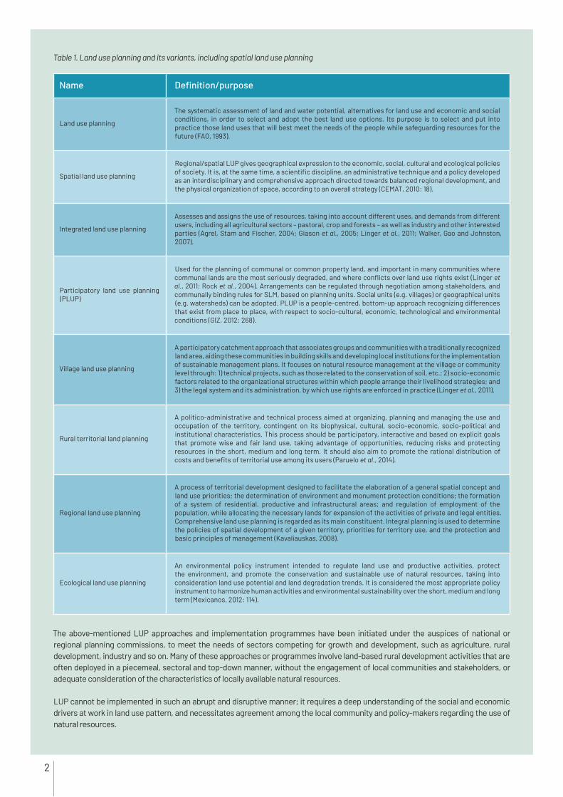
Name Definition/purpose
Land use planning
The systematic assessment of land and water potential, alternatives for land use and economic and social conditions, in order to select and adopt the best land use options. Its purpose is to select and put into practice those land uses that will best meet the needs of the people while safeguarding resources for the future (FAO, 1993).
Spatial land use planning
Regional/spatial LUP gives geographical expression to the economic, social, cultural and ecological policies of society. It is, at the same time, a scientific discipline, an administrative technique and a policy developed as an interdisciplinary and comprehensive approach directed towards balanced regional development, and the physical organization of space, according to an overall strategy (CEMAT, 2010: 18).
Integrated land use planning
Assesses and assigns the use of resources, taking into account different uses, and demands from different users, including all agricultural sectors – pastoral, crop and forests – as well as industry and other interested parties (Agrel, Stam and Fischer, 2004; Giason et al., 2005; Linger et al., 2011; Walker, Gao and Johnston, 2007).
Participatory land use planning (PLUP)
Used for the planning of communal or common property land, and important in many communities where communal lands are the most seriously degraded, and where conflicts over land use rights exist (Linger et al., 2011; Rock et al., 2004). Arrangements can be regulated through negotiation among stakeholders, and communally binding rules for SLM, based on planning units. Social units (e.g. villages) or geographical units (e.g. watersheds) can be adopted. PLUP is a people-centred, bottom-up approach recognizing differences that exist from place to place, with respect to socio-cultural, economic, technological and environmental conditions (GIZ, 2012: 268).
Village land use planning
A participatory catchment approach that associates groups and communities with a traditionally recognized land area, aiding these communities in building skills and developing local institutions for the implementation of sustainable management plans. It focuses on natural resource management at the village or community level through: 1) technical projects, such as those related to the conservation of soil, etc.; 2) socio-economic factors related to the organizational structures within which people arrange their livelihood strategies; and 3) the legal system and its administration, by which use rights are enforced in practice (Linger et al., 2011).
Rural territorial land planning
A politico-administrative and technical process aimed at organizing, planning and managing the use and occupation of the territory, contingent on its biophysical, cultural, socio-economic, socio-political and institutional characteristics. This process should be participatory, interactive and based on explicit goals that promote wise and fair land use, taking advantage of opportunities, reducing risks and protecting resources in the short, medium and long term. It should also aim to promote the rational distribution of costs and benefits of territorial use among its users (Paruelo et al., 2014).
Regional land use planning
A process of territorial development designed to facilitate the elaboration of a general spatial concept and land use priorities; the determination of environment and monument protection conditions; the formation of a system of residential, productive and infrastructural areas; and regulation of employment of the population, while allocating the necessary lands for expansion of the activities of private and legal entities. Comprehensive land use planning is regarded as its main constituent. Integral planning is used to determine the policies of spatial development of a given territory, priorities for territory use, and the protection and basic principles of management (Kavaliauskas, 2008).
Ecological land use planning
An environmental policy instrument intended to regulate land use and productive activities, protect the environment, and promote the conservation and sustainable use of natural resources, taking into consideration land use potential and land degradation trends. It is considered the most appropriate policy instrument to harmonize human activities and environmental sustainability over the short, medium and long term (Mexicanos, 2012: 114).
The above-mentioned LUP approaches and implementation programmes have been initiated under the auspices of national or regional planning commissions, to meet the needs of sectors competing for growth and development, such as agriculture, rural development, industry and so on. Many of these approaches or programmes involve land-based rural development activities that are often deployed in a piecemeal, sectoral and top-down manner, without the engagement of local communities and stakeholders, or adequate consideration of the characteristics of locally available natural resources.
LUP cannot be implemented in such an abrupt and disruptive manner; it requires a deep understanding of the social and economic drivers at work in land use pattern, and necessitates agreement among the local community and policy-makers regarding the use of natural resources.
Table 1. Land use planning and its variants, including spatial land use planning
2

Direct stakeholders Make use of the land targeted in the plan
Indirect stakeholders Are affected by the actions of land users
Interest groups Are concerned by the conservation or scientific use of land
Integrated land-use planning should aim at incorporating biodiversity conservation, sustainable land management and climate change adaptation into spatial development plans. The productivity and sustainability of a land use system is determined by the interaction between land resources, climate and human activities. In the face of climate change and variability, selecting the right land uses for given biophysical and socio-economic conditions, and implementing SLM, are essential for minimizing land degradation, rehabilitating degraded land, ensuring the sustainable use of land resources (i.e. soils, water and biodiversity) and maximizing resilience.
Sustainable land use and management in relation to human activities dictates the sustainability and resilience or degradation and vulnerability of land resources.
FAO encourages the use of integrated land use planning approaches to meet the rising demands of human settlements and livestock and other sectors, while sustaining ecosystem services and livelihoods. FAO developed integrated land use planning as a knowledge-based procedure to help integrate the needs of different sectors, as well as those of land, water, biodiversity and environmental management, while ensuring local community and stakeholder participation.
The planning process should involve a wide range of stakeholders. However, some of these stakeholders may not be readily apparent. It is therefore important to identify them in order to take into account their interests and objectives during the planning process. Table 2 describes three types of stakeholder.
The integrated land use planning approach illustrated in Figure 3, it is a flexible planning process that can be adapted to specific requirement at national regional and country level. It includes four main steps: 1) identification of planning objectives; 2) assessment of the current situation, gaps and conflicts; 3) an integrated planning and negotiation process; and 4) the development of recommendations for establishment of an implementation mechanism.
Figure 2. Illustration of the integrated land use planning approach
Table 2. Types of stakeholders
Source: FAO, 2017.
SOIL TERRAIN BIODIVERSITY
CLIM
ATE
FAVORABLE
UN-FAVORABLEHUM
AN
ACT
IVIT
IES
PLANT & LIVESTOCK
(Agriculture, forest,
rangelands)
HUMAN SETTLEMENTS (Urban/rural)
LAND RESOURCES
WATER RESOURCES
SUSTAINABILITYRESILIENCE
DEGRADATION VULNERABILITY
3

The above-mentioned LUP approaches and implementation programmes have been initiated under the auspices of national or regional planning commissions, to meet the needs of sectors competing for growth and development, such as agriculture, rural development, industry and so on. Many of these approaches or programmes involve land-based rural development activities that are often deployed in a piecemeal, sectoral and top-down manner, without the engagement of local communities and stakeholders, or adequate consideration of the characteristics of locally available natural resources.
LUP cannot be implemented in such an abrupt and disruptive manner; it requires a deep understanding of the social and economic drivers at work in land use pattern, and necessitates agreement among the local community and policy-makers regarding the use of natural resources.
Integrated land-use planning should aim at incorporating biodiversity conservation, sustainable land management and climate change adaptation into spatial development plans. The productivity and sustainability of a land use system is determined by the interaction between land resources, climate and human activities. In the face of climate change and variability, selecting the right land uses for given biophysical and socio-economic conditions, and implementing SLM, are essential for minimizing land degradation, rehabilitating degraded land, ensuring the sustainable use of land resources (i.e. soils, water and biodiversity) and maximizing resilience.
Sustainable land use and management in relation to human activities dictates the sustainability and resilience or degradation and vulnerability of land resources.
Figure 3. Developing an integrated land use planning approach
Source: Sawanthvong, 2004.
STAKEHOLDER ANALYSIS(Village Classification)
Collection and analysis of date
Use of data and information in land use
management
DATA COLLECTION
SYSTEMATIC POINT SAMPLING
PARTICIPATORY RURAL APPRAISAL
ANALYSIS DATA AND INFORMATION
VILLAGE INFORMATION
VILLAGE LAND USE ZONING
AREA PRODUCTION MODEL (SENARIO)
TEMPORARY LAND USE AND CONVERSATION AGREEMENT
4

Figure 4. Methodological framework for integrated land use planning
3. The integrated land use planning methodological framework The integrated land use planning approach contains four main steps. Each of these is elaborated according to site-specific priorities in line with the national and/or regional policy framework, with the aim of maximizing contributions for sustainable development.
Figure 4 illustrates the integrated land use planning methodological framework and the following section explains the main steps involved.
3.1. Planning process 3.1.1. Identification of integrated land use planning objectives
Setting planning priorities and environmental objectives is the first step in establishing an integrated planning process in the planning area. The objectives established in this phase relate mainly to attaining sustainability, and are identified in coordination with the institutions and key stakeholders who will lead and form part of the integrated planning process.
Overall, the integrated land use planning approach for food security, which is based on enhancing climate change resilience and ecosystem management, has six main objectives. These reflect the main challenges as embodied in the views of a wide range of stakeholders (Table 3).
3. WORK PLANNegotiation process + binding agreements
Prioritize what to do, where, whom
2. ASSESSING THE CURENT SITUATION, GAPS AND CONFLICTS
Assessing the enablingenvironment; policies,
laws, finance, incentives
Sectoral plans, stakeholders and decision-making
Biogeographic and soil
assessment
Participatory land use and
land degradation assessment
Water management, ecosystem services and Climate change
Socio-economic
and gender
Farmers needs
Conflicting areas
4. IMPLEMENTATION
5. COMMUNICATION STRATEGY
EVALUATION AND MONITORING SYSTEM
Supporting Integrated Land Use Planning planning and implementation+ systematization of the process for scaling out to other manicipalities and districts
Integrated Land Use Planning implementation mechanism + actionsAmendment of policies and regulations, providing incentives, project interventions, etc.
1. INTEGRATED LAND USE PLANNING OBJECTIVESTo attain
sustainable soil and land management
SSS/SLM
To enhance food security and protect agricultural
areas from other land uses
To conduct a multi-sectoral and participatory planning
and implementation process
To delineate agricultural,
rangeland forested and urban areas
To harmonize interventions
between sectors and institutions
To nsure climate change resillence,
blodiversity protection ans ecosystems
5

Integrated land use planning objective Expected outcome
Sustainable soil and land management (SSM/SLM) The plan should contribute to eliminating the main soil/land threats, and work to avoid, reduce and reverse land degradation, in order to achieve the land degradation neutrality targets.
Food security and land use reduction to protect fertile agricultural areas from other forms of land use (urbanization, industry)
The transformation of fertile agricultural lands into lands for urbanization or industrial zones should be prevented to the extent possible. The plan must help to reduce land abandonment.
Multi/sectoral and participatory planning
The plan should consider the needs of different sectors and the requirements of various stakeholders including the local community and farmers, and should be harmonious with national environmental priorities.
Zoning: Delineating land areas A specific agreed zoning to delimit present and future agricultural, forest and urban areas should be established.
Harmonizing interventions between sectors
While protecting fertile agricultural and forested lands, the plan must also provide alternatives for other sectors including tourism and industry, while avoiding negative impacts on land resources and livelihoods, etc.
Ensuring climate change resilience, biodiversity protection and ecosystem management
In determining optimal land use scenarios, the protection of biodiversity and water availability must be prioritized and climate change vulnerabilities should be taken into account.
Table 3. Integrated land use planning objectives and expected outcomes
Figure 5. Integrated land use planning methodology for assessing the current situation
3.1.2. Assessing the current situation, gaps and conflicts
This step consists of an analysis of existing situations relating mainly to natural resources, the identification of sectoral priorities and the location of significant land use conflicts. These are identified through the use of inventories, geo-spatial data, social and economic evaluations including field interviews, surveys and consultation meetings with stakeholders. The analysis should include an assessment of land use changes in the past and the suitability of agricultural production systems, forestry and grassland management, as well as tourism and other expected activities, examining the socio-economic drivers and opportunities related to each of these sectors. The details and scales are determined in accordance with the integrated land use planning objectives. This information should be supported by GIS cartography that shows clearly the main land uses, areas of degradation and current conflicts. The basic method used to assess the current situation is shown in Figure 5.
The main analysis to determine the current situation
Screening of current policies and laws,
financial mechanisms and incentives
Analysis of sectoral plans, key stakeholders and decision-making
processes
Participatory Land Use and
Land Degradation Assessment
Identify the needs and expectations os Smallholder’s
farmers
Biogeographical information - Climate, Topography, Soil..etc
Analysis of Water Resources and
Management, ecosystem services and Climate Change Vulnerability
Identify conflicting areas across
different land use sector
Socio-economic and gender analysis
Evaluation of the results Final Report on the assessment of current situation, gaps and conflicts
Sharing the final results with all stakeholders
6

Table 4. Types of land-related data and Information
3.1.3. Integrated planning and negotiation process
The planning process includes discussion between different sectors, institutions and stakeholders about priorities, opportunities and actions to accomplish Integrated Land Use Planning objectives in the territory. It also involves the development of an optimal land use scenario covering all sectors and identifying the implementation tools needed to take action. The engagement of the local community and stakeholders in this regard is essential to selecting the best optimal scenario. The process should also include sector-specific analyses and planning in line with the Integrated Land Use Planning objectives, for example, forest conservation and restoration suitability, crop suitability, cost and benefits assessments, and the development of production scenarios for land uses and specific croplands. Finally, a zonation should be agreed that foregrounds the need for sustainable management of the area. Accordingly, the plan should incorporate an environmental focus such as biodiversity conservation, sustainable land management, food systems, land and forest restoration, and/or climate change mitigation and adaptation.
The approach to the planning of land resources emphasizes the integration of various disciplines, which is reflected in the data and information that needs to be collected. The types of data and information are listed in Table 4.
Land resources data
- Climate - Landforms and soils - Land cover - Water resources
Land use-related data
- Present land use systems and characteristics - Systems (present and potential) - Ecological requirements of crops, production systems, land use - DPSIR (drivers, pressures, status, impacts and responses) of land degradation.
Social-economic data
- Population (including age and gender distribution, stakeholders) - Living conditions (including workload, cultural aspects, traditions, etc.) - Access to markets - Costs of production and product prices - Socio-economic characteristics of communities
Legal data and information
- Relevant government policy documents, laws and regulations related to land - Present system of land allocation - Land tenure information - Traditional ownership and user rights
Institutional information - Involved institutions and their mandates, resources and infrastructure - Links between institutions - Support services (extension, etc.)
General data and information - Infrastructure, accessibility
7

Figure 6. Main steps and components of the integrated planning process
Multi-sectoral plan for optimum land use senario
Province level 1/25000 scale
Village level 1:10000 or
smaller scale
Zoning - delineating optimal areas for agro-production
Side-specific recommendation for agricultural production
Cost - Benefit Assessment for market integration
Ensuring the stakeholder engagement on the development of recommendations
Crop Suitability Analysis to develop ecosystem-oriented proposals
Development recommendation for Sustainable soil and land management (SSM/SLM)
Negotiation process to reach agreement on the boundaries of agro-production zone
Identify land capability on preserving hish quality croplands
Negotiation process to harmonize the intervention between sectors
Sector-specific analyses of current land use and develop baseline scenario
Spatial analyses for optimal land use
Identify the land requirements for livestock operations
Climate change vulnerability assessment
8
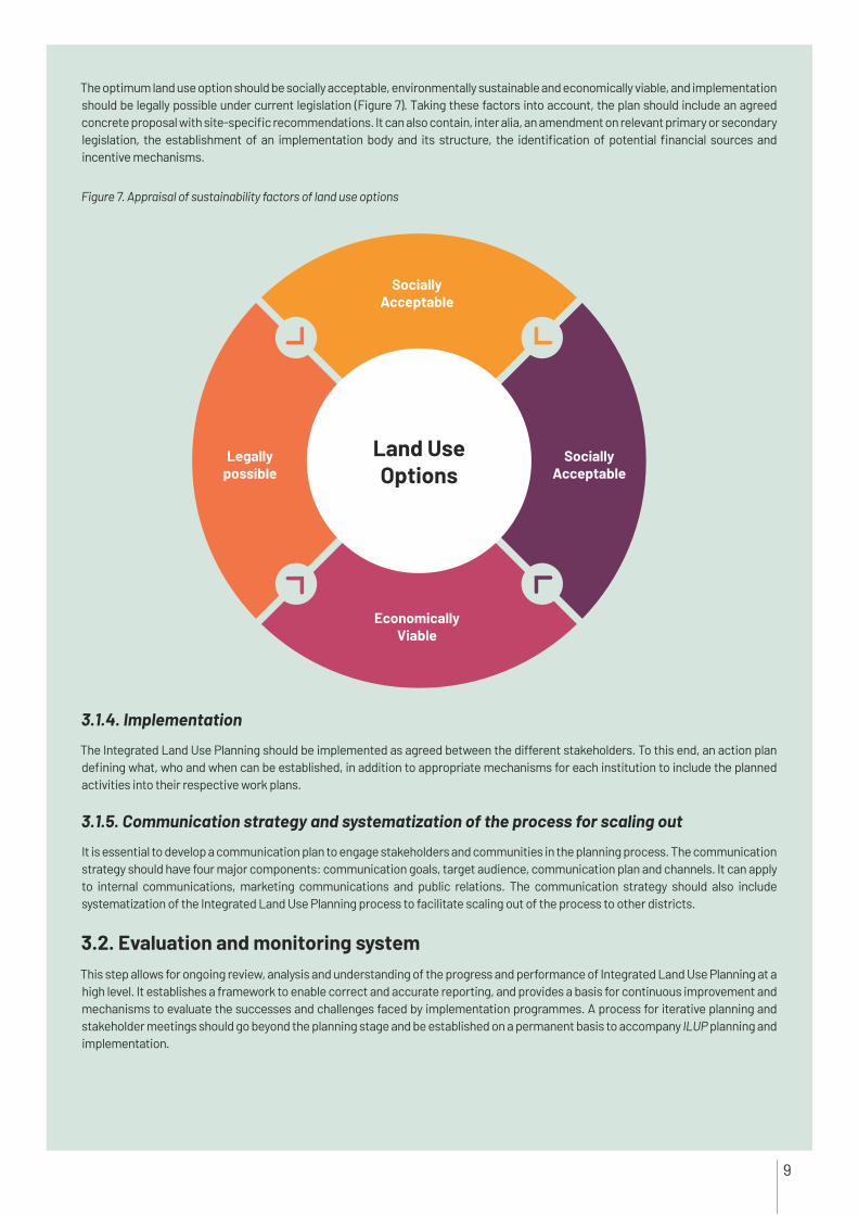
Figure 7. Appraisal of sustainability factors of land use options
The optimum land use option should be socially acceptable, environmentally sustainable and economically viable, and implementation should be legally possible under current legislation (Figure 7). Taking these factors into account, the plan should include an agreed concrete proposal with site-specific recommendations. It can also contain, inter alia, an amendment on relevant primary or secondary legislation, the establishment of an implementation body and its structure, the identification of potential financial sources and incentive mechanisms.
3.1.4. Implementation
The Integrated Land Use Planning should be implemented as agreed between the different stakeholders. To this end, an action plan defining what, who and when can be established, in addition to appropriate mechanisms for each institution to include the planned activities into their respective work plans.
3.1.5. Communication strategy and systematization of the process for scaling out
It is essential to develop a communication plan to engage stakeholders and communities in the planning process. The communication strategy should have four major components: communication goals, target audience, communication plan and channels. It can apply to internal communications, marketing communications and public relations. The communication strategy should also include systematization of the Integrated Land Use Planning process to facilitate scaling out of the process to other districts.
3.2. Evaluation and monitoring system This step allows for ongoing review, analysis and understanding of the progress and performance of Integrated Land Use Planning at a high level. It establishes a framework to enable correct and accurate reporting, and provides a basis for continuous improvement and mechanisms to evaluate the successes and challenges faced by implementation programmes. A process for iterative planning and stakeholder meetings should go beyond the planning stage and be established on a permanent basis to accompany ILUP planning and implementation.
Land Use Options
Socially Acceptable
Legallypossible
EconomicallyViable
SociallyAcceptable
9

ReferencesAgrell, P.J., Stam, A. &. Fischer, G.W. 2004. Interactive multi-objective agro-ecological land use planning: The Bungoma region in Kenya. European Journal of Operational Research, 158(1): 194–217.
CEMAT. 2010. European Regional/Spatial Planning Charter: Torremolinos Charter. Strasbourg.
FAO. 1993. Guidance for land use planning. FAO Development Series No. 1. Rome.
FAO. 2017. Climate-smart agriculture sourcebook, Module B.7 Sustainable soil/Land management for climate-smart agriculture. Rome (available at www.fao.org/climate-smart-agriculture-sourcebook/production-resources/module-b7-soil/b7-overview/en).
Giasson, E., Sauza, L.F.C., Levien, R. & Merten, G.H. 2005. Integrated land use planning: An integrational agronomy course at the Federal University of Rio Grande do Sul. Revista Brasileira De Ciencia Do Solo, 29(6): 995–1003.
GIZ. 2012. Land use planning: Concept, tools and applications. Eschborn, Federal Ministry for Economic Cooperation and Development (BMZ).
Kavaliauskas, P. 2008. A concept of sustainable development for regional land use planning: Lithuanian experience. Technological and Economic Development of Economy, 14(1): 51–63.
Liniger, H.P., Mekdachi Studer, R., Hauert, C. & Gurtner, M. 2011. Sustainable land management in practice: Guidelines and best practices for sub-Saharan Africa. Rome, TerrAfrica, World Overview of Conservation Approaches and Technologies (WOCAT) and FAO.
Metternich, G.I. 2017. Land use planning. UNCCD Global Land Outlook Working Papers. Paris/New York, United Nations Convention to Combat Desertification.
Metternich, G.I. 2018. Land use and spatial planning enabling sustainable management of land resources. Berlin, Springer Nature. http://dx.doi.org/10.1007/978-3-319-71861-3.
Mexicanos. 2012. Ley general del equilibrio ecologico y la proteccion al ambiente. Articulo 3 [General law of ecological balance and protection of the environment. Article 3]. Mexico.
Paruelo, J.M., Jobbágy, E.J., Laterra, P., Dieguez, H. García Collazo, M.A. & Panizza, A. 2014. Ordenamiento territorial rural: Conceptos, métodos y experiencias [Rural land management: Concepts, methods and experiences]. Buenos Aires, FAO, MAGyP and FAUBA (available at www.fao.org/3/a-i4195s.pdf).
Rock, F. 2004. Comparative study on practices and lessons in land use planning and land allocation in Cambodia, Lao PDR, Thailand and Viet Nam. Plascassier, MRC-GTZ Cooperation Programme, Agriculture, Irrigation and Forestry Programme, and Watershed Management Component.
Sawathvong, S. 2004. Experiences from developing an integrated land use planning approach for protected areas in the Lao PDR. Forest Policy and Economics, 6: 553–566.
Walker, W.T., Gao, S. & Johnston, R.A. 2007. UPlan: Geographic information system as framework for integrated land use planning model. Transportation Research Record, 1994: 117–127.
Annex I. Activities carried out within the scope of the Integrated Land Use Planning in Ayaş under TCP/TUR/3701
Identification of Integrated Land Use Planning objectives
- The stakeholder engagement process was completed during the inception workshop - Project-specific Integrated Land Use Planning objectives have been identified by government agencies, local stakeholders, NGOs and universities.
Assessing the current situation, gaps and conflicts
- To fill gaps on detailed soil information, a DSM exercise has been undertaken. 2 026 soil samples were collected in Ayaş Province and laboratory analysis of 700 soil samples was completed in April 2020.
- Social and economic analysis was conducted in 13 villages of Ayaş Province. Primary data were collected through the use of the Rapid Rural Assessment Form (RRA), the Depth Interview Form (DIF) and Focal Group Discussions (FGD). - Key findings on the socio-economic situation, the structure of the agricultural sector, and the needs and expectation of smallholder farmers were reported.
Integrated land use planning - Required data were collected from relevant institutions for sector-specific analyses of current land use and to develop a baseline scenario
10


Some rights reserved. This work is available under a CC BY-NC-SA 3.0 IGO licence ©
FAO
, 202
0 /1/1
1.20