An Evaluation on Sustainable Brownfield Regeneration ...
176
An Evaluation on Sustainable Brownfield Regeneration Opportunities in Periphery Area of Nicosia Buffer Zone Mohsen Shojaee Far Submitted to the Institute of Graduate Studies and Research in partial fulfillment of the requirements for the Degree of Master of Science in Urban Design Eastern Mediterranean University September 2011 Gazimağusa, North Cyprus
Transcript of An Evaluation on Sustainable Brownfield Regeneration ...

An Evaluation on
Sustainable Brownfield Regeneration Opportunities
in Periphery Area of Nicosia Buffer Zone
Mohsen Shojaee Far
Submitted to the
Institute of Graduate Studies and Research
in partial fulfillment of the requirements for the Degree of
Master of Science
in
Urban Design
Eastern Mediterranean University
September 2011
Gazimağusa, North Cyprus

Approval of the Institute of Graduate Studies and Research
Prof. Dr. Elvan Yılmaz
Director
I certify that this thesis satisfies the requirements as a thesis for the degree of Master
of Science in Urban Design.
Assoc. Prof. Dr. Özgür Dinçyürek
Chair, Department of Architecture
We certify that we have read this thesis and that in our opinion it is fully adequate in
scope and quality as a thesis for the degree of Master of Science in Urban Design.
Assoc. Prof. Dr. Resmiye Alpar Atun
Supervisor
Examining Committee
1. Prof. Dr. Şebnem Önal Hoşkara
2. Assoc. Prof. Dr. Resmiye Alpar Atun
3. Asst. Prof. Dr. Beser Oktay Vehbi

iii
ABSTRACT
Previously developed lands, which are now vacant and/or abandoned, are widely
referred to the term brownfield, which is the opposite of the undeveloped lands
(greenfields). These sites mainly have started to appear after Second World War,
which was combined with rapid growth of population and urban environment, and
changes in industries and technology. One of the significant causes of urban crisis
within the cities is the appearance of brownfields. After many years of urban decays,
the idle land-uses became a golden opportunity for further developments of cities and
also it was realized that by re-using them it reduces the pressure on greenfields,
therefore in 1990‟s the term brownfield was born to emphasise these properties.
Accordingly, this study reviews the critical principles related to brownfield issues
and exploring the recent discussions on the topic. Afterwards, example studies will
help to understand the impacts of sustainable brownfield regeneration (SBR).
According to the issues that have been discussed in this research, a guideline as a
product of theoretical framework for process for sustainable brownfield regeneration
program has been produced. This guideline has been developed to show how
complex and comprehensive is the SBR program. In this regard, the inner part of the
city of Nicosia, which is the last divided city in Europe, is selected as the field study
in general and in particular the peripheral of buffer zone within the city. Because of
many reasons (e.g. Buffer zone, military areas, political conflicts, and etc.) the study
area has been faced serious urban declines. For these purposes the examinations and
evaluations have been done by means of physical, environmental, social, cultural,
economic, and political dimension to draw a framework for first step of sustainable

iv
brownfield regeneration program. This first step framework consists of recognition
and examination of existing situation related to brownfield issues, which identify,
decode, and de-contextualize the soul of the problem.
The methodology for data collection of this study is based on qualitative and
quantitative data collection from physical environment of the site, local community,
and official authorities. For data analysis and evaluations, the statistic results and
qualitative analysis categorized in positive and negative issues to decode and identify
the existing situation and problems towards brownfield issues. The outcome of the
analysis have been formed a clear understandings of the existing problems within the
study area, therefore as the result and conclusion of this study, which is based on
regeneration principles, a conceptual guideline model which demonstrated the
process of SBR program has been suggested.
Keywords: Land-use Policies, Urban Regeneration, Sustainable Development,
Brownfield, Nicosia

v
ÖZ
Şu anda terk edilmiş veya boş olan gelişmiş araziler gelişmemiş arazilerin
(greenfield) tam tersi olan Brownfield olarak adlandırılırlar. Bu alanlar, 2. Dünya
Savaşı‟ndan sonra hızlı nüfus artışı, şehirlerin gelişimi ve endüstri ve teknolojinin
gelişmesi sayesinde görülmeye başlandı. Şehirlerdeki sorunların en önemli
sebeplerinden birisi de brownfield‟ların ortaya çıkışıdır. Şehirlerin bozulmalarından
yıllar sonra terk edilmiş alanların kullanılması şehirlerin gelişimi adına altın fırsatlar
sunmaktadır, ve anlaşılmıştır ki bu alanların tekrar kullanılmaları yeşil alanlar
(greenfields) üzerindeki baskıyı azaltmaktadır. Bu yüzden, 1990‟larda bu mülkleri
tanımlamak adına brownfield terimi doğmuştur.
Bu bağlamda, bu çalışma brownfield konuları hakkındaki önemli prensipleri gözden
geçirmektedir, ve konu hakkındaki yeni tartışmaları incelemektedir. Daha sonra,
örnek çalışmalar sürdürülebilir brownfield‟ların etkilerini anlamamızda yardımcı
olacaktır. Bu araştırmada tartışılan sorunlar ışığında, sürdürülebilir brownfield
yenileme programı için uygulanacak işlemlerin teorik çerçevesini oluşturan bir
kılavuz hazırlanmıştır. Bu kılavuz SBR programının ne kadar karışık ve geniş çaplı
olduğunu göstermek amacıyla geliştirilmiştir. Bu bağlamda, Avrupa‟nın bölünmüş
son şehri olan Lefkoşa‟nın iç kısmı genel anlamda ve tampon bölgenin uç kısımları
da hususi anlamda çalışma alanı olarak seçilmiştir. Birçok sebepten dolayı (örneğin
tampon bölge, askeri alanlar, siyasi çekişmeler vs…), çalışma alanı şehircilik
açısından düşüşe geçmiştir. Bu sebepten dolayı, bir sürdürülebilir brownfield
yenileme programının çizilebilmesi için gerekli olan ilk adımları atmak adına yapılan
araştırma ve değerlendirmeler fiziksel, çevresel, sosyal, kültürel, ekonomik ve siyasi

vi
açılardan ele alınmıştır. Bu ilk adımlar brownfield ile ilgili halihazırdaki durumun
görülmesi ve incelenmesini içermektedir, ki bu incelemeler problemlerin temelini
tanımlamakta, çözmekte ve bağlamlarından ayırmaktadır.
Bu çalışmanın bilgi toplama yöntemi bölgenin fiziksel çevresi, yerel halk ve resmi
otoritelerden niteliksel ve niceliksel bilgi toplamaya dayanmaktadır. Bilgi analizi ve
değerlendirmesi için istatistiksel veriler ve niteliksel analizler, halihazırdaki durumun
ve brownfield problemlerinin anlaşılması için olumlu ve olumsuz olarak kategorilere
ayrılmıştır. Analizin sonuçları çalışılan bölgedeki halihazırdaki sorunların
anlaşılmasını sağlamıştır. Bu yüzden, yenileme prensiplerine dayalı bu çalışmanın
sonucu olarak, SBR programının işlemlerini gösteren içeriksel bir kılavuz model
önerilmiştir..
Anahtar Kelimeler: Alan kullanım mevzuatları, Kentsel Dönüşüm, Sürdürülebilir
gelişim, Brownfield, Lefkoşa

vii
DEDICATION
To People of Cyprus Who Deserve Better Quality of Life

viii
ACKNOWLEDGMENT
I would like to thank my parents who supported me, not only in my educational life,
but also in every step of my success. Although for many years I have been living far
away from them, I believe this would not be happened if I could not feel them all the
time in my heart. Also; especially I would like to thank my wife Losha, whose
patient love enabled me to complete this thesis; I cannot forget her endless supports
ever since she was my classmate and girlfriend during my undergraduate studies, till
now that I finish the Master thesis.
This research could not have been written without Assoc. Prof. Dr. Resmiye Alpar
Atun, who encouraged and challenged me through my academic program, not only in
the thesis supervision, also in urban design projects. She never accepted less than my
best efforts. Thank you.
Here I want to take the chance to thank all professors in faculty of architecture, who
supported and motivated me in my education, especially Prof. Dr. Sebnem Onal
Hoskara, who not only served as my professor but also supported me and my friends
in urban design program like a bigger sister. Also I would like to thank Prof. Dr.
Naciye Doratli, Prof. Dr. Derya Oktay and Asst. Prof. Dr. Beser Oktay Vehbi for
their academic supports during the program.
In addition, special thanks to my classmates and all my friends for their cooperation
and motivation, and especially to Fatih Parlak for his great help in site surveying
process.

ix
TABLE OF CONTENTS
ABSTRACT ......................................................................................................................iii
ÖZ ...................................................................................................................................... v
DEDICATION ................................................................................................................. vii
ACKNOWLEDGMENT .................................................................................................viii
LIST OF TABLES ..........................................................................................................xiii
LIST OF FIGURES ........................................................................................................ xiv
1 INTRODUCTION .......................................................................................................... 1
1.1 Definition of the Problem ........................................................................................ 1
1.2 Research Question, Aims, and Objectives ............................................................... 3
1.3 Research Methodology and Delimitations ............................................................... 6
1.4 Structure of the Thesis ............................................................................................. 7
2 A REVIEW ON BROWNFIELD REGENERATION ................................................. 10
2.1 Introduction ............................................................................................................ 10
2.2 History of Brownfields........................................................................................... 11
2.3 Definition of Brownfield ........................................................................................ 16
2.3.1 Exploration in Diversity of Brownfield‟s Definition ...................................... 16
2.3.2 Overall Definition of Brownfield Sites ........................................................... 18
2.4 Exploration in Contemporary Issues of Brownfield Sites ..................................... 20
2.4.1 Previously Developed Land (PDL) ................................................................. 21
2.4.2 Derelict/Abandoned Lands and Buildings ...................................................... 21
2.4.3 Vacant Buildings/Lands .................................................................................. 22
2.4.4 Partially Occupied Buildings/Lands ............................................................... 23
2.4.5 Greyfields, Kinds of Brownfield Classification in Northern America ........... 25

x
2.4.6 Impacts of Brownfield Sites ............................................................................ 27
2.5 An Essential Review on Basics of Brownfield Regeneration ................................ 29
2.5.1 Urban Regeneration ........................................................................................ 30
2.6 Summary and Conclusion ...................................................................................... 35
3 SUSTAINABILITY AND BROWNFIELD REGENERATION: CRITICAL
ELEMENTS, IMPACTS, AND EXAMPLES ................................................................. 38
3.1 Introduction ............................................................................................................ 38
3.2 Sustainable Development and Brownfield Regeneration ...................................... 39
3.2.1 Debates on Sustainability and Sustainable Development ............................... 40
3.2.2 Sustainable Brownfield Regeneration (SBR) .................................................. 41
3.2.3 Brownfield Regeneration as a Tool to Achieve Sustainable Development .... 43
3.3 Three Critical Elements in Process of Sustainable Brownfield Regeneration
(SBR) ........................................................................................................................... 45
3.3.1 Stakeholders‟ Network and Their Role in SBR programs .............................. 46
3.3.2 Benefits and Barriers to SBR .......................................................................... 51
3.3.3 Risk Assessments and Risk Management in Implementation Process of
SBR Programs .......................................................................................................... 57
3.4 An Overview on Impacts of SBR Programs .......................................................... 62
3.4.1 Physical/Environmental Impacts of SBR Programs ....................................... 63
3.4.2 Socio-Economic Impacts of SBR Programs ................................................... 64
3.4.3 Economic Impacts of SBR Programs .............................................................. 65
3.5 Sustainable Brownfield Regeneration Example Study .......................................... 66
3.5.1 Urban Scale Example Study ............................................................................ 67
3.5.2 Building Scale Example Study ........................................................................ 75
3.6 Summary and Conclusion: Conceptual Model for Process of SBR Program ........ 86

xi
4 BROWNFIELD REGENERATION AS A VALUABLE SOLUTION FOR
URBAN DECAYS: INITIAL ANALYSIS OF BROWNFIELD‟S CHALLENGE IN
CASE OF NORTHERN PART OF NICOSIA ................................................................ 94
4.1 Introduction: Brownfields of Nicosia .................................................................... 94
4.1.1 Nicosia, Last Divided City in Europe ............................................................. 96
4.1.2 UN Buffer Zone of Cyprus and Urban Decays Which Caused by UN
Buffer Zone in Nicosia ............................................................................................. 99
4.1.3 Brownfield Sites in Peripheral of Nicosia Buffer Zone ................................ 102
4.2 Macro Scale Review of Brownfields in Peripheral of Buffer Zone ..................... 105
4.3 Methodology of Examination and Analysis of Selected Brownfield Sites (Case
Study) ......................................................................................................................... 108
4.3.1 Framework of Examination and Analysis of Study Area ............................. 108
4.3.2 Methodology of Data Collection, Data Analysis, and Evaluations .............. 110
4.4 Initial Stage: Findings For The Periphery Area of Nicosia Buffer Zone ............. 112
4.4.1 Physical/Environmental Dimension .............................................................. 119
4.4.2 Socio-Economic Dimension .......................................................................... 123
4.4.3 Economic Dimension .................................................................................... 127
4.4.4 Stakeholders .................................................................................................. 129
4.5 Evaluation of The Initial Stage Findings ............................................................. 130
4.5.1 Positive Issues ............................................................................................... 134
4.5.2 Negative Issues .............................................................................................. 135
4.6 Summary and Conclusion .................................................................................... 137
5 SUMMARY AND CONCLUSION ............................................................................ 140
REFERENCES ............................................................................................................... 146
APPENDICES ............................................................................................................... 156

xii
Appendix A: Sustainable Brownfield Regeneration Questionnaire .......................... 157
Appendix B: Main Questions in Qualitative Survey Interview With Official
Authorities .................................................................................................................. 159

xiii
LIST OF TABLES
Table 1: Comparison Table Of Brownfield Definitions (Nathanail, Sbr, 2011) ........ 19
Table 2: Five Driving Forces, Which Are Structuring The Process Of Sbr (Doak &
Karadimitriou, 2007) .......................................................................................... 49
Table 3: Benefits Of Sbr (Nrtee, 2003) ...................................................................... 53
Table 4: Sbr Program‟s Profile Of London Docklands .............................................. 73
Table 5: Sbr Profile Of The Steel Yard ...................................................................... 83
Table 6: Conceptual Model For Process Of Sbr Program ......................................... 91
Table 7: Stage One Of Conceptual Model For Process Of Sbr Program ................... 96
Table 8: Initial Site Survey (Area Profile) ............................................................... 114
Table 9: Positive And Negative Issues Of Study Area ............................................ 131

xiv
LIST OF FIGURES
Figure 1: Structure Of The Thesis ................................................................................ 9
Figure 2: Classifications Of Brownfield Sites ........................................................... 20
Figure 3: Solutions For Brownfield Sites................................................................... 29
Figure 4: Categories Of Regeneration By Regenwm ................................................. 32
Figure 5: Tsenkova (2002) Five Key Instrumental Factors Of Success In Urban
Regeneration ...................................................................................................... 34
Figure 6: (Successful Urban Regeneration Process) .................................................. 35
Figure 7: (Sd) + (Br) = (Sbr) ...................................................................................... 40
Figure 8: “Exploring The Role Of „Agency‟ And „Structure‟ In The Brownfield
Regeneration Process” (Doak & Karadimitriou, 2007). .................................... 51
Figure 9: London Docklands As Biggest Brownfield In Europe With 22,000 Square
Kilometers Of Derelict Land (Source: Monograph Archive Of The Lddc History
Pages, 1981-1998) .............................................................................................. 68
Figure 10: Lddc Regeneration Proposals In 1982 (Source: Monograph Archive Of
The Lddc History Pages, 1981-1998) ................................................................ 69
Figure 11: Shadwell Basin 1985 (Left), Shadwell Basin 1998 (Right) (Source:
Monograph Archive Of The Lddc History Pages, 1981-1998).......................... 70
Figure 12: Limehouse Basin, 1983 (Left), Limehouse Basin, 1998 (Right) (Source:
Monograph Archive Of The Lddc History Pages, 1981-1998).......................... 70
Figure 13: Surrey Docks - Early 1980s (Left), Surrey Quays Shopping Centre 1996
(Right) (Source: Monograph Archive Of The Lddc History Pages, 1981-1998)
............................................................................................................................ 71

xv
Figure 14: Acorn Walk, Surrey Docks, Before Refurbishment (Left) And After
(Right) (Source: Monograph Archive Of The Lddc History Pages, 1981-1998)
............................................................................................................................ 71
Figure 15: West India Docks, Looking West, 1982 (Left), Canary Wharf And The
Isle Of Dogs, 1997(Right) (Source: Monograph Archive Of The Lddc History
Pages, 1981-1998) .............................................................................................. 72
Figure 16: Allocated Land-Use To London Docklands In 1997 (Source: Monograph
Archive Of The Lddc History Pages, 1981-1998) ............................................. 72
Figure 17: An Old Photo Of Providence Steel And Iron Company (Source: Portfolio
Of Klopfer Martin Design Group, Http://Www.Klopfermartin.Com) ............... 76
Figure 18: Steel Yard Location Map, Valley District, Providence, Rhode Island
(Source: Google Map, Http://Maps.Google.Com) ............................................. 77
Figure 19: Steel Yard With Brownfield Status (Source: Portfolio Of Klopfer Martin
Design Group, Http://Www.Klopfermartin.Com) ............................................. 78
Figure 20: Steel Yard Remediation Project In Progress 2009 (Source: Steel Yard
Flickr Photo Stream, Http://Www.Flickr.Com/Photos/Thesteelyard) ............... 79
Figure 21: Steel Yard Remediation Project Completed By 2010 (Source: Steel Yard
Flickr Photo Stream, Http://Www.Flickr.Com/Photos/Thesteelyard) ............... 79
Figure 22: Activities At Steel Yard (Source: Steel Yard Flickr Photo Stream,
Http://Www.Flickr.Com/Photos/Thesteelyard) ................................................. 80
Figure 23: Night Time Activities At Steel Yard (Source: Steel Yard Flickr Photo
Stream, Http://Www.Flickr.Com/Photos/Thesteelyard) .................................... 81
Figure 24: Steel Yard Workshops (Source: Steel Yard Flickr Photo Stream,
Http://Www.Flickr.Com/Photos/Thesteelyard) ................................................. 82

xvi
Figure 25: Site Plan Of The Steel Yard (Source: Steel Yard Flickr Photo Stream,
Http://Www.Flickr.Com/Photos/Thesteelyard) ................................................. 83
Figure 26: Framework For The Evaluation And Analysis Of Sites With Brownfield
Status .................................................................................................................. 90
Figure 27: Map Of Cyprus According To Ethnic Distribution In 1973 (Source:
Library Of Texas University, Url:
Http://Www.Lib.Utexas.Edu/Maps/Europe/Cyprus_Ethnic_1973.Jpg) ............ 97
Figure 28: Cyprus Map From Cia World Factbook, After 1974 (Source: Cia Fact
Book, Url: Https://Www.Cia.Gov/Library/Publications/The-World-
Factbook/Maps/Maptemplate_Cy.Html) ........................................................... 98
Figure 29: Categories Of Un Buffer Zone According To Its Location .................... 100
Figure 30: Walled City And 3 Region Of Brownfield ............................................. 103
Figure 31: Study Areas, Peripheral Of Nicosia Buffer Zone ................................... 104
Figure 32: Urban Structure Of City Of Nicosia ....................................................... 105
Figure 33: Inner Ring Of Brownfield In Peripheral Of Nicosia Buffer Zone .......... 106
Figure 34: Brownfields In Study Area ..................................................................... 107
Figure 35: Study Areas, Mix-Used Environment .................................................... 113
Figure 36: Vacant And Abandoned Houses In Caglayan Neighborhood ................ 113
Figure 37: Sites With Possible Brownfield Status At The Centre Of Study Area ... 119
Figure 38: Industrial Building .................................................................................. 120
Figure 39: Regeneration Option Rather Than Redevelopment ................................ 121
Figure 40: Warehouses, Which Were Transformed To Residential ........................ 122
Figure 41: Back Street Areas ................................................................................... 123
Figure 42: Vacant Warehouses ................................................................................ 124

xvii
Figure 43: Level Of User Satisfaction Of People Who Live And Work In Peripheral
Of Nicosia Buffer Zone .................................................................................... 125
Figure 44: Community Partnership With Government ............................................ 125
Figure 45: Community Partnerships To Regeneration Program .............................. 126
Figure 46: Job Opportunity Opinions ...................................................................... 128
Figure 47: Opinions About Investment Opportunities ............................................. 129
Figure 48: Opinions About Tax Payments ............................................................... 129
Figure 49: Guideline For Process Of Sbr Program, Which Acts As A Conceptual
Model For Sbr Program ................................................................................... 143

1
Chapter 1
1 INTRODUCTION
1.1 Definition of the Problem
In general, urban crisis, which started in 1950‟s, had many dimensions, and variety
of reasons. The conflicts of the Second World War and Cold War ruined the structure
of many cities in the world, and on the other hand the rapid growth of science and
technology led fast population growth and mass productions. Sprawl developments
took the place of traditional neighbourhoods, and consequently the inner parts of the
cities have experienced serious declines; moreover, the rapid development on the
greenfields loaded the big amount of pressure on natural environment and resources.
Meanwhile, because of the rapid growth of urban environments, residential and
commercial areas surrounded the factories, which were at the edges of the cities. This
was one of the main reasons for shutting down the factories to make sure the
environment and people are protected from pollutions.
Commonly these industrial areas became vacant and abandoned, and subjected to
new status, which referred to the term “Brownfield”. Brownfield is the terminology
that is used in policies, laws, and guidelines related to land use policies, to define
previously developed lands, which are now vacant and/or abandoned. Because of the
nature of this terminology, from one country to another country there are differences
in definition of the term. To be more specific, the history of this terminology dates
back to 1980‟s, when the value of land in the United States, Europe, and some other
countries increased and old factory sites and military bases became attractive to
developers. Suddenly those abandoned properties turned into valuable pieces of real

2
estate. The term brownfield was born in the late 1990‟s to describe those sites that
are not being used to its fullest potential because of contamination, opposite of term
Greenfield which describes uncontaminated or undeveloped rural lands (Maczulak,
2009).
The main common former land-use of brownfields was industrial. However in
variety of cases, because of different conflicts and events such as wars, civil wars,
ethnical/ religious/ political conflicts, many properties became vacant and
abandoned. If these previously developed lands were not located in historical places,
then widely they were referred to brownfield status (PPS3, 2010).
According to variety of brownfield definitions, one of the important problems of this
topic is to recognize the brownfield sites and choose the right solution and action for
them, since there are different types of brownfield sites, such as previously
developed land which is now vacant or derelict, vacant or derelict buildings, land or
buildings currently fully or partially in use with redevelopment potential, and some
other types by different definition of brownfield, we need significant strategy for
each type of land that can be applicable in local and global scale. Furthermore after
recognition of these sites within the cities the first important step is to clearly
understand and realize the actual existing situation of the area by means of all
dimensions such as physical, environmental, social, cultural, economic, and political
dimensions.
Although many people think that there are disadvantages in using previously
developed lands or buildings, many potentials are shining within those sites such as
being close to the core of the cities, and usually they have some infrastructures on the

3
site or nearby. The regeneration of these sites does not only decrease the pressure on
greenfields, but also clean up contaminated sites and transform the vacant,
abandoned, and idle properties to beneficial use (Nichols & Laros, 2009).
Solo vision, thinking, and mentality are an unfortunate fact in process of many
decision systems. This is another key problem related to brownfield issues, which
limits corporation and multidisciplinary approaches. Therefore in regeneration
processes the partnership and positive communication between all stakeholders is an
essential (Dixon, Raco, Catney, & Lerner, 2007). On the other hand the urban
environment consist of variety of confusing problems which usually are not appeared
in greenfields, therefore to succeed the regeneration projects and using the full
potentials out of the possibilities, attention to democratic partnership is an important
issue (Russ, 2002).
1.2 Research Question, Aims, and Objectives
In Cyprus, city of Nicosia, which remains as the last divided city in the Europe, is the
selected city in this thesis as the study area. In 1958, ethnical and religious conflicts
between two communities who live in the island formed a barrier between both
Turkish and Greek Cypriots. Additional political conflicts ended up in 1974 with
intervention of Turkish army to the island as the guarantor for safety of Turkish
Cypriots and the island has been divided horizontally into two parts. Then Turkish
Cypriots moved to northern part of the island and in 1983 they have formed and
established a new republic, which has been called Turkish Republic of North Cyprus
(TRNC).

4
As a result of the conflict in 1974, the border between two communities has became
sharper and a physical border appeared and crossed the country, which is referred to
UN buffer zone or green line. Although they have called the buffer zone as the peace
line, according to this study, it has acted as killing line for the urban environment. At
any point where buffer zone crossed the cities/settlements, a big portion of properties
in the middle of these cities/settlements have been covered and remains vacant and
abandoned for many years. Not only the properties, which have been closed by the
function of border, are suffering from urban declines, but also the peripheral of
buffer zone has been negatively impacted from those dead areas. One of the
significant cities in this scenario is the city of Nicosia, which is the capital of Cyprus;
however it was divided into two parts. The northern part is the capital of TRNC and
the southern part remained as the capital of Republic of Cyprus.
The exact field study of this research is at peripheral area of Nicosia buffer zone in
TRNC. Because of physical barrier within the city, this area that used to be the city
centre has been located at the southern edge of Nicosia in Turkish part. As the
natural response of the city to the impacts of buffer zone and political, economic, and
social issues in the new republic, these areas have been faced serious urban declines.
Gradually the original users of those neighbourhoods have been moved to newly
developed areas in suburbs of Nicosia where progressively has been attached to the
city. These vacant properties have been rented with low price to the immigrants and
refugees, therefore another social problem occurred with the no sense of belonging to
the area. As a result, the area has been changed to the poor urban environment, which
was perceived as a slum condition or refugee camps. On the other hand, most of the
industrial and commercial activities have been closed down and left empty for many

5
years, however about the level of contamination within those sites, there is no
information and they never uncontaminated.
The main aim of this study is to recognize the potential brownfield lands in
peripheral of Nicosia buffer zone, and then in regards to brownfield issues, produce a
clear understanding of existing situation and related problems of those areas.
Therefore this study tries to make the first step for sustainable brownfield
regeneration approaches throughout identifying and examining the problems in the
study area. In this regard, the final product of this research will be a guideline for
sustainable brownfield regeneration, which will consist of several steps. These steps
will lead to main research question, which is “how should sustainable brownfield
regeneration program be developed and applied for the first time?” and the answer to
this question will be interpreted in the case of Nicosia. The objectives to achieve this
first step are listed below:
- To explore the international disciplines related to brownfield issues, and
review recent related discussions to identify efficient and effective solutions
for brownfields with focus on inner part of cities, that shows how motivating
and vibrant places can be produced from problematic places throughout
different types of regeneration policies and practices.
- To evaluate the role of stakeholders and importance of their participation to
these projects as a multidisciplinary task with respect to democratic issues.
- To identify the affected areas in peripheral of Nicosia buffer zone and analyse
their characteristic to provide an initial evaluation for brownfield sites where

6
technical and social disciplines can be brought together to provide success in
sustainable brownfield regeneration program.
1.3 Research Methodology and Delimitations
This study will be utilized based on theoretical researches and analytical methods.
Investigation on the study area and the theoretical frameworks will be developed
according to legal policies, example studies, documentary researches and surveys.
The study will be started with theoretical reviews on discussions, important issues
and legal policies. Then reviewing the example studies, documentary researches and
qualitative and quantitative surveys will shape a framework to approach sustainable
brownfield regeneration. This method and technique will examine the study area as a
model to evaluate the existing situation. Then a table of positive and negative issues
with three dimensions of physical/environmental, socio-economic, and economic
concerns will demonstrates existing situation of study area to decode and de-
contextualize the nature of the problem.
According to the method, time, restricted military areas, and policy limitations, the
research content has been limited to potential brownfield lands within the peripheral
of Nicosia buffer zone. Although the initial site surveys will evaluate the physical
conditions and community perspectives, this study has been limited itself with the
surveys, data, and information exist in the municipality as the main operational body
of other official stakeholders (official authorities) related to urban environment.

7
1.4 Structure of the Thesis
This study consists of five chapters which all come in sequence; the first chapter is
the introduction of the study which will explain the main content of problem, the
field study, research question, aims and objective of the research, the applied
methodology for data collection and analysis, and explain the limitations of the
research.
The second chapter makes a comprehensive review on history of brownfield issue
and then it will explore the variety of definition of the term in different countries.
Then the study will focus on contemporary issues related to brownfield sites. At this
point a critical review on the issues of “RE” concept and especially urban
regeneration and sustainability concerns provides basis for option of brownfield
regeneration. Also concerns of urban regeneration and sustainable development will
form a framework for the idea of sustainable brownfield regeneration (SBR).
The focus of the third chapter is on sustainability and brownfield regeneration which
provides a theoretical framework throughout exploring main important elements in
the process of SBR program, such as related stakeholders and their role, benefits and
barriers to the program, and risk related issues. Afterwards the positive impacts of
sustainable brownfield regeneration program will be discussed, and then two
examples of SBR program with both urban, and building scale will be evaluated.
This chapter will identify the profits, advantages and also the threats to SBR
programs throughout the result of two successful examples. As the conclusion of
chapter three and the final product of theoretical framework, a guideline for process

8
of SBR program will be developed to show all complex and comprehensive stages of
that program.
In chapter four, the field study will be examined and evaluated in initial stage to
emphasise the problems and importance of brownfield regeneration. In this chapter
the history of Nicosia will be reviewed in general, and, in particular, the issues and
impacts of brownfields within the study area will be discussed. In this regard, a
variety of data, which has been collected from the site, will be examined and
evaluated to show the findings out of existing situation of study area.
Chapter five, which is the final chapter, summarizes and connects all discussions to
achieve a holistic approach for the initial step of sustainable brownfield regeneration
programs. In this regard, the outcomes of this study will demonstrate the
opportunities and importance of SBR programs in the city of Nicosia.
In summary, it can be said that this research structured to make a comprehensive and
analytic review on literature, knowledge, and experiences related to brownfield
issues to develop a guideline for further studies and adopt a case (Nicosia) to the first
initial step of that guideline (Figure 1).

9
Figure 1: Structure of the thesis

10
Chapter 2
2 A REVIEW ON BROWNFIELD REGENERATION
2.1 Introduction
In this chapter, the focus of study is on theoretical discussions on brownfield issues,
regeneration and sustainability concerns, and collects recent data and debates about
brownfield issues in macro level, and also in particular it wills overview the history
of brownfield, and evolution of policies, which have arisen in respect to these
problematic locations. Then it will study the types of brownfields and strategic
implementation programs.
Accordingly variety of brownfield‟s definitions will be explored and an overall
definition of brownfield sites will be offered in this chapter, to be a base for this
study. Then the sites with brownfield status will be classified according to their
character. This classification will help to identify brownfield sites within the
problematic urban environments. Finally impacts of brownfield sites will be explored
and option of regeneration will be discussed to finalize the summary of this chapter
which will connect all these general studies to make a solid conclusion, decoding,
and grouping the findings to provide a basis for next chapter, which will focus on
sustainable brownfield regeneration (SBR) and its impacts in different dimensions.
Accordingly, it will explore the relationship between urban regeneration and
sustainable development, and then the summary and conclusion section will connect
all these general studies to make a solid conclusion, decoding, and grouping the

11
findings to provide a basis for next chapter, which will focus on the impacts of
brownfield regeneration in different dimensions. These impacts will be explored
according to the example studies.
2.2 History of Brownfields
19th
Century to Mid-20th
Century
The storyline of brownfield sites started from the beginning of industrial cities at the
glance of industrial revolution in 18th
and 19th
century. The most important of the
changes, were the invention of machines, the use of steam, and the adoption of the
factory system (Hackett, 1992). The towns and cities in North America and Western
Europe grown up intended with industrial process and there were the product of
industrialism. New way of production that human have never experienced before,
brought by mass production. And one of the needs of factories and mass production
was huge armies of workers who needed accommodation and many other basic
needs. In mid-19th
century, those industrial cities became a fairly poor place, because
of all their noise, affluence, pollutions, stenches and all those consequences which
were the side effect of factories, and people did not want to live anymore close to
those areas1.
The shared beliefs and moral attitudes, which operate as a unifying force within
those societies, brought the idea that the cities are not a very good place to live. The
alternatives were the city and the countryside. First, suburbs in the late 19th
century,
which was an estate in a park, was made by the upper class, to get away from those
problems and workers society. By the beginning of 20th
century, eventually those
1 For more information see the documentary movie “The End of Suburbia: Oil Depletion and the
Collapse of the American Dream”, directed by Gregory Greene in 2004

12
suburb areas became a wonderful neighbourhood just out of centre of cities. Public
transportation, railways and automobile movement, made the idea of suburb much
more mature than only a countryside.
In mid-20th
century suburb development projects were interrupted by the great
depression of Second World War. Because of housing crisis2 after end of the WWII,
in North America a promise of emergency housing program to help solve housing
emergency was lunched. The target of that program was 2,700,000 homes and
apartments by the end of 1947, just two years after WWII. (OHE, 1941-53)
Similarly, Western Europe was dealing with the same housing crisis. Heavy bombing
from 1940 onwards made millions of people homeless and when the war ended, large
number of troops returned, therefore lunching a comprehensive emergency housing
program was the priority orders of governments. Also, since 1945 in Australia the
same strategy has been applied.
Early Discussions on Brownfield Issues (1950s - 1990s)
As the result of suburb development idea and emergency housing program, from
1950s to 1960s, urban populations spread into suburban areas and then, rural land
and places once reserved for heavy industry and waste disposal suddenly became the
closed by area for new community at suburbs. Those industrial zones were affecting
the new community health; therefore the time had come for new and strong laws
against environmental polluters. Follow those laws manufacturing plants began
shutting down, and after several years because of political reasons of post-World
2 By the summer of 1946, about 10 million men and women had been released from the armed forces.
Veterans along with the rest of American society settled down to rebuild their lives and one of their
main needs was a place to live. For more information see American history about post WWII.

13
War II and the Cold War, the military bases also began closing, leaving behind
polluted land with explosives and munitions.
In the 1980s, the value of land in the North America and Western Europe increased
and old factory sites and military bases became attractive to developers. Suddenly
those abandoned properties had turn into valuable pieces of real estate. The term
brownfield was born in the late 1990s to describe those sites that are not being used
to its fullest potential because of contamination. This term is also used opposite of
term greenfield which describes uncontaminated or undeveloped rural lands.
(Maczulak, 2009)
In 1990s, the identification of sustainable approaches to redevelopment3 of inner part
of industrial cities, where has started to refer as Brownfield sites, became an
important issue in sustainable urban environmental planning process. These
sustainable approaches clearly had been shown the associated issues, problem and
potentials of brownfield sites and also helped to all stakeholders (Public authorities,
private companies, community, and professionals/academics) to understand the
importance of this issue (Beer & Higgins, 2000). Annual conference of mayors of the
United States of America for the first time in 1993 entered the term brownfield into
conversation. Mayor of Chicago claimed that in his city there are around 2000 sites
that can be identified as brownfield. Next year the term Brownfield was coined as a
contrast to Greenfield in morning call newspaper (Kunsman, 1994), a year after that
3 “Our Common Future, Chapter 2: Towards Sustainable Development” Report of the World
Commission on Environment and Development (1987) stated that Sustainable Development is
development that meets the needs of the present without compromising the ability of future
generations to meet their own needs. It contains within it two key concepts: (1) the concept of 'needs',
in particular the essential needs of the world's poor, to which overriding priority should be given; and
(2) the idea of limitations imposed by the state of technology and social organization on the
environment's ability to meet present and future needs. For more information see sustainable
development section in http://www.un-documents.net

14
US Environmental Protection Agency (EPA) introduced the Brownfields Economic
Redevelopment Initiative, hence in 1995 hundreds of towns and cities soon identified
sites within city limits as potential restoration projects. (Maczulak, 2009)
Evolution and Development of Rules, Regulations and Policies in Brownfield
Issues (1996 – 2010)
US Environmental Protection Agency (EPA) formed a multidisciplinary team in
1996 across the different department in government to work on brownfields to draw
a national plan, which guides the future related works. EPA brownfield program
aimed to support official authorities, communities and all stakeholders to work
integrated by means of fastest possible time to clean up those properties and apply
sustainable solution to reuse brownfields (CERCLA, 1996-2010). But in contrasting
to EPA working group at the late 90s, an environmental committee4 of UK
parliament stated that it would be pointless having a policy to concentrate
development in urban areas and brownfield sites when there is still no clear and
strong definition of these areas available to official authorities and national
government (Alker, Joy, Roberts, & Smith, 2000).
In 1999 the National Brownfield Association was created in Chicago, and nine years
after the first time usage of the term Brownfield, in 2002 laws5 related to the
brownfield issue has been signed to the US government. These laws support and
protect developers and landowners, which they are not responsible for any
contamination discovered after they purchase property. (Maczulak, 2009)
4 The UK Parliamentary Select Committee on Environment, Transport and Regional Affairs (1998)
5 Small Business Liability Relief and Brownfields Revitalization Act was signed into law by President
George W. Bush (2002)

15
Since environmental activists and professionals were lobbying to sign brownfield
issue into law of USA, till present time Environmental Protection Agency (EPA)
took over the main role of brownfield act in United States (North America). EPA‟s
Office of Brownfields and Land Revitalization (OBLR) states that their main goals
are to empower community revitalization and the sustainable redevelopment of
contaminated properties by providing technological and financial support for the
clean-up of contaminated properties to efficiently use them again (EPA, 2009).
According to Western European policies and acts about brownfield issues, in United
Kingdom Planning Policy Guidance Note 3 (PPG3), which was published first time
in 1992 towards the Urban Renaissance by the United Kingdom's Urban Task Force
and the revision version of it in 2000, was the main guidance for brownfield issue till
2006. In 2006 the duties of the Office of the UK‟s Deputy Prime Minister (ODPM)
shifted to the Department for Communities and Local Government (DCLG). Then
after that duty shifts in 2006 the PPG3 has been replaced by Planning Policy
Statement 3: Housing (PPS3). The third edition, which was published June 2010, has
now replaced the first edition of PPS3 and now it is the main policy statement of
brownfield issue in United Kingdom. At the same time in 2006 English Partnerships6
published a comprehensive brownfield guide to assist government for enhancing
high quality sustainable growth in England. Until 2011, this guide is one of the main
guidance of brownfield issues in UK.
6 English Partnerships is the UK‟s national regeneration agency which helping the Government to
support high quality sustainable growth in England.

16
2.3 Definition of Brownfield
According to this research the definition of brownfield will be explored and
categorized by two main areas of action, which are North America and Western
Europe. USA, UK and European Union are the selected territories for exploration of
Brownfield‟s Definition within their policies. Through history of brownfield
regeneration it is proved that these two countries and European Union were the first
bodies that investigate on researches and action plans of brownfield issues in the
world. British, Europeans and American definition of the term “Brownfield” will be
explained in following sections.
2.3.1 Exploration in Diversity of Brownfield’s Definition
(A)- British Definition (PPS3)
In the UK, the term brownfield refers to previously developed land (PDL), and also
the main housing policy objectives in UK, which provide the framework for planning
through development plans and Planning Policy Statements 3 (PPS3) has drawn
strategic decisions. According to PPS3 planning system should be flexible, and use
the lands more effective and efficient, and in particular it should put its efforts to
reuse brownfields. The definition of “Brownfield Sites” or in other words the PDLs
in PPS3 has been replaced the Planning Policy Guidance Note 3 (PPG3) in
November 2006. The slogan of PPG3 and also PPS3 is Brownfield first, Greenfield
last, focused to draw a series of policy on sustainable development to make a better
quality of life. The latest British definition, which has drawn by PPS3, is presented
here:
Previously developed land is that which is or was occupied by a permanent
structure, including the curtilage of the developed land and any associated
fixed surface infrastructure. The definition includes defence buildings, but
excludes:

17
Land that is or has been occupied by agricultural or forestry buildings.
Land that has been developed for minerals extraction or waste
disposal by landfill purposes where provision for restoration has been
made through development control procedures.
Land in built-up areas such as private residential gardens, parks,
recreation grounds and allotments, which, although it may feature
paths, pavilions and other buildings, have not been previously
developed.
Land that was previously-developed but where the remains of the
permanent structure or fixed surface structure have blended into the
landscape in the process of time (to the extent that it can reasonably
be considered as part of the natural surroundings).
There is no presumption that land that is previously-developed is necessarily
suitable for housing development nor that the whole of the curtilage should
be developed. (PPS3, Annex B)
(B)- European Union’s Definition (CABERNET Network)
Europe‟s sustainable Brownfield regeneration network, CABERNET7 which is the
European expert network where located in United Kingdom, addressing the
multidisciplinary approaches that are raised through brownfield regeneration issues.
The aim of CABERNET is to improve the rehabilitation of brownfield sites through
sustainable approaches to this issue and sharing experiences from across Europe.
CABERNET has defined brownfields (CABERNET, 2006) as sites which:
-have been affected by former uses of the site or surrounding land;
-are derelict or underused;
-are mainly in fully or partly developed urban areas;
-require intervention to bring them back to beneficial use; and
-may have real or perceived contamination problems (CABERNET, 2006)
The reason that in this definition CABERNET used „may’ for contamination
problems is to realize that any site with the characteristic of brownfield should be
consider as brownfield site and it is not necessary to have contamination within the
site.
7 Concerted Action on Brownfield and Economic Regeneration Network (CABERNET) is a
multidisciplinary network comprising six expert Working Groups that aims to facilitate new practical
solutions for urban brownfields. for more information see http://www.cabernet.org.uk

18
(C)- American Definition, EPA
Since mid-1990s, US Environmental Protection Agency (EPA) Program related to
brownfields issues has investigated programs that have changed the way
contaminated, underused and previously developed properties/lands are perceived,
addressed, and managed. Through signing brownfield policies into US laws, the
effective related policies of EPA, which has been developed in several years, have
been applied into that law. According to US public law (107-118 - H.R. 2869), the
term Brownfield sites in general means:
“Real property, the expansion, redevelopment, or reuse of which may be complicated
by the presence or potential presence of a hazardous substance, pollutant, or
contaminant” (EPA, 2009).
Sustainable brownfields regeneration supported by brownfield related laws to act as
the new tools for private and public partnership. EPA defines brownfield sites as
“abandoned, idled or under-used industrial or commercial facilities where expansion
or redevelopment is complicated by real or perceived environmental contamination”
(EPA, 2009).
2.3.2 Overall Definition of Brownfield Sites
The definitions‟ exploration of the term “Brownfield” clearly shows that there is no
exact common definition for this term. Although some sites under the British
definition can be considered as brownfield, at the same time it would not be under
another definitions such as European and/or US definition. Correspondingly
Nathanail (2011) developed comparison table (Table 1) of Brownfield definitions
according to UK, USA, and Europe.

19
Table 1: Comparison table of Brownfield definitions (Nathanail, SBR, 2011)
Site Type Land use Definition
Land Type Current
Function
Europe UK US
Former Department
Store
Derelict Place of
worship
No Yes Yes
Former landfill Derelict,
contaminated,
geotechnical
unstable
Mixed
commercial
and retail
Yes Yes Yes
Former mine Derelict and
locally
contaminated
Yes No Yes
Historical Fortress Monument Monument No No No
According to this research and base on definitions which are discussed above the
term “Brownfield Sites” is defined as previously developed land which are real
(estate) properties and may occupied by a permanent structure in both built-up and
rural locations. These areas have been affected by former activities on the site or
nearby lands. Brownfield Sites generally are abandoned, derelict, idled or underused,
and may have real or perceived contamination problems, where require intervention
to bring them back to beneficial use.
This definition exclude agricultural/forestry buildings, undeveloped lands
(Greenfield), previously developed lands, which have blended into the landscape in
the process of time, land with special landscape in built-up areas, and minerals
extraction or waste disposal lands.

20
2.4 Exploration in Contemporary Issues of Brownfield Sites
Since the definition of brownfield is related to the laws and policies, there are some
differences in the definition from one country to another one (Nathanail, SBR, 2011).
Classification of brownfield sites is depending on the definition and the viewpoint to
its regeneration process. The classification of these sites can be varying from country
to country, and region to region. According to this research brownfield sites are
classified (Figure 2) base on their types regarding to overall definition by this
research. Also is good to consider that this classification is relatively similar to
identified categories of brownfield lands by National Land Use Database (NLUD)8
of UK. (LDA, n.d.)
Figure 2: Classifications of Brownfield Sites
8 NLUD manages the National Land Use Database of Previously Developed Land (NLUD-PDL) on
behalf of UK‟s government. The database contains information on previously developed land and
buildings in England that may be available for development and is updated annually (NLUD, 2008-
2010). For more information see http://www.homesandcommunities.co.uk
Previously Developed Land (PDL)
Greyfields, Kinds of Brownfield
Classification in Northern America
Derelict/Abandoned Lands and Buildings
Partially Occupied Buildings/Lands
Not Currently Fully In Use Buildings/Lands
Land or building currently in use and
allocated by different land use in local plan
Land or building currently in use with
redevelopment potentials
Vacant Buildings/Lands

21
2.4.1 Previously Developed Land (PDL)
Although in the United Kingdom they are using the term “brownfield” as synonym to
previously developed land or simply “PDL”, it cannot be said that all PDLs are
brownfields and also these lands do not have to be derelict or abandoned.
Accordingly PDLs has been defined as a base for definition of brownfield sites, in
case that the PDLs be derelict, abandoned and vacant. Also these kinds of sites may
have been affected by its previous use, which can have real or perceived
contamination, and need multidisciplinary intervention to bringing back those
problematic spaces to beneficial use. The intervention process should be done by
participation of all stakeholders who are officials, land owners, consultants,
developers, funders, insurers, researchers, educators, investors, technology providers,
lawyers and, community groups (Nathanail, General approach of Brownfields, n.d.).
The important issue in this process is respecting democracy in participation.
2.4.2 Derelict/Abandoned Lands and Buildings
As the result of urban development of post-World War II and expansion of cities
toward the rural areas, which has been explained in history section of this research,
there are many industrial/commercial buildings and their related lands which are left
over for many years, these types of previously developed lands which are now
abandoned and derelict is known as “brownfield sites”. These kinds of properties are
damaged by previous activities that make them unable for effective use without
intervention and treatment. Mostly these buildings9 and lands (PDL) have private
owners who wish not to reopen them or reinvest in those areas, and there are derelict
and abandoned for many years. Because these properties had been left over without
9 Include constructed area and its surrounding lands

22
cleaning up, many of them still have contamination issues, and also it is expensive to
un-contaminating those sites, therefore it has problems in attracting new investors.
Consequently as the impact of these lands, there is high unemployment rate, in those
areas, which cause socio-economic problems and has adverse effects on urban life.
These social conflicts may appear as somehow slum neighbourhood in those sites or
the sites, which were affected by them in those areas. This cause decrease in tax
income and it is worsening the situation. Examples for these kinds of properties are
closed factories, former military bases, disused warehouses, closed petrol stations,
derelict office blocks, discarded railway lands, and etc. (NLUD, 2008-2010).
2.4.3 Vacant Buildings/Lands
The terms “vacant” and “abandoned” are often used when talking about brownfields
and we should know that there is significant difference between vacant and
abandoned/derelict buildings or lands. Oxford Dictionary defines “vacant” as
“empty; not occupied” and the word “abandon” is defined as “leave (a place or
vehicle) empty or uninhabited, without intending to return; give up completely”.
Therefore it can be conclude that the difference is related to owner behaviour.
A vacant building/land is a property that may be empty or unoccupied, but there
exists an owner with an expressed interest in the building. An abandoned
building/land is a place where there is no clear owner of the place or the owner will
not take reasonable steps to maintain the property, the main characteristics of
abandoned places are unsecure environment and physically poorly maintained.
Consequently abandoned places should always be vacant, but vacant properties are
not necessarily abandoned (Daley, 2011). In vacant properties when the issue is

23
specifically about lands it should be consider that vacant land have no permanent
structure or have buildings with low value. (Parker, Juntunen, Goodman, &
Coddington, 2009)
Examples for these kinds of properties are unoccupied residential complexes, closed
or bankrupt properties in macro or micro scales such as military or civilian‟s airports,
old fashion/technology factories (in macro scale) which are closed and need loan or
new investment to upgrade and reopen, and many other properties which have left
empty for long time. In micro scale houses that are empty for sale/rent (transition10
of
ownership) or just extra property as some kind of family investment can be a good
example. The vacant properties include buildings that are not functioning any more
or where they do not have permission for their former use.
2.4.4 Partially Occupied Buildings/Lands
Partially occupied lands can be referred to partially vacant land. In both phrases
somehow part of the land is occupied and other parts are left empty. The portion of
vacant part of these lands is large enough for further development. These lands can
be categorized in three categories; (1) not currently fully in use, (2) land or building
currently in use and allocated by different land use in local plan, and (3) land or
building currently in use with redevelopment potentials. These lands in some way
occupied by a use but contain enough land for further subdivisions, but may not be
capable for further development without intervention.
10
One example that fire departments use, is "transitional building" that is in the process of changing
ownership, but is uninhabited, such as the sale and transfer of ownership of a single-family residential
dwelling to other ones. (Daley, 2011)

24
Correspondingly, the characteristics of these lands are significant with physical,
environmental or infrastructure limits to development. In discussions about partially
vacant lands, sometimes it is referred to “Constrained Land”, where its Physical
constraints include manmade steep topography, and may contain some
contaminations. Environmental constraints of these lands include on-site wetlands,
floodplains or significant riparian areas, and infrastructure constraints include
inadequate public facilities. (Parker, Juntunen, Goodman, & Coddington, 2009)
Not Currently Fully In Use Buildings/Lands
These types of properties are the lands that partially occupied and may contain a low
value of improvements relative to the value of the land. This can refer to type of
definition of brownfield11
sites which have been offered by London Metropolitan
University; it says “brownfield are the site which has previously been used or
developed and is not currently fully in use, although it may be partially occupied or
utilized” (LMU, 2007).
Land or building currently in use and allocated by different land use in local
plan
This type of brownfields explain the sites which are currently in use, however there
are some buildings within the site that may have been vacant or
unregistered/temporary structures which has no proper or permitted function in land
use of local plan. These sites mostly are the result of derelict properties, which have
11
Brownfield Land is any land or premises which has previously been used or developed and is not
currently fully in use, although it may be partially occupied or utilized. The land may also be vacant,
derelict or contaminated but excludes parks, recreation grounds, allotments and land where the
remains of previous use have blended into the landscape, or have been overtaken by nature
conservation value or amenity use (LMU, 2007). For more information see
http://www.londonmet.ac.uk

25
been occupied by self-decisions of users. According to this research if these sites are
not in historic urban quarters, then it can be marked as brownfield sites.
Land or building currently in use with redevelopment potentials
These types of brownfields are located in potential areas for redevelopment, which
have no planning permission. These areas include sites which are currently in use,
however there are some buildings within the site that have been vacant for a portion
of time and the owners of these properties are not willing to reinvest or making any
redevelopment/renovation in following years. (LDA, n.d.)
These sites are mainly currently in use in poor condition and users are mainly low
profile people. The difference between these sites and the sites that are currently in
use and allocated by different land use in local plan is that these site are not
considered or allocated in local redevelopment plan and it may have random
development by non-owners of these properties, however other discussed sites have
planning permission and allocated in local plan, but because of abandoned situations,
they have misused functions and problems.
2.4.5 Greyfields, Kinds of Brownfield Classification in Northern America
Different terms have been used for different types of development sites.
“Greenfields” are undeveloped land; “Brownfields” are previously developed land,
which may contaminated by its former activities and land use. In scientific and legal
discussions about brownfield issues, the term “Greyfields” which is a new term is
used interchangeably in documents published in North America, which means USA
and Canada. In these regions they differ between contaminated previously developed
lands (PDL) and uncontaminated PDL, they categorized Brownfield sites as

26
previously developed land which has kinds of contaminations; however Greyfields
are marked as previously developed land which has no contamination at all.
In-depth study about the appearance‟s reasons of Greyfield sites shows that these
types of PDLs are the result of changes since mid-20th
to 21st century, which
discussed in history section of this research. Changes included rapid expansion of
cities, suburbs, sudden changes of demographical forms of urban setting and changes
in post-World War II industries and technology. In the case of American dead
shopping malls it is good to know that these properties mainly developed from 1950s
to 1970s on Greenfield sites to be a good resource for suburbs. Because of
development of roads and high ways, these sites were surrounded by mass of hard
pavement instead of urban settlements and consequently it caused reduction in
number of customers and no other option was available rather than closing them and
leaves them behind (GQGP, n.d.).
Definition that offers by department of conservation and natural resource12
of State
of Pennsylvania says that Greyfields are “previously developed properties that are
not contaminated. They are usually, but not exclusively, former commercial
properties that may be underutilized, derelict or vacant” (Glossary of DCNR, n.d.).
This definition is similar to overall definition offered by this research for
Brownfields, which pointed out that brownfield sites May have contaminations, that
means if the site is not contaminated then still it can consider as brownfield.
12
For more information see the glossary of department of conservation and natural resource of State
of Pennsylvania, USA, http://www.dcnr.state.pa.us

27
Moreover the guidelines of NAHB model of green home building guidelines13
of US
defined Greyfields as “any site previously developed with at least 50% of the surface
area covered with impervious material” (NAHB Guidelines, SITE PLANNING AND
LAND DEVELOPMENT, n.d.). This definition has been covered by the
classification of Brownfields, which has discussed in pervious sections of this study;
partially occupied land, which is not currently fully in use. These types of PDLs are
usually abandoned, obsolete and old commercial areas, where left behind many
spaces of commercial area which surrounded by grey asphalt. Unique real estate and
community development challenges are the most important issues of these types of
properties (Chilton, 2004). Accordingly the main characteristics of these kinds of
PDLs are low levels of pedestrian activity, a high level of store vacancies, a large
amount of unused parking, and declining building conditions.
2.4.6 Impacts of Brownfield Sites
The negative impacts of brownfield sites it not limited to the site itself, it may cover
the lands that originally are not defined under brownfield sites; however they have
obsolescence in different dimensions as the impacts of brownfields on them.
Therefore the impacts of Brownfield lands to its surrounding environment make a
bigger decline in whole environment. In more simple way it can be said that the sites
next to or nearby brownfields are affected by the negative impacts of brownfield
sites. In this section the study aims at reviewing the negative impacts of brownfields,
which are affecting itself and its surrounding environment.
13
For more information see National Association of Home Builders (NAHB) website,
http://www.nahb.org

28
In one perspective brownfields are vacant and abandoned which are suffering from
all those declines, but the bad scenario is, that is not only brownfields are suffering
from decline situation, but also surrounding environment, which most of the time has
no relation to the site is suffering from a bigger decline, which is the side effect of
brownfields. In another perspective, sometimes these side effects are creating greater
problems than the brownfield itself. These sites, which are under the pressure of
brownfield‟s impacts, usually suffer from different dimension such as
physical/environmental, socio-economic, and economic issues.
Problems of physical and environmental issues, which aroused by impacts of
brownfields, caused decline in quality of social and economic structure of these
areas. Almost low degree of interest in participation or reinvestment in those
neighbourhoods, low rate of rent prices, leave of local inhabitants which caused no
sense of belonging, changes in structure of ownership, lack of community support,
and growth of crime is the most common characteristic of these areas.
All of these factors are taking role to make barriers for improvement of these
decayed places. Risks that have associated with brownfield sites and its surrounding
environment have shown in a report14
(2007) of HSRC15
to identify some important
barriers. One of the important barriers is weak market demand for the affected area
which makes the area lose its value due to decreasing in interest of investment,
reduction of population and employment. The other barrier is actual or perceived
investment risk which developers may see the enhancement action costs, the possibly
14
Greyfield Sites and Greyfield Redevelopment Report (Environmental Update #27) Published by the
Hazardous Substance Research Centers/South & Southwest Outreach Program in June 2007. 15
The HSRC (Hazardous Substance Research Centers) is an EPA-funded consortium led by Louisiana
State University, with the cooperation of the Georgia Institute of Technology, Rice University, Texas
A&M University, and the University of Texas at Austin. For more information see
http://www.hsrcssw.org

29
overvalue costs compare to original value of the land, and investment in a multi-
disciplinary development program is risky in the market. Another barrier to the
improvement of these areas is lack of leadership and sponsorship which communities
may find it difficult to find the resources for further improvements (HSRC, 2007).
2.5 An Essential Review on Basics of Brownfield Regeneration
In the literature there are many proposals for the brownfield sites. The aim of all
those solutions is to turn brownfields to functional and liveable space where it can
function in beneficial use. All these solutions are relevance to the words with prefix
“RE” which Nathanial (2011) call it “RE Concept”, such as remediation,
reclamation, redevelopment, and regeneration (Figure 3). According to recent
discussions about brownfield issues, these solutions are most accepted tools. Related
to the condition and type of brownfield sites, one or combination of these tools can
be applicable.
Figure 3: Solutions for Brownfield Sites
Tools for Brownfield
Issues
REMEDIATION:
Removes and reduces the risk of toxics and
chemical contaminations on the site
RECLAMATION:
Site has a physical condition that make it
difficult or impossible for further development
REDEVELOPMENT:
Creates new landscape, buildings and infrastructure
REGENERATION:
Gives new function to the existing development,
when the previous one is failed and another will
takes its place

30
Most often in the case of contaminated site, the (1) remediation techniques will apply
to remove and reduce the risk of toxics and chemical contaminations on the site.
Another technique which is (2) reclamation is applied where the site has a physical
condition that make it difficult or impossible for further development to turn it back
to beneficial use. Then the other technique is (3) redevelopment, which is the step
after reclamation and/or remediation, where it can create new landscape, buildings
and infrastructure. As a final point the technique of (4) regeneration is applied to
gives new function to the existing development, when the previous one is failed and
another will takes its place, however the redevelopment option will not be effective,
and consequently some restoration or renovating may be necessary. For example,
Millennium Dome of London in 2000 had many visitors for its previous function,
which was the exhibition centre, but after its failure to attract more visitors now it
has changed to one of the popular music venue in the world (Nathanail, SBR, 2011).
In this study the focus is on regeneration programs and the issues related to this
concern will be explored in following sections.
2.5.1 Urban Regeneration
It is highlighted that since post World War II the evolution of methodologies and
terminologies for development schemes has the main role in shaping urban
transformation. In 1950s “Reconstruction” terminology has applied to reconstruction
and extension of older part of cities, which were often based on master plan and
suburban growths. 1960s was the age of “Revitalization” which was the continuation
of reconstruction period and early attempt of rehabilitation. 1970s the focus went on
neighbourhood scheme and the term “Renewal” was applied for it. 1980s was the
years of major strategies and orientation of key diagrams of development and
redevelopment flagship. These strategies have been applied in both inner part and

31
outside of cities, and widely in literature this period referred to the period of
“Redevelopment”. Since 1990s this urban transformation moved toward
comprehensive form of policy and it focuses on integrated treatments in practice,
which took the name of “Regeneration” period (Beswick & Tsenkova, 2002).
The word „regeneration‟ is defined in Oxford dictionary as “the action or process of
regenerating or being regenerated” which in the case of a place it means the action
that gives a new function to an existing structures. The policies, which have arisen
upon this term, are defined by the views of the politicians and professionals.
It is important to mention that urban decays, accelerated by rapid economic and
social differentiation, which coupled with deterioration of the urban fabric in poor
communities. Correspondingly, the evolution of policies and strategies to respond to
these urban problems conclude that, the regeneration is an essential complex solution
to solve these problems (Tsenkova, Urban Regeneration, 2002). In general,
regeneration is defined as the improvement process of a place through physical,
social, economic, and cultural investment. Respectively RegenWM16
categorized
regeneration to five categories, which are (1) Economic Regeneration, (2) Physical
Regeneration, (3) Rural Regeneration, (4) Social Regeneration, and (5) Urban
Regeneration. These categories identify the steps to a successful regeneration
process, which is often happening by combination of all these key issues (Figure 4).
16
RegenWM is an organization to promote and develop regeneration excellence in the West Midlands
of UK. For more information see: http://www.regenwm.org

32
Figure 4: Categories of Regeneration by RegenWM
Exploration of these steps by RegenWM pointed out that economic regeneration is
about interventions to failure of economic in declined areas such as physical and
environmental improvements, supporting growing businesses, and developments of
skills of people within their society to promote more job opportunities. Other step of
regeneration is the physical regeneration which is the progress of enhancing
problematic physical environments within a specific area to interest investors. The
next step is social regeneration that aims to deal with poverty, deprivation and social
exclusion in declined area, or within a specific group of people. This identification
shows also the rural regeneration, which is out of our discussion however Tsenkova
(2002) stated that one of the key factors in challenges of regeneration is
environmental actions and green policies.
The main destination of regeneration process is the urban regeneration, which is the
combination of all those key issues. RegenWM identified that urban regeneration
process aims to turning declined communities and areas to fresh urban environment,
which should be done through a holistic approach by means of physical, social, and
economic regeneration programmes. In this scenario the participation of local
Regeneration
Economic Regeneration
Physical Regeneration
Social Regeneration
Rural Regeneration
Urban Regeneration

33
community in the decision making processes and public/private participation (PPP)
are essential. It is what Tsenkova (2002) called it cities/places which are competitive,
liveable, fiscally sounds good, and socially inclusive, which is the outcome of
combination of all those actions. Correspondingly he stated that these actions in
economic issues need new economic opportunities, economic diversification, and
support for new and existing firms, and in social issues it need employment
retraining, improvement in education and healthcare services. Additionally to these
ones the parallel physical improvement is needed such as rebuilding city centre,
improvement of housing, new social facilities, transportation, and etc. (Tsenkova,
Urban Regeneration, 2002)
Achieve the Success in Urban Regeneration Program
A clear vision is what Tsenkova (2002) belives that is fundamental to urban
regeneration and besides successful regeneration seems to involve a process of
balanced incremental development. He emphasises five key instrumental factors of
success in urban regeneration (Figure 5). These factors are (1) partnerships which are
powerful factor for accelerating the process of change, (2) public sector that has a
key role in providing strong leadership, (3) public investment which is a catalyst for
change, (4) regenerating people, rather than places, and (5) most importantly the
sustainability of result is the final key. It is important to know that relationship
between the economic, social and political forces shaping urban regeneration and its
impact in different cities. In the regeneration programs, diversity of approaches,
sustainability of results and partnerships is the key, and it will result in successful
urban experience. (Tsenkova, Urban Regeneration, 2002)

34
Figure 5: Tsenkova (2002) Five Key Instrumental Factors Of Success In Urban
Regeneration
As Roger Madelin‟s17
famous quote says that “Development is easy, but regeneration
requires partnership” most successful urban regeneration is delivered when there is a
balance in partnership between public authorities, private investors/companies (PPP),
and of course the community. Correspondingly it can conclude that the key success
in urban regeneration is social, professional/technical partnership based on the
integrated moral vision of politicians and professionals, which are acceptable, widely
by the community. Therefore the role of social and cultural issues is crucial
alongside all economic and physical concerns.
According to this study, it can be suggested that a practical regeneration program
should happen in a holistic way and based on multi-disciplinary understanding of the
17
Roger Madelin is the chief executive of Argent Group. For more information see
http://www.argentgroup.plc.uk/
Key Instrumental
Factors of Success in
Urban Regeneration
partnerships which are
powerful factor for accelerating the process of
change
Public Sector that has a key role in providing strong
leadership
Public Investment which
is a catalyst for change
Regenerating people, rather
than places
Sustainability of result is the final
key

35
social, cultural and economic issues affecting urban environment and the physical
form of cities. Consequently it is better to concern socio-economic and socio-cultural
issues rather than taking separately each of social and cultural and economic issues
into consideration. These concerns will shape the core of urban regeneration
alongside of regeneration process of physical environment (Figure 6). Despite of fact
urban regeneration at many levels affecting the urban physical environment, so if it
can catch the successful results, then it will protect and enhance the city‟s identity,
local culture, community, and the built environment. Besides this partnership process
will deliver a unique experience of spiritual and responsive relationships between
people and urban spaces.
Figure 6: (Successful Urban Regeneration Process)
2.6 Summary and Conclusion
Brownfields are the footprint of industrial movements and began their appearance
after the events of Second World War. Basically brownfield sites defined as
previously developed land, which is abandoned, derelict, vacant, or partially
occupied. Besides, these lands may have some kind of contamination. The term
brownfield is defined in policies and laws of countries, then from one country to
another country, and sometimes within a country there is some difference in the

36
definition. Overall accepted definition of brownfield, which is offered by this study,
is based on European definition (CABERNET) with additional consideration to
British and American ones.
According to this study which has discussed the overall accepted definition of
brownfield sites in section 2.3.2 “Brownfield Sites” is defined as previously
developed land which are real (estate) properties and may occupied by a permanent
structure in both built-up and rural locations. These areas have been affected by
former activities on the site or nearby lands. Brownfield Sites generally are
abandoned, derelict, idled or underused, and may have real or perceived
contamination problems, where require intervention to bring them back to beneficial
use.
Parallel to the term brownfield, the term Greyfield is discussed in this chapter. This
terminology has used in North America (US and Canada) to refer to the dead
shopping malls, which are partially occupied land and have the huge vacant asphalt
area. Since the characteristics of Greyfields are within the overall definition of
brownfield sites, this study suggested that this terminology could also be used for
sites that are nearby or next to brownfield sites, and are suffering from impacts of
brownfields.
Accordingly the tools for brownfield sites has been discussed which act as solutions
in different situations of brownfields, however depend of situation of the sites one or
combination of all the tools should be used to turn those problematic sites to
beneficial use. Therefore out of the strong idea of “RE” concept the option of
regeneration and its different types, which are the tools for problematic urban

37
environment, has been explored, and the urban regeneration became the more
dominant focus of this chapter. A clear vision is what Tsenkova (2002) belives that is
fundamental to urban regeneration and besides successful regeneration seems to
involve a process of balanced incremental development. In this regard the
importance of partnership in urban regeneration programs has been emphasised to
show the key instrumental factors of success in urban regeneration (Figure 5).

38
Chapter 3
3 SUSTAINABILITY AND BROWNFIELD
REGENERATION: CRITICAL ELEMENTS, IMPACTS,
AND EXAMPLES
3.1 Introduction
Unfortunately not only the real characteristics and problems of brownfields, but also
in many areas the impacts of brownfields on urban environments are not clearly
understood. Previous chapter discussed the issues related to brownfield sites and
their impacts on surrounding environments. This chapter will explore the relationship
between urban regeneration and sustainable development, which provides the base
for sustainable brownfield regeneration (SBR). Since brownfields are the golden
opportunities for cities and at the same time they are problematic places, the clear
and deep understanding on impacts of sustainable brownfield regeneration (SBR)
programs are essential.
SBR programs are not only reducing negative impacts of brownfield sites, but also
improving the quality of life and enhancing urban environment. Accordingly there
are three dimensions in SBR programs, which are affecting the urban system. These
are physical/environmental, socio-economic, and economic dimensions, which have
very important impacts on urban environment. The satisfaction and
benefit/advantage of these impacts out of SBR programs become really important
when the program is applied on vacant and/or abandoned brownfield sites, where the
regeneration project is not profitable (Ferber, Grimski, Millar, & Nathanail, 2006). In

39
this condition, public sector is the major actor like a catalyser to provide an
acceptable situation for private sectors and community partnership.
Beside the impacts of SBR program, this study will make an overview on critical
elements in process of sustainable brownfield regeneration (SBR) program such as
stakeholders and their role, benefits and barriers to SBR programs, and the brief
information on risks in the process, and the way of assessment and management of
the risks. These three elements will be explored in the beginning of this chapter to
show the initial issues in steps of SBR program.
Accordingly the aims of this chapter are to provide a clear understanding of
sustainable brownfield regeneration (SBR) programs and explore its impacts in
different dimensions, to give a better understanding of the issue about transformation
of brownfields to effective urban land use. Besides through exploration in successful
examples of SBR programs, this research will review the practical issues to make
better understanding of the impacts of SBR programs and finally produce a guideline
for process of SBR program out of all discussed theoretical issues.
3.2 Sustainable Development and Brownfield Regeneration
The term Sustainability in urban and development discussions is often related to the
term Sustainable Development. When the focus of sustainable development comes to
brownfield issue, the role of development will replace with the role of regeneration.
Accordingly, Dixon (2006) pointed out that the term “Sustainable Brownfield
Regeneration” (Figure 7) is widely used in the globe, which consists of the
“Sustainable Development” and “Brownfield Regeneration” as the two main key

40
policies. However still there are some debates about sustainability that says it is not
clear what should be sustains? These issues will be explored in following sections.
Figure 7: (SD) + (BR) = (SBR)
3.2.1 Debates on Sustainability and Sustainable Development
Although the main theme of sustainability and accordingly sustainable development
is “Securing the Future” (HM Government, 2005), Dixon (2006) identified that there
is a big question on sustainable development which says that “which elements of a
development need to be sustainable?” Is it the regeneration process, the planning, or
in the micro level is it the building itself? Moreover, there are questions such as what
should be sustained and how should it sustain?
About 30 years ago there is many lobbying for sustainability in environmental and
development departments of many governments, in many cases the practical result of
current model of development are unsustainable. Marcuse (1998) argued that
sustainability should not be a goal for a development program, which has seen that
several bad programs are sustainable, and then he suggested that rather than taking
sustainability as the goal for any program, it should be one of the criteria‟s of
achieving the goal. According to his argument nowadays is cleared that if
sustainability become a goal who actually has everything will gain benefit out of

41
sustainability, in other way in the case of environmental and urban decays the
problem is not that the situation cannot be sustained, the problem is that these
conditioned should not be sustained. (Marcuse, 1998)
The fact in sustainability concerns and sustainable development is the journey, which
is the most important key factor in this issue, which can be related to the sustainable
regeneration journey (Nathanail, SBR, 2011) rather than destination and target. This
journey should sustain in meets the essential needs of people for now and future with
the balance within all indicators such as social, physical, economic, and
environmental concerns.
3.2.2 Sustainable Brownfield Regeneration (SBR)
Sustainable brownfield regeneration, as it was discussed in previous sections, is the
result of combination of sustainable development and brownfield regeneration. This
regeneration program is for turning back the insufficient land (brownfields which
may or may not contaminated) to beneficial use. Through the journey of
sustainability and by following the principles of triple bottom line, the vision of
brownfield regeneration should be sustainable for the long-term. Indeed it is
important to mark that the main theme of sustainable development agendas for
purpose of brownfield regeneration is the reminder of “how future generations can
enjoy similar resources and opportunities to the ones we presently enjoy?” (Dixon,
Raco, Catney, & Lerner, 2007)
Brownfield sites often located in the inner part of cities, and they are the golden
opportunity for governments to find the solution for growing population and need of
new lands for development. Moreover regenerating brownfields will reduce the

42
pressure on greenfields and preventing urban sprawl, which make the cities more
sustainable compact urban areas. These decays, which are resulted of brownfields in
inner part of cities, have caused urban poverty, neighbourhood with low-income
residents and high rate of unemployment. (Barnekov, Boyle, & Rich, 1989).
Therefore, brownfield regeneration can be considered as relationship between
technical and socio-economic concerns.
Within the framework of triple bottom line, RESCUE (2003) delivered a European
widely accepted definition of sustainable brownfield regeneration:
The management, rehabilitation and return to beneficial use of brownfields in
such a manner as to ensure the attainment and continued satisfaction of
human needs for present and future generations in environmentally sensitive,
economically viable, institutionally robust and socially acceptable ways
within the particular regional context” (RESCUE, 2003).
The exploration in this definition shows that this new methods of development need
a reconsideration of the complex relationship between economic growth, the
planning and implication of new urban environments, the reformation of government
strategies, and the enhancement of place identity (Raco, Henderson, & Bowlby,
2007). Then Raco et al. (2007) have suggested that the successful sustainable
brownfield regeneration need to have a clear and strong vision, which is very
important in scheme of development practices. The strong vision defines the
direction and time of correct development program, and correspondingly it help to
draw the form of final result and assessing its impact. Their debates in favour of
strong and clear vision for sustainable brownfield regeneration program pointed out
that, the vision defines success, failure and policy directions.

43
In many developed countries, a key component in a new “green agenda” is the
sustainable brownfield regeneration. This is what that Dixon et al. (2007) stated the
“brown is the new green” and then he noted that ways of regeneration brownfields is
really critical, because the development and built environment that it provide should
sustain over the time and delivers liveable space. Accordingly he raised a big
question, which he believes only time will tell the true answer to it: “Can we develop
sustainable cities that really will stand the test of time?” (Dixon, Raco, Catney, &
Lerner, 2007).
3.2.3 Brownfield Regeneration as a Tool to Achieve Sustainable Development
“Sustainable development is development that meets the needs of the present without
compromising the ability of future generations to meet their own needs” (WCED,
1987); this is the widely accepted definition of sustainable development from Report
of the World Commission on Environment and Development (WCED) which
popularised the concept of sustainable development since 1987. The key concept of
this definition is “satisfaction of human needs and aspirations in the major objective
of development” and the goal of it, is to achieve the better quality of life.
The clear requirements of sustainable development are economic growth, social
justice and socio-cultural development to ensure equal opportunities for everyone.
Furthermore the main objection of sustainable development is against the way of life
that compromises the ability of future generation to meet their essential needs. It also
cleared in the report of WCED that none of the major problems such as poverty,
environmental decay, and population growth can be solved in an isolation method,
they all need to develop alongside of each other to achieve success in their
development program. Accordingly, Dixon (2006) states that sustainable
development attempts, promotes economic growth, with enhancement of social

44
inclusion and reduces environmental impact. These concerns are what often referred
to “Triple Bottom Line” which draws the main policy of sustainable development.
Triple bottom line has defined by three elements, which are social, environment, and
economic factors, and in some places it referred to the similar elements, which are
planet, profit, and people.
Six “Core Ideas” of sustainable development that noted by Jacobs (1999) have
shown the structure of the term. These core ideas are (1) environment-economy
integration, (2) Futurity, (3) Environmental protection, (4) Equity, (5) Quality of life,
and (6) Participation. (1) Environment-economy integration is about leads the
programs to ensure that economic growth and environmental protection is integrated
in all development programs. (2) Futurity concerns are other key factor of these core
ideas, which are about the impact of in progress actions on future generations.
Moreover the (3) environmental protection focuses on controlling the sufficient use
of resource and reducing the environmental deprivation. Till here the main focus was
on environmental and economic concerns, then the other next three core ideas are
about social and justice issues which lead the idea to (4) equity to meets the basic
needs of current generation and between future generations. Furthermore another
core idea in this regard is (5) quality of life, which pointed out that people welfare,
needs more than just economic growth. Then as the last item in these core ideas, the
(6) participation of all stakeholders is required in any development program to
structure sustainable journey. (Jacobs, 1999)
According to this study, as it was discussed before, in the case of brownfield sites,
role of development would be replaced with regeneration program. Indeed, as
Nathanail (2011) said, sustainable regeneration program is a journey, not a target.

45
This means that the journey of sustainable regeneration in brownfield sites includes
many series of remediation, reclamation, redevelopment, refurbishment, and many
other “Re Concepts” of development issues. Therefore it can be stated that right
regeneration is regeneration that sustain in its successful results. Correspondingly
Dixon et al. (2007) noted that economic policies should not be isolated from social
and environmental issues; therefore the principle of sustainable development is
fundamental in macro level‟s key factor of public policies.
3.3 Three Critical Elements in Process of Sustainable Brownfield
Regeneration (SBR)
In the process of any SBR programs there are many critical issues that should be
considered in the strategic planning and implementation process, these issues are
based on social, cultural, economic, and environmental perspectives that it discussed
in previous sections. Correspondingly according to literature it can be summarize
that there are three critical elements that should be involved in any SBR programs,
and people who involve in strategic planning stage should be aware of them. These
elements are (1) Actor‟s Network, (2) Benefits and Barriers to SBR, and (3) Risk
Assessment and Risk Management” which shape the form of final result of SBR
programs.
As it has been noted before, to be aware of these elements has an important role in
decision-making process. Level of awareness in macro and micro scale of benefits
and barriers to any SBR programs, clearly help in decision making process to
identify the realistic dimensions of it and to know what will they gain and how
limited they are. Another important element is the actor‟s network or what often

46
referred to stakeholders. The role and shares of all stakeholders in the process has a
key factor in success of any SBR program, in this regard the concerns of democratic
participation is another key. Then assessment and management of potential risks in
the process and also in the result will help to reduce and prevent trends in the project.
3.3.1 Stakeholders’ Network and Their Role in SBR programs
In brownfield regeneration programs there are many stakeholders who participate in
the process, and generally the range of stakeholders is related to the size and
complexity of program. Exploration in policies and academic literatures show that
many types of groups and organizations take an important role in SBR programs.
These organizations and groups can be categorized in three categories. These three
categories are (1) public sector, (2) private sector, and (3) community organizations,
and there are many actors involved in these groups (Tsenkova, Partnership in Urban
Regeneration, 2002).
In this regard, public sector provides tax incentive, subsides, grants, financial
supports, knowledge/expertise in urban planning, social service, and infrastructure to
ensure the participation of private sector. Moreover Tsenkova (2002) noted that
public sector should make balance in challenges between principles of productivity
and equity. Public sector is covering by all related departments in national and local
level of government and governmental institutions such as environmental agencies,
planning agencies, economic departments, local governments, and etc.
Accordingly the private sector, which corporate to coordinate the decisions has two
main characteristics, first characteristic is that they have the ability to assume
development risk, and also they provide job opportunities and skill trainings for local
community. Private sector, which simply is the market, includes investors, such as

47
trust and loan companies, banks, insurance companies, properties developers,
technical consultants, legal counsels, and businesses (Tsenkova, Partnership in Urban
Regeneration, 2002).
Community organizations, which are basically non-profit organization, are willing to
participate in decisions. According to the concept of voluntary groups, community
organizations are independent from governmental system and they will act as
advocates in SBR programs. These kinds of community organization include
charities, NGOs, interest groups, community representatives, and non-profit
organizations.
Similar to these three groups, which were identified by Tsenkova (2002) in Canadian
literatures, respectively CABERNET that is a European network of experts identified
eight stakeholder groups who act in SBR programs. CABERNET believes that in this
multi-stakeholder manner, democratic participation and equity are the key items that
drive the SBR program. These eight working groups are:
1. Financiers (representing banks, funding organisations, insurers, etc.)
2. Technology Suppliers (representing contractors and technical, etc.)
3. Academics and other researchers (representing technical institutes,
universities, etc.)
4. Landowners (representing leaseholders, private sector landowners, etc.)
5. Developers (representing private and public sector developers, etc.)
6. Regulators and Policy Makers (representing national ministries,
regional authorities, local authorities)
7. Community Groups (representing NGOs, etc.)
8. Professional Advisors (representing architects, consultants, engineers,
environmental specialists, property specialists, etc.) (CABERNET, 2006).
Accordingly Nathanail (2011) noted that these multi-disciplinary approaches to SBR
programs need expert people with special skills, who have the ability of democratic

48
teamwork, strong communication skill to communicate, understand, and respect
different perspectives of other team members and stakeholders, and having special
willingness to the program. These groups will shape the actors‟ network, and this
network can be significant to drive the SBR program towards positive ways (Doak &
Karadimitriou, 2007).
In matter of democratic participation inside the network, all stakeholders equally
should be aware of economic necessities, governmental policies, program
requirements, risks, and opportunities within the program, which structuring the
process of SBR. Consequently this structure within the process of SBR effect actors‟
behaviour, however actors‟ decisions shape the structure of SBR process (Doak &
Karadimitriou, 2007). In this regard Doak et al. (2007) identified a network of actors
and main driving forces which structuring the process of SBR. Through combination
of network of actors and driving forces, a complex set of relationship network
(Figure 8) with variety of inputs and outputs will appear. This complex relationship
network explores the role of stakeholders and structures in SBR programs. Actors in
this network are:
Investors
Developers
Landowners
Utility companies
Government agencies
Local authorities
Amenity/Environmental groups

49
Residents/Communities
Occupiers
Construction companies
Engineers
Agents
Architects/Urban Designers
Lenders
According to Doak‟s et al. (2007) study, five driving forces, which are structuring
the process of SBR, are (1) economic forces, (2) political forces, (3) legal forces, (4)
ideological forces, and (5) cultural forces. The element within each force (Table 2)
shown in a table that adopted from that study.
Table 2: Five driving forces, which are structuring the process of SBR (Doak &
Karadimitriou, 2007)
Forces
Economic Political Legal Ideological Cultural
Elements
within the
Forces
Demand/supply
State
institutions
Property rights Values Professional
norms/codes
Market
institutions
Other
institutions
of governance
Citizenship
rights
Political ideas
Forms of
knowledge
Accumulation
imperative
Policy
processes
Legislation
Conceptions of
justice
Language
Development
costs
Policy
objectives
Case law
State powers
and
resources
Legal challenge

50
As it was noted before, these forces influence the behaviour of actors in SBR
programs, and through their decisions, SBR program will shape its structure. These
forces and decisions have an interchangeable relation, which forms the
comprehensive setting of relationships. These setting of relationships between forces
and actors have drawn the concept of partnership, which in many policies and
academic literature widely referred to public-private partnership (PPP). This kind of
partnership includes public sector, private sector, and community, which are the soul
of concept of sustainable regeneration process.
Although partnership and democratic participation has many benefits such as more
effective use of resources, combination of powers, evaluation of urban problems in
more complex condition, equal involvement of different perspectives, and production
of more concentrated action plan, there are number of disadvantages caused by
diversity of partnerships‟ setting. One of the disadvantages is difficult condition to
manage and coordinate the different perspectives; sometimes there are unequal
influential power and capacities of partners, which is another disadvantage, and also
variety of interest may cause different objectives and priority of action (Tsenkova,
Partnership in Urban Regeneration, 2002). Then to cure these disadvantages it
strongly suggested having an equal balance in partnership, which may be led by fair
and willingness public sector. Therefore as Tsenkova (2002) noted the “public sector
has a key role in providing strong leadership” (pp. 83) and he believes that the
catalyst for change is strongly available through participation of public sector in
investment, beside supporting private sector, and to make sure the community
involve in the process of SBR programs. All these discussions led the direction of
public-private partnership to complexity thinking of all actors that needs the dynamic
relationship (Doak & Karadimitriou, 2007). As a result it can be stated that

51
successful SBR strategies and implementation can be achieved through structure of
democratic partnership approaches.
Figure 8: “exploring the role of „agency‟ and „structure‟ in the brownfield
regeneration process” (Doak & Karadimitriou, 2007).
3.3.2 Benefits and Barriers to SBR
Benefits of SBR Programs
Benefits that come with any SBR program are usually not easy to be measured in a
quantitative method, however the benefits will acquire in a long-term results and it is
more qualitative. Of course there are some short-term benefits through improvement

52
of physical environment, but as the long-term returns, regenerated area will gain
social, cultural, economic, and environmental improvement.
Due to rapid growth of population in most of developed and developing countries the
resources become more limited, therefore as it was noted before, brownfields are a
golden opportunity for further developments.
In this regard, Dixon (2006) noted that benefits of returning brownfields to sufficient
area is not limited to beneficial use of available lands and preventing the pressure on
greenfields, but also reuse and improvement of existing infrastructure and aiding to
regeneration of deprived places and communities. In this regard, from micro level to
macro level of government and community, will gain benefits out of SBR programs.
The range of group, which are achieving benefit out of these programs, is started
from neighbourhood, municipal and local government level to provincial level and
also national level.
In 2003, National Round Table on Environment and the Economy (NRTEE)18
of
Canada drew a brownfield redevelopment strategy, which clearly marked the
benefit‟s dimensions in SBR programs. These dimensions are the same as the area of
sustainable development and it‟s a kind of practice of it, which are economic, social,
and environmental (Table 3) that will be explored in this study.
The potential benefits within economic dimension are floating from the process of
SBR programs which offer many job opportunities to community and it goes to final
18
The National Round Table on the Environment and the Economy (NRTEE) was created to “play the
role of catalyst in identifying, explaining and promoting, in all sectors of Canadian society and in all
regions of Canada, principles and practices of sustainable development.” Specifically, the agency
identifies issues that have both environmental and economic implications, explores these implications,
and attempts to identify actions that will balance economic prosperity with environmental
preservation. For more information see http://www.nrtee-trnee.com/

53
results that increase the income and capital taxes for all level of government and
attract new investor to the area which make it a competitive place. Furthermore
because usually brownfields located within the cities, governments have the
opportunity to use existing infrastructures and not to develop and invest for new
ones.
The benefits, which are laid in social dimension, can lead the society to experience
more sustainable community, which promotes a healthy social life. These can be
happened by full participation of all stakeholders through developing affordable
housing, mixed-use neighbourhood, and compact form of urban spaces which will
improve the quality of life of residents. This scenario will regenerate neighbourhoods
and communities, bring the new community places, and locating recreational
facilities and work places closer to residential areas, besides it promote more job
opportunities in the area.
Table 3: Benefits of SBR (NRTEE, 2003)
Dimension of Benefits in SBR Programs
Economic Social Environmental
creation and retention
of employment
opportunities
increased
competitiveness for
cities
increased tax base for
all three levels of
government
improved quality of
life in neighbourhoods
(people can live closer
to work and
recreational facilities)
removal of threats to
human health and
safety
Access to affordable
housing.
reduced urban sprawl
pressures on
greenfield sites
around a community
restoration of
environmental quality
in the community
Improved air quality
and reduced
greenhouse gas
emissions in urban
areas.

54
Basically developments on greenfields associated with pressure on nature and rural
areas; also it is not friendly with public transit and pedestrian paths, therefore in
environmental dimension the focuses are on preventing urban sprawl, improving
environmental quality, health, and safety. The SBR programs which often applied to
older inner sites of cities can be an alternative opportunity to urban sprawl through
cleaning up the contaminated sites, restore environmental quality, support transit
oriented development (TOD), and promote more vibrant, liveable, walkable, and
compact urban environment. According to literature, general benefits out of any SBR
program are:
- Promoting sustainable urban living
- Protecting and reducing the pressure on greenfields
- Returning the problematic places and decayed areas to wellbeing condition
according to economic, social, and environmental perspectives
- Preventing urban sprawl
- Keep the cities more compact and mixed-use
- Reuse and improvement of existing infrastructure
Barriers to SBR Programs
Although the benefits of SBR programs, which have discussed before, attract
investors and public authorities to pay more attention to brownfield sites, there are
some limits and barriers, which inject several difficulties and risk to the process of
SBR programs.
The main components which are associated with all these barriers are budget, time,
and skills (technical solutions), which can simply concluded that to overcome all

55
these problems the financial issues need to be solved (Gold, 2009). Because the
process of SBR programs has many different steps, the financial issues are usually
complicated which seems difficult in compare to normal developments. Furthermore
un-contamination and clean-up process consume more time, and also all these
additional steps can increase the cost; consume more time, and bringing risk to the
program. Therefore, investors and developers need to be financially secured by some
other stakeholders. In this regard the governmental solutions such as incentives and
tax relief programs can be a huge aid to accelerate and support the SBR programs.
Another barrier to SBR programs is lack of comprehensive database of the
brownfield sites such as their condition, and other issues associated with them (POST
117, 1998) in local governments and public authorities. Unclear databases or absence
of them as well is the result of limited or even bad understanding of sustainable
development. Still there are many governments and countries, which have no data on
their brownfield sites, or sometimes not even clear action policies. Unfortunately
existence of this issue can slow down or even stop the recognition, assessment,
intervention, and other development opportunities on brownfield sites.
Always there is a question that asks what should be done after the clean-up process?
Although the answer to this question in most of developed and developing countries
are housing and residential areas, but there are some other alternative such as mixed-
use development, recreational facilities, or new commercial area. To choose between
these alternatives in-depth intervention on the project which sometimes it makes
doubt on the target is needed. This doubt is another barrier to SBR programs, which
in manner of democratic participation needs to have a clear common vision on the
target.

56
Controlling and managing the environmental liabilities of SBR programs is the one
of the main elements in SBR process. Accordingly, Gold (2009) noted that these
environmental liabilities make risk and fear of liability for stakeholders, which are
the one of the strongest barrier to SBR programs. Basically, stakeholders are who
actually responsible and involve for controlling the process on the site, this means
that who has responsibilities, has several liabilities. Then in these regards Gold
(2009) stated, “it is important to understand that liability still remains a huge concern
for constituents and is an immense barrier to redevelopment” (pp. 8)
The other barrier to SBR programs is that many brownfield sites have private
owners, and many of them do not have any problem with leaving their property idle
with its current condition. The main reason of this issue is that usually the property
value is low and development cost is high, then it is not worth to reinvest on these
properties. The other reason for this issue is that they may not have clear information
and understanding of disadvantages of leaving brownfields as it is. This barrier
sometimes caused bigger liability if the site has hazardous contamination and put the
neighbours to the risky condition of health or environmental issues. (BCELI, n.d.)
To overcome all these barriers the SBR program need to have the right information,
financial resource, creativity in its process, and democratic participation of all
stakeholders, then SBR programs can successfully turn the problematic space to a
vibrant and lively place. According to literature the general barriers to most of SBR
programs are some or all the items, which listed below:

57
• Financial issues
• Lack of comprehensive database
• Doubt on the target (what kind of development should be applied?)
• Contamination issues which cause clean-up cost and considerations
• Environmental liability of SBR programs
• Owners who wish not to reinvest on their properties
• Limited or bad understanding of sustainable development concerns by all
level of stakeholders
• Generally low value land and high development cost
3.3.3 Risk Assessments and Risk Management in Implementation Process of
SBR Programs
Risk is a situation that humans are dealing with everyday. Anytime that anybody
wants to cross a street, there is a risk of having accident by vehicles, therefore
naturally people will look around to make sure there is no risk of accident and then
carefully with estimating of speed of cars, speed of walking, and distances they cross
the street. This familiar concept is what risk assessment and risk management are
dealing with. In this manner when they evaluate the risk of having accident, they are
actually doing the risk assessment and then when they estimating the speed and
distance and start to crossing the street they are doing the risk management.
Also, it is good to know that there are two kinds of risks; voluntary risk and imposed
risk (Swartjes, 2011). The examples are simple, smoking a cigarette which cause
health problem is voluntary risk, but breathing the air pollution caused by traffic is an
imposed risk which is not voluntary and the main aim of risk assessment and
management is to reduce and control the degree of imposed risks. The focus of this

58
section is to review and explore the assessment and management of imposed risks in
areas of financial issues, physical/environmental concerns, and human health.
Overview of Risk Assessment and Management
The evaluation and analysis of possible negative impacts on any case or project are
called risk assessment, which help to draw rational, solid, and transparent decisions
to examine, control and reduce it (Swartjes, 2011). Also, main concept behind the
risk assessment is to estimate that the degree of risk is acceptable or not, which is an
important factor of risk management. This process is aimed to make sure the
probable profit is more than potential cost (Russ, 2002). Accordingly Swartjes
(2011) noted that magnitude of problem cannot be seen in numbers, therefore it
needs to estimate the scale of problem, which make the risk assessment an essential
technique for start of any project. One of the widely accepted definitions of risk
assessment is:
“The process of identifying and evaluating risks to human health, human safety
and/or the environment from the actual or potential presence and/or use of specific
pollutants” (NRTEE, 2003).
All the time there are some uncertainties in assessment process. Russ (2002) believes
that because of limited knowledge that people have, and also not to be aware of all
dimension of the case, there is a degree of uncertainty in risk assessment. For dealing
with uncertainty Swartjes (2011) argued that choices are subjected to the type,
purpose, and the possible political boundary of Risk Assessment, besides the balance
between the safe side, realism, and pragmatism is an important factor. Since always
the conditions of political boundaries shape the views of assessment, any risk

59
assessment report must clarify that which political boundaries are integrated in
assessment process, and in critical reports the peer review or second opinions is
essential (Swartjes, 2011).
Basically the purpose of risk assessment is to decoding the hidden risks within a
project and transferring it to manageable situations. Similarly as Swartjes (2011)
stated that the keyword in this process is the risk reduction, Bardos et al. (2011)
believes that practical steps to reduce identified risks are shaping the risk
management which lead to elimination or reduction of risk to an acceptable level.
Long before these discussions Moughtin et al. (1999) identified two steps in risk
management process, (1) having analysed risk, and (2) complex strategies that reduce
the negative impacts.
As it was mentioned before, the areas of assessment are in financial issues,
physical/environmental concerns, and human health/safety. Human health with no
doubt is the most important issue in the risk assessment and management process.
When it comes to question of what is the most important thing in the life, almost
everybody will put good health as number one answer; therefore the human health is
widely accepted as the major protection target. Besides according to environmental
concerns Cornelis (2011) noted that the main target for ecological risk assessment is
ecological health and this happen ideally at the level of whole ecosystem.
Correspondingly the remediation technique is one of the recognized risk
management tools for contaminated sites to protecting human health and ecosystems.
Risk also contains in area of financial issues and physical environment. Financial
risks are simply related to lose of money, and physical risks are related to loss or
damage to goods and properties (Cornelis & Swartjes, 2011).

60
Dealing with Risks in SBR Programs
Here the focus of study is on brownfield sites with contamination and SBR
programs. Basically each SBR program contains financial, environmental, and
human health risk assessment, and nowadays each brownfield project start with
expert risk assessment (Maczulak, 2009). Furthermore at the end of the process of
risk assessment, the expert team will draw the remediation plan, which widely
referred to risk management plan. As it was mentioned before risk assessment and
management are the important part of decision making process of any SBR program
which human risks are often the major driver in these processes (Ferber et al., 2006),
in this regard CABERNET suggest “the risk based land management approach” as
environmental tools for preparation and regeneration of brownfields. However, it
warns that unclear and weak risk assessment will result in increasing the cost for
little benefit. Thereby the designers of SBR programs are likely to become involve
with risk as part of process of the project (Russ, 2002).
In the case of SBR programs, Moughtin et al. (1999) identified two different natures
of risks; the internal risks and the external risks, which are almost harder to deal,
however if the risk can be identified, then the project manager has opportunity to
reduce the impacts. Internal risks would be found in goal, plan, organization, and the
method of the project, and also the external risks involve in market environment,
supporting links, competition situations, and client itself. All these risks are in the
category of imposed risks, which in the case of contaminated sites the protection
target is on human health, food safety, groundwater, and the ecosystem.
According to Swartjes (2011) risk assessment and management process for
contaminated sites has two possible ways. The first way is when the information and

61
data about specific site are available, then the investigation will be on the specific
site and this is an actual risk assessment. This actual risk assessment or what
Swartjes (2011) call site-specific risk assessment is the main possible way of these
process, and lead the assessor to have better conclusion to manage the problem. The
second possible way is when there is not enough available data about the site, and
then the possible way is to analysing the soil quality standard, which has often called
potential risk assessment. Regarding to this type of assessment the degree of
uncertainty is higher and need more study or other opinions if the site or
contamination is critical. Mostly in these cases strict remediation techniques as direct
way of risk reduction are applied to eliminating the contamination sources.
Bardos et al. (2011) identified four main objectives of remediation techniques as the
aim of risk management for contaminated sites. These four objectives are (1) to
protect the environment and human safety/health, (2) enable redevelopment
opportunities, (3) limiting and balancing the potential liabilities, and (4) in case of
applying second time remediation project, repair or enhance the previous one.
Participation is The Key in Dealing with Risk
Risk and dealing with it is not just a technical practice, or it is not just something to
be measured and have simple solution. Most often the risks of critical situations have
many hidden dimensions that even when they are identified, probably still there is
some other risks which nobody were aware of them at the time of assessment. Then
for securing the process of assessment and management of risk it is important that
different stakeholders actively be involve in the process. Accordingly Catney et al.
(2007) noted that democratic and open processes in dealing with risk is an essential
and make higher degree of social trust.

62
Trust in the process of dealing with risk is an important issue. Full participation and
partnership of all stakeholders include public, private, and the community in a
trustful manner empower the result of risk assessment and management, besides this
will reduce the degree of uncertainty in these processes. Also combination of
different opinions shapes the stronger form of protection for human health, financial
issues, and physical/environmental concerns. Therefore according to this study
democratic participation of level of stakeholders is the key to have a successful risk
assessment and management.
3.4 An Overview on Impacts of SBR Programs
As it was discussed before, the impacts of SBR programs have three dimensions,
which are physical/environmental, socio-economic, and economic dimension. In
physical and environmental dimensions, focus is on reducing the pressure on
Greenfields and protecting urban system from sprawl development. Also remediation
and reclamation techniques, which is cleaning up the contaminated sites, will be a
reduction factor of risks to public health, besides air and water quality will be
improved. On the side of socio-economic dimensions, there are good impacts on the
neighbourhood scale and sometimes even on district scale, as well as producing new
jobs, which will result in high level of employment rate and investment.
Furthermore, as beneficial impacts of economic dimension, new source of tax
income for government is considerable and also it requires less public investment on
infrastructure.

63
3.4.1 Physical/Environmental Impacts of SBR Programs
Public health with no doubt is an important issue, and also protecting public health is
one of the main profits out of SBR programs which can be achieve through cleaning
up the contaminated sites. However the main barrier to clean up is the cost of it and
also the cost of preparation of the site. As an example the UK Council for Urban
Economic Development (1999) found that the average clean-up cost for perceived
contamination is around $15 per one square meter. Therefore the support from public
sector is an essential catalyst to ease the program.
Another important impact in physical and environmental dimension is protecting the
urban environment from sprawl development, and also to save rural and natural
environment from rapid developments on Greenfields. It is clear that the population
growth should accommodate somewhere, and if the existing urban environment does
not have proper space, the growth will lead to occupying Greenfields for
accommodation (Paull, 2008). NEMW19
has estimated that each one square meter of
brownfield which will turn back to effective use, protect 4.5 square meters of
greenfields, this is the reason that SBR programs are making an opportunity for
accommodating the population growth through offering new mixed use and compact
residential environment.
These compact urban forms which are the result of SBR programs in compare to
Greenfield development save around 40% of vehicular travel as it has shown in
NEMW researches. This estimated amount of reduction in vehicular travel is
19
The Northeast-Midwest Institute (NEMW) is a private nonprofit, nonpartisan research organization
based in the US nation‟s capital. Their mission is to promote the economic vitality, the environmental
quality, as well as regional equity for the 18 Northeastern and Midwestern states of US. For more
information see http://nemw.org/

64
reducing the air pollution caused by traffic, and also save more energy, besides
greenhouse gasses (GHG) will be reduced. This compact form of urban environment
which is produce out of SBR programs are much more sustainable than Greenfield
development, because in these programs they use existing land and infrastructure and
returning deprived area to effective and vibrant places. As far as SBR programs
produce more dense neighbourhoods, it seems that there is lower degree of run-off
water and it is likely to improve water quality as another environmental aspect.
3.4.2 Socio-Economic Impacts of SBR Programs
Degree of employment rate is one of the measuring tools of a healthy community,
which is associated with public and private investment. As much as this degree goes
higher, the amount of investment in the area and also improvement in quality of life
will increase. SBR programs create new job opportunities and attract investors to the
area, besides it brings the public investment as the foundation of the program. For
example, by 2008 EPA brownfield program invested $1.3 billion to the projects and
it creates around 50,000 permanent jobs and brought another $11 billion new
investment to the projects, besides a survey of US conference of mayors (2007)
estimate that each SBR program creates approximately 140 new jobs per site.
All these numbers show the importance of public investment and the depth of socio-
economic impacts of SBR programs, and then it became clear that public supports
and grants are the essential instrument to attract private investment. According to
NEMW case studies of brownfield programs, approximately each $1 of public
investment will totally generate $8 of new investment; this $8 in some projects will
even go to $20. That is why socio-economic impacts of SBR program will result in

65
regeneration and revitalization of whole neighbourhood or even district as well as
increasing the value of properties.
Regeneration and revitalization of the neighbourhood improve the physical setting of
urban environment, and also will maintain the social structure of the area. This will
be resulted in a jump in the property value. A study by NEMW approximately shows
that properties up to one kilometre radius from the site will gain around 15 per cent
increase in their value, however in some cases of turning brownfields to park or
mixed use, higher impacts will occurs, which even goes to more than 100 per cent.
Also another benefit in socio-economic dimension is improvement in social structure
of neighbourhood as a whole as well as an increase in the quality of user‟s profile.
But then again it is important to know as Paull (2008) argued that SBR programs are
not effective if the site is isolated which make no difference in environment.
3.4.3 Economic Impacts of SBR Programs
Increase in income tax, lower investment for infrastructures, and earn out of
environment that was not functioning before, are the other key factors in SBR
programs. These are the main benefits of economic impact to the area, in this regard
Paull (2008) noted that on the tax side there are two scenarios which both works
parallel to each other. The first one is direct generation of income tax from turning
unproductive sites to effective land use, which make new source of income tax; the
second one is related to the rise in the propertie‟s value in the area, which
correspondingly increases the amount of existing income tax.
NEMW studies show that upon available information, public grants and investment
will be paid back by normal tax system in five years or even less. For example base

66
on 2005 tax rate of Milwaukee County in USA, brownfield related public
investments, which were around $5.7 million, have been paid back in less than three
years.
Another important economic impact of SBR programs is lower investment in
infrastructure; most of brownfields have infrastructure within the site, and it is
beneficial for public sectors, which in most of cases, they do not need to invest for
new infrastructure. Of course those old existing infrastructures need utilization and
maintenance; however the amount of investment for this purpose is much lower than
in greenfields. Although the amount of this cost saving is not certain, but in
researches which have done by Centre For Neighbourhood Technology and NEMW,
it shows that approximately it is around 10 times cheaper to reuse existing ones
rather than new investment.
3.5 Sustainable Brownfield Regeneration Example Study
Two examples will be explored in this section, which demonstrates the process and
impacts of transforming brownfield sites into beneficial use, besides they show how
stakeholders challenged the problems of those sites. Examples are selected and
adopted from successful case studies in literature. The selection of these examples is
based on two criteria, which are sustainable brownfield regeneration program, and
their scale. One of them is a huge brownfield site as a portion of urban environment
in a city, which is considered as urban scale, and the other one is a brownfield site
within a poor neighbourhood, which is reflected as building scale.
Also another reason for selecting these two examples is their location; the urban
scale example located in Europe (United Kingdom), where most of huge brownfield

67
sites are located. The reason that these huge brownfields appeared in Europe was
because of rapid changes in industry, population growth, and being at the centre of
Second World War. Also most of these brownfield sites transformed to beneficial use
at least one decade ago or more, and the long-term impacts and results of those
programs can be perceived. However in the US, most of brownfield sites are in
building scale, and the regeneration programs recently has been applied, therefore the
short-term impacts and results of brownfield regeneration program can be evaluated.
The exploration in these examples gives some good lessons about their way of
approach to achieving sustainable brownfield regeneration for their project‟s
program, besides it demonstrates the strong concept of public-private participation in
practice. Furthermore these example studies will evaluate the SBR program within
these examples according to three dimensions, which are physical/environmental,
socio-economic, and economic concerns.
3.5.1 Urban Scale Example Study
The review of this example will show how an urban scale brownfield site in hearth of
a city, which is a problematic space, can be regenerated and transformed to a vibrant
urban environment. London docklands, which were the biggest port in the world
during 19th century, had faced a huge decline in 1950s. This was the result of
environmental, social, and economic problems of London in post-WWII, and by
1970s because of changes in transport system, those areas was out-dated and they
became one of the biggest brownfield sites throughout Europe which consisted of 22
square kilometres of vacant and abandoned buildings and lands (Figure 9).

68
Decline in these areas where located in inner city at eastern London, caused more
than 10,000 jobs lose (LDDC, 1981-1998). In 1970s government started to think
about this huge vacant and abandoned area and it takes decades to finalize a program
for it. Although the rent prices were high and office spaces were limited, it was the
first times in the centre of London they have faced this amount of vacant lands. In
closer look at the problems of London Docklands, clearly it could be seen that the
population and employment decline caused slum condition in the area, besides it was
suffering from lack of shopping facilities, open space, recreational facilities, and
public transport.
Figure 9: London Docklands as biggest brownfield in Europe with 22,000 square
kilometers of derelict land (Source: Monograph archive of The LDDC History Pages,
1981-1998)
Therefore, in order to attract new investors and transforming that area to a better
place, national government in 1982 took a significant role by offering incentives and
supports to encourage private investment, besides the London Docklands
Development Corporation (LDDC) has been formed for supervision of whole

69
program to regenerate the area (Towers, 2005). In this project other stakeholders
were taking role as well, such as property developers (e.g. Canary Wharf), local
housing association, conservation groups, and Newham council (Figure 10).
The main theme of this program was “Regeneration of a brownfield site to create a
mixed and economically viable community” (Towers, 2005), a community which is
balanced by means of social and economic concerns, besides the general objectives
of this project was to attract new industries to the area, to increase the amount of
office space and new high quality housing, to improve transportation system within
the area and to the other parts of London, and finally to revitalize the area.
Figure 10: LDDC Regeneration Proposals in 1982 (Source: Monograph archive of
The LDDC History Pages, 1981-1998)
The impacts and the result of the project are categorized in three categories,
physical/environmental, socio-economic, and economic impacts (Table 4). The
highlights of physical/environmental regeneration are summarized as attention to

70
pedestrian friendly street design with provided paths for cyclers through the dock
edges, providing new open spaces (Figure 11) such as water based Ecology Park, and
planting around 200,000 trees, besides old docks have been transformed to marine
(Figure 12). Moreover, huge amount of office spaces developed and old warehouses
have been transformed to offices and luxury apartments. These actions were
significant improvement of London docklands by means of physical/environmental
impacts of brownfield regeneration program (LDDC, 1981-1998).
Figure 11: Shadwell Basin 1985 (left), Shadwell Basin 1998 (right) (Source:
Monograph archive of The LDDC History Pages, 1981-1998)
Figure 12: Limehouse Basin, 1983 (left), Limehouse Basin, 1998 (right) (Source:
Monograph archive of The LDDC History Pages, 1981-1998)
In socio-economic dimension of the regeneration program, £10 million for
improvement of council and housing association, and £100 million for health,
education, and job training have been dedicated and spent to regenerate the area for
commercial and residential use. As the result 22,000 new accommodation places,
which around 80% were used by private owners and around 20% rented, have been
built, besides new shopping centres (Figure 13), many shops, restaurants, pubs, cafes,
sailing and water sport centres have taken place in the area (LDDC, 1981-1998). As

71
the results were successful, many young well educated people moved in the area and
eventually as the impact of socio-economic dimension of regeneration program the
social structure and user profile of the London docklands have been improved
(Figure 14).
Figure 13: Surrey Docks - early 1980s (left), Surrey Quays Shopping Centre 1996
(right) (Source: Monograph archive of The LDDC History Pages, 1981-1998)
Figure 14: Acorn Walk, Surrey Docks, before refurbishment (left) and after (right)
(Source: Monograph archive of The LDDC History Pages, 1981-1998)
Economic impacts of London docklands regeneration program highlighted by £7.7
billion private investment and 2,700 new businesses trading (Figure 15). As a result,
unemployment rate had fallen into 7.4% and public transport by light railway in 1987
has got its strong affect in the area (LDDC, 1981-1998). Also former royal docks
have been transformed to a city airport for short distance air travels, which made
direct connection of London docklands to all over the Europe. Therefore through
great improvement of accessibility of the docklands, financial and high-tech firms,
TV studios, and newspapers have been attracted to take place in the area (Figure 16).

72
Figure 15: West India Docks, looking west, 1982 (left), Canary Wharf and the Isle of
Dogs, 1997(right) (Source: Monograph archive of The LDDC History Pages, 1981-
1998)
Figure 16: Allocated Land-use to London Docklands in 1997 (Source: Monograph
archive of The LDDC History Pages, 1981-1998)
This example achieved a high standard of urban design principles through the full
participation of all stakeholders; moreover the incentives and investment from public
sectors eased the process, which resulted in improvement of the area by means of
physical/environmental, socio-economic, and economic aspects.
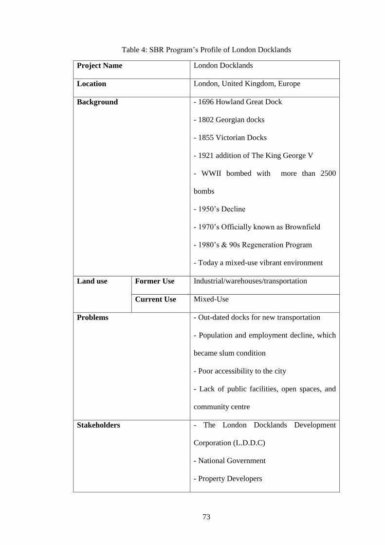
73
Table 4: SBR Program‟s Profile of London Docklands
Project Name London Docklands
Location London, United Kingdom, Europe
Background - 1696 Howland Great Dock
- 1802 Georgian docks
- 1855 Victorian Docks
- 1921 addition of The King George V
- WWII bombed with more than 2500
bombs
- 1950‟s Decline
- 1970‟s Officially known as Brownfield
- 1980‟s & 90s Regeneration Program
- Today a mixed-use vibrant environment
Land use Former Use Industrial/warehouses/transportation
Current Use Mixed-Use
Problems - Out-dated docks for new transportation
- Population and employment decline, which
became slum condition
- Poor accessibility to the city
- Lack of public facilities, open spaces, and
community centre
Stakeholders - The London Docklands Development
Corporation (L.D.D.C)
- National Government
- Property Developers

74
- Local Housing Association
- Conservation Groups
- Newham Council
Aims and Objectives Regenerate the whole area and provide
mixed-use urban environment to create a
balanced community by means of social and
economic concerns
Brownfield
Regeneration
Physical/
Environmental
- Pedestrian friendly street design
- Providing new open spaces
- Planting trees
- Transforming old docks and warehouses to
attractive place (e.g. old docks transformed to
marine)
Socio-Economic - 22,000 new accommodation places
- Public facilities such as new shopping
centre, many shops, restaurant, pub, cafes,
sailing and water sport centre
- Over £100 million public investment
Economic - Former royal docks have been transformed
to a city airport
- Public transport by light railway within the
area and toward the city
- Placement of financial and high-tech firms
such as TV studios, newspapers, and etc.
(e.g. guardian newspaper)

75
Impacts and Results - Improvement in social structure and user
profile of the area (e.g. many young well
educated people moved in)
- £7.7 billion private investment
- 2,700 new businesses trading
- Unemployment rate had fallen to 7.4%
- Old warehouses have been transformed to
offices and luxury apartments
- Program has realized as a great level of
urban design standards.
3.5.2 Building Scale Example Study
Exploration of this example will shows how a non-profit organization has dealt with
a contaminated brownfield site in building scale. This brownfield site has a great
history in steel manufacturing industry, which established in 1882 (Figure 17). The
location of the site is in Providence city in Rhode Island where it was one of the first
cities that had been established in the United States in 1636. Steel fabrication
facilities expanded by development of two story building with around 2,000 square
meter of land occupation in 1902, and during the next 30 years it expanded to
another 10,000 square meter of land for development of an office building and
ornamental ironwork workshops. By the beginning of 21st century, like many other
factories in USA, this steel fabrication facility was forced to close because it was no
longer environmentally and financially reasonable (Hollander, Kirkwood, & Gold,
2010). However because of the history of the site, it took place in National Register

76
in Historic Places (NRHP) in 2005. Then in 2007, a non-profit organization with the
name of Steel Yard purchased the site.
Figure 17: An old photo of Providence Steel and Iron company (Source: Portfolio of
Klopfer Martin Design Group, http://www.klopfermartin.com)
This site, which most often referred as steel yard, is located in Valley district (Figure
18), where it was an industrial centre in Providence. Economic decline in this district
resulted in around 250 vacant and/or abandoned factories, while some of these
brownfields have been regenerated and redeveloped to commercial and residential
function, many of them remained abandoned (Cameron, 2011). Moreover the social
structure and inhabitant profile of the neighbourhood around steel yard was one of
the poorest social structures in Providence. Therefore in this community, in which
most of the people are below the level of poverty, it was difficult to reach community
participation, and because of soil contamination within the site, an extraordinary
amount of investment was expected (Hollander, Kirkwood, & Gold, 2010). In this
regard, except steel yard non-profit organization and professional companies who

77
hired by them, environmental protection agency of United States (EPA), Coastal
Resources Management Council (CRMC), and Department of Environmental
Management (DEM) were important stakeholders in the project.
Figure 18: Steel Yard Location Map, Valley district, Providence, Rhode Island
(Source: Google Map, http://maps.google.com)
The project was developed with the aim of development of identical and flexible
space. Where the brownfield site has a significant history in industry, a community-
based non-profit system has been formed to promote educational issues related to
industrial arts, which brings changes to the area. The focus of this brownfield project
(Figure 19) was regenerating the different type of industrial practice by using
industrial art to achieve development in community and revitalize the urban
environment of the area, which gives a chance to develop a distinctive resource for
local community (Hollander, Kirkwood, & Gold, 2010). For these purposes, the
regeneration of existing structure, providing the public landscape, and operating the
best possible sustainable practices, are essential.

78
Figure 19: Steel Yard with Brownfield Status (Source: Portfolio of Klopfer Martin
Design Group, http://www.klopfermartin.com)
Similar to the previous example, the dimensions of this regeneration program were
defined within three categories (Table 5). According to contamination of the site, the
strategy for physical/environmental regeneration of this example is significant. They
did not want to take out the contaminated soil and put it in somewhere else, which
they believed it is not sustainable to transfer contamination from a site to another
(Cameron, 2011). Therefore Department of Environmental Management used
remediation techniques for treatment of the soil and then covered it by 60 centimetre
clean soil, pavements, and buildings (e.g. an amphitheatre and raised lawn have been
built by contaminated soil on top of covered site) which technically they call this
method as capping technique (Figure 20 & 21). However the small amount of soils,
which had high concentrated contamination, removed and disposed in licenced
facilities (Hollander, Kirkwood, & Gold, 2010).

79
Figure 20: Steel Yard Remediation Project in progress 2009 (Source: Steel Yard
Flickr Photo Stream, http://www.flickr.com/photos/thesteelyard)
Although they kept toxic soil on site, for controlling the runoff lest it penetrates to
the sewer system or nearby river, natural filtering system such as permeable surfaces,
rain gardens, bioswales, and etc. for storm water has been proposed to handle most
runoffs before it reach out the site (Cameron, 2011). Therefore the regeneration
program for this brownfield site became significant in environmental sustainability.
The development plan of this project consists of active and passive open spaces,
outdoor work areas, parking, landscaped sculpture park, open-air stage, and
pedestrian/vehicle circulation arrangements (Ford, 2007).
Figure 21: Steel Yard Remediation Project completed by 2010 (Source: Steel Yard
Flickr Photo Stream, http://www.flickr.com/photos/thesteelyard)
In regards to socio-economic dimension of this SBR program, the lands and
buildings regenerated to function for community organizations and industrial art
centre with its growing population of artists in neighbourhood (Hollander, Kirkwood,
& Gold, 2010). Therefore a public space is created which provides functional spaces

80
for daytime activities (Figure 22) such as artist studios, art markets, art and cultural
festivals, educational programs, and community meetings. Besides at nights there are
some night activities (Figure 23), which take place in that public space such as place
for movie nights, hang out space for relaxation, and venues for music and dance
(SteelYard, 2010). Besides the buildings of steel fabrication facilities have been
regenerated and transformed to industrial art facilities and education centre (Figure
24) where classes and workshops are located. The general topics of industrial art
activities in this complex are welding, ceramics, jewellery, glass casting,
blacksmithing, and the foundry arts workshops (Mission & History of Steel Yard).
Figure 22: Activities at Steel Yard (Source: Steel Yard Flickr Photo Stream,
http://www.flickr.com/photos/thesteelyard)

81
Figure 23: Night Time Activities at Steel Yard (Source: Steel Yard Flickr Photo
Stream, http://www.flickr.com/photos/thesteelyard)
Although the project was based on non-profit organization, steel yard organization
has lunched around 90 contracts in regards to public projects to make street furniture,
which was one of the most financially successful economic dimensions of this SBR
program (Cameron, 2011). Their profits were not limited to benefits of non-profit
status in regard to loans and grants such as $400,000 grants from EPA, $199,000
grants from Economic Development Corporation, and many other loans from
national government, but also they have achieved a range of in-kind contributions
and participation which helped to cover many of their costs (Hollander, Kirkwood, &
Gold, 2010).

82
Figure 24: Steel Yard Workshops (Source: Steel Yard Flickr Photo Stream,
http://www.flickr.com/photos/thesteelyard)
Through looking to overall result of this SBR program (Figure 25), it will be shown
that steel yard provided a unique urban environment and social resource for its
community, furthermore this project acted as a catalyst in the area to provide an
opportunity for value reconsideration of industrial heritages. This project has
attracted many artists and developers to the area that resulted in profits of local
community in micro scale and as macro scale the city of Providence (Cameron,
2011).

83
Figure 25: Site Plan of The Steel Yard (Source: Steel Yard Flickr Photo Stream,
http://www.flickr.com/photos/thesteelyard)
Table 5: SBR Profile of the Steel Yard
Project Name The Steel Yard
Location Providence, Rhode Island, USA
Background - 1882, Providence Steel and Iron Company
established in Providence
- 1902 to 1930s property expansion of factory
- 2001, Steel fabrication facility closed and
became officially a brownfield site
- 2005, Site placed on National Register of
Historic Places
- 2007, The Steel Yard non-profit organization
has bought the site and site being regenerated

84
Land use Former Use Industrial (Steel Fabrication Facilities and
Manufacturing)
Current Use Industrial Art Education Centre
Problems - Soil Contamination
- Traditionally Poor Neighbourhood
- Many vacant and abandoned properties
surrounded the site
- Lack of attraction of new investors
- Extraordinary budget needed for cleaning up
the site
Stakeholders - Woonasquatucket Valley Community Build
(aka The Steel Yard)
- Local government state agencies
- Rhode Island Department of Environmental
Management (DEM)
- Coastal Resources Management Council
- US Environmental Protection Agency (EPA)
Narragansett Bay Commission (NBC) for
water storm control
- Professional Private Companies (klopher
martin design group for landscape design, e. a.
engineering, science, technology Inc. for
environmental design, morris beacon design
company for implementation project, and etc.)
Aims and Objectives Sustainably regenerating a brownfield site

85
with significant history in industry to bring
changes to the area and to develop an identical
and flexible space through community-based
non-profit system, which promotes
educational issues related to industrial arts.
Brownfield
Regeneration
Physical/
Environmental
- Soil remediation techniques (un-
contamination and capping the soil and in case
of high contamination, removal and disposal
the contaminated soil)
- Controlling and keeping away the runoffs
from sewer systems and nearby river through
natural filtering systems
- Creating active and passive open spaces,
outdoor work areas, parking, landscaped
sculpture park, open-air stage, and
pedestrian/vehicle circulation arrangements
Socio-Economic - Providing space for community activities to
support the community
- Creation of educational spaces (e.g. welding,
ceramics, jewellery, glass casting,
blacksmithing, and the foundry arts workshops
and classes)
- Providing public spaces for both daytime and
night activities

86
Economic - Achieving more than $700,000 grants and
loans
- Provides an opportunity to contribute in
public space projects (e.g. street furniture
projects)
Impacts and Results - Provides a unique urban environment
- Social resource to community
- Value increase of the area
- Light-up for consideration of other industrial
heritage
- Attraction for artists and investors to the area
- Improvement in social structure of
neighbourhoods nearby the sites
3.6 Summary and Conclusion: Conceptual Model for Process of SBR
Program
One of the accepted solutions for turning deprived urban areas to lively, vibrant, and
functional space is laid in the combination of urban regeneration and sustainable
development, which widely called sustainable brownfield regeneration (SBR).
Although the main theme for the issue of sustainability is “securing the future”,
recently there are some discussions about the way of sustainability which says it is
not cleared that which element should be sustain. Is it the regeneration process,
planning process, or building itself? Moreover one may say that everything has its
own beginning and end, so how should it sustain? And more clearly there is question

87
that what should be sustained? According to these questions on of the best answer is
from Nathanail (2011), which said that sustainability is the journey not destination.
By means of the general discussion, sustainable brownfield regeneration is about
connection between technical issues and socio-economic concerns to gives a new life
to those dead lands and properties. Besides, these regeneration programs will reduce
the pressure on Greenfield and prevent the urban sprawl to achieve more compact
way of urban form.
This chapter reviewed SBR program as a comprehensive tool to solve brownfield
issues. Accordingly initial critical elements of SBR program have been discussed,
which are the most awareness in the beginning of SBR program and as a whole will
shape the journey and destination of it. These elements are (1) Actor‟s Network, (2)
Benefits and Barriers to SBR, and (3) Risk Assessment and Risk Management,
which help together to identify the realistic dimensions of the projects, defining the
role of stakeholders, managing the partnership, and also recognition and handling the
potential risks.
Towards the initial critical elements of SBR program, this chapter demonstrated the
impacts of sustainable brownfield regeneration programs, which result in
improvement of quality of life and enhancing urban environment. These impacts are
categorized in three categories to make more clear understanding of dimensions out
of SBR programs by means of physical/environmental, socio-economic, and
economic concerns.
Physical/Environmental dimension of SBR programs has focused on reducing the
pressure on Greenfield and prevent urban sprawl to have better and more compact

88
form of urban environment. Moreover cleaning up techniques is for treating the
contaminated sites to secure safety and public health issues within those brownfields,
besides by cleaning up the site, air and water quality will be improved. In the
findings of both discussed examples, it can be seen that many public, open, and green
spaces have been provided, the quality of urban settings has been improved, and
contaminations within the site have been treated, to promote more sustainable urban
environment.
Socio-economic dimension of SBR program has its focus on improving the quality of
life, and provides an appropriate service to community. In this dimension the
unemployment rate will be reduced and new job opportunities will show up. In
example of Docklands, it can be seen that the program resulted in more than 2,700
businesses trade and consequently in many job opportunities. On the other hand,
community centres, commercial and entertainment facilities will provide to serve as
a social resource which will secure the quality of educational, social, and user‟s
profile and reduce the crime within the regenerated neighbourhood. In this regard,
the example of steel yard project gave a good clue of what might happened if a
contaminated site is transformed to a community centre and function as an artistic
educational space with some public spaces, which has resulted to become a vibrant
urban space.
Economic dimension of SBR programs generally are about the rewards of the
programs by means of profits, tax incomes, and new investments. Brownfield sites,
which usually have installed infrastructures within the site, will lower the cost of
public sectors investments, and in compare to greenfield investment it is a huge steps
forward in process by means of time and money. In both examples the existence of

89
infrastructure within the sites has eased the process. Another side of economic profit
is the new source of tax income from places where had idle status which is a great
profit for local and national government, plus throughout the regeneration program
the property value will be increased, therefore it will cause increase in existing
amount of income tax. These incomes and profits give more confidence to public
sector for investment in those projects and act as catalyst to attract private investors
by means of supports and incentives.
Based on literature through the review on sustainable brownfield regeneration, this
chapter as a whole has drawn a framework (Figure 26) for the evaluation and
analysis of sites with brownfield status, and it shows the importance of public-private
partnership in the process of SBR programs. This framework will be consisting of
three dimensions, which has discussed and referred before as the dimensions of SBR
programs. Although all these dimensions should be considered in SBR programs, but
the importance and order of them are varies from case to case. For example in the
case of Steel Yard the strong focus was on physical/environmental dimension, and
then the socio-economic one, but although the cost of remediation and regeneration
was high, the economic impacts of this regeneration project was not the issue, and
the main expected rewards was laid in environmental and social concerns.

90
Figure 26: Framework for the evaluation and analysis of sites with brownfield status
According to the issues that have been discussed in this research, a guideline as a
product of theoretical framework for process for SBR program has been produced,
which is, consists of seven stages. This guideline is designed to show how complex
and comprehensive is the SBR program and it is just a conceptual model, in actual
projects the real framework should be more expandable and detailed (Table 6).
Problematic Urban Environment
Sustainable Brownfield
Regeneration (SBR)
Analysis Stages
Initial Process (General Assessment
and Problem Definition)
Comprehensive Analysis
Risk Assessment and Management
Decision Making and Strategic Plan
Implementation and Improvement Stages
Physical Implementation
Process
Socio-Economic Improvement
Monitoring the results in short term
and long term
Sustainable Development
Brownfield Regeneration

91
Table 6: Conceptual Model for Process of SBR Program
Process of SBR Program
Stage 1 Initial Process
(General
Assessment and
Problem
Definition)
Initial Site Survey:
- Physical/Environmental Observation and
Literature Analysis (Study of existing documents)
- Socio-Economic Survey (Interviews,
questionnaires, etc.)
Recognition of Stakeholders and arrangement of
multi-disciplinary team for further stages
Identification of theme of general problems
Conceptual Framework out of initial analysis for
SBR Program to emphasize positive and
negative points
Stage 2 Comprehensive
Analysis
Physical/Environmental Analysis:
- Determination of Contamination and its levels
(Soil, Water, Air, etc.)
- Assessment of site physical condition
- Determination of physical obsolescence of
buildings within the site (façade, structure, etc.)
- Spatial Analysis of the site and its surroundings
- Determination of existence and obsolescence of
infrastructure within the site
- Natural Environment Analysis
Socio-Economic Analysis:
- Assessment of area‟s Social Structure
- Assessment of community partnership
- Assessment of political views for applied policies
- Recognition of stakeholders and level assessment
of public-private partnership
- Assessment of users satisfaction level
Economic Analysis:
- Determination of incentives and founding
availability

92
- Evaluation and calculation of existing income tax
and approximate future income tax
- Identifying the missing elements for private
investment
- Assessment of existing strategic economic plans
and their results
Barriers and Possible benefit to SBR program:
- Analysis and determination of physical barrier to
the area
- Analysis and determination of social conflicts and
barriers
- Analysis and determination of economic barriers
- Analysis and determination of political and policy
related barriers
- Calculation and determination of approximate
possible future profits in all dimensions
Comprehensive SWOT analysis out of
multidisciplinary workshops
Stage 3 Risk Assessment
and Management
Determination the threats to the program and
existing situation
Determination the level of uncertainty in the
process
Producing a multi-disciplinary approach and plans
to manage the certain risks and potential risks
At least include a peer review to the final results
Stage 4 Decision Making
and Strategic
Plan
Variety of workshop with stakeholders to
summarize and synthesis the analysis
Produce a strong vision for the program
Draw a flexible, expandable, and detail strategic
plan to be overviewed by stakeholders in decision
making workshops
Development a detail mission and objective plan to
be a comprehensive and clear check list of what to
do

93
Stage 5 Physical
Implementation
Process
In case of contamination, remediation techniques
should apply to remove and reduce the risk of
toxics and chemical contaminations on the site
Reclamation techniques should apply where the site
has a physical condition that make it difficult or
impossible for further development to turn it back
to beneficial use
Redevelopment Techniques should apply where it
can creates new landscape, buildings and
infrastructure
Stage 6 Socio-Economic
Improvement
Social or Community Regeneration should apply to
improve the structure of society
Physical Regeneration should apply where a
function is failed or expired and another function
should take its place
Stage 7 Monitoring the
results in short
term and long
term
Short Term Result:
- Between 1 to 5 years (Produce a brief reports to
record the results)
Frequent Monitoring:
- Assessment of all the situations approximately
each 5 years (Produce a comprehensive report to
analyses and evaluate the result, and try to find a
solution for possible mistakes/ failures or problems)
Long Term Result:
- Assessing the situations after approximately 30 to
50 years (To learn from successful practices or
mistakes, and start to think about new strategic
regeneration plans)
Based on this framework, next chapter will now implement the stage one on the case
study of this research: periphery area of Nicosia buffer zone.

94
Chapter 4
4 BROWNFIELD REGENERATION AS A VALUABLE
SOLUTION FOR URBAN DECAYS: INITIAL ANALYSIS
OF BROWNFIELD’S CHALLENGE IN CASE OF
NORTHERN PART OF NICOSIA
4.1 Introduction: Brownfields of Nicosia
In areas that are subjected to urban decays, urban obsolescence gradually changes the
urban settings and one of the reasons of this problem is existence of brownfields.
These vacant and/or abandoned properties are eye sore and not just new investment
will not take place, the existing businesses will face crises in those areas. Moreover,
the social structure of the area will change and progressively all these problems put
hands together to form a slum condition. On the other hand without any doubt,
option of sustainable brownfield regeneration is one of the most accepted tools in
sustainable development issue, which is a complex solution for those problems, as
has been discovered in previous chapters.
Aim of this chapter is to put all previously discussed issues together to make an
initial analysis on brownfield sites in northern part of Nicosia, which is the last
divided city in Europe. This division is result of conflict in 1974 between two
communities of Turkish and Greek Cypriots within the island. The existence of the
border or by other mean, the UN buffer zone which horizontally divided the whole
island into two parts, and particularly the division of the city of Nicosia, caused

95
urban decays with many dimensions at peripheral of the buffer zone. The focus of
this study will be limited to the peripheral of northern part of Nicosia buffer zone.
This study will examine and evaluate the characteristic of these areas in a holistic
approach. This holistic analysis will take the whole area as a mixed-use environment,
with variety of users, and will try to decode and decontextualize the problems
regarding to brownfield issues. This case study consists of industrial, commercial,
and residential properties. In most of the literature and actual practices the most
common brownfield sites are industrial, and then commercial ones are in second
place, the residential properties have become vacant and abandoned due to the result
of special events, such as political/ethnical/religious conflicts, earthquake, war, and
etc. The special issue about this case study is existence of the residential properties
within the area, and these unique cases became brownfield as the impacts of buffer
zone or by other mean, the dead area, which are now functioning as a barrier between
two communities.
As it was discussed in previous chapter, the process of SBR program consists of
seven steps, which each step is essential and foundation of another one. These seven
steps are the conceptual model, to be a guideline for further SBR programs. One of
the most important stages is the first one, because it produces a general assessment
and defines the problems (Table 7). This research tries to adopt the case of Nicosia in
the first stage to emphasise the theme of general problems related to brownfield
issues.

96
Table 7: Stage one of Conceptual Model for Process of SBR Program
Process of SBR Program
Stage
1
Initial Process
(General
Assessment and
Problem
Definition)
Initial Site Survey:
- Physical/Environmental Observation and
Literature Analysis
- Socio-Economic Survey (Interviews,
questionnaires, etc.)
Recognition of Stakeholders and arrangement of
multi-disciplinary team for further stages
Identification of theme of general problems
Conceptual Framework out of initial analysis for
SBR Program to emphasize positive and
negative points
4.1.1 Nicosia, Last Divided City in Europe
Nicosia is a city where its history goes back to the early Bronze Age (3000 B.C.) and
Roman period. In literatures, Wilbrand, Count of Oldenburg, who visited Cyprus in
1211, makes the early references to Nicosia. From 9th
century A.D. to 20th
century
many dynasties and kingdoms used to rule the island, such as the Byzantines,
Lusignans, Venetians, Ottomans, and British governors (Gunnis, 1973). In all these
periods the city of Nicosia was served as the capital of Cyprus, and even today the
city is serving as the last divided capital in Europe, which is the capital for both
Turkish and Greek Cypriots communities. (Timeline of Cyprus, 2011)
Finally after British period (1878-1960) in 1960 the people of Cyprus formed and
established the Republic of Cyprus, however by the agreements between United
Kingdom, Turkey, and Greece, two base areas have been reserved for Britain which
are still in use and active (Figure 27). The life of new republic was so short, which it

97
last only less than 14 years. Political conflict between Turkey and Greece in
influential of new republic, and also the ethnical conflict between the two
communities of Turkish and Greek Cypriots conclude another political conflict in
1974. Turkey intervened to the island as the guarantor for safety of Turkish Cypriots.
Result of the conflict was the dividing of the island into two parts, with an
establishment of a border by United Nation. Turkish Cypriots moved to the northern
part of the island and Greek Cypriots to the southern part. The impact of this disaster
also showed up in the city of Nicosia as well, which leads to division of the city into
two parts (Cyprus country profile, 2011).
Figure 27: Map of Cyprus according to ethnic distribution in 1973 (Source: Library
of Texas University, URL:
http://www.lib.utexas.edu/maps/europe/cyprus_ethnic_1973.jpg)
Since 1974, south part of the island where Greek Cypriots moved to remained as
Republic of Cyprus; however until 1983 the northern part was self administrated area

98
(Figure 28). In 1983, the Turkish Cypriot community in northern part of the island
formed and established a new republic, which has called Turkish Republic of North
Cyprus (TRNC). In other hands Republic of Cyprus in southern part has been
recognized in the world as the main legal government of the island, however because
of the political conflicts, except Turkey, none of the countries in the world
recognized the TRNC (Timeline of Cyprus, 2011). Although the TRNC faced many
problems regarding to the unrecognized government, the northern part became one of
the attractive tourist destinations in Mediterranean region, and many known and
qualified universities opened there, which made the northern part as one of the high
quality educational destination as well. Nowadays United Nations (UN) put many
effort to find a solution for both communities to unite the island, however from many
countries in Europe there are flights to TRNC via Turkey, and not officially, but
widely the TRNC is known in the world.
Figure 28: Cyprus map from CIA World Factbook, after 1974 (Source: CIA Fact
Book, URL: https://www.cia.gov/library/publications/the-world-
factbook/maps/maptemplate_cy.html)

99
4.1.2 UN Buffer Zone of Cyprus and Urban Decays Which Caused by UN
Buffer Zone in Nicosia
The border, which divided the country, consists of a buffer zone that established by
UN to function as a physical barrier between the two communities. Agreeing the
importance of buffer zone itself, there is another important factor about the buffer
zone, which has shown in Alpar (2008) studies. In her studies it has noted that after
southern part of the island have been placed to the European Union (EU), the buffer
zone and northern Nicosia became one of the edges of EU, and Nicosia buffer zone
transformed to the EU border. Therefore the existence of vacant and abandoned
properties at peripheral of EU makes more sensitive discussions about brownfield
conditions. Furthermore what is perceived in buffer zone is like that the time is
stopped since 1970‟s and all elements within the buffer zone such as houses, shops,
cars, and etc. remain as how Cypriots‟ life style was in 1970‟s.
Right now the buffer zone itself has a function which is the country border, but if any
time in future the conflict of Cyprus will be solve the buffer zone will not have any
other function and it will turn to a huge amount of brownfield. According to this
research the UN buffer zone is categorized into three parts according to where the
buffer zone is located (Figure 29). The three parts of buffer zone are explained here:
A. The part which divide the cities/settlements; these sections of buffer zone are
located within the cities, and a portion of cities where many commercial, residential,
and industrial functions were located, have become vacant and abandoned (e.g.
Nicosia Buffer Zone, Maras Neighbourhood in Famagusta).

100
B. The part which divide the greenfields, now is no man land and is a huge
undeveloped land where crossing horizontally all over the country.
C. The part which is completely covered by previously functional land/buildings
or facilities and now they are vacant and abandoned because of characteristic of
border itself, these properties are not within the cities and they are located in suburbs
or rural areas (e.g. Cyprus International Airport).
Figure 29: Categories of UN Buffer Zone According to its Location
The main difference in these categories is in the locations of the buffer zone, for
example although both category A and C are a built up area, the difference between
them is that the category A located within the city and category C located at suburbs
or totally out of the city.

101
As a matter of fact, the buffer zone divided the city of Nicosia into two parts, and
although before the event of 1974, the historic walled city of Nicosia was the centre
of city, it turned to the edge of the city as well as the other central neighbourhoods.
In the northern part of Nicosia the properties where Greeks used to live, became
vacant and abandoned, and because of population transfer it started to be used by
Turkish people20
. The threat of another possible conflict, the huge vacant and
abandoned area within the buffer zone, existence of army in the area, and existent of
physical and mental border resulted in population crisis of original inhabitant.
Besides for many years because of its strategic location, the government did not put
any effective urban investment into the area. (Cyprus country profile, 2011)
All these situations caused urban decays in peripheral of Nicosia buffer zone. The
strong curtain feeling of the border and the shadow of another divided city in Europe
which reminds the feelings of berlin‟s wall and Cold War changed the social
structure of the area. The neighbourhoods where used to be a vibrant urban space,
turned down to a poor neighbourhood, which progressively caused the slum
condition. Although after establishment of TRNC many efforts has been taken place,
but except the outer layout and few properties, most of them remains in poor
condition. It is important to know that the physical barrier was not the only reason
for urban decays of peripheral of buffer zone and other older part of the city.
Accordingly other several reasons were involved in that condition such as negative
political and international situation, economical problems, big number of immigrants
with low user‟s profile, and many other issues that have discussed in further sections
of this study.
20
Both Turkish Cypriots who were refugee from the southern part and Turkish immigrants from
Turkey.

102
Existence of the barrier in middle of the city transferred most of economic activities
toward the northern part of the city, and stayed away from the buffer zone. Many
commercial and industrial buildings were shut downed in last 30 years, and left a
vacant and abandoned area within the city at the peripheral of buffer zone, as well as
many residential properties. The division showed its impacts on urban structure and
formed a negative socio-economic setting within the area. (Timeline of Cyprus,
2011)
4.1.3 Brownfield Sites in Peripheral of Nicosia Buffer Zone
In peripheral of Nicosia buffer zone there is many previously developed lands, which
are vacant, derelict, and abandoned. Although in land use policies of TRNC, there
are no rules for brownfields, according to this study, these properties are subjected to
brownfield status. In this regard there are three regions of brownfields next to
Nicosia buffer zone in northern part, which surrounded the historical Walled City.
On the other hand, although in the Walled City there are many sites with
brownfield‟s characteristic, but because the Walled City is a historic place, then
those sites are considered as historic urban quarters and they cannot have the status
of brownfield.
Accordingly if the Walled City which is divided into two parts by a narrow boarder
will be considered as a historic layer next to the buffer zone, then it can be
summarized that at the three sides of it in the actual city of Nicosia, there are three
regions with brownfield characteristic (Figure 30). In this study, these regions have
been marked with brownfield status according to the accepted definition of
brownfield by this research. Within these regions there are many previously
developed lands (PDL), which are vacant and/or abandoned, and also according to

103
the classification of brownfield sites which has discussed in chapter two; many sites
have the characteristic of partially occupied lands. These sites have one or
combination of the elements of partially occupied lands which are (1) not currently
fully in use, (2) land or building currently in use and allocated by different land use
in local plan, and (3) land or building currently in use with redevelopment potentials.
Two of these regions have the residential land use and located at sides (east & west)
of the walled city and the other one is a mixed-use area consists of commercial,
industrial, and residential area, which is located on top (north) of the walled city
(Figure 31).
Figure 30: Walled City and 3 region of brownfield
These three areas have been suffering from an urban decline because of that huge
vacant and abandoned area (Buffer Zone) which crossed the city and gradually by the
time, they have lost their original users, and became vacant and abandoned. Although
some restoration and conservation project were applied on a number of those

104
properties, but still many of them remains empty with no good condition, and as a
whole is seems to be far from achieving sustainability concerns in the area.
Figure 31: Study Areas, Peripheral of Nicosia Buffer Zone
With no doubt there are variety of barriers to achieve sustainable development in
these areas, such as lack of professional updated methods, absence of sufficient
policies regarding to sustainable development, variety of visions between local
government and professionals, poor attention to social sustainability, and of course
the existence of physical and psychological border. All these limitation shaped an
unsustainable scheme for these areas.
Accordingly in this study the characteristic of these areas will be examined and
evaluated in a holistic approach. This holistic analysis as a part of the first stage of
the SBR framework will take the whole area as a mixed used environment, with
variety of users, and will try to decode and decontextualize the problems regarding to
brownfield issues.

105
4.2 Macro Scale Review of Brownfields in Peripheral of Buffer Zone
Today, the urban structure of the city of Nicosia consist of three parts, (a) the historic
walled city, (b) the inner part of the city, and (c) the newly developed areas in
suburbs which has been attached progressively to the city. On the other hand, the
shape of buffer zone, which is the dividing element in the city, formed the southern
edge of the Nicosia in northern part (Figure 32). The two-dimensional physical shape
of Nicosia buffer zone appears as an arc, which holds the northern part (Figure 33).
At the pick of the arc, the historical walled city taken place and mirror of the arc
covered the peripheral of buffer zone.
Figure 32: Urban Structure of City of Nicosia

106
Both arcs together can be perceived as a ring, which has enclosed the declined area;
the outer part of the ring is the buffer zone, and the inner ring in other side is the
study area, which is subjected to brownfield status. As it discussed before the buffer
zone has been categorized into three categories, therefore in this scenario, the buffer
zone located in the category A. This section of buffer zone is located within the
cities, where many commercial, residential, and industrial functions were located
become vacant and abandoned. Progressively according to these situations, the
peripheral areas of buffer zone which consists of mixed land use include residential,
commercial, industrial, governmental, and public facilities have been faced the
serious declines in urban environment (Figure 34).
Figure 33: Inner Ring of Brownfield in Peripheral of Nicosia Buffer Zone

107
Impacts of buffer zone have been affected this inner ring and have shown up in many
ways such as in functional, infrastructure, and transportation systems of the city. Not
just brownfield sites within the area, also most of properties in the area as a whole
need a comprehensive regeneration plan. In regard to finding a solution, Alpar
(2008) suggested that a holistic top down decision with combination of bottom up
decision system, which is partnership of community, could resulted in more
sustainable outcomes.
Figure 34: Brownfields in Study Area
Although many efforts have been taken place for redevelopment of the area, such as
Nicosia Master Plan (NMP) and United Nation Development Program (UNDP), the
main focus of all these programs were on protection of historic and cultural heritage.
These efforts achieved some good results such as NMP by winning the Aga Khan

108
Award in 2007, which restored and regenerated some areas, however it fails in social
dimension, due to lack of participation of property owners who are waiting for
political settlement (Hadjri, 2008).
4.3 Methodology of Examination and Analysis of Selected
Brownfield Sites (Case Study)
4.3.1 Framework of Examination and Analysis of Study Area
Case studies, which are related to Brownfield sites, are defined in a framework that is
formed throughout three dimensions; these three dimensions are
physical/environmental, socio-economic, and economic. Each dimension has its own
indicators, which all together formulate a framework for beginning of brownfield
regeneration program. Also the outcome of this framework produces another
framework for beginning of a holistic strategic plan. As it has been studied in
example studies, in each dimension there are some indicators, which act as the
checklist for brownfield site analysis and evaluations. According to the findings in
example studies, these indicators are listed here:
Physical/Environmental Dimension Examination
o To find out about existence of any kind of contamination within the
site
o To find out about level of property obsolescence and damages
o To find out about natural and environmental capacity of the area
o To find out about stakeholders related to environmental protection
issues
Socio-Economic Dimension Examination

109
o To find out about level of human satisfaction of existing situation
o To find out about does community wills to participate or not
o To find out about existing social structure and user profile in the area
o To find out about rate of employment in the area
o To find of about the existence of community support and public-
private partnership
Economic Dimension Examination
o To estimate existing tax income
o To find out about existing infrastructure
o To estimate future possible job opportunities and new source of tax
income
o To find out about existence of governmental incentives
To be aware of variety in reflections of dimensions and indicators is an essential. For
example in the case of Nicosia, regeneration of residential areas will not increasing
the rate of tax, therefore the indicator of tax income will not be the consideration. As
a result, this research will use dimensions and indicators according to the
characteristic of the area.
For the purpose of this study, an initial site survey has been carried out in regards to
all dimensions. This initial site survey is towards the first stage of SBR program
guideline, which has been offered in previous chapter. Beside exploration in existing
documents and researches related to the Nicosia for finding out its physical
characteristics, the questionnaires, in-depth interviews with locals and governmental
authorities, decodes many problems of the area. Moreover the observations and
physical evaluations of the sites, in combination with qualitative and quantitative

110
data drew a framework to assess the problems and give the better understanding of
existing situation.
4.3.2 Methodology of Data Collection, Data Analysis, and Evaluations
Data collection for the areas with brownfield status consists of three stages; the first
initial stage is about collecting general information from physical, environmental,
social, and economic issues within the area. This initial stage is a short survey, which
provide essential data and information for the comprehensive site analysis.
Subsequently the comprehensive site analysis consists of comprehensive data
collection and analysis, which shape the main decisions about the area. Second stage
in data collection is that comprehensive data collection, which is also the second
stage of SBR program. The third stage is the data collection related to risks to the
program, project, and the area, to provide the necessary data and information for risk
assessment and management process, which is also the third stage in SBR program.
In this research the methodology for the data collection has been based on the first
stage, which is the initial site survey. This initial site survey holds two types of
investigations; physical/environmental observations, area study and
qualitative/quantitative surveys.
The qualitative and quantitative surveys have been carried out to find out how people
consider the existing situation, and know their opinions about urban issues in general
and in particular brownfield and regeneration related issues. In these regards a
questionnaire has been prepared, and has been conducted on approximately 50
Turkish Cypriots who live or work in the study area. These questionnaires produced
quantitative data about their level of satisfaction, percentage of their willingness for

111
positive changes in urban environment and their participation. Parallel to the
questionnaires, a qualitative survey has been carried out to understand their points of
view, in this regards many in-depth interviews has been done with locals who used to
live and work in the area for a long time.
On the other hand, this survey needed to collect the information and opinions from
official authorities to compare with the opinions from community, and evaluate the
situation according to opinions of both sides. However because of time limitation of
this study, only one of the authorities has been selected out of responsible authorities
such as municipality, department of city planning, parliament, ministry of interior,
department of environmental office, and ministry of tourism and environment.
Therefore because in most of the cases, which is related to urban environment, the
municipality is the operational body of the system, the selected official authority was
the municipality. In this regard some in-depth interviews with personnel at project
department of municipality has been done and it is completed with an interview with
the deputy town clerk of Nicosia. Parallel to these interviews few questionnaires has
been answered by Turkish Cypriots whom originally are from the city of Nicosia.
According to the quantitative and qualitative data which have been collected during
the initial site survey, and pie charts which show the percentages of different
opinions, a table of positive and negative points (Table 9) has been produced to
combines all data together and categorize the result according to positive and
negative issues to the area. Emphasising and grouping the positive and negative
issues helped the study to decode and de-contextualize the problem, and make clearer
understanding of existing situation of the city in regard to urban environment and
brownfield issues.

112
4.4 Initial Stage: Findings For The Periphery Area of Nicosia Buffer
Zone
Based on the study of the existing documents about the physical characteristics of the
case area, it can be said that the selected study area has variety of land use;
previously industrial activities and accordingly vacant industrial buildings are located
at the heart of the area, which surrounded with vacant commercial buildings and
warehouses (Figure 35). Existence of some functional daily activities such as
governmental offices (parliament, ministry buildings, and Turkish embassy), public
high school and historic walled city brought some daily life to the area. However
these activities are not enough to change the social structure of the area and did not
help the improvement of urban settings. On the other hand, the residential areas (e.g.
Caglayan neighbourhood21
), which are one of the oldest neighbourhoods in Nicosia,
are suffering from abandoned properties and lack of sense of belonging form owners,
users, and public authorities (Figure 36).
21
Caglayan neighborhood used to be a rich environment, and mainly with the high profile users, steel
some villas with yellow stone façade can be seen there, however the overall condition of those
buildings and whole neighborhood is in decline.
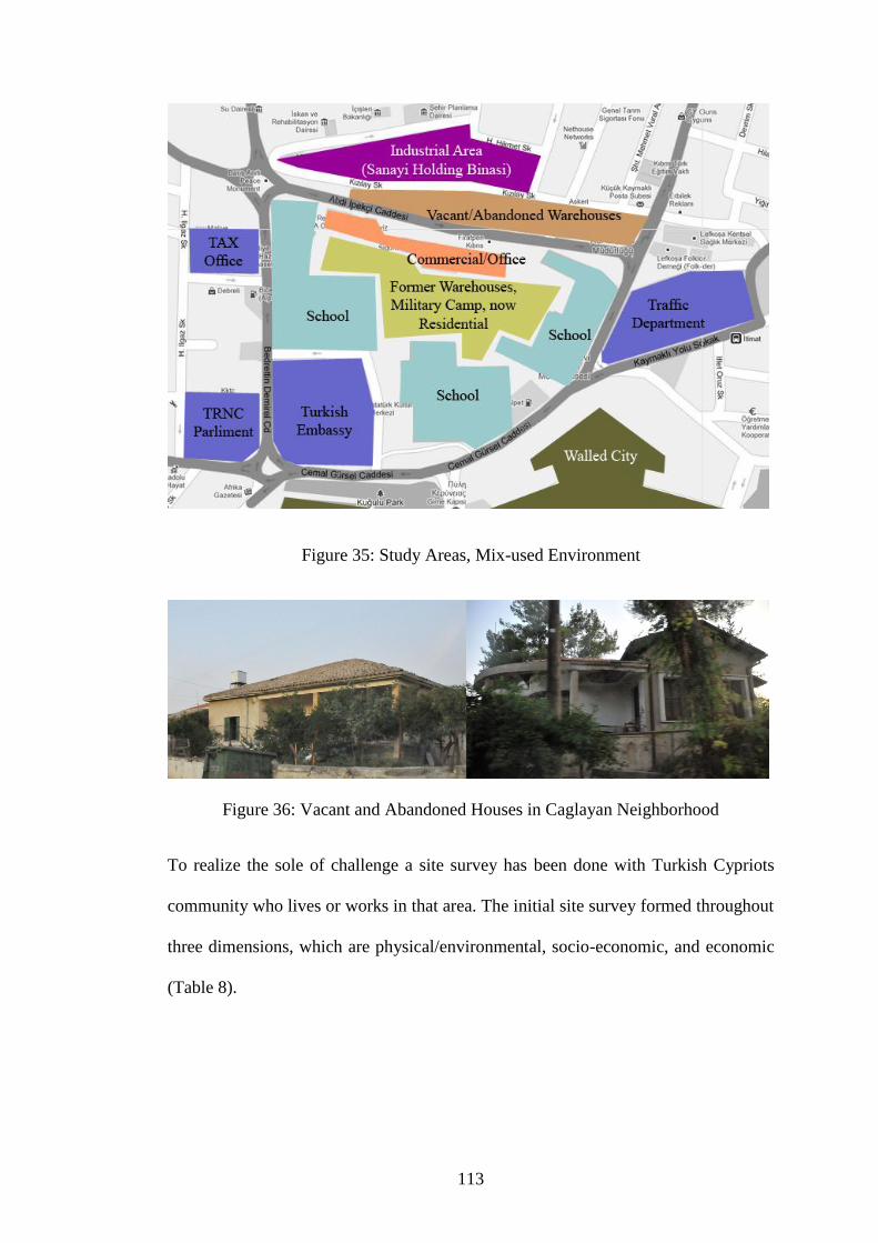
113
Figure 35: Study Areas, Mix-used Environment
Figure 36: Vacant and Abandoned Houses in Caglayan Neighborhood
To realize the sole of challenge a site survey has been done with Turkish Cypriots
community who lives or works in that area. The initial site survey formed throughout
three dimensions, which are physical/environmental, socio-economic, and economic
(Table 8).

114
Table 8: Initial Site Survey (Area Profile)
Initial Site Survey (Area Profile)
Location Peripheral of Nicosia Buffer Zone, Turkish side of
Nicosia (North), Turkish Republic of Northern Cyprus,
Eastern Mediterranean Region
Background - 3000 B.C. first inhabitants
- From 9th
to 20th
century A.D. Byzantines, Lusignans,
Venetians, Ottomans, and British governors rules and
developed the city
- 1878-1960 British period
- 1960 establishment of republic of Cyprus, and Nicosia
remained as capital city
- 1974 social/political conflict, Turkey intervened to the
island as the guarantor for safety of Turkish Cypriots
- 1974 division of Cyprus and Nicosia by UN Buffer
Zone
- 1983 establishment of Turkish Republic of Northern
Cyprus and north part of Nicosia again became the
capital
- 1974-2011 urban decays in peripheral of northern
Nicosia buffer zone, changes in social structure, big
amount of abandoned properties by original owners, new
development on greenfields toward the north of the city,
appearance of brownfields in peripheral of Nicosia
buffer zone

115
Land
Use
Former Use Residential, Commercial, Industrial, Governmental
Current Use If not abandoned or vacant mainly residential,
governmental, and military use
Problems Physical/Environmental - Physical barrier within the
city
- Existence of huge vacant and
abandoned area (Buffer Zone)
within the city
- Possibility of toxic and
chemical contamination within
the area and there is no statics
and analysis about that
- Absence of Policies and
regulation about brownfields
and contaminated sites
- Attempt and invest on
restoration and finally
gentrification rather than
regeneration
- Old and unutilized
infrastructure
- Poor urban setting condition
- Lack of green spaces,
landscape, and public space
- Investment for new

116
development in greenfield
rather than regeneration of
brownfields
Socio-Economic - Physical barrier between the
two communities
- The area have lost their
original users
- Absence of sufficient
policies regarding to
sustainable development
- Poor attention to social
sustainability
- Poor satisfaction level of
inhabitants
- Lack of public facility and
community centre
- Low population of locals
- Poor educational background
- Lack of sense of belonging,
community partnership, and
public-private partnership
- Top down decision system
- Central government concerns
more economical issues rather
than social ones

117
- Central government doesn‟t
believe in regeneration, and
focused on new developments
Economic - Public sector does not act as
catalyst for regeneration
programs
- Low interest in private
investment
- There is no incentives for
regenerations
- Lack of feasible financial
strategic plan
- Lack of management for
economic and strategic
development
Brownfield Issue Brownfield Status In peripheral of Nicosia buffer
zone there is many previously
developed lands (PDL), which
are vacant, derelict, and
abandoned. Although in land
use policies of TRNC, there
are no rules for brownfields,
however according to this
study, these properties are
subjected to brownfield status
(Figure 37).
Brownfield
Characteristic
These sites have one or
combination of the elements of
“partially occupied lands”
which are (1) not currently

118
fully in use, (2) land or
building currently in use and
allocated by different land use
in local plan, and (3) land or
building currently in use with
redevelopment potentials.
Related Stakeholders Physical environment
issues
- Ministry of interior
- Parliament
- City planning department
- Municipality
Environmental issues - Environmental office
department
- Ministry of tourism and
environment
Community support
and social issues
- Working and social security
department
- NGOs
- Associations
Economic issues - Central government
- Department of economy

119
Figure 37: Sites with possible brownfield status at the centre of study area
4.4.1 Physical/Environmental Dimension
During the study it was realized that there is a level of contamination in whole
neighbourhood, and there is no statics and analysis about that. The industrial building
(Sanayi Holding Binası) has been vacant for many years and municipality does not
have any authority and rights22
about that building (Figure 38). This building which
was performing industrial activities, for sure has been contaminated the soils and
water base, however there is no action about this and rather than applying brownfield
regeneration program, which leads to un-contamination and regeneration, the
government decided to demolish the building and built the new one.
22
Before municipality of Nicosia built its new building, municipality asked for that industrial building
to regenerate and change it for use of the new municipality building, however they never succeed in
their request and they built a new building somewhere else.

120
Figure 38: Industrial Building
In challenge between demolition and regeneration option a questionnaire shows that
more than 50% of the people who live in the area were strongly agreed to regenerate
that building and any buildings with same situation rather than demolition option
(Figure 39). Towards resident‟s opinion, also people who work in municipality were
strongly agree with the regeneration. In this regard, deputy town clerk of Nicosia
noted everything in that area are suffering from lack of a holistic strategic plan and
for sure the partial planning and fragmented decisions will not help any of these
problems.

121
Figure 39: Regeneration Option rather than redevelopment
The bigger disaster was about another neighbourhood just in front of that industrial
zone, the neighbourhood has a long history, it was a graveyard and then it turned to
industrial warehouses and British soldiers‟ camp, and then the function has changed
to UN camp. In 1964 Turkish Cypriots23
who forced to leave their properties, moved
to this neighbourhood and some other refugees and immigrants moved there after
1974. This area was never un-contaminated (graveyard, military camp, copper
warehouses), and people live in the warehouses, where now transformed to
residential area, however the physical condition is more look like a slum
neighbourhoods (Figure 40).
23
The verbal story from an old man who actually moved there in 1964 and still living there in poor
condition.
Agree
55% Not Agree
22%
Maybe
23%
Do you think is it good idea to give new function to existing
vacant buildings rather than demolition of them?

122
Figure 40: Warehouses, which were transformed to residential
In center of study area there is two sides, the main street and the back street side
where most of properties are located. Thanks to Nicosia Master Plan, the main street
side is improved and somehow it is gentle by means of physical environment;
however the back street side is suffering from serious urban declines.
In those back street areas (Figure 41) there is no utilized infrastructure (e.g. street
lights, proper roads, pedestrian, and etc.), rain water runoffs in the road during the
winter time, garbage and waste materials are everywhere. Unfortunately as a matter
of fact, in governmental departments and municipality there is no policy and
regulation regarding to brownfield issues, and more sadly nobody knew about it,
from top to down level, include professionals and decision makers were unfamiliar
with the term “Brownfield”. Accordingly, since there is no policy, then nobody
knows about the risks of brownfields and the benefits of regenerating them,

123
moreover it is a policy disaster that there is no action about that. This is the
foundation of problems regarding to SBR program in TRNC.
Figure 41: back street areas
Also physical existence of UN buffer zone and military area in nearby all civil
functions in study area are affecting the physical environment of the area. The
shadow of restricted areas prevents any further efficient development in nearby sites.
4.4.2 Socio-Economic Dimension
The people who live and work in the industrial, commercials (e.g. vacant
warehouses) (Figure 42), and residential areas (e.g. Caglayan neighborhood and
residential nearby industrial zone) do not have any sense of belonging to the area and
as what perceived there, it resembles refugee camps rather than urban environments.
There are just some conservation projects about historical heritages, which act as a
gentrification scenario, and there is no actual regeneration. Most importantly people
lost their believe in government for any further changes, therefore there is a high
level of user‟s un-satisfaction (Figure 43).

124
Figure 42: Vacant Warehouses
In series of interviews at Nicosia municipality many thoughts and believes has been
demonstrated the professional opinions about the area. In this regard, an architect
from project department believes that many components should get together to
succeed the regeneration program, and especially in the case of brownfield sites it
needs specific knowledge and policies that are not exist in TRNC. He believes what
they are doing is only the restoration program, and because it fails in social aspects, it
will be only a gentrification. In the city-planning department there is a progress to
produce a new master plan, but unfortunately as he mentioned there is no specific
consideration about brownfield issues.

125
Figure 43: Level of user satisfaction of people who live and work in peripheral of
Nicosia buffer zone
Although most of people are not satisfied with existing situations and they do not
believe the local government will share the decisions with community (Figure 44),
but then again more than half the people who answered the questionnaire have the
willing to participate with any future regeneration programs (Figure 45). This
willingness is an opportunity for further development plans.
Figure 44: Community Partnership with government
Yes 10%
NO 85%
I don’t know 5%
Are you happy and satisfied with existing situation?
Agree 0%
Not Agree 91%
Maybe 9%
Do you think government will share the partnership in
decision making with community?

126
Figure 45: Community Partnerships to Regeneration Program
Opinions about participation of community in regeneration programs have two sides;
people within the community wish to participate and open a new page of healthy
urban environment and in other side government and in particular the municipality
believes that there is no community to partnership. Accordingly deputy town clerk
noted that the community in Nicosia changes a lot and people are behaving privately
and not like a community. It is because of many changes in texture of community
during less than a century. Each week the municipality has a council meeting for
public, to let them share their opinions, but as the long term results, these discussions
will not affect the decision processes, and it is a top down decision system. Deputy
town clerk sharply defends this situation by referring to lack of existence of
permanent community, and then he raised this question that “when we don‟t have a
permanent community how can expect the community shares the ideas and be a part
of the projects?”
Agree 55%
Not Agree 22%
Maybe 23%
Do you will to participate to the regeneration program?

127
Although there is no regulations regarding to brownfield regeneration, and both sides
of community and government lost their beliefs in partnership, but municipality still
believes that the problem can be solve by partnership with private sectors with
economically feasible strategic plans. This Public-Private Partnership (PPP) idea can
open new chapter in governmental decisions and leads it to the community
partnership.
According to the in-depth interviews, it is perceived that there is not much
partnership between these actors. In this regards municipality believes that
everything will come to the political issues, and since politic is the part of holistic
approach, there is an essential needs for a holistic strategic plan. Therefore, if a
holistic strategic planning happens, then it can be expected the partnership of all
stakeholders, and particularly the community, which leads the project to succeed.
Also, uncertainty about political situation will produce uncertainty in public, private,
and community decisions.
4.4.3 Economic Dimension
Unfortunately, there are no defined incentives or grants for propose of regeneration
plans or SBR program, therefore mostly it is too costly for private sectors to handle
these types of programs in their development plans. In this regards private investors
are not interested in those areas and the investment will goes to greenfields rather
than brownfields, therefore more pressure will be on natural environment. The main
source of this situation is lack of feasible financial strategic plan for brownfield
regeneration, which means there is no holistic management for economic and
strategic development. Also, as the start point of economic analysis to produce initial
analysis for SBR program, the opinion of community is an essential.

128
According to the questionnaire survey, which has collected the data from community
about their opinion related to economic issues, most of the people in community
were agreed that the regeneration programs bring new job opportunities and new
investment to the area (Figure 46 & 47) and if the government provides some grants
and incentives as a catalyst the private sector and community have the willing of
partnership. Therefore if the area is regenerated they might not be complaining for
any possible future new tax systems and more tax payments (Figure 48).
Figure 46: Job Opportunity Opinions
Agree 70%
Not Agree 5%
Maybe 25%
Do you think there will be more job opportunities if the whole
area is regenerated and become lively space?

129
Figure 47: Opinions about Investment Opportunities
Figure 48: Opinions about Tax Payments
4.4.4 Stakeholders
According to the findings of this research, the existing stakeholders are mainly from
public sector. Stakeholders in regards to brownfield issue have been categorized into
four categories. In physical environment this is the top down decision system, which
Agree 75%
Not Agree 5%
Maybe 20%
Do you agree that if the area is regenerated, then it will attract
many new investments?
Agree 30%
Not Agree 45%
Maybe 25%
Do you will to pay more tax if the whole area regenerated and
become lively space?

130
start from ministry of interior, parliament, city planning department, and
municipality, and these are the main actors in this category. For environmental issues
there is an environmental office department, and ministry of tourism and
environment, which are the main stakeholders. For community support and social
issues, working and social security department, NGOs, and associations are the main
stakeholders. Finally, for economic issues the government and department of
economy are the main actors.
4.5 Evaluation of The Initial Stage Findings
In order to provide a better understanding of existing situation, and according to
initial qualitative and quantitative data analysis, for future decisions and holistic
plans, this research categorized the positive and negative issues related to the study
area and demonstrated in a table with the three dimensions and their indicators to
emphasize the positive and negative points in the study area (Table 9).
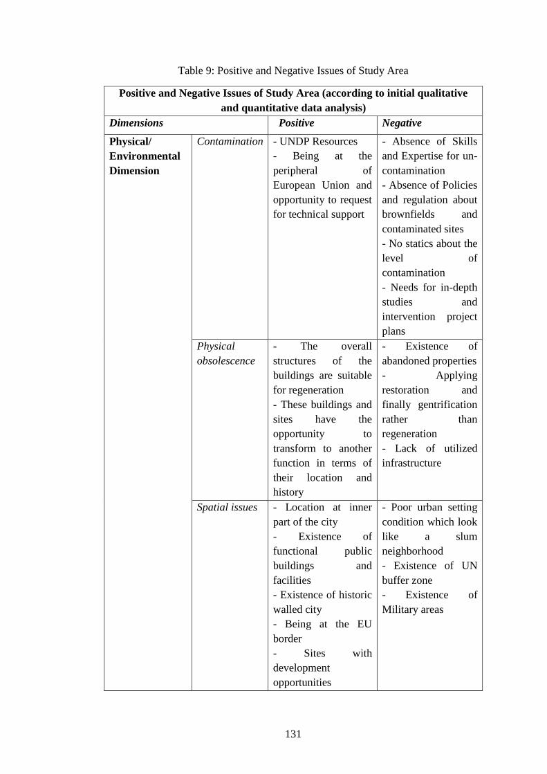
131
Table 9: Positive and Negative Issues of Study Area
Positive and Negative Issues of Study Area (according to initial qualitative
and quantitative data analysis)
Dimensions Positive Negative
Physical/
Environmental
Dimension
Contamination - UNDP Resources
- Being at the
peripheral of
European Union and
opportunity to request
for technical support
- Absence of Skills
and Expertise for un-
contamination
- Absence of Policies
and regulation about
brownfields and
contaminated sites
- No statics about the
level of
contamination
- Needs for in-depth
studies and
intervention project
plans
Physical
obsolescence
- The overall
structures of the
buildings are suitable
for regeneration
- These buildings and
sites have the
opportunity to
transform to another
function in terms of
their location and
history
- Existence of
abandoned properties
- Applying
restoration and
finally gentrification
rather than
regeneration
- Lack of utilized
infrastructure
Spatial issues - Location at inner
part of the city
- Existence of
functional public
buildings and
facilities
- Existence of historic
walled city
- Being at the EU
border
- Sites with
development
opportunities
- Poor urban setting
condition which look
like a slum
neighborhood
- Existence of UN
buffer zone
- Existence of
Military areas

132
Environmental
and Natural
Issues
- Low air pollution - Possible
contamination within
soils and water based
- Lack of green
spaces
- Lack of landscapes
Socio-Economic
Dimension
Social
Structure
- Who works and
lives in those areas
wishes for changes
and better quality of
life
- High level of users‟
un-satisfaction
- Low income people
- Low population of
original owners
- Low level of
educational
background
- Lack of permanent
community
- Lack of sense of
belonging
Partnership - People wills to
participate with any
possible future
regeneration program
- Top down decision
system
- People lost their
believes in
government
- Government does
not share the
decisions with the
community
- Lack of community
partnership
- Lack of public-
private partnership
- Lack of partnership
with public
stakeholders
Political and
Governmental
Issue
- People in
municipality are
mainly Cypriots who
has the wills and
political opinions for
making better quality
of life
- Experience of
political and
- Municipality does
not have enough
power for main
decisions of city
- Central government
concerns more
economical issues
rather than social
ones

133
professional
partnership between
Turkish and Greek
Cypriot (NMP)
- People in
municipality are
aware of most of the
existing situations
- Central government
doesn‟t believe in
regeneration, and
focused on new
developments
- No guideline for
previously developed
lands (PDL)
- Lack of holistic
strategic plan
- Uncertainty about
political situations
and settlements
Economic
Dimension
Public
Incentives
- Grants and incentive
programs has been
applied for restoring
historic heritages
- Existence of
infrastructure within
the area
- Since the
government gave the
incentives to
revitalize the historic
heritage and have got
the positive result,
then there is chance
for incentives for
regenerations
- Incensement in tax
income
- Public sector does
not act as catalyst for
regeneration
programs
- There is no
incentives for
regenerations
- Lack of feasible
financial strategic
plan
- Lack of
management for
economic and
strategic
development
Private
Investment
- Municipality
believes the solution
is laid in private
approaches
- High level of profit
after regeneration
- Investment for new
development in
greenfield rather than
regeneration of
brownfields
- Low interest in
investment into those
areas
Findings out of the data evaluations and initial site survey are categorized according
to the positive and negative issues. It examines the area‟s strengths and weaknesses,

134
which identified the opportunities for further improvements and threats where
needed to be controlled and managed.
4.5.1 Positive Issues
The study area is located in heart of the inner part of the city and there are many
public buildings and facilities in that area, which are giving the impression of daily
life activities. Also the existence of historic walled city and tourists who come to see
the historical heritages is a great advantage to the area. On other hand, the overall
structure of most of buildings is suitable for restoration and then regeneration.
Moreover, as an environmental advantages the area has a good air quality.
Another positive point of the area is that the people who works in municipality are
mainly Turkish Cypriots who experienced and seen the advantage of cooperation
with other society (Greek Cypriots) throughout NMP, and they have a strong willing
for improving the quality of life of people who lives in their community. Also
existence of infrastructure within the area is an economic advantage for government,
which they do not need to invest for new ones.
Throughout de-contextualization of existing situation within the site, the study shows
some opportunities for further developments, which also should be considered as
positive issues. These opportunities are the access to the UNDP resources, being at
the peripheral of European Union, which provide the possible request for technical
support, have chance to find a solution for contamination problem, and also because
of historical and strategically location there are many optional new functions for
regenerating the abandoned properties, and then development opportunities in vacant
lands.

135
On the other hand, people who work and live in those areas are willingly
participating in any possible future regeneration program and they wish for changes
for better quality of life. Also another good signal of opportunities is that
professionals who work in municipality are aware of most of the existing situations.
Moreover since the government gave the incentives to revitalize and protect the
historic heritage and have got the positive results, then there is chance for possible
incentives for future regeneration programs, which increase the tax income for the
government. Another positive point of study area is that municipality believes the
solution is laid in private approaches, which sound like high profit for privet sectors
throughout participation and investment.
4.5.2 Negative Issues
Throughout the analysis and evaluation of the study area it has shown that there are
some risks and threats existed there, which need to be controlled and managed. The
best solution for these problems is placed on a clear and professional risk assessment
and management process. The level of awareness is an important factor regarding to
the risks. One of the main threats to the studied site is absence of policies and
regulation about brownfields and contaminated sites and no existence of statics and
surveys about the level of contamination. On the other hand, existence of abandoned
properties which has the ownership problem, poor urban setting which look like a
slum neighborhood, and possible contamination within soils and water bases produce
the physical and environmental threats to the area.
Another negative issue is producing the high risk for the community and social
aspects; these risks, which have long-term effects, can end up with another social
disaster. High level of users‟ un-satisfaction, top-down governmental decision

136
system, no more community believe in government and government does not share
the decisions with the community are the main social negative issues.
Correspondingly, because of political situations, municipality does not have enough
power to make the main decisions of city and in other hands central government
concerns more economical issues rather than social ones and also they do not believe
in regeneration, which make them focused and invest on new developments. Since
public sector does not act as catalyst for brownfield regeneration programs, then
private sectors invest for new developments in greenfields. Furthermore the most
important negative point is the absence of guideline for previously developed lands
(PDL), which are vacant and/or abandoned now.
As general negative issues in study area there is lack of many things such as lack of
skills and knowledge for un-contamination techniques, lack of utilized
infrastructures, lack of green spaces and landscapes, lack of permanent community,
lack of sense of belonging, lack of community partnership, public-private
partnership, partnership of public stakeholders, lack of holistic strategic plan, lack of
incentives and grants, lack of feasible financial and economic plans, and lack of
management for economic and strategic development. These missing elements draw
a scheme of what does not exist.
However, there is existence of some other elements, which are the reason for other
negative issues in study area such as UN buffer zone, military bases, uncertainty
about political situations and settlements, and gentrifications rather than
regeneration. Moreover low level of some other issues such as people‟s income,
local‟s population, educational background, and low interest of investment from
private and public sector make the negative points of the study area more dominant.

137
For finding a solution for these negative issues, an intervention and in-depth studies
are essential need.
4.6 Summary and Conclusion
This chapter analysed the peripheral of buffer zone where located at inner part of
Nicosia by means of physical/environmental, socio-economic, and economic
dimension. These analyses were based on existing situation of the city in regards to
urban declines, vacant and abandoned properties, and in more complex way the
brownfields issue. Nicosia is the last divided city in Europe which is the result of
conflict between two communities who live in the island and in 1974 a spatial border
which formed after Turkey‟s intervention separate the community and the lands.
Since 1974 the island is divided into two parts, Greek Cypriots moved to the
southern part and Turkish Cypriots to the northern part. The Greek side became an
EU member and considerable amount of help and support from EU improved the
urban settings of southern cities, however the Turkish side has extremely slow
improvements because of lack of international recognition and many other political
conflict which ends with many urban declines.
Existence of physical barrier and the dead area, which referred to UN buffer zone,
put a huge impression to the urban areas at peripheral of border within the island.
These impacts affected the social structure, physical environment, and economics of
those areas. These urban crises were shown up with the vacant and abandoned
properties widely referred to brownfield issue. Unfortunately because the issue of
brownfield was a new concern within the island, there is no existing policy and
regulation about it. All abandoned and vacant properties with possible contamination

138
have been leftover in poor urban environment, which many immigrants and refugees
moved there. The area that ones used to be a vibrant urban environment has turned to
a neighbourhood where look likes a refugee camp or slum.
In this regard, this research studied these areas to assess and analyse the existing
situation and recognize the source of problems to handle the initial stage of SBR
program. For this aim, after all initial site surveys and data collections, the study
categorized the positive and negative issues related to the study area, which
developed a table according to the three dimensions of study and their indicators.
This table has been developed to emphasis and decode the problems towards
brownfield issues throughout identifying all dimensions of positive and negative
issues in study area.
Analytic outcome of the positive and negative table showed that the existence of the
historical walled city and other public building act as strong positive points to the
area. Except the physical location of the site and possible access to UNDP and EU
resources, another positive points in study area laid on social and community beliefs.
Most of the Turkish Cypriots has the willing for participation in any future changes,
which improve their quality of life. This is a big opportunity for governors and
decision makers to find a solution for these urban problems.
However, there are many negative issues, which are forming the future threats.
Unsustainability in social texture of the community, lack of improvement in urban
environment, lack of knowledge and action about brownfield issues and
contaminations, lack of partnership between public, private and community, and lack

139
of public support and uncertainty about political situation are the main negative
issues in study area.
Accordingly, as the strong negative issues, there are many risks and threats to the
area, which are placed in three regions; these are policy, social, and governmental
issues. There is no policy and regulation about brownfield issues, contamination, and
sustainable urban regeneration, also the ownership problems and abandoned
properties worsen the situation. Community is unsatisfied with the existing situation
and the government does not partnership in any aspect with the community, which is
a solid top down decision system.

140
Chapter 5
5 SUMMARY AND CONCLUSION
This study has reviewed the history and most up-to-date policies and discussions
about brownfield issues. Reviewing the history of why and how this situation
acquired, shows as a well-known fact that brownfields are the footprints of industrial
movements and began their appearance after the events of Second World War.
Basically brownfield sites defined as previously developed land, which is abandoned,
derelict, vacant, or partially occupied. Besides, these lands may have some kind of
contamination. The term brownfield is defined in policies and laws, and from one
country to another country, and sometimes within a country there is some difference
in the definition. Overall accepted definition of brownfield, which is offered by this
study, is based on European definition (CABERNET) with additional consideration
to British and American ones.
According to this study “Brownfield Sites” is defined as previously developed land
which are real (estate) properties and may occupied by a permanent structure in both
built-up and rural locations. These sites have been affected by former uses of the site
or surrounding lands. Brownfield sites are generally abandoned, derelict, idled or
underused, and may have real or perceived contamination problems, where require
intervention to bring them back to beneficial use. One of the accepted solutions for
turning these deprived areas to lively, vibrant, and functional space is laid in the
combination of urban regeneration and sustainable development, which widely called
sustainable brownfield regeneration (SBR).

141
Sustainable brownfield regeneration is about connection between technical issues
and socio-economic concerns to gives a new life to those dead lands and properties.
Besides, these regeneration programs will reduce the pressure on Greenfield and
prevent the urban sprawl to achieve more compact way of urban form. Awareness of
the realistic dimensions of the projects is an essential, which throughout defining the
role of stakeholders and managing the partnership, and also recognition and handling
the potential risks, more realistic and sufficient results are expected.
With no doubt sustainable brownfield regeneration (SBR) programs should result in
improvement of quality of life and enhancing urban environments.
Physical/Environmental dimension of SBR programs has focused on reducing the
pressure on Greenfield and prevent urban sprawl to have better and more compact
form of urban environment. Moreover, cleaning up techniques is for treating the
contaminated sites to secure safety and public health issues within those brownfields;
besides, by cleaning up the site, air and water quality will be improved.
Socio-economic dimension of SBR program has its focus on improving the quality of
life, and provides an appropriate service to community. In this dimension the
unemployment rate will be reduced and new job opportunities will show up.
Throughout the socio-economic dimension of SBR, the community centres, and
commercial/entertainment facilities will be provided to serve as a social resource.
These social resources will secure the quality of educational and social issues, and
also will improve user‟s profile, besides it will reduce the level of poverty and crime
within the regenerated neighbourhood.

142
Economic dimensions of SBR programs generally are about the rewards of the
programs by means of profits, tax incomes, and new investments. Brownfield sites,
which usually have installed infrastructures within the site, will lower the cost of
public sectors investments, and in compare to greenfield investment it is a huge steps
forward in process by means of time and money. Another side of economic profit is
the new source of tax income from places where had idle status which is a great
profit for local and national government, plus throughout the regeneration program
the property value will be increased, therefore it will cause increase in existing
amount of income tax. These incomes and profits give more confidence to public
sector for investment in those projects and act as catalyst to attract private investors
by means of supports and incentives.
Base on theoretical framework and discussed issues, this study offered a guideline
for process of SBR program (Figure 49). This guideline, which acts as a conceptual
model for SBR program, consists of seven stages, which are in sequence, and each of
them is essential for the next step. Accordingly, this study has been adopted the case
of peripheral of Nicosia buffer zone to the first stage of the guideline, which is the
initial stage of analysis to provide a general assessment and defining the general
problems of the study area.

143
Figure 49: Guideline for process of SBR program, which acts as a conceptual model
for SBR program
The first initial stage of the guideline analysed the existing situation of peripheral of
Nicosia buffer zone to decode and de-contextualize the problems in regard to
brownfield issue. Initial site surveys and analysis have been carried out through inner
part of the Nicosia by means of physical/environmental, socio-economic, and
economic dimension. After the initial data collections, qualitative and quantitative
analyses evaluated the existing situation of the city in regards to urban declines,
vacant and abandoned properties, and in more complex way the brownfields issue.
Stage 7
Monitoring the results in short term and long term
Stage 6
Socio-Economic Improvement
Stage 5
Physical Implementation Process
Stage 4
Decision Making and Strategic Plan
Stage 3
Risk Assessment and Management
Stage 2
Comprehensive Analysis
Stage 1
Initial Process (General Assessment and Problem Definition)

144
Accordingly the main contrasted nearby area, which had almost the same problems,
is the southern part of Nicosia, however as a result of the EU membership of the
Greek side, urban settings in general and brownfield issues in particular have been
improved throughout helps and support from EU. But the Turkish side has extremely
slow improvements because of lack of international recognition, in-community and
many other political conflicts, which have ends with many urban declines.
Existence of physical barrier and the dead area, which has referred to UN buffer
zone, set a huge pressure to the urban areas in general and in particular to peripheral
of border within the island. These impacts affected the social structure, physical
environment, and economics of those areas. These urban crises were shown up with
the vacant and abandoned properties have been addressed as urban declines that
referred to brownfield site. Unfortunately, because the issue of brownfield was a new
concern within the island, there is no existing policy and regulation about it. All
abandoned and vacant properties with possible contamination have been leftover in
poor urban environment, which many immigrants and refugees moved there. The
area that once used to be a vibrant urban environment has turned into a
neighbourhood where look like a refugee camp or slum.
Although there are some positive points within the study area, the negative issues
lead the area to the serious risky situation. Contamination within the sites, which
never evaluated, can cause the long-term health problems for the community, and
affect the natural and environmental system in the area. On the other hand people are
extremely unhappy about the existing situation and lost their belief to the
government, and uncertainty about political situation adds more pressure to the
situation. Also, the government does not share the partnership and this solo mentality

145
in decision making system, which referred to the top down decision system, will
produce the high risk of urban disasters for future of the city and in particular the
brownfield issues.
In general overview, what are needed for the study area are, improvement in state
policies, transformation of abandoned and vacant properties to the functional form,
transformation of military areas within the city to some other public functions which
leads to contribution of those facilities and properties in city life, and enhancing the
community partnership which are essential to improve the quality of life in Nicosia.
Nowadays the main development issue in Cyprus has focused on greenfields and
these sprawl development will have long term negative impacts to the urban
environment of the island. If this situation continues with the existing condition,
approximately in next 30 years, the solution for all these problems become so
expensive by means of money, time, and effort. According to these situations the
main outcome of this study should be considered as a serious warning for future of
the island in general and in particular the city of Nicosia.
All these discussions are beneficial for improving the quality of life of those who
actually live and work in the island in general and particularly in the city of Nicosia.
If the responsible authorities take these discussions as a warning about the existing
situation and consider them reasonably, plus consideration to the conceptual model
of SBR program, then it is likely to see the days of vital, vibrant and lively urban
environment in the cities of TRNC and specifically in the city of Nicosia.

146
REFERENCES
WCED. (1987). Our Common Future, Chapter 2: Towards Sustainable
Development. World Commission on Environment and Development (WCED).
Geneva: United Nation.
Wilson, E. (1996). Measuring and Monitoring: The Precautionary Principle and the
Compact City. In M. Jenks, E. Burton, & K. Williams (Eds.), The Compact City: A
Sustainable Urban Form? (pp. 187-197). Oxford: E & FN Spon.
Alker, S., Joy, V., Roberts, P., & Smith, N. (2000). The Definition of Brownfield.
Journal of Environmental Planning and Management , 43 (1), 49-69.
Alpar, R. (2008). The quest for the role of division in urban development of Nicosia
and prospects for urban integration. Cyprus and Divided Cities, A Multi-disciplinary
Workshop. Belfast: Queen's University.
Bardos, R., Bakker, L. M., Slenders, H. L., & Nathanail, C. (2011). Sustainability
and Remediation. In F. A. Swartjes (Ed.), Dealing with Contaminated Sites: From
Theory Towards Practical Application (pp. 889-948). London: Springer.
Barnekov, T. K., Boyle, R., & Rich, D. (1989). Privatism and Urban Policy inBritain
and the United. Oxford: Oxford University Press .
BCELI. (n.d.). Brownfields Basics. Retrieved May 7, 2011 from Brownfields Center
at Environmental Law Institute: http://www.brownfieldscenter.org/bfbasics.cfm

147
Beer, A. R., & Higgins, C. (2000). Environmental Planning for Site Development
(2nd ed.). London: E & FN Spon.
Bensel, C. (2011, August 02). Interview about regeneration and brownfield issues
related to Nicosia from an Architect in Municipality. (M. S. Far, Interviewer)
Beswick, C. A., & Tsenkova, S. (2002). Cahpter 2: Overview of Urban Regeneration
Policies. In S. Tsenkova (Ed.), Urban Regeneration: Learning from the British
Experience (pp. 9-15). Calgary, Canada: Faculty of Environmental Design,
University of Calgary.
Brundtland Commission. (1987). Our Common Future, Chapter 2: Towards
Sustainable Development. World Commission on Environment and Development
(WCED). Geneva: United Nation.
Cyprus country profile. (2011). Retrieved June 10, 2011 from BBC News:
http://news.bbc.co.uk/2/hi/europe/country_profiles/1016541.stm
CABERNET. (2006). Brownfields Definitions across Europe. Retrieved November
14, 2010 from Concerted Action on Brownfield and Economic Regeneration
Network (CABERNET): http://www.cabernet.org.uk/index.asp?c=1316
Cameron, K. (2011, January 17). Community Activists: Rising from the Ashes.
Metropolis Magazine , pp. 70-74.

148
Catney, P., Eiser, D., Henneberry, J., & Stafford, T. (2007). Democracy, Trust and
Risk Related to Contaminated Sites in the UK. In T. Dixon, M. Raco, P. Catney, &
D. Lerner (Eds.), Sustainable Brownfield Regeneration: Liveable Places from
Problem Spaces (pp. 35-66). Oxford: Blackwell Publishing Ltd.
CERCLA. (1996-2010). Comprehensive Environmental Response, Compensation,
and Liability Act. Retrieved 12 10, 2010 from Office of Health, Safety and Security
(HSS): http://www.hss.energy.gov/nuclearsafety/env/policy/cercla.html
Chilton, K. M. (2004). Greyfields: The New Horizon for Infill and Higher Density
Regeneration. Southeast Regional Environmental Finance Center. EPA Region 4:
University of Louisville.
Cornelis, C., & Swartjes, F. A. (2011). Human Health Risk Assessment. In F. A.
Swartjes (Ed.), Dealing with Contaminated Sites: From Theory Towards Practical
Application (pp. 209-259). London: Springer.
English Partnerships, The National Regeneration Agency. (2006, October). The
Brownfield Guide. United Kingdome.
EPA. (2009, November 13). Brownfields Definition. Retrieved March 05, 2011 from
US Environmental Protection Agency:
http://www.epa.gov/brownfields/overview/glossary.htm

149
Daley, M. P. (2011, April 18). Vacant and Abandoned Building Marking Systems.
Retrieved May 05, 2011 from Firehouse: http://www.firehouse.com/topic/firefighter-
safety/vacant-and-abandoned-building-marking-systems
Dixon, T. (2006). Integrating Sustainability into Brownfield Regeneration: Rhetoric
or Reality? - An Analysis of the UK Development Industry. Journal of Property
Research , 23 (3), 237-267.
Dixon, T., Raco, M., Catney, P., & Lerner, D. N. (Eds.). (2007). Sustainable
Brownfield Regeneration. Oxford: Blackwell Publishing Ltd.
Doak, J., & Karadimitriou, N. (2007). Actor Networks: The Brownfield Merry-Go-
Round. In T. Dixon, M. Raco, P. Catney, & D. N. Lerner (Eds.), Sustainable
Brownfield Regeneration (pp. 67-88). Oxford: Blackwell Publishing Ltd.
Ferber, U., Grimski, D., Millar, K., & Nathanail, P. (2006). Sustainable Brownfield
Regeneration: CABERNET Network Report. Nottingham: University of Nottingham.
Ford, J. (2007). Implenemtation and Construction Report of The Steel Yard .
Providence: Morris Beacon Design.
Gunnis, R. (1973). Historic Cyprus. Nicosia: Rustem & Bro.
Guralp, H. (2011, August 02). Interview about regeneration and brownfield issues
related to Nicosia with Deputy Townclerk of Nicosia. (M. S. Far, Interviewer)
150
Glossary of DCNR. (n.d.). Retrieved May 11, 2011 from Department of conservation
and natural resource of State of Pennsylvania:
www.dcnr.state.pa.us/brc/grants/Glossary.doc
Gold, J. W. (2009). Preparing First Time Brownfield Developers:An Examination of
the Challenges They Face and Their Pathways to Success. Tufts University, Master
Program of Urban and Environmental Policy and Planning . Tufts: ProQuest LLC.
GQGP. (n.d.). Greyfield Redevelopment. Retrieved June 20, 2011 from Georgia
Quality Growth Partnership:
http://www.dca.state.ga.us/toolkit/ToolDetail.asp?GetTool=154
Greene, G. (Director). (2004). The End of Suburbia: Oil Depletion and the Collapse
of the American Dream [Motion Picture].
Hackett, L. (1992). Industrialization: The First Phase. Retrieved April 07, 2011 from
International World History Project: http://history-world.org/Industrial%20Intro.htm
Hadjri, K. (2008). Building pertnership for the future: An overview of bi-communal
initiatives in Cyprus. Cyprus and Divided Societies. Belfast: Queen's University
Belfast.
HM Government. (2005). Securing the Future: Delivering UK sustainable
development Strategy. London: DEFRA.

151
Hollander, J. B., Kirkwood, N. G., & Gold, J. L. (2010). Principles of brownfield
regeneration : clean up, design, and reuse of derelict land. Washington: Island Press.
HSRC. (2007). Greyfield Sites and Greyfield Redevelopment. Hazardous Substance
Research Centers - South & Southwest. HSRC/South & Southwest Technical
Outreach Publication.
Jacobs, M. (1999). Sustainable Development as a Contested Concept. In A. Dobson
(Ed.), Fairness and Futurity: Essays on Environmental Sustainability and Social
Justice (pp. 21-45). Oxford: Oxford University Press.
Kunsman, K. (1994, December 18). After 100 Years, Blast Furnaces Will Be
Silenced. The Morning Call .
LDA. (n.d.). What is Brownfield Land? Retrieved March 10, 2011 from London
Development Agency:
http://www.londonbrownfieldsites.org/Content/Brownfield.aspx
LDDC. (1981-1998). The LDDC History Pages. Retrieved June 20, 2011 from The
LDDC History Pages: http://www.lddc-history.org.uk
LMU. (2007, November 12). Glossary of The London Enterprise Office in
Professional Service Departments. Retrieved May 07, 2011 from London
Metropolitan University: http://www.londonmet.ac.uk/services/london-
office/resources/glossary/a-to-d.cfm

152
NAHB Guidelines, SITE PLANNING AND LAND DEVELOPMENT. (n.d.). Retrieved
May 14, 2011 from Homebuilder - Lawrence KS:
http://www.rodlainghomes.com/sitebuildercontent/sitebuilderfiles/site_planning.pdf
National Round Table on Environment and Economy. (2003). Cleaning Up the Past,
Building the Future, A National Brownfield Redevelopment Strategy for Canada.
Ontario, Canada: National Round Table on Environment and the Economy.
Nathanail, C. P. (n.d.). General approach of Brownfields. Retrieved April 28, 2011
from EUGRIS portal for soil and water management in europe:
http://www.eugris.info/FurtherDescription.asp?Ca=2&Cy=0&T=Brownfields&e=3
Nathanail, C. P. (2011). Sustainable Brownfield Regeneration. In F. A. Swartjes
(Ed.), Dealing with Contaminated Sites; From Theory Towards Practical
Application (pp. 1079-1104). London: Springer.
Neal, P. (2003). Urban Villages and the Making of Communities. London: Spon
Press.
Nichols, A., & Laros, J. (2009). INSIDE THE CIVANO PROJECT. New York:
McGraw-Hill.
NLUD. (2008-2010). National Land Use Database. Retrieved March 09, 2011 from
Homes and Communities Agency of UK:
http://www.homesandcommunities.co.uk/ourwork/national-land-use-database

153
NRTEE. (2003). Cleaning Up the Past, Building the Future, A National Brownfield
Redevelopment Strategy for Canada. Ontario, Canada: National Round Table on
Environment and the Economy.
Maczulak, A. (2009). BROWNFIELD SITES. In A. Maczulak, CLEANING UP THE
ENVIRONMENT: Hazardous Waste Technology (pp. 89-111). New York: Infobase
Publishing.
Marcuse, P. (1998). Sustainability is not enough. Environment and Urbanization , 10
(2), 103-111.
Mission & History of Steel Yard. (n.d.). Retrieved June 25, 2011 from The Steel
Yard: http://www.thesteelyard.org/explore/mission
Moughtin, C., Cuesta, R., Sarris, C., & Signoretta, P. (1999). Urban design: method
and techniques. Oxford: Architectural Press.
OHE. (1941-53). Records of the Office of the Housing Expediter [OHE]. Retrieved
April 22, 2011 from The U.S. National Archives and Records Administration:
http://www.archives.gov/research/guide-fed-records/groups/252.html
Paull, E. (2008). The Environmental and Economic Impacts of Brownfields
Redevelopment. Washington: Northeast-Midwest Institute.
Parker, R., Juntunen, L., Goodman, B., & Coddington, K. (2009). City of Sandy,
Urbanization Study, Final Report. ECONorthwest. Sandy: ECONorthwest.

154
POST 117. (1998). A Brown and Pleasant Land. London: Parliamentary Office of
Science and Technology, House of Commons, UK's Parliament.
PPS3. (2010). Planning Policy Statement 3 (PPS3): Housing. London: Communities
and Local Government.
Swartjes, F. A. (2011). Introduction to Contaminated Site Management. In F. A.
Swartjes (Ed.), Dealing with Contaminated Sites: From Theory Towards Practical
Application (pp. 3-89). London: Springer.
SteelYard. (2010). The Steel Yard Fact Sheet. Providence: The Steel Yard.
Russ, T. A. (2002). Site Planning and Design Handbook. New York: McGraw-Hill.
Raco, M., Henderson, S., & Bowlby, S. (2007). Delivering Brownfield Regeneration:
Sustainable Community-Building in London and Manchester. In T. Dixon, M. Raco,
P. Catney, & D. N. Lerner (Eds.), Sustainable Brownfield Regeneration (pp. 119-
139). Oxford: Blackwell Publishing Ltd.
RESCUE. (2003). Analytical Sustainability Framework in the Context of Brownfield
Regeneration in France, Germany, Poland and the UK. Final Report of Work
Package 1.
Timeline of Cyprus. (2011). Retrieved June 10, 2011 from BBC News:
http://news.bbc.co.uk/2/hi/europe/1021835.stm

155
The changing face of London: London today [Motion Picture]. BBC.
Towers, G. (2005). Case Study C: An Urban Village on a „Brownfield‟ Site, West
Silvertown, London. In An Introduction to Urban Housing Design: At Home In The
City (pp. 221-226). Oxford: Architectural Press.
Tsenkova, S. (2002). Cahpter 1: Urban Regeneration: Learning from the British
Experience. In S. Tsenkova (Ed.), Urban Regeneration: Learning from the British
Experience (pp. 1-8). Calgary, Canada: Faculty of Environmental Design, University
of Calgary.
Tsenkova, S. (2002). Cahpter 7: Partnership in Urban Regeneration: From „Top
Down‟ to „Bottom Up‟ Approach. In S. Tsenkova (Ed.), Urban Regeneration:
Learning from the British Experience (pp. 73-84). Calgary, Canada: Faculty of
Environmental Design, University of Calgary.

156
APPENDICES

157
Appendix A: Sustainable Brownfield Regeneration Questionnaire
After the conflict of 1974 the northern part of Nicosia went to an urban decline,
particularly the peripheral area of Nicosia buffer zone suffering from
physical/environmental, socio-economic, and economic crisis. One of the world wide
accepted solutions for this crisis is urban regeneration. Accordingly many buildings
and properties are vacant and abandoned, and to bring new life to them without
demolition and new construction the regeneration is an essential which make these
areas vibrant and increase the quality of life. Then by considering these issues please
answer these questions.
# Question Strongly
Disagree
Not
Really
Maybe It is ok Strongly
Agree
1 Do you think is it good idea to
gives new function to existing
vacant buildings rather than
demolition of them?
2 Do you will to participate to the
regeneration program?
3 Do you know think government
will share the partnership in
decision making with
community?
4 Are you happy and satisfied
with existing situation?
5 Do you will to pay more tax if
the whole area regenerated and
become lively space?

158
6 Do you think there will be more
job opportunities if the whole
area regenerated and become
lively space?
7 Do you agree that if the area
regenerated, then it will attract
many new investments?
8 Do you think if government
provides incentives, the
community and especially you
have the will to participate in
regeneration program?
9 How old are you?
10 What is your original
nationality?
11 How many years are you living
in Cyprus?
12 How much is your annual
income?
13 What is your level of education?
14 Are you the original owner
before 1974?
15 Do you have any comment or opinion about these areas?

159
Appendix B: Main Questions in Qualitative Survey Interview With
Official Authorities
1- Do you know what brownfield site or regeneration means?
2- Do you know the profits of brownfield regeneration?
3- Are there any governmental incentives for this issue?
4- Does government partnership with community? If yes how? If no why?
5- Do you know the advantage of existing infrastructure?
6- What was the previous function of ……… site? Does it deal with any kind of
contamination?
7- Who are the related stakeholders in these categories?
A. Physical
B. Environmental
C. Social
D. Economic
8- What is government vision for these areas?
9- Do you know about huge amount of new tax income, new job opportunities,
and investment attraction throughout regeneration programs? If yes how?