AN ENVIRONMENTAL PROFILE OF THE MATALE … · Abbreviations Used ACLG - Assistant Commissioner of...
65
AN ENVIRONMENTAL PROFILE OF THE MATALE DISTRICT CENTRAL ENVIRONMENTAL AUTHORITY MINISTRY OF TRANSPORT. ENVIRONMENT & WOMEN'S AFFAIRS
-
Upload
trinhnguyet -
Category
Documents
-
view
218 -
download
0
Transcript of AN ENVIRONMENTAL PROFILE OF THE MATALE … · Abbreviations Used ACLG - Assistant Commissioner of...

AN ENVIRONMENTAL PROFILE OF THE
MATALE DISTRICT
C E N T R A L E N V I R O N M E N T A L A U T H O R I T Y MINISTRY OF TRANSPORT. ENVIRONMENT & WOMEN'S AFFAIRS

AN ENVIRONMENTAL PROFILE OF THE
MATALE DISTRICT
CEA Library
A Report writ ten by Prof.C.M.Madduma Bandara , Department of Geography University of Peradeniya for a study sponsored by the Central Environmental
Authority wi th NORAD collaboration (i)

PREPARED IN 1 9 9 1
The f ind ings , in terpre ta t ions and conc lus ions expressed in t h i s d o c u m e n t do not necessari ly represent t h e v i e w s of t h e
Central Environmenta l A u t h o r i t y
This d o c u m e n t m a y be reproduced in fu l l or in par t w i t h due a c k n o w l e d g e m e n t t o t h e
Central Environmental A u t h o r i t y
F o r m a t t e d & pr in ted by t h e Central Envi ronmenta l A u t h o r i t y M a l i g a w a t t e N e w T o w n . C o l o m b o 1 0 , Sri Lanka .

FOREWORD
Sri Lanka 's nat ional energies and e f fo r ts during t h e last f e w decades have increasingly
been t o w a r d s t h e ach ievement of economic and social goals of deve lopment . H o w e v e r
unplanned deve lopment , w i t h o u t due regard to the pro tec t ion and m a n a g e m e n t o f t h e
env i ronment could lead t o the reduct ion of the count ry ,s natural resource base and the
degradat ion of the env i ronment . The f ru i t fu l incorporat ion and in tegrat ion of env i ronmenta l
considerat ions into the deve lopment strategies are fundamenta l t o susta inable
deve lopment . Un for tuna te ly env i ronmenta l concerns have not been incorpora ted into t h e
planning process of some deve lopment projects and programmes. This has been main ly
due t o t h e lack of i n fo rmat ion on available human and natural resources , their ut i l izat ion
and d e v e l o p m e n t .
The Central Environmenta l A u t h o r i t y launched a p rogramme t o prepare D is t r ic t
Envi ronmenta l Profi les for each o f t h e d is t r ic ts w i t h i n the Island t o iden t i f y and r e v i e w t h e
h u m a n and natural resources , their ut i l izat ion , and s igni f icant env i ronmenta l p rob lems ,
associated w i t h each d is t r ic t . I am grateful t o the Norweg ian Embassy for D e v e l o p m e n t
Co-operat ion (NORAD) for prov id ing the necessary f inancial assistance t o carry out th is
pro ject .
The prof i les have been prepared for the CEA by var ious c o m p e t e n t and au thor i ta t i ve
personnel and their ready coopera t ion in the successfu l comple t ion of th is exercise is du ly
a c k n o w l e d g e d . T h e project has been managed by the Natural Resources M a n a g e m e n t
Divis ion of the CEA.
• V *
I t r u s t th is Environmenta l Profile w o u l d serve as a too l in the fu ture d e v e l o p m e n t planning
process for e f f ec t i ve p ro tec t ion and management of the env i ronment .
G K A m a r a t u n g a C H A I R M A N CENTRAL ENVIRONMENTAL AUTHORITY A u g u s t 1 9 9 3

Mrs S E Yasaratne Director / Natural Resources Management Mr Anura Jayatilake Asst Director / Natural Resources
Management Mr C Senevirathne Environmental Officer
1077
Natural Resources Management Division Central Environmental Authority
1 st Floor , New Secretariat Building , Maligawatte New Town , Colombo 10.
(iv)

CONTENTS Page
Preface 01
Abbreviations 0 2
Chapter I Executive Summary 03
Chapter II : Main Recommendations 05
Chapter III : Environmental Setting and Human Resources 09
Chapter IV : Resources and Human Activities 28
Chapter V : Environmental Problems and Existing Management Structures 40
Chapter VI : Potential Resources and Management Strategies 52
Annex I List of Persons met by the Team 56
Annex II Bibliography 57
Appendix I : Hydrological Reservations on Private Lands 58
1
(v)

PREFACE
The Environmental Profile of the Matale District is the outcome of a study sponsored by the
Central Environmental Authority in collaboration wi th Norwegian Development Corporation
(NORAD). It is based on a comprehensive analysis of available data in the District and information
gathered through field surveys and consultations wi th District administration, local environmental
NGOs and the people.
The field investigations began at a time when the country was passing through a period of
serious civil disturbances. The communication network suffered badly, and local administration was
disrupted in most areas. Some of the AGA Offices particularly in remote areas were destroyed
totally. The field investigations had to be staggered and postponed several times under trying
circumstances.
Nevertheless, the cooperation extended by both Government officials as well as NGOs had
facilitated the field surveys immensely. The support and encouragement provided at all times by
Mr. E.W. Karalliyadda, the Government Agent, deserves special mention. Similarly Mr.
Y.M.Dayaratna Banda (Additional GA) and Mr. Gamini Dassanayaka (Asst. Commisioner, Local
Government and Secretary DEA) have spent much time and effort to help the survey team. The
enthusiasm expressed in the survey by Mr. Gamini Jayatissa (Makulemada NGO) and Mr. Jinadasa
Ekanayake (of Kaikawala NGO) and Rev. Batawal Sri Sorath (Kaludewala temple) had given much
encouragement to the Survey Team.
The AGAs of most Divisions, the MOH, and many officers of the Kachcheri and the
Municipality supported our efforts in various ways. A full list of those who contributed by way of
consultation is given in Annex-I of the Report. I wish to thank them all.
Finally, I must record my appreciation of the excellent work done by the t w o field
investigators, Mr. W . M . Navaratne, and Mr. Chandana Seneviratne. Cartographic Assistance was
provided by Ms. Swarna Seneviratne.
It is our fervent hope that, the findings and recommendations of this report will be utilized
by those involved in environmental management activities in the Matale District.
C M . Madduma Bandara
University Park,
Peradeniya
December 1 9 9 1 .
1

Abbreviations Used
ACLG - Assistant Commissioner of Local Government
AGA - Assistant Government Agent
CTC - Ceylon Tobacco Company
DANIDA - Danish International Development Agency
DEA - District Environmental Agency
DLUP - District Land Use Planner
GA - Government Agent
GSN - Grama Seva Niladari
IFS - Institute of Fundamental Studies
IUCN - International Union for Conservation of Nature
IRDP - Integrated Rural Development Project
LUPPD - Land Use Policy Planning Division, Ministry of Lands
MOH - Medical Officer of Health
NBRO - National Building Research Organization
NGO - Non-Governmental Organization
NORAD - Norwegian Development Corporation
UNICEF - United Nations Children's Fund
2

CHAPTER I Executive Summary
The Environmental Profile of the Matale District Provides an account of the environmental setting of the District, the status of its natural and human resources, trends in resource use, current environmental concerns and management measures. It also attempts to indicate possible strategies for sustainable development and efficient environmental management in the future.
Since the coverage of above themes had been wide, the method of approach had to be necessarily consultative than systematic scientific research. Thus a number of Government officials, municipal authorities, development agencies personnel and representatives of NGOs were met f rom time to time, both individually and at meetings organized through the District Environment Agency(DEA). The continued dialogue wi th some of the NGOs, and participation at their public functions enabled the research team to gain an understanding of the public concern in environmental issues.
The Matale District is characterized by its natural diversity as it spreads across all major ecological regions of Sri Lanka. Thus climatically its variation f rom Dry zone, to Wet zone, through a wide belt of intermediate conditions sets the background for many environmental issues. Similarly, the elevational range of the terrain from low lands below 100m to those above 1500m had resulted in a variety of land uses, human activities and settlements. Therefore, the general approach to environmental planning in the Matale District has to take into account the basic factor of natural diversity. It means that centralized planning may not prove desirable since it may fail to encompass much of ground reality. One possible approach would be to use the AGA Division as the unit of planning and environmental management even though it forms only an administrative demarcation. It is in recognition of this fact, that much of the information presented in the Report is given by AGA divisions(Table 1.1). This is also in line wi th the current Government Policy of administrative decentralization.
Compared wi th most other districts, Matale could be considered as relatively better endowed in mineral resources. There are sizeable deposits of mica, gems, feldspar and crystalline limestones. However, the rate of exploitation of these minerals is high and the sustainability of extractive industries based on them may become uncertain as time goes on. Therefore, the application of rapid extraction technologies such as mechanized gem mining have to be considered carefully. Similarly, environmental problems arising from them such as the incidence of Malaria have to be monitored regularly. Once of the reasons for indiscriminate exploitation of these resources is the fact that they are often owned and operated by interest groups outside the District. The district may have to develop a more 'protectionist attitude' in the future, if the exploitation of nonrenewable resources is to be maintained at sustainable levels.
The two major environmental concerns of the District as emerged at various discussions are deforestation and water scarcity. These t w o problems which are closely interrelated, often lead to other environmental concerns such as soil erosion, siltation and water-borne diseases. The incidence of malaria and dysentery are major health problems in the District. They arise f rom water pollution, particularly in and around towns, and poor solid waste disposal facilities. The solid waste disposal site in Matale is not only a threat to the adjoining area and particularly the neighbouring temple, but also tends to contaminate the waters of Sudu Ganga which may spread the impact long distances downstream.
3

The general approach to environmental management in the District appears to be administrative and ceremonial. It is administrative in the sense that most programmes are driven by the personal dynamism of the GA and a few officials. The initiative had always come from them than f rom the people. This means that there is a need for promotion of environmental awareness among the public, through some incentives particularly among certain target groups such as estate workers, gem miners, municipal health workers, and chena farmers. A selective approach may be more cost effective than general awareness programmes centred around the celebrations of World Environment Day or some days of political significance. There are only a few NGOs which are active int the environmental field and they naturally deserve every support.
The dependency of the District on external support for its environmental management programmes may not be able to continue indefinitely. Therefore, there is a need for a strategy to generate at least part of the resources for such programmes f rom within the District. The 'polluter pay' principle may be applied here too . Thus the Tobacco Company, State Gem Corporation and the timber industry must be persuaded to invest part of their profits on environmental conservation.
Matale District is equally rich in its cultural resources, as in the case of natural resources. However the existence of religio-cultural centres such as Sigiriya, Dambulla and Aluvihare and those of other denominations had hardly been utilized for environmental protection and management. A strategy need to be developed to harness these cultural centres for environmental promotion.
The data base for macro-level planning appears to be somewhat satisfactory in the matale District as reflected by publications such as statistical handbooks and those by the IRDP and Health services. For planning at the AGA level however, there is a need for a better data base w i t h village level statistics. The Strengthening of data storage and retrieval facilities at the AGA level than at District level is also in conformity wi th the present Government Policy. There is also a need to link and streamline activities at the AGA level where most policy decisions are increasingly taken.

CHAPTER II
MAIN RECOMMENDATIONS The discussions held wi th a range of Government officials and NGOs. and the results of field investigations and questionnaire surveys led to the identification of some 8 major environmental issues in the District. These are listed in Table 5 . 1 . The main recommendations related to these issues are given below.
1 . Deforestation:
The remedial action to address this issue, which is of course not confined to Matale, should be both preventive and curative and must be based on an analysis of real causes. The solutions must also necessarily be both immediate and long-term. The immediate need is to increase vigilance not only by the Forest Department personnel, but also by the local people preferably organized through NGOs. With regard to increasing official vigilance, the number of Beat Forest Officers as well as road check points have to be increased particularly in remote areas. The large number of mushrooming timber depots (Some 14 in Dambulla AGA Division and 7 within Matale municipality alone) indicate, the volume of timber trade. A flying squad service to check these timber depots may act as a restraint on illicit timber felling. A survey should also be launched to assess the volume of timber transport within and out of the District and to ascertain their sources so that remedial action can be taken more effectively.
The long-term solutions include the rehabilitation of deforested lands w i th economically attractive tree species. The Tobacco Company should be encouraged to develop their o w n fuelwood lots. Al though at present, the C.T.C. maintains that barn owners in the District have been obtaining their wood-fuel requirements f rom 'legal sources', this is contested by others. A plan of action is needed to produce adequate fuel wood for barns (both tobacco and cardamom) through popularisation of the cultivation of gliricidia and similar species among barn owners.
In the long run a programme of phasing out chena farming has to be launched not only through legislative and administrative measures, but also through a scheme of alternative employment for chena farmers. Where it cannot be avoided for the time-being, farmers should be encouraged to go back to their traditional chena practices which were more environment friendly.
With regard to forest fire prevention i t is recommended that local NGOs (Such as Makulemada NGO) be given assistance to acquire fire control equipment along wi th necessary training.
2 . Water Scarcity:
The shortage of water for agriculture as well as for domestic use emerged as a prominent environmental issue in many discussions. In the Dry Zone parts of the District, the most affected groups are those living in purana villages served by small village irrigations tanks w i th a limited catchment area. Here the problems are generally created by erratic rainfall; but the rapid rates of siltation due to deforestation of catchments has reduced the capacity of most tanks. Therefore, some action is needed to reforest at least the margins of reservoirs and streams w i th less water consuming species such as bamboos and local species such as kumbuk and midella. This should be carried out as a matter of priority in newly desilted and rehabilitated tank catchments.

For bathing, washing and domestic use, water f rom springs, streams and wells are generally used in many villages. The protection of the immediate catchment of springs and maintenance of stream reservations is a matter that deserves urgent attention. Al though, in this regard necessary legislative provisions are available under the Crown Lands Ordinance, their enforcement has been slack, particularly in view of the difficulties of dealing w i th encroachers. Here, along w i th the enforcement of law, i t is necessary to develop a plan to re-vegetate such hydrologically critical areas w i t h less water consuming species such as bamboo. Re-vegetating such environmentally sensitive zones, certainly deserves equal or even higher priority than avenue planting by the road sides for which some attention is now given. The latter is more convenient, ornamental and has greater visibility. But the former deserves more attention f rom an ecological perspective.
Water scarcity can also result f rom the inability of local people to use water f rom some streams traditionally used by them, due to increasing pollution. The use of such polluted water has been quoted as a reason for recent out-breaks of dysentery. The pollutants f rom estate line-rooms, f rom waste water disposals, and certain industries such as tanneries (Eg. Tanneries of Warakamura Road) are largely responsible for water pollution in the District. Every encouragement should be given to provide small-scale and less expensive water treatment facilities at such sites. The waste water disposal in Matale City due to its location in a valley that conveys water to downstream areas in the Dry Zone, deserves particular attention. A t present, some of the waste water drains are in a state of neglect and the level of pollution can be seen f rom the colour of water in the streams as those draining the City and the Matale Hospital site. All such drains and storm water f rom dumping grounds at Kaludewaia, pollute the waters of Sudu Ganga carrying Mahaweli waters to the North. Therefore, a Municipal waste water treatment plant along w i th an alternative solid waste disposal system is an urgent need not only for the sake of Matale but for many other areas
downstream.
There had been some public concern on the environmental implications of deep tube wells constructed by various organizations in the recent past. By 1989, there were over 1000 such wells in the District. Most of them are concentrated in Galewela and Pallepola AGA Divisions. There is no systematic monitoring programme to understand their immediate and long-term environmental impacts. It is therefore, suggested that a scientific study be undertaken by an independent team outside the agencies involved.
3. Land Slides and Soil Erosion:
In some southern parts of the District w i th a hilly terrain, land slides often occur after heavy rains. Land slides caused by geological factors and excessive rainfall cannot be totally prevented. However, damage f rom them can be minimised by necessary landuse adjustments. The f irst step in such an approach is to identify and map out land slide prone areas in the District. The technical capability for this exercise is not available within the District. The NBRO which has gained much experience in conducting this sort of mapping activities may be invited to handle this task. If not , either the University of Peradeniya or the Geological Survey Department may be approached for this purpose.
Once the land slide prone areas are identified and mapped, relocation of people should begin immediately to save life and property. Agriculture in vulnerable locations have to be changed to forestry, w i t h a suitable scheme of incentives to farm owners. These are however, medium to long-term options. The immediate need is to develop a land slide warning system when rainfall exceeds certain threshold limits and durations. This has to be done under the guidance of the Department of Meteorology.
6

With regard to soil erosion most critical target groups are tea small-holders, encroachers and chena cultivators. The existing subsidy schemes of the TSDA are highly inadequate and delivery systems are far f rom efficient. Therefore, there is a need to enhance the subsidy and to channel it to farmers wi th minimum bureaucratic control. Encroachers and chena cultivators who often form the same group have hardly any interest to invest on soil conservation due to insecurity of tenure and poverty. There had been nearly 24,000 acres under encroachments in the District in 1979 and almost 10,000 were in locations which were not suitable for regularization of tenure. If any tenurial incentives are provided to such persons, it may encourage further encroachments and even accelerate the rate of illegal occupation of vulnerable lands. This dilemma leaves much of the encroached lands without any ofrm of soil conservation measures. Here too the solution has to be sought in land use planning in which erosion prone lands have to be identified and rehabilitated or encroachers on them be relocated. As a short-term measure there is hardly any choice than to pursuade the encroachers to use crops and agricultural practices which are less likely to cause erosion, by means of awareness programmes. A t the same time. District Land Use Planner has to develop a programme of maintaining such lands and to protect them from re-encroachment.
4 . Tobacco and Vegetable Cultivation and Associated Problems:
In a given year, over 5000 acres of land come under tobacco in the District, of which the larger share is cultivated during the yala season. In view of the economic and employment benefits of the tobacco industry, it is likely to expand further in the near future. Certain environmental safe-guards are therefore necessary to overcome adverse effects such as soil erosion, depletion of soil fertility and deforestation. Since the Ceylon Tobacco Company is the prime-mover of the tobacco industry in the area, it has a great social responsibility particularly towards environmental protection. It is therefore, suggested that the Company be persuaded to reinvest at least 5% of its net profits every year for the cause of environmental conservation.
Since paddy cultivation is becoming increasingly uneconomical due to high'costs of production, the depression of the local market price of rice due to continued imports, and problems of irrigation water supply, farmers are turning more towards diversification into tobacco and vegetables particularly during the yala season. This helps to boost the rural family incomes and employment, particularly among the young generation. This trend is therefore likely to continue into the future. One of the negative aspects of this trend of agricultural intensification is the accelerated use of fertilizers and agrochemicals, over and above what is already being used in other forms of cultivation including tea, as well as paddy. Apart f rom their adverse impacts on water resources, insecticide poisoning, despite continued attempts in health education is a major social problem in the District. Therefore, there is a need to monitor and regulate the sale;and use of agrochemicals at least in environmentally sensitive areas such as stream reservations and the immediate catchment areas of springs, wells, reservoirs and canals.
5. Environmental Health:
Water-borne and water related diseases lead the list of health problems in the District. These include malaria, diarrhoeas and dysentery. Malaria is particularly rampant in the gem mining areas of Elahera, Kaluganga and Hattota Amuna. As a result of the influx of a .considerable f low of migrant labour to these areas, pressure on existing health facilities has significantly increased. Therefore, as a short-term measure, the Gem Corporation should be persuaded to invest a part of their profits (at least 5%) to improve health facilities in these areas. In addition, gem traders who are willing to make donations to these efforts should be given priority in issuing permits.
7

There were several out-breaks of dysentery in the Matale District in recent years. The cause of these epidemics is widely believed to be the faecal pollution of water used for drinking and domestic purposes. The MOH division of Matale is the worst affected area. Here the waters of the Suduganga becomes highly polluted during the low water f lows. Thus the highest incidence of dysentery is observed in the months of May and June wi th another peak in January. Some epidemics of dysentery seem to come frequently and the immediate need is to have better preparedness to cope w i th such situations. There is also a belief among the people that, water issued f rom pumping stations are not properly chlorinated due to frequent pilferage of chlorine. The authorities have to investigate such irregularities and take corrective action immediately. In the long-run however, sources of pollution have to be detected and treated or eliminated. In this regard faecal pollution originating f rom the line rooms in certain private estates need urgent attention. The expansion of the tube-well programme and a better water supply scheme for the Matale city are bound to have some positive impacts in the future.
6. Institutional Capacity:
At present environmental management in the District is based largely on the administrative structure centred on the Kachcheri, the Government Agent and his deputies. It is also shared by several line departments such as Forestry, Health, Water Supply and Drainage. The DEA which has representatives f rom many of these agencies is only a coordinating mechanism and not an implementation agency. In this context, it is necessary to identify a lead agency which can be in charge of both planning and implementation of environmental programmes at the District level. For this purpose it may be best to strengthen the District Land Use Planner's office in view of the fact that most environmental problems in the District tend to revolve around land use planning.
With on-going and anticipated changes in the District administrative set-up, it may be desirable to concentrate most environmental management activities at AGA level, than at the District level. In this regard DEA can take the role of a Divisional Environmental Agency. If the current emphasis of the Provincial, and Divisional level take root, the District is likely to fade away gradually into insignificance. On the other hand, if the office of the GA is retained wi th less administrative resources and responsibilities, then he can perform a useful role in environmental management as a coordinator of funds and activities at Divisional levels. Institutional changes however, should depend largely on the actual policies and the outlook of the Government in power.
Environmental Awareness.
Legal or institutional changes alone are insufficient to attain a greater degree of efficiency in environmental management. Many laws remain dead letters such as those that are related to soil conservation or the maintenance of stream reservations. As observed by the Hon. Attorney General recently, most environmental issues arise from 'ignorance, apathy and greed'. It is in this context that, promotion of civic consciousness in environment can go a long way in achieving sustainable development and conservation of the environmental heritage. The attempts made so far in the District were primarily concentrated on school children. This is certainly a right direction since environmental ethics should take root in young minds early in life. The results of this approach are however, necessarily long-term, and there is an urgent need to achieve something in the short-run.
In this context, it is necessary to identify certain critical target groups and direct environmental awareness programmes towards them. In the Matale District, these groups consist of encroachers on ecological reservations, illicit gemmers, cardamom cultivators, apathetic state officials and local community and religious leaders and organized commercial interests. Different awareness promotion strategies are needed to reach each of these target groups and particularly for those driven by pure profit motives. Such attempts could best be handled by local NGOs who are adequately motivated to undertake such tasks.
8
CHAPTER III ENVIRONMENTAL SETTING AND HUMAN RESOURCES
Introduction
The Matale administrative District which forms an integral part of the Central province, spreads over a land area of 1,236.8 sq. kilometres. The Districts of Kandy, Kurunegala, Anuradhapura, Polonnaruwa and Ampara, share borders wi th the Matale District. The population of the District was 357,441 at 1981 Census. But by mid-1987 it was estimated have passed the 400 ,000 mark. The District spreads over all three major climatic regions of the Island, namely Wet, Dry and Intermediate zones. It encompasses rugged terrains wi th elevation ranging from 100 metres up to 1905 metres. However, only about 15% of the district lies above an elevation of 1000 metres. Only 3 5 % of the total land area of the District comes under agricultural holdings while the rest is largely under natural forest cover or under 'sparsely used crop lands' including chena cultivation. The District comprises 11 A.G.A. Divisions (10 earlier) of which t w o , namely, Dambulla and Laggala cover nearly half the land area of the District (Table. 1.1 and Fig. 1.1).
The country around Matale, is of great historical, cultural and ecological significance. The term 'Matale' derived from the word 'Mahatalawa' denotes a 'Great Plain' surrounded by the hills(Fig.2.1). I t 's history runs back to the pre-historic period of the legendary king Ravana. whose capital-Lankapura, according to folk-lore was located around Laggala. These pre-historic sites are still well known to the local people. The folk-lore further reveals that Kuveni, the queen of Vijaya-the first king of Sri Lanka, hailed from Galewela a small township in the nothern part of the District. The Princess Hemamala and Prince Dantha who brought the sacred tooth relic of the Buddha to Sri Lanka have become the residents of the Menikdena village in the Matale District. The District also has several places of great cultural significance. The Dambulu Lena, the Aluvihare Temple (where the text of the Tripitaka was first written), Sigiriya Rock (which has some of the oldest and finest frescoes) and the Nalanda Gedige, are some of the cultural remains which are known all over the wor ld .
Several secrad places of worship belonging to all major religions namely. Buddhism, Hinduism, Islam and Christianity, visited every year by pilgrims from all over the country are located in the Matale District. Apart from the numerous Buddhist places of worship, there are many others which include the Ambokka Paththini Devale, Sri Muthumari Amman Kovil of Matale, the Alagesha Muth Ali Uli Alia Mosque at Kottegoda and the St. Anthony's Church at Vahakotte.
PHYSICAL CHARACTERISTICS
Since the Matale District is only an administrative division of the Central Province, it does not necessarily coincide w i th any distinct natural physiographic region. In general. It can be described as an area which forms the north eastern periphery of the Central Highlands of Sri Lanka. In an analysis of the physical geography of the hill country, Elsie Cook (1930) recognized several physiographic units within i t (Fig.3.1) namely,
(i) The Knuckles group (ii) Matale Valley (iii) Mahaweli Ganga Valley (iv) Dry Zone Lowlands and (v) The North-Western Uplands.
9

FIG. 1.1 MAP OF MATALE DISTRICT
10

Table 1.1
A.G.A.Division Total Area Sq.MOes
Land area excluding inland waters
Area of inland waters Sq.miles
No. of villages
Matale District 7781/2 773 51/2 967
Matale 661/2 661/2 - 261
Rattota 33 33 - 116
Ukuwela 221/4 221/4 - 112
Galewela 751/2 73 21/2 86
Pallepola 32 32 - 61
Naula 911/2 91 1/2 55
Dambulla 1691/2 167 21/2 96
Laggala 160 160 - 52
Wilgamuwa 108 108 - 48
Amban Ganga Korale 201/4 201/4 - 80
Source Survey Department
With the possible exception of the Matale Valley, none of the above physiographic units fall entirely within the Matale District. Although the Knuckles range forms a distinct morphological region wi th in the Central Highlands, only i t 's nothern sector comes within the Matale District; i t 's southern flanks spread over to the Kandy District.Thus any characterization of the environmental setting of the Matale District has to take into account its great physical diversity.
Matale Valley
The Matale Valley as a distinct morphological unit is flanked by long ridges rising over 1,000 metres in height in the East and West. On the South it rises up to the watershed of the Mahaweli Ganga in the Kandy Plateau, while it gradually declines in elevation until merging gradually w i th the North Central lowlands.
Knuckles Range
The Knuckles Range (Dumbara Hills) which represents the highest elevations in the District, rise above 1900 metres f rom the sea-level. The rugged appearance of these hills and their characteristic climate and biotic features, and their importance as Mahaweli watersheds, has led to a conservation programme by the Forest Department under the sponsorship of the International Union for Conservation of Nature (IUCN). In view of these developments it is necessary to deal w i t h certain aspects of natural environment of the Knuckles Range in some detail.
The Knuckles Range runs in an approximately north-west to south-west direction up to a distance of about 20 kilometres stretching f rom Laggala to Urugala (Fig.3.2). With its principal spurs and extensions the Range covers an area of about 160 squre kilometres. Although the name 'Knuckles' originated during the British period due to the resemblance of its prominent peaks to the Knuckles of a man's hand viewed f rom a distance, the traditional name had remained as the Dumbara Hills.
11
AREA AND NUMBER OF VILLAGES OF MATALE DISTRICT CLASSIFIED BY AGA DIVISIONS

FIG. 1.2 PHYSIOGRAPHIC REGIONS OF THE HILL COUNTRY ( after Cook-1931)
12

FIG. 1.3. SKETCH MAP OF THE KNUCKLES REGION SHOWING M A J O R CATCHMENT A R E A S

The term 'Dumbara' itself had obviously been derived from its misty peak£. The Dumbanagala Peak for example had undoubtedly derived its name this way. The Knuckles peak area had also been referred to as 'Batadandukanda', by the villagers; probably due to the occurence of tracts of short varieties of bamboos and similar vegetation types.
The main mountain range wi th an undulated crest has an average elevation of 1500 metres, puntuated only by some spectacular peaks like Gombaniya (1905 m). Knuckles (1804 m), and Kirigalpotta (1648 m). The highest peak Gombaniya has adjacent to it a rugged rock escarpment known as 'Yakungegala', which has a vertical drop of over a 300 metres. The wild isolated beauty of this area may even surpass that of the 'World's End' on the high Horton Plains (Edussooriya, 1988). Between Yakungegala and Knuckles peak there is a relatively flat area which is referred to as the Selvakanda Plateau which has unique type of vegetation of its o w n . The western slopes of the main range generally display gentle slopes, while the eastern face often has rugged scarpments as could be seen at Vamarapugala. As in the Horton Plateau it is likely that, this feature is influenced or at least related to the direction of rain-bearing winds (Madduma Bandara, 1974). In addition to certain structural controls, the assemblage of triangular wedge-shaped peaks and scarps is best developed at Kalupahana, Lakegala and Sphinx rock near the Corbet's gap (Cooray, 1961).
, There are t w o prominent physiographic extensions from the Knuckles Range which lie almost at right-angles to the main divide(Fig.3.2)
(i) Kalupahana - Wamarapuqala - Lakegala Extension
Kalupahana, also referred to as 'Thunhisgala', denotes a three-headed peak. It is believed that the Lakegala peak which is visible f rom the eastern sea-board on clear days had been used as a significant land mark of the Island by ancient navigators and hence the name Lakegala. It is fascinating experience to observe the changing appearence of Lakegala when viewed f rom different directions.
(ii) Dumbanagala - Kehelpotdoruweoala - Telambuqala and Velanqala Extension
The Kehelpotdoruwegala peak wi th sharply rising edges is referred sometimes as the 'Matterhorn' of the Knuckles. The well-known Nitre-cave is located on the Western slopes below the Telambugala peak. It is a large natural cavern probably developed by the solution of a crystalline limestone formation. It extends to a distance of about 50 metres and inhabited by a large colony of bats; thus the floor of the cave is covered by a thick layer of bat-droppings. It is said that in the old days villagers in the vicinity had used this bat-dung as fertilizer in their fields.
Etipola Kanda On the Western flanks of the Matale Valley, another important mountain range namely, Etipola Kanda is located. It rises over 1000 metres forming significant rock out crops, steep slopes and escarpments. It spreads across three Grama Niladhari Divisions of Atipola, Watagala and Makulemada. The Atipola range also comes within the Vicarton tea estate. Although this range is much smaller in extent than that of Knuckles, it forms an important watershed area for the streams f lowing north-westwards through the Kurunegala district. In recent years the rural youth in the area have formed a local NGO for the conservation of the Etipola range, which is now being supported by the Central Environmental Authority.
North Central Lowlands The elevation of the Matale District declines gradully towards the North Central Lowlands. This decline is rapid in some places as could be seen at the Balakaduwa Pass. In many other areas it gradually merges wi th the North Central Lowlands characterized by undulating plains and residual rocks or 'inselbergs'. These isolated rock out crops as could be seen at Dambulla and Sigiriya, often rise above 200 metres f rom the sea-level. Most of them have become culturally important sites due to the presence of religious monuments and cave and temple paintings dating back to early periods of history.
14
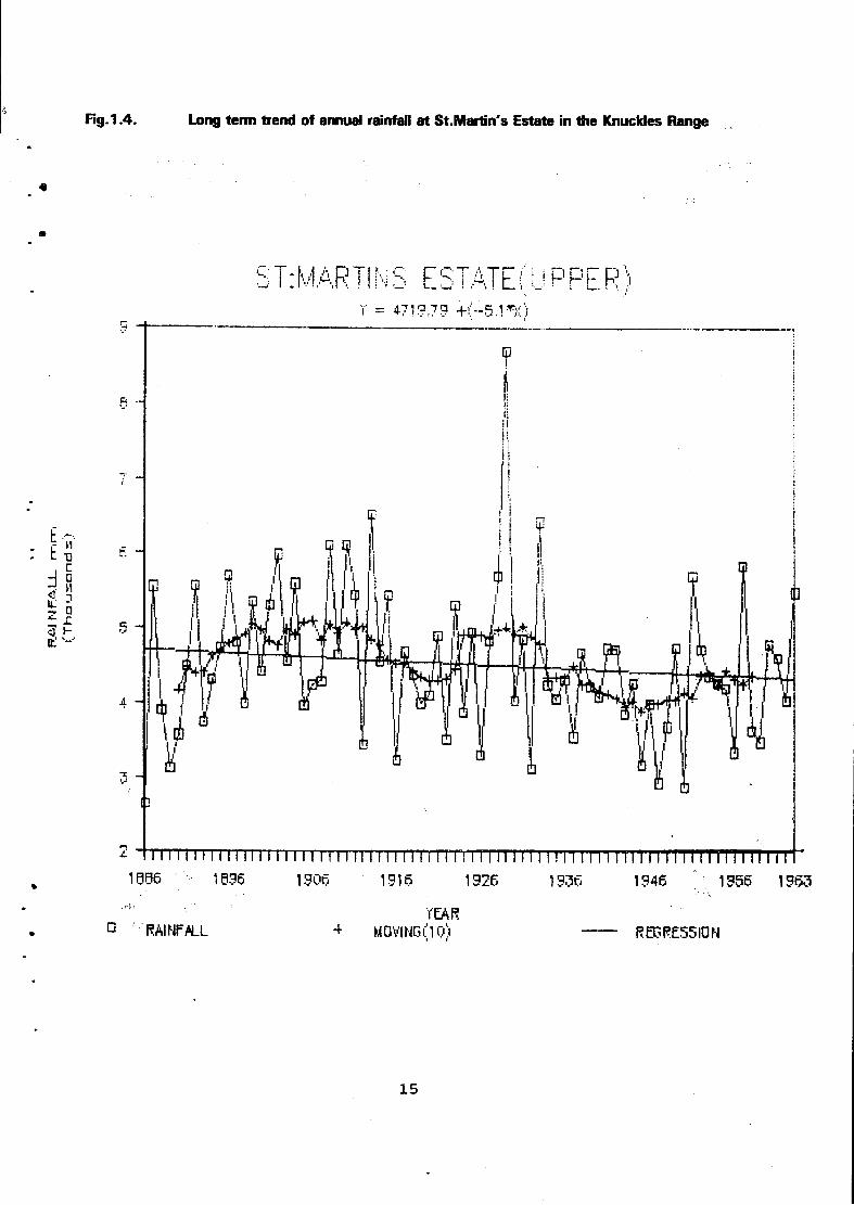
H g . 1 . 4 . Long term trend of annual rainfall a t St .Martin's Estate in the Knuckles Range
15

Climate and Biogeography
The topographic diversity of the Matale District has influenced its climate and biotic environments in a significant way. Each physiographic unit thus tends to have its o w n climatic character. The Matale Valley for example surrounded by t w o mountain ranges had developed its own topo-climate. On the other hand, lowland Dambulla area has a typical Dry Zone climate, on the summits of the Dumbara Hills where the elevation exceeds 1500 metres, the climate is much cooler and wetter. Such locations however, form only a small part of the District.
Raifall in the Matale District varies widely both temporally and spatially depending on elevation and aspect. The monthly rainfall figures for Matale (Table 3.1) indicates predominantly a dry zone regime wi th much of the rainfall concentrated in north-east monsoon months f rom October to December. However, the influence of the south west monsoon is also felt in July and August occasionally as in 1988 when over 500mm of rain was received in August. Rainfall at stations on high elevation is as high as that in the wettrst part of Sri Lanka. A t St. Martins Estate (Upper) for example annual rainfall can exceed 5000mm in most years.The long-term trend however, appears stable wi th hardly any significant changes (Fig.3.3).
The vertical zonation of vegetation wi th altitude is an important biogeographic feature at high elevations. Thus from deciduous hard wood forests of Dry Zone Lowlands, vegetation varies through Pigmy and Elfin forests to mossy vegetation (old man's beard) near the summits of Knuckles.
A t least five types of vegetation are observed in the Matale District (Bharathie, 1988).
(i) The Lowland Tropical Semi-Evergreen Forests (with species such as Milla (vitex altissima) and Mora (Nephelium longan).
(ii) Sub-montane Tropical Wet-Semi-Evergreen Foreststwith species such as Kududaula (Neolitsea involucrata) and Mihiriya (palaquium grande).
(iii) Montane Tropical Wet Evergreen Forests (wiht species such as Pihimbiya (Filicium decipieus) and Damba (Syzgium assimile).
(iv) Montane grasslands wi th species such as illuk (imperata cylindrica) and mana (cymbopogon confertiflorus).
(v) Pigmy Forests (with Ossbeckia buxiffolia).
Some wind-shaped tree species on wind-swept slopes indicate that the dominant wind-direction is f rom the west and the south west (Yoshino, 1982).
Hydrography and Water Resources
The south east to north west alignment of the Dumbara Hills enables the area to receive rainfall f rom both monsoons. The geographical location of these hills around which the main streams of Mahaweli which run on all sides, makes it an important watershed. The Matale Valley and the Atipola hills f rom which the main tributaries to the Ambanganga originates, also contributes a significant share of water.
16

Fig. 1.5. RUNOFF / RAINFALL RATIO - KALU GANGA
17

The main streams that originate in the Knuckles range and its surrounding area includes, Heen Ganga, Kalu Ganga, Hulu Ganga (Fig.3.2) Sudu Ganga and Dambulu Oya. The streamflow records also reflect dry zone regimes w i th minimum f low conditions during the south west monsoon period and high f lows during the north east monsoon period. Thus Nalanda Oya and Dambulu Oya can totally dry up in September creating conditions of serious water scarcity (Table 3.2). Most streams originating in the Knuckles indicate an increasing trend in the runoff rainfall ratios during the last four decades (Fig.3.4). This indicates significant changes in catchment landuse. The reduction in forest cover and the conversion of land at high elevations to cardamom plantations had been the major cause of this trend.
STATUS OF HUMAN RESOURCES
Demographic Features
The total population of the Matale District at the last Census (1981) was 3 5 7 , 4 4 1 . It is now estimated to be over 400 ,000 . The average annual population growth during the period 1946 to 1981 had declined f rom 3 .7% to 1.4. Thus at the last Census. Matale District was one of the seven districts in the Island which had lowest population growth rates. This was partly due to the repatriation of estate workers in the 1970s. In the last few years however, an influx of refugees f rom troubled areas of the North and East had possibly rectified this imbalance.
In terms of ethnic composition, the Sinhalese comprise 8 0 % of the population of the District, while 1 2 % were Tamils and 7 % were Moors (Table 3.3). Ail others comprised of less than 1 % of the population. The Sinhalese are predominnantly rural and agrarian, while the minority ethnic groups are concentrated in towns and estates.
The average population density of the District today is around 310 per sq.kilometre. This is much higher than the national average which is around 260 per sq.kilometre. This is particularly significant in view of the fact, that a considerable proportion of the District is hilly and the density of agricultural population is high. The population desity between AGA Divisions within the District varies widely between 33 - 700 (Table 3.4)- The highest densities are in Ukuwela and Matale AGA Divisions which have a high density of homesteads and residential places. Same thing applies to Rattota. Matale City being the District Capital and one of the oldest Municipalties in the country has also attracted a sizeable population. In terms of population increase rates, Dambulla had the highest while the lowest was f rom Laggala. The rapid rate of development of the Dambulla Urban area is largely responsible for the increasing trend of population in the AGA Division as a whole.
The age and sex distribution of the population in the Matale District at the last census is given in Table 3.5. As could be seen, some 4 1 % of the population in the District was less than 15 years, while that over 60 years was less than 6%. Therefore, the working population in the age group of 15-60 was about 53%. An important feature of the population structure is that the largest category of people (among the females as well as males) was in the productive age of 20-34 years. This may mean that the population growth rates are likely to increase further or at least remain static in the near future.
18

a cr a CO
U3
ETHNIC COMPOSITION OF THE MATALE DISTRICT
Ethn ip firnun 1981 1986 — _
Total Population Urban (%) Rural &
Estate (%) Total Population Urban (%) Rural &
Estate (%) Sinhala 285354 7.59 92.41 306044 7.60 92.4 Ceylon Tamil 20579 30.60 69.4 22071 30.61 69.39 Indian Tamil 24912 5.75 94.25 26719 5.77 94.23 Yonaka 24995 32.30 67.7 26808 32.31 67.69 Burghers 272 42.27 57.73 292 42.46 57.54 Malay 574 36.93 63.07 615 36.91 63.09 Other 668 47.00 53.00 716 46.92 53.08
District Total 357354 202.42 497.57 383265 202.58 497.42
m 3"
o o 3 *D O 2. 5 ' 3 3" CD
s 0) #* S. CD
g Si'
Source : Department of Census and Statistics of Matale.

0) A
POPULATION OF THE MATALE DISTRICT *
1981 1986/87* A.G./-.. Diviaion Total
Population Kale [%) remale (%) Total Population % Increase
Density per Sq.kilometre.
Matale/Yatawatta 93278 49.41 50.59 99590 06.77 608 Rattota 42922 48.06 51.94
* 46150 07.52 498
Dambulla 39122 54.40 45.6 42350 08.25 93 Galewela 50993 50.69 49.31 54700 07.26 284 Ambanganga 14475 48.93 51.07 15600 07.78 298 Ukuwela 35263 48.79 51.36 37350 05.92 700 Pallepola 24222 57.22 41.21 26450 09.20 328 Laggala 12476 53.20 47.78 13025 04.40 33 Naula 22607 53.27 46.8 24325 07.60 97 Wilgamuwa 22083 50.59 49.73 23725 07.43 90
District Total 357441 50.59 49.41 38326S 07.10 310
o 5>"
* Estimated data
Source : Department of Census and Statistics Census of Population (1981).

Population-Age and Sex distribution in the Matale
• —'— Population 1981 % Distribution
Male Female Total
Under 1 year 1.2 1.1 2.3
1 _ 4 years 6.4 5.8 11.2
5 - 9 Years •7.1 7.3 14.4
10 - 14 Years 6.8 6.8 13.6
15 - 19 Years 5.3 5.5 • 10.8
2 0 - 3 4 Years 10.8 11.2 22.0
35 - 49 Years 9.0 7.5 16.5
50 - 59 Years 2.3 1.5 3.8
60 - 69 Years 1.9 1.4 3.3
70 - Years & over 1.2 0,9 2.1
Total 51.0 49.0 100.0
21

The average birth and death rates in the District for the ten year period 1970-1980 compared w i th the national average for the same period are given in Table 3.6.
Table 3.6 A v e r a g e Birth and Death Rates in the Matale District (1970-1980)
Matale District Sri Lanka
Birth Rate 31.17 28.50 (per 1000 population)
Death Rate 7.87 7.54 (per 1000 population)
This clearly indicates that the average birth rates are significantly higher in the Matale District than in the Country as indicated by the national average. This is due to the high rural and estate population who lag behind in the adoption of birth control practices. On the other hand, the death rate is not significantly higher than the national average reflecting probably the beneficial impact of free health services. This situation had not changed significantly during the last decade.
Employment Profile
Available employment statistics for the Matale District indicate that the largest share of population (54%) is engaged in paddy or other food crop cultivation. Plantation workers who occupy the second place account for 13%; while the former comprises mainly rural Sinhalese, the latter is made up of tamils of Indian origin. The third most important category of employment is casual labour. This category which comprises of persons of all ethnic groups is a daily wage earning class representing the porest segments of society. In contrast, traders who make only 5% of the employed population enjoy higher personal incomes and wealth.
In terms of industry, 53% of the people were employed in primary activities of agriculture, mining forestry & fishing. The second most important industry was construction in which almost 2 7 % had been employed. Only about 9% was employed in manufacturing industries. Wholesale and retail trade, restaurants and hotels employed only 7%, while all others accounted for less than 4 % of employed population. In recent years employment in mining and quarrying had also increased significantly due to the expansion of gemming and the extraction of the graphite, feldspar and crystalline limstones. In general, the employment of the largest share of population in primary and extractive industries tends to create severe stresses on their resource base; particularly on land and water. The growing importance of the construction industry as reflected by the population employed in it also indicates increasing demands for forest as well as non-forest sources of timber.
The General Administrative Set -up
As in other Districts, the general administration of the Matale District at the time of the survey was centred around the Government Agent (GA) and the Assistant Government Agents (AGA) of 11 Divisions. Therefore, the system of district administration is a vestige of the colonial administrative set-up w i th the Kachcheri in the District Capital and the AGA offices in smaller townships in the Divisions. However, compared wi th the powerful office of the Government Agent in the Colonial days, its present position is only a figure-head. With the introduction of the Provincial council system, the Government Agents have also been designated as District Secretaries. A t the Kachcheri, the GA is assisted by t w o additional GAs in-charge of Administration and Lands. A Head Quarters AGA, coordinates the activities of all Divisional AGAs (See Fig 3.5). A t the lowest level of the administrative hierarchy is the Gramaseva Niladari (GSN) who now covers 2-4 villages. With the absorption of former Cultivation Officers and Vishesa Seva Niladari to the rank of GSN, the number of GSN Divisions had also been multiplied recently.
22

31 to
O
I o 2 O
£ o •n >
o
a I

The Government Agent as the Head of District Administration still performs such a wide variety of functions, that he is practically a 'jack of all trades.' Over 50 such functions can be identified ranging f rom ceremonies to sewerage. Any residual functions not covered by any other line-agency also fall on his street. The GA also coordinates several District Committees such as the District Agricultural Committee, District Landuse Committee and the District Environmental Agency in which he functions as the Chairman.
Apart f rom offices under the GA in the district administration, a large number of 'line departments' have their 'branches' in the District. These include various institutions related to agriculture, forestry, health etc. Some of these are located within the 'Kachcheri' premises which form the hub of district administration. Most of them derive their authority and instructions from head offices in Colombo. The funtion of the GA is only to coordinate their activities.
As at present the District Administrative set-up is undergoing rapid changes, AGAs are called upon to shoulder greater responsibilities, while the GA and the Kachcheri is left to fade away gradually. It is anticipated that the Kachcheri system will cease to perform its usual role in the near future, while the Government policy regarding the future of the position of the GA also remains uncertain. One positive aspect of this period of transition is that as a result of the transfer of many responsibilites, the GA could pay more attention to environmental matters than ever before. Similarly, at the village level the multiplication of GSN Divisions has brought the GSN closer to the people. However, absorption of cultivation officers to the GSN ranks is likely to have some negative effects on agricultural extension and resource conservation.
Natural resources conservation and environmental management are in general, perceived as administrative functions than specialist tasks. This was inevitable in a set-up w i th hang-overs from the colonial past, in which revenue collection was the prime motive and for which rigid adminstrative control was essential. In more recent decades, there had however, been a tendency to break away from the past. The emrgence of strong line Departments such as Health, Agriculture and Forestry, and the development of relatively independent Development Projects such as the IRDP, had contributed to this trend. This had the effect of eroding the authority of the Kachcheri, some times creating problems of inter-sectoral coordination. As i t is today, environmental management functions are scattered over a variety of institutions which are coordinated by the GA, particularly through the District Environmental Agency (DEA). The DEA is undoubtedly performing a useful 'watch-dog' function, by bringing out many current environmental issues to official attention; when it comes to implementation however, DEA has to work through line agencies.
With the shift of executive authority upwards to the Province on one hand and down wards to the Divisional level on the other, the District as an administrative unit seems to be fast loosing its status, it appears therefore, that in the future, environmental management functions will be based on the Provincial and Divisional levels. It is likely that Provincial councils may take over the regional policy making role while Pradeshiya Sabhas and Divisional Secretaries may perform implementational functions leaving the District and the DEA to wither away.
Infra-Structure Facilities and Serv ices
The Matale District is connected wi th the adjoining areas by a network of major and monor roads (See Fig 1.1). There are 865 km of main roads maintained by the Department of highways while a similar length (823 km) is maintained by the Local government. The warm and humid weather conditions necessitate constant repair, making maintanence of these roads a formidable task. The main traffic artery is the Kandy-Jaffna road which had been widened and rubberized during the last three years. The most popular form of passenger transport is the bus. The Central Transport Board has t w o major bus depots at Matale and Dambulla. These t w o depots operate over 150 buses daily, although a part of the fleet has suffered during the period of civil disturbances in 1988 and 1989. A vigorous private bus service supplements the transport services performed by the Transport Board. Matale is one of the railway terminals in the hill country and the train is important as a mode of transport for goods rather than passengers.
24
The District was served by 9 main post offies and 79 sub-post offices before the recent civil disturbances. Telephone and telegraph facilities (with direct dialling) are available in nearly half of these post offices although they are not often operating efficiently. Many sub-post offices suffered serious damage during the times of recent troubles. Some of the AGA offices were also destroyed and normal administration was seriously disturbed particularly in remote parts of the District.
Education
Compared wi th the national situation, Matale District can be considered as an educationally backward area in several ways. The percentage of people who can read and write in the District is around 8 4 % while that of the country is slightly higher (88%). The adult literacy rate remains however, around 6 7 % . The literacy rates are much lover in the villages and estates (83%) while they are around 9 2 % in the urban areas.
The District has over 300 schools wi th a student population of around 100.000. However, there are only 10 large schools coming within the categories, of (A) and (B). Average participation rate of students is around 6 7 % while the national average is 7 1 % . Although the pupil teacher ratio is 22 which is comparable to the national average, the percent of graduate teachers employed is much lower, particularly in the science stream. Thus the proportion of senior secondary students who enrol for science (32%) is much lesser than that in Colombo (56%).-School drop-out rates remain high w i th over 2 0 % leaving school before they reach Grade 8. Most of these persons, due to lack of employment opportunities fall back on agriculture as a means of livelihood.
In accordance wi th the general education policy, environmental studies form part of the school curriculum up to Grade Five. Thereafter, it is taught under a variety of disciplines, in sciences as well as in Ar ts .
Health
Health care facilities in the District include both preventive as well as curative services provided through a network of Hospitals, Dispensaries, Clinics, and Peripheral Units. Altogether there are 41 such institutions, they include only one base Hospital and a District Hospital. Although there are 4 Rural Hospitals, a large percentage of the rural population is served by a system of Central Dispensaries. There are only a little over 1100 beds in all hospitals in the District, half of which are in the Base Hospital at Matale.
The statistics on the morbidity indicate that the leading causes of hospitalization are: malaria, pregnancy, wounds, abdomenal pains, asthma, anaemias, pneumonia, skin diseases, rheumatism, and respiratory infections. It may be noted that the topmost cause of hospitalization is malaria which is closely related to environmental factors. Among the notifiable diseases (under the Notifiable Diseases Act ) , the leading diseases in the District are: diarrhoeas and dysentery, infective hepatities, tuberculosis, and typhoid fevers. Of these four, the dysentery reaches epidemic proportions in certain years due to faecally polluted water used for domestic consumption and poor environmental sanitation.
The available medical staff in most hospitals is hardly adequate to cope wi th the current numbers of patients seeking treatment. A t the time of the last Census there were only 24 medical officers in the District of whom 16 were at the Matale Base Hospital. There were none in the rural hospitals. The number of available specialist medical officers and dentists were very small and almost all of them were in Matale. The availability of medical personnel in other grades such as nurses, technicians, and dispensers was also poor. Thus there were no dental nurses for the whole district in 1980 while there were no mid-wives in some of the maternity homes. Since then the situation in these hospitals cannot be claimed to have improved adequately. By 1989, there were only 35 medical officers, while the requirement was 44. There were only 124 staff nurses while the requirement was 206.

0> o; (V
C (A a
to CTl
Area
Urban
Rural
Estate
Total
Total
5975
55005
7228
68208
USE OF TOILETS IN THE MATALE DISTRICT
Commode System
572
564
168
1304
Drainage System
2331 1041 2877 35283 775 2392
5983 38716
Pantry System
Bucket System
1423
331
1754
Without Toilets
556
14784
3414
18754
Others
52
1166
478
1696
g 5" It) 5" 3 -»
s 0) 92. re" O Si' o '
CO to
Source: Census and Statistics Division, Matale Kachcheri.
S 9

Housing, Electricity. Water Supply and Sanitation
A t the last Census (1981) total housing stock in the Matale District stood at 74 ,811 units. The large majority (90%) of this was in the rural sector and remaining 10% was in urban areas. The rate of growth of housing in the rural sector was also higher than in the urban areas. This was facilitated by various housing programmes such as the Electoral Housing schemes and Self-Help Model Village housing programmes sponsored by the Government.
In respect of most domestic amenities such as water supply, electricity and sanitation, urban sector is far ahead than most rural areas. Thus while 7 2 % of urban housing units had their o w n wells or pipe-borne supplies, such facilities were available only for 2 2 % of houses in rural areas. The expansion of tube-well programmes in the recent past had undoubtedly helped to rectify this imbalance in some way.
As could be seen in Table 3.7, nearly 2 5 % of houses had no toilet facilities at all in 1 9 8 1 . In the rural sector this figure was as high as 50%. Where toilet facilities were available in the rural houses they were mostly pit latrines.
With regard to electricity, the imbalance between the rural and urban areas was most conspicuous. Thus in 1977 out of a total of 763 villages in the District only 74 had electricity. For the District as a whole, only about 5% of housing had electricity. This situation has been changing in the recent past due to rural electrification programmes launched by the Government.

CHAPTER IV Resources and Human Activities
The most important natural resources in the District are land, water, minerals and forests. Compared wi th most adjoining areas, the Matale District is better endowed in several types of minerals (See Fig 4.1). These include mica, gem stones, feldspar, fluorspar, vein quartz, crystalline limestones, and various types of building stones. Of these minerals, mica depostits which are mostly phoiogophites, are found in the ares around Bandarapola and Naula. Large heaps of mica collected for processing as a cottage industry could be seen on road sides from Kaluganga to Naula.
Matale District had become prominent for gemming in recent years. It is mainly concentrated in Elehaera, Kaluganga and Pallegame areas. Gemming is carried out in these areas both under permits as well as illicitly. State Gem corportation issues three types of permits for gemming, i.e. for State lands, for Private lands and permits for auctioned lands. The permits are issued at places in the gemming areas such as Wellewela, Hattota Amuna, Kongahawela, Thorapitiya and Rattota. The charge for a permit at the time of the survey was Rs. 4 0 0 / = wi th a deposit of Rs. 5 0 0 / = per gem-pit. For State lands, a mineral tax of Rs. 5 0 0 / = for the first acre and Rs. 250/ = for each additional acre is charged.
Illicit gemming is a major problem in the Matale District which results in loss of revenue and often leads to environmental problems associated w i th neglected gem-pits. An idea of the intensity of gemming can be obtained from the state of affairs at Polwatta Colony where topaz is mined (Table 4.1) .
Table 4 .1 Gemming at Polwatta Colony. NikaweSla.
1985 1986 1987 1988
No.of permits issued 106 133 213 168 Extent of land under gemming 318 399 639 Permits issued for auctioned land 06 - 63 144 Extent of auctioned land in use 01 - 7.5 18
(Source: Gem Corporation, Naula)
•licit Gemming is often practised in State reservations for streams and forests. It has been estimated that illicit gemming is carried out in at least 500 acres of land in the District. A t Hattota Amuna the local population is around 10,000 while there is a migrant population of around 3000 . This leads to spread of diseases and social problems. The local people complain that while they are still waiting for permits for their own lands, gemming permits were issued to outsiders wi thout delay.
The mining of feldspar and fluorspar is carried out in areas such as Thalagoda, Elahera, Owala and Rattota. These deposists are often inter-bedded with quartz and mica. They supply the requirements of the Porcelain Industry, both at Rattota as well as in other areas.
Crystalline limestone forms the most common raw material exploited in the Matale District. It occurs in narrow bands interbedded wi th other rocks of the Khondalite series. These are still available for open-pit mining in localites around Dambulla, Galewela and Thalagoda. The occurence of crystalline limestones due to their porosity, is also a reason for better groundwater conditions in some places. Wells and springs in places such as Bubula, Godapoia, and Madawala Ulpotha are believed to be benefitted from these limestone formations.
28

Fig 4 . 1 Natural Resources of the Matale District
29

0) CP
LAND USE IN THE MATALE DISTRICT BY AGRARIAN SERVICES DIVISION - 1988
UJ o
Agrarian Services Total Suitable Extent for Perennial Crops Asweddu- Other Forest Agrarian Services Extent Sxtent r t i z e d Seasonal and Division (Ha) (Ha)
L a n d Reserve Tea % Rubber % Coconut* Other % crops Land
Palapathwela 5023 4750 0.01 0.83 0.90 2.09 0.53 0.23 0.28 Yatawaththa 4940 4940 0.15 0.57 0.28 3.03 0.54 0.49 Walewela 1440 1440 0.04 0.02 0.01 1.07 0.34 0.49
Tanna 2562 2402 0.79 0.005 0.09 1.22 0.33 0.02 0.16 Galewela 7575 5865 - 0.001 1.13 0.12 1.87 0.13 1.76 Dewahuwa 4158 3631 - - 0.12 0.12 1.73 1.75 0.54 VJahakotte 4366 4124 - 0.22 1.03 1.50 0.56 0.81 0.24 Pallepola 4097 3847 0.008 0.19 0.98 1.21 0.64 0.07 0.25 Dambulla 6797 5335 - - 0.67 1.41 2.40 0.79 1.47 Kimbissa 1250 1138 - - 0.04 _ 0.88 0.17 0.11 Weragama 2086 2066 0.61 0.41 0.25 0.52 0.16 0.15 0.02 Bandarapola 2768 2695 0.91 0.06 0.10 0.85 0.22 0,44 0-07 Rattota 4146 4036 2.46 0.07 0.20 0.75 0.43 0.16 0.11 Ukuwela 2985 2892 0.29 0.73 0.11 1.29 0.28 0.13 0.09 Elkaduwa 2364 2235 0.61 0.01 0.02 1.33 0.22 0^07 0.13 Alugolla 2778 2278 - - 0.25 _ 9.43 1.54 ©.51 Kongahawela 1652 1482 0.008 0.002 0.03 0.37 0.80 0.09 0.71 Hattota Amuna 4860 3360 - - .09 0.78 0.84 0.86 1.54 Ilukkumbura 11261 3121 0.35 - 0.002 1.13 0.42 0.31 8.39 Hunuketa Ela 7574 5273 0.79 0.52 0.49 0.49 0.44 0.55 2.37 Hettipola 7701 4701 -. - _ 1.23 2.58 .0.51 3.09 jHadunaamuwa I TOT 7X51 1 " | — o : m n j 0177 7 yn |Total 97008 73766 | 6.65 | 3.73 | 6.79 | 21.96 | 17.89 9.89 23.87
ET a a. c (A (D
5" » S
n ' D
I er >« *• B 3 in » 1. o
5" 3 .
(0 CO 00

Land Resources
In view of the large proportion of labour force (52%) engaged in agriculture, forestry and mining, land is obviously the most important natural resource in the District. It generates not only employment but also a the largest share of revenue in the District. As could be seen in Table 4 .2 , of a total extent of 97008 ha. of land in the District, some 7 6 % (or 73,766 ha) is suitable for agriculture. The balance is rocky, mountainous or under urban and other uses. The largest user of Land in the District is forestry, covering nearly 2 4 % of the total area. Although this is almost equal to the national average forest cover, a large proportion of forests in the District are either in.Hhe mountainous areas such as Knuckles Range on in the Dry Zone. Attempts towards reforestation had only limited success. As could be seen in Table 4 .3 , by 1985 the total area reforested by the Forest Department remained at only 12,000 acres, of which the largest extents were under pinus and eucalyptus species.
The second important type of land use is asweddumized paddy which covers nearly 18% of the total area. It is concentrated particularly in the valleys (or deniya) in the hills or in lowland areas of the Dry Zone under village tanks and major irrigation schemes. A similar extent is found under the three major plantation crops of tea. rubber and coconut. Most of these plantation crops are in small holdings w i th only a few exceptions. All other perrenial crops cover about 2 2 % of land. The balance agricultural area is under chena and seasonal crops. In general, forestry, paddy cultivation, plantation crops and chena wi th seasonal crops cover approximately equal extents of land in the Matale District.
Historically, the land use had evolved in harmony wi th the slopes and soil catenas in the hills. This is reflected in the topnomy of lands as Ovilikanda, Ovilla, Ovita, Tenna and Deniya representing diferrent segments of slopes in a catenary sequence. Similarly, in the Dry Zone around Dambulla and Sigiriya the traditional three-fold land use system of paddy land, chena and the homestead had developed in harmony wi th the resource base.
Land Tenure and Ownership
The land ownership among the rural families in the Matale District is given in Table 4 .3 . This shows that in 1977, out of a total of 53,120 families, some 15,743 (or 30%) did not own any land. This indicates the magnitude of the problem of rural landlessness in the District and generally in the hill country. Most persons in rural families are emplyed as agricultural labourers, ande tenants and other daily wage earners. Similarly, the nubrner of near landless families (or those owning less than 1/2 acre), comprise nearly 2 3 % of the total . In other words, the majority of rural families in the District are landless or near landless. A large proportion of these families are found in Matale, Galewela and Ukuwela AGA divisions. Those who own more than 5 acres constitue only about 5%, indicating a highly skewd distribution.
The presence of a large number of rural families in the landless or near landless categories can have serious environmental implications. Although reliable data are not available, it is likely that these are the groups who resort to chena cultivation and encroachment of State lands.
A t the national survey of encroachments in 1979, some 9265 encroachments were reported f rom Matale District covering an extend of 23,951 acres or nearly 10% of the total area (Table 4.4) . The highest incidence of encroachments was in the AGA divisions of Dambulla, Galewela and Wilgamuwa, where State land is still available for encroachment. The most disturbing feature was that over 4 0 % of the encroachments were on stream and other reservations which could not be regularized. The eviction of encroachers from such lands is a painfull process, and the District administration could eject only less than 2 0 % of them. The others continue to occupy these lands without any security of tenure - a condition that contributes much to land degradation. The LDO permits were issued to only about 1/3 of the regularized encroachments by 1988. However, the encroachment regularization policy of the Government seems to induce further encroachments.

Table 4 . 3 Land ownership among rural families in the Matale District
A.G.A. Division Total No. of Families
No. of families Owning no Land
No. of families Owning less than \ an Acre
No. of families Owning *5 to 3 Acres
No. of fami lies Owning 3-5 Acres
• No. of fami lies Owning more than 5 Acres
Ukuwela 6011 2304 2198 1274 111 124
Rattota 5764 1270 2176 1871 326 121
Dambulla 5885 154 1 616 2161 861 706
Naula 3904 1332 552 1498 03 219
Galewela 8807 2914 1628 2652 712 901
Pallepola 4310 1194 1082 1591 236 207
Wilgamuwa 34 59 750 77 462 2152 18
Ambanganga Karate 1910 475 278 935 135 87
Matale 11002 3379 3175 3462 534 452
Laggala 2068 584 219 1026 123 116
Total 53120 15743 12001 16932 5493 2951
Source : Department of Census and Statistics
Basic Village Statistics (1977).
32

ENCROACHMENT ON STATE LAND
A H A Division Encroachments Reported (1979)
Not suitable f o r i Regularisation
Ejections of Encroachers
EncroacH^ Regulari
iments sed
L.D.O. 1 Issued I
3ermits iy 29.03.88
No. Acreage No. Acreage No. Acreage No. Acreage N o . Acreage
Wilgamuwa 881 4626 1237 1947 183 270 1644 2684 678 810
Laggala - 2945 403 2021 152 1498 669 925 368 420
Naula 1802 2091 984 1178 163 169 818 912 793 872
Ambanganga 568 627 359 385 - - 209 241 102 130
Dambulla 4 14 6522 970 1308 148 159 3144 5213 835 1125
'Galewela 3670 5188 1438 2201 420 592 2232 2986 498 580
Pallepola 938 1059 442 362 254 169 496 696 189 236
Matale Yatawatta 375 229 239 137 108 59 136 91 113 54
Ukuwela 187 164 112 141 14 02 75 23 12 04
Rattota 339 460 206 310 18 06 133 149 31 09
Dewahuwa Project 91 112 02 03 - - 89 108 57 55
Total 9 2 6 5 23951 ( •6392 9 9 9 3 1 4 5 9 2 9 2 4 9 6 4 5 14028 3 6 7 6 4295
: Land Commissioner's Department, National Encroachment Survey,

Table 4.5 Paddy cultivation in the Matale District ( Yala & Maha)
M A H A (Ha)
1984/85 1985/86 1986/87 1987/88
Total 16,497 16,612 15,202 15,171
Major Irrigation 5,001 5,018 4 ,910 4 ,828
Minor Irrigation 7,083 7,092 6,879 6,884
Rainfed 4 ,412 4 ,502 3,502 3,458
Y A L A (Ha)
Total 5,585 5,948 3,928 5,497
Major Irrigation 1,958 1,983 1,237 2,233
Minor Irrigation 3,012 2,808 2 ,460 2,946
Rainfed 610 633 228 300
Source : Department of Agriculture in Matale.
34

Crops and Livestock
Agricultural crops grown in the District include paddy, plantation crops, minor export crops and seasonal crops of cereals and pulses.
Paddy which forms the staple diet of the people in the District is grown both under irrigation, as well as under rainfed conditions. Permanent rainfed cultivation is possible only in the wetter parts of the District and accounts for only one-third of the total area under paddy. In terms of acreage, minor irrigation is more prominent than both major irrigation and rainfed farming (Table 4 .5 ) . The total area under paddy had recorded a slight drop in recent years. This was mainly due to diversification into other crops such as tobacco and vegetables.
Among the plantation crops, coconut covers a larger area than tea or rubber which were confined to a few AGA Divisions such as Rattota and Matale. Coconut also has a much wider distribution (Table 4 . 6 ) .
The Matale District is also well known for minor export crops such as cardamom, cloves, nutmeg, cocoa, coffee and pepper (Table 4 . 7 ) . These crops have a growing export market and it was found inappropriate to call them minor-export any longer. They have also become a tourist attraction as could be seen from the large number of 'spice gardens' w i th foriegn names found along the road between Matale and Dambulla. Cardamom is grown at higher elevations particularly on the Knuckles Range. The environmental impact of cardamom cultivation is still a subject of debate and a serious concern among ecologists.
A considerable proportion of the cereals and pulses are grown under chena conditions (Table 4 . 8 ) . These include kurakkan (finger millet) maize, green gram, cowpea and soya beans. Of these crops, kurakkan which is now considered a 'health food' had been the staple diet of rural people in the historical past. Soya beans had been a more recent introduction which did not catch on for various reasons. Anys strict prohibition on chena cultivation can seriously affect the production of these subsidiary food crops.
Livestock forms an important integral part of the rural farm sector. These stocks include mainly cattle, buffabloas, sheep and goats, pigs, poultry and bees. As could be seen in Table 4 . 9 numbers of animals in all categories have increased over the years except in the case of sheep and goats. The most significant increases were in the popularization of buffaloas and poultry. Rattota and Matale AGA divisions had some of the largest populations of livestock, particularly, cattle, buffaloas and poultry. Keeping piggeries particularly in the drier, malarial parts of the District had been discouraged in recent years due to outbreaks of Japanese Encephalitis, a disease believed to be transmitted by mosquitoes through pigs.

Table 4 . 6 Extents under major plantation crops by A G A Divisions
A.G.A. Divisions Tea Rubber Coconut A.G.A. Divisions Extent Extent Extent
Acres Acres Acres
Matale District 10,170 13,093 29,985 Ambanganua Koralaya 1,811 1,765 785 Dambulla - 58 1,974 Galewela - 166 9,682 Laggala Pallegama 380 - 449 Matale 3,731 5,169 6,373 Naula 40 135 1,802 Pallepola 93 1,736 6,560 Rattota 8,105 2,450 1,658 Ukuwela 3,980 1,401 629 Wilgamuwa - 193 73
Source: Department of Census and Statistics Census of Highland Crops and Livestock (1980).
36

EXTENTS UNDER MINOR EXPORT CROPS BY A.G.A.DIVISIONS
A.G.A. Divisions Cardamom Cloves Nut meg Cashew Cocoa Coffee
Extent Acres
Cinnamon Extent Acres
Citronella Extent Acres
Pepper Extent Acres
A.G.A. Divisions Extent Acres
Extent Acres
Extent Acres
Extent Acres
Extent Acres
Coffee Extent Acres
Cinnamon Extent Acres
Citronella Extent Acres
Pepper Extent Acres
Matale District 5,085 707 203 77 14,166 4,311 386 242 1
10,413 Ambanganga Korala 601 153 17 3 1,797 67 - - 1,513 Dambulla - - - 46 - - - -Galewela - - 4 9 169 26 - 114 183 Laggala Pallegama 2,969 - - - 1 10 - - 1 Matale 7 207 150 4 6,145 2,928 342 32 3,280 Naula • 10 _ - 5 91 35 1 357 Naula • 35 357 Pallepola - 2 - - 2,223 299 - - 2,382 Rattota 1,390 70 17 - 1,793 343 - - 1,614 Ukuwela 108 275 15 - 1,947 603 43 96 1,081 Hilgamuwa — 10 - - 2
Source: Department of Census and Statistics. Census of Highland Crops and Livestocks (1980)
0 •

A.G.A. Division Kurakkan Maize Green Gram Cow Pea Soya Beans Extent Acres
A.G.A. Division Extent Acres
Extent Acres
Extent Acres Extent
Acres
Soya Beans Extent Acres
Matale District
Ambanganga Koralaya 3,589
8 4, 350 199 1,400 204
Dambulla
Galewela 1,003
438 1, 765
675 73
64 626
321 180
24 Laggala Pallegama 915 803 37 85 Matale - 4 _
Naula 785 377 6 23 Pallepola 4 8 _
Rattota 1 ukuwela - _
Wilgamuwa 435 718 19 345
Source: Department of Census and Statistics. Census of Highland Crops and Livestocks (1980)

Table 4 .9 Number of Livestock and Poultry
Type 194G 1962 -
1973 — 1980
Cattle 24,077 32,828 23,457 37,172
3uffaloes 18,107 23,340 14,886 35,289
Sheeps ] Goats j 7,250 5,636 5,198 7,127
Pigs 265 628 684 916
Poultry 48,627 82,427 75,478 122,647
Beehive Boxes - - 355 248
Source : Department of Census and Statistics.
Note: Figures are based on the Agricultural Censuses 1946, 1962,19 7 and census of Highland Crops and Livestock-1980.
39

CHAPTER V ENVIRONMENTAL PROBLEMS AND EXISTING MANAGEMENT
MEASURES The problems related to environment in the Matale District were initially identified through a process of consultation wi th the GA, AGAs and other Government Officials. The discussions w i th the District Environmetal Agency followed by a questionairre survey proved particularly useful in prioritizing environmental concerns. The close collaboration wi th the Makulemada Grama Abhiwurdhi Sangamaya has contributed much to the understanding of people's perceptions and their participation in Environmental conservation programmes. Field visists to problem areas provided an opportunity to have a direct dialogue wi th farmers, gem miners as well as wi th village level officials.
Problems Arising f ron Human Activities
A listing of environmental concerns in the District based on above sources of information is given in Table 5 . 1 . The ranking indicated is mainly based on the following criteria.
(a) the degree of official and public concern, (b) the level of ecological and economic significance, (c) potential importance for the future.
The range and variety of expressed environmental concerns reflect the ecological diversity of the District as well as its economic base which is predominantly agricultural. The more prominent environmental concerns are discussed here in some detail.
TABLE 5.1 ENVIRONMENTAL PROBLEMS IN THE MATALE DISTRICT
(Based on perceptions of A G A s , Members of the District Environmental Agency and other Government Officials)
Ranking Environmental Problem
1 Deforestation
2 Water Scarecity
3 Soil Erosion
4 Land Slides
5 Tobacco Cultivation
6 Agrochemical Use 7 Mosquitoe menace (malaria) 8 Water Pollution
Reported Location
Laggala, Ambokke, Rathgama, Millawana, Laggala-Pal legama, Udupih i l la , Naula , A n d a w a l a , Kuhumbiyangaha Ela, A m b a n a , Opalgala , Helambagahawatte, Arangala, Nayakumbura, Kaluggawa, Kolagaha Ela, Wewala Wewa, Sigiriya. Kandegedara, Galewela, Lei Oya, Ma Oya, Makulemada, Kirimetiyawa, Etipola, Kiriibbangala. Walewela, Delwita. Laggala, Udagama, Pallegama, Bodikotuwa, Rattota, Bandarapola, Hapuwida. Makulemada, Etipola, Pussella, Gammaduwa, Pansaltenna, Udupihilla, Elkaduwa, Ovilikanda, Guruwela, lllukkumbura. Pallepola, Wahakot te , Kimbissa, Galewela, Dambulla. Laggala. Polwatta, Nikawella Diyabubula, Laggala. Elahera, Ankanda Puwakpitiya, Handungamuwa, Matale City.
40

Deforestation
The available landuse statistics for the Matale District indicate that about 2 4 % of the land area is under 'dense natural forests. ' Another 5% is under 'open forest. ' Over 8 0 % of these forest lands were found in four AGA Divisions namely, Laggala, Wilgamuwa, Naula and Dambulla. Therefore, the aggregate figures for the whole distrct tend to conceal the wide variations in forest cover within the district. Thus in the AGA Division of Ukuwela less than 150 ha remain under forest.
The total forest cover of the Matale District is close to the national average and is twice as high as that for the adjoining Kandy District. However, compared w i t h the situation t w o decades ago, the rate of depletion of the natural forest cover had been extremely rapid. Considering the agricultural base of the district's economy and its heavy dependence on water resources, the loss of forest cover can have both short-term and long-term consequences.
The depletion of the forest cover in the District is related to three main factors, namely, shifting cultivation (chena), illicit timber felling and destruction by fire. The plans for construction of the Moragahakanda reservoir had also led to some local deforestation in the areas that would be inundated.
Shifting cultivation is primarily concentrated in the dry zone segments of the district such as Dambulla, Naula, Laggala and Galewela. It is estimated that over 2 0 % of the land area of the district is under some form of chena cultivation. As practised elsewhere in the Dry Zone, chena cultivation involves the clearing of forest patches and burning them to prepare seed-beds for seasonal crops before the on-set of the maha rains. Rainfed crops such as finger millets (Kurakkan*) sweet corns, mustard and vegetables are grown in chena during the maha season. After their harvest in the January-March period, a second cultivation is tried out in some chena (yal hen) w i th crops such as those of gingelly and tobacco. Unlike during the maha season, yala crops are grown more for commercial purposes than for subsistence. The spread of tobacco cultivation in the Matale district was greatly facilitated by the availability of land for chena and encroachments. Tobacco is also grown as a seasonal crop in the paddy fields during the yala season.
The main tobacco areas in the District are found in Galewela, Pallepola and Naula AGA divisions. In Galewela AGA division in particular, tobacco cultivation area has recorded an increase of over 5 0 0 % in the period between 1980 and 1990. Tobacco has gained an importan status as a cash crop and had become much popular among the young farmers.
The cultivation of tobacco as a chena crop can affect forests both in the process of clearing and through the deamand it creates for curing in fuelwood-barns. Nevertheless, it 's economic attraction often surpasses the environmental concern.
The ban on chena cultivation which was imposed by the Government since the early 1980s has proved ineffective in many ways. It certainly had some impact in restraining encroachments into existing high forest lands. On the otherhand, it had increased the intensity of the use of already chenaed lands. Thus in many areas not only the chena cycle had become shorter over the years, but in some of them the land is now cultivated year after year almost in perpetuity. This is obviously depleting the soil fertility at a rapid rate making the whole system of rainfed farming unsustainable. The preponderance of certain plant species such as andara, eraminiya and creepers such as niyangala (glorioza superba) are believed by villagers to be the symptions of increasing infertility of chena lands.
The gradual transformation of chena lands in forest environments to perpetual cultivation plots and the eventual conversion of some of them into home gardens had seriously reduced the area available for wild life, particularly to elephants, in recent years. The outcome is increasing damage to crops from roaming wild elephants creating more frequent problems of man-elephant conflict in which both sustain varying degrees of damage. The withdrawal of fire-arms from the villagers for
41

security purposes in recent years had indeed helped wild-life conservation in an indirect way. Thus, the wild-boar population had increased significantly and the incidence of damage to crops had increased accordingly. In some of the chenas visited, farmers say that they have to now choose crops which are less prone to damage from wild elephants.
Illicit timber felling
The illicit extraction of valuable timber from natural forest reserves, as well as from forest plantations occasionally, goes on unabated despite all attempts to control it. Since this is done through a process of 'selective felling' the ecological impacts of it are not often clearly visible on the landscape. Nevertheless, it leads to a progressive degradation of the quality of forests.
The rapid increase of demand for building timber in recent years has increased the local consumption within the District. Therefore, despite a dearth of reliable data i t is likely that the illicit felling of timber from forests by the villagers as well as by organized business interests has increased significantly. The major share of illicit timber felling appears to be by commercial interests often aided and abetted by powerful persons in the District. In these circumstances the law enforement officers not only find themselves helpless, but often tend to be lured by the personal benifits of connivance. The locations from which significant illicit felling is reported include the fol lowing: Laggala, Ambokka, Millawana, Naula, Ambana, Opalgala, Helambagahawatte, Sigiriya, Arangala and Nayakumbura. Some of these places are remote from the townships and main roads, so that the vigilance of law enforcement authorities become less intensive.
Destruction by Hre
One of the main impediments for regeneration of forests where it had been already degraded to grasslands or open forests is burning of such areas during the dry season. The natural forest fires are rather uncommon in the District, but fires startd by reckless persons destroy considerable extents of land every year, particularly in the areas of montane grasslands.
Once burnt, the ground remains bare and it takes several months to regain the vegetation cover. A bare ground surface at the on-set of the rainy season is highly prone to soil erosion and depletion of soil nutrients. It destroys most micro-organisms and leads to compaction of surface soil and increased runoff. The low retention of moisture in the soil dessicates the land, discouraging the germination and growth of tree species. Many areas made barren by such processes can be seen around Matale at Etipola Kanda.
Water Scarci ty
Serious water scarecities for agriculture as well as for huiman consumption are experienced in many areas of the Matale District, not only in its Dry Zone parts but also in the wetter areas on the hills. Water shortages in agriculture are largely due to climatic variabilitiy, particularly in the drier nothern portions of the district. The traditional response to overcome such shortfalls in water supply was the development of irrigation schemes of varying types. Of all irrigated schemes, minor tanks and anicuts which come under the administration of the Agrarian Services Department, command the largest proportion of irrigated lands. While the minor tanks are located primarily in the drier northern parts of the District, anicuts are found in the climatically intermediate foot hill zone. These are the irrigation systems which suffer acute water shortages, partly due to the poor reliability of rainfall and also due to reuction in capacity due to siltation resulting from deforestation of catchment ares. Within the District there are some 275 minor tanks, 678 anicut schemes and five major irrigation projects commanding a total irrigated area of over 5000 hectares (See Tabe 5.2). In addition, there are also nearly 2500 hectares of rain fed paddy lands locatd mainly in the wetter parts of the District.
42

Table 5 . 2 Major Irrigation S c h e m e s of the Matale District ( 1 9 8 6 )
A . G . A . D i v i s i o n M a m p o f S c h e m e L a n d o f u n d e r t h e S c h e m e ( H £ Xmo ' t t ee j j i l\
A . G . A . D i v i s i o n
P a d d y L a n d H i g h l a n d
Xmo ' t t ee j j i l\
L a g g a l a H a t t o t a A m m u n a 2 0 2 1 3 4 '"• 1 6 6 • '• ' :
G a l e w e l a D e w a h u w a 9 4 1 1 2 0 8 4 6 5
D a m b u l l a K a n d a l a m a 1 , 1 1 8 0 0 4 9 0 6 3 8
D a m b u l l a W a v a l a w a v a 9 6 4 8 1 1 9
W i l g a m u w a M i n i p e 1 1 1 . i v 2 1 0 4 1 3 0 6 3 1 1 9
T o t a l F i v e - P r o j e c t s 4 1 4 3 3 1 8 6 4 5 0 7
S o u r c e : Census a n d S t a t i s t i c s . D i v i s i o n .
M a t a l e K a c h c h e r i .
4 3

Table 5.3 Tube wells in the Matale District
A.G.A. Division I.R.D.P. and UNICEF tube wells *
DANIDA tube welli **
Matale 42 123
Yatawatta 24 70
RAttota - 35
Gallewela 85 168
Ukuwela 09 -Pallepola 47 103
Naula 11 42
Dambulla 48 149
Wilgamuwa 102 74
Ambanganga 14 -Laggala - -
District Total 382 764
* Shallow wells
** Deep wells
Source :- Danish International Development AGency
44

T u b e Wells and their Environmental Implications
In recent years, many rural areas in the Matale District were provided wi th Tube Wells for domestic water supply. This programme was carried out wi th assistance from DANIDA and a few other agencies. Table 5.3 indicates the distribution of these tube wells in different AGA Divisions. The largest concentration of these wells is in the drier parts of the District and particularly in the Galewela and Dambula AGA divisions.
By the end of 1989 over 1000 tube wells were opened by different Agencies within the Matale District. These included 861 wells by DANIDA, 181 wells by the Water Supply and Drainage Board and a few wells dug by non-governmental organizations such as Redbarna and some private individuals.
Before the tube wells programme was launched, there were a large number of shallow dug wells in use in most villages. Most of these were located at the foot of slopes adjoining the homestead gardens. Some of them were constructed by rubble masonry or boulder walls. In addition to these wells, the IRDP and UNICEF have been instrumental in the recent past in introducing a large number of shallow wells particularly in the AGA Divisions of Galewela and Wilgamuwa. In some villages natural springs were used for domestic water supplies and for bathing and washing.
The rapid rate of tube well development, had undoubtedly helped may distant villages which had serious problems of domestic water supply often necessitating women and children to trek several miles a day to fetch water. They have already helped 'indirectly' to lower the incidence of water borne diseases, although statistical evidence for such an assertion is hard to obtain. A t the same time the environmental impact of the tube well programme had become a subject of some public concern. In our field surveys we have come across persons who believed that tube wells have led to drying of shallow wells and springs. Some of them went to the extent of claiming that the dessication of ground surface as a result of seepage of surface water into tube wells had a wilt ing effect on the vegetation. Some publicity has been given by the news media for such beliefs (Divaina 1989) generating some public debate. In order to establish the veracity of such opinions, a comprehensive scietific field study is necessary. This was not possible to accomodate in a study limited to an environmental profile of the district. Nevertheless, it was possible to discern t w o major trends of thought between the environmentally concerned citizens and the agencies who are responsible for the tube well development programme, particularly DANIDA (Kampsex Kruger).
The agency view point was expressed by one of it 's hydrogeologists who argued that fears about the dessication of landscape due to tube wells is unfounded, since the amount of water extracted for domestic water supply is not large enough to create such environmental impacts. Further, it was contended that the water extracted from tube wells are often re-cycled back after use.
It is apparent however, that the arguments put forward in defence of the tube well programme wi th regard to its environmental impact are largely theoretical pronouncements wi th little backing f rom empirical evidence. Our investigations did not reveal any systematic monitoring efforts by the agencies concerned wi th regard to possible environmental impacts. Since the density of tube well development of certain localities is fairly high and therefore, the extraction rates can exceed critical thresholds, it may be of interest to all the parties concerned to monitor their possible impacts in such areas more closely.
Land Sl ides and Soil Erosion
Land slides as well as problems of soil erosion are more common in AGA Divisions in the wetter and hilly parts of the District. After spells of heavy rains, earth-slips of varying sizes occur on steeply sloping lands. Some of the worst affected AGA Divisions are Ukuwela, Rattota, Yatawatta and Ambanganga. In one of the worst episodes of landslides in 1982, at Pitakanda, Pansalatenna and Palindagama some 23 persons were buried alive by debris. Similar, although not so serious earth-slips have taken place in Etipola, Alagumalai, Opalgala and Gurundagahamula.
45

The immediate cause of earth slips is heavy and continuous rainfall exceeding certain threshold limits. It is therefore, possible to anticipate the occurence of land slides in most geologically vulnerable areas. The damage from land slides is greater in more intensively used hilly lands and densely populated areas. In that sense many landslides are man-made than mere natural events.
A n examination of the sites of most landslides indicate that many of them are either associated wi th steep lands in tea estates or in highland settlement schemes. Both result f rom improper land use and imprudent land policies of the past (Madduma Bandara, 1986).
The onus of responsibility regarding managing the problems related to land slides largely falls on the District Administration. Thus when a land slide of a serious nature occurs, the AGA of the respective Division and the GA has to mobilize relief activities. Therefore, the approach is essentially a 'fire-brigade' type wi th a 'social service' outlook. Long-term planning to manage land slide problems had been virtually absent in the past. More recently, however an attempt has been made to set up a District Land Slide Steering Committee wi th the following officers: Additional GA (Lands), Engineer (Buildings Dept), Engineer (RDA) Irrigation Engineer, and the Asst. Director, Social Services who will also function as the convenor. The collective responsibility of this committee is to monitor land slide prone areas and to formulate suitable actions for their prevention. These include physical, agronomic and social service approaches.
A considerable proportion of damge from landslides can be reduced through proper landuse planning. In this context the on-going land slide prone area mapping project of the National Building Research Organisation may be extended to cover particularly the southern parts of the District. A map showing land slides prone areas can be a valuable planning tool which can form the basis of relocation of affected people and the reversal of vulnerable lands to forestry. This may be urgently needed for AGA Divisions such as Rattota and Ukuwela. In this regard there is a need to give urgent attention to the maintenance of hydrological reservations.
In general, preservation of hydrological reservations is more difficult when they occur in private lands. They can only be aquired or regulated under the Soil Conservation Act . Although 30 such hydrological reservations have been identified (see Appendix I) and reported to the Depratment of Agriculture, hardly any action appears to have been taken so far.
The problem of soil erosion, although not so visible as land slides is affecting most agricutural lands on sloping terrains. The AGAs of Laggala and Rattota report this as a serious problem in their areas. Neglected tea, tobacco and chena lands are the worst affected. The soil conservation programme of the Agriculture Dept faced major set backs in recent times due to the low priority accorded to it. Thus most field personnel trained for soil conservation work had been reassigned to other duties. A t present, the transition to the provincial system has created an atmosphere of uncertainity and in such a situation, ' low priority subjects' such as soil conservation tends to suffer most.
In bigger tea estates, soil conservation activities were given much attention in the past. With the State take-over, this interest has dwindled and sizeable portions of estate land had been abandoned. These have eventually degraded to patana grasslands. The regeneration of forest cover on them is retarded by periodic burning, which has a negative impact on soil ferti l i ty, facilitating the perpetuation of dry grasses. Soil erosion is much more prominent among small holders (of less than 10 acres), whose earnings are often inadequate for re-investment on soil conservation. State subsidies provided are too meagre and often difficult to obtain due to excessive bureaucratic control.
Similarly, encroachers on State lands as well as highland colonists wi th LDO permits tend to show little interest in soil conservation. This is partly due tp their poverty, but at least to some extent due to insecurity of tenure. Therefore, the confirment of free title to LDO lands enabling the farmers to obtain credit for land development purposes from commercial banks is necessary and helpful. Soil conservation is vitally necessary not only to maintain fertility of agricultural lands but also to minimise siltation of tanks and water ways.
4 6

Tobacco and Vegetable Cultivation
Tobacco cultivation is practised particularly, in the Dry and Intermediate regions of the District, such as in areas around Galewela, Naula, Dambulla, Kimbissa, Wahakotte and Pallepola. Tobacco, due to its economic attraction, and its ability to thrive under marginal climatic and soil conditions had become increasingly popular in the District. Over 3000 acres of land are cultivated wi th tobacco in Galewela and Pallepola AGA divisions alone, during yala season. Realizing this trend CTC had established one of its major depots and demonstrating centres ad Naula. Altogether over 5000 acres of land come under tobacco in the District (Table 5.4) of which the bulk of leaf produced is for cigerettes and betel chewing. There is also a small extend of land producing tobacco for beedi and cigar industries. According to the Agricultural Implementation Programme for 1988/89 there were over 450 barns and some 401 barn owners in the District.
The negative environmental impacts of tobacco cultivation are related to soil erosion, declining fertility of agricultural lands and the demand it creates for fuel wood. The declining feritlity is often reported from paddy lands which are cultivated with tobacco during the yala season. Although this brings an additional income to the farmers, yields tend to decline in the following season, necessitating heavy use of fertilizer and agro-chemicals which in turn generates other environmental problems.
Where tobacco is grown as a chena crop, the damage to environment is much greater, since it is done in an exploitative way on land while bringing heavy pressures on adjoining forests. The CTC which provides incentives to out growers, despite some positive steps does not seem to exhibit the same degree of concern for environmental conservation as for leaf production. It is needless to mention that the CTC as the major institution promoting tobacco cultivation has a great responsibility towards environmental protection.
In terms of agro-chemical uses, paddy and vegetable cultivation are much ahead of tobacco; when both vegetables and tobacco are grown in paddy fields during the yala season environmental impacts are even greater. This is particularly evident in the Laggala area. In view of the potential threat to water pollution and health, there is a need to monitor and regulate the sale of agrochemicals particularly in such areas where water is likely to be contaminated as in the case of cultivations on stream reservations and immediate catchment areas of springs. Such problems of water pollution are reported from Diyabubula & Laggala, Puwakpitiya, Elahera and Handungamuwa. Apart f rom the impact of agro-chemicals on land and wqater pollution, health statistics indicate that 'poisoning and toxic effects' lead the list of top ten causes of hospital deaths in the District.
Problems of Health and related Environmental Issues
Water borne diseases seem to top the list of health problems in the District. Thus of the top 10 causes of hospitalization malaria comes first. In 1987, over 25,000 cases have been reported and nearly 9000 were treated in hospitals in the District (Table 5.5). Similarly, statistics on the incidence of diseases under the Notifiable Diseases Act shows that diarrhoeas and Dysentery top the list in the District (Table 5.5). Every year over 2000 cases are reported to hospitals which had to stretch their limited facilities to accommodate sudden influxes of patients. In 1986 in one of the worst epidemics, nearly 3000 persons were hospitalized and 46 of them had died (Table 5.6). The spread of the e p i d e m i c to other areas downstream necessitated the temporary closure of many eating houses and boutiques in several towns. .
For both malaria and dysentery, the Matale District is now considered as an area of origin and a centre of diffusion. In the case of malaria, the intermediate climate provides a natural setting for mosquitoe breeding grounds, with stagnating pools of clear water in stream beds. The situation has been aggravated in the recent past by t w o other factors, namely expansion of gem mining and the increased mobility of people between the dry zone and the wetter parts of the District.

TOBACCO CULTIVATION IN THE MATALE DISTRICT (1981 - 88) (IN ACRES)
A.G.A. Division 1980/81 1981/82 ' 1982/83 1983/84
Yala Maha Yala Maha Yala Maha Yala Maha
Matale 200 - 316 - 315 - 231 62 Rattota - - - - - - - -Ukuwela - - - - 03 05 21 _
Galewela 586 - 1293 652 2041 910 2940 _
Pallepola 1029 - 1088 - 1124 _ 1071 45 Naula 115 .- 40 20 161 83 342 200 Dambulla 248 166 375 - 463 318 266 402 Laggala 380 46 51 47 54 53 34 75 Wilgamuwa - - - - _ _ _ _
Ambanganga - - - - _ 58 _
District Total 2558 212 3163 719 4161 1369 4963 784

TOBACCO CULTIVATION IN THE MATALE DISTRICT (1985 - 88)
A.G.A. Division 1984/85 1985/86 1986/87 1987/88
Yala Maha Yala Maha Yala Maha Yala Maha
Matale 427 77 339 268 386 83 468 25 Rattota 04 - 25 - 22 - 19 18 Ukuwela - - 83 - 111 07 03 -Galewela 3170 143 3071 122 2634 60 1605 70 Pallepola 1150 829 860 204 1077 - 905 85 Naula 340 - 157 - 253 213 132 Dambulla 265 244 272 351 160 713 313 932 Laggala - 85 02 110 - 92 - 108 Wilgamuwa - 03 - 02 - - - -Ambanganga 25 48 - 62 - 33 -District Total 5434 1406 4854 1057 4705 955 3559 1370
Source: census and Statistics Division, Matale Kachcheri.

INCIDENCE OF MALARIA IN THE MATALE DISTRICT (1982-1988) (No.of cases reported)
M.0.H• 1982 1983 1984 1985 1986 1987 1988
Division PV PF PV PF PV PF PV PF PV PF PV PF PV PF
Matale 147 5 817 45 1701 19 602 38 1725 227 3120 684 2083 463
Rattota 32 1 225 21 381 3 177 10 412 39 757 131 368 73
Naula 205 4 1408 58 2021 62 1566 153 6922 1994 11220 1474 9555 1575
Dambulla 1592 5 3101 200 6415 597 6687 1153 26734 4506 26309 7810 17455 3557
PV = Malaria
PF = Cerebral Malaria

Table 5.6 Incidence of Diarrhoea and Dysentery in the Matale District ( 1985-1987)
1985 1986 1987
No of cases No of deaths No of cases No of deaths No of cases No of deaths
2393 22 2934 46 2010 25
Source : Annual District Health Plan 1988
Gem Mining
Gem mining which had witnessed a rapid expansion since early 1960s is particularly concentrated in an area of about 35-40 sq. miles in the Elahera, Kaluganga and Hattota Amuna areas. According to the Gem Corporation sources there were some 309 gem camp sites in 1989. In the Hattota Amuna which forms a major irrigation settlement of some 165 families, the persons of the second generation have also taken up mining as a source of livelihood. Although this had some beneficial effect on them who would have otherwise ended up landless, jobless and an embittered group of persons, a large number of open gem pits in the area led to frequent out-breaks of malaria. Gemming had also spread to an extent where even irrigation structures have become threatened and the Government had to intervene to protect them (See news reports). A t the sites of mechanized gemming (now remaining abandoned) large tracts of land were left w i thout rehabilitating them as agreed initially.
A t some places such as Polwatta colony near Kaikawala, village access roads and even private houses are threatened by indiscriminate mining of topaz. Thus land degradation and malaria had become rampant in most villages where it is practised. Much of the benefits however, f low oout of the District, since gemming operations are often under the control of large scale gem traders.
51

CHAPTER VI POTENTIAL RESOURCES AND MANAGEMENT STRATEGIES
Land and Water
Land and Water resources are undoubtedly the greatest natural assets of the Matale District. As noted earlier over 7 5 % of the total land area of the District is suitable for agriculture. The balance 2 5 % is in rocky or mountanous terrains. It is of vital importance to conserve these hilly lands which possess not only the sources of water but also habitats for several rare species of flora and fauna. In this context, the conservation of the Dumbara Hills (Knuckles Range) and the Etipola Kanda are of crucial importance.
A t present there is a well formulated conservation plan for the knuckles Range under the sponsorship of the IUCN wi th Forest Department as the implementing agency. The Matale District however, covers only a portion of the Knuckles Range while its southern part falls wi th in the Kandy District. Therefore, in the long- run an integrated programme of action that transcends district boundaries is needed for its effective management.
There is much local interest in the conservation of the Etipola Hills. Smaller conservation areas such as Etipola range however, tends to attract less attention than the bigger ones such as the knuckles. It is therefore, necessary to provide some assistance to the local NGOs to look after their o w n local conservation needs. In this regard, exsisting programmes of assistance have to be greatly enhanced, while giving more autonomy for the local NGOs to carry out their work programmes, relatively free from political and other forms of undue interference.
The Poppham arboretum in Dambulla which has been developed by a life-time devotion and dedication of a nature lover, needs urgent attention. A t present it is managed by the IFS, Kandy, w i th meagre resources. Unless a long-term plan to maintain it is implemented, it 's very survival is doubtful. The Poppham arboretum can serve as a useful demonstration site to school children and researchers who are interested in Dry Zone fauna and flora.
With regard to land suitable for agriculture, there is an urgent need for a rational land use plan for the District. Some progress has been made in this direction in recent years through the Land Use Policy Planning Division of the Ministry of Lands. In the Matale District, there is a need to find alternative lands for chena farmers and those who occupy stream and reservoir reservations. This can be achieved through an identification of available unused or under-utilized lands combined w i th a programme of rehabilitating degraded lands. Providing land for rural landless should be one of its primary targets.
Matale District is also relatively rich in certain types of mineral resources such as mica, feldspar, gems and crystalline limestones. With continued exploitation of surface deposits, the availability of most of these minerals is likely to diminish rapidly over the years. Some of these may exhaust completely. In the next phase therefore, deep mining may become necessary as distinct f rom open-cast mining. Gemming has much potential to continue for some time. Therefore, there is a need to integrate the location of areas wi th gem bearing deposits within the framework of land use planning. Some studies should be launched to identify gem-bearing lands as well as to device a strategy to reclaim degraded areas due to indiscriminate mining. A n immediate need is to set up an independent monitoring mechanism to follow up developments taking place every year.
52
In the field of water resources development, the proposed Moragahakanda reservoir will be one of the biggest projects that comes within the district. Although there had been some delay in launching the project, field visits indicated that valuable timber and even the forest cover within the area to be inundated has already been removed. The project may have implications on local fauna and micro-climate. The diminishing forest cover in the dry zone part of the district had already increased the elephant damage to life and property in the neighbouring villages while causing heavy casualties among the herds. Therefore, a comprehensive further study on possible environmental impact of the Moragahakanda Project is needed to be conducted by an independent group.
The present legislative and admnistrative arrangements to protect stream and reservoir reservations appear to be totally inadequate. More encroachments take place in these critical hydrological locations every year and the eviction of encroachers had become increasingly difficult. It is therefore, necessary to concentrate on a few critical areas and implement the regulations under the Crown Lands Ordinance strictly. In this context, special attention should be given to the flood plans of the Kaluganga where gemming is widespread. It is necessary to maintain at least a w id th og three chains on either side of the Kaluganga. For large scale mechanized gemming a much wider belt may be needed. In view of the importance of Sudu Ganga both as a natural stream and a conveyance channel of Mahaweli waters, high priority should be given to the maintenance of its banks. Several problems of water pollution in the District are also associated wi th Sudu Ganga. It is therefore, of vital importance to protect its banks and stream reservations. It may be desireable to commision a study of existing landuse in the flood plain of Sudu Ganga before implementing the provisions under the Crown Lands Ordinance. The maintenance of stream reservations on estate lands can be entrusted to the respective estates subject to supervision by the Director of Agriculture under the Soil Conservation Act. In the Dry Zone lowlands, siltation of tanks presents serious problems for lands under their command. There should be an effective reforestation programme in the catchments of at least those tanks which have been rehabilitated recently. This could be undertaken by the village Irrigation Rehabilitation Project (VIRP) and the Department of Agrarian Services.
Cultural Resources
Apart f rom natural resources, Matale District also has several places of great cultural significance such as Dambulla, Sigiriya, Nalanda and Aluvihare. These areas are attracting a considerable f low of visitors from near and far every year. Obviously they have much potential for further development and generation of revenue. At present the involvement of local people in managing these places is minimal and the District is not benifitting adequately f rom the revenues generated. These historical places can also be utilized as centres for promotion of environmental awareness. The conservation of their immediate natural setting on a planned basis is needed for their own survival.
Institutional Needs
As at present environmental functions in the District are coordinated by the DEA under the chairmanship of the GA. Administrative functions are performed by the ACLG, since the time when CEA was under the Ministry of Local Government. In order to handle a greater volume of environmental functions, which are largely related to land use planning, it is proposed that a seperate environmental unit be established in the office of the District Land Use Planner. (DLUP). It may eventually become necessary for the CEA to appoint an environmental officer for the District to work directly under the GA. Untill such time, DLUP may be authorized to carry out this reponsibility in collaboration wi th the ACLG and the Planning Division. In order to bring about greater dynamism to environmental management functions in the District, it is necessary to identify a lead agency and fix responsibility to an officer who would be fully devoted to the subject of environment. This environmental unit should be delgated with authority to implement, supervise and monitor environmentally related projects under the general direction and control of the Government Agent.
53

An Environmental Action Plan
The development of a comprehensive environmental action plan for the Matale District is beyond the purview of this study. Schedule 6.1 presents only a list of activities that are aimed at addressing certain critical environmental issues surfaced during the course of the survey. In order to make it a workable plan of action, specific time frames and cost estimates have to be provided by the agencies concerned. Therefore, the immediate follow-up action to this Report should be a consultative meeting of representatives from all agencies earmarked for different tasks. A t such a conference including members of the DEA, specific projects for technical and financial assistance be identified and formulated.
SCHEDULE 6 .1
An Environmental Action Programme for the Matale District
Recommended Actions Implementation Priority Possible Implementation Agency
Land and Water
1.0 i.
i i .
2.0
3.0
4.0
i.
i i .
5.0
6.0
Conservation of Etipola Kanda Develop a Comprehensive Conservation Programme Implementation of the Plan
Management of the Poppham Arboretum
District Land Use Plan Plan Implementation
Immediate CEA/DEA
Medium to long-term Pradeshiya Sabha,NGO (Makulemada)
Immediate IFS/Kandy and DEA.
Immediate Medium to long-term
Monitoring of gem mining. Immediate mapping gem bearing areas Rehabilitation degraded Lands Medium to
long-term Maintenance of Critical Stream Reservations. i. Kaluganga flood plain. i i . Sudu Ganga reservation
Status reports Immediate Implementation Medium term
Environmental Impact Study Immediate of the proposed Moragahakanda Reservoir.
LUPPD/DLUP DLUP/DEA .Agriculture Department
IFS/University Geological Survey Forest Dept. NGOs involved in reforestation
GA/University.
GA/lrrig.Dept., Gem Corporation
IFS, Kandy University/Peradeniya,
7.0
8.0
Land slide prone area mapping Warning System. Relocation of affected People
Commission a study on the environmental impact of tube well programme.
Immediate
Medium term
Immediate
NBRO, Met. Dept. University. GA/Land Commissioner Dept. Social Services.
CEA/IFS/ DANIDA/ University
54

Forestry
9.0 Action to contain deforestation i. Increasing the number Immediate
of Beat forest officers. i i . Establishing check Immediate
points at critical locations. iii. Technical support Immediate
10.0 Re-vegetation of recently rehabilitated reservoir reservations.
11.0 Development of gliricidia and feulwood forestry for tobacco barns on degraded land
Urban Pollution
Medium Term
Immediate
Forest dept.
Police/Forest Department
NGOs. Forest Dept.
GA/lrrigation Dept.Forest NGOs.
Ceylon Tobacco Company Forest Department,/NGOs
12.0 Alternative Siting for disposal of soilid waste from Matale City Waste water treatment facilities for Matale
Immediate
Medium term
Environmental Health
13.0 Detection of the sources Immediate of dysentryepidemics and their elimentation.
Municipalty Health Department
Municipality Private sector
MOH/Matale
14.0 Malaria control in gemming Immediate areas (Kaluganga and Hattota Amuna )
15.0 Monitoring the sale and Immediate use of Agro-chemicals in critical areas
Cultural Resources
16.0 Development of Immediate environmental- conservation plans for Sigiriya and Dambulla.
Institutional Capacity
17.0 Strengthen DLUPs office to Immediate handle environmental funtions
Anti-Malaria campain; State Gem Corporation
IFS / University
Dept. of Archaeology University, Forest Dept.
G A / C E A
Environmental Education
18.0 Develop an environmental Immediate Education-programme to enhance civic consciousness regarding, environmental problems Programme implementation Medium-term
CEA .University of Peradeniya, Department of Education
NGO(Kaikawala), Dept /Education.
55

Annex - 1 List of Persons met by the Team K.W.E.Karalliyadde G.A.Matale
Y.M.Dayaratna Banda Additional G.A. Matale
Gamini Dassanayake Asst. Commissioner,Local Govt.
Y.B.M.M.Yapa
Y.Samaraweera
H.B.Amarasena
S.Weerabahu
A.C.M.Razeek
E.G.Chandraratna
K.S.Somaratna
D.G.Hemapala
Mayor, Matale MC
Municipal Commissioner, Matale.
Range Forest Officer, Matale.
Asst. Land Commissioner,Matale.
Asst. Land Commissioner,. Matale.
A.G.A. Pallepola.
A.G.A.Ambanganga Korale.
A.G.A.Wilgamuwa
P.A.G.Jayawardhana A.G.A.Dambulla
Ratnasiri Dissanayake District Youth Services Officer,Matale.
W.B.Ekanayaka A.G.A.,Naula
R.A.Wijayatilleke A.G.A.Galewela
A.G.A.Laggala
A.G.A.Rattota
A.G.A.Yatawatta
A.G.A.Matale
Asst. Land Commissioner, Matale
Project Director,IRDP, Matale
R.M.Chandrasekara
K.W.Gamage
T.G.U.B.Tambugala
S.A.Navaratne
G.H.Jayaweera
I.G.Abeyratne
H.H. Ratnayake
I.K.Kandegedara
M.S.Samarasekara
W.A.B.R.Guneratna
H.M.S.Priyantha
Dr. S.Peiris
Research Officer.CISIR, Colombo
Divisional Development Officer, Matale.
Divisional Health Services Director, Matale
A.G.A.Ukuwela
Environment Clerk, Local Govt.Office, Matale.
M.O.H., Matale
Ven.Batawala Sri Soratha Kaludewala, Matale
A.Dahamsonda Regional Manager, Gem Corporation,Matale.
H.M.A.B.Herath Forest Officer, Laggala
D.M.R.B.Dasanayake Beat Forest Officer,lllukkumbura. Gamini Jayatissa Coordinating Secretary, Grama Abhiwurdhi Prisara Sanrakshana Vyaparaya
(NGO) Makulemada, Ovilikanda.
Jinadasa Ekanayaka Parisara Sanrakshana Sabawa, Uda Eriyagama, Kaikawala, Matale.
M.A.Abeyratna District Commiunity Development Officer, Local Govt.Office,Matale
56

Annex - II Bibliography Annual District Health Plans (1988 & 1989). Matale Distrct.
Census and Statistics Division, (1987). ,
Statistical Handbooks, Matale District 1986/87, 1978, Kachcheri, Matale.
Cook.E.K.(1931)
Ceylon: Its Geography, Its Resources and ts People. Macmillan, London.
Coorav. P.G.H956).
The Knuckles Expedition Bulletin of the Ceylon Geographical Society, Vol. 10.(3 & 4) .
DANIDA(1988)Review Appraisal Report on the Rural Water Supply Sanitation Programme in Matale and Polonnaruwa Districts.Ref No. 104, Sri Lanka.2. Development Division. Matale Kachcheri(1989). Agricultural Implementation programme (in Sinhaia) District Cultural Board! 1984).
Ayithihasika Matalelin Sinhalese) Historical Matale. Govt, press.
Edussuriva. S.C.(1988).
Some Physiographical and other related aspects of the Knuckles Region. Workshop-June, 1988.
Kampsax-Kruqer (1987), Survey of 15 IRDP shallow wells in Matale District.Including cost estimates for their Rehabilitation, National Water Supply and Drainage Board, Sri Lanka. Madduma Bandara (1974). Orientation of Straight slope forms of the Hatton Plateau of Central Sri Lanka, Journel of Tropical Geography, Vol .38. Ministry of Plan Implementation (1982). District Integrated Rural Development Project-1980-85. Ministry of Mahaweli Development (1988), Mechanised Gem mining in System 'F',Environmental Impact Study.
Saukydana Programme, Matale (1988) Suvaya (in Sinhaia) (Manuscipt Journel).
Sri Bharathie.K.P.(1988). Present Status of Management & Protection of the Knuckles Range of Forests. Workshop ,June 88
Urban Development Authority (1989) Draft Zoning Plan for Matale MC Area.
Yosihino.M. (1982) (Ed.) Climate Water and Agriculture in Sri Lanka, Tskuba.Japan.
57

Appendix -I Hydrological Reservations and Ridge Cres t s on Private Lands Identified for Protection Under the Soil Conservation Ac t in the Matale District.
G S N Division Land Identified for Protection
Ellepola Dombawela Selagama Idangama Aluthgama Gammulla Etiploa Ovilikanda Tenna Tibbotuwawa Makulemada
Raitalawela Narangolla Galgedivela Kuhumbiyangaha Ela Karawilahena Melapitiya
Imbulpitiya Wariyapola Kaduwela Elwala
Balakaduwa Bowatta-Nugapitiya Marukona Owala
Muwandeniya Nayakumbura Dembawa
Nabadagahawatta
Hilton Kanda Makulessawatta and Hiltonwatta Selagamawatta 'B' Eduragala, Demaderoda and Udukumbureroda Hiltonwatta Makulessa and Kandekumbura Ela Rathnindawatta, Galapita Kotuwa and Bulathwatta Katamadagollehena Galgodehena, Pihillagawahena and Bogahamulahena Etipolawatta (lots 3&4) Panwatta Maha Aramba. Kande Aramba and the spring of Katuattabada Wela Elhentennawatta of Hunuketa Ela Elagalawafta of Sirangahawatta Village (land called Wehipola) Land called Eriyagaha Ulpotha Bowatennawatta Kahatagahakumbura Mukalana, Galpihille Mukalana Wew Mukalana, Witharadeniya, Randeniya,Akariya, Mukalanwatta, Melikumbura. Mandalagiri Kanda Pihillakandawatta and Pyroshillwatta Aranwatta and Kurugodawatta Delgaspihilla Ela, Punchipihilla Ela .Wariyapolawatta Ela and Teligampola Pihilla Balakaduwa alias Ukuwelawatta Balakaduwawatta, Nugapitiya Pihilla Marukonawatta Kandepihilla reservation, Pillewa of Dunadeniya , Arambe Ulpotha reservation, and iriyagolla spring reservation Pallewatta, Pokune Ela, Tennewatta Aramba Arambe Ulpotha of Keeralessagama Ehelepolapare Yaya, Balagolle Yaya, Katupolgolla, Hapugaha Yaya, Ellepolawatta Keppetiya and Ranwediyawa
Ridge crests of the GSN Divisions of Beligamuwa and Lenawala.
5 8

Natural Resources Management Division Central Environmental Authority
1 st Floor , New Secretariat Building , Maligawatte New Town , Colombo 10.
Sri Lanka
Telephone No : 01 / 439073 - 6 ( 4 lines ) Fax No : 01 / 446749