An Atomic History 08 - Savannah River Site
32
At 12 noon on Tuesday, November 28, 1950, a carefully worded announcement accompanied by a map of the proposed plant area was released to the press and to radio stations. Flash radio announcements brought the news into homes and businesses in the CSRA, interrupting regularly scheduled programming. The incredible announcement was repeated at regular inter- vals throughout the day. Billy Tisdale of Ellenton and his co-workers at the Leigh Banana Crate Company had heard that an important announcement was to be made for people in their community. “At noon we went out to listen to our car radios. It was hard to believe; in fact we didn’t exactly believe it. But we didn’t get much work done the rest of that day.” 1 Teacher Louise Cassels heard it second-hand in her Ellenton classroom from a student who went home for lunch. 2 The announcement was one of the region’s top news stories, making headlines across the South. Newspaper extras were run in Atlanta, Augusta, Savannah, Columbia, and Charleston, and the Barnwell People-Sentinel, a small weekly paper, ran its first special edition in its 74 years of news reporting. 3 Major American papers also carried the story, mostly providing little more information than was given in the press release, but some accounts correctly likened the new operations plant to Hanford. 4 Word had leaked out that morning as AEC and Du Pont officials, working in twelve teams, began with military precision to inform state and city officials in Atlanta and Augusta in Georgia and in Aiken, Columbia, and Barnwell, in South Carolina through simultaneous interviews scheduled for 11:00 a.m. The week’s frigid weather would no longer be a topic of conversation as South 8 Changing Identity Chapter Eight UNITED STATES ATOMIC ENERGY COMMISSION WASHINGTON 25, D.C. FOR PRESS AND RADIO N0. 322 TEL. ST 8000 BRS., 307, 308 AEC ANNOUNCES NEW PRODUCTION SITE TO BE LOCATED IN AIKEN AND BARNWELL COUNTIES, SOUTH CAROLINA The United States Atomic Energy Commission today announced that its new production plants to be designed, built and operat- ed by the E.I. du Pont de Nemours Company of Wilmington, Delaware, will be located in Aiken and Barnwell counties, South Carolina near the Savannah River. About 250,000 acres will be acquired for the site. Exact boundaries remain to be deter- mined. The new site will be known as the Savannah River Plant. As was noted by the President last July in asking the Congress to appropriate $260,000,000 to start construction, these additional plants, like the existing facilities, will pro- vide materials which can be used either for weapons or for fuels potentially useful for power purposes. The Commission emphasized, however, that the operations at the Savannah River plants will not involve the manufacture of atomic weapons. Acquisition of the land will be undertaken by the Corps of Engineers. The specific boundaries of the site will be announced later after completion of detailed engineering studies. However, the general area in which the Commission proposes to build the plants and related facilities with their security areas is shown on the attached map. To make way for the plants and the surrounding security and safety zone, it will be necessary for about 1,500 families to relocate in the next 18 months. The Federal –State agricultural agencies are organizing to give help to the families who must relocate. The first families affected will be those in Areas 1 and 2 on the map. These general areas will be vacated at an early date to make way for construction. Exact boundaries of these areas cannot be defined until engineers have established the location of the facilities. FOR RELEASE IN TUESDAY NEWSPAPERS, AFTER 12 NOON (EST) NOVEMBER 28, 1950
Transcript of An Atomic History 08 - Savannah River Site

At 12 noon on Tuesday, November 28, 1950, a
carefully worded announcement accompanied by a map
of the proposed plant area was released to the press and
to radio stations. Flash radio announcements brought
the news into homes and businesses in the CSRA,
interrupting regularly scheduled programming. The
incredible announcement was repeated at regular inter-
vals throughout the day. Billy Tisdale of Ellenton and
his co-workers at the Leigh Banana Crate Company
had heard that an important announcement was to be
made for people in their community. “At noon we
went out to listen to our car radios. It was hard to
believe; in fact we didn’t exactly believe it. But we
didn’t get much work done the rest of that day.”1
Teacher Louise Cassels heard it second-hand in her
Ellenton classroom from a student who went home
for lunch.2 The announcement was one of the
region’s top news stories, making headlines across
the South. Newspaper extras were run in Atlanta,
Augusta, Savannah, Columbia, and Charleston,
and the Barnwell People-Sentinel, a small weekly
paper, ran its first special edition in its 74 years of
news reporting.3 Major American papers also
carried the story, mostly providing little more
information than was given in the press release,
but some accounts correctly likened the new
operations plant to Hanford.4
Word had leaked out that morning as AEC
and Du Pont officials, working in twelve teams,
began with military precision to inform state
and city officials in Atlanta and Augusta in Georgia and in Aiken,
Columbia, and Barnwell, in South Carolina through simultaneous interviews scheduled for
11:00 a.m. The week’s frigid weather would no longer be a topic of conversation as South
8 Changing Identity
Chapter EightCarolinians and Georgians learned about the new plant. The contents of the announce-
ment had been carefully crafted over a three-week period, as well as the plan for its deliv-
ery.5 A parallel program was unfolding in Washington, DC, so that members of Congress
were equally informed. The teams, probably both exhilarated and tired, gathered that
evening in the office of the Du Pont Field Project Manager Bob Mason at the Richmond
Hotel to compare notes and to prepare
assignments for the following day.6
One of the
teams traveled to
Charleston, where the
Southern Governors
Conference was in progress.
AEC Field Manager Curtis
Nelson and Public Relations
Director Morse Salisbury, and Du Pont’s
Chief Engineer Granville Read, formally deliv-
ered the news to South Carolina’s Governor Strom
Thurmond and Governor-elect James F. Byrnes. Read had made an appointment with the
state executives the preceding day for 11:00 a.m. Upon hearing the good news, Governor
Thurmond invited Georgia’s Governor Herman Talmadge to join in a regularly
scheduled press conference for the annual meeting where the announcement
was made at noon.7 The timing of the announcement for what could only be
forecasted as a regional economic success story was excellent for all con-
cerned. All three men were major figures in national and regional politics and
it is unlikely they watched the “secret” site-selection process unfold without
knowledge or interest.
The announcement team would spend the following day in local commu-
nities, particularly those to be acquired: Jackson, Snelling, Ellenton, and
Dunbarton. The teams consulted the mayor or commissioner of each town
and reviewed the press release and map, along with the acquisition procedure
and the “acquisition time element.” Jackson and Snelling were still included
in the plant area at this point in time. Teams visited elected officials of
neighboring communities such as Williston, White Pond, Windsor, and
Blackville with the press release and map in hand to discuss the scope of the
project and housing needs and to request the community’s cooperation and assistance.
135
UNITED STATES
ATOMIC ENERGY COMMISSI
ON
WASHINGTON 25, D.C.
FOR PRESS AND RADIO
N0. 322
TEL. ST 8000 BRS., 307
, 308
AEC ANNOUNCES NEW PROD
UCTION SITE TO BE LOCA
TED
IN AIKEN AND BARNWELL
COUNTIES, SOUTH CAROLI
NA
The United States Atom
ic Energy Commission t
oday announced
that its new productio
n plants to be designe
d, built and operat-
ed by the E.I. du Pont
de Nemours Company of
Wilmington,
Delaware, will be loca
ted in Aiken and Barnw
ell counties, South
Carolina near the Sava
nnah River. About 250
,000 acres will be
acquired for the site.
Exact boundaries rem
ain to be deter-
mined. The new site w
ill be known as the Sa
vannah River Plant.
As was noted by the Pr
esident last July in a
sking the
Congress to appropriat
e $260,000,000 to star
t construction,
these additional plant
s, like the existing f
acilities, will pro-
vide materials which c
an be used either for
weapons or for fuels
potentially useful for
power purposes.
The Commission emphasi
zed, however, that the
operations at the
Savannah River plants
will not involve the m
anufacture of atomic
weapons.
Acquisition of the lan
d will be undertaken b
y the Corps of
Engineers.
The specific boundarie
s of the site will be
announced later
after completion of de
tailed engineering stu
dies. However, the
general area in which
the Commission propose
s to build the
plants and related fac
ilities with their sec
urity areas is shown
on the attached map.
To make way for the pl
ants and the surroundi
ng security and
safety zone, it will b
e necessary for about
1,500 families to
relocate in the next 1
8 months. The Federal
–State agricultural
agencies are organizin
g to give help to the
families who must
relocate. The first f
amilies affected will
be those in Areas 1
and 2 on the map. The
se general areas will
be vacated at an
early date to make way
for construction. Ex
act boundaries of
these areas cannot be
defined until engineer
s have established
the location of the fa
cilities.
FOR RELEASE IN TUESDAY
NEWSPAPERS, AFTER 12
NOON (EST) NOVEMBER 28
, 1950
(Opposite Page) The announcement ofthe location of the new productionfacility on November 28, 1950, madeheadlines in all the area’s newspapers.The carefully worded announcement,that outlined the project and the moreimmediate concerns for those whowould be displaced, was delivered tothe press and radio for distribution.Source: United States Atomic EnergyCommission, Washington, DC, PressRelease No. 322, November 28, 1950.Courtesy of SRS Archives.
(Left) The first map of the proposedproject area was released by the AECwith the November 28 announcement.The stylized map showed a roughlyirregular area within Aiken andBarnwell counties bounded by theSavannah River on the west. Fourtowns were within the original bound-aries: Jackson, Ellenton, Dunbartonand Snelling. The hatched areas withinthe project boundary were priorityareas needed to begin construction.They would be targeted for immediateacquisition. Source: Aiken Standardand Review, November 29, 1950.
(Below) Front page of The AugustaChronicle, November 29, 1950,reported on the announcement fromseveral angles reflecting the manymeanings the new plant would have forthe country, the CSRA, and for thoseto be displaced by the proposed landacquisition.
An Atomic History 08 8/11/02 7:54 AM Page 134

State Senator Edgar A. Brown has a smile on his face and
relief in his voice, now that the best kept secret of the year has
been shared with the public. Senator Brown was the only public
official in South Carolina who knew what was going on behind
exploratory investigations which had residents of Barnwell and
Aiken counties in a mild state of suspense for six months or
more.9
State Senator Edgar Brown and Representative Solomon Blatt, known recruiters for
economic development in their home county of Barnwell, received a personal visit on the
day of the announcement.10 Brown had been part of the site-selection process, acting as
South Carolina’s sole point of contact. After the meeting, Senator Brown gave an Aiken
Standard and Review reporter his story: “There were no politics involved in this at all.”11
The reporter indicated that readers would find this hard to believe as most people associ-
ate the senator’s every move with politics, yet Brown’s statement seemed to be borne out
by the facts.
Brown pointed out that Du Pont had already accumulated information on the Ellenton
area during the site-selection process for their Orlon factory. The state’s Research,
Planning, and Development Board had prepared brochures and summary data describing
the Ellenton vicinity as a candidate site for an industrial plant, and Du Pont had received
the promotional materials. Government officials and Du Pont used this informational pack-
et in their decision-making for the 1950 project.
Clarks Hill Dam, Hartwell Dam, and the new H-bomb plant were evolutionary steps
in the shaping of the CSRA’s industrial future. In November 1950, the Clarks Hill Dam
was 80 percent complete. Its first generator capable of producing 280,000 kilowatts was
projected to go into operation in October 1952; all seven generators would be scheduled
for completion to provide power for the new plant. The engineer at Clarks Hill admitted
that the remaining ten Savannah hydroelectric projects that had been proposed were need-
ed to handle the upsurge of industrial development. Hartwell was next on the list of
Savannah River projects. It would be sorely needed now that the AEC plant would share
power with the new cotton mills and other industrial growth projected for the future of
Horse Creek Valley.12 The AEC announcement rewarded all involved with the state and
region’s efforts to bring industry and growth to the area. The Clarks Hill Dam was a sig-
nificant factor in the site-selection process. The presence of the smaller fish had enticed a
larger fish into the pond. A good portion of the $260,000,000 first appropriated for the
construction of the AEC plant would find its way to the CSRA.
Newspaper headlines clamored that Augusta would become a metropolis, Aiken a
“fast growing city,” and Barnwell and environs would quickly follow suit. Lester Moody,
the Augusta contact for the site-selection team, helped put the future in perspective in a
New York Times interview, noting that the plant’s economic impact would equal “the
simultaneous installation of fifty small factories in Augusta” where he envisioned an addi-
tional 25,000 individuals would settle. Aiken’s Mayor H. Odell Weeks estimated an
increase of 4,000 for his city, voicing the concern that Aiken needed to handle the popula-
tion explosion without losing its character. Aiken, the county seat and small resort town,
supported 7,500 “year-round residents.” State Representative John A. May, interviewed in
Aiken’s Chamber of Commerce, then housed in a remodeled log cabin, offered that
137While teams were dispatched to the above locations, H. Magoon of Du Pont and
Edwards of the AEC were sent to Augusta to locate office and warehouse space on a rental
basis for a four- to six-month period. City officials made space available initially at
Augusta’s Bell Municipal Auditorium. Thursday and Friday were reserved for meetings
with the director of the F.H.A., U.S.E.S., transportation officials, state and county highway
officials, city police and local sheriffs, boards of education, local selective service boards,
S.C. Power and Light Company, Bell Telephone, Western Union, Atlantic Coast Line and
West Charleston railroad companies, retail merchants associations, heads of realtors asso-
ciations, local contractor’s associa-
tions, and hotel managers concerning
housing.8 The weeklong schedule
was rigorous and the coverage thor-
ough as the announcement team and
an unknown number of secretaries
and support personnel removed the
cloak of secrecy, taking Georgia and
South Carolina by storm.
“SENATOR BROWN’S WELLKEPT SECRET”
Reaction to the public announce-
ment of the site selection was jubilant
in Georgia and South Carolina. Barnwell’s Senator Edgar Brown and Augusta’s Chamber
of Commerce secretary, Lester Moody, had been working for months to secure the new
plant for the CSRA. The two “economic statesmen” for the Clarks Hill Project had turned
their attention to the AEC project when approached, and then linked the completion of the
federal dam project to the new Savannah River Plant.
Chapter Eight
Horace A. Andrews, a member of the Safety Division in 1955 well
remembered the day in 1950 when he was summoned hurriedly to
Wilmington from his home in Walla Walla, Washington and told of a
new atomic energy plant to be built by Du Pont.
About ten sites were still being considered for the plant at that
time, and Mr. Andrews, who had done housing work for Du Pont
Construction at Hanford during World War II, spent the next few weeks
collecting housing data on various sites.
It was Nov. 26 when Mr. Andrews boarded a train for Augusta, a
good tip-off to him that the South Carolina site had been selected. This
was confirmed in a secret briefing with other Du Ponters and AEC rep-
resentatives the next day in a hotel room in Augusta. The group had
registered with different home addresses to avoid suspicion and had
avoided congregating in the hotel.
Then the visitors paired off, and Mr. Andrews and an AEC repre-
sentative flew to Atlanta. At 11 a.m. the next day (Nov. 28) they met
with newsmen and handed them an announcement.
Source: Plant Announcement Five Years Ago Set Stage for ‘Biggest
Project,’ Savannah River Plant News, Vol. III, No. 21, November 25,
1955.
Inside Story
Augusta’s Bell Municipal Auditorium,circa 1950. This Art Deco styleAugusta landmark served as the AECand Du Pont’s first "office" during thewinter of 1950-1951 until the firstadministrative buildings were con-structed in the project area. Courtesyof SRS Archives.
Undated photograph of State SenatorEdgar Brown and RepresentativeSolomon Blatt, both from BarnwellCounty. Edgar A. Brown Collection,Mss 91. Courtesy of SpecialCollections, Clemson UniversityLibraries, Clemson, South Carolina.
Just Can’t Escape,Mourns Ellentonian
Ellenton, SC (UP) Waitress Mary
Derry was aghast yesterday at the
news a plant to make hydrogen
bomb materials will be built there.
She came here from Oak Ridge,
Tenn., several years ago to get
away from the atom bomb. “It looks
like you can’t go anywhere any
more,” she said.
-The Augusta Chronicle, November
29, 1950.
An Atomic History 08 8/11/02 7:54 AM Page 136

In the weeks after the announcement, reporters came from all over to get an inside
line on the project. Others just wanted a final glimpse of the towns that would disappear to
make way for the bomb plant. Newspapers were filled with news reports, commentaries,
and editorials about the new plant, its importance to the Cold War, and its meaning for the
CSRA. While many debated that meaning, it was clear that the direct impact of the Cold
War on this community would be dramatic, forming in historian Jim Farmer’s words, “the
dividing line between what was and what is.”16
THE VARIOUS MEANINGS OF THE NEW PLANT
SRP’s management team—Curtis Nelson, Robert Blair, Bob Mason, and Don
Miller—appeared to be everywhere in the days following the announcement. Speaking on
radio and at farmer’s meetings, in public meetings, and at Rotary Clubs, they shucked their
previous anonymity. Their photographs and credentials were presented on the front pages
of the local papers and their words were closely followed in the press. Each showed pol-
ish, presenting a well-crafted, shared narrative. Curtis Nelson had instituted a plan for a
public information and community relations program as early as August 1, and the success
of the announcement was likely an outcome of this early planning between AEC and Du
Pont officials.17 The public announcement of the project and the care with which it was
executed signaled that the AEC recognized that the project would be under public scrutiny.
It also indicated that the AEC was aware that the transformation between what was and
what is would be watched by an increasingly aggressive media.
On November 29, radio station WGAC of Augusta aired a half-hour roundtable dis-
cussion on the plant’s meaning to Augusta and its environs, featuring prominent local lead-
ers and SRP officials. The Augusta Chronicle’s Managing Editor Louis C. Harris moderat-
ed the discussion. Aiken’s secretary of the Chamber of Commerce, Sara Bush; Camp
Gordon’s Brigadier General H. G. Maddox; Henry Darling, Jr., director of plans and train-
ing for Augusta’s civilian defense program; the AEC’s Curtis Nelson and G. O. Robinson;
Du Pont’s Howard Miller; and the Corps of Engineers Assistant Real Estate Officer,
Harold Robinson took part.18
139Aiken’s development could be controlled by zoning “to prevent a ‘shantytown’ like that at
Oak Ridge. We don’t want any hoodlums or honkytonks or labor racketeers.”13 Some
Aiken businessmen worried about the town’s fortunes
such as W. I. Smith, an Aiken barber, who commented,
“we haven’t waked up yet.” Aiken druggist H. E. Blake
dourly predicted that Aiken’s days as a popular resort
could be ending and reported that he might sell out if
he could find a “sucker.” However, other Aiken busi-
nessmen, like their Augusta counterparts, were expect-
ing to reap economic profit from the huge payrolls
that would energize local commerce.
About 2,500 Northern “wealthy and socially
prominent sportsmen” wintered at the beautiful resort
town of Aiken. New York Times correspondent Ira
Henry Freeman commented that the South Carolina
city’s tax rolls read like an abbreviated version of
New York’s Social Register. The Whiskey Road area
contained scores of estates anchored around three
tracks and six polo fields, where hundreds of racehorses were trained and polo was played
for high stakes. The plant’s executives, technicians, scientists, and “better paid employees”
were expected to chose home sites in the Aiken area according to one report “by prefer-
ence.” The Nelsons, for example, would find a home in Aiken’s Highland Park; the Blairs
also resided in Aiken. However, Du Pont Field Manager Bob Mason and his family
resided in Augusta during the construction of the plant.
While the economic promise of the plant was eagerly discussed, the social changes it
would bring in an era of national social change received less mention. It is not surprising
that Georgia’s Lester Moody would tackle the topic:
This development will revolutionize the Savannah
River basin. It will make Augusta a minor metropolis. . .
The new plant will bring in many educated people, tech-
nicians, professional men, highly skilled workers,
Yankees and Middle Westerners with other viewpoints on
race relations, labor relations, and world affairs. We may
not enjoy all the changes, but it is impossible to be con-
servative about our future.14
Others saw change occurring that reversed the traditional order
of Southern agricultural life. Amos Ward, an agricultural economist
responsible for relocating farmers for the Department of Agriculture,
commented on a group of farm hands and wood cutters shielded by felt hats and clothed in
overalls who were already gathering outside AEC offices in Augusta looking for work.
Ward observed that uprooted agricultural workers would never return to the soil. A share-
cropper who worked even in an unskilled labor position at the project would receive cash
for his work and would have money in the bank perhaps for the first time. His family
would leave the farm, buy a jalopy, and “live like townfolks.”15
Chapter Eight
Postcard, "Taking the Hurdles in theHitchcock Woods, Aiken, S.C."Courtesy of J. Walter Joseph
Postcard, "Rosebank, Residence of E.G. Grace, Aiken, S.C." Courtesy of J.Walter Joseph.
One New York Times correspondentcommented that Aiken’s tax rolls readlike an abbreviated version of NewYork’s social register. The wintercolony estates within the WhiskeyRoad area were nestled around a set oftracks and polo fields. Trails withinHitchcock Woods were also well usedby the equestrian set.
Savannah River Plant’s original man-agement team, 1950. From left toright, Curtis A. Nelson, Manager of thenew AEC operations office; Robert C.Blair, Deputy Manager; Robert K.Mason, Du Pont Field ProjectManager responsible for the plant’sconstruction; and Donald A. Miller,Du Pont’s Manager of the Plant’sOperations. Source: Aiken Standard,December 6, 1950.
“As far as I could see, cars almost
bumper to bumper were milling
around like ants. My heartbeat
slowed down after I realized curios-
ity seekers had come to scrutinize
the little town destined to die. “What
better entertainment could they
want on a cold, gray Sunday after-
noon?” I asked in sarcasm, forget-
ting I was my only audience.
Ellenton had never before had a
traffic jam.”
Source: Louise Cassels, The
Unexpected Exodus, (Aiken, SC:
Sand Hill Press, 1971), 24.
An Atomic History 08 8/11/02 7:54 AM Page 138

Louise Cassels, who attended, described the discussion as long but peaceful. For some
in the audience the plant’s coming was an opportunity. For others who had generations
invested in the land and their homes, a deep well of patriotism was needed to go forward.
Cassels began to realize how hard the months ahead were to be that night. She correctly
pinpointed that the definition of “hard” would rest on the agreement of the people and the
government on “just compensation.”
COE ACQUISITION PROCEDURE
The South Atlantic Real Estate Division of the U.S. Army Corps of Engineers (COE)
was given the responsibility for the acquisition program. Authority was formally conveyed
in a letter from the Chief of Engineers to the Division Engineer that was dated December
1, 1950. A letter from the U.S. Atomic Energy Commission to the Office of the Chief of
Engineers, dated November 28, 1950, authorized the Corps to handle the work. The pro-
gram that included cemetery relocations was legally authorized by the 81st Congress as
Public Law 843, approved on September 27, 1950, and as Public Law 911, approved on
January 6, 1951.22
141Chapter EightSeveral concerns emerged from the forum. Each shows that the new plant had multi-
ple meanings depending on one’s home place and livelihood. Would the new plant make
the CSRA a primary target for the enemy? How would the land to be acquired be
appraised? Would highways need to be relocated? Would local labor
be hired? In answer, tenant farmers were encouraged to contact their
county agents for instructions. General Maddox assured listeners
that if defensive measures were needed the Third Army would
respond in accordance with orders. Mrs. Bush stated that the City of
Aiken had already passed resolutions to control rents and to lend aid
to employees of federal agencies and the Du Pont staff. The Corps
of Engineers would conduct the acquisition program. Curtis Nelson
closed the program reiterating patiently that the new plant would
make not only materials to be used in the manufacture of the H-
bomb, but also materials for peacetime use. This last statement was
very important for all concerned. A diversified plant that had multi-
ple products translated into longevity.
While Curtis Nelson and Howard Miller answered questions on
the radio, Robert C. Blair and Bob Mason attended an equally
important meeting in Augusta. The Georgia Power Company audito-
rium was filled with over 100 representatives of agricultural agen-
cies from ten counties who came to learn about the project and its
impact on local farmers.19 Representatives of the Production
Marketing Association, Farmers Home Association, National Farm
Loan Associations, Production Credit Associations, Rural
Electrification Administration, Soil Conservation Service, vocational
agricultural programs, the veterans’ agricultural training program,
and county agents of the Agricultural Service were in attendance.
Arthur Miner, assistant to the Secretary of Agriculture and Amos
Ward, a housing specialist with the Farmer’s Home Association, had
called the meeting. Their intent was to inform these groups and
enlist their aid in helping farming families, owners, tenants, and sharecroppers within the
plant area find new homes and assist in their relocation.
The most difficult meeting was yet to come. The map with the press release had
shown very approximate project boundaries with two irregularly-shaped priority areas that
needed to be vacated “at an early date.” Residents within the proposed plant area listened
carefully to news releases in which the South Atlantic Corps officials began to outline the
acquisition procedure. Gordon Britton, the Corps of Engineers real estate officer responsi-
ble for the land acquisition, conducted a public meeting in Ellenton’s school auditorium on
December 6 at 8:00 p.m. A representative of each family was asked to attend the question
and answer session, and the hall was filled with more than 500 individuals.20
When eight o’clock finally crept in, people crowded the
school auditorium, even standing against the walls, in the aisles,
and barely within the doors. Naturally the first question asked was
what concerned everyone most: What was the Government’s
acquisition policy for land and property?21
For the Atomic Energy Commission:
Curtis A. Nelson, ManagerArthur L. Tackman, PersonnelClarence A. Bergan, Labor RelationsW. C. McKelvey, HousingJames Hopkins, Property and ProcurementGeorge O. Robinson, Public Information
For the Du Pont Company:
Robert K. Mason, Field Project ManagerHoward M. Miller,
Administrative Assistant to Mr. MasonH. A. Andrews, HousingJ.W. Mercke, EmploymentHarry Magoon, EngineeringJ. W. McAuliffe, Control DepartmentE.B. Riggin, General Accounting
Who are the AEC andDu Pont officials in charge?
Meeting at Ellenton Auditorium,December 6, 1950. The U.S. Corps ofEngineers real estate officers responsi-ble for the land acquisition called apublic meeting in Ellenton. A repre-sentative from each family was askedto attend the question and answer ses-sion. Reportedly, over 500 individualsattended what appears to have been asegregated meeting with attendees,both black and white, spilling out ofthe main hall into the building entriesand lobby. Courtesy of SRS Archives,negative 1221-1.
The need to inform the public aboutthe project was paramount and theAEC and Du Pont officials in chargecontinually instructed the public on theproper contact points for the SavannahRiver Operations Office and Du Pont.Source; Savannah River OperationsOffice, Atomic Energy Commission,Augusta, Georgia, Information SheetNo. 1, December 7, 1950. Courtesy ofSRS Archives.
An Atomic History 08 8/11/02 7:54 AM Page 140

nificant that only four communities are mentioned in the report: Ellenton in Aiken County,
and Dunbarton, Meyers Mill, and Leigh in Barnwell County. Snelling and Jackson were
not discussed. This suggests that the COE was working with better-defined boundaries
than those announced to the public. Ellenton was the largest with a population of 760 and
Dunbarton was home to 300 individuals. Ellenton was briefly described as a typical south-
ern trading center in the extreme southwestern part of the county through which the
Charleston and Western Railroad ran. Municipal improvements included a city hall and
jail; the city had no bonded indebtedness. Dunbarton was similarly described but with no
municipal improvements nor a high school. Its incorporated land area was larger than
Ellenton. Meyers Mill was described as a cluster of a few stores and a cotton gin, and
Leigh’s focal point was a box factory around which a small village had grown. A list of
the improvements in each of the four communities was given:
Ellenton Dunbarton Meyers Mill Leigh
Commercial 31 15 3 2
Residences 190 35 10 52
Gin 1 2 1
School 2 1
Church 5 1 2
Railroad Station 1 1
Saw Mill 1 1
Fraternal Halls 3
City Hall 1
Box Factory 1
State and county roads served the project area, rural mail delivery service was avail-
able throughout, telephone service was available in Ellenton and its surrounds, and limited
telephone service was available beyond that.
COE staff had reviewed recent land sales in this area in December to identify compa-
rable properties to establish “value trends” that would help inform the appraisers. This
review was not successful, as many sales were conveyances between family members or
sales by unknowledgeable absentee property owners. For example, in 27 conveyances in
Aiken County the price per acre ranged from $2.00 to $162.50. Thirteen transactions
required a consideration of $25 per acre or less, twelve at $75 or less, and two required
$100 and over an acre. Given this fluctuation in price, the COE concluded that the recent
sales data was too erratic a source for comparable sales information.
The proposed project area was considered to have minor outstanding interests. The
report noted the presence of a rich kaolin deposit immediately to the north and peat bogs
along the river. As no one had yet developed these interests, they did not present a prob-
lem. Only timber deeds or leases and hunting leases might pose problems. Hunting licens-
es, the majority of which were given for five years, covered ten percent of the project area.
Large timber holdings owned by the International Paper Company and the Leigh Banana
Crate Company would prove problematic as each had centered their operations in specific
localities, and the interruption of their work would entail severance damage. In the case of
the Leigh Banana Crate Company that assessment would be prophetic.
143During the Manhattan Project and until the formation of the civilian AEC, atomic
energy development and the siting of the early production complex were under the aegis of
the Corps of Engineers. For new sites selected by the civilian agency, the AEC was
accorded the authority to receive help from fellow government agencies. Under the Atomic
Energy Act of 1947, the AEC was authorized to acquire land and employ the services of
any other government agency in order do so. Executive Order 9816 transferred all funds
and properties of the Manhattan Engineering District to the AEC; the order also stipulated
that all government agencies that had rendered service to the MED should make that same
service available to the AEC. David Lilienthal’s letter dated January 16, 1947, to Robert P.
Patterson, Secretary of War, which requested the Chief of Engineers, or his authorized rep-
resentative, to conduct all real estate activities for the AEC, was the final authority.
The COE had been
brought into the site-selec-
tion process in June. The
AEC had requested the
assistance of the Chief of
Engineers in site selection
and in acquisition of the
plant property when the site
was selected. In November,
AEC General Manager M.W.
Boyer sent Major General
Lewis A. Pick, the Chief of Engineers, the AEC press release and a map showing the area
under consideration. The COE immediately developed a planning report, outlining their
approach to the acquisition of land for the Savannah River Plant. The Division Engineer
submitted this report to the Chief of Engineers on December 9. 23
The planning report
generally described the proj-
ect area from the perspective
of a buyer, noting both the
area’s advantages and the
challenges the Corps would
face over the coming
months. After a brief physi-
cal description, the report
moves to population data
and descriptions of improve-
ments in the areas. The ini-
tial estimate suggested that
about 2,300 farms were in
the proposed area. The larger
farms appeared to be non-owner-operated and many were sharecropped or rented to tenant
farmers. It was reported that the acquisition would affect up to 8,000 farmers of whom the
majority were African American.
The project area was home to crossroad communities such as Hawthorne and
Hattieville as well as four larger communities, two of which were incorporated. It is sig-
Chapter Eight
Dunbarton’s train depot is the focalpoint of this downtown view circa1952. A small commercial districtwith frame and brick commercialbuildings lined the railroad corridor.Courtesy of SRS Archives, negativeM-642.
Meyers Mill’s town square including(from left to right) the depot, BobPeeple’s store, Olan Meyer’s cottongin and the post office circa 1950.Courtesy of SRS Archives, negative6683-1.
An Atomic History 08 8/11/02 7:54 AM Page 142

African American history into broader cultural themes. SRARP archaeologists have also excavated
archaeological sites historically associated with African Americans to help illuminate the African Ameri-
can experience at SRS, such as the study of the Willie
Floyd Farm in Barnwell County.
Despite these efforts, no systematic study has
addressed how African Americans dealt with the
changes required of them in 1950 and where
these changes led them. Black ownership of
farms was on the increase, particularly in Barn-
well County, but sharecropping and tenancy
was still a fact of life. For the new African
American property owner, the announcement
of the plant could only have been heartbreak.
For the tenant and sharecropper, the news
would have been equally grim and, as non-
landowners, little help was available to guide
them through the relocation process. The
specific parameters that were involved with
the relocation of African Americans and their
communities, the reshaping of neighborhoods
and the reestablishment of church organiza-
tions, is all a part of this unexplored experi-
ence. Savannah River was responsible for a
new landscape in and outside of the plant
area. The role that African Americans
took in the creation of the post-1950 cultural
landscape in Aiken and Barnwell counties is yet
to be told.
145
African-American DisplacementThe story of African American displacement caused by the making
of the site is little known. While population figures from 1950 suggest
that African Americans were in the majority within the future project
area, the exact number of those affected has not been tallied. The
U.S. Army Corps of Engineers originally estimated that the proposed
land acquisition program within the rural agricultural area could
affect up to 8,000 farmers, the majority of whom were black
landowners, tenant farmers, and sharecroppers. The AEC later
refined the total estimate to a projected displacement of 6,000 indi-
viduals, white and black, or
1,500 families based on the
presence of 19 persons per
square mile within the 315-
square-mile tract (see compiled
1939 Barnwell and Aiken County
Highway Map). This refined figure did
not project how many or what percentage of
that population were African American, how many lived in small
towns or farms, and occupational data. A University of North
Carolina study conducted in 1951 surveyed 78 white families
and 81 African American families. Accurate population statis-
tics are difficult to extract from the existing data that is weight-
ed toward describing mainstream history or is focused upon the
site’s Cold War history. The absence of primary documentary
sources that relate to the black communities also plays a role
in this bias.
The Savannah River Archaeologi-
cal Research Program’s (SRARP)
community studies have looked inten-
sively at the pre-federal communities,
telling through oral history and docu-
mentary data the story of the small
towns and their citizens, white and
black. In particular, their work on Barn-
well County’s Four-Mile High School
and the Dunbarton and Meyers Mill
communities is significant, weaving
Chapter Eight
Meyer Family Reunion, Warren Meyer Homeplace, Meyers Mill vicinity, Summer 1952. This photograph capturesthe "1952 Meyer Family reunion when we had to sign the papers." The reunion allowed family members a last visitat their family homeplace and an occasion to gather the signatures needed to sell their property to the AEC.Courtesy of Laura Meyer and the Savannah River Archaeological Research Program.
St. Luke’s Church, Meyer Mill vicinity,Barnwell County, circa 1945. St. LukeBaptist Church was constructed in 1880.The founders were Simon Lafette, LewisSanders, Andrew Jackson, Nero Jackson,Ishmel Schaver, Offie Williams, HenryBurke, Stephen Robinson, Robert Ingram,Bob Dunbar, Joe Dunbar, Daniel Allen,Jeff Ashley, Payton Brown, CharlotteBurke, Janet Robinson, Sophie Allen,Amenda Ingram, Mollie Dunbar, andKatherine Dunbar. Reverend CommodoreDunbar was the congregation’s first pastor.Courtesy of Alean Meyer Hay and theSavannah River Archaeological ResearchProgram.
Barbecue for Buist Eavesfarmhands at the "Owens Place,"Dunbarton vicinity, BarnwellCounty, 1951. Courtesy of Lois"Yarby" Eaves and the Savannah RiverArchaeological Research Program.
(Right) Willie Floyd Farmhouse, 1951.Courtesy of the Savannah RiverArchaeological Research Program.
Eli and Lena Meyer Anderson, MeyersMill vicinity, circa 1945. Courtesy ofLaura Meyer and the Savannah RiverArchaeological Research Program.
(Left) Council Meyer, circa 1925.Courtesy of Laura Meyer and theSavannah River ArchaeologicalResearch Program.
Lena Anderson, Ruth Meyer Corbettand Caroline Meyer Moody, MeyersMill, Barnwell County, circa 1950.Courtesy of Laura Meyer and theSavannah River ArchaeologicalResearch Program.
Albert Foreman in World War II uni-form, note baton and Military Policearmband. Courtesy of Laura Meyerand the Savannah River Archaeologi-cal Research Program.
An Atomic History 08 8/11/02 7:54 AM Page 144

report also noted the need for help from other federal agencies in relocating farmers. The
COE stated that they would follow the AEC’s lead in hiring local personnel where possible
on the acquisition program. They would also write a weekly bulletin to be mailed to all
“boxholders” in the area that would offer information and advice about the land acquisi-
tion program and related issues.
The acquisition program formally began the day after the announcement so that the
government would have the necessary lands either by declaration of taking or through
actual purchase by June 30, 1952. Gordon Britton and his assistant, George L. Fryer,
established the Real Estate Office in the United States Courthouse in Aiken. Burton J. Bell
was the COE’s public relations director and probably was the author of the information
bulletins mailed to area homes.
Sixty-four graded employees were initially assigned to the program and at least three
additional local appraisers were to be hired according to
the planning report. Until the U.S. Courthouse office was
fully staffed, appraisers were borrowed from the
Columbia, SC, Office of the Federal Land Bank. While
the U.S. Courthouse was the main office, the Mapping
and Survey Branch was located in Aiken’s Municipal
Building and the Appraisal Branch in an unnamed adja-
cent building. Key COE personnel had been transferred
from other positions within the South Atlantic Division
and several persons who had worked in the Real Estate
Office of the COE during World War II were re-hired.
On December 29, a contract was let to a Columbia
firm styled as James D. Walters, Title Examiners, to
provide the legal legwork involved with establishing
accurate title information on the acquired properties.
Like the COE, the title firm opened an Aiken office
for the project’s duration.24
COE personnel had actually begun to arrive on
November 29, and by December 12 they were able
to open the Aiken office. The COE office lived up
to its promise. Of the nineteen staff members hired
locally, twelve were Aiken County residents and
five were from Ellenton.25 Over 120 persons had
been interviewed for clerical and survey work. By
January 26, four (more than the initial announce-
ment of three) local men had been added to the
field appraisal staff.
The first project area map published in the
newspaper had shown the approximate bound-
aries and two priority areas for acquisition. From
the beginning it was clear that the acquisition
would occur in stages set by construction
requirements. Landowners outside the first pri-
ority areas were advised “to go about their reg-
147
Circulars were sent out by the U.S.Corps of Engineers Office in Aiken tokeep landowners informed about theland acquisition and their progress.Source: Prepared by the office of theDirector of Real Estate, South AtlanticDivision, Corps of Engineers, Aiken,S.C. Savannah River History Project.
INFORMATION CONCERNING LAND ACQUISITION, SAVANNAH RIVER PLANT
Information Bulletin No. 11
RESIDENTS OF THE SAVANNAH RIVER PLANT AREA IN SOUTH CAROLINA:RUMORS SEEM CONTAGIOUS:The past several weeks tongues have been wagging and all sorts of rumors started concern-
ing the land acquisition program – the employment of labor – rates of wages – and the
like. May we again emphasize that persons desiring correct information concerning the
construction and operation of the Savannah River Plant, please contact the Atomic Energy
Commission at Augusta. If the questions relate to real estate and land acquisition, then
your questions should be directed to this office at Aiken.WAGE RATES:
Some have said that laborers would be paid as high as $4 an hour for work in connection
with the removal of graves, and many applications have been received asking for this type
of work at that pay. This is not true since most of the work in connection with grave
removal will be common labor, to be paid at rates established for common labor by the U.
S. Department of Labor. The Atomic Energy Commission recently announced in the newspaper
that wage rates had not as yet been set up, and when they were set up they would be set
up by the U.S. Department of Labor.FIRST PROPERTY HAS BEEN PURCHASED BY OPTION:During the past week, Property A in Priority Area No. 1 was purchased by this office for
the Federal Government from Mr. David Sims of Aiken County and check for the full amount
is being delivered to Mr. Sims on 29 January when he delivers the deed. It is for an
improved farm off Highway 19, located on Rouses Bridge Road (SC Rte 148). In the transac-
tion, Mr. Sims elected to reserve and removes the buildings and improvements, which he
will do in the next few weeks. Options have been secured for properties adjacent to Mr.
Sims and from now on out many such settlements will be made to property owners each week.
As this Bulletin is being printed, it is hoped that Mr. L. H. Walker, second property
under option, will be paid off on 29 January also. Mr. Walker has secured a new location
for his store, and a farm near Springfield where he has made plans to move almost immedi-
ately.
AEC OPENING OFFICE AT ELLENTON:Mr. Curtis Nelson, Manager of the Atomic Energy Commission at Augusta has asked us to
announce the opening of an AEC office at Ellenton this coming week. Mr. Hunter Kennedy of
the AEC Augusta office, will be there to meet the people and answer problems confirming
the new plant.
WHERE TO SECURE THE CORRECT INFORMATION CONCERNING THIS PROJECT:1- The land acquisition program – the Director of Real Estate, Corps of Engineers, Federal
Building, Aiken. Mail address P.O. Box 700, Aiken, S.C.
2- General information concerning the plant and its construction – the Manager of the
Atomic Energy Commission, 2822 Central Avenue, Augusta, Georgia.
SOUTH ATLANTIC DIVISIONCORPS OF ENGINEERSOFFICE OF THE DIRECTOR OF REAL ESTATEAIKEN, SO. CAROLINA
A gross appraisal of land and improvements was attempted based on the reported
information.
Item Amount Value
Farm Properties
Timberland 20,000 acres $1,000,000
Cut-over Woodland 40,000 acres 800,000
Cropland and Pasture 140,000 acres 5,600,000
Farm Buildings 2,000 acres 3,000,000
Community Properties
Residences 300 units 1,000,000
Commercial 60 units 200,000
Industrial 6 units 1,200,000
Schools 21 300,000
Churches 50 150,000
Subtotal 13,250,000
Severance 2% 265,000
Subtotal 13,515,000
Contingencies 10% 1,351,500
Total $14,866,500
The authors of the planning report noted that the acquisition of large areas by the gov-
ernment typically inflates surrounding land values and that the dispossessed owners are
affected as a result. Therefore, the gross appraisal price was slightly higher than under nor-
mal conditions. The need to relocate telephone systems, railroads, roads, and cemeteries
was also estimated. Ellenton’s Cassels Telephone Company, a private franchise, had to be
dissolved and at least 4,500 graves relocated. Relocation costs were estimated at $300,000.
Disposal of existing improvements was defined in the report. If neither the owner nor
the AEC were interested in retaining a building or improvement then it would be sold at a
public sale on a sealed-bid basis. The COE hoped to accrue $50,000 from such sales. The
Chapter Eight
Leigh Banana Crate Factory circa1950. This concern, located south ofEllenton in Barnwell County, was thelargest industrial venture within thefuture Savannah River Site. Courtesyof SRS Archives, negative 6690.
An Atomic History 08 8/11/02 7:54 AM Page 146

One of the challenges that the COE recognized at the outset was the inflationary
effect the program would have on land prices. Reports in both South Carolina and Georgia
surfaced early of the “greed and chop-licking” of Aikenites who had raised the price of
housing and land in the weeks after the announcement. One Ellenton man commented in
disgust, “We’re just clay pigeons and
these people are shooting at us.”29
While some community members acted
out of self-interest, others offered a
helping hand. Sol Blatt of Barnwell
welcomed those who were displaced
into his home county. “We would like to
have them come to Barnwell. If they do
every effort will be made to assist. We
want them in our churches, our lodges,
our clubs.”
The invitation to Barnwell County
was somewhat compromised by the
actions of State Senator Edgar Brown
and an “option” committee. The Barnwell People-Sentinel reported that a group of local
landowning citizens, including Brown, had optioned their contiguous properties along with
adjacent smaller tracts to reserve the acreage for use as a housing project. Brown cleared
the air, explaining that prior to the announcement
he had committed to the COE Barnwell
County’s help in housing those displaced as
well as the incoming operation and construction
forces.30 The local paper commented that the
timing of the options might have looked like
bad judgement but noted that civic good was
the aim of all involved.31 A more serious
incident occurred earlier when an AEC offi-
cial tipped off a Salt Lake City grocer about
the new plant location. The grocer made a
quick profit on two parcels that he sold to a
lawyer and developer, J. C. Long of
Charleston. The AEC official resigned and a
FBI investigation was undertaken.32
Other communities, near and far,
extended a welcome to those affected by
the project. The newspapers contain scores of invitations, letters of
condolence, and even editorials that called for “just compensation” for the properties to be
taken:
Even if a man owns a little ramshackle barn, and a tumble-
down house, this property means far more to him than the market
value which some appraiser might place upon it. It is his home;
his roots are there.
149
ular business.” Their properties would not be affected until the end of the year, and farmers
were further advised that the proposed action should not affect the production of their
1951 crop.26
Appraisal of the tracts in Area No.1 began on December 18. All residents within Area
No, 1 had to leave before March 15; residents of Area No. 2 had until June 1 to relocate.
Chief Appraiser Spencer R. Cooley was in charge of the appraisals of Area No. 1. His
team included Y. H. Daniell, Clark B. Honold, and Andres L Mauney.27 Rights of entry to
54 properties and 3 cemeteries were acquired by December 21. The first property transfers
occurred on January 29 for 582 acres of land and 20 buildings.
The names and experience level of the appraisal team were released in an information
bulletin so that all involved would be aware of their professional experience, particularly
their work in South Carolina. It also served to identify the men to the larger community.
The Augusta Chronicle reported that individuals posing as federal agents or Du Pont
employees were canvassing property owners in the vicinity. A bogus agent posing as a Du
Pont employee told one North Augusta property owner that she was personally represent-
ing Mr. Du Pont.28 Luckily, the owner declined the offer.
Chapter Eight
Between January 29, 1951, and June 30, 1952,
the U.S. Army Corps of Engineers completed the land-
acquisition program, acquiring by declaration of taking
or by actual purchase 1,706 tracts of land. Ultimately
123,100 acres in Barnwell County, 73,462 acres in
Aiken County, and 4,084 acres in Allendale County
were acquired. Boundary alignments occurred as the
acquisition program progressed. The first major
change occurred on January 11, 1951, when the AEC
and Du Pont reached a compromise on the acreage
needed for an exclusion area and for safe reactor
spacing. This change spared the towns of Jackson and
Snelling from the plant boundaries. A second change
occurred on September 5, 1951, when approximately
1,800 acres in Barnwell County were eliminated from
the planned site and 1,650 acres in Allendale County
were added. This change affected the plant area’s
southern boundary. A third major change in the project
boundaries occurred in May 1952 when a 4,453-acre
corridor of land on both sides of Lower Three Runs
Creek in Barnwell and Allendale counties was added to
the plant area. The addition of the creek and its banks
allowed for a more efficient drainage system for the
proposed facilities.
Boundary Definition
Savannah River Plant - Atomic Energy CommissionNote: Areas are designated by numbers (1 to 6) in the priority in which they will be acquired for theU.S. Government by the Corps of Engineers. Exact location of railroad right-of-way undetermineduntil engineering studies are completed.
Project Boundary and Priority Areas as Originally Announced
Revised Project Boundary
Revised Priority Areas
OUR WARMEST WELCOME
Our deepest Sympathy and warmest
welcome are extended to our friends in
hydrogen plant reservation area – our
friends, who will vacate their homes and
leave their friends, churches and
schools.
We the undersigned firms and individu-
als offer you a hand of understanding.
We invite you to the City of Aiken where
you will find neighborly folks, excellent
schools, and friendly churches:
W. Herbert Stiefel, Contractor
Owen & Thomas
American Oil Company
Buchanan Home and Auto Supply
Thomas Laundry and Dry Cleaning, Inc
B. C. Moore and Sons
Bank of Greenwood
Swingle Chevrolet Co., Inc
Commercial Pharmacy
Holley Tractor and Implement Co.
D. M. George Funeral Home
Nelson Implement Co.
Redd-Mc Lain Furniture Co.
Holley Motor Co.
Hutson-Etherredge Insurance Agency
Wise Hardware Co.
Auto Supply and Appliance Co.
Eulalie Salley and Co.
Lyon-Croft Mutual Insurance Agency
Belks Department Store
Farmers & Merchants Bank
Ram’s Theatres
Source: Aiken Standard and Review,December 6, 1950.
This map with revised boundaries forthe plant area was released by the AECshowing the elimination of Jacksonand Snelling from the project area.Source: US AEC Press Releases.
Area newspapers were filled with invi-tations to those who were displaced bythe plant.
Free Lots! Source: Aiken Standardand Review, January 22, 1953. Bombed Out? Source: The AugustaChronicle, December 4, 1950.
An Atomic History 08 8/11/02 7:54 AM Page 148

boundaries within each section, and their rightful
owners. Government lawyers, provided with the
field information, followed with a title search on
the property, verifying ownership. The engineers
could then begin assembling tract descriptions
that would allow the appraisers to establish
the fair market value of each tract.
Fair market value was defined as
the amount of money that could be
agreed upon between a willing seller and
a willing buyer, neither of them being
obligated to enter the transaction. The
COE hired local appraisers, who were
familiar with local land values,
to prepare the first
appraisals. These men
were asked to look at the
buildings, the timber, and the soil
on each tract and then look at compa-
rable properties to arrive at an appraisal
value. Any special considerations should be
brought to their attention, and the COE
encouraged property owners to do so by
accompanying the appraiser during his visit.
The identities of the COE’s team of 13
appraisers and their credentials were pub-
lished in an information bulletin dated April 24,
1951.35 Each had between 2 and 23 years of expe-
rience as an appraiser in South Carolina. This was an important point, as dis-
gruntled landowners were quick to claim that an appraiser was unfamiliar with com-
parative farm prices.
When each appraisal was complete, “review appraisers” checked it. COE staff mem-
bers would check the appraisal, and in some cases refer an appraisal to the Chief Appraiser
for the South Atlantic Division. After the appraisal was approved, the matter was turned
over to the U.S. Department of Justice, which was responsible for approaching the rightful
owner with the appraisal and legal documents in preparation for acquisition. Due to feder-
al regulations, the owner was not provided a breakdown of the appraisal, and the appraiser
was not permitted to quote a price higher or lower than what was considered the full fair
market value as disclosed in the appraisal. The latter regulation was invoked for the prop-
erty owner’s protection against being a paid a price less than the Government believed the
property was worth.
If both parties were in agreement, an option contract was signed. If there were
improvements on the property—i.e., a house, barn, shed, office—the value of these
improvements was reflected in the appraisal. If the owner elected to keep any or all of the
buildings on their property, he or she could reserve them at their salvage value in the
option contract. When the option contract was finalized, a timetable for the removal of the
151In our opinion, the only fair thing for the government to do is
to pay every one of these displaced South Carolina residents the
replacement value on their property. What with the skyrocketing
prices, and the fact that these people are going to have to start life
all over again, they should be paid enough for their property so
that it can be replaced somewhere else without any monetary loss
to them.33
The appraisers sent out to inspect the properties were intrepid. Their orders were to
appraise and evaluate the affected properties according to federal regulations that made no
mention of sentimental value in the evaluative process nor “replacement value.” To do
their jobs, these “government men,” armed only with the credentials that identified them as
official appraisers, entered into the lives of rural and urban families and placed a value on
what they possessed, regardless of its meaning.
The acquisition program moved forward. For those who had the financial wherewithal
to move regardless of the financial outcome on their land in the project area, it was fairly
straightforward. These individuals or families were able to move quickly before inflation
set in and had a better selection of available house sites or farms. For those who share-
cropped or rented, choices were to move elsewhere and continue farming or to apply to the
project’s employment office. From the first, displaced persons were given first considera-
tion in the plant work force that was developing. The COE information bulletins always
included information on where and who to contact for a job. Many residents found jobs
that changed their lives and the future of their families, as second and third generations of
these families would later work at the site. For those residents who needed the purchase
money to acquire a new home, the appraisal process and the speed with which it happened
was crucial to their chances to establish satisfactory new lives elsewhere.
SURVEY AND APPRAISAL
Based on the premise of “negotiated purchase,” the land acquisition
involved several steps.34 First, the engineers were given specific bound-
aries for the area to be acquired. In the case of the Savannah River Site,
these boundaries were not fixed until January 11; approximate bound-
aries were used initially. The acquisition map showed six areas that
were prioritized according to the construction schedule.
The first task was to create an accurate map of the project area,
based upon field survey and aerial photography. Joseph Hovas, the
Chief of the Mapping Section, led six to eight survey crews in the field
to accomplish this task. The surveyors, using aerial photography sup-
plied by Aero Service of Philadelphia, located recognizable property
lines on larger tracts, typically those along the river. From these known
points, the surveyor could better ascertain the boundaries of the smaller
tracts.
The COE organized the plant area into 33 sections, listed alphabeti-
cally. The COE staff would then identify individual tracts and their
Chapter Eight
The task of creating an accurate sitemap was considerable. Joseph E.Hovas, Chief of the US COE MappingSection, and his multiple survey crewswere responsible for completion of thefield survey. Hovas had signed on withthe Corps of Engineers in 1948 work-ing as a cartographic engineer on theClarks Hill Project. He was trans-ferred to the Savannah River Project in1951, later joining the AEC as a civilengineer. The original survey’s accu-racy is still commented on by later sur-veyors and Joseph Hovas’ signature ispresent on all original maps. Source:Savannah River Operations Office,Atomic Energy Commission, NewsRelease No. 956, December 16, 1974.
(Below) Unidentified surveyor inpeach orchard, August 13, 1951.Courtesy of SRS Archives, negativeM-241.
Acquisition map for Savannah RiverSite used by US COE for acquisitiontract register dividing the site area into33 sections. Courtesy of SavannahRiver Site Archives.
An Atomic History 08 8/11/02 7:54 AM Page 150

trial with three judges who would go direct to a Claimant’s lot in order to make the final
decision.”36 Land that was needed immediately was obtained through declaration of tak-
ing, which uses the government’s power of eminent domain. Where this happened, the
government took land by court proclamation after paying for it.
As Louise Cassels had pointed out, the appraisal value of land would be the sticking
point. On March 27, at a public meeting in Aiken, about 200 persons met with
Representative John J. Riley and Colonel Gordon Britton to express their dissatisfaction
with the AEC appraisals.37 Two resolutions were formed. In the first, those affected by the
AEC plant asked to be exempt from capital gains tax on property sold to the government
for the plant. The second resolution requested that the COE condemn land to be used in
1951, serve notice, and place the money with the clerk of court so that those who were
forced into an early removal would have the financial wherewithal to relocate. The second
resolution also asked that the COE provide a complete breakdown of a property’s appraisal
to anyone appealing his or her land transfer to the court. J. Strom Thurmond, former gov-
ernor, was in the audience. Thurmond advised that the people should receive fair and just
compensation for their properties and that they have recourse through the courts to obtain
what they thought was fair.
Two days later a second meeting was held in Ellenton. State Senator Dorsey K.
Lybrand joined Congressman Riley at this meeting along with 200 attendees. William E.
Bush, an Augustan and landowner in the project area, spoke forcefully asking state offi-
cials—governor, senators, and representatives—to work in their behalf by passing an act
that stated clearly that a property owner must be paid the full replacement value for prop-
erty. Also, each property owner should have a breakdown of his/her property’s appraised
worth. The latter should be signed by two appraisers and approved by the head of the
COE’s acquisition program.38 No resolutions were generated at the Ellenton meeting.
Despite the dissatisfaction with their efforts, the COE forged ahead. On April 20, condem-
nation proceedings began on 22 tracts. As promised, funds equaling appraised values were
deposited with the clerk of court, and landowners with clear title to those tracts could draw
down the full amount accorded their property. An answer also came on the first resolution
formed at the Aiken meeting. The House Ways and Means Committee approved a bill to
eliminate the capital gains tax clause from the proceeds from seized property that was con-
demned by government agencies.39
Some of those who were unhappy with the COE appraisals followed the course of
action suggested by Strom Thurmond. The former governor had become an Aiken resident
in 1950, practicing law with Charles Simons and Dorsey Lybrand from their downtown
Aiken office. Styled Thurmond, Lybrand, and Simons, the local firm handled a number of
suits against the government brought by area landowners.40 The Aiken Standard and
Review reported on several cases in 1952 where the Aiken firm successfully represented
the landowners, sometimes doubling the original appraisal offer.41 Other local attorneys
such as Fabian Keirce of Bamberg and Henry Busbee also provided legal advice to proj-
ect-area landowners.42
In May a special three-member commission appointed by Federal Judge George Bell
Timmerman heard the Leigh Banana Crate Company’s suit against the government. The
appointees were Dean Samuel L. Prince of the University of South Carolina Law School,
Louis O. Rast of Swansea, and C. D. Barr of Leesville. Carl G. Leigh sought $3 million
dollars for his production plant, which was sited on land owned by the Cassels Company,
153“reserved improvements” was provided. If an owner chose not to reserve homes or any
other types of improvements, the government had the right to dispose of them to the high-
est bidder.
If the owner disagreed with the appraisal, then the Real Estate Office would request
that the Federal Court decide what the property was worth in a condemnation proceeding.
At the outset of such a proceeding, the appraised value of a tract was deposited with the
Court so that the owner could petition the Court for 80 to 90 percent of the amount
deposited as a credit against the final award. All sellers had the right of a jury trial to
ascertain whether an appraisal was fair. A ruling later passed in August “replaced a jury
Chapter Eight
Born in 1902 in Edgefield, South Carolina, Strom Thurmond
began his career as a farmer and an educator. He was a product of the
Edgefield County public school system and had obtained his degree
from Clemson College (now Clemson University) in 1923 in horticul-
ture. His political career began when he became Edgefield County’s
superintendent of education in 1929, a position he held through 1933.
Thurmond read law with his father,
John William Thurmond, and was
admitted to the South Carolina Bar in
1930, after which he served as the
Edgefield Town and County attorney
from 1930-1938. During the 1930s he
held positions in the state legislature
and the U.S. Court of Appeals, followed
by service in the army during World War
II. A member of the Civil Affairs section
of the First Army headquarters,
Thurmond was a part of the Normandy
invasion while on assignment with the
82nd Airborne Division. After a stint in
the Pacific, he returned to his home
state where he was successful in his
bid for state governor in 1946.
In response to the nomination of
Harry Truman for President in 1948, he
sought the presidential nomination of
the States Rights’ Democratic Party, a race in which he won 39 elec-
toral votes. His later race against Olin D. Johnston for U.S. Senator in
1950 was unsuccessful. After his tenure as governor he retired to pri-
vate life in Aiken where he practiced law. He was instrumental in help-
ing many landowners secure better prices for their property during the
land acquisition program for Savannah River. In 1954, he was the first
person in U.S. history to be elected as a write-in candidate for the state
senate seat, defeating Edgar Brown. He has served as a member of
the United States Senate from South Carolina since 1954. He
switched to the Republican Party in 1964, helping Barry Goldwater in
his campaign for president and played a significant role in the Nixon
presidential campaign strategy, mar-
shalling the Southern vote.
Thurmond’s senatorial career
includes a number of committee
appointments to the Armed Services,
Judiciary, and Veteran’s Affairs commit-
tees. He was the President Pro
Tempore between 1981-1987 and 1995
of the U.S. Senate, and has served as
chair of the aforementioned commit-
tees. In these contexts, Senator
Thurmond has been a strong supporter
of Savannah River and atomic energy,
looking for ways early on to deepen his
home state’s edge in atomic energy,
supporting projects such as the Parr
Shoals Nuclear Reactor and other pri-
vate power projects. Later he and other
influential South Carolinians would go
to bat for Savannah River in 1963 when
the closure of R reactor loomed large, protecting the State and region’s
interests.
Source: "Strom Thurmond Biography," The Strom Thurmond Institute.
http://www.strom.clemson.edu/strom/bio.html.
Strom Thurmond
Strom Thurmond in downtown Aikenlaw office, 1951. Strom ThurmondCollection, Mss 100. Courtesy ofSpecial Collections, ClemsonUniversity Libraries, Clemson, SouthCarolina.
An Atomic History 08 8/11/02 7:54 AM Page 152

Chapter Eightappraisers. However, a
recent study has shown
that even individuals
involved in commerce
operated or rented farm
property. This study, con-
ducted by the SRARP,
identifies 99 percent of all
SRS land as agricultural
lands, containing home
places, cultivated fields,
idle fields, pastures, and
woodland. The average
size of a rural property on
the site in 1951 was 197 acres.51 This was larger than average farms in Aiken and
Barnwell counties in 1950. Aiken County farms averaged 123.9 acres in size and Barnwell
138.8 acres. For both counties sharecropping was on the decline, and an early report noted
many vacant buildings on the area farms as a result.52 Also for many of the younger gen-
eration, the job market was slim. As a result, there was a steady out-migration of younger
men and women who made their homes in regional cities where work could be found.53
While some large tracts owned by lumber companies would traditionally be consid-
ered commercial properties, they were not extensively timbered, but used dually for agri-
cultural pursuits. The SRARP land-use study con-
sidered them as agricultural properties as well.54
The lumber company landholdings included the fol-
lowing: International Paper Company (15,204.3
acres), Aiken Lumber Company (72 acres),
Savannah River Lumber Corporation (256 acres),
United States Plywood Corporation (101 acres),
West Virginia Pulp and Paper Company (245 acres),
and the Woodward Lumber Company (362 acres).
The appraisal records detail through photogra-
phy and written descriptions the assemblage of
buildings that were typical of the many rural prop-
erties on these tracts. Rural vernacular house types
characteristic of the eighteenth, nineteenth, and
early twentieth centuries were all present. I-houses,
shotgun houses, hall and parlor houses, cottages of
all types, and bungalows were architectural styles
that suited the area’s residents. Tenant homes tend-
ed to be simple in plan and construction. For both the main house and the ancillary
dwelling, unpainted frame buildings with porches were in evidence, shaded by a stand of
trees. Surrounding fields of corn, cotton, peanuts, orchards, and vegetables provided the
livelihoods of the occupants. Small southern barns, sheds, smokehouses, corn cribs, chick-
en coops, and privies were familiar companions to the main house. While the COE
appraisers recorded 32 different types of outbuildings, chicken houses, barns, and privies
155which in turn lodged a suit against the government, contesting the appraisal amount.43 As
the COE mentioned in their planning report, the relocation costs of this business would
cause problems. The Corps would end up paying $1,280,965 for the Leigh Banana Crate
Factory, almost $500,000 more than its appraised value.44
In July 1953, the District Engineer, Savannah, took over responsibility for completing
all remaining real estate transactions. The COE Aiken office closed in May 1954; person-
nel would be sent up to Aiken when needed from this point onward.45 At the close of the
land acquisition program, 46 percent of the property acquired resulted from condemnation
proceedings. The largest single condemnation action was filed in the Federal District Court
by the government in September 22, 1952, and it embraced 19,302.35 acres in all three
counties. Faulty title was attributed to one-third of the 698 tracts that were condemned.46
When completed, the COE would purchase all the land and necessary improvements for
$15,582,026. The State of South Carolina was to be reimbursed $471,621 for its costs in
relocating highways affected by the project. The cost of relocating the major utilities, not
including the railroads, was $270,673. The utilities were Aiken Electric Cooperative,
Salkehatchie Electric Cooperative, S.C. Gas and Electric, Cassels Telephone Company and
Williston Telephone Company. Finally, the cemetery relocations totaled $168,749. The
entire program was estimated in 1959, prior to the final audit, to cost $19,000,000.47
“EVEN THE DEAD”
The Corps was also asked to handle cemetery removals. An inventory of the site area
identified 161 cemeteries, some of which dated to the late 1700s. One hundred twenty six
cemeteries were removed, and 5,984 graves were relocated outside the project area with
the approval of the next of kin. The reports written by the COE show the care taken with
this aspect of the land acquisition program. Relatives were involved in the decision-mak-
ing and the AEC bore all costs involved. Notably, area historical societies were contacted
for discussions about removing graves that had historical significance. Cemeteries that
were located within the site’s outer boundary were left in place, and visitation privileges
were established.48
Between 1951 and 1954, the Corps contracted with private firms
to handle the removal and reinterment. E. H. Moody of Bryson City,
North Carolina, handled the first group, which were located in the
northwest section of the plant area. Colburn and Shumaker of
Wagoner, Oklahoma, handled the second group located in the center of
the plant area, and Scherwin and Jessen of Charleston handled the
remaining three groups. Final removals were completed in February
1954.49
FROM “WHAT WAS” TO “WHAT IS”
Agriculture was the area’s economic backbone. Farmers reported-
ly occupied 73 percent of the 1,706 tracts acquired.50 This fact, report-
ed in 1960, was probably based upon the field observation of the
Dunbarton Grammar School withschoolbuses and children lined up forschool photograph in 1926. Courtesyof Margaret Anderson and theSavannah River ArchaeologicalResearch Program.
Agriculture was the economic main-stay of the project area with farmersoccupying the majority of the landacquired for the new plant. Modestvernacular residential and farm build-ings like this frame tenant home werecommonly found shaded by a singletree, surrounded by fields. Courtesy ofSRS Archives, negative M-199.
Dunbarton Grammar School convertedfor use as a weather station furnishingneeded weather information for con-struction crews, 1951. Courtesy ofSavannah River Archives, negative M-144.
An Atomic History 08 8/11/02 7:54 AM Page 154
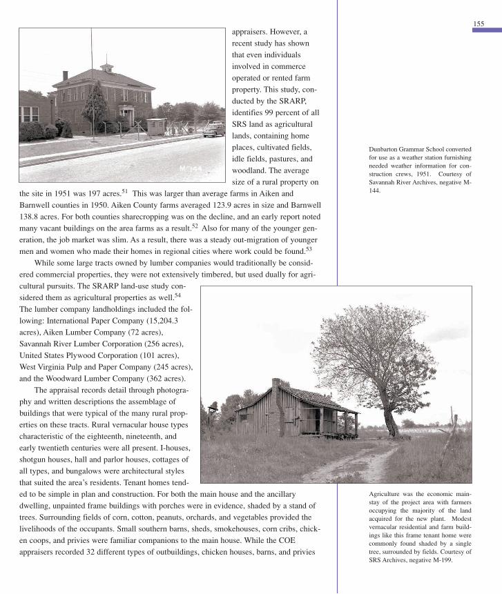

mechanics of the many small close-knit communities in the project area at the point of
change:
Communities have been small and unchanging. Families of
whites and Negroes have worked together for decade on decade,
the one guaranteeing a minimum of physical security, the other
providing hands to till the soil, and the labor for the stores, the
yards, the homes. Neighbors and relatives have valued highly the
personal, close ties of life on settlements where everyone knew
everybody else’s joys, sorrows, scandals, and hopes.58
157
were the most prevalent. If a property had a tenant or sharecropper’s home on their farm,
this secondary dwelling probably had its own “area.”55
Churches, cemeteries, and schools anchored the scattered rural communities. While an
occasional poker game, cockfight or “snort” of moonshine was tolerated, area residents
placed a high value on church attendance and membership.56 Baptist, Methodist, and
Methodist Episcopal churches predominated among the 44 church congregations and reli-
gious societies that owned land in the project area.57 Rural and urban, frame and brick,
these buildings provided structure to the landscape and the people they served. A
University of North Carolina study of urbanization in the area in 1954 describes the
Chapter Eight
VALUATION OF IMPROVEMENTS
Kind Size Construction Roof Foundation Condition Present Value Salvage Val.
6-rm dwelling (3379) 14x42
Ell 22x24 Frame Metal Brick Piers Fair 2,000.00 350.00
Privy (3380) 4x4 Frame Wood Shingle Wood Poor 5.00 XXX
Stable (3381) 8x14 Frame Board Wood Poor 15.00 XXX
Corn Crib (3382) 14x18 Frame Metal Wood Block Good 125.00 20.00
Barn (3383) 10x40 Frame Metal Brick Piers Poor 135.00 25.00
Shed 10x12
5-rm Ten. House (3384) 20x25 Frame Metal Wood Poor 300.00 40.00
Barn (3385) 10x12 Pole Metal Wood Poor 50.00 10.00
Shed 10x12
Main house – 1 story unpainted – 12 windows – 5 doors – no electricity – 2 chimneys I flueSills 6 x 6 Floor Joists – 2- 10”x 30” cts190’ deep well – 2” casing hand pump 175.00 10.00
Approximately 410’1” pipe galvanized A.15 61.50 20.00
TOTAL* $2,866.50 $475.00
* Estimated contribution improvements to appraised market value of the property as a whole.
This sequence of photographs showsthe appraisal record captured on filmfor one tract of land. Each buildingwas assigned a number. Seven build-ings are shown including a main housedenoted as a six-room unpainteddwelling on brick piers with twelvewindows and five doors with a kitchenell on its back elevation, a privy, stable,corn crib, barn and shed. In addition afive-room tenant house with a barn andshed was also recorded. Courtesy ofDepartment of Energy, SiteAcquisition Appraisal Records.
VALUATION OF LAND
Present Use Soil type Topography Area Unit Value Total Value
Cultivated & Idle DSL Level-Undulating 73 45.00 3,285.00
Cultivated OSL Undulating 6 40.00 240.00
Cultivated & Idle OLS Undulating 25 30.00 750.00
Idle OLS Level 23 25.00 575.00
Reverting DLS Level 57 15.00 855.00
Woodland (Upland) OLS Undulating 24 10.00 240.00
Woodland (Swamp) PLS Level 88 6.00 704.00
TOTAL 171.00 $6,649.00
Source: Cabak, Melanie A. and Mary M. Inkrot. Old Farm, New Farm An Archaeology of RuralModernization in the Aiken Plateau, 1875–1950. Savannah River Archaeological ResearchPapers 9, Occasional Papers of the Savannah River Archaeological Research Program, SouthCarolina Institute of Archaeology and Anthropology, University of South Carolina.
Appraisal Report for Land and Improvementsfor the J. B. Large Tract (F-546–296 acres)
An Atomic History 08 8/11/02 7:54 AM Page 156

Attesting to this sense of community, many of these churches would be moved to new
locations where a majority of their congregation was relocating.
Community schools were listed in the acquisition records. There were 23 schools of
various sizes in the project area that served the area’s children. Their names, enrollment
for the beginning of the 1950/51 school year and number of teachers are shown below.
Name County Pupils Teachers
Ellenton Aiken 290 12
Ellenton Aiken 123 4
Brinkley Aiken 73 3
Bloomingdale Aiken 47 2
Fairfield Aiken 27 2
Oakview Aiken 12 1
Greendale Aiken 43 2
Willow Pitt Aiken 25 1
Mill Branch Aiken 11 1
Mossy Aiken 17 1
Dunbarton Barnwell 44 3
Thomas Grove Barnwell 330 12
Union Branch Barnwell 29 1
Fair Branch Barnwell 34 1
Union Branch Barnwell 40 2
(Four-Mile District)
Haley Branch Barnwell 28 1
Craig Pond Barnwell 22 1
Ashley Grove Barnwell 45 2
St. Luke Barnwell 31 1
Gum Pond Barnwell 60 3
Ned Branch Barnwell 68 2
Four Mile Park Barnwell 119 4
Spring Branch Barnwell 50 2
Total Pupils 1,568 64
Only two of the above schools were attended by white students; the remainder served
African American students. The Ellenton schools closed in February; their closure was
delayed until a new school in Jackson was completed. Unlike the Ellenton students, stu-
dents at the Dunbarton School completed their school year in June 1952.59 Places for all
children had to be found at either new schools or at already established outer community
schools. Local school boards began to work with AEC officials almost immediately in
planning closures and in realigning school districts to accommodate the substantial
changes in their school populations.
159Chapter Eight
Another day of comotion all day don’t Suppose there will ever be another
day of Happiness here Since the Government has come in and hit a death
blow on this part of the world see nothing and hear nothing else -
December 4, 1950
don’t think there was ever a Saturday night Since Dunbarton was in exis-
tence that there was so few people here all stores closed before the reg-
ular time no money and no one knows what to do or where to go
- December 30, 1950
Things have changed up a little in the place with the government they
come in today and informed Henry Moody Bo Corley and Lane they would
have to be out by April the 1st has got things all up in the air we don’t know
what to expect next. - January 12, 1951
Ham Dicks had a sale today at his farm they say there was quite a crowd
there Margaret had to go up with Ham to keep records - January 31, 1951
I cleaned up the backyard this AM and opened up the flower pit and taken
out what was left in it. think I will fill it up. don’t suppose they will ever need
it again here. there has been a good deal stirring around here today.
guess things will soon be different - February 12, 1951
They had a regular election to see what should do with the church funds
and parsonage a lot of confusion too - February 18, 1951
Today has been a busily day around here they had a bake sale on
Clarence Dicks all daylong there was quite a crowd attended the Sale they
sold Clarence Albert Ellis & Geddings Farm implement I went over for a
few minutes this AM don’t think they finished up. I could hear them at Sun
Set. - February 28, 1951
We all went to ride taken Jule up to see the Bumed Area up by Rouse
Bridge and on up to New Ellenton and back by Ellenton. - March 18, 1951
The Government Man was here this PM and settled up for the old
Homeplace after being in the family for 80 years or more it don’t seem fair
that Such a thing could happen. - July 5, 1951
They started up with the House (old Home Place) today got the Kitchen
& dining Room as far as the Bay just below Hams Fertilizer House the
dwelling got as far as Clarence Dicks Corn Field. - August 1, 1951
They moved Thomas Grove Church today takeing it out about Elko.
September 13, 1951
Done nothing all day. Dupont work in full blast from the way the machines
are passing through here during the day. the House movers are busiy too.
Wallace Harley house got this far in PM that makes 3 I have seen pass
through today. Beatty Gin
House caught on fire this PM.
Dupont fire Truck put it out. -
October 12, 1951
One year ago today the
Government anounced they
was going to take over every-
thing in this part of the country
there has been quite a change
Since Tuesday November
1950. old Homes that had been in the family for generations has been
vacated and they have moved to new Homes. Some locaitys there is noth-
ing left to mark the old Home Site. never in the History has people been
so demoralized as they have been during the past year. They have not
taken Dunbarton yet but we are expecting it to happen any day. One year
ago today the Government taken Over. - November 28, 1951
Clarence Dicks moved his clubHouse from his fish pond to Barnwell
today. - December 6, 1951
No doubt today was the quietest Christmas Day that was ever seen here.
and as we stop to think this will be the last Christmas that will ever be
spent in Dunbarton. enough to make all feel Sad for Soon it will a thing of
the past like the song, I use to hear that my old Daddy did love to hear
Jerry Snelling Sing the words of it was (Far Away). - December 25, 1951
Today winds up the old year 1951 and none of us can realize the many
changes that has been made this year. and Soon (there) will be more as
it (is) just a question of time (until) Dunbarton will be like other places. a
thing of the past. Meyers Mill passed out today. the PO and mail Route
was closed today. we can all see now what the Government has done for
us. Dupont will Soon blot Dunbarton (off) the map. it is hard for the peo-
ple to understand why we have to give up our Home and locality
Somewhere else. (we) do not know where we will live to see it closed out
if I am living. hope God will give me the courage and strength to leave the
old familiar places with a Smile instead of sheding tears. - C.S. Anderson
Diary, December 31, 1951
Source: Richard Johnson, Jr, Tonya Algerine Browder, Richard David
Brooks, and David Colin Crass. Memories of Home: Dunbarton and
Meyers Mill Remembered. Savannah River Archaeological Research
Heritage Series I. Occasional Papers of the Savannah River
Archaeological Research Program, Community History project, South
Carolina Institute of Archaeology and Anthropology and University of
South Carolina, 1993: 56.
Excerpt from C. S. Anderson Diary
C. S. Anderson and son Randolph, circa
1920. Photograph courtesy of Margaret
Anderson and the Savannah River
Archaeological Research Program.
“The school was constructed in theearly 1920s and was built by a Mr.Rosenwall as a gift to the people. Theschool was known as the Academy.Then a group of black churches, calledthe Association, took over operation ofthe school and changed the name toThomas Grove. Later the state tookover and that was when the name waschanged to Four Mile, because of theFour Mile Association. Four Mile alsohad a boarding house, because it wasthe only black school in the area.Children came from all over the coun-ty came to the school. They wouldcome to school on Sunday and go backhome on Friday.” Source: RichardJohnson, Jr, Tonya Algerine Browder,Richard David Brooks, and DavidColin Crass. Memories of Home:Dunbarton and Meyers MillRemembered. Savannah RiverArchaeological Research HeritageSeries I.
An Atomic History 08 8/11/02 7:54 AM Page 158

Ellenton, incorporated in 1880, was a railroad town 25 miles southeast of Augusta
founded by a number of wealthy land-owning families including the Bush, Dunbar,
Ashley, and Buckingham families.60 These same surnames occur in the 1950 acquisition
records, joined by the Cassels, Brinkley, Risher, and Smith families. All appear to have
deep roots in the commu-
nity in which they and
their extended families
lived. Ellenton’s half- and
one-acre rectangular lots
within a one-mile-square
incorporated area, reached
back away from the tracks
of the Charleston and
Western Railroad. River,
Jackson, and Dunbar
streets paralleled the rail-
road; Evergreen, Center,
Fair, and Church streets
paralleled Main Street. South Carolina State Highway 28 also sliced through the eastern
edge of town. Some roads, such as Main Street, were paved while side streets were typi-
cally unimproved. The town’s 1950 population was 746 prior to the announcement.61
Housing ran the gamut from large mansions to smaller frame vernacular buildings
such as central-hall homes or hall and parlor types. The presence of bungalows and cot-
tages attest to Ellenton’s twentieth-century growth. County tax records show that Ellenton
had 56 merchants whose respective businesses were housed in 33 buildings in 1950. Main
Street was the place where businesses clustered. The Cassels Family, a major force in
modernizing Ellenton and wielding considerable influence in town affairs, operated the
“Long Store” on Main Street. The frame commercial building,
210 feet long and 41 feet wide, was a town fixture; most resi-
dents and farmers from outlying areas remembered the store
that had everything from “toothpicks to coffins.”62 In addi-
tion, this family built and operated a power plant and owned a
Standard Oil and Gas franchise, two funeral homes, a dairy
farm, a sawmill, several large farms, the telephone company,
and the bank. Other Ellenton businesses included barbershops,
a dry cleaner, auto garages, a movie theater, a drugstore, two
icehouses, auto parts store, a Chevrolet dealership, a post
office, several restaurants, and a hotel.
Churches, such as Ellenton Baptist Church, Ellenton
Christian Church, Ellenton Methodist Church, Four Mile
Baptist Church, House of Prayer, Mount Mariah Baptist
Church, and Runs Missionary Baptist Church, served the
town’s white and black congregations. Children were educat-
ed at two schools. African American children attended a grammar school in town that
ended at the seventh-grade level. For their high school education, these children attended
Four Mile High School in Dunbarton or Schofield School in Aiken. Attending either
161
TOWN CLOSURES
On April 23, 1951, the AEC asked the COE to move forward with
appraisals of Ellenton and Dunbarton. The need to expedite the process
stemmed from changing construction requirements and from a request
from town officials to get the process underway so residents could begin
planning their futures. Mapping the town was their first priority, and this
was forecasted to be a two-month proposition. The maps and appraisal
records prepared by the COE along with the comments of the residents
quoted in newspapers or captured in oral history accounts offer an
incomparable image of these towns and their environs before they dis-
appeared.
Chapter Eight
(Opposite Page) February 29, 1952,the last day for postal service forEllenton Post Office, is reported onlive by Augusta’s radio station WGACcrew. Courtesy of SRS Archive, nega-tive M-581.
(Below) Oswalt House MovingCompany of Batesburg, S.C. jacks up ahouse to prepare it for moving offsite.Courtesy of SRS Archives, negative9273-1.
Mike Cassels, the proprietor of the Long Store turned UPI corre-
spondent, wrote a story about the end of his hometown:
“It wasn’t a very beautiful place except to the people who lived
there. The railroad ran through the middle of town, and the folks who had
nothing better to do met the 4:30 passenger train, which we called ‘Fido’.
Lord knows why.
The depot was right across the street from my father’s general
store….That was the center of town because the fire bell was there too.
In the winter, the farmers would stand around the pot-bellied iron stove
in the long store and wonder whether it would ever quit raining. In the
summer, the fields turned white with cotton and the sun that baked down
so intensely that it was hard to find energy enough to do anything except
go swimming in the creek, or eat a cool watermelon or plan a possum
hunt for the cool of the evening.
That was the way it was when my
grandfather was a boy, and that’s the
way it still was when I took my son there
for the first time a few years ago.
I am afraid my son won’t remember
it that way, though. What little Mike will remember, I suspect, is all the
noise and confusion and feverish activity which has descended on
Ellenton when he made his last visit to grandmother’s house last
Thanksgiving. Armies of bulldozers were snorting through the cotton
fields, turning them overnight into flat expanses of land.”
Source: The Augusta Chronicle, November 29, 1950.
Photograph Source: Louise Cassels, The Unexpected Exodus, (Aiken,
SC., Sand Hill Press,1971).
“The first of the house movers, a
man by the name of Ralph South,
set out for these parts from Ordway,
Colorado, on November 28th, the
day the government announced
the project.”
Daniel Lang, “Camellias and
Bombs, ” The New Yorker, July 7,
1951.
The End of a Hometown
(Inset) Cassels’ Long Store, was anEllenton landmark on Main Street.The 210’ general store built circa 1900heated by a pot-bellied stove was animportant gathering place for thetownspeople. "From early morninguntil late afternoon, male customerscoming into the store would take timeto ‘set a spell’ in these chairs. Theydebated how to correct the evils of theworld, the nation and the state.Somehow I doubt there was much wis-dom imparted around that hot stove,but judging from the laughter, theremust have been a lot of wit…” Source:Louise Cassels, The UnexpectedExodus, (Aiken, SC., Sand Hill Press,1971), 54. Courtesy of SRS Archives,negative 6675.
An Atomic History 08 8/11/02 7:54 AM Page 160

of Bay Street. The town’s com-
mercial area and public build-
ings were contained on about 17
lots that were sandwiched north
of the railroad but south of SC
Highway 64.
Dunbarton was home to
about 300 people in 1951; the
majority of the population were
old time residents. Sixty-six
landowners were contacted
about Dunbarton property. The
Anderson, Brailsford, Dicks,
Doe, Eaves, Greene, Hiers,
Moody, Rountree, Schumpert,
Tisdale, Wall, Whaley, and
Williams families are well rep-
resented in the acquisition regis-
ter. While the COE acquisition
planning report counted 15
commercial buildings, 35 homes, 2 gins, a church, a sawmill, a school, and a railroad sta-
tion, the actual acquisition records show there were additional buildings in the small agrar-
ian community. The two-story brick grammar school and the high school were open from
1920 through 1950 for white children. Four-Mile High School, which taught eleven grades
for the black community, was also in the general community. This single-story frame
school had dormitories so that students who had to travel to get to school could be accom-
modated during the week.68 Churches, particularly Baptist churches, were plentiful in and
around the community. Cypress Chapel–Dunbarton Baptist Church, St. Luke Baptist,
Bethlehem Baptist, Joyce Branch Church, Pleasant Mountain Baptist Church, Ned Branch
Baptist, and Steele Creek/Meyers Mill Baptist Church were all described in a community
history.69
Dunbarton’s house types reflected the community’s rural origins and primarily con-
sisted of I-houses and vernacular farmhouses such as hall and parlor types. Photographs
shown in a community history show up-to-date remodeling, as older house types are dis-
cernible behind more fashionable bungalow details. A small brick jail comprised the sole
municipal improvement. The town was electrified but had only two telephones. Its post
office was perhaps its most well known building. The Rountree, Hiers, Anderson, and
Dicks families operated several general stores, and in 1950 Barnwell County’s first depart-
ment store, the Western Carolina Trading Company, opened in Dunbarton.70
Meyers Mill stretched along the Atlantic Coast Line. The Ellis, Halford, Hankinson,
Meyer, Peeples, Phenix, Simon, and Swett families owned small lots in the mill area, all
one acre or less in size. Olan Meyer’s cotton gin was the major business in the community.
Leigh, an industrial village that produced crates and boxes, was also taken. The only large
industrial operation in the plant area, the banana case factory, was in operation from 1926
to 1952. Mill housing was available for workers, and the mill village also had a church,
store, and hotel. Up to 350 people would work at the plant during their springtime peak
163required traveling long distances. White children attended both grammar and high school
in a new complex that featured a gymnasium and other new improvements, indicating that
Ellenton was building for its future.
After the appraisals began, change rapidly occurred in Ellenton. The business people
were the first to evacuate, followed by their employees. Louise Cassels described Ellenton
in the spring of 1951 as a “well groomed corpse.” Residents spruced up their homes, gar-
dens were well tended, and interiors kept immaculate as residents waited for the apprais-
er’s knock on the door.63 Over the next year, the town and its environs would take on a
“snaggletooth” appearance as houses and other improvements were moved away. Du Pont
assigned an engineer–coordinator, D. M. Murphy, to aid those who wished to move their
homes to other sites and to coordinate those moves with their construction schedule.
Murphy was responsible for removing overhead wiring in Ellenton and on certain high-
ways to assure that the houses were safely moved through the plant area, and for schedul-
ing and coordinating the expected 200 to 300 house moves from Ellenton and Dunbarton.
By January 1952, one source reported that owners had removed only 75 buildings of all
types from Ellenton.64 This was almost half of the town’s total building stock. A subse-
quent report noted that five other buildings had been removed and several more still were
to be moved.65 The new owner left municipal buildings in place for use. Curtis Nelson
reassured all that any building that remained on the AEC plant area would be used not
indiscriminately razed.66 He also noted that buildings with historical significance would
be protected.67
Ellenton was to be evacuated by March 1 and Dunbarton by April 1. Dunbarton, a
nineteenth-century railroad community named after the Dunbar family, was incorporated
in 1910; its town limits extended one mile in all directions from the Atlantic Coast Line
railroad depot in its center. The majority of the town was situated south of the tracks of the
Atlantic Coast Line along Main or Hickory Street and off the three blocks that were south
Chapter Eight
Dunbarton Baptist Church, circa 1950.Courtesy of the Zobel Family.
Dunbarton Post Office was a locallandmark and community gatheringspot. Courtesy of SRS Archives, neg-ative 6684.
Detail of Post Office entry wherepostal customers pause to look at COEsurveyor at work. Profile of surveyoris reflected in window glass.
An Atomic History 08 8/11/02 7:54 AM Page 162

brought its death as she watched the huge shipments of construction materials offloaded at
the Ellenton station. By the time she left her home in March, neighbors’ homes had
become “pipe shops” or storage buildings for other construction materials. Familiar places
and placenames were fast disappearing. Even the composition of her classroom, now in
Jackson, had changed. “Trailer children” attended classes along with the local children.
The construction force had arrived.
165season in preparation for the peach
harvest.71 Other smaller crossroad
communities or “whistle stops” were
also in existence such as Hawthorne,
a community of dispersed farm-
steads, and Talatha, Robbins,
Greenland, Skinface, Hattieville, and
Bush.
Although they constituted only
one percent of the land area, the
removal of these communities—
Ellenton, Dunbarton, and to some
extent Meyers Mill and Leigh—cap-
tured the nation’s attention. Some
residents held onto the hope that the
two larger towns could be saved,
some even inquired about whether
their land could be bought back
when the government was done with it.72 Reporters chronicled the process, writing objec-
tive stories about their plight and more emotional pieces that went right to the heart.
Historian James O. Farmer’s study of the impact of the plant on Aiken shows that as the
meaning of the plant finally sunk in, reactions varied among the displaced from anticipa-
tion, patriotic resignation, resentment, to self-pity.
The young, who saw excitement in the many changes, and those who profited from
the plant’s coming, were the happiest. H. M. “Mike” Cassels, one of the latter, would tell a
New York Times reporter that “I haven’t got a gripe in the world.” The government pur-
chased his store and his gas station. He then liquidated his stock, bought the gas station
back at the salvage price of 12 percent and moved it to New Ellenton, a community form-
ing at the plant’s northern rim. The AEC was buying 9,000 gallons of gas from his new
operation per day.73
The elderly, both black and white, were the least happy. Their emotional investment in
their homes and communities was too great to measure in dollars.
Eighty-seven-year old “Miss Ida” Jones had lived in the same
house for sixty-seven years. She met her fate with the quiet resig-
nation of the powerless. Dr. Fred Brinkley took the news harder.
Also a lifelong resident, he had been present at the births and
deaths of many of his neighbors, and had treated them as long as
many could remember. The Times reporter who interviewed him
wrote that “he cannot reconcile himself to the evacuation.”….
Another local doctor, Paul Culbreath, predicted that most of the
evacuees would not long survive the trauma of their forced uproot-
ing. Many, including himself, would bear out his prophecy.74
By the end of June all former inhabitants, about 1500 families, were evacuated.
Louise Cassels stated with irony that the railroad was the impetus for Ellenton and it also
Chapter Eight
Mrs. Ida Jones, at age 87, was one ofEllenton’s oldest residents. Courtesyof SRS Archives negative M-455.
"It is hard to understand why our townmust be destroyed to make a bomb thatwill destroy someone else’s town thatthey love as much as we love ours. Butwe feel that they picked not just thebest spot in the U.S., but in the world.We love these dear hearts and gentlepeople who live in our home town."
Bonner Lee Smith’s words of protestwritten in December 1950 and mount-ed on an Ellenton town sign havebecome an icon at SRS. "In December1950, I was working for Leigh BananaCase Company. When I went home tolunch that day, I went by Cubie Hill’sHome & Auto Supply and bought abottle of Griffin shoe polish or dye for15 cents. When I got to the mill, Iwent over to the Cleat Mill and got five13/16 black gum boards. I went backto the box factory, laid the boards onthe floor and started writing. I had noscript or plan as to what to say…. Thatafternoon, when I went home, I nailedthe boards on the sign." Source:Maureen B. Chavis, Aiken Standard,November 27, 2000.
An Atomic History 08 8/11/02 7:54 AM Page 164