Ames Urban Fringe Plan
48
A A m m e e s s U U r r b b a a n n F F r r i i n n g g e e P P l l a a n n City of Ames City of Gilbert Boone County Story County JULY 2006
Transcript of Ames Urban Fringe Plan
AAmmeess UUrrbbaann FFrriinnggee
PPllaann CCiittyy ooff AAmmeess CCiittyy ooff GGiillbbeerrtt BBoooonnee CCoouunnttyy SSttoorryy CCoouunnttyy
JULY 2006

Ames Urban Fringe Plan 2
Table of Contents Table of Contents................................................................................................2
Why Cooperate to Plan and Manage Land Use?..............................................3
Planning Area Boundary ...................................................................................4 Purposes of Planning in the Ames Urban Fringe...............................................5
Planning Context ................................................................................................8
Guiding Principles for Cooperative Planning.................................................11
Vision and Goals for the Urban Fringe ...........................................................14
Identifying Issues.............................................................................................14 Balancing Issues .............................................................................................15 Common Goals for the Urban Fringe ..............................................................16 Distinct Land Use Classes ..............................................................................17 Rural Service and Agricultural Conservation Area ..........................................18 Rural/Urban Transition Area............................................................................19 Urban Service Area .........................................................................................21
Land Use Framework Plan and Policies .........................................................24
Land Use Designations and Policies for Rural Service and Agricultural Conservation Area...........................................................................................25 Land Use Designations and Policies for Rural/Urban Transition Area ............28 Land Use Designations and Policies for Urban Service Area..........................36 Additional Policies for All Areas.......................................................................40
Implementation .................................................................................................44
Overview .........................................................................................................44 Jurisdictional Influence ....................................................................................44 Development Regulations ...............................................................................46 Relationship to Budgets and Capital Improvement Plans................................47 Plan Implementation Program.........................................................................48
Land Use Classes Map
Land Use Framework Map
Ames Urban Fringe Plan 3
Why Cooperate to Plan and Manage Land Use? Iowa law delegates authority to county governments to regulate land uses outside city boundaries. The Code of Iowa also enables cities to exercise control over subdivision of land outside, but within two miles of, these corporate boundaries. Generally, communities plan for the future of the lands located within their incorporated limits, extending only limited distances beyond these established boundaries. With many overlapping jurisdictions governing land uses and subdivision approval in such areas, clear and consistent plans and standards need to be developed in order to successfully manage growth and development. The area within two miles of the City of Ames (in this plan, commonly referred to as the “Urban Fringe” or “fringe area”) is located mostly within western Story County and partially within the eastern part of Boone County. It also overlaps areas within two miles of the city boundaries of Gilbert and Kelley. The areas surrounding the City of Ames (including areas around the City of Gilbert as well as the City of Kelley) are subject to the land use regulations of Boone and Story County as well as subdivision review by each affected community. The City of Ames has exercised this subdivision review authority for many years to regulate the division of land within Story and Boone County. The Urban Fringe around the City of Ames has historically been one of the major rural "growth" areas of unincorporated Story County. When the Land Use Policy Plan (LUPP) was adopted by the City of Ames in 1997, the City identified a planning area extending two miles from the City’s boundary, recognizing the need for cooperative planning efforts. Gilbert, as well, in the Gilbert Comprehensive Plan adopted in 2003, identified both a Study Area and a Planning Area extending into the area within two miles of the Gilbert city boundary (also crossing into the Ames’ two-mile boundary). Story County further identified the need for cooperative planning among the various overlapping jurisdictions in the Story County Development Plan – Land Use Framework adopted in 2003. As all jurisdictions update and adopt new regulations, it becomes clear that shared and consistent planning objectives need to be identified to manage development in and around communities. The Ames Urban Fringe Plan is a shared land use plan cooperatively developed by Boone County, Story County, the City of Ames and the City of Gilbert. The Plan provides guidelines for understanding and predicting future land use planning for the area. The Plan consists of written principles and policy statements, along with a Land Use Framework Map, which, together, establish guidelines and locations for areas of growth, agricultural land preservation, and natural areas protections. This Ames Urban Fringe Plan is intended to serve as the blueprint for cooperation among the various governmental entities, providing a road map to an agreed future. Cooperation will help each entity manage its land resources, services, service capital, and infrastructure systems more efficiently and effectively; coordination will lead to better management of public resources.
Ames Urban Fringe Plan 4
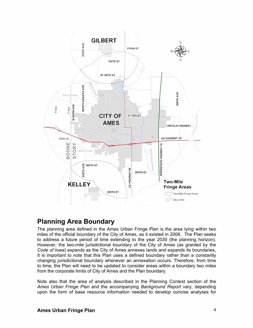
Planning Area Boundary The planning area defined in the Ames Urban Fringe Plan is the area lying within two miles of the official boundary of the City of Ames, as it existed in 2006. The Plan seeks to address a future period of time extending to the year 2030 (the planning horizon). However, the two-mile jurisdictional boundary of the City of Ames (as granted by the Code of Iowa) expands as the City of Ames annexes lands and expands its boundaries, It is important to note that this Plan uses a defined boundary rather than a constantly changing jurisdictional boundary whenever an annexation occurs. Therefore, from time to time, the Plan will need to be updated to consider areas within a boundary two miles from the corporate limits of City of Ames and the Plan boundary. Note also that the area of analysis described in the Planning Context section of the Ames Urban Fringe Plan and the accompanying Background Report vary, depending upon the form of base resource information needed to develop concise analyses for
Ames Urban Fringe Plan 5
planning purposes. For example, Census block group boundaries are different from watershed boundaries and are also considerably different from soil type boundaries.
Purposes of Planning in the Ames Urban Fringe In the Ames Urban Fringe, overlapping regulations (some more restrictive than others), different policies, and overlying service jurisdictions all exist. Despite existing cooperation among governmental entities, each affected jurisdiction shares concerns about issues and impacts from land development in fringe areas, including:
• Overlapping regulations of different local jurisdictions; • Inconsistencies among different land use policies; and • Impacts of development on rural/agricultural activities.
Further description of each of these impacts follows. The separate Background Report contains research information and analysis on these and many other issues related to conditions in the planning area.
Overlapping regulations of different local jurisdictions There are many different stakeholders in the identified planning area, each with unique purposes, powers, plans, and priorities for development. Service providers and governmental units include school districts, rural water districts, drainage districts, fire districts, law enforcement agencies, ambulance and emergency service providers, and environmental stewards. Different land use policy plans, subdivision regulations, permitting standards, and zoning criteria overlap in the Ames Urban Fringe. Overlapping jurisdictions cause intergovernmental inefficiencies and sometimes impose financial burdens on those governments; the lack of coordination and shared knowledge among government agencies can lead to miscommunication and conflicting objectives. Each governing entity can find itself in a reactive role, dealing with problems and inconsistencies after an issue has occurred. Layer upon layer of service providers and governmental organizations impose respective polices, regulations and practices upon private property owners. Private property owners receive inconsistent direction regarding what is and what is not acceptable. This is difficult and frustrating for landowners who are trying to preserve, improve and/or maintain their property.
Inconsistencies among different policies on land use Lack of coordination hinders each government’s ability to effectively accomplish its own land use goals. The regulations and policies of one county, city, or other related agency might undermine or hinder the regulations and policies of others. Lack of coordination and cooperation could lead to poor land use decisions that would be difficult, if not impossible, to reverse or correct at some time in the future. Such inconsistencies and potential for conflict and increased public costs demonstrate the need for shared vision and planning.
Impacts of development on rural/agricultural activities Decisions affecting growth and development have long-term impacts on many conditions and resources in the planning area. Growth brings a need to carefully balance the needs of residents and businesses within the cities and counties involved without sacrificing the area’s assets and quality of life. Positive assets and quality of life are

Ames Urban Fringe Plan 6
often associated with growth’s long-term impacts on preservation on natural resources, public health, transportation resources and adequate provision of emergency services. Impacts of development on these areas are further discussed below. Environmental Quality Decisions affecting growth and development have long-term impacts on the condition of such environmental factors as soils, groundwater, rivers and major drainageways, steep slopes, scattered woodlands, natural prairies, and wetland areas. These natural areas provide habitat for wildlife and are necessary to sustain and support environmental systems (ecosystems). These resources also minimize the negative effects of stormwater run-off, stabilize soils, modify climatic effects, provide visual attractiveness, and serve as recreational areas. Development encroaching stream corridors, wooded areas, natural vegetation areas, and the like, reduces the quality and extent of these areas for wildlife habitat and the other environmental benefits they provide. Impacts can be direct, as in removing or altering the habitat itself, or indirect, such as increased human activity decreasing vegetation species diversity or increasing predator animal species. Identifying such resources, and cooperatively planning in order to sustain the natural areas within the planning area, helps mitigate the negative affects of growth and development on these areas. Transportation Facilities Because of their convenience, safety, and speed of travel, paved rural roads attract development in the Ames Urban Fringe. As suitable sites become less available on paved roads, development also occurs on secondary roads with rock surfacing. As traffic increases on secondary road networks, road rebuilding and surfacing may be necessary, as well as widening existing lanes, adding lanes, increasing shoulder widths, or completing more capital intensive improvements such as bridges, improved intersections, and other traffic control mechanisms. Such improvements may, in turn, encourages more traffic, creating a cyclical effect encouraging more dispersed development patterns, again increasing traffic demand. As a result, costs of maintaining road systems also increase. Emergency Services The Ames Urban Fringe is served by the Story County Sheriff's Department and by volunteer fire departments with second response service provided by the City of Ames Fire Department. Mary Greeley Medical Center, Boone Hospital and Story County Hospital also provide ambulance services. The dispersed nature of rural growth reduces emergency response times and the ability of volunteer organizations to provide services at the same levels provided today in urban areas. Unimproved and/or less maintained street networks may slow response times and make emergency incident locating and mitigation more difficult. School Districts Due to the relatively static nature of school district boundaries, schools pay special attention to residential development trends and patterns. Widespread growth, especially at very low densities, can impact revenues, service levels, efficiencies of school infrastructure and resources and the ability to sustain educational services. For example, busing is a large cost associated with educational services. The more residential

Ames Urban Fringe Plan 7
structures are dispersed, and the development of non-urban street facilities increases, busing costs increase as well. Agricultural Production As the number of farms decrease, replaced by residential or other non-agricultural development, the ability to effectively operate family-owned farms decreases. Farmers, often required to travel greater distances to rent land, feed and seed, move equipment, and ship product, face increased costs to farm. In addition, as land values increase due to adjacent residential development, new farmers meet cost barriers that hinder establishing new farming or expanding existing operations. Without carefully planned buffers and areas designated for agricultural uses only, dispersed and increased residential and other non-agricultural uses can work against the long-term future of agricultural production within the two-mile fringe area. As the fringe area develops, dispersed non-agricultural residential development can conflict with agricultural operations and facilities. Agricultural production activities, such as spraying, harvesting, manure spreading, odorous activities, and other operations may conflict with residential development.

Ames Urban Fringe Plan 8
Planning Context The Ames Urban Fringe Plan is accompanied by a Background Report detailing forces shaping the Urban Fringe including the physical environment, growth trends, and community values. Due to its length and level of detail, the Background Report is printed in a separate document. Nonetheless, it is important to note that the information base in the Background Report defines the context from which the Plan and Land Use Framework were developed. Some of this foundational information is summarized below. For more detail, please refer to the Background Report. Natural Resources The Ames Urban Fringe contains scattered woodlands, natural prairies, wetlands, rivers, lakes, and streams. These natural areas provide habitat for wildlife, minimize the negative effects of stormwater run-off, stabilize soils, modify climatic effects, provide visual attractiveness, and serve as recreational areas. The Ames Urban Fringe also benefits from the economic and cultural value of high-value agricultural lands and associated open spaces. Despite the inherent attractiveness of these resources, these and other natural features may pose significant constraints to development. Environmental factors that challenge development include steep slopes, sensitive soil conditions, propensity for flooding, and conditions of shallow depth-to-bedrock that increase the potential for groundwater contamination as a result of human activities. The public benefit of these natural features also often outweighs that of expanding adjacent development.
The following statistics highlight some of the past trends related to development and natural resources in the Ames Urban Fringe:
• From 1990 to 2000, an average of approximately 12 acres of land per year were
absorbed by single-family residential growth in areas defined (at the time) as Critical Resource Areas according to the Story County Development Plan. At a typical lot size of three to three and one-half acres, this roughly translates to four residential lots per year.
• From 1990 to 2000, approximately 35 acres per year were absorbed within 1/8 mile from waterways, and 30 acres per year of soils with a poor rating for septic systems were absorbed.
• From 1990 to 2001, approximately 18 acres of land per year were developed within areas designated as Natural Areas in the “Norris Study” (City of Ames inventory of natural areas).
Demographics Since 1970, population growth in the Ames Urban Fringe has been greater than the total unincorporated, rural population growth in Story County. The decade of 1970 to 1980 saw a significant population loss for rural Story County. During this same period, the fringe area experienced population gains. Likewise, the decade of 1990 to 2000 saw an increase in population growth for unincorporated Story County; however, the Ames

Ames Urban Fringe Plan 9
Urban Fringe population grew at a rate two to three times faster than the total population for rural, unincorporated Story County. When the Ames Urban Fringe growth was excluded from the unincorporated population from 1990 to 2000, the unincorporated area population decreased, suggesting that net increase in population occurred in the Ames Urban Fringe.
Residential Development Between the years 1970-2001, the land absorption rate due to non-agricultural single-family residential growth in areas considered prime agricultural land by the USDA averaged approximately 27 acres per year. Based on a 30-year housing projection, the Urban Fringe population is expected to increase by 50% by the year 2030, an increase of approximately 1,100 people. Based on an average of 2.39 people per household, there will be a need for approximately 460 more housing units in the Urban Fringe to accommodate this growth trend by the year 2030 (approximately 15 units per year).
Agricultural Production When land use policy from Story County, Boone County, and Story County is overlapped, over 80% of high value agricultural land (as defined by the USDA) in the Urban Fringe falls into an agricultural land use designation.
Other Physical Development The majority of commercial development within the Ames Urban Fringe is generally located along the southeast area adjacent to Highway 30, just east of Interstate 35, and within Boone County along Lincoln Way. There are no well-defined commercial centers located in the Ames Urban Fringe.
Like commercial growth, the majority of industrial development within the Ames Urban Fringe is generally located along the southeast area adjacent to Highway 30, just east of Interstate 35, and within Boone County along Lincoln Way. Limited industrial activity does occur northeast of Ames, along Arrasmith Trail. There are no well-defined industrial areas located in the Ames Urban Fringe. Industrial growth has developed within the corporate limits of the City of Ames, or has been annexed over the years (after initially constructed under county jurisdictions), to utilize the community’s urban infrastructure. Most of the industrial activity within the Ames Urban Fringe is small in scale and related to rural/agricultural activities.
Employment Commercial and industrial development requires urban services (fire, police, sewer, water, etc.). Therefore, the need for non-residential, rural development in the Ames Urban Fringe is more difficult to predict than residential development. Many of the residents within the Ames Urban Fringe commute to employment within the City of Ames.
Community Values In the spring of 2004, representatives of Boone County, Story County, the City of Gilbert, and the City of Ames met with various groups with an interest or connection to the Ames Urban Fringe to learn about issues, ideas, and aspirations that will affect future use of land. The following is a general summary of input from groups of people represented at these meetings:
Ames Urban Fringe Plan 10
Agricultural Producers Group. Farm ground and agricultural services should be protected. Agricultural producers rely on quality road systems, the freedom to farm, separation from the built environment, eased building and zoning restrictions, and the ability to sell land for its highest and best use. Growth adjacent to farms creates significant compatibility issues and can hinder farming activities. Economic Development Group. The Urban Fringe provides additional housing opportunities that are needed in today’s market. The fringe around Ames allows for large rural lots, a development option many families are seeking. Therefore, cooperative planning should result in the reduction of the amount of red tape developers must go through to develop in the fringe. Provisions should be made for more public infrastructure in the fringe, and efforts should continue to streamline methods for additional rural development.
Environment Group. The Urban Fringe includes delicate ecosystems and valuable environmental resources that are important to the region. Measures must be taken to restrict development in sensitive areas, protect existing natural areas, and enhance natural corridors. Growth should stay within the limits of the existing city. Government/Institutional Group. The operations of Iowa State University must be kept in mind when land is developed in the Urban Fringe. The University maintains many research farm operations that may conflict with rural development. ISU should continue its operations without encumbrance from Urban Fringe land use activities. Development within the fringe must take government operations into consideration. As the fringe area develops, costs will increase for road maintenance, policing, and fire protection. Today, many of these services are straining limited resources to the maximum. School districts must be taken into consideration. As areas develop as single-family residential, they in turn contribute to school capacity costs. Neighborhood/Public Group. Development in the fringe area should respect existing rural residents. Further development can destroy the existing rural lifestyle, add to service costs, and damage the established rural community. Land within the Urban Fringe should be preserved for agricultural and natural resource purposes and growth should stay within the boundaries of the existing city.

Ames Urban Fringe Plan 11
Guiding Principles for Cooperative Planning Cooperatively planning for development offers opportunities to: • Preserve and enhance environmental assets and ecological services; • Efficiently provide infrastructure facilities and services; and • Meet need/demand for certain types of lifestyle/housing choices. Given the varied and often competing interests of the agencies within the Ames Urban Fringe, it is most appropriate that all stakeholders within the fringe come together to create and implement common planning objectives. Each brings its own priorities and agendas to the discussion - in the end, all perspectives must be balanced and mutual priorities established in order to develop a shared and workable framework for city/county land use cooperation. Because the overall objective for all who are affected by development in the Ames Urban Fringe is to further the quality of life, consensus must be established about the best course of action to bring about the greatest amount of good to the area. The first step toward such a consensus is agreement on the principles that are to guide the planning. When the land use policies of Boone County, Story County, City of Ames and City of Gilbert are compared to one another, six common guiding principles emerge. In 2003, the City Councils of Ames and Gilbert and the Boards of Supervisors of Boone County and Story County jointly discussed and agreed to these principles. Generally, these six guiding principles include intergovernmental coordination, prime agricultural land preservation, targeted growth, growth management, transitional land uses, and environmental protection. These shared fundamental values provide guidance to cooperatively plan and manage land use in the Ames Urban Fringe.
Principle 1: Recognizing that population and economic growth is likely, Boone County, Story County, the City of Ames and the City of Gilbert will strive towards intergovernmental coordination for successful planning within the Ames Urban Fringe. • Manage growth -- Growth should be predictable, sustainable, and foster and protect
the quality of life of all citizens. Boone County, Story County, City of Ames and the City of Gilbert seek to manage growth with other governmental agencies whose jurisdictions fall within the Ames Urban Fringe.
• Formal agreements -- The four governmental jurisdictions seek to establish and
maintain formalized agreements to map out responsibilities and obligations of each jurisdiction within the two-mile fringe area of the City of Ames in accordance with this shared land use plan. In addition, Boone County, Story County, City of Ames and City of Gilbert will work with other governmental agencies when further agreements are warranted.
• Planning procedures -- Boone County, Story County, City of Ames and City of
Gilbert seek to establish planning procedures to review and provide
Ames Urban Fringe Plan 12
recommendations regarding proposed land use issues within the fringe area. Such issues could include changes to shared plans and strategy, zoning changes, subdivision coordination, and annexation agreements.
Principle 2: Boone County, Story County, City of Ames and City of Gilbert seek to work together to preserve agricultural lands and protect rural lands from unplanned, rural single-family development and other forms of inefficient urbanization.
• Define prime agricultural lands -- Boone County, Story County, City of Ames and
City of Gilbert have the common goal to reach a consensus on the definition of prime agricultural lands. This common definition shall be the basis for identifying and preserving agricultural resources in the future.
• Uniform approach to analysis -- The four governmental agencies will work together
to adopt a universal and uniform approach to analyze and calculate prime agricultural resources. The method, approach, or tool used for analysis of agricultural land will include the recognition of planned city growth areas, planned county growth areas, environmental resources, crop suitability, and soil conditions. An inventory of prime agricultural lands shall be created and used to establish the demarcation of prime agricultural preservation areas.
Principle 3: Boone County, Story County, City of Ames and City of Gilbert will work together to ensure that future development will be directed and targeted towards identified growth areas, as identified in a shared fringe area land use plan.
• Mutual growth needs -- Each county and city will work together to ensure that
identified growth needs are mutually representative. • Logical growth areas -- The four government entities shall work together to identify
logical growth areas. These growth patterns will take into account urban growth needs, the preservation of environmental resources, the protection of prime agricultural land, and the efficient and effective distribution of infrastructure and services.
Principle 4: Boone County, Story County, City of Ames and City of Gilbert seek effective and efficient management of growth. Growth shall be managed by each government entity in order to minimize negative impacts to another affected governmental entity.
• Joint procedures -- Joint planning rules and procedures shall be adopted by each
government agency in efforts to manage growth. • Shared land use plan -- Boone County, Story County, City of Ames and City of
Gilbert shall share a land use plan for the Ames Urban Fringe. This plan will outline common plan objectives, a unified understanding of growth priorities, the enduring responsibilities of managing growth, and the regulation of existing and future land uses.

Ames Urban Fringe Plan 13
• Common standards -- Clear, concise, and common development standards shall be adopted by each government entity. These standards shall include subdivision regulations, zoning regulations, and permitting rules. These shared standards shall be consistent with a common fringe area plan and form the foundation for managed growth.
Principle 5: In efforts to establish an orderly transition of land uses from urban to rural (as well as rural to urban), Boone County, Story County, City of Ames and City of Gilbert seek to work together to delineate areas of responsibility and come to a common agreement on the definition of rural and urban land uses.
• Define rural uses -- Boone County, Story County, City of Ames and City of Gilbert
shall share a common definition of rural land uses, representing each governmental agency's perspective.
• Spheres of influence -- Preferred land uses and priority areas for growth shall be
defined and delineated on a shared land use plan and map. Each governmental entity shall define critical areas on the map that directly affect the distribution and management of resources and services.
• Consistent criteria -- Boone County, Story County, City of Ames and City of Gilbert
shall establish consistent criteria to address the contiguity requirements for development, established levels of service, design and improvement standards, annexation requirements and procedures, and issues that may surface during future land use planning and development processes.
Principle 6: Boone County, Story County, City of Ames and City of Gilbert seek to establish growth policy within the Ames Urban Fringe compatible with ecological systems. It is commonly understood by each governmental agency that future growth will be compatible with natural resources. Environmental resources shall be protected. • Common resource definitions -- Each governmental entity shall reach a
consensus on the definition and delineation of natural resources. The definition shall outline natural plant and animal habitats, stream corridors, drainageways and flood management systems, scenic areas, open space areas, water quality protection areas, critical watersheds, aquifer protection areas, and air quality protection areas.
• Uniform protection approach -- Boone County, Story County, City of Ames and
City of Gilbert shall develop a uniform approach to protect natural resources. • Watershed management principles -- Watershed management principles shall be
established for future development within the Ames Urban Fringe. These principals shall include standards for nutrient loading, alternative mitigation approaches and techniques, and the development of "best management practices” (BMPs).
The goals, objectives, plans and policies described in this planning document have been guided by these principles.
Ames Urban Fringe Plan 14
Vision and Goals for the Urban Fringe
Identifying Issues Growth pressures around the City of Ames bring challenges to the City of Ames, City of Gilbert, Boone County, and Story County. The issues associated with growth identified in this Chapter form the basis for each jurisdiction’s future land use and growth coordination goals and policies, and justify the strategies recommended in this Plan. The following issues, identified in the planning process, are discussed in detail in the Background Report. These issues bring challenges addressed by policies and strategies embodied in this Plan.
Environmental Issues • Protect properties from flood damage • Preserve prime agricultural land • Protect groundwater, river and stream systems, and potable water quality • Ensure non-agricultural land uses/development adequately addresses constraints
from steep slopes and bedrock • Protect woodland and prairie areas • Preserve and protect (managed) watersheds • Mitigate the negative affects of stormwater run-off • Provide a connected system of open space and greenway corridors
Growth Issues • Manage residential growth in agricultural areas • Promote sound economic development and diversification • Manage impacts from residential, commercial, and industrial growth • Foster efficient growth patterns and land uses • Facilitate intergovernmental coordination between Story County, Boone County, City
of Gilbert, and City of Ames • Establish a common growth strategy that includes a shared vision for the location,
type, intensity, and timing of growth • Reach agreement on the type of services and facilities that should be provided for
urban and rural development • Support the agricultural industry • Reduce commercial leakage • Support health and welfare of all citizens • Identify the necessary amount and appropriate areas for growth • Maximize all forms of transportation networks • Encourage residential growth where services can be efficiently distributed
Community Facility Issues • Plan for the provision of adequate public facilities and services (e.g. streets, utilities,
storm water facilities, fire services/stations, parks, trails and greenways) to serve planned growth
• Protect transportation corridors

Ames Urban Fringe Plan 15
• Provide and maintain an efficient and complete road system • Minimize conflicts between agricultural and non-agricultural traffic • Coordinate roadway and land use decisions • Establish appropriate levels of service • Establish equitable responsibilities for public improvements and services • Facilitate development of telecommunications networks
Regulatory Issues • Ensure that Story County, Boone County, City of Ames and City of Gilbert land
regulations are consistent with each jurisdiction’s land use goals and objectives • Develop consistent and appropriate regulations addressing the unique needs of
urban and rural development
Balancing Issues Cooperation to plan and manage land use requires balancing the many issues arising from simultaneously protecting natural resources, preserving agricultural operations, and accommodating rural and urban development all within the Ames Urban Fringe. The following statements address priorities to help balance conflicts among issues. Agricultural Land Preservation -- means that high value agricultural land will be protected from premature development. Some high value agricultural land will be developed in urban service/urban growth areas, but elsewhere in the unincorporated areas, development will be located and designed to minimize interference with agricultural operations/land uses. Land Use Compatibility -- means that land uses can exist in close proximity without interfering with one another. It does not imply identical land uses, intensities, or similar densities. It means that potential negative affects/impacts of one use on adjacent properties have been mitigated. Fiscal Integrity -- means that a jurisdictional decision will not result in an unnecessary public sector fiscal burden on the jurisdiction or other affected jurisdictions. While some decisions may generate public or private short-term losses, all decisions should result in long-term financial and non-financial benefits that enhance the quality of life in Story County, Boone County, and the City of Ames and City of Gilbert. Efficient Service Provision -- means that the decision will capitalize on existing public investment in infrastructure and minimize increases in long-term capital, maintenance, administrative, and operations costs. Community Health and Stability -- will be promoted through the regulation of development with the Urban Fringe. Retention of Viable Agribusiness -- will be fostered through the protection of agricultural operations from incompatible non-agricultural development and support for activities and businesses that strengthen each jurisdiction’s economic and agricultural base.
Ames Urban Fringe Plan 16
Economic Development -- will be supported through the reservation of key commercial and industrial sites within the Urban Fringe, namely those along the area’s major rail, highway, and interstate transportation systems. Capital improvements will favor development of these sites. Development Quality -- will be a high priority for each jurisdiction in order to enhance the attractiveness of the City of Ames, City of Gilbert, Story County, and Boone County for economic growth and sustain fiscal integrity. Quality development will be measured in terms of subdivision design, efficiency, durability, serviceability, and protection of the natural environment. Open Space Preservation -- is essential to maintain the natural and rural character of the Urban Fringe and to provide adequate passive recreational opportunities for existing and future residents.
Common Goals for the Urban Fringe The six principles discussed in the first section of this report guide the cooperation to plan and manage land uses in the Ames Urban Fringe, including intergovernmental coordination, prime agricultural land preservation, targeted growth, growth management, transitional land uses, and environmental protection. These principles are embodied in the following goals for the Urban Fringe. Common Goal 1.1
To provide a balanced mix of land uses that is arranged to avoid conflicts and to maximize efficient delivery of municipal and county services and facilities.
Common Goal 1.2
To prevent premature development and preserve the most high value farmland in appropriate locations.
Common Goal 1.3
To provide a variety of housing opportunities in the Ames Urban Fringe in appropriate locations.
Common Goal 1.4
To provide adequate opportunities for commercial and industrial development in appropriate locations.
Common Goal 1.5
To coordinate development decisions with the efficient provision of public facilities and services.
Common Goal 1.6
To protect and preserve sensitive natural resources, including floodplains, woodland areas, wetlands, and other sensitive natural areas.
Common Goal 1.7
To secure a system of public and private open spaces throughout the Ames Urban Fringe that serves as a visual and recreational amenity.

Ames Urban Fringe Plan 17
Distinct Land Use Classes It is clear from the research and projections that change is taking place in the Ames Urban Fringe. It contains both rural and urban conditions and areas where one condition is changing to another. By its nature, it accommodates fundamentally different types of land use. Reflecting this, and to balance the issues, land uses and policies for the Ames Urban Fringe are grouped into three separate classes: • - Rural Service and Agricultural Conservation Area; • - Rural/Urban Transition Area; and • - Urban Service Area.

Ames Urban Fringe Plan 18
Rural Service and Agricultural Conservation Area The Rural Service and Agricultural Conservation Area is intended to be rural and agricultural in use and character throughout the life of the Plan. It should be protected from development that would damage the rural character of Boone and Story County. It is not intended for urban-scale growth. Inappropriate development includes both residential and non-residential development not characteristic of the countryside or a rural community.
Key Issues and Goals for Rural Service and Agricultural Conservation Area Land Use The Rural Service and Agricultural Conservation Area is intended for agricultural and other very low intensity uses. Limited residential development should only occur as it relates to farming. Provisions may be made to cluster farm related developments on a limited scale; however, adequate road access and quality potable water supply must exist. All rural area development in the Rural Service and Agricultural Conservation Area should be designed to avoid interference with agricultural operations. It shall be developed in unison with the rural agricultural environment. Water and Wastewater Since there will be limited growth in the Rural Service and Agricultural Conservation Area, there is not an immediate need for centralized wastewater systems. Rural development may use existing rural water supplies or well water. Wastewater may be treated with on-site systems in accordance with the Iowa Department of Natural Resources and County Boards of Health regulations and standards. Agricultural activity and limited commercial/industrial development servicing the agricultural industry will be encouraged to provide on-site systems. Transportation The Rural Service and Agricultural Conservation Area will continue to use the existing county road systems that include dirt, gravel, and hard-surfaced roads. Boone and Story County shall have a limited paving program and generally will not pave roads or add new roads in the Rural Service and Agricultural Conservation Area unless and until increases in traffic volumes indicate the need in order to provide safe roads. System expansions must be done within the fiscal means of the county and should provide flexibility to evolve as needs and technology change. The location and design of new facilities should be compatible with municipal street networks and transportation plans. Street systems shall protect the character of existing areas. Transportation system planning is an on-going process that should be flexible, but comprehensive, open to public participation, and focused on the long-term. Public Facilities and Services Development within the Rural Service and Agricultural Conservation Area should not expect the same level of public facilities and services as the urban growth areas of the Cities of Ames and Gilbert. New public facilities and services are likely to be built and provided in identified growth areas as the communities develop. Services shall be provided as the density of population increases, making the provision for services efficient and cost-effective. In rural areas, the affected county will maintain its existing levels of law enforcement and emergency services.

Ames Urban Fringe Plan 19
In addition to the goals stated above for all areas, the following goals guide planning and management of land use in the Rural Service and Agricultural Conservation Area. RSACA Goal 2.1
To maintain the rural character of the countryside. RSACA Goal 2.2
To maintain the county road systems in areas designated to remain rural to minimize long-term costs while providing adequate access.
RSACA Goal 2.3
To protect and preserve sensitive natural resources, including floodplains, woodland areas, wetlands, and other sensitive natural areas.
RSACA Goal 2.4
To secure a connected system of public and private open spaces throughout the Ames Urban Fringe that serves as a visual and recreational amenity
RSACA Goal 2.5
To prevent premature development and preserve the most productive farmland. RSACA Goal 2.6
To ensure that all areas have safe and adequate water and wastewater service. RSACA Goal 2.7
To maintain the identities of both Gilbert and Ames as separate and distinct communities.
Rural/Urban Transition Area The Rural/Urban Transition Area is to accommodate rural development that can also be accommodated within municipal jurisdiction at some time, perhaps beyond the life of the Plan. This area coordinates public preferences for broad choices in rural development with orderly and efficient future transition between land uses within municipal limits and unincorporated areas. These areas are not necessarily expected to be developed under sole municipal jurisdiction during the life of the Plan, but because of their proximity and/or juxtaposition in relation to city limits, development of these areas must be carefully orchestrated to be compatible with city development patterns.
Key Issues and Goals for Rural/Urban Transition Area The Rural/Urban Transition Area represents a critical intersection of county and city land use policies. It is here that the greatest potential for conflict among cooperating communities exists, and also where the greatest potential for public frustration over a non-unified planning approach exists. Lands in the Rural/Urban Transition Area, if developed appropriately, can contribute to efficiently meeting the needs of the City of Ames and City of Gilbert to grow, while also helping to meet the market demand for larger residential lots in a rural setting. Lands identified for future industrial or commercial use are also included in the Rural/Urban Transition Area, but not all of this land will be utilized this way in the near future. Until such time that conversion of these land resources is justified, land in the Rural/Urban
Ames Urban Fringe Plan 20
Transition Area designated for industrial or commercial uses is best maintained for agricultural production. Because of the dual role of land in the area, the Rural/Urban Transition Area becomes the center stage for cooperative planning among the City of Ames, City of Gilbert, Story County, and Boone County. All have strong interests in the land use of the area, and may therefore seek to apply differing policies at different times, depending on the location of proposed development. Therefore, a clear outline of split jurisdictional responsibilities, shared goals, and clear expectations are needed. Land Use The Rural/Urban Transition Area is intended to create as smooth a transition as possible between rural and urban areas. Residential land uses occur, in some cases, at a density more typical of rural areas, while in other areas where city expansion is more likely in the near future, residential density is more typical of an urban area. Likewise, urban infrastructure standards may be applied in certain critical areas, while other areas are subject only to the minimum urban standards necessary to smooth potential transition into city limits in the distant future. Water and Wastewater The provision of water and wastewater services in the Rural/Urban Transition Area will need to be carefully orchestrated to ensure that the needs of all cooperating communities are met, while unnecessary expenditures on urban-type services are eliminated where urban expansion is not anticipated in the near future. In certain areas, the installation of dry sewer and water services may be necessary to ease the future rural-to-urban transition of development. Annexation and development agreements may also be necessary. Transportation The existing county road systems that include dirt, gravel, and hard-surfaced roads, will continue to be utilized within the Rural/Urban Transition Area. Boone and Story County shall have a limited paving program and generally will not pave roads or add new roads in this area unless and until traffic volume increases indicate the need to improve the system in order to provide safe roads. However, developer-funded additions to the road system are probable in keeping with city and county subdivision improvement standards. System expansions must be done within the fiscal means of the county and should provide flexibility to evolve as needs and technology change. The location and design of new facilities should be compatible with the Cities of Ames and Gilbert street networks and transportation plans. Street systems shall protect the character of existing areas. Transportation system planning is an on-going process that should be flexible, but comprehensive, open to public participation, and long-term focused. Public Facilities and Services Development within the Rural/Urban Transition Area should not expect the same level of public facilities and services as the urban growth areas of the City of Ames and City of Gilbert. New public facilities and services are likely to be built and provided in the urban growth areas as the cities develop. Services shall be provided as the density of population increases, making the provision for services efficient and cost-effective. In rural areas, the affected county will maintain its existing levels of law enforcement and emergency services.

Ames Urban Fringe Plan 21
In addition to the goals stated above for all areas, the following goals guide planning and management of land use in the Rural/Urban Transition Area. RUTA Goal 3.1
Provide for strategically located development in portions of the Urban Fringe that will not be served by the City of Ames or City or Gilbert in the time horizon of the Ames Urban Fringe Plan.
RUTA Goal 3.2 To prepare non-agricultural development for efficient rural-to-urban transition.
RUTA Goal 3.3
To ensure that new development has safe and adequate water and wastewater service and other adequate facilities and that there is sufficient space for these facilities to be improved so that they may become public facilities.
RUTA Goal 3.4
To maintain the rural character of the surrounding countryside. RUTA Goal 3.5
To maintain the county road system and effectively incorporate new subdivision roads and other system expansions in the existing and planned road system.
Urban Service Area The Urban Service Area contains the lands into which Ames and Gilbert may expand its municipal boundaries as development occurs. This area is adjacent to city limits and should be planned for urban development, with urban development standards, such as centralized water and wastewater services. These areas should be protected from any form of development that would constrain the efficient growth of the communities. Inappropriate development includes low-density residential lots served by on-site wastewater treatment systems and other forms of rural development. This will enable Ames and Gilbert to grow in unison with the growth in the Ames Urban Fringe, in an orderly manner where there is coordination of annexation with the timely and efficient extension of public facilities and services.
Key Issues and Goals for Urban Service Area Balanced, Smart Growth Rural and city residents are affected by large lot, scattered development in the Urban Fringe. Development that occurs in a disorderly, unplanned pattern can create barriers to planned expansion of infrastructure and city boundaries. Infrastructure is expensive and barriers add unnecessary costs to the expansion and extension of services. Expansion of infrastructure is critical to the physical and economic health of each county, Gilbert, and Ames. Unplanned, sporadic residential growth also consumes areas ideal for agricultural uses. There are areas within the Urban Fringe where high value agricultural land needs to be preserved. There are also natural areas that are negatively affected by residential development. Sprawling development increases the area of conflict between agricultural uses and residential development. It is critical that the Ames Urban Fringe Plan provide better guidance for the timing and intensity of land use and development decisions.

Ames Urban Fringe Plan 22
Utility Capacity and Service Area Definition Ames and Gilbert expect to grow beyond their current boundaries. Both communities have identified areas where infrastructure can be efficiently extended in the next 30 years. Property owners in the Urban Fringe have reasonable expectations for the extension of centralized water and sewer service in the future. Developed rural water suppliers provide rural levels of service; however, limited capacity for adequate fire protection exists. On-site wastewater treatment systems can be used successfully by certain levels of non-urban development. These systems, however, are not ideal for suburban and urban-intensity development and are very costly when they fail. When these areas are annexed, conversion to urban-type wastewater treatment system is also very costly, for property owners as well as taxpayers. Requiring up-front installation of infrastructure or agreements for the development of infrastructure in order to install municipal water and sewer service will be required for development within the identified growth areas. When on-site systems are requested for planned areas outside of the growth area, these areas will be reviewed by their proximity or affect on the municipalities. Additional requirements for water and sewer services, both on-site and off-site, may be required in some locations. Development in Identified Growth Areas Identified growth areas delineate locations where the communities expect to support growth over the next 30 years. Development within these growth corridors will be required to provide the necessary infrastructure to support the expanding urbanized population. If interim development is allowed, it should not create a barrier to future infrastructure expansion and growth. Such development should entail explicit development and annexation agreements and may require the installation of “dry” sanitary and sewer systems – meaning installing the necessary water and sewer infrastructure that will eventually connect to municipal services. Since the growth areas provide undeveloped areas for planned growth for City of Ames and City of Gilbert development, these unincorporated areas should be reserved for annexation. Involuntary annexation should not occur unless it is determined that the affected community has sufficient capacity to serve the location with municipal infrastructure and services, including but not limited to public safety services, water, sewer, and road maintenance. However, reasonable availability of adequate municipal water and wastewater service does not mean that infrastructure will be extended to each vacant parcel. It means that the affected community, in review of the annexation, will provide for the extension of utilities to existing developed parcels in a reasonable time frame as specified in State of Iowa law. Peripheral Development There has been a proliferation of new parcels created through the plat of survey process. Historically, there has been little political resistance to these incremental, small subdivisions of land. This practice has created more intensive development without the consideration of the cumulative impacts. These developments form an obstacle to rational urban growth. Irregular platting of land becomes a prime motivation for defensive actions by the City of Ames because it provides obstacles to orderly city growth. Rural Planning and Development Regulations Rural residential development may consume valuable farmland, generate public services demands usually exceeding revenues from the development, often interfere with normal

Ames Urban Fringe Plan 23
farm practices, and increases pressure on the conversion of farmland. Designated areas for rural development avoid creating barriers to the long-term growth of the City of Ames and City of Gilbert and the preservation of valuable farmland and farm economy. Fiscal Planning Development patterns impact the ability of Boone County, Story County, the City of Gilbert, and the City of Ames to provide public facilities and services generated by new development. The establishment of impact fees or “pay-as-you-grow” programs for new growth may be necessary to promote development in designated areas. Service and infrastructure capacity should be in place to serve designated growth areas. Development outside of service areas is costly and should be avoided or should be required to pay the expense of inefficient growth. Development Review Process Development review is the key implementation mechanism for the Ames Urban Fringe Plan. Defining a common and straightforward development review process for land use decisions in the Ames Urban Fringe, building on shared plan that identifies growth goals and objectives with specific growth policies, results in a common understanding of each other’s jurisdictions, goals, and objectives, and provides more streamlined and effective development decisions. In addition to the goals stated above for all areas, the following goals guide planning and management of land use in the Urban Service Area. USA Goal 4.1
Ensure that development and improvements in the Urban Fringe are consistent with Ames Urban Fringe Plan.
USA Goal 4.2
Ensure that new development has adequate public facilities. USA Goal 4.3
Require new development to fund the cost of new improvements and services required by new development.
USA Goal 4.4
Coordinate infrastructure development and provision of services with applicable entities.

Ames Urban Fringe Plan 24
Land Use Framework Plan and Policies Sources of the Land Use Framework Plan The vision for the Ames Urban Fringe Plan generally describes future conditions that all cooperating jurisdictions desire to achieve. These desired conditions are based on existing physical and social conditions of the Ames Urban Fringe, as the “Planning Context” section summarizes, and the Background Report describes in detail. This planning context makes possible the desired conditions. The physical and social conditions, such as the natural environment, demographic composition, current land use pattern and community values, create both opportunities and constraints. These documents also describe how land use and management can change these physical and social conditions over time. By consciously and purposefully planning and managing land use, we can guide how conditions in the Ames Urban Fringe will change in the future. The Land Use Framework Plan and Policies are intended to guide how Story County, Boone County, City of Gilbert and City of Ames plan and manage land use within this planning context in order to move toward the vision for the Ames Urban Fringe.
Uses of the Land Use Framework Plan The Land Use Framework Plan is primarily intended as a guide for land use decisions by all four of the governmental entities in the Ames Urban Fringe. Policies are intended to guide the application of the Ames Urban Fringe Plan and its land use designations through review of land use, zoning, subdivision and other regulations and procedures of local government. By adopting the Plan, each jurisdiction adopts the Framework Plan map and the Plan’s definitions, designations and policies for land use. The Ames Urban Fringe Plan will guide the regulatory activities by each government. It will also guide other actions of government, such as capital investments, economic development activities, land acquisition, annexation, and resource conservation. Identified growth areas are intended to provide a more effective growth management tool besides statutory two-mile extraterritorial subdivision jurisdiction of the City of Ames and City of Gilbert. The “Implementation” section describes in more detail how this Plan is intended to be used. The Land Use Framework Plan is not intended to compromise the individual authorities of Story County, Boone County, City of Ames or City of Gilbert. Rather, it is intended to help each of these governments to coordinate the exercise of their authority with each other. Boone County, Story County, City of Gilbert and City of Ames all support the Urban Fringe and associated cities as a center for social and economic vitality. Each jurisdiction, through this Plan, is entering into a partnership to ensure that development within the Urban Fringe reinforces long-term vitality. The establishment of land use designations and policies and their implementation throughout the Ames Urban Fringe will address land use, transportation, utilities, and other public service issues in a manner that reinforces a shared growth plan.

Ames Urban Fringe Plan 25
As described in the previous chapter, the Ames Urban Fringe Plan has identified three distinct land use classes. The Land Use Framework Map builds upon these three classes, establishing land use designations. These are described in detail below, and are shown on the Land Use Framework Map (Appendix A.)
A Note on Boone County Future Land Use
Although there seems to be no great demand for Ames to grow into Boone County by annexation, the Plan shows more limited area for rural development in Boone County compared to current practice. At the time this Ames Urban Fringe Plan is being prepared, Boone County is in the process of preparing a new comprehensive plan for land use in the entire county. Therefore, the parties preparing this Plan recognize that the comprehensive plan may identify future land use needs in Boone County different from what is shown on the Ames Urban Fringe Land Use Framework Map at the time it is first adopted. Should that occur, the jurisdictions that are parties to this Plan may need to come to agreement on modifying the Plan and the Land Use Framework Map. This is consistent with the role of this Plan as a guide for land use decisions by all four of the governmental entities in the Ames Urban Fringe and their stated intention to coordinate the exercise of their authority for land use policy. Story County Study Area
The area between the cities of Ames and Gilbert, because of its key location, is identified as the ‘Story County Study Area’ and is set aside as an exception to the Urban Fringe Plan until a detailed study for potential land uses in the area is completed. The County and respective cities shall retain their jurisdictional powers in the study area and continue to maintain status quo with respect to current land use, zoning and subdivision until a joint decision is made.
Land Use Designations and Policies for Rural Service and Agricultural Conservation Area With isolated exceptions, all land within the Rural Service and Agricultural Conservation Area is expected to remain rural in character. Urban services and development standards are not typically required for the limited non-agricultural development that is expected to occur within this area. Inappropriate development includes both residential and non-residential development not characteristic of the countryside or a rural community. The following policies apply to the entire Rural Service and Agricultural Conservation (RSACA) Area:
RSACA Policy 1: Maintain farming and agricultural production as the predominant characteristic of the Rural Service and Agricultural Conservation (RSACA) Area. RSACA Policy 2: Prohibit urban-scale growth and development in the Rural Service and Agricultural Conservation Area. (Relates to RSAC Goal 2.1)

Ames Urban Fringe Plan 26
RSACA Policy 3: Within the Rural Service and Agricultural Conservation Area, minimize conflicts between agricultural and non-agricultural land uses by educating residents and potential residents on the realities of rural living and by requiring adequate buffers between land uses. (Relates to RSAC Goal 2.1) RSACA Policy 4: Permit agricultural/farmstead and strategically located rural residential development (areas at a large distance from municipal services) to use well water or other water systems in conformance with the standards of the Iowa Department of Natural Resources and respective County Boards of Health. (Relates to RSAC Goal 2.6) RSACA Policy 5: Permit agricultural/farmstead and strategically located rural residential development (areas at a large distance from municipal services) to use on-site wastewater treatment systems where soils provide adequate drainage and filtration in conformance with the standards of the Iowa Department of Natural Resources and respective County Boards of Health. (Relates to RSAC Goal 2.6) RSACA Policy 6: Limit development in areas that would create a need for the upgrade of roads before they are scheduled in the appropriate jurisdiction’s capital improvements program. Where proposed development will potentially increase the traffic volumes in excess of the current road capacity, provide for the cost of road improvements at the time of development. (Relates to RSAC Goal 2.2)
The following land use designations are planned in the Rural Service and Agricultural Conservation Area.
Agriculture and Farm Service (AFS) The designation encompasses large areas of highly valuable farmland, with farming and agricultural production as the primary activity. This designation also includes areas where the landowner has chosen not to use the land for agricultural production. The vegetative cover of this land may be native (either original or re-established) or introduced, but not part of the Natural Areas land use designation.
AFS Policy 1 Recognizing that agricultural land is a natural resource of the Ames Urban Fringe that should be protected, farming and agricultural production is and will continue to be the predominant land use of areas given the Agriculture and Farm Service designation. Land given this designation has been determined to be moderate to high value agricultural land with regard to one or more of the following general factors: soil productivity, effect of surrounding land uses on agricultural use, and physical characteristics that affect the ease with which the land can be utilized for agriculture. (Relates to RSACA Goals 2.1, 2.5) AFS Policy 2: Recognizing that industrial and commercial land uses dependent on proximity to local agricultural land uses are essential to the continued feasibility of farming in Story County and Boone County, support these services within the Agriculture and Farm Service designation. (Relates to RSACA Goals 2.1, 2.5)

Ames Urban Fringe Plan 27
AFS Policy 3: Strategically locate such industrial and commercial uses in order to:
-utilitize existing adequate access and road capacity and otherwise assure the existence of adequate public facilities; -protect productive soils and environmental resources; -support the continued use of these areas for farming and agricultural production. (Relates to RSACA Goals 2.1, 2.2, 2.3, 2.6)
AFS Policy 4: Limit non-agricultural residences in the Agriculture and Farm Service designation to homes existing at the time of this Plan or remaining scattered building sites where farmstead homes once existed or homes on very large parcels of ground typical of the agricultural setting. Otherwise, subdivision for the creation of new residential development lots is not supported within the Agriculture and Farm Service designation. (Relates to RSACA Goals 2.1, 2.5) AFS Policy 5 Allow the clustering of agricultural-related development at a limited scale where properties have adequate access to a public road. Such development shall be configured and designed to be harmonious with agricultural activities and avoid negative impacts to agricultural operations.
Rural Residential (RR) Residential land uses within Rural Residential designated areas are developed at a rural density and in areas where urban infrastructure may not be in place for a time period beyond the Ames Urban Fringe Plan. The Rural Residential designation recognizes a residential market segment seeking large lots in a rural setting, benefiting from agricultural activities on a small scale
RR Policy 1: This land use designation includes all single-family residential land uses/developments that involve maximum average net densities of one unit per acre. RR Policy 2: Full urban infrastructure standards are not required. (Relates to RSACA Goal 2.6) RR Policy 3: Decentralized wastewater treatment facilities and wells shall meet IDNR, county, and city standards. (Relates to RSACA Goal 2.6) RR Policy 4: Encourage clustering of residential sites within these land areas to limit the short-term and long-term costs associated with infrastructure improvements and the distribution of public services. (Relates to RSACA Goal 2.6) RR Policy 5: Make provisions to protect environmental resources, environmentally sensitive areas and adjacent Natural Areas. (Relates to RSACA Goal 2.3, 2.4) RR Policy 6: Mitigate and manage stormwater run-off, soil erosion, and wastewater discharge from Rural Residential land uses according to IDNR and county standards. . (Relates to RSACA Goal 2.3)
Ames Urban Fringe Plan 28
RR Policy 7: Protect the rural character of the Rural Service and Agricultural Conservation Area through residential density requirements, buffering requirements between conflicting land uses and other appropriate transitions from urban to rural areas. (Relates to RSACA Goal 2.1) RR Policy 8: Limit rural residential development on prime agricultural land. Assure that the development on prime agricultural land is farm-related and has adequate access to road systems and potable water. Development should not interfere with agricultural-related activities. . (Relates to RSACA Goal 2.1, 2.2, 2.5, 2.6).
RR Policy 9 Minimize the impact of non-agriculture development in rural areas on existing agricultural operations. . (Relates to RSACA Goal 2.1, 2.5)
Parks and Recreational Areas (PRA) This designation involves private areas for recreation that do not fall within areas designated as Natural Areas, such as golf course facilities.
PRA Policy 1: Include in this designation recreation, conservation and closely related uses. PRA Policy 2: Uses in this designation are highly intensive and limited in duration. PRA Policy 3: Locate these areas to utilitize as much as possible existing adequate access, road capacity and other public facilities. (Relates to RSACA Goal 2.2, 2.5, 2.6) PRA Policy 4. Full urban infrastructure standards are not required. Decentralized wastewater treatment facilities and wells shall meet IDNR, county, and city standards. (Relates to RSACA Goal 2.6) PRA Policy 5: Make provisions to protect environmental resources, environmentally sensitive areas and adjacent Natural Areas. (Relates to RSACA Goal 2.3) PRA Policy 6: Development of parks and recreational areas should not interfere with agricultural-related activities. Minimize the impact of non-agriculture development in rural areas on existing agricultural operations. (Relates to RSACA Goal 2.1, 2.5)
Land Use Designations and Policies for Rural/Urban Transition Area This area is intended to be rural in character as it develops, but within an urban setting at some time in the future, beyond the time horizon of the Ames Urban Fringe Plan. Urban services and development standards are required for non-agricultural development in certain critical locations within this area. Annexation agreements and/or

Ames Urban Fringe Plan 29
other tools also may be utilized to ensure that the future transition into the City of Ames or City of Gilbert is a smooth one. The following policies apply to the entire Rural/Urban Transition Area (RUTA)
RUTA Policy 1: Rural-type services and development standards are often acceptable in the Rural/Urban Transition Area, but urban services and standards may be required in certain critical locations or in response to certain intensities of development. (Relates to RUTA Goal 3.1, 3.3) RUTA Policy 2: At the discretion of the cities, annexation agreements and other tools may be utilized to ensure that new development is prepared for potential annexation in the future. (Relates to RUTA Goal 3.2) RUTA Policy 3: Ames, Gilbert, Story County and Boone County seek to accommodate public preferences by permitting an expanded range of rural development options that allow orderly and efficient future transition between urban and rural land uses. (Relates to RUTA Goal 3.1, 3.4) RUTA Policy 4: Permit interim development to occur in a manner that will support long-term urbanization of the Ames Urban Fringe. (Relates to RUTA Goal 3.2) RUTA Policy 5: Limit development in areas that would create a need for the upgrade of roads before they are scheduled in the appropriate jurisdiction’s capital improvements program. Where proposed development will potentially increase the traffic volumes in excess of the current road capacity, provide for the cost of road improvements at the time of development. (Relates to RUTA Goal 3.5)
The following land use designations are planned in the Rural/Urban Transition Area:
Rural Transitional Residential (RTR) Areas designated Rural Transitional Residential are located in areas where urban infrastructure may not be in place for a time period beyond the Ames Urban Fringe Plan planning horizon. Rural Transitional Residential development is designed to transition seamlessly into adjacent rural residential and agricultural land use, providing buffers where necessary to separate residences from particularly intense or noxious agricultural activities. Residential densities with this designation are between rural densities and urban densities.
RTR Policy 1: This land use designation includes all single-family and two-family residential land uses/developments that involve average net densities between one unit per acre and 3.75 units per acre. (Relates to RUTA Goal 3.2) RTR Policy 2: Strategically locate Rural Transitional Residential land uses in areas where they can provide for an orderly and efficient future transition between land uses within the likely future extent of municipal limits and the unincorporated area. (Relates to RUTA Goal 3.2)
Ames Urban Fringe Plan 30
RTR Policy 3: Encourage clustering of residential sites within these land areas to limit the short-term and long-term costs associated with infrastructure improvements and the distribution of public services. (Relates to RUTA Goal 3.2, 3.4) RTR Policy 4: Depending on location, density of units, size of lots, timing of development, development design, clustering of proposed sites, or other considerations, require full urban infrastructure standards. If the City does not require these improvements to be installed at the time of subdivision, require infrastructure assessment agreements. (Relates to RUTA Goal 3.2, 3.3, 3.5) RTR Policy 5: Any decentralized wastewater treatment facilities, wells and supporting infrastructure shall meet IDNR, county, and city standards. Other rural development standards may be acceptable on a case-by-case basis. Require agreements that if and when the property is annexed to a city, the land developer and/or landowner shall be responsible for the full cost of abandoning the rural systems and connecting to urban infrastructure. (Relates to RUTA Goal 3.2, 3.3) RTR Policy 6: Make provisions to protect environmental resources, environmentally sensitive areas and adjacent Natural Areas. (Relates to RUTA Goal 3.4) RTR Policy 8: Mitigate and manage stormwater run-off, soil erosion, and wastewater discharge according to IDNR and city standards. (Relates to RUTA Goal 3.4) RTR Policy 7: Require annexation agreements and developer agreements in instances of new development that is particularly intense, or that occurs in certain critical locations. (Relates to RUTA Goal 3.2)
Priority Transitional Residential (PTR) Priority Transitional Residential development provides for an orderly and efficient transition between existing or future urban areas and rural unincorporated areas. If future annexation is required, Priority Transitional Residential development will transition seamlessly into adjacent urban-scale land uses. Therefore, they require a greater degree of urban infrastructure standards.
PTR Policy 1: This land use designation includes all single-family residential land uses/developments that involve minimum average net densities of 3.75 units per acre. PTR Policy 2: Strategically locate Priority Transitional Residential land uses in targeted areas adjacent existing municipal limits or Urban Service Areas. (Relates to RUTA Goal 3.2) PTR Policy 3: Encourage clustering of residential sites within these land areas, in order to limit the short-term and long-term costs associated with infrastructure

Ames Urban Fringe Plan 31
improvements and the distribution of public services. (Relates to RUTA Goal 3.2, 3.3) PTR Policy 4: Require urban infrastructure and subdivision standards, including urban right-of-way standards, urban street construction and urban sanitary and potable water systems. If the City does not require these improvements to be installed at the time of subdivision, require infrastructure assessment agreements. (Relates to RUTA Goal 3.2, 3.3) . PTR Policy 5: Require well water and common treatment systems, but these shall be abandoned upon annexation. If rural water systems are incorporated into a development, require agreements that upon annexation the land developer and/or landowner shall be responsible for the full cost of abandoning the system and connecting to urban infrastructure. Common treatment systems, potable water systems, and supporting infrastructure must meet IDNR, county, and city standards. (Relates to RUTA Goal 3.2, 3.3) PTR Policy 6: Make provisions to protect environmental resources, environmentally sensitive areas and adjacent Natural Areas. (Relates to RUTA Goal 3.4) PTR Policy 7: Mitigate and manage stormwater run-off, soil erosion, and wastewater discharge according to IDNR, county and city standards. (Relates to RUTA Goal 3.4) PTR Policy 8: Require annexation and development agreements to guide future transition of the subdivision/development into the City of Ames or City of Gilbert. (Relates to RUTA Goal 3.2)
Highway-Oriented Commercial (HOC) This designation applies to commercial land uses along arterial corridors that are primarily designed to accommodate the automobile. It is intended to provide for an orderly and efficient transition between existing or future urban areas and the rural, unincorporated areas.
HOC Policy 1: Highway-Oriented Commercial designation includes commercial uses that are more compatible with the characteristics of rural areas than with urban commercial corridors and centers. HOC Policy 2: Strategically locate Highway-Oriented Commercial in targeted areas along high traffic transportation corridors. (Relates to RUTA Goal 3.2. 3.5) HOC Policy 3: Give preference to clustering of uses in order to limit the short-term and long-term costs associated with infrastructure improvements and the distribution of public services. (Relates to RUTA Goal 3.2, 3.4) HOC Policy 4: Require urban transportation infrastructure to meet the demands of high vehicular movement. (Relates to RUTA Goal 3.2, 3.3)
Ames Urban Fringe Plan 32
HOC Policy 5: Require full urban infrastructure standards under certain conditions such as location with respect to existing or planned urban infrastructure, intensity or size of development improvements, timing of development, development design, and commercial use, such as a restaurants, water intensive uses, or places designed for the gathering of people. Such urban infrastructure standards may include, but not be limited to, wastewater treatment and potable water distribution of sufficient size to support emergency services. If these improvements are not installed at the time of development, require infrastructure assessment agreements. (Relates to RUTA Goal 3.2, 3.3) HOC Policy 6: Where the city does not require urban standards, require temporary common wastewater collection systems that meet IDNR and city specifications, and temporary common water distribution systems, such as wells or rural water services, that meet specifications of the City of Ames or City of Gilbert. Require agreements that if and when the property is annexed to a city, the land developer and/or landowner shall be responsible for the full cost of abandoning the rural systems and connecting to urban infrastructure. (Relates to RUTA Goal 3.2, 3.3) HOC Policy 7: Make provisions to protect environmental resources, environmentally sensitive areas and adjacent Natural Areas. (Relates to RUTA Goal 3.4) HOC Policy 8: Mitigate and manage stormwater run-off, soil erosion, and wastewater discharge according to IDNR, county and city standards. (Relates to RUTA Goal 3.4) HOC Policy 9: Require annexation and development agreements to guide future transition of the subdivision/development into the City of Ames or City of Gilbert. (Relates to RUTA Goal 3.2)
Gateway Protection (GP) The Gateway Protection land use designation provides the opportunity to enhance the perception of significant entrances into the urban areas and to link major areas or activity centers.
GP Policy 12: Gateway Protection designation applies to entrances into the City of Ames from major transportation corridors (Highway 30 and Interstate 35). GP Policy 3: Require distinctive design characteristics and other standards more specific than in other land use designations, including, but not limited to, more restrictive signage regulation, higher landscape standards, building placement standards, limited ingress and egress, limited parking in front of uses, and compatibility standards that promote the continuation and preservation of distinctive design elements associated with the entrance area. (Relates to RUTA Goal 3.2)
Watershed Protection Area (WPA) The existing natural/man-made resources of the Skunk River, underground alluvial aquifers, and quarried lakes provide vital water resources to the area and surrounding
Ames Urban Fringe Plan 33
region. Stormwater run-off from increased urban and agricultural development can have negative impacts that jeopardize water quality. The Watershed Protection Area designation includes watersheds for existing wetlands and other vegetation that protect and/or improve water quality. Within a Watershed Protection Area, buffers and other mitigation measures filter out and prevent pollutants from entering the region's water resources.
WPA Policy 1: This designation applies to watershed areas of Ada Hayden Lake and other important water resources particularly sensitive to negative impacts of stormwater run-off. WPA Policy 2: Construct mitigation facilities at nodal locations where they can protect effectively the water resources within the watershed. Develop mitigation facilities or Best Management Practices according to city standards. WPA Policy 3: Accommodate or provide Best Management Practices within all development within Watershed Protection Areas. WPA Policy 4: Name Watershed Protection Areas named according to the waterway, water body, or aquifer they are designated to protect.
Airport Protection Area (APA) This land use designation is intended to reduce risk, increase safety and promote land use compatibility between the airport and adjacent land uses. The Federal Aviation Administration (FAA) regulates operations of both airplanes and airports. The FAA, however, has no jurisdiction over land uses adjacent to the airport. Given that risk in this area cannot be completely eliminated, the goal of this designation is to reduce the consequences of accidents and the compatibility issues related to noise and pollution.
APA Policy 1: Land in this designation is adjacent to or in close proximity of the airport. APA Policy 2: Limit or restrict intensity and density of land uses in order to protect life and maintain the integrity of aviation operations. APA Policy 3: Analyze land uses within this designation in terms of aviation risk, noise attenuation, height, and by local, state, and federal regulations.
General Industrial (GI) This designation applies to the existing surface operation that supports the subsurface mineral extraction in the Agricultural/Subsurface Mining land use designation.
GI Policy 1: Locate this use designation in the area that can best support the extraction of the existing mineral resource and has access to roads and highways needed to transport its products. The extent of the area accommodates the needs of the operation and the need to limit negative impacts on other surrounding established uses. GI Policy 2: Water, wastewater systems and other infrastructure meet IDNR and county standards. At the time that surface activities for mineral resource

Ames Urban Fringe Plan 34
extraction need to be expanded, required appropriate permits and rezoning may be to regulate these surface operations.
Agriculture/Subsurface Mining (ASM) This designation supports the long term planning objective of preserving resources and avoiding land use conflicts.
ASM Policy 1: Designate Agriculture/Subsurface Mining areas where substantial geological resources exist below the surface, specifically limestone of a quality required for concrete and other construction uses. ASM Policy 2: Agricultural uses are compatible with this designation. Prohibit land uses to which blasting and very heavy truck traffic would be a nuisance, such as residential and commercial uses. This designation does not include surface operations necessary for mineral extraction, which have an Industrial land use designation.
Agriculture/Long Term Industrial Reserve (ALTIR) The Agriculture/Long Term Industrial Reserve designation supports the long term planning objective of accommodating future demand for industrial growth as described in the Industrial Study of July 2002 by the City of Ames. Although the need for this land use at these location may arise only after the planning horizon of this Plan, preventing uses incompatible with large industrial facilities and maintaining agricultural use will help secure the availability of suitable land for future industrial uses.
ALTIR Policy 1: Agricultural uses are compatible with this designation. Industrial development is not anticipated during the life of the plan unless significant development of Planned Industrial areas has already occurred, or unless it can be demonstrated that significant public benefit would be gained from such development.
ALTIR Policy 2: Prior to consideration of any request for rezoning or industrial subdivision development approval, require an amendment to the Ames Urban Fringe Land Use Framework Map re-designating the area proposed for development from Agriculture/Long Term Industrial Reserve to Planned Industrial.
ALTIR Policy 3: When development is proposed, require the urban level design requirements and service standards as required in areas designated Planned Industrial.
Ames Urban Fringe Plan 35
Industrial Reserve/Research Park (IRRP)
The Industrial Reserve/Research Park area provides for future expansion of uses similar to the ISU Research Park: innovative technology companies that are supported by proximity to Iowa State University, within a planned development setting. There is land available for this use within the adjacent Planned Industrial portion of the Urban Service Area, but demand for this land use is difficult to predict accurately. This Industrial Reserve/Research Park designation provides additional expansion area for this use.
IRRP Policy 1: Locate this land use designation adjacent to areas within the Urban Service Area land use classification that are designated for expansion of the ISU Research Park.
IRRP Policy 2: Agricultural uses are compatible with this designation.
IRRP Policy 3: Prior to consideration of any request for rezoning or industrial research park subdivision development approval, require an amendment to the Ames Urban Fringe Land Use Framework Map re-designating the area proposed for development from Industrial Reserve/Research Park to Planned Industrial.
IRRP Policy 4: When development is proposed, require the urban level design requirements and service standards as required in areas designated Planned Industrial.
Natural Areas (NA) Natural Areas are vital to the region. They provide habitat for wildlife, minimize storm water run-off, stabilize soils, modify climactic effects, provide for visual attractiveness, and serve some recreational purposes. This designation seeks to conserve such natural resources. This designation is intended to prevent development encroachment and encourage greater mitigation standards. A buffer or other mitigation device may be necessary to fully protect Natural Areas.
NA Policy 1: Natural Areas are composed of the following features and locales that intermingle with each other.
Environmentally Sensitive Areas – flood-prone areas, wetlands, water bodies, areas of steep slopes and sensitive soil conditions, and other designated areas that should be protected from detrimental impacts from other land uses.
Significant Natural Habitat -- areas surveyed and evaluated based on vegetation type and condition in the “Norris Study.” These Significant Natural Habitat Areas may also occur outside of the designated Natural Areas. In such locations, the underlying land use designation applies. Parks and Open Spaces – facilities, land, and/or structured programs for a variety of public recreational opportunities. The term "Open Space" refers to primarily undeveloped areas; such areas are typically maintained and managed as natural areas for passive recreational uses.
Ames Urban Fringe Plan 36
Future Parks -- general areas where future parks are anticipated. Greenways -- stream ways, parks, improved and unimproved trail systems, and open spaces that provide linkages that in effect create a continuous "greenway" or recreational system. Greenways provide recreational and open space linkages in both rural and urban areas.
Particular features and locales in the Natural Areas often are appropriately described by more than one of the above labels. This is a reflection of the multiple benefits of, and the diversity of landscapes represented in the areas designated Natural Areas. Regardless of type, Natural Areas are protected from negative land use impacts.
NA Policy 2: Prevent subdivisions for new non-farm residential development. However, Natural Areas may include farm and non-farm residences existing at the time of this Plan or remaining scattered building sites where farmstead homes once existed or homes on very large parcels of ground typical of the agricultural setting. NA Policy 3: Mitigate negative impacts to Natural Areas, including, but not limited to: agricultural chemical application, animal confinement and feeding, agricultural irrigation, miscellaneous agricultural activities like manure and fuel storage, outdated and non-functioning on-site wastewater systems, underground storage tanks, and nutrient-loaded urban stormwater run-off.
Land Use Designations and Policies for Urban Service Area This area is intended to be urban in character and become part of a municipal jurisdiction as it develops. Urban services and development standards are required for development within this area. Typically, lands within this area are annexed as they are developed. The following policies apply to the entire Urban Service Area (USA):
USA Policy 1: Require land uses and the intensity of development within identified growth areas to be consistent with the Ames Urban Fringe Plan. (Relates to USA Goal 4.1) USA Policy 2: Require all urban development to provide improvements consistent with the improvement standards, building codes, and service requirements adopted by the City of Ames to ensure adequate public facilities and building safety. (Relates to USA Goal 4.2) USA Policy 3: Ensure that annexation is coordinated with the timely and efficient provision of adequate public facilities and services. (Relates to USA Goal 4.1, 4.4)
USA Policy 4: Require developments to provide adequate street, right-of-way, and drainage, bicycle, pedestrian and connected open space improvements.

Ames Urban Fringe Plan 37
Such improvements should allow for adequate emergency access and ability to connect to municipal street networks in the future. (Relates to USA Goal 4.1) USA Policy 5: At the time of development provide secure funding sources for the cost of new improvements and services required by new development. (Relates to USA Goal 4.3)
USA Policy 6: Ensure that development for which services may change from rural systems to urban infrastructure when available has guaranteed the costs for installation and connection to future urban infrastructure in an acceptable manner before recording final plats for development. (Relates to USA Goal 4.3) USA Policy 7: Coordinate street and drainage improvement projects with other service providers to meet the demands from planned development more efficiently. Prior to constructing improvements, ensure that needed utility improvements are coordinated so new pavement will not need to be disturbed for planned upgrades. (Relates to USA Goal 4.4) USA Policy 8: Promote coordination and cooperation among all fire prevention, emergency medical services, and law enforcement agencies. (Relates to USA Goal 4.4) USA Policy 9: Support the provision for responsive, high-quality fire suppression and emergency medical services. Require that development have adequate access to emergency services. Coordinate the design, location, and construction of standpipes and fire hydrants with fire districts and the City of Ames Fire Department as needed to protect new development. (Relates to USA Goal 4.4) USA Policy 10: Establish a process to enable the City of Ames to negotiate with the owners of property planned for park and recreation purposes prior to the approval of rezoning or subdivision applications. (Relates to USA Goal 4.4)
The following land use designations are planned in the Urban Service Area:
Urban Residential (UR) This land use designation applies to areas reserved for future city growth. Residential land uses within Urban Residential designated areas are annexed and then developed at an urban density and with infrastructure and subdivision according to urban standards.
UR Policy 1: This land use designation includes residential use in "traditional" Village Residential Development with minimum average net density of 8 units per acre. It also includes conventional single-family/suburban residential development with minimum average net residential densities of 3.75 units per acre and conventional suburban/medium density residential development with minimum average net residential densities of 10 units per acre. When combined in a development or area, conventional suburban single-family and conventional suburban medium density residential developments should not exceed 5 dwelling units per net acre.

Ames Urban Fringe Plan 38
UR Policy 2: Require annexation by the city before land is developed or further subdivided. UR Policy 3: Require urban infrastructure and subdivision standards, including urban right-of-way standards, urban street construction, urban sanitary and potable water systems and urban storm water management systems. UR Policy 4: Require land development agreements with the city before land is developed or further subdivided. UR Policy 5: Mitigate and manage stormwater run-off, soil erosion, and wastewater discharge according to IDNR and city standards.
Community Commercial Node (CCN) Community Commercial Node designates a cluster of mixed commercial uses typically associated with one or more arterial streets. This designation is intended to contain the majority of future community-scale commercial activities that are appropriate within an urban area. Each nodal location is 40 to 75 acres in total land area.
CCN Policy 1: Require uses within the nodes to be more selective than those permitted in the City’s commercial corridors. Allow shopping and service uses that together create a shared attraction involving one vehicular trip to two-or-more destinations within a node. CCN Policy 2: The development scale within these nodal locations is 100,000 to 800,000 gross square feet of commercial land uses, with a maximum of 150,000 gross square feet in any one commercial building. Allow larger buildings and area only where there is an exceptional concentration of residents. CCN Policy 3: Strategically locate Community Commercial Node land uses in targeted areas at intersections of arterial streets with highways or other arterial streets. CCN Policy 4: Require clustering of uses to limit the short-term and long-term costs associated with infrastructure improvements and the distribution of public services. CCN Policy 5: Require annexation by the city before land is developed or further subdivided. CCN Policy 7: Require urban infrastructure and subdivision standards, including urban right-of-way standards, urban street construction, urban sanitary and water systems and urban storm water management systems. CCN Policy 8: Require land development agreements with the city before land is developed or further subdivided. CCN Policy 9: Mitigate and manage stormwater run-off, soil erosion, and wastewater discharge according to IDNR and city standards.

Ames Urban Fringe Plan 39
Convenience Commercial Node (CVCN) Convenience Commercial Nodes represent areas for neighborhood scale commercial development for conventional suburban residential developments and support a population base of 2000 – 3000 persons within a one to two mile radius. Total land area of a Convenience Commercial Node is generally between one and ten acres. Land use and standards for building placement and materials, landscaping and screening, signage and lighting ensure compatibility between the commercial activity and adjacent residential land uses will be.
CVCN Policy 1: Require land uses that serve convenience and localized neighborhood needs and are functionally and aesthetically compatible with surrounding residential land uses. CVCN Policy 2: Each commercial building can be no larger than 35,000 square feet, and is located within a cluster of other commercial land uses, which cannot exceed a total of 100,000 square feet. CVCN Policy 3: Locate Convenience Commercial Nodes on streets of collector class or greater. CVCN Policy 4: Require clustering of uses to limit the short-term and long-term costs associated with infrastructure improvements and the distribution of public services. CVCN Policy 5: Require annexation by the city before land is developed or further subdivided. In some cases, depending on the initial square footage to be developed, type of commercial use, or timing of development, the City may determine that convenience commercial node is to be rural in character and may not be required to be annexed until some time after initial development. CVCN Policy 6: Require urban infrastructure standards and subdivision standards, including urban right-of-way standards, urban street construction, urban sanitary and water systems and urban storm water management systems. CVCN Policy 7: Where the city does not require annexation before development, require temporary common wastewater collection systems that meet IDNR and city specifications, and temporary common water distribution systems, such as wells or rural water services, that meet specifications of the City of Ames or City of Gilbert. Require agreements that if and when the property is annexed to a city, the land developer and/or landowner shall be responsible for the full cost of abandoning the rural systems and connecting to urban infrastructure. CVCN Policy 8: Mitigate and manage stormwater run-off, soil erosion, and wastewater discharge according to IDNR, county and city standards. CVCN Policy 9: Where the city does not require annexation, require annexation and development agreements to guide future transition of the subdivision/development into the City of Ames or City of Gilbert.

Ames Urban Fringe Plan 40
Planned Industrial (PI) Planned Industrial is a designation intended for clustered industrial uses. These uses are strategically located to minimize environmental impacts and conflict with residential land uses. Locations also provide for an orderly and efficient transition between land uses within municipal limits and the unincorporated areas of the county. Such areas involve the integration of uses, access, and appearance.
PI Policy 1: Land uses are clustered/industrial park uses that are larger in scale than most general industrial uses. PI Policy 2: Locate Planned Industrial uses near limited access thoroughfares and/or major railroad systems to accommodate the transportation of industrial goods and services. Minimize environmental impacts and conflict with residential land uses. PI Policy 3: Give preference to clustering of uses to limit the short-term and long-term costs associated with infrastructure improvements and the distribution of public services. PI Policy 4: Permit Planned Industrial uses when suitable infrastructure and services are available. Require annexation into the city and comply with all municipal regulations, including zoning, land use policy, subdivision, and building code requirements. PI Policy 5: Mitigate and manage stormwater run-off, soil erosion, and wastewater discharge according to IDNR, county and city standards. PI Policy 5: Require buildings to front major thoroughfares to minimize the appearance of industrial operations and enhance the aesthetics of the road corridor. Require landscape and earthen buffering of parking areas and industrial activity, such as assembly yards, storage locations and loading facilities.
Additional Policies for All Areas These policies statements are organized based on the Common Goals listed in the section “Vision and Goals for the Urban Fringe”.
Policy 1.1.1: Use the identified land use designations in the Land Use Framework Plan section for future land use planning, as they relate to the Ames Urban Fringe Land Use Framework Map. The uses set forth in the Land Use Designations section generally describe uses and should not be considered all-inclusive. Intensities establish the minimum net density or density range for each land use category. Residential densities are expressed as dwelling units per acre
Goal 1.1: To provide a balanced mix of land uses that are arranged to avoidconflicts and to maximize efficient delivery of municipal and county servicesand facilities.
Ames Urban Fringe Plan 41
of a development subdivision proposal, which excludes street right-of-way, protected areas, and other public dedication areas. General locations are described where each land use category is appropriate, but the Land Use Framework Map more accurately defines locations of uses.
Policy 1.1.2: Use the Land Use Framework Map to coordinate and guide land use and development decisions. Zoning and subdivision decisions should be consistent with the adopted Land Use Framework Map and other policies of this Plan. Policy 1.1.3: Maintain the Land Use Framework Map and include adopted Map amendments as they occur. Each jurisdiction must approve a Map amendment. Policy 1.1.4: Establish a process and criteria for amendment of the Land Use Framework Map in each jurisdiction’s land development policies and regulations. Policy 1.1.5: The four jurisdictions will clearly define roles and responsibilities for coordinated review for proposed zoning, subdivision and annexation actions based on the Plan and Framework Map. Policy 1.1.6: Provide for citizen participation from Boone County, Story County, the City of Gilbert and the City of Ames for development proposals located in the Ames Urban Fringe.
Goal 1.2: To provide a variety of housing opportunities in the Ames Urban Fringe in appropriate locations.
Policy 1.2.1: Ensure that the Ames Urban Fringe Plan provides for adequate development potential for a variety of housing types required to meet the housing needs of present and future residents. When evaluating need for new housing, each jurisdiction shall consider the availability of housing within Ames and Gilbert where infrastructure and housing choice exists. Policy 1.2.2: Direct the construction of new affordable housing projects to locations within Ames and Gilbert where such developments have immediate access to water and wastewater infrastructure, paved street systems, and access to employment opportunities.
Goal 1.3: To provide adequate opportunities for commercial and industrial development.
Policy 1.3.1: Ensure an adequate supply of commercial land resources. Locate urban commercial services strategically within the communities or in commercial areas designated in the Framework Map and locate agricultural-based commercial services locate in unincorporated areas that provide the most economical and efficient access to the agricultural industry. Policy 1.3.2: Ensure an adequate supply of industrial land resources. Locate agricultural-based industrial services in unincorporated areas that provide the most economical and efficient access to the agricultural industry. Locate large
Ames Urban Fringe Plan 42
industrial services/land uses strategically within the communities or in commercial areas designated in the Framework Map Policy 1.3.4: Allow existing commercial and industrial uses to be maintained, expanded, or redeveloped. Limit new commercial and industrial development in areas in the Framework Map where the following conditions are met:
• Adequate roads; • Adequate water and wastewater facilities are provided to serve the
proposed industrial/commercial use, including the provision of water for fire suppression; and
• Proposed development will be compatible with surrounding land uses.
Policy 1.3.5: Encourage commercial development serving regional commercial needs to locate within city limits where existing zoning regulations and established adequate public facilities and services for such levels of development exist.
Goal 1.4: To coordinate development decisions with the efficient provision of public facilities and services.
Policy 1.4.1: Ensure that street, bicycle, pedestrian and trail configurations provide for adequate and efficient connectivity to provide for effective long-term access to and through all properties planned for development. Policy 1.4.2: Ensure that street configurations and design provide for adequate access for fire and emergency medical services. Policy 1.4.3: Secure adequate right-of-way for planned road expansion. Policy 1.4.4: Maintain a safe and effective transportation system and program that meets the needs of residents and businesses with the City of Ames, City of Gilbert and Ames Urban Fringe. Incorporate bicycle, pedestrian and trail facilities in road projects so that streets are complete transportation systems. Policy 1.4.5: Provide for adequate and efficient connectivity of utility systems where required or planned for in the future. Policy 1.4.6: Coordinate development activity with the capital improvement programs of Boone County, Story County, City of Gilbert, and the City of Ames. Policy 1.4.7: Communicate and coordinate with school districts to ensure that proposed developments can be adequately-served and that all service providers are aware of each other’s improvement plans. Policy 1.4.8: Develop policies whereby the City of Ames, the City of Gilbert, Boone County, and Story County identify growth-related costs and implement suitable financial tools to offset these costs.
Ames Urban Fringe Plan 43
Goal 1.5: To protect and preserve natural resources sensitive to changes in development type and intensity and activity, including flood plains, woodland areas, wetlands, and other sensitive natural areas.
Policy 1.5.1: Protect environmentally valuable land, including woodlands, steep slopes, wetlands, stream banks, and wildlife and vegetative habitat areas from inappropriate development. Encourage the use of buffers and clustering of development to preserve open space and undisturbed, natural areas. Policy 1.5.2: Preserve scenic and historic areas through zoning and flexible design standards. Policy 1.5.3: Locate future development outside of flood hazard areas. Where development is allowed in the floodplain, require the development to be elevated, flood-proofed, and located outside of the floodway. Policy 1.5.4: Ensure that flood management programs of each jurisdiction meet or exceed the regulatory requirements of the Federal Emergency Management Agency (FEMA), and all applicable state regulations and agencies.
Policy 1.5.5: Establish a system of greenbelts along all rivers, as well as their tributaries. Encourage the development of trail systems, where appropriate, along these waterways. Some trail systems or segments may be appropriate adjacent to waterways, but separate trails that parallel waterways should be considered based on their aesthetic value, safety, and cost-effectiveness. Policy 1.5.6: Coordinate with private property owners and other agencies to preserve and protect environmentally-sensitive areas and to retain non-farm lands with high aesthetic or environmental value (e.g., ridgelines, steep slopes, floodplains, woodlands, and wetlands), and promote the linkage and connection of these area to larger natural and/or wildlife refuges. Hold private open space in conservation easements where appropriate. Encourage public dedication or purchase for key trail linkages and land that is identified for inclusion in the park system of each County, City of Gilbert and City of Ames. Policy 1.5.7: Preserve natural features to the greatest extent practical through the design of developments in unincorporated areas.

Ames Urban Fringe Plan 44
Implementation
Overview The Ames Urban Fringe Plan represents the shared goals, policies, and future vision of the City of Gilbert, the City of Ames, Boone County, and Story County for land use and development within the Urban Fringe. The Plan, together with a map depicting the intended land uses and referencing the Plan’s policies, meets the expectations of the public that the use of land in the Urban Fringe follow a predictable pattern. The Plan serves as the basis for the regulation of land use, and all applications of policy affecting land use – regulatory or otherwise – should clearly conform to the vision, goals, policies, and spirit and intent of the Plan. These applications of policy may take the form of zoning and subdivision regulations, capital improvement plans and investments, and voluntary incentive-based programs, as well as others. If and when the City of Ames, City of Gilbert, Boone County, and/or Story County disagree on the best approach toward implementing the provisions of the Plan, the core intent of the Plan and the end result of a given jurisdiction’s actions should be broadly critiqued to ensure that cooperation among the jurisdictions is not threatened by such disagreement. It is unusual that four different jurisdictions are called upon to jointly implement a single, shared vision. This tends to invite complication, making a simple and clear implementation strategy especially important. In some instances it may be necessary for the four jurisdictions to surrender authority where individually each finds it to be less critical, in order to accept autonomous authority where land use and development issues tend to have the greatest impact on each jurisdiction. This “give and take” approach may be atypical, but it serves the interests of all four jurisdictions while better serving the public, which is seeking straightforward, efficient, effective government action regardless of jurisdictional lines. Though the Plan reliably indicates how land use will generally be regulated and how development proposals will be considered, it is not intended to be static. In order to address changing needs and conditions, the Plan must make accommodation for amendments in response to significant changes in the economic climate, the political and administrative environment of the four jurisdictions, and the values of the residents of each jurisdiction. Nonetheless, such changes should not be made lightly. Each jurisdiction should carefully consider each proposed amendment to determine if the proposed change is consistent with the Plan’s goals and policies. The cumulative effect of minor changes may create a significant change in policy direction. For these reasons, amendments to the Ames Urban Fringe Plan must be evaluated in terms of their significance to the Plan’s overall policy.
Jurisdictional Influence The Ames Urban Fringe Plan describes land use types that are envisioned in each of three different areas:
□ Rural Service and Agricultural Conservation Area, □ Rural/Urban Transition Area, and □ Urban Service Area.

Ames Urban Fringe Plan 45
Land use types that bear the most scrutiny from the City of Ames and City of Gilbert because of their potential impact on municipal services, expenditures, and future growth objectives are included in the Urban Service Area. Annexation of these land uses is imminent, or is probable within the window described by the Plan. Land use types that by their nature are more rural and have a greater long-term effect on the services, expenditures, and growth objectives of Boone and Story Counties are included in the Rural Service and Agricultural Conservation Area. Annexation of these areas within the Plan’s time frame is unlikely. Those land use types that fall in the intermediate have roughly equal degrees of impact on the cities and counties, and are thusly located in the Rural/Urban Transition Area. While annexation of these land uses is not expected during the life of the Plan, changing growth trends and other conditions may make urban expansion into this area necessary sometime near the Plan’s horizon. In the meantime, however, Boone and Story County will be greatly affected by the land use pattern in this area. The logical breakdown of land uses into these three areas points toward an equally logical regulatory approach to guiding development in the Urban Fringe. Based on the relative priority with which each jurisdiction must address the impacts of development in each of the areas, a give and take of regulatory authority between the three jurisdictions should be considered. A workable scenario follows:
Zoning and Permitting Authority
Subdivision Review Authority
Urban Fringe Land Use Plan
Amendment Authority
Special or Conditional Use
Permit and Rezoning Authority
Responsibilities and
Agreements
Rural Service and
Agricultural Conservation
Area
Boone County or Story County (as applicable) exclusively
Boone County or Story County (as applicable) with recommendation from City of Ames/Gilbert; county standards apply
Unified application process requiring approval from all three jurisdictions
Boone County or Story County (as applicable) with recommendation from City of Ames/Gilbert
Rural infrastructure standards
Rural/Urban Transition
Area
Boone County or Story County (as applicable) exclusively
Unified application process requiring approval from applicable county and City of Ames/Gilbert; joint staff report and recommendation; most stringent standards apply except when waived by either jurisdiction
Unified application process requiring approval from all three jurisdictions
Boone County or Story County (as applicable) with recommendation from City of Ames/Gilbert
Urban infrastructure standards or agreements except for Rural Transitional Residential
Urban Service Area
Boone County or Story County (as applicable) exclusively
City of Ames with recommendation from applicable county, City of Ames/Gilbert standards apply
Unified application process requiring approval from all three jurisdictions
Boone County or Story County (as applicable) with recommendation from City of Ames/Gilbert
Urban infrastructure standards

Ames Urban Fringe Plan 46
The above scenario is only an example of the general form that joint regulation of the Urban Fringe could take. Detailed intergovernmental agreements would be necessary to formalize an authority sharing arrangement as illustrated above. The adoption of this approach would be a substantial improvement over the status quo, in which the public must navigate the often confusing – and sometimes conflicting – regulations of two or more jurisdictions. Other demands on the public, such as multiple application submittals, conflicting procedural schedules, and multiple layers of public hearings would also be reduced.
Development Regulations As noted earlier in this Chapter, land use and development regulations are only one tool of several available to City of Gilbert and City of Ames, Boone County, and Story County to implement to the vision, goals, and policies of the Ames Urban Fringe Plan. In most cases, though, development regulations tend to be the most effective tool for advancing jurisdictions toward their land use goals. Codified zoning and subdivision standards are the most common example of development regulations, which may include subsets of rules for signs, site design and landscaping, dedication and improvement of infrastructure, parking, and lighting, to advance the goals of the plan on which they are based. The City of Gilbert, City of Ames, Boone and Story County all currently enforce zoning and subdivision regulations in their jurisdictions. Ideally, the day-to-day administration of these regulations will be maintained by each of the jurisdictions individually with a few notable exceptions as described in the section of this chapter on Jurisdictional Influence. Give and take of authority will be necessary when new development approvals are sought by the public, but the usual issuance of zoning permits and enforcement of regulations, when in conformance with the Plan, should remain the exclusive domain of each jurisdiction with respect to current jurisdictional lines. This will minimize confusion on the part of the public, and avoid the need to create a new joint appeals board and other additional layers of bureaucracy. The four communities should seek agreement on processes for new development proposals requiring something more stringent than day-to-day administrative review. These proposals usually require review by the jurisdictions’ planning and zoning commissions and legislative bodies. The best example of this type of development proposal is a subdivision. Subdivisions in the Urban Fringe currently are reviewed by two or more jurisdictions, applying two or more sets of development regulations. Implementation of the Plan, in order to be successful, must include agreements between jurisdictions clearly outlining which community(ies) have jurisdiction, and which set of development regulations will be applied. Balancing four different sets of development regulations in the Urban Fringe is possible and preferable if all of the following can be achieved: • It is clear which jurisdiction(s) have authority; • It is clear which set of regulations will be applied, and; • The regulations, though different for each jurisdiction, all conform to the Plan. In order to ensure that the regulations of each jurisdiction all conform to the Plan, it will be necessary for each jurisdiction to review the regulations of the others and make

Ames Urban Fringe Plan 47
recommendations for amendments. It will be important to review each other’s regulations from a broad perspective, evaluating the general conformance of the development regulations with the Plan. Disagreement about the details of the regulatory approaches of each jurisdiction has the potential to slow the implementation process. This review of development regulations should occur as soon as possible after adoption of the Plan, but should not delay the implementation process. An initial presumption of Plan conformance should be granted to existing regulations, as the values of each jurisdiction are simultaneously reflected in current regulations and in the Plan.
Relationship to Budgets and Capital Improvement Plans The annual budget is one of the most important tools for plan implementation because it sets priority for action. Capital, operational, and administrative funding decisions should directly reflect the goals and policies of the Ames Urban Fringe Plan. The Plan should serve as the basis for the staff’s recommended work programs and a focus for each jurisdiction’s discussion of priorities for the Urban Fringe from year to year. Boone County, Story County, City of Gilbert and City of Ames staff should review the Plan’s goals and implementation programs and recommend appropriate strategies to achieve the Plan’s goals in a manner consistent with the Plan’s policies. If specific Plan recommendations are not funded by the appropriate jurisdiction, through the established amendment process the affected jurisdiction shall recommend alternatives or provide sound reason why the recommendation should be omitted from the Plan. Where there is a conflict between budget priorities and the goals and policies of this Plan, collectively Boone County, Story County, and City of Gilbert and City of Ames should consider whether those specific goals and/or policies remain valid. If they are valid, the affected jurisdiction should consider reevaluation of budget priorities or recommend alternatives through the established amendment process. The long-range Capital Improvements Program (CIP) is an important planning tool to ensure that the Ames Urban Fringe maintains the most cost effective facilities and to determine whether there is capacity to fund additional public facilities. Each jurisdiction should establish, maintain and regularly update a long-range CIP that reflects the size, approximate location, and estimated costs for improvements needed to serve anticipated growth within the Ames Urban Fringe for the life of this Plan. However, the plan is not an engineering document. Nevertheless, it should provide enough specificity to determine which costs are required to remedy existing deficiencies and which costs provide new capacity that will be demanded by new development. The long-range CIP should establish the basis for appropriate development fees and conditions. The CIP should be updated when significant changes to base systems modify long-term capital investment strategies (e.g. changes to service areas, significant changes to the Ames Urban Fringe Plan, and/or changes in demand or service delivery patterns.) The CIP should also list short-term projects needed to maintain existing levels of service, with each project being assigned a budget and time frame for completion. The CIP should delineate the proportion of costs that is designed to provide new capacity and the proportion that is required to fund existing deficiencies. The delineation will enable each affected jurisdiction to quantify the capital costs associated with new development.
Ames Urban Fringe Plan 48
Plan Implementation Program The Ames Urban Fringe Plan requires on-going action to achieve its goals. The “Plan Implementation Program” (not included in this document) provides an initial listing of tasks required to carry out the goals and policies of the plan. This program should be updated on a regular basis to reflect accomplishments and incorporate new program proposals. The “Plan Implementation Program” is a tool for establishing budgetary priorities. Programs that are not funded in the recommended time frame should be reevaluated and amended for later implementation. Programs that are completed should be removed from the list. The Plan Implementation Program is intended to be the most dynamic component of the Plan. Through updates, Boone County, Story County, and City of Gilbert and City of Ames can ensure that the Plan continues to serve each jurisdiction effectively.
Review, Monitoring and Amendments The Ames Urban Fringe Plan is intended to serve as a guide for public and private development and land use decisions. The intent of the Ames Urban Fringe Plan is for each jurisdiction to adopt a mutually accepted formal amendment process that will be codified in each jurisdiction’s development regulations. Future map changes are anticipated as growth occurs, boundaries are modified, environmental conditions change, and market conditions fluctuate. Nevertheless, the strategic focus and overriding policies adopted in this Plan shall take precedent over an amendment decision. Each jurisdiction should discourage and/or limit changes to the Ames Urban Fringe Plan and Land Use Framework Map to reduce the potential for incremental land use changes that could result in unintended policy shifts. Such shifts could greatly compromise the shared vision and policy of Boone County, Story County, and City of Gilbert and City of Ames for the Urban Fringe. To ensure that the Ames Urban Fringe Plan remains an effective guide for decision makers, the jurisdictions should cooperatively conduct periodic evaluations of the Plan’s goals and policies. These evaluations should be conducted every 3-5 years, depending on the rate of change in the Urban Fringe, and should consider the following: • Progress in implementing the Plan; • Changes in conditions that form the basis/framework of the Plan; • Fiscal conditions and the ability to finance public investments recommended by the
Plan; • Community support for the Plan’s goals and policies; and • Changes in State or Federal laws that affect each jurisdiction’s tools for the Plan’s
implementation. This major review process should encourage input from neighborhood groups, representatives from each jurisdiction, planning and zoning commissions from each jurisdiction, developers, business groups, and other community interests. The process should represent interests on an equal platform; no interest group should be singled out to provide input in the review process. Plan amendments that appear appropriate as a result of a comprehensive review would be incorporated according to the adopted Plan amendment process.