
American Fork Canyon Water Quality - Utah · Discuss DWQ’s role in the Snowbird expansion project...
34
Presentation to: Cedar Hills City Council Division of Water Quality Utah Department of Environmental Quality American Fork Canyon Water Quality
Transcript of American Fork Canyon Water Quality - Utah · Discuss DWQ’s role in the Snowbird expansion project...
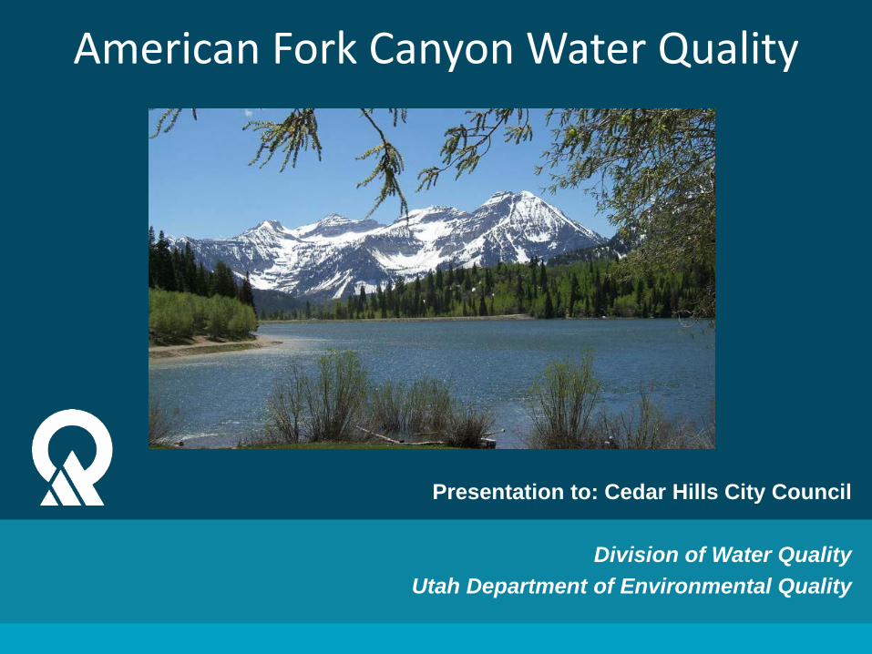
Presentation to: Cedar Hills City Council
Division of Water Quality Utah Department of Environmental Quality
American Fork Canyon Water Quality
Division of Water Quality
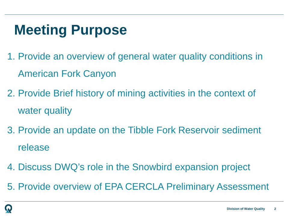
1. Provide an overview of general water quality conditions in
American Fork Canyon
2. Provide Brief history of mining activities in the context of
water quality
3. Provide an update on the Tibble Fork Reservoir sediment
release
4. Discuss DWQ’s role in the Snowbird expansion project
5. Provide overview of EPA CERCLA Preliminary Assessment
Meeting Purpose
2

Water Quality Conditions
Division of Water Quality
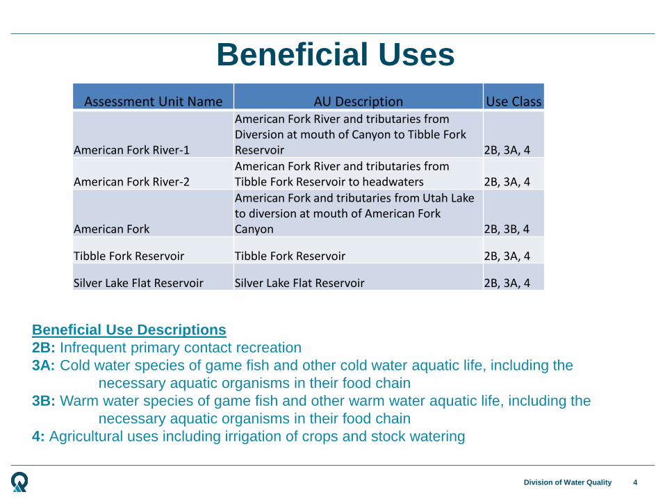
Assessment Unit Name AU Description Use Class
American Fork River-1
American Fork River and tributaries from Diversion at mouth of Canyon to Tibble Fork Reservoir 2B, 3A, 4
American Fork River-2 American Fork River and tributaries from Tibble Fork Reservoir to headwaters 2B, 3A, 4
American Fork
American Fork and tributaries from Utah Lake to diversion at mouth of American Fork Canyon 2B, 3B, 4
Tibble Fork Reservoir Tibble Fork Reservoir 2B, 3A, 4
Silver Lake Flat Reservoir Silver Lake Flat Reservoir 2B, 3A, 4
Beneficial Uses
4
Beneficial Use Descriptions 2B: Infrequent primary contact recreation 3A: Cold water species of game fish and other cold water aquatic life, including the necessary aquatic organisms in their food chain 3B: Warm water species of game fish and other warm water aquatic life, including the necessary aquatic organisms in their food chain 4: Agricultural uses including irrigation of crops and stock watering

Division of Water Quality
Monitoring Location Name Start Date
End Date
HANSEN CAVE SPRING IN TIMPANOGOS CAVE NM 7/29/08 11/5/15 WIDE HOLLOW AB CONFL DEER CK AB TIBBLE FORK RES 10/26/09 6/30/15 N FK AMERICAN FK CK AB TIBBLE FORK RES 6/3/81 9/13/12 N FK AMERICAN FK R AB CNFL/ S FK 5/4/92 8/17/12 DEER CREEK AB TIBBLE FORK RES 6/3/81 7/17/12 SILVER CK AB SILVER LAKE FLAT RESERVOIR 7/1/97 7/17/12 N FK AMERICAN FK BL MARY ELLEN GULCH AF-12 6/7/00 10/26/11 SILVER LAKE FLAT RESERVOIR 7/1/97 8/25/10 TIBBLE FORK RES AB DAM 01 6/3/81 8/25/10 MARY ELLEN GULCH AB CNFL W/ N. FK OF AMERICAN FK 10/7/09 10/7/09 N FK AMERICAN FK AB PACIFIC MINE AF-5 6/6/00 10/23/08 N FK AMERICAN FK BL PACIFIC MINE AF-10 6/6/00 10/23/08 AMERICAN FORK RIVER AT MOUTH OF CANYON 2/12/92 6/30/05 S FK AMERICAN FK R 1/2 MILE ABOVE MUTUAL DELL 9/15/04 9/15/04 Pacific Mine Well 02 7/25/01 7/25/01 Pacific Mine Well 03 7/25/01 7/25/01
Monitoring Locations

Division of Water Quality
Monitoring and Assessment
6
Jordan-Utah Lake
Watershed Management Unit
Targeted Probabilistic
2018
YEAR
2009 2010 2011 2012 2013 2014 2015 2016 2017
2012/2014 Integrated Report 2016 IR 2018 IR 2020 IR
Assessment Unit Name AU Description Assessment Results
American Fork River-1
American Fork River and tributaries from Diversion at mouth of Canyon to Tibble Fork Reservoir Supporting Uses
American Fork River-2 American Fork River and tributaries from Tibble Fork Reservoir to headwaters Insufficient Data w/ exceedances
American Fork American Fork and tributaries from Utah Lake to diversion at mouth of American Fork Canyon Supporting Uses
Tibble Fork Reservoir Tibble Fork Reservoir No Evidence of impairment Silver Lake Flat Reservoir Silver Lake Flat Reservoir No Evidence of impairment

Mining History
Division of Water Quality
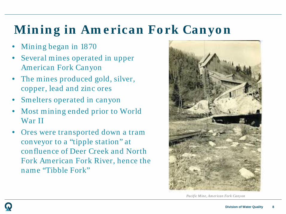
Mining in American Fork Canyon
8
Pacific Mine, American Fork Canyon
• Mining began in 1870 • Several mines operated in upper
American Fork Canyon • The mines produced gold, silver,
copper, lead and zinc ores • Smelters operated in canyon • Most mining ended prior to World
War II • Ores were transported down a tram
conveyor to a “tipple station” at confluence of Deer Creek and North Fork American Fork River, hence the name “Tibble Fork”

Division of Water Quality
Mining Impacts on Water Quality
9
• Uncovered tailings piles remain outside of several mines
• Some mines are discharging contaminated groundwater
• Some streams flowing over tailings, dissolving metals
• Contaminated water and sediment flowing directly into streams
• Primary contaminants of concern are Arsenic, Cadmium, Copper, Lead, Mercury and Zinc
Tibble Fork Dam Sediment Release

Division of Water Quality
Tibble Fork Reservoir
11
Tibble Fork Reservoir prior to construction
• Dam built in 1966 for flood control and sediment retention
• Dam is currently being seismically upgraded and raised 15 feet to increase water storage
• Stores approximately 258 acre-feet of water (~ 385 ac. ft. after upgrade)
• About 14 acres in size (23 after upgrade)
• Construction began in June 2016 and will be completed in December 2016
Division of Water Quality
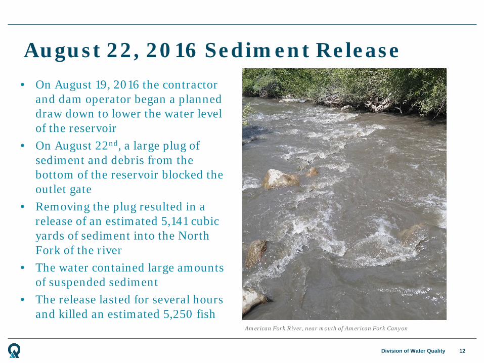
August 22, 2016 Sediment Release
12
American Fork River, near mouth of American Fork Canyon
• On August 19, 2016 the contractor and dam operator began a planned draw down to lower the water level of the reservoir
• On August 22nd, a large plug of sediment and debris from the bottom of the reservoir blocked the outlet gate
• Removing the plug resulted in a release of an estimated 5,141 cubic yards of sediment into the North Fork of the river
• The water contained large amounts of suspended sediment
• The release lasted for several hours and killed an estimated 5,250 fish
Division of Water Quality
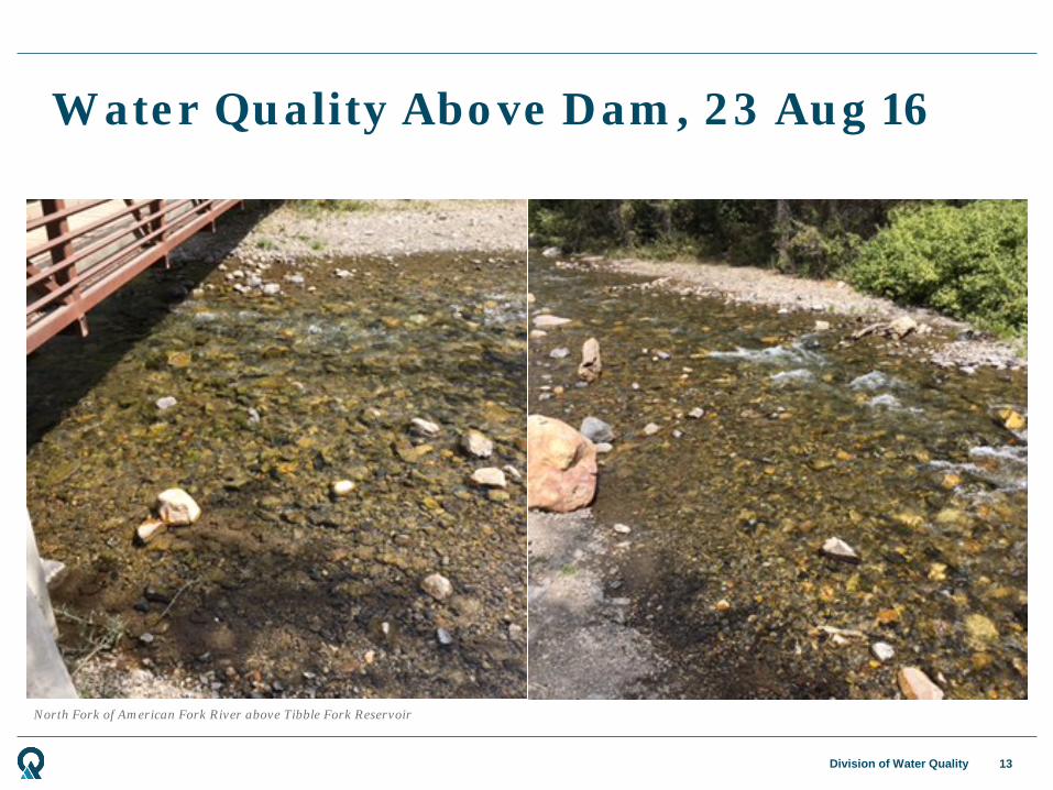
North Fork of American Fork River above Tibble Fork Reservoir
Water Quality Above Dam, 23 Aug 16
13

Division of Water Quality
Water Quality Below Dam, 23 Aug 16
14
North Fork of American Fork River below Tibble Fork Dam

Division of Water Quality
Fish Kill Below Dam
15
Dead trout in North Fork American Fork River below Tibble Fork Dam
Division of Water Quality
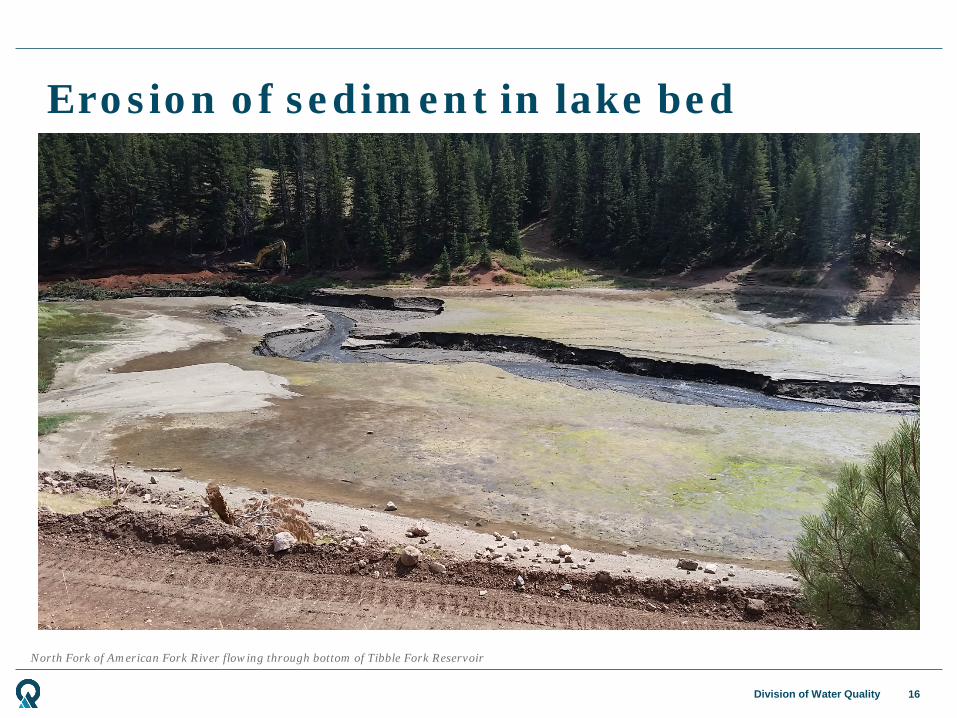
Erosion of sediment in lake bed
16
North Fork of American Fork River flowing through bottom of Tibble Fork Reservoir

Division of Water Quality
Division of Water Quality Response
17
• Division of Water Quality was not notified of the release until August 23, 2016
• DWQ consulted with several agencies, including Forest Service, Park Service, National Resource Conservation Service, Division of Wildlife Resources, and Utah County Health Department
• DWQ took samples at several points upstream and downstream of dam
• Contractor for dam construction dug a canal to allow the river to bypass the sediment in the lake bed and prevent further erosion

Division of Water Quality
Bypass Canal in bottom of Tibble Fork Reservoir
Bypass Canal
18
Division of Water Quality
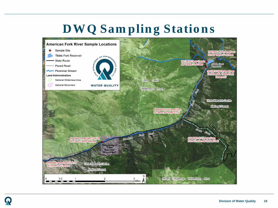
DWQ Sampling Stations
19

Division of Water Quality
DWQ Sampling Plan
20
• Samples were taken for two weeks after discharge to monitor water quality and determine scope of spill
• Water samples were analyzed for water chemistry, dissolved metals, total metals, turbidity, and suspended solids
• Sediment samples were analyzed for total metals
• Metal results were screened for human health, agricultural use, and aquatic wildlife health
• Water turbidity and dissolved solids were used as an indicator for overall water quality
Division of Water Quality
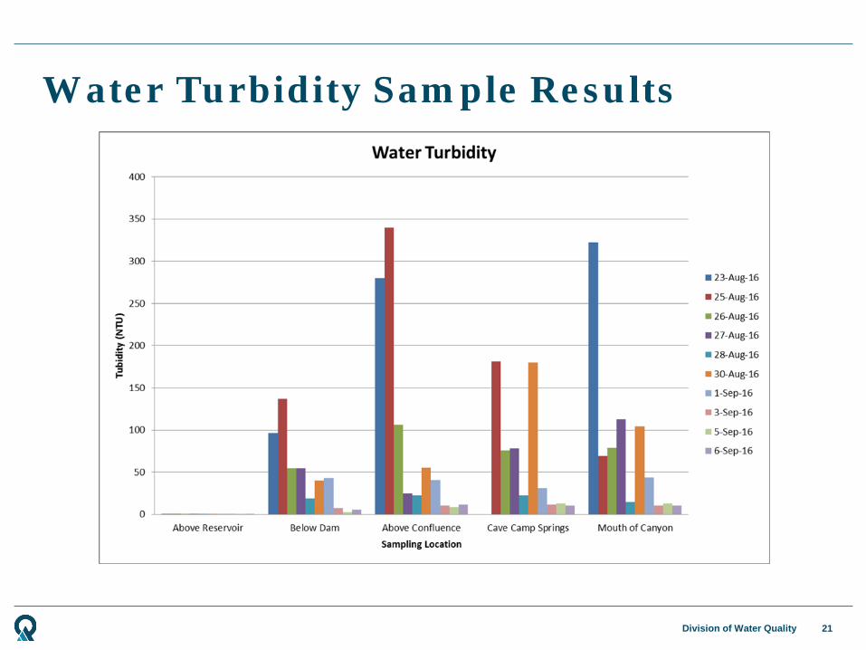
Water Turbidity Sample Results
21
Division of Water Quality
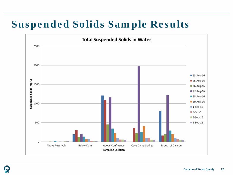
Suspended Solids Sample Results
22

Division of Water Quality
Water Chemistry Metals Sampling Results
23
Recreational Water (Total Metals)No Exceedence Above Screening Level
Alu
min
um
Ant
imon
y
Ars
enic
Bar
ium
Ber
ylliu
m
Bor
on
Cad
miu
m
Chr
omiu
m
Cob
alt
Cop
per
Iron
Lead
Man
gane
se
Mer
cury
Mol
ybde
num
Nic
kel
Sele
nium
Silv
er
Thal
lium
Vana
dium
Zinc
Recreational Screening Values 1,579,000 630 7,900 315,800 3,160 315,800 790 1,787,000 39,480 15,790 14,800 74,220 11,050 7,900 157,900 7,900 13,160 63 15,790 789,500Monitoring Location Site Description Collection Date
Collection Time
ug/L ug/L ug/L ug/L ug/L ug/L ug/L ug/L ug/L ug/L ug/L ug/L ug/L ug/L ug/L ug/L ug/L ug/L ug/L ug/L ug/L
MLID Site Description CollectionDate CollectionTime ug/L ug/L ug/L ug/L ug/L ug/L ug/L ug/L ug/L ug/L ug/L ug/L ug/L ug/L ug/L ug/L ug/L ug/L ug/L ug/L ug/L8/23/2016 2:25 PM ND ND ND 41.1 ND ND ND ND ND ND ND ND ND ND 2.1 ND ND ND ND ND 6.28/25/2016 4:35 PM ND ND ND 41.5 ND ND ND ND ND ND ND ND ND ND ND ND ND ND ND ND 7.88/26/2016 11:40 AM ND ND ND 40.9 ND ND ND ND ND ND ND ND ND ND ND ND ND ND ND ND 7.48/27/2016 8:55 AM ND ND ND 41.9 ND ND ND ND ND ND ND ND ND ND ND ND ND ND ND ND 10.38/28/2016 8:40 AM ND ND ND 42.1 ND ND ND ND ND ND ND ND ND ND ND ND ND ND ND ND 10.08/30/2016 2:10 PM ND ND ND 42.6 ND ND ND ND ND ND ND ND ND ND 2.1 ND ND ND ND ND 7.5
5912830 Deer Creek AB Tibble Fork Res
8/25/2016 4:21 PM ND ND ND 98.2 ND ND ND ND ND ND ND ND 4.1 ND 2.6 ND ND ND ND ND ND
8/23/2016 2:45 PM 1,510.0 4.6 15.4 179.0 ND ND 1.0 2.1 ND 9.5 3,500.0 83.0 279.0 ND 2.7 4.6 ND ND ND ND 122.08/24/2016 4:25 PM 2,370.0 5.0 13.9 165.0 ND ND 0.9 2.6 ND 12.0 3,820.0 73.0 239.0 ND 2.5 5.2 ND ND ND ND 106.08/25/2016 4:08 PM 2,460.0 4.3 15.1 159.0 ND ND 1.5 5.0 ND 18.7 5,730.0 115.0 305.0 ND 2.2 8.0 ND ND ND 5.0 170.08/26/2016 11:17 AM 1,040.0 3.0 9.3 130.0 ND ND 0.6 ND ND 7.7 2,410.0 45.5 174.0 ND 2.5 3.4 ND ND ND ND 65.18/27/2016 9:27 AM ND 2.9 10.0 142.0 ND ND 0.9 2.6 ND 9.7 ND 53.2 221.0 ND 2.3 4.4 ND ND ND ND 79.98/28/2016 9:00 AM ND 2.5 8.3 102.0 ND ND 0.9 ND ND 8.2 ND 60.5 136.0 ND ND 3.2 ND ND ND ND 78.98/30/2016 2:35 PM 1,010.0 2.4 3.5 72.7 ND ND ND ND ND 3.9 1,300.0 19.1 57.2 ND 2.4 ND ND ND ND ND 36.28/23/2016 3:00 PM 7,780.0 6.3 28.3 295.0 ND ND 3.9 11.2 8.2 40.1 15,700.0 296.0 779.0 0.3 2.1 21.4 ND ND ND 14.6 475.08/25/2016 3:48 PM 6,790.0 6.5 28.3 350.0 ND ND 4.4 13.6 9.4 41.8 17,200.0 317.0 907.0 0.3 ND 23.6 ND ND ND 13.4 538.08/26/2016 12:20 PM 2,080.0 3.8 14.0 161.0 ND ND 1.4 3.4 ND 14.8 5,560.0 106.0 353.0 ND 2.2 8.0 ND ND ND ND 173.08/27/2016 9:45 AM ND 5.3 31.2 275.0 ND ND 5.0 12.7 9.1 59.9 ND 364.0 773.0 0.3 ND 23.6 ND ND ND ND 574.08/28/2016 9:20 AM ND 2.6 9.2 119.0 ND ND 1.0 2.6 ND 10.5 ND 72.6 194.0 ND ND 4.7 ND ND ND ND 112.08/30/2016 2:45 PM 1,570.0 ND 5.3 89.7 ND ND 0.6 2.9 ND 6.5 2,490.0 37.4 113.0 ND 2.1 3.6 ND ND ND ND 69.0
4994983S FK American FK R
½ mile AB Mutual Dell
8/25/2016 3:26 PM ND ND ND 31.4 ND ND ND ND ND ND ND ND ND ND ND ND ND ND ND ND ND
8/9/2016 4:30 PM NS ND ND NS ND NS ND ND NS ND NS ND NS ND NS ND 2.7 ND ND NS ND8/22/2016 3:50 PM NS 12.4 276.0 NS 8.3 NS 76.8 94.9 NS 781.0 NS 5,610.0 NS 4.3 NS 221.0 3.5 25.9 2.5 NS 8,050.08/24/2016 4:15 PM 2,610.0 3.8 12.0 138.0 ND ND 1.3 3.2 ND 14.7 5,310.0 93.7 217.0 ND ND 6.7 ND ND ND 5.4 154.08/25/2016 3:01 PM 2,920.0 4.7 14.4 147.0 ND ND 2.0 6.2 ND 23.8 6,210.0 138.0 275.0 0.2 2.1 9.1 ND ND ND 6.2 223.08/26/2016 12:45 PM 1,430.0 3.2 9.4 112.0 ND ND 1.0 2.4 ND 10.6 3,620.0 76.2 189.0 ND ND 5.2 ND ND ND ND 124.08/27/2016 10:05 AM ND 11.5 92.6 418.0 2.2 ND 22.0 25.9 22.2 246.0 ND 1,640.0 1,540.0 1.2 ND 55.1 ND 8.0 ND ND 2,270.08/28/2016 9:35 AM ND ND 6.5 99.9 ND ND 0.9 2.2 ND 8.7 ND 59.5 147.0 ND ND 4.4 ND ND ND ND 92.38/29/2016 11:13 AM NS 3.2 8.6 NS ND NS 1.3 2.8 NS 12.7 NS 93.1 NS ND NS 6.0 ND ND ND NS 153.08/30/2016 2:55 PM 4,300.0 ND 6.9 119.0 ND ND 0.9 10.2 ND 12.5 5,040.0 49.0 231.0 ND ND 8.3 ND ND ND 9.0 96.19/7/2016 10:53 AM NS ND 2.2 NS ND NS ND ND NS ND NS 12.2 NS ND NS ND ND ND ND NS 22.59/14/2016 11:35 AM NS ND 3.6 NS ND NS ND ND NS 4.3 NS 29.1 NS ND NS 2.1 ND ND ND NS 45.39/21/2016 2:35 PM NS ND ND NS ND NS ND ND NS ND NS 6.3 NS ND NS ND ND ND ND NS 14.78/23/2016 12:25 PM 3,450.0 6.1 19.8 155.0 ND ND 3.1 5.2 4.6 26.6 7,510.0 231.0 423.0 0.4 ND 10.2 ND ND ND 7.7 341.08/25/2016 2:42 PM 1,270.0 3.6 8.0 103.0 ND ND 0.9 2.4 ND 9.8 3,000.0 65.7 133.0 ND ND 4.2 ND ND ND ND 108.08/26/2016 12:55 PM 935.0 3.0 8.5 100.0 ND ND 1.0 ND ND 9.3 2,780.0 76.2 173.0 0.2 ND 4.1 ND ND ND ND 116.08/27/2016 10:20 AM ND 9.2 50.0 290.0 ND ND 10.8 18.2 13.0 131.0 ND 795.0 948.0 0.6 ND 36.7 ND 3.9 ND ND 1,140.08/28/2016 10:00 AM ND 2.2 7.7 103.0 ND ND 1.0 2.8 ND 10.4 ND 68.9 161.0 ND ND 5.5 ND ND ND ND 114.08/30/2016 3:10 PM 2,550.0 ND 6.6 93.3 ND ND 0.8 4.5 ND 9.7 3,580.0 52.5 151.0 ND ND 4.9 ND ND ND 5.3 90.5
American Fork River BL Cave Camp Springs
American Fork River at mouth of
Canyon
5912840
5912810
4994990
4994984
4994980
N FK American FK CK AB Tibble Fork
Res
N FK American FK R BL Tibble Fork
Res
N FK American FK R AB confl S FK
Post Plume ArrivalPrior to Plume Arrival Estimated Plume Arrival

Division of Water Quality
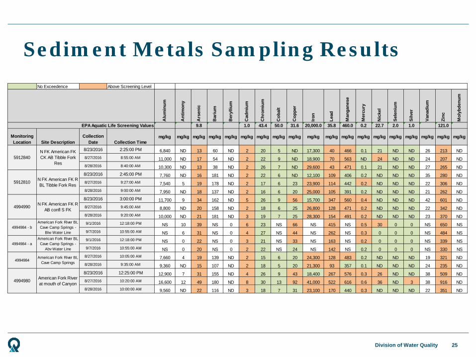
Sediment Metals Sampling Results
24
No Exceedence Above Screening Level
Alu
min
um
Ant
imon
y
Ars
enic
Bar
ium
Ber
ylliu
m
Cad
miu
m
Chr
omiu
m
Cob
alt
Cop
per
Iron
Lead
Man
gane
se
Mer
cury
Nic
kel
Sel
eniu
m
Silv
er
Van
adiu
m
Zinc
Mol
ybde
num
165,428 66 753 33,086 331 87 213,402 1,654 1,654 115,799 400 7,775 1,158 3,309 827 827 1,654 49,628 827
Monitoring Location Site Description
Collection Date
Collection Time
mg/kg mg/kg mg/kg mg/kg mg/kg mg/kg mg/kg mg/kg mg/kg mg/kg mg/kg mg/kg mg/kg mg/kg mg/kg mg/kg mg/kg mg/kg mg/kg
8/23/2016 2:25:00 PM 6,840 ND 13 60 ND 2 20 5 ND 17,300 40 466 0 21 ND ND 26 213 ND8/27/2016 8:55:00 AM 11,000 ND 17 54 ND 2 22 9 ND 18,900 70 563 ND 24 ND ND 24 207 ND8/28/2016 8:40:00 AM 10,300 ND 13 38 ND 2 26 7 ND 29,600 43 471 0 21 ND ND 27 265 ND8/23/2016 2:45:00 PM 7,760 ND 16 181 ND 2 22 6 ND 12,100 109 406 0 ND ND ND 35 280 ND8/27/2016 9:27:00 AM 7,540 5 19 178 ND 2 17 6 23 23,900 114 442 0 ND ND ND 22 306 ND8/28/2016 9:00:00 AM 7,950 ND 18 137 ND 2 16 6 20 25,000 105 391 0 ND ND ND 21 262 ND8/23/2016 3:00:00 PM 11,700 9 34 162 ND 5 26 9 56 15,700 347 560 0 ND ND ND 42 601 ND8/27/2016 9:45:00 AM 8,800 ND 20 158 ND 2 18 6 25 26,800 128 471 0 ND ND ND 22 342 ND8/28/2016 9:20:00 AM 10,000 ND 21 181 ND 3 19 7 25 28,300 154 491 0 ND ND ND 23 370 ND9/1/2016 12:18:00 PM NS 10 39 NS 0 6 23 NS 66 NS 415 NS 0 30 0 0 NS 650 NS9/7/2016 10:55:00 AM NS 6 31 NS 0 4 27 NS 44 NS 262 NS 0 0 0 0 NS 484 NS9/1/2016 12:18:00 PM NS 0 22 NS 0 3 21 NS 33 NS 163 NS 0 0 0 0 NS 339 NS9/7/2016 10:55:00 AM NS 0 20 NS 0 2 22 NS 24 NS 142 NS 0 0 0 0 NS 330 NS
8/27/2016 10:05:00 AM 7,660 4 19 139 ND 2 15 6 20 24,300 128 483 0 ND ND ND 19 321 ND8/28/2016 9:35:00 AM 9,360 ND 15 107 ND 2 18 5 20 21,300 93 357 0 ND ND ND 24 235 ND8/23/2016 12:25:00 PM 12,900 7 31 155 ND 4 26 9 43 18,400 267 576 0 26 ND ND 38 509 ND8/27/2016 10:20:00 AM 16,600 12 49 180 ND 8 30 13 92 41,000 522 616 1 36 ND 3 38 916 ND8/28/2016 10:00:00 AM 9,560 ND 22 116 ND 3 18 7 31 23,100 170 440 0 ND ND ND 22 351 ND
American Fork River BL Cave Camp Springs -
Blw Water LineAmerican Fork River BL
Cave Camp Springs - Abv Water Line
American Fork River BL Cave Camp Springs
American Fork River at mouth of Canyon
4994984
4994980
N FK American FK CK AB Tibble Fork
Res
N FK American FK R BL Tibble Fork Res
N FK American FK R AB confl S FK
5912840
5912810
4994990
4994984 - b
4994984 - a
Health Based Comparison Values for Recreation
Division of Water Quality
Sediment Metals Sampling Results
25
No Exceedence Above Screening Level
Alu
min
um
Ant
imon
y
Ars
enic
Bar
ium
Ber
ylliu
m
Cad
miu
m
Chr
omiu
m
Cob
alt
Cop
per
Iron
Lead
Man
gane
se
Mer
cury
Nic
kel
Sele
nium
Silv
er
Vana
dium
Zinc
Mol
ybde
num
9.8 1.0 43.4 50.0 31.6 20,000.0 35.8 460.0 0.2 22.7 2.0 1.0 121.0
Monitoring Location Site Description
Collection Date Collection Time
mg/kg mg/kg mg/kg mg/kg mg/kg mg/kg mg/kg mg/kg mg/kg mg/kg mg/kg mg/kg mg/kg mg/kg mg/kg mg/kg mg/kg mg/kg mg/kg
8/23/2016 2:25:00 PM 6,840 ND 13 60 ND 2 20 5 ND 17,300 40 466 0.1 21 ND ND 26 213 ND8/27/2016 8:55:00 AM 11,000 ND 17 54 ND 2 22 9 ND 18,900 70 563 ND 24 ND ND 24 207 ND8/28/2016 8:40:00 AM 10,300 ND 13 38 ND 2 26 7 ND 29,600 43 471 0.1 21 ND ND 27 265 ND8/23/2016 2:45:00 PM 7,760 ND 16 181 ND 2 22 6 ND 12,100 109 406 0.2 ND ND ND 35 280 ND8/27/2016 9:27:00 AM 7,540 5 19 178 ND 2 17 6 23 23,900 114 442 0.2 ND ND ND 22 306 ND8/28/2016 9:00:00 AM 7,950 ND 18 137 ND 2 16 6 20 25,000 105 391 0.2 ND ND ND 21 262 ND8/23/2016 3:00:00 PM 11,700 9 34 162 ND 5 26 9 56 15,700 347 560 0.4 ND ND ND 42 601 ND8/27/2016 9:45:00 AM 8,800 ND 20 158 ND 2 18 6 25 26,800 128 471 0.2 ND ND ND 22 342 ND8/28/2016 9:20:00 AM 10,000 ND 21 181 ND 3 19 7 25 28,300 154 491 0.2 ND ND ND 23 370 ND9/1/2016 12:18:00 PM NS 10 39 NS 0 6 23 NS 66 NS 415 NS 0.5 30 0 0 NS 650 NS9/7/2016 10:55:00 AM NS 6 31 NS 0 4 27 NS 44 NS 262 NS 0.3 0 0 0 NS 484 NS9/1/2016 12:18:00 PM NS 0 22 NS 0 3 21 NS 33 NS 163 NS 0.2 0 0 0 NS 339 NS9/7/2016 10:55:00 AM NS 0 20 NS 0 2 22 NS 24 NS 142 NS 0.2 0 0 0 NS 330 NS
8/27/2016 10:05:00 AM 7,660 4 19 139 ND 2 15 6 20 24,300 128 483 0.2 ND ND ND 19 321 ND8/28/2016 9:35:00 AM 9,360 ND 15 107 ND 2 18 5 20 21,300 93 357 0.1 ND ND ND 24 235 ND8/23/2016 12:25:00 PM 12,900 7 31 155 ND 4 26 9 43 18,400 267 576 0.3 26 ND ND 38 509 ND8/27/2016 10:20:00 AM 16,600 12 49 180 ND 8 30 13 92 41,000 522 616 0.6 36 ND 3 38 916 ND8/28/2016 10:00:00 AM 9,560 ND 22 116 ND 3 18 7 31 23,100 170 440 0.3 ND ND ND 22 351 ND
4994980
N FK American FK CK AB Tibble Fork
Res
N FK American FK R BL Tibble Fork Res
N FK American FK R AB confl S FK
American Fork River BL Cave Camp Springs -
Blw Water LineAmerican Fork River BL
Cave Camp Springs - Abv Water Line
American Fork River BL Cave Camp Springs
American Fork River at mouth of Canyon
5912840
5912810
4994990
4994984 - b
4994984 - a
4994984
EPA Aquatic Life Screening Values

Division of Water Quality
• Although heavy metals were present in the water column they did not exceed the screening values for recreation, agricultural, or aquatic life uses
• Water Turbidity and Suspended Solids returned to near-normal levels within 3 weeks of original discharge
• The bypass canal appeared to significantly reduce turbidity and suspended solids
• Levels of lead in the sediment sometimes exceeded the human recreational health screening values
• Levels of arsenic, cadmium, lead, and zinc in the sediment exceeded the screening values for aquatic life both upstream and downstream from the dam
• In general, levels of heavy metals in the sediment were 2 to 7 times higher below the dam than above the dam
Sampling Conclusions
26
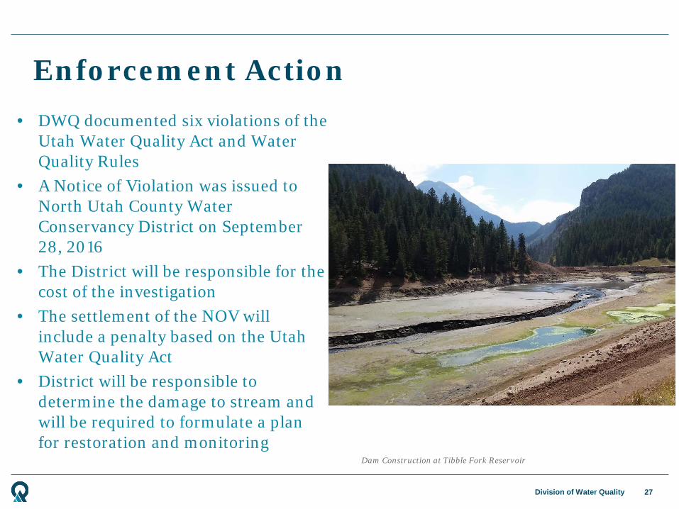
Division of Water Quality
Enforcement Action
27
Dam Construction at Tibble Fork Reservoir
• DWQ documented six violations of the Utah Water Quality Act and Water Quality Rules
• A Notice of Violation was issued to North Utah County Water Conservancy District on September 28, 2016
• The District will be responsible for the cost of the investigation
• The settlement of the NOV will include a penalty based on the Utah Water Quality Act
• District will be responsible to determine the damage to stream and will be required to formulate a plan for restoration and monitoring

Division of Water Quality
• An environmental consulting company has prepared a conceptual plan for assessment and monitoring of the river
• The plan includes surveys of macroinvertebrates and fish upstream and downstream of the dam
• Tissue samples of macroinvertebrates and fish will be analyzed for heavy metal contamination
• Water and sediment samples will be taken at the same locations to assess levels of heavy metals contamination
• Sediment in irrigation canals downstream will be sampled to determine if contaminated sediment entered the irrigation system
• Sampling will be performed at least 4 times per year, at times of the year corresponding with high and low water conditions
• Monitoring will continue for 5 years after incident
Proposed Sampling and Monitoring Plan
28

Snowbird Expansion Project

Division of Water Quality
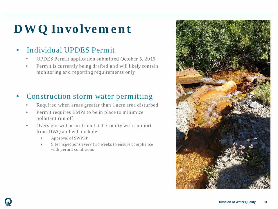
DWQ Involvement
30
• Monitoring plan review • Surface water metals sampling • Macroinvertebrate sampling • Quality assurance • Guidance for UPDES permit application
• Data available for future assessments • Fill assessment data gaps
Map of Mary Ellen Gulch, American Fork Canyon
Division of Water Quality
DWQ Involvement
31
• Individual UPDES Permit • UPDES Permit application submitted October 5, 2016 • Permit is currently being drafted and will likely contain
monitoring and reporting requirements only
• Construction storm water permitting • Required when areas greater than 1 acre area disturbed • Permit requires BMPs to be in place to minimize
pollutant run off • Oversight will occur from Utah County with support
from DWQ and will include: • Approval of SWPPP • Site inspections every two weeks to ensure compliance
with permit conditions
Comprehensive Environmental Response, Compensation, and Liability Act
(CERCLA)
Division of Water Quality
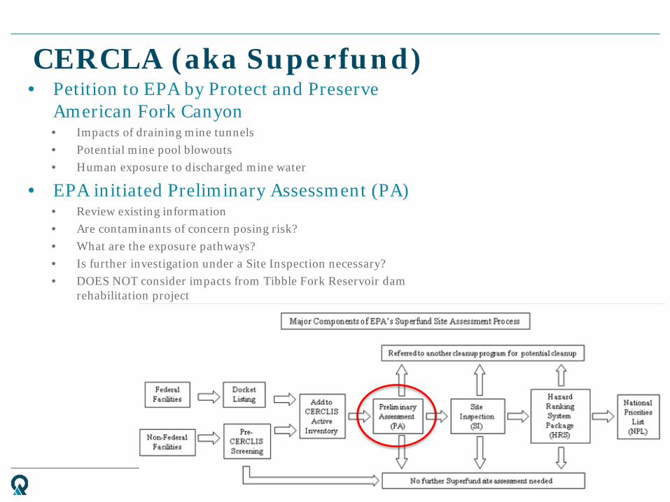
CERCLA (aka Superfund)
33
• Petition to EPA by Protect and Preserve American Fork Canyon • Impacts of draining mine tunnels • Potential mine pool blowouts • Human exposure to discharged mine water
• EPA initiated Preliminary Assessment (PA) • Review existing information • Are contaminants of concern posing risk? • What are the exposure pathways? • Is further investigation under a Site Inspection necessary? • DOES NOT consider impacts from Tibble Fork Reservoir dam
rehabilitation project