All logos, trademarks, trade names and graphics used herein are the property of their respective...
26
All logos, trademarks, trade names and graphics used herein are the property of their respective owners © Infotech Enterprises Ltd. 2008 . All rights reserved www.infotechsw.com www.infotech-enterprises.com WELCOME to the Delegates of NLRMP Technical Fair 2009 New Delhi City (NCR) B A C
-
Upload
liliana-quinn -
Category
Documents
-
view
217 -
download
1
Transcript of All logos, trademarks, trade names and graphics used herein are the property of their respective...

All logos, trademarks, trade names and graphics used herein are the property of their respective owners © Infotech Enterprises Ltd. 2008. All rights reserved
www.infotechsw.com
www.infotech-enterprises.com
WELCOME
to the Delegates of
NLRMP Technical Fair 2009
WELCOME
to the Delegates of
NLRMP Technical Fair 2009
New Delhi City (NCR)
B
A
C

All logos, trademarks, trade names and graphics used herein are the property of their respective owners © Infotech Enterprises Ltd. 2008. All rights reserved
www.infotechsw.com
www.infotech-enterprises.com
Creating Business Impact | Providing Expert Solutions | Delivering Quality Consistently | Building Partnerships Globally
NLRMP – Some issues and way forward
Chandrasekhar Nori
Dec 16, 09

All logos, trademarks, trade names and graphics used herein are the property of their respective owners © Infotech Enterprises Ltd. 2008. All rights reserved
www.infotechsw.com
www.infotech-enterprises.comProfile
Founded in 1991; corporate headquarters in Hyderabad, India
Largest independent offshore provider of geospatial and engineering design services
Focused on utilities, transportation, government and manufacturing verticals
Over 7000 resources across 25 global locations, including 7 development centers
CMMi Level 5, ISO 9001:2000, BS7799
Rs. 889.75 Cr revenue & Rs. 92.48 Cr net income in FY 2009.
11.7
$ M
FY 01 FY 02 FY 03 FY 04 FY 06
Revenue Net Profit
19
27
34
43
59
2.5
3.74.1
6
3.2
82.3
FY 05
34% revenue CAGR 36% profit CAGR
Over 5 years
All logos, trademarks, trade names and graphics used herein are the property of their respective owners © Infotech. All rights reserved www.infotechsw.com
Experience
Karnataka - UPOR – SP and TSP on PPP
MP Land Records
Cadastral Data Management – Dubai
LRIMS – SAIL, Bokaro
KLR Urban Cadastre pilot
RPA, UK
Defence Estates UK…many more
Experimental Resurveys in AP
Photogrammetry pilot in Khammam, AP

|KLR – Pilot work -Process Flow
Selection of Ground Control Points on Image
Collection of Ground
Control Points
Geo rectification of Satellite Imagery
Demarcation
Digital Transfer of Demarcated Data
Field Supplementation
15% ETS (& Laser Ranger) Measurements
Title Enquiry Process
Digital Conversion of Title Enquiry Data
Spatial & Attribute Data Integration
Clean up & Topology Quality Check
Deliverables
& Final Report
Quality Check
Unsupervised Extraction
Digital TransferStatistical Analyses of WD Pts. & WD Prcls.
Hardcopy Plots for Demarcation
Incorporation of Layouts
Obtaining High Resolution Image
Reconnaissance Survey
Documents/Records Collection

All logos, trademarks, trade names and graphics used herein are the property of their respective owners © Infotech. All rights reserved www.infotechsw.com
KLR Project - Photographs

All logos, trademarks, trade names and graphics used herein are the property of their respective owners © Infotech. All rights reserved www.infotechsw.com
NLRMP Main Objectives
• usher in a system of updated land records
• automated and automatic mutation
• integration between textual and spatial records
• replace the present deeds registration and presumptive title system with that of conclusive titling with title guarantee
The NLRMP has three major components:
• Computerization of land record
• Survey/ re-survey
• Computerization of Registration

All logos, trademarks, trade names and graphics used herein are the property of their respective owners © Infotech. All rights reserved www.infotechsw.com
… a system of updated land records
• The central objective of NLRMP is not just
fresh cadastral surveys
• Land records in almost all the states are not
up-to-date
• Given that the land records are not in
continuous maintenance in most of the states
• To meet the first objective,
• land records should be made up-to-date at
one instance of time and
• be kept under continuous maintenance from
then on

All logos, trademarks, trade names and graphics used herein are the property of their respective owners © Infotech. All rights reserved www.infotechsw.com
… a system of updated land records
• Globally speaking, land records comprise of:
• Graphical sketches depicting accurately the extent and boundaries of all parcels
• An index map of the entire administrative unit
• A textual record comprising of the owners name, occupier/ enjoyer’s name, approximate area, unique ID number of the parcel
• The graphical records and the textual records should be individually correct and up-to-date and also be connected with each other properly to constitute the complete title cadastre
• “modernisation” in the program refers to employment of appropriate technology that will ensure this integration

All logos, trademarks, trade names and graphics used herein are the property of their respective owners © Infotech. All rights reserved www.infotechsw.com
Mutation
• Mutation is the process of recording and registering change of ownership and other changes in the statutory records
• Change of ownership and other changes on the ground can occur in several ways, where transaction in land is only one of them
• All such sources of change, as also the processes through which such changes occur, are to be fully understood and captured
• The complete “as-is” business processes of the participating organisations should be understood, reengineered and rendered amenable for process automation
• GIS technology can then be embedded into this IT framework, so that the graphical data is simultaneously updated along with the textual title record, during mutation.

All logos, trademarks, trade names and graphics used herein are the property of their respective owners © Infotech. All rights reserved www.infotechsw.com
Conclusive title
• Weakness of the present land records management system is the lack of connectivity between the processes of the Registration and Revenue Departments.
• In reality, registration does not confer title to the buyer;
• It is actually the mutation of the change of title in the revenue records that validates the registration process
• Every registration process – rather any process whatsoever by which ownership changes – should be immediately followed by mutation
However, registration is carried out by the Department of Stamps and Registration, whereas mutation is carried out by the Revenue Dept.
…

All logos, trademarks, trade names and graphics used herein are the property of their respective owners © Infotech. All rights reserved www.infotechsw.com
… Conclusive title
• Integration of the business processes of these Departments takes us one step closer to the land title security regime.
• There may be simpler methods to impart a semblance of “conclusiveness” to the land titles;
• creation of an up-to-date land records database integrating textual and graphical record,
• Business process integration between Revenue, Survey and Registration Departments and
• Tweaking a few Departmental procedures to ensure proper consistency in their day-to-day implementation across the Departments.

All logos, trademarks, trade names and graphics used herein are the property of their respective owners © Infotech. All rights reserved www.infotechsw.com
Appropriate technologies
Aerial, field survey and HRSI – what are the criteria for appropriateness?
If accuracy is the only criterion, field survey is the best; but, is it scalable?
Is aerial photography the only alternative, for survey of large tracts?
How accurate is HRSI method? … …
What is the real accuracy required?
Are cost and time important considerations?

All logos, trademarks, trade names and graphics used herein are the property of their respective owners © Infotech. All rights reserved www.infotechsw.com
Departmental processes
Essential processes like boundary demarcation, title
enquiry, adjudication, etc are time tested and should be
preserved as such to sustain public confidence.
Technology should render itself amenable for
incorporation into these essential processes rather than
being end-all-be-all.
Technology is no panacea. Depts should shed their
diffidence and refrain from “throwing-away-the-baby-
with-bathwater”

All logos, trademarks, trade names and graphics used herein are the property of their respective owners © Infotech. All rights reserved www.infotechsw.com
Fresh survey vs updating existing record
Long-standing debate over condition of land records and
their utility
Several states preferring fresh surveys over updating
Framework in tact in major parts of several states, which
can be improved upon
Existing records enjoy acceptance by public.
Even in litigation-ridden peri-urban areas, disputed parcels
do not exceed 10%
Fresh surveys, the only solution?
All logos, trademarks, trade names and graphics used herein are the property of their respective owners © Infotech. All rights reserved www.infotechsw.com
Validation before modernization
Erstwhile CLR – a case in point
Correctness of data not considered as a pre-requisite
Result – digitized parcel data could not be put to routine maintenance
Fresh across-the-board surveys may not be the only plausible solution
No computerization before validation – graphical or textual
Costly re-surveys may be avoidable in many areas
Excellent village boundary framework is mandatory

All logos, trademarks, trade names and graphics used herein are the property of their respective owners © Infotech. All rights reserved www.infotechsw.com
The principle of precedence of boundary over extent
In most disputes, areas and extents are not the only
contention
Disputes are often caused by location, unique id, title etc.
Boundary is objective; area subjective
Correct boundary identification makes measurement accuracy
less critical
Accurate measurement alone does not guarantee correct
boundary

All logos, trademarks, trade names and graphics used herein are the property of their respective owners © Infotech. All rights reserved www.infotechsw.com
Correctness vs accuracy
If boundary is correctly identified, measurement is
redundant
Measurement accuracy is a function of technology
Technology does not guarantee correct identification
Boundary demarcation – essential pre-requisite to
measurement survey
Required measurement accuracy can be chosen based on
affordability

All logos, trademarks, trade names and graphics used herein are the property of their respective owners © Infotech. All rights reserved www.infotechsw.com
Capacity building
Cadastral surveys – domain of Govt. for times immemorial
Companies do not have adequate comprehension of
legal cadastre
Private surveyors have technology awareness, no domain
knowledge
Lack of capacity in private sector – a serious limitation
Large scale capacity building by state LR Depts. is the
only solution
All logos, trademarks, trade names and graphics used herein are the property of their respective owners © Infotech. All rights reserved www.infotechsw.com
Approval process
On the other hand, Departmental surveyors are not
exposed to technology
No exposure to modern survey instruments and computer
processing
No knowledge of digital cadastre and GIS
Several projects suffering because of delayed and often
incorrect approval process
Large scale staff training is mandatory for success of
projects

All logos, trademarks, trade names and graphics used herein are the property of their respective owners © Infotech. All rights reserved www.infotechsw.com
Infotech in NLRMP
Pre project phase - Consulting, pre project support, NLRMP proposal preparation and funding support – Infotech has rich domain experience
Project execution phase –
• Undertake digitization of the existing village maps, parcel sketches and RoR documents for creation of a comprehensive GIS – we have the entire life-cycle mapped in our facility at Hyderabad
• Undertake comprehensive cadastral surveys with appropriate technology and/ or combinations thereof.
• Undertake business process integration and automation in the Depts. involved, leading to creation of the essential framework for land title security
• Development of necessary software for management of land information, applications, computerization of revenue and registration Depts., delivery to the public on the web etc.
• Various engagement options – nomination, Consultancy, project management, competitive bidding and participatory modes
All logos, trademarks, trade names and graphics used herein are the property of their respective owners © Infotech. All rights reserved www.infotechsw.com
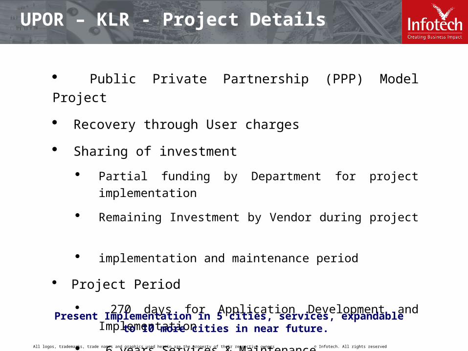
UPOR – KLR - Project Details
Public Private Partnership (PPP) Model Project
Recovery through User charges
Sharing of investment
Partial funding by Department for project implementation
Remaining Investment by Vendor during project
implementation and maintenance period
Project Period
270 days for Application Development and Implementation
6 years Services & Maintenance
Present Implementation in 5 cities, services, expandable to 10 more cities in near future.

All logos, trademarks, trade names and graphics used herein are the property of their respective owners © Infotech. All rights reserved www.infotechsw.com
To create a robust system of Urban Property Ownership Records for
every property which accurately record both for the spatial
characteristics of the property as well as record of rights data.
This property record will serve as a trusted record for all
transactions.
This property record created through this project will evidence
property ownership for all regulatory and legal purpose.
The property record over the years will continue to remain current
and accurate i.e. will not become obsolete or inaccurate.
All property record related transactions and services will be fulfilled
through this project.
UPOR – KLR - Project Details

All logos, trademarks, trade names and graphics used herein are the property of their respective owners © Infotech. All rights reserved www.infotechsw.com
UPOR – KLR - Project Scope
Develop a UPOR Software Suite with following modules: Data entry software Scanning software Vectorization (digitization) software GIS module to view maps. Portal Development for information on services Portal Integration with a payment gateway Bulk data (spatial and non spatial) upload module Performance monitoring (of both SP and TSP) module MIS reports Module for tracking delivery of various services Module for reconciliation of accounts Integration of finger print capture device System maintenance (for 6 years) Training Help Desk support
All logos, trademarks, trade names and graphics used herein are the property of their respective owners © Infotech. All rights reserved www.infotechsw.com
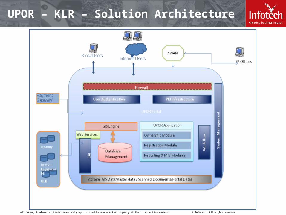
UPOR – KLR – Solution Architecture

All logos, trademarks, trade names and graphics used herein are the property of their respective owners © Infotech. All rights reserved www.infotechsw.com
Creating Business Impact | Providing Expert Solutions | Delivering Quality Consistently | Building Partnerships Globally
Thank you
[email protected]+91 98480 15566