Alaska DEM Workshop July 22-23, 2008 – Anchorage, AK ASRC Management Services Cartosat-1 Data...
39
Alaska DEM Workshop July 22-23, 2008 – Anchorage, AK ASRC Management Services Cartosat-1 Data Information Provided by: Dr. Shawana P. Johnson, GISP and J. Edward Kunz, GISP 1
-
Upload
mervin-ira-elliott -
Category
Documents
-
view
216 -
download
3
Transcript of Alaska DEM Workshop July 22-23, 2008 – Anchorage, AK ASRC Management Services Cartosat-1 Data...

Alaska DEM WorkshopJuly 22-23, 2008 – Anchorage, AK
ASRC Management Services
Cartosat-1 Data Information Provided by:Dr. Shawana P. Johnson, GISP
and J. Edward Kunz, GISP
Alaska DEM WorkshopJuly 22-23, 2008 – Anchorage, AK
ASRC Management Services
Cartosat-1 Data Information Provided by:Dr. Shawana P. Johnson, GISP
and J. Edward Kunz, GISP
1
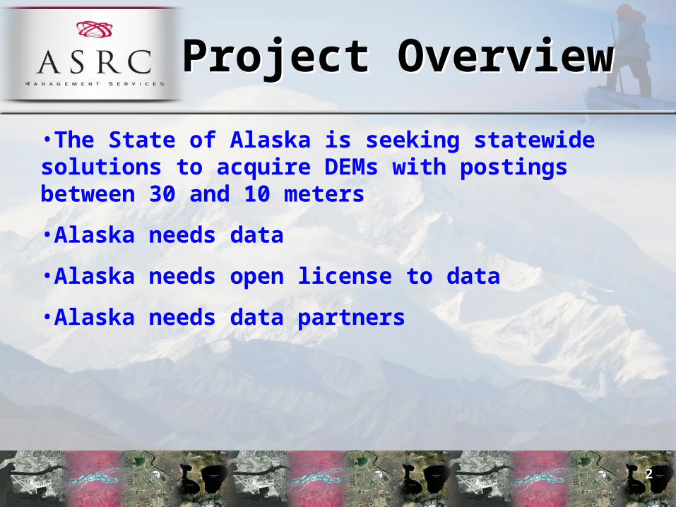
Project OverviewProject Overview
•The State of Alaska is seeking statewide solutions to acquire DEMs with postings between 30 and 10 meters
•Alaska needs data
•Alaska needs open license to data
•Alaska needs data partners
2
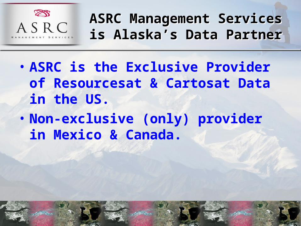
ASRC Management Services is Alaska’s Data Partner
ASRC Management Services is Alaska’s Data Partner
• ASRC is the Exclusive Provider of Resourcesat & Cartosat Data in the US.
• Non-exclusive (only) provider in Mexico & Canada.

IRS Current MissionsIRS Current MissionsRESOURCESAT-1 CARTOSAT-1
CARTOSAT-2
4

Cartosat-1 OverviewCartosat-1 Overview
5

Mission Objectives:• To design and develop an advanced 3-axis
body stabilized remote sensing satellite for stereo imaging and cartographic applications.
• To further stimulate new areas of user applications in the areas of cartographic applications, urban management, national security, and disaster management.
Cartosat-1 OverviewCartosat-1 Overview
6
Cartosat-1 OverviewCartosat-1 Overview
7
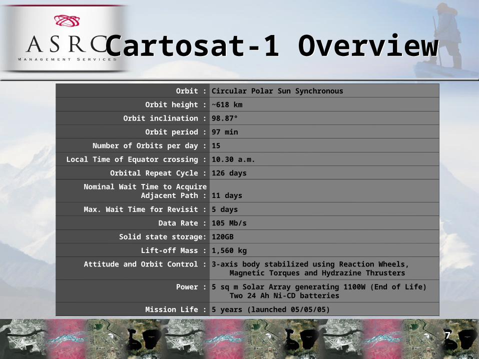
Orbit : Circular Polar Sun Synchronous
Orbit height : ~618 km
Orbit inclination : 98.87°
Orbit period : 97 min
Number of Orbits per day : 15
Local Time of Equator crossing : 10.30 a.m.
Orbital Repeat Cycle : 126 days
Nominal Wait Time to Acquire Adjacent Path : 11 days
Max. Wait Time for Revisit : 5 days
Data Rate : 105 Mb/s
Solid state storage: 120GB
Lift-off Mass : 1,560 kg
Attitude and Orbit Control : 3-axis body stabilized using Reaction Wheels, Magnetic Torques and Hydrazine Thrusters
Power : 5 sq m Solar Array generating 1100W (End of Life) Two 24 Ah Ni-CD batteries
Mission Life : 5 years (launched 05/05/05)

Cartosat-1 OverviewCartosat-1 Overview
8
120 GB capacity for image data storage
Solid State Recorder
105 Mbps for each cameraData Rate
0.50-0.85 MicronSpectral Band
30 kmSwath
<2.5 mInstantaneous Geometric Field of View (GFOV)
Two PAN Cameras (PAN fore mounted with a tilt fo+26 deg and PAN alt mounted with a tilt of -5 deg from the yaw axis to generate stereoscopic imagery)
Payloads
CARTOSAT-1PAN Camera
Future IRS MissionsFuture IRS Missions
•Resourcesat-n
•Cartosat-n
•Radar
•HSI
9
Future IRS MissionsFuture IRS Missions
• Follow on concepts to existing systems– 2009 to 2018– Many systems already under development
• Resourcesat-3 series:– Increased resolution and more spectral bands:– Addition of new sensors with 25km swath
• Resourcesat-4 series
• Increased resolution for Cartosat Series
• RISAT – First IRS SAR system
10

DEM Workshop Questions

1. Sensor1. Sensor
What sensor do you propose to use for acquisition of source data to be used for DEM production?
• Cartosat-1
12
2. Model2. Model
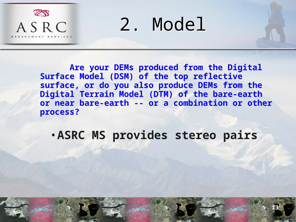
Are your DEMs produced from the Digital Surface Model (DSM) of the top reflective surface, or do you also produce DEMs from the Digital Terrain Model (DTM) of the bare-earth or near bare-earth -- or a combination or other process?
• ASRC MS provides stereo pairs
13

3. Native Z accuracy3. Native Z accuracyWith minimal ground control, what is the vertical accuracy (Accuracy z) of your DSMs at the 95% confidence level? If you also produce DTMs, what is the vertical accuracy (Accuracy z) of your DTMs at the 95% confidence level?
•Use at least one control point every 25sqkm, which provides 9 GCP’s per scene
•Accuracy expectation of DSM in the urban can be 6.0m – 9.0m with high accuracy DGPS points
14
3. Native Z accuracy3. Native Z accuracy
With minimal ground control, what is the vertical accuracy (Accuracy z) of your DSMs at the 95% confidence level? If you also produce DTMs, what is the vertical accuracy (Accuracy z) of your DTMs at the 95% confidence level?
•GCP’s can be derived with accurate maps for handheld GPS devices
•With a couple of GCPs per scene, the vertical DSM accuracy can be 15 meters at 95%, based on the numbers in Table 1
15
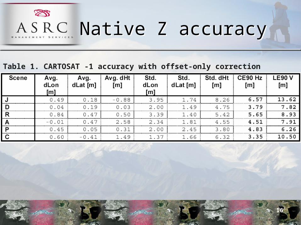
Native Z accuracyNative Z accuracy
Table 1. CARTOSAT -1 accuracy with offset-only correction
16

4. Improved Z accuracy
4. Improved Z accuracy
For producing digital topographic data of Alaska, would you plan to rely upon satellite or GPS/IMU parameters for accuracy, or would you plan to establish an improved control network? What improved vertical accuracy would you then hope to achieve for your DSMs or DTMs with improved ground control?
•An improved control network is necessary.
•If increase GCP’s to 25 per scene and DEM accuracy in Urban and Open zones will range 2.5m – 5m.
•The onboard GPS/IMU solution is not accurate enough to do DEM extraction (see Table 2).
17
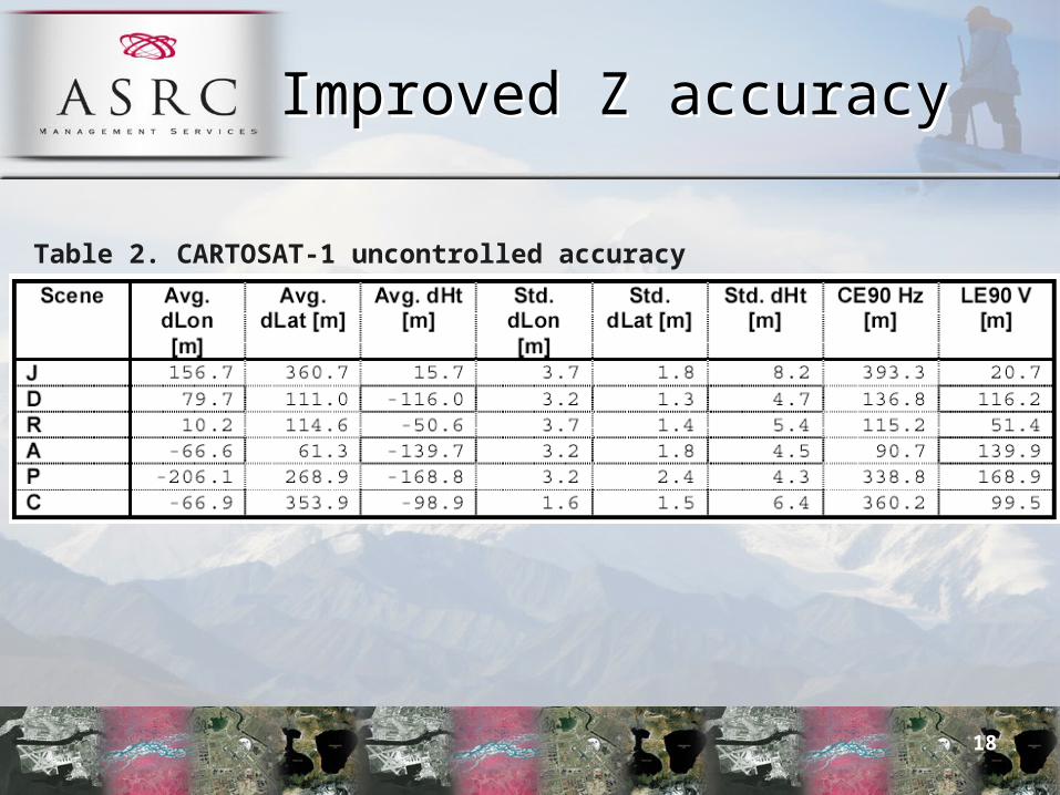
Improved Z accuracyImproved Z accuracy
Table 2. CARTOSAT-1 uncontrolled accuracy
18
5. R accuracy5. R accuracy
What is the (radial) horizontal accuracy (Accuracy r) of your DSMs or DTMs at the 95% confidence level?
• Horizontal accuracy of the DEM range 5m – 7m for 9 GCP’s per scene and 3m – 5m for 25 GCP’s per scene.
• Horizontal accuracy 10 meters at 95% with a couple of GCPs per scene
19
6. Grid Spacing6. Grid Spacing
What DEM grid spacing(s) do you normally use or provide?
• 20m regular grid generated from epipolar pairs is optimum and 10 meters has also been achieved
20
7. Deliverables7. Deliverables What is delivered with your product, e.g. DEM, DSM,
breaklines, contours, orthoimage, ortho radar image, backscatter intensity, etc? Please distinguish between standard products and value-added products.
• ASRC provides stereo pairs and thus these products would be completed by a value added provider which provide: - DSM
- Edited DEM
- Ortho imagery
- Breaklines if stereo editing is desired
21
8. Archive8. Archive
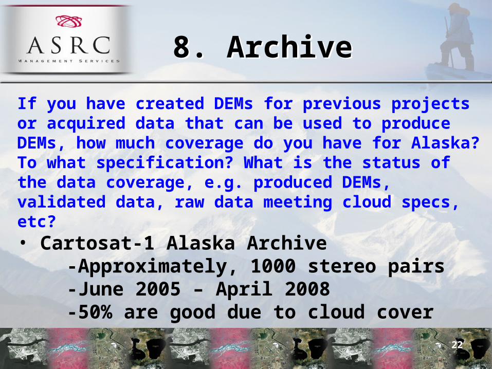
If you have created DEMs for previous projects or acquired data that can be used to produce DEMs, how much coverage do you have for Alaska? To what specification? What is the status of the data coverage, e.g. produced DEMs, validated data, raw data meeting cloud specs, etc?• Cartosat-1 Alaska Archive
-Approximately, 1000 stereo pairs-June 2005 – April 2008-50% are good due to cloud cover
22
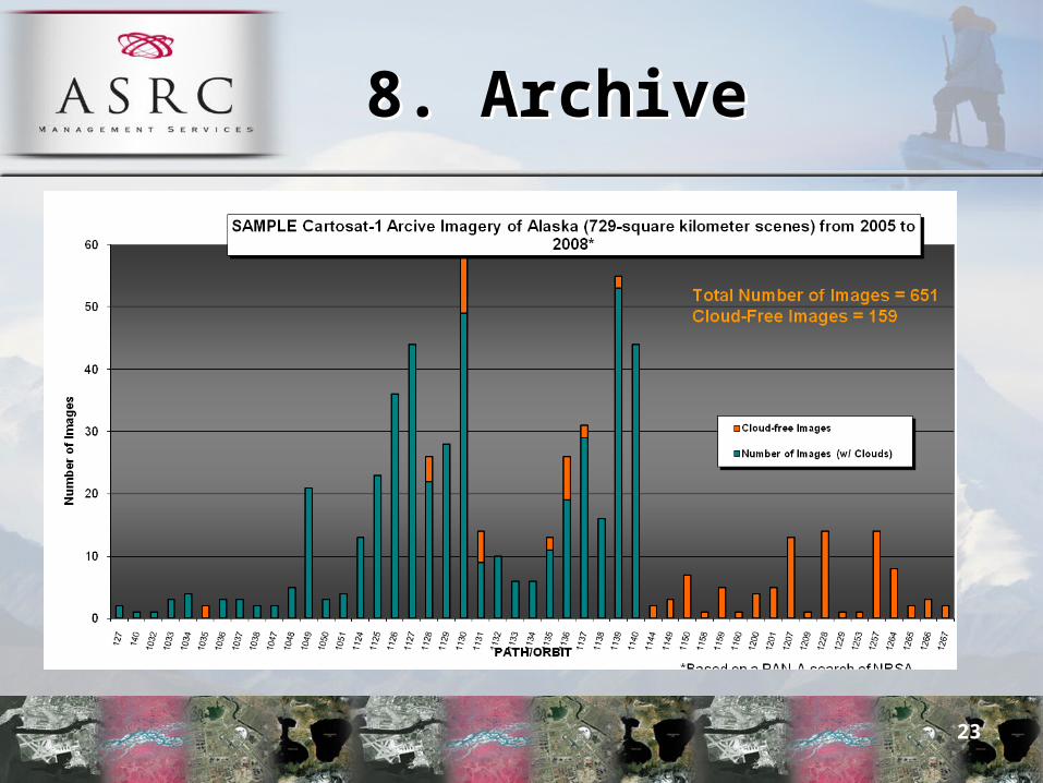
8. Archive8. Archive
23

Cloud CoverCloud Cover
• GDA Corp. has developed a Cloud Cover Extraction Tool which improves the percentage of usable data an additional 25% - Deliver per pixel cloud & shadow data
gap info - Easily allows removal for DEM
24
9. Product9. Product
Do you deliver a DEM product or do you deliver data that can be made into DEMs by others?
• ASRC Management Services provides CARTOSAT-1 Panchromatic 2.5 meter stereo imagery pairs to be used for generation of DEMs by value added processors
25
10. Processor10. ProcessorIf you provide data to generate DEMs, rather than a finished product, what is required to produce DEMs from your data? Have you found certain software that works well? Do you have established processing partners? Is there an opportunity for local Alaska productions of DEMs?•ASRC MS works with value added processing partners
•PCI and Genesys are being demonstrated at the workshop due to their recent experience
•Most value added processors use PCI-OrthoEngine software
•PCI Geomatics has achieved complete certification for its flagship software, Geomatica® to be used for processing data from the CARTOSAT-1 satellite
26

10. Processor10. ProcessorIf you provide data to generate DEMs, rather than a finished product, what is required to produce DEMs from your data? Have you found certain software that works well? Do you have established processing partners? Is there an opportunity for local Alaska productions of DEMs?•ASRC Management Services is a subsidiary of Arctic Slope Regional Corporation and encourages the use of Alaskan labor in the creation of DEMs for the State
•ASRC MS currently supports and is involved with the development of GIS Programs in coordination with:
- Several North Slope Borough District High Schools for students to obtain GIS Certification to enter college with credit- Programs are underway with llisagvik College and the University of Alaska
27
11. Special Applications11. Special
Applications
Please identify special applications for planimetric and topographics mapping, and unique value-added applications:
•ASRC MS value added processors provide the following standard mapping products:
-DSM-Edited DEM-Ortho imagery-Breaklines if stereo editing is desired
28
11. Special Applications11. Special
ApplicationsPlease identify special applications for planimetric and topographics mapping, and unique value-added applications:
•ASRC MS value added processors also provide unique value applications such as:
- 3-D fly through from digital terrain models generated with panchromatic CARTOSAT-1 stereo imagery as well as colorization from Resourcesat- Change detection and environmental
monitoring services are also available29
12. Ground Control12. Ground ControlWhat are your requirements for ground control points for acquisition, production, and/or horizontal/vertical accuracy testing? What accuracy would you require both horizontally and vertically for such ground control? Would the existing NGS control be suitable for your needs, or would you require more? If more control is required, what spacing or density of survey points would be needed?
•One control point every 25 sqkm, which provides a uniform spread of 9 GCP’s per CARTOSAT scene
30

13. Geodesy Issues13. Geodesy Issues
How do you propose to address geodesy issues such as sparse CORS network, geoid limitations, and the impact of solar activity (k-index) on airborne and ground GPS data collection? Do you have preferences for datums, projections, coordinate systems, and units?
•Our Value Added Processors will determine how sparse CORS network, geoid limitations, and solar activity (k-index) on airborne and ground GPS data collection will effect the generation of mapping products from CARTOSAT-1 stereo imagery and data preferences
31

14. License14. License
What license options are available for your elevation data?
•ASRC Management Services is currently working with the Alaska SDMI on an “open license”
•Derived products from CARTOSAT-1 imagery such as DEMs may be shared in the state (not for commercial purposes).
32

15. Production volume15. Production volume
How much area could you produce each year over Alaska? •CARTOSAT-1 imagery collection for the entire State of Alaska will require a minimum of 24-36 months
•DEM development running parallel with the imagery collection and cloud cover could take up to 6 years to develop.
33
16. Experience16. Experience
Please provide examples if you produced large volumes of data in remote, poorly ground controlled areas in the past. •Horizontal and vertical accuracy of the datasets beyond what can be produced from imagery off of the satellite is in effect proportional to the amount, location and quality of ground control
•Our value added processors have been engaged in utilizing CARTOSAT-1 stereo pair imagery since launch to generate DEMs of the nation of India
•In this massive project large volumes of data have been produced in areas of minimal or no control. Similar projects are also underway by Euromap
34

17. Pricing17. PricingOne goal of the workshop is to bin solutions by cost. A potential binning is <$10M, $10-30M,>$30M. There will be opportunity, either through a future RFP or discussions under NDA, to discuss pricing with potential buyers. Costs should approximate all expenses (tasking, collection, production, licensing to include annual subscription fees, etc.)
•A “Satellite Receiving Ground Station” in Alaska that is capable of down linking CARTOSAT-1 and Resourcesat-1 will cost under $5 million per year
35
17. Pricing17. PricingOne goal of the workshop is to bin solutions by cost. A potential binning is <$10M, $10-30M,>$30M. There will be opportunity, either through a future RFP or discussions under NDA, to discuss pricing with potential buyers. Costs should approximate all expenses (tasking, collection, production, licensing to include annual subscription fees, etc.)
•If imagery costs are 20% of the total project cost in the scenario above, it will require an investment based on the Value Added Community charges for DEMs
•The estimated cost to “Acquire & Download Cartosat-1 Data in Alaska” is approximately $3.26/per sqkm vs. $8.60 per sqkm if Cartosat-1 Data is purchased from the recorder
36

18. IDIQ Contracts18. IDIQ Contracts
Are you a prime contractor and/or subcontractor on existing government IDIQ contracts? If so please list the contract(s) as well as name(s) of prime contractor(s) for which you serve as subcontractor.
ASRC MS is The Prime Contractor and subcontractor on numerous IDIQ type contracts such as:
•The US Department of Agriculture Prime Vendor Contract •Partner in the NJVC (manages multimillion dollar IDIQ for NGA)
37
All Cartosat-1 DEM Publications
All Cartosat-1 DEM Publications
www.asrcms.com
38
Thank You!Thank You!
For More Information Contact:
Dr. Shawana P. Johnson, GISP
216-525-0600~or~
J. Edward Kunz, GISP
301-837-535439