AJourneythroughthe CentralHighlandsofSouthSulawesi...
13
A Journey through the Central Highlands of South Sulawesi by Ian Caldwell To tell the truth, the historian is not unlike the traveller. He tends to linger over the plain, which is the setting for the leading actors of the day, and does not seem eager to approach the high mountains nearby. More than one historian who has never left the towns and their archives would be surprised to discover their existence. And yet how can one ignore these conspicuous actors, the halfwild mountains, where man has taken root like a hardy plant; always semideserted, for man is constantly leaving them? How can we ignore them when often their sheer slopes come right down to the sea’s edge? —Ferdinand Braudel, The Mediterranean and the Mediterranean world in the age of Philip II, pp.2930. In November 1992, an English companion and I made a journey of over 200 kilometers on foot, horseback and by river across the remote northern highlands of South Sulawesi. This little known and sparsely inhabited region lies between the northern arc of the Quarles mountains and the southern extension of the Taloklekaju or Molengraaf mountains. 1 The highlands, which form one of the most mountainous areas of Sulawesi, are the denuded fragments of a shattered and uplifted peneplain and the deep valleys which cross it are cut by torrential rivers, or formed by tectonic depressions (Bemmelen 1949:42). The region is the wettest in South Sulawesi, with a rainfall of between 1,500 and 3,000 millimeters a year. The dense virgin forests which cover the mountains are home to numerous species of animals, including the solitary and dangerous anoa or dwarf buffalo, and the babirusa or ‘pigdeer’, whose extraordinary, inverted upper tusks curl upwards through the skin and backwards, in a logarithmic spiral, towards the skull. I had first set eyes on this largely undocumented region two years earlier, from the window of a small aircraft flying from Palu to Ujung Pandang. Below, in the shadows of the late afternoon sun, lay a vast, dark and faintly menacing ocean of trees. I knew that this region was in earlier times a part of the kingdom of Luwu, once the wealthiest and most powerful of the Bugis kingdoms of South Sulawesi (Bulbeck and Caldwell 2000). I wondered what attraction this somber, mountainous land had for the kingdom of Luwu and I resolved to find out by exploring the region on foot. Visits to libraries in Canberra, Leiden and London established that no accurate 1 The Taloklekaju mountains run from the west side of Palow bay to the Luwu plain. They have two high peaks: Bulu Wakukara, 3,127 m, in the north, and B. Kambuno, 2,950 m., at the southern extremity. The Quarles mountains, which stretch more than 100 kilometers in a slow, northeasterly curve from the Mamasa river in the south to the Karama river in the north, rise to 2,963 m. in Bukit Kalando, and to 3,074 m. in Bukit Gandiwata. The north side of the Quarles range is drained by the Karama river, which flows west into the strait of Makasar; it is navigable for a short distance upstream by canoe.
Transcript of AJourneythroughthe CentralHighlandsofSouthSulawesi...

A Journey through the Central Highlands of South Sulawesi
by Ian Caldwell
To tell the truth, the historian is not unlike the traveller. He tends to linger over the plain, which is the setting for the leading actors of the day, and does not seem eager to approach the high mountains nearby. More than one historian who has never left the towns and their archives would be surprised to discover their existence. And yet how can one ignore these conspicuous actors, the half-‐wild mountains, where man has taken root like a hardy plant; always semi-‐deserted, for man is constantly leaving them? How can we ignore them when often their sheer slopes come right down to the sea’s edge? —Ferdinand Braudel, The Mediterranean and the Mediterranean world in the age of Philip II, pp.29-‐30.
In November 1992, an English companion and I made a journey of over 200 kilometers on foot, horseback and by river across the remote northern highlands of South Sulawesi. This little known and sparsely inhabited region lies between the northern arc of the Quarles mountains and the southern extension of the Taloklekaju or Molengraaf mountains.1 The highlands, which form one of the most mountainous areas of Sulawesi, are the denuded fragments of a shattered and uplifted peneplain and the deep valleys which cross it are cut by torrential rivers, or formed by tectonic depressions (Bemmelen 1949:42). The region is the wettest in South Sulawesi, with a rainfall of between 1,500 and 3,000 millimeters a year. The dense virgin forests which cover the mountains are home to numerous species of animals, including the solitary and dangerous anoa or dwarf buffalo, and the babirusa or ‘pig-‐deer’, whose extraordinary, inverted upper tusks curl upwards through the skin and backwards, in a logarithmic spiral, towards the skull. I had first set eyes on this largely undocumented region two years earlier, from the window of a small aircraft flying from Palu to Ujung Pandang. Below, in the shadows of the late afternoon sun, lay a vast, dark and faintly menacing ocean of trees. I knew that this region was in earlier times a part of the kingdom of Luwu, once the wealthiest and most powerful of the Bugis kingdoms of South Sulawesi (Bulbeck and Caldwell 2000). I wondered what attraction this somber, mountainous land had for the kingdom of Luwu and I resolved to find out by exploring the region on foot. Visits to libraries in Canberra, Leiden and London established that no accurate
1The Taloklekaju mountains run from the west side of Palow bay to the Luwu plain. They have two high peaks: Bulu Wakukara, 3,127 m, in the north, and B. Kambuno, 2,950 m., at the southern extremity. The Quarles mountains, which stretch more than 100 kilometers in a slow, northeasterly curve from the Mamasa river in the south to the Karama river in the north, rise to 2,963 m. in Bukit Kalando, and to 3,074 m. in Bukit Gandiwata. The north side of the Quarles range is drained by the Karama river, which flows west into the strait of Makasar; it is navigable for a short distance upstream by canoe.

map of the area could be found, and that the best map of the central highlands of South Sulawesi was a sketch map published in 1920 based on information provided by the Dutch missionary A.C. Kruyt, who lived and worked in central Sulawesi.2 In the same year, Kruyt published articles on the peoples of the Limbong and Seko regions (Kruyt 1920a, 1920b). Limbong lies at the head of the Rongkong valley, which starts at the edge of the coastal plain of the Gulf of Bone. Limbong is an oval valley approximately five km wide and 10 km long. The main settlement, of the same name, lies at the eastern end of the valley. The Seko region is divided three regions or valleys. Seko Pada is a circular valley, roughly ten kilometers in diameter, through which flow the salo (rivers) Betue and Kasumong. The southern end of the valley lies 50 kilometers north of Limbong and is separated by the vast forest I had seen from the aeroplane. Seko Tengah is the lower valley of the salo Betue, which runs east from the southern edge of Seko Pada. Seko Lemo is the valley of the salo Uro, which runs from the south, in a northwest arc, to merge with the salo Betue. We therefore planned a route that would take us west from Sabbang on the coastal plain up the Rongkong valley to Limbong, then due north to Seko Pada, then southwest along the Betue river through Seko Tengah, before turning southeast along the Urah river and climbing southwest once more through the hills to rejoin the salo Betue and Uro, now merged to form the fast-‐flowing Karama river (Map 1).
Map 1 showing settlements visited on the journey
2 In recent years the Badan Koordinasi Surat Tanah Nasional in Bogor has published modern 1:50,000 maps of the region. Kruyt’s map, which appears to have formed the basis for later Dutch and American maps, shows many of the major settlements, mountains and rivers in the region, but its topography is unreliable.
Our journey began early one morning from the main bus terminal in Palopo, the administrative capital of kabupaten Luwu. After a hurried breakfast of bananas and coffee, we piled into a minibus for the two-‐hour ride along the metalled road to Sabbang, at the foot of the Rongong valley that leads up to Limbong. The settlement of Sabbang, now abandoned, once prospered from the trade passing out of the central highlands. Today all that remains are the hundreds of looted pre-‐seventeenth century graves which lie a short distance from the main road (Willems 1940). Waiting at the junction of the turn off to Limbong was a four-‐wheel-‐drive Toyota Land Cruiser, its roof piled high with baggage and its interior crammed with passengers. Diesel cans and baggage were lashed fore and aft After some negotiations, we squeezed in to make twelve including the driver. Four more people climbed onto the outside of the vehicle, and we set off up the bumpy dirt road for the four-‐hour, fifty-‐seven kilometer drive to Limbong. The road to Limbong winds along a narrow, twisting valley, its steep sides covered in tropical forest. Down the valley over a rocky bed rushes the shallow, fast-‐flowing Rongkong river. Our vehicle halted frequently to disgorge its passengers so that its driver could negotiate the small wooden bridges which cross the numerous small streams which flow into the Rongkong river. Halfway, we refueled from a cache of large oil drums brought up from Sabbang. We stretched our legs and photographed the wood-‐planked, thatched or tin-‐roofed houses perched over small patches of fertile ground clinging precariously to the valley’s lower slopes. The small courtyards in front of the houses were planted with yard beans, cucumber, marrow, chillies, rambutan, tapioca, papaya, banana, coconut and kapok trees. Many hamlets had small, whitewashed fences bordering the road, behind which grew marigolds and poinsettia. People here looked healthy and prosperous, with only the older people showing signs of goiter due to iodine-‐deficient soils. Small girls in Girl Guide uniforms or wrapped head to foot in checked cotton sarong came to stare at us. At Kanandédé 3 I enquired about metal ores and was told there were none, but that gold was still panned from rivers in the Kalumpang region, further to the west. Shortly after Kanandédé , about two thirds of the way up the valley, the road crossed the Rongkong river, then steepened and deteriorated into a dirt track as it wound up to Komba. The air cooled and coffee bushes appeared. Four hours after leaving Sabbang, we reached the crest of the pass and saw below us the countless green ripples of gently descending terraced ricefields, half shrouded in mist and ragged clouds, before a brief descent brought into sight the glistening tin roofs of Limbong. Limbong is one of the four dusun (hamlets) that make up desa Marampa’, in kecamatan Rongkong. The four dusun, Lowarang, Ponglégen and Salutalang and Limbong, sit around the edge of a small fertile valley at the head of the pass, up from Sabbang. The valley is terraced with ricefields; coffee is grown on the lower slopes of the surrounding mountains. The higher slopes, which are partially deforested, have been replanted with pine trees, some of which are nearing maturity. The
3 There are fifteen hamlets between Sa’bang and Limbung: Pongoq, Montoq Bombongan, Parrara, Kanan, Lenaq, Saluturunan, Malélara, Tandung, Rantésibuno, Bukah, Polobang, Kanandédé, Komba, Kawaléan, and Salotalang.
people of Rongkong speak a dialect of the Torajan language and are renowned as hardy and enterprising traders. Sturdy mountain ponies bred here are used to carry coffee down to Sabbang, while salt, dried fish, paraffin and manufactured goods are carried up from Sabbang and traded northward to the Seko valley. In Limbong we stayed at the home of the 33-‐year-‐old kepala dusun, Pak Effendi Sweang, a quiet, reserved man with a keen eye for human foibles and a subtle sense of humour. He was to prove an excellent guide and companion as well as a source of information on the districts through which we passed. Coffee and rice are the main export crops of the Rongkong valley, but in the Dutch period (and possibly earlier) dammar, a resin or gum excluded by certain trees, notably of the genera Shorea and Hopea, was the most important export good.4 I was informed that families in Rongkong and Seko have traditional gathering areas, and that these are registered with at the camat’s office in Limbong. An annual tax is still levied on them: I was told that a man can collect 40-‐50 kg of dammar in 5-‐8 days. Amber is also found in the forests which surround Rongkong but is not marketed; river stones (presumably a kind of agate) and rock crystal are collected and sold. When I explained to Pak Effendi that we were interested in locating old iron mines, he told us of three sources of iron in the district. The first two, Balanalu and one is at Pangiwangen, lie south of Rongkong; the latter was said to have yielded weapons-‐grade (i.e. high quality) iron. The third and outstanding source was at bukit Porreo’ (Porreo’ hill), about 5 km west of Limbong. The ore here yielded an iron, besi Porreo’, which was reputed to be highly poisonous, to the extent that a single scratch from it could kill. The deadly nature of the iron (the ore is said to be harmless) probably reflects a practice of coating the blades of weapons with vegetable poisons. Pak Elias Tipa’ (b. 1942), a Christian neighbour of Pak Effendi, told us that in former times the people of Rongkong were the chief defenders of Luwu and well known for their martial prowess as well as their fierce loyalty to the Datu Luwu. Weapons made from besi Porero’ are said to have been worn by Luwu’s nobles, and the metal is famous throughout Luwu and Tana Toraja.5 Pak Effendi told us that tombak (spear-‐heads) and parang (cutting and slashing knives) were once made in Rongkong, some with beautiful veins, produced by working a plate of chromium rich iron between two plates of plain iron.6 Some kepala tombak (spear heads) were as long as the hand and forearm. No agricultural tools were made from besi Porero’. The following day we awoke to find that the northwest monsoon had arrived early, bringing with it light but frequent showers of rain.7 We set off in the drizzle, walking in a northwesterly direction up a steep ridge towards Bukit Porerro’ about five kilometers distant. On our way out of the village we passed a small forge, with
4 In pre-‐colonial times, its main use was for caulking boats, 5 I was later told of the poisonous nature of besi Porero’ in the Mori-‐speaking settlement of Matano in eastern Luwu. 6 Bulbeck and Caldwell (2000:22-‐3) provide evidence that chromium, not nickel, was the important admixture in iron from Lake Matano. 7 The northwesterly monsoon runs from November to April; the southeasterly monsoon, which brings much less rain, blows from April to June. The driest month is October. Many of the mountain valleys further west and north lie in permanent rain-‐shadows, the driest agricultural zone being the Gorontalo-‐Palu valley.
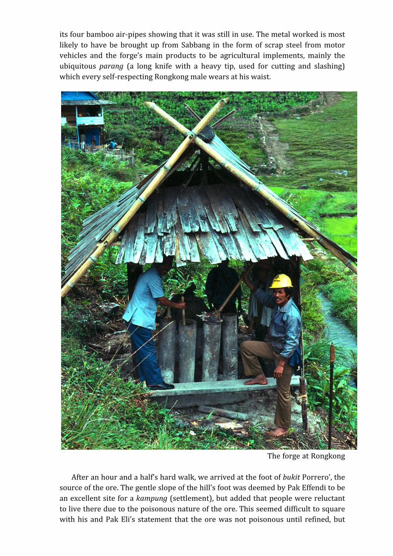
its four bamboo air-‐pipes showing that it was still in use. The metal worked is most likely to have be brought up from Sabbang in the form of scrap steel from motor vehicles and the forge’s main products to be agricultural implements, mainly the ubiquitous parang (a long knife with a heavy tip, used for cutting and slashing) which every self-‐respecting Rongkong male wears at his waist.
The forge at Rongkong After an hour and a half’s hard walk, we arrived at the foot of bukit Porrero’, the source of the ore. The gentle slope of the hill’s foot was deemed by Pak Effendi to be an excellent site for a kampung (settlement), but added that people were reluctant to live there due to the poisonous nature of the ore. This seemed difficult to square with his and Pak Eli’s statement that the ore was not poisonous until refined, but
presumably reflects the general awe in which besi Porerro’ is held. The ore is also found on the surface at the foot of gunung (Mt.) Beradarada, which is visible from the ridge. The route down a valley and along another ridge to gunung Beradarada looked difficult, and it was unlikely that we could return from there to Limbong before dark. No ore was visible on the surface of bukit Porerro’, but a fist-‐sized lump of light brown ore, was dug up from just below the surface of the soil. We were told that there was a large pit nearby, possibly a former mine working, but this proved impossible to find in the thick undergrowth. Slipping and sliding on the narrow muddy path in the intensifying rain, a circular route back brought us out on the trail to Seko, which terminates a kilometer south of Limbong. Knee-‐deep in mud and soaked to the skin, we cut through a patch of forest, stopping in a clearing to cook lunch and to remove the small leaches which we had collected on our arms and faces. Late in the afternoon, we arrived back at Limbong, rather the worse for wear and wondering if the rest of the journey was going to be so taxing. On our way to bukit Porreo’ we had passed a small path leading off to the south, which I was told was the trail to Tana Toraja and which exits at gunung Seran, 10 kilometers north of Rantepao. I had enquired about this trail two years previously in Tana Toraja but was unable to learn much. The trail is still used to transport buffalos and coffee down to Rantepao, where the price is higher than in Palopo. The journey through the forest takes three days. The trail does not seem to ever have been a major trade route as the products available at each end are similar: coffee, buffalos, rice, and (formerly) dammar. Further conversation elicited the fact that there was no direct trail to Masamba, but that a difficult trail starting below Limbong on the road to Sabbang could take you in a day to Rampi, from which Masamba could be reached in four days. Coffee, kayu manis (cinnamon) and dried deer meat is exported via Sabbang from Rampi, which has an airstrip and is connected to Masamba by an air service run by a Church mission. The following day dawned overcast with ample promise of the rain that was to follow. We arranged with Pak Effendi to hire two ponies: one we loaded with our rucksacks, cooking pots, rice and coffee, and grass for fodder, while the other was fitted with a crude, stirrupless saddle of wood and sacking stuffed with straw. With one of us riding and the other on foot, shortly after nine in the morning, we set off for Ma’busa, a clearing in the forest where travellers spend the night. The road from Limbong to Ma’busa, and from Ma’busa to Lambiri travels due north through a vast, uninhabited forest covering the slopes of the Quarles mountains. The road, which was built by the Dutch before the Second World War, is two meters wide but now heavily overgrown, with a well-‐trodden path running down its centre. Due to its inaccessibility, this forest is one of the remaining uncut forests in Indonesia. It was this forest I had seen beneath me like a dark green ocean from the plane two years earlier; on the ground it was no less forbidding. For most of the day the road climbed through its gloomy shade, winding upwards towards the western shoulder of Gunung Tabembeng. At three in the afternoon the road reached its highest point, which we estimated to be about 2,000 meters, and began the descent to the bridge at Ma’busa, which we reached an hour before dusk. Here we found a substantial roofed bridge, a large wooden hut, and a house on stilts, occupied by a single family. We unloaded the packhorse, which had developed
two ugly sores on its flank due to the swaying motion of the crude saddle. After a meal of rice, boiled leaves and a rehydrated packet of meat, we unrolled our camping mattresses and spread out the large acrylic blanket we had brought with us from Limbong in a back room of the hut. The sun went down, and the air turned cold. As darkness fell, the forest rats came out in their hundreds, forcing us to hang our belongings from the rafters as the creatures scuttled round the room and frequently over our heads. While my companion attempted to sleep, I went outside to join the traders camped out on the sturdy wooden bridge. Like all bridges in this region, it had a stout roof to prevent its timbers from rotting in the wet-‐season. These bridges are excellent camping places; a fire is lit at one end and people gather to talk and to slumber until dawn. In the east the Pleiades were rising while overhead stood the great autumn square of Pegasus, and in the west Cygnus the Swan made her slow, graceful descent to the horizon. At a height of 1800 meters, or six thousand feet, the air was surprisingly cold. At one end of the bridge was a blazing fire around which sat half-‐a-‐dozen traders, men and women, surrounded by sacks of coffee, on their way down to Sabbang. In the encircling darkness, ponies snorted restlessly as the forest rats scuttled back and forth across the bridge and boldly sniffed at the feet of the people sitting around the fire. Talk centred mainly on the hardships of mountain life and the lack of a surfaced road, which meant that profit on coffee was low due to the cost of transport, while salt, paraffin and manufactured goods cost double what they did in the lowlands. Wherever we went in this mountain region, people unanimously spoke in favour of a road to link them to the outside and the progress (kemajan) it would bring. It was agreed that the dammar market was at a nadir and that no money could be made collecting it. Sleep was punctuated by loud voices, babies crying and the ponies hoofs reverberating on the wooden bridge. Early in the morning when the sky was still dark, the household arose to prepare a communal breakfast, and as soon as it was light we set off we set off for the remaining thirty-‐eight kilometer walk to Lambiri in the Seko Tengah valley. Just after the bridge, a trail led away to the left, starting the shorter and more difficult route to Sepon and Kariango in the Seko Lemo valley. The trail crosses a pass between gunung Malimongeng and Takokong, both more than 2000 m high. The rain had now stopped, and at mid-‐morning the sun made a brief but welcome appearance. We continued along the main trail, which now ran due north along the western side of a deep, narrow valley. The path clung high to the side of the valley, dipping down occasionally to run alongside the river at its foot. All day we walked through the dreary valley, the monotony of the scenery occasionally broken by large, apricot-‐coloured flowers growing at the edge of the forest, and yellow-‐and-‐black, and tiny sky-‐blue, butterflies that settled in miniature clouds upon the path. Around mid-‐day we passed a caravan of coffee-‐laden ponies heading east to Sabbang, and shortly after three o’clock we were rewarded by our first view of the low, grassy hills of the Seko Tengah valley bathed in afternoon sunlight. Here the path crossed the river and continued along the right-‐hand bank, then left the river and curved around the shoulder of a hill at the end of the valley. We entered an open grassy region, walking past pondok in recently burnt ladang awaiting the rains of the monsoon, which had followed us across the mountains. One hour later we arrived in Lambiri, a new settlement founded a decade or so ago by people from Ambalong, further to the west. Despite its height of 1170 meters, Lambiri’s climate
was pleasantly warm and dry, due largely, we suspected, to the local deforestation. In Lambiri we stayed with Pak Tasi, the 34-‐year-‐old kampung head. He told us that in former times dammar had been collected in the surrounding forests, but that the current low price made collection uneconomic. The ground around Lambiri is scattered with large boulders which are attributed to Tolambia, a legendary pendekar (champion) who could lift two cows at one time and who fished for ikan belut in the local rivers. To scare away rice birds from his crop, he is said to have thrown the large boulders lying scattered around. Eno, or Wono, at the foot of the Seko Pada valley, is a pleasant morning’s walk away along the Betué river valley, winding northward through high grassy hills. After a kilometer, we passed the path leading west to Seko Tengah and Seko Lemo; further on, we came to the deserted village of Saé, now a travellers’ resting halt marked by a large wooden balé (shelter). Two hours walk along the a winding valley brought us to a broad tributary of the Betué river. Footsore, muddy and covered in scratches, we plunged gratefully into the cold water where we bathed and washed our clothes before walking the final kilometer to Eno. Eno is a well-‐kept village with bamboo-‐fenced house gardens, a junior high school, a district health centre, and a large grassy airstrip by which it is connected to the outside world by a twice-‐weekly flight from Masamba. Eno stands at the junction of the trails to Gimpu in the southern Palu valley, and the valley of Rampi, to the northeast; the former is two nights distant and the latter is one. Eno forms the central terminus for trade and communication from these districts, as well as for settlements to the west and south. We did not have time to explore the valley to the north, but a map at the kepala desa’s office suggests that the it is roughly circular is shape and about 15 km in diameter. The Betué river flows past Eno to the east but is not bridged as the river becomes a torrent in the wet season. Across the river is a hot spring, marked by a fetid pool with a temperature of about 45° C. The climate of the Seko Pada valley is warm, with a marked dry season; the valley produces coffee and sugar. The staple is rice and there are a few fruit trees; wild deer are hunted for meat. Dammar was also once collected all round Eno. The people of Eno seem prosperous and content and do not appear to travel much; we were unable to learn anything about the route of Kalumpang, nor was anyone willing to hire us fresh ponies for more than a day’s journey out of Eno. The acting village head, Pak Anshar, age 56, took us on a tour of Eno’s archaeological sites, which included two unrecorded large stone structures, just out of the village on the path to Rampi (Photo 1). The first consists of four standing stones, each slightly less that a metre in height arranged in a square; one has fallen over and is half buried in the soil. The sides of the square are oriented to the cardinal directions and no markings are visible on the stones. The second stone structure was a large vat or sarcophagus (kalamba) of the type found in large numbers in Central Sulawesi, in the district of Besoa, where not less than 54 of them can be found (Heekeren 1958:60) (Photo 2). I was told that the vat is the only one of its kind in the Seko Pada valley, and that it had been carried from Central Sulawesi, following a successful raid by the men of Eno. The vat is broken in three pieces, deliberately, we were told, to facilitate carrying. An alternative explanation is that the vat has shattered due to internal stresses caused by the periodic burning of lalang (elephant grass) around it. No lid could be seen. Locally, the vat is known as
lesung batu Tolambi (the mortar of Tolambi, the strong man of the Lambiri legend). The vat has four ridges carved round it and a substantial ledge on the inside (Photo 3). It would have taken considerable effort to transport such a heavy object all the way from Bada or one of the other valleys of Central Sulawesi, yet this is indeed what seems to have happened. After we had rested the ponies for a couple of days we set off on the second, and more arduous stage of our journey to Kalumpang, a settlement on the bank of the Karama river, four days’ journey to the west. We backtracked to Saé, where we located some opencast iron mines at the foot of a small defile, a couple of hundred yards off the main track. The mines, if that is the correct word, consisted of dozens of one to two metre-‐wide pits, originally two to four meters deep but now filled with earth.8 The area of is heavily overgrown with secondary forest, and the mines are at least 50 years old, possibly older. No ore could be seen on the surface. Our informants agreed that the iron manufacture, whether smelting or working of scrap iron, was for local use only, and was never exported. Turning west after Saé, we entered the Seko Tengah valley, along a well-‐marked footpath which wound in and out of the hills, with the Betué river winding below us. In the early afternoon we stopped at Ambalong to enquire about reports of iron working, but could find no-‐one to help us. In the mid-‐afternoon we had a splendid view of the Seko valley system as far as Wayané, at the northwestern end of the Seko Lemo district. In the late afternoon we reached Longa, a small village perched 1,200 feet up on the side of the Betué valley. That evening, Pak Ansar, aged 26, from Palopo who was visiting relatives, told us that half a day’s excursion from Longa, at Hartorondo, was a group of rocks etched with images of people, buffaloes and other subjects. We were told that iron was once mined at Berropa’, further along the trail to Kariango, at the end of the Seko Tengah valley, and also at Pewanéang. Informants again insisted that the iron was smelted and worked solely for local use. Some copper was said to be found at Singkalong, 10 kilometers from Eno. In the morning we continued westward down the Betué valley. Shortly after Kalaha, Gunung Sandepan, with its remarkable double summit, came into view. We descended to Kariango, at the end of the valley, and crossed the river on a long suspension bridge, the ponies wading across farther up river. Here we left the Seko valley system and entered much less developed country of scattered hills, patches of freshly burnt swidden, and pioneer settlements. At Berropa’ it was the same story as at Ambalong: the men were in the fields and we were unable to ask about iron working. At Berropa’ we took a wrong turning, and headed west instead of south. We spent the night in Lédan a small, recently opened settlement, which we were told was the last settlement until one reached Bau, directly to the west. Our host warned us that the road ‘rose a little’ (ada sedikit naik) in the course of its progress. The house we were staying in was dirty and full of fleas. After a night of poor sleep we set off and began what could be described, with some understatement, as a steep climb through difficult country, hacking our way through the undergrowth
8 Bronson (1992:68) observes that in Southeast Asia rarely involved underground working; the ores were collected from the surface of the ground, panned from river sands, broken from outcrops or dug from shallow pits.
and dragging our uncomplaining ponies up the side of what was evidently a small mountain. By now the trail was so poor and the undergrowth so thick that we had to unload our belongings from the pony and carry them ourselves. Had we a modern map, we could have seen that the trail we were following was a difficult shortcut over a small mountain, gunung Ba’san’ (1,489 m). After three and a half hours of battling through undergrowth, we emerged on the summit of the mountain. The view from the top, down on to drifting clouds and jungle clad hills below us, was worth at least some of the effort of the climb. The trail we were supposed to have followed ran south from Berropa’, via Rantédanga and Buakayu, then climbed steeply to 1200 m to descend in a northwest direction along the salu Olé h and down to the Oléh valley (327 m). The topography of this route, and the absence of settlements along its greater length suggests that this route is no easy alternative to a direct assault on gunung Ba’san. All the way through the Seko valley system I had asked people where they sold their coffee; I was surprised to learn that, even as far west as Léden, coffee was still traded to Sabbang. It would appear therefore that Gunung Ba’san (actually a series of ridges and summits rather than a single massif) forms a physical barrier that divides the northern region of South Sulawesi into two distinct economic zones, one focussed on Sabbang and the other on Kalumpang. In the early afternoon, after an equally precipitous descent from the summit, we arrived in Bau, a small Christian village, where we talked to the pastor, Robert Tumbangi, aged 41 years. Like most other village in the region, the economy of Bau, which has about 60 families, is based on monsoon-‐irrigated rice (both wet rice and hill-‐grown dry rice), root vegetables and maize grown in swidden fields. Coffee is grown as a cash crop and exported to Kalumpang. We continued on, descending slowly, following the right bank of the salu Oléh with a fine view of Gunung Sandapan (1,705 m) to the west. Crossing the salu Oléh, we walked through a series of villages until we joined the Karama river at Tambing-‐Tambing. We decided to push on to the next village, Sa’bamba, where we heard that we might be able to get a boat down the river to Kalumpang. Our ponies were by now in a sorry condition, grown thin and with ugly sores on their backs. A few kilometers out of Sa’bamba, we came across a large patch of sweet grass which the animals refused leave until they had eaten their fill. Having ourselves suffered the pangs of hunger more than once on the journey, we left them in charge of a local and walked to Sa’bamba, which we reached at dusk. By now, the steady diet of rice and boiled leaves was taking its toll, and my companion had acquired a debilitating intestinal infection. We decided not to attempt the final 24-‐kilometer walk to Kalumpang but to stay in Sa’bamba and wait for the boat, which was expected shortly. Sa’bamba was not an impressive place. The entire population of the village sported large goiters, presumably as the result of acute iodine deficiency. At dusk the village disappeared into the blackness as people retreated to their kitchens, lit by a single, dim light; by eight it was dark. The next day was Sunday, when work is forbidden, so we sat on the verandah of the kepala kampung while villagers squatted before us, silently inspecting the visitors. No boat appeared. Evelyn Waugh’s novel A Handful of Dust came to mind and we began to suspect that any moment an English speaking chief would appear and command us to read him the novels of Dickens. When we finally enquired when the

kepala kampung would arrive to meet us, he was pointed out as one of the men squatting before us. Our enquiries as to the expected boat were met with polite expressions of hope, and the offer to construct for us a bamboo raft on which we could drift down the Karama river to Kalumpang. One look at the turbulent river was enough for us make reading even Little Dorrit an attractive alternative. My companion was becoming increasingly ill, so on the following morning we engaged two young men to walk to Kalumpang to charter a boat. We said farewell to Pak Effendi, who had proved a reliable guide and companion, and he set off with the ponies for the long walk back to Limbong, via the mountain route from Kariango to Ma’busa. In the mid-‐afternoon, a long outrigger canoe fitted with three large outboard motors arrived from Kalumpang. After negotiations, in which we did not have much leverage, we set off down the Karama river. Sa’bamba is almost the highest point these boats can reach due to the shallowness and speed of the river, and Kalumpang was reached after barely an hour, through a narrow gorge cut by the river, past rapids, large whirlpools and invisible hazards from which the powerful outboard motors kept us clear. The footpath, which we could see from the boat, followed the south bank of the river, winding across bald, grass-‐covered hills and freshly-‐burnt patches of ladang. Soaked but exhilarated, we stepped ashore at the large stone embankment of Kalumpang, after a journey of eight days. Kalumpang is a large and attractive village which is the administrative centre of a large district. The village is set around a large open square and the settlement has an air of enlightened prosperity. This is due to partly to government money in the form of schools and health programmes, and partly to good communications with the outside world, despite the fact that Kalumpang is several hours walk from the nearest town, Mamuju. On our journey we had seen how much of the character of a village stems from the personality and energy of the kepala desa. The village head of Kalumpang, who was away in Mamuju at the time of our visit, was evidently a man of energy and enthusiasm. The village had its own electricity supply, powered by a generator, and several houses had television sets. My companion was able to get medical treatment from a Balinese doctor, who had married a local school teacher and set up a clinic in the village. A road to connect Kalumpang with Tana Toraja was under construction and had progressed six kilometers from the former. A large rumah adat (modelled on the traditional large wooden houses of the district) has been built at the edge of the village in order to preserve some of the customs and traditions that development will inevitably destroy. The kepala desa’s wife, with whom we stayed, an energetic and capable woman of about 45, has resuscitated the weaving industry, for which Kalumpang has long been famous. Kalumpang is dominated by Gunung Paken, which lies on the north bank of the river, directly across from the village. We were told that the mountain can be climbed in about two hours, and that on the summit was a large hollow stone in which rice grows. Kalumpang is famous as the location of an important neolithic site, excavated by the archaeologist van Stein Callenfels in 1937, and by Van Heekeren in 1947. Bark cloth beaters have been found at the Kalumpang site which Bellwood (1985:248) is inclined to date around 1000 BCE. We were told that gold is still panned from the Karama river and from its tributary Sungai Karataun, especially in the dry season. We also heard talk of plans
to open a gold mine at Batuisi, 18 kilometers north from Kalumpang, which probably means no more than that a geological survey has been carried out in the district. All that remained the following morning was for us to complete our journey was a two and a half hour boat ride down river to Tarailu, along the fast-‐flowing, but now more benign, Karama river. At Tarailu a mini-‐van was waiting for the two-‐hour journey to Mamuju, and from Mamuju to Pare-‐Pare, and our first cold beer in nearly a fortnight. What had we learnt from our journey? Firstly, we had learnt that iron ore was plentiful between Sabbang and Karama. Iron mines, if that it the correct term, were simply holes dug in the ground, from which the ore was extracted. No-‐one knew of an export trade; villagers everywhere claimed that the iron was smelted and forged into tools and weapons for local use. This may have been true of most of the production, though the fame of Limbong’s bessi porerro’ suggests at least one exception. Secondly, we learnt that the northern mountainous region through which we had passed was divided into two economic (and to some extent cultural) regions, separated by the formidable barrier of Gunung Ba’san. It was our distinct impression that to the east of Ba’san, the culture was different, and that people looked west to the coast rather than east to the Gulf of Bone. Thirdly, we learnt that gold was still panned on the Karama river and its tributaries. The Karama river is where the Sampaga Buddha was found. This is the most famous bronze object from Sulawesi, the Buddha image in the style of Amaravati (2-‐5th C AD) Pelras (1996:25) speculates that this is evidence of trade along the Karama river to ‘the iron ore-‐producing area of Séko, one of the few places in the archipelago where iron could be extracted relatively easily in ancient times, which suggests the existence there of early trading.’ However, the physical separation of the Karama and Seko valleys, noted above, suggests otherwise. A more likely reason for the import of a fifth-‐century Indian bronze buddha is the gold panned on the Karama river. Fourthly, we learnt that dammar was formerly collected throughout the region, and that traditional collecting territories are still recorded in local government offices, and that a tax is still levied on them. Today coffee is the main export crop and the means of paying for necessities such as salt and clothing (formerly cotton cloth) But coffee is a fairly recent introduction, dating back no more than three or four centuries. Dammar trees grow in large numbers in the highland forests right across Luwu, and while the origins of the trade cannot be dated, the physical difficulty of hauling less valuable products, such as rice or rotan, down to the coast along difficult mountain trails, would have made dammar an attractive export product. No-‐one I questioned seemed able to name another marketable forest product, and dammar was always the first product mentioned after coffee, today’s main export crop. It seems possible that the economic basis of the relationship between Luwu and Rongkong, and Luwu’s influence much further north into Central Sulawesi, was based, at least in part, upon the dammar trade as well as upon the export of iron goods and weapons. Lastly, and significantly, we had seen the attraction of economic development for the people who live and who make their living in this difficult, mountainous region.
It is easy for visiting outsiders to bemoan the sight of airstrips, television aerials, forest clearance for farming and modern concrete housing with sanitation and electricity, all of which detract from the romance of isolation and the natural beauty of the region. But the monotonous diet, the physical effort involved in moving even short distances (we averaged just 20 kilometers a day with two ponies), the difficulty of educating children and the poor health of many of the people in this isolated mountain district, as a result of ignorance rather than poverty, convinced us that ‘progress’ was far from a bad thing. No-‐one we spoke to was in doubt that a metalled road from Sabbang to Kalumpang would be anything other than good and all were in favour of better connection with the outside world, in short to enjoy some of the basic amenities that we in the developed world take for granted. BIBLIOGRAPHY Bellwood, P. 1985. Prehistory of the Indo-Malaysian archipelago. Sydney: Academic Press. Bemmelen, R. W. van. 1949. The geology of Indonesia. The Hague: Government Printing Office. Volume 1. Braam Morris, D. F. van. 1889. 'Het landschap Loewoe'. Tijdschrift voor Indische Taal-, Land- en Volkenkunde 32: 497-‐530. Braudel, F. 1972. The Mediterranean and the Mediterranean world in the age of Philip II. New York: Harper and Row. Volume 1. Translation of the revised 1966 edition of La Méditerranée et la Monde Méditerranéean à l'Epoque de Philippe II. Bronson, B. 1992. 'Patterns in the early Southeast Asian metal trade'. In: I. Glover, P. Suchitta and J. Villiers (eds), Metallurgy, trade and urbanism in early Thailand and Southeast Asia. Bangkok: n.p. pp.65-‐116. Bulbeck, D. and I. Caldwell. 2000. Land of iron; The historical archaeology of Luwu and the Cenrana valley. Hull: Centre for South-‐East Asian Studies, University of Hull. Heekeren, H. R. van. 1958. The bronze-iron age of Indonesia. ’s-‐Gravenhage: M. Nijhoff. Kruyt, A. C. 1920a. “De to Rongkong in midden-‐Celebes.” Bijdragen tot de Taal-, Land- en Volkenkunde 76: 366-‐397. Kruyt, A. C. 1920b. “De to Seko in midden-‐Celebes.” Bijdragen tot de Taal-, Land- en Volkenkunde 76: 398-‐430. Willems, W. J. A. 1940. “Preliminary report on the excavation of an urn-‐burial ground at Sabbang near Paloppo” (Central Celebes). Proceedings of the Third Congress of Prehistorians, Singapore