AIS ONOFF Report FINAL -...
11
1 | Avoiding Detection Avoiding Detection: Global Case Studies of Possible AIS Avoidance March 2018 Authors: Lacey Malarky and Beth Lowell Executive Summary Oceana highlighted cases of commercial fishing vessels “going dark” to public tracking systems around the world. Despite the associated safety benefits for vessels to use the Automatic Identification System (AIS), a ship’s crew may turn off this public tracking system to hide its location. Global Fishing Watch a (www.globalfishingwatch.org) uses public broadcast data from AIS to track the movement of fishing vessels to determine apparent fishing activity, and Oceana uses the technology to identify potentially suspicious activities at sea. In this report, Oceana identifies events where a ship’s AIS transponder was possibly turned off, which include: • A Panamanian purse seine vessel that seemed to disappear from public tracking systems for 15 days while operating near the border of the Galápagos Marine Reserve. • An Australian longliner that exhibited a pattern of potentially evasive AIS behavior by appearing to disable its AIS near the Heard Island and McDonalds Islands exclusive economic zone and marine reserve on 10 separate occasions during the period of just over one year. • A Spanish trawler that appeared to repeatedly turn off its AIS transponder when approaching the border between Senegal and The Gambia’s national waters over a period of at least one and a half years. • A Spanish purse seiner that appeared to turn off its AIS signal consistently over a seven-month period while operating in the national waters of at least five African countries as well as on the high seas. Proprietary Vessel Monitoring System (VMS) data can complement AIS; however, except for a few countries, VMS data can only be viewed by government or intergovernmental monitoring and enforcement agencies. Oceana is working to help stop illegal fishing, increase transparency at sea, and to require traceability of all seafood. To those ends, Oceana urges governments to require all commercial fishing vessels to be equipped with and continually transmit tamper-resistant AIS technology. These tracking systems are essential for transparency and public accountability of global fishing operations. In addition, they improve maritime safety and can help combat illegal fishing and increase compliance of laws and regulations. a Any and all references to “fishing” should be understood in the context of Global Fishing Watch’s fishing detection algorithm, which is a best effort to determine “apparent fishing effort” based on vessel speed and direction data from the Automatic Identification System (AIS) collected via satellites and terrestrial receivers. As AIS data varies in completeness, accuracy and quality, it is possible that some fishing effort is not identified and conversely, that some fishing effort identified is not fishing. For these reasons, Global Fishing Watch qualifies all designations of vessel fishing effort, including synonyms of the term “fishing effort,” such as “fishing” or “fishing activity,” as “apparent,” rather than certain. Any/all Global Fishing Watch information about “apparent fishing effort” should be considered an estimate and must be relied upon solely at your own risk. Global Fishing Watch is taking steps to make sure fishing effort designations are as accurate as possible.
Transcript of AIS ONOFF Report FINAL -...

1 | Avoiding Detection
Avoiding Detection: Global Case Studies of Possible AIS Avoidance
March 2018
Authors: Lacey Malarky and Beth Lowell
Executive Summary
Oceana highlighted cases of commercial fishing vessels “going dark” to public tracking systems around the world. Despite the associated safety benefits for vessels to use the Automatic Identification System (AIS), a ship’s crew may turn off this public tracking system to hide its location. Global Fishing Watcha (www.globalfishingwatch.org) uses public broadcast data from AIS to track the movement of fishing vessels to determine apparent fishing activity, and Oceana uses the technology to identify potentially suspicious activities at sea.
In this report, Oceana identifies events where a ship’s AIS transponder was possibly turned off, which include:
• A Panamanian purse seine vessel that seemed to disappear from public tracking systems for 15 days while operating near the border of the Galápagos Marine Reserve.
• An Australian longliner that exhibited a pattern of potentially evasive AIS behavior by appearing to disable its AIS near the Heard Island and McDonalds Islands exclusive economic zone and marine reserve on 10 separate occasions during the period of just over one year.
• A Spanish trawler that appeared to repeatedly turn off its AIS transponder when approaching the border between Senegal and The Gambia’s national waters over a period of at least one and a half years.
• A Spanish purse seiner that appeared to turn off its AIS signal consistently over a seven-month period while operating in the national waters of at least five African countries as well as on the high seas.
Proprietary Vessel Monitoring System (VMS) data can complement AIS; however, except for a few countries, VMS data can only be viewed by government or intergovernmental monitoring and enforcement agencies.
Oceana is working to help stop illegal fishing, increase transparency at sea, and to require traceability of all seafood. To those ends, Oceana urges governments to require all commercial fishing vessels to be equipped with and continually transmit tamper-resistant AIS technology. These tracking systems are essential for transparency and public accountability of global fishing operations. In addition, they improve maritime safety and can help combat illegal fishing and increase compliance of laws and regulations.
a Any and all references to “fishing” should be understood in the context of Global Fishing Watch’s fishing detection algorithm, which is a best effort to determine “apparent fishing effort” based on vessel speed and direction data from the Automatic Identification System (AIS) collected via satellites and terrestrial receivers. As AIS data varies in completeness, accuracy and quality, it is possible that some fishing effort is not identified and conversely, that some fishing effort identified is not fishing. For these reasons, Global Fishing Watch qualifies all designations of vessel fishing effort, including synonyms of the term “fishing effort,” such as “fishing” or “fishing activity,” as “apparent,” rather than certain. Any/all Global Fishing Watch information about “apparent fishing effort” should be considered an estimate and must be relied upon solely at your own risk. Global Fishing Watch is taking steps to make sure fishing effort designations are as accurate as possible.
2 | Avoiding Detection
Remote Monitoring Technologies
Ships navigate the oceans using a variety of tools, including AIS and VMS. These tracking systems serve different functions and can complement each other for the purpose of remotely monitoring vessel activity worldwide.
AIS was initially designed as a safety mechanism for vessels to avoid collisions at sea; a vessel equipped with an AIS transponder automatically broadcasts a signal as frequently as once every few seconds with vessel identity and location information, including vessel name, position, speed and direction. These signals are broadcast from ship-to-ship and from ships to orbiting satellites and land-based receivers. The International Maritime Organization (IMO) requires large vessels to carry AIS;b however, governments can decide if and how these requirements apply to fishing vessels. For example, the European Union (EU) requires all fishing vessels longer than 15 meters (about 49 feet) to be equipped with AIS,1 and the United States requires all fishing vessels longer than 65 feet (about 19 meters) to have AIS.2 However, Canada exempts all its fishing vessels from the AIS requirements.3 In situations not mandated by its flag state to carry AIS, fishing vessels can voluntarily utilize AIS to enhance their maritime domain awareness and safety at sea.
AIS provides a global feed of publicly available vessel location and identification information, however, it is not an infallible method for tracking vessels at sea. According to the IMO, under certain circumstances, ships with AIS may turn the equipment off: “AIS should always be in operation when ships are underway or at anchor. If the master believes that the continual operation of AIS might compromise the safety or security of his/her ship, the AIS may be switched off. This might be the case in sea areas where pirates and armed robbers are known to operate.”4 AIS systems can not only be turned off, erroneous and incorrect location and/or identification information can be broadcast.2,4
VMS is another vessel communication tool used to remotely monitor the locations of fishing vessels in real-time around the world. Unlike AIS, VMS is a closed-source tracking system, and its data is not publicly accessible. Certain governments and regional fisheries management organizations (RFMOs) require VMS tracking for fishing vessels. National authorities and RFMOs use this proprietary data as a standard tool for fisheries monitoring and control. However, the time interval of VMS data broadcasts is less frequent than AIS, making it more challenging to track and identify fine-scale vessel movements and behaviors. For example, AIS autonomously broadcasts every few minutes while a vessel is at anchor or as frequent as every few seconds while a vessel is sailing,4 whereas VMS typically broadcasts hourly. Additionally, only those authorities with access to a vessel’s VMS feed can “see” that vessel’s location information. Countries that allow foreign vessels to fish in their exclusive economic zone (EEZ) — or a nation’s sovereign waters, which extend 200 nautical miles from the coast — may not have access to VMS data even when a licensed foreign vessel is fishing within their national waters.
VMS and AIS have different communication systems and reporting rates, and therefore are not interoperable. However, these systems can be used in combination and for cross-checking purposes; where gaps exist in one system, data from the other can be used to fill in the blanks. For example, AIS data can complement VMS data, allowing public oversight of vessel activities that is impossible with confidential VMS data. Alternatively, VMS data can be used to fill in the gaps of AIS data; gaps in AIS data can result from low satellite coverage, high vessel density or the intentional disabling of transponders. Some governments use a combination of VMS, AIS and other data sources to monitor their commercial fishing fleets. When used together, AIS and VMS data offer one of the most accurate and comprehensive datasets for monitoring fishing activity beyond the horizon.
b The International Maritime Organization (IMO) International Convention for the Safety of Life at Sea (SOLAS) requires AIS to be fitted aboard all international voyaging ships of 300 gross tonnage and upwards, cargo ships of 500 gross tonnage and upwards not engaged on international voyages and all passenger ships regardless of size. (Chapter V, Regulation 19 of the 1974 SOLAS Convention).

3 | Avoiding Detection
Hiding from the Public Eye
A common but potentially unscrupulous practice is for vessel operators to turn off their AIS or “go dark” to public maritime tracking systems. Some vessel operators may choose to hide from public view for legitimate reasons, which may include hiding from pirates or for other navigational security purposes. Though sometimes justified, disabling AIS can jeopardize the safety of a vessel and its crew, possibly putting them at a higher risk of colliding with another vessel — especially at night. This behavior may indicate that a vessel is intentionally avoiding detection to hide suspicious or illegal fishing activities, such as fishing in protected areas, transshipping illegally caught fish, entering a country’s waters without authorization or violating other fisheries laws.
Global Fishing Watch receives AIS data from approximately 70,000 fishing vessels. Global Fishing Watch algorithms can help determine when vessels are likely fishing based on information from the AIS data, such as vessel speed, direction and rate of turn and distinguish the type of fishing gear used (e.g., trawler, purse seiner, longliner, etc.). In addition to providing a publicly available global view of commercial fishing activity, Global Fishing Watch algorithms can aid in the detection of potentially suspicious vessel behaviors. A gap in the transmission of AIS may indicate that a vessel operator intentionally turned its AIS transponder off. These gaps were determined by first identifying the locations where an AIS signal disappeared for more than 48 hours. Global Fishing Watch algorithms removed any gaps in AIS transmissions that were the result of low satellite coverage (i.e., regions of the world where satellites rarely pass directly overhead) or high vessel density (i.e., regions where the number of vessels transmitting AIS signals is so high that the ability for the receiver to collect all the signals is compromised). The remaining dataset of gaps in AIS transmissions reflected events that were possibly the result of a ship’s crew intentionally turning off its AIS. Oceana used this global database to identify the four case studies presented in this report.
Case Studies of Possible AIS Avoidance
The act of ships hiding at sea is disconcerting for ocean conservationists, fisheries managers, researchers and others that use publicly available information such as AIS in their efforts to manage and protect important marine areas. Global Fishing Watch can identify suspicious AIS activity and improve our ability to monitor and protect vulnerable and remote marine resources around the world. Oceana used Global Fishing Watch data to explore this global phenomenon by highlighting case studies where commercial fishing vessels appear to go dark (to public tracking systems) in regions of the ocean that may raise suspicion and warrant further investigation.
MARINE PROTECTED AREAS
Governments or other management bodies establish Marine Protected Areas (MPAs) to safeguard biodiversity and restore ocean abundance. Management regimes can vary widely and are created by the government or organization that has jurisdiction over the area. Some MPAs are designated as no-take zones, which prohibit fishing and other activities to protect marine wildlife and vulnerable habitats. Currently, nearly 7 percent of the world’s oceans are protected by MPAs, with only a small percentage designated as no-take zones.5 Consistent and effective monitoring and control is necessary for these designations to adequately protect the valuable resources in these areas.
GALÁPAGOS MARINE RESERVE
Oceana identified a Panamanian-flagged fishing vessel, the Tiuna, which appeared to stop broadcasting AIS signals in October 2014 when it reached the western boundary of the Galápagos Marine Reserve (GMR) (Figure 1). The

4 | Avoiding Detection
waters surrounding the Galápagos Islands near Ecuador are some of the most biologically diverse in the world, and the GMR protects its unique diversity of species, including corals, sharks, penguins and marine mammals.6 The United Nations Educational, Scientific and Cultural Organization (UNESCO) added these islands to its World Heritage List in 1978. The Galápagos’ EEZ, which is managed by Ecuador, supports high-value fisheries such as skipjack tuna, jumbo flying squid, blue shark, bigeye tuna and yellowfin tuna, however, the marine reserve is rife with illegal fishing, especially for those seeking sharks for their fins.7
Figure 1: The Tiuna, a Panamanian purse seine vessel,8 seemed to disappear from public tracking systems for 15 days while operating near the border of the Galápagos Marine Reserve. The GMR has protected the waters surrounding the Galápagos Islands since 1998. Only local artisanal fishermen are allowed to fish in a portion of the reserve and all industrial fishing is prohibited throughout.9 Commercial fishers that enter the GMR risk confiscation of their vessel and imprisonment of their crew.10 Unfortunately, illegal fishing and inadequate enforcement threaten the protection of the Galápagos Islands. In August 2017, a Chinese-flagged ship was apprehended in the GMR with thousands of sharks and other fish onboard.11 But this vessel was caught by chance — it had its AIS on, which enabled the Ecuadorian navy to locate and pursue the vessel.12
After the Tiuna’s AIS signal seemed to disappear outside of the GMR, it then seemed to appear again on public tracking systems 15 days later, on the eastern side of the reserve, where it headed straight for the Port of Manta in Ecuador. Going invisible to public tracking systems does not mean that this vessel entered or fished within the boundaries of the GMR, but it raises questions and warrants further investigation. Oceana reached out to the owners of the Tiuna for comment but did not receive a response, despite repeated attempts.13

5 | Avoiding Detection
HEARD ISLAND AND MCDONALD ISLANDS MARINE RESERVE
The Australian territory of the Heard Island and McDonald Islands (HIMI) is located in the Southern Indian Ocean. These tiny islands, formed by subsea volcanic activity, lack any permanent human inhabitants and remain one of the world’s least anthropogenically disturbed areas, hosting unique but vulnerable marine ecosystems.14 These islands were added to the UNESCO World Heritage List in 1997.15 Commercially valuable species found in these waters include mackerel icefish (Champsocephalus gunnari) and Patagonian toothfish (Dissostichus eleginoides), also known as Chilean seabass16 — the latter of which has been plundered by illegal fishers for decades.
In 2002, a no-take marine reserve was created over a portion of these sub-Antarctic waters when they were declared an IUCN Category 1a Strict Nature Reserve, prohibiting all fishing activities unless for scientific research or management purposes.14 Oceana discovered an Australian-flagged longliner, the Corinthian Bay, exhibiting potentially suspicious behavior while operating near the HIMI marine reserve (Figure 2). During the period from July 2015 through September 2016, the vessel appeared to turn off its AIS before entering the protected area, and appeared to immediately turn it back on after exiting on 10 separate occasions.
Figure 2: The Corinthian Bay, an Australian longliner,17 exhibited a pattern of potentially evasive AIS behavior by appearing to disable its AIS near the Heard Island and McDonalds Islands Marine Reserve.
According to the Australian Maritime Safety Authority, “fishing vessels may be required to carry AIS, but any vessel may switch off its AIS if the master believes continual operation may compromise the safety or security of the vessel.”18 This vessel was authorized by the Commission for the Conservation of Antarctic Marine Living Resources

6 | Avoiding Detection
(CCAMLR) and Australian Fisheries Management Authority (AFMA) to fish for Patagonian toothfish in the national waters of HIMI;19 however, the waters within the marine reserve remain off-limits to commercial fishing. While the satellite data does not suggest that this vessel was capturing species other than those for which it was licensed, this type of systematic behavior of AIS avoidance raises questions, especially when a vessel disappears from public tracking systems near the boundary of a no-take protected area. Both the CCAMLR and AFMA require licensed fishing vessels to transmit VMS.20,21
In response to Oceana’s outreach,22 a representative for the vessel said that turning off AIS is “regular practice for our vessels” and that “the reason for the AIS turning off once inside the HIMI EEZ as you are seeing is to protect the commercially sensitive nature of our IP [intellectual property,] [b]oth against other commercial operators in our fishery, but also to hide our positions from any potential IUU operator.” They also added that “While we are not mandated to use AIS during fishing operations, we are required to have port to port VMS monitoring of each of our vessels, which are required to poll hourly, and monitored by both AFMA and CCAMLR to ensure we remain compliant with our Australian fishing rights and CCAMLR conservation measures.”23
Oceana reached out to the Australian government but did not receive a response.24
INTERNATIONAL MARINE BOUNDARIES
Illegal fishing has widespread effects on the food security and economies of developing countries and small island nations with insufficient resources to adequately police their national waters. The waters surrounding West Africa are home to some of the most productive and economically important fishing grounds in the world. As such, they attract fishing vessels from all over the globe. Unfortunately, West African waters are also prey to the highest levels of illegal and unreported fishing worldwide,25 and at least $2.3 billion annually is lost to illegal, unreported and unregulated (IUU) fishing in this region.26 Nearly 7 million people in West African countries directly depend on fishing activities for food and income,27 but illegal fishing is reducing fish populations, stealing fish from legal fisheries and harming the marine environment. Increased transparency and strong oversight of commercial fishing activities are critical to stopping illegal fishing in the world’s most vulnerable areas.
DEVELOPING COUNTRIES’ WATERS
On numerous voyages between January 2014 to July 2015, the Releixo, a Spanish-flagged trawler, appeared to repeatedly turn off its AIS transponder after leaving the port of Dakar in Senegal, transiting south toward Gambian waters (Figure 3). This vessel appeared to go dark to public tracking systems at least 21 times over the 19-month period. Each incident lasted an average of 16 days, resulting in over 8,000 hours of unaccounted activity. Notably, in 2011, the Gambian government fined this vessel $261,682 for fishing in an unauthorized area.28
The Releixo was awarded a license to fish in the waters of The Gambia despite an existing but inactive Fisheries Partnership Agreement with The Gambia, whereby European Union vessels cannot legally fish in Gambian waters.29 This ship could have been fishing in The Gambia or another developing West African country’s waters, but without broadcasting its AIS, it is nearly impossible for the public, the Gambian government or others to know. A Gambian government official that works in the Monitoring, Control and Surveillance Unit of the Fisheries Department told Oceana that (as of April 2017) the government does not have access to VMS data, and they also have many constraints preventing them from effectively controlling fishing activities, including a lack of capacity and the slow speed and high fuel consumption of its navy patrol boat.30 Therefore, public AIS data is one way for the government to proactively monitor its waters.

7 | Avoiding Detection
Figure 3: The Releixo, a Spanish trawler,31 appeared to repeatedly turn off its AIS transponder when approaching the border between Senegal and The Gambia’s national waters. These tracks show a six-month subset of this behavior, which occurred over a period of at least one and a half years.
In response to Oceana’s outreach,32 a vessel representative said that the Releixo was authorized by the Gambian Ministry of Fisheries to fish in The Gambia’s waters from January 1, 2014 to July 19, 2015 and claims that the vessel transmits its position, course and speed multiple times a day, every day, using two VMS systems. They added that the vessel’s captain must transmit the vessel’s position, activity and detail of fish catch to Madrid in compliance with regulations. Additionally, they noted that during each period in which the vessel fished in the waters of The Gambia with its corresponding license, it was obliged to have an observer from The Gambia on board at all times, who reported the vessel’s activities to the authorities.33
While, according to Global Fishing Watch, the AIS for this vessel appears to have been off, a vessel representative noted that they maintain VMS tracking systems on at all times, as required of Spanish-flagged vessels. While Global Fishing Watch has VMS data from Indonesia, and a commitment from Peru to share its VMS data, it does not include VMS data from Spain, Senegal or The Gambia where this vessel was located. This example demonstrates the importance of transparency and the need for more countries to share VMS data.
The European Union, and thus the Spanish government, require vessels longer than 15 meters to have both AIS and VMS installed and operational.1 The European Commission and the Spanish government are currently investigating the matter.34
8 | Avoiding Detection
POSSIBLE TRANSNATIONAL AIS AVOIDANCE
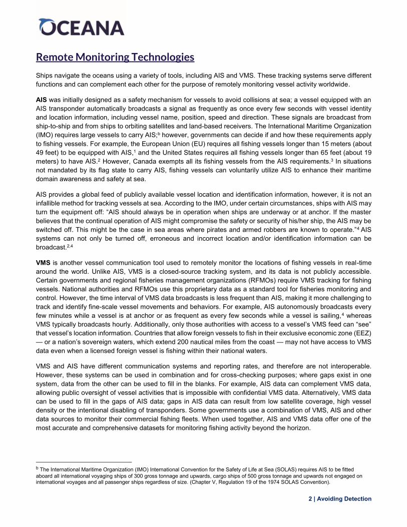
The Egaluze, a Spanish-flagged purse seiner, demonstrated a pattern of potentially evasive behavior by appearing to broadcast intermittent AIS signals over a period of seven months (Figure 4). This vessel was found to be operating in the national waters of at least five different developing African countries as well as on the high seas. The true extent of its fishing is unknown to those outside of the Spanish government — which have access to this vessel’s private VMS data — due to gaps in its AIS transmissions. The European Commission and the Spanish government are currently investigating the matter.34
Figure 4: The Egaluze, a Spanish purse seiner,31 appeared to turn off its AIS signal consistently over a seven-month period while operating in the national waters of at least five West African countries as well as on the high seas.
Oceana reached out for comment,35 and a representative from the company that owns this vessel said that its fleet operates under the regulatory framework of the Common Fisheries Policy of the European Union which imposes strict and rigorous control, inspection and observation schemes to guarantee compliance. They state that the monitoring and control system of the European fishing fleet is based on VMS (not AIS), which is managed by the flag state, and through which a vessel’s location and identity can be monitored 24 hours a day and 365 days a year. They also claim that, in special circumstances, the European Union legislation allows the AIS system to be disconnected if the captain deems it necessary for the safety of the ship.36
9 | Avoiding Detection
The examples highlighted in this paper outline only a few of the many examples of possible AIS avoidance detectable using Global Fishing Watch. As governments continue to move toward the United Nations’ goal of 10 percent ocean protection by 2020,37 they have a responsibility to make sure that MPAs do not merely become another circle on the map, or so-called “paper parks.” Strong monitoring and enforcement are critical for MPAs to successfully restore the areas in which they are intended to protect. Additionally, developing countries like those on the west coast of Africa rely on fisheries for food security, jobs and income, but these governments can lack the resources necessary to adequately monitor their fisheries. AIS provides a solution to some of the challenges surrounding the effective monitoring of developing countries’ waters and protection of large-scale and remote MPAs by enabling public oversight and accountability of vessel activity — but only when all vessels are held to the same public standard.
Recommendations
While AIS usage increases a vessel’s navigational safety at sea, no global requirement for all commercial fishing vessels to carry and transmit AIS exists. A vessel operator may choose to go dark to public tracking systems due to valid concerns over the safety or security of the ship; however, this behavior can also assist vessels that are intentionally hiding at sea and can conceal illegal activities like fishing in no-take protected areas or entering a country’s national waters without proper authorizations. We do not know for a fact whether any of the case studies identified here involve illegal fishing, but they do illustrate the need for greater transparency. Increased transparency at sea can help deter IUU fishing and help coastal nations monitor their waters. Oceana recommends:
● Fishing vessel transparency: Governments mandate vessel tracking by requiring all commercial fishing vessels flying their flag or operating within their EEZs to carry and continually transmit publicly accessible, tamper-resistant AIS and VMS systems;
● Stricter requirements by RFMOs: All RFMOs require AIS and VMS usage by any commercial vessel operating in their territories;
● Increased enforcement: Flag states and coastal states enforce existing AIS requirements; and
● Record of AIS operations: Require vessel owners to notify the flag state and/or coastal state when and why a fishing vessel operator stops transmitting AIS.
Conclusion
Governments should enact policies that mandate the use of AIS and VMS by domestic and foreign vessels, especially in the waters of developing countries, where illegal fishing is prevalent and governments face challenges in monitoring their waters and enforcing fisheries laws. Public platforms like Global Fishing Watch will continue to improve as this global feed of vessel tracking data increases. Improving monitoring and surveillance capabilities can be expensive, but with the help of Global Fishing Watch — which is free for anyone to use — governments can proactively monitor their waters in a cost-effective way. This added transparency also enables an unprecedented level of public accountability of the fishing industry.
New technologies like Global Fishing Watch can help prevent those who would violate fishing restrictions from being able to hide beyond the horizon. Oceana will continue to use Global Fishing Watch to advocate for transparency at sea to restore and increase ocean biodiversity and abundance.

10 | Avoiding Detection
Acknowledgements The authors would like to thank the following individuals for their contributions during the development and review of this report: Eric Bilsky, Dustin Cranor, Charles Glasser, Megan Jordan, Dr. Dana Miller, Patrick Mustain, Jacqueline Savitz and Vanya Vulperhorst.
References 1. Council Regulation (EC) No 1224/2009 of 20 November 2009 establishing a Community control system
for ensuring compliance with the rules of the common fisheries policy.
2. United States Coast Guard (2015) Vessel Requirements for Notices of Arrival and Departure, and Automatic Identification System. 80: 1–57.
3. Transport Canada Bulletin No.: 09/2007 Automatic Identification System (AIS) Requirement - July 1, 2008.
4. IMO (2002) Resolution A.917(22) Guidelines for the onboard operational use of shipborne automatic identification systems (AIS).
5. UNEP-WCMC and IUCN (2018) Marine Protected Planet On-line, Cambridge, UK: UNEP-WCMC and IUCN Available: www.protectedplanet.net. Accessed January 25, 2018.
6. UNESCO World Heritage Centre, World Heritage List, Galápagos Island. Available: http://whc.unesco.org/en/list/1. Accessed January 25, 2018.
7. Schiller L, Alava JJ, Grove J, Reck G and Pauly D (2016) Ecuador (Galápagos). P. 242 In: Pauly D, Zeller D, editors, Global Atlas of Marine Fisheries: A critical appraisal of catches and ecosystem impacts. Washington, D.C.: Island Press.
8. Vessel length, gross tonnage and gear type information from the Inter-American Tropical Tuna Commission’s Vessel Register Available: https://www.iattc.org. Accessed February 1, 2018.
9. Congreso Nacional del Ecuador (1998) Ley de Régimen Especial para la Conservación y Desarrollo Sustentable de la Provincia de Galápagos. Quito, Pichincha, Ecuador.
10. Llerena E, Quisingo T and Maldonado R (2017) Analysis of agreements reached in the Participatory Management Board 2010-2015. In: Galápagos Report 2015-2016. GNPD, GCREG, CDF and GC. Puerto Ayora, Galápagos, Ecuador.
11. Ministerio del Ambiente (2017) Detienen embarcación China con peces y especies amenazadas de la Reserva Marina de Galápagos. Available: http://www.ambiente.gob.ec/detienen-embarcacion-china-con-peces-y-especies-amenazadas-en-la-reserva-marina-galapagos/. Accessed January 25, 2018.
12. National Geographic Society (2017) Thousands of Sharks Found on Boat in Huge Illegal Haul. Available: https://news.nationalgeographic.com/2017/08/wildlife-watch-galapagos-illegal-shark-fishing/. Accessed January 25, 2018.
13. Letter from Oceana to vessel representative (October 13, 2017) (on file with Oceana).
14. Commonwealth of Australia (2014) Heard Island and McDonald Islands Marine Reserve Management Plan 2014-2024. Department of the Environment, Canberra.
15. UNESCO World Heritage Centre, World Heritage List, Galápagos Island. Available: http://whc.unesco.org/en/list/577. Accessed February 12, 2018.
16. Kleisner KM, Brennan C, Garland A, et al. (2016) Australia (Heard and McDonald Islands). P. 194 in: Pauly D, Zeller D, editors In: Global Atlas of Marine Fisheries: A critical appraisal of catches and ecosystem impacts. Washington, D.C.: Island Press.
17. Vessel length, gross tonnage and gear type information from the Commission for the Conservation of Antarctic Marine Living Resources’ list of authorized vessels. Available: https://www.ccamlr.org/en/compliance/list-authorised-vessels. Accessed February 1, 2018.
11 | Avoiding Detection
18. Australian Government: Australian Maritime Safety Authority. Requirements for carrying an automatic identification system. Available: https://www.amsa.gov.au/safety-navigation/navigation-systems/requirements-carrying-automatic-identification-system. Accessed January 25, 2018.
19. Commission for the Conservation of Antarctic Marine Living Resources. Authorized Vessels: Corinthian Bay https://www.ccamlr.org/en/node/97862. Accessed February 15, 2018.
20. CCAMLR Conservation Measure 10-04 (2015) Automated satellite-linked Vessel Monitoring Systems (VMS).
21. Australian Government, Australian Fisheries Management Authority Vessel Monitoring system requirements http://www.afma.gov.au/fisheries-services/vessel-monitoring/. Accessed February 15, 2018.
22. Email from Oceana to vessel representative (October 14, 2017 3:48 p.m. EST) (on file with Oceana).
23. Email from vessel representative to Oceana (October 16, 2017 3:07 a.m. EST) (on file with Oceana).
24. Email from Oceana to Australian Fisheries Management Authority representative (January 5, 2018 12:55 p.m. EST) (on file with Oceana).
25. Agnew DJ, Pearce J, Pramod G, et al. (2009) Estimating the worldwide extent of illegal fishing. PLoS ONE 4.
26. Doumbouya A, Camara OT, Mamie J, et al. (2017) Assessing the Effectiveness of Monitoring Control and Surveillance of Illegal Fishing: The Case of West Africa. Frontiers in Marine Science.
27. Belhabib D, Sumaila UR and Pauly D (2015) Feeding the poor: Contribution of West African fisheries to employment and food security. Ocean and Coastal Management Elsevier Ltd.111: 72–81.
28. Criminal Record of Fishing Vessels © 2018 Dyhia Belhabib, and I-Sea Fisheries a Project at Ecotrust Canada funded by the Paul M. Angell Family Foundation.
29. Vulperhorst V, Malarky L, Cornax MJ and Lowell B (2017) Fishing the Boundaries of Law: How the Exclusivity Clause in EU Fisheries Agreements was Undermined. Available: http://usa.oceana.org/sites/default/files/fishing_the_boundaries_of_law_final.pdf
30. Email from Amadou Jallow ([email protected]), Fisheries Department, Banjul, The Gambia to Oceana (April 10, 2017, 3:25 p.m. EST) (on file with Oceana).
31. Vessel length, gross tonnage and gear type information from the Community Fishing Fleet Register of the European Union. Available: http://ec.europa.eu/fisheries/fleet/index.cfm. Accessed February 1, 2018.
32. Letter from Oceana to vessel representative (June 2, 2017) (on file with Oceana).
33. Letter from vessel representative to Oceana (June 6, 2017) (on file with Oceana).
34. Email from European Commission representative to Oceana (November 24, 2017 7:47 a.m. EST) (on file with Oceana).
35. Letter from Oceana to vessel representative (November 6, 2017) (on file with Oceana).
36. Email from vessel representative to Oceana (November 14, 2017 4:09 a.m. EST) (on file with Oceana).
37. United Nations Sustainable Development Goal 14.5. Available: https://sustainabledevelopment.un.org/sdg14. Accessed March 5, 2018.