AIRSPACE UTILIZATION REPORTING SYSTEM FOR...
10
AIRSPACE UTILIZATION REPORTING SYSTEM FOR THE R-2508 COMPLEX Item Type text; Proceedings Authors Ward, John M. Publisher International Foundation for Telemetering Journal International Telemetering Conference Proceedings Rights Copyright © International Foundation for Telemetering Download date 02/07/2018 18:23:49 Link to Item http://hdl.handle.net/10150/608523
Transcript of AIRSPACE UTILIZATION REPORTING SYSTEM FOR...
AIRSPACE UTILIZATION REPORTINGSYSTEM FOR THE R-2508 COMPLEX
Item Type text; Proceedings
Authors Ward, John M.
Publisher International Foundation for Telemetering
Journal International Telemetering Conference Proceedings
Rights Copyright © International Foundation for Telemetering
Download date 02/07/2018 18:23:49
Link to Item http://hdl.handle.net/10150/608523
AIRSPACE UTILIZATION REPORTING SYSTEMFOR THE R-2508 COMPLEX
John M. WardR-2508 Engineer
(661) 277-9604 Fax: 661-277-4790100 E. Sparks Dr., Edwards AFB, CA 93524
email: [email protected]
ABSTRACT
Increasingly, military managers are requiring better and more efficient use of Special UseAirspace (SUA) and Military Operating Areas (MOA). To date, there has been noautomated method for determining airspace utilization within the R-2508 Complex. Thispaper describes the development of a computer based airspace management tool calledAirspace Utilization Reporting System (AURS). AURS receives aircraft beacon radar datafrom an air traffic control automation system used within the R-2508 Complex. The systemprocesses this data in a customized Oracle database format and responds to queryrequests, making any information about aircraft activities and airspace utilization availableto the user. AURS operates continuously 24 hours per day, seven days per week. Thesystem provides a tool for near complete analysis of all transponder equipped aircraftactivities and utilization information within the 20,000 square miles R-2508 airspaceComplex. In this paper we also provide detailed AURS reports and examples of militaryand civilian aircraft activities obtained with AURS.
KEY WORDS
Military Operating Areas, Beacon Codes, Flight Strips, Airspace Management, SpecialUse Airspace
PURPOSE OF AURS
The Airspace Utilization and Reporting System (AURS) is designed to be a managementtool intended to reduce the potential for mid-air collisions and increase the efficiency of themilitary and civilian traffic in the R-2508 Complex. The purpose of AURS is to maintain acomprehensive database of flight and target data in the R-2508 Complex Airspace for thedevelopment of timely and accurate reports documenting utilization of airspace.

INTRODUCTION
Special Use Airspace (SUA) is a finite Department of Defense (DoD) national resourcedelegated to the military by the Federal Aviation Administration (FAA), which periodicallyevaluates the usage and stewardship of airspace. Consequently, military managers ofairspace have always been interested in cataloging usage of SUA, Military OperatingAreas (MOA), and low-level routes under their control. They want efficient ways ofanswering questions such as: how many aircraft entered and exited their airspace over acertain period of time and how long did such aircraft operate in their Military OperatingAreas (MOA). However, answering these questions generally involve very tedious andcrude manual methods of counting flight strips, which provide only limited and ofteninaccurate information about airspace utilization. Because of this limitation, other methodsare needed for producing accurate and timely information about aircraft activities andutilization of Special Use Airspace.
BACKGROUND
The R-2508 Complex is a tri-service managed, high altitude restricted area used by theDepartment of Defense, Civilian Agencies, Government Contractors, and PrivateOrganizations for the advancement of weapon systems technology and pilot training. Itcovers nearly 20,000 square miles of the Upper Mojave Desert and contains fiveindependently managed special use restricted areas (R-2502, R-2505, R-2506, R-2515,and R-2524). These special use restricted areas are encompassed by Military OperationAreas (MOA) through which civilian aircraft operate. The daily management of theComplex is done by the R-2508 Central Coordinating Facility. The airspace managers(called ASM) assigned to that office have established the goal of improving efficienciesand the reduction in the potential for mid-air collisions by using AURS. Figure 1 depictsthe R-2508 Complex.
The Complex is covered by six gap filler short range radar and three long range radarwhich provide transponder input to an air traffic automation system called Rehost. Rehostis used by air traffic controllers to monitor aircraft activity within the Complex. Rehostalso provides digital beacon data input to the Airspace Utilization Reporting System(AURS). This beacon data consist of flight plan and track information on each aircraftentering R-2508 airspace. Examples of flight plan information are departure and arrivalinformation, assigned altitude and beacon code, aircraft type and number of aircraft inflight. Track information includes current position, mode C altitude, beacon code, aircraftcall sign, airspeed, and current date and time. AURS receives this data from Rehost in anASCII format and processes it into a customized Oracle database.

FIGURE 1: R-2508 Complex including restricted areas and MOAs
The processed data from AURS is made available to any authorized user by 0800 thefollowing morning. The data is received in tabular form on the user desktop computerusing the Oracle query based user interface called Oracle Discovery. It can then be sortedas necessary to extract nearly any information about airspace utilization and aircraftactivity. Although AURS cannot track aircraft flight profiles, it provides valuableinformation about a piece of airspace that can maximize its efficient use.

AURS HARDWARE CONFIGURATION
The AURS software consists of an Oracle Enterprise Manager 8.0 database operating onWindows NT 4.0 platform. The system is entirely PC based and can be operated from anydesktop personal computer connected to the AURS network, or dialed in from any laptopsystem equipped with the appropriate software and security codes. Figure 2 shows a blockdepiction of the AURS hardware system. All hardware connection to AURS begins at theAURS Central Hub. The Central Hub serves as a gateway for routing user queries toAURS and one way radar data from the Rehost radar automation system into the AURSserver. Data coming from the Rehost is unidirectional beacon radar information protectedby another personal computer with firewall software installed. This radar informationconsists of beacon data characterizing all pertinent aircraft target information, i.e., mode3A and mode C data, etc.
Figure 2: AURS network connected to User network and Rehost autoon system

RADAR DATA ACQUISITION FRONT END
After passing through the AURS Central Hub the beacon data enters the Radar DataAcquisition Front End (RDAFE) where it is stored for seven days. The RDAFE is simply apersonal computer containing seven files which continuously collect the radar data fromRehost. It collects this information 24 hours per day, seven days per week. Each filecollects radar data on one particular day of the week. For example, Rehost file 1 builds upon Mondays only, Rehost file 2 builds on Tuesdays only. Every seven days the collectionprocess recycles and starts over again.
AURS CENTRAL SERVER
Radar data passes from the RDAFE and enters the AURS Central Server. Aircraft positioninformation from the beacon data is merged with latitude-longitude mapping informationfor the R-2508 Complex. The AURS Central Server software consist of a database createdwith Oracle Enterprise Manager. The database allows AURS to perform the followingfunctions:1) Load the beacon data from the RDAFE into the Central Server.2) Constraint the beacon Data to client specified parameters.3) Spatially defines R-2508 Military Operating Areas (MOA) based on latitude-longitude
maps.4) Spatially defines aircraft identification and positional information from mode 3A and
mode C as well as aircraft velocity from analytical methods.5) Determines aircraft position within R-2508 MOA.
AURS CLIENT CONNECTIVITY
The Airspace Manager’s (ASM) connectivity to AURS is through Oracle Discoverer 3.1User Edition. The whole purpose of Discoverer is to help the Airspace Manager accessaircraft activity and airspace utilization data from the AURS database, analyze it tosupport decisions, and create reports to keep track of important airspace information. Thisinformation is available to the ASM through standardized or user defined queries andreports.
Every Client workstation is interfaced to the AURS NODE through Oracle Discoverer 3.1.Administrative Edition. The AURS-Node is the user interface part of AURS. The user orclient makes all information requests to AURS through Oracle Discoverer User edition.This request are processed by the AURS NODE using Oracle Discoverer AdministrativeEdition. The combination of Discoverer User and Discoverer Administrative Editionsallows the user to request a variety of information concerning the utilization and aircraftactivity within the R-2508 Complex.

Currently, AURS contains five (5) standardized queries which are available to anyauthorized AURS client. The ASM’s, for example, can access the daily airspaceutilization, military and/or commercial minimum and maximum altitude utilization; aircrafttype, number in flight, call sign, beacon code, area with entry and exit times, as well as ahost of other query based information. These queries are automatically generated on adaily schedule and the results are available to the ASM or other clients at 0800 local eachday.
Figure 3 displays a report generated on June 1, 1999. It is the Daily Airspace Utilizationreport for April 1, 1999 and shows that R-2515 was utilized for four hours and fifty-fourminutes (4:54) during a twenty-four (24) hour period of time. Likewise, there wereseventy-nine aircraft that flew in R-2515. Also, line three shows that R-2506 (Area 15)was utilized for only three minutes (:03) by four (4) aircraft.
FIGURE 3: Daily Utilization Report for April 1, 1999, Generated on Jun 1, 1999
In addition, the ASM can generate ad hoc analysis queries to support quick responsedecisions, answer questions or aid in problem resolution. For example, an AirspaceManager is asked the following question on June 1, 1999. Did any military aircraft fly atairspeeds greater than 500 knots in the R-2515 special use airspace between 2100 to 2400Zulu on May 27, 1999? To accomplish this, the airspace manager would query theDiscoverer 3 on his workstation with the above constraints. Figure 4 shows that on May27, 1999 eight aircraft flying in the R-2515 special use airspace met the above constraints.

Figure 4 lists the date the activity took place, the call sign of all military targets in thatparticular airspace, the abbreviation for the area (R-2515 is listed at 15), the maximum andminimum altitudes and ground speeds. Had the operator request also included non-militaryaircraft as well, the table would have obviously been larger.
Notice that the request was made for information which took place five days earlier. Asmentioned before, AURS automatically archive the daily database tables indefinitely forretrieval at any time in the future. All files are archived using the current date ( formatDDMMYYYY) as the file name in order to make retrieval as easy to remember aspossible. For instance, May 20, 1999 would be retrieved by opening the file 20051999.
Figure 5 shows the result of a quick reaction query generated on May 20, 1999. The taskwas to identify maximum and minimum altitudes of all military cargo aircraft flying in R-2515 between Mar 30 and 31.
FIGURE 4: Aircraft Activity on May 20, 1999
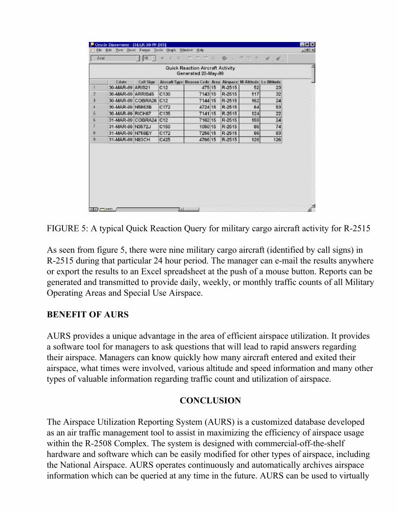
FIGURE 5: A typical Quick Reaction Query for military cargo aircraft activity for R-2515
As seen from figure 5, there were nine military cargo aircraft (identified by call signs) inR-2515 during that particular 24 hour period. The manager can e-mail the results anywhereor export the results to an Excel spreadsheet at the push of a mouse button. Reports can begenerated and transmitted to provide daily, weekly, or monthly traffic counts of all MilitaryOperating Areas and Special Use Airspace.
BENEFIT OF AURS
AURS provides a unique advantage in the area of efficient airspace utilization. It providesa software tool for managers to ask questions that will lead to rapid answers regardingtheir airspace. Managers can know quickly how many aircraft entered and exited theirairspace, what times were involved, various altitude and speed information and many othertypes of valuable information regarding traffic count and utilization of airspace.
CONCLUSION
The Airspace Utilization Reporting System (AURS) is a customized database developedas an air traffic management tool to assist in maximizing the efficiency of airspace usagewithin the R-2508 Complex. The system is designed with commercial-off-the-shelfhardware and software which can be easily modified for other types of airspace, includingthe National Airspace. AURS operates continuously and automatically archives airspaceinformation which can be queried at any time in the future. AURS can be used to virtually

eliminate the need for flight strips in managing airspace. We believe AURS will become avaluable tool for the development of timely and accurate reports documenting utilization ofthe airspace.
ACKNOWLEDGEMENT
The author would like to thank Doug Johnson, the lead Airspace manager at R-2508Central Coordinating Facility for his keen understanding of the airspace environment. Histimely inputs contributed greatly to the success of the AURS program.
REFERENCES
1. Zarchan, Paul, “Global Positioning System: Theory and Applications, Volume II2. R-2508 Complex User’s Handbook, http://r2508.edwards.af.mil3. Federal Aviation Administration, Special Military Operations, Nov 3, 19984. Federal Aviation Regulations, Part 73, Special Use Airspace, Sept 1993
Biography of presenting Author
John Ward has worked for the Air Force Flight Test Center for more than 15 years as aninstrumentation engineer and then as a flight test engineer. Currently, he serves as the R-2508 engineer where his responsibilities include managing all engineering improvementand modernization efforts for the R-2508 Complex. John holds a Masters degree inElectrical Engineering with an emphasis on communications.