Air Mass
51
Chapter 9 -Air Masses and Fronts As he turned to go he spat speculatively. There was a sharp explosive crackle that startled him. He spat again. And again in the air, before it could fall to the snow, the spittle crackled. He knew that at fifty degrees below zero spittle cracked on the ground, but this spittle had crackled in the air. Undoubtedly it was colder than fifty belowhow much colder he did not know. To Build a Fire , J. London The man in this story was certainly not walking in a subtropical high pressure region. He was walking in the Arctic, and probably would have welcomed a change in weather. The Arctic is a source of cold air, which can sweep southward affecting the weather of a region as far south as the subtropical highs. If this happens in spring, the weather is often unwelcome as it can cause massive agricultural economic losses. As damaging as the cold arctic air mass may be, it never arrives at subtropical latitudes as cold as in London's story because it warms as it moves southward. The movement of extremely cold and hot air masses has historically influenced the geographic regions humans inhabit. Throughout human evolution, air masses that dominated a given location determined the degree to which humans needed shelter and clothing, how they found or grew food, and 1
-
Upload
rahul-deka -
Category
Documents
-
view
5 -
download
1
description
Air Mass
Transcript of Air Mass

Chapter 9 -Air Masses and Fronts
As he turned to go he spat speculatively. There was a sharp explosive crackle that startled him. He spat again. And again in the air, before it could fall to the snow, the spittle crackled. He knew that at fifty degrees below zero spittle cracked on the ground, but this spittle had crackled in the air. Undoubtedly it was colder than fifty belowhow much colder he did not know.
To Build a Fire, J. London
The man in this story was certainly not walking in a subtropical high pressure
region. He was walking in the Arctic, and probably would have welcomed a change in
weather. The Arctic is a source of cold air, which can sweep southward affecting the
weather of a region as far south as the subtropical highs. If this happens in spring, the
weather is often unwelcome as it can cause massive agricultural economic losses. As
damaging as the cold arctic air mass may be, it never arrives at subtropical latitudes as
cold as in London's story because it warms as it moves southward.
The movement of extremely cold and hot air masses has historically influenced
the geographic regions humans inhabit. Throughout human evolution, air masses that
dominated a given location determined the degree to which humans needed shelter and
clothing, how they found or grew food, and the type of transportation they developed.
Even with today's powerful engines, transportation can grind to a halt with bad weather
conditions. A wintry air mass can cause icy roadways, runways, and sidewalks and
hamper travel. Extremely cold weather can drain a car battery causing the vehicle to fail
to start. In cold climates, engines are equipped with electric warmers to make starting
them easier. Extremely hot air masses can also cause difficult travel conditions. For
example, hot air masses can cause engines to overheat.
1

Hot weather in particular can lead to stressful conditions that affect human health
and mortality rates. Humans can, and have, adapted physiologically to different weather
conditions. But occasionally intense heat waves can increase the mortality rates in cities
not acclimatized to heat, such as urban dwellers of the northern regions of the United
States.
This chapter discusses where air masses form, the direction they typically move
in, and the characteristic weather that develops when two air masses meet.
2

What is an Air mass?
An air mass is an extremely large body of air
whose properties of temperature and moisture content
(humidity) are similar in any horizontal direction. Air
masses can cover hundreds of thousands of square miles.
Observations
Heat waves in the summer can bring perilous weather to cities not accustomed to
handling such hazardous conditions (Box 9. 1). These heat waves are nothing more than
stagnant air masses. For example, between July 13-14, 1995 the deaths of over 200
people were attributed to a hot and humid air mass that occupied much of the central and
eastern United States (Figure 9.1). A heat wave in the Midwest in late July 1999 resulted
in average daily temperatures of greater than 90F! More than 200 deaths in the Midwest
were attributed to this 1999 heat wave.
Problems and hazards are also caused by cold air outbreaks. For example,
between 12 and 16 February 1990, a large mass of cold air spread southward from
northern Canada into the central United States. The associated weather, which included
freezing rain, tornadoes, severe thunderstorms and flooding, caused an estimated $120
million of damage.
Once formed, air masses move. The boundary between two air masses is a front
(Chapter 2), which provides a lifting mechanism for cloud formation and precipitation.
When we identify fronts, we mark the boundary between two air masses. On satellite
An air mass is an expansive mass of air with homogeneous near-surface weather characteristics, particularly with respect to temperature and humidity.
3

images, fronts are identified through analysis of cloud patterns (Figure 9.2). Tracking
fronts is an important part of weather forecasting.
Air mass Types
Air masses are formed when air stagnates for long periods of time over a uniform
surface. The characteristic weather features (temperature and moisture) of air masses are
therefore defined by the surface they form over. An air mass acquires these attributes
through heat and moisture exchanges with the surface. As a result, an air mass can be
warm or cold, and moist or dry.
Cold air masses originate in polar regions and are therefore called polar air
masses. Warm air masses typically form in tropical or sub-tropical regions and are called
tropical air masses. Moist air masses form over oceans and are referred to as maritime air
masses. Air masses that form over land surfaces are called continental air masses. The
five primary air mass types are summarized below:
Polar air mass (P) - formed poleward of 60 degrees north and south--cold
Tropical air mass (T) - formed within about 30 degrees of the equator--warm
Arctic (A) - formed over the Artic -- very cold
continental air mass (c) - formed over large land masses--dry
maritime air mass (m) - formed over the oceans--moist
We can make four combinations of the above air mass types: continental polar
(abbreviated cP), continental tropical (cT), maritime polar (mP), and maritime tropical
(mT). How cold and dry the air mass is will be a function of the time of year it forms.
Winter air masses will be colder than those that form during the summer. Some
classification schemes differentiate cold air masses into polar and arctic air masses.
4

Arctic air masses (A) form poleward of 60N, and are colder than cP air masses. They
are much colder than polar air masses and form in winter over snow covered surfaces in
Siberia, the Arctic Basin, North America and Greenland. The temperature and moisture
properties of these four air masses are shown in Table 9.1.
Table 9.1 Temperature and moisture characteristics of air masses.
Air Mass Type Winter Characteristics Summer Characteristics
continental polar
cP
Very cold and dry Cool and dry
maritime polar
mP
Mild and humid Mild and humid
continental tropical
cT
warm and dry very hot and dry
maritime tropical
mT
Warm and humid Warm and humid
arctic
A
Bitter cold and dry
Air Mass Source Regions
Air mass source regions are geographic areas where air masses originate. A
source region must have light winds or no winds, so the air has time to acquire the
temperature and moisture properties from the surface. Strong winds would move the air
before it can acquire the characteristics related to the surface. Given the constraints of a
uniform surface and light or no winds, not all regions of the world can generate air
masses. Good source regions for air masses are the high-pressure regions, or
5

anticyclones, which have light winds and thus favor the development of uniform
temperature and moisture air masses (Figure 9.3).
A source region must be an extensive and homogeneous surface. Large water
bodies or flat uniform lands are potentially good source regions for air masses. Coastal
regions are not very good source regions of air masses because the region has land and
water.
Once formed, air masses are not restrained to their source region. They move on
to other regions. How they move is determined by upper air patterns and is discussed in
the next chapter. When air masses move, they bring changing weather to the region over
which they advance. As they move, the air mass temperature and humidity are modified
due to the changing energy gains and losses the air undergoes from the surfaces they pass
over.
Air Masses affecting North America
This section discusses the major air mass types that influence the weather of
North America. In addition to identifying the source regions of these air masses, we will
describe the typical direction they move. Figure 9.4 shows the major air mass source
regions that affect North American weather and climate. The arrows show the typical
paths the air masses take once they begin to move. The weather an air mass produces is
determined by whether it moves over a relatively colder or warmer underlying surface.
Exchanges of energy between the air and ground can make the atmosphere stable or
unstable (Chapter 3). A stable atmosphere inhibits the vertical movements of air parcels.
An unstable atmosphere is favorable for the upward movement of air and cloud
formation.
6

mP air mass
Maritime polar air is formed over the oceans at high latitudes. The North Pacific
is a good source region of mP air masses. These North Pacific air masses often move
into the Gulf of Alaska and then to the west coast to North America. During winter, they
can influence the weather as far south as California. The east coast of North America is
also affected by these air masses. These air masses approach that coast from the
northeast. The stormy weather associated with these advancing air masses is referred to
as northeaster (typically pronounced nor'easter). Air masses that compose a nor'easter
typically move up the East Coast of North America during October through April. The
winds blow warm moist air over the Atlantic Ocean inland. At the same time, cold air
moves south over the East Coast and meets with the northward moving warm air. The
combination of warm and cold has produced some of the heaviest snowfalls of the East
Coast (Figure 9.5).
The weather associated with mP air masses is quite variable. Winter mP is
formed in polar regions over water. Cold mP air that moves over a warm surface is
unstable and can bring rain showers. When the mP air moves over a surface that is only
slightly warmer, the atmosphere is less unstable and may produce stratus clouds and
drizzle.
cP air mass
Continental air masses are formed over the high latitude regions of Siberia,
northern Canada, Greenland, and the frozen Arctic Basin. The air masses formed in
winter are very cold and dry. They require long, clear nights to form due to strong
radiational cooling of air near the surface. They can become bitterly cold when formed
7

over snow-covered regions in winter. Surface temperature inversions are often observed
indicating the stable nature of these air masses.
In winter, the weather associated with cP is cloud free and frigid. From northern
Canada cP air masses move southward, and can result in bitter cold temperatures as far
south as Florida. This can lead to crop damage and cause economic hardships (Figure
9.6). The wintry temperatures and surface temperature inversion can also lead to reduced
air quality and poor visibility as pollution levels increase with the burning of heating fuel
(e.g. coal, fuel oil, wood).
When formed in summer, cP temperatures have temperatures that are more
moderate. The snow that would cool this air in winter has melted due to the increased
warmth from the sun. Surface temperature inversions are usually absent in cP air masses
formed in summer. The air mass has formed over a relatively dry surface, so the
characteristic weather is cool, dry and cleara pleasant change from a humid summer
caused by mT air masses.
A air mass
Arctic air masses are formed over the frozen Arctic and are much colder than cP
(Figure 9.7). This air mass type is confined to a shallow layer near the surface. Because
the layer is not very deep, less than 1 mile, there is not much vertical lifting associated
with its movement, and thus little precipitation. Arctic air can move south and
occasionally reach into the southern US.
cT air mass
Continental tropical air masses are hot and dry and typically form over tropical
and subtropical deserts. The hot surface temperatures and the lack of vegetation make the
8

cT air mass hot and dry. The southwest US and northern Mexican are summertime source
regions in North America.
Continental tropical air influences the US in summertime as warm, dry air arrives
from the Mexican Plateau. The hot temperatures near the ground make the air mass
unstable, but the dryness limits cloud formation. Stagnant cT air masses are often
associated with droughts.
mT air mass
Warm tropical oceans are the source regions of maritime tropical air masses. The
temperatures are not as hot as the cT, but the higher humidity can lead to high heat
indices with lethal results (Figure 9.8). While all mT air masses are hot and humid, the
weather they generate is varied. This is due to differences in the vertical structure of
temperature and moisture.
Some mT form and remain in descending branches of the Hadley cell. As a result
of the subsidence, there is stability aloft and the moisture is confined to a shallow layer
near the surface. There is little precipitation associated with these subtropical air masses.
In contrast, some tropical maritime air masses form in equatorial waters and the moisture
mixes into the air mass higher in the atmosphere. This makes them more unstable and
more favorable for cloud formation. In these mT air masses cumulonimbus clouds can
yield heavy showery rains, particularly when there is divergence aloft.
The sultry summer weather of the southeastern United States is strongly
influenced by mT air masses that form over the Gulf of Mexico, the subtropic western
Atlantic Ocean, and the Caribbean Sea. The moisture source of precipitation for the mid-
western United States is supplied by mT air masses, particularly those originating over
9

the Gulf of Mexico. Summertime weather of the southwestern United States is
influenced by Pacific mT air masses. Moisture supplied by these mT air masses to the
southwest generates rains referred to as the Arizona Monsoon (Figure 9.9).
Air masses can move from one region to another. The movement of air masses is
a fundamental cause of weather in mid-latitude regions. To understand how the
movement of air masses causes changing weather conditions, including storms, it is
useful to re-visit the concept of atmospheric stability and describe how to determine if an
atmosphere is stable or unstable..
Atmospheric Stability
Clouds form when air rises, expands, and cools. Fronts provide a mechanism to
lift air. The upward force that lifts air to form clouds must overcome the downward force
of gravity. As noted in Chapter 2, an atmosphere that is unstable has a temperature and
moisture structure that is favorable for lifting air parcels and thus forming clouds and
possibly precipitation. A stable atmosphere inhibits rising motions.
Determining Atmospheric Stability
The static stability of the atmosphere is
one way of determining the stability of the
atmosphere. Static stability is determined by
comparing the temperature change of a rising parcel with the environmental lapse rate.
At a given pressure, the colder the air parcel, the greater its density. If an air parcel is
colder than the environment, it is more dense than its surroundings and will descend. The
atmosphere is stable when an ascending parcel, which cools due to expansion, is cooler
than the environment. Therefore, as discussed in Chapter 3, any region of the atmosphere
Static stability is a measure of the stability of the atmosphere with respect to vertical displacements of air parcels.
10

that has a temperature inversion is stable. If an air parcel is warmer than the surrounding
air, it will rise. If an ascending parcel within an air mass becomes warmer than the
environment, the air mass is said to be unstable.
Special diagrams have been devised to study the thermodynamic structure of the
atmosphere to determine the convective stability of the atmosphere. These are known as
thermodynamic diagrams and are discussed in detail on the book's web page. Another
important concept to understand is how the stability of the atmosphere changes.
Changing air mass stability
Warm air overlying cold air is a stable atmosphere. So, when the lower regions of
the troposphere are cooled the air mass becomes more stable. This is why polar air
masses are generally stable. However, when cold air moves over a warm surface, for
example a warm body of water, the air near the surface warms. Warming the air near the
ground makes the atmosphere less stable. This is why tropical air masses are, in general,
more unstable than polar air masses.
To make an air mass unstable the environment must be more conducive to vertical
motions. This can be accomplished by warming the lower layers of the atmosphere
through energy exchanges with the surface under the air mass. For example, by solar
heating the surface or by moving the air mass over a warmer surface we make the air
unstable.
Air Mass Modification
As air masses move from one place to another, they are modified. Their
properties, temperature, moisture, and stability change as the air masses exchange heat
11

and moisture with the underlying surface. There are two primary methods of modifying
an air mass: heat exchanges with the surface and mechanical lifting.
Heat exchanges with the surface primarily affect the lowest regions of the air
mass. How fast the air mass temperature and moisture change is determined by the rate of
heat and moisture exchanges. The greater the temperature difference between the air
mass and the surface over which it is moving, the greater the heat exchange. Exchanges
of moisture are a maximum when the relative humidity is low and the surface wet (Figure
9.10).
As a cold continental polar air mass moves over a warm body of water, there is a
rapid exchange of heat and moisture. The lowest layer of the air mass warms and
moistens. This increases the instability of the air mass. If the temperature difference
between the air and water are large, rapid evaporation causes the air to saturate and form
a fog. These are steam fogs (Chapter 5). Steam fog is common over the Great Lakes and
the north Atlantic in fall and winter when the cP air flows over the warm waters (Figure
9.11). This fog can be as deep as 1,500 meters with swirls of columns of fog called
steam devils. The movement of cP air masses over the Great Lakes can increase snowfall
downwind. The increased snowfall is referred to as lake effect snow (Box 9.2).
Fogs over the Great Lakes also form during summer when mT air moves over the
cooler lake waters. This is an example of an advection fog (Chapter 4). In this weather
situation, the mT air near the surface cools, increasing the relative humidity and causing a
fog to develop. The cooling of the air occurs rapidly in the lowest 45 m (150 feet). In this
case the lower layers of the air mass are cooling, causing the air mass to become more
stable. This suppresses vertical mixing, limiting how deep the fog will form.
12

Air masses can also be modified when lifted or forced to descend by topography.
As an mP air mass from the Pacific Ocean moves over the northwest coast of the US, the
mountains lift it. This causes the air to cool, increasing the relative humidity leading to
cloud formation and snowfall in the mountains. A cP air mass formed over the
Greenland Plateau will descend as it moves.
It is common for two air masses to interact with one another. The boundary
between two air masses is called a front (Chapter 1). As discussed in Chapter 4, one of
the four basic methods of lifting air occurs along fronts. One air mass is denser than the
other which causes a lifting, cloud formation and precipitation. The next chapter
discusses in detail how fronts move.
Fronts
Air masses with different characteristics do
not mix readily. So, when two air masses come in
close contact they retain their identity over a long period. The transition zone between
two different air masses is called a front. Fronts can be hundreds of miles long and exist
as long as the air masses they separate remain distinct.
Norwegian meteorologists around the time of World War I laid the foundation for
our concepts of fronts and their movements. They observed large air masses with
different temperature and moisture that advanced and retreated towards one another.
Clashing air masses often led to disruptive weather conditions. The boundary was called
a front, analogous to the boundary used on war maps to separate battling armies.
A frontal zone is a sloping surface that separates two air masses. Figure 9.12 is a
three dimensional sketch of a front. Where the front meets the ground is called the
Fronts are formed when tow air masses meet.
13

surface frontal zone. The surface frontal zone is typically featured on weather maps
because this is where the frontal features are usually greatest. While fronts are
represented on weather maps as lines, the front is a transition zone where weather
conditions rapidly change from one air mass to the other.
Fronts, like most weather phenomena, are three-dimensional. They are usually not
identified on weather maps of the upper troposphere. Fronts always slope towards the
cold side of the front at the surface. Figure 9.13 shows a vertical slice through a cold and
warm front. Both the cold front and warm front tilt over the cold air mass. Notice also
that the slope of the cold front (1:50) is steeper than the warm front (1:200).
Fronts are classified by the temperature changes that result after an air mass
passes a given location. A cold front indicates cold air will follow the fronts passage; a
warm front means warm air will follow. But, there are more weather changes than just
temperature during a frontal passage. In this section, we will investigate the changes in
temperature, pressure, wind direction and cloudiness of an idealized, well-developed cold
front. Then we will do the same for a warm front. There are also the stationary and
occluded fronts, which are also discussed in this section.
Since this is a textbook, it presents an idealized example of the type of weather
associated with a cold and warm front. Nature is much more complex than presented in
simple textbook cases, but these examples should help you to identify the general features
of fronts. Realistic examples are presented on the web and change each day. Look for the
similarities of the daily weather presented on the web with the idealized cases shown
below.
14

Cold Front
Figure 9.14 shows an idealized structure of temperature, pressure, wind direction
and precipitation associated with a cold front. The blue triangles point in the direction of
the movement of the front. This is consistent with the cold air behind the front as
indicated by the isotherms (Figure 9.14a). To imagine how temperature changes as a
cold front approaches, observe how the isotherms change along a line perpendicular to
the front. As a cold front approaches, the temperature steadily falls. The temperature
then quickly drops in the frontal zone region as the cold air mass moves into place.
As the cold front approaches, the pressure is observed to decrease (Figure 9.14b).
After passage the atmospheric pressure begins to increase as a cold, high-pressure air
mass moves over the region. The largest pressure changes occur in the frontal zonal.
Household barometers use changes in pressure to indicate changing weather patterns. A
change in weather is predicted when the pressure drops, assuming a front is approaching.
With an approaching front, there is also a change in cloudiness and precipitation.
Strong wind shifts accompany fronts. Air flows into the low pressure in a
counterclockwise direction in the Northern Hemisphere, and because of friction (Chapter
6), crosses the isobars. So, ahead of a cold front the winds tend to be from the southwest
(Figure 9.14c). Wind direction is variable in a frontal zone as the winds are shifting to
northwesterly winds following frontal passage. These northerly winds advect the cold air
into the region. If a cP air mass is behind the front, it has low humidity and the visibility
is usually good.
Precipitation associated with our ideal cold front is shown in Figure 9.14d.
Precipitation is confined to near the surface front, usually in the form of scattered
showers and thunderstorms. In the spring, a squall line is sometimes observed in front of
15

the cold front. The reasons for this are discussed in Chapter 11. After the front passes
the sky clears. Scattered cumulus clouds or stratus sometimes accompany the cold air
mass behind the front. Showers behind the cold front can occur when a cP air mass
moves over a warm surface (Figure 9.8d).
Fronts extend above the surface, since air masses are three-dimensional
phenomena. Figure 9.15 is a vertical slice through our idealized cold front. The front
slopes upward, towards the pool of cold air. The cold frontal zone typically increases 1
km in altitude for each 50 to 100 km horizontal distance along the surface. The slope is
steepest where the air mass meets the surface (Figure 9.13), sloping more gently behind
the surface front. Friction at the surface slows the progress of the cold front. Since
friction decreases away from the surface, the air at higher levels advances more rapidly.
This gives the characteristic curved profile of the cold front (Figure 9.15). The steep
slope near the surface frontal zone forces the warmer air it is replacing to rapidly rise.
The abrupt vertical motion tends to generate thunderstorms. So, precipitation associated
with the cold front is often intense, but brief and in the immediate vicinity of the cold
frontal zone near the surface.
The duration of the precipitation depends on the horizontal extent of the vertical
lifting and the speed of the front. The precipitation band is narrow because of the steep
cold front. The speed of a cold front is observed to vary from nearly stagnant to about 30
mph (50 km/hr).
Warm Front
Figure 9.16 depicts the temperature, pressure, wind direction and cloud patterns
typically observed in association with a warm front. The red half circles point towards
16

the direction of movement of the warm air mass. After the passage of a warm front, the
air is warmer and often more humid. As a warm front approaches, the temperature first
falls and then rapidly increases during the frontal passage (Figure 9.16a). As with the
cold front, pressure is a minimum along the front (Figure 9.16b). Therefore, the pressure
drops as the warm front approaches and then increases as it passes by. The changes in
pressure associated with the warm front are not as rapid as in those associated with the
cold front.
The winds ahead of the warm front are typically observed to be easterly or
northeasterly (Figure 9.16c). Again, this is associated with the clockwise convergence of
surface air in towards low pressure. Behind the front, the winds are typically
southwesterly, the same direction as out ahead of our idealized cold front. The wind
tends to flow in a direction that is counterclockwise around the low.
The vertical slope of the warm frontal zone
is gentler than the cold front. The average slope of
a warm front is about 1:200. As a result, the warm frontal air slides upward gradually as
the cooler air ahead of the front is replaced. This is a form of overrunning. Overrunning
occurs when an air mass moves over another air mass of greater density. The term
overrunning usually refers to when warm air ascends a warm front. Deep layers of
stratiform clouds (Cs, As, and Ns) are often the result of overrunning.
Steady precipitation falls from nimbostratus and stratus clouds that result from the
overrunning (Figure 9.16d). The precipitation can be far in advance of the frontal zone.
The frontal slope also tends to generate stratus type clouds far in advance of the frontal
zone. So, in an idealized warm front you can predict the approach of a warm front by
Overrunning occurs when an air mass aloft is moving over an air mass of greater density at the surface.
17

watching the changing cloud conditions (Figure 9.16d. Cirrus first appear followed by
cirrostratus, which may result in a halo around the sun (Chapter 5). Cirrostratus are
followed by altostratus clouds, which make the sun appear watery. Stratus and then
nimbostratus follow the middle level clouds. As discussed in Chapter 4, nimbostratus
clouds produce steady precipitation. If the warm air is unstable, cumuliform clouds may
also appear.
Though the warm air mass may be stable, the air is forced to lift and form clouds
as warm air rises over the cooler air it is replacing. A vertical slice through a warm front
showing the cloud vertical structure is shown in Figure 9.17. The warm front gently
slopes up over the denser cooler air. The gentle slope generates stratus cloud types,
starting with cirrus (Ci), cirrostratus (Cs), altostratus (As), stratus (St), and finally
nimbostratus (Ns). The cirrus that first heralds the approach of the front can be as much
as 200 miles ahead of the surface front. Precipitation is steady and moderate and can last
for several days, depending on how fast the front is moving. Warm fronts are typically
slower than cold fronts, moving at about 12 mph (20 km/hr). The slow movement
coupled with the large scale vertical lifting explains why precipitation can persist for
several days.
Hazardous weather can accompany warm fronts. As rain falls from the warm air
into the cold air near the surface, they evaporate and increase the relative humidity of the
air near the surface. If the warm air is much warmer than the cold air below, the drops
will evaporate quickly and form a fog referred to as a frontal fog (Chapter 4). If the air
near the ground is below freezing, sleet or freezing rain can occur (Chapter 4).
18

Stationary Front
Stationary fronts occur when two air masses collide, but move little or not at all at
the surface. Although the front appears stationary at the surface, the air above can be
moving, causing overrunning. This is why the weather conditions along a stationary front
are sometimes similar, though milder, to a warm front with a stable warm air mass.
Figure 9.18 is a cross section showing the cloud structure associated with a
stationary front. Most of the precipitation, be it rain or snow, falls into the cold air mass.
The warm air overrunning the colder air mass causes the clouds and precipitation along a
stationary front. This overrunning can result in extended periods of cloudiness and light
precipitation. As with all fronts, the amount of rain depends on the supply of moisture
and the stability of the atmosphere.
The winds of the middle and upper troposphere determine how fast fronts move.
This is an important topic covered in the next chapter.
Occluded Front
Cold fronts and warm fronts can merge to form an occluded front, or an
occlusion. The occluded front is represented by a purple line with alternating triangles
and half-circles. The direction of movement is indicated by the direction the triangles and
half-circles point. Occluded fronts are typically associated with mature storms. It is the
first sign that the storm is beginning to decay.
While warm and cold fronts separate polar and tropical air masses, occluded
fronts mark the boundary between two polar air masses. There are two basic types of
occluded front: the cold-type occlusion and the warm-type occlusion. In the cold-type
occlusion, the cold air behind the cold front underlies the air ahead of the warm front. In
19

the warm-type occlusion, the cold air behind the cold front overrides the colder air
proceeding of the warm front (Figure 9.19).
Weather conditions along an occluded front are similar to a combination of warm
and cold fronts. The weather ahead of the occluded front is similar to that ahead of a
warm front. The weather behind the occluded front is similar to that of a cold front.
Cirrus clouds are observed ahead of the occluded front. Cloud base lowers as the
occluded front approaches with persistent precipitation in the vicinity of the front. Heavy
precipitation associated with embedded thunderstorms can also be observed. Clouds
rapidly disperse with the passage of the occluded front.
The Extratropical Cyclone
The weather associated with each type of front was presented separately in this chapter;
however, cold, warm and occluded fronts often exist together as one weather system and can be
identified in satellite images (Figure 9.20 and Box 9.3). Notice the similarity between the weather
associated with the weather system in the Midwest on November 23, 1999 and our idealized
models discussed in this chapter. For example, the precipitation and cloud patterns on November
23 are very similar to our idealized model. There are also differences, such as a stationary front
connected to the warm front. The weather system forms what is called the extratropical or
midlatitude cyclone. Extratropical cyclones are low-pressure systems of the middle and high
latitudes. The next chapter focuses on the extratropical cyclone.
20

Summary
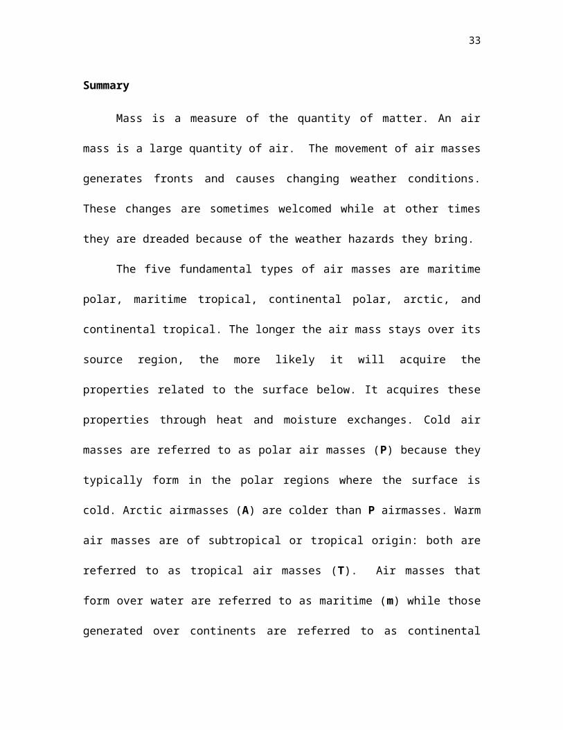
Mass is a measure of the quantity of matter. An air mass is a large quantity of air.
The movement of air masses generates fronts and causes changing weather conditions.
These changes are sometimes welcomed while at other times they are dreaded because of
the weather hazards they bring.
The five fundamental types of air masses are maritime polar, maritime tropical,
continental polar, arctic, and continental tropical. The longer the air mass stays over its
source region, the more likely it will acquire the properties related to the surface below. It
acquires these properties through heat and moisture exchanges. Cold air masses are
referred to as polar air masses (P) because they typically form in the polar regions where
the surface is cold. Arctic airmasses (A) are colder than P airmasses. Warm air masses
are of subtropical or tropical origin: both are referred to as tropical air masses (T). Air
masses that form over water are referred to as maritime (m) while those generated over
continents are referred to as continental (c). You can mix and match the temperature and
moisture characteristics to arrive at the four basic air mass types: cP, cT, mP, and mT.
An air mass eventually moves and exchanges heat and moisture with the ground it
migrates over. When a cold air mass moves over a warm surface, lower layers of the
troposphere warm, increasing the instability of the air mass. This favors ascent, which
increases the possibility of condensation and precipitation. Conversely, when the warmer
air mass moves over a cold surface it is chilled, increasing the stability of the mass, which
opposes the formation of clouds and precipitation.
Fronts form when air masses collide. The colder air mass is pushed under the
warmer air mass. When a cold air mass replaces a warm air mass the boundary between
21

the two air masses is called a cold front. A warm front occurs when the warm air mass
replaces a cooler air mass. A stationary front occurs when neither air mass is advancing.
While weather along a warm and a cold front differ, several general statements can be
made concerning fronts and the weather associated with them:
1. Fronts form at the boundary between air masses of different temperatures
and moisture.
2. Warm air always slopes upward over colder air.
3. Clouds and precipitation form as warm air mass rises over the more dense
colder air.
4. The front always slopes upward over the cold air.
5. Pressure drops as a front approaches.
6. In the Northern Hemisphere, wind direction near the ground shifts
clockwise as the front passes.
22

Terminology
You should understand all of the following terms. Use the glossary and this chapter to
improve your understanding of these terms.
Air mass
Cold Front
cP
cT
Fronts
mP
mT
Occluded front
Overrunning
Stability
Stationary Front
Warm Front
23

Review Questions
1. Explain the relationship between air mass source regions affecting North America
and the surface pressure maps in Figure 7.9
2. Why is mountainous terrain a poor source region for air masses?
3. Explain the requirements for a geographic region to serve as source region for an air
mass.
4. Describe the characteristics of each of the four types of air mass.
5. Describe the type of weather associated with an approaching cold front.
6. Explain the existence of a frontal zone.
7. Do air masses form on Antarctica? Explain your answer.
8. Discuss the differences and similarities between a warm and a cold front.
9. Explain why a cold cP winter air mass would make it difficult for firefighters to do
their job.
10. Would it be more likely to have freezing rain with the passage of a warm front or a
cold front? Why?
11. Before the advent of satellites and advanced systems for tracking fronts, weather
predictions where often made by observing changes in wind direction, pressure, and
cloud types. These predictions drew from accumulated knowledge from years of
weather observations. The predictive nature of these observations is sometimes
revealed in weather lore. The following weather lore predicts precipitation.
Ring around the moon or sun, Rain before the day is done.
Is there a physical basis for this weather-wise statement?
12. Is there any physical explanation to the following weather lore?
24

Mackerel clouds in sky,Expect more wet than dry.
Web Activities
Web activities related to subjects in the book are marked with subscript . Activities
include:
Satellite Observations of Air Masses and Fronts
Identifying Air Masses using surface weather maps
Identifying Fronts using surface weather maps
Practice multiple choice exam
Practice true/false exam
25

Box 9.1 Deadly Heat Waves
Each summer approximately 175-200 Americans die from heat waves. Most of
these deaths occur in cities, particularly northern cities. When regions suffer under
intense hot spells they are usually dominated by a surface high-pressure system with a
mid-tropospheric ridge aloft. Dew points are also high and to compound matters, wind
speeds are often light. Clear or partly cloudy skies allow intense solar radiation to further
heat the ground and the air mass. All these conditions reduce our body's ability to cool
down through sweating (Box 4.2 and 5.1). This can be life threatening.
Over exposure to heat leads to giddiness and nausea. Heat cramps are generated
when the body loses too much water and salts through perspiration. Symptoms of heat
cramps are cramps, fever and nausea. Heat exhaustion occurs when the body loses too
much heat too quickly. In that case, the body temperature and blood pressure drop and
the skin turns cool and clammy. Perspiration is profuse as the body continues to try and
lose energy. More dangerous than heat exhaustion is heat stroke, which poses an
immediate treat to life. Most victims of heat stroke are people over 60, although infants
are also susceptible. The first signs of a heat stroke are that the skin becomes dry and hot
as sweating ceases, the face becomes flush and the pulse rapid. Once the body fails to
maintain its ability to cool down, death can occur in a few hours. A victim of heat stroke
needs immediate medical attention. Sponging the body with water will help cool the
body.
Loss of life by heat stroke during a heat wave is heightened in large cities by the
urban heat island which amplifies the heat wave by 2 to 5 degrees F or more (see figure).
During the heat of the day, closed up urban houses and apartments that do not have air
26

conditioning can become brick ovens. To avoid the dangers of heat exhaustion it is
important to drink water, stay out of direct sunlight and minimize physical activity.
Reduction in the loss of life can be accomplished by monitoring the health of the urban
elderly. The news media helps by providing useful information not only about the
weather but also on procedures that lessen heat stress and where to seek help.
Heat waves also have a strong economic impact, even if there is no loss of life. A
prolonged heat wave can lead to the widespread use of air conditioning, leading to new
demands for power that stress gas and electric utilities. Over demands can leave people
without power for hours, and sometimes days. Major highway damage can occur due to
heaving of road surfaces. All types of outdoor work, such as landscaping or construction,
experience reduced productivity. The combination of heat and lack of rainfall can result
in stunted crops. Agriculture in general can be hard hit as cattle, pigs, and chickens can
all die due to heat exposure.
Intense heat waves are often broken with the passage of a polar air mass. Violent
storms can be associated with these fronts, resulting in additional economic losses adding
to a potential increased loss of life.
27

Figure Caption: The urban heat island is demonstrated by a comparison of the differences
in hourly temperatures between Chicago, IL and Aurora, IL (a nearby suburban station).
During the late afternoon and early evening, of 25-31 July, the averaged temperatures
were about 5-7 degrees F higher in Chicago. During this heat wave, most of the people
who died on the 29th and 30th, lived in large cities with an old infrastructure of non-air-
conditioned brick buildings.
28

Box 9.2 Lake Effect Snows
The accompanying figure shows the annual average snowfall for the Great Lakes
region. Two distinct patterns are discernible. The first is that, in general, snow depth
increases northward. This is expected as temperature usually decreases poleward. The
other distinct feature is the difference in the amount of snow along the shoreline. Regions
with the localized maximum in snowfall are on the downwind, or lee, side of the Lakes
and are referred to as snowbelts. Because of this, some regions along the coast have more
snow than regions to the north. Why does the geographic location of the snowbelts vary
for each lake?
The Great Lakes modify the weather and climate in the region by modifying air
masses that move over them. As the cold air moves over the water the lower layers are
warmed and moistened by the underlying lakes. This makes the air mass unstable.
Evaporation increases the moisture content of the air mass, which is then precipitated in
the form of snow on the land downwind. Maximum heat and moisture exchanges occur
when the air is cold and the temperature difference between the air and the water is large.
This condition tends to occur during early winter; this is when the most lake effect snow
is produced. A long path across the warm water by the air mass results in a heavy
precipitation over the land (See figure). The longer the fetch of the water, the more
evaporation and the greater the potential for large snowfall amounts over the land on the
downwind side of the lake. Hills can amplify the snowfall amounts by providing addition
lifting. The location of a snowbelt along a particular lake is a function of the temperature
difference between the air mass and the water, how much water the air moves over (the
fetch) and the terrain on the leeward side of the lake.
29

Lake effect snows are good for the economy of a region, particularly ski resorts.
They also provide water for reservoirs and rivers. Too much lake effect snow can be
hazardous as during the winter of 1976-1977 (See figureBOX2.2). During that winter,
lake effect snows helped to produce 40 straight days of snowfall in Buffalo, New York.
A blizzard during this time generated 30-foot snowdrifts and resulted in the deaths of 29
people.
Figure Box2.1 (Map of snowfall amounts over the Great Lakes region. e.g.
Morgan and Moran figure 12.6)
Figure Box 2.2 As a cold polar air mass moves over a warm body of water, it
becomes unstable. This results in increased snowfall on the downward side of the lake.
(Those blobs are clouds).
30

Red Cross workers search for victims buried in cars following heavy Lake Effect snowfall near Buffalo, New York in February 1977. (Photographer: American Red Cross, from NOAA web page).
31

Box 9.3 Satellite observations of extratropical cyclones
Cyclogenesis refers to the development of an extratropical cyclone. Cyclogenesis
can be monitored with surface observations and with satellite images. Figure B3.1
displays the classic view of cyclogenesis from a satellite perspective, which includes four
basic cloud patterns: Leaf stage, Open Comma stage, Occluded stage and the Dissipation
Stage.
Leaf Stage: During the initial development of an extratropical cycle, the cloud
pattern appears in the shape of a leaf. This characteristic shape is often observed on the
east side of an upper-level trough (Chapter 7). The clouds are thick and thus clearly
appear on infrared, visible and water vapor imagery. The leaf shaped pattern is caused by
the jet stream rushing into the western edge of the cloud system and spreading the cloud
down wind.
Open Comma Stage: A comma shaped cloud pattern appears in satellite imager
when the extratropical cyclone has well-developed warm and cold fronts. As the comma
cloud pattern develops, pressure at the surface usually falls. The back edge of the
common cloud pattern is easily identified and represents the position of the cold front and
the clouds, often thunderstorms, form because of the frontal lifting. The front edge of the
comma cloud pattern is more diffuse due to the different cloud types that form due to
overrunning associated with the warm front.
Occluded Stage: As the occlusion forms, the low-pressure circulation separates
from the jet stream. This is the mature stage of the storm, when the central pressure in the
storm stops falling. The cloud pattern is still in the shape of a comma, but notice how the
clouds spiral around the center of the storm located in the head of the comma.
32
Dissipating Stage: As the extratropical cyclone continues to weaken, we see a
distinct separation in the cloud patterns. The comma head separates from the tail as the
cloud system becomes unorganized.
Figure B3.1 Stage of development of an extratropical cyclone as viewed from a satellite.
(I'm working getting satellite images of these stages.)
33

34