Ain al-Sira Site Analysis
36
Ehsan Abushadi 2013 Ain al-Sira Site Analysis Site Analysis of Ain al-Sira, for the design of a sustainable school for AENG 453. The site analysis looks at the history of the area, the topography, the water bodies and the situation today. The American University in Cairo Ehsan Abushadi 900092053 Aeng 453
Transcript of Ain al-Sira Site Analysis

Eh
san
Ab
ush
adi
20
13
Ain
al-
Sir
a S
ite
An
aly
sis
Site Analysis of Ain al-Sira, for the design of a sustainable school for AENG 453. The site analysis looks at the history of the area, the topography, the water bodies and the situation today.
The American University in Cairo Ehsan Abushadi
900092053 Aeng 453

A b u s h a d i P a g e | 2
Contents Table of Figures ........................................................................................... 3
Ain al-Sira General Overview ...................................................................... 5
North Fustat and the Fustat Plateau ....................................................... 5
Ain al-Sira, the Lake................................................................................. 5
Babylon (Qasr al-Sham)......................................................................... 11
Fustat, the city ...................................................................................... 11
The Mosque of Amr .......................................................................... 11
The Houses of Fustat ......................................................................... 12
The Area Today ..................................................................................... 14
Project Developments........................................................................... 16
Demographics ....................................................................................... 17
Ain al-Sira physical changes since the start of the new millennia ........ 18
The Plots .................................................................................................... 24
Plot 1 ..................................................................................................... 24
Physical Response ............................................................................. 25
Environmental Aspects ..................................................................... 26
Social Aspects .................................................................................... 26
Plot #2 ................................................................................................... 27
Physical Response ............................................................................. 27
Environmental Aspects ..................................................................... 27
Social Aspects .................................................................................... 27
Plot #3 ................................................................................................... 28
Physical Response ............................................................................. 28
Environmental Aspects ..................................................................... 28
Social Aspects .................................................................................... 28
Plot #4 ................................................................................................... 29
Physical Response ............................................................................. 30
Environmental Aspects ..................................................................... 30
Social Aspects .................................................................................... 30
Plot #5 ................................................................................................... 30
Physical Response ............................................................................. 32
Environmental Response .................................................................. 32
Social Aspects .................................................................................... 32
Plot #6 ................................................................................................... 32
Physical Response ............................................................................. 33
Environmental Response .................................................................. 33
Social Aspects .................................................................................... 33
Site Evaluation .......................................................................................... 34
References ................................................................................................ 35
Appendix ................................................................................................... 36
3 | P a g e A b u s h a d i
Table of Figures Figure 1 Fragment of Plan general de la Ville du Kaireet des Environs, Baur
& Szultz (1846) .................................................................................. 6
Figure 2Fragment of Plan Du Kaire Ancien, Erhand (1878) ........................ 6
Figure 3 Fragment of Eastern Environs of Cairo, Wagner & Debes (1885) . 7
Figure 4Fragment of The Environs of Cairo, Stanford’s Geographical
Establishment (1888) ........................................................................ 7
Figure 5Fragment of Cook's Map of the Environs of Cairo, W. & A.K.
Johnston Limited (1897) ................................................................... 8
Figure 6Fragment of Map of the Environs of Cairo, Wagner & Debes
(1898) ................................................................................................ 8
Figure 7 Fragment of Environs of Cairo, Wagner & Debes (1908) .............. 9
Figure 8Fragment of Environs of Cairo 1:75.000, Wagner & Debes (1914) 9
Figure 9 Fragment of Historic map of Cairo, Egypt, Nicohosoff (c. 1933) 10
Figure 10 Fragment of Cairo No. 2, 1:10,000, Edition 4-AMS, Series P971,
U.S. Army Map Service (1958) ........................................................ 10
Figure 11 Axonometric reconstruction of the fort of Babylon by Nicholas
Warner, from Babylon of Egypt: The archaeology of old Cairo and
the origins of the city, Shaheen ...................................................... 11
Figure 12 Monuments in the Babylon enclosure of Old Cairo, by Nicholas
Warner, from Babylon of Egypt: The archaeology of old Cairo and
the origins of the city, Shaheen ...................................................... 11
Figure 13 Reconstruction of the plan of the fort of Babylon by Nicholas
Warner and Peter Shaheen, from Babylon of Egypt: The
archaeology of old Cairo and the origins of the city, Shaheen ....... 11
Figure 14 Ethnic Groups and Multi-tribal Quarters, from Al-Fustạt, its
foundation and early urban development, Kubiak ......................... 12
Figure 15Fustat street network excavated by Ali Bahgat, from Al-Fustạt,
its foundation and early urban development, Kubiak .................... 12
Figure 16 House No. I, by AlyBahgat and Gabriel, in The Muslim
Architecture of Egypt, Creswell ...................................................... 12
Figure 17 House No. II, by AlyBahgat and Gabriel, in The Muslim
Architecture of Egypt, Creswell ...................................................... 12
Figure 18 House No. III, by AlyBahgat and Gabriel, in The Muslim
Architecture of Egypt, Creswell ...................................................... 13
Figure 19 House No. V, by AlyBahgat and Gabriel, in The Muslim
Architecture of Egypt, Creswell ...................................................... 13
Figure 20 House No. VI, by AlyBahgat and Gabriel, in The Muslim
Architecture of Egypt, Creswell ...................................................... 13
Figure 21 Different house types, by AlyBahgat and Gabriel, in The Muslim
Architecture of Egypt, Creswell ...................................................... 13
Figure 22 House No. VIII, by AlyBahgat and Gabriel, in The Muslim
Architecture of Egypt, Creswell ...................................................... 13
Figure 23 Google Earth image of area captured June 24, 2012 ................ 14
Figure 24 Aerial view of the mosque of Amr, cemetery and informal
settlement, by Rajan Patel, from Babylon of Egypt: The archaeology
of old Cairo and the origins of the city, Shaheen ............................ 14
Figure 25 Aerial view of the fortress of Babylon, by Rajan Patel, from
Babylon of Egypt: The archaeology of old Cairo and the origins of
the city, Shaheen ............................................................................ 14
Figure 26 Fragment of the “Historical Map”, showing urban development
of the area up until c.1988, from Implementation of the
homogeneous sector concept, homogeneous sector no. 1 Cairo
Centre final report November 1988, vol. 1, General Organization for
Physical Planning ............................................................................ 15
Figure 27 Fragment of the “Average Building Heights”, showing urban
development of the area up until c.1988, from Implementation of
the homogeneous sector concept, homogeneous sector no. 1 Cairo
Centre final report November 1988, vol. 1, General Organization for
Physical Planning ............................................................................ 15
Figure 28 Fragment from “Land Use”c.1988, from Implementation of the
homogeneous sector concept, homogeneous sector no. 1 Cairo
Centre final report November 1988, vol. 2, General Organization for
Physical Planning ............................................................................ 15
Figure 29 “Fustat Project Location”, from Implementation of the
homogeneous sector concept, homogeneous sector no. 1 Cairo
Centre final report November 1988, vol. 2, General Organization for
Physical Planning ............................................................................ 15
Figure 30 Cross-section C-D, marked on Figure 28, from Implementation
of the homogeneous sector concept, homogeneous sector no. 1
Cairo Centre final report November 1988, vol. 2, General
Organization for Physical Planning ................................................. 15
Figure 31 “Recommended for Development”, from Implementation of the
homogeneous sector concept, homogeneous sector no. 1 Cairo
Centre final report November 1988, vol. 2, General Organization for
Physical Planning ............................................................................ 16
Figure 32 Program arrangement, from Al-Fustat: Revitalizing the Old
Capital, Ain Shams & Clemson Universities .................................... 16
Figure 33 Redesign proposals, from Al-Fustat: Revitalizing the Old Capital,
Ain Shams & Clemson Universities ................................................. 16
Figure 34 Population Density, From Urban Regeneration project for
Historic Cairo, First Report of Activities, July 2010 – June 2012,
UNESCO ........................................................................................... 17
Figure 35 Unemployment, from Urban Regeneration project for
Historic Cairo, First Report of Activities, July 2010 – June 2012,
UNESCO ........................................................................................... 17
Figure 36 Illiteracy, From Urban Regeneration project for Historic Cairo,
First Report of Activities, July 2010 – June 2012, UNESCO ............. 17
Figure 37 Google Earth image of area captured October 7, 2000 ............ 18
Figure 38 Google Earth image of area captured May 24, 2003 ................ 18
Figure 39 Google Earth image of area captured May 29, 2006 ................ 19
Figure 40 Google Earth image of area captured July 2, 2007 ................... 19
Figure 41 Google Earth image of area captured July 24, 2009 ................. 20
Figure 42 Google Earth image of area captured November 5, 2009 ........ 20
Figure 43 Google Earth image of area captured November 5, 2010 ........ 21
Figure 44 Google Earth image of area captured June 12, 2011 ................ 21
Figure 45 Google Earth image of area captured June 24, 2012 ................ 22
Figure 46Fragment of “Relief contour lines” c.1988, from Implementation
of the homogeneous sector concept, homogeneous sector no. 1
Cairo Centre final report November 1988, vol. 1, General
Organization for Physical Planning ................................................. 22
Figure 47 Relief-cross section east-west c.1988, from Implementation of
the homogeneous sector concept, homogeneous sector no. 1 Cairo
Centre final report November 1988, vol. 1, General Organization for
Physical Planning ............................................................................ 23
Figure 48 Plan of shafts and their network, used for dewatering during
the conservation project, from Babylon of Egypt: The archaeology
of old Cairo and the origins of the city, Shaheen ............................ 23
Figure 49 Plot 1, between Cairoland and the Qarafa, overlooking the Ain
al-Sira lake ....................................................................................... 24
Figure 50 Plot #1 & #2 surroundings ......................................................... 24
Figure 51 Plot #1 & #2 urban fabric & solid-void distribution analysis ..... 25
Figure 52 Building inside Cairoland’s empty sand plot, with architectural
influence from the 60s .................................................................... 25
Figure 53 Back gate of land adjacent to Cairoland ................................... 25
Figure 54 View of Fustat garden ............................................................... 25
Figure 55 View of Ain al-Sira Lake ............................................................. 25
Figure 56 Sketch of the informal settlement on the banks of the lake –
timber is used as roof, baked red brick for the walls ..................... 26
Figure 57 Sketch of lake showing the Qarafa skyline in the background
with the imposing alien middle-income development on the right26
Figure 58 Map of Old Cairo District; Source – تفصيلية الحياء محافظة القاهرة
26 ................................................................................................ خرائط
Figure 59 Map of Khalifa & Mokattam District, Source - الحياء محافظة القاهرة
26 ..................................................................................... خرائط تفصيلية
Figure 60 Plot #2, Cairoland ...................................................................... 27
Figure 61 South of Ain al-Sira – East of Civilization Museum ................... 28
Figure 62 Plot #3 surroundings ................................................................. 28
Figure 63 Plot #3 urban fabric & solid-void distribution analysis ............. 28
Figure 64 Civilizations museum ................................................................ 29
Figure 65 Around Fustat excavation site .................................................. 29
Figure 66 Plot #4 surroundings ................................................................. 29

A b u s h a d i P a g e | 4
Figure 67 Plot #4 urban fabric & solid-void distribution analysis ............. 29
Figure 68 Archaeological remains of old Fustat – mountainous landfill
seen in the background............................................................................. 30
Figure 69 Another view of the ruins of old Fustat .................................... 30
Figure 70 View of swamped land .............................................................. 30
Figure 71 Between Pottery Centre and Souk al-Fustat ............................. 30
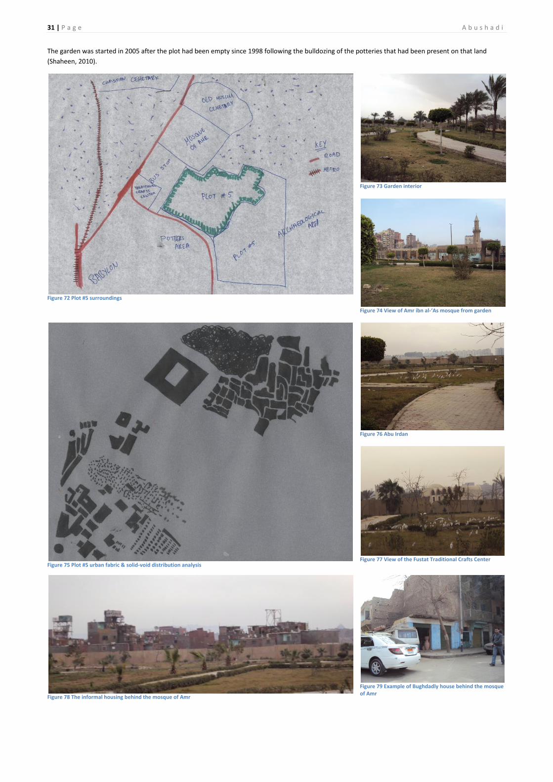
Figure 72 Plot #5 surroundings ................................................................. 31
Figure 73 Garden interior ......................................................................... 31
Figure 74 View of Amr ibn al-‘As mosque from garden ............................ 31
Figure 75 Plot #5 urban fabric & solid-void distribution analysis ............. 31
Figure 76 Abu Irdan ................................................................................... 31
Figure 77 View of the Fustat Traditional Crafts Center ............................ 31
Figure 78 The informal housing behind the mosque of Amr .................... 31
Figure 79 Example of Bughdadly house behind the mosque of Amr ....... 31
Figure 80 North of Khayyala Lake, south of new Upper middle class
housing development ..................................................................... 32
Figure 81 Plot #6 surroundings ................................................................. 32
Figure 82 Plot #6 urban fabric & solid-void distribution analysis ............. 32
Figure 83 Debris land fill ........................................................................... 33
Figure 84 Variation of limestone debris .................................................... 33
Figure 85 Land almost at water level – not good for building .................. 33
Figure 86 Slate ........................................................................................... 33
Figure 87 Granite & sandstone – strong and weak stones combined ...... 33
Figure 88 Marble and hashmi ................................................................... 33

5 | P a g e A b u s h a d i
Site Analysis
The area of Ain al-Sira was chosen as the site for the model Egyptian
school despite it being a unique area. The philosophy behind this is that
the model school should be designed in such a way that it would not
become the blueprint for all schools but rather it becoming a guide on
how to design schools according to the context of each area. In other
words it would be a way of dealing with parameters as these vary from
area to area.
The plots provided for the project at Ain al-Sira each have their own
advantages and disadvantages, even though one will be selected the
others will be used as aid on how to ensure that the school is designed as
a methodology rather than a product by comparing how certain design
elements would or wouldn’t be different if it had been placed on one of
the other sites. For this purpose, more than one plot will be thoroughly
analysed.
Ain al-Sira General Overview
North Fustat and the Fustat Plateau The whole area encompassed by what is today Aqueduct (Magr el
‘Ayoun) and Old Cairo road (Masr el Qadima) is refered to as North Fustat
while the area from Old Cairo road to the Ring Road is the Fustat plateau.
In the past this whole area had a rough topography due to natural
erosion and quarrying (Kubaik, 1987). Figure 2 shows some of the
topographical arteries which were used as roads. However, the
topography shown in Figure 2 would not have been anything like the
original topography of early medieval times.
The topography of the region has been constantly changing. Since the
late Middle Ages rubble and refuse has been amassing in the valleys and
valley sides, as well as raising the height of hills (Kubaik, 1987).Much of
the land was levelled off post-1950s to build low income housing. With
these modern urban developments many of the old roads in the valleys
that connected Fustat to Islamic Cairo have disappeared and the ones
that remain are not clear.
Ain al-Sira, the Lake Ain al-Sira is categorised as a well (EL-Jakee, Moussa, Mohamed, &
Mohamed, 2009), it’s water rich in minerals and sulphates (Ahmed,
2013). People would bathe in the lake for its healing properties. During
Nasser’s rule the lake came to be mixed with sewage water(Ahmed,
2013), the situation has not improved since then as the existing high
water table contains sewage. Levels of coliforms, a bacteria present in
fecal matter used as an indicator for its source, found at Ain al-Sira were
as high as the levels found in New Cairo’s untreated sewage (EL-Jakee et
al., 2009).The well/spring which first fed the lake is a renewable source of
water; if treated or extracted from the source the water can be used.
The lake of Ain al-Sira was formed after the earth had ruptured during an
earthquake in 1926, causing underground water to surface, it had
spanned across 30 acres (Ahmed, 2013).However, observing maps of
Cairo from 1846 to 1958, Figure 1 to Figure 10, it becomes evident that
Ahmed’s (2013) dating of the formation of Ain al-Sira is not completely
correct. The first appearance, as far as this research can demonstrate, of
any water bodies in the area dates to before 1898, Figure 6. It would not
be accurate to say it was formed between 1897 and 1898 because it
cannot be confirmed that the 1897 map was drawn that year, as the date
it has is the date it was published. If we are to assume that Ahmed (2013)
is correct and Ain al-Sira was formed as a result of an earthquake, then it
could have been formed as a result of the July 17, 1887 earthquake,
which caused some damage in Fustat (Ambraseys, Melville & Adams,
1994). However, this would not explain why it was not drawn in the 1897
map, ten years later. This suggests that maybe Ain al-Sira was formed
over a series of earthquakes each contributing to its formation. In the
period between 1898 and 1887 there were two minor earthquakes. The
first originated in Lower Egypt, took place December 7, 1895, shocks were
felt in Cairo but no damage was reported. The second originated in the
Hellenic Arc, took place on June 29, 1896, Cairo felt a slight earthquake
but again no damage was reported. Between 1856 and 1887 there had
been 7 moderately violent earthquakes and shocks felt by Cairo, one
caused extensive damages, half of them caused moderate damage and
the other half caused no damage. (Ambraseys, Melville & Adams, 1994)
Despite this information, Ahmed (2013) was not completely incorrect
when dating Ain al-Sira to 1926. Comparing the 1908 Environs of Cairo to
the 1914 Environs of Cairo 1:75.000, Figure 7 and Figure 8 respectively,
both by Wagner & Debes, it is noticeable that the water bodies fluctuated
in water content where five widely spaced water bodies in the 1908 map
were reduced, in the 1914 map, to one water body tiny in comparison to
what had existed. The lakes later resurface as shown in Nicohosoff‘s1933
map, Figure 9. On June 26, 1926, there was a large earthquake originating
in the Hellenic Arc which caused damage in poorer areas of Cairo as well
as causing a new hot spring in Helwan near its other existing thermal
springs(Ambraseys, Melville & Adams, 1994).There are two possibilities
for the great reduction in water of the lakes at Ain al-Sira:
1. The source of the water could have been obstructed by any of the
three earthquakes that occurred between 1906 and 1918 that
were felt in Cairo, causing the lakes to dry out. The 1926
earthquake could have unblocked the source allowing for the lake
to form again.
2. Overuse of the lake waters could have contributed to drying out
as there was a greater output than input.

A b u s h a d i P a g e | 6
Figure 1 Fragment of Plan general de la Ville du Kaireet des Environs, Baur & Szultz (1846)
Figure 2Fragment of Plan Du Kaire Ancien, Erhand (1878)

7 | P a g e A b u s h a d i
Figure 3 Fragment of Eastern Environs of Cairo, Wagner & Debes (1885)
Figure 4Fragment of The Environs of Cairo, Stanford’s Geographical Establishment (1888)

A b u s h a d i P a g e | 8
Figure 5Fragment of Cook's Map of the Environs of Cairo, W. & A.K. Johnston Limited (1897)
Figure 6Fragment of Map of the Environs of Cairo, Wagner & Debes (1898)

9 | P a g e A b u s h a d i
Figure 7 Fragment of Environs of Cairo, Wagner & Debes (1908)
Figure 8Fragment of Environs of Cairo 1:75.000, Wagner & Debes (1914)

A b u s h a d i P a g e | 10
Figure 9 Fragment of Historic map of Cairo, Egypt, Nicohosoff (c. 1933)
Figure 10 Fragment of Cairo No. 2, 1:10,000, Edition 4-AMS, Series P971, U.S. Army Map Service (1958)

11 | P a g e A b u s h a d i
Babylon (Qasr al-Sham) Babylon was either a Byzantine fortress (Creswell, 1979) or a Roman
fortress (Butler, 1914). If Butler’s account is correct, the fortress would
have originally have been founded by Nebuchadnezzar, king of Medes
and Persia, hence the name Babylon, and later built into a fortress by the
Roman Emperor Trajan. Trajan also built the canal of Trajan, sometimes
called Amnis Traianus, which passing through the fort’s gates connected
the Nile to the Red Sea (Butler, 1914). See
The Babylon fortress hosts the old synagogues, Coptic and Orthodox
churches of Cairo as can be seen in Figure 12.
Originally the fort was located on the river edge but due to the changing
course of the Nile, change caused by soil erosion and land formation due
to the floods, it is now located further inland.
Figure 11 Axonometric reconstruction of the fort of Babylon by Nicholas Warner, from Babylon of Egypt: The archaeology of old Cairo and the origins of the city, Shaheen
Figure 12 Monuments in the Babylon enclosure of Old Cairo, by Nicholas Warner, from Babylon of Egypt: The archaeology of old Cairo and the origins of the city, Shaheen
Figure 13 Reconstruction of the plan of the fort of Babylon by Nicholas Warner and Peter Shaheen, from Babylon of Egypt: The archaeology of old Cairo and the origins of the city, Shaheen
Fustat, the city Amr ibn al-‘As captured Babylon after it surrendered following a seven
month siege on April AD 641, he then went on to capture Alexandria.
Upon his return from Alexandria to Babylon, he founded his Fustat as his
capital – misr, meaning capital - on the edge of Babylon. He first built his
house and was later commissioned by the Khalif to build a congregational
mosque which became known as the mosque of Amr ibn al-‘As. (Creswell,
1979)
Originally a camp city, since those were the living arrangements of the -
moving army, it maintained the military structure while becoming a
permanent camp to make it easy to control and mobilise, as well as
maintaining the tribes together to integrate into a community. This
arrangement resulted in a unique urban development pattern. The tribes
formed their own clusters with the land between tribes being no-man’s
land, see Figure 14 . The street networks would not have only been
affected by the tent arrangement, but also by the diverse space and
irregular land. There is no specific evidence that the camp city consisted
of tents like Bedouin camps and early Arab army housing however, it is
plausible. Eventually, the camp had mud and reed huts and then houses
built. Based on the population, the city would have measure 5-6 x 1-2 km.
However, some areas of the city fell into disuse due to their irregular
shapes, growing social-ethnic differences caused by the increasing wealth
of the upper class that wanted larger houses, and quarters’ limits.
(Kubaik, 1987)
Al-Fustat seized to be the capital of Egypt when in AD 750, the Abbasids
took over Egypt.
The areas of Fustat that were least affected by modern planning is the
one east and north-east of the mosque of Amr ibn ‘As (Kubiak, 1987),
despite the areas of quarrying that took place in its midst over the years,
it could present a good reference on how the city developed while
maintaining its identity. One could then forecast how it would have
developed further if it were still fully inhabited, which is not the case.
The Mosque of Amr
Most historians agree that it was built following the fashion of the
mosque at the Prophet’s house, made of palm columns and tie-beams. It
only measures 29 x 17.5 m. With low roofs, lighting was provided by the
six doors to the mosque that always remained open. The mosque was
located 4 m away from the house of Amr ibn al-‘As. The mosque was not
only used for prayer but also for official announcements and public
ceremonies. Other prayer places or smaller mosques built by each tribe in
their neighbourhood were also used for political or municipal meeting
places for tribal affairs. The mosque underwent many expansions and
redecorations. (Creswell, 1979)

A b u s h a d i P a g e | 12
Figure 14 Ethnic Groups and Multi-tribal Quarters, from Al-Fustạ t, its foundation and early urban development, Kubiak
Figure 15Fustat street network excavated by Ali Bahgat, from Al-Fustạt, its foundation and early urban development, Kubiak
The Houses of Fustat
Since the Arab army was unskilled in construction they hired the local
labor to build their houses. As a result, the Fustat houses have a clear
Coptic influence (Kubaik, 1987).
Materials used in construction according to Kubaik (1987):
Mud bricks
Mud mortar
Red burned bricks
Lime mortar
Gypsum
Stone
Palm trees
Cesspools were dug or cut into the bedrock to collect waste from latrines
under houses, although pipes were found at Fustat, their intention was
not for central sewage (Kubaik).
Examples of the Fustat Houses
Figure 16 House No. I, by AlyBahgat and Gabriel, in The Muslim Architecture of Egypt, Creswell
Figure 17 House No. II, by AlyBahgat and Gabriel, in The Muslim Architecture of Egypt, Creswell

13 | P a g e A b u s h a d i
Figure 18 House No. III, by AlyBahgat and Gabriel, in The Muslim Architecture of Egypt, Creswell
Figure 19 House No. V, by AlyBahgat and Gabriel, in The Muslim Architecture of Egypt, Creswell
Figure 20 House No. VI, by AlyBahgat and Gabriel, in The Muslim Architecture of Egypt, Creswell
Figure 21 Different house types, by AlyBahgat and Gabriel, in The Muslim Architecture of Egypt, Creswell
Figure 22 House No. VIII, by AlyBahgat and Gabriel, in The Muslim Architecture of Egypt, Creswell

A b u s h a d i P a g e | 14
The Area Today
Figure 23 Google Earth image of area captured June 24, 2012
Key:
A. Amr ibn al-‘As Mosque
B. Aqueduct (Magr el ‘Ayoun)
C. Café overlooking lake
D. Champion’s Club (Nady al-abtal)
E. City of the dead (al-Qarafa)
F. Civilizations Museum (incomplete)
G. Coptic Cairo
H. Coptic Cemetery
I. Coptic Museum& Mar Girgis – site of Babylon (Qasr al-Sham)
J. Egyptian Club (Nady al-Masry)
K. Fustat excavations
L. Fustat Garden (Hadiqat al-Fustat)
M. Fustat Traditional Crafts Center
N. General Authority for the Environment
O. Leather Tanners
P. Mar Girgis Metro Station
Q. Ministry of Culture for traditional arts
R. Ministry of Interior Security and Guard Offices
S. Potters
T. Souk Fustat (Fustat Market)
U. Youth Club (Nady al-shabab)
Figure 24 Aerial view of the mosque of Amr, cemetery and informal settlement, by Rajan Patel, from Babylon of Egypt: The archaeology of old Cairo and the origins of the city, Shaheen
Figure 25 Aerial view of the fortress of Babylon, by Rajan Patel, from Babylon of Egypt: The archaeology of old Cairo and the origins of the city, Shaheen
A
B
C
D
E F
H
I
J
A
K
L
M
N
O
P Q R
S
U
T
G

15 | P a g e A b u s h a d i
Figure 26 Fragment of the “Historical Map”, showing urban development of the area up until c.1988, from Implementation of the homogeneous sector concept, homogeneous sector no. 1 Cairo Centre final report November 1988, vol. 1, General Organization for Physical Planning
Figure 27 Fragment of the “Average Building Heights”, showing urban development of the area up until c.1988, from Implementation of the homogeneous sector concept, homogeneous sector no. 1 Cairo Centre final report November 1988, vol. 1, General Organization for Physical Planning
Figure 28 Fragment from “Land Use”c.1988, from Implementation of the homogeneous sector concept, homogeneous sector no. 1 Cairo Centre final report November 1988, vol. 2, General Organization for Physical Planning
Figure 29 “Fustat Project Location”, from Implementation of the homogeneous sector concept, homogeneous sector no. 1 Cairo Centre final report November 1988, vol. 2, General Organization for Physical Planning
Figure 30 Cross-section C-D, marked on Figure 28, from Implementation of the homogeneous sector concept, homogeneous sector no. 1 Cairo Centre final report November 1988, vol. 2, General Organization for Physical Planning

A b u s h a d i P a g e | 16
Kubiak (1987) mentions that a dump more than 10m thick and covering
over ten hectares filled up many of the cavities and natural depressions of
the topography, and obscuring many unexplored ruins. The date of his
book coincides with the date of the map shown in Figure 28, it is then
safe to assume that the dump he refers to is the one shown in Figure 28,
which was later covered and converted into Fustat Garden, labeled ‘L’ in
Figure 23. In a way the existence of the land fill helped preserve the ruins,
quarries and topography underneath, because if it had not been a landfill
it would have been flatted like the land it’s left. If anyone chooses to
learn more about it, the garden and landfill underneath can always be
excavated.
Project Developments There have been many project redevelopments proposed for the area. Of
the most recent ones, only one has been started although it only amounts
to 5% of the total proposal, that shown in Figure 29, which due to its slow
progress – that 5% being still under construction despite its proposal pre-
1988 – it may be that the project will not be completed, particularly as it
would mean displacing many people. Another proposal, submitted in
1988 is that shown in Figure 31, which has also not been implemented.
The main issues with these two proposals are that they do not design for
historic, urban or societal preservation; they are completely redesigning
the fabrics of the area. In the same document as the mentioned
proposals is also an intricate system of drainage for the whole area and
plateau, which was also never implemented, and as an alternative to the
large scale housing projects, a proposal which suggests half of the area
between Salah Salem and the Ring Road into “Fustat Garden”.
Figure 31 “Recommended for Development”, from Implementation of the homogeneous sector concept, homogeneous sector no. 1 Cairo Centre final report November 1988, vol. 2, General Organization for Physical Planning
A student proposal designed between Ain Shams and Clemson University
students also offered two alternatives, which although they do take into
consideration the importance of historic preservation, designing for an
archeological park, they disregard the importance of preserving the
historic urban fabric, Figure 32 & Figure 33.
Figure 32 Program arrangement, from Al-Fustat: Revitalizing the Old Capital, Ain Shams & Clemson Universities
Figure 33 Redesign proposals, from Al-Fustat: Revitalizing the Old Capital, Ain Shams & Clemson Universities

17 | P a g e A b u s h a d i
Demographics
Figure 34 Population Density, From Urban Regeneration project for Historic Cairo, First Report of Activities, July 2010 – June 2012, UNESCO
Figure 35 Unemployment, from Urban Regeneration project for Historic Cairo, First Report of Activities, July 2010 – June 2012, UNESCO
Figure 36 Illiteracy, From Urban Regeneration project for Historic Cairo, First Report of Activities, July 2010 – June 2012, UNESCO
Comparing the population density of Misr al-Qadima, 146.1
people/hectar, to the maximum and minimum, 574.4 & 66.0
people/hectar respectively, it can be said that Misr al-Qadima has
medium-low population density, Figure 34. The area also has the highest
unemployment rate in Historic Cairo, 8%, Figure 35. Its illiteracy, 29%,
compared to the maximum and minimum, 34% and 13% respectively, it
can be said that illiteracy is above average, Figure 36.
It is therefore important that the school be designed in such a manner
that it would contribute to the employment of the district.

A b u s h a d i P a g e | 18
Ain al-Sira physical changes since the start of the new millennia
` Figure 37 Google Earth image of area captured October 7, 2000
Figure 38 Google Earth image of area captured May 24, 2003
A
G
C B
D
E
F

19 | P a g e A b u s h a d i
Figure 39 Google Earth image of area captured May 29, 2006
Figure 40 Google Earth image of area captured July 2, 2007
H

A b u s h a d i P a g e | 20
Figure 41 Google Earth image of area captured July 24, 2009
Figure 42 Google Earth image of area captured November 5, 2009

21 | P a g e A b u s h a d i
Figure 43 Google Earth image of area captured November 5, 2010
Figure 44 Google Earth image of area captured June 12, 2011

A b u s h a d i P a g e | 22
Figure 45 Google Earth image of area captured June 24, 2012
There has been a large change in the surface water masses of the area
where some have dried out while others have grown. Looking at the first
available Google image of the area dated 2000, Figure 37, seven
congregations of surface water are visible. Comparing Figure 37 to Figure
39, captured 2006, we find that water areas B, C, D and F have greatly
been reduced in surface area, whereas volume H was formed. The
following year, Figure 40, volume D had become almost inexistent,
volume E was no longer visible through the vegetation, volume H had
dried up. By mid-2009, Figure 41, volume C has vanished, B had become a
small fraction of what it once was, volume H had resurfaced. Half a year
later, Figure 42, volume B had almost halved in surface area. In 2010,
Figure 43, volume B became a tiny patch of water and contrary to most
patterns in the area, volume G claimed the land between itself and the
point where volume F was: about a fourth of volume G’s original surface
area. By 2011, volume B had almost disappeared, volume D had grown
slightly but with murky water, and volume H had deepened the area it
reclaimed. The 2012 image, Figure 45, reveals a small patch of greenery,
about one fifth of the 2000 greenery, represents the high water table that
volumes B, C and D left.
The increase in surface area of volume G can be attributed to a rise in the
water table caused by digging, both for archaeological and construction
purposes (Ahmed, 2013). However, other causes for the rise in water
level include higher Nile levels, seepage from Muqattam, irrigation,
leaking water and sewage pipes, and well water extraction (Shaheen,
2010); since Ain al-Sira is on lower land, as can be seen fromFigure 46 and
Figure 47, this sewage water runs down to Ain al-Sira. It is an urban
problem, not a district problem.
Although Figure 6 toFigure 10 show that the water bodies did fluctuate in
water content of its own accord for natural reasons, indirect human
activity also affected the water content. The bodies of water B, C, D, E
were originally formed by an overall rise in the water table that was a
result of the High Dam being built causing the land to swamp/flood due
to seepage, as shown in Figure 28; prior to the dam the valley had been
dry for most of the year (Kubiak, 1987).
Since the year 2000 the general disappearance of surface water for
volumes B, C, and D is most likely to have been a result of being buried
under the land fill. Monitoring closely the Google images through the
years it can be observed that there is a land mass that increases over the
years in height and in reach, filling the land, and the water bodies. A
sudden change is more obvious between the years 2006and 2007,Figure
39 and Figure 40 respectively, where the land gained height and a ridge is
obvious marking the height difference. This ridge can be observed
spreading south-east, east and then north along the green valley,
encompassing and finally burying volume C by mid-2009. One can see a
similar development of increased ground level on the shores of volume G,
except where it swamped part of the land.
Figure 46Fragment of “Relief contour lines” c.1988, from Implementation of the homogeneous sector concept, homogeneous sector no. 1 Cairo Centre final report November 1988, vol. 1, General Organization for Physical Planning

23 | P a g e A b u s h a d i
Figure 47 Relief-cross section east-west c.1988, from Implementation of the homogeneous sector concept, homogeneous sector no. 1 Cairo Centre final report November 1988, vol. 1, General Organization for Physical Planning
However, the increase in landfill was not the only factor that affected the
decrease in water in the region. Water body D was not engulfed by
landfill yet it also experienced water reduction. This may be allocated to a
USAID funded project that aimed to lower the groundwater level in old
Cairo, particularly the area of Babylon to provide access to the flooded
basements of many monuments (Shaheen, 2010). Between the late 1970s
and 2000, the ground water in that area had risen by about 2 metres.
Some twenty-two shafts for dewatering were built, when the project was
ended the water rose again.
Figure 48 Plan of shafts and their network, used for dewatering during the conservation project, from Babylon of Egypt: The archaeology of old Cairo and the origins of the city, Shaheen

A b u s h a d i P a g e | 24
The Plots
Plot 1
Figure 49 Plot 1, between Cairoland and the Qarafa, overlooking the Ain al-Sira lake
Figure 50 Plot #1 & #2 surroundings

25 | P a g e A b u s h a d i
Figure 51 Plot #1 & #2 urban fabric & solid-void distribution analysis
Physical Response
30 feddan
Easily accessible by cars as it is next to main roads
Location would target children from the informal settlement
within the plot, children living in the Qarafa and children living in
the north east area between the aqueduct and
There already is a primary school opposite the Champion’s Club in
the public housing area
Plot has two fronts: overlooking lake, overlooking the Qarafa
There’s a service road that leads to the back of Cairoland, ending
at the back door – parking is currently used for buses and for
driving classes
There are a few buildings in the plot adjacent to Cairoland that
are intact, clearly influenced by 60s architecture, Figure 52
Plot opens up to the back of Fustat Garden – no fence, also has
access to the Civilizations Museum’s back gate
The Fustat garden is on higher land and can be seen from the plot
Cairoland and Civilizations Museum are concrete structures, the
informal settlement inside the plot are either stone, bughdadly or
brick structures
Mosque in the informal settlement that is flooded by the lake
The section of the Qarafa that can be seen are mostly brick tombs
from the 60s onwards, only a few are older and in stone
The bank of the lake closest to the bus parking was raised using
debris – remnants of tiles and rocks are identifiable
The informal settlement was fenced off from the rest of the plot
The plot is generally empty of people except for the informal
settlement
Children not from the informal settlement would be required to
cross main streets – dangerous
There is a variety of urban textures to integrate which would give
an interesting contextual building
The topography was flatten, takes away from the character of the
area
Figure 52 Building inside Cairoland’s empty sand plot, with architectural influence from the 60s
Figure 53 Back gate of land adjacent to Cairoland
Figure 54 View of Fustat garden
Figure 55 View of Ain al-Sira Lake

A b u s h a d i P a g e | 26
Figure 56 Sketch of the informal settlement on the banks of the lake – timber is used as roof, baked red brick for the walls
Figure 57 Sketch of lake showing the Qarafa skyline in the background with the imposing alien middle-income development on the right
Environmental Aspects
Prevailing wind is north
Little precipitation
Passive cooling due to the large body of water
Reeds grow on the banks and in the middle of the lake in clusters
Reeds are inhabited, probably by rodents, cats, dogs and birds
Building techniques of the cemetery consist of wall bearing stone
or brick masonry
Building techniques of the informal area is predominantly
bughdadly as it is an old settlement, and reinforced concrete &
baked red brick
Timber roofs in some informal houses
Lake is polluted by sewage
Air is polluted by the ash and smoke of burned garbage
Some reeds are burned by children to clear the path to the lake
for them to swim
No seepage
Social Aspects
In popular areas territoriality tends to be a strong issue – this may
be a problem for plot #1 as the plot, along with the lake, is
located in the district of al-Khalifa & Mokattam while the rest of
Ain al-Sira belongs to the district of Old Cairo,
Figure 58 &
Figure 59 respectively
The school can either overcome the territoriality issue or be ruled
by it
Since the plot is right next to the Youth Club which acts more like
a community center it would be a bit redundant to have a
community oriented school so close to the Youth Club when
other plots lack the proximity to these services
Urban setting
Surrounding buildings are mostly residential, abandoned, graves
or parks/clubs
Main roads and side road are in good conditions, all are two lane
two-ways
Figure 58 Map of Old Cairo District; Source – خرائط تفصيلية الحياء محافظة القاهرة
Figure 59 Map of Khalifa & Mokattam District, Source - خرائط تفصيلية الحياء محافظة القاهرة

27 | P a g e A b u s h a d i
Plot #2
Figure 60 Plot #2, Cairoland
Physical Response
10 Feddan
Easily accessible by cars as it is next to main roads
Location would target children from the informal settlement
within the plot, children living in the Qarafa and children living in
the north east area between the aqueduct and
There already is a primary school opposite the Champion’s Club in
the public housing area
There’s a service road that leads to the back of Cairoland, ending
at the back door – parking is currently used for buses and for
driving classes
Many buildings in Cairoland are intact, clearly influenced by 60s
architecture, Figure 52
The Fustat garden is on higher land and can be seen from the plot
Cairoland and Civilizations Museum are concrete structures, the
informal settlement inside the plot are either stone, bughdadly or
brick structures
The informal settlement was fenced off from the rest of the plot
The plot is generally empty of people except for the informal
settlement
The plot is linear in form
Low-income public housing across Salah Salem, children would be
required to cross main street – dangerous
There is a variety of urban textures to integrate which would give
an interesting contextual building
The topography was flatten, takes away from the character of the
area
Environmental Aspects
Prevailing wind is north
Little precipitation
Passive cooling due to the large body of water and gardens
nearby
Building techniques of the cemetery consist of wall bearing stone
or brick masonry
Building techniques of the informal area is predominantly
bughdadly as it is an old settlement
Lake is polluted by sewage
Air is polluted by the ash and smoke of burned garbage
Many of the buildings remain intake, they could be remodelled
and reused
The plot is full of amusement park rides, can be re-engineered
into other machines or steel recycled into
Potential for being a brown field due to the rides that would have
needed lubricants and such
Ground relatively dry
Social Aspects
In popular areas territoriality tends to be a strong issue – this may
be a problem for plot #1 as the plot, along with the lake, is
located in the district of al-Khalifa & Mokattam while the rest of
Ain al-Sira belongs to the district of Old Cairo,
Figure 58 &
Figure 59 respectively – The school can either overcome the
territoriality issue or be ruled by it
Since the plot is right next to the Youth Club which acts more like
a community center it would be a bit redundant to have a
community oriented school so close to the Youth Club when
other plots lack the proximity to these services
Urban setting
Surrounding buildings are mostly residential, abandoned, graves
or parks/clubs
Main roads and side road are in good conditions, all are two lane
two-ways
The part of street which the main entrance overlooks, Malik al-
Salih joining into Salah Salem, had a queue of transportation for
the gas station located at the fork. The queue stretched past the
main entrance of Cairoland, appropriating the drop-off lane as a
service road. This could cause future problems when accessing
the site from the main entrance
The layout of Cairoland consists of an L-shaped main pedestrian
path with rides on either side

A b u s h a d i P a g e | 28
Plot #3
Figure 61 South of Ain al-Sira – East of Civilization Museum
Figure 62 Plot #3 surroundings
Figure 63 Plot #3 urban fabric & solid-void distribution analysis
Physical Response
7 feddan
Accesible via Masr al Qadima road
Not as easily accessible to informal areas
Since its next to an MOI building may be limited to ground floor
building only
Next to the Museum of Civilizations – which is not contextual
Closest to the middle-income housing that is under development
Flat topography
Contemporary buildings have no unique urban character
Environmental Aspects
Prevailing wind is north
Little precipitation
Passive cooling due to the large body of water and gardens
nearby
Lake is polluted by sewage
Reinforced concrete is predominant in this area
Ground seemed relatively dry
Air is polluted by the ash and smoke of burned garbage
Potential for being a brown field due to the rides that would have
needed lubricants and such
Near an indefinite construction site – raises dust and causes air
pollution
Social Aspects
Does the land belong to the museum?
Would indirectly target the middle-income children as they live
closer to it, isolated from any other residential areas
The middle-income development is predominantly uninhabited,
which community would the school target?
The middle-income community is in less need as the low-income
community

29 | P a g e A b u s h a d i
Figure 64 Civilizations museum
Plot #4
Figure 65 Around Fustat excavation site
Figure 66 Plot #4 surroundings
Figure 67 Plot #4 urban fabric & solid-void distribution analysis

A b u s h a d i P a g e | 30
Physical Response
75 feddan
Accessible via secondary roads from Masr al Qadima road or al
Malik al Saleh
Near informal area, would need to respect tight urban fabric
Half of the land is swamp land
Half of the land is a landfill
Near historic Fustat
Includes Fustat archaeological site
Large differences in topography – however many are a result of
garbage, may not be safe to build on
Lots of urban fabrics on site
Archaeological site – cannot build on ruins or potential
excavation ground
Lots of debris, not good to build on
A desolate view
Topography offers character as well as variation to the new
developments which cut and fill the land
Environmental Aspects
Prevailing wind is north & little precipitation
Swamp land – unhealthy/unsanitary
Filtration of swamp into other land
Landfill - unhealthy/unsanitary
Pollution from burning garbage - unhealthy/unsanitary
Secluded and quiet
The old Fustat housed were made of mudbrick, baked red brick,
stone, lime mortar, gypsum mortar
Could use recyclable materials found in the landfill, create a
recycling /reuse identity for the community
Social Aspects
Would target low-income
Near traditional crafts – potters, quarrymen
Near heritage – perfect for heritage school
By building there would prevent littering to some extent
Building would either show others importance of heritage, or
encourage others to also build in the archaeological site
Could employ local craftsmen in the building of the school –
creating instant employment
Could build using the special crafts of the area
Figure 68 Archaeological remains of old Fustat – mountainous landfill seen in the background
Figure 69 Another view of the ruins of old Fustat
Figure 70 View of swamped land
Plot #5
Figure 71 Between Pottery Centre and Souk al-Fustat
31 | P a g e A b u s h a d i
The garden was started in 2005 after the plot had been empty since 1998 following the bulldozing of the potteries that had been present on that land
(Shaheen, 2010).
Figure 72 Plot #5 surroundings
Figure 73 Garden interior
Figure 74 View of Amr ibn al-‘As mosque from garden
Figure 75 Plot #5 urban fabric & solid-void distribution analysis
Figure 76 Abu Irdan
Figure 77 View of the Fustat Traditional Crafts Center
Figure 78 The informal housing behind the mosque of Amr
Figure 79 Example of Bughdadly house behind the mosque of Amr

A b u s h a d i P a g e | 32
Physical Response
Large variation of urban fabrics
Near historic area
Directly targets the informal settlements that threaten the
historic preservation of the area
Overlooks the archaeological site
Plot encompasses the dewatering shafts that were built between
2000-2005 – can be put into use to lower water level
Access from bus stop or from Masr al Qadima Road
Green areas already exist
Some traditional architecture near site for inspiration – the
Traditional Crafts Center
Very close to a low-income large residential area
Environmental Response
Prevailing wind is north
Little precipitation
Landfill - unhealthy/unsanitary
Pollution from burning garbage - unhealthy/unsanitary
The old Fustat housed were made of mudbrick, baked red brick,
stone, lime mortar, gypsum mortar
Could use recyclable materials found in the landfill, create a
recycling /reuse identity for the community
The new houses of reinforced concrete and baked red brick
Social Aspects
Would target low-income
Near traditional crafts – potters, quarrymen
Near heritage – perfect for heritage school
By building there would prevent littering to some extent
Building would either show others importance of heritage, or
encourage others to also build in the archaeological site
Near the Fustat market, could aim to buy needed things from
there as much as possible
Plot #6
Figure 80 North of Khayyala Lake, south of new Upper middle class housing development
Figure 81 Plot #6 surroundings
Figure 82 Plot #6 urban fabric & solid-void distribution analysis

33 | P a g e A b u s h a d i
Figure 83 Debris land fill
Figure 84 Variation of limestone debris
Figure 85 Land almost at water level – not good for building
Figure 86 Slate
Figure 87 Granite & sandstone – strong and weak stones combined
Figure 88 Marble and hashmi
Physical Response
50 feddan
Land has high filtration
Large part of the land is near land reclaimed by lake – very likely
not good for construction – too weak
Land is a debris landfill – site is not flat
Overlooks the lake
Overlooks the informal settlement on the cliff – Batn el Baqara
Far end of lake, at the edge of the informal settlement cliff
Cliff edge used as landfill – falls into lake – lake becomes landfill
(waterfill)
Pollution from litter in lake makes water unusable without
treatment and can help spread diseases
Lots of material reuse potential from debris site
We found a fragment of a tombstone, dated by a professor of
Islamic Architecture to the 9th century – probably came from the
debris of the foundation excavation from the middle-income
development – the Qarafa cemetery probably originated in Ain al-
Sira then spread to the east – potential good excavation site for
kids
Informal area has no direct access to the site due to the height
difference (cliff), a stair case would need to be built
Poor connection of skyline
Street network of middle-income residential development are
too narrow, already hard to drive through and not even 10% of
residents are installed
Environmental Response
Lots of stone for reuse
Land has potential to swamp
Water contamination from landfill
Water contamination from sewage
Soft land
Mostly reinforced concert and baked red brick construction
Social Aspects
Help bridge the low-income and middle-income children from the
informal and formal area respectively
Establish a reusing mentality
Establish a archaeological sensitive mentality

A b u s h a d i P a g e | 34
Site Evaluation
N/A = Not Available/Applicable 0 = None/not at all 1 = slightly/poor 5 = absolutely/excellent
Site Evaluation Checklist Plot 1 Plot 2 Plot 3 Plot 4 Plot 5 Plot 6
Location
Near historical context Near buildings of certain urban importance
3 3
3 1
1 1
5 5
5 5
3 1
Surrounding buildings have variety of construction materials 4 4 1 5 5 3
Accessibility from main roads 4 5 5 0 4 0
Accessibility from residential areas Accessibility from residential areas that does not involve crossing main roads Accessibility from metro Large area for future development Near more than one residential area Not near areas that are prone to congestion In an area that can provide activities for the children that would complement their
school work Un-built land Near main roads for access to sewage & water networks Interesting urban fabrics that do not follow modern urban planning
3 3 0 3 4 0 4 3 4 5
4 2 0 2 4 0 4 0 5 3
3 0 0 1 0 4 4 3 5 0
3 5 3 5 5 5 5 5 2
4 4 5 2 5 3 5 4 5
3 5 0 3 3 2 4 5 5
Water
Not in a swamping prone area 4 4 2 0 2 0
View of water 5 4 5 2 0 5
Quality of water Water can be used in passive design
2 3
2 0
2 5
1 0
N/A N/A
1 0
Environment & Healthiness
Healthy air Prevailing wind is unobstructed by other buildings
2 3
1 5
2 5
0 3
2 3
0 1
Not near a landfill 5 5 5 0 0 0
Not near stagnant water Quiet area Away from construction zones Reusable materials Raw materials Near existing greenery Would not replace a lot of greenery
4 5 4 2 3 4 5
4 3 4 3 1 5 5
3 3 0 3 2 2 5
0 5 4 5 2 5 3
0 5 5 3 0 5 3
0 5 0 5 1 1 5
Topography
Some irregularity of terrain to maintain to true essence of the historic area 2 0 0 5 2 N/A
Solid ground – i.e. not layers of sand and garbage 0 5 N/A 0 2 0
Land not too steep Not a drainage area (i.e. valley or downhill)
5 4
5 4
5 2
2 0
4 3
5 0
Service
Near a community that lacks sufficient schools Not near a community center or other building that may offer services to the
community
3 0
3 0
2 3
5 4
5 3
0 3
Contributes to targeting an environmental issue 2 2 3 5 5 5
Contributes to settling local political issues: territoriality, income class segregation 5 5 3 1 1 5
Total 115 107 90 105 109 79
Plots #1 & #5 have almost equal scores. The site for the school will be on one of these. The decision will be made based on the study of the “the proposal of
protection measures for the world heritage property” in Urban Regeneration project for Historic Cairo, First Report of Activities, July 2010 – June 2012,
which is available in the appendix. Although I have a personal preference to Plot #5, Plot #1 would be more applicable to the rest of Egypt for being less
unique. However, it would also be interesting to adjust the school so it may fit on a swamped land as in rural Egypt a lot of the land has seepage.

35 | P a g e A b u s h a d i
References
Ain Shams University Department of Architecture, & Clemson University
department of Landscape & Urban Planning. (2012, April 22). Al-
Fustat: Revitalizing the Old Capital [Scholarly project]. Retrieved
March 2, 2013, from http://www.behance.net/gallery/Al-Fustat-
Revitalizing-the-Old-Capital/3670089
Ahmed, S. (2013, January 15). A rising tide of pollution. Daily News Egypt.
Retrieved February 21, 2013, from
http://www.dailynewsegypt.com/2013/01/15/a-rising-tide-of-
pollution/
Ambraseys, N. N., Melville, C. P., & Adams, R. D. (1994).Descriptive
catalogue of earthquakes (184 BC - AD 1992). In The seismicity of
Egypt, Arabia, and the Red Sea: A historical review. Cambridge:
Cambridge University Press.
Baur, M. & Szultz. (1846). Plan general de la Ville du Kaireet des Environs
[map]. Retrieved February 27, 2013 from
http://www.archcairo.org/icmcnet/19th.htm
Butler, A. J. (1914). Babylon of Egypt: A study in the history of Old Cairo.
Oxford: Clarendon Press.
Creswell, K.A.C. (1978). The Muslim Architecture of Egypt, vol. I. Oxford:
Hacker Art Books.
Creswell, K. A. C. (1979). Early Muslim architecture.Vol. 1.Pt.1. New York:
Hacker Art Books.
EL-Jakee, J., Moussa, E. I., Mohamed, K. F., & Mohamed, G. (2009). Using
Molecular Techniques for Characterization of Escherichia coli
Isolated from Water Sources in Egypt. Global Veterinaria, 3(5),
354-362. Retrieved February 21, 2013, from
http://idosi.org/gv/gv3%285%2909/1.pdf
Erhard. (1878). Plan du Kaireancien [map].In Rhone, Arthur’s L'Egypte: A
petites journees, etudes et souvenirs (Libraire de la societe
Asiatique, de l'ecole des langues Orientales de la societe
Khediviale du Kaire, Etc). Retrieved February 27, 2013 from
Travelers in the Middle East Archive
(TIMEA)http://hdl.handle.net/1911/9452
General Organization for Physical Planning. (1988). Implementation of the
homogeneous sector concept: homogeneous sector no. 1 Cairo
Centre final report November 1988.Vols 1 & 2. Cairo: General
Organization for Physical Planning.
Kubiak, W. B. (1987). Al-Fustat , its foundation and early urban
development. Cairo: American University in Cairo Press.
Nicohosoff, A. (c. 1933).Historic map of Cairo, Egypt [map].Retrieved
February 27, 2013 from Wikipedia.org
http://de.wikipedia.org/wiki/Datei:Cairo_map1933_Nicohosoff.jp
g
Shaheen, P. (2010). Babylon of Egypt: The archaeology of old Cairo and
the origins of the city. Cairo: American University in Cairo Press.
Stanford's Geographical Establishment. (1888).The environs of Cairo
[map]. In Murray, John’s a handbook for travellers in Lower and
Upper Egypt; including descriptions of the course of the Nile
through Egypt and Nubia, Alexandria, Cairo, The Pyramids,
Thebes, The Suez Canal, The Peninsula of Mount Sinai, the Oases,
the Fayoom, &c. in Two Parts - Part I. Seventh Edition. Retrieved
February 27, 2013 from
Travelershttp://hdl.handle.net/1911/9434
UNESCO. (2012). Urban Regeneration project for Historic Cairo, First
Report of Activities, July 2010 – June 2012. Retrieved March 2,
2013 from
http://whc.unesco.org/uploads/activities/documents/activity-
663-3.pdf
U.S. Army Map Service. (1958). Cairo No. 2, 1:10,000, Edition 4-AMS,
Series P971. U.S. Army Map Service [map]. Retrieved February 27,
2013 from the Perry-Castañeda Library Map
Collectionhttp://www.lib.utexas.edu/maps/world_cities/txu-oclc-
47175049-cairo1-1958.jpg
W. & A.K. Johnston Limited. (1897). Cook's Map of the Environs of Cairo
*map+. In Cook, Thomas’s Cook's tourist's handbook: Egypt, the
Nile and the desert. Retrieved February 27, 2013, from
Travelershttp://hdl.handle.net/1911/9421
Wagner & Debes. (1885).Eastern Environs of Cairo [map]. In Baedeker,
Karl’s Egypt, handbook for travellers. pt. 1.Lower Egypt, with the
Fayum and the peninsula of Sinai. Retrieved February 27, 2013
from Travelers in the Middle East Archive
(TIMEA)http://hdl.handle.net/1911/9308
Wagner & Debes. (1898). Map of the Environs of Cairo [map]. In
Baedeker, Karl’s Egypt: handbook for Travellers. Fourth
Remodelled Edition. Retrieved February 27, 2013
from Travelers in the Middle East Archive
(TIMEA)http://hdl.handle.net/1911/9328
Wagner & Debes. (1908).Environs of Cairo [map]. In Baedeker, Karl’s
Egypt and the Sudân. Sixth remodelled edition. Retrieved
February 27, 2013 from
Travelershttp://hdl.handle.net/1911/9347
Wagner & Debes. (1914). Environs of Cairo 1:75.000 [map]. In Baedeker,
Karl’s Egypt and the Sudân. Seventh remodelled edition. Retrieved
February 27, 2013 from Travelers in the Middle East Archive
(TIMEA)http://hdl.handle.net/1911/9372
.(2008, December 25) .[Web log post] خرائط تفصيلية الحياء محافظة القاهرة
Retrieved February 22, 2013, from
http://arabicivilization2.blogspot.com/2008/12/blog-
post_25.html

A b u s h a d i P a g e | 36
Appendix