Aggregate Potential Okanagan North - British · PDF fileAdams Lake Anglemont Annis Armstrong...
3
Adams Lake Anglemont Annis Armstrong Ashton Creek Balmoral Barnhartvale Bestwick Blind Bay Broadview Canoe Celista Chase Dallas Duck Range Eagle Bay Enderby Falkland Gleneden Grandview Bench Grindrod Lee Creek Magna Bay Malakwa Mara Martin Prairie Monte Creek Monte Lake Notch Hill Pinantan Lake Pritchard Ranchero Salmon Arm Salmon Arm Scotch Creek Shuswap Sicamous Six Mile Point Solsqua Sorrento Spallumcheen Squilax St. Ives Sun Peaks Sunnybrae Tappen Trinity Valley Turtle Valley Westwold White Lake L14-08 Mckenzie, M.O.T.H. L14-11 Gardiner, M.O.T.H. L14-17 Armitage, M.O.T.H. L14-07 Bristow, M.O.T.H. L14-05 Scotch Creek, M.O.T.H. L14-18 Turgeon, M.O.T.H. L13-19 Bear Creek, M.O.T.H. L13-18 Holding, M.O.T.H. L13-16 Eva, M.O.T.H. L13-21 Lougheed, M.O.T.H. L14-16 White Lake, M.O.T.H. L14-14 Rivers, M.O.T.H. L14-01 Garroway, M.O.T.H. L13-20 Loakin, M.O.T.H. L14-15 Settle, M.O.T.H. L13-04 McGillvary esker, M.O.T.H. L13-12 Chum Ck. I.R., M.O.T.H. L14-32 Dowding, M.O.T.H. L13-22 Whitecroft, M.O.T.H. L14-25 Nightingale, M.O.T.H. L14-02 Funk, M.O.T.H. L14-19 McCaully, D. McCaully L13-03 McGillvary Forestry, M.O.T.H. L14-26 Blackwood Creek, M.O.T.H. L13-01 Eileen, M.O.T.H. L14-20 Interior Crushing, Int. Crush. Ltd. L14-21 James, M.O.T.H. L13-13 Byers, M.O.T.H. L14-04 Easy, M.O.T.H. L13-09 Niskonlith, M.O.T.H. L14-23 Bastion, M.O.T.H. L14-29 Annis, M.O.T.H. L14-13 Skimiken, M.O.T.H. L14-24 Reinecker Creek, M.O.T.H. L14-12 Blanc, M.O.T.H. L13-23 Eileen Lake, M.O.T.H. L14-28a Clancy, M.O.T.H. L14-27 Hummingbird, M.O.T.H. L13-06 Green acre, M.O.T.H. L14-33 Partridge, D. Partridge L11-05 Gleneden, M.O.T.H. L12-17 V+J Piva, V+J Piva L11-04 Bettles, M.O.T.H. L12-23 Turcotte, M.O.T.H. L12-13 Grey, M.O.T.H. L12-18 Ellis, M.O.T.H. L12-12 Strauss, M.O.T.H. L11-11b South Canoe, M.O.T.H. L11-09 Davy Road, M.O.T.H. L11-08 Blurton Creek, M.O.T.H. L11-02 Pozzobon, M.O.T.H. L12-25 Larson, M.O.T.H. L11-07 Rankin, M.O.T.H. L11-01 Ritchie, M.O.T.H. L11-06 Kirsfelt, M.O.T.H. L12-22 Danny Dee, M.O.T.H. L12-11 China Valley, M.O.T.H. L12-01 Monte Creek, M.O.T.H. L11-19 Duckett, M.O.T.H. L12-02 Rock Quarry, M.O.T.H. L11-18 Shartner, M.O.T.H. L11-17 Baird, M.O.T.H. L12-08 Boolean, M.O.T.H. L12-04 Duck Meadows, M.O.T.H. L12-03 Robbins Range, M.O.T.H. L11-21 John Tweed, M.O.T.H. L11-16 Watershed, M.O.T.H. L12-26 Paxton V. Esker, M.O.T.H. L11-24 Stoney Creek, M.O.T.H. L12-07 Paxton Valley Kame, M.O.T.H. L12-27 Paxton V. Kame/Terra, M.O.T.H. L12-05 C.N.R., M.O.T.H. L11-23 Spa Creek, M.O.T.H. L12-09 Morgan, M.O.T.H. L12-28 Strong, M.O.T.H. L12-06 Monte Lake, M.O.T.H. L11-15 Indian Pit, native L12-14 Mine, M.O.T.H. L11-14 Indian Reserve, M.O.T.H. L12-10 Perrault, M.O.T.H. L5-07 Zickmantel, M.O.T.H. L5-01 Westwold, M.O.T.H. L6-07 McTavish, M.O.T.H. L5-08 Wilson, M.O.T.H. L6-09 Needoba, M.O.T.H. L6-10 Matt, M.O.T.H. L5-06 Pinnaus, M.O.T.H. L6-01 Inland Aggregates, Inland Agg. L5-03 Lucas, M.O.T.H. L6-11 Demorest, M.O.T.H. L6-14b Vernon Agg. Ltd., 546-3088 L6-14a Okanagan Agg., Private L6-13 Bach, M.O.T.H. L6-28 Sasgas Gravel, Sasgas Gravel L6-02 Otter Lake Sand & Gravel, C.R. Tischir L6-03 Tischik, M.O.T.H. L6-05 St. Anne, M.O.T.H. L5-04 Twig Rock, M.O.T.H. L6-23 Eagle Rock Agg., 260-3540 L6-26 Abbott Creek, M.O.T.H. L5-10 Weyman Creek, M.O.T.H. L6-20 Silver Star Park, M.O.T.H. L5-09 Boulder Creek, M.O.T.H. L6-19 Silver Star Mountain, Silver Star Resorts L6-15 McKoryk, M.O.T.H. L6-16 Hein, M.O.T.H. L6-18 no name, Private 082M/04 082M/03 082M/02 092P/01 092I/16 092I/09 082L/11 082L/10 092I/08 BC Administrative Area Layers BC Communities City Town Village Resort Municipality Settlement Community District Municipality Aggregate Pits Okanagan Aggregate Pits Borrow Gravel Rock Sand Sand & Gravel Unknown Okanagan Aggregate Pits Labels Topographic Layers Roads 1:250K (<2M) Lakes 1:250K (<2M) Rivers 1:250K (<2M) Border line 1:250K (<2M) Grid Layers Grid 1:50K maps - labels Grid 1:50K maps - outline Grid 1:250K maps - outline Aggregate Potential Okanagan Aggregate Potential 1 Primary 2 Secondary 3 Tertiary H Historic U undefined Undefined BC Border Layers BC Border 1:250K (<2M) Aggregate Potential Okanagan North http://ebony.gov.bc.ca/mapplace/maps/minpot/aggregate.MWF Tuesday, December 10, 2002 11:54 AM SCALE 1 : 400,000 0 10 10 20 30 KILOMETERS N
Transcript of Aggregate Potential Okanagan North - British · PDF fileAdams Lake Anglemont Annis Armstrong...

Adams Lake
Anglemont
Annis
Armstrong
Ashton Creek
Balmoral
Barnhartvale
Bestwick
Blind Bay
Broadview
Canoe
Celista
Chase
Dallas
Duck Range
Eagle Bay
Enderby
Falkland
Gleneden
Grandview Bench Grindrod
Lee Creek
Magna Bay Malakwa
Mara
Martin Prairie
Monte Creek
Monte Lake
Notch Hill
Pinantan Lake
Pritchard Ranchero
Salmon Arm Salmon Arm
Scotch Creek
Shuswap
Sicamous
Six Mile Point
Solsqua
Sorrento
Spallumcheen
Squilax
St. Ives
Sun Peaks
Sunnybrae Tappen
Trinity Valley
Turtle Valley
Westwold
White Lake
L14-08Mckenzie, M.O.T.H.
L14-11Gardiner, M.O.T.H.
L14-17Armitage, M.O.T.H.
L14-07Bristow, M.O.T.H.
L14-05Scotch Creek, M.O.T.H.
L14-18Turgeon, M.O.T.H.
L13-19Bear Creek, M.O.T.H.
L13-18Holding, M.O.T.H.
L13-16Eva, M.O.T.H.
L13-21Lougheed, M.O.T.H.
L14-16White Lake, M.O.T.H.
L14-14Rivers, M.O.T.H.
L14-01Garroway, M.O.T.H.
L13-20Loakin, M.O.T.H.
L14-15Settle, M.O.T.H.
L13-04McGillvary esker, M.O.T.H.
L13-12Chum Ck. I.R., M.O.T.H. L14-32
Dowding, M.O.T.H.
L13-22Whitecroft, M.O.T.H.
L14-25Nightingale, M.O.T.H.
L14-02Funk, M.O.T.H.
L14-19McCaully, D. McCaully
L13-03McGillvary Forestry, M.O.T.H.
L14-26Blackwood Creek, M.O.T.H.
L13-01Eileen, M.O.T.H.
L14-20Interior Crushing, Int. Crush. Ltd.L14-21
James, M.O.T.H.
L13-13Byers, M.O.T.H.
L14-04Easy, M.O.T.H.
L13-09Niskonlith, M.O.T.H.
L14-23Bastion, M.O.T.H.
L14-29Annis, M.O.T.H.
L14-13Skimiken, M.O.T.H.
L14-24Reinecker Creek, M.O.T.H.
L14-12Blanc, M.O.T.H.
L13-23Eileen Lake, M.O.T.H.
L14-28aClancy, M.O.T.H.
L14-27Hummingbird, M.O.T.H.
L13-06Green acre, M.O.T.H.
L14-33Partridge, D. Partridge
L11-05Gleneden, M.O.T.H.
L12-17V+J Piva, V+J Piva
L11-04Bettles, M.O.T.H.
L12-23Turcotte, M.O.T.H.
L12-13Grey, M.O.T.H.
L12-18Ellis, M.O.T.H.
L12-12Strauss, M.O.T.H.
L11-11bSouth Canoe, M.O.T.H.
L11-09Davy Road, M.O.T.H.
L11-08Blurton Creek, M.O.T.H.
L11-02Pozzobon, M.O.T.H.
L12-25Larson, M.O.T.H.
L11-07Rankin, M.O.T.H.
L11-01Ritchie, M.O.T.H.
L11-06Kirsfelt, M.O.T.H.
L12-22Danny Dee, M.O.T.H.
L12-11China Valley, M.O.T.H.
L12-01Monte Creek, M.O.T.H.
L11-19Duckett, M.O.T.H.
L12-02Rock Quarry, M.O.T.H.
L11-18Shartner, M.O.T.H.
L11-17Baird, M.O.T.H.
L12-08Boolean, M.O.T.H.
L12-04Duck Meadows, M.O.T.H.L12-03
Robbins Range, M.O.T.H.
L11-21John Tweed, M.O.T.H.
L11-16Watershed, M.O.T.H.
L12-26Paxton V. Esker, M.O.T.H.
L11-24Stoney Creek, M.O.T.H.
L12-07Paxton Valley Kame, M.O.T.H. L12-27
Paxton V. Kame/Terra, M.O.T.H.L12-05C.N.R., M.O.T.H.
L11-23Spa Creek, M.O.T.H.
L12-09Morgan, M.O.T.H.
L12-28Strong, M.O.T.H.
L12-06Monte Lake, M.O.T.H.
L11-15Indian Pit, native
L12-14Mine, M.O.T.H.
L11-14Indian Reserve, M.O.T.H.
L12-10Perrault, M.O.T.H.
L5-07Zickmantel, M.O.T.H.
L5-01Westwold, M.O.T.H.
L6-07McTavish, M.O.T.H.
L5-08Wilson, M.O.T.H.
L6-09Needoba, M.O.T.H.
L6-10Matt, M.O.T.H.
L5-06Pinnaus, M.O.T.H.
L6-01Inland Aggregates, Inland Agg.
L5-03Lucas, M.O.T.H.
L6-11Demorest, M.O.T.H.
L6-14bVernon Agg. Ltd., 546-3088
L6-14aOkanagan Agg., Private
L6-13Bach, M.O.T.H.
L6-28Sasgas Gravel, Sasgas Gravel
L6-02Otter Lake Sand & Gravel, C.R. TischirL6-03
Tischik, M.O.T.H.L6-05St. Anne, M.O.T.H.
L5-04Twig Rock, M.O.T.H.
L6-23Eagle Rock Agg., 260-3540
L6-26Abbott Creek, M.O.T.H.
L5-10Weyman Creek, M.O.T.H.
L6-20Silver Star Park, M.O.T.H.
L5-09Boulder Creek, M.O.T.H.
L6-19Silver Star Mountain, Silver Star Resorts
L6-15McKoryk, M.O.T.H.
L6-16Hein, M.O.T.H. L6-18
no name, Private
082M/04082M/03 082M/02
092P/01
092I/16
092I/09
082L/11082L/10
092I/08
BC Administrative Area Layers
BC CommunitiesCityTownVillageResort MunicipalitySettlementCommunityDistrict Municipality
Aggregate Pits
Okanagan Aggregate PitsBorrowGravelRockSandSand & GravelUnknown
Okanagan Aggregate Pits Labels
Topographic Layers
Roads 1:250K (<2M)
Lakes 1:250K (<2M)
Rivers 1:250K (<2M)
Border line 1:250K (<2M)
Grid Layers
Grid 1:50K maps - labels
Grid 1:50K maps - outline
Grid 1:250K maps - outline
Aggregate Potential
Okanagan Aggregate Potential1 Primary2 Secondary3 TertiaryH HistoricU undefinedUndefined
BC Border Layers
BC Border 1:250K (<2M)
Aggregate Potential Okanagan North
http://ebony.gov.bc.ca/mapplace/maps/minpot/aggregate.MWF Tuesday, December 10, 2002 11:54 AM
SCALE 1 : 400,000
010 10 20 30
KILOMETERS
N
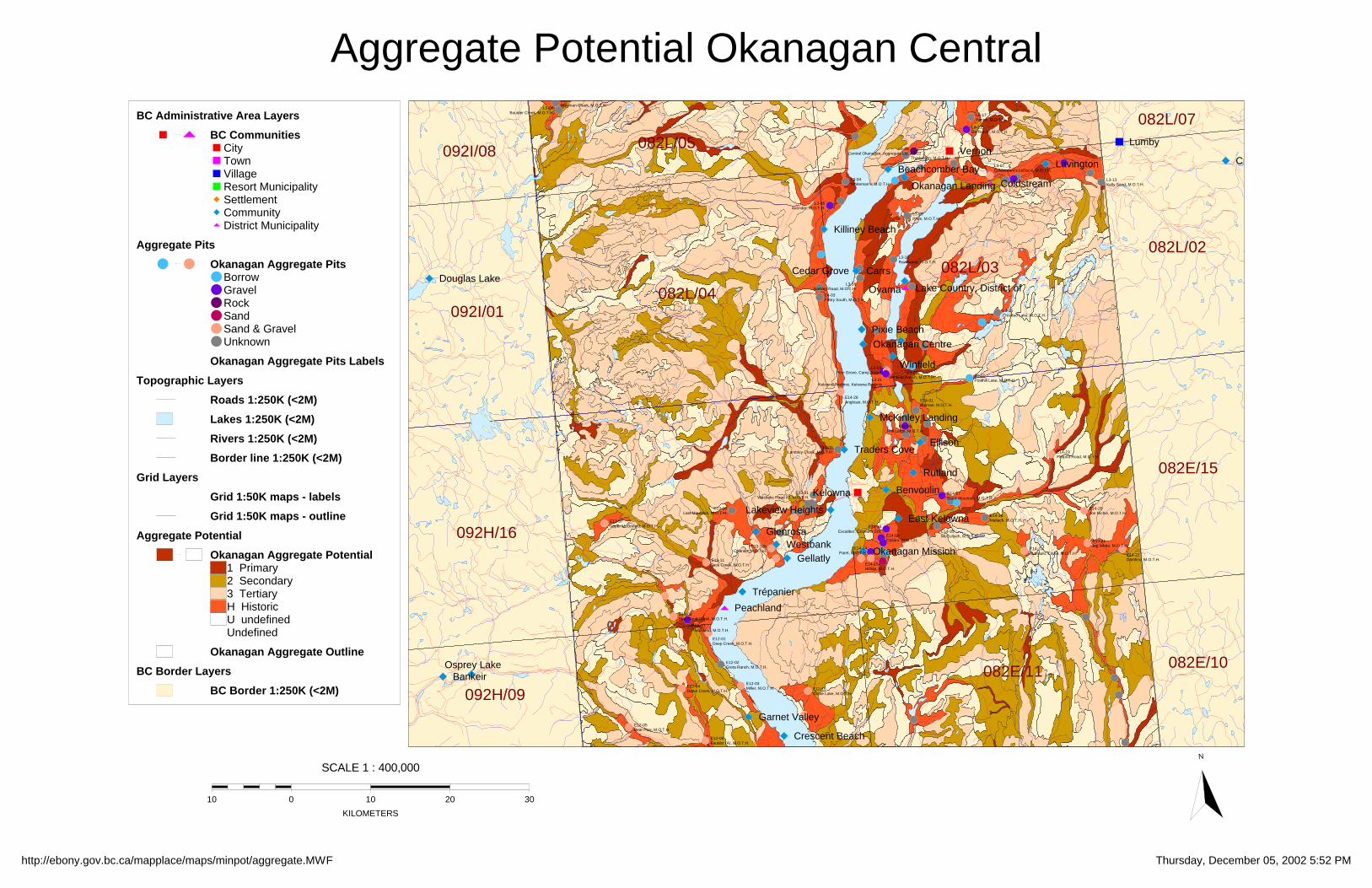
Bankeir
Beachcomber Bay
Benvoulin
Carrs Cedar Grove
Coldstream
Creighton Valley
Crescent Beach
Douglas Lake
East Kelowna
Ellison
Garnet Valley
Gellatly
Glenrosa
Kelowna
Killiney Beach
Lake Country, District of
Lakeview Heights
Lavington
Lumby
McKinley Landing
Okanagan Centre
Okanagan Landing
Okanagan Mission
Osprey Lake
Oyama
Peachland
Pixie Beach
Rutland
Traders Cove
Trépanier
Vernon
Westbank
Winfield
L5-10Weyman Creek, M.O.T.H.
L5-09Boulder Creek, M.O.T.H. L6-17
Penno, M.O.T.H.
L6-21BX Ranch, M.O.T.H.
L6-25Central Okanagan, Aggregate Ltd. L6-22
Thorlakson, M.O.T.H.
L3-04Whiteman's, M.O.T.H.
L3-07Coldstream's LeDuc's, M.O.T.H.
L3-06Avender, M.O.T.H.
L3-13Kelly Sand, M.O.T.H.
L3-29Price, M.O.T.H.
L3-18Rawthorne, M.O.T.H.
L3-16Barkley Road, M.O.T.H.
L4-03Fintry South, M.O.T.H.
L3-25Crooked Lake, M.O.T.H.
L3-23Winfield Ranch, M.O.T.H.
L3-19Pine Grove, Camp Board
L3-21Kelowna Redimix, Kelowna Redimix
L3-27Posthill Lake, M.O.T.H.
E14-26Anglican, M.O.T.H. E14-01
Bulman, M.O.T.H.
E14-05Phil Large, M.O.T.H.
E13-05Lambley Creek, M.O.T.H. E14-19
Philpott Road, M.O.T.H.
E13-01Westlake Road #2, M.O.T.H.
E13-06Last Mountain, M.O.T.H.
E13-07Upper McDonald, M.O.T.H.
E14-17Black Mountain, M.O.T.H.
E14-24Mallach, M.O.T.H.
E14-10Excaliber, Excaliber Ent.
E14-20Joe Richie, M.O.T.H.
E14-25McCulloch, M.O.T.H.E14-08
Casaro, M.O.T.H.E13-12b
Orlando, M.O.T.H.
E13-11Jack Creek, M.O.T.H. E14-15a
Hilltop, M.O.T.H.
E14-14Paret, M.O.T.H.
E14-21Big White, M.O.T.H.
E14-23Hydraulic Creek, M.O.T.H. E14-22
Damfino, M.O.T.H.
E13-09Peachland Creek, M.O.T.H.
E13-10Peachland, M.O.T.H.
E12-01Deep Creek, M.O.T.H.
E12-02Greta Ranch, M.O.T.H.
E12-04Darke Creek, M.O.T.H.
E12-03Miller, M.O.T.H. E12-16
Chute Lake, M.O.T.H.
E12-05Bear Paw, M.O.T.H.
E12-06Faulder (A), M.O.T.H.
092I/08 082L/05082L/07
082L/04
082L/03082L/02
092I/01
092H/16
082E/15
092H/09082E/11 082E/10
BC Administrative Area Layers
BC CommunitiesCityTownVillageResort MunicipalitySettlementCommunityDistrict Municipality
Aggregate Pits
Okanagan Aggregate PitsBorrowGravelRockSandSand & GravelUnknown
Okanagan Aggregate Pits Labels
Topographic Layers
Roads 1:250K (<2M)
Lakes 1:250K (<2M)
Rivers 1:250K (<2M)
Border line 1:250K (<2M)
Grid Layers
Grid 1:50K maps - labels
Grid 1:50K maps - outline
Aggregate Potential
Okanagan Aggregate Potential1 Primary2 Secondary3 TertiaryH HistoricU undefinedUndefined
Okanagan Aggregate Outline
BC Border Layers
BC Border 1:250K (<2M)
Aggregate Potential Okanagan Central
http://ebony.gov.bc.ca/mapplace/maps/minpot/aggregate.MWF Thursday, December 05, 2002 5:52 PM
SCALE 1 : 400,000
010 10 20 30
KILOMETERS
N

Beaverdell
Bridesville
Cawston
Crescent Beach
East Osoyoos
Fairview
Garnet Valley
Hedley
Inkaneep
Kaleden
Keremeos
Kettle Valley
Mount Baldy
Naramata
Okanagan Falls
Olalla
Oliver
Osoyoos
Penticton
Poplar Grove
Prairie Valley
Rock Creek
Summerland
Trout Creek
West Bench
West Midway
Willowbrook
E12-02Greta Ranch, M.O.T.H.
E12-04Darke Creek, M.O.T.H.
E12-03Miller, M.O.T.H. E12-16
Chute Lake, M.O.T.H.
E12-05Bear Paw, M.O.T.H.
E12-06Faulder (A), M.O.T.H.
E12-07Faulder (B), M.O.T.H.
E12-14Chapman, M.O.T.H.
E12-11Bathville Road, M.O.T.H. E12-17
Arawana Holdings, Arawana Holdings
E12-13Experimental Farm, M.O.T.H.
E12-12Trout Creek, M.O.T.H.
E5-05Westhills Aggregate, Indian Band
E5-01Normar Industries, Normar
E5-06Penticton I.R., Indian Band
E5-11Farleigh Lake, M.O.T.H.
E5-12Clarke's, M.O.T.H.
E5-13Boulder Creek, M.O.T.H.
E5-14Riordan, M.O.T.H.
E5-17Green Mountain, M.O.T.H.
E5-15Winters Creek, M.O.T.H.
E5-16LOT 909, M.O.T.H.
E5-22Marron Valley, M.O.T.H.
E5-08bOld Thompson, M.O.T.H.
E5-21Watts, M.O.T.H.
E5-07Phelps, M.O.T.H.
E5-18Yellow Lake, M.O.T.H.
E5-10McCall, M.O.T.H.
E5-20D.L. 282, M.O.T.H.
E4-14Lucky River Flats, M.O.T.H.
E4-01Secrest, M.O.T.H.E4-02
Westside/Secrest, M.O.T.H.
E4-15Outward Bound, M.O.T.H.
E4-22Fairview, M.O.T.H.
E4-21Keremeos, M.O.T.H.
E4-19Harris and Sons Tran, Harris and Sons Tran
E4-04Camp McKinney, Indian Band
E4-23aCawston #1, M.O.T.H.
E4-03S. Okanagan Land Irr, S. Okanagan Land Irr
E4-25B Line Construction, M.O.T.H.
E3-07McKinney, M.O.T.H.
E4-24I.R. #3, M.O.T.H.
E4-12Brown, M.O.T.H.
E4-05Graveyard, M.O.T.H.
E3-02Osoyoos Ready Mix, Osoyoos Ready MixE4-11
Richter Pass, M.O.T.H.
E3-06Vineyard, M.O.T.H.
E3-09Cantex Eng. Const., Cantex Eng. Const.
E4-10Skemeoskuankin IR7, Indian Band
E4-09aPollack (A), M.O.T.H.
E4-09bPollack (B), M.O.T.H. E4-07
D.L. 29, M.O.T.H.
E3-089 Mile Anarchist, M.O.T.H.
E4-08Customs, M.O.T.H.
092H/09082E/11
082E/10
092H/08
082E/06082E/07
092H/01
082E/03082E/02
BC Administrative Area Layers
BC CommunitiesCityTownVillageResort MunicipalitySettlementCommunityDistrict Municipality
Aggregate Pits
Okanagan Aggregate PitsBorrowGravelRockSandSand & GravelUnknown
Okanagan Aggregate Pits Labels
Topographic Layers
Roads 1:250K (<2M)
Lakes 1:250K (<2M)
Rivers 1:250K (<2M)
Border line 1:250K (<2M)
Grid Layers
Grid 1:50K maps - labels
Grid 1:50K maps - outline
Grid 1:250K maps - outline
Aggregate Potential
Okanagan Aggregate Potential1 Primary2 Secondary3 TertiaryH HistoricU undefinedUndefined
BC Border Layers
BC Border 1:250K (<2M)
Aggregate Potential Okanagan South
http://ebony.gov.bc.ca/mapplace/maps/minpot/aggregate.MWF Tuesday, December 10, 2002 12:02 PM
SCALE 1 : 400,000
010 10 20 30
KILOMETERS
N


![· PDF fileADAMS, John Quincy. [Autograph letter, signed, to Ward Nicholas Boylston discussing the Boylston prize at Harvard and University politics]. Washington](https://static.fdocuments.us/doc/165x107/5ab7f3f57f8b9a684c8c2d98/john-quincy-autograph-letter-signed-to-ward-nicholas-boylston-discussing-the.jpg)