AGENDA - Leander, Texas€¦ · · 2017-10-06AGENDA . PLANNING & ZONING COMMISSION MEETING . CITY...
30
1 AGENDA PLANNING & ZONING COMMISSION MEETING CITY OF LEANDER, TEXAS Leander Fire Administration Building, Training Room 101 E. Sonny Drive ~ Leander, Texas Thursday ~ October 12, 2017 at 7:00 PM 1. Call to Order. 2. Roll Call. 3. Approval of Minutes. Regular Planning & Zoning Commission Meeting: September 28, 2017 4. Director’s report to the Planning & Zoning Commission on actions taken by the City Council at the October 2, 2017 meeting 5. Review of meeting protocol. 6. Citizen Comments: Three (3) minutes allowed per speaker. [Please turn in speaker request form before the meeting begins.] 7. Discuss and consider action on Subdivision Case 17-FP-015 to approve the Bluffs at Crystal Falls Section 3, Phase 3L Final Plat on one (1) parcel of land approximately 8.409 acres ± in size, more particularly described by Travis Central Appraisal District Parcel 877337; generally located at the western terminus of Osage Dr., Leander, Travis County, Texas. Applicant/Agent: Sam Kiger on behalf of Taylor Morrison at Crystal Falls, LLC. CONSENT AGENDA: ACTION Place 1 – Laura Lantrip Place 5 – Uryan Nelson Place 2 – John Cosgrove Place 6 – Angela Means Place 3 – Jason Anderson, Vice Chair Place 7 – Marshall Hines Place 4 – Sid Sokol, Chair
-
Upload
nguyencong -
Category
Documents
-
view
215 -
download
1
Transcript of AGENDA - Leander, Texas€¦ · · 2017-10-06AGENDA . PLANNING & ZONING COMMISSION MEETING . CITY...

1
AGENDA
PLANNING & ZONING COMMISSION MEETING CITY OF LEANDER, TEXAS
Leander Fire Administration Building, Training Room 101 E. Sonny Drive ~ Leander, Texas
Thursday ~ October 12, 2017 at 7:00 PM
1. Call to Order.
2. Roll Call.
3. Approval of Minutes. Regular Planning & Zoning Commission Meeting: September 28, 2017
4. Director’s report to the Planning & Zoning Commission on actions taken by the City
Council at the October 2, 2017 meeting
5. Review of meeting protocol.
6. Citizen Comments: Three (3) minutes allowed per speaker. [Please turn in speaker request form before the meeting begins.]
7. Discuss and consider action on Subdivision Case 17-FP-015 to approve the Bluffs at Crystal
Falls Section 3, Phase 3L Final Plat on one (1) parcel of land approximately 8.409 acres ± in size, more particularly described by Travis Central Appraisal District Parcel 877337; generally located at the western terminus of Osage Dr., Leander, Travis County, Texas. Applicant/Agent: Sam Kiger on behalf of Taylor Morrison at Crystal Falls, LLC.
CONSENT AGENDA: ACTION
Place 1 – Laura Lantrip Place 5 – Uryan Nelson Place 2 – John Cosgrove Place 6 – Angela Means Place 3 – Jason Anderson, Vice Chair Place 7 – Marshall Hines Place 4 – Sid Sokol, Chair
AGENDA (Cont’d)
2
8. Discuss and consider action on Subdivision Case 17-SFP-006 to approve the Highlands at Crystal Falls, Section 1, Phase IV Short Form Final Plat on one (1) parcel of land approximately 1.216 acres ± in size, more particularly described by Williamson Central Appraisal District Parcel R484296; generally located to the northwest of the intersection of Osage Drive and Highland Trail, Leander, Williamson County, Texas. Applicant/Agent: Mike Siefert on behalf of Lookout Development Group, LP.
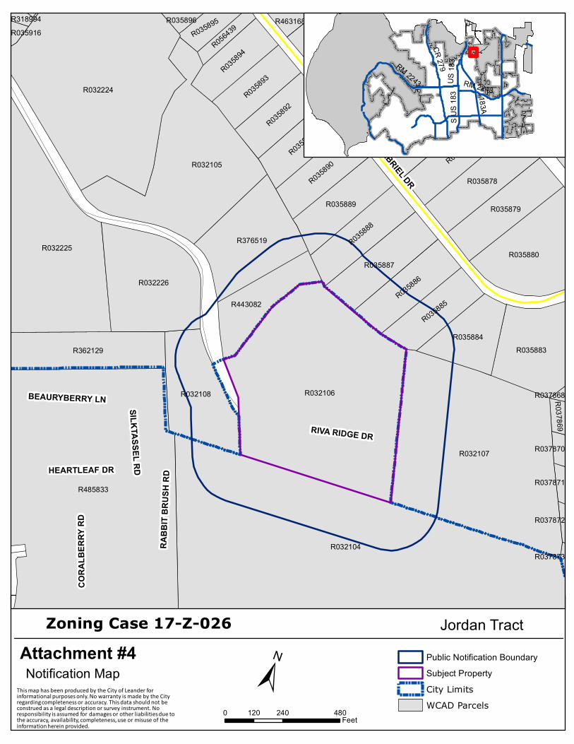
9. Conduct a Public Hearing regarding Zoning Case 17-Z-026 to amend the current zoning of SFS-
2-B(Single-Family Suburban) to SFE-2-B (Single-Family Estate) on one (1) parcel of land approximately 10.804 acres ± in size, more particularly described by Williamson Central Appraisal District Parcel R032106; and generally located at the eastern terminus of Riva Ridge Drive, Leander, Williamson County, Texas. Applicant/Agent: Stefan Pharis on behalf of Crescent Leander TX LLC (Tommy Tucker).
a. Staff Presentation b. Applicant Presentation c. Open Public Hearing d. Close Public Hearing e. Discussion f. Consider Action
10. Discuss Planning & Zoning Commission Progress Report October 2016- September 2017
11. Adjournment.
CERTIFICATION This meeting will be conducted pursuant to the Texas Government Code Section 551.001 et seq. At any time during the meeting the Planning & Zoning Commission reserves the right to adjourn into Executive Session on any of the above posted agenda items in accordance with the Sections 551.071 [litigation and certain Consultation with attorney]. 551.072 [acquisition of interest in real property], 551.073 [prospective gift to city], 551.074 [certain personnel deliberations] or 551.076 [deployment/implementation of security personnel or devices]. The City of Leander is committed to compliance with the American with Disabilities Act. Reasonable modifications and equal access to communications will be provided upon request. Please call the City Secretary at (512) 528-2743 for information. Hearing impaired or speech disabled persons equipped with telecommunication devices for the deaf may call (512) 528-2800. I certify that the above agenda for this meeting of the Planning & Zoning Commission of the City of Leander, Texas, was posted on the bulletin board at City Hall in Leander, Texas on the 6th day of October 2017 by 5:00 pm pursuant to Chapter 551 of the Texas Government Code.
_______________________________ Ellen Pizalate, Planning Coordinator
REGULAR AGENDA
PUBLIC HEARING: ACTION
1
MINUTES
PLANNING & ZONING COMMISSION MEETING CITY OF LEANDER, TEXAS
Pat Bryson Municipal Hall 201 North Brushy Street ~ Leander, Texas
Thursday ~ September 28, 2017 at 7:00 PM
1. Call to Order. Meeting called to order at 7:00 pm
2. Roll Call. All Commissioners were present except Commissioner Cosgrove.
3. Approval of Minutes. Regular Planning & Zoning Commission Meeting: September 14, 2017
Motion made by Commissioner Hines to approve the minutes with corrections, seconded by Commissioner Lantrip. Motion passed unanimously.
4. Director’s report to the Planning & Zoning Commission on actions taken by the City
Council at the September 21, 2017 meeting. Tom Yantis, Assistant City Manager, presented the Director’s Report for actions taken at the September 21, 2017 City Council Meeting. Mr. Yantis also reminded the Commission that the next meeting will be held at the Fire Station on Sonny Drive and that the APA Conference is scheduled for November 1-3, 2017.
5. Review of meeting protocol. Chair Sokol referred to the posted meeting protocol.
6. Citizen Comments: Three (3) minutes allowed per speaker.
No Citizen wished to speak.
Place 1 – Laura Lantrip Place 5 – Uryan Nelson Place 2 – John Cosgrove Place 6 – Angela Means Place 3 – Jason Anderson, Vice Chair Place 7 – Marshall Hines Place 4 – Sid Sokol, Chair

AGENDA (Cont’d)
2
7. Discuss and consider action on Subdivision Case 17-FP-005 to approve the Whitt Ranch
Final Plat on five (5) parcels of land approximately 76.89 acres ± in size, more particularly described by Williamson Central Appraisal District Parcels R022924-R022926, R473840, and R473841; generally located west of the intersection of Live Oak Rd and CR 279, on the west side of CR 279, Leander, Williamson County, Texas. Applicant/Agent: Dan Jackson on behalf of San Gabriel Whitt Ranch, LLC (Davy Roberts).
8. Discuss and consider action on Subdivision Case 17-TOD-FP-019 to approve the Bryson, Phase 1, Section 1E Final Plat on three (3) parcels of land approximately 12.384 acres ± in size, more particularly described by Williamson Central Appraisal District Parcels R032239, R485833, and R555888; generally located to the northeast of the intersection 183A Toll Road and Bryson Ridge Trail, and to the north of Bryson, Phase 1, Section 1D subdivision, Leander, Williamson County, Texas. Applicant/Agent: Brett Burke (Kimley-Horn) on behalf of Crescent Leander, TX, LLC, Jean Baptiste, LTD, and Bryson Development, LLC.
9. Discuss and consider action on Subdivision Case 17-TOD-FP-008 to approve the Bryson, Phase 2, Section 1 Final Plat on one (1) parcel of land approximately 19.35 acres ± in size, more particularly described by Williamson Central Appraisal District Parcels R485833; generally located to the northeast of the intersection 183A Toll Road and Bryson Ridge Trail, and to the north of Bryson, Phase 1, Section 1E subdivision, Leander, Williamson County, Texas. Applicant/Agent: Christine Potts (CSF Civil Group, LLC) on behalf of Crescent Leander, TX, LLC. Commissioner Hines moved to approve the consent agenda with staff recommendations. Commissioner Means seconded the motion. Motion passed unanimously.
10. Conduct a Public Hearing regarding Subdivision Case 17-CP-010 to adopt the Crystal
Springs Concept Plan, Revision #1 on six (6) parcels of land approximately 128.40 acres ± in size, more particularly described by Williamson Central Appraisal District Parcels R031204-R031206, R526321, R523989 and R523991; generally located to the southeast of the intersection of Raider Way and East Crystal Falls Parkway; generally located to the
CONSENT AGENDA: ACTION
PUBLIC HEARING: ACTION

AGENDA (Cont’d)
3
west of Cold Springs Subdivision, Leander, Williamson County, Texas. Applicant/Agent: Steven Crauford, PE (Pape-Dawson Engineers) on behalf of BLD Crystal Springs, LLC.
a. Staff Presentation Robin Griffin, Planning Manager, explained the proposed revision to the Concept plan.
b. Applicant Presentation No applicant was present.
c. Open Public Hearing Chair Sokol opened the public hearing. No one wished to speak.
d. Close Public Hearing Chair Sokol closed the public hearing.
e. Discussion Discussion took place.
f. Consider Action Vice Chair Anderson moved to approve the concept plan revision with staff recommendations. Commissioner Hines seconded the motion. Motion passed unanimously.
11. Conduct a Public Hearing and consider action regarding Zoning Case 17-TOD-Z-019 to amend the current zoning of PUD/TOD (Planned Unit Development/Transit Oriented Development) to PUD/TOD (Planned Unit Development/Transit Oriented Development) with the following base zoning districts: MF-2-A (Multi-Family) and GC-2-A (General Commercial) on one (1) parcel of land approximately 21 acres ± in size, more particularly described by Williamson Central Appraisal District Parcel R481339; and generally located to the southeast of the intersection of East San Gabriel Pkwy and 183A Toll Road, Leander, Williamson County, Texas. Applicant/Agent: Robert J Stone III on behalf of Butler Family Shinoak LTD & J. Sam Winters, Trustee of Dorothy Winters Exempt Family Trustee.
a. Staff Presentation Robin Griffin, Planning Manager, explained the proposed zoning request.
b. Applicant Presentation Robert Stone was present for questions.

AGENDA (Cont’d)
4
c. Open Public Hearing Chair Sokol opened the public hearing. No one wished to speak.
d. Close Public Hearing Chair Sokol closed the public hearing.
e. Discussion Discussion took place.
f. Consider Action Commissioner Lantrip moved to approve the zoning request with staff recommendations. Commissioner Hines seconded the motion. Motion passed unanimously.
12. Adjournment 7:24 pm.
CHAIRMAN SOKOL
ATTEST: ELLEN PIZALATE PLANNING & ZONING COMMISSION SECRETARY
REGULAR AGENDA

AGENDA ITEM # 7
Executive Summary
10/12/2017
PLANNING & ZONING COMMISSION AGENDA SUBJECT: Discuss and consider action on Subdivision Case 17-FP-015 to approve the Bluffs at Crystal Falls Section 3, Phase 3L Final Plat on one (1) parcel of land approximately 8.409 acres ± in size, more particularly described by Travis Central Appraisal District Parcel 877337; generally located at the western terminus of Osage Dr., Leander, Travis County, Texas. Applicant/Agent: Sam Kiger on behalf of Taylor Morrison at Crystal Falls, LLC. BACKGROUND: This request is the final step in the subdivision process. Pursuant to Section 212.005 of the Texas Local Government Code, approval by municipality is required since the final plat satisfies the applicable regulations without requesting any variances. ORIGINATION: Applicant/Agent: Sam Kiger on behalf of Taylor Morrison at Crystal Falls LLC. FINANCIAL CONSIDERATION: N/A RECOMMENDATION: This final plat includes 22 residential lots, and 3 HOA Landscape lots. This proposal meets all of the requirements of the Subdivision Ordinance. Staff recommends to approve the final plat. MOTION: The Planning & Zoning Commission recommends approval of the final plat for the subject property with staff recommendation. ATTACHMENTS:
1. Final Plat PREPARED BY: Martin Siwek Planner, AICP, GISP 10/05/2017

AGENDA ITEM # 8
Executive Summary
10/12/2017
PLANNING & ZONING COMMISSION AGENDA SUBJECT: Discuss and consider action on Subdivision Case 17-SFP-006 to approve the Highlands at Crystal Falls, Section 1, Phase IV Short Form Final Plat on one (1) parcel of land approximately 1.216 acres ± in size, more particularly described by Williamson Central Appraisal District Parcel R484296; generally located to the northwest of the intersection of Osage Drive and Highland Trail, Leander, Williamson County, Texas. Applicant/Agent: Mike Siefert on behalf of Lookout Development Group, LP. BACKGROUND: This request is the final step in the subdivision process. Pursuant to Section 212.005 of the Texas Local Government Code, approval by municipality is required since the short form final plat satisfies the applicable regulations without requesting any variances. ORIGINATION: Applicant/Agent: Mike Siefert on behalf of Lookout Development Group, LP. FINANCIAL CONSIDERATION: N/A RECOMMENDATION: This short form final plat includes two (2) single-family residential lots, one (1) HOA lot and one (1) HOA landscape lot. This proposal meets all of the requirements of the Subdivision Ordinance. Staff recommends to approval of the short final plat. MOTION: The Planning & Zoning Commission recommends approval of the short form final plat for the subject property with staff recommendation. ATTACHMENTS:
1. Short Form Final Plat PREPARED BY: Robin M. Griffin, AICP Planning Manager 10/02/2017


AGENDA ITEM # 9
Executive Summary
10/12/2017
PLANNING & ZONING COMMISSION AGENDA SUBJECT: Conduct a Public Hearing regarding Zoning Case 17-Z-026 to amend the current zoning of SFS-2-B(Single-Family Suburban) to SFE-2-B (Single-Family Estate) on one (1) parcel of land approximately 10.804 acres ± in size, more particularly described by Williamson Central Appraisal District Parcel R032106; and generally located at the eastern terminus of Riva Ridge Drive, Leander, Williamson County, Texas. Applicant/Agent: Stefan Pharis on behalf of Crescent Leander TX LLC (Tommy Tucker). Discuss and consider action on amending the current zoning SFS-2-B (Single-Family Suburban) to SFE-2-B (Single-Family Estate); on one (1) parcel of land approximately 10.804 acres ± in size, more particularly described by Williamson Central Appraisal District Parcel R032106; and generally located at the eastern terminus of Riva Ridge Drive Leander, Leander, Williamson County, Texas. BACKGROUND: This request is the first step in the zoning process. ORIGINATION: Applicant/Agent: Stefan Pharis on behalf of Crescent Leander TX LLC (Tommy Tucker). FINANCIAL CONSIDERATION: N/A RECOMMENDATION: See Planning Analysis MOTION: APPROVAL: The Planning & Zoning Commission recommends approval of
rezoning the subject property to __________. (zoning district) DENIAL: The Planning & Zoning Commission recommends denial of the
applicant’s request to rezone the subject property. ATTACHMENTS:
1. Planning Analysis 2. Current Zoning Map 3. Future Land Use Map

AGENDA ITEM # 9
4. Notification Map 5. Proposed Zoning Map 6. Aerial Map 7. Letter of Intent
PREPARED BY: Martin Siwek Planner 09/25/2017

Attachment # 1
1
P L A N N I N G A N A L Y S I S
ZONING CASE 17-TOD-Z-026
JORDAN TRACT GENERAL INFORMATION Owner: Crescent Leander Tx LLC Current Zoning: SFS-2-B (Single-Family Suburban) Proposed Zoning: SFE-2-B (Single-Family Estate) Size and Location: The property is generally located at the eastern terminus of Riva Ridge Dr. Staff Contact: Martin Siwek, AICP, GISP Planner ABUTTING ZONING AND LAND USE: The table below lists the abutting zoning and land uses.
ZONING LAND USE
NORTH OCL High Gabriel East- large lot residential subdivision
EAST OCL Developed large tract residential home
SOUTH PUD/TOD Planned/under construction Bryson Community
WEST OCL Developed large tract residential homes

Attachment # 1
2
COMPOSITE ZONING ORDINANCE INTENT STATEMENTS USE COMPONENT
SFE – SINGLE FAMILY ESTATE: Features: 12,000 sq. ft. lot min.; 1,600 sq. ft. living area min. Intent: Development of single-family detached dwellings on large lots and for other compatible and complimentary uses. The purpose of this component is to provide regulations to maintain and protect the City's single-family residences and neighborhoods in an area with larger lot sizes.
SITE COMPONENT
TYPE 2: Features: Accessory buildings greater of 10% of primary building or 120 sq. ft.; accessory
dwellings for SFR, SFE and SFS; drive-thru service lanes; uses not to exceed 40,000 sq. ft.; multi-family provides at least 35% of units with an enclosed garage parking space.
Intent: (1) The Type 2 site component may be utilized with non-residential developments that are adjacent to
a residential district or other more restrictive district to help reduce potential negative impacts to the more restrictive district and to provide for an orderly transition of development intensity.
(2) The Type 2 site component is intended to be utilized for residential development not meeting the intent of a Type 1 site component and not requiring the additional accessory structure or accessory dwelling privileges of the Type 3 site component.
(3) This component is intended to be utilized with the majority of LO and LC use components except those that meet the intent of the Type 1 or Type 3 site component or with any use requiring drive-through service lanes.
(4) This component is generally not intended to be utilized with HC and HI use components except where such component is adjacent to, and not adequately buffered from, residential districts or other more restricted districts, and except as requested by the land owner.
ARCHITECTURAL COMPONENT
TYPE B: Features: 85% masonry 1st floor, 50% all stories; 4 or more architectural features. Intent: (1) The Type B architectural component is intended to be utilized for the majority of residential
development except that which is intended as a Type A architectural component. (2) Combined with appropriate use and site components, this component is intended to help provide
for harmonious land use transitions. (3) This component may be utilized to raise the building standards and help ensure compatibility for
non-residential uses adjacent to property that is more restricted. (4) This component is intended for the majority of the LO and LC use components except those
meeting the intent of the Type A or C architectural components.

Attachment # 1
3
COMPREHENSIVE PLAN STATEMENTS: The following Comprehensive Plan statements may be relevant to this case: Create strong neighborhoods with a variety of housing choices. Provide a balanced mix of complementary uses that support a strong and diverse tax base. Encourage a range of housing types at a variety of price points.
NEIGHBORHOOD RESIDENTIAL Neighborhood Residential is intended to accommodate a variety of housing types. The
density and mix of housing types is dependent on a number of suitability factors including environmental constraints (such as steep topography and floodplain), the availability of sewer infrastructure, proximity to neighborhood and community centers, existing and planned parks and recreation sites, schools, and the road network.
ANALYSIS: The applicant is requesting to rezone the property from SFS-2-B (Single-Family Suburban) to SFE-2-B (Single-Family Estate). This property was voluntarily annexed into the City of Leander on February 16, 2017. The Planning & Zoning Commission previously heard a zoning case on this property at the February 23, 2017 requesting a change from Interim SFR-1-B to SFS-2-B; the Commission voted to recommend approval. This property is located within the Neighborhood Residential Land Use category as designated by the City’s Comprehensive plan. This land use classification seeks to accommodate a variety of housing types based on suitability factors pertaining to available infrastructure and environmental constraints such as topography. The applicant is seeking to incorporate this tract into the Bryson subdivision at a later time and seeking to provide a larger lot product then what was previously approved. The SFE use component permits a minimum lot width of 80’, a minimum lot depth of 120’, and a minimum lot area of 12,000 sq. ft. The Type 2 site component is the standard site component paired with residential districts. The Type B architectural component requires 85% masonry on the first story of homes and 50% masonry on each additional story thereafter. A minimum of four architectural features is required on street facing façades. The Type B architectural component is intended to be utilized for the majority of residential development. The property is generally sloping northward with steeper slopes along the northern property line. The property’s topography would lend its development to moderately dense single family homes, and utilities will be available to it through the future build out of the Bryson subdivision. The property is located within the Neighborhood Residential land use category and is not within proximity of an Activity, Community, or Neighborhood Center. STAFF RECOMMENDATION: Staff recommends approval of the applicant’s requested SFE-2-B zoning district. This proposal meets the intent statements of the Composite Zoning Ordinance, and the goals of the Comprehensive Plan.

! ! ! ! ! ! ! ! ! ! ! ! ! ! ! ! ! ! ! ! !
! ! ! ! ! ! ! ! ! ! ! ! ! ! ! ! ! ! ! ! !
! ! ! ! ! ! ! ! ! ! ! ! ! ! ! ! ! ! ! ! !
! ! ! ! ! ! ! ! ! ! ! ! ! ! ! ! ! ! ! ! !
! ! ! ! ! ! ! ! ! ! ! ! ! ! ! ! ! ! ! ! !
! ! ! ! ! ! ! ! ! ! ! ! ! ! ! ! ! ! ! ! !
! ! ! ! ! ! ! ! ! ! ! ! ! ! ! ! ! ! ! ! !
! ! ! ! ! ! ! ! ! ! ! ! ! ! ! ! ! ! ! ! !
! ! ! ! ! ! ! ! ! ! ! ! ! ! ! ! ! ! ! ! !
! ! ! ! ! ! ! ! ! ! ! ! ! ! ! ! ! ! ! ! !
! ! ! ! ! ! ! ! ! ! ! ! ! ! ! ! ! ! ! ! !
! ! ! ! ! ! ! ! ! ! ! ! ! ! ! ! ! ! ! ! !
! ! ! ! ! ! ! ! ! ! ! ! ! ! ! ! ! ! ! ! !
! ! ! ! ! ! ! ! ! ! ! ! ! ! ! ! ! ! ! ! !
! ! ! ! ! ! ! ! ! ! ! ! ! ! ! ! ! ! ! ! !
! ! ! ! ! ! ! ! ! ! ! ! ! ! ! ! ! ! ! ! !
! ! ! ! ! ! ! ! ! ! ! ! ! ! ! ! ! ! ! ! !
! ! ! ! ! ! ! ! ! ! ! ! ! ! ! ! ! ! ! ! !
! ! ! ! ! ! ! ! ! ! ! ! ! ! ! ! ! ! ! ! !
! ! ! ! ! ! ! ! ! ! ! ! ! ! ! ! ! ! ! ! !
! ! ! ! ! ! ! ! ! ! ! ! ! ! ! ! ! ! ! ! !
! ! ! ! ! ! ! ! ! ! ! ! ! ! ! ! ! ! ! ! !
! ! ! ! ! ! ! ! ! ! ! ! ! ! ! ! ! ! ! ! !
! ! ! ! ! ! ! ! ! ! ! ! ! ! ! ! ! ! ! ! !
! ! ! ! ! ! ! ! ! ! ! ! ! ! ! ! ! ! ! ! !
! ! ! ! ! ! ! ! ! ! ! ! ! ! ! ! ! ! ! ! !
! ! ! ! ! ! ! ! ! ! ! ! ! ! ! ! ! ! ! ! !
! ! ! ! ! ! ! ! ! ! ! ! ! ! ! ! ! ! ! ! !
! ! ! ! ! !
! ! ! ! ! !
! ! ! ! ! !
! ! ! ! ! !! ! ! ! ! ! ! ! ! ! ! ! ! ! ! ! ! ! ! ! ! ! ! ! ! ! ! ! ! ! ! ! ! ! ! ! ! ! ! ! ! !
! ! ! ! ! ! ! ! ! ! ! ! ! ! ! ! ! ! ! ! ! ! ! ! ! ! ! ! ! ! ! ! ! ! ! ! ! ! ! ! ! !
! ! ! ! ! ! ! ! ! ! ! ! ! ! ! ! ! ! ! ! ! ! ! ! ! ! ! ! ! ! ! ! ! ! ! ! ! ! ! ! ! !
! ! ! ! ! ! ! ! ! ! ! ! ! ! ! ! ! ! ! ! ! ! ! ! ! ! ! ! ! ! ! ! ! ! ! ! ! ! ! ! ! !
! ! ! ! ! ! ! ! ! ! ! ! ! ! ! ! ! ! ! ! ! ! ! ! ! ! ! ! ! ! ! ! ! ! ! ! ! ! ! ! ! !
! ! ! ! ! ! ! ! ! ! ! ! ! ! ! ! ! ! ! ! ! ! ! ! ! ! ! ! ! ! ! ! ! ! ! ! ! ! ! ! ! !
! ! ! ! ! ! ! ! ! ! ! ! ! ! ! ! ! ! ! ! ! ! ! ! ! ! ! ! ! ! ! ! ! ! ! ! ! ! ! ! ! !
! ! ! ! ! ! ! ! ! ! ! ! ! ! ! ! ! ! ! ! ! ! ! ! ! ! ! ! ! ! ! ! ! ! ! ! ! ! ! ! ! !
! ! ! ! ! ! ! ! ! ! ! ! ! ! ! ! ! ! ! ! ! ! ! ! ! ! ! ! ! ! ! ! ! ! ! ! ! ! ! ! ! !
! ! ! ! ! ! ! ! ! ! ! ! ! ! ! ! ! ! ! ! ! ! ! ! ! ! ! ! ! ! ! ! ! ! ! ! ! ! ! ! ! !
! ! ! ! ! ! ! ! ! ! ! ! ! ! ! ! ! ! ! ! ! ! ! ! ! ! ! ! ! ! ! ! ! ! ! ! ! ! ! ! ! !
! ! ! ! ! ! ! ! ! ! ! ! ! ! ! ! ! ! ! ! ! ! ! ! ! ! ! ! ! ! ! ! ! ! ! ! ! ! ! ! ! !
! ! ! ! ! ! ! ! ! ! ! ! ! ! ! ! ! ! ! ! ! ! ! ! ! ! ! ! ! ! ! ! ! ! ! ! ! ! ! ! ! !
! ! ! ! ! ! ! ! ! ! ! ! ! ! ! ! ! ! ! ! ! ! ! ! ! ! ! ! ! ! ! ! ! ! ! ! ! ! ! ! ! !
! ! ! ! ! ! ! ! ! ! ! ! ! ! ! ! ! ! ! ! ! ! ! ! ! ! ! ! ! ! ! ! ! ! ! ! ! ! ! ! ! !
! ! ! ! ! ! ! ! ! ! ! ! ! ! ! ! ! ! ! ! ! ! ! ! ! ! ! ! ! ! ! ! ! ! ! ! ! ! ! ! ! !
! ! ! ! ! ! ! ! ! ! ! ! ! ! ! ! ! ! ! ! ! ! ! ! ! ! ! ! ! ! ! ! ! ! ! ! ! ! ! ! ! !
! ! ! ! ! ! ! ! ! ! ! ! ! ! ! ! ! ! ! ! ! ! ! ! ! ! ! ! ! ! ! ! ! ! ! ! ! ! ! ! ! !
! ! ! ! ! ! ! ! ! ! ! ! ! ! ! ! ! ! ! ! ! ! ! ! ! ! ! ! ! ! ! ! ! ! ! ! ! ! ! ! ! !
! ! ! ! ! ! ! ! ! ! ! ! ! ! ! ! ! ! ! ! ! ! ! ! ! ! ! ! ! ! ! ! ! ! ! ! ! ! ! ! ! !
! ! ! ! ! ! ! ! ! ! ! ! !
! ! ! ! ! ! ! ! ! ! ! ! !
! ! ! ! ! ! ! ! ! ! ! ! !
! ! ! ! ! ! ! ! ! ! ! ! !
! ! ! ! ! ! ! ! ! ! ! ! !
! ! ! ! ! ! ! ! ! ! ! ! !
RIVA RIDGE DR
HEARTLEAF DR
SOUTH GABRIEL DR
CORA
LBER
RY R
D
RABBIT BRUSH RD
SILKT
ASSE
L RD
BEAURYBERRY LN
183A
CR 279
RM 2243
S US 1
83
US 183
RM 2243
±0 200
Feet
ZONING CASE 17-Z-026 Attachment #2 Current Zoning Map - Jordan Tract
CITY MAPË
City LimitsSubject Property
SFRSFESFSSFUSFC
SFLSFTSFU/MHTFMF
LOLCGCHCHI
! ! ! !! ! ! !! ! ! !PUD - Commercial
! ! ! !! ! ! !! ! ! !
PUD - Mixed Use
! ! ! !! ! ! !! ! ! !
PUD - Multi-Family
! ! ! !! ! ! !! ! ! !PUD - Townhomes
! ! ! !! ! ! !PUD - Single-Family
This map has been produced by the City of Leander for informational purposes only. No warranty is made by the City regarding completeness or accuracy, please refer to the official ordinance for zoning verification. This data should not be construed as a legal description or survey instrument. No responsibility is assumed for damages or other liabilities due to the accuracy, availability, completeness, use or misuse of the information herein provided.

CR 27
0
RIVA RIDGE DR
SOUTH GABRIEL DR
HEARTLEAF DR
CORA
LBER
RY R
D
RABBIT BRUSH RD
BEAURYBERRY LN
ARROYO CIR
CRAVEN HILL LN
PLEA
SANT
HILL
RD
SILKT
ASSE
L RD
ORCHARD DR
183A
CR 279
RM 2243
S US 1
83
US 183
RM 2243
±0 200
Feet
ZONING CASE 17-Z-026 Attachment #3 Future Land Use Map - Jordan Tract
CITY MAPË
Subject PropertyCity LimitsOpen SpaceMixed Use Corridor
Commercial CorridorNeighborhood Center Community CenterActivity Center
Transit Supportive Mixed UseStation Area Mixed UseOld Town Mixed UseEmployment Mixed UseIndustrial DistrictNeighborhood Residential
This map has been produced by the City of Leander for informational purposes only. No warranty is made by the City regarding completeness or accuracy, please refer to the official ordinance for zoning verification. This data should not be construed as a legal description or survey instrument. No responsibility is assumed for damages or other liabilities due to the accuracy, availability, completeness, use or misuse of the information herein provided.
R032104
R485833
R032106
R032107
R032224
R032225
R032105
R032226
R376519
R032108
R035880
R362129 R035883
R540057R035874
R035879
R035878
R035875
R035876
R035877
R035887
R443082
R035889
R035888
R035884
R035886
R356827R035873
R035885
R035890
R035892
R035891
R035893R035894
R049517R035895
R056439R037869
R540056
R463168R035896
R037870
R037871
R035916R318994
R037872
R037868
R037873
RIVA RIDGE DR
HEARTLEAF DR
SOUTH GABRIEL DR
CORA
LBER
RY R
D
RABB
IT BR
USH
RD
BEAURYBERRY LN SILKTASSEL RD
±Zoning Case 17-Z-026
Public Notification BoundarySubject PropertyCity LimitsWCAD Parcels0 240 480120
Feet
This map has been produced by the City of Leander for informational purposes only. No warranty is made by the City regarding completeness or accuracy. This data should not be construed as a legal description or survey instrument. No responsibility is assumed for damages or other liabilities due to the accuracy, availability, completeness, use or misuse of the information herein provided.
183A
CR 279
RM 2243
S US 1
83US
183RM 2243
Attachment #4Notification Map
Jordan Tract

! ! ! ! ! ! ! ! ! ! ! ! ! ! ! ! ! ! ! ! !
! ! ! ! ! ! ! ! ! ! ! ! ! ! ! ! ! ! ! ! !
! ! ! ! ! ! ! ! ! ! ! ! ! ! ! ! ! ! ! ! !
! ! ! ! ! ! ! ! ! ! ! ! ! ! ! ! ! ! ! ! !
! ! ! ! ! ! ! ! ! ! ! ! ! ! ! ! ! ! ! ! !
! ! ! ! ! ! ! ! ! ! ! ! ! ! ! ! ! ! ! ! !
! ! ! ! ! ! ! ! ! ! ! ! ! ! ! ! ! ! ! ! !
! ! ! ! ! ! ! ! ! ! ! ! ! ! ! ! ! ! ! ! !
! ! ! ! ! ! ! ! ! ! ! ! ! ! ! ! ! ! ! ! !
! ! ! ! ! ! ! ! ! ! ! ! ! ! ! ! ! ! ! ! !
! ! ! ! ! ! ! ! ! ! ! ! ! ! ! ! ! ! ! ! !
! ! ! ! ! ! ! ! ! ! ! ! ! ! ! ! ! ! ! ! !
! ! ! ! ! ! ! ! ! ! ! ! ! ! ! ! ! ! ! ! !
! ! ! ! ! ! ! ! ! ! ! ! ! ! ! ! ! ! ! ! !
! ! ! ! ! ! ! ! ! ! ! ! ! ! ! ! ! ! ! ! !
! ! ! ! ! ! ! ! ! ! ! ! ! ! ! ! ! ! ! ! !
! ! ! ! ! ! ! ! ! ! ! ! ! ! ! ! ! ! ! ! !
! ! ! ! ! ! ! ! ! ! ! ! ! ! ! ! ! ! ! ! !
! ! ! ! ! ! ! ! ! ! ! ! ! ! ! ! ! ! ! ! !
! ! ! ! ! ! ! ! ! ! ! ! ! ! ! ! ! ! ! ! !
! ! ! ! ! ! ! ! ! ! ! ! ! ! ! ! ! ! ! ! !
! ! ! ! ! ! ! ! ! ! ! ! ! ! ! ! ! ! ! ! !
! ! ! ! ! ! ! ! ! ! ! ! ! ! ! ! ! ! ! ! !
! ! ! ! ! ! ! ! ! ! ! ! ! ! ! ! ! ! ! ! !
! ! ! ! ! ! !
! ! ! ! ! ! !
! ! ! ! ! ! !
! ! ! ! ! ! !
! ! ! ! ! ! !
! ! ! ! ! ! !
! ! ! ! ! ! ! ! ! ! ! ! ! ! ! ! ! ! ! ! ! ! ! ! ! ! ! ! ! ! ! ! !
! ! ! ! ! ! ! ! ! ! ! ! ! ! ! ! ! ! ! ! ! ! ! ! ! ! ! ! ! ! ! ! !
! ! ! ! ! ! ! ! ! ! ! ! ! ! ! ! ! ! ! ! ! ! ! ! ! ! ! ! ! ! ! ! !
! ! ! ! ! ! ! ! ! ! ! ! ! ! ! ! ! ! ! ! ! ! ! ! ! ! ! ! ! ! ! ! !
! ! ! ! ! ! ! ! ! ! ! ! ! ! ! ! ! ! ! ! ! ! ! ! ! ! ! ! ! ! ! ! !
! ! ! ! ! ! ! ! ! ! ! ! ! ! ! ! ! ! ! ! ! ! ! ! ! ! ! ! ! ! ! ! !
! ! ! ! ! ! ! ! ! ! ! ! ! ! ! ! ! ! ! ! ! ! ! ! ! ! ! ! ! ! ! ! !
! ! ! ! ! ! ! ! ! ! ! ! ! ! ! ! ! ! ! ! ! ! ! ! ! ! ! ! ! ! ! ! !
! ! ! ! ! ! ! ! ! ! ! ! ! ! ! ! ! ! ! ! ! ! ! ! ! ! ! ! ! ! ! ! !
! ! ! ! ! ! ! ! ! ! ! ! ! ! ! ! ! ! ! ! ! ! ! ! ! ! ! ! ! ! ! ! !
! ! ! ! ! ! ! ! ! ! ! ! ! ! ! ! ! ! ! ! ! ! ! ! ! ! ! ! ! ! ! ! !
! ! ! ! ! ! ! ! ! ! ! ! ! ! ! ! ! ! ! ! ! ! ! ! ! ! ! ! ! ! ! ! !
! ! ! ! ! ! ! ! ! ! ! ! ! ! ! ! ! ! ! ! ! ! ! ! ! ! ! ! ! ! ! ! !
! ! ! ! ! ! ! ! ! ! ! ! ! ! ! ! ! ! ! ! ! ! ! ! ! ! ! ! ! ! ! ! !
! ! ! ! ! ! ! ! ! ! ! ! ! ! ! ! ! ! ! ! ! ! ! ! ! ! ! ! ! ! ! ! !
! ! ! ! ! ! ! ! ! ! ! ! ! ! ! ! ! ! ! ! ! ! ! ! ! ! ! ! ! ! ! ! !
! ! ! ! ! ! ! ! ! ! ! ! ! ! ! ! ! ! ! ! ! ! ! ! ! ! ! ! ! ! ! ! !
! ! ! ! ! ! ! ! ! ! ! ! ! ! ! ! ! ! ! ! ! ! ! ! ! ! ! ! ! ! ! ! !
! ! ! ! ! ! ! ! ! ! ! ! ! ! ! ! ! ! ! ! ! ! ! ! ! ! ! ! ! ! ! ! !
! ! ! ! ! ! ! ! ! ! ! ! ! ! ! ! ! ! ! ! ! ! ! ! ! ! ! ! ! ! ! ! !
! ! ! ! ! ! ! ! ! ! ! ! ! ! ! ! ! ! ! ! ! ! ! ! ! ! ! ! ! ! ! ! !
! ! ! ! ! ! ! ! ! ! ! ! ! ! ! ! ! ! ! ! ! ! ! ! ! ! ! ! ! ! ! ! !
! ! ! ! ! ! ! ! ! ! ! ! ! ! ! !
! ! ! ! ! ! ! ! ! ! ! ! ! ! ! !
! ! ! ! ! ! ! ! ! ! ! ! ! ! ! !
! ! ! ! ! ! ! ! ! ! ! ! ! ! ! !
! ! ! ! ! ! ! ! ! ! ! ! ! ! ! !
! ! ! ! ! ! ! ! ! ! ! ! ! ! ! !
! ! ! ! ! ! ! ! ! ! ! ! ! ! ! !
! ! ! ! ! ! ! ! ! ! ! ! ! ! ! !
! ! ! ! ! ! ! ! ! ! ! ! ! ! ! !
! ! ! ! ! ! ! ! ! ! ! ! ! ! ! !
! ! ! ! ! ! ! ! ! ! ! ! ! ! ! !
! ! ! ! ! ! ! ! ! ! ! ! ! ! ! !
CR 27
0
RIVA RIDGE DR
HEARTLEAF DR
SOUTH GABRIEL DR
CORA
LBER
RY R
D
PLEA
SANT
HILL
RD
RABBIT BRUSH RD
BEAURYBERRY LN
CRAVEN HILL LN
SILKT
ASSE
L RD
183A
CR 279
RM 2243
S US 1
83
US 183
RM 2243
±0 200
Feet
ZONING CASE 17-Z-026 Attachment #5 Proposed Zoning Map - Jordan Tract
CITY MAPË
Subject PropertyCity Limits
SFRSFESFSSFUSFC
SFLSFTSFU/MHTFMF
LOLCGCHCHI
! ! ! !! ! ! !! ! ! !PUD - Commercial
! ! ! !! ! ! !! ! ! !
PUD - Mixed Use
! ! ! !! ! ! !! ! ! !
PUD - Multi-Family
! ! ! !! ! ! !! ! ! !PUD - Townhomes
! ! ! !! ! ! !PUD - Single-Family
This map has been produced by the City of Leander for informational purposes only. No warranty is made by the City regarding completeness or accuracy, please refer to the official ordinance for zoning verification. This data should not be construed as a legal description or survey instrument. No responsibility is assumed for damages or other liabilities due to the accuracy, availability, completeness, use or misuse of the information herein provided.
Proposed SFE-2-B

CR 270
CR 26
6
RIVA RIDGE DR
SOUTH GABRIEL DR
HEARTLEAF DR
CR 267
BEAURYBERRY LN
ARROYO CIR
CRAVEN HILL LN
CORALBERRY RD
ORCHARD DR
RABBIT BRUSH RD
LITTLELEAF LN UPCHURCH ST
UPCHURCH HILL ST
SILKTASSEL RD
183A
CR 279RM 2243
S US 1
83US
183RM 2243
Ë0 200Feet
CITY MAPË
Subject PropertyCity Limits
ZONING CASE 17-Z-026 Attachment #6Aerial Exhibit - Approximate BoundariesJordan Tract
This map has been produced by the City of Leander for informational purposes only. No warranty is made by the City regarding completeness or accuracy, please refer to the official ordinance for zoning verification. This data should not be construed as a legal description or survey instrument. No responsibility is assumed for damages or other liabilities due to the accuracy, availability, completeness, use or misuse of the information herein provided.

msiwek
Typewritten Text
ATTACHMENT 7
AGENDA ITEM #10
Executive Summary
10/02/2017
PLANNING & ZONING COMMISSION AGENDA SUBJECT: Discuss the Planning & Zoning Commission Progress Report for October 2016 to September 2017. BACKGROUND: The Planning & Zoning Commission Progress Report is required to be submitted to the City Council on an annual basis. ORIGINATION: City of Leander Planning and Zoning Commission RECOMMENDATION: Approval ATTACHMENTS:
1. Annual Progress Report PREPARED BY: Tom Yantis, AICP 09/28/2017 Assistant City Manager

Attachment # 1
1
P L A N N I N G & Z O N I N G C O M M I S S I O N
A N N U A L P R O G R E S S R E P O R T
O C T O B E R 2 0 1 6 – S E P T E M B E R 2 0 1 7
GENERAL INFORMATION The Planning and Zoning Commission is assigned the duties and powers by Section 14.108, Article 10 of the Leander City Code to “Submit each September a progress report to the City Council summarizing its activities, major accomplishments for the past year and a proposed work program for the coming year. The report shall contain for the year the attendance record of all members and the identity of commission officers.” SPECIAL PROJECTS / TRAINING
Special Projects Composite Zoning Ordinance, Subdivision Ordinance, Transportation Plan amendments to implement recommendations in the Comprehensive Plan. The Commission conducted several meetings and work sessions to discuss ordinance amendments related to implementation of the Comprehensive Plan. Some of the highlights included: new street cross-sections to implement Complete Streets principles; new residential streetscape standards including street trees and alternative garage placement standards; requirements for a mix of residential housing districts in new neighborhoods; and design standards for centers and corridors. Creation of new, optional architectural standards for residential buildings. The Commission spearheaded work on a new set of architectural standards for residential buildings including sponsoring a work session with City Council and a community workshop that included homebuilders and real estate professionals as well as professional speakers on the topic. Community Impact Fee Advisory Committee. The Commission plus two additional members served as the Community Impact Fee Advisory Committee to review the land use assumptions and make a recommendation to City Council on the adoption of updated impact fees for water and sewer. Special Meetings
12/08/2016 – Work session to review the proposed ordinance amendments associated with the Comprehensive Plan Implementation. 12/22/2016 – Work session to review the proposed ordinance amendments associated with the Comprehensive Plan Implementation. 03/23/2017 – Work session to discuss the Architectural Components and Standards listed in the Composite Zoning Ordinance.

Attachment # 1
2
04/20/2017 – Joint work session with City Council to discuss an uppdate on Comprehensive Plan implementation and possible amendments to the Composite Zoning Ordinance architectural components (architectural pattern book). 08/24/2017 – Community Impact Fee Meeting to discuss amendments to the land use assumptions, the Capital Improvements Plan, and the imposition of an impact fee. 09/07/2017 – Joint work session with City Council to discuss proposed ordinance amendments for fiscal year 2018, bicycle lane delineators, and recent structure fires caused by lightning.
Training Commissioners Lantrip, Means, and Sokol attended the 2016 State of Texas Planning Conference hosted by the American Planning Association in Galveston, Texas Commissioners Anderson, Cosgrove, Hines, and Lantrip attended the Building Great Neighborhoods workshop on September 22, 2017. Commissioner Hines attended the Strong Towns Summit in Oklahoma in April.
ORDINANCE AMENDMENTS
• Composite Zoning Ordinance: 1. Provide limitations on the amount of stucco permitted on street facing walls 2. Adopt streetscape standards to enhance Leander’s public spaces to create and link
destinations. 3. Update use components to include lot size maximums in order to require a
mixture of housing types within neighborhoods and encourage higher density residential closest to the intersections of major roadways.
4. Modify the masonry requirements to provide for master architectural standards at major intersections.
5. Adopt new use components that would permit cottage style development, tiny houses, and neighborhood residential housing types.
6. Require access management through driveway standards. 7. Identify criteria for lots to be serviced by on-site sewage treatment systems to
support the plan for complete utility extension and oversizing projects. 8. Update the parameters regarding rock crushing as part of a project.
• Subdivision Ordinance:
1. Adopt streetscape standards to enhance Leander’s public spaces to create and link destinations.
2. Update the concept plan requirements to accommodate a mixture of housing types within neighborhoods and encourage higher density residential closest to the intersections of major roadways.

Attachment # 1
3
3. Identify criteria for lots to be serviced by on-site sewage treatment systems to support the plan for complete utility extension and oversizing projects.
4. Require access management through driveway standards.
• Transportation Plan: 1. Update the Plan to include a support document that incorporates the Thoroughfare
Map and Pedestrian & Bicycle Map as well as guidelines for access management street and intersection design, and updated roadway classifications.
• Sign Ordinance: 1. Update the Master Plan Standards to include architectural palette that provide for
a sense of place and contribute to a cohesive identity. 2. Update the Open House Signs regulations. 3. Clarify masonry surround requirements.
RECEIVED ACTIVITY - OCTOBER 2016 THROUGH SEPTEMBER 2017 The Planning and Zoning Commission reviewed the following:
Concept Plans: 15 Preliminary Plats: 18 Final Plats: 44 Short Form Plats: 7 Amended Final Plats 10 Special Use Permits: 1 TOD Zoning Cases: 8 Zoning Cases: 33 Ordinance Amendments: 4 Street Vacate: 1 Plat Vacate: 2 Comprehensive Plan Amendment: 3 Variances 8
CASES WHERE CITY COUNCIL ACTION DIFFERED FROM P&Z
1. Zoning Case 16-Z-024: • Zoning Request: Hold a public hearing and consider action the rezoning of several
parcels of land including 128.1 acres more or less; generally located to southeast of the intersection of Raider Way and East Crystal Falls Parkway; located to the west of Cold Springs Subdivision; WCAD Parcels R031204-R031206, R526321 R523989, and R523991. Currently, the property is zoned SFC-2-B (Single Family Compact) and SFU-2-B (Single Family Urban). The applicant is proposing to rezone the property to PUD (Planned Unit Development) with the following base zoning districts: SFL-2-A (Single-Family Limited), SFT-2-A (Single-Family Townhouse), and MF-2-A (Multi-Family detached condo regime); Leander, Williamson County, Texas. Applicant: SEC Planning (Mark Baker) on behalf of BLD Crystal Springs, LLC.
Attachment # 1
4
• P&Z action: Commissioner Hines moved to approve the PUD with the base zoning districts of SFL-2-A (Single-Family Limited), SFL-2-A (Single-Family Condo Regime), and SFT-2-A (Single-Family Townhouse) with the following conditions: 1. Remove the section of the PUD permitting the heritage tree removal; 2. A twenty foot setback between the alley and the adjacent Cold Springs
lots along the east property line. This setback area shall include 2 caliper inch trees every 30 feet; and
3. Add 4 foot bike lanes on either side of the collector roadway. Vice Chair Anderson seconded the motion. Motion passed unanimously.
• City Council action: Motion to approve with a 5 ft. setback, 3 ft. landscape
easement, mitigation on the heritage trees, and widening the hike and bike trial on one side to 10 ft. made by Council Member Shepherd; Second by Council Member Navarrette.
Motion passed with the vote of 5 – 2
2. Zoning Case: Zoning Case 16-TOD-Z-023 & Subdivision Case 16-TOD-CP-007:
• Zoning Request: Hold a public hearing and consider action on the rezoning and St. David’s Healthcare Leander Campus concept plan for a parcel of land including 51.993 acres more or less; located at 4181 N Hwy 183, WCAD Parcel R433110. Currently, the property is zoned PUD/TOD (Planned Unit Development / Transit Oriented Development District) within the Conventional Development Sector and the S1 General Sector. The applicant is proposing to amend the PUD to designate a Medical Services Special District (base zoning district of GC-2-A General Commercial) within the Conventional Development Sector portion of the property and to designate the T5 Urban Center Zone Transect Zone within the S1 General Sector portion of the property; Leander, Williamson County, Texas. Applicant: Michael J. Whellan on behalf of Butler Family Shinoak LTD & J Sam W.
• P&Z Action: Commissioner Hines moved to approve the St. David’s Zoning and Concept Plan with the following conditions: 1. Drive aisle connections shall be provided to the property to the north
regardless of use. 2. Buildings and related structures for the garages, central plant, cooling
towers, mechanical and electrical facilities, or other accessory buildings or structures shall have architectural standards compatible with the renderings. The applicant shall work with staff to develop standards before the City Council meeting.
3. Parcel 2 shall be reconfigured to provide a visual line of site along the alignment of the future Main Street to the hospital. A public open space shall be provided on Parcel 2 where Main Street terminates into the site. The proposed pond on Parcel 2 will be separated into 2 ponds on either

Attachment # 1
5
side of the public open space. Cars shall not be parked in the line of site from Main Street to the hospital however a drive aisle may be located in this area.
4. Pylons signs are not permitted along San Gabriel Pkwy. An architectural feature with a red hospital sign may be provided at the entrance in lieu of a pylon.
5. Monument signs along San Gabriel Pkwy shall be limited to two at each entry and meet the size limitation of the Sign Ordinance.
6. A continuous pedestrian and bicycle path shall be provided along the entry boulevard that is in line with Mel Mathis and continue north through the site following the alignment of the eastern drive aisle and tie back into the hike and bike path on 183A at the north end of the site. Commissioner Cosgrove seconded the motion. Motion passed 3 to 1 with Commissioner Lantrip opposing.
• City Council Action: Motion to approve by Mayor Field with a combination of
staff and P&Z’s recommendations: keep the drive aisle to the back not limited, the buildings and related structures per P&Z, the driveway per P&Z, Partial 2 per P&Z, splitting the pond making the center space open, the pylon sign per P&Z, as an architectural feature and the height per P&Z, a bike path, A-architecture with no EIFS. Second by Council Member Seiler. Motion passed 5 – 1
3. Zoning Case: 16-Z-032 • Zoning Request: Hold a public hearing and consider action on the rezoning of
several parcels of land including 9.941 acres more or less; located at 10959 & 10965 E. Crystal Falls Pkwy; WCAD Parcels R031341, R031342, and R473476. Currently, the property is zoned interim SFS-2-B (Single-Family Suburban) and interim SFR-1-B (Single-Family Rural). The applicant is proposing to rezone the property to GC-4-C (General Commercial); Leander, Williamson County, Texas. Applicant: Jim Witliff on behalf of Emelia C McDaniel and Celeste H. Yeakley.
• P&Z Action: Commissioner Hines moved to recommend approval of LO-1-A
(Local Office) for the north 100 feet of the property and LC-3-C (Local Commercial) for the remainder of the property, Vice Chair Anderson seconded the motion. Motion passed 4 to 2 with Commissioner Means and Commissioner Cosgrove opposing. Commissioners Cosgrove and Means opposed the motion because they felt that the Type B Architectural Component was more appropriate at this location.
• Council Action: Councilmember Seiler made a motion, seconded by Councilmember Navarrette, to approve LO-1-A (Local Office) for the north
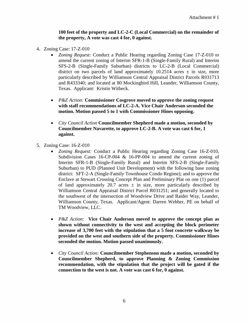
Attachment # 1
6
100 feet of the property and LC-2-C (Local Commercial) on the remainder of the property, A vote was cast 4 for, 0 against.
4. Zoning Case: 17-Z-010 • Zoning Request: Conduct a Public Hearing regarding Zoning Case 17-Z-010 to
amend the current zoning of Interim SFR-1-B (Single-Family Rural) and Interim SFS-2-B (Single-Family Suburban) districts to LC-2-B (Local Commercial) district on two parcels of land approximately 10.2514 acres ± in size, more particularly described by Williamson Central Appraisal District Parcels R031713 and R433340; and located at 80 Mockingbird Hill, Leander, Williamson County, Texas. Applicant: Kristin Witbeck.
• P&Z Action: Commissioner Cosgrove moved to approve the zoning request with staff recommendations of LC-2-A. Vice Chair Anderson seconded the motion. Motion passed 5 to 1 with Commissioner Hines opposing.
• City Council Action Councilmember Shepherd made a motion, seconded by Councilmember Navarette, to approve LC-2-B. A vote was cast 6 for, 1 against.
5. Zoning Case: 16-Z-010
• Zoning Request: Conduct a Public Hearing regarding Zoning Case 16-Z-010, Subdivision Cases 16-CP-004 & 16-PP-004 to amend the current zoning of Interim SFR-1-B (Single-Family Rural) and Interim SFS-2-B (Single-Family Suburban) to PUD (Planned Unit Development) with the following base zoning district: SFT-2-A (Single-Family Townhouse Condo Regime); and to approve the Enclave at Stewart Crossing Concept Plan and Preliminary Plat on one (1) parcel of land approximately 20.7 acres ± in size, more particularly described by Williamson Central Appraisal District Parcel R031251; and generally located to the southwest of the intersection of Woodview Drive and Raider Way, Leander, Williamson County, Texas. Applicant/Agent: Darren Webber, PE on behalf of TM Woodview, LLC.
• P&Z Action: Vice Chair Anderson moved to approve the concept plan as
shown without connectivity to the west and accepting the block perimeter increase of 3,700 feet with the stipulation that a 5 foot concrete walkway be provided on the west and southern side of the property. Commissioner Hines seconded the motion. Motion passed unanimously.
• City Council Action: Councilmember Stephenson made a motion, seconded by
Councilmember Shepherd, to approve Planning & Zoning Commission recommendation, with the stipulation that the project will be gated if the connection to the west is not. A vote was cast 6 for, 0 against.

Attachment # 1
7
PROPOSED WORK PROGRAM The proposed work program for 2017-18 includes continuing implementation of the updated comprehensive plan. P&Z will also oversee an annual update to the zoning, subdivision and sign ordinances to address issues identified by staff, applicants and citizens during the normal course of applying the ordinances. The Commission will continue work on the architectural pattern book project. The Commission will also continue to hold joint work sessions with City Council at least twice annually. Commissioners Anderson, Cosgrove, Hines, Lantrip, Means, and Nelson will attend the 2017 State of Texas Planning Conference hosted by the American Planning Association in Frisco, Texas. ATTENDANCE RECORD Total absences from October 2016 through September 2017 were as follows:
Name/Position Number
of Absences
Absence Percentage
Laura Lantrip, Place 1: (current term began Oct. 2016 - expires Oct. 2019)
2 7%
John Cosgrove, Place 2: (current term began Oct. 2016 - expires Oct. 2018)
3 11%
Jason Anderson, Vice Chair Place 3: (current term began Jan. 2014 - expires Oct. 2019)
3 11%
Sid Sokol, Chairman, Place 4: (current term began Oct. 2015 - expires Oct. 2018)
2 7%
Uryan Nelson, Place 5: (current term began April. 2017 - expires Oct. 2019)
2 7%
Angela Means, Place 6: (current term began Oct. 2015 - expires Oct. 2018)
2 7%
Marshall Hines, Place 7: (current term began Oct. 2015 - expires Oct. 2018)
0 0
Total regular and special meetings for the year – 28
Regular 24 Special 4