African Conservation Tillage Network (ACT and Conservation Agriculturein africa

CONSERVATION AGRICULTURE IN KENYA, A CASE STUDY OF
BUNGOMA DISTRICT
An activity of the EU fundedCA2Africa Project
BY
1 Eng. Saidi Mkomwa; 1 Hamisi Mzoba; 2Mutai Weldone
Africa Conservation
Tillage Network
1 African Conservation Tillage Network MARCH, 2011
2 Consultant & UON MSC student & graduate assistant

SUMMARY
Conservation Agriculture (CA) is increasingly promoted in Africa as an alternative for
coping with the need to increase food production on the basis of more sustainable farming
practices. CA is specifically seen as a way to address the problems of soil degradation
resulting from agricultural practices that deplete the organic matter and nutrient content
of the soil. It aims at higher crop yields and lower production costs. Yet, success with
adopting CA on farms in Africa has been limited (Kassam et al., 2009). This situation
therefore prompted the inception of a collaborative project, CA2Africa, which seeks to
better understand the reasons for the limited adoption of CA in Africa by analyzing past
and on-going CA experiences. A better comprehension of where, when and for whom CA
works best, and how CA should be configured in different settings to enable the
identification of knowledge gaps for future research, development and promotion of CA in
Africa.
The overall objective of this project is to assess and learn jointly from past and on-going CA
experiences under which conditions and to what extent does CA strengthen the socio-economic
position of landholders in Africa. For this purpose, a consortium comprising 10 highly experienced,
complementary European, African and International partners has been assembled. It will develop
an up-to date knowledge database on CA practices in Africa. Biophysical, socioeconomic and
conceptual models of innovation systems will be applied to a series of case studies across five
regions in Africa to analyze the impact and adoption of CA at different scales (field, farm, and
region). This will facilitate the identification of pathways to make models readily applicable for
decision-makers in different African regions and under different conditions. It will allow set the
agenda for future research, development and promotion of CA in Africa.
The project brings together the major research players involved with CA in Africa to share, assess
and learn together with practitioners from past and ongoing experiences on CA in five regions
across Africa. The Eastern Africa platform has two case studies which include; Bungoma district in
Kenya and Karatu district in Tanzania. Therefore this report presents a brief profile description of
Bungoma district case study.

1.0 Contextual information of the project/ site
1.1 Biophysical conditions
Location
Bungoma district is a border district in Western Kenya.
of Mt. Elgon bordering Republic of Uganda to the West and lies between latitude 0
53.2’ North and longitude 34
district, to the East Kakamega district, to the south Mumias Butere district and southwest
borders Busia and Teso districts.
The district covers a land area of 2,068.5 km
that supports crop and livestock production is estimated at 1,838 km2 (183,800 ha). This area is
mostly spread into the agro- ecological zones of Lower midland Sugar cane zone to Lower
midland Cotton zone which are suitable for sugar cane and Cotton growing and Coffee
to Maize- Sunflower zone which are suitable for tea, coffee and dairy production
2005).
The district has ten administrative divisions, comprising 44 locations and 11
shown in figure 1.2. Administrative boundaries however, are undergoing reviews every other
time depending on the constantly changing governance structure.
Figure 1.1 Map of Bungoma district; administrative units (Divisions and lo
Contextual information of the project/ site
Bungoma district is a border district in Western Kenya. It is situated on the slopes and foothills
Republic of Uganda to the West and lies between latitude 0
21.4’ and 35 04’ East. To the north, it borders Trans
district, to the East Kakamega district, to the south Mumias Butere district and southwest
borders Busia and Teso districts. (Ralph et al., 2005).
The district covers a land area of 2,068.5 km2 or a quarter of western province, Agricultural land
that supports crop and livestock production is estimated at 1,838 km2 (183,800 ha). This area is
ecological zones of Lower midland Sugar cane zone to Lower
e which are suitable for sugar cane and Cotton growing and Coffee
Sunflower zone which are suitable for tea, coffee and dairy production
The district has ten administrative divisions, comprising 44 locations and 114 sub locations as
shown in figure 1.2. Administrative boundaries however, are undergoing reviews every other
time depending on the constantly changing governance structure.
Map of Bungoma district; administrative units (Divisions and lo
It is situated on the slopes and foothills
Republic of Uganda to the West and lies between latitude 0 25.3’ and 0
04’ East. To the north, it borders Trans-Nzoia
district, to the East Kakamega district, to the south Mumias Butere district and southwest it
or a quarter of western province, Agricultural land
that supports crop and livestock production is estimated at 1,838 km2 (183,800 ha). This area is
ecological zones of Lower midland Sugar cane zone to Lower
e which are suitable for sugar cane and Cotton growing and Coffee-Tea zone
Sunflower zone which are suitable for tea, coffee and dairy production (Ralph et al.,
4 sub locations as
shown in figure 1.2. Administrative boundaries however, are undergoing reviews every other
Map of Bungoma district; administrative units (Divisions and locations)

The land in Bungoma generally slopes from the foot of Mt. Elgon from the North where the
altitude is over 2000 metres above sea level falling to the lower lying South and South West of
altitude 1200 metres. Four major rivers drain the land, river Nzoia forms the boundary to the
West with Lugari and Butere Mumias, river Lwakhakha forms another boundary with Uganda to
the West while Kuywa and Chwele and Khalaba rivers drain the middle areas (Ralph et al.,
2005)
The district enjoys generally abundant and well distributed annual average rainfall. It has a two-
season rain regime, the long rains covering March to July while the short rains start in August to
October. The average precipitation ranges from 1250 mm to 1800 mm with the central and north
areas receiving a higher amount.
Altitude of agricultural areas ranges from about 1300 m (thermal zone 3; 20.0-22.5° Celsius) in
the southern part of Bungoma to about 3500 m (thermal zone 8; 5.0-10.0° Celsius) on the slopes
of Mt. Elgon in the North of the district. Temperature variations in most of the areas are very
moderate ranging from 21-25° centigrade during the year. Evapo-transpiration is relatively low
in the agricultural zones and increases from less than 1 400 mm (in LH 1) to 1 800 mm (in UM
1/UM 2). In the southern part of the district only, potential evapo-transpiration may reach more
than 1 800 mm per year (Fischer, et al., 1994).
The district have good physical and varying soil types properties , with inherently fertile deep
rich Andosols and Nitisols towards the slopes of Mt. Elgon. The western part of the district has
Acrisols, while the centre of the district is predominantly Feralsols. The eastern part of the
district comprises Acrisols and Feralsols. The soils have been mined of their nutrients due to
continuous cropping with little addition of quality inputs. The availability of major nutrients N,
and P is low in the districts. (Ralph et al., 2005)
1.2 Socio- economic conditions
A majority of residents of Bungoma district belong to the Bukusu nationality group. They are
friendly farming people who have lived in the area south of Mt. Elgon for many hundred years
only a few miles north of the equator on the East African plateau (at 4-5000 ft above sea level).
The population of the district is estimated at 1.0 million in 2006. It is evenly distributed with an
average population density of 482 persons per square km. There are heavier population
concentrations in the main urban centers and major factories. These include Webuye (Pan Paper
Mills), Nzoia Sugar Company, Bungoma Town, Kimilili, Sirisia, Malakisi, Tobacco Leaf Centre
Chwele and Tongaren. Urban population is about 30 percent of the total.
1.2.1 Crop production
The main economic activity in the most part of the district is subsistence agriculture with Maize,
Sunflower, Sugarcane, Coffee, Tobacco, Potatoes, Beans and cotton being the main crops. Of the
total labour force of about 565,000, 52 percent are engaged in agricultural production which
provides 60 percent all household incomes; 19 percent wage employment, 13 percent urban self
employment.
The district is one of the fertile regions of Kenya and the agriculturally potential land is
estimated at 183,800 ha. The combination of good soils, adequate amount of rainfall which is
well distributed during the growing season makes it suitable for a variety of small scale farming
enterprises. The district comprises of the Agro-Ecological Zones; Sugarcane Zones to Cotton
Zone and Coffee/Tea/Dairy Zone to Maize-Sunflower Zone. Coffee is planted on approximately
4,500 ha, yielding 320 kg per ha of clean coffee. The potential for sugarcane production covers
more than half the agricultural land area measuring the agro-ecological zones, the well suited
soils are less extensive. Sugarcane is with 27,000 ha (2004) the main cash crop and increases its
performance (Ralph et al., 2005)
1.2.2. Livestock production
The Farm Survey (FS) was carried out during the year 2004 in nine sites covering the various
agro-ecological zones, with different Subzones, it indicated that the size of the farms ranged
between 0.5 ha and 10 ha. This can be compared to the overall farm size in Bungoma district of
0.9 ha per household. Despite the reduced land size per household, some amount of land is still
put under grazing. Only between 5 - 14% of the cattle are improved dairy stocks. Sheep and
goats are also important components of the livestock in the district, by numbers almost the same
as cattle. The stocking rate of 2.0 - 9.5 Livestock Unit (LU)/ha is an indication of the important
role livestock plays in these districts (Ralph et al., 2005)

Tongaren Division of the District has the highest population of grade cattle with more or less the
same population of zebu cattle, though the other Divisions have low and almost comparable
populations of grade cattle. This is because of the settlement scheme that had an early start on
dairy activities in the Division pre and post independence. Kanduyi, Bumula and Sirisia
Divisions have the highest population of zebu cattle as compared to the other divisions as a result
of the socio-cultural roles (dowry payments, prestige, sales for income) these cattle play in the
livelihoods of the local communities and the animals’ resistance to diseases (Mudavadi et al.,
2001). The cattle population in the District has been fairly constant over the years with
population of zebu cattle being very high as compared to that of grade cattle and crosses.
Communication and infrastructure in the area
Infrastructure is a major constraint to the development in Bungoma. The district has a total of
1158 km of road of which 165 km are paved. Of the 199,435 households only 4000 have
commercial electricity supplies. The number of households with access to piped water is 65,248.
The households share 6 hospitals with a doctor/patient ratio of 1:142,446.
Perhaps the most critically needed infrastructure is that for Information and Communication. The
total number of households with telephones is 957 compared to the total of 199,435 or 1:200.
Since the average household size is 5, the tele-density is 0.01 phone lines per 100 people. This is
much too inadequate compared to the ITU target of 5 phones per 100 people for developing
countries. There are automatic exchanges at Webuye, Bungoma, and Kimilili. Manual exchanges
are at Chwele, Sirisia and Malakisi.
1.3 Institutional environment
Agricultural production situation in Bungoma district have attracted several institution and/or
organizations, all with prime objective of improving farming conditions and efficiency in the
area through various intervention such as right inputs provision, capacity building, on-farm
demonstrations of new technologies, remedial or mitigation measures of degrade soils advocacy
among other functions. These organizations and their functions are briefly summarized in table
1.0 below and few others are briefly discussed as follows:
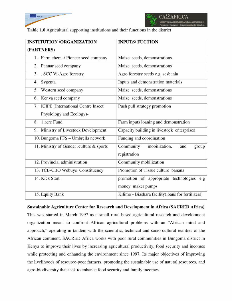
Table 1.0 Agricultural supporting institutions and their functions in the district
INSTITUTION /ORGANIZATION
(PARTNERS)
INPUTS/ FUCTION
1. Farm chem. / Pioneer seed company Maize seeds, demonstrations
2. Pannar seed company Maize seeds, demonstrations
3. . SCC Vi-Agro forestry Agro forestry seeds e.g sesbania
4. Sygenta Inputs and demonstration materials
5. Western seed company Maize seeds, demonstrations
6. Kenya seed company Maize seeds, demonstrations
7. ICIPE (International Centre Insect
Physiology and Ecology)-
Push pull strategy promotion
8. 1 acre Fund Farm inputs loaning and demonstration
9. Ministry of Livestock Development Capacity building in livestock enterprises
10. Bungoma FFS – Umbrella network Funding and coordination
11. Ministry of Gender ,culture & sports Community mobilization, and group
registration
12. Provincial administration Community mobilization
13. TCB-CBO Webuye Constituency Promotion of Tissue culture banana
14. Kick Start promotion of appropriate technologies e.g
money maker pumps
15. Equity Bank Kilimo - Biashara facility(loans for fertilizers)
Sustainable Agriculture Center for Research and Development in Africa (SACRED Africa)
This was started in March 1997 as a small rural-based agricultural research and development
organization meant to confront African agricultural problems with an “African mind and
approach,” operating in tandem with the scientific, technical and socio-cultural realities of the
African continent. SACRED Africa works with poor rural communities in Bungoma district in
Kenya to improve their lives by increasing agricultural productivity, food security and incomes
while protecting and enhancing the environment since 1997. Its major objectives of improving
the livelihoods of resource-poor farmers, promoting the sustainable use of natural resources, and
agro-biodiversity that seek to enhance food security and family incomes.
International Centre of Insect Physiology and Ecology (ICIPE) in Kenya
This organization aimed at providing and advancing affordable alternative strategies needed to
combat the growing threats to the smallholders’ livelihoods due to constraints caused by
stemborers, the parasitic weed Striga hermonthica, low and declining soil fertility, lack of
knowledge on how to manage these pests in crop production. It targeted enhancing the Push-Pull
strategy, which combines knowledge of the chemical ecology and agro-biodiversity of the stem
borer, with Striga management.
The Push-Pull curriculum was successful launch in Bungoma district in western Kenya, in March
2007 by ICIPE. Through training workshop for FFS facilitators, the strategy was immediately
implemented in Bungoma district using then existing 22 FFSs (David et al., 2007)
Conservation Agriculture for Sustainable Agriculture for Rural Development (CA SARD)
This is a FAO project funded by the German Trust Fund. The project started in 2004 and its
second phase which ended on March, 2010. Ministries of agriculture from Kenya, KARI (Kenya
Agricultural Research Institute), ACT (African Conservation Tillage Network) and FAO (Food
& Agriculture Organization) are the key implementers of this project.
Conservation Agriculture for Sustainable Agriculture in Rural Development is a Project focused
in contributing to the promotion of growth and improved food security in Kenya through the
scaling up of conservation agriculture (CA) as a sustainable land management (SLM) option.
The project was introduced to Bungoma district in 2004 and uses farmer field school (FFS)
methodology as a tool for introducing the CA concept to smallholder farmers.
2.0 History/trajectory of work related to CA in the project/site
The practical manifestations of attempts to introduce improved and sustainable agriculture in
Bungoma district date back as early as 1954, during agrarian diversification and intensification
of the development of Africa agriculture in Kenya, when it was establish that the district needed
adequate soil conservation measures as a means to obtain a reward for good husbandry
(Makana, 2010). This marked the beginning of venture to bring back the depleted soils and
improved productive of the land. From then, several approaches have been employed depending
on the suitability and over time many local and international organizations have taken the

responsibility of implementation of soil and water conservation technologies in this area through
improved farming innovations. These organization among other include, ICIPE, SACRED-
Africa, SUSTAINET East Africa and ACT.
Conservation agriculture innovation was introduced and has been practiced in the district since
2004 exclusively under Conservation agriculture for sustainable agriculture for rural
development (CA SARD) projects (Phase I and II) funded by German Government through the
FAO trust Fund. The project is anchored on the principles of Conservation agriculture that is;
Minimum soil disturbance, permanent soil cover and crop rotation and its associations (Pascal et
al., 2007). The local farmers have swiftly appreciated the technology and have adopted despite
few challenges associated with it, but the output of the CA is tremendous compared to
conventional tillage farmers have witness.
3.0 Recommended CA practices/technologies
Conservation agriculture is a technique that is adapted to conserve, improve and make more
efficient use of natural resources through integrated management of available soil, water and
biological resources combined with external inputs. It contributes to environmental conservation
as well as to enhance and sustainable agricultural production. It can also be referred to as
resource-efficient and resource- effective agriculture.
It is anchored on simultaneous practice of minimal soil disturbance, permanent soil cover, and
crop rotations/associations.
3.1 Minimum soil disturbance/ reduced-tillage
Soil is a living organism and therefore has to be treated as such. Soil organisms are destroyed by
exposure to solar radiation and rapid drying of the soil. Soil inversion enhances the
decomposition of organic matter in the soil and leads to soil compaction, reduced water
infiltration and reduced aeration (Steiner, 2002)
A major cause of this soil degradation in Bungoma district is intensive soil preparation by
traditional hoe or plough which now is being replaced by conservation agriculture equipment
such as rippers, sub-soilers, direct Ox- or Tractor- seeders or planters, Zam wipe weeder among
others that ensure minimized soil disturbance through absolute minimum or reduced soil turning

and compaction hence improving soil structure/moisture storage within the soil. Table 2.0
highlight the differences between the two forms of farming practices as witnessed by the farmers
in the district.
Table 2.0: Comparison between conventional tillage and conservation agriculture
Intensive / conventional tillage Conservation agriculture
• costly in equipment and labour
• Accelerates soil and moisture losses
• Destroys the soil structure
• Creates compacted layers
• Delays planting (unless timely)
• Less costly due to reduced labour
requirement
• Improve soil moisture storage
• Improve soil structure
• Prevent development of compacted layers
• Ensures timely planting
3.2 Permanent soil cover
This provides the only way to protect, feed and regenerate the soil as a habitat. It involves
maintaining permanent soil cover of live or dead vegetal matter in the soil surface. Soil cover
includes, grown cover crops, mulch cover, crop residues and green manure, which are grown or
applied for the purpose of covering the soil surface with the purpose of reducing the soils
degradation and conserving soils moisture and fertility. The cover crops preferred by farmers in
the district are; Mucuna, Dolichos Lab lab, Desmodium, bananas, canavalis, cow peas among
others. These cover crops have suitably been adopted in the district and provide the anticipated
benefits to the society.
3.3 Crop rotation under conservation agriculture
This refers aspect of rotating crops over several seasons in a given field. In addition to
minimizing the build up of diseases or pests, crop rotation is essential in sustainable farming as it
allows differential use of the soil over time, thereby optimizing plant nutrient use through
synergy between different crop types. Alternating shallow-rooting crops with deep-rooted ones is
also an important feature in deciding crops in a rotation. Besides, this system of crop rotation
farmers in the district has preferred intercropping systems of cover crops with main crops as they
had been traditionally doing it.

4.0 Impact of CA
Over the last decades there has been a general trend of soil productivity decline on cropland
witnessed in Bungoma district. Land degradation, including a decline in plant available
moisture, reduced soil fertility and soil compaction, has been identified as the factor behind this
gradual decline in agricultural productivity.
A major cause of this land degradation is continuous intensive soil preparation by hoe or plough,
which together with the removal or burning of crop residues leaves the soil exposed to climatic
hazards such as rain, wind and sun. Conventional tillage using ox-or tractor drawn ploughs as
practiced in the area has over the years been perceived as the indicator of farm systems
modernization in developing countries while in the real sense have caused serious adverse effects
on the long term productivity of erosion-prone tropical soils in the area.
The introduction of Conservation Agriculture (CA) Bungoma district has offered a window of
opportunity to convert these degraded soils into productive soils and thereby improves crop
yields and reduces land degradation. It has created a win-win system based on the integrated
management of soil, water and agricultural resources. This was long overdue since the farmers
in the region had realized the need to reverse land degradation by employing improved land
practices like establishing of soil and water conservation structures, enhancing push-pull
strategy, bio-intensive agriculture and crop rotations in various combinations.
4.1 Agronomic and environmental aspects at the field level
Bungoma district as shown above is predominantly a small- scale farming region and farmers
have been able to integrate this new farming techniques with traditional farming practices,
leading to more environmentally friendly, less costly and high output practices. Farmers applied
conservation agriculture principles to address environmental concerns, regenerate degraded soils
and improved the soil characteristics which have led to restoration of soil fertility fostering
increased yields.
Adoption of cover crops like Desmodium, dolichos lablab not only improves the soil
characteristics but also helps in controlling notorious striga hermoenthica predominant parasitic
weeds among other weeds. Cover crops smother weeds therefore reducing the cost of weed

management in terms of labour and chemical costs. This has been greatly witnessed in the
district even through other pests or weeds control technologies, such as push-pull strategy which
employ CA principle.
Conservation agriculture has brought about some adjustments in some agronomic practices.
Inter-row spacing increased to create room from the cover crop, reducing the amount of cereal or
main crop planted. But through the symbiotic association of the two crops, the cereal or main
crop yields dramatically increased. The planting calendar in conservation agriculture fields
changed, even farmers have been enabled to do dry planting.
The use of Conservation agriculture equipment like sub-soiler, rippers and direct seeders or
planters have improved aeration of the soil, removal of hardpans, less costly and ease planting
practice.
4.2 Socio-economic aspects at the farm level
Agriculture is the main economic activity for people of Bungoma district. Local farmers groups
such as Farmers Fields Schools, have form a consortiums that increase farmers bargaining power
through training, marketing produce and accessing credit from local microfinance institutions
and willing funding from sponsoring organizations.
Establishing of field schools brings about cohesiveness and integration in the society which
foster unity and coexistence and sharing of experiences. The graduates from these schools may
get involved in offering training to other farmers for a fee, thus providing a form of employment.
Through conservation agriculture labour requirements in farm operations is tremendously
reduced hence removing the drudgery associated with labour and the problems at the peak of
labour during planting seasons. The district is also facing the scourge of HIV and AIDS, which
have affected the availability of able labour in the society required for labour intensive peak
period of farming, but conservation agriculture is alternative innovation that overcome this
misfortune in the society to ensure continuous production of foods

4.3 Institutional aspect
The introduction and adoption of conservation agriculture in the district have created an enabling
environment for various organizations both local and international to have a lot of investment,
project development and implementation in new farming practices. This is has been achieved in
the district because of established groupings such as Farmers field schools. Organizations have
enabled to advanced capacity building programs through farmers training and workshops and
developed farmers field school’s curriculum. Information sharing and networking in enforcing
sustainable agriculture innovations is sufficient in the district among the partners or
collaborators. Supply of inputs and conservation agriculture equipment is also a major
achievement that institutions in the region have been engaged in and prudently created business
to the some institution or organizations.
5.0 Adaptation and adoption of CA
Local and international organizations have been responsible for introduction and implementation
of conservation agriculture technologies in the area. In the year, 2004, FAO through CASARD
adopt more organized and coordinated way to introduce the full package of conservation
agriculture technology inscribe in three principles through farmers field schools well known as
FFS. This facilitated more adaptation, adoption and diffusion of the innovation.
• Adaptation
Conservation agriculture adaptations in Bungoma include changes farmers have made in their
practices in the standard recommendations to suit their local socio-economic, cultural, technical,
agro-ecological and other local conditions. Generally, all farmers who have tried CA technology
have really appreciated and continue using it, but slightly modified some technologies to suit
their environment. For instance instead of strict crop rotation they have resorted to intercropping
because of shortage of land. Cover crops like Dolichos lablab, mucuna, canavalis, desmodium
and banana have suitably been adapted in region and are doing well. Reduced soil inversion or
no- tillage and shallow weeding have been greatly practiced as this have improved farm
conditions and timely planting.

• Adoption
Every active member of a farmer field school in the district adopted conservation agriculture
technology and is now continuing practicing it. Over 90% adopted a cover crop because it had
obvious benefits and it matured quickly and visibly. Box 1.0 and 2.0 shows success stories of
farmers who have adopted the CA. Since 2004, many farmers have had the good side of
conservation agriculture technology, after the FFS training and immediate implementation of the
acquired knowledge and skills on the subject, many have end up celebrating with different
stories of successes. The cases in point include; ROSELYNE NGOSIA from NASIKHOLOLO
FFS and hails in Matisi Sub location, Bokoli location Webuye Division of Bungoma District,
adopted CA principles of cover crops and planted maize without digging the land On the small
plot of about 10m x 50m which she later harvested 4 bags of maize instead of the usual one.
This was amazing to me and this is what he had to say “I thank God who gave FAO this new
farming practice to have lessened the labour cost and now I have more yields than enough.” The
same sentiments was shared with ALEX KITUYI MUKHONGO from MATULO FFS
BUNGOMA “TAABU’S SALVATION‘’ who lived in Matulo village. He lived miserably with
a family of ten children in one hectare of land. He struggled to work on his hardpaned and
eroded soil but could hardly produce enough food for his family. He living in abject poverty and
he was a daily drinking officer. On joining FFS in 2004, learnt about the principles of CA and
gave a trial on his farm. He realized a very good harvest of maize and dolichos. This made him
adopt CA. He is now a very serious farmer and a good expert of planting using the jab planter.
Intercropping maize and dolichos lablab has helped reduce the rampant soil erosion in his farm
and has also improved the fertility of the soil. The hardpan problem has also varnished due to
lablab roots which were able to penetrate deep into the soil.
Several farmers in the district who have actively participated in FFS have adopted CA principles
and now share the same stories as Alex and Roselyne highlighted above. Benefits farmers are
realising on adoption of CA are immense and has helped improved the living standard in the
society, (Kennedy, 2005)

5.0 Present challenges in CA work
Challenges in practicing conservation agriculture
According to many farmers, crops were attacked by insects and diseases more often with zero
tillage than before since the crop residue harboured insects and diseases. This brings another
problem of means of controlling these, but they admitted that conservation agriculture was still
more profitable than conventional farming and have revolutionized their lives. Increases in soil
moisture availability led to water grass emerging as a weed that depletes soil moisture.
Unavailability of CA equipment at local farming equipment outlets is highlighted as a major
challenge and hindrance to faster rate of CA adoption. Most of the equipment currently being
used in the FFS and farmers fields are imported from Brazil and are not locally available.
The cost of inputs is very high and the government needs to intervene so that most of the inputs
can become affordable to most small scale farmers. Borrowing from commercial banks is very
expensive and introduction of microfinance can be of help
Establishing a permanent soil cover or maintaining mulch at all times is not easy. Dolichos
lablab is liked by very many pests and the pesticides are expensive. Crop residues are also used
as a fodder for the livestock, cooking fuel; fencing etc. the cover crop seeds are not readily
available.
Literacy level is also another challenge especially sensitization on the CA technology and
adoption of the same. Lack of enough draught animals limited the use of CA equipment like ox-
seeder and the scarce tractor power is exorbitant to small- holder farmers.

6.0 REFERENCES
David, M. A. and Zeyaur, R. K.(2007). Enhancing Push-Pull strategy. Habitat Management
Programme, International Centre of Insect Physiology and Ecology (ICIPE), Nairobi, Kenya
Fischer, G.W. and J. Antoine, (1994). Agro-ecological land resources assessment for
agricultural development planning. A case study of Kenya. Making land use choices for district
planning. Food and Agriculture Organization of the United Nations and International Institute for
Applied Systems Analysis Rome 1994.
Kennedy, W. M. (2005). Conservation Agriculture for sustainable agriculture for rural
development (CA-SARD) project March monthly report. Bungoma district, Kenya
Steiner, K. G. (2002). Producing in Harmony with Nature through Conservation Tillage –
Gateway to Food Security and Sustainable Rural Development. Information series 1. ACT, GTZ.
Makana, Nicholas E. (2010). Peasant response to agricultural innovations: land consolidation,
agrarian diversification and technical change. The case of Bungoma district in western kenya,
1954-1960. Journal of third world studies.
Mudavadi, P. O., K. Otieno, J. W. Wanambacha, J. O. Odenya, M. Odendo and O. K.
Njaro, (2001). Smallholder Dairy Production and Marketing In Western Kenya: A Review of
Literature. Ministry of agriculture Kenya, MOARD/KARI/ILRI; Smallholder Dairy (Research &
Development) Project
Pascal k., and Josef, K. (eds), (2007). Conservation agriculture as practised in Kenya: two case
studies; Laikipia and Siaya districts. African Conservation Tillage Network (ACT). Kenya.
Ralph, J., Helmut, S., Berthold, H., and Chris S., (2005). Farm Management Handbook of
Kenya, Natural Conditions and Farm Management Information. 2nd Edition, Volume II, PART
A WEST KENYA.

ANNEX
ANNEX A: PHYSIOGRAPHIC EXPLANATIONS
U: Uplands
Uh: Upper Middle-Level Uplands (undulating to rolling; slopes between 5 and 16%; altitudes
between 1650 and 2650 m, here 2200 m)
Um: Lower Middle-Level Uplands (gently undulating to undulating; slopes between 2 and 8%;
altitudes between 1200 and 2100 m)
U l: Lower-Level Uplands (very undulating to undulating; slopes between 2 and 8%; altitudes
between 1200 and 1900 m)
Soil unit’s descriptions
FB1: Well drained, deep to very deep, dark reddish brown, friable clay, with humic topsoil; in
places shallow to moderately deep and rocky: chromo-luvic PHAEOZEMS, partly lithic and
rocky phase, with mollic NITISOLS
FG1: Well drained, shallow to moderately deep, dark yellowish brown to reddish brown, friable,
stony, sandy clay loam to gravely sandy clay; in places with an acid humic topsoil or very
shallow and rocky: ferralic, dystric and humic CAMBISOLS and orthic ACRISOLS, stony
and partly lithic and rocky phases; with LITHOSOLS and Rock Outcrops
UmG2: Well drained, deep, dark yellowish brown to dark brown, friable sandy clay loam to sandy
clay; in places gravely in the deeper subsoil: ferralo-orthic ACRISOLS