AFGHANISTAN - British Geological SurveyAfghanistan is ethnically and linguistically mixed, a result...
12
AFGHANISTAN n World-class undeveloped deposits n Significant potential for further major discoveries n Government favourable to mineral development n New mining law SPECIAL PUBLICATION
Transcript of AFGHANISTAN - British Geological SurveyAfghanistan is ethnically and linguistically mixed, a result...

AFGHANISTANn World-class undeveloped depositsn Significant potential for further major discoveriesn Government favourable to mineral developmentn New mining law
SPECIAL PUBLICATION

� Mining Journal special publication
IT iS a privilege for me to draw your attention to this Mining Journal special supplement on Afghanistan. Mining in Afghanistan has a history dating back over
6,000 years, and despite all the upheavals over the past 25 years, mining has continued to operate. The main task facing us now is to expand the industry from its present small base.
The Government regards the development of Afghanistan’s natural resources as the most impor-tant driver of economic growth, and essential to the reconstruction and development of the country. in order to achieve this growth, Afghanistan must become established as a globally competitive and attractive destination for investment in mineral and hydrocarbon exploration. Development of these resources must be effectively regulated to promote a healthy and sustainable industry for the benefit of the people of Afghanistan.
To meet these objectives the Government, with the help of the World Bank and other donor agencies, has started the reconstruction and reform of the Ministry of Mines. The former Ministry of Mines and industries was responsible for extractive and associated heavy industries, mining and construction minerals, hydrocar-bons and the operation of downstream industries. The new Ministry of Mines is responsible for assisting in the exploration, exploitation and processing of minerals and hydrocarbons.
The promotion of the geological potential of the country will be carried out by the re-habilitated Af-ghanistan Geological Survey. it will provide comprehen-sive, objective, impartial and up to date geoscientific information and advice to the Government and the user community. There is still much geological work to be done as our country lies astride the important collision zone between the indian and Eurasian plates whose
geology is still relatively unknown, and along which many mineral deposits remain to be discovered.
We are starting to see the first shoots of re-growth of the minerals industry. For example, construction minerals production has grown dramatically with the increased need for raw materials to feed road building and reconstruction. i expect this will be followed shortly by further investment in the coal, cement and hydro-carbons industries. The first signs of grassroots mineral exploration for gold have started, and with the appoint-ment of Tender Advisors for the future development of the world class Aynak copper deposit, i expect this to lead to really significant investment in the mining sec-tor of the economy in the very near future. Aynak is one of the world’s largest undeveloped copper deposits and it has already attracted interest from a wide spectrum of international companies.
in my view, security is an issue but is not a significant problem with trouble only occurring in areas close to the Pakistan border. The majority of the country is entirely peaceful and ready for the exploration of both solid minerals and hydrocarbons.
investment in the country brings with it the responsibility of safeguarding and regulating the investment. Consequently one of my priorities will be to support the principles of the Extractive industries Transparency initiative (EiTi) in the granting of licences and the collection of revenue. The government will then distribute these monies to other official depart-ments.
i invite you to read this supplement. it clearly illus-trates the very high potential of the minerals industry in Afghanistan and helps to promote our vision to establish Afghanistan as an attractive destination for investment in mineral and hydrocarbon exploration, development and mining.
AFGHANISTAN
CONTENTSA country of opportunity 3
Geological overview 4
Afghan Geological Survey 5
Major metals 6
Minor metals 8
Gemstones 9
Other minerals 10
Minerals law and key contacts 11
Published by Mining Journal, London, August 2006
A message from the Hon. Eng. Ibrahim Adel, Minister of Mines
AFGHANISTAN
“The Government regards the
development of Afghanistan’s natural resources as the most
important driver of economic growth,
and essential to the reconstruction and development of the
country”
AFGHANISTAN
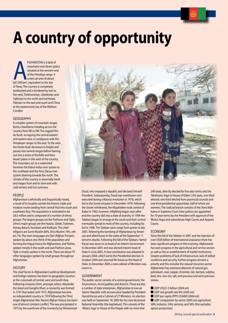
AFGHANiSTAN is a land of mountains and desert plains situated at the western end of the Himalaya range. it covers an area of about
647,500 km2, equivalent to the size of Texas. The country is completely landlocked and is bordered by iran to the west, Turkmenistan, Uzbekistan and Tajikistan to the north and northeast, Pakistan to the east and south and China at the easternmost top of the Wakhan Corridor.
GEOGrAPHyA complex system of mountain ranges forms a backbone trending across the country from NE to SW. The rugged Hin-du Kush, occupying the central-eastern and eastern area, is contiguous with the Himalayan ranges to the east. To the west the Hindu Kush decreases in height and passes into several ranges before fanning out into a series of foothills and then desert plains in the west of the country. The mountains act as a watershed between the Kabul-indus river system to the southeast and the Amu Darya river system draining towards the north. The climate of the country is seasonally harsh and ranges from arid to semi-arid with cold winters and hot summers.
PEOPLEAfghanistan is ethnically and linguistically mixed, a result of its location astride the historic trade and invasion routes leading from central Asia into south and southwest Asia. The population is estimated to be 28.5 million and is composed of a number of ethnic groups. The largest groups are the Pashtuns and Tajiks, others major groups are the Hazara, Uzbek, Turkmen, Aimaq, Baluch, Nuristani and Kizilbash. The chief religions are Sunni Muslim 80%, Shi’a Muslim 19%, oth-ers 1%. The main languages are Dari (Afghan Persian), spoken by about one-third of the population and forming the lingua franca for Afghanistan, and Pashto, spoken mostly in the south and east Pashtun areas. Tajik is mostly spoken in the north. There are about 70 other languages spoken by small groups throughout Afghanistan.
HiSTOry The chief factor in Afghanistan’s political development and foreign relations has been its geographic location at the crossroads of central, west and south Asia. Following invasions from, amongst others, Alexander the Great and Genghis Khan, a monarchy was formed in 1747 that lasted until 1973. Afghanistan became an independent country in 1919 following the Third Anglo-Afghanistan War. recent Afghan history has been one of almost constant conflict. This was precipitated in 1973 by the overthrow of the monarchy by Mohammad
Doud, who imposed a republic and declared himself President. Subsequently, Doud was overthrown and executed during a Marxist revolution in 1978, which led to the Soviet invasion in December 1979. Following the Soviet withdrawal, the Mujahideen took control of Kabul in 1992, however, infighting began soon after and the country slid into a state of anarchy. in 1994 the Taleban began to emerge in the south and their control eventually spread to most of the country, including Ka-bul in 1996. The Taleban were swept from power in late 2001, following the bombing of Afghanistan by Ameri-can and allied forces in the wake of the September 11 terrorist attacks. Following the fall of the Taleban, Hamid Karzai was sworn in as head of an interim Government in December 2001 and was elected interim head of State in June 2002. A new constitution was adopted in January 2004, which led to the Presidential election in October 2004 and returned Mr Karzai as the Head of State. in December 2004, a new cabinet of Ministers was sworn in.
GOvErNMENTThe public sector consists of a central government, the 34 provinces, municipalities and districts. There are also a number of state enterprises. Afghanistan is now an islamic republic with an executive headed by President Hamid Karzai and a Cabinet of 27 Ministers. An election was held on September 18, 2005 for the new bicameral National Assembly (the legislature). This consists of the ‘Wolesi Jirga’ or House of the People with no more that
249 seats, directly elected for five-year terms and the ‘Meshrano Jirga’ or House of Elders (102 seats, one third elected, one third elected from provincial councils and one third presidential appointees, half of whom are women). The Judicial branch consists of the Stera Mah-kama or Supreme Court (nine justices are appointed for 10-year terms by the President with approval of the Wolesi Jirga) and subordinate High Courts and Appeals Courts.
ECONOMySince the fall of the Taleban in 2001 and the injection of over US$8 billion of international assistance there has been significant progress in the economy. Afghanistan has seen progress in the agricultural and service sectors as well as the re-establishment of market institutions. Despite problems of lack of infrastructure, lack of skilled workforce and security, further progress remains a priority and this includes the natural resources sector. Afghanistan has extensive deposits of natural gas, petroleum, coal, copper, chromite, talc, bartyes, sulphur, lead, zinc, iron ore, salt, and precious and semi-precious stones.
n GDP US$21.5 billion (2004 est)n GDP real growth rate 8% (2005 est)n GDP per capita (PPP) US$800 (2004 est)n GDP composition by sector (2005 est) agriculture: 38%; industry: 24%; services; and 38% (this excludes opium production)
A country of opportunity
Mining Journal special publication �

� Mining Journal special publication
AFGHANISTANAFGHANISTAN
AFGHANiSTAN has some of the most complex and varied geology in the world. The oldest rocks are Archean and they are succeeded by rocks from the Proterozoic and every Phanerozoic system up to the
present day. The country also has a long and compli-cated tectonic history, partly related to its position at the western end of the Himalayas.
This diverse geological foundation has resulted in a significant mineral heritage with over 1,400 mineral occurrences recorded to date. Historical mining concen-trated mostly on precious stone production, with some of the oldest known mines in the world established in Afghanistan to produce lapis lazuli for the Egyptian Pharaohs.
More recent exploration in the 1960s and 70s resulted in the discovery of significant resources of metallic minerals, including copper, iron and gold, and non-metallic minerals, including halite, talc and mica. The bedrock geology of Afghanistan can be thought of as a jigsaw of crustal blocks separated by fault zones, each with a different geological history and mineral prospectivity. This jigsaw has been put together by a series of tectonic events dating from the Jurassic up to the present.
NOrTh AfghANISTANThe Tadjik block of northern Afghanistan formed the southern margin of the Eurasian continental plate dur-ing Permo-Triassic times. The Palaeozoic basement was intruded by Triassic granitoids as a result of subduction related to the first stages of the closure of the Tethys Ocean during the Cimmeride Orogeny.
Subsequent to this, a Jurassic clastic sequence was deposited, which changes upwards to Cretaceous carbonate platform sedimentation. This area is now the prime target for hydrocarbon exploration, although the exposed granitoids in the northeast of the block are prospective particularly for precious (and base) metal mineralisation, and further exploration of the occur-rences identified to date is warranted.
ThE CImmErIdE OrOgENyDuring the Triassic, parts of the northern edge of the Gondwanaland supercontinent broke away and began drifting north, before colliding with the Tadjik block, resulting in the Cimmeride Orogeny.
The orogeny is marked by two distinct collisions, which brought first the Farad block against the Tadjik block, followed closely by the Helmand block against the Farad block. The Herat Fault system marks the suture line of this first collision, which was finished by the beginning of the Cretaceous, and the Panjao Suture marks the line of the second collision that was complete by early Cretaceous times. Both suture zones are ophio-lite bearing, and the Herat Fault system in particular has had a long history of sedimentation and igneous activ-ity up to the present. The Farad block was subsequently overlain by Upper Jurassic-Cretaceous sediments and the Helmand block by Cretaceous sediments only.
During this period the Pamir and West Nuristan blocks of northeast Afghanistan were also accreted onto Eurasia. These four blocks, together with the Tadjik block, are collectively known as the Afghan Block. Due to processes discussed below, the south-eastern margin
of this Block is considered prospective for precious and base metal mineralisation, as well as rare metals in the numerous pegmatite fields.
ThE hImALAyAN OrOgENyFollowing a brief period of quiescence, tectonic activity began once again as india drifted north, away from Gondwanaland and towards the enlarged Eurasian plate with the Afghan Block at its southern margin.
The first evidence of this is preserved as the Kanda-har volcanics, which marked the beginning of the devel-opment of a volcanic arc on the margins of the Eurasian plate. These were intruded by subduction-related, ‘i-type’ granitoids in the Helmand and West Nuristan blocks (during the Cretaceous to early Tertiary).
This geological setting is highly prospective for a number of different mineralisation styles, and the large number of mineral discoveries to date only reinforces the potential of the east-central Afghanistan region. igneous activity was not confined to this region, with younger (Oligocene) alkaline intrusions and basaltic extrusions in the Farad Block and the sedimentary basins within the Herat Fault Zone. The chemistry of these rocks suggests derivation from a mantle source beneath a zone of continental extension (within an overall setting of dextral transtension).
Oligocene granitoids were also intruded into the thickened continental crust of northeast Afghanistan. By the start of the Tertiary, the widespread marine sedimentation that had preceded the Himalayan Orog-eny had become restricted to the Tadjik Block and by Neogene times even this had become localised as the collision of india began to raise the area above sea level.
Himalayan deformation of the Afghan Block resulted in the reactivation of many of the internal block bound-aries including the Herat Fault system (as discussed above, but not active since the Miocene) and the Cha-
man Fault system (which marks the southeast edge of the Afghan Block and is still active to the present day).
Folding and thrusting of the Mesozoic sediments also led to basin inversion and imbrication with the Palaeozoic basement.
EAST AfghANISTANTo the east of the Afghan Block is a complex collage of tectonic units that mark the collision zone with the indian plate. During the Cretaceous period, the East Nuristan volcanic arc was accreted to the margin of Eur-asia (although magamatism continued into the Eocene). This was followed by the docking of the Kabul Block. The Kabul Block is somewhat of an enigma in Afghan geology. it includes, to the west and east, the Kabul and Khost ophiolites respectively, but is itself formed of Upper Proterozoic to Palaeozoic basement overlain by Mesozoic sediments. it is now believed that the Block was a sliver of continental crust, separated from the indian and Afghan blocks by oceanic crust that got caught up in the collision and was accreted to the edge of the Afghan Block before final collision with india.
The Kabul Block is particularly prospective for sedi-ment-hosted copper in its basement sediments and chromite in the ophiolites.
The final block in the Afghanistan jigsaw is the Katawaz Basin in Southeast Afghanistan. This is interpreted as a flexural basin on the western margin of the indian Plate where subsidence synchronous with sedimentation resulted in the deposition of more than 10 km of Tertiary sediments before shortening and inversion in the late Tertiary as india finally collided with Afghanistan.
Sedimentation across the country since this time has been continental, with large areas of Neogene and Quaternary deposits particularly across the very north and south of the country.
geological overview
0 100 200 km
Scale 1:2 000 000
N
61º
38º
37º
36º
35º
34º
33º
32º
31º
30º
29º
62º60º 63º 64º 65º 66º 67º 68º 69º 70º 71º 72º 73º 74º 75º
Quaternary sedimentsand volcanics
Neogene sedimentsand volcanics
Cretaceous sedimentsand volcanics
Palaeogene sedimentsand volcanics
Jurassic sedimentsand volcanics
Triassic sedimentsand volcanics
Archean metamorphicrocks
Plutonic rocks
Geological map of Afghanistan

AFGHANISTAN
Mining Journal special publication �
AFGHANISTAN
Afghanistan geological Survey
THE Afghanistan Geo-logical Survey (AGS) is the national custodian of geoscientific information. The history of geological
studies in Afghanistan falls within three phases. The first covering many centuries was characterised by the development of ancient mining.
A second phase lasted from the 1880s to the mid-1950s when a number of geologists first started traversing Afghanistan, at first re-cording the geology along the main caravan routes and then later along the arterial motor roads. July 7, 1955 marked the start of the third phase with the setting up of a national geological survey by the Afghanistan Government. The AGS under the Ministry of Mines and industries started the first purely mapping operations, followed by exploration and evaluation of the mineral resources of some of the more promising localities. Much work was also achieved with German, italian, French and, in 1963, with Soviet co-operation. it was with the latter that systematic mapping of the whole country was undertaken at 1:500,000 scale and extensive mineral prospecting was initiated.
The legacy of Afghanistan-Soviet co-operation is ex-tensive. The present AGS building was constructed and equipped by the Soviets. it was subsequently wrecked in twenty years of civil war.
Geological outputs were the previously mentioned 1:500,000 map of the whole country and a large range of other maps and reports on the mineral exploration and mapping programmes. An excellent synthesis was written: Geology and mineral resources of Afghanistan. Two volumes; 1980, edited by Abdullah et al. Book 1 covers geology and Book 2 covers mineral deposits. The latter included an extensive catalogue, with detailed descriptions of all the mineral deposits of Afghanistan known at the time.
The AGS could be regarded as entering a fourth phase. The wrecked buildings have very recently (June 2006) been renovated and refurbished by USAiD. Since 2004, the BGS and the US Geological Survey have developed extensive programmes of retraining and education. The AGS is also currently undergoing a re-form process to create a geological survey organisation suitable for the future.
ThE AgS ArChIvE ANd mUSEUm SErvICESThe AGS archive contains a wealth of reports, aerial photographs and maps of the geology and mineral resources of Afghanistan. These are housed in the AGS building and consist of a suite of eight rooms containing a secure archive, document consultation rooms and storage areas. in addition, a library facility is under development. The core of the archive is a collection of around 2,600 unpublished reports,
often with substantial map and data appendices.
The reports are mostly in russian although others ex-ist in Dari, English and a few other western European languages. Details of most reports have been captured in an accessions register. Survey staff are, with the assistance of the staff from the British Geological Survey (BGS), creating and populating a database of bibliographic data in the original language of the re-port and providing Dari and English translations where necessary. A programme of digitisation is under way to capture key reports and maps and to make them available as PDF documents.
Separate collections of aerial photographs and maps exist within the archive. A collection of geological photographs and images is being created by scanning historical photographs and by taking new digital images as part of fieldwork or studio photography of specimens. Photomicroscopy will also be developed when the Petrography Laboratory is created.
ThE BgS PrOjECT IN AfghANISTANThe BGS are involved in a three-year project funded by the Department for international Development (DfiD) to institutionally strengthen the Afghan Geological Survey. The work focuses on training, cataloguing and creating databases for existing geological and mineralogical infor-mation, promotion of the non-energy minerals sector, and creation of a Mines Cadastre unit.
Below: New lab facilities in the refurbished AGS building (top)
� Mining Journal special publication
AFGHANISTANAFGHANISTAN
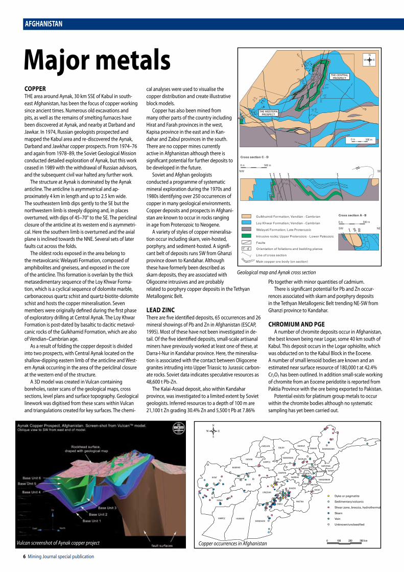
COPPErTHE area around Aynak, 30 km SSE of Kabul in south-east Afghanistan, has been the focus of copper working since ancient times. Numerous old excavations and pits, as well as the remains of smelting furnaces have been discovered at Aynak, and nearby at Darband and Jawkar. in 1974, russian geologists prospected and mapped the Kabul area and re-discovered the Aynak, Darband and Jawkhar copper prospects. From 1974–76 and again from 1978–89, the Soviet Geological Mission conducted detailed exploration of Aynak, but this work ceased in 1989 with the withdrawal of russian advisors, and the subsequent civil war halted any further work.
The structure at Aynak is dominated by the Aynak anticline. The anticline is asymmetrical and ap-proximately 4 km in length and up to 2.5 km wide. The southeastern limb dips gently to the SE but the northwestern limb is steeply dipping and, in places overturned, with dips of 45–70° to the SE. The periclinal closure of the anticline at its western end is asymmetri-cal. Here the southern limb is overturned and the axial plane is inclined towards the NNE. Several sets of later faults cut across the folds.
The oldest rocks exposed in the area belong to the metavolcanic Welayati Formation, composed of amphibolites and gneisess, and exposed in the core of the anticline. This formation is overlain by the thick metasedimentary sequence of the Loy Khwar Forma-tion, which is a cyclical sequence of dolomite marble, carbonaceous quartz schist and quartz-biotite-dolomite schist and hosts the copper mineralisation. Seven members were originally defined during the first phase of exploratory drilling at Central Aynak. The Loy Khwar Formation is post-dated by basaltic to dacitic metavol-canic rocks of the Gulkhamid Formation, which are also of vendian–Cambrian age.
As a result of folding the copper deposit is divided into two prospects, with Central Aynak located on the shallow-dipping eastern limb of the anticline and West-ern Aynak occurring in the area of the periclinal closure at the western end of the structure.
A 3D model was created in vulcan containing boreholes, raster scans of the geological maps, cross sections, level plans and surface topography. Geological linework was digitised from these scans within vulcan and triangulations created for key surfaces. The chemi-
cal analyses were used to visualise the copper distribution and create illustrative block models.
Copper has also been mined from many other parts of the country including Hirat and Farah provinces in the west, Kapisa province in the east and in Kan-dahar and Zabul provinces in the south. There are no copper mines currently active in Afghanistan although there is significant potential for further deposits to be developed in the future.
Soviet and Afghan geologists conducted a programme of systematic mineral exploration during the 1970s and 1980s identifying over 250 occurrences of copper in many geological environments. Copper deposits and prospects in Afghani-stan are known to occur in rocks ranging in age from Proterozoic to Neogene.
A variety of styles of copper mineralisa-tion occur including skarn, vein-hosted, porphyry, and sediment-hosted. A signifi-cant belt of deposits runs SW from Ghanzi province down to Kandahar. Although these have formerly been described as skarn deposits, they are associated with Oligocene intrusives and are probably related to porphyry copper deposits in the Tethyan Metallogenic Belt.
LEAd ZINCThere are five identified deposits, 65 occurrences and 26 mineral showings of Pb and Zn in Afghanistan (ESCAP, 1995). Most of these have not been investigated in de-tail. Of the five identified deposits, small-scale artisanal miners have previously worked at least one of these, at Darra-i-Nur in Kandahar province. Here, the mineralisa-tion is associated with the contact between Oligocene granites intruding into Upper Triassic to Jurassic carbon-ate rocks. Soviet data indicates speculative resources as 48,600 t Pb-Zn.
The Kalai-Assad deposit, also within Kandahar province, was investigated to a limited extent by Soviet geologists. inferred resources to a depth of 100 m are 21,100 t Zn grading 30.4% Zn and 5,500 t Pb at 7.86%
Pb together with minor quantities of cadmium. There is significant potential for Pb and Zn occur-
rences associated with skarn and porphyry deposits in the Tethyan Metallogenic Belt trending NE-SW from Ghanzi province to Kandahar.
ChrOmIUm ANd PgEA number of chromite deposits occur in Afghanistan,
the best known being near Logar, some 40 km south of Kabul. This deposit occurs in the Logar ophiolite, which was obducted on to the Kabul Block in the Eocene. A number of small lensoid bodies are known and an estimated near surface resource of 180,000 t at 42.4% Cr2O3 has been outlined. in addition small-scale working of chromite from an Eocene peridotite is reported from Paktia Province with the ore being exported to Pakistan.
Potential exists for platinum group metals to occur within the chromite bodies although no systematic sampling has yet been carried out.
major metals
85º
85º80º
60º
80º
10º
10º
50º
85º 23º
50º
55º60º
50º
67º
54º
75º
56º
50º 56º
60º
75º8045º
78º
80º
70º
50º80º
70º
60º80º
10º
70º
35º
50º63º
50º
70º
45º
65º82º65º
34º
75º80º
75º60º
75º
60º
88º70º
A
B
C
D
500 m0 m
N
S
EW
Cross section C - D
NW SE
0 m 500 m
Cross section A - B
SW NE
0 m 500 m
Faults
Line of cross section
Intrusive rocks; Upper Proterozoic - Lower Paleozoic
Gulkhamid Formation; Vendian - Cambrian
Loy Khwar Formation; Vendian - Cambrian
Welayati Formation; Late Proterozoic
Main copper ore body (on section)
Orientation of foliations and bedding planes
THE WESTERNPROSPECT
THE CENTRALPROSPECT
HIRAT
BADGHIS
FARYAB
JAWZJANBALKH
BAGHLAN
KUNAR
NANGARHAR
LAGHMANKAPISTA
BAMYAN
URUZGAN
GHOR
FARAH
NIMROZ HILMANDKANDAHAR
ZABUL
GHAZNI
WARDAK
KABUL
LOGAR
PAKTIKA
Dyke or pegmatite
Sedimentary/volcanic
Skarn
Vein
Unknown/unclassified
0 100 200 300 km
Shear zone, breccia, hydrothermal
PAKTYA
KHOST
PARWAN
TAKHAR
NURISTAN
BADAKHSHANKUNDUZ
SARIPUL
SAMANGAN
N
S
EW
Geological map and Aynak cross section
Vulcan screenshot of Aynak copper project Copper occurrences in Afghanistan

AFGHANISTAN
Mining Journal special publication �
AFGHANISTAN
gOLdGold has been worked intermittently in Afghanistan for centuries. in the past, gold has been mined in northern Afghanistan in Zabul province and in the southwest in Takhar, Ghazni and Kandahar provinces. Today, gold is worked almost solely from the Samti placer deposit in Zabul Province, by groups of artisanal miners.
There are 112 gold occurrences recorded throughout the country. Significant geological potential exists for the discovery of further gold mineralisation throughout the country and, although a considerable amount of systematic exploration has been conducted in the past, leading to the discovery of a number of gold deposits, Afghanistan has yet to be evaluated in the light of modern mineral deposit models and improved analytical methods. From a global perspective, Afghanistan is relatively under explored and the potential for the discovery of gold mineralisation is high.
Gold deposits and prospects in Afghanistan are known to occur in rocks ranging in age from Proterozoic to Neogene. A variety of styles of gold mineralisation occur, in particular skarn, vein hosted, porphyry and al-luvial. Several examples of other styles are also present.
Gold deposits, occurrences and showings discovered to date are the result of work conducted in the 1960s and 1970s, principally by russian geologists who identified two main prospective regions: the northeast provinces of Badakhshan and Takhar and the southern provinces of Ghanzi, Zabul and Kandahar. Further detailed work has not been completed since that time.
Skarn-type mineralisation occurs in association with Miocene granite porphyries in the south of Baghlan Province and in western Badghis Province at Ahankashan both within the North Afghanistan Platform (Tadjik Block). At Ahankashan, polymetallic mineralisation, with grades of up to 3.6% Cu and 5 g/t Au, occurs in pods and veinlets as well as shear zones. A number of skarn occurrences have also been identified in Badakhshan.
in southwestern and western Afghanistan, less is known about the geology but, the discovery of porphyry style mineralisation in neighbouring iran and Pakistan highlight the potential of the area for skarn style minerali-sation, given the general association between porphyry copper systems and gold-bearing skarns.
Above right: Geological map of AhankashanRight: Old artisanal workings at Samti
0 1 km
5º
5º
5º
5º
64º 20’ E
39º 40’ NN
Recent unconsolidated deposits
Limestone, marl, quartzose sandstone
Siltstone, sandstone, gravel limestonevolcanics
Acid dykes of diorite porphry, graniteand monzonite porphry
Granite porphry, granodiorite porphyry,and syenite porphry
Epidote-garnet-magnetite skarn
Magnetite-haematite-bearing skarn
Zones with molybdenum-coppermineralisation
Zones with gold mineralisation
Faults
Shatter zones
Strike and dip of beds

� Mining Journal special publication
AFGHANISTANAFGHANISTAN
UrANIUmAfghanistan formerly produced uranium from the mountains of Khawaja rawash, north of Kabul, after the discovery of deposits in 1983. Soviet engineers were also said to be mining uranium at Koh Mir Daoud, between Herat and Shindand, and also in the Khakriz area of Kanda-har province. very little information on this work is available but Afghanistan has a high potential for further discoveries.
IrONThere are nearly 100 ferrous metal occurrences recorded to date in Afghanistan. A number of different styles and ages of mineralisation are distributed across the country, including report-edly the largest un-mined iron oxide deposit in the Middle East region. Most exploration was completed in the 1960s and 1970s and, as such, these deposits are worthy of review in light of new geological models. Sulphide dissemina-tions, including chalcopyrite in some of the iron oxide deposits, may be of particular interest in the search for potential iron oxide-copper-gold-style mineralisation.
n Hajigak depositThe best known iron-oxide deposit in Afghani-stan is located about 100 km west of Kabul in Bamyan Province, although mineralisation of this style has been identified discontinuously in an east-west belt over 600 km from Herat to the Panjsher river. The iron-bearing formations are in a sequence of sedimentary and volcanic rocks of Proterozoic age. The deposit extends over 32 km and contains 16 separate zones, up to 5 km in length, 380 m wide and extending 550 m down dip, seven of which have been studied in detail. The ore occurs in both primary and oxidised states. The primary ore (80% of the deposit) occurs below 100-130 m and comprises magnetite and pyrite, with minor other sulphides including chalcopyrite, and averages 61.3% Fe, 5% sulphide and 0.05% P. The remaining 20% is oxidised and consists of three hematitic ore types at 62.8% Fe. The mineralisation is believed to be partly structurally controlled and related to Oligocene magmatism. russian estimates for the entire deposit are 1 700 Mt, although estimates for the near surface oxide ore in the most explored area are 85 Mt (Category A-C2). A feasibility study on the deposit was undertaken in 1972 by a Franco-German group and included the construction of a blast furnace. The availability of coking coal from the Dar-i-Suf district, not far to the north, makes this a viable proposal.
n Other iron-oxide depositsFour other deposits have been identified to date, although none have been explored to the same extent as at Hajigak. The largest is the Khaish deposit, also in Bamyan province, situated in the above-mentioned iron belt. The deposit contains five oxidised hematite-mag-netite orebodies of 100-300 m in length, 10-20 m thick and traced for 200 m down dip. Specula-tive estimates suggest that the deposit may contain up to 117 Mt, at a grade 48.6% Fe, up to 0.1% Ti and 0.019% Co. Two deposits have been discovered in Badakhshan province. The Furmurah and Syakh Jar deposits are both tabular skarn-style bodies occurring at the margins of Oligocene granitic plugs. The Furmuyrah deposit is a
massive magnetite body, up to 1,000 m in length and 2-35 m thick, assaying up to 67% Fe and with inferred resources of 35 Mt. Syakh Jar is a hematite-magnetite orebody, 150 m in length and 2.0-3.5 m thick. The Zerak deposit in Baghlan province occurs in a fault zone between Proterozoic greenstone volcanics and younger dolomites. Three hematite magnetite bodies of 90-450 m long long and 12-75 m thick have been identified, grading up to 62.5% Fe. Speculative resources are 20 Mt of iron ore.
minor metalsPEGMATiTES, known in eastern Afghanistan since ancient times, are exploited using small-scale surface excavations for precious stones such as kunzite, aquamarine and coloured tourmaline. The first attempt at rare-metal extraction was carried out from 1950-60 in the pegmatite fields at Dara-i-Nur where 130 t of beryl was extracted from open-cast mining of pegmatite veins. Subsequent exploration for beryl occurred at the Dara-i-Pech pegmatite field from 1963-64, and this work also identified the large pegmatite fields at Nilaw and Paron.
An extensive Soviet and Afghan exploration pro-
gramme throughout Afghanistan from 1971-74 iden-tifying three pegmatite fields in eastern Afghanistan and one in Oruzgan province. in eastern Afghanistan the fields are located in Nuristan, the Hindu-Kush and Badakhshan, and extend for 400, 180 and 150 km respectively, whilst the Oruzgan province field extends for over 200 km.
The exploration programme determined that rare-metal pegmatites in Afghanistan are predominantly spatially and genetically associated with Cretaceous-Palaeogene granites hosted within quartz-mica schist, gneiss, and gabbro-diorites. This programme also dis-covered a large number of pegmatites with concentra-tions of Li, Ta, Cs, Be, Sn, precious stones and piezo-opti-cal minerals that were of commercial interest and could potentially be worked. The most promising discoveries made were for lithium within the Paron pegmatite field and for tantalum within the Nilaw-Kulem field.
Widespread occurrences and showings of tungsten throughout Afghanistan including that at Farah ii emplaced in a brecciated zone associated with skarns and hornfels that grades up to 0.68% W. All known primary tin occurrences are associated with skarns, fault zones or pegmatites. Many of the latter type are also associated with tantalum, columbium, or lithium- bearing minerals.
Map of the Hajigak iron-ore deposits

AFGHANISTAN
Mining Journal special publication �
AFGHANISTAN
PrECiOUS and semi-precious gemstone deposits have been exploited in Afghani-stan for 6,500 years. They include emeralds, rubies, sapphires, semi-precious lapis lazuli, tourmaline, aquamarine, kunzite, topaz,
garnets, fluorite and varieties of quartz.All gemstone mining in Afghanistan is artisanal and
uses primitive methods often with recycled high explo-sives. This can lead to much waste and damage to the gems and results in low yield. Once mined many of the gemstones are exported illicitly. Low-value stones are cut for the domestic Pakistan market and the medium and high quality stones are sent to centres around the world for accurate cutting for the western markets. Unfortunately, this pattern of trade has meant that the Afghanistan economy has gained little from gemstones.
Annual production value is difficult to estimate but the World Bank believes the annual value of gems currently mined to be US$2.75 million. The true figure is, however, likely to be higher and could be as much as US$160 million if better techniques were instituted and if all known deposits were worked. The world trade in uncut coloured gemstones is estimated to be US$320 million. Afghanistan, with development, has a great opportunity to increase its share of this market. Afghanistan has a close historical and geographical proximity to india, the world’s largest coloured gemstones import market as well as an outlet for higher quality gems to the high-income countries of North America, Europe, East Asia and the Middle East.
EmErALdSThe emerald-bearing zone in the Panjsher valley occu-pies an area 16 km long by 3 km wide with the deposits at 3,000-4,000 m. The emeralds exhibit a rich green colour and can occur in crystals up to 100 carats in weight. They are found in quartz-ankerite veins cutting an altered gabbro, their clarity often rivaling better-known Columbian emeralds. Gem-quality crystals are up to 1 to 1.5 cm long and 2-3 mm thick and very rarely
up to 5 cm long and 2 cm wide. Production is thought to be valued at US$9-12 million although the true value is un-known. Emeralds are currently exported through Pakistan.
rUBIESrubies are found at Jegdalek-Gandamak in Kabul Province. They are colourless to a deep red, often purplish with strong fluorescence in ultraviolet ra-diation. True rubies form 15% of the production at Jegdalek; pink sapphires form 75% and blue sapphire 5%. The deposit occurs in a calcite dolomite marble bed 500-2,000 m thick within a regionally meta-morphosed marble cut by Oligocene granitic intrusions. Clean faceting quality rubies are rare but those that occur are of excellent quality and are said to match those from the very best source of rubies in the world at Mogok in Myanmar.
LAPIS LAZULILapis lazuli Badakhshan is still regarded as the world’s premier source in terms of quantity and quality. it is a rock composed of the feldspathoid minerals lazurite, hauyne, nosean, sodalite, calcite and pyrite. it is mined on the ‘Blue Mountain’ on the right bank of the Kokcha river. Nests and lenses of the dark blue lapis lazuli rock occur in a wide band of marbles underlain by gneiss. The mines, only above 3,300 m altitude, can only be worked between June and September. Production is thought to be around 9,000 kg/y with speculative
resources of 1,300 t.
SEmI-PrECIOUS gEmS frOm NUrISTANNuristan hosts one of the largest pegmatite fields in the world and yields a range of gems often of exceptional size and quality. Gem-quality tourmalines can be found up to 15 cm long and 4 cm in width and in a wide range of colours. Afghanistan is a major world supplier of kunzite, a pink variety of the mineral spodumene. Aquamarine is a light blue-greenish variety of beryl that has been mined near the village of Konar in Nuristan since the mid-1980s. it occurs in crystals up to 7.5 cm long, which are often of very clear gem quality.
OThEr gEm ANd mINErAL OCCUr-rENCESBlue sapphire recently has been reported from Wardak Province west of Kabul. Cut stones over 2 carats are known, though not in any great quantity. Kandahar fluorite is a well-known collector’s gemstone, particularly attractive and sought after are the blue and sea green varieties.
SUmmAryAfghanistan is a country very rich in gemstones but at the bottom of the value chain. increased security, recent changes to the legal framework for mining and the Afghan Government’s strategy for legitimising the mining sector will improve the prospects for investment and will increase standards and yields. Allied to the gradual development of Kabul as a centre for gem trade and the development within Afghanistan of value-added cutting and polish-ing centres, the country has the potential for a major internationally recognised gemstone industry.
gemstones
Rough emeralds
Lapis Lazuli

10 Mining Journal special publication
CONSTrUCTION mINErALSTHE post-conflict reconstruction and development in Afghanistan has created a strong indigenous demand for construction minerals throughout the country, especially in the capital, Kabul.
The booming construction market is currently dominated by military and donor-funded projects; there are also numerous commercial and residential construction projects such as new hotels, shopping malls, smaller retail outlets and private housing. The construction minerals used in Afghanistan are natural sand and gravel, crushed rock aggregate, dimen-sion stone, cement raw materials and clay for brick manufacture.
Natural sand and gravel is extracted from alluvial deposits, typically from active rivers, with little or no processing. Small-scale quarrying operations, such as along the Chelsetoon river, involve manual digging of pits with shovels and loading straight onto lorries. Larger-scale quarrying operations, for example in the Paghman river west of Kabul, involve extraction using front-end loaders and processing plants equipped with screens and crushers for oversize material. Crushed rock aggregate is produced from hard-rock (Proterozoic marble, gneiss, schist and amphibolite) quarries throughout the country. Often in these operations, a lack of production expertise and plant maintenance results in poor quality aggregate with an excessive proportion of flaky particles and lower strength.
Most cement used in Afghanistan is imported from Pakistan, with a small amount from iran and Uzbeki-stan. There are two state-owned cement plants, Ghuri Cement Factory in Pul-i-Khumri, Baghlan Province and Jabelseraj Cement Enterprise, 80 km north of Kabul in Jabelseraj district, Parwan Province. Both plants are operating well below their production capacity due to the age of the plant (both date from the late 1950s) and irregular power supply.
Sun-dried mud bricks are made and sold locally throughout Afghanistan. Fired bricks are made in Afghanistan and are also imported from Pakistan. The production of clay bricks has increased significantly over the last five years. Typically, clay is quarried in the vicinity of traditional wood-fired kilns, known as ‘Bhatas’, which are squat chimney shaped kilns. As well as the traditional brick kiln, Hoffman and chamber kilns are also used. Brick clay deposits are located mainly in the central and western areas of Afghanistan.
INdUSTrIAL mINErALSAfghanistan is well-endowed with a wide range of industrial minerals, which remain largely undeveloped and have enormous potential. The geographical loca-tion of Afghanistan is well suited for exporting these minerals to China, the indian sub-continent and the Persian Gulf.
Barytes is principally used in the manufacture of oil well drilling fluid where it acts as a weighting agent. it is also used as a source of barium in chemicals and ceram-ics. A high-grade deposit of barytes occurs at Sangilyan, 65 km northwest of Herat in western Afghanistan. The deposit contains some 1.5 Mt of barytes and has been worked previously on a small-scale. Barytes also occurs in an Ordovician lead-zinc carbonate deposit at Farenjal,
Parwan Province in central Afghanistan. This material has been used in the past in oil and gas exploration well drilling in the northern regions of Afghanistan. Celestite is used in the production of specialist glass and stron-tium chemicals. it occurs in Kunduz Province hosted by Palaeogene deposits, and consists of fine and medium-grained crystalline white and bluish-white celestite with a grade of 77 % in an estimated resource of 1 Mt.
Fluorspar is used in the manufacture of hydrofluoric acid, which in turn is used to manufacture a wide range of fluorocarbon chemicals used in products such as plastics and air conditioning units. An estimated 8.8 Mt of fluorspar (grade 46.7 % CaF2) occurs in a carbonate-hosted hydrothermal deposit at Bakhud in Oruzghan Province, central Afghanistan. The fluorspar mainly occurs as massive, thin veins or stockworks in a calcare-ous matrix.
There are numerous other small deposits of fluorspar in Oruzghan Province.
Gypsum is used primarily in the manufacture of construction materials such as cement and plaster. High-grade gypsum occurs in Upper Jurassic sedimen-tary sequences in Baghlan and Takhar provinces. in Nangarhar Province, there is currently a gypsum plaster factory located in Tatang village.
Talc is used mainly in the manufacture of ceramics, paint and cosmetics. High-grade talc occurs in lenses, pods and veins formed by the alteration of Proterozoic marbles by intermediate-basic igneous intrusions in Nangarhar Province. Working of the talc deposit in Ghunday is carried out by artisanal and small-scale miners. in Achin, Konar District, the talc occurs closely associated with magnesite; with estimated resources of 1.3 Mt talc and 31 Mt magnesite.
Other industrial mineral deposits and occurrences in Afghanistan include apatite, asbestos, ceramic raw ma-terials, graphite, mica, phosphorite, high-purity quartz, salt, silica sand, sulphur and speciality clays.
dImENSION STONESAlthough the size of the Afghan dimension stone in-dustry is largely unknown, there are at least 21 factories across the country mostly producing marble. The major-ity of marble is exported as rough hewn blocks and is often re-imported as higher value polished marble products, mostly from Pakistan.
The Afghan marble industry lacks proper equipment, has little technical knowledge and uses poor extraction methods, which often degrade the value of the marble. Extraction is typically carried out by blasting using black powder, which causes micro fracturing and results in high levels of wastage during both quarrying and processing stages.
Active marble quarries are located in Badakhshan, Balgh, Helmand, Herat, Kabul, Kandahar, Mayden Ward-ak and Nangarhar provinces. Proterozoic marble is con-sidered to be the highest quality for use as dimension stone. The Maydan marble mines are well known, with five working areas stretching over a 10-12 km distance. Here, they have worked a grey-dark grey Proterozoic marble for 40 years. The Proterozoic Kariz-Amir marble deposit (40 km north of Kabul) consists of granular white, rarely grey-yellow marble. The Silurian-Devonian Bini-Kama marble deposit (Badakhshan Province) consists of medium and coarsely crystalline marble with a resource estimate of 1,300 Mt. The Proterozoic Chesht-i-Sharif marble deposits (120 km east of Herat city) consists of a finely-crystalline white to a subtle light green marble. The Proterozoic Khogiani marble deposit (35 km SW of Jalalabad) consists of white marble.
Limestone is quarried in several locations for dimen-sion stone. The largest deposits are in Badakhshan Province, notably the Jamarchi-Bolo, Sabz and Bakunvij quarries. Limestone suitable for use as dimension stone also occurs in Herat, Baghlan and Parwan provinces. Tertiary (Eocene to Quaternary) aragonite deposits are also worked in Helmand Province.
Other mineralsAFGHANISTAN
Barytes: Afghanistan is well-endowed with a wide range of industrial minerals

Mining Journal special publication 11
AFGHANISTAN
A MODErN Minerals Law was passed by the islamic State of Afghanistan in July 2005. The Law has been drafted with the aid of the World Bank and conforms to current international standards. Work is due to
start soon on the preparation of the regulations, which will provide more detail about the processes of apply-ing for mineral rights. The new law contains transitional provisions to cover the period before the regulations are promulgated.
This article is a summary of the new law and should not be taken as a definitive statement. All mineral substances on or under the surface of the territory of Afghanistan are the exclusive property of the State. The Mining Law covers all naturally occurring mineral substances and artificial deposits, such as tailings and waste deposits, but not hydrocarbons and water, which are regulated by separate laws and excluded from this legislation.
The principal role of the State is to promote the efficient development of the minerals industry by the private sector. State bodies can participate in mineral activities but only in accordance with the law. The Ministry of Mines and industries is responsible for the administration and implementation of this law. it is planned that the Ministry will create Mining Cadastre, Mining inspectorate and Environmental Protection Departments this year to oversee its responsibilities for the mining sector. The Mining Cadastre Department will be responsible for accepting applications for mineral rights, coordinating their technical and environmen-tal evaluation, processing renewals and collecting application and surface right fees. They will also keep a national registry of mineral rights, and create and maintain the cadastral map using modern database and GiS technology. The first-come first-served principle will be applied and the Ministry has an obligation to apply the law in a transparent and open manner.
Citizens, legal associations and companies registered
in Afghanistan are eligible to apply for mineral rights, and foreign citizens who have legal right of residence and foreign companies with a registered local office can also apply. Government employees, civil servants and members of the armed forces are not eligible.
importantly, the law also includes a section on investment security, allowing the Ministry to provide assurances to the holder of a mineral right, protecting them against any financial consequences of subsequent
changes in legislation. The State can also not expropri-ate Mineral rights without adequate and effective compensation in accordance with international norms. Mineral rights are divided into licences, issued for met-als, industrial minerals, ornamental stones and gems and authorisations, issued for quarry and construction minerals.
Exploration licences can extend for up to 250 km2 and are issued for an initial period of three years with two renewals of three years. A reduction in area of at least 25% is required on each renewal. Holders of exploration rights have the automatic right to apply for an exploitation licence if they discover an economic deposit. These cover an area of up to 50 km2 and last for up to 30 years with 5-year renewals up to the life of the mine. Conditions for granting of the exploitation licence are: evidence of financial capability and completed
feasibility studies; development plans; environmental and social impact assessments; and an environmental management plan including a social mitigation plan, rehabilitation and mine closure plans. Both licences give exclusive rights to the area covered, but with the holder’s permission they can overlap with quarry authorisations.
Small-scale exploitation licences can also be granted for small mines using semi-industrial methods. Prospecting, which is defined as surface geological exploration and aerial or remote sensing, does not need a mineral right but must be registered with the Ministry. it is non-exclusive and conveys no prior rights to a mineral right.
Quarry materials are defined as non-metallic mineral substances, which can be used for building, road making, general construction purposes, ceramic clays, lime, cement and crushed rock. Quarry authorisations are issued for exploration, exploitation, temporary exploitation and tailings exploitation. Details of the extent and duration of these rights are given in the law. Authorisations are also issued for artisanal exploitation, which may cover mineral substances including metals and gems. Trading and exporting minerals, where not carried out by the producer, also needs authorisation from the Ministry of Mines and industries.
The rates of mineral royalties given in the law and range from 5% of gross revenue for industrial minerals up to 10% for gemstones. Other fees for applications and surface rights will be defined in the regulations. Special provision is made in the law for public tenders and mining contracts. Public tenders will be used to award mineral rights on sufficiently well known depos-its, such as the Aynak copper deposit. Mining contracts may also be agreed with mining companies for large deposits and these will supplement but not contradict the Minerals Law. Such contracts will allow for special provisions outside the Minerals Law, such as taxation and customs. Further details are provided in the law.
minerals Law
Key contacts
Minister of MinesThe Hon. Eng. ibrahim AdelPashtoonistan WattPO Box 291KabulAfghanistanAfghan cell phone: +93 70 225897 and +93 799 863258E-mail: [email protected] and [email protected]
British Geological Survey Afghanistan Project LeaderKabul OfficeShawr-e-NawKabulAfghan cell phone: +93 799 136140E-mail: [email protected]: http://www.bgs.ac.uk/afghanminerals
Senior mining geologist advisor to the Minister of MinesMr James r yeagerAfghan cell phone: +93 799 661797US Tel: +1 303 921-2587E-mail: [email protected]
Afghanistan Investment Support Agency (AISA)AiSA is responsible for the registration, licensing and promotion of all new invest-ments in AfghanistanE-mail: [email protected]; [email protected]: http://www.aisa.org.af/
Afghan Information Management Service (AIMS)This is a good source of free-to-download maps of Kabul and the rest of AfghanistanE-mail: [email protected]: http://www.aims.org.af/
“The principal role of the State is to promote the
efficient development of the minerals industry by
the private sector.”

Published by:Mining Communications LtdAlbert House, 1 Singer StreetLondon EC2A 4BQTel: +44 (0)20 7216 6060 Fax: +44 (0)20 7216 6050E-mail: [email protected] Website: www.mining-journal.com
Supplement editor: Peter McCreadyDesign and production: Simon SmithPrinted by Stephens & George, Merthyr Tydfil, UK© Mining Communications Ltd 2006