Ätrike and dip of joints - The Nevada Seismological...
1
PRELIMINARY GEOLOGIC MAP OF THE WEST HALF OF THE HAZEN QUADRANGLE, LYON AND CHURCHILL COUNTIES, NEVADA James E. Faulds and Alan R. Ramelli 2009 OPEN-FILE REPORT 09-11 PRELIMINARY GEOLOGIC MAP OF THE WEST HALF OF THE HAZEN QUADRANGLE, LYON AND CHURCHILL COUNTIES, NEVADA Prepared as part of the STATEMAP component of the National Cooperative Geologic Mapping Program in cooperation with the U.S. Geological Survey Symbology (per FGDC-STD-013-2006) NEVADA BUREAU OF MINES AND GEOLOGY Tl Qfbls Qa Qx Tb Tb Qay Tg Qsmb Tg Tbu Qsmb Tb Qsm Qx Qa Qsmb Qsmd Qsm Tby Qx Tb Tb Qfb Qsu Qsmb Tg Tsc Qsu Qa Tb Tb Tb Qe Qm Qfy Qsmd Qsm Tb Qa Tb Tb Qa Qsmb Qfy2 Qfw Qe Tb Tg Qfp Qsmb Tb Tg Tb Qfb Qfy2 Qfb Tb Tb Qfy1 Qa Qfw Qsmb Qsm Tg Tg Qfw Qfy2 Qa Qay Qe Qsp Tb Qfy1 Qfp Tb Qf Qfe Qfb Qx Qsmb Tby Qsmt Qfy1 Qf Tb Qsmt Qa Qe Tb Qfw Qay Qx Qsmb Qsmb Tg Tl Qfy Qsms Tds Qfy2 Qfy2 Tb Tb Qsu Qsms Tb Qfy2 Qfw Qay Qfy Qsu Qfy Qay Qfw Qf Tg Qfy2 Qsu Tg Qfy Qfy Tby Qfb Qfy Qfw Qess Tbu Qsmb Tb Tb Tb Qsu Qa Qsmb Qay Tb Qfp Tl Qfw Qsm Qfy1 Qsm Tb Qsu Qfb Tb Qf Tb Qay Qfw Qsm Qsms Qa Qsm Qfy Qsms Tb Qfy Qa Tg Tby Qa Qf Qfy Qm Tds Qsm Qfp Tb Qfb Tg Qfp Qfb Tg Qfy Qsm Qsmb Tb Tl Qsmd Qfw Qfy Tl Qfy Tb Qsmb Tss Tb Qfw Qemd Tbu Qf Tb Qfp Qsu Tb Tg Tb Qsmb Tb Qm Qsp Tb Qsmb Tds Qsmb Tl Qfb Qfw Qsu Tds Tby Qfp Qfy Qfy1 Tds Qsms Qfy Tb Tg Qfb Qfy1 Qfy Qf Tbcg Tb Tb Tds Tb Tb Qfw Tl Tl Qsmb Qc Tg Qfy Qfy Qsmb Qp Qsi Tds Tg Qsu Qfb Qsu Qfy Qfp Qsu Tsc Tb Qfy Qsm Qfy Qfy Qsu Qf Tl Qfb Qfy2 Qay Qfw Qa Qfy Qsmb Qsm Tds Qsu Qf Tl Qsmt Tl Tds Qfy2 Tl Qfy Qfy Qay Tg Tgdb Qx Qfp Tb Qfy Qay Qc Well Well Well Well Well 7 9 5 6 5 8 7 8 43 50 30 49 31 47 26 48 13 33 31 32 34 22 42 77 43 54 39 26 52 38 33 73 12 13 53 40 49 26 35 24 23 43 32 62 20 63 45 18 36 40 29 24 32 40 40 38 33 30 31 40 33 32 36 37 41 68 58 57 70 80 18 59 65 67 15 25 10 15 28 46 17 22 18 29 41 19 25 19 44 48 33 39 52 30 14 13 55 30 32 30 19 24 38 16 20 15 10 10 13 60 14 20 74 38 37 28 32 25 67 20 50 29 27 43 55 57 33 49 17 68 19 25 37 18 11 15 11 10 35 41 54 25 50 26 13 17 10 25 17 18 17 18 15 25 30 44 31 35 76 41 32 35 72 55 17 70 35 32 71 43 60 57 59 60 38 68 53 40 33 33 11 56 53 60 24 30 69 16 39 64 25 53 30 15 38 19 15 27 64 29 56 57 21 25 32 28 21 15 17 46 45 34 44 39 54 42 41 33 46 31 35 Well 18 3 18 000m. E 19 19 3 20 3 20 21 21 22 22 23 23 24 24 25 25 26 26 27 27 28 28 74 43 75 000m. N 75 76 76 77 77 78 78 79 79 43 80 43 80 81 81 82 82 83 83 84 84 85 85 86 86 87 87 88 Projection: Universal Transverse Mercator, Zone 11, North American Datum 1927 (m) Base map: U.S. Geological Survey Hazen 7.5' Quadrangle (1985) Field work done in 2008-2009 Supported by the U.S. Geological Survey STATEMAP Program (Agreement No. 08-HQ-AG-0053) DRAFT Preliminary geologic map Has not undergone office or field review Will be revised before publication Compilation by James E. Faulds and Alan R. Ramelli Cartography and map production in ESRI ArcGIS v9.3 (ArcGeology v1.3) by Matthew Richardson and Irene Seeley First Edition, October 2009 Printed by Nevada Bureau of Mines and Geology This map was printed on an electronic plotter directly from digital files. Dimensional calibration may vary between electronic plotters and X and Y directions on the same plotter, and paper may change size; therefore, scale and proportions may not be exact on copies of this map. For sale by: Nevada Bureau of Mines and Geology 2175 Raggio Pkwy. Reno, Nevada 89512 ph. (775) 784-6691, ext. 2 www.nbmg.unr.edu; [email protected] 2108 Scale 1:24,000 CONTOUR INTERVAL 10 METERS kilometer 0 0.5 1 mile 0 0.5 1 feet 0 1000 2000 3000 4000 5000 1 Two Tips 2 Eagle Rock 3 Soda Lake NW 4 Fernley East 5 Hazen 6 Soda Lake West 7 Silver Springs North 8 Lahontan Dam 9 Sheckler Reservoir Map location 119 o 07’ 30” W 39 o 37’ 30” N 119 o 00’ 00” W 39 o 30’ 00” N 119 o 07’ 30” W 39 o 30’ 00” N 119 o 00’ 00” W 39 o 37’ 30” N Contact Long-dashed where approximate, short-dashed where inferred, queried if identity or existence uncertain. Normal fault Long-dashed where approximate, dotted where concealed; queried if identity or existence uncertain. Showing dip; Ball on downthrown side. : ? ? Tl Tt Qf Tg Tb Tst Qx Qc Tsr Qe Qa Qp Tql Tdl Tbi Tsc Qsi Tcv Tss Qfy Qm Qfp Qfe Tyb Qfb Tds Tby Tbu Tba Tbb Qfw Qsp Qsu Qay Tsds Qsm Qfy2 Qfy1 Tdss Tbcg Tgdb Tpba Qess Qsmt Qsub Qsms Qsmg Qsmd Qsmb Qemd Qsmss Other Units Calcite veins (late Miocene) MIOCENE INTRUSIONS Colluvial deposits Mine waste (recent) QUATERNARY DEPOSITS Tephra (late Miocene) Siltstone (late Miocene) Limestone (late Miocene) Spring deposits (recent) Silicified muds and silts Quaternary Lacustrine Deposits Basaltic breccia (late Miocene) MIOCENE - EARLY PLIOCENE STRATA Anthropogenic deposits (recent) Piedmont and Hillslope Deposits Basalt intrusions (late Miocene) Basaltic andesite (late Miocene) Diatomaceous shale (late Miocene) Alluvial fan deposits (undivided) Siltstone and tuffs (late Miocene) Basaltic conglomerate (late Miocene) Middle Sehoo member (late Pleistocene) Altered yellowish basalt (late Miocene) Young alluvial fan deposits (undivided) Playa deposits (recent to late Holocene) Eetza member (late? to middle Pleistocene) Porphyritic basaltic andesite (late Miocene) Silicified diatomaceous shale (late Miocene) Young alluvial flat deposits (late Holocene) Younger aphanitic basalt lavas (late Miocene) Eolian reworked diatomite mine waste (recent) Aphanitic basalt lavas and breccia (late Miocene) Basalt-dominated alluvial fan deposits (undivided) Massive, commonly tuffaceous sandstone (late Miocene) Middle Sehoo member, tufa deposits (late Pleistocene) Middle Sehoo member, silt deposits (late Pleistocene) Upper Sehoo member, beach deposits (late Pleistocene) Young alluvial fan deposits (late to middle Holocene) Silicified ledges, commonly jasperoidal (late Miocene) Middle Sehoo member, beach deposits (late Pleistocene) Young alluvial fan deposits (middle to early Holocene) Middle Sehoo member, gravel deposits (late Pleistocene) Upper Sehoo member (early Holocene? to late Pleistocene Middle Sehoo member, silicified sands (late Pleistocene) Diatomaceous shale, limestone, and siltstone (late Miocene) Roundstone fluvial gravels (late Miocene to early Pliocene) Eetza member, silicified sands (late? to middle Pleistocene) Alluvium in recently active washes (late Holocene to historic) Diatomaceous shale and lesser sandstone, siltstone (late Miocene) Basalt lavas and lesser sedimentary rocks, undivided (late Miocene) Sandstone and lesser fluvial gravels (late Miocene to early Pliocene) Middle Sehoo member, tufa capped dendritic terrace (late Pleistocene) Eolian deposits of the Fallon alloformation (late to middle Holocene) Alluvial fan deposits of the Wyemaha alloformation (late Pleistocene) Alluvial fan deposits of the Paiute alloformation (middle to early Pleistocene) Roundstone gravels with abundant large dacite boulders (late Miocene to early Pliocene) Adjoining 7.5' quadrangle names 1 2 4 6 7 3 5 8 9 Strike-slip fault Dotted where concealed. Arrows show relative motion. $ Strike and dip of foliation in igneous rocks Inclined ¦ 33 Strike and dip of bedding Inclined o 41 Strike and dip of joints Ä Vertical Former shoreline Long-dashed where approximate. I I I I I I I I I I Spring A Tufa mound k Geothermal well Well
Transcript of Ätrike and dip of joints - The Nevada Seismological...
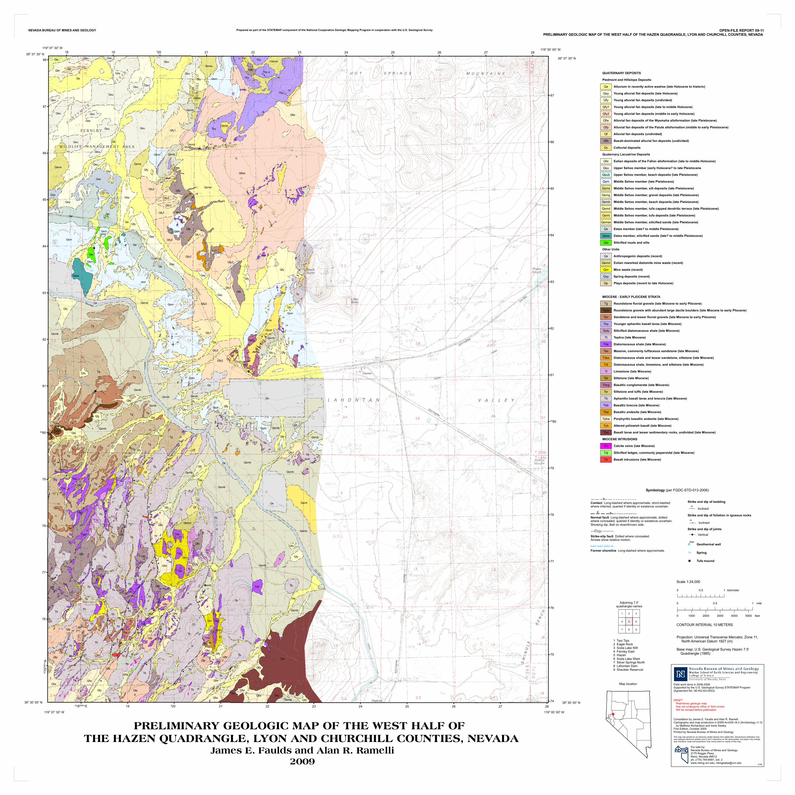
PRELIMINARY GEOLOGIC MAP OF THE WEST HALF OF THE HAZEN QUADRANGLE, LYON AND CHURCHILL COUNTIES, NEVADA
James E. Faulds and Alan R. Ramelli2009
OPEN-FILE REPORT 09-11PRELIMINARY GEOLOGIC MAP OF THE WEST HALF OF THE HAZEN QUADRANGLE, LYON AND CHURCHILL COUNTIES, NEVADA
Prepared as part of the STATEMAP component of the National Cooperative Geologic Mapping Program in cooperation with the U.S. Geological Survey
Symbology (per FGDC-STD-013-2006)
NEVADA BUREAU OF MINES AND GEOLOGY
Tl
Qfbls
Qa
Qx
Tb
Tb
Qay
Tg
Qsmb
Tg
Tbu
Qsmb
Tb
QsmQx
Qa
Qsmb
Qsmd
Qsm
Tby
Qx
Tb
Tb
Qfb
Qsu
Qsmb
Tg
Tsc
Qsu
Qa
Tb
Tb
Tb
Qe
Qm
Qfy
Qsmd
Qsm
Tb
Qa
Tb
Tb
Qa
Qsmb
Qfy2
Qfw
Qe
Tb
Tg
Qfp
Qsmb
Tb
Tg
Tb
Qfb
Qfy2
Qfb
Tb
Tb
Qfy1
Qa
Qfw
Qsmb
Qsm
Tg
Tg
Qfw
Qfy2
Qa
Qay
Qe
Qsp
Tb
Qfy1
Qfp
Tb
Qf
Qfe
Qfb
Qx
Qsmb
Tby
Qsmt
Qfy1
Qf
Tb
Qsmt
Qa
Qe Tb
Qfw
Qay
Qx
Qsmb
Qsmb
Tg
Tl
Qfy
Qsms
Tds
Qfy2
Qfy2
Tb
Tb
Qsu
Qsms
Tb
Qfy2
Qfw
Qay
Qfy
Qsu
Qfy
Qay
QfwQf
Tg
Qfy2
Qsu
Tg
Qfy
Qfy Tby
Qfb
Qfy
Qfw
Qess
Tbu
Qsmb
Tb
Tb
Tb
Qsu
Qa
Qsmb
Qay
TbQfp
Tl
Qfw
Qsm
Qfy1
Qsm
Tb
Qsu
Qfb Tb
Qf
Tb
Qay
Qfw
Qsm
Qsms
Qa
Qsm
Qfy
Qsms
Tb
Qfy
Qa
Tg
Tby
Qa
Qf
Qfy
Qm
Tds
Qsm
QfpTb
Qfb
Tg
Qfp
Qfb
TgQfy Qsm
Qsmb
Tb
Tl
Qsmd
Qfw
Qfy
Tl
Qfy
Tb
Qsmb
Tss
Tb
Qfw
Qemd
Tbu
Qf
Tb
Qfp
Qsu
Tb
Tg
Tb
Qsmb
TbQm
Qsp
TbQsmb
Tds
Qsmb
Tl
Qfb
Qfw
Qsu
Tds
Tby
Qfp
Qfy
Qfy1
Tds
Qsms
Qfy
Tb
Tg
Qfb
Qfy1
Qfy
Qf
Tbcg
Tb
Tb
Tds
Tb
Tb
Qfw
Tl
Tl
Qsmb
Qc
Tg
Qfy
Qfy
Qsmb
Qp
Qsi
Tds
Tg
Qsu
Qfb
Qsu
Qfy
Tby
Qfp
Qsu
Tsc
Tb
Qfy
Qsm
Qfy
Qfy
Qsu
Qf
Tl
Qfb
Qfy2
Qay
Qfw
Qa
Qfy
Qsmb
Qsm
Tds
Qsu
Qf
Tl
Qsmt
Tl
Tds
Qfy2
Tl
Qfy
Qfy
Qay
Tg
TgdbQx
Qfp
Tb
Qfy
Qay Qc
Well
Well
Well
Well
Well
7
9
5
6
5
8
7
8
43
50
30
49
31
47
2648
13
3331
3234
2242
77
43
54
39
26
5238
33
73
12
13
53
4049
26
35
24
23
43
32
62
2063
4518
36
40
29
2432 40
4038
33 30
3140
33
32
36
3741
68
58
57
70
80
18
59
65
67
15
25
10
1528
4617
2218
294119
25
19
4448
33
3952
30
141355
30
3230
19
24 38
16
20
15
10
10
1360
14
207438
37
28
32
25
67
2050
29
27
43
5557
33
49
17
6819
25
37
18
11
15
11 10
35
41
54
25
50
26
13
17
10
2517
18
17
18
1525
30
44
31
35
76
41
3235
7255
17
70
35
32
71
43
60
57 59
60 38
68534033
33
11
56
53
60
24
3069
16
3964
2553
3015
38
19
15
27
64
295657
21
25
32
28
21
15
17
4645 34
4439
5442
4133
46 31
35
Well
18
318000m.E
19
19
320
320
21
21
22
22
23
23
24
24
25
25
26
26
27
27
28
2874
4375
000m
. N
75
76
76
77
77
78
78
79
79
4380
4380
81
81
82
82
83
83
84
84
85
85
86
86
87
87
88
Projection: Universal Transverse Mercator, Zone 11, North American Datum 1927 (m)Base map: U.S. Geological Survey Hazen 7.5' Quadrangle (1985)
Field work done in 2008-2009Supported by the U.S. Geological Survey STATEMAP Program (Agreement No. 08-HQ-AG-0053)
DRAFT Preliminary geologic map Has not undergone office or field review Will be revised before publication
Compilation by James E. Faulds and Alan R. RamelliCartography and map production in ESRI ArcGIS v9.3 (ArcGeology v1.3) by Matthew Richardson and Irene SeeleyFirst Edition, October 2009Printed by Nevada Bureau of Mines and GeologyThis map was printed on an electronic plotter directly from digital files. Dimensional calibration may vary between electronic plotters and X and Y directions on the same plotter, and paper may change size; therefore, scale and proportions may not be exact on copies of this map.
For sale by: Nevada Bureau of Mines and Geology 2175 Raggio Pkwy. Reno, Nevada 89512 ph. (775) 784-6691, ext. 2 www.nbmg.unr.edu; [email protected] 2108
Scale 1:24,000
CONTOUR INTERVAL 10 METERS
kilometer0 0.5 1
mile0 0.5 1
feet0 1000 2000 3000 4000 5000
1 Two Tips2 Eagle Rock3 Soda Lake NW4 Fernley East5 Hazen6 Soda Lake West7 Silver Springs North8 Lahontan Dam9 Sheckler Reservoir
Map location
119o 07’ 30” W39o 37’ 30” N
119o 00’ 00” W
39o 30’ 00” N
119o 07’ 30” W
39o 30’ 00” N
119o 00’ 00” W
39o 37’ 30” N
Contact Long-dashed where approximate, short-dashed where inferred, queried if identity or existence uncertain.
Normal fault Long-dashed where approximate, dotted where concealed; queried if identity or existence uncertain. Showing dip; Ball on downthrown side.
: ?
?
Tl
Tt
Qf
Tg
Tb
Tst
Qx
Qc
Tsr
Qe
Qa
Qp
Tql
Tdl
Tbi
Tsc
Qsi
Tcv
Tss
Qfy
Qm
Qfp
Qfe
Tyb
Qfb
Tds
Tby
Tbu
TbaTbb
Qfw
Qsp
Qsu
Qay
Tsds
Qsm
Qfy2Qfy1
Tdss
Tbcg
Tgdb
Tpba
Qess
Qsmt
Qsub
QsmsQsmg
QsmdQsmb
Qemd
Qsmss
Other Units
Calcite veins (late Miocene)MIOCENE INTRUSIONS
Colluvial deposits
Mine waste (recent)
QUATERNARY DEPOSITS
Tephra (late Miocene)
Siltstone (late Miocene)Limestone (late Miocene)
Spring deposits (recent)
Silicified muds and silts
Quaternary Lacustrine Deposits
Basaltic breccia (late Miocene)
MIOCENE - EARLY PLIOCENE STRATA
Anthropogenic deposits (recent)
Piedmont and Hillslope Deposits
Basalt intrusions (late Miocene)
Basaltic andesite (late Miocene)
Diatomaceous shale (late Miocene)
Alluvial fan deposits (undivided)
Siltstone and tuffs (late Miocene)Basaltic conglomerate (late Miocene)
Middle Sehoo member (late Pleistocene)
Altered yellowish basalt (late Miocene)
Young alluvial fan deposits (undivided)
Playa deposits (recent to late Holocene)
Eetza member (late? to middle Pleistocene)
Porphyritic basaltic andesite (late Miocene)
Silicified diatomaceous shale (late Miocene)
Young alluvial flat deposits (late Holocene)
Younger aphanitic basalt lavas (late Miocene)
Eolian reworked diatomite mine waste (recent)
Aphanitic basalt lavas and breccia (late Miocene)
Basalt-dominated alluvial fan deposits (undivided)
Massive, commonly tuffaceous sandstone (late Miocene)
Middle Sehoo member, tufa deposits (late Pleistocene)
Middle Sehoo member, silt deposits (late Pleistocene)
Upper Sehoo member, beach deposits (late Pleistocene)
Young alluvial fan deposits (late to middle Holocene)
Silicified ledges, commonly jasperoidal (late Miocene)
Middle Sehoo member, beach deposits (late Pleistocene)
Young alluvial fan deposits (middle to early Holocene)
Middle Sehoo member, gravel deposits (late Pleistocene)
Upper Sehoo member (early Holocene? to late Pleistocene
Middle Sehoo member, silicified sands (late Pleistocene)
Diatomaceous shale, limestone, and siltstone (late Miocene)
Roundstone fluvial gravels (late Miocene to early Pliocene)
Eetza member, silicified sands (late? to middle Pleistocene)
Alluvium in recently active washes (late Holocene to historic)
Diatomaceous shale and lesser sandstone, siltstone (late Miocene)
Basalt lavas and lesser sedimentary rocks, undivided (late Miocene)
Sandstone and lesser fluvial gravels (late Miocene to early Pliocene)
Middle Sehoo member, tufa capped dendritic terrace (late Pleistocene)
Eolian deposits of the Fallon alloformation (late to middle Holocene)
Alluvial fan deposits of the Wyemaha alloformation (late Pleistocene)Alluvial fan deposits of the Paiute alloformation (middle to early Pleistocene)
Roundstone gravels with abundant large dacite boulders (late Miocene to early Pliocene)
Adjoining 7.5'quadrangle names
1 2
4 6
7
3
5
8 9
Strike-slip fault Dotted where concealed. Arrows show relative motion.
$
Strike and dip of foliation in igneous rocksInclined¦33
Strike and dip of beddingInclinedo41
Strike and dip of jointsÄVertical
Former shoreline Long-dashed where approximate.I I I I I I I I I I
SpringATufa moundk
Geothermal wellWell

![O] information on triglyceride (TG) species, such as TG ...](https://static.fdocuments.us/doc/165x107/62cb3c5f42d02721c85055e4/o-information-on-triglyceride-tg-species-such-as-tg-.jpg)