Aerospatial remote sensing as catalyst of an operational...
12
INT. J. REMOTE SENSING, 1991, VOL. 12, NO. 4,713-724 Aerospatial remote sensing as catalyst of an operational marine fishery (halieutic) science M. PETIT Centre ORSTOM B.P. 5045, 34032 Montpellier Cedex, France Abstract. A brief balance of the attainments and limits in the modern halieutic (fishery biology and economy) field is stricken and shows off the gap between the present management structure and the present problems. The surface tuna fishery case is thoroughly studied, considering its specificity and its economical impor- tance. From there, it appears that conclusive strides will be made by halieutic science through the knowledge of the relationship between tuna and its environ- ment. Some tuna environment studies are presented through typical remote sensing examples and introduce the basis of a coherent theory of tuna behaviour which can be schematically summarized by this basic general hypothesis; namely, that if tuna are present in a zone they will be inclined to aggregate close to any anomalies (gradients) of parameters in their environmental sensing field. From there, several models are presented in order to assess or forecast surface tuna stocks. A second part analyses the potential and contribution of the aerospatial remote sensing in the halieutic field through several original exampleswhich point out clearly that this technique is one of the only tools able to visualize some essential concepts in oceanography and halieutic science. Last, we propose a study in several countries within the framework of several activities to integrate remote sensing tools in the fishery management structure, and to establish the data acquisition system in remote sensing satellites. From this study, a true operational halieutic field can be created. 1. Introduction In the most concrete and the most general meaning of the word, a fishery is just a zone in the ocean, found by fishermen, where there exists a spatial and/or temporal concentration of living substances, a sÚpply of nëcessary proteins or gastronomic ingredients, or currency. The halieutic science or fisheries theory is the science which searches for optimization tools for the efficiency of these -fisheries. So, halicutic science includes fishery biology and economics. 2. The problem 2.1. Brief assessment of inputs and problems in inoderri halieutic science Before introducing the operational halieutic concept, it is necessary to draw up a short and very schematic table of fishery exploitation mechanisms to diagnose the status of fisheries methods. The behaviour of fishermen, who are more or less encouraged by the lack of legal restraint does not change, so the fishery is very often ruthlessly exploited. While the increase in fishing was, at most, proportional to the increase of qatches this was not of great importance, but for many fisheries in the last fifty years, the increase of fishing has clearly surpassed the increase in catch and in many cases we have seen production 0143-1161/91 $3.00 0 1991 Taylor Francis Ltd ORSTOM Fonds Documentaire Nok 3EsoAG 23 MA\ 1991 Cote 20 B I UA- gta
Transcript of Aerospatial remote sensing as catalyst of an operational...
INT. J. REMOTE SENSING, 1991, VOL. 12, NO. 4,713-724
Aerospatial remote sensing as catalyst of an operational marine fishery (halieutic) science
M. PETIT Centre ORSTOM B.P. 5045, 34032 Montpellier Cedex, France
Abstract. A brief balance of the attainments and limits in the modern halieutic (fishery biology and economy) field is stricken and shows off the gap between the present management structure and the present problems. The surface tuna fishery case is thoroughly studied, considering its specificity and its economical impor- tance. From there, it appears that conclusive strides will be made by halieutic science through the knowledge of the relationship between tuna and its environ- ment. Some tuna environment studies are presented through typical remote sensing examples and introduce the basis of a coherent theory of tuna behaviour which can be schematically summarized by this basic general hypothesis; namely, that if tuna are present in a zone they will be inclined to aggregate close to any anomalies (gradients) of parameters in their environmental sensing field. From there, several models are presented in order to assess or forecast surface tuna stocks. A second part analyses the potential and contribution of the aerospatial remote sensing in the halieutic field through several original examples which point out clearly that this technique is one of the only tools able to visualize some essential concepts in oceanography and halieutic science. Last, we propose a study in several countries within the framework of several activities to integrate remote sensing tools in the fishery management structure, and to establish the data acquisition system in remote sensing satellites. From this study, a true operational halieutic field can be created.
1. Introduction In the most concrete and the most general meaning of the word, a fishery is just a
zone in the ocean, found by fishermen, where there exists a spatial and/or temporal concentration of living substances, a sÚpply of nëcessary proteins or gastronomic ingredients, or currency. The halieutic science or fisheries theory is the science which searches for optimization tools for the efficiency of these -fisheries. So, halicutic science includes fishery biology and economics.
2. The problem 2.1. Brief assessment of inputs and problems in inoderri halieutic science
Before introducing the operational halieutic concept, it is necessary to draw up a short and very schematic table of fishery exploitation mechanisms to diagnose the status of fisheries methods.
The behaviour of fishermen, who are more or less encouraged by the lack of legal restraint does not change, so the fishery is very often ruthlessly exploited. While the increase in fishing was, at most, proportional to the increase of qatches this was not of great importance, but for many fisheries in the last fifty years, the increase of fishing has clearly surpassed the increase in catch and in many cases we have seen production
0143-1161/91 $3.00 0 1991 Taylor Francis Ltd ORSTOM Fonds Documentaire N o k 3 E s o A G
23 MA\ 1991 Cote 2 0 B I UA- gta
714 ' M. Petit
collapse for lack of stabilization. Consequently, there are a number of economic problems which generally generate some management laws without scientific basis, a call for scientific proposals, and eventually new laws arising from the first results of scientific programmes.
We may note that this scheme, in spite of its extreme simplification, remains even now very general indeed. Fisheries which adopt scientific management are rare, relatively recent and operate in traditionally unexploited zones for harvested species; for example, shrimps in the Persian Gulf or lobster in Western Australia.
By analogy with the terrestrial ecosystems laws, it has been possible to find the parameters-the symptoms-of the fishery state in considering the marine ecosystem characteristics; far example, the very high natural mortality rate (egg number is very often important). Because the goal of research is to evaluate the stock level, the population dynamics experts have elaborated the concept of the fishery unit or population (Laurec and Le Guen 1981) relatively independent of external events (isolation criterion) and without subpopulations having very different characteristics (homogeneity criterion). To assess the population abundance, it is necessary to know or to estimate the following data, which can be classified into three groups:
(1) (a) species distribution field, statistical catches, and unit effort. To determine, for example, whether there could be two populations within two fields, or whether the same stock could be exploited by two different fisheries.
(b) data about size (age) composition of catches.
(b) biology and physiology characteristics. (2) (a) spawning zones,
(3) the species behaviour in its environment.
Research efforts have developed in different ways, thereby generating a separation between the studies and the experts.
For thirty years, mathematical investigations and computer technology have encouraged models which try to find the mathematical equation (E) to express the relation between recruitment, growth, natural mortality and fishing mortality (Bever- ton and Holt 1957, Diemientieva 1971, Laurec and Le Guen 1981). Generally, fishery data and tag data are used. For each piece of research in a new field, the marine population dynamics gave outstanding results and allowed the diagnosis of the status and productive capacities of fisheries. However, like the deductions based on recent ecological information made by Dickie et al. (1987) we suggest that although current fishery assessment methodology has captured the main features of fishery production, it may not anticipate well the effects of early natural mortality or major changes in fishing.
Biology studies, while continuing classically, also indicated some elements which aided the evaluation of the same parameters of the mathematical equation (E). Studies of behaviour, or of direct assessment (count) have been neglected because of the difficulty of getting data. This difficulty was inhibitory until recent times for pelagic species.
2.2. Industrial surface tuna fishery The industrial surface tuna fishery followed comparable evolution with its own
specificity until the end of the 1970s; the problem changed for several reasons. First of all, from the point of view of the fishery industry, it was important to obtain a stock assessment for each year. Because of a dramatic increase in exploitation cost it has

Y
Aerospace Technology in Oceanology 715
become necessary to forecast the potential of fishing grounds, in order to maintain an acceptable energetic efficiency (in terms of harvested living matter per spent energy unit).
In the second place, international management has given way in part, to individual country responsibility because of the establishment of exclusive economic zones (EEZ). This is how international organizations such as the International Commission for Conservation of Atlantic Tunas (ICCAT), the Inter-American Tropical Tuna Commission (IATTC), and the Commission du Pacifique Sud (CPS) have declined in influence. To be convinced, one only has to analyse the proceedings of the electronic conference organized by the South Pacific Commission (SPC) on EIESnet (Telenet), following the text from Hilborn and Silbert entitled ‘Is inter- national management of tuna necessary?’
Lastly, to cope with problems of restructured technology (Japan), geopolitics (USA, Mexico) or stock abundance decreasing (French-Ivorian-Senegalese fleet), it seemed absolutely necessary to survey and, above all, to assess the halieutic stocks in virgin zones, i.e. without fishery data. Without such data, it has been necessary to develop environmental and behaviour studies. Even at this level, aerospatial remote sensing has been a first-rate tool to calibrate methods for fishing forecasting and directly assessing fishing potential.
’
This point of view can be illustrated by two examples.
2.2.1. Aerial radiometry and tuna survey ( A R T S ) experiments in the South Pacific In the South Pacific the vastness of the area occupied by fisheries very often
inhibits any classical study of oceanography or fishery biology. The rapid changes which have been observed in the tuna halieutic field in this region often make these studies unsuitable or decrease their interest. For instance, the important tagging programme realized by SPC since the end of the 1970s required with its methodology several years before getting some conclusions on the overall zone (Kearney 1978, Kleiber et al. 1987). The importance and the interest of this programme should not be questioned but its regional innovation created some difficulties, however, in dealing with socio-economic problems of the SPC countries which looked at these changes.
Between 1979 and 1984, ORSTOM developed an important programme of aerial remote sensing in the South Pacific French territories, in Vanuatu and New Zealand. The New Caledonia administration signed with ORSTOM a contract to realize aerial radiometry and tuna surveys between 1979 and 1982. The first aim of this research, paid by Fond d’Investissement Economique et Social (FIDES) and the Ministry of the Sea, was to assess the tuna resources potential in the area of New Caledonia, Wallis and Futuna EEZ with a view to developing industrial fisheries. In these areas, as in the whole South Pacific, the sea surface temperature was at this time not very well known and the fishing activities were simply Japanese pole and liners. As early as 1979 the first results of our programme were presented to the SPC tuna conference. This generated requests for similar experiments in some South Pacific countries. So ORSTOM signed contracts with the administrations of Vanuatu in 1980 and French Polynesia in 1982. Finally, in 1983 New Zealand asked ORSTOM to install aerial radiometry equipment with its methodology on the search commercial aircraft for US seiners operating in New Zealand waters. The principal aim in this case was direct fishing assistance.
All in all, not less than 2400 hours were flown in the South Pacific area. A general view of the material and method was given in numerous reports (Petit and Henin
716 M. Petit
1982, Petit and Kulbicki 1982). We can note that the ARTS method has been used, in aggregate or in part, for a long time by several French (ORSTOM, Institute français de recherche pour l’exploitation de la mer (IFREMER), university, weather service) and foreign (Japan, U.S.A., Australia) laboratories.
In short, the modus operandi is as follows: the flight path is determined after the analysis of various historical data (general hydrology, fishing statistics), some SST data (satellite and merchant ships) and earlier flight results (SST, catches, weather). Then the survey zone is defined but the path within this zone, can be changed during the flight because of thermal or weather changes. It is essential to find the optimal survey conditions for ihe success and efficiency of flights.
During the flight (altitude between 90 and 450 m), we record every 5 min or for each event (by ‘event’ we mean tuna schools, logs, fish aggregative devices (FADS), SST gradient, sea colour changes, cetaceans birds or fishing boats).
The records are as follows:
nature of event time cloud cloud level for atmospheric correction sea surface temperature after correction position heading sea state and colour wind speed and direction distance between plane path and spotted tuna schools.
By finding thermal anomalies on surface water, aerial radiometry focuses the aerial spotting on the best zones where tuna seem to gather. Thus, this method gives three kinds of results which concern tuna ecology, abundance, assessment and distribution and, in real time, the evaluation of the fishing richness potential in the survey area (Petit and Henin 1982, Petit and Kulbicki 1982).
Thus, it has been confirmed that, in the South Pacific, when frontal zones and tuna are present, tuna aggregate near these zones. The aggregative effect of islands and sea mounts has been shown. The whole set of observations has allowed us to elaborate a coherent theory of tuna behaviour (Petit 1986).
The halieutic potential assessment, in real time, for the aerial survey area and direct fishing assistance have been made several times during these experiments. In New Zealand, for example, with US seiners, in Tahiti with local trolling boats, and with local and Japanese pole and liner companies in New Caledonia.
The principal results of these studies are the perfecting of an assessment method for surface tuna stock, and putting the method into practice. This method (Petit 1984) integrates a mathematical model (using non-parametric statistics) which attempts to take into account the influence of the different parameters (time, sea surface temperature, clouds, sea state, distance from land, distance between schools, season, etc.) as well as the discontinuous character of the sightings (tuna schools, birds, whales and porpoises, etc.). The concept of mathematical distance 6, which allows the data to be reduced to a single dimension, is used. By fitting a curve to these data we can compute the relationship between 6 and the spot probability which is used as an index of abundance. Then, using an estimate of the school size and surveyed area, we can also compute the relationship between 6 and the tuna density. We found that the
Aerospace Teclinology in Oceanology 717
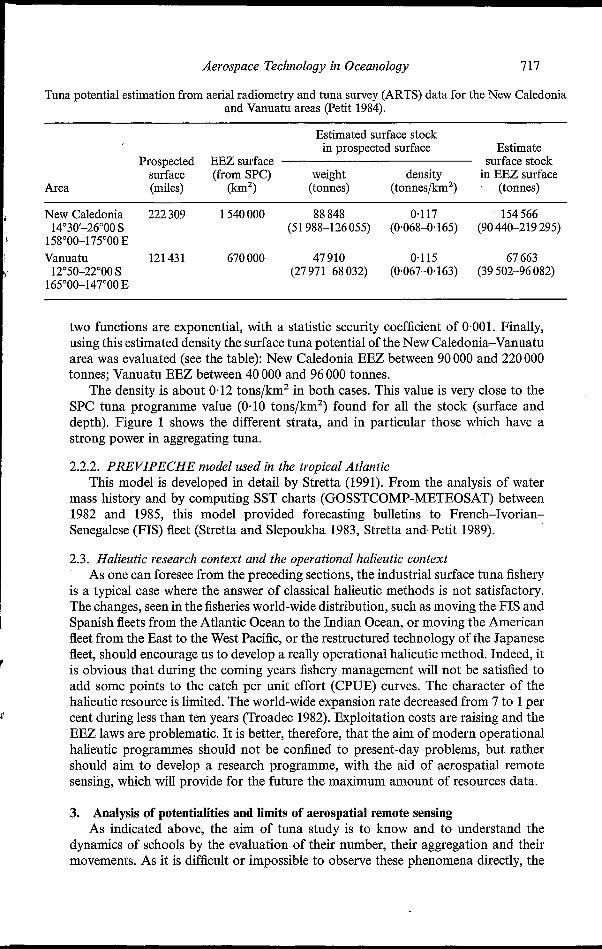
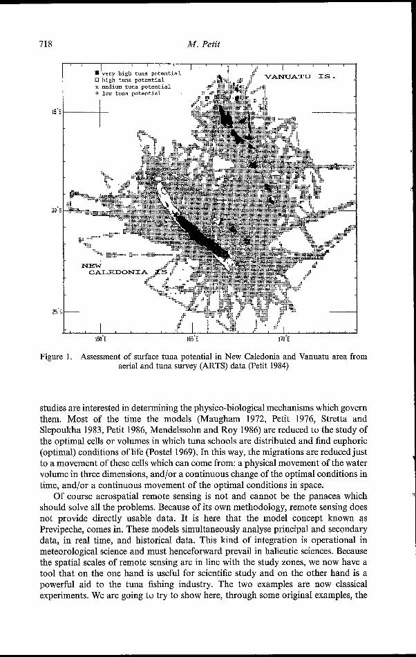
Tuna potential estimation from aerial radiometry and tuna survey (ARTS) data for the New Caledonia and Vanuatu areas (Petit 1984).
Estimated surface stock in prospected surface Estimate
Prospected EEZ surface surface stock surface (from SPC) weight density in EEZ surface
Area (miles) (h2) (tonnes) (tonnes/km2) (tonnes)
New Caledonia 222 309 1 540 O00 88 848 0.117 154 566 14"30'-26"00 S (51 988-126 055) (0.0684165) (90 440-219 295)
158"00-175"00 E Vanuatu 121 431 670 O00 47910 0.115 67 663
12"50-22"OO S (27 971-68 032) (0.0674163) (39 502-96 082) 165'00-147'00 E
two functions are exponential, with a statistic security coefficient of 0.001. Finally, using this estimated density the surface tuna potential of the New Caledonia-Vanuatu area was evaluated (see the table): New Caledonia EEZ between 90 O00 and 220 O00 tonnes; Vanuatu EEZ between 40 O00 and 96 O00 tonnes.
The density is about 0.12 tons/km2 in both cases. This value is very close to the SPC tuna programme value (0.10 tons/km2) found for all the stock (surface and depth). Figure 1 shows the different strata, and in particular those which have a strong power in aggregating tuna.
2.2.2. PREVIPECHE model used in the tropical Atlantic This model is developed in detail by Stretta (1991). From the analysis of water
mass history and by computing SST charts (GOSSTCOMP-METEOSAT) between 1982 and 1985, this model provided forecasting bulletins to French-Ivorian- Senegalese (FIS) fleet (Stretta and Slepoukha 1983, Stretta and. Petit 1989).
2.3. Halieutic research context and tlze operational lialieutic context As one can foresee from the preceding sections, the industrial surface tuna fishery
is a typical case where the answer of classical halieutic methods is not satisfactory. The changes, seen in the fisheries world-wide distribution, such as moving the FIS and Spanish fleets from the Atlantic Ocean to the Indian Ocean, or moving the American fleet from the East to the West Pacific, or the restructured technology of the Japanese fleet, should encourage us to develop a really operational halieutic method. Indeed, it is obvious that during the coming years fishery management will not be satisfied to add some points to the catch per unit effort (CPUE) curves. The character of the halieutic resource is limited. The world-wide expansion rate decreased from 7 to 1 per cent during less than ten years (Troadec 1982). Exploitation costs are raising and the EEZ laws are problematic. It is better, therefore, that the aim of modern operational halieutic programmes should not be confined to present-day problems, but rather should aim to develop a research programme, with the aid of aerospatial remote sensing, which will provide for the future the maximum amount of resources data.
3. Analysis of potentialities and limits of aerospatial remote sensing As indicated above, the aim of tuna study is to know and to understand the
dynamics of schools by the evaluation of their number, their aggregation and their movements. As it is difficult or impossible to observe these phenomena directly, the
718
1s
aú
2
M. Petit
IW'E 165'E 170'E
Figure 1. Assessment of surface tuna potential in New Caledonia and Vanuatu area from aerial and tuna survey (ARTS) data (Petit 1984)
studies are interested in determining the physico-biological mechanisms which govern them. Most of the time the models (Maugham 1972, Petit 1976, Stretta and Slepoukha 1983, Petit 1986, Mendelssohn and Roy 1986) are reduced to the study of the optimal cells or volumes in which tuna schools are distributed and find euphoric (optimal) conditions of life (Postel 1969). In this way, the migrations are reduced just to a movement of these cells which can come from: a physical movement of the water volume in three dimensions, and/or a continuous change of the optimal conditions in time, and/or a continuous movement of the optimal conditions in space.
Of course aerospatial remote sensing is not and cannot be the panacea which should solve all the problems. Because of its own methodology, remote sensing does not provide directly usable data. It is here that the model concept known as Previpeche, comes in. These models simultaneously analyse principal and secondary data, in real time, and historical data. This kind of integration is operational in meteorological science and must henceforward prevail in halieutic sciences. Because the spatial scales of remote sensing are in line with the study zones, we now have a tool that on the one hand is useful for scientific study and on the other hand is a powerful aid to the tuna fishing industry. The two examples are now classical experiments. We are going to try to show here, through some original examples, the

Aerospace Technology in Oceanology 719
possible evolution of this technique, its applicability to the current problems and, finally, its potential to catalyze the emergence of an operational halieutic method.
3.1. Example 1: VARANS-S R A D A R (SAR) in lialieutic studies The high-resolution imaging radar has been developed by CNES with IFP
support. It is implemented by CNES onboard an IGN aircraft within the framework of GDTA. This is a side looking airborne radar (SLAR) using synthetic aperture radar (SAR) mode within the X band (9375 MHz). Its antenna is stabilized in pitch, roll and yaw and can be used with vertical or horizontal polarization. Ground incidence is around 45" 20°, geometrical resolution is close to 3 m x 3 m in the one- look mode, or 9 m x 9m in the nine-looks mode. All these parameters have been carefully chosen with a view to simulating potential future images from satellites.
different terrestrial and aquatic fields have been studied (agriculture, forest, geology, etc.). Recordings of oil pollution and slicks have been carried out in the Channel, in the Atlantic Ocean and in the strait of Gibraltar. The oyster-beds and small-scale fishing tackles in the Languedoc-Roussillon coast in France have been investigated. Some stationary and internal wave studies have been performed in the Gibraltar zone and bathymetric evaluations have been realized in the Pas-de-Calais area. Some radar data about swell and waves have been recorded to improve the definition of numerical models in the Atlantic ocean. This brief list of the VARAN-S applications shows well all the interest in this sensor for the studies at sea (see Wadsworth 1991).
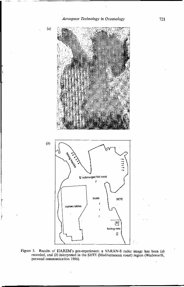
The technical characteristics of this radar equipment are such that the tuna schools, in their surface behaviour, and associated sightings (birds, cetaceans, floating logs) could be detected from 6000 m altitude, within a 10 nautical miles swath; and up to 20 knots wind speed. Thus, the potential of this radar for detecting sea surface deformation, makes it a very efficient tool for drawing up a complete inventory of fishing effort (boats, nets, traps) in a small-scale fishing field. With a view to checking the potential of this radar we have proposed the HAREM experiment (halieutic radar experiment Mediterranean sea). In this experiment (figure 2) we wish to study precisely the relation between the radar signal and Mediterranean bluefin schools (HAREM-thon), and on the other hand small-scale fishing tackle (figure 3) in the Languedoc-Roussillon Lagoon (HAREM-Etang). The aim, beyond this experiment semu stricto, is to restate a direct method for assessing tuna resources from surface sampling as an alternative to classical assessment methods which are always depen- dent upon fishery statistics and which are not available in unfished areas. This experiment was conducted during August 1989, with DLR radar (E-SAR) and not VARAN-S for technical reasons, and the results are reported by Petit et al. (1990).
3.2. Example 2: SPOT as an oceanographic satellite It is necessary to spot the sea state and surface, not only to develop fundamental
knowledge of oceanographic phenomena, but chiefly from an economic (navigation,
T
\ This radar has flown since 1985-in the SAR mode-and a large number of

720 M. Petit
These unexpected performances have been described elsewhere (Wadsworth and Petit 1987, Wadsworth 1988). The high resolution of SPOT would seem of great interest, but in fact it is not so important in considering oceanographic phenomena. What plays the essential role in the surprising SPOT efficiency is the possibility of tilting the sensor, i.e. to aim not only in a vertical but also oblique plane, with as much as a 29" angle of incidence. The multispectral images we can obtain in an east sighting, close to the specular reflection effect, allows us to detect oceanographic surface phenomena. With L ndsat or with SPOT in vertical sighting, we obtain all the information from th sea colour. That is also true with SPOT in oblique sighting; thus, the signal is ver clear and correlated in three bands even in the infra-red band which allows absolu ely no water penetration. These, then, are the surface effects which are observed. Il :: addition, the detected signal has a similar morphology with a radar signal. So, it is certain that the east oblique SPOT sightings come from local variations of the sea surface roughness which is modulated by deep oceanic phenomena, as we know from aircraft radar studies. The SPOT field of view (4"13') is narrow and allows homogeneous detection over a swath of about 60 km. This is a good scale for ocean studies. In addition, numerical processing, necessary within vertical sighting images because of the low sea image density, is not necessary with oblique sightings.
Wadsworth and Petit (1987) and Wadsworth (1988) gave numerous SPOT images to illustrate detection of waves, internal waves, fronts, eddies, boats tracks, oil slicks. As a direct application of this SPOT potential, sea mounts detection has been recently
Aerospace Technology in Oceanology 72 I
I
boats
I
I
I
fishing 5 nets . .
Figure 3. Results of HAREM’S pre-experiment: a VARAN-S radar image has been (u) recorded, and (b) interpreted in the SETE (Mediterranean coast) region (Wadsworth, personal communication 1986).
722 M. Petit
shown (Petit et al. 1989). In this study, the SPOT image presented is near a volcanic sea mount, the coral top of which is at about 10m depth. The oceanic surface anomaly, which is shown by very simple SPOT image processing, spreads 20 km wider. The importance of such sea mounts to increasing the richness of water masses is known (Boehlert and Genin 1987), and the interest for tuna fisheries is evident.
Of course, SPOT has its own limits. First, no useful data can be obtained when it is cloudy or at night, as can with a radar satellite. Then to observe the surface roughness it is necessary to obtain a minimum roughness, i.e. minimum wind force, that is not really restrictive. However, if the wind speed is too high (force 6), breakers hide the roughness variations.
We emphasize the fact that nobody was expecting this kind of performance from SPOT over the sea: SPOT Image Corporation does not record sea images systemati- cally because, until now, the requirements concern mostly terrestrial zones. So for oceanographers the possibility of obtaining SPOT sea images is a real asset and it will not cause conflicts with the satellite recording programming.
3.3 Primary production with visible multispectral satellites (Nimbzu-7) One of the keys of halieutic methods in the next few years will be to understand
how the euphoric environment of harvested species is distributed, is modified and moves. This will be true particularly for tuna species. So the forecasting of rich zones concerning primary production will be a very important crossroad for operational oceanography and halieutic methods. From the following example, we understand to what extent aerospatial remote sensing can help in perfecting and overturning classical concepts.
Tropical seas are major sites for extensive cyanobacteria (blue-green algal) developments. The oceanic nitrogen fixation caused by such bloooms may be of relatively great importance with regard to the global nitrogen budget.
Dupouy et al. (1988) found a large phytoplankton bloom (90000km2) within a Nimbus-7 Coastal Zone Colour Scanner (CZCS) image on 4 January 1982 around New Caledonia and the Vanuatu archipelago, located east of Australia in the Coral Sea (165" E, 20" S). The bloom was caused by cyanobacteria, presumably Oscillatoria (Trichodesmium) spp. which occur systematically in this region. This assertion was not confirmed by simultaneous sea truths, but several indications and current knowledge of the region indicate that our hypothesis is reasonable. By using the CZCS image, an estimate is made for the nitrogen fixation of the bloom. It suggests that such a biological event plays a significant role in the global nitrogen oceanic budget.
4. Synthesis and conclusions From the preceding examples it is now possible to come to some conclusions. Aerospatial remote sensing allows us to quantify, and helps us to visualize,
oceanographic and halieutic concepts. Thus, it can assist in spatio-temporal surveys. High-seas oceanography and the tuna halieutic studies have similar requirements
in the spatio-temporal scale for surveys and the essential parameters of their research. For the next ten years, several satellites will be launched (ERS-1, JERS-1, Radarsat, EOS) which are, to a large extent, dedicated to high-seas studies. So it seems that with these new space tools a new age for oceanography and halieutic studies is coming in the very near future; these changes must be conducted on a planetary scale and should emerge into operational oceanography and halieutic methods.
Aerospace Technology iiz Oceanology 723
However, these developments will be obtained only if the sea observation strategy, the satellite data selection and their commercialization, and finally the data transmis- sion, are integrated.
To emphasize these conclusions, it is necessary to keep in mind the fishery context. A purse seiner, a tuna fishing boat, is a real production unit with just twenty
people on board and is worth 8-9 million ecu. The world-wide annual fish catch is approaching SO million tons and represents one of the most important sources of animal proteins. More than two hundred million people are living on the marine biological resources, and the fisheries business corresponds to about 30 per cent of marine activities. In spite of that, advances in fishery came mainly from the accumulated experience of fishermen, and the difficulty in developing efficient and scientific methods for operating boats and managing resources is considerable.
In spite of the economic importance of fisheries and the fact that remote sensing is becoming adult, the remote-sensing investigation in halieutic fields has stayed on a very limited basis, with some experiments in the U.S.A. for tuna, albacore and salmon, or in Europe for tuna and albacore too. However, two exceptions are to be noted, the fishing aid bureau (BAP) of ORSTOM in the Ivory Coast (between 1978 and 1984) and the programme now realized in Japan by JAFIC (Japanese Fisheries Center), reported by Doumenge (1987) have run or are running on an operational basis.
We think that it is the time to become conscious of this reality, particularly in Europe, and to promote integrated studies within an international framework.
References BEVERTON, R. J. H., and HOLT, S. J., 1957, On the dynamics of exploited fish populations.
Fishery Investigations, Serie 2, volume XIX (London: U.K. Ministry of Agriculture and Fishery), p. 533.
BOEHLERT, G. W., and GENIN, A., 1987, A review of the effects of seamounts and biological processes. In Seamounts, Islands and Atolls, edited by B. H. Keating, P. Friger, R. Batiza and G. W. Boehlert, Geophysical Monography, Vol. 43, (Washington, D.C.: American Geophysical Union), pp. 3 19-334.
DICKE, L. M., KERR, S. R., and SCHWINGHAMER, P., 1987, An ecological approach to fisheries assessment. Canadian Journal of Fisheries and Aquatic Science, 4, 68-74.
DIEMIENTIEVA, T. F., 1971, Considérations sur la formation des stocks exploitées et sur les fluctuations des propriétés biologiques des populations de poissons en vue de l'établisse- ment des prévisions de pêche. Traductions des travaux du VNIRQ (Moscou) (Paris: Centre national de la recherche scientifique).
DOUMENGE, F., 1987, Deux yeux pour la pêche japonaise: transmission en fac-similé et cartographie thermique satellitaire. La Pêche Maritime, 1316, 28-32.
DUPOW, C., PETIT, M., and DANDONNEAU, Y., 1988, Satellite detected cyanobacteria bloom in the S.W. Tropical Pacific: Implication for nitrogen fixation. International Journal of Remote Sensing, 9, 389-396.
KEARPJEY, R. E., 1978, Le programme d'étude et d'évaluation des stocks de bonites de la CPS. Coigérence annuelle thonière held in Moumea, New Caledonia, in November 1978, document 1 1, edited by Commission du Pacifique Sud (Nouméa-Novelle Caledonie),
KLEIBER, P., ARGUE, A. W., and KEARNEY, R. E., 1978, Assessment of Pacific skipjack tuna resources by estimating stock and components of population turnover from tagging data. Canadian Journal of Fisheries and Aquatic Science, 44, 1122-1 134.
LAUREC, A., and LE GUEN, J. C., 1981, Dynamique des populations exploitées, Vol. 1: Concepts et modèles. Rapport Scientifique et Technique du Centre National d'Exploitation des Océans, numero 45 (Paris: CNEXO).
pp. 48-63.
724 Aerospace Techl-iology in Oceanography
MAUGHAM, P. M., 1972, The impact of remote sensing data on the U.S. menhaden and shrimp fisheries. Final report prepared for spacecraft oceanography project, number 62306-71- C-O173 (Washington: Earth Satellite Corporation).
MENDELSSOHN, R., and ROY, C., 1986. Environmental influences on the F.I.S.M. tuna catches in the gulf of Guinea. Proceedings of the ICCAT Conference on the International Skipjack Program held on the Canaries, on 21-29 June 1983, edited by P. E. K. Symons, P. M. Miyake and G. T. Sakagawa (Madrid, Spain: ICCAT), pp. 253-268.
PETIT, M., 1976, Ecologie du germon et télédétection aérospatiale. DAA halieutique à l'Ecole National Supérieure Agronomie (Rennes: Ecole Nationale Supérieure d'Agronomie de Rennes).
PETIT, M., 1984, Aerial radiometry, and tuna survey: a method for evaluation of surface tuna stocks in New Caledonia and Vanuatu area. Proceedings of the 35th Annual Tuna Conference held at Lake Arrowhead, on 17-20 May 1984 (La Jolla, U.S.A.: National Marine Fishery Service), report H84-13.
PETIT, M., 1986, Coherent theory on tuna behaviour. Proceedings of the 37th Annual tuna conference held at Lake Arrowhead, on 18-21 May 1986, edited by R. Brill (La Jolla, U.S.A.: National Marine Fishery Service), report H86-19.
PETIT, M., STRETTA, J. M., FARRUGIO, H., and WADSWORTH, A., 1990, HAREM: Halieutique et radar expérimentation en Méditerranée; potentialités du radar SAR en halieutique application à la pêche thonière de surface et à la pêche artisanale. Collection Etudes et thèses (Paris: Editions de I'ORSTOM).
PETIT, M., and HENIN, C., 1982, Radiomètrie aérienne et prospection thonière rapport final Vanuatu. Notes et Document du Centre ORSTOM de Port Vila, numero 3 (Port-Vila, Vanuatu: ORSTOM).
PETIT, M., and KULBICKI, M., 1982, Radiomètrie aérienne et prospection thonière dans la ZEE de polynésie française. Notes et Document du Centre ORSTOM de Papeete, numero 20 (Polynésie Française: ORSTOM Tahiti).
PETIT, M., STRETTA, J. M., SIMIER, M., and WADSWORTH., A., 1989, Anomalies de surface et pêche thonière; un potentiel inattendu de SPOT pour la détection des zones de pêche par l'inventaire des hauts-fonds. Mappemonde, 89, 13-19.
POSTEL, E., 1969, Répartition et abondance des thons dans l'Atlantique tropical. 109-138. Actes du Symposium sur L'océanographie et les Ressources Halieutiques de l'Atlantique Tropical held at Abidjan, on the 20-28 Octobre 1966, organisé conjointement par l'UNESCO, la FAO et l'OUA (Paris: Editions de l'UNESCO).
POSTEL, E., 1973, Dynamique des populations exploitées, In Théorie despêches, Vol. 3 (France: Rennes, Université de Rennes).
STRETTA, J. M., 1991, Forecasting models for tuna fishery with aerospatial remote sensing. International Journal of Remote Sensing, 12, 771-779.
STRETTA, J. M., and PETIT, M., 1989, Télédétection spatiale et pêche thonière en Atlantique intertropical. In Synthèse Telédétection Satellitaire et Pêcheries Thonières Océaniques, FAO document technique des pêches, numero 302 (Rome: ORSTOM/IFREMER/
STRETTA, J. M., and SLEPOUKHA, M., 1983, Les satellites, l'lordinateur et l'aide à la pêche. La
TROADEC, J. P., 1982, Introduction à l'aménagement de pêcheries: Intérêt, difficultés et
WADSWORTH, A., 1988, SPOT 1, Un satellite qui n'a pas peur de l'eau. La Recherche, 198,
WADSWORTH, A., 1991, The GDTA, a partner in oceanography. International Journal of Remote Sensing, 12, 763-770.
WADSWORTH, A., and PETIT, M., 1987, SPOT: un satellite pour l'océanographie. Actes du Colloque SPOT I : Ultisation des Images, Bilan, Résultats held in Paris, in November 1987 paris: Centre National #Etude Spatial), pp. 1087-1094.
FAO), pp. 99-1 11.
Pêche Maritime, Janvier, 1258, 38-41.
principales méthodes. FAO Document Techniques des Pêches, numero 224.
536-538.