Aerial Ortho and Oblique Photography Sample Data · Aerial Ortho and Oblique Photography Sample...
11
Aerial Ortho and Oblique Photography Sample Data
Transcript of Aerial Ortho and Oblique Photography Sample Data · Aerial Ortho and Oblique Photography Sample...
Aerial Ortho and Oblique Photography
Sample Data
Contact Us: Phone: 318-658-9818 Fax: 318-746-8184 P.O. Box 72357 Bossier City, LA 71172
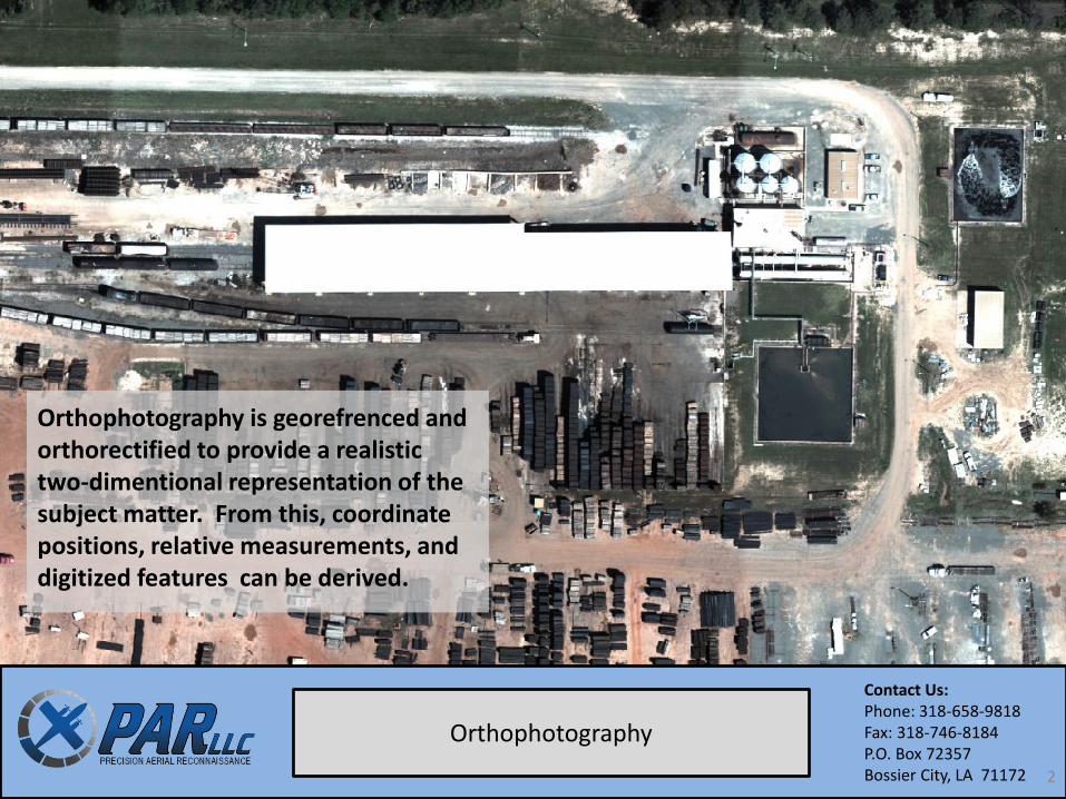
Orthophotography
Orthophotography is georefrenced and orthorectified to provide a realistic two-dimentional representation of the subject matter. From this, coordinate positions, relative measurements, and digitized features can be derived.
2
Contact Us: Phone: 318-658-9818 Fax: 318-746-8184 P.O. Box 72357 Bossier City, LA 71172
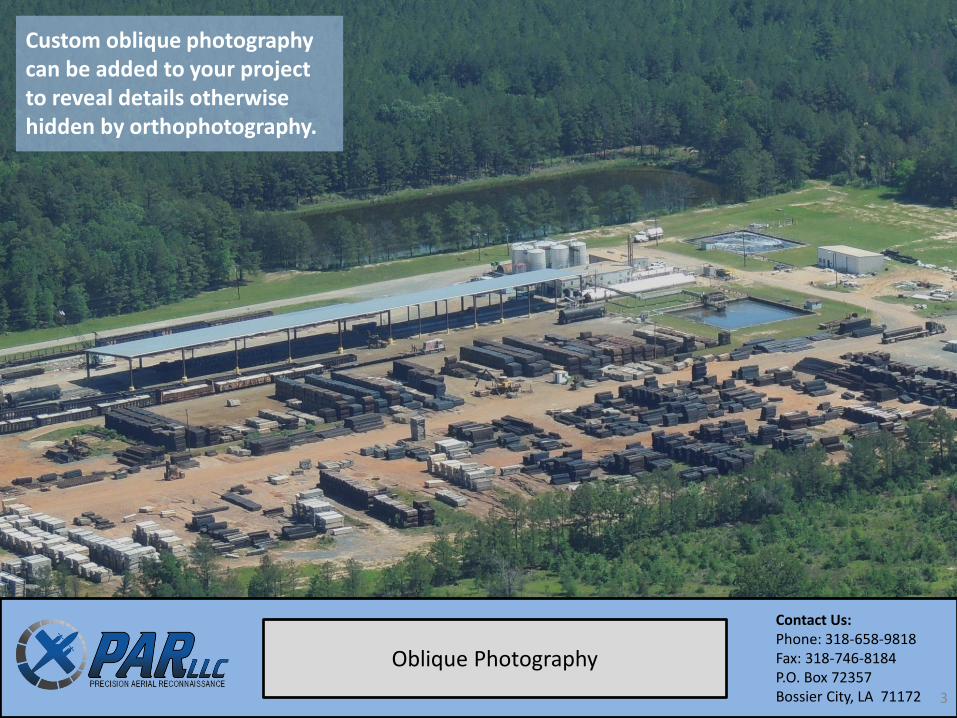
Oblique Photography
Custom oblique photography can be added to your project to reveal details otherwise hidden by orthophotography.
3
Contact Us: Phone: 318-658-9818 Fax: 318-746-8184 P.O. Box 72357 Bossier City, LA 71172
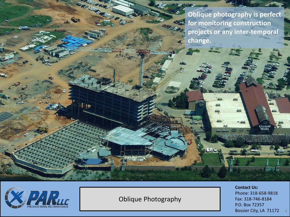
Oblique Photography
Oblique photography is perfect for monitoring construction projects or any inter-temporal change.
4
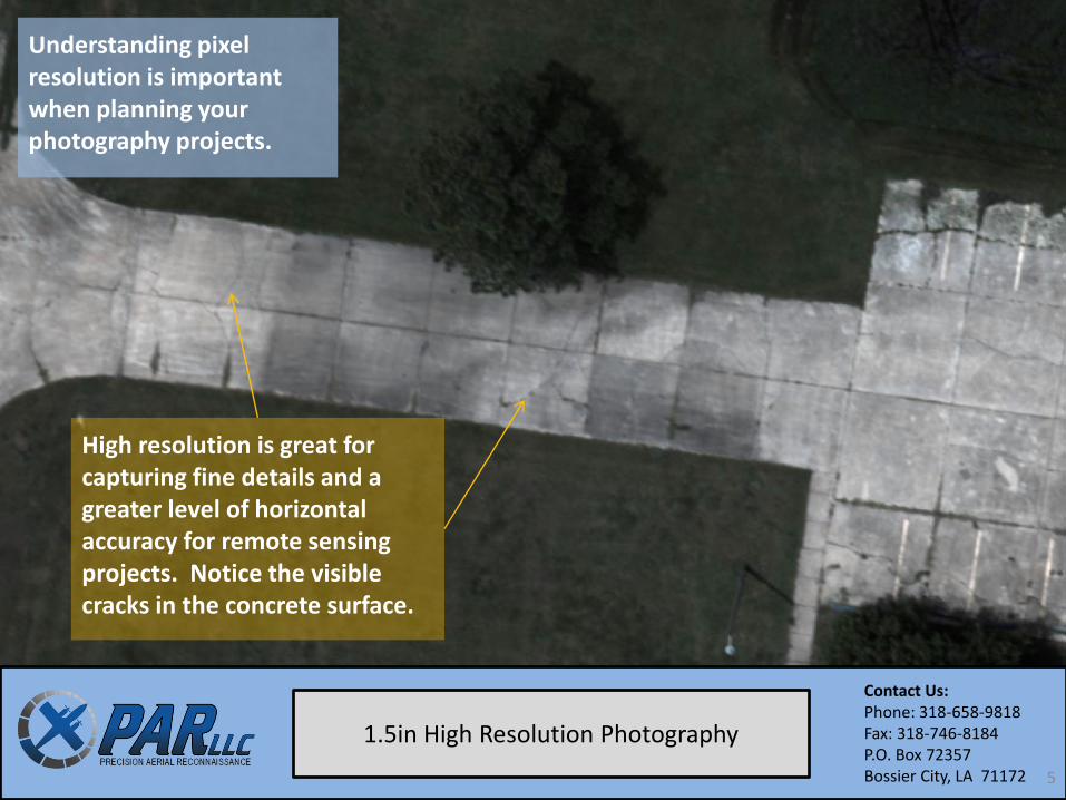
Understanding pixel resolution is important when planning your photography projects.
Contact Us: Phone: 318-658-9818 Fax: 318-746-8184 P.O. Box 72357 Bossier City, LA 71172
1.5in High Resolution Photography
High resolution is great for capturing fine details and a greater level of horizontal accuracy for remote sensing projects. Notice the visible cracks in the concrete surface.
5
Contact Us: Phone: 318-658-9818 Fax: 318-746-8184 P.O. Box 72357 Bossier City, LA 71172
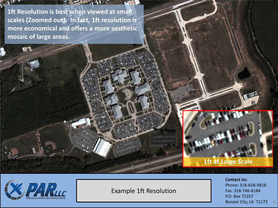
Example 1ft Resolution
6
1ft Resolution is best when viewed at small scales (Zoomed out). In fact, 1ft resolution is more economical and offers a more aesthetic mosaic of large areas.
1ft at Large Scale
Contact Us: Phone: 318-658-9818 Fax: 318-746-8184 P.O. Box 72357 Bossier City, LA 71172
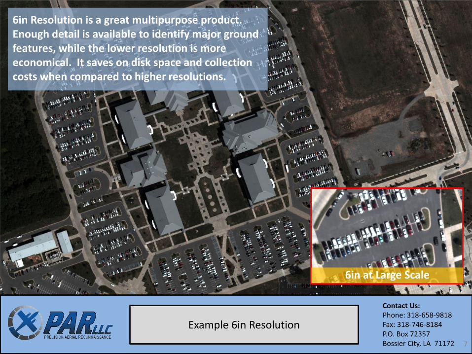
Example 6in Resolution
7
6in Resolution is a great multipurpose product. Enough detail is available to identify major ground features, while the lower resolution is more economical. It saves on disk space and collection costs when compared to higher resolutions.
6in at Large Scale
Contact Us: Phone: 318-658-9818 Fax: 318-746-8184 P.O. Box 72357 Bossier City, LA 71172
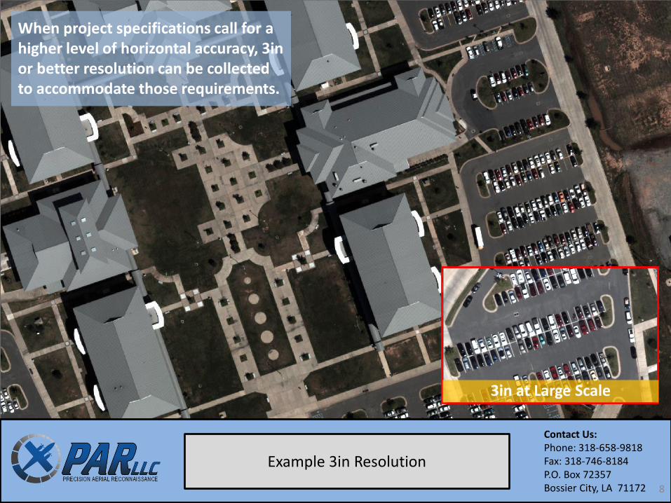
Example 3in Resolution
8
When project specifications call for a higher level of horizontal accuracy, 3in or better resolution can be collected to accommodate those requirements.
3in at Large Scale
Contact Us: Phone: 318-658-9818 Fax: 318-746-8184 P.O. Box 72357 Bossier City, LA 71172
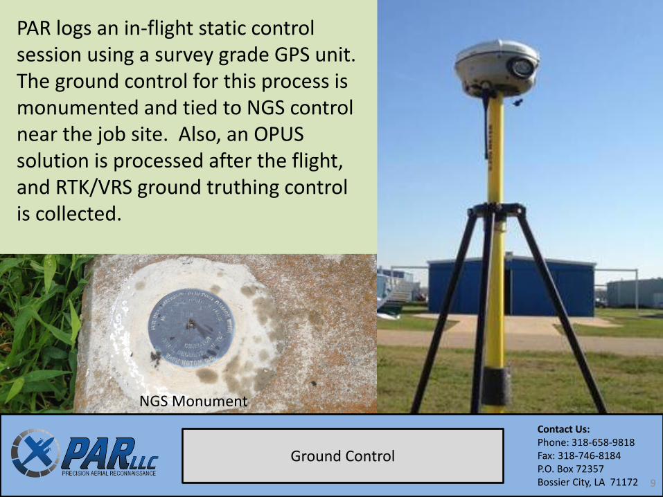
Ground Control
PAR logs an in-flight static control session using a survey grade GPS unit. The ground control for this process is monumented and tied to NGS control near the job site. Also, an OPUS solution is processed after the flight, and RTK/VRS ground truthing control is collected.
NGS Monument
9
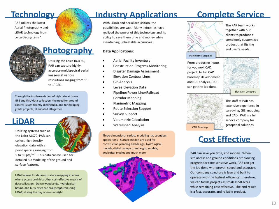
Photography
Complete Service
LiDAR
Industry Applications Technology PAR utilizes the latest
Aerial Photography and
LiDAR technology from
Leica Geosystems®.
Utilizing the Leica RCD 30,
PAR can capture highly
accurate multispectral aerial
imagery at various
resolutions ranging from 1”
to 1’ GSD.
Utilizing systems such as
the Leica ALS70, PAR can
collect high density
elevation data with a
point spacing ranging from
5 to 50 pts/m2. This data can be used for
detailed 3D modeling of the ground and
surface features.
With LiDAR and aerial acquisition, the
possibilities are vast. Many industries have
realized the power of this technology and its
ability to save them time and money while
maintaining unbeatable accuracies.
Data Applications:
Aerial Facility Inventory
Construction Progress Monitoring
Disaster Damage Assessment
Elevation Contour Lines
GIS Analysis
Levee Elevation Data
Pipeline/Power Line/Railroad
Corridor Mapping
Planimetric Mapping
Route Selection Support
Survey Support
Volumetric Calculation
Watershed Analysis
The PAR team works
together with our
clients to produce a
completely customized
product that fits the
end user’s needs.
From producing inputs
for you next CAD
project, to full CAD
basemap development
and GIS analysis, PAR
can get the job done.
The staff at PAR has
extensive experience in
surveying, GIS, mapping,
and CAD. PAR is a full
service company for
geospatial solutions.
PAR can save you time, and money. When
site access and ground conditions are slowing
progress for time sensitive work, PAR can get
the job done with proven speed and accuracy.
Our company structure is lean and built to
operate with the highest efficiency; therefore,
we can tackle projects as small as 50 acres
while remaining cost effective. The end result
is a fast, accurate, and reliable product.
Cost Effective
Through the implementation of high rate airborne
GPS and IMU data collection, the need for ground
control is significantly diminished, and for mapping
grade projects, eliminated altogether.
LiDAR allows for detailed surface mapping in areas
where access prohibits other cost-effective means of
data collection. Dense woodlands, hydrological
basins, and busy cities are easily captured using
LiDAR, during the day or even at night.
Three-dimensional surface modeling has countless
applications. Surface models are used for
construction planning and design, hydrological
models, digital canopy (tree height) models,
geological studies and much more.
Planimetric Mapping
Elevation Contours
CAD Basemap
10
Precision Aerial Reconnaissance, LLC is a service disabled
veteran owned small business based out of Bossier City, LA.
Phone: 318-658-9818
Fax: 318-746-8184
P.O. Box 72357
Bossier City, LA 71172
www.parlidar.com
Send us a quote request online. There is no obligation. Just
submit some information about the project along with some
contact information and we will provide a detailed quote
within 24 hours.
11