AECOS No. 661 SURVEY OF LOWER WAIAWA...
22
AECOS No. 661 SURVEY OF LOWER WAIAWA STREAM AND IMPACTS ASSESSMENT FOR FLOOD RETENTION BASINS AT THE WAIAWA RIDGE DEVELOPMENT PROJECT Prepared For: Environmental Communications, Inc. 1146 Fort Street Mall, Suite 200 Honolulu, Hawaii 96809 Prepared By: AECOS, Inc. 970 North Kalaheo Ave., Suite C311 Kailua, Hawaii 96734 December 1991 AR00009726
Transcript of AECOS No. 661 SURVEY OF LOWER WAIAWA...
AECOS No. 661
SURVEY OF LOWER WAIAWA STREAM AND IMPACTS ASSESSMENT
FOR FLOOD RETENTION BASINS AT THE
WAIAWA RIDGE DEVELOPMENT PROJECT
Prepared For:
Environmental Communications, Inc. 1146 Fort Street Mall, Suite 200
Honolulu, Hawaii 96809
Prepared By:
AECOS, Inc. 970 North Kalaheo Ave., Suite C311
Kailua, Hawaii 96734
December 1991
AR00009726

INTRODUCTION
The Waiawa Ridge Development Project encompasses a total area of 4400 acres of sloping land which extends from the H-1/ H-2/Kamehameha Highway interchanges near Pearl City to the 1200-foot elevation in the Kololau Range. Waiawa Ridge is essentially that land which lies between Waiawa Stream on the east and Panakauahi Gulch on the west and north.
The purpose of this report is to assess the Waiawa Ridge Development Project's potential impacts on stream ecology. However, the proposed project is a large and complex one which will eventually result in the urbanization of a substantial portion of the property. It would be premature to address the water quality implications of each of the specific features of this 2621-acre, planned community which includes open areas, parks, golf courses, schools, housing areas of various densities, and commercial districts. Instead, this report is concerned with providing a general description of the aquatic environments that could be impacted; and with the implica-tions, in terms of environmental impacts, of the master drainage plan which proposes to utilize drainage catchment basins to mitigate flood hazard potential from storm run-off events.
To accomplish the purposes of the report as stated, several visits were made to the gulches and streaM areas on and adjacent to the property. As appropriate, biological observations were made and water samples collected. Gentry Development Company provided maps and basic development and drainage plans for the Waiawa Ridge Project. Engineering and hydrologic data have been obtained from other sources, including the Gentry Development Company Engineering Depart-ment and a report prepared by G. L. Dugan (1990).
1
AR00009727
THE WAIAWA WATERSHED
All of the project is located on the Waiawa watershed which drains into Middle Loch of Pearl Harbor. With a total area of 26.4 square miles, this watershed is one of the largest on Oahu (Dugan, 1990). The streams and gulches which drain this large area feed into Waiawa Stream, with all of the major confluences located above Kamehameha Highway. Waiawa Stream is coded 3-4-06 in the report by the Hawaii Cooperative Park Service Unit (1990) assessing Hawaiian streams. Waiawa Stream is listed as a medium size stream (average yearly mean flow given as 32.6 cfs). The flow from Waiawa Stream has produced a flood hazard or the lowlands on numerous occasions. A report by the U.S. Soil Conservation Service (1982) indicates that in the tidal estuary of Waiawa Stream (the portion below Farrington Highway), "the stream, made shallow in this area by the accumulation of sediment, overflows its banks as often as six times a year."
Recent incidences of serious flooding have occurred in May 1963, November 1965, January 1969, October 1981, and February 1991(?). The - 1981 flood of Waiawa Stream was documented in detail by the Soil Conservation Service and the Department of Land and Natural Resources (SCS, 1981; DLNR, 1982). The flood height during this particular event, as measured at the Farrington Highway stream gaging station on Waiawa Stream, peaked at 22.46 feet. Peak discharge was estimated at 26,000 cubic feet per second. The recurrence interval, or the average interval within which a flood of this magnitude will be exceeded once, is 25 years.
The areas subject to flooding are mostly below Kamehameha Highway and generally below the H-1 Freeway (ACOE, 1982). However, the relatively deep, steep-sided gulches which characterize the major tributary stream courses above Kamehameha Highway provide some indication of the power of flow these tributaries are capable of carrying. Most of the time, stream flow in this watershed is either absent (flow is intermittent or interrupted) or quite modest. the average flow at the downstream gaging station on Waiawa Stream is 34.3
2
AR00009728

AR00009729
3
I
111
II
111
Ii
111
I. 111

ft3/sec. (USGS, 1990). The flow during the dry periods is on the order of 2 or 3 ft 3/sec.
Waiawa Stream, along with it's tributaries of Manana Stream and Waimano Stream, is the perennial stream of this drainage. These water courses drain the Ko'olau slopes to the east of the project, although some of the Waiawa Ridge land drains directly into Waiawa Stream. Most of the project site drains towards the southwest through several small gulches which eventually feed into Panakauahi•Gulch (Figure 1). Panakauahi Gulch joins Waiawa Stream at the extreme southern end of the project site, just above the point where Waiawa Stream crosses under Kamehameha Highway and flows out onto the coastal plain. The several gulches on the project site are distinct on the landscape as densely vegetated and, in places forested, gorges between the sugar cane (abandoned in 1983) and pineapple fields which cover much of the land proposed for development. The largest gorge, Panakauahi, can be traced into the Ko'olau Range to about the 1400-foot elevation, and like the others is normally dry. That is, water flow occurs in this gulch only during major rainfall events.
PANAKAUAHI GULCH
A field survey of lower Panakauahi was made on October 7 and November 6, 1991. Gulches across the middle and upper parts of the project were visited on November 7. The road crossing within Panakauahi Gulch at the 760-foot elevation (near the upper project land use boundary) was reached at this time. In no part of this gulch, or the several other smaller ones which drain the site, was flowing water observed. In fact, the stream beds (actually the floor of the gulches) consists of fine, sedimentary material (soil) or (in upper Panakauahi) some areas of a rounded gravel of friable material. In some of the gulches, vegetation (mostly grasses) obscure the water course. It is clear that water flow occurs only during periods of fairly substantial rainfall and flow probably ceases not long after the rainfall ceases.
4
AR00009730
Aquatic environments are limited to temporary pools and wet areas remaining after a storm. Because these intermittent streams are not eroding through rock, pools are retained only where the stream bed intersects the local water table: where the soil saturation zone is exposed at the ground surface. One such pool was observed in upper Panakauahi Gulch. The overall diameter barely exceeded 1 or 1.5 meter and water depth was only several centimeters. The pool was densely inhabited by mosquito larvae and tubifex worms.
The lower end of Panakauahi Gulch shows ample evidence of highly erosive water flow, but no permanent water bodies. Our observations indicate that, within this northwest part of the Waiawa drainage system, all of the tributary streams (i.e., all those within the project area except Waiawa Stream) are intermittent streams. None are interrupted streams (see below).
WAIAWA STREAM
The largest of the streams located on the project site is Waiawa Stream. Portions of the middle and upper reaches of
41 this stream are encompassed by the property boundary which crosses Waiawa or its tributary, Manana Stream, seven times. However, development plans show all of the stream canyon to be
Al in open space and mostly outside of the designated land use MI area. Development is proposed for the ridge above the steep-
sided canyon of Waiawa Stream and for a 17-acre commercial/industrial site on the valley floor near the Pearl City Industrial Park.
Much of the upper reach of Waiawa Stream is inaccessible by ordinary means. Military property (Naval Reservation) lies across the access point at the upper end of Pearl City Industrial Park. Consequently, a survey of the stream for this report was limited to the reach between the Naval Reserve property and Kamehameha Highway (immediately downstream of the development property boundary). This area was visited on November 6 and November 7, 1991. Water samples were collected and observations of stream fauna were made. Specimens were collected as needed to confirm field identifications.
5
AR00009731
Within the survey area, Waiawa Stream transforms from a stream flowing around massive basalt boulders (presumably characteristic of most of the reach above the survey area) to a stream flowing over sand and small cobble. Such a physical change in the nature of the stream bed is indicative of a change in gradient. Within this segment, Waiawa Stream 'flows out of it's steep-sided canyon and onto the coastal plain.
At the upstream station located just above the Pearl City Industrial Park, water was present as a series of pools and riffle zones around large basalt boulders. Pools ranged up to 60 cm in depth. Large trees shaded much of the stream bed. Waiawa Stream was followed upstream nearly to the confluence with Waimano Stream. Most abundant in this area was the sailfin molly, Poecilia latipinna. Present, although not particularly abundant, were the guppy, Poecilia reticulata, and the green swordtail, Xiphophorus helleri. All of these are introduced (non-native) species of small fishes very common in O'ahu streams. A Malaysian prawn,.Macrobrachium rosenbergi, an introduced species, was seen. Also, a night heron, Nycticorax nvcticorax hoactli, was observed close to the stream. The stream environment here is quite natural appearing, although one bank is lined with a fabric and concrete structure to prevent erosion where damage would occur to a commercial office building near the stream.
From just above Waihona Place, Waiawa Stream drops over a spillway-like structure and flows into a concrete-lined culvert. The end of this channelized section was not established, but apparently coincides with the lower end of the industrial area.
A second station was located below the light industrial area at the point where the Plantation Road crosses Waiawa Stream. The stream in this area was confined to several pools within a sand, gravel, and small cobble bed. A concrete structure serving as a vehicle ford built across the stream created an upstream pool which was hydrologically connected via 24" concrete pipes with a deeper down stream pool. No water was flowing over the surface of the structure, creating a biological barrier, since the upper end of the pipes were buried beneath the stream sediment. The downstream pool
6
AR00009732
II
MI
contained an abundance of fishes, including sailfin molly, tilapia (Oreochromis mossambica), convict cichlid (Cichlasoma nigrofasciatum), 'o'opu naniha (Stenogobius genivittatus), 'o'opu nakea (Awaous stamineus), and tadpoles of the toad, Bufo marinus. The indigenous 'o'opu naniha was very abundant in this pool. The upstream pool was surveyed only briefly, but appeared to be dominated by sailfin mollies.
The final location surveyed was the stream beneath the Kamehameha Highway bridges and downstream for a distance of about 100-150 meters. A shallow riffle zone connected large pools beneath the bridges. Stream bed material was mostly sand and gravel. Pools here were large and mostly around 30 cm deep, but exceeded 50 cm in some areas. ThiS area supported an abundance of stream life, including a mixture of introduced and native species. As observed elsewhere during the survey, the sailfin molly was most abundant. Common were 'o'opu nakea, and tilapia (possibly including Sarotherodon melanotheron); present were convict cichlid and 'o'opu naniha. Abundant in the large pool under the bridges were 'opae 'oeha'a, Macro-brachium grandimanus. A Tahitian prawn, Macrobrachium lar, and a Malaysian prawn, M. rosenbergi, were also observed in this same pool.
COMPARISON WITH EARLIER SURVEYS
Waiawa Stream was surveyed as part of the U.S. Fish and Wildlife Service (USFWS) inventory of Hawaiian streams (Timbol and Maciolek, 1978). The results of the inventory are summarized in Figure 2 reproduced here from Figure B19 in the original report. The purpose of the survey was to document the extent and impacts of stream channelization in Hawaii. As can be seen from the figure, a series of three elevated culverts (representing Kamehameha Highway crossings) and a realigned channel characterized lowermost Waiawa Stream in 1978. An elevated culvert and short cleared channel were noted on Waimano Stream (at Komo Mai Drive).
Development of Pearl City Industrial Park along the stream alignment has resulted in further channel modification since 1978. The channel of Waimano Stream is natural between
7 Ft
II AR00009733

4•110 cleared, realigned channel
Wala
wa
Str
eam
, al
gra
dien
t (m
/km
• %. „Le.,
Irt I
5% o
f c
hann
el l
eng
th a
ltere
d.
Dis
tanc
e fro
m m
eth
(n
in)
elevated culvert
UQp4D.j3 elevated culvert
MOLE LOW MAL. HARBOR
Figure 2. Graphical presentation of the stream channelization study for Waiawa Stream (after Timbol and Maciolek, 1978).
AR00009734
Id
the elevated culvert under Komo Mai Drive and the point of confluence with Waiawa Stream upstream of Waihona Street. The channel may have been altered in the vicinity of a housing development on Lanikeha Way, but access in this area is restricted. Small modifications along the banks might be classed as representing a "cleared, realigned channel" on Waiawa Stream from just above the Navy bridge on Waihona Street to just above Waihona Place, where a concrete spillway structure feeds a concrete, lined channel through a portion of the industrial park. A culvert structure has reportedly been installed below the Industrial Park (S. Samuals, DLNR, pers. comm.). A low concrete structure with pipe culverts is found where the cane haul road crosses the stream between the industrial park and Hwy 99 (Kamehameha). The northernmost of the three highway crossings indicated on the map in Figure 2 is not an elevated culvert. The bridge is built on supports across the natural stream channel. The other two were not
surveyed.
Two biological surveys for the Waiawa Stream system are indicated in Figure 2 from the USFWS report. An upstream
station appears to have been located on Waimano Stream at Komo Mai Drive. Reported from this location were only the swordtail (Xiphophorus helleri = "Xh") as common and Chinese catfish
(Clarias fuscus = "Cf") as rare or occasional. A downstream
station was located on Waiawa Stream somewhere between Waihona Place and the old Plantation Road crossing. The reported fauna was more diverse and included shortfin molly• (Poecilia
mexicana = "Pm") and guppy (P. reticulata = "Pr") as abundant;
tolopu nakea (Awaous stamineus = "As") and crayfish (Pro-
cambarus clarkii = "Pc") as common; and tilapia (Oreochromis
mossambica = "'I'm") as rare.
The 1978 USFWS biological survey results are generally different from those reported here for November 1991, perhaps in part explained by the somewhat different stream sites actually visited. One impression of this part of Waiawa
Stream was that the nature of the stream habitats varied substantially from place to place. Whatever the reasons, the fauna revealed by the most recent survey is richer in native species, and the abundance of the native prawn and gobies is
noteworthy. The convict cichlid is a relatively recent
AR00009735

introduction to Oahu aquatic environments, whose presence in this area may be of concern. Not seen during any of these surveys, but probably present much further upstream, is the native (endemic) shrimp, 'opae kala'ole (Atyoida bisulcata). Generally common in the estuarine reach, and certainly to be expected in lower Waiawa Stream, are two other native fibhes: the aholehole (Kuhlia sandvicensis) and the 'o'opu okuhe (Eleotris sandwicensis). The tilapia is probably also abundant downstream as well.
The Timbol and Maciolek (1978) map shows by solid lines that the lowermost section and the upper sections of nearly all of the tributaries of Waiawa Stream are perennial; that is, water flow is continuous in the channel all year long. The middle sections of the tributaries are shown, by dashed lines, to be interrupted. That is, flow in these channels is intermittent; continuous flow in the channel from the mountain to the sea occurs during rainy periods. At other times, flow in the uppermost reach infiltrates, into the stream bed.
Such streams may support native fauna in the upper reaches even while the lower reaches are invaded by introduced forms and/or suffer generally poor water quality from a variety of pollutant sources. However, the Hawaiian native stream fauna is mostly diadromous; that is, the species migrate between freshwater and the sea during their life cycle. The usual pattern is a release of eggs or larvae from breeding adults in the upper reach of the stream, followed by early development and dispersion in the sea, followed by migration of the juveniles upstream. This pattern is interrupted, and the viability of the upstream populations threatened, by construction of dams, elevated culverts, and other similar structures on the stream which restrict upstream migration during the appropriate time. Flat-bottom lined channels can also serve as barriers much of the time because of a lack of suitable habitats in the sheet of water comprising the channel. Lower Waiawa Stream has several potentially significant barriers within the Industrial Park area, including a dam and a flat-bottom lined channel.
10
AR00009736
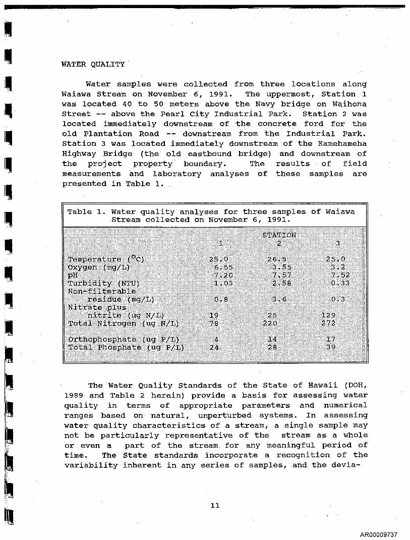
Table 1. Water quality analyses for three samples of Waiawa Stream collected on November 6, 1991.
WATER QUALITY
Water samples were collected from three locations along Waiawa Stream on November 6, 1991. The uppermost, Station 1 was located 40 to 50 meters above the Navy bridge on Waihona Street -- above the Pearl City Industrial Park. Station 2 was located immediately downstream of •the concrete ford for the old Plantation Road -- downstream from the Industrial Park. Station 3 was located immediately downstream of the Kamehameha Highway Bridge (the old eastbound bridge) and downstream of the project property boundary. The results of field measurements and laboratory analyses of these samples are presented in Table 1.
The Water Quality Standards of the State of Hawaii (DOH, 1989 and Table 2 herein) provide a basis for assessing water quality in terms of appropriate parameters and numerical ranges based on natural, unperturbed systems. In assessing water quality characteristics of a stream, a single sample may not be particularly representative of the stream as a whole or even a part of the stream for any meaningful period of time. The State standards incorporate a recognition of the variability inherent in any series of samples, and the devia-
11
AR00009737

II
Table 2. State of Hawaii Water Quality Criteria for freshwater streams (DOH, 1989).
Not to Geometric Not to Exceed Exceed the
mean not to the given value given value exceed the more than 10% more than 2%
Parameter given value of the time of the time
Turbidity (NTU) 5* 15* 25* 2** 5.5** 10**
Total Nonfilterable 20* 50* 80* Residue (mg/L) 10** 30** 55**
Nitrate + Nitrite 70* 180* 300* Nitrogen (ug N/L) 30** 90** 170**
Total Nitrogen 250* 520* 800* (ug N/L) 180** 380** 600**
Total Phosphorus 50* 100* 150* . (ug P/L) 30** 60** 80**
, pH units shall not deviate more than 0.5 units from ambient
conditions and shall not be lower than 5.5 nor higher than 8.0.
Dissolved Oxygen (DO) shall not be less than 80% saturation.
Temperature shall not vary more than 1°C from ambient conditions.
Specific conductance shall not be more than 300 micromhos/cm.
* wet season values ** dry season values (November through April) (May through October)
tions which can occur as a result of infrequent events such as storms. The standard for most of the parameters is embodied in more than one numerical expression, even within a given class of water. Thus, for these water quality parameters, the criteria encompass three levels of criteria:
1) the geometric mean of all measurements is not to exceed one given value;
12
AR00009738

2) 10% of the measurements are not exceed a second (higher) given value; and
3) 2% of the measurements are not to exceed a third (usually highest) value at any time.
The State Standards also recognize that a number of parameters change naturally between high and low stream flow conditions. Therefore, the Department of Health (DOH) established wet season (November 1, through April 30) and dry season (May 1 through October 31) values for many of the criteria. A single measurement event cannot be used as a basis for comparison with the standards. A minimum of three separate measurements are required in order that a geometric mean can be calculated or a frequency of occurrence can be established. Ideally, multiple samplings should span a characteristic range of conditions for the location and
I/ season. If comparisons of sample measurements with the appropriate criteria show the quality of the water to be better than the criteria limits, it can be concluded that the system is not seriously perturbed with respect to those parameters.
Table 2 shows the values for the different water quality criteria applicable to Hawaiian freshwater streams during both the wet and dry seasons. Samples collected in November are, by definition, "wet season" values. However, the single set of measurements reported here for Waiawa Stream does not permit a geometric mean to be calculated. Nonetheless, the values obtained on this one occasion can be compared with the State's criteria values as a means of assessing if water quality problems are indicated.
The appearance of the water at Station 3 was noted in the field to be exceptionally clear. The laboratory results confirm this observation. In fact, the results obtained on November 6 are indicative of rather good water quality with respect to nearly all of the parameters considered. Only the downstream oxygen levels appear low, perhaps because measurements were from pools containing an abundance of fish life. Oxygen content at Station 3 was around 55% of
saturation, at Station 2, around 63%, and at Station 1, just under 80% of saturation (the State's lower limit criterion).
13
AR00009739

The inorganic nutrients, nitrates and orthophosphates were measured, were exceptionally low for stream water (except for nitrate at Station 3) and again indicative of very clean water. The total nitrogen (inorganic, organic, and particulate forms) tended to be high, especially at the downstream stations. Total phosphorus was also somewhat elevated.
The results of the biological and water quality surveys of Waiawa Stream were somewhat unexpected. The stream is rated low in Timbol and Maciolek (1978) for natural values. The Hawaii Stream Assessment, Aquatic Resources Committee (Hawaii Cooperative Park Service Unit, 1990) did not rank Waiawa Stream. Occasional overflows from a WWTP on Waimano Streaifi' '- were reported to contribute to water quality problems. Proximity of the survey location to a light industrial area, posting of the stream access points for a Leptospirosis hazard, and the stream's reputation for violent flooding, contributed to a pre-conception that this aquatic environment would be without merit or special interest. Problems do exist. Introduced species are abundant, and serious impediments to the upstream migration of native fauna have been constructed in the industrial park area.
14
AR00009740

IMPACTS ASSESSMENTS
The process of urbanization results in changes in surface runoff characteristics for the land and consequently the flow characteristics of the streams receiving that runoff. The changes inevitably involve increases in the volume of runoff from a given storm. For a rainfall event of sufficient magnitude to generate run-off, both the total volume of the run-off and the volume at peak flow will be greater from an urban watershed of a given size than from a rural or an undeveloped watershed of the same size. One specific reason is that more of the urban land area will be surfaces of low permeability (e.g., roofs, roads, parking lots) compared with rural or forested areas. Also contributing, will be efficiencies in runoff collection and flow that are built into the man-made drainage systems of urban lands specifically to reduce or eliminate local flooding problems.
Potential changes in storm water runoff volume from the proposed Waiawa Ridge Development Project have been studied by Dugan (1990). To accommodate the anticipated increase runoff volume, particularly at peak flow, the Gentry Development Company has proposed a system of catchment reservoirs as shown in Figure 3. The map indicates the locations of the primary catchment ponds. However, smaller, "subregional" catchments would also be incorporated into the system upslope of many of the primary ponds.
The proposal to construct catchment or retention basins at strategic points to retard the peak flow discharge from drainages within the Waiawa Ridge Development will have the important primary purpose of preventing damaging floods along the lower course of Waiawa Stream, or at least removing any significant contribution to such floods by the Panakauahi drainage. The major drainages feeding Waiawa Stream will be mostly unaffected by the project one way or the other, and thus flooding in some lowland areas from Waiawa Stream and it's southern tributaries could remain a hazard.
15
AR00009741

16
AR00009742

The catchment basins would be developed as part of the open space environment of the project. When in use, these basins would become reservoirs or artificial lentic or lake-like environments. Presumably, these bodies of water are intended to be temporary, with the water released in a controlled manner over a relatively short period of time. Any water which is retained represents lost capacity for a subsequent high run-off event. Thus, prudent management requires that retained water be released as soon as downstream conditions permit. Some of the subregional basins may be used to capture water for supply to permanent reservoirs on site. This water would be used for irrigation purposes.
The impacts of the catchment scheme on water quality would seem to be positive. Reservoirs constructed along existing, natural streams can result in stream quality degradation (Bhutani, et al., 1975). Downstream, the water flow may be reduced, the temperature increased, oxygen levels decreased, and nutrient content altered. On the other hand, temporary catchments on intermittent drainages hold the potential for general improvements in water quality by filtering out some of the sedimentary material carried by the stream during flood flow conditions. Reducing peak flow discharge (the primary purpose) will reduce erosion downstream, thereby reducing stream habitat damage and sediment load generated below the point of a proposed catchment basin. These improvements in stream water quality, notably the reduced peak flow and reduced sediment load, also should have positive consequences for marine environments off the mouth of the stream system.
The retention basins will accumulate sediments that ordinarily would be carried on by the peak flow. Included would be the coarser bed load readily stopped by a dam, as well as truly suspended material that will settle out as peak flow declines and controlled release of water is implemented. This accumulation will reduce the catchment's volume capacity and possibly pose a risk of excessive downstream sedimentation from erosive release under certain conditions. To be fully effective then, the retention basins must be maintained by regular removal of sedimentary deposits. The rate of
17
AR00009743

accumulation of these deposits may decrease as urbanization
proceeds, but the pollutant content will increase.
Any reservoir and dam structure can potentially have
predictable and unpredictable impacts on the ecology of the
stream below the structure because the structure will alter
the manner in which water is released during and after major
storm events. While the consideration of human residents on
floodplains will certainly favor an elimination of all
flooding, the process is actually very beneficial in many
areas in terms of wetlands development, productivity of
floodplain soils and estuaries, and patterns of scouring which
maintain deep stream channels- across the flood-plain (EPA,
1976). While the proposed catchment basins for Waiawa Ridge
are anticipated to have generally beneficial impacts on the
lower reach of Waiawa Stream, some changes in stream flow
dynamics are likely. In general, the catchments are being
designed to handle the excess peak flow generated by the
proposed development. That is,' the catchment basins will
mitigate increased runoff potential from the land as it is
developed. In fact, the contribution to peak flow in lower
Waiawa Stream that is presently derived from Panakauahi Gulch
will be reduced because the retention basins will accumulate
water (that is, decrease the peak flow volume) for all storms
above a certain size.
Clearly, the kinds of negative impacts alluded to above
become increasingly subtle and therefore unpredictable without
detailed study of existing stream dynamics and perhaps
hydrologic modeling of the effects of the retention basin
system. Waiawa Stream below the project is not highly
urbanized, but remains generally rural in character (in part
because of the flood hazard) with many floodplain
characteristics still intact, including fresh and estuarine
wetland areas. However, these wetlands are highly altered and
would require management intervention to become fully useful
to native aquatic wildlife (see AECOS, 1985).
The use of catchment basins has the potential for
creating barriers to diadromous species, although basins could
be designed to mitigate this problem. However, the field
surveys reveal that only Waiawa Stream is perennial and has
18
AR00009744
suitable habitats which support native aquatic animals. Plans for retention basins mostly involve Panakauahi Gulch and the floodways which drain into Panakauahi Gulch. These are all intermittent drainage system which do not support native fishes or crustaceans. No basin would be located on Waiawa Stream itself. One small, intermittent drainage (floodway "F" in Figure 3) enters Waiawa Stream independent of Panakauahi Gulch and would have its own catchment system.
AR00009745
19

BIBLIOGRAPHY
AECOS. 1985. Final environmental impact statement for a
proposed watercress development project at Waiawa,
O'ahu. Prep. for Watercress of Hawaii, Inc., Aiea.
AECOS-438, 60 p. plus appendices.
Bhutani, J., R. Holberger, W.E. Jacobson, P. Spewak, and
J.B. Truett. 1975. Impact of hydrologic modifications
on water quality. MITRE Tech. Rept. 6887. 531 p.
DLNR. 1982. Waiawa Stream flooding, Oahu, Hawaii, October
27-28, 1981. State of Hawaii, Department of Land and
Natural Resources, Division of Water and Land
Development. Circular C87, 28 p.
DOH, 1989. Department of Health. Amendment and compilation
of Chapter 11-54, Hawaii Administrative Rules, November
'20, 1989, Summary. 67 p.
Dugan, G.L. 1990. Incremental increase of storm water runoff
volume based on 24 hour - 100 year storm. Waiawa
Development Project, Southern Oahu, Hawaii. 18 p.
EPA, 1976. Impacts of construction activities in wetlands of
the United States. U.S. Environmental Protection
Agency, Corvallis, OR. EPA-600/3-76-045, 392 p.
Hawaii Cooperative Park Service Unit. 1990. Hawaii stream
assessment, a preliminary appraisal of Hawaii's stream
resources. Prep. for Commission on Water Resource
Management, State of Hawaii.
Maciolek, J.A. 1972. Diadromous macrofauna and the Kahana
Stream-Estuary ecosystem. University of Hawaii. 22 p.
SCS. 1981. Storm damage report, Waiawa Stream, October 28,
1981. U.S. Dept. of Agriculture, Soil Conservation
Service, Honolulu, Hawaii. 3 p.
AR00009746
• undated. Field investigation report, Waiawa Stream,
Island of Oahu, City and County of Honolulu, Hawaii.
U.S. Dept. of Agriculture, Soil Conservation Service,
Honolulu, Hawaii. 7 p.
Timbol, A.S. and J.A. Maciolek. 1978. Stream channel
modification in Hawaii, Part A: Statewide inventory of
streams, habitat factors and associated biota. U.S.
Fish and Wildlife Service, FWS/OBS-78/16. 158 p.
and Environmental Impact Study Corp. 1977. A report
on the aquatic survey of stream macrofauna for the
hydroelectric power study for Hawaii. Prep. for U.S.
Army, Corps of Engineers, Pacific Ocean Div., Honolulu.
48 p.
USACOE. 1982. Flood insurance study, Zone A revisions.
Waiawa Stream, Pearl City, Oahu. Prep. for the City &
County of Honolulu, Dept. of'Land Utilization.
USGS. 1990. Water Resources Data, Hawaii and other Pacific
Areas, Water Year 1989. Vol. 1. Hawaii. U.S. Geological
Survey, Water-Data Report. HI-89-1.
AR00009747


![Dr. Kalpakis CMSC 661, Principles of Database Systems kalpakis/Courses/661 Query Execution [15]](https://static.fdocuments.us/doc/165x107/56649cfa5503460f949cc254/dr-kalpakis-cmsc-661-principles-of-database-systems-httpwwwcseeumbcedukalpakiscourses661.jpg)