ADAMS COUNTY RIVERDALE REGIONAL PARK MASTER PLAN
114
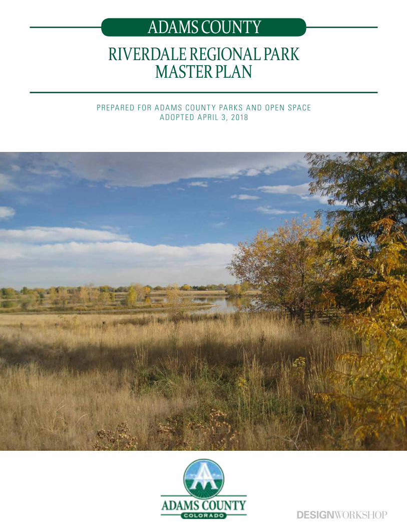
RIVERDALE REGIONAL PARK MASTER PLAN PREPARED FOR ADAMS COUNTY PARKS AND OPEN SPACE ADOPTED APRIL 3, 2018 ADAMS COUNTY
Transcript of ADAMS COUNTY RIVERDALE REGIONAL PARK MASTER PLAN
RIVERDALE REGIONAL PARKMASTER PLAN
P RE PA RE D F OR A DA MS C OUN T Y PA RKS A ND O P E N SPAC E A DO P T E D A P R IL 3 , 2 018
ADAMS COUNTY
ACKNOWLEDGEMENTS
*Note: “Adams County Regional Park and Fairgrounds” and “Riverdale Regional Park” are interchangeable within this document and reference the same site and terminology.
ADAMS COUNTY STAFF
Kurt Carlson, Regional Park Manager/Project Manager
Nathan Mosley, Parks and Open Space Director
Casandra Vossler, Fair and Special Events Manager
Sean Braden, Facilities Project Manager
Shannon McDowell, Open Space Program Manager
Julia Ferguson, Adams County Sustainability Coordinator
Russell Nelson, Adams County Drainage Engineer
Juliana Archuleta, Stormwater Administrator
Erik Bryant, Facilities Building Maintenance Supervisor
Dean Whalen, Regional Park Grounds Supervisor
Trevor Graf, Regional Park Facility and Utilities Supervisor
Eric Hammond, CSU Extension Horticulture Agent
Kenzie Krinkee, CSU Extension 4-H, Youth, Small Animal Associate
Jen Tierney, ADCO Purchasing Agent
ADAMS COUNTY COMMISSIONERS
Eva J. Henry (District 1)
Charles ‘Chaz’ Tedesco (District 2)
Erik Hansen (District 3)
Steve O’Dorisio (District 4)
Mary Hodge (District 5)
CONSULTANT TEAM
Design Workshop
K/O Architects
Crossroads Consulting Services
Martin/Martin, Inc.
Sink Combs Dethlefs
Image credit: Adams County
CONTENTS
On the Cover: Riverdale Regional Park| Adams County, Colorado
GOALS
SITE HISTORY
REVIEW OF PAST PLANS
PHASING
APPENDIX
MASTER PLAN
COMMUNITY OUTREACH
MARKET ASSESSMENT
BENCHMARK STUDY
EXISTING CONDITIONS & ANALYSIS
FINANCIAL ASSESSMENT
1
4
6
196
210
112
50
62
90
14
102
Focus Group MeetingsCommunity Meetings and Surveys
Fairgrounds FacilitiesRegional Park
Local Market ConditionsOverview of Fairgrounds OperationsSupply of Competitive Area FacilitiesSummary of Market Findings
Regional ContextNatural ResourcesSite InventoryEventsCirculation and Accessibility
Master Plan OverviewRegional Park SouthRegional Park NorthFairgrounds Area VisionSite Design and Place-makingWater ResourcesVehicular Access and ParkingTrailsUtility and Drainage StrategiesLand AcquisitionPark Accreditations and CertificationsSustainability Concepts
Appendix A: Recommendations SummaryAppendix B: Assessment of Existing FacilitiesAppendix C: Previous Plan ConceptsAppendix D: Concept DevelopmentAppendix E: Civil Utility DocumentsAppendix F: Cost EstimateAppendix G: Benchmark Study WorksheetsAppendix H: Public Polling Results
5254
198206
64727886
1622303844
114116122130143149154159170184186188
212220
246248250260270302
Image credit: Adams County
1
GOALSADAMS COUNTY MISSION STATEMENT:
“To responsibly serve the Adams County Community with Integrity and Innovation.”
PARKS AND OPEN SPACE MISSION:“To enhance the quality of life for residents by providing recreational, educational, and cultural opportunities through our system of parks, trails, open spaces, and facilities; and to preserve and protect the natural and cultural resources of the county for present and future generations.”
ADAMS COUNTY FAIR MISSION STATEMENT:“The mission of the Adams County Fair is to provide a quality event for our guests and to enhance educational opportunities with an emphasis on youth and agriculture while uniting urban and rural communities in a time honored celebration.”
TECHNICAL ADVISORY COMMITTEE (TAC) VISION FOR SOUTH PLATTE RIPARIAN CORRIDOR:
“In the economic and ecological interest of Adams County, the Technical Advisory Committee (TAC) for the Regional Park and Fairgrounds Master Plan update has a vision of a healthy and continuous terrestrial and aquatic habitat along the South Platte River from 136th Avenue upstream to 120th Avenue Parkway and beyond. Attainment of this vision will provide a healthy river ecosystem and an unfragmented riparian corridor; thereby contributing to Riverdale Regional Park and promoting both recreational fishing and bird watching; activities that have a high economic benefit for the local economy.”
2 | Goals
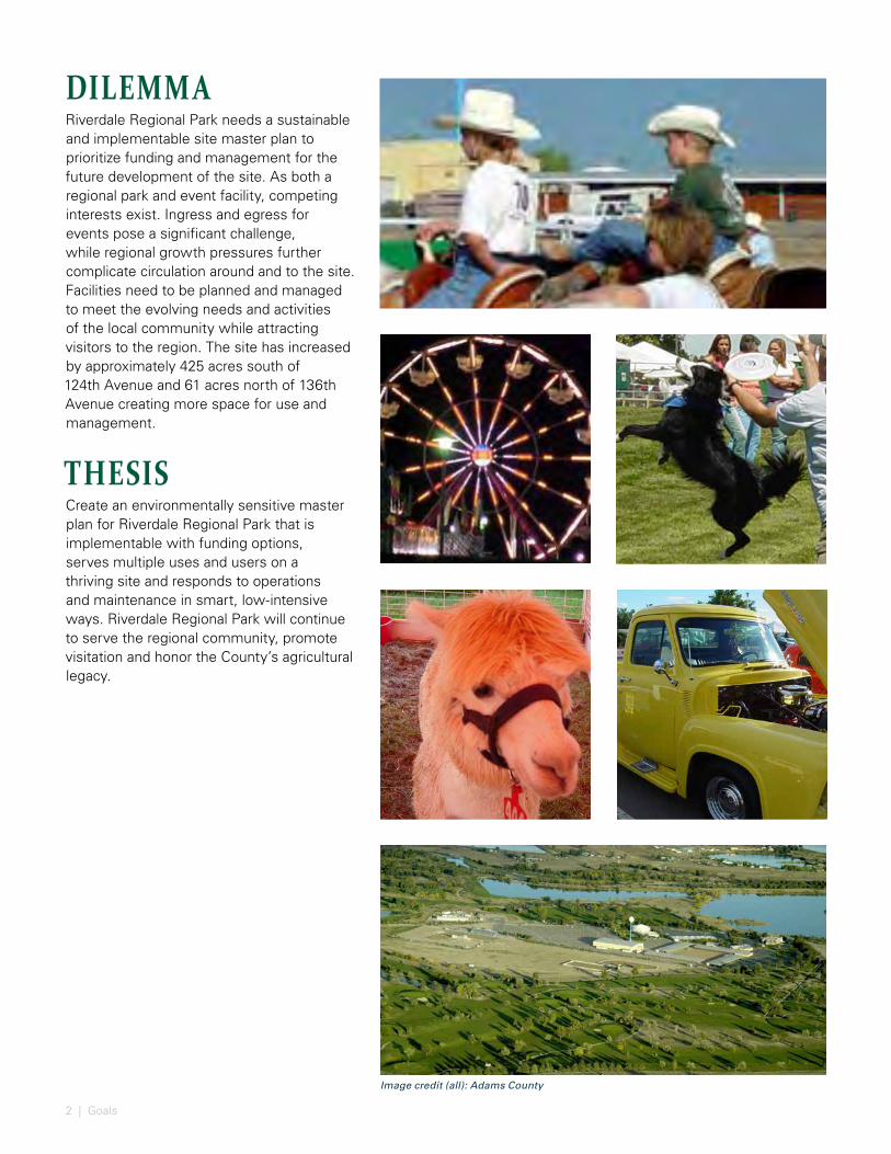
DILEMMARiverdale Regional Park needs a sustainable and implementable site master plan to prioritize funding and management for the future development of the site. As both a regional park and event facility, competing interests exist. Ingress and egress for events pose a significant challenge, while regional growth pressures further complicate circulation around and to the site. Facilities need to be planned and managed to meet the evolving needs and activities of the local community while attracting visitors to the region. The site has increased by approximately 425 acres south of 124th Avenue and 61 acres north of 136th Avenue creating more space for use and management.
THESISCreate an environmentally sensitive master plan for Riverdale Regional Park that is implementable with funding options, serves multiple uses and users on a thriving site and responds to operations and maintenance in smart, low-intensive ways. Riverdale Regional Park will continue to serve the regional community, promote visitation and honor the County’s agricultural legacy.
Image credit (all): Adams County
3
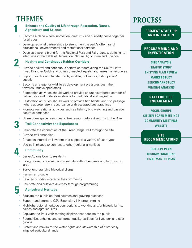
THEMESEnhance the Quality of Life through Recreation, Nature, Agriculture and Science
• Become a place where innovation, creativity and curiosity come together for all ages
• Develop regional partnerships to strengthen the park’s offerings of educational, environmental and recreational services
• Develop a strong brand for the Regional Park and Fairgrounds, defining its intentions in the fields of Recreation, Nature, Agriculture and Science
Healthy and Continuous Habitat Corridors
• Provide healthy and continuous habitat corridors along the South Platte River, Brantner Gulch and other connected aquatic and terrestrial resources
• Support wildlife and habitat (birds, wildlife, pollinators, fish, riparian/aquatic)
• Become a refuge for wildlife as development pressures push them towards undeveloped areas
• Restoration activities should work to provide an unencumbered corridor of native trees and understory shrubs for bird habitat and migration
• Restoration activities should work to provide fish habitat and fish passage (where appropriate) in accordance with accepted best practices
• Promote recreational activities such as fishing, bird watching and passive nature experiences
• Utilize open space resources to treat runoff before it returns to the River
Trail Connectivity and Experiences
• Celebrate the connection of the Front Range Trail through the site
• Provide trail amenities
• Create an internal trail system that supports a variety of user types
• Use trail linkages to connect to other regional amenities
Community
• Serve Adams County residents
• Be right-sized to serve the community without endeavoring to grow too large
• Serve long-standing historical clients
• Remain affordable
• Be a fair of today – cater to the community
• Celebrate and cultivate diversity through programming
Agricultural Heritage
• Educate the public on food sources and growing practices
• Support and promote CSU Extension/4-H programming
• Highlight regional heritage connections to working and/or historic farms, dairies and agrarian sites
• Populate the Park with rotating displays that educate the public
• Reorganize, enhance and construct quality facilities for livestock and user groups
• Protect and maximize the water rights and stewardship of historically irrigated agricultural lands
1
2
3
4
5
PROJECT START UP AND INITIATION
PROGRAMMING AND INVESTIGATION
STAKEHOLDER ENGAGEMENT
SITE RECOMMENDATIONS
SITE ANALYSIS
TRAFFIC STUDY
EXISTING PLAN REVIEW
MARKET STUDY
BENCHMARK STUDY
FUNDING ANALYSIS
FOCUS GROUPS
CITIZEN BOARD MEETINGS
COMMUNITY MEETINGS
WEBSITE
CONCEPT PLAN
RECOMMENDATIONS
FINAL MASTER PLAN
PROCESS
4 |
Image credit: Adams County
5
The Adams County Fair dates back to the early establishment of the County itself. The first “Adams County” Fair and Rodeo was held in October of 1904, but earlier, in 1888, regional fairs and rodeos were held during monthly Market Days at the old fairgrounds in Brighton. These events included space for exhibits, a grandstand for 500 people, a racetrack called Driving Park for horse and plow races, cattle and horse auction sales, a fine arts hall, stalls and more.
The first day of the fair was known as Tomato Day. A noon barbecue was followed by a tomato contest that was called the Battle of Brighton. Two teams lined up and faced each other in front of the grandstand. Each team member was given a box of ripe tomatoes and on command they disposed of the fruit as quickly as possible by throwing it at the opposing team and occasionally the spectators. Events at the early fair also included wild bronco riding, half-mile foot races, bicycle and motorcycle races, a mule race, horse races of various sorts and a baby contest.
In 1965, the old fairgrounds became too small, and the Adams County Board of County Commissioners elected to move the fair to the old Denver Poor Farm site and its present location.
The Denver Poor Farm, which was sold to the County by Denver in 1960 for $176,500, included barns, corrals, dormitories, an icehouse, a dining hall and an administration building. The original deed included about 356 acres of land, 24 shares in the Old Brantner Ditch and 12 water shares in the Lower Clear Creek Ditch Company.
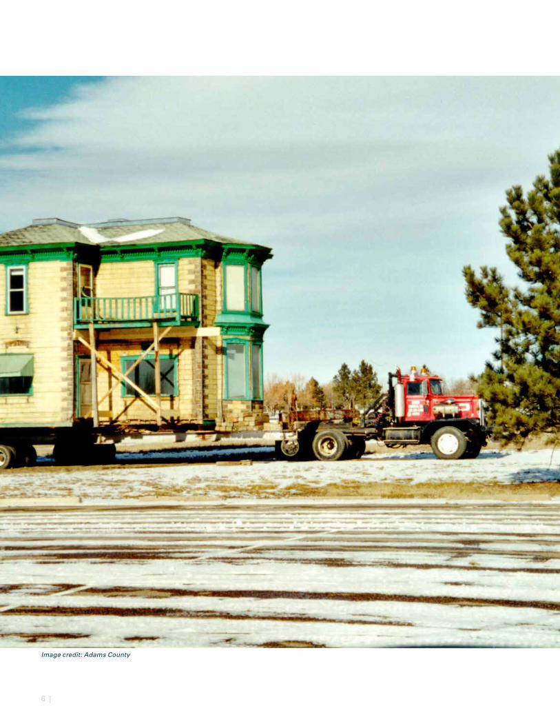
The Denver Poor Farm was located on John Henderson’s ranch, dating back to the 1860’s. It was named Henderson’s Island, as an island was formed when the South Platte River split into two branches. The site attracted people as a resort and later became the McCool Ranch before becoming the Denver Poor Farm. The Poor Farm was a home for convalescents, elderly, the sick and destitute.
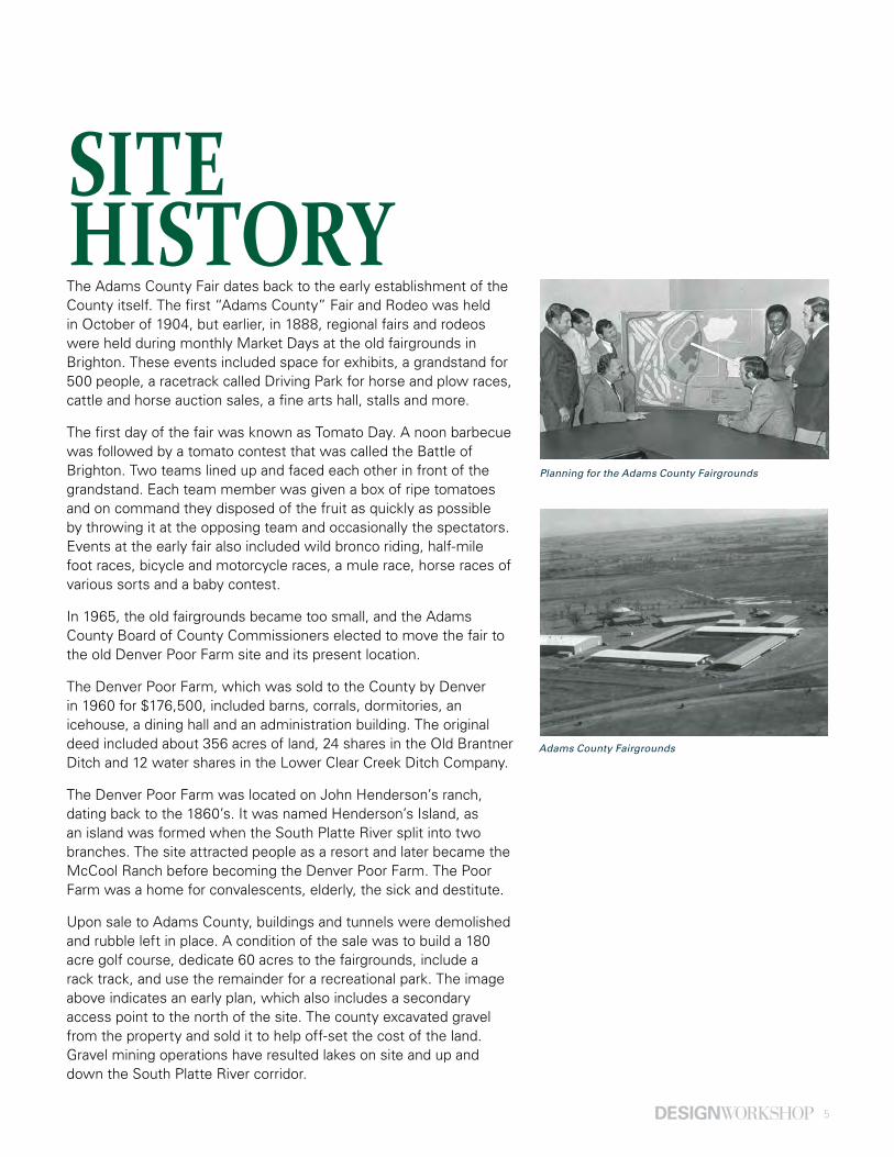
Upon sale to Adams County, buildings and tunnels were demolished and rubble left in place. A condition of the sale was to build a 180 acre golf course, dedicate 60 acres to the fairgrounds, include a rack track, and use the remainder for a recreational park. The image above indicates an early plan, which also includes a secondary access point to the north of the site. The county excavated gravel from the property and sold it to help off-set the cost of the land. Gravel mining operations have resulted lakes on site and up and down the South Platte River corridor.
SITE HISTORY
Adams County Fairgrounds
Planning for the Adams County Fairgrounds
6 |
Image credit: Adams County
7
REVIEW OF PAST PLANSThis master plan update for the Riverdale Regional Park is necessary due to the expansion of county-owned lands surrounding the site, the changing needs of the Parks and Open Space Department, the shift in demographics, a change in neighboring uses and growth and development pressures in the surrounding area. This master plan will seek to provide a more balanced look at the fairgrounds and the park assets of the subject property.
Past master planning efforts for the park and fairgrounds should be recognized for accomplishing many of the goals and objectives while recognizing items that have not been completed but remain relevant to this plan update. Past plans reviewed included:
• 1999 Adams County Regional Park Master Plan
• 2008 Adams County Regional Park South and Northeast Areas Master Plan
• 2009 Adams County Regional Park Fairgrounds Master Plan
Additional planning efforts pertinent to the park and fairgrounds were reviewed for goals and objectives that impact, or have the potential to impact, the future use of the park. The following plans were reviewed to determine alignment with this plan update:
• 1997 South Platte River Heritage Corridor
• 2005 Riverdale Road Corridor Plan
• 2007 Colorado Front Range Trail Comprehensive Implementation Plan
• 2012 Adams County Open Space, Parks and Trails Master Plan
• 2012 Adams County Comprehensive Plan and 2015 Amendment
8 | Review of Past Plans
1997 SOUTH PLATTE RIVER HERITAGE CORRIDORThis plan focused on a 17-mile stretch of the South Platte from Commerce City to Brighton, including the portion of the river through the Regional Park. The South Platte River Heritage Corridor Plan provided a strategic action plan for preserving and enhancing the natural, cultural and recreational qualities of the corridor.
Goals of the 1997 South Platte River Heritage Plan included:
• Complete the South Platte River Trail system and connect to the adjacent trail systems
• Demonstrate the potential for multi-purpose gravel mine restoration
• Gateway enhancements and stream corridor improvements to change the public image
• Protect natural lands and wildlife habitat and establish a riparian buffer along the river
• Preserve the rural character and key agricultural properties
• Expand recreational opportunities, especially at the Adams County Regional Park
• Develop environmental education and interpretation programs
• Foster community stewardship programs: Engage people in caring for the river
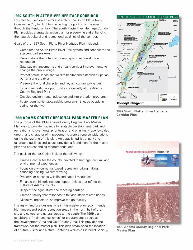
1999 ADAMS COUNTY REGIONAL PARK MASTER PLANThe purpose of the 1999 Adams County Regional Park Master Plan was to provide guidance for suitable development, park and recreation improvements, prioritization and phasing. Properly-scaled growth and character of improvements were strong considerations during the crafting of this plan. An established list of park and fairground qualities and issues provided a foundation for the master plan and corresponding recommendations.
The goals of the 1999 plan include the following:
• Create a center for the county, devoted to heritage, cultural, and environmental experiences
• Focus on environmental based recreation (biking, hiking, canoeing, fishing, wildlife viewing)
• Preserve or enhance wildlife and natural resources
• Enhance the historic resource opportunities that reflect the culture of Adams County
• Respect the agricultural and ranching heritage
• Create a facility that responds to fair and stock related needs
• Minimize impacts to, or improve the golf facility
The major land use designations in this master plan recommends high-impact and active recreation areas in the north half of the site and cultural and natural areas to the south. The 1999 plan established “maintenance zones” or program areas such as the Development Area and Golf Course Area. This provided the framework for the master plan. This plan established the location of a future Visitor and Nature Center as well as a Historical Society/
1999 Adams County Regional Park Master Plan
Smith Reservoir
Concept Diagram
Sand Creek
Third Creek
0 20002000 4000 feet
MULTIPLE-USE WATER STORAGEInclude habitat restoration and recreation in future water storage facilities
RURAL CHARACTERProtect key agricultural lands and views from Riverdale Road
TRAIL CONNECTIONSConnect cities and neighborhoods to the Platte River Trail
EXPAND REGIONAL PARK New 'gateway' off of extended 120th
FOCUS AREA Includes all components of the VISION (enhanced reclamation,multiple-use water storage, environmentaleducation, recreation, natural areas protection, rural character, cultural history)
RIPARIAN BUFFER Varies in width, designed to protect sensitiveareas, flood plain, allows compatible uses
EXPAND CONSERVATION AREAInclude remainder of cottonwood grove and adjacent prairie dog towns
LINK to SAND CREEK
GATEWAYSEnhanced reclamation, restore/repair streambanks,trail access, environmental education, visual amenity
PLATTE RIVER TRAIL Extend trail the length of Adams County,
avoid sensitive riparian/natural areas
E. 112th Avenue
Brig
hton
Roa
d
Brig
hton
Roa
d
Eastlake #3
Brig
hto
n D
itch
Bra
ntn
er D
itch
AdamsCountyRegionalPark
270
265
2
Rocky Mountain ArsenalNational Wildlife Refuge
York
Str
eet
Connect to Denver's South Platte System
Connect to Rural Character in Weld County
Adams County
Weld County
Barr Lake
Fir st Cre
ek
Second
Cre
ek
keerC raleC
E. 88th Avenue
E. 104th Avenue
McK
ay Rd
Riv
erd
ale
Ro
ad
E. 120th Avenue
Baseline Road
Highway 7
Bromley Lane
E. 160th Avenue
85
Burlin
gton
Ditch
Fulto
n D
itch
reviRettalP htuoS
Ho
lly S
tree
t
Co
lora
do
Blv
d.
Todd Creek
Bull Se
ep
Gra
nge H
all
Creek
Bran Gtner ulch
Basin 4100Hoffm
an D
rain
Was
hin
gto
n St
reet
E. 124th Avenue
E-47)
0d
(P eropos
O'Br
ian
Ditch
Surface Water
Study Area
Riparian Buffer
Existing Trails
Proposed Trails
Gateways
76
Niver Creek Canal
SOUTH PLATTE RIVER HERITAGE PLAN
Conservation Partners/ERO Resources Corporation
June 16, 1997
Adams County Parks and Community ResourcesAdams County Commissioners: Martin J. Flaum Ted Strickland Elaine T. Valente
1997 South Platter River Heritage Corridor Plan
9
Agricultural Heritage Center centralized in the southern portion of the site.
The goals for the fairgrounds area include the following:
• Spread out and move buildings as necessary to improve health, safety, human comfort, and relationships between existing uses
• Add needed facilities, including animal barns and provide an enlarged indoor arena
• Create a central, landscaped pedestrian spine with a plaza for events
The fairgrounds site plan is organized by a north-south pedestrian spine. The animal barns, the 4-H arena, and the rodeo stadium would all be located on the north end of the spine. Smaller exhibition buildings would all remain on the south end of the site. The indoor arena would anchor the center of the spine. Parking is located along the periphery of the fairgrounds area with clear access ways into the central pedestrian spine.
2005 RIVERDALE ROAD CORRIDOR PLAN Riverdale Road is categorized as a rural collector road. In 2005, most of Riverdale Road was a 2-lane road with a gravel shoulder, no curbs and drainage ditches. The corridor included about ten miles along the west side of the South Platte River from Colorado Boulevard, at 90th Avenue, north to State Highway 7, paralleling the Regional Park’s western edge. The 2005 Plan is an amendment to the Adams County Comprehensive Plan that discusses issues specific to the South Platte River Valley, and as such relates to the South Platte Heritage Plan as well. The intent of the Riverdale Road Plan is ‘to prevent urban growth and development from spoiling the natural and scenic beauty of this unique area of Adams County by providing a vision and implementation policies to guide future development and conservation efforts in the corridor.’
The plan set forth four general goals for the road corridor, followed by broad objectives and specific strategies for implementation. These goals included:
• Limit development and prioritize agricultural development
• Preserve the corridor by limiting urban or suburban scale development
• Design guidelines to reinforce the road’s scenic corridor
• Enhance the corridor with signage and park improvements
10 | Review of Past Plans
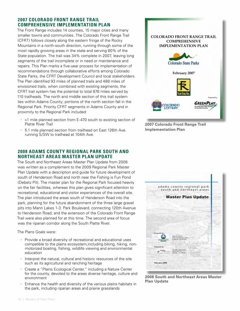
2007 COLORADO FRONT RANGE TRAIL COMPREHENSIVE IMPLEMENTATION PLANThe Front Range includes 14 counties, 15 major cities and many smaller towns and communities. The Colorado Front Range Trail (CFRT) follows closely along the eastern fringe of the Rocky Mountains in a north-south direction, running through some of the most rapidly growing areas in the state and serving 80% of the State population. The trail was 34% complete in 2007, leaving long segments of the trail incomplete or in need or maintenance and repairs. This Plan marks a five-year process for implementation of recommendations through collaborative efforts among Colorado State Parks, the CFRT Development Council and local stakeholders. The Plan identified 93 miles of planned trails and 488 miles of envisioned trails, when combined with existing segments, the CFRT trail system has the potential to total 876 miles served by 110 trailheads. The north and middle section of this trail system lies within Adams County; portions of the north section fall in the Regional Park. Priority CFRT segments in Adams County and in proximity to the Regional Park included:
• >1 mile planned section from E-470 south to existing section of Platte River Trail
• 5.1 mile planned section from trailhead on East 126th Ave. running S/SW to trailhead at 104th Ave.
2008 ADAMS COUNTY REGIONAL PARK SOUTH AND NORTHEAST AREAS MASTER PLAN UPDATEThe South and Northeast Areas Master Plan Update from 2008 was written as a complement to the 2009 Regional Park Master Plan Update with a description and guide for future development of south of Henderson Road and north near the Fishing is Fun Pond (Debetz Pit). The master plan for the Regional Park focused heavily on the fair facilities, whereas this plan gives significant attention to recreational, educational and visitor experiences of the overall site. The plan introduced the areas south of Henderson Road into the park, planning for the future abandonment of the three large gravel pits into Mann Lakes 1-3. Park Boulevard, connecting 120th Avenue to Henderson Road, and the extension of the Colorado Front Range Trail were also planned for at this time. The second area of focus was the riparian corridor along the South Platte River.
The Plans Goals were:
• Provide a broad diversity of recreational and educational uses compatible to the plains ecosystem,including biking, hiking, non-motorized boating, fishing, wildlife viewing and environmental education
• Interpret the natural, cultural and historic resources of the site such as its agricultural and ranching heritage
• Create a “Plains Ecological Center,” including a Nature Center for the county, devoted to the areas diverse heritage, culture and environment
• Enhance the health and diversity of the various plains habitats in the park, including riparian areas and prairie grasslands
2007 Colorado Front Range Trail Implementation Plan
1 Colorado Front Range Trail Comprehensive Implementation Plan
COLORADO FRONT RANGE TRAIL COMPREHENSIVE
IMPLEMENTATION PLAN
February 2007
Prepared by:
2008 South and Northeast Areas Master Plan Update
11
• Promote sustainable environments
• Preserve and enhance wildlife habitats and other natural resources
• Utilize water aesthetically, sustainably and educationally
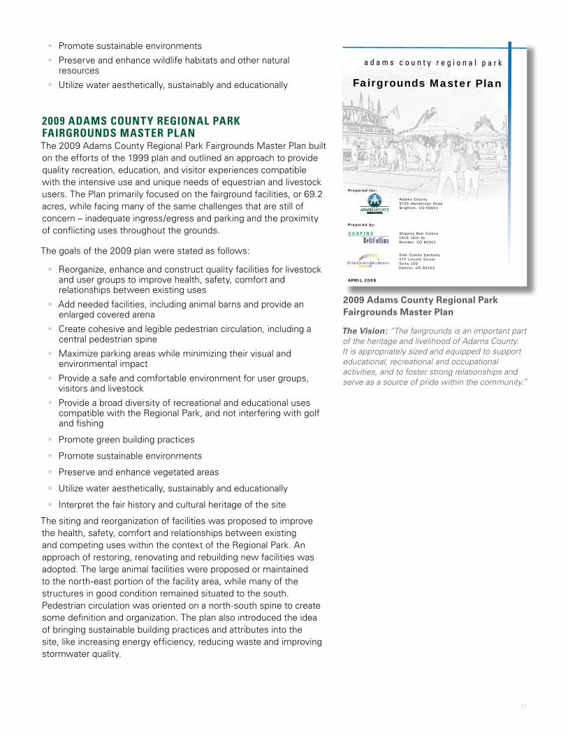
2009 ADAMS COUNTY REGIONAL PARK FAIRGROUNDS MASTER PLANThe 2009 Adams County Regional Park Fairgrounds Master Plan built on the efforts of the 1999 plan and outlined an approach to provide quality recreation, education, and visitor experiences compatible with the intensive use and unique needs of equestrian and livestock users. The Plan primarily focused on the fairground facilities, or 69.2 acres, while facing many of the same challenges that are still of concern – inadequate ingress/egress and parking and the proximity of conflicting uses throughout the grounds.
The goals of the 2009 plan were stated as follows:
• Reorganize, enhance and construct quality facilities for livestock and user groups to improve health, safety, comfort and relationships between existing uses
• Add needed facilities, including animal barns and provide an enlarged covered arena
• Create cohesive and legible pedestrian circulation, including a central pedestrian spine
• Maximize parking areas while minimizing their visual and environmental impact
• Provide a safe and comfortable environment for user groups, visitors and livestock
• Provide a broad diversity of recreational and educational uses compatible with the Regional Park, and not interfering with golf and fishing
• Promote green building practices
• Promote sustainable environments
• Preserve and enhance vegetated areas
• Utilize water aesthetically, sustainably and educationally
• Interpret the fair history and cultural heritage of the site
The siting and reorganization of facilities was proposed to improve the health, safety, comfort and relationships between existing and competing uses within the context of the Regional Park. An approach of restoring, renovating and rebuilding new facilities was adopted. The large animal facilities were proposed or maintained to the north-east portion of the facility area, while many of the structures in good condition remained situated to the south. Pedestrian circulation was oriented on a north-south spine to create some definition and organization. The plan also introduced the idea of bringing sustainable building practices and attributes into the site, like increasing energy efficiency, reducing waste and improving stormwater quality.
Prepared for:
Adams County 9755 Henderson Road Brighton, CO 80601
Prepared by:
Shapins Belt Collins 1818 16th St. Boulder, CO 80302
Sink Combs Dethlefs 475 Lincoln Street Suite 100 Denver, CO 80203
APRIL 2009
a d a m s c o u n t y r e g i o n a l p a r k
Fairgrounds Master Plan
BeltCollinsS H A P I N S
2009 Adams County Regional Park Fairgrounds Master Plan
The Vision: “The fairgrounds is an important part of the heritage and livelihood of Adams County. It is appropriately sized and equipped to support educational, recreational and occupational activities, and to foster strong relationships and serve as a source of pride within the community.”
12 | Review of Past Plans
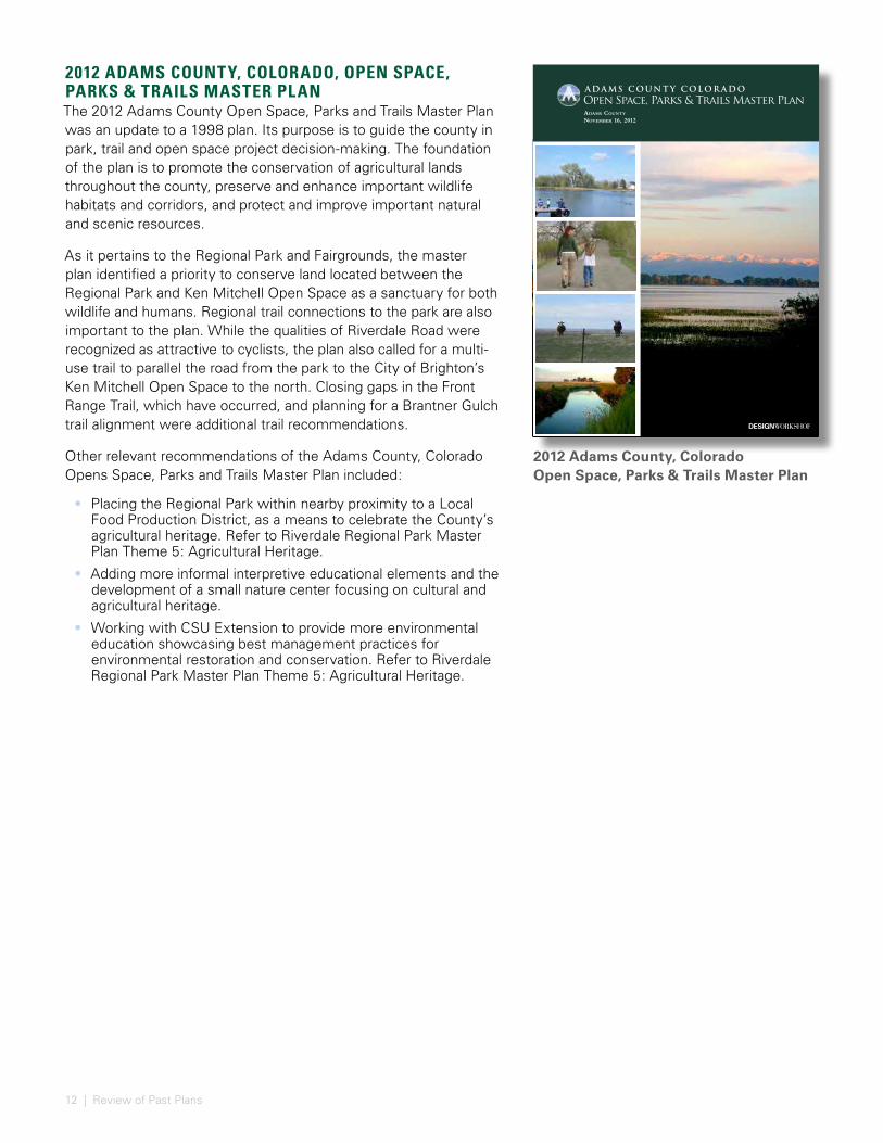
2012 ADAMS COUNTY, COLORADO, OPEN SPACE, PARKS & TRAILS MASTER PLANThe 2012 Adams County Open Space, Parks and Trails Master Plan was an update to a 1998 plan. Its purpose is to guide the county in park, trail and open space project decision-making. The foundation of the plan is to promote the conservation of agricultural lands throughout the county, preserve and enhance important wildlife habitats and corridors, and protect and improve important natural and scenic resources.
As it pertains to the Regional Park and Fairgrounds, the master plan identified a priority to conserve land located between the Regional Park and Ken Mitchell Open Space as a sanctuary for both wildlife and humans. Regional trail connections to the park are also important to the plan. While the qualities of Riverdale Road were recognized as attractive to cyclists, the plan also called for a multi-use trail to parallel the road from the park to the City of Brighton’s Ken Mitchell Open Space to the north. Closing gaps in the Front Range Trail, which have occurred, and planning for a Brantner Gulch trail alignment were additional trail recommendations.
Other relevant recommendations of the Adams County, Colorado Opens Space, Parks and Trails Master Plan included:
• Placing the Regional Park within nearby proximity to a Local Food Production District, as a means to celebrate the County’s agricultural heritage. Refer to Riverdale Regional Park Master Plan Theme 5: Agricultural Heritage.
• Adding more informal interpretive educational elements and the development of a small nature center focusing on cultural and agricultural heritage.
• Working with CSU Extension to provide more environmental education showcasing best management practices for environmental restoration and conservation. Refer to Riverdale Regional Park Master Plan Theme 5: Agricultural Heritage.
AdAms County november 16, 2012
2012 Adams County, Colorado Open Space, Parks & Trails Master Plan
13
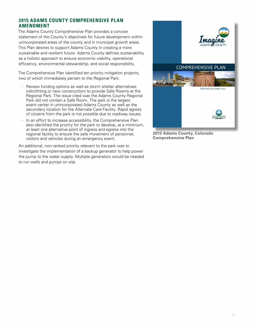
2015 ADAMS COUNTY COMPREHENSIVE PLAN AMENDMENTThe Adams County Comprehensive Plan provides a concise statement of the County’s objectives for future development within unincorporated areas of the county and in municipal growth areas. This Plan desires to support Adams County in creating a more sustainable and resilient future. Adams County defines sustainability as a holistic approach to ensure economic viability, operational efficiency, environmental stewardship, and social responsibility.
The Comprehensive Plan identified ten priority mitigation projects, two of which immediately pertain to the Regional Park:
• Review funding options as well as storm shelter alternatives (retrofitting or new construction) to provide Safe Rooms at the Regional Park. The issue cited was the Adams County Regional Park did not contain a Safe Room. The park is the largest event center in unincorporated Adams County as well as the secondary location for the Alternate Care Facility. Rapid egress of citizens from the park is not possible due to roadway issues.
• In an effort to increase accessibility, the Comprehensive Plan also identified the priority for the park to develop, at a minimum, at least one alternative point of ingress and egress into the regional facility to ensure the safe movement of personnel, visitors and vehicles during an emergency event.
An additional, non-ranked priority relevant to the park was to investigate the implementation of a backup generator to help power the pump to the water supply. Multiple generators would be needed to run wells and pumps on site.
ADOPTED DECEMBER 2012
COMPREHENSIVE PLAN
2012 Adams County, Colorado Comprehensive Plan
14 |
Image credit: Adams County

15
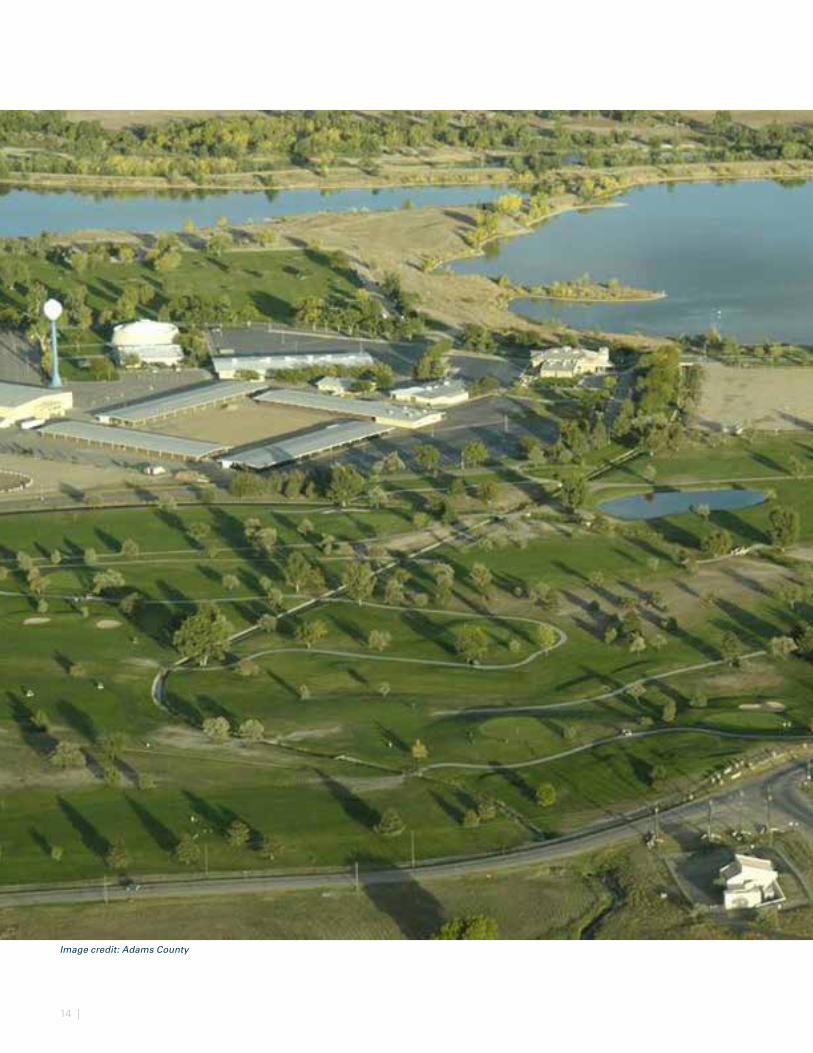
EXISTING CONDITIONS & ANALYSIS Riverdale Regional Park contains 1,197 acres of parklands on the west side of Adams County, just north of Denver. The park’s location, situated at the southwest quadrant of Highway 470 and Highway 85, creates a very accessible park. The existing park consists of two 18-hole golf courses, a disc golf course, picnic areas, and the county fairgrounds at the core of the site. The fairgrounds account for 69.2 acres of the site. A number of buildings and facilities in varying conditions can be found within the fairgrounds. Recently, the regional park has expanded to acquire lands to the south adding approximately 425 acres, and the county has also added 61 acres to the north of 136th Avenue in 2017.
Over the past 20 years, the landscape surrounding the park has largely shifted from a low-density suburban area with ample open space to a much more developed and altered context. A visual survey of the surrounding landscapes show increased development and reduced open spaces largely along the major roadway corridors to the west and a lower density development to the east of the park. The Denver International Airport is one example of expanded development in the region. Between 1990 and 2000 its services and facility footprint grew rapidly. On the other extreme, gravel extraction activity along the South Platte River is resulting in reclaimed lakes along the riparian corridor. This evolution of the corridor is counter to comparable developed areas around rivers where floodplains and wetlands are minimized over time in the interest of development.
This section serves to describe the context and demographics surrounding Riverdale Regional Park and highlight on-site natural resources. It also inventories site programs and facilities, examines circulation and accessibility and opportunities for multi-modal improvements and details the variety of events that are hosted at the park. Finally, this section provides an assessment of existing facilities on-site. The existing conditions and analysis provide a comprehensive understanding of the park and implications of design and policy-level decisions.
16 | Existing Conditions and Analysis
60 Minute Drive Time
30 Minute Drive Time
15 Minute Drive Time
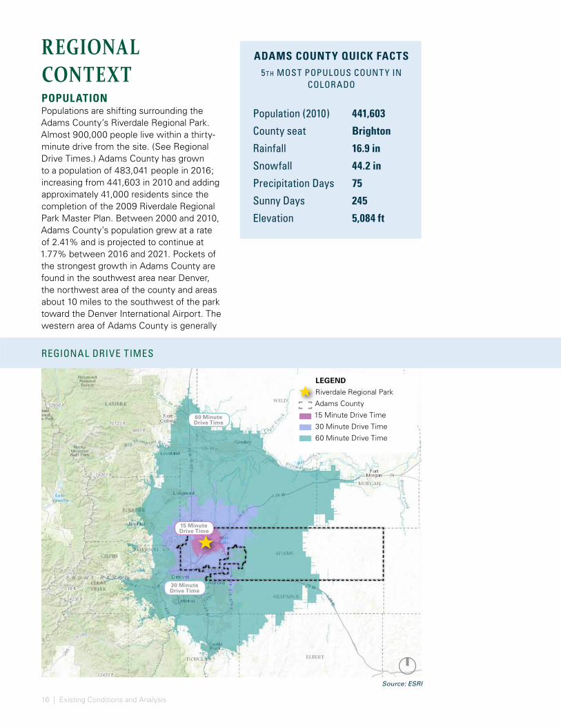
REGIONAL CONTEXTPOPULATIONPopulations are shifting surrounding the Adams County’s Riverdale Regional Park. Almost 900,000 people live within a thirty-minute drive from the site. (See Regional Drive Times.) Adams County has grown to a population of 483,041 people in 2016; increasing from 441,603 in 2010 and adding approximately 41,000 residents since the completion of the 2009 Riverdale Regional Park Master Plan. Between 2000 and 2010, Adams County’s population grew at a rate of 2.41% and is projected to continue at 1.77% between 2016 and 2021. Pockets of the strongest growth in Adams County are found in the southwest area near Denver, the northwest area of the county and areas about 10 miles to the southwest of the park toward the Denver International Airport. The western area of Adams County is generally
LEGEND
Riverdale Regional Park
Adams County
15 Minute Drive Time
30 Minute Drive Time
60 Minute Drive Time
ADAMS COUNTY QUICK FACTS5t h MOST POPULOUS COUNT Y IN
COLORADO
Population (2010) 441,603
County seat Brighton
Rainfall 16.9 in
Snowfall 44.2 in
Precipitation Days 75
Sunny Days 245
Elevation 5,084 ft
REGIONAL DRIVE TIMES
Source: ESRI

17
DISTANCES TO REGIONAL DESTINATIONS
more populous than the eastern area and the northern areas boast slightly higher incomes compared to the southern area of the county.
REGIONAL DESTINATIONSWithin the western portion of Adams County, three major open spaces serve the surrounding populations including Rocky Mountain Arsenal National Wildlife Refuge, Barr Lake State Park and the Riverdale Regional Park. (See Distances to Regional Destinations.) As a centrally located park with a facility and program development yet to be defined, Riverdale Regional Park has the potential to bring together the almost 900,000 people within
Barr Lake State Park12.5 miles
National Western Complex16.0 miles
Denver International Airport19.3 miles
Rocky Mountain Arsenal National Wildlife Refuge12.4 miles
a thirty-minute driving distance for various park amenities, events and programs. The park’s proximity to the Denver core has the potential to serve existing populations and attract new visitors from both the higher income residents to the north and lower income minority residents to the south, higher density dwellers to the west and lower density dwellers to the east. It’s location in proximity of three major metro area highways (E-470, US 85, and I-76) provide an opportunity to capitalize on the population concentrated in close proximity by creating additional entrances to the park and streamlining vehicular routes.
Source: Bing Map (base map only)
18 | Existing Conditions and Analysis
Adams County Regional ParkRoads (Asphalt)Dirt Road (Primary)Dirt Road (Secondary)
Creek, Canal, Stream, or DitchRiverLakesStormwater PondsParks and Open SpaceParcels
Data Source: Adams County Parks and
Open Space Department
0 5,3002,650Feet
1 3
5
2
4
6
I-470
I-85
I-85
I-76
SH-2
BRIG
HTO
N RO
AD
RIVERDALE
ROAD
RIVE
RDAL
E RO
AD
E 140TH AVE
E 96TH AVE
W 88TH AVE
E 124TH AVE
E 128TH AVE
E 120TH AVE
RIVERDALE REGIONAL PARK
(1,197 AC)
E 136TH AVE
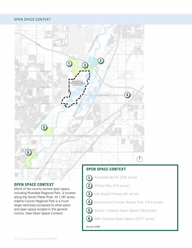
OPEN SPACE CONTEXT
OPEN SPACE CONTEXTMuch of the county-owned open space, including Riverdale Regional Park, is located along the South Platte River. At 1,197 acres, Adams County Regional Park is a much larger land area compared to other parks and open space located in the general vicinity. (See Open Space Context)
1
3
5
2
4
6
OPEN SPACE CONTEXT
Riverdale Bluffs (226 acres)
Willow Bay (174 acres)
Van Scoyk Parcels (61 acres)
Government Center Nature Park (19.5 acres)
Elaine T Valente Open Space (163 acres)
88th Avenue Open Space (227.7 acres)
Source: ESRI
19
Adams County Regional ParkRoads (Asphalt)Dirt Road (Primary)Dirt Road (Secondary)
Creek, Canal, Stream, or DitchRiverLakesStormwater Ponds
Data Source: Adams County Parks and Open Space Department
0 10,0005,000Feet
1
1
3
5
2
4
6
I-470
I-85
I-76
SH-2
I-25
FED
ERAL
BLV
D
E 140TH AVE
I-70
National Western Stock Show Complex
Riverdale Regional Park
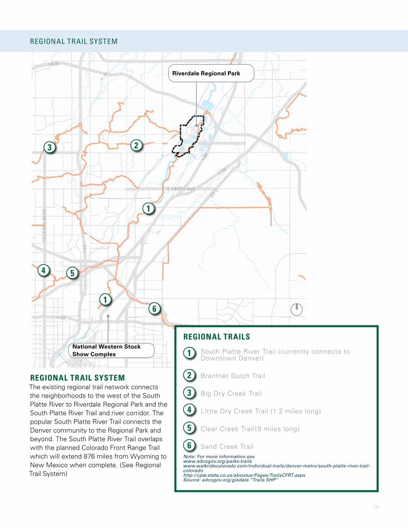
REGIONAL TRAIL SYSTEM
REGIONAL TRAIL SYSTEMThe existing regional trail network connects the neighborhoods to the west of the South Platte River to Riverdale Regional Park and the South Platte River Trail and river corridor. The popular South Platte River Trail connects the Denver community to the Regional Park and beyond. The South Platte River Trail overlaps with the planned Colorado Front Range Trail which will extend 876 miles from Wyoming to New Mexico when complete. (See Regional Trail System)
1
3
5
2
4
6
REGIONAL TRAILS
South Platte River Trail (currently connects to Downtown Denver)
Brantner Gulch Trail
Big Dry Creek Trail
Little Dry Creek Trail (1.2 miles long)
Clear Creek Trail (9 miles long)
Sand Creek TrailNote: For more information see www.adcogov.org/parks-trails www.walkridecolorado.com/individual-trails/denver-metro/south-platte-river-trail-coloradohttp://cpw.state.co.us/aboutus/Pages/TrailsCFRT.aspxSource: adcogov.org/gisdata “Trails SHP”
20 | Existing Conditions and Analysis
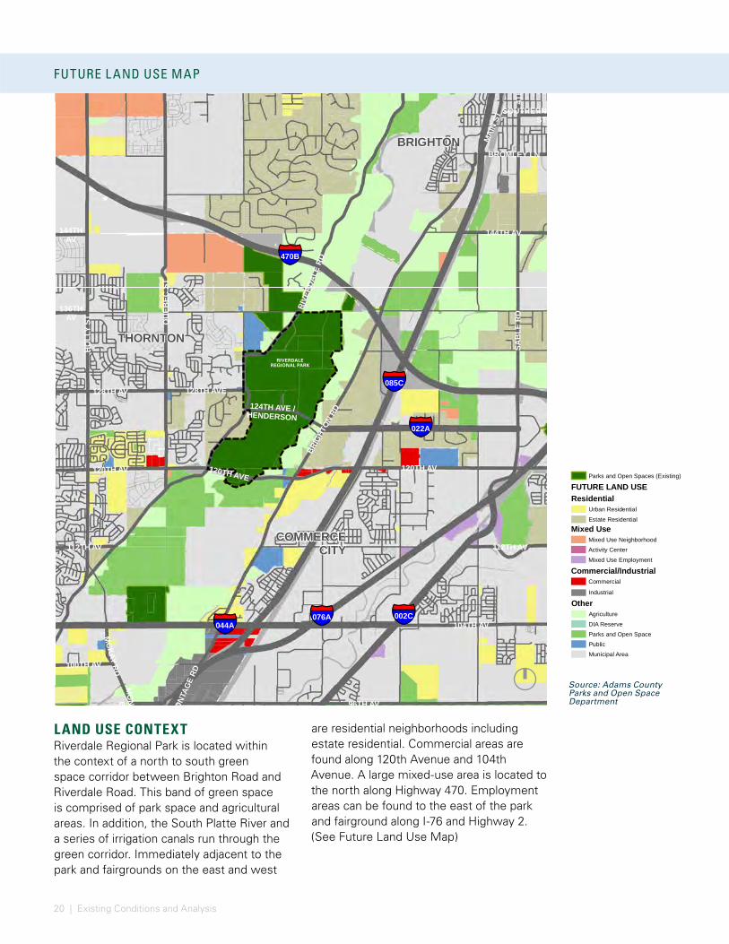
LAND USE CONTEXT Riverdale Regional Park is located within the context of a north to south green space corridor between Brighton Road and Riverdale Road. This band of green space is comprised of park space and agricultural areas. In addition, the South Platte River and a series of irrigation canals run through the green corridor. Immediately adjacent to the park and fairgrounds on the east and west
§̈¦022A
§̈¦085C
§̈¦076A
§̈¦470B
§̈¦002C
§̈¦044A
BRIGHTON
COMMERCECITY
THORNTON
MAI
N ST
QU
EBEC
ST
BRIG
HTON
RD
120TH AVE
BROMLEY LN
SOUTHERNST
112TH AV
124TH AVE /HENDERSON
104TH AV
SAB
LE R
D
112TH AV
MCKAY RD
128TH AVE
100TH AV
FRON
TAGE
RD
144TH AV144THAV
136THAV
120TH AV 120TH AV
96TH AV
HO
LLY
ST
4TH
AV
MO
NACOBD
RIVE
RDAL
E RD
128TH AV
Data Source: Adams County Parks and
Open Space Department
0 4,1002,050Feet [Parks and Open Spaces (Existing)
FUTURE LAND USEResidential
Urban ResidentialEstate Residential
Mixed UseMixed Use NeighborhoodActivity CenterMixed Use Employment
Commercial/IndustrialCommercial
Industrial
OtherAgricultureDIA ReserveParks and Open SpacePublicMunicipal Area
§̈¦022A
§̈¦085C
§̈¦076A
§̈¦470B
§̈¦002C
§̈¦044A
BRIGHTON
COMMERCECITY
THORNTON
MAI
N ST
QU
EBEC
ST
BRIG
HTON
RD
120TH AVE
BROMLEY LN
SOUTHERNST
112TH AV
124TH AVE /HENDERSON
104TH AV
SAB
LE R
D
112TH AV
MCKAY RD
128TH AVE
100TH AV
FRON
TAGE
RD
144TH AV144THAV
136THAV
120TH AV 120TH AV
96TH AVH
OLL
Y ST
4TH
AV
MO
NACOBD
RIVE
RDAL
E RD
128TH AV
Data Source: Adams County Parks and
Open Space Department
0 4,1002,050Feet [Parks and Open Spaces (Existing)
FUTURE LAND USEResidential
Urban ResidentialEstate Residential
Mixed UseMixed Use NeighborhoodActivity CenterMixed Use Employment
Commercial/IndustrialCommercial
Industrial
OtherAgricultureDIA ReserveParks and Open SpacePublicMunicipal Area
§̈¦022A
§̈¦085C
§̈¦076A
§̈¦470B
§̈¦002C
§̈¦044A
BRIGHTON
COMMERCECITY
THORNTON
MAI
N ST
QU
EBEC
ST
BRIG
HTON
RD
120TH AVE
BROMLEY LN
SOUTHERNST
112TH AV
124TH AVE /HENDERSON
104TH AV
SAB
LE R
D
112TH AV
MCKAY RD
128TH AVE
100TH AV
FRON
TAGE
RD
144TH AV144THAV
136THAV
120TH AV 120TH AV
96TH AV
HO
LLY
ST
4TH
AV
MO
NACOBD
RIVE
RDAL
E RD
128TH AV
Data Source: Adams County Parks and
Open Space Department
0 4,1002,050Feet [Parks and Open Spaces (Existing)
FUTURE LAND USEResidential
Urban ResidentialEstate Residential
Mixed UseMixed Use NeighborhoodActivity CenterMixed Use Employment
Commercial/IndustrialCommercial
Industrial
OtherAgricultureDIA ReserveParks and Open SpacePublicMunicipal Area
RIVERDALE REGIONAL PARK
are residential neighborhoods including estate residential. Commercial areas are found along 120th Avenue and 104th Avenue. A large mixed-use area is located to the north along Highway 470. Employment areas can be found to the east of the park and fairground along I-76 and Highway 2. (See Future Land Use Map)
FUTURE L AND USE MAP
Source: Adams County Parks and Open Space Department

21
ZONING MAP
ZONING CONTEXT The zoning around Riverdale Regional Park reveals much of the surrounding areas are zoned residential or mixed use. Rural residential areas dominate the area north of 470 and directly south of the park, while medium density homes can be found to the west of the park. Within the residential areas to the west, open spaces are distributed. Retail areas are fragmented along Brighton Road - to the
north in Brighton and to the east along 120th Avenue. This Zoning Map illustrates large land tracts used for industrial purposes to the north east and to the south of the park. Analyzing the zoning and the street grids, the areas to the west illustrate more dense development. These areas have the potential to connect to the park via multi-use paths by using the street grid and network of canals and green spaces. (See Zoning Map)
§̈¦022A
§̈¦085C
§̈¦076A
§̈¦470B
§̈¦002C
§̈¦044A
128TH AV
144TH AV
QU
EBEC
ST
BROMLEY LN
120TH AVE
104TH AV
112TH AV
120TH AV
MC
KA Y
RD
128TH AVE
100TH AV
96TH AV
4TH
AV
MAI
NST
BRIG
HTON
RD
HO
LLY
ST
SAB
LE R
D
SouthPlatte Ri ver
Brig
hton
Ditc
h
Bri
ghto
nLa
teral
Brantner
Ditc
h
Signal Di tch
McCan n Di
tch
ThirdCreek
Gra nge HallCreek
O'Brian
Canal
First Creek
To dd Cr eek
Brantner Gulch
LowerCl
earC
reek Canal
Se condCreek
De
nver
Huds
on
Canal
Burlington Ditch
Fulton Ditc h
Data Source: Adams County Parks and Open Space Department
0 4,2002,100Feet [Adams County Regional Park
Open
Agriculture
Airport
Civic Low
Civic High
Exempt
Mining
Industrial
Mixed Use Residential
Mixed Use
Mixed Use Commercial
Office
Retail Services
Residential Rural
Residential Low
Residential Medium
Residential High
RIVERDALE REGIONAL PARK
Source: Adams County Parks and Open Space Department
22 | Existing Conditions and Analysis
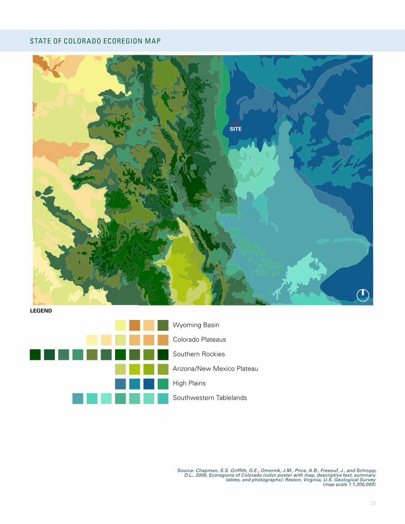
NATURAL RESOURCESCOLORADO ECOREGIONSColorado natural resources are organized by ecological regions, or ecoregions, by national and state entities including the US Environmental Protection Agency and Colorado Parks and Wildlife, among others. The ecoregions provide an ecological framework where each area identified generally contain similar ecosystems in type, quality, and quantity. The state of Colorado boasts a wide variety of ecoregions including arid canyons, alluvial valleys, woodland hills, and wetlands, among many others. By understanding the ecoregion context of Riverdale Regional Park, the best stewardship and ecosystem management strategies can be deployed.
STATE OF COLORADO ECOREGION MAP
ADAMS COUNT Y T YPICAL ECOREGION VISTA
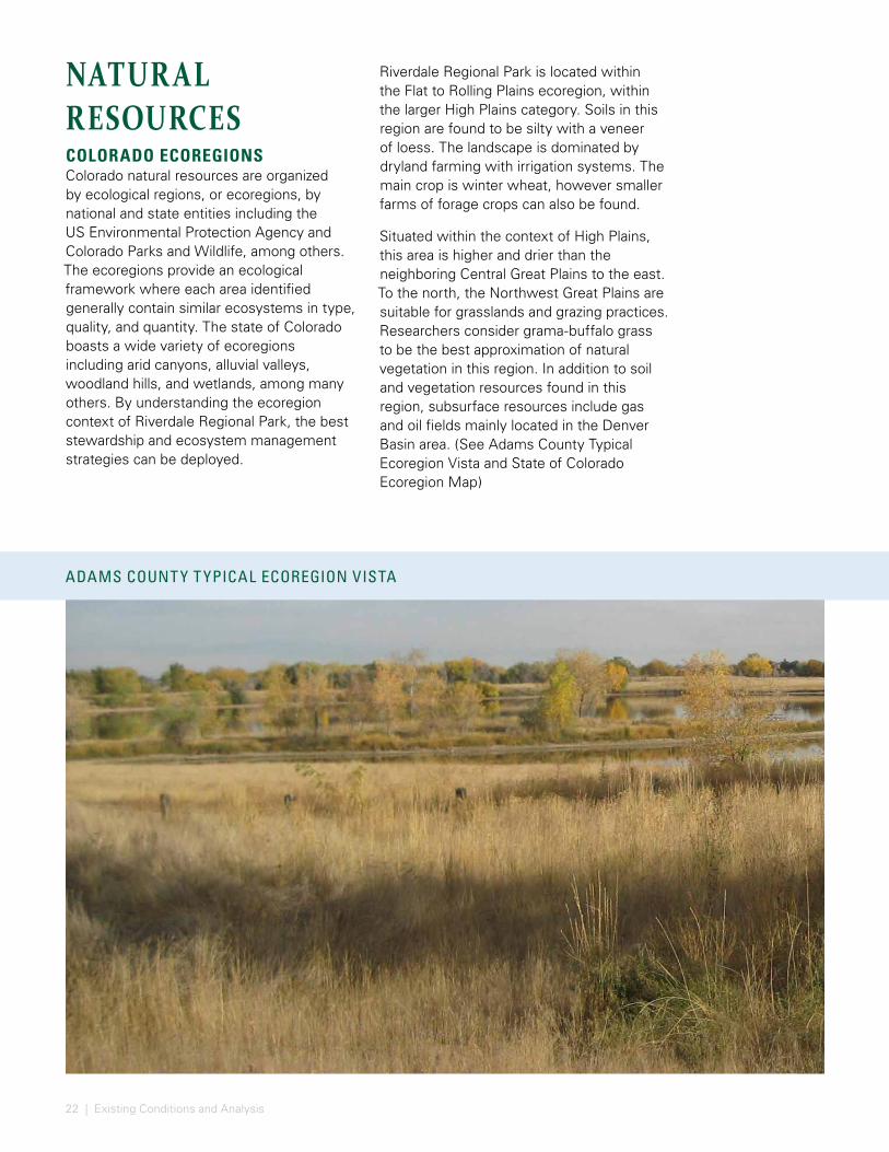
Riverdale Regional Park is located within the Flat to Rolling Plains ecoregion, within the larger High Plains category. Soils in this region are found to be silty with a veneer of loess. The landscape is dominated by dryland farming with irrigation systems. The main crop is winter wheat, however smaller farms of forage crops can also be found.
Situated within the context of High Plains, this area is higher and drier than the neighboring Central Great Plains to the east. To the north, the Northwest Great Plains are suitable for grasslands and grazing practices. Researchers consider grama-buffalo grass to be the best approximation of natural vegetation in this region. In addition to soil and vegetation resources found in this region, subsurface resources include gas and oil fields mainly located in the Denver Basin area. (See Adams County Typical Ecoregion Vista and State of Colorado Ecoregion Map)
23
STATE OF COLORADO ECOREGION MAP
LEGEND
SITE
Wyoming Basin
Colorado Plateaus
Southern Rockies
Arizona/New Mexico Plateau
High Plains
Southwestern Tablelands
Source: Chapman, S.S. Griffith, G.E., Omernik, J.M., Price, A.B., Freeouf, J., and Schrupp, D.L., 2006, Ecoregions of Colorado (color poster with map, descriptive text, summary
tables, and photographs): Reston, Virginia, U.S. Geological Survey (map scale 1:1,200,000)

24 | Existing Conditions and Analysis
L AND COVER CHANGES OVER TIME
1990
2000
2010
Source: http://www.esri.com/software/landsat-imagery/viewer
LEGEND
LAND COVER AND VEGETATIONA visual survey of the surrounding landscapes show increased development and reduced open spaces largely along the major roadway corridors to the west and a lower density development to the east of the park.
Land cover has changed notably over time across the region in the following ways:
• The Denver International Airport expanded its footprint after 1990
• Gravel activity has resulted in reclaimed lakes along the South Platte River
• Visible development pressures continue to expand along roadway corridors
• Reduction of agricultural lands/irrigated agricultural lands
• Expansive growth in Thornton, Brighton and Commerce City
(See Land Cover Changes Over Time)

25
L AND COVER CHANGES OVER TIME
0% - 5%
DEVELOPMENT SLOPES
5% - 10%
10% - 15%
15% - 20%
20% - 25%
25% - 30%
> 30%
BRIGH
TON R
D
E. 126TH AVE
E. 128TH AVE
124TH AVE / HENDERSON
120TH AVE
130TH AVE
E. 136TH AVE
YOSE
MITE
STRIV
ERDA
LE R
D22A
85C
RIVER
DALE
RD
SLOPES
0% - 5%
DEVELOPMENT SLOPES
5% - 10%
10% - 15%
15% - 20%
20% - 25%
25% - 30%
> 30%
BRIGH
TON R
D
E. 126TH AVE
E. 128TH AVE
124TH AVE / HENDERSON
120TH AVE
130TH AVE
E. 136TH AVEYO
SEM
ITE ST
RIVER
DALE
RD
22A
85C
RIVER
DALE
RD
SLOPES
SLOPE STUDYSLOPESThe slopes study illustrates that the areas surrounding the fairgrounds are quite flat with less than five percent slope. Just to the west of the site, however, bluffs are present and create a drainage impact to the site via Brantner Gulch.
The lakes to the south of 124th Avenue are quite irregular in shape and have very steep embankments of 3:1. Lake 3 has slopes of 5:1 along the eastern shoreline to accommodate future proposed access.
The north of the site shows a collection of small landforms amongst the site’s two golf courses.
(See Slope Study)
MANN LAKE #1
MANN LAKE #2
MANN LAKE #3
MANN-NYHOLT LAKE
FISHING IS FUN POND
RIVERDALEBLUFFS
Source: analysis derived from Adams County GIS and ESRI
26 | Existing Conditions and Analysis
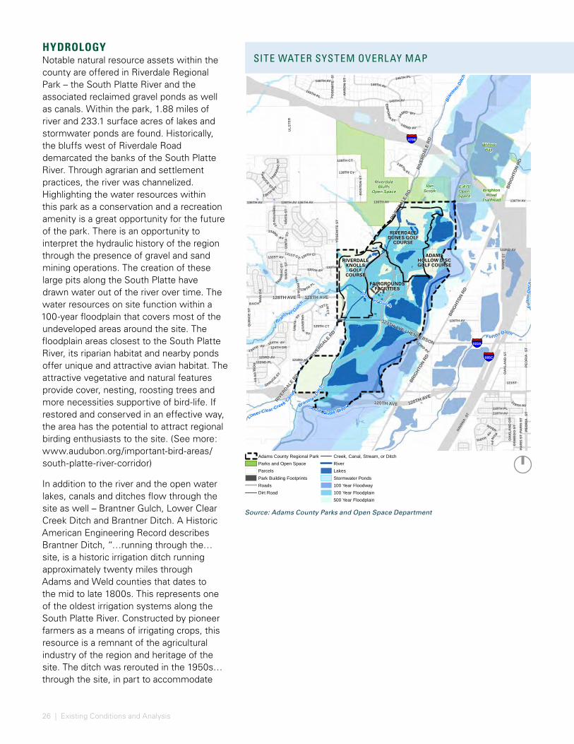
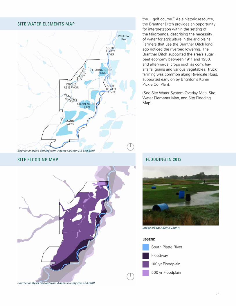
HYDROLOGYNotable natural resource assets within the county are offered in Riverdale Regional Park – the South Platte River and the associated reclaimed gravel ponds as well as canals. Within the park, 1.88 miles of river and 233.1 surface acres of lakes and stormwater ponds are found. Historically, the bluffs west of Riverdale Road demarcated the banks of the South Platte River. Through agrarian and settlement practices, the river was channelized. Highlighting the water resources within this park as a conservation and a recreation amenity is a great opportunity for the future of the park. There is an opportunity to interpret the hydraulic history of the region through the presence of gravel and sand mining operations. The creation of these large pits along the South Platte have drawn water out of the river over time. The water resources on site function within a 100-year floodplain that covers most of the undeveloped areas around the site. The floodplain areas closest to the South Platte River, its riparian habitat and nearby ponds offer unique and attractive avian habitat. The attractive vegetative and natural features provide cover, nesting, roosting trees and more necessities supportive of bird-life. If restored and conserved in an effective way, the area has the potential to attract regional birding enthusiasts to the site. (See more: www.audubon.org/important-bird-areas/south-platte-river-corridor)
In addition to the river and the open water lakes, canals and ditches flow through the site as well – Brantner Gulch, Lower Clear Creek Ditch and Brantner Ditch. A Historic American Engineering Record describes Brantner Ditch, “…running through the… site, is a historic irrigation ditch running approximately twenty miles through Adams and Weld counties that dates to the mid to late 1800s. This represents one of the oldest irrigation systems along the South Platte River. Constructed by pioneer farmers as a means of irrigating crops, this resource is a remnant of the agricultural industry of the region and heritage of the site. The ditch was rerouted in the 1950s… through the site, in part to accommodate
085C
022A
470B
PAR
IS S
T
131ST CT
125TH CT
128 TH PL
139TH CT
127THC
T
121ST
130TH AV
123RD AV
138TH CT
123RD AV
PAR
IS S
T
BACH MA
ND
R131ST AV
124TH AV
146TH AV
124TH DR
126TH AV
UIN
TAST
UIN
TAST
133RD
AV
SP
RUCEST
UIN
TAST
1 24TH AV
RO
SLYNST
14
3RD WY
YO
SEM
ITE
ST
142ND AV
TREN
TON
ST
AK
RO
N S
T
EM
POR
IA
ST
TAM
AR
AC
ST
136TH AV 136TH AV
VALEN
TIAST
PEO
RIA
ST
122ND PL
OSW
EGO
ST
ULS
TER
SPRUCE ST
145TH PL
UIN
TAST
1 38THPL
QU
INC
E ST
146TH PL
BO
STO
N S
T
130TH CI
118TH PL118TH AV
OA
KLA
ND
ST
132ND AV
146TH AV
YOSE
MIT
E ST
PEO
RIA
ST
136TH AV
HAVA
NA S
T
145TH AV
NO
ME
ST
119TH AV
136TH WY
116TH
AV
TAM
ARA
CST
VALEN
TI A
ST
130TH AV
123RD AV
OA
KLA
ND
DR
RIVERRUNPY
136TH AV 136TH AV
120TH AVE
128TH AVE
RIVERDALE R
D
BRIG
HTON
RD
RIVE
RDAL
E RD
120TH AVE
124TH AVE / HENDERSON
128TH AVE
RIVER
DALE R
D
BRIG
HTON
RD
RIVE
RDAL
E RD
BRIG
HTON
RD
RiverdaleBluffs
Open SpaceE-470OpenSpace
BrightonRoad
Trailhead
South Platte River
Brantner Gulch Fulto
nD
itch
Lower Clear Creek Canal
B rantn
er Gulch
Brantne r Ditc
h
Bran
tner
Ditc
h
Ful ton Ditch
Data Source: Adams County Parks and
Open Space Department
0 2,0001,000Feet
WillowBay
VanScoyk
§̈¦085C
§̈¦022A
136TH AV
128T
HPL
131ST CT
129TH PL
XAN
THIA
CT
125TH CT
WA
B
ASH CT
130TH PL
130TH AV
123RD AV
123RD AV
124TH PL
FAIR
GRO
UN
DR
D
126TH AV
VALE
NTI
AS
T
YOSE
MIT
E ST
VALE
NTI
A ST
127T
H CT
VERB
EN
AS T
UIN
T AST
130TH CI
RIV
ERD
ALE
RD
120TH AVE
124TH AVE / HENDERSON
BRIG
HTON
RD
128TH AVE
RiverdaleBluffs
Open Space
E-470OpenSpace
MannNyholtLake
Fishing isFun Pond
DunesReservoir
WastewaterLagoon #1-#3
WastewaterOverflow Pond
KnollsReservoir
MannLakes
Lower Cle
arCr
eekCanal
Brantner Gulch
Brantner Gulch
Fulto
n Ditch
Brantner Ditch
South Platte River
Adams County Regional ParkParks and Open SpaceParcelsPark Building FootprintsRoads Dirt Road
Creek, Canal, Stream, or DitchRiverLakesStormwater Ponds100 Year Floodway100 Year Floodplain500 Year Floodplain
Data Source: Adams County Parks and
Open Space Department
0 1,250625Feet [
RIVERDALE KNOLLS
GOLF COURSE
FAIRGROUNDS FACILITIES
RIVERDALE DUNES GOLF
COURSE
ADAMS HOLLOW DISC GOLF COURSE
SITE WATER SYSTEM OVERL AY MAP
Source: Adams County Parks and Open Space Department
27
the… golf course.” As a historic resource, the Brantner Ditch provides an opportunity for interpretation within the setting of the fairgrounds, describing the necessity of water for agriculture in the arid plains. Farmers that use the Brantner Ditch long ago noticed the riverbed lowering. The Brantner Ditch supported the area’s sugar beet economy between 1911 and 1950, and afterwards, crops such as corn, hay, alfalfa, grains and various vegetables. Truck farming was common along Riverdale Road, supported early on by Brighton’s Kuner Pickle Co. Plant.
(See Site Water System Overlay Map, Site Water Elements Map, and Site Flooding Map)
SITE WATER SYSTEM OVERL AY MAP SITE WATER ELEMENTS MAP
FLOODING IN 2013SITE FLOODING MAP
FISHING IS FUN POND
MANN-NYHOLT LAKE
MANN LAKES
KNOLLS RESERVOIR
SOUTH PLATTE RIVER
SOUTH PLATTE RIVERBRANTNER
GULCH
BRANTN
ER
DITCH
LEGEND
South Platte River
Floodway
100 yr Floodplain
500 yr Floodplain
WILLOW BAY
Source: analysis derived from Adams County GIS and ESRI
Source: analysis derived from Adams County GIS and ESRI
Image credit: Adams County
28 | Existing Conditions and Analysis
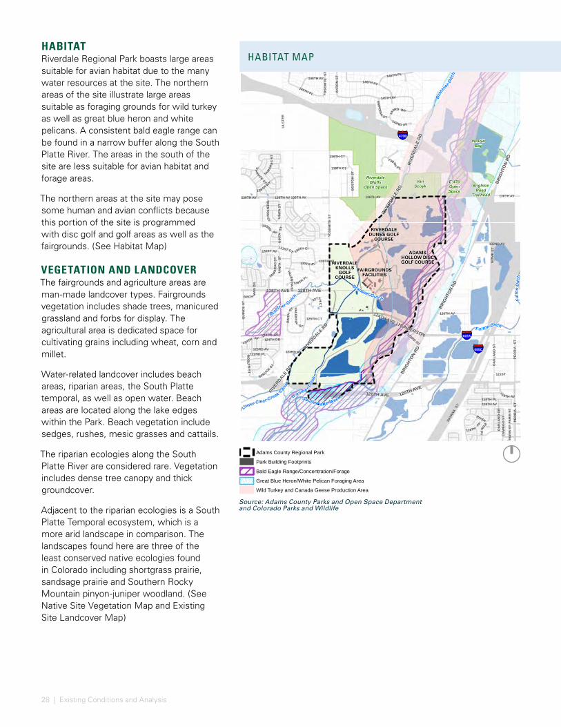
HABITATRiverdale Regional Park boasts large areas suitable for avian habitat due to the many water resources at the site. The northern areas of the site illustrate large areas suitable as foraging grounds for wild turkey as well as great blue heron and white pelicans. A consistent bald eagle range can be found in a narrow buffer along the South Platte River. The areas in the south of the site are less suitable for avian habitat and forage areas.
The northern areas at the site may pose some human and avian conflicts because this portion of the site is programmed with disc golf and golf areas as well as the fairgrounds. (See Habitat Map)
VEGETATION AND LANDCOVERThe fairgrounds and agriculture areas are man-made landcover types. Fairgrounds vegetation includes shade trees, manicured grassland and forbs for display. The agricultural area is dedicated space for cultivating grains including wheat, corn and millet.
Water-related landcover includes beach areas, riparian areas, the South Platte temporal, as well as open water. Beach areas are located along the lake edges within the Park. Beach vegetation include sedges, rushes, mesic grasses and cattails.
The riparian ecologies along the South Platte River are considered rare. Vegetation includes dense tree canopy and thick groundcover.
Adjacent to the riparian ecologies is a South Platte Temporal ecosystem, which is a more arid landscape in comparison. The landscapes found here are three of the least conserved native ecologies found in Colorado including shortgrass prairie, sandsage prairie and Southern Rocky Mountain pinyon-juniper woodland. (See Native Site Vegetation Map and Existing Site Landcover Map)
085C
022A
470B
PAR
IS S
T
131ST CT
125TH CT
128 TH PL
139TH CT
127THC
T
121ST
130TH AV
123RD AV
138TH CT
123RD AV
PAR
IS S
T
BACH MA
ND
R131ST AV
124TH AV
146TH AV
124TH DR
126TH AV
UIN
TAST
UIN
TAST
133RD
AV
SP
RUCEST
UIN
TAST
1 24TH AV
RO
SLYNST
14
3RD WY
YO
SEM
ITE
ST
142ND AV
TREN
TON
ST
AK
RO
N S
T
EM
POR
IA
ST
TAM
AR
AC
ST
136TH AV 136TH AV
VALEN
TIAST
PEO
RIA
ST
122ND PL
OSW
EGO
ST
ULS
TER
SPRUCE ST
145TH PL
UIN
TAST
1 38THPL
QU
INC
E ST
146TH PL
BO
STO
N S
T
130TH CI
118TH PL118TH AV
OA
KLA
ND
ST
132ND AV
146TH AV
YOSE
MIT
E ST
PEO
RIA
ST
136TH AV
HAVA
NA S
T
145TH AV
NO
ME
ST
119TH AV
136TH WY
116TH
AV
TAM
ARA
CST
VALEN
TI A
ST
130TH AV
123RD AV
OA
KLA
ND
DR
RIVERRUNPY
136TH AV 136TH AV
120TH AVE
128TH AVE
RIVERDALE R
D
BRIG
HTON
RD
RIVE
RDAL
E RD
120TH AVE
124TH AVE / HENDERSON
128TH AVE
RIVER
DALE R
D
BRIG
HTON
RD
RIVE
RDAL
E RD
BRIG
HTON
RD
RiverdaleBluffs
Open SpaceE-470OpenSpace
BrightonRoad
Trailhead
South Platte River
Brantner Gulch Fulto
nD
itch
Lower Clear Creek Canal
B rantn
er Gulch
Brantne r Ditc
h
Bran
tner
Ditc
h
Ful ton Ditch
Data Source: Adams County Parks and
Open Space Department
0 2,0001,000Feet
WillowBay
VanScoyk
§̈¦085C
§̈¦022A
136TH AV
128T
HPL
131ST CT
129TH PL
XAN
THIA
CT
125TH CT
WA
B
ASH CT
130TH PL
130TH AV
123RD AV
123RD AV
124TH PL
FAIR
GRO
UN
DR
D
126TH AV
VALE
NTI
AS
T
YOSE
MIT
E ST
VALE
NTI
A ST
127T
H CT
VERB
EN
AS T
UIN
T AST
130TH CI
RIV
ERD
ALE
RD
120TH AVE
124TH AVE / HENDERSON
BRIG
HTON
RD
128TH AVE
RiverdaleBluffs
Open Space
E-470OpenSpace
Lower Cle
arCr
eekCanal
Brantner Gulch
Brantner Gulch
Fulto
n Ditch
Brantner Ditch
South Platte River
Data Source: Adams County Parks and
Open Space Department
0 1,250625Feet [Adams County Regional Park
Park Building Footprints
Bald Eagle Range/Concentration/Forage
Great Blue Heron/White Pelican Foraging Area
Wild Turkey and Canada Geese Production Area
BIRD HABITAT
HABITAT MAP
RIVERDALE KNOLLS
GOLF COURSE
FAIRGROUNDS FACILITIES
RIVERDALE DUNES GOLF
COURSE
ADAMS HOLLOW DISC GOLF COURSE
Source: Adams County Parks and Open Space Department and Colorado Parks and Wildlife

29
NATIVE SITE VEGETATION MAP
EXISTING SITE L AND COVER MAP
LEGEND
LEGEND
Golf
Agriculture
Fairgrounds
South Platte Temporal
Beach
Open Water
Riparian
Deciduous Riparian
Cottonwood Gallery
Herbaceous Mesic Grasses
Herbaceous Cattails/Rushes
Source: analysis derived from Adams County GIS and ESRI
Source: analysis derived from Adams County GIS and ESRI
30 | Existing Conditions and Analysis
SITE INVENTORYSITE PROGRAM AND FACILITIESRiverdale Regional Park boasts two 18-hole golf courses. The Riverdale Knolls Golf Course to the west of the fairgrounds and Riverdale Dunes Golf Course to the north. Riverdale Knolls Golf Course is a traditional park-style layout offering municipal level play. As an alternative, Riverdale Dunes Golf Course, designed by Pete and Perry Dye is one of the top-rated golf courses in Colorado. This course offers a different golfing experience on a Scottish-style links course. The golf course also houses the Colorado Golf Hall of Fame.
A number of buildings and facilities exist at the fairground site and are in varying degrees of condition. The Administration Building, built in 2001, is 15,000 square feet and in good condition. The former Red Cross Building is a smaller 3,000 square feet structure and is the location of facility operations with a small meeting room, kitchen, shower and three restrooms. The Al Lesser Building is about 8,000 square feet with capacity for 250 people featuring a small food service area, PA system, and a portable stage platform. The Exhibit Hall has capacity for 800 to 1,000 people with space for 150 table top booths, a small
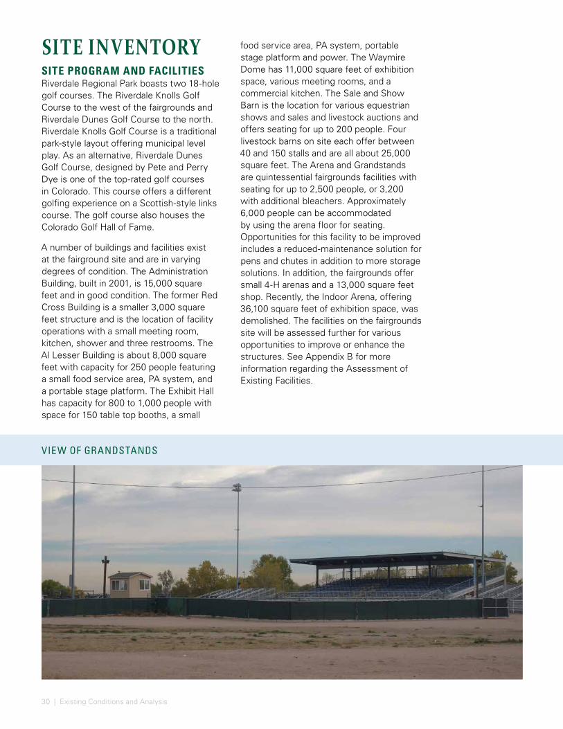
food service area, PA system, portable stage platform and power. The Waymire Dome has 11,000 square feet of exhibition space, various meeting rooms, and a commercial kitchen. The Sale and Show Barn is the location for various equestrian shows and sales and livestock auctions and offers seating for up to 200 people. Four livestock barns on site each offer between 40 and 150 stalls and are all about 25,000 square feet. The Arena and Grandstands are quintessential fairgrounds facilities with seating for up to 2,500 people, or 3,200 with additional bleachers. Approximately 6,000 people can be accommodated by using the arena floor for seating. Opportunities for this facility to be improved includes a reduced-maintenance solution for pens and chutes in addition to more storage solutions. In addition, the fairgrounds offer small 4-H arenas and a 13,000 square feet shop. Recently, the Indoor Arena, offering 36,100 square feet of exhibition space, was demolished. The facilities on the fairgrounds site will be assessed further for various opportunities to improve or enhance the structures. See Appendix B for more information regarding the Assessment of Existing Facilities.
VIEW OF GRANDSTANDS
31
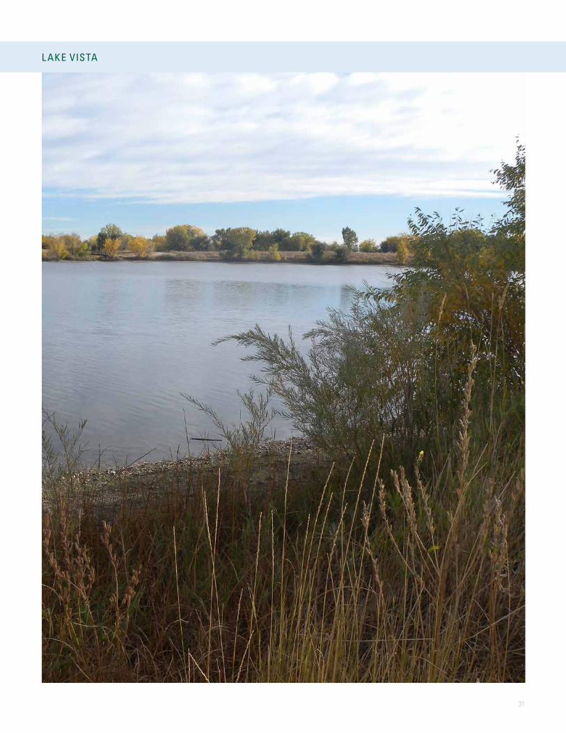
L AKE VISTA
VIEW OF GRANDSTANDS
32 | Existing Conditions and Analysis
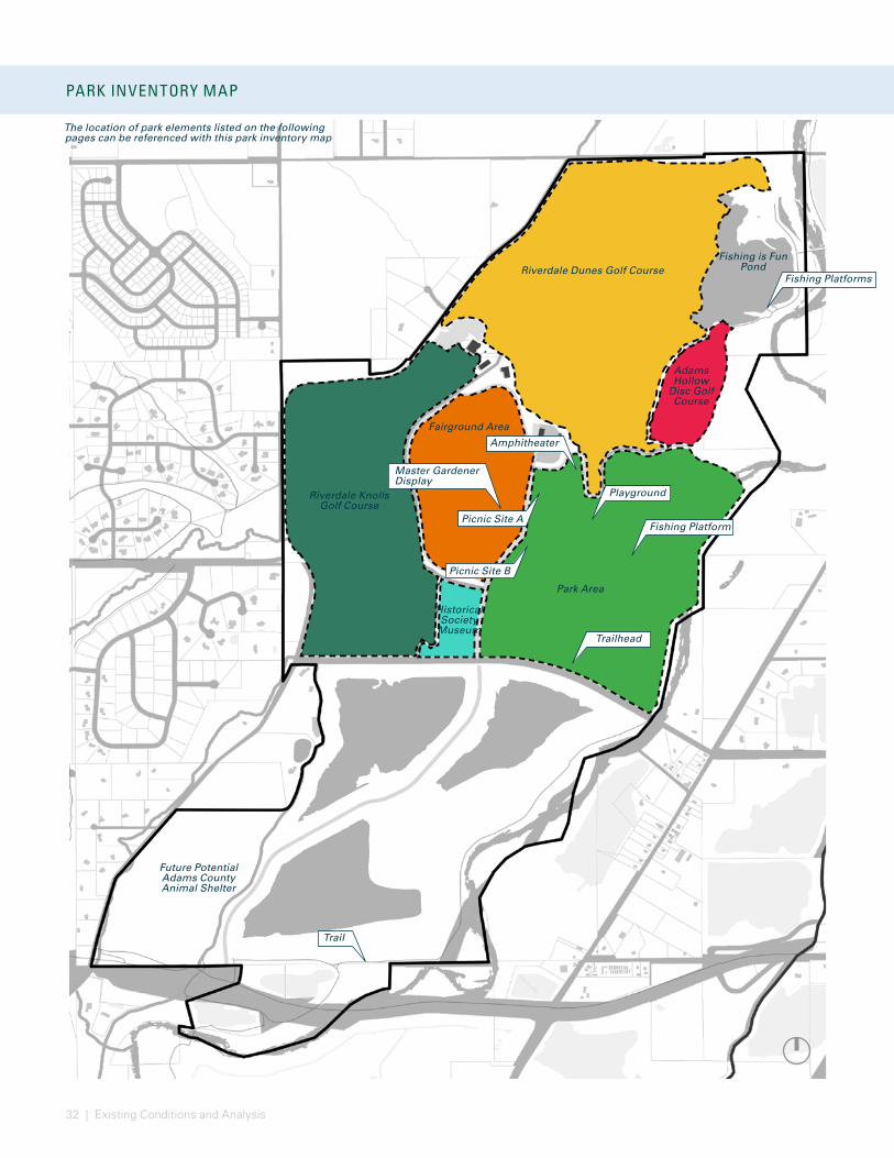
PARK INVENTORY MAP
FUNCTIONAL USE DIAGRAM - SITE
Riverdale Dunes Golf Course
Adams Hollow
Disc Golf Course
Fishing is Fun Pond
Fairground Area
Park Area
Riverdale Knolls Golf Course
Historical Society
Museum
Future Potential Adams County Animal Shelter
The location of park elements listed on the following pages can be referenced with this park inventory map
Picnic Site A
Picnic Site B
Playground
Amphitheater
Trailhead
Fishing Platforms
Fishing Platform
Master Gardener Display
Trail
33
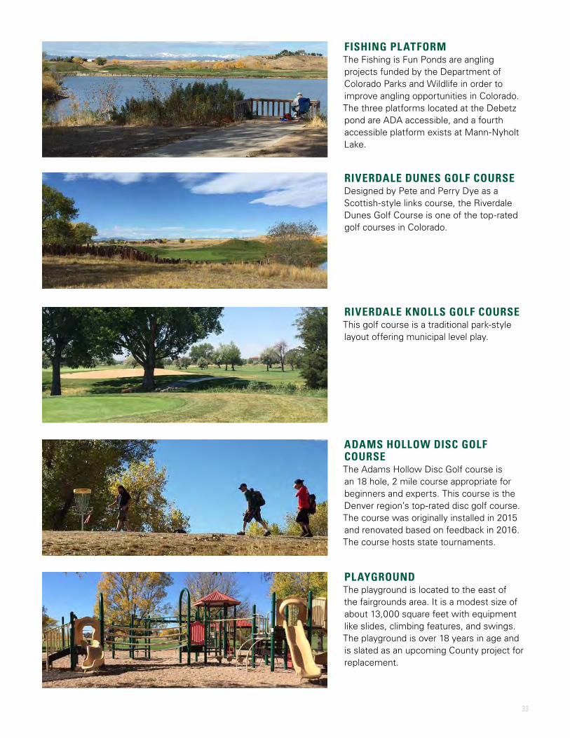
FISHING PLATFORMThe Fishing is Fun Ponds are angling projects funded by the Department of Colorado Parks and Wildlife in order to improve angling opportunities in Colorado. The three platforms located at the Debetz pond are ADA accessible, and a fourth accessible platform exists at Mann-Nyholt Lake.
RIVERDALE DUNES GOLF COURSEDesigned by Pete and Perry Dye as a Scottish-style links course, the Riverdale Dunes Golf Course is one of the top-rated golf courses in Colorado.
RIVERDALE KNOLLS GOLF COURSEThis golf course is a traditional park-style layout offering municipal level play.
ADAMS HOLLOW DISC GOLF COURSEThe Adams Hollow Disc Golf course is an 18 hole, 2 mile course appropriate for beginners and experts. This course is the Denver region’s top-rated disc golf course. The course was originally installed in 2015 and renovated based on feedback in 2016. The course hosts state tournaments.
PLAYGROUNDThe playground is located to the east of the fairgrounds area. It is a modest size of about 13,000 square feet with equipment like slides, climbing features, and swings. The playground is over 18 years in age and is slated as an upcoming County project for replacement.

34 | Existing Conditions and Analysis
PAVILIONSThe park contains two large pavilions (Picnic Site A and Picnic Site B) with 100-person capacities. All park pavilions require reservations for parties of 25 or greater. Electricity is available at each pavilion, and large pavilions include a potable water spigot. Picnic Site A and B have access to sand volleyball and horseshoe pits.
MASTER GARDENER DISPLAYSTwo demonstration gardens are located outside the Waymire Building. The original display is a mature perennial garden located to the west of the Waymire. A more recent xeric garden is located to the north of the building, originally designed and installed in 2009. The garden was the recipient of the 2014 Golden Shovel Award
AMPHITHEATERThe amphitheater is a concrete stage platform with lawn seating and floral displays. It has 1,000 amps of electrical service and analog phone pedestals.
TRAILHEADThe trailhead and associated parking lot located on Henderson Road leads visitors around the Mann-Nyholt Lake and beyond.
PICNIC SHELTERSA collection of 8 small picnic shelters are found in the park area. Each shelter is approximately 280 square feet with a 24-person capacity. The shelters are available on a first come first serve basis. Some shelters have nearby electrical pedestals.
Image credit: Adams County
35
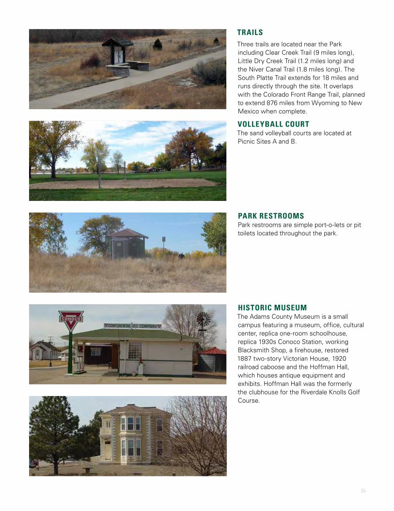
TRAILSThree trails are located near the Park including Clear Creek Trail (9 miles long), Little Dry Creek Trail (1.2 miles long) and the Niver Canal Trail (1.8 miles long). The South Platte Trail extends for 18 miles and runs directly through the site. It overlaps with the Colorado Front Range Trail, planned to extend 876 miles from Wyoming to New Mexico when complete.
VOLLEYBALL COURTThe sand volleyball courts are located at Picnic Sites A and B.
PARK RESTROOMSPark restrooms are simple port-o-lets or pit toilets located throughout the park.
HISTORIC MUSEUMThe Adams County Museum is a small campus featuring a museum, office, cultural center, replica one-room schoolhouse, replica 1930s Conoco Station, working Blacksmith Shop, a firehouse, restored 1887 two-story Victorian House, 1920 railroad caboose and the Hoffman Hall, which houses antique equipment and exhibits. Hoffman Hall was the formerly the clubhouse for the Riverdale Knolls Golf Course.

36 | Existing Conditions and Analysis
FAIRGROUNDS INVENTORY MAP
The location of fairgrounds elements listed on the following pages can be referenced with this fairgrounds inventory map.
Maintenance Shop
Irrigation Pond
Pump House/Chlorination Facility
Picnic Site A
Water Storage Tank
Administration Building
Good Luck 4-H Building
Former Red Cross
Waymire Dome
Al Lesser
Building
Exh
ibit
Hal
l
Amphitheater
Adams County Historical Society
Livestock Barns/
Quadrangle
Sale Barn
Concessions and
Restrooms
Restroom
Restroom
Grand
stan
dArena
4-H A
rena
4-H A
rena
Barn 4
Barn 1
Barn 2
Barn 3
Bull P
ens
Mann-Nyholt Lake
PAR
K B
LVD
GOLF COURSE WAYBRANTNER GULCH
BRANTNER DITCH

37
Former Red Cross Building
4-H ArenaLivestock Barns
Pumphouse/Chlorination Facility Golf Course Clubhouse
Sale Barn Grandstands Arena
Amphitheater Maintenance Building
Administration Building Al Lesser Building Good Luck 4-H Building
Waymire Dome Exhibit Hall
PARK STRUCTURES
38 | Existing Conditions and Analysis
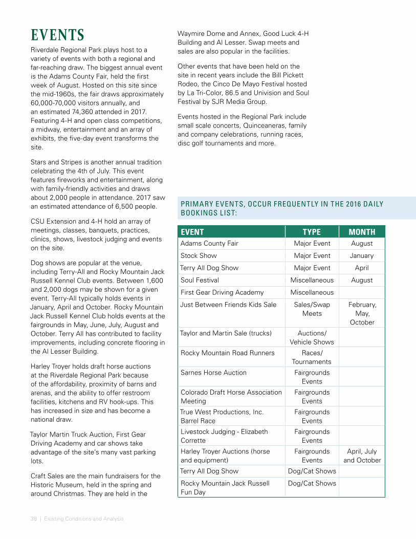
EVENTSRiverdale Regional Park plays host to a variety of events with both a regional and far-reaching draw. The biggest annual event is the Adams County Fair, held the first week of August. Hosted on this site since the mid-1960s, the fair draws approximately 60,000-70,000 visitors annually, and an estimated 74,360 attended in 2017. Featuring 4-H and open class competitions, a midway, entertainment and an array of exhibits, the five-day event transforms the site.
Stars and Stripes is another annual tradition celebrating the 4th of July. This event features fireworks and entertainment, along with family-friendly activities and draws about 2,000 people in attendance. 2017 saw an estimated attendance of 6,500 people.
CSU Extension and 4-H hold an array of meetings, classes, banquets, practices, clinics, shows, livestock judging and events on the site.
Dog shows are popular at the venue, including Terry-All and Rocky Mountain Jack Russell Kennel Club events. Between 1,600 and 2,000 dogs may be shown for a given event. Terry-All typically holds events in January, April and October. Rocky Mountain Jack Russell Kennel Club holds events at the fairgrounds in May, June, July, August and October. Terry All has contributed to facility improvements, including concrete flooring in the Al Lesser Building.
Harley Troyer holds draft horse auctions at the Riverdale Regional Park because of the affordability, proximity of barns and arenas, and the ability to offer restroom facilities, kitchens and RV hook-ups. This has increased in size and has become a national draw.
Taylor Martin Truck Auction, First Gear Driving Academy and car shows take advantage of the site’s many vast parking lots.
Craft Sales are the main fundraisers for the Historic Museum, held in the spring and around Christmas. They are held in the
Waymire Dome and Annex, Good Luck 4-H Building and Al Lesser. Swap meets and sales are also popular in the facilities.
Other events that have been held on the site in recent years include the Bill Pickett Rodeo, the Cinco De Mayo Festival hosted by La Tri-Color, 86.5 and Univision and Soul Festival by SJR Media Group.
Events hosted in the Regional Park include small scale concerts, Quinceaneras, family and company celebrations, running races, disc golf tournaments and more.
EVENT TYPE MONTHAdams County Fair Major Event August
Stock Show Major Event January
Terry All Dog Show Major Event April
Soul Festival Miscellaneous August
First Gear Driving Academy Miscellaneous
Just Between Friends Kids Sale Sales/Swap Meets
February, May,
October
Taylor and Martin Sale (trucks) Auctions/Vehicle Shows
Rocky Mountain Road Runners Races/Tournaments
Sarnes Horse Auction Fairgrounds Events
Colorado Draft Horse Association Meeting
Fairgrounds Events
True West Productions, Inc. Barrel Race
Fairgrounds Events
Livestock Judging - Elizabeth Corrette
Fairgrounds Events
Harley Troyer Auctions (horse and equipment)
Fairgrounds Events
April, July and October
Terry All Dog Show Dog/Cat Shows
Rocky Mountain Jack Russell Fun Day
Dog/Cat Shows
PRIMARY EVENTS, OCCUR FREQUENTLY IN THE 2016 DAILY BOOKINGS LIST:

39
PRIMARY EVENTS, OCCUR FREQUENTLY IN THE 2016 DAILY BOOKINGS LIST:
• First Gear Driving Academy
• School District 27J
• Prairie View High School Picnic
• Brighton Booster Club Crab Boil
• Prairie View High School Softball Dinner
• Legacy High School Football Banquet
• Northglenn Youth Football Dinner
• Brighton High School Football Dinner
• Horizon Football Dinner
• Eagle Ridge 2016 Graduation
• Cub Scouts
• Girl Scouts
• AC Republican Party
• Aurora Repeater Club
• Brighton Chamber
• Cactus Promotions
• Colorado Judicial Department staff retreat
• Cisec Meeting
• Colorado Contractors Association Career Days
• Colorado Romance Writers luncheon
• Young Marines Dinner
• Purple Circle
• Finance Casino Night
2016 EVENTS, COMPLETE LISTMajor Events
• Adams County Fair - August
• Stock Show - January
• Terry All Dog Show - April
Rentals:• Sweet Sixteens
• Quinceaneras
• Birthday Parties
• Baby Showers
• Weddings
• Graduation Parties
• Funerals
• Picnics – Family, church, company
• Family Reunions
• Anniversary Parties
• Sunday Services (Lutheran Church)
• Neighborhood Meetings
Events (Misc)• Adams County Historical Society Christmas Craft
Bazaar - November and December
• Adams County Historical Society Spring Bazaar - April
• ICO Ceramic Show
• Soul Festival (SJR Media Group) - August
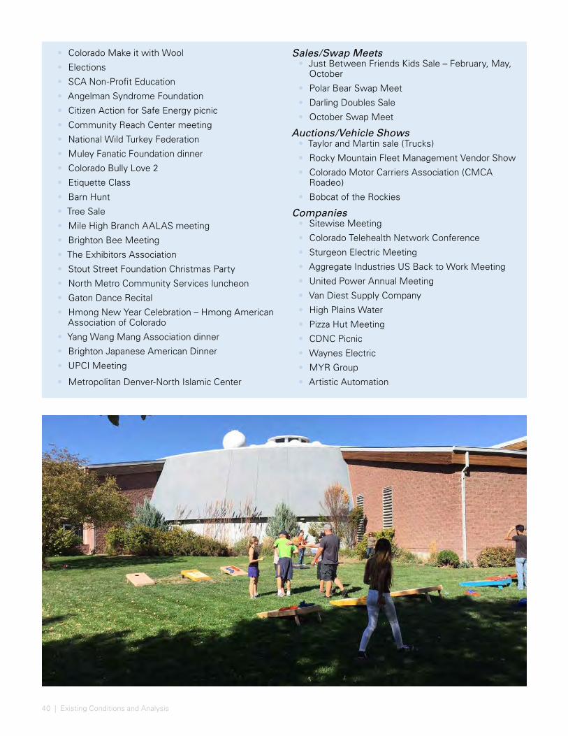
40 | Existing Conditions and Analysis
Sales/Swap Meets• Just Between Friends Kids Sale – February, May,
October
• Polar Bear Swap Meet
• Darling Doubles Sale
• October Swap Meet
Auctions/Vehicle Shows• Taylor and Martin sale (Trucks)
• Rocky Mountain Fleet Management Vendor Show
• Colorado Motor Carriers Association (CMCA Roadeo)
• Bobcat of the Rockies
Companies• Sitewise Meeting
• Colorado Telehealth Network Conference
• Sturgeon Electric Meeting
• Aggregate Industries US Back to Work Meeting
• United Power Annual Meeting
• Van Diest Supply Company
• High Plains Water
• Pizza Hut Meeting
• CDNC Picnic
• Waynes Electric
• MYR Group
• Artistic Automation
• Colorado Make it with Wool
• Elections
• SCA Non-Profit Education
• Angelman Syndrome Foundation
• Citizen Action for Safe Energy picnic
• Community Reach Center meeting
• National Wild Turkey Federation
• Muley Fanatic Foundation dinner
• Colorado Bully Love 2
• Etiquette Class
• Barn Hunt
• Tree Sale
• Mile High Branch AALAS meeting
• Brighton Bee Meeting
• The Exhibitors Association
• Stout Street Foundation Christmas Party
• North Metro Community Services luncheon
• Gaton Dance Recital
• Hmong New Year Celebration – Hmong American Association of Colorado
• Yang Wang Mang Association dinner
• Brighton Japanese American Dinner
• UPCI Meeting
• Metropolitan Denver-North Islamic Center

41
• Adams County High School Rodeo
• Colorado Rodeo & Gymkhana Club
• Little Britches Rodeo
• True West Productions, Inc. – Barrel Race
• Colorado Auctioneers Association
• National Convention of Al Khamsa Inc.
• Livestock Judging – Elizabeth Corrette
• Harley Troyer Auction (horse and equipment)
• Rocky Mountain Feather Fanciers
Adams County• AC Team Ropers
• AC Royalty Competition
• AC Quilters
• AC Community Corrections
• AC Human Resources Employee Recognition Lunch, Picnic
• AC Sheriffs Award Banquet
• AC Parks Quarterly Staff Meeting
• AC Parks County Animal Response Training
• AC Fair – Queen Coronation
• AC Sustainability Recycling Event
• AC Sustainability Rain Barrel Workshop
• AC Aging Network Conference
• AC Head Start Program – Cultural Literacy Festival
Races/Tournaments• Rocky Mountain Road Runners 5k and 10k Race;
Marathon Training Series
• Step For Life 5k Run
• Runs with Scissors
• Five Star 5K for Wellness
• Cross Country Clash Race
• Horizon High School Track Meet
• Hearts for Hearts 5K (Platte Valley Medical Center)
• Brighton High School/Prairie High School Cross Country
• Frisbee Golf Tournament
• PDGA Tournament
• Funnel Cake 5K
Fairgrounds Events:• Stock Show
• Stalling – horse, cattle
• Open Riding ($5/horse)
• Wild Wild West Simmental Sale
• Platte River Rabbit Fanciers
• Barnes Horse Auction
• Mile Hi Horse Association
• Colorado Draft Horse Association meeting
• Colorado Junior Rodeo Association
Source: Adams County

42 | Existing Conditions and Analysis
4-H• Rabbit Hopping
• Rabbit Judging
• Rabbit Tattoo Workshop
• Rabbit Workshop
• Rising Sun
• Monthly Meetings
• Bad to the Bone Dog Classes
• Cavy Club
• Front Range
• Sewing
• Creative Cooks
• Hunting and Outdoor Skills Workshop
• BarnBRATS Dog Project
• Kickin Country
• Community Service
• Horse Club meeting
• Working Ranch Horse
• Horse Clinic
• Horse Bowl
• Hippology
• Shooting Sports
• Livestock Judging
• Market Beef Tag in
• AC Open Space Advisory Board Meetings
• AC Sheriffs Search and Rescue Class
• AC Bar Association - AC Law Day
• AC Parks Emergency Training
• AC Sheriff’s Office Fishing Derby
• AC Health and Wellness Family Fit Day
• AC Health and Wellness Destress Stretch Class
• AC Community and Economic Development Picnic
• AC Parks Holiday
• AC Sheriffs Graduation
• AC Social Services Foster Kids Party
Dog/Cat Shows:• Mountain Dog Sports
• Flyball Tournament
• Terry All Dog Show
• Irish Setter Club
• Rocky Mountain Jack Russell Fun Day
• The Boxer Club of Colorado
• Econ Cat Show
• Mile High Sporting Dog Fanciers
• Labrador Retriever Club
• Mile High Lure Coursing
• Mountain States Dog Training Club
• Colorado Kennel Club match
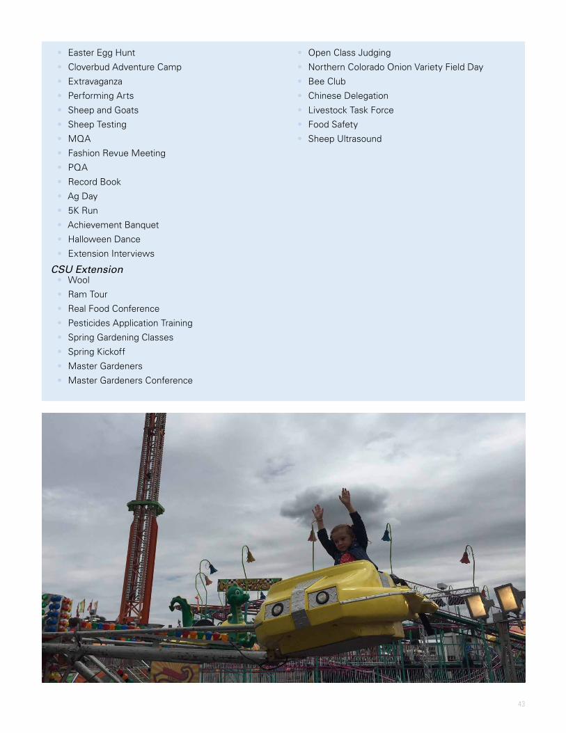
43
• Easter Egg Hunt
• Cloverbud Adventure Camp
• Extravaganza
• Performing Arts
• Sheep and Goats
• Sheep Testing
• MQA
• Fashion Revue Meeting
• PQA
• Record Book
• Ag Day
• 5K Run
• Achievement Banquet
• Halloween Dance
• Extension Interviews
CSU Extension • Wool
• Ram Tour
• Real Food Conference
• Pesticides Application Training
• Spring Gardening Classes
• Spring Kickoff
• Master Gardeners
• Master Gardeners Conference
• Open Class Judging
• Northern Colorado Onion Variety Field Day
• Bee Club
• Chinese Delegation
• Livestock Task Force
• Food Safety
• Sheep Ultrasound
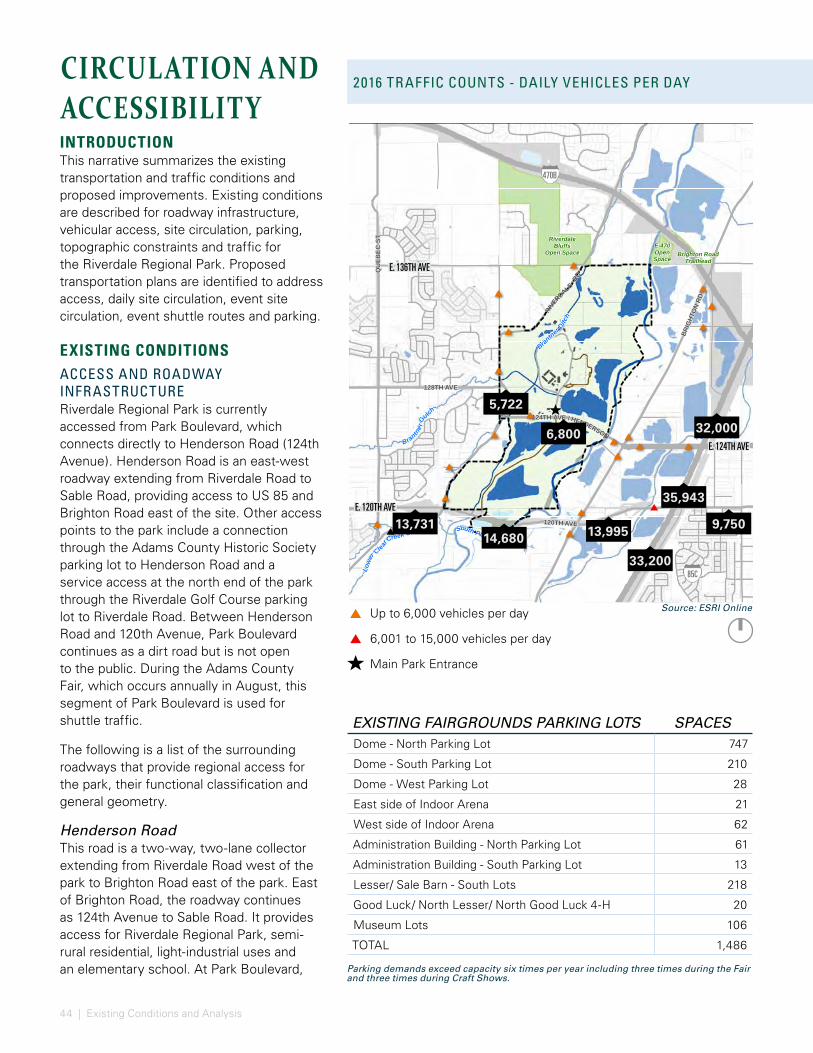
44 | Existing Conditions and Analysis
RIVER
DALE
RD
BRIG
HTON
RD
120TH AVE
124TH AVE / HENDERSON
QU
EBEC
ST
128TH AVE
RiverdaleBluffs
Open SpaceE-470OpenSpace
Brighton RoadTrailhead
South Platte River
Low
erClear
Creek Canal
Brantner
Ditch
Brantner
Gulch
FultonDitch
Data Source: Adams County Parks and
Open Space Department
0 2,2001,100Feet [
470B
85C
14,68013,731 13,995 9,750
32,0006,800
5,722
35,943
33,200
E. 124TH AVE
E. 120TH AVE
E. 136TH AVE
Up to 6,000 vehicles per day
6,001 to 15,000 vehicles per day
Main Park Entrance
CIRCULATION AND ACCESSIBILITYINTRODUCTIONThis narrative summarizes the existing transportation and traffic conditions and proposed improvements. Existing conditions are described for roadway infrastructure, vehicular access, site circulation, parking, topographic constraints and traffic for the Riverdale Regional Park. Proposed transportation plans are identified to address access, daily site circulation, event site circulation, event shuttle routes and parking.
EXISTING CONDITIONSACCESS AND ROADWAY INFRASTRUCTURERiverdale Regional Park is currently accessed from Park Boulevard, which connects directly to Henderson Road (124th Avenue). Henderson Road is an east-west roadway extending from Riverdale Road to Sable Road, providing access to US 85 and Brighton Road east of the site. Other access points to the park include a connection through the Adams County Historic Society parking lot to Henderson Road and a service access at the north end of the park through the Riverdale Golf Course parking lot to Riverdale Road. Between Henderson Road and 120th Avenue, Park Boulevard continues as a dirt road but is not open to the public. During the Adams County Fair, which occurs annually in August, this segment of Park Boulevard is used for shuttle traffic.
The following is a list of the surrounding roadways that provide regional access for the park, their functional classification and general geometry.
Henderson RoadThis road is a two-way, two-lane collector extending from Riverdale Road west of the park to Brighton Road east of the park. East of Brighton Road, the roadway continues as 124th Avenue to Sable Road. It provides access for Riverdale Regional Park, semi-rural residential, light-industrial uses and an elementary school. At Park Boulevard,
2016 TRAFFIC COUNTS - DAILY VEHICLES PER DAY
EXISTING FAIRGROUNDS PARKING LOTS SPACESDome - North Parking Lot 747
Dome - South Parking Lot 210
Dome - West Parking Lot 28
East side of Indoor Arena 21
West side of Indoor Arena 62
Administration Building - North Parking Lot 61
Administration Building - South Parking Lot 13
Lesser/ Sale Barn - South Lots 218
Good Luck/ North Lesser/ North Good Luck 4-H 20
Museum Lots 106
TOTAL 1,486
Parking demands exceed capacity six times per year including three times during the Fair and three times during Craft Shows.
Source: ESRI Online
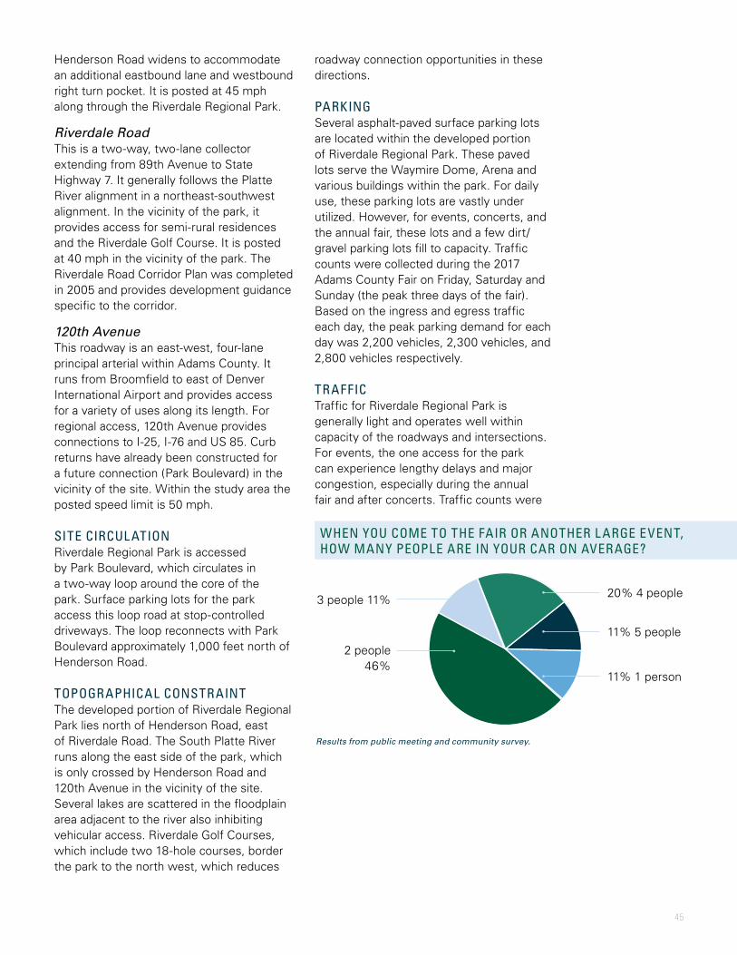
45
2016 TRAFFIC COUNTS - DAILY VEHICLES PER DAYroadway connection opportunities in these directions.
PARKINGSeveral asphalt-paved surface parking lots are located within the developed portion of Riverdale Regional Park. These paved lots serve the Waymire Dome, Arena and various buildings within the park. For daily use, these parking lots are vastly under utilized. However, for events, concerts, and the annual fair, these lots and a few dirt/gravel parking lots fill to capacity. Traffic counts were collected during the 2017 Adams County Fair on Friday, Saturday and Sunday (the peak three days of the fair). Based on the ingress and egress traffic each day, the peak parking demand for each day was 2,200 vehicles, 2,300 vehicles, and 2,800 vehicles respectively.
TRAFFICTraffic for Riverdale Regional Park is generally light and operates well within capacity of the roadways and intersections. For events, the one access for the park can experience lengthy delays and major congestion, especially during the annual fair and after concerts. Traffic counts were
WHEN YOU COME TO THE FAIR OR ANOTHER L ARGE EVENT, HOW MANY PEOPLE ARE IN YOUR CAR ON AVERAGE?
11% 5 people
11% 1 person
Results from public meeting and community survey.
20% 4 people3 people 11%
2 people 46%
Henderson Road widens to accommodate an additional eastbound lane and westbound right turn pocket. It is posted at 45 mph along through the Riverdale Regional Park.
Riverdale RoadThis is a two-way, two-lane collector extending from 89th Avenue to State Highway 7. It generally follows the Platte River alignment in a northeast-southwest alignment. In the vicinity of the park, it provides access for semi-rural residences and the Riverdale Golf Course. It is posted at 40 mph in the vicinity of the park. The Riverdale Road Corridor Plan was completed in 2005 and provides development guidance specific to the corridor.
120th AvenueThis roadway is an east-west, four-lane principal arterial within Adams County. It runs from Broomfield to east of Denver International Airport and provides access for a variety of uses along its length. For regional access, 120th Avenue provides connections to I-25, I-76 and US 85. Curb returns have already been constructed for a future connection (Park Boulevard) in the vicinity of the site. Within the study area the posted speed limit is 50 mph.
SITE CIRCUL ATIONRiverdale Regional Park is accessed by Park Boulevard, which circulates in a two-way loop around the core of the park. Surface parking lots for the park access this loop road at stop-controlled driveways. The loop reconnects with Park Boulevard approximately 1,000 feet north of Henderson Road.
TOPOGRAPHICAL CONSTRAINTThe developed portion of Riverdale Regional Park lies north of Henderson Road, east of Riverdale Road. The South Platte River runs along the east side of the park, which is only crossed by Henderson Road and 120th Avenue in the vicinity of the site. Several lakes are scattered in the floodplain area adjacent to the river also inhibiting vehicular access. Riverdale Golf Courses, which include two 18-hole courses, border the park to the north west, which reduces

46 | Existing Conditions and Analysis
ON A SCALE OF 1-5, THE EXPERIENCE OF ARRIVING AT THE SITE DURING THE FAIR IS:
ON A SCALE OF 1-5, THE EXPERIENCE OF LEAVING THE SITE DURING THE FAIR IS:
DAILY TRAFFIC FOR EACH 2017 FAIR DAY (DURING COUNT TIMES)
PEAK HOUR TRAFFIC AND PEAK PARKING DEMAND FOR EACH 2017 FAIR DAY (DURING COUNT TIMES)
SUNDAY
SATURDAY
FRIDAY
1:00 pm 2:00 pm 3:00 pm 4:00 pm 5:00 pm 6:00 pm 7:00 pm 8:00 pm 9:00 pm 10:00 pm
TOTAL
EGRESS
INGRESS 783
PEAK PARKING DEMAND: 2,200
PEAK PARKING DEMAND: 2,300
PEAK PARKING DEMAND: 2,800
811
998
754
1,015
1,143
911
1,240
1,353
INGRESS
INGRESS
EGRESS
TOTAL
EGRESS
TOTAL
TRAFFIC COUNTS WERE COLLECTED DURING THE 2017 ADAMS COUNTY FAIR
Friday, August 5 - 9:00 am to 1:00 am
Saturday, August 6 - 9:00 am to 1:00 am
Sunday, August 7 - 9:00 am to 10:30 pm
4,639 5,201
9,840
5,160 5,298
10,458
5,775 5,631
11,406
-
2,000
4,000
6,000
8,000
10,000
12,000
Ingress Egress Total
Friday Saturday SundaySource: Martin/Martin traffic counts (2017)
Source: Martin/Martin traffic counts (2017)
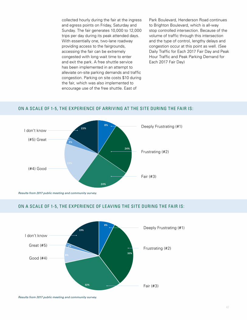
47
Results from 2017 public meeting and community survey.
Results from 2017 public meeting and community survey.
8%
32%
32%
8%
2%
19%
Deeply Frustrating - my whole experience and memory of the Fair is affected DeeplyFrustrating - my whole experience and memory of the Fair is affected
Frustrating – I feel inconvenienced Frustrating – I feel inconvenienced
Fair – the experience is tolerable and expected Fair – the experience is tolerable and expected
Good – I don’t experience major i ssues Good – I don’t experience major i ssues
Great – everything works fine Great – everything works fine
I don’t know/I have no opinion I don’t know/I have no opinion
8%
24%
24%
19%
3%
15%
Deeply Frustrating - my whole experience and memory of the Fair is affected
Frustrating – I feel inconvenienced
Fair – the experience is tolerable and expected
Good – I don’t experience major issues
Great – everything works fine
I don’t know/I have no opinion
Deeply Frustrating (#1)
Frustrating (#2)
Fair (#3)
(#4) Good
(#5) Great
I don’t know
Deeply Frustrating (#1)
Frustrating (#2)
Fair (#3)
Good (#4)
Great (#5)
I don’t know
ON A SCALE OF 1-5, THE EXPERIENCE OF ARRIVING AT THE SITE DURING THE FAIR IS:
ON A SCALE OF 1-5, THE EXPERIENCE OF LEAVING THE SITE DURING THE FAIR IS:
collected hourly during the fair at the ingress and egress points on Friday, Saturday and Sunday. The fair generates 10,000 to 12,000 trips per day during its peak attended days. With essentially one, two-lane roadway providing access to the fairgrounds, accessing the fair can be extremely congested with long wait time to enter and exit the park. A free shuttle service has been implemented in an attempt to alleviate on-site parking demands and traffic congestion. Parking on site costs $10 during the fair, which was also implemented to encourage use of the free shuttle. East of
Park Boulevard, Henderson Road continues to Brighton Boulevard, which is all-way stop controlled intersection. Because of the volume of traffic through this intersection and the type of control, lengthy delays and congestion occur at this point as well. (See Daily Traffic for Each 2017 Fair Day and Peak Hour Traffic and Peak Parking Demand for Each 2017 Fair Day)
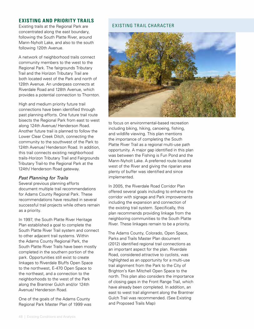
48 | Existing Conditions and Analysis
EXISTING AND PRIORITY TRAILSExisting trails at the Regional Park are concentrated along the east boundary, following the South Platte River, around Mann-Nyholt Lake, and also to the south following 120th Avenue.
A network of neighborhood trails connect community members to the west to the Regional Park. The fairgrounds Tributary Trail and the Horizon Tributary Trail are both located west of the Park and north of 128th Avenue. An underpass connects at Riverdale Road and 128th Avenue, which provides a potential connection to Thornton.
High and medium priority future trail connections have been identified through past planning efforts. One future trail route bisects the Regional Park from east to west along 124th Avenue/ Henderson Road. Another future trail is planned to follow the Lower Clear Creek Ditch, connecting the community to the southwest of the Park to 124th Avenue/ Henderson Road. In addition, this trail connects existing neighborhood trails-Horizon Tributary Trail and Fairgrounds Tributary Trail-to the Regional Park at the 124th/ Henderson Road gateway.
Past Planning for TrailsSeveral previous planning efforts document multiple trail recommendations for Adams County Regional Park. These recommendations have resulted in several successful trail projects while others remain as a priority.
In 1997, the South Platte River Heritage Plan established a goal to complete the South Platte River Trail system and connect to other adjacent trail systems. Within the Adams County Regional Park, the South Platte River Trails have been mostly completed in the southern portion of the park. Opportunities still exist to create linkages to Riverdale Bluffs Open Space to the northwest, E-470 Open Space to the northeast, and a connection to the neighborhoods to the west of the Park along the Brantner Gulch and/or 124th Avenue/ Henderson Road.
One of the goals of the Adams County Regional Park Master Plan of 1999 was
EXISTING TRAIL CHARACTER
to focus on environmental-based recreation including biking, hiking, canoeing, fishing, and wildlife viewing. This plan mentions the importance of completing the South Platte River Trail as a regional multi-use path opportunity. A major gap identified in this plan was between the Fishing is Fun Pond and the Mann-Nyholt Lake. A preferred route located west of the River and giving the riparian area plenty of buffer was identified and since implemented.
In 2005, the Riverdale Road Corridor Plan offered several goals including to enhance the corridor with signage and Park improvements including the expansion and connection of the existing trail system. Specifically, this plan recommends providing linkage from the neighboring communities to the South Platte River. These linkages remain to be a priority.
The Adams County, Colorado, Open Space, Parks and Trails Master Plan document (2012) identified regional trail connections as an important aspect for the plan. Riverdale Road, considered attractive to cyclists, was highlighted as an opportunity for a multi-use trail alignment from the Park to the City of Brighton’s Ken Mitchell Open Space to the north. This plan also considers the importance of closing gaps in the Front Range Trail, which have already been completed. In addition, an east to west trail alignment along the Brantner Gulch Trail was recommended. (See Existing and Proposed Trails Map)
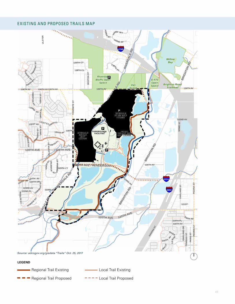
49
085C
022A
470B
131ST CT
LIMA
CT125TH CT
128 TH PL
139TH CT
121ST
130TH AV
123RD AV
138TH CT
123RD AV
131ST AV
124TH AV124TH DR
SPRUCEST
126TH AV
UIN
TAST
UINT
AS
T
133RD
AV
TAMAR
ACST
SP
RUCE ST
UINT
AST
ROS
LYNS T
136TH AV
14
3RD WY
142ND AV
TRENTON
ST
146TH AV
EMPO
RIA
S T
TA
MA
RAC
ST
122ND PL
136TH AV
VALE
NTI
A ST
PEO
RIA
ST
VERB
ENA
ST
ULS
TER
SPRUCE ST
145TH PL
UINT
AST
1 38TH
PL
OS
WEG
OST
BO
STO
N S
T
130TH CI
118TH PL118TH AV
OA
KLA
ND
ST
132ND AV
YOSE
MIT
E ST
136TH AV
PEO
RIA
ST
145TH AV
HAVA
NA S
T
NOM
EST
PAR
IS S
T
119TH AV
13 6TH WY
124TH AV
116TH
AV
TAM
ARA
CST
VALENTIA
ST
130TH AV
123RD AV
OA
KLA
ND
DR
RIVERRUNPY
136TH AV 136TH AV
120TH AVE
128TH AVE
RIVE
RDAL
E RD
BRIG
HTON
RD
RIVE
RDAL
E RD
120TH AVE
124TH AVE / HENDERSON
128TH AVE
RIVERDALE RD
BRIG
HTON
RD
RIVE
RDAL
E RD
BRIG
HTON
RD
RiverdaleBluffs Open
SpaceE-470OpenSpace Brighton Road
Trailhead
Data Source: Adams County Parks and Open Space Department
0 1,900950Feet
WillowBay
VanScoyk
RIVERDALE KNOLLS
GOLF COURSE
FAIRGROUNDS FACILITIES
RIVERDALE DUNES GOLF
COURSE
ADAMS HOLLOW DISC GOLF COURSE
EXISTING AND PROPOSED TRAILS MAPEXISTING TRAIL CHARACTER
LEGEND
Regional Trail Existing
Regional Trail Proposed
Local Trail Existing
Local Trail Proposed
Source: adcogov.org/gisdata “Trails” Oct. 25, 2017
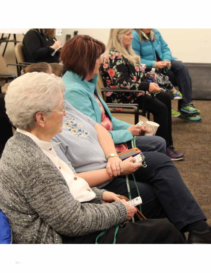
50 |

51
COMMUNITY OUTREACHCreating a shared vision for the future of the Riverdale Regional Park requires first ensuring broad representation in the input collected – from the community, stakeholders, staff, events, operations and maintenance, recreation groups, and more. The stakeholder engagement process included a series of stakeholder meetings, community public meetings, and online surveys. Stakeholder engagement activities were geared towards collecting feedback and input on recreation demands, facility demands, user expectations, park/fairgrounds identity, gap analysis, future demands, priorities and preferences. The following list summarizes the feedback:
• Agriculture plays an important role on this site and regionally; It will continue to be an important aspect for programming, character and heritage education
• Regional connections such as trails and water (lakes, river) link the site to a greater system
• Take care of the citizens first – this is a county facility for the community; The public worries about getting too big, whereas they want the facility to strive towards the “right,” or optimal size that serves the community
• The amphitheater is a desired asset, but under-utilized. Initiate “right size” programming to serve this community
• The site plays an important role in educating the public and Adams County citizens; Continue to make relevant connections to learning opportunities
• Traffic (ingress and egress) to the site is a serious issue
• Camping is desirable to support events with RV spaces and primitive tent camping for occasional children’s groups
• User groups miss the indoor arena and desire a facility to replace it
OVERALL THEMESThe feedback that emerged from engagement activities were integral to the formulation of the four overall themes for this Master Plan:
1. Provide a healthy and continuous habitat corridor along the South Platte River and Brantner Gulch and other connected aquatic and terrestrial resources.
2. Agricultural heritage
3. Trail connectivity and experiences
4. Community
ENGAGEMENT TYPE
DATE(S) PARTICIPANTS
Kick-Off Meeting
11/17/16 18
Focus Group Meetings
02/02/17 60
Community Meeting One
02/02/17 23
Online Survey One
02/02/17 to 03/24/17
103
Community Meeting Two
04/04/17 41
Online Survey Two
04/04/17 to 06/13/17
18
Community Meeting Three
10/12/17 30
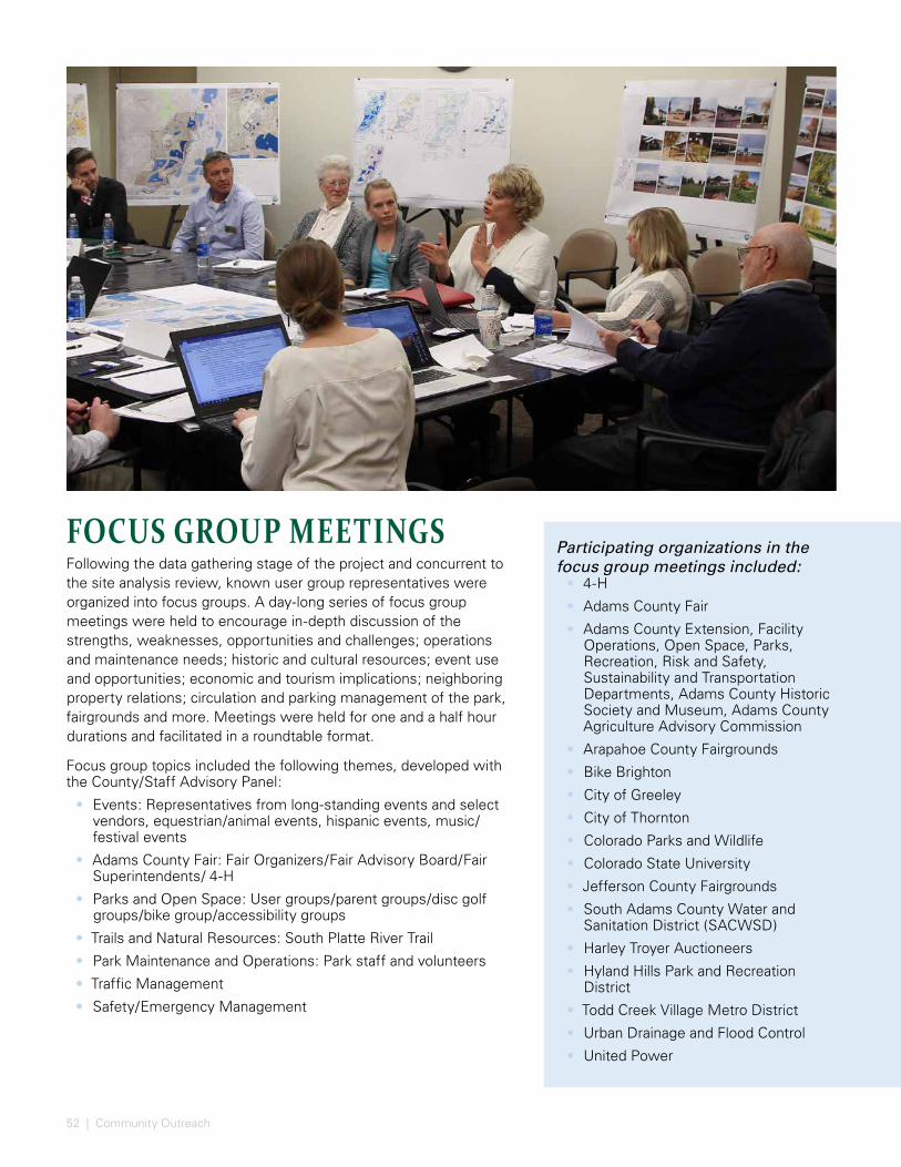
52 | Community Outreach
FOCUS GROUP MEETINGSFollowing the data gathering stage of the project and concurrent to the site analysis review, known user group representatives were organized into focus groups. A day-long series of focus group meetings were held to encourage in-depth discussion of the strengths, weaknesses, opportunities and challenges; operations and maintenance needs; historic and cultural resources; event use and opportunities; economic and tourism implications; neighboring property relations; circulation and parking management of the park, fairgrounds and more. Meetings were held for one and a half hour durations and facilitated in a roundtable format.
Focus group topics included the following themes, developed with the County/Staff Advisory Panel:
• Events: Representatives from long-standing events and select vendors, equestrian/animal events, hispanic events, music/festival events
• Adams County Fair: Fair Organizers/Fair Advisory Board/Fair Superintendents/ 4-H
• Parks and Open Space: User groups/parent groups/disc golf groups/bike group/accessibility groups
• Trails and Natural Resources: South Platte River Trail
• Park Maintenance and Operations: Park staff and volunteers
• Traffic Management
• Safety/Emergency Management
Participating organizations in the focus group meetings included:
• 4-H
• Adams County Fair
• Adams County Extension, Facility Operations, Open Space, Parks, Recreation, Risk and Safety, Sustainability and Transportation Departments, Adams County Historic Society and Museum, Adams County Agriculture Advisory Commission
• Arapahoe County Fairgrounds
• Bike Brighton
• City of Greeley
• City of Thornton
• Colorado Parks and Wildlife
• Colorado State University
• Jefferson County Fairgrounds
• South Adams County Water and Sanitation District (SACWSD)
• Harley Troyer Auctioneers
• Hyland Hills Park and Recreation District
• Todd Creek Village Metro District
• Urban Drainage and Flood Control
• United Power

53
FOCUS GROUPS KEY FINDINGS
Natural Resources, Parks and Open Space, Trails
• Lakes are an asset to the park for wildlife watching, fishing, and some potential for low impact recreation.
• Regional trail connections and future extensions make the park centralized for visitors as a trailhead and destination.
• Future ideas include a connection to a mountain bike park, various trail types (single track, multi-use, equestrian), and an arboretum.
• Environmental restoration is a goal within the park and river corridor and includes stormwater management, riparian area enhancement, habitat enhancement, water quality, and flood control.
• Buffers between differing and sometimes competing uses, such as the golf courses, are important.
• Educational programs and/or interpretive learning experiences are appropriate here (natural environment, demonstration gardens, agricultural heritage, Adams County Historic Society and Museum, Museum of Nature and Science, Denver Botanic Gardens, art, etc).
Events• The park’s assets include location, proximity to
lodging, and the natural setting.
• A broad variety of events are accommodated here, including quinceaneras, craft sales, the fair, and much more.
• A comparison with the facilities and performance of neighboring counties was held, including Weld, Jefferson, and Arapahoe Counties. Concessions, security, facility sizes, camping, access, parking management and operations were discussed.
• Groups that are exempt from paying for facility use are subject to being bumped for paid rental uses. These long-standing organizations would like dedicated spaces.
Partner Agencies• Assets include the park’s centralized location,
staff, and versatility that can occur here.
• Many long-standing events use the site and like the value they get from it. Users that are exempt and/or pay reduced rental fees include county departments, 4-H, and others, and are subject to being bumped for non-exempt users. In the future, the historical/long-standing clients should continue to be served as much as possible.
• More camping facilities for events with electrical hookups near event facilities, a new indoor building for animal events, and a welcoming gateway are desired.
• Traffic is an issue, and reimagining the park’s “front door” was discussed to alleviate traffic. More emergency access points are warranted.
• Consider partners in sustainability and land management.
• A resurgence of the amphitheater is desired, but successful events need to be held first, including ease in access and parking. Right-sizing the venue and events is important so as not to try and compete out of the venue’s capacity or to appear out of character with Adams County.
• Think about the fair for a diversity of users now and into the future.
• Consider how the facility can facilitate public health through food and beverage choices, connection to food sources, sun safety, and more.
Agriculture Groups• Connection to agricultural heritage is important
through food preservation, farm-to-table, linkages to other local facilities and farmers, festivals, CSU Extension, and more.
• A Multi-Purpose building that functions as an indoor arena should cater to many user groups. A warm-up facility is also desired concurrent to that facility.
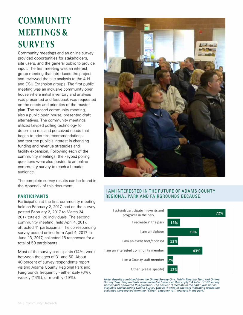
54 | Community Outreach
Note: Results combined from the Online Survey One, Public Meeting Two, and Online Survey Two. Respondents were invited to “select all that apply.” A total of 162 survey participants answered this question. The answer “I recreate in the park” was not an available choice during Online Survey One so 4 write-in answers indicating recreation activities were moved from the “Other” category to “I recreate in the park.”
I AM INTERESTED IN THE FUTURE OF ADAMS COUNT Y REGIONAL PARK AND FAIRGROUNDS BECAUSE:
COMMUNITY MEETINGS & SURVEYSCommunity meetings and an online survey provided opportunities for stakeholders, site users, and the general public to provide input. The first meeting was an interest group meeting that introduced the project and reviewed the site analysis to the 4-H and CSU Extension groups. The first public meeting was an inclusive community open house where initial inventory and analysis was presented and feedback was requested on the needs and priorities of the master plan. The second community meeting, also a public open house, presented draft alternatives. The community meetings utilized keypad polling technology to determine real and perceived needs that began to prioritize recommendations and test the public’s interest in changing funding and revenue strategies and facility expansion. Following each of the community meetings, the keypad polling questions were also posted to an online community survey to reach a broader audience.
The complete survey results can be found in the Appendix of this document.
PARTICIPANTSParticipation at the first community meeting held on February 2, 2017, and on the survey posted February 2, 2017 to March 24, 2017 totaled 126 individuals. The second community meeting, held April 4, 2017, attracted 41 participants. The corresponding survey posted online from April 4, 2017 to June 13, 2017, collected 18 responses for a total of 59 participants.
Most of the survey participants (74%) were between the ages of 31 and 60. About 40 percent of survey respondents report visiting Adams County Regional Park and Fairgrounds frequently - either daily (6%), weekly (14%), or monthly (19%).
72%
15%
39%
13%
43%
7%
12%
I attend/participate in events andprograms in the park
I recreate in the park
I am a neighbor
I am an event host/sponsor
I am an interested community member
I am a County staff member
Other (please specify)

55
75%
20%
13%
48%
30%
49%
31%
22%
6%
16%
The Adams County Fair
July 4th Event
Movies in the Park
Rodeos / Equestrian
Dog / Animal Shows
Craft Fairs / Bazaars / Festivals / Auctionsor vehicle shows
Private events / rentals
Club/organization meetings
Races or tournaments
Other (please specify)
48%
36%
63%
18%
2%
37%
Connect to Nature: The ability to seewildlife and aquatic habitat
Connect to People: Spend time withfamily/friends
Connect to Community: Attend largecommunity-wide events
Learn: The ability to participate inCSU/4H classes and programs
None of these
Other (please specify)
WHY DO PEOPLE GO TO THE PARK?The reason for visiting the park that resonated most (60%) with the participants was the sense of connecting to their community though attendance at large community events. Seventy percent of survey participants reported attending The Adams County Fair, the largest annual event. Other events that many survey participants attend that support a connection to community include the rodeos and equestrian events (50%), as well as craft fairs, bazaars, festivals and auctions or vehicle shows (45%).
Almost half of participants (45%) appreciate the connections to nature within the park and the ability to view wildlife and aquatic habitats. Park activities foster a sense of connection to nature including trails for walking and biking (57%), equestrian and horseback riding (38%) as well as picnicking (29%).
Write-in responses in the online survey indicate reasons for visiting the park. Forty- six percent of respondents wrote in the following top activities:
• Geocaching
• Bike Riding
• Fishing
• Walking
• Disc Golf
• Playground
Top reasons listed relating to participatory and community events included:
• Equestrian Events
• Barrel Racing
• Horse Shows
• Dog Shows
THE REASON I GO TO ADAMS COUNT Y REGIONAL PARK AND FAIRGROUNDS IS TO:
WHAT EVENTS OR PROGRAMS DO YOU AT TEND?
2%
WHAT PARK ACTIVITIES DO YOU COME TO THE ADAMS COUNT Y REGIONAL PARK AND FAIRGROUNDS FOR?
Note: results from the Online Survey One. Respondents were invited to “select all that apply.”
Note: results from the Online Survey One.Respondents were invited to “select all that apply.”
Note: results from the Online Survey One.Respondents were invited to “select all that apply.”
60%35%
13%32%
6%22%
9%18%17%17%
Trails (walking/biking)
Equestrian/Riding Arena
Disc Golf
Picnics
Amphitheater
Playground
Golf
Fishing
Museum
Other (please specify)
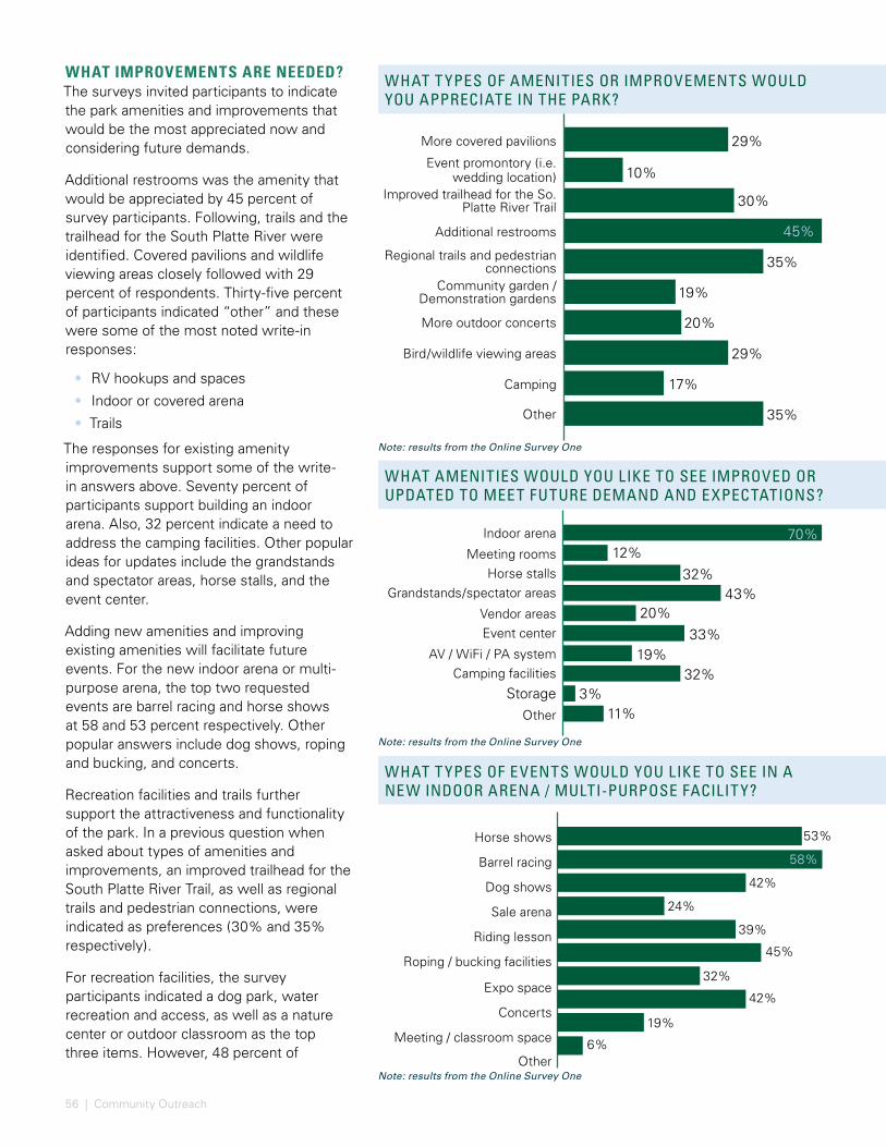
56 | Community Outreach
WHAT AMENITIES WOULD YOU LIKE TO SEE IMPROVED OR UPDATED TO MEET FUTURE DEMAND AND EXPECTATIONS?
I BELIEVE THE MOST IMPORTANT MEASURE OF COMMUNIT Y SUCCESS IS:
WHAT T YPES OF AMENITIES OR IMPROVEMENTS WOULD YOU APPRECIATE IN THE PARK?
WHAT T YPES OF EVENTS WOULD YOU LIKE TO SEE IN A NEW INDOOR ARENA / MULTI-PURPOSE FACILIT Y?
More covered pavilions
Event promontory (i.e. wedding location)
Improved trailhead for the So. Platte River Trail
Additional restrooms
Regional trails and pedestrian connections
Community garden / Demonstration gardens
More outdoor concerts
Bird/wildlife viewing areas
Camping
Other
29%
10%
30%
45%
35%
19%
20%
29%
17%
35%
Indoor arena
Meeting roomsHorse stalls
Grandstands/spectator areas
Vendor areasEvent center
AV / WiFi / PA systemCamping facilities
StorageOther
70%12%
32%43%
20%33%
19%32%
3%11%
Horse shows
Barrel racing
Dog shows
Sale arena
Riding lesson
Roping / bucking facilities
Expo space
Concerts
Meeting / classroom space
Other
53%
42%
24%
39%
45%
32%
42%
19%
6%
58%
WHAT IMPROVEMENTS ARE NEEDED?The surveys invited participants to indicate the park amenities and improvements that would be the most appreciated now and considering future demands.
Additional restrooms was the amenity that would be appreciated by 45 percent of survey participants. Following, trails and the trailhead for the South Platte River were identified. Covered pavilions and wildlife viewing areas closely followed with 29 percent of respondents. Thirty-five percent of participants indicated “other” and these were some of the most noted write-in responses:
• RV hookups and spaces
• Indoor or covered arena
• Trails
The responses for existing amenity improvements support some of the write-in answers above. Seventy percent of participants support building an indoor arena. Also, 32 percent indicate a need to address the camping facilities. Other popular ideas for updates include the grandstands and spectator areas, horse stalls, and the event center.
Adding new amenities and improving existing amenities will facilitate future events. For the new indoor arena or multi-purpose arena, the top two requested events are barrel racing and horse shows at 58 and 53 percent respectively. Other popular answers include dog shows, roping and bucking, and concerts.
Recreation facilities and trails further support the attractiveness and functionality of the park. In a previous question when asked about types of amenities and improvements, an improved trailhead for the South Platte River Trail, as well as regional trails and pedestrian connections, were indicated as preferences (30% and 35% respectively).
For recreation facilities, the survey participants indicated a dog park, water recreation and access, as well as a nature center or outdoor classroom as the top three items. However, 48 percent of
Note: results from the Online Survey One
Note: results from the Online Survey One
Note: results from the Online Survey One

57
WHAT RECREATION FACILITIES WOULD YOU LIKE TO SEE WITHIN THE REGIONAL PARK?
WHAT TRAIL T YPES WOULD YOU LIKE TO SEE PRIORITIZED IN THE REGIONAL PARK?
I BELIEVE THE MOST IMPORTANT MEASURE OF COMMUNIT Y SUCCESS IS:
Nature Center / Outdoor Classroom
Water-based recreation / Boating access
Dog Park
Agricultural demonstration area
Art in the Park
Programmed / active sports facilities
Skating rink
Nature Play
None of these
Other
28%
30%
36%
20%
24%
13%
17%
18%
2%
Nature Trails (interpretative)
Dirt track/bike specific trailsSoft surface trails
Portal trails/Equestrian trails
Hard surface multi-use trails
Dual surface multi-use trails
Non-motorized water trail
Art/Sculpture walk
Botanic walk/Sensory walk
Other (please specify)
36%
10%
31%28%
22%14%
18%33%
11%
# of annual visitors 46%
# of individual return trips 45%
Distance of travel to event 7%
# of out of town visitors 10%
# of events
None of these 3%
Cost Recovery 26%
Other (please specify) 14%
51%
48%
50%
participants selected “other” and wrote in a response. The top responses were:
• an indoor arena
• bike paths and trails
• outdoor swimming in the lakes
Survey participants were given an array of trail types to choose from for prioritizing the trails at the park. The most selected trail type was soft surface trails at 51 percent. Other popular trails include nature trails, botanic or sensory walks and equestrian trails at 36, 33 and 31 percent respectively. Write in answers were provided by 11 respondents include:
• improving connections to the surrounding neighborhoods
• all of the above
In summary, survey participants are very repetitive about improvements to the indoor arena for events like horse shows and barrel racing, enhancement of existing trails and expansion of the trail network, and consideration for guest amenities like restrooms and the grandstands and spectator areas.
MEASURE OF SUCCESSInviting the community to define their measure of success for the park and fairgrounds allows this plan to focus on the outcomes that are most important to them. The three most noted metrics of success were the number of events, the number of individual return trips and the number of annual visitors. However, a number of survey respondents chose to write-in ideas, such as:
• “Local community involvement”
• “Integration with the existing trail and park system”
• “Use of the grounds and facilities”
• “Attracting and nurturing people with diverse interests, backgrounds and abilities”
Note: results from the Online Survey One
Note: results from the Online Survey One
Note: results from the Online Survey One
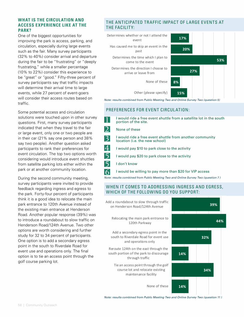
58 | Community Outreach
THE ANTICIPATED TRAFFIC IMPACT OF L ARGE EVENTS AT THE FACILIT Y:
PREFERENCES FOR EVENT CIRCUL ATION:
WHEN IT COMES TO ADDRESSING INGRESS AND EGRESS, WHICH OF THE FOLLOWING DO YOU SUPPORT:
WHAT IS THE CIRCULATION AND ACCESS EXPERIENCE LIKE AT THE PARK?One of the biggest opportunities for improving the park is access, parking, and circulation, especially during large events such as the fair. Many survey participants (32% to 40%) consider arrival and departure during the fair to be “frustrating” or “deeply frustrating,” while a smaller percentage (10% to 22%) consider this experience to be “great” or “good.” Fifty-three percent of survey participants say that traffic impacts will determine their arrival time to large events, while 27 percent of event-goers will consider their access routes based on traffic.
Some potential access and circulation solutions were touched upon in other survey questions. First, many survey participants indicated that when they travel to the fair or large event, only one or two people are in their car (21% say one person and 38% say two people). Another question asked participants to rank their preferences for event circulation. The top two options worth considering would introduce event shuttles from satellite parking lots either within the park or at another community location.
During the second community meeting, survey participants were invited to provide feedback regarding ingress and egress to the park. Forty-four percent of participants think it is a good idea to relocate the main park entrance to 120th Avenue instead of the existing main entrance at Henderson Road. Another popular response (39%) was to introduce a roundabout to slow traffic on Henderson Road/124th Avenue. Two other options are worth considering and further study for 32 to 34 percent of participants. One option is to add a secondary egress point in the south to Riverdale Road for event use and operations only. The final option is to tie an access point through the golf course parking lot.
17%
20%
53%
27%
8%
15%
Determines whether or not I attend theevent
Has caused me to skip an event in thepast
Determines the time which I plan tocome to the event
Determines the direction I choose toarrive or leave from
None of these
Other (please specify)
I would ride a free event shuttle from a satellite lot in the south portion of the site.
None of these
I would ride a free event shuttle from another community location (i.e. the new school)
I would pay $10 to park close to the activity
I would pay $20 to park close to the activity
I don’t know
I would be willing to pay more than $20 for VIP access
321
4556
AMPHITHEATER, SELECT ONE:
MUSEUM, SELECT ONE:
WHAT T YPE OF CAMPING WOULD YOU SUPPORT ON THE SITE:
Note: results combined from Public Meeting Two and Online Survey Two (question 5)
Note: results combined from Public Meeting Two and Online Survey Two (question 7 )
Note: results combined from Public Meeting Two and Online Survey Two (question 11 )
39%
44%
32%
14%
34%
14%
Add a roundabout to slow through trafficon Henderson Road/124th Avenue
Relocating the main park entrance to120th Parkway
Add a secondary egress point in thesouth to Riverdale Road for event use
and operations only
Reroute 124th on the east through thesouth portion of the park to discourage
through traffic
Tie an access point through the golfcourse lot and relocate existing
maintenance facility
None of these
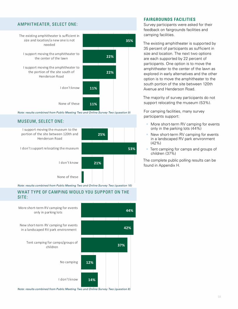
59
44%
42%
37%
12%
14%
More short-term RV camping for eventsonly in parking lots
New short-term RV camping for eventsin a landscaped RV park environment
Tent camping for camps/groups ofchildren
No camping
I don’t know
35%
22%
22%
11%
11%
The existing amphitheater is sufficient insize and location/a new one is not
needed
I support moving the amphitheater tothe center of the lawn
I support moving the amphitheater tothe portion of the site south of
Henderson Road
I don’t know
None of these
25%
53%
21%
2%
I support moving the museum to theportion of the site between 120th and
Henderson Road
I don’t support relocating the museum
I don’t know
None of these
AMPHITHEATER, SELECT ONE:
MUSEUM, SELECT ONE:
WHAT T YPE OF CAMPING WOULD YOU SUPPORT ON THE SITE:
FAIRGROUNDS FACILITIESSurvey participants were asked for their feedback on fairgrounds facilities and camping facilities.
The existing amphitheater is supported by 35 percent of participants as sufficient in size and location. The next two options are each supported by 22 percent of participants. One option is to move the amphitheater to the center of the lawn as explored in early alternatives and the other option is to move the amphitheater to the south portion of the site between 120th Avenue and Henderson Road.
The majority of survey participants do not support relocating the museum (53%).
For camping facilities, many survey participants support:
• More short-term RV camping for events only in the parking lots (44%)
• New short-term RV camping for events in a landscaped RV park environment (42%)
• Tent camping for camps and groups of children (37%)
The complete public polling results can be found in Appendix H.
Note: results combined from Public Meeting Two and Online Survey Two (question 9)
Note: results combined from Public Meeting Two and Online Survey Two (question 10)
Note: results combined from Public Meeting Two and Online Survey Two (question 8)
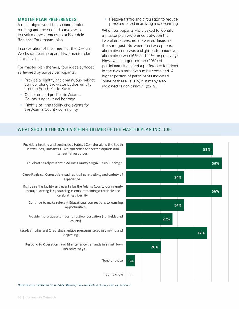
60 | Community Outreach
Note: results combined from Public Meeting Two and Online Survey Two (question 2)
MASTER PLAN PREFERENCESA main objective of the second public meeting and the second survey was to evaluate preferences for a Riverdale Regional Park master plan.
In preparation of this meeting, the Design Workshop team prepared two master plan alternatives.
For master plan themes, four ideas surfaced as favored by survey participants:
• Provide a healthy and continuous habitat corridor along the water bodies on site and the South Platte River
• Celebrate and proliferate Adams County’s agricultural heritage
• “Right size” the facility and events for the Adams County community
WHAT SHOULD THE OVER ARCHING THEMES OF THE MASTER PL AN INCLUDE:
• Resolve traffic and circulation to reduce pressure faced in arriving and departing
When participants were asked to identify a master plan preference between the two alternatives, no answer surfaced as the strongest. Between the two options, alternative one was a slight preference over alternative two (16% and 11% respectively). However, a larger portion (20%) of participants indicated a preference for ideas in the two alternatives to be combined. A higher portion of participants indicated
“none of these” (31%) but many also indicated “I don’t know” (22%).
51%
56%
34%
56%
34%
27%
47%
20%
5%
0%
Provide a healthy and continuous Habitat Corridor along the SouthPlatte River, Brantner Gulch and other connected aquatic and
terrestrial resources.
Celebrate and proliferate Adams County’s Agricultural Heritage.
Grow Regional Connections such as trail connectivity and variety ofexperiences
Right size the facility and events for the Adams County Communitythrough serving long-standing clients, remaining affordable and
celebrating diversity.
Continue to make relevant Educational connections to learningopportunities.
Provide more opportunities for active recreation (i.e. fields andcourts)
Resolve Traffic and Circulation reduce pressures faced in arriving anddeparting.
Respond to Operations and Maintenance demands in smart, low-intensive ways
None of these
I don’t know
.
.
.

61
Note: results combined from Public Meeting Two and Online Survey Two (question 12)
WHICH ALTERNATIVE DO YOU PREFER:
16%
11%
20%
31%
22%
Alternative 1
Alternative 2
A combination of Alternative 1 and 2
None of these
I don’t know
OVERALL STAKEHOLDER ENGAGEMENTThe first stakeholder meeting was valuable to gather insights from a diverse group of experts in different areas such as natural resources, events, partner agencies and agriculture.
The first public meeting and first online survey opportunity helped shape the priorities for developing master plan alternatives and defining success.
The second public meeting and second online survey focused on feedback regarding access and circulation and two master plan alternatives.
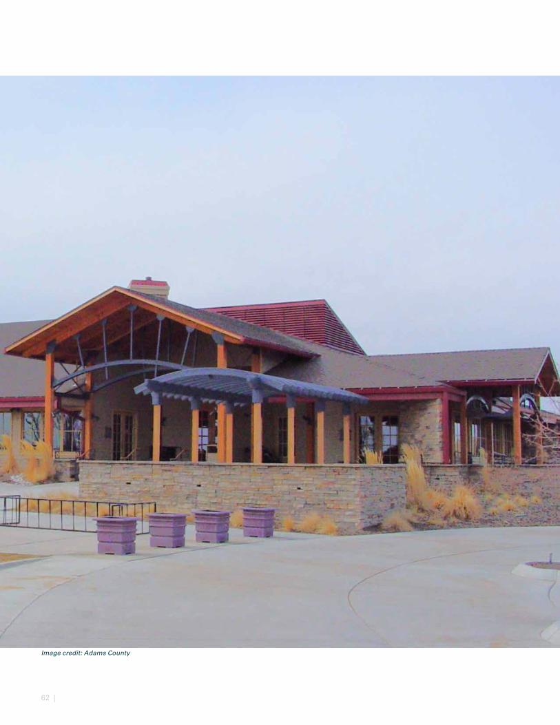
62 |
Image credit: Adams County
63
MARKET ASSESSMENTThe purpose of the Master Plan is to explore various options for renovating and re-purposing existing facilities at the Adams County Fairgrounds (fairgrounds) as well as constructing new public use facilities. Crossroads Consulting Services LLC (Crossroads) was retained to focus on specific market and economic factors as part of the Master Plan. Our role is to assist the Project Team by preparing analysis and observations as well as providing specific subject matter support. While our team members will contribute specific analysis related to the Master Plan, Adams County (County) will maintain total responsibility for management decisions pertaining to this engagement.
This deliverable focuses on the market assessment. Research tasks completed by Crossroads as part of the market assessment included, but were not limited to, the following:
• Participated in stakeholder meetings/interviews including representatives from the County, management and staff at the fairgrounds, existing facility user groups, community leaders, among others
• Analyzed select market attributes
• Reviewed the supply of existing and planned facilities in the area
• Analyzed historical facility use of the existing assets on the site based on available information provided by management
• Reviewed program attributes and operating data from various competitive/ comparable facilities
• Reviewed industry trends that may impact future operations of the fairgrounds
• Obtained feedback from a select number of existing users of the fairgrounds regarding future programmatic needs
• Summarized potential market-related strengths, challenges/threats, and opportunities associated enhanced/new facilities at the fairgrounds
• Identified recommended physical improvements based on potential market opportunities
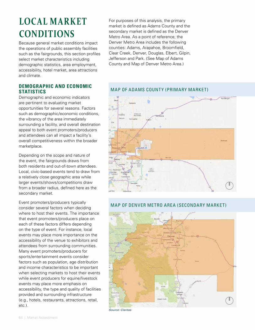
64 | Market Assessment
LOCAL MARKET CONDITIONSBecause general market conditions impact the operations of public assembly facilities such as the fairgrounds, this section profiles select market characteristics including demographic statistics, area employment, accessibility, hotel market, area attractions and climate.
DEMOGRAPHIC AND ECONOMIC STATISTICSDemographic and economic indicators are pertinent to evaluating market opportunities for several reasons. Factors such as demographic/economic conditions, the vibrancy of the area immediately surrounding a facility, and overall destination appeal to both event promoters/producers and attendees can all impact a facility’s overall competitiveness within the broader marketplace.
Depending on the scope and nature of the event, the fairgrounds draws from both residents and out-of-town attendees. Local, civic-based events tend to draw from a relatively close geographic area while larger events/shows/competitions draw from a broader radius, defined here as the secondary market.
Event promoters/producers typically consider several factors when deciding where to host their events. The importance that event promoters/producers place on each of these factors differs depending on the type of event. For instance, local events may place more importance on the accessibility of the venue to exhibitors and attendees from surrounding communities. Many event promoters/producers for sports/entertainment events consider factors such as population, age distribution and income characteristics to be important when selecting markets to host their events while event producers for equine/livestock events may place more emphasis on accessibility, the type and quality of facilities provided and surrounding infrastructure (e.g., hotels, restaurants, attractions, retail, etc.).
For purposes of this analysis, the primary market is defined as Adams County and the secondary market is defined as the Denver Metro Area. As a point of reference, the Denver Metro Area includes the following counties: Adams, Arapahoe, Broomfield, Clear Creek, Denver, Douglas, Elbert, Gilpin, Jefferson and Park. (See Map of Adams County and Map of Denver Metro Area.)
MAP OF ADAMS COUNT Y (PRIMARY MARKET)
MAP OF DENVER METRO AREA (SECONDARY MARKET)
Source: Claritas
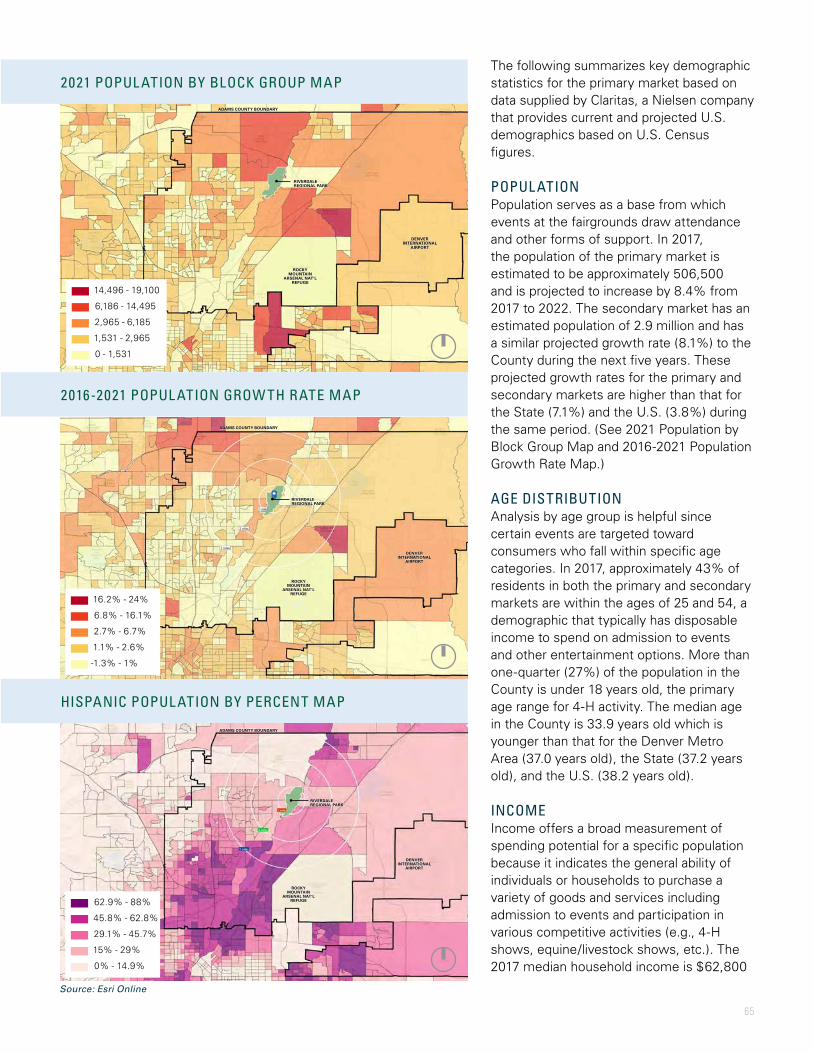
65
2016-2021 POPUL ATION GROW TH RATE MAP
HISPANIC POPUL ATION BY PERCENT MAP
The following summarizes key demographic statistics for the primary market based on data supplied by Claritas, a Nielsen company that provides current and projected U.S. demographics based on U.S. Census figures.
POPUL ATIONPopulation serves as a base from which events at the fairgrounds draw attendance and other forms of support. In 2017, the population of the primary market is estimated to be approximately 506,500 and is projected to increase by 8.4% from 2017 to 2022. The secondary market has an estimated population of 2.9 million and has a similar projected growth rate (8.1%) to the County during the next five years. These projected growth rates for the primary and secondary markets are higher than that for the State (7.1%) and the U.S. (3.8%) during the same period. (See 2021 Population by Block Group Map and 2016-2021 Population Growth Rate Map.)
AGE DISTRIBUTIONAnalysis by age group is helpful since certain events are targeted toward consumers who fall within specific age categories. In 2017, approximately 43% of residents in both the primary and secondary markets are within the ages of 25 and 54, a demographic that typically has disposable income to spend on admission to events and other entertainment options. More than one-quarter (27%) of the population in the County is under 18 years old, the primary age range for 4-H activity. The median age in the County is 33.9 years old which is younger than that for the Denver Metro Area (37.0 years old), the State (37.2 years old), and the U.S. (38.2 years old).
INCOMEIncome offers a broad measurement of spending potential for a specific population because it indicates the general ability of individuals or households to purchase a variety of goods and services including admission to events and participation in various competitive activities (e.g., 4-H shows, equine/livestock shows, etc.). The 2017 median household income is $62,800
RIVERDALE REGIONAL PARK
ADAMS COUNTY BOUNDARY
DENVER INTERNATIONAL
AIRPORT
DENVER INTERNATIONAL
AIRPORT
ROCKY MOUNTAIN
ARSENAL NAT’L REFUGE
ROCKY MOUNTAIN
ARSENAL NAT’L REFUGE
ADAMS COUNTY BOUNDARY
RIVERDALE REGIONAL PARK
DENVER INTERNATIONAL
AIRPORT
ROCKY MOUNTAIN
ARSENAL NAT’L REFUGE
ADAMS COUNTY BOUNDARY
RIVERDALE REGIONAL PARK
14,496 - 19,100
6,186 - 14,495
2,965 - 6,185
1,531 - 2,965
0 - 1,531
16.2% - 24%
6.8% - 16.1%
2.7% - 6.7%
1.1% - 2.6%
-1.3% - 1%
62.9% - 88%
45.8% - 62.8%
29.1% - 45.7%
15% - 29%
0% - 14.9%
2021 POPUL ATION BY BLOCK GROUP MAP
Source: Esri Online
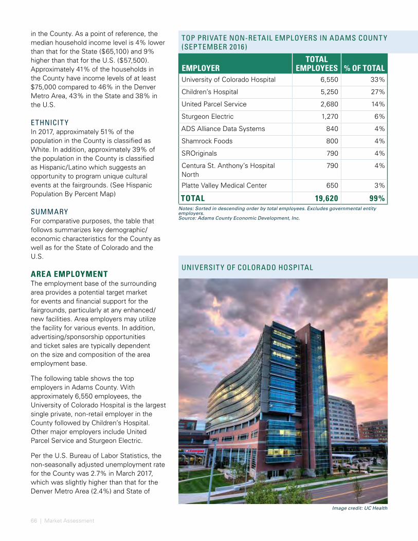
66 | Market Assessment
in the County. As a point of reference, the median household income level is 4% lower than that for the State ($65,100) and 9% higher than that for the U.S. ($57,500). Approximately 41% of the households in the County have income levels of at least $75,000 compared to 46% in the Denver Metro Area, 43% in the State and 38% in the U.S.
ETHNICIT YIn 2017, approximately 51% of the population in the County is classified as White. In addition, approximately 39% of the population in the County is classified as Hispanic/Latino which suggests an opportunity to program unique cultural events at the fairgrounds. (See Hispanic Population By Percent Map)
SUMMARYFor comparative purposes, the table that follows summarizes key demographic/economic characteristics for the County as well as for the State of Colorado and the U.S.
AREA EMPLOYMENTThe employment base of the surrounding area provides a potential target market for events and financial support for the fairgrounds, particularly at any enhanced/new facilities. Area employers may utilize the facility for various events. In addition, advertising/sponsorship opportunities and ticket sales are typically dependent on the size and composition of the area employment base.
The following table shows the top employers in Adams County. With approximately 6,550 employees, the University of Colorado Hospital is the largest single private, non-retail employer in the County followed by Children’s Hospital. Other major employers include United Parcel Service and Sturgeon Electric.
Per the U.S. Bureau of Labor Statistics, the non-seasonally adjusted unemployment rate for the County was 2.7% in March 2017, which was slightly higher than that for the Denver Metro Area (2.4%) and State of
EMPLOYERTOTAL
EMPLOYEES % OF TOTALUniversity of Colorado Hospital 6,550 33%
Children’s Hospital 5,250 27%
United Parcel Service 2,680 14%
Sturgeon Electric 1,270 6%
ADS Alliance Data Systems 840 4%
Shamrock Foods 800 4%
SROriginals 790 4%
Centura St. Anthony’s Hospital North
790 4%
Platte Valley Medical Center 650 3%
TOTAL 19,620 99%Notes: Sorted in descending order by total employees. Excludes governmental entity employers.Source: Adams County Economic Development, Inc.
TOP PRIVATE NON-RETAIL EMPLOYERS IN ADAMS COUNT Y (SEPTEMBER 2016)
UNIVERSIT Y OF COLORADO HOSPITAL
Image credit: UC Health
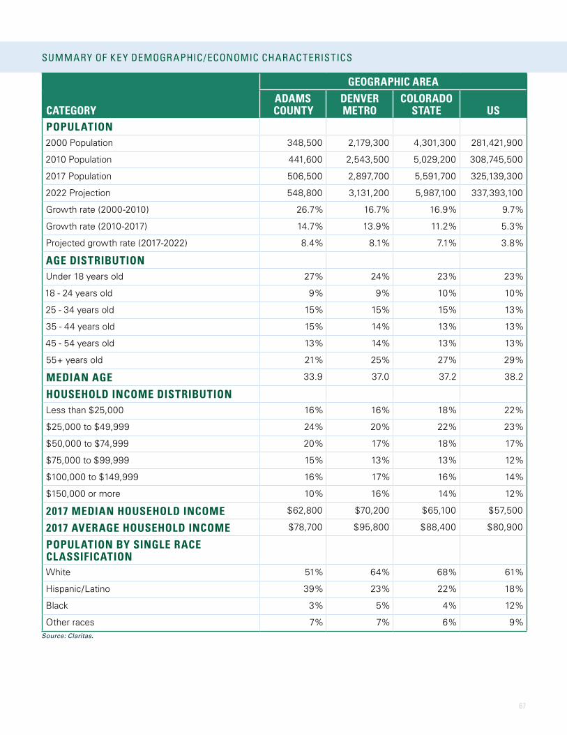
67
TOP PRIVATE NON-RETAIL EMPLOYERS IN ADAMS COUNT Y (SEPTEMBER 2016)
UNIVERSIT Y OF COLORADO HOSPITAL
GEOGRAPHIC AREA
CATEGORYADAMS COUNTY
DENVER METRO
COLORADO STATE US
POPULATION2000 Population 348,500 2,179,300 4,301,300 281,421,900
2010 Population 441,600 2,543,500 5,029,200 308,745,500
2017 Population 506,500 2,897,700 5,591,700 325,139,300
2022 Projection 548,800 3,131,200 5,987,100 337,393,100
Growth rate (2000-2010) 26.7% 16.7% 16.9% 9.7%
Growth rate (2010-2017) 14.7% 13.9% 11.2% 5.3%
Projected growth rate (2017-2022) 8.4% 8.1% 7.1% 3.8%
AGE DISTRIBUTIONUnder 18 years old 27% 24% 23% 23%
18 - 24 years old 9% 9% 10% 10%
25 - 34 years old 15% 15% 15% 13%
35 - 44 years old 15% 14% 13% 13%
45 - 54 years old 13% 14% 13% 13%
55+ years old 21% 25% 27% 29%
MEDIAN AGE 33.9 37.0 37.2 38.2
HOUSEHOLD INCOME DISTRIBUTIONLess than $25,000 16% 16% 18% 22%
$25,000 to $49,999 24% 20% 22% 23%
$50,000 to $74,999 20% 17% 18% 17%
$75,000 to $99,999 15% 13% 13% 12%
$100,000 to $149,999 16% 17% 16% 14%
$150,000 or more 10% 16% 14% 12%
2017 MEDIAN HOUSEHOLD INCOME $62,800 $70,200 $65,100 $57,500
2017 AVERAGE HOUSEHOLD INCOME $78,700 $95,800 $88,400 $80,900
POPULATION BY SINGLE RACE CLASSIFICATIONWhite 51% 64% 68% 61%
Hispanic/Latino 39% 23% 22% 18%
Black 3% 5% 4% 12%
Other races 7% 7% 6% 9%Source: Claritas.
SUMMARY OF KEY DEMOGRAPHIC/ECONOMIC CHARACTERISTICS
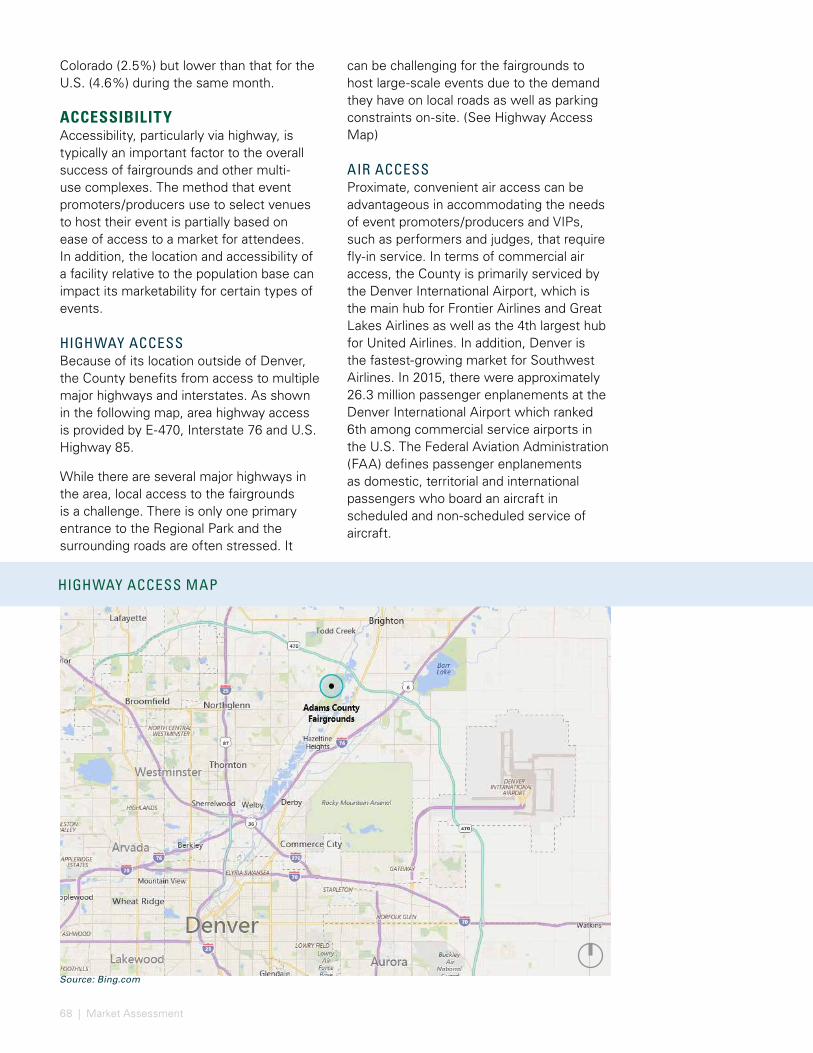
68 | Market Assessment
Source: Bing.com
HIGHWAY ACCESS MAP
TRENDS IN ADR AND OCCUPANCY AT DENVER AREA HOTELS
HOTEL SUPPLY IN BRIGHTON
Colorado (2.5%) but lower than that for the U.S. (4.6%) during the same month.
ACCESSIBILITYAccessibility, particularly via highway, is typically an important factor to the overall success of fairgrounds and other multi-use complexes. The method that event promoters/producers use to select venues to host their event is partially based on ease of access to a market for attendees. In addition, the location and accessibility of a facility relative to the population base can impact its marketability for certain types of events.
HIGHWAY ACCESSBecause of its location outside of Denver, the County benefits from access to multiple major highways and interstates. As shown in the following map, area highway access is provided by E-470, Interstate 76 and U.S. Highway 85.
While there are several major highways in the area, local access to the fairgrounds is a challenge. There is only one primary entrance to the Regional Park and the surrounding roads are often stressed. It
can be challenging for the fairgrounds to host large-scale events due to the demand they have on local roads as well as parking constraints on-site. (See Highway Access Map)
AIR ACCESSProximate, convenient air access can be advantageous in accommodating the needs of event promoters/producers and VIPs, such as performers and judges, that require fly-in service. In terms of commercial air access, the County is primarily serviced by the Denver International Airport, which is the main hub for Frontier Airlines and Great Lakes Airlines as well as the 4th largest hub for United Airlines. In addition, Denver is the fastest-growing market for Southwest Airlines. In 2015, there were approximately 26.3 million passenger enplanements at the Denver International Airport which ranked 6th among commercial service airports in the U.S. The Federal Aviation Administration (FAA) defines passenger enplanements as domestic, territorial and international passengers who board an aircraft in scheduled and non-scheduled service of aircraft.

69
HOTEL MARKET The diversity, supply and availability of hotel rooms proximate to the fairgrounds can play a role in attracting events that draw overnight attendees.
HOTEL SUPPLYAs shown in the following table, there are approximately 460 rooms in Brighton. The closest hotels to the fairgrounds are approximately five miles away. This hotel supply is supplemented by hotels in the Denver Metro Area that offer approximately 45,000 hotel rooms with multiple brands and price points. However, the majority of these rooms are outside the desired driving distance of most attendees
In addition to the hotel supply in Brighton, there is the Barr Lake RV Park which is located approximately five miles from the fairgrounds. This RV park offers a total of 108 RV sites - 90 offer full-service hookups and 18 only have electric and water. There are 11 additional campsites that do not have hookups. Barr Lake RV Park’s charges $30 per day for RV hookups. This supply of RV
Source: Rocky Mountain Lodging Report.
TRENDS IN ADR AND OCCUPANCY AT DENVER AREA HOTELS
$112 $115 $124 $134 $140 $125
68%71% 76% 76% 75% 73%
0%
10%
20%
30%
40%
50%
60%
70%
$0
$20
$40
$60
$80
$100
$120
$140
$160
2012 2013 2014 2015 2016 Five-yearaverage
ADR Occupancy
Notes: Sorted in descending order by number of rooms. Rooms outside of Brighton represent only those located adjacent to I-25 All profiled properties and rooms are located within 10 miles of the fairgrounds. Sources: Hotels.com; secondary research.
HOTEL SUPPLY IN BRIGHTON
PROPERTYNUMBER OF
ROOMS
DISTANCE FROM THE FAIRGROUNDS
(MILES)Holiday Inn Express Suites Denver Northeast - Brighton 88 8
Fairfield Inn & Suites Denver Northeast/Brighton 78 5
Hampton Inn Denver Northeast Hotel 76 5
Candlewood Suites Denver Northeast - Brighton 72 8
Best Western Brighton Inn 58 5
Comfort Inn Brighton 52 5
Super 8 Brighton 37 5
TOTAL IN BRIGHTON 461Westminister 602
Thornton 480
Northglenn 366
TOTAL OTHER ADJACENT TO I-25 1,448
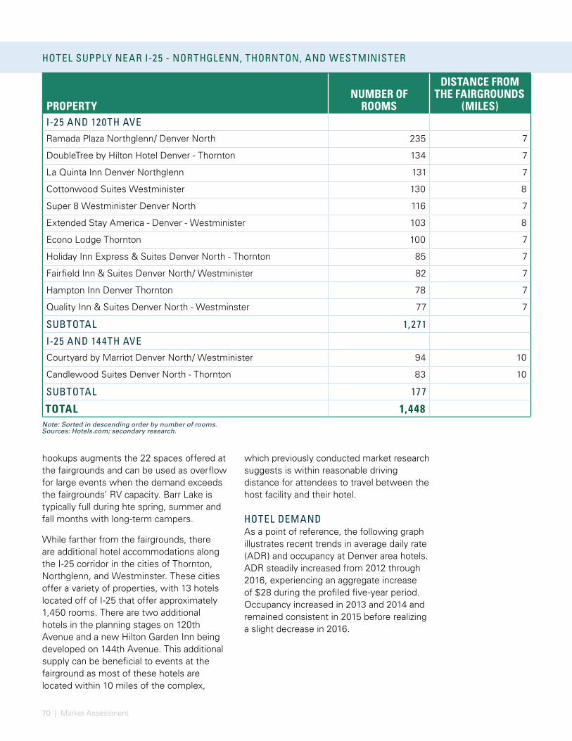
70 | Market Assessment
hookups augments the 22 spaces offered at the fairgrounds and can be used as overflow for large events when the demand exceeds the fairgrounds’ RV capacity. Barr Lake is typically full during hte spring, summer and fall months with long-term campers.
While farther from the fairgrounds, there are additional hotel accommodations along the I-25 corridor in the cities of Thornton, Northglenn, and Westminster. These cities offer a variety of properties, with 13 hotels located off of I-25 that offer approximately 1,450 rooms. There are two additional hotels in the planning stages on 120th Avenue and a new Hilton Garden Inn being developed on 144th Avenue. This additional supply can be beneficial to events at the fairground as most of these hotels are located within 10 miles of the complex,
AVERAGE PRECIPITATION BY MONTH IN ADAMS COUNT Y:
Note: Sorted in descending order by number of rooms.Sources: Hotels.com; secondary research.
HOTEL SUPPLY NEAR I-25 - NORTHGLENN, THORNTON, AND WESTMINISTER
PROPERTYNUMBER OF
ROOMS
DISTANCE FROM THE FAIRGROUNDS
(MILES)I-25 AND 120TH AVE
Ramada Plaza Northglenn/ Denver North 235 7
DoubleTree by Hilton Hotel Denver - Thornton 134 7
La Quinta Inn Denver Northglenn 131 7
Cottonwood Suites Westminister 130 8
Super 8 Westminister Denver North 116 7
Extended Stay America - Denver - Westminister 103 8
Econo Lodge Thornton 100 7
Holiday Inn Express & Suites Denver North - Thornton 85 7
Fairfield Inn & Suites Denver North/ Westminister 82 7
Hampton Inn Denver Thornton 78 7
Quality Inn & Suites Denver North - Westminster 77 7
SUBTOTAL 1,271
I-25 AND 144TH AVE
Courtyard by Marriot Denver North/ Westminister 94 10
Candlewood Suites Denver North - Thornton 83 10
SUBTOTAL 177
TOTAL 1,448
which previously conducted market research suggests is within reasonable driving distance for attendees to travel between the host facility and their hotel.
HOTEL DEMANDAs a point of reference, the following graph illustrates recent trends in average daily rate (ADR) and occupancy at Denver area hotels. ADR steadily increased from 2012 through 2016, experiencing an aggregate increase of $28 during the profiled five-year period. Occupancy increased in 2013 and 2014 and remained consistent in 2015 before realizing a slight decrease in 2016.
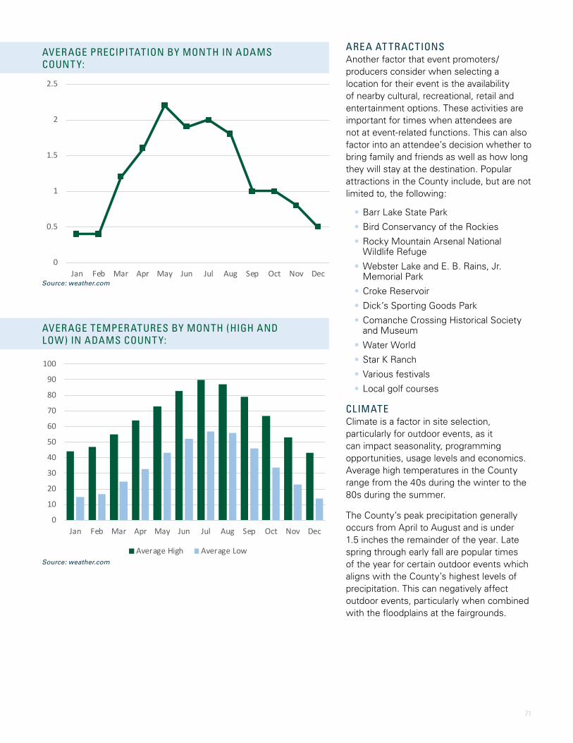
71
0
10
20
30
40
50
60
70
80
90
100
Jan Feb Mar Apr May Jun Jul Aug Sep Oct Nov Dec
Average High Average Low
AVERAGE TEMPERATURES BY MONTH (HIGH AND LOW) IN ADAMS COUNT Y:
Source: weather.com
0
0.5
1
1.5
2
2.5
Jan Feb Mar Apr May Jun Jul Aug Sep Oct Nov Dec
AVERAGE PRECIPITATION BY MONTH IN ADAMS COUNT Y:
Source: weather.com
HOTEL SUPPLY NEAR I-25 - NORTHGLENN, THORNTON, AND WESTMINISTERAREA AT TRACTIONSAnother factor that event promoters/producers consider when selecting a location for their event is the availability of nearby cultural, recreational, retail and entertainment options. These activities are important for times when attendees are not at event-related functions. This can also factor into an attendee’s decision whether to bring family and friends as well as how long they will stay at the destination. Popular attractions in the County include, but are not limited to, the following:
• Barr Lake State Park
• Bird Conservancy of the Rockies
• Rocky Mountain Arsenal National Wildlife Refuge
• Webster Lake and E. B. Rains, Jr. Memorial Park
• Croke Reservoir
• Dick’s Sporting Goods Park
• Comanche Crossing Historical Society and Museum
• Water World
• Star K Ranch
• Various festivals
• Local golf courses
CLIMATEClimate is a factor in site selection, particularly for outdoor events, as it can impact seasonality, programming opportunities, usage levels and economics. Average high temperatures in the County range from the 40s during the winter to the 80s during the summer.
The County’s peak precipitation generally occurs from April to August and is under 1.5 inches the remainder of the year. Late spring through early fall are popular times of the year for certain outdoor events which aligns with the County’s highest levels of precipitation. This can negatively affect outdoor events, particularly when combined with the floodplains at the fairgrounds.
72 | Market Assessment
FAIRGROUNDS ORGANIZ ATIONAL STRUCTUREOVERVIEW OF FAIRGROUNDS OPERATIONSTo assist the County with its long-term planning efforts for the fairgrounds, this section provides a general overview of its operations which serves as a baseline for the market assessment.
GENERAL OVERVIEW AND MISSIONThe fairgrounds is owned and operated by the County and overseen by the Adams County Commissioners comprised of five elected officials. The fairgrounds are one component of the Parks & Open Space Division of the County whose mission is
“to enhance the quality of life for residents by providing recreational, educational, and cultural opportunities through our system of parks, trails, open spaces, and facilities and to preserve and protect the natural and cultural resources of the County for present and future generations.” The Open Space Board is made up of seven members appointed by the Adams County Commissioners.
One of the major annual events hosted at the fairgrounds is the Adams County Fair (Fair). Its mission is “to provide a quality event for our guests and to enhance educational opportunities with emphasis on youth and agriculture while uniting urban and rural communities in a time-honored celebration.” The Fair is overseen by the County Fair Board, comprised of five appointed members.
RENTAL POLICIESFacilities at the fairgrounds are rented on a first come, first serve basis with the exception of events having a historical date which is obtained when an organization holds the same event utilizing the same facilities during the same time frame for two consecutive years.
Events are categorized as commercial, non-profit, and County Government. Commercial events are held by private persons or
for-profit organizations. Non-profit events are held by an organization, association or entity that is registered with the Secretary of State’s office as a non-profit organization. County Government events are those held by Adams County Government departments and agencies using facilities for official County business or programs. CSU Extension and 4-H events are subject to the same rules as County Government events. CSU Extension is assessed an annual fee to receive this classification. These events are subject to the following rules:
• Tenants may not assess a fee to participants except as necessary to reimburse the tenant for costs of materials
• If used, the tenant must clean the kitchen
• Events will be scheduled Monday through Thursday from 7 AM – 10 PM. Events scheduled outside this time frame will be assessed the lowest non-profit rate available
• Events shall not be scheduled on holidays
• Events should be held in the Rendezvous Rooms, former Red Cross Building or Parks Meeting Rooms, when possible
• Paying events may cancel non-paying County Government events outside of a 30-day window prior to the event
ORGANIZATIONAL STRUCTUREPermanent, full-time staffing plans can vary based on several factors such as management’s philosophy of maintaining event-related personnel as full-time or part-time staff. Staffing levels are also dependent on the extent to which a facility utilizes contract services versus providing services such as security, food & beverage, janitorial cleaning and event labor in-house. Determining what services to provide in-house versus outsourcing is typically a question of which option provides the best competitive advantage for a facility relative to its core mission and to the cost/benefit of providing a specific service. One such example is when the fairgrounds became the provider of alcohol at all events starting in 2015. (See Fairgrounds Organizational Structure)

73
PARKS AND OPEN SPACE DIRECTOR
REGIONAL PARK MANAGER
FACILITY AND UTILITY SUPERVISOR GROUNDS SUPERVISOR
GROUNDS CREW LEADER
PARKS AND OPEN SPACE MAINTENANCE WORKER II
SEASONAL PARKS AND OPEN SPACE TECHNICIAN (3)
FACILITY AND SPECIAL EVENTS COORDINATOR
FAIR AND SPECIAL EVENTS COORDINATOR
EVENTS SERVICES AND BEVERAGE SUPERVISOR
ON-CALL BARTENDERS
CREW LEADER DAYS
MAINTENANCE AND EVENT SERVICES (1 FTE)
SEASONAL EVENT SERVICES (2)
TRUSTEE WORKER PROGRAM (2)
SEASONAL EVENT SERVICES (3)
MAINTENANCE AND EVENT SERVICES (3)
CREW LEADER NIGHTS AND WEEKENDS
PARKS MECHANIC
FAIR AND EVENTS MANAGER
FAIRGROUNDS ORGANIZ ATIONAL STRUCTURE
Note: The table above does not include Golf Course OperationsSource: Facility Management

74 | Market Assessment
SUMMARY OF EVENT ACTIVIT Y AT THE ADAMS COUNT Y FAIRGROUNDS (2014-2016)
1,068 1,083 1,167 1,106
2,145
1,497
1,523
1,722
-
500
1,000
1,500
2,000
2,500
-
200
400
600
800
1,000
1,200
1,400
2014 2015 2016 Three-yearaverage
Use
Days
Book
ings
Axis Title
Bookings Use Days
HISTORICAL UTILIZATIONThe fairgrounds hosts a diverse set of event activity including the Fair, 4-H activities, agricultural and animal events, community events, and various banquets, parties, Quinceaneras and weddings. In addition, the fairgrounds rents stalls and picnic pavilions as well as RV and camping spaces. This section profiles utilization trends at the fairgrounds for the last three calendar years (2014–2016) which helps identify future market demand opportunities.
As shown in the following graph, the total number of bookings and attendance at the fairgrounds increased each year from 2014 to 2016. During the profiled period, the fairgrounds averaged approximately 1,100 bookings and 1,700 use days per year. A booking accounts for each building or space rental, regardless of the amount of time the space was booked. For example, a meeting room may be booked by one event for multiple days, resulting in one booking whereas a meeting room could be booked by multiple events in one day, resulting in multiple bookings. Analyzing bookings and event activity by type can identify trends in usage and attendance. The following table summarizes activity by booking type during the profiled three-year period.
4-H activity includes meetings, classes, banquets, practices, clinics, shows, livestock judging and various other activity. As shown, 4-H activity accounted for the highest number of bookings each of the last three years. 4-H activity also generated the most total use days in 2015 and 2016. Although most 4-H bookings only last one day and have relatively low attendance, they contribute to local youth development, as well as general economic activity to the County.
Meetings, conferences, and classes accounted for the second highest number of bookings during the profiled period. These events averaged more than 100 attendees per booking and drew the second most attendees of any event type. Most of these events last one day per use and utilize a variety of event spaces including the Waymire Dome, former Red Cross Building,
Parks Meeting Rooms and the Al Lesser Building.
RV and Camping rentals averaged the highest number of use days during the profiled period which was primarily attributable to approximately 900 use days in 2014. However, a policy change in 2015 discontinued public camping. Campers are now only allowed if they are associated with an event. As such, total use days in 2015 and 2016 are more reflective of current operations. RV & Camping rentals generate revenue for the fairgrounds and generally require less staff labor than other types of bookings.
Pavilion and Picnic rentals increased each year during the profiled period and accounted for approximately 8% of overall attendance. The fairgrounds’ setting within the Regional Park helps draw people to utilize these facilities and offers additional activities for picnic and event attendees.
Source: Facility Management.
ADAMS COUNT Y FAIRGROUNDS - SUMMARY OF ACTIVIT Y
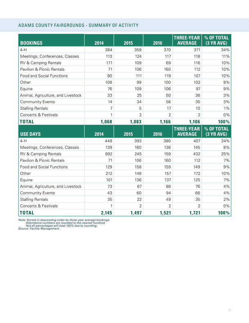
75
BOOKINGS 2014 2015 2016THREE-YEAR
AVERAGE% OF TOTAL (3 YR AVG)
4-H 384 359 370 371 34%
Meetings, Conferences, Classes 113 124 117 118 11%
RV & Camping Rentals 171 109 69 116 10%
Pavilion & Picnic Rentals 71 106 160 112 10%
Food and Social Functions 90 111 119 107 10%
Other 108 99 100 102 9%
Equine 76 109 106 97 9%
Animal, Agriculture, and Livestock 33 25 50 36 3%
Community Events 14 34 56 35 3%
Stalling Rentals 7 5 17 10 1%
Concerts & Festivals 1 2 2 2 0%
TOTAL 1,068 1,083 1,166 1,106 100%
USE DAYS 2014 2015 2016THREE-YEAR
AVERAGE% OF TOTAL (3 YR AVG)
4-H 449 393 380 407 24%
Meetings, Conferences, Classes 139 160 136 145 8%
RV & Camping Rentals 892 245 159 432 25%
Pavilion & Picnic Rentals 71 106 160 112 7%
Food and Social Functions 129 158 159 149 9%
Other 212 148 157 172 10%
Equine 101 136 137 125 7%
Animal, Agriculture, and Livestock 73 67 88 76 4%
Community Events 43 60 94 66 4%
Stalling Rentals 35 22 49 35 2%
Concerts & Festivals 1 2 2 2 0%
TOTAL 2,145 1,497 1,521 1,721 100%Note: Sorted in descending order by three-year average bookings. Attendance numbers are rounded to the nearest hundred. Not all percentages will total 100% due to rounding.Source: Facility Management.
ADAMS COUNT Y FAIRGROUNDS - SUMMARY OF ACTIVIT Y
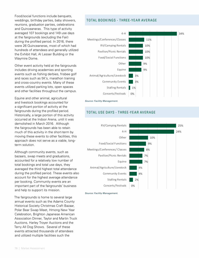
76 | Market Assessment
TOTAL BOOKINGS - THREE-YEAR AVERAGE
TOTAL USE DAYS - THREE-YEAR AVERAGE
34%
11%
10%
10%
10%
9%
9%
3%
3%
1%
0%
4-H
Meetings/Conferences/Classes
RV/Camping Rentals
Pavilion/Picnic Rentals
Food/Social Functions
Other
Equine
Animal/Agriculture/Livestock
Community Events
Stalling Rentals
Concerts/Festivals
25%
24%
10%
9%
8%
7%
7%
4%
4%
2%
0%
RV/Camping Rentals
4-H
Other
Food/Social Functions
Meetings/Conferences/ Classes
Pavilion/Picnic Rentals
Equine
Animal/Agriculture/Livestock
Community Events
Stalling Rentals
Concerts/Festivals
TOTAL AT TENDANCE - THREE-YEAR AVERAGE
VIEW OF ADAMS COUNT Y FAIR IN THE EVENING
Food/social functions include banquets, weddings, birthday parties, baby showers, reunions, graduation parties, celebrations and Quinceaneras. This type of activity averaged 107 bookings and 149 use days at the fairgrounds (excluding the Fair) during the profiled period. In 2016, there were 26 Quinceaneras, most of which had hundreds of attendees and generally utilized the Exhibit Hall, Al Lesser Building or the Waymire Dome.
Other event activity held at the fairgrounds includes driving academies and sporting events such as fishing derbies, frisbee golf and races such as 5K’s, marathon training and cross-country events. Many of these events utilized parking lots, open spaces and other facilities throughout the campus.
Equine and other animal, agricultural and livestock bookings accounted for a significant portion of activity at the fairgrounds during the profiled period. Historically, a large portion of this activity occurred at the Indoor Arena, until it was demolished in March 2016. Although the fairgrounds has been able to retain much of this activity in the short-term by moving these events to other facilities, this approach does not serve as a viable, long-term solution.
Although community events, such as bazaars, swap meets and graduations, accounted for a relatively low number of total bookings and total use days, they averaged the third highest total attendance during the profiled period. These events also account for the highest average attendance per booking. Community events are an important part of the fairgrounds’ business and help to support its mission.
The fairgrounds is home to several large annual events such as the Adams County Historical Society Christmas Craft Bazaar, Polar Bear Swap Meet, Hmong New Year Celebration, Brighton Japanese American Association Dinner, Taylor and Martin Truck Auctions, Harley Troyer Auctions and the Terry All Dog Shows. Several of these events attracted thousands of attendees and utilized multiple facilities such the
Source: Facility Management.
Source: Facility Management.
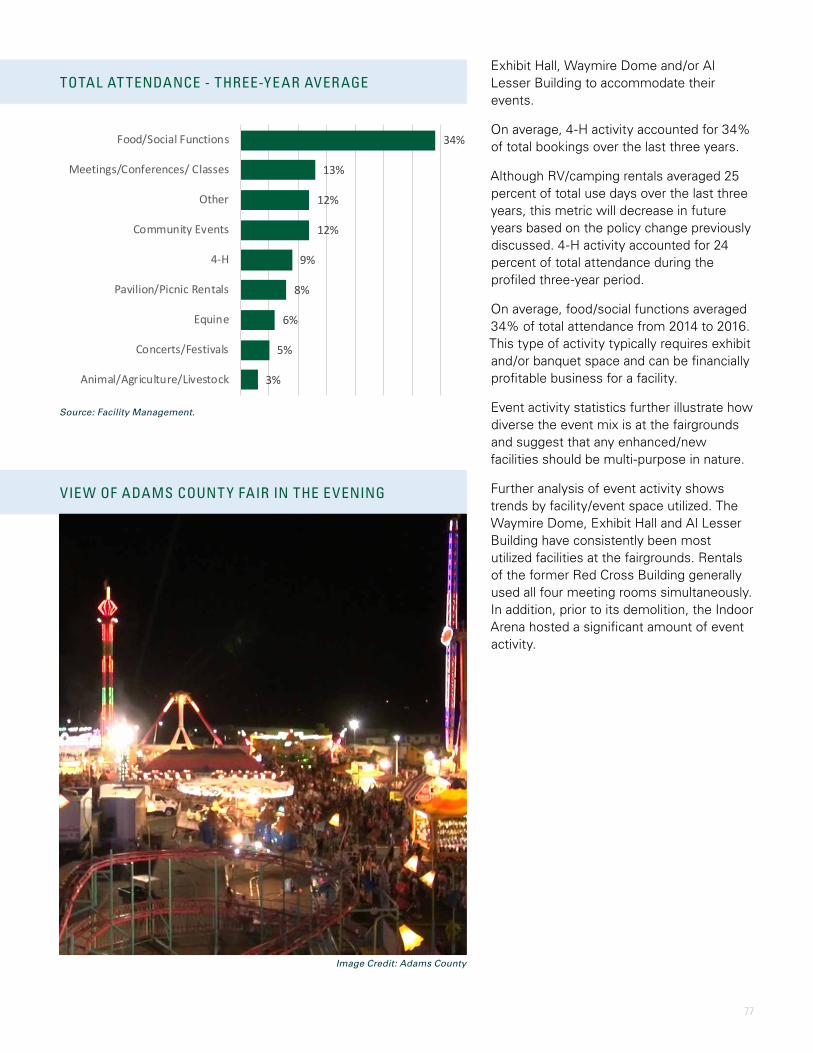
77
TOTAL AT TENDANCE - THREE-YEAR AVERAGE
VIEW OF ADAMS COUNT Y FAIR IN THE EVENING
34%
13%
12%
12%
9%
8%
6%
5%
3%
Food/Social Functions
Meetings/Conferences/ Classes
Other
Community Events
4-H
Pavilion/Picnic Rentals
Equine
Concerts/Festivals
Animal/Agriculture/Livestock
Exhibit Hall, Waymire Dome and/or Al Lesser Building to accommodate their events.
On average, 4-H activity accounted for 34% of total bookings over the last three years.
Although RV/camping rentals averaged 25 percent of total use days over the last three years, this metric will decrease in future years based on the policy change previously discussed. 4-H activity accounted for 24 percent of total attendance during the profiled three-year period.
On average, food/social functions averaged 34% of total attendance from 2014 to 2016. This type of activity typically requires exhibit and/or banquet space and can be financially profitable business for a facility.
Event activity statistics further illustrate how diverse the event mix is at the fairgrounds and suggest that any enhanced/new facilities should be multi-purpose in nature.
Further analysis of event activity shows trends by facility/event space utilized. The Waymire Dome, Exhibit Hall and Al Lesser Building have consistently been most utilized facilities at the fairgrounds. Rentals of the former Red Cross Building generally used all four meeting rooms simultaneously. In addition, prior to its demolition, the Indoor Arena hosted a significant amount of event activity.
Source: Facility Management.
Image Credit: Adams County
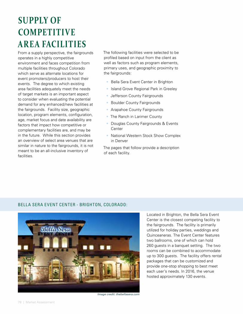
78 | Market Assessment
SUPPLY OF COMPETITIVE AREA FACILITIESFrom a supply perspective, the fairgrounds operates in a highly competitive environment and faces competition from multiple facilities throughout Colorado which serve as alternate locations for event promoters/producers to host their events. The degree to which existing area facilities adequately meet the needs of target markets is an important aspect to consider when evaluating the potential demand for any enhanced/new facilities at the fairgrounds. Facility size, geographic location, program elements, configuration, age, market focus and date availability are factors that impact how competitive or complementary facilities are, and may be in the future. While this section provides an overview of select area venues that are similar in nature to the fairgrounds, it is not meant to be an all-inclusive inventory of facilities.
Located in Brighton, the Bella Sera Event Center is the closest competing facility to the fairgrounds. The facility is primarily utilized for holiday parties, weddings and Quinceaneras. The Event Center features two ballrooms, one of which can hold 260 guests in a banquet setting. The two rooms can be combined to accommodate up to 300 guests. The facility offers rental packages that can be customized and provide one-stop shopping to best meet each user’s needs. In 2016, the venue hosted approximately 130 events.
BELL A SERA EVENT CENTER - BRIGHTON, COLORADO:
ISL AND GROVE REGIONAL PARK - GREELEY, COLORADO:
The following facilities were selected to be profiled based on input from the client as well as factors such as program elements, primary uses, and geographic proximity to the fairgrounds:
• Bella Sera Event Center in Brighton
• Island Grove Regional Park in Greeley
• Jefferson County Fairgrounds
• Boulder County Fairgrounds
• Arapahoe County Fairgrounds
• The Ranch in Larimer County
• Douglas County Fairgrounds & Events Center
• National Western Stock Show Complex in Denver
The pages that follow provide a description of each facility.
Image credit: thebellasera.com Source: poudretrail.org
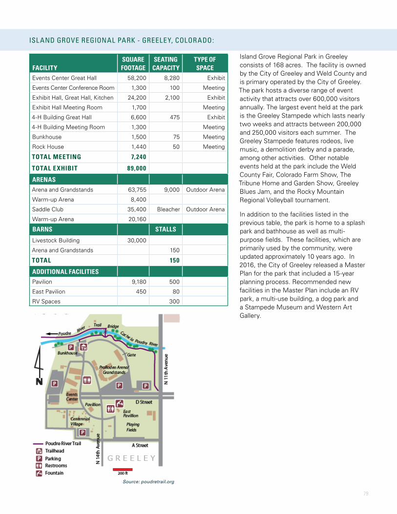
79
BELL A SERA EVENT CENTER - BRIGHTON, COLORADO:
Island Grove Regional Park in Greeley consists of 168 acres. The facility is owned by the City of Greeley and Weld County and is primary operated by the City of Greeley. The park hosts a diverse range of event activity that attracts over 600,000 visitors annually. The largest event held at the park is the Greeley Stampede which lasts nearly two weeks and attracts between 200,000 and 250,000 visitors each summer. The Greeley Stampede features rodeos, live music, a demolition derby and a parade, among other activities. Other notable events held at the park include the Weld County Fair, Colorado Farm Show, The Tribune Home and Garden Show, Greeley Blues Jam, and the Rocky Mountain Regional Volleyball tournament.
In addition to the facilities listed in the previous table, the park is home to a splash park and bathhouse as well as multi-purpose fields. These facilities, which are primarily used by the community, were updated approximately 10 years ago. In 2016, the City of Greeley released a Master Plan for the park that included a 15-year planning process. Recommended new facilities in the Master Plan include an RV park, a multi-use building, a dog park and a Stampede Museum and Western Art Gallery.
ISL AND GROVE REGIONAL PARK - GREELEY, COLORADO:
FACILITYSQUARE FOOTAGE
SEATING CAPACITY
TYPE OF SPACE
Events Center Great Hall 58,200 8,280 Exhibit
Events Center Conference Room 1,300 100 Meeting
Exhibit Hall, Great Hall, Kitchen 24,200 2,100 Exhibit
Exhibit Hall Meeting Room 1,700 Meeting
4-H Building Great Hall 6,600 475 Exhibit
4-H Building Meeting Room 1,300 Meeting
Bunkhouse 1,500 75 Meeting
Rock House 1,440 50 Meeting
TOTAL MEETING 7,240
TOTAL EXHIBIT 89,000
ARENASArena and Grandstands 63,755 9,000 Outdoor Arena
Warm-up Arena 8,400
Saddle Club 35,400 Bleacher Outdoor Arena
Warm-up Arena 20,160
BARNS STALLS
Livestock Building 30,000
Arena and Grandstands 150
TOTAL 150
ADDITIONAL FACILITIESPavilion 9,180 500
East Pavilion 450 80
RV Spaces 300
Source: poudretrail.org
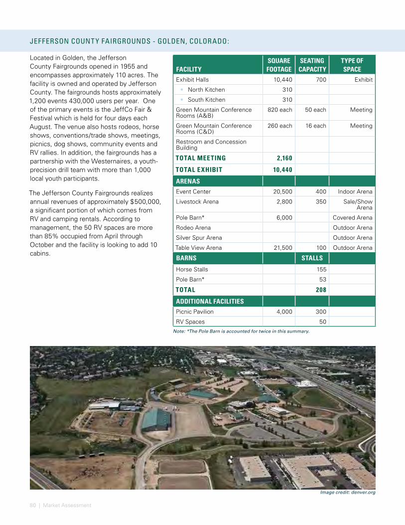
80 | Market Assessment
Located in Golden, the Jefferson County Fairgrounds opened in 1955 and encompasses approximately 110 acres. The facility is owned and operated by Jefferson County. The fairgrounds hosts approximately 1,200 events 430,000 users per year. One of the primary events is the JeffCo Fair & Festival which is held for four days each August. The venue also hosts rodeos, horse shows, conventions/trade shows, meetings, picnics, dog shows, community events and RV rallies. In addition, the fairgrounds has a partnership with the Westernaires, a youth-precision drill team with more than 1,000 local youth participants.
The Jefferson County Fairgrounds realizes annual revenues of approximately $500,000, a significant portion of which comes from RV and camping rentals. According to management, the 50 RV spaces are more than 85% occupied from April through October and the facility is looking to add 10 cabins.
JEFFERSON COUNT Y FAIRGROUNDS - GOLDEN, COLORADO:
FACILITYSQUARE FOOTAGE
SEATING CAPACITY
TYPE OF SPACE
Exhibit Halls 10,440 700 Exhibit
• North Kitchen 310
• South Kitchen 310
Green Mountain Conference Rooms (A&B)
820 each 50 each Meeting
Green Mountain Conference Rooms (C&D)
260 each 16 each Meeting
Restroom and Concession Building
TOTAL MEETING 2,160
TOTAL EXHIBIT 10,440
ARENASEvent Center 20,500 400 Indoor Arena
Livestock Arena 2,800 350 Sale/Show Arena
Pole Barn* 6,000 Covered Arena
Rodeo Arena Outdoor Arena
Silver Spur Arena Outdoor Arena
Table View Arena 21,500 100 Outdoor Arena
BARNS STALLS
Horse Stalls 155
Pole Barn* 53
TOTAL 208
ADDITIONAL FACILITIESPicnic Pavilion 4,000 300
RV Spaces 50
Note: *The Pole Barn is accounted for twice in this summary.
BOULDER COUNT Y FAIRGROUNDS - LONGMONT, COLORADO:
Image credit: denver.org
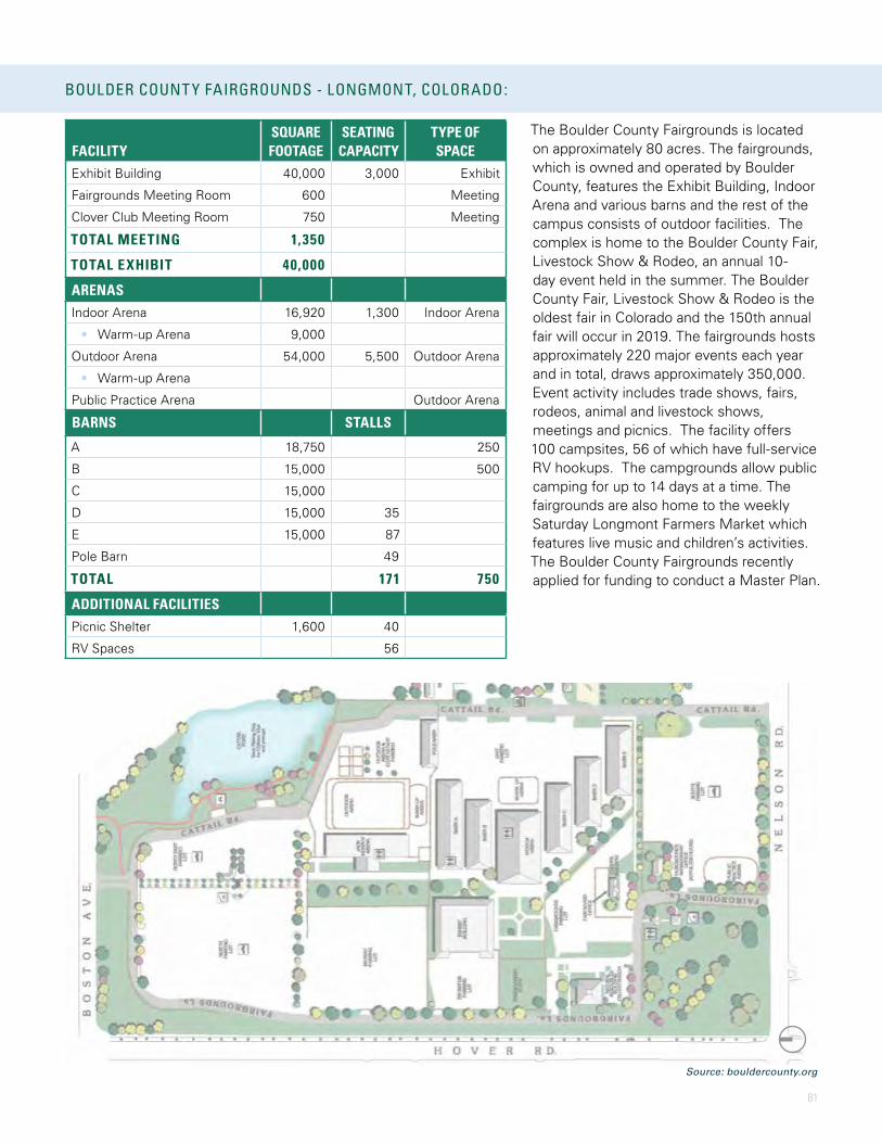
81
JEFFERSON COUNT Y FAIRGROUNDS - GOLDEN, COLORADO:
The Boulder County Fairgrounds is located on approximately 80 acres. The fairgrounds, which is owned and operated by Boulder County, features the Exhibit Building, Indoor Arena and various barns and the rest of the campus consists of outdoor facilities. The complex is home to the Boulder County Fair, Livestock Show & Rodeo, an annual 10-day event held in the summer. The Boulder County Fair, Livestock Show & Rodeo is the oldest fair in Colorado and the 150th annual fair will occur in 2019. The fairgrounds hosts approximately 220 major events each year and in total, draws approximately 350,000. Event activity includes trade shows, fairs, rodeos, animal and livestock shows, meetings and picnics. The facility offers 100 campsites, 56 of which have full-service RV hookups. The campgrounds allow public camping for up to 14 days at a time. The fairgrounds are also home to the weekly Saturday Longmont Farmers Market which features live music and children’s activities. The Boulder County Fairgrounds recently applied for funding to conduct a Master Plan.
BOULDER COUNT Y FAIRGROUNDS - LONGMONT, COLORADO:
FACILITYSQUARE FOOTAGE
SEATING CAPACITY
TYPE OF SPACE
Exhibit Building 40,000 3,000 Exhibit
Fairgrounds Meeting Room 600 Meeting
Clover Club Meeting Room 750 Meeting
TOTAL MEETING 1,350
TOTAL EXHIBIT 40,000
ARENASIndoor Arena 16,920 1,300 Indoor Arena
• Warm-up Arena 9,000
Outdoor Arena 54,000 5,500 Outdoor Arena
• Warm-up Arena
Public Practice Arena Outdoor Arena
BARNS STALLS
A 18,750 250
B 15,000 500
C 15,000
D 15,000 35
E 15,000 87
Pole Barn 49
TOTAL 171 750
ADDITIONAL FACILITIESPicnic Shelter 1,600 40
RV Spaces 56
Source: bouldercounty.org
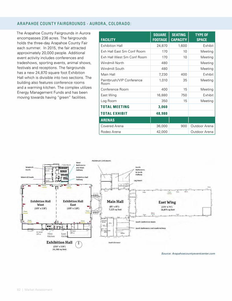
82 | Market Assessment
The Arapahoe County Fairgrounds in Aurora encompasses 236 acres. The fairgrounds holds the three-day Arapahoe County Fair each summer. In 2015, the fair attracted approximately 20,000 people. Additional event activity includes conferences and tradeshows, sporting events, animal shows, festivals and receptions. The fairgrounds has a new 24,870 square foot Exhibition Hall which is divisible into two sections. The building also features conference rooms and a warming kitchen. The complex utilizes Energy Management Funds and has been moving towards having “green” facilities.
ARAPAHOE COUNT Y FAIRGROUNDS - AURORA, COLORADO:
FACILITYSQUARE FOOTAGE
SEATING CAPACITY
TYPE OF SPACE
Exhibition Hall 24,870 1,600 Exhibit
Exh Hall East Sm Conf Room 170 10 Meeting
Exh Hall West Sm Conf Room 170 10 Meeting
Windmill North 480 Meeting
Windmill South 480 Meeting
Main Hall 7,230 400 Exhibit
Paintbrush/VIP Conference Room
1,010 35 Meeting
Conference Room 400 15 Meeting
East Wing 16,880 750 Exhibit
Log Room 350 15 Meeting
TOTAL MEETING 3,060
TOTAL EXHIBIT 48,980
ARENASCovered Arena 36,000 900 Outdoor Arena
Rodeo Arena 42,000 Outdoor Arena
THE RANCH - LOVEL AND, COLORADO:
Source: Arapahoecountyeventcenter.com

83
ARAPAHOE COUNT Y FAIRGROUNDS - AURORA, COLORADO:
Opened in 2003, The Ranch Events Complex encompasses approximately 240 acres. The complex is owned and operated by Larimer County, with the exception of the Budweiser Events Center which is managed by Spectra Venue Management. The Budweiser Events Center hosts the Colorado Eagles of the ECHL and the Colorado Crush of the Indoor Football League. The Ranch holds more than 2,000 events a year including the Larimer County Fair & Rodeo which is a five-day event that draws more than 90,000 attendees. Event activity at The Ranch includes meetings, conferences and tradeshows, equine shows, livestock events, 4-H and community activity, weddings, banquets and sporting events.
Larimer County is currently conducting a Master Plan to design the future outlay of the campus and plan for the next 20 years of operation.
THE RANCH - LOVEL AND, COLORADO:
FACILITYSQUARE FOOTAGE
SEATING CAPACITY
TYPE OF SPACE
First National Bank - Exhibit Space
36,000 800 Exhbit
First National Bank - Meeting Space
2,900 Meeting
• Kitchen
McKee Building - Exhibit Space 12,500 300 Exhibit
McKee Building - Meeting Space
5,950 Meeting
• Kitchen
TOTAL MEETING 8,850
TOTAL EXHIBIT 48,500
ARENASBudweiser Events Center 7,200 Commercial
Arena
Ranch-Way Feeds 45,000 1,000 Indoor Arena
• Warm-up Arena 9,000
Roundup Arena 28,800 100 Outdoor Arena
Longhorn Arena 28,800 100 Outdoor Arena
BARNS STALLS
Pavilion 1 48,000 180
Pavilion 2 48,000 180
TOTAL 360
Source: budweisereventscenter.com

84 | Market Assessment
Located in Castle Rock, the Douglas County Fairgrounds consists of approximately 45 acres and is owned and operated by Douglas County. The fairgrounds is home to the Douglas County Fair & Rodeo, a four-day event that drew more than 35,000 attendees in 2015. The Douglas County Fairgrounds & Events Center has more than 2,000 bookings a year including festivals, banquets, trade shows, concerts, sporting events and meetings as well as equine and other animal shows. The fairgrounds is currently planning multiple improvements including changes to kitchens, upgrading their security systems and adding permanent pens.
DOUGL AS COUNT Y FAIRGROUNDS AND EVENTS CENTER - CASTLE ROCK, COLORADO:
FACILITYSQUARE FOOTAGE
SEATING CAPACITY
TYPE OF SPACE
Events Center - Exhibit Hall 29,070 3,380 Exhibit
Events Center - Conference Rooms
3,300 220 Meeting
• Kitchen
Kirk Hall 4,800 280 Meeting
• Kitchen
CSU Extension Building Room 1 790 55 Meeting
CSU Extension Building Room 2 660 45 Meeting
TOTAL MEETING 9,550
TOTAL EXHIBIT 29,070
Witman - Lowell Pavilion 7,200 250 Show Pavilion
Multi-Purpose Barn 10,100 100 Multi-Purpose
ARENASIndoor Arena 31,860 2,010 Indoor Arena
• Warm-up Arena 15,000
Outdoor Arena 40,500 2,800 Outdoor Arena
• Warm-up Arena 15,000
BARNS STALLS
Large Animal Barn 150
Brown Horse Barn 64
Green Horse Barn 28
TOTAL 242
NATIONAL WESTERN STOCK SHOW COMPLEX - DENVER, COLORADO:
Source: xxx

85
DOUGL AS COUNT Y FAIRGROUNDS AND EVENTS CENTER - CASTLE ROCK, COLORADO: NATIONAL WESTERN STOCK SHOW COMPLEX - DENVER, COLORADO:
The National Western Stock Show Complex is in Denver and encompasses nearly 100 acres. The Western Stock Show Association currently owns and operates the Complex but is planning to transition ownership of the asset to the City and County of Denver. The Complex’s largest event is the National Western Stock Show & Rodeo. This 16-day event attracted more than 680,000 attendees in 2015 and is home to the nationally recognized Denver Stock Show. The Master Plan, which was released in 2014, recommended an eight-phase complex overhaul that could take up to 10 years to complete. One of the recommended new additions is a 10,000-seat arena with a 140’ X 260’ show ring that can host commercial and sporting events and locker rooms, restaurants, and premium seating. Additional recommended facilities include a 350,000 square-foot Exhibition Hall, a new Livestock Center and Stockyards, and an Equestrian Center which would feature two arenas and four warm-up arenas. The Master Plan also calls for a partnership with Colorado State University that would feature an Equine Sport Medicine Facility, Community Outreach Clinic, and Clinical Trials Center.
FACILITYSQUARE FOOTAGE
SEATING CAPACITY
TYPE OF SPACE
Expo Hall 34,730 Exhibit
Hall of Education - West 35,680 Exhibit
Hall of Education - East 59,350 Exhibit
Stadium Hall 33,530 Exhibit
Hall of the West 24,000 Exhibit
Coors Art Room 2,820 150 Meeting
Centennial Room 1,990 150 Meeting
NW Club 3,600 250 Meeting
TOTAL MEETING 8,410
TOTAL EXHIBIT 187,290
ARENASEvents Center 45,000 7,280 Indoor Arena
Stadium Arena 25,000 5,200 Indoor Arena
• Warm-up Arena
BARNS STALLS
TOTAL 800
Source: National Western Complex

86 | Market Assessment
SUMMARY OF MARKET FINDINGSThe purpose of the market assessment is to provide analysis and observations related to the existing facilities and opportunities for enhanced/new facilities as well as to assist in prioritizing future facility needs from a market perspective; not to provide a detailed, stand-alone evaluation for each project component under consideration as part of the master planning effort. For instance, while we obtained direct feedback from multiple stakeholders including representatives from Adams County, the fairgrounds and various users regarding the conditions of existing facilities to meet their future needs and programmatic requirements, we did not conduct a comprehensive survey of potential users of enhanced/new facilities. The remainder of this section summarizes the key findings related to the market assessment.
Several common factors appear to impact the success of similar facilities including, but not limited to, the following:
• Demographic/economic attributes
• Accessibility to/from the facility and overall ingress/egress throughout the site
• Focused short and long-term operating objectives of the facility
• Management team with experience and relationships with event producers in target market segments
• Strong recognizable brand identity
• Proactive and strategic marketing efforts from multiple partners
• Building program elements, amenities and supporting infrastructure that appropriately accommodate the desired target market(s) and provide a unique guest experience
• Providing a well-designed, safe, and flexible facility with the required equipment to efficiently accommodate simultaneous events
• Modern technology in support of event production and patron expectations such as WiFi access throughout facilities and/or the complex
• Inventory of, and proximity to, supporting amenities such as hotels, restaurants, retail and entertainment establishments
• Affordability/value of rental packages
• Type/amount of activity and related revenue streams
• Cost containment of operating expenses
• Ability to attract capital investment
COMPETITIVE MARKET ASSESSMENTIt is our understanding that the driving forces of any enhanced/new facilities at the fairgrounds include, but are not limited to: accommodating diverse, year-round event activity for residents and visitors; regaining lost events; retaining and growing existing events, particularly those that previously utilized the Indoor Arena that was demolished in March 2016; attracting incremental new events; supporting agricultural-related businesses; as well as generating operating revenue to help offset operating expenses.
Market factors that may influence the type and amount of event activity at any enhanced/new facilities at the fairgrounds include local demographic/economic attributes, accessibility, hotel supply and availability, the supply of competitive area facilities, broader industry trends as well as the existing base of business.
Because activity at the fairgrounds primarily consists of local events, attributes such as population and income statistics, are important factors when assessing potential demand for enhanced/new facilities. The strength of a market’s ability to attract events and attendees is partially attributable to its population base and demographic composition as well as its accessibility. In addition, a market’s infrastructure in terms of the supply, diversity, and proximity of hotels, restaurants and retail establishments also impacts its ability to attract non-local events and to capture visitor spending that generates economic and fiscal impacts.
The County has several favorable market attributes relative to attracting multiple,
87
diverse demand generators including a fast-growing, young, ethnically diverse population base with discretionary income to spend participating, attending and/or hosting events. The proximity of commercial air access from the Denver International Airport is a benefit for people who require fly-in service.
At a macro level, the County is accessible from multiple highways and interstates. However, vehicular accessibility to the fairgrounds site is currently a challenge which would be further exacerbated with enhanced/new facilities that would increase the amount of event activity. As such, addressing the current ingress and egress to the fairgrounds is an important aspect of the Master Plan.
Other market challenges including the relatively small employment base in the County and low unemployment rate may impact the ability to find affordable labor to support increased activity at enhanced/new facilities. The number of proximate hotels is a limiting factor for events that require overnight attendees. While the supply of RV spaces at the fairgrounds and at nearby parks is viewed as a positive for some events, other events require hotel accommodations for their attendees. Weather and existing floodplains on the site can be a detriment to both outdoor activities and sheltering for disasters.
The degree to which existing area facilities adequately meet current and anticipated future needs of a community is an important aspect to consider when evaluating the potential demand for enhanced/new facilities. From a supply perspective, the fairgrounds operates in a highly competitive environment and faces competition from multiple facilities throughout the Denver Metro Area and the State.
Several area facilities including the Island Grove Regional Park, the National Western Stock Show Complex, and The Ranch have completed or are in the process of evaluating the merits of renovating/expanding/modernizing existing assets and/or developing new facilities to better serve
their constituents and further enhance their market position.
The fairgrounds currently offers multiple facilities which allows it to host a diverse set of events and serve the local community. The location of the fairgrounds within the Adams County Regional Park Complex offers a unique setting to event producers and attendees. In addition, the site size allows for expansion.
In general, the age, condition, dated aesthetics and lack of modern amenities at some of the existing facilities at the fairgrounds limit their marketability to certain user groups. Other programmatic constraints include the layout/configuration and relatively limited amount of flexible space. Another disadvantage at the existing fairgrounds is the lack of connectivity between like facilities such as arenas and barns or meeting and banquet spaces. Facilities around the U.S. are being designed or renovated to provide a campus-style setting that features zones of similar event activity along with the appropriate supporting infrastructure.
The demolition of the Indoor Arena negatively impacted date and space availability for users as well as the amount and type of space that some groups are utilizing. Although fairgrounds staff has been able to relocate some of this activity to other facilities, a long-term solution is needed.
In addition, fairgrounds staff cited increased demand for the use of large open spaces for events such as truck auctions and sales. These events are currently utilizing the parking lots at the fairgrounds which impacts the number of available parking spaces for use at other events held at the Regional Park. Recently, Verizon ‘Oath’ was held on site, a large event that selected the site due to its vast open areas that could be used to transform the park into their ideal event campus.
Consistent with its mission, the primary event activity at the fairgrounds includes 4-H, food/social functions, and meetings/conferences as evidenced by historical event activity previously presented. These
88 | Market Assessment
market niches are consistent with the County’s Parks & Open Space Division’s mission “to enhance the quality of life for residents by providing recreational, educational, and cultural opportunities through our system of parks, trails, open spaces, and facilities; and to preserve and protect the natural and cultural resources of the County for present and future generations.”
Agriculture is important to the history of both Adams County and the State of Colorado. According to the United States Department of Agriculture (USDA), in 2015, net farm income totaled nearly $1.5 billion and cash receipts totaled nearly $7.4 billion. Colorado ranks in the top 10 states for production of various crops including barley, potatoes and wheat, as well as for livestock including cattle/calves and sheep/lambs. The State produced a record high 3.75 billion pounds of milk in 2015. In addition, there was a 6% increase in the inventory of cattle and calves in Adams County in 2016 over the prior year.
4-H plays a significant role in Colorado and involves more than 6.5 million youth throughout the Country and has 45 million alumni. Adams County 4-H reached more than 15,000 youth in 2016 and has approximately 500 members between the ages of 5 and 18, which ranks 4th among counties in Colorado. A large portion of the agricultural-related event activity at the fairgrounds is through 4-H and CSU Extension programs. This event activity serves specific community needs and plays an important role in the development of local youth. The County features 23 4-H clubs and offered approximately 130 workshops in 2016. Adams County 4-H offers more than 60 different 4-H projects that are divided into more than 225 divisions. The most popular projects in County are shooting sports, small animals and horse related activities. Additional activity includes agriculture, livestock, food production, crafts, wood working, photography, robotics, and rocketry, among others.
The fairgrounds hosts a number of agricultural-related activities including 4-H, various clinics, livestock sales and shows, as well as dog events. It will be important for the fairgrounds to continue to provide facilities and resources to service this significant industry.
RECOMMENDED PHYSICAL IMPROVEMENTSAny enhanced/new facilities should fulfill the community’s needs, capitalize on market niche opportunities and related programming, complement existing assets, and accommodate multiple demand segments. In addition, future physical improvements should address existing constraints/deficiencies and incorporate modern building and patron amenities.
Market research indicates that demand exists for both new construction and enhancements to existing facilities currently located at the fairgrounds. From a market perspective, the highest priority is for a new multi-purpose, climate-controlled arena with a modest number of fixed seats that is flexible enough to be used for multiple event types. This facility should be constructed and operated in a manner that allows it to be affordable to users.
The next priority for development should focus on replacement of or renovating/ repurposing/expanding/modernizing existing assets including the Exhibit Hall, Al Lesser Building, and the Waymire Dome as well as constructing new multi-purpose expo space to better accommodate meeting/banquet business.
Based on the research conducted for this assessment, the following outlines market-driven programmatic improvements.
A combination of renovation, expansion, and relocation of existing assets and construction of new facilities would allow the fairgrounds to better meet its mission of serving the community by increasing and broadening programming opportunities and further diversifying the user base. Developing a critical amount of flexible, multi-purpose space under one roof in conjunction with creating a campus-style setting will yield more synergies among assets and be consistent with industry trends and users’ expectations. Strategically planning for large, open-space areas, either grass or paved, would increase the fairgrounds’ ability to host additional outdoor event activity that produces revenue.
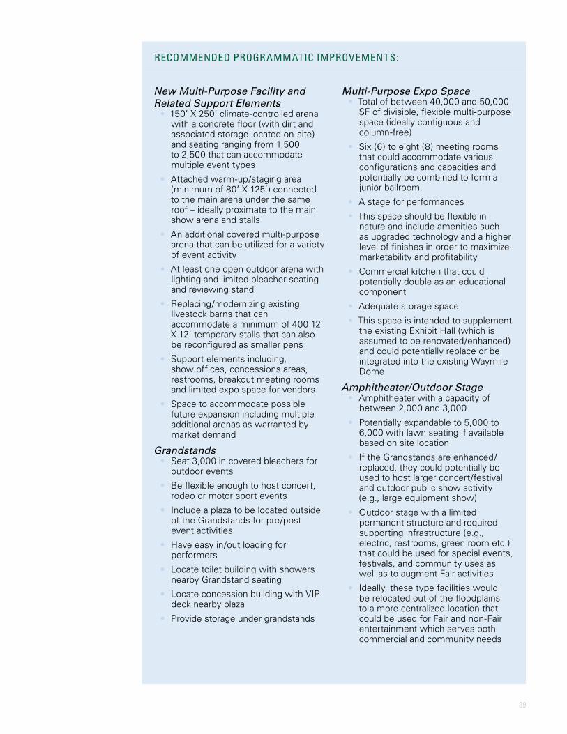
89
New Multi-Purpose Facility and Related Support Elements
• 150’ X 250’ climate-controlled arena with a concrete floor (with dirt and associated storage located on-site) and seating ranging from 1,500 to 2,500 that can accommodate multiple event types
• Attached warm-up/staging area (minimum of 80’ X 125’) connected to the main arena under the same roof – ideally proximate to the main show arena and stalls
• An additional covered multi-purpose arena that can be utilized for a variety of event activity
• At least one open outdoor arena with lighting and limited bleacher seating and reviewing stand
• Replacing/modernizing existing livestock barns that can accommodate a minimum of 400 12’ X 12’ temporary stalls that can also be reconfigured as smaller pens
• Support elements including, show offices, concessions areas, restrooms, breakout meeting rooms and limited expo space for vendors
• Space to accommodate possible future expansion including multiple additional arenas as warranted by market demand
Grandstands• Seat 3,000 in covered bleachers for
outdoor events
• Be flexible enough to host concert, rodeo or motor sport events
• Include a plaza to be located outside of the Grandstands for pre/post event activities
• Have easy in/out loading for performers
• Locate toilet building with showers nearby Grandstand seating
• Locate concession building with VIP deck nearby plaza
• Provide storage under grandstands
Multi-Purpose Expo Space • Total of between 40,000 and 50,000
SF of divisible, flexible multi-purpose space (ideally contiguous and column-free)
• Six (6) to eight (8) meeting rooms that could accommodate various configurations and capacities and potentially be combined to form a junior ballroom.
• A stage for performances
• This space should be flexible in nature and include amenities such as upgraded technology and a higher level of finishes in order to maximize marketability and profitability
• Commercial kitchen that could potentially double as an educational component
• Adequate storage space
• This space is intended to supplement the existing Exhibit Hall (which is assumed to be renovated/enhanced) and could potentially replace or be integrated into the existing Waymire Dome
Amphitheater/Outdoor Stage• Amphitheater with a capacity of
between 2,000 and 3,000
• Potentially expandable to 5,000 to 6,000 with lawn seating if available based on site location
• If the Grandstands are enhanced/replaced, they could potentially be used to host larger concert/festival and outdoor public show activity (e.g., large equipment show)
• Outdoor stage with a limited permanent structure and required supporting infrastructure (e.g., electric, restrooms, green room etc.) that could be used for special events, festivals, and community uses as well as to augment Fair activities
• Ideally, these type facilities would be relocated out of the floodplains to a more centralized location that could be used for Fair and non-Fair entertainment which serves both commercial and community needs
RECOMMENDED PROGRAMMATIC IMPROVEMENTS:
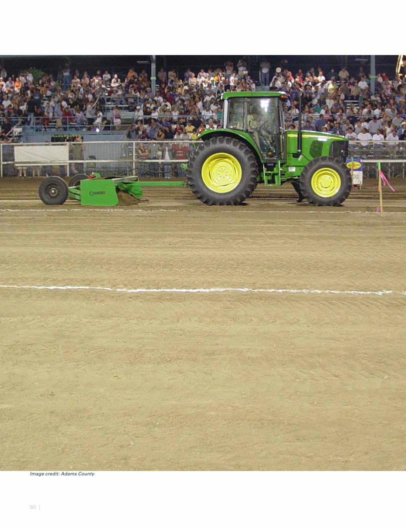
90 |
Image credit: Adams County
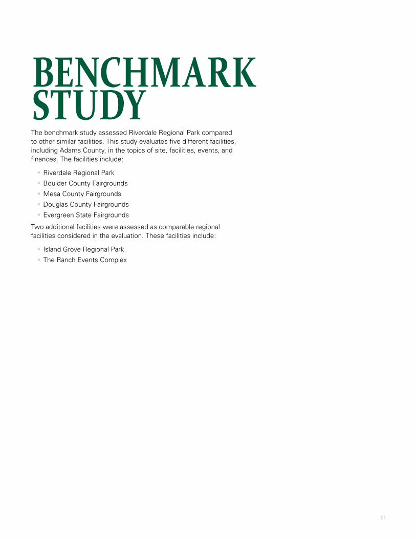
91
The benchmark study assessed Riverdale Regional Park compared to other similar facilities. This study evaluates five different facilities, including Adams County, in the topics of site, facilities, events, and finances. The facilities include:
• Riverdale Regional Park
• Boulder County Fairgrounds
• Mesa County Fairgrounds
• Douglas County Fairgrounds
• Evergreen State Fairgrounds
Two additional facilities were assessed as comparable regional facilities considered in the evaluation. These facilities include:
• Island Grove Regional Park
• The Ranch Events Complex
BENCHMARK STUDY
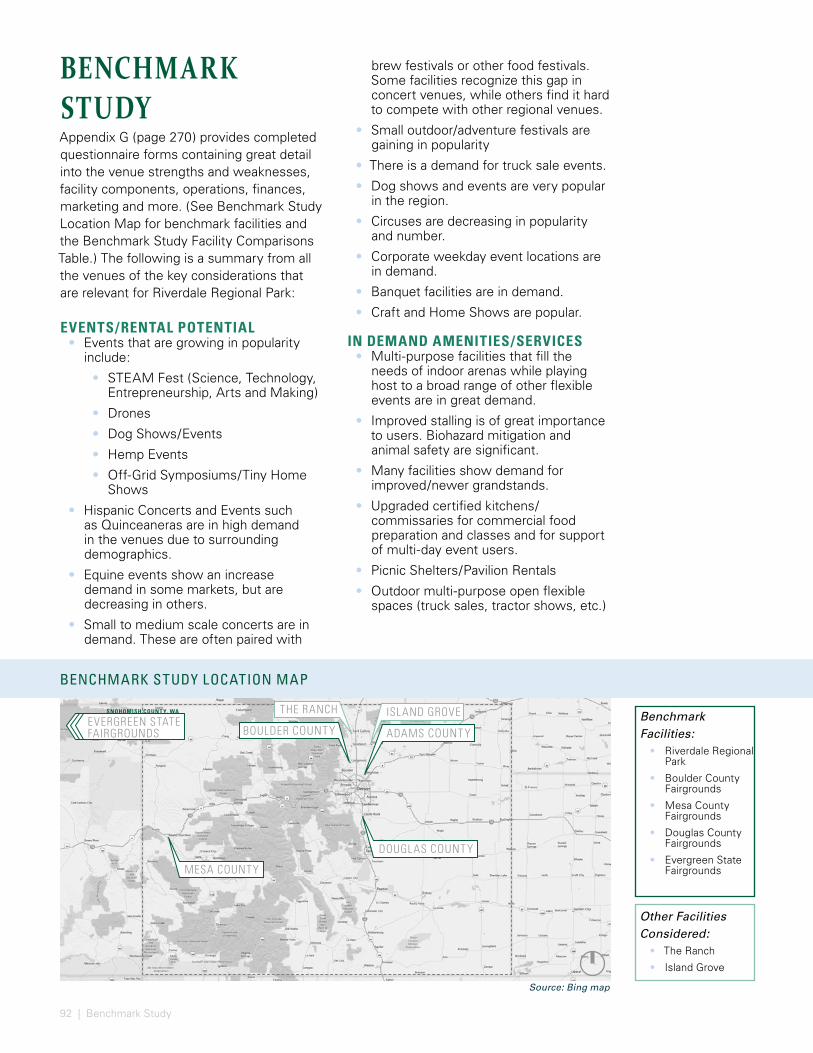
92 | Benchmark Study
BENCHMARK STUDY LOCATION MAP
ISLAND GROVE
ADAMS COUNTY
MESA COUNTY
EVERGREEN STATE FAIRGROUNDS
SNOHOMISH COUNT Y, WA
DOUGLAS COUNTY
THE RANCH
BOULDER COUNTYBenchmark Facilities:
• Riverdale Regional Park
• Boulder County Fairgrounds
• Mesa County Fairgrounds
• Douglas County Fairgrounds
• Evergreen State Fairgrounds
Other Facilities Considered:
• The Ranch
• Island Grove
Source: Bing map
BENCHMARK STUDYAppendix G (page 270) provides completed questionnaire forms containing great detail into the venue strengths and weaknesses, facility components, operations, finances, marketing and more. (See Benchmark Study Location Map for benchmark facilities and the Benchmark Study Facility Comparisons Table.) The following is a summary from all the venues of the key considerations that are relevant for Riverdale Regional Park:
EVENTS/RENTAL POTENTIAL• Events that are growing in popularity
include:
• STEAM Fest (Science, Technology, Entrepreneurship, Arts and Making)
• Drones
• Dog Shows/Events
• Hemp Events
• Off-Grid Symposiums/Tiny Home Shows
• Hispanic Concerts and Events such as Quinceaneras are in high demand in the venues due to surrounding demographics.
• Equine events show an increase demand in some markets, but are decreasing in others.
• Small to medium scale concerts are in demand. These are often paired with
brew festivals or other food festivals. Some facilities recognize this gap in concert venues, while others find it hard to compete with other regional venues.
• Small outdoor/adventure festivals are gaining in popularity
• There is a demand for truck sale events.
• Dog shows and events are very popular in the region.
• Circuses are decreasing in popularity and number.
• Corporate weekday event locations are in demand.
• Banquet facilities are in demand.
• Craft and Home Shows are popular.
IN DEMAND AMENITIES/SERVICES• Multi-purpose facilities that fill the
needs of indoor arenas while playing host to a broad range of other flexible events are in great demand.
• Improved stalling is of great importance to users. Biohazard mitigation and animal safety are significant.
• Many facilities show demand for improved/newer grandstands.
• Upgraded certified kitchens/commissaries for commercial food preparation and classes and for support of multi-day event users.
• Picnic Shelters/Pavilion Rentals
• Outdoor multi-purpose open flexible spaces (truck sales, tractor shows, etc.)
BENCHMARK STUDY FACILIT Y COMPARISONS TABLE
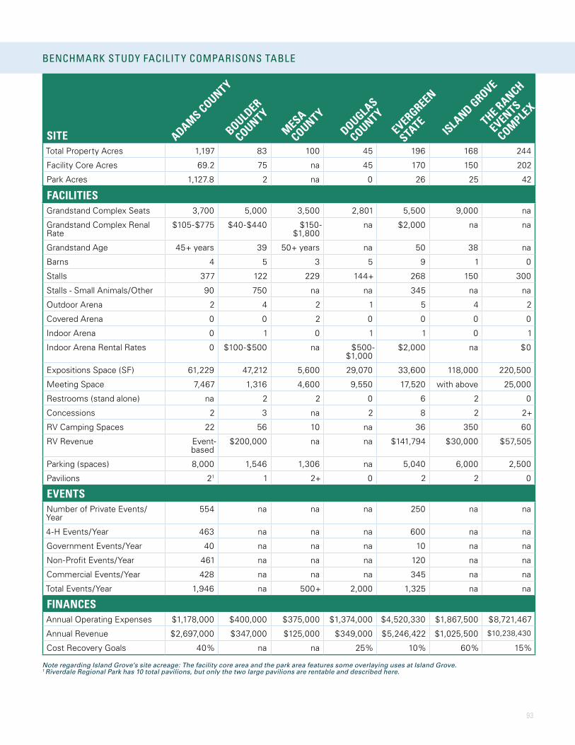
93
BENCHMARK STUDY LOCATION MAP
SITETotal Property Acres 1,197 83 100 45 196 168 244
Facility Core Acres 69.2 75 na 45 170 150 202
Park Acres 1,127.8 2 na 0 26 25 42
FACILITIESGrandstand Complex Seats 3,700 5,000 3,500 2,801 5,500 9,000 na
Grandstand Complex Renal Rate
$105-$775 $40-$440 $150-$1,800
na $2,000 na na
Grandstand Age 45+ years 39 50+ years na 50 38 na
Barns 4 5 3 5 9 1 0
Stalls 377 122 229 144+ 268 150 300
Stalls - Small Animals/Other 90 750 na na 345 na na
Outdoor Arena 2 4 2 1 5 4 2
Covered Arena 0 0 2 0 0 0 0
Indoor Arena 0 1 0 1 1 0 1
Indoor Arena Rental Rates 0 $100-$500 na $500-$1,000
$2,000 na $0
Expositions Space (SF) 61,229 47,212 5,600 29,070 33,600 118,000 220,500
Meeting Space 7,467 1,316 4,600 9,550 17,520 with above 25,000
Restrooms (stand alone) na 2 2 0 6 2 0
Concessions 2 3 na 2 8 2 2+
RV Camping Spaces 22 56 10 na 36 350 60
RV Revenue Event-based
$200,000 na na $141,794 $30,000 $57,505
Parking (spaces) 8,000 1,546 1,306 na 5,040 6,000 2,500
Pavilions 21 1 2+ 0 2 2 0
EVENTSNumber of Private Events/Year
554 na na na 250 na na
4-H Events/Year 463 na na na 600 na na
Government Events/Year 40 na na na 10 na na
Non-Profit Events/Year 461 na na na 120 na na
Commercial Events/Year 428 na na na 345 na na
Total Events/Year 1,946 na 500+ 2,000 1,325 na na
FINANCESAnnual Operating Expenses $1,178,000 $400,000 $375,000 $1,374,000 $4,520,330 $1,867,500 $8,721,467
Annual Revenue $2,697,000 $347,000 $125,000 $349,000 $5,246,422 $1,025,500 $10,238,430
Cost Recovery Goals 40% na na 25% 10% 60% 15%
BENCHMARK STUDY FACILIT Y COMPARISONS TABLE
ADAMS COUNTY
BOULDER
COUNTY
MESA
COUNTY
DOUGLAS
COUNTYEVERGREEN
STATE
ISLAND GROVE
THE RANCH
EVENTS
COMPLEX
Note regarding Island Grove’s site acreage: The facility core area and the park area features some overlaying uses at Island Grove.1 Riverdale Regional Park has 10 total pavilions, but only the two large pavilions are rentable and described here.

94 | Benchmark Study
• The proximity of lodging and/or camping plays an important role in larger shows and bookings.
TRENDS IN FACILITIES• Multi-purpose facilities that address
many user groups and provide flexibility in event hosting.
• Facilities tend to be organized in a campus setting, and exhibitors and users desire covered proximity that prevents them from exposure to inclement weather. Other shows want to be indoors to limit the potential of poor weather at event times.
• There is a growing need and popularity in outdoor vendor spaces for food truck courts, etc.
• Zero Waste/Waste Stream Reduction: initiation of recycling, composting and animal waste reduction.
• Energy efficiency measures.
• BioHazard/Communicable Disease amongst animals is a big deal, and has an impact on types of events that will come to a given facility. Biosecurity planning is important.
• Electronic Ticketing provides a greater level of accuracy in understanding visitation numbers. It also helps in tracking who is visiting the website, etc. and the user demographics. After initiation of such a system, one facility discovered that its previously held thoughts on numbers was significantly inaccurate.
• Social media is having an impact on facilities and events, from marketing to visitation.
• Campground/RV Parking
• Boulder County Revenue from Camping = $192,000/year
• Evergreen State Revenue from Camping = $141,794/year; investing $700,000 in RV facilities to increase use for general recreation, travelers on U.S. Highway 2, and to promote winter skiing.
• Other activities offered
• Automobile Racetrack (Evergreen State)
• BMX Bike Park (Mesa County)
• Arboretum (Mesa County)
• Public Park (Adams County, Mesa County)
• Museums (Adams County, Evergreen State)
RENTAL POLICIES:• Many facilities prioritize historical events
(+ 2 years of activity). Some historical events have diminished in attendance and popularity, but maintain a low rate and take up space that cannot be leased to another group. This does not leave a great deal of availability for new events.
• Finding the right balance of for-profit versus nonprofit can be a challenge when addressing cost recovery goals. Most venues have different rates charged for commercial versus community events.
• County government agencies can often use the facilities for events and activities without charge.
FUNDING SOURCES:• Snohomish County code allows
Evergreen State Fairgrounds to operate as a semi-enterprise, where they keep the money they make. This allows the management to build business models and charge people for use according to the model.
• Foundations that fundraise
• Partnerships with for-profit entities
• County budgets - property tax/sales tax, facilities tax
• Grants - Great Outdoors Colorado, Open Space Tax (Fund) and other potential grants (SCFD, Gates Foundation, USDA, Land and Water Conservation Fund, etc.)
EVENTS THAT ARE TURNED AWAY AT SOME VENUES
• Steer Tailing
• Quinceaneras – alcohol issues, trash and overtime for staff
• Marijuana symposiums (legalities associated with)
• Gambling activities such as horse racing
• Circuses
• Rave Parties

95
ADAMS COUNT Y FACILITIES
BARN 1EXHIBIT
HALL
WAYMIRE DOME
PARK SHELTERS
AND OPEN LAWN
PLAYGROUND
HISTORICAL SOCIETY AND
MUSEUM
124TH AVE/ HENDERSON ROAD
PARK
BLV
D
KNOLLS GOLF COURSE
CLUBHOUSE
RIVERDALE DUNES GOLF
COURSE
KNOLLS RESERVOIR
MAINTENANCE AREAGRANDSTANDS
MANN-NYHOLT LAKE
MANN-NYHOLT LAKE
ADMINISTRATION BUILDING
GOOD LUCK 4-H BUILDING
AL LESSER BUILDING
RED CROSS BUILDING
BARN 3
BARN 2BARN 4
Source: Google Earth Image
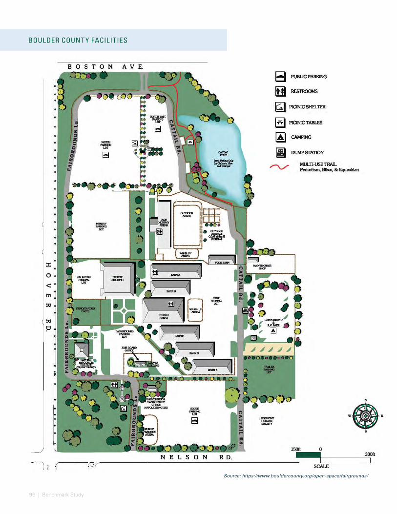
96 | Benchmark Study
BOULDER COUNT Y FACILITIES
Source: https://www.bouldercounty.org/open-space/fairgrounds/
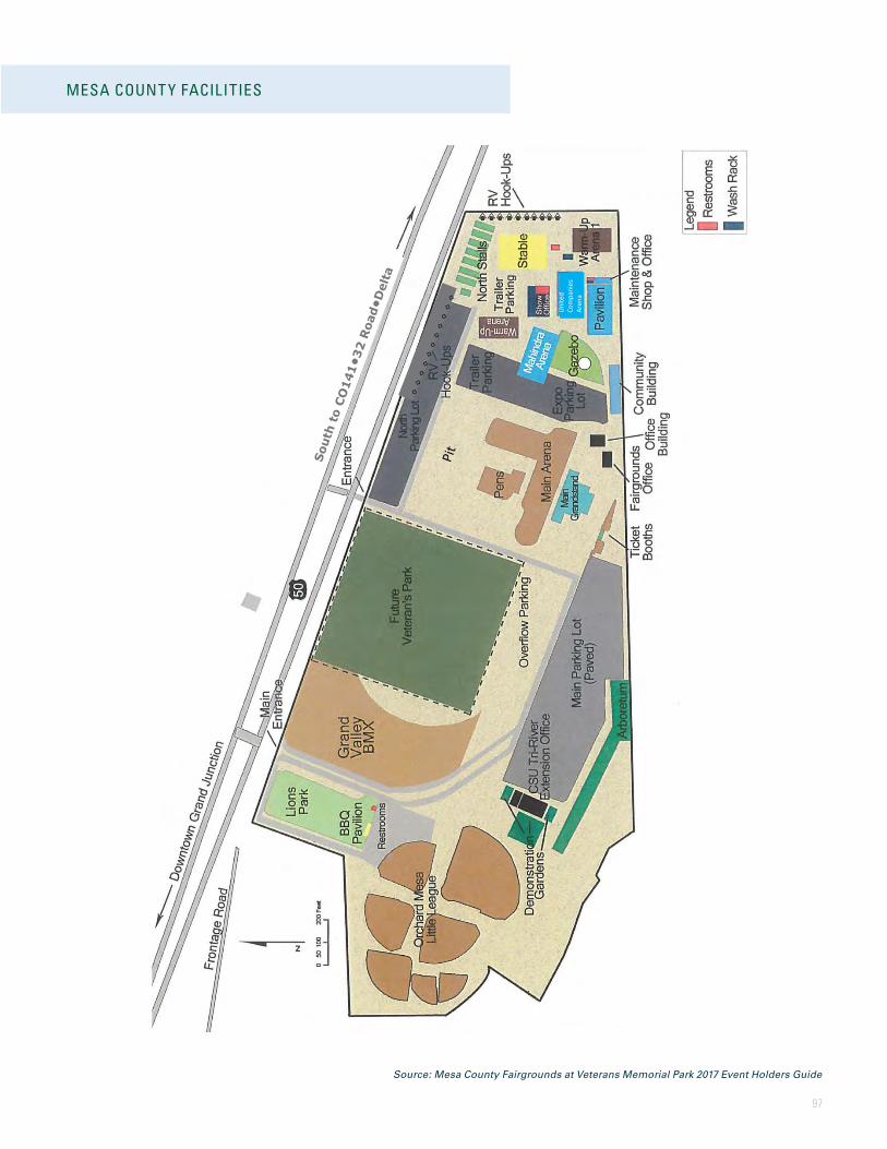
97
MESA COUNT Y FACILITIES
Source: Mesa County Fairgrounds at Veterans Memorial Park 2017 Event Holders Guide
7 of 46 as adopted by BoCC 2/27/17
Map of the Fairgrounds
Uni
ted
Com
pani
es
Aren
a
970-255-7107
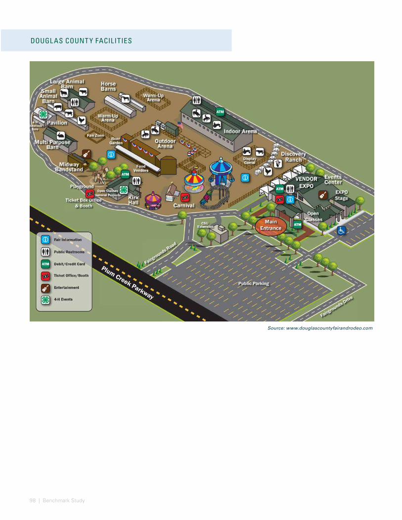
98 | Benchmark Study
Source: www.douglascountyfairandrodeo.com
DOUGL AS COUNT Y FACILITIES
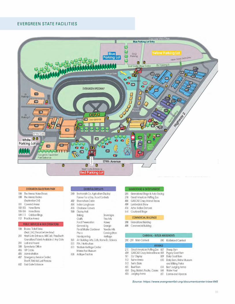
99
EVERGREEN STATE FACILITIES
Source: https://www.evergreenfair.org/documentcenter/view/645
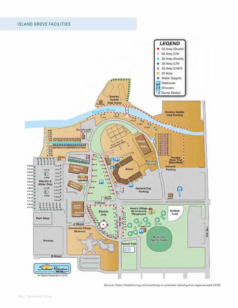
100 | Benchmark Study
ISL AND GROVE FACILITIES
Source: https://mobilerving.com/camping-in-colorado-island-grove-regional-park-23152

101
THE RANCH EVENTS COMPLEX FACILITIES
Source: http://treventscomplex.com/ourCampus.html
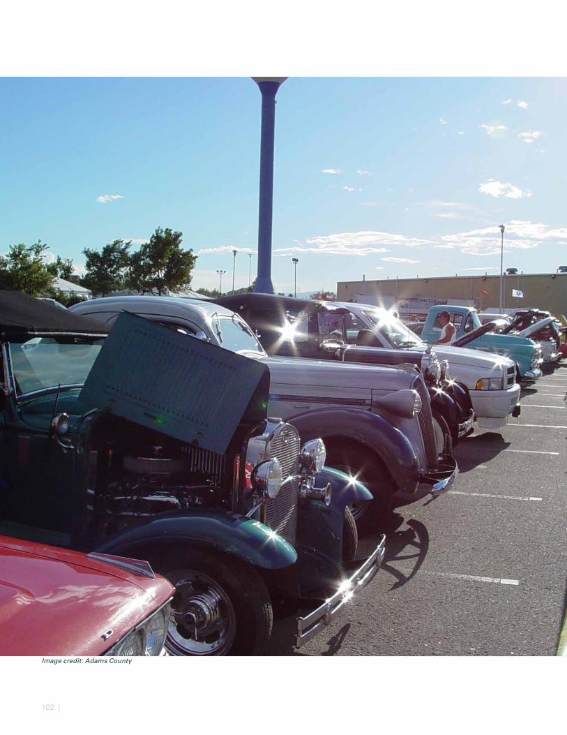
102 |
Image credit: Adams County
103
Primary objectives of the Master Plan include, but are not limited to, assessing the fairgrounds from a physical and operational perspective and providing a financial analysis of the recommended improvements. A complex’s physical state relative to its competitive supply has an impact on its marketability, resulting financial performance, and return on investment. This section summarizes the estimated impact to financial operations of the recommended Master Plan relative to a baseline. The capital improvement costs are discussed in the Phasing chapter of this document.
FINANCIAL ASSESSMENT
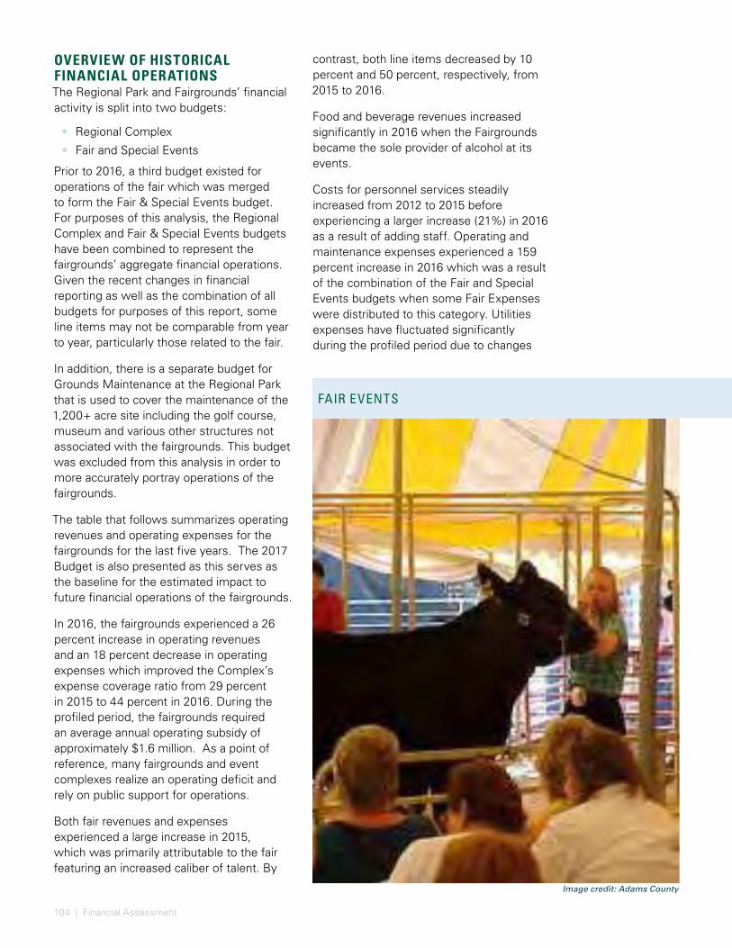
104 | Financial Assessment
RIVERDALE REGIONAL PARK - HISTORIC FINANCIALSOVERVIEW OF HISTORICAL FINANCIAL OPERATIONSThe Regional Park and Fairgrounds’ financial activity is split into two budgets:
• Regional Complex
• Fair and Special Events
Prior to 2016, a third budget existed for operations of the fair which was merged to form the Fair & Special Events budget. For purposes of this analysis, the Regional Complex and Fair & Special Events budgets have been combined to represent the fairgrounds’ aggregate financial operations. Given the recent changes in financial reporting as well as the combination of all budgets for purposes of this report, some line items may not be comparable from year to year, particularly those related to the fair.
In addition, there is a separate budget for Grounds Maintenance at the Regional Park that is used to cover the maintenance of the 1,200+ acre site including the golf course, museum and various other structures not associated with the fairgrounds. This budget was excluded from this analysis in order to more accurately portray operations of the fairgrounds.
The table that follows summarizes operating revenues and operating expenses for the fairgrounds for the last five years. The 2017 Budget is also presented as this serves as the baseline for the estimated impact to future financial operations of the fairgrounds.
In 2016, the fairgrounds experienced a 26 percent increase in operating revenues and an 18 percent decrease in operating expenses which improved the Complex’s expense coverage ratio from 29 percent in 2015 to 44 percent in 2016. During the profiled period, the fairgrounds required an average annual operating subsidy of approximately $1.6 million. As a point of reference, many fairgrounds and event complexes realize an operating deficit and rely on public support for operations.
Both fair revenues and expenses experienced a large increase in 2015, which was primarily attributable to the fair featuring an increased caliber of talent. By
contrast, both line items decreased by 10 percent and 50 percent, respectively, from 2015 to 2016.
Food and beverage revenues increased significantly in 2016 when the Fairgrounds became the sole provider of alcohol at its events.
Costs for personnel services steadily increased from 2012 to 2015 before experiencing a larger increase (21%) in 2016 as a result of adding staff. Operating and maintenance expenses experienced a 159 percent increase in 2016 which was a result of the combination of the Fair and Special Events budgets when some Fair Expenses were distributed to this category. Utilities expenses have fluctuated significantly during the profiled period due to changes
FAIR EVENTS
Image credit: Adams County
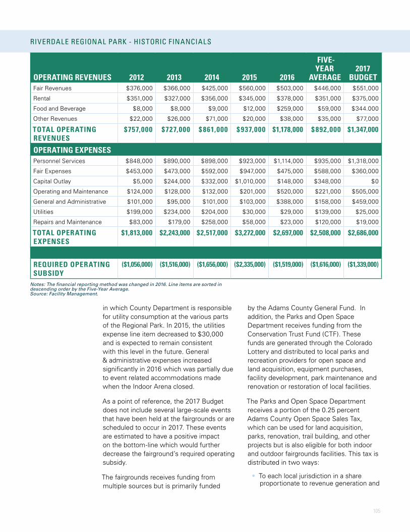
105
in which County Department is responsible for utility consumption at the various parts of the Regional Park. In 2015, the utilities expense line item decreased to $30,000 and is expected to remain consistent with this level in the future. General & administrative expenses increased significantly in 2016 which was partially due to event related accommodations made when the Indoor Arena closed.
As a point of reference, the 2017 Budget does not include several large-scale events that have been held at the fairgrounds or are scheduled to occur in 2017. These events are estimated to have a positive impact on the bottom-line which would further decrease the fairground’s required operating subsidy.
The fairgrounds receives funding from multiple sources but is primarily funded
by the Adams County General Fund. In addition, the Parks and Open Space Department receives funding from the Conservation Trust Fund (CTF). These funds are generated through the Colorado Lottery and distributed to local parks and recreation providers for open space and land acquisition, equipment purchases, facility development, park maintenance and renovation or restoration of local facilities.
The Parks and Open Space Department receives a portion of the 0.25 percent Adams County Open Space Sales Tax, which can be used for land acquisition, parks, renovation, trail building, and other projects but is also eligible for both indoor and outdoor fairgrounds facilities. This tax is distributed in two ways:
• To each local jurisdiction in a share proportionate to revenue generation and
OPERATING REVENUES 2012 2013 2014 2015 2016
FIVE-YEAR
AVERAGE2017
BUDGETFair Revenues $376,000 $366,000 $425,000 $560,000 $503,000 $446,000 $551,000
Rental $351,000 $327,000 $356,000 $345,000 $378,000 $351,000 $375,000
Food and Beverage $8,000 $8,000 $9,000 $12,000 $259,000 $59,000 $344.000
Other Revenues $22,000 $26,000 $71,000 $20,000 $38,000 $35,000 $77,000
TOTAL OPERATING REVENUES
$757,000 $727,000 $ 861,000 $ 937,000 $1,178,000 $ 892,000 $1,347,000
OPERATING EXPENSESPersonnel Services $848,000 $890,000 $898,000 $923,000 $1,114,000 $935,000 $1,318,000
Fair Expenses $453,000 $473,000 $592,000 $947,000 $475,000 $588,000 $360,000
Capital Outlay $5,000 $244,000 $332,000 $1,010,000 $148,000 $348,000 $0
Operating and Maintenance $124,000 $128,000 $132,000 $201,000 $520,000 $221,000 $505,000
General and Administrative $101,000 $95,000 $101,000 $103,000 $388,000 $158,000 $459,000
Utilities $199,000 $234,000 $204,000 $30,000 $29,000 $139,000 $25,000
Repairs and Maintenance $83,000 $179,00 $258,000 $58,000 $23,000 $120,000 $19,000
TOTAL OPERATING EXPENSES
$1,813,000 $2,243,000 $2,517,000 $3,272,000 $2,697,000 $2,508,000 $2,686,000
REQUIRED OPERATING SUBSIDY
($1,056,000) ($1,516,000) ($1,656,000) ($2,335,000) ($1,519,000) ($1,616,000) ($1,339,000)
RIVERDALE REGIONAL PARK - HISTORIC FINANCIALS
Notes: The financial reporting method was changed in 2016. Line items are sorted in descending order by the Five-Year Average.Source: Facility Management.
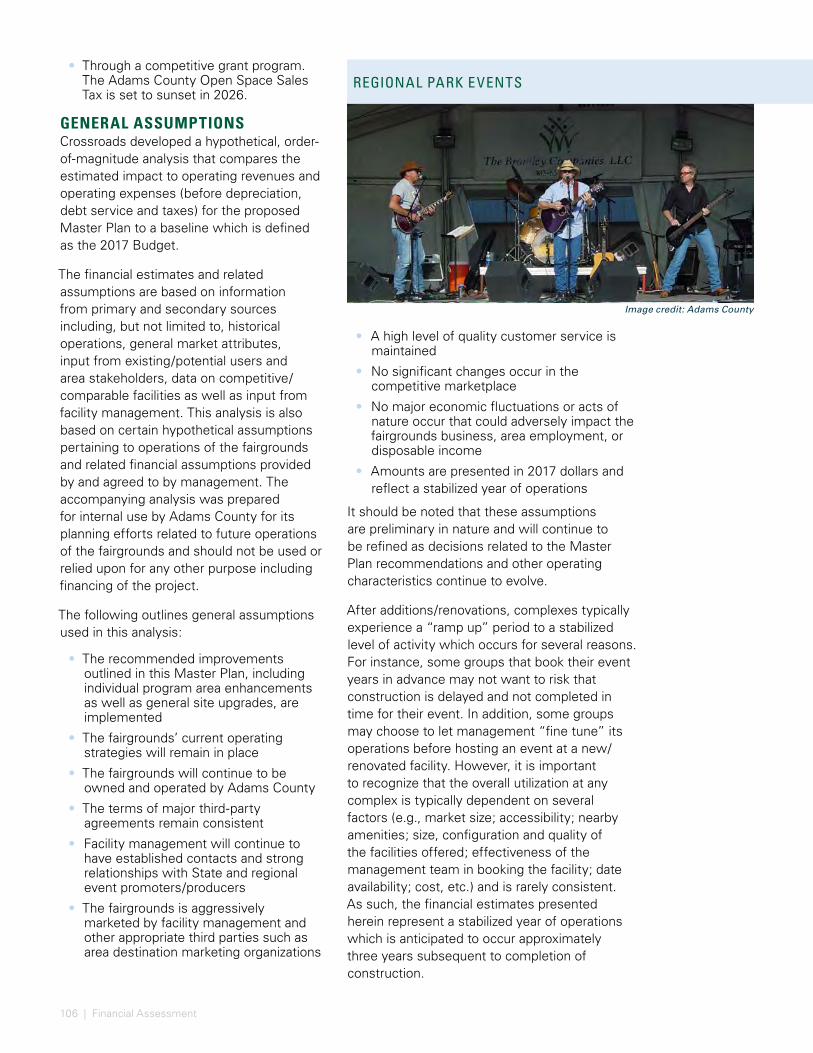
106 | Financial Assessment
FINANCIAL ESTIMATES FOR RECOMMENDED MASTER PL AN
• Through a competitive grant program. The Adams County Open Space Sales Tax is set to sunset in 2026.
GENERAL ASSUMPTIONS Crossroads developed a hypothetical, order-of-magnitude analysis that compares the estimated impact to operating revenues and operating expenses (before depreciation, debt service and taxes) for the proposed Master Plan to a baseline which is defined as the 2017 Budget.
The financial estimates and related assumptions are based on information from primary and secondary sources including, but not limited to, historical operations, general market attributes, input from existing/potential users and area stakeholders, data on competitive/comparable facilities as well as input from facility management. This analysis is also based on certain hypothetical assumptions pertaining to operations of the fairgrounds and related financial assumptions provided by and agreed to by management. The accompanying analysis was prepared for internal use by Adams County for its planning efforts related to future operations of the fairgrounds and should not be used or relied upon for any other purpose including financing of the project.
The following outlines general assumptions used in this analysis:
• The recommended improvements outlined in this Master Plan, including individual program area enhancements as well as general site upgrades, are implemented
• The fairgrounds’ current operating strategies will remain in place
• The fairgrounds will continue to be owned and operated by Adams County
• The terms of major third-party agreements remain consistent
• Facility management will continue to have established contacts and strong relationships with State and regional event promoters/producers
• The fairgrounds is aggressively marketed by facility management and other appropriate third parties such as area destination marketing organizations
• A high level of quality customer service is maintained
• No significant changes occur in the competitive marketplace
• No major economic fluctuations or acts of nature occur that could adversely impact the fairgrounds business, area employment, or disposable income
• Amounts are presented in 2017 dollars and reflect a stabilized year of operations
It should be noted that these assumptions are preliminary in nature and will continue to be refined as decisions related to the Master Plan recommendations and other operating characteristics continue to evolve.
After additions/renovations, complexes typically experience a “ramp up” period to a stabilized level of activity which occurs for several reasons. For instance, some groups that book their event years in advance may not want to risk that construction is delayed and not completed in time for their event. In addition, some groups may choose to let management “fine tune” its operations before hosting an event at a new/renovated facility. However, it is important to recognize that the overall utilization at any complex is typically dependent on several factors (e.g., market size; accessibility; nearby amenities; size, configuration and quality of the facilities offered; effectiveness of the management team in booking the facility; date availability; cost, etc.) and is rarely consistent. As such, the financial estimates presented herein represent a stabilized year of operations which is anticipated to occur approximately three years subsequent to completion of construction.
REGIONAL PARK EVENTS
Image credit: Adams County
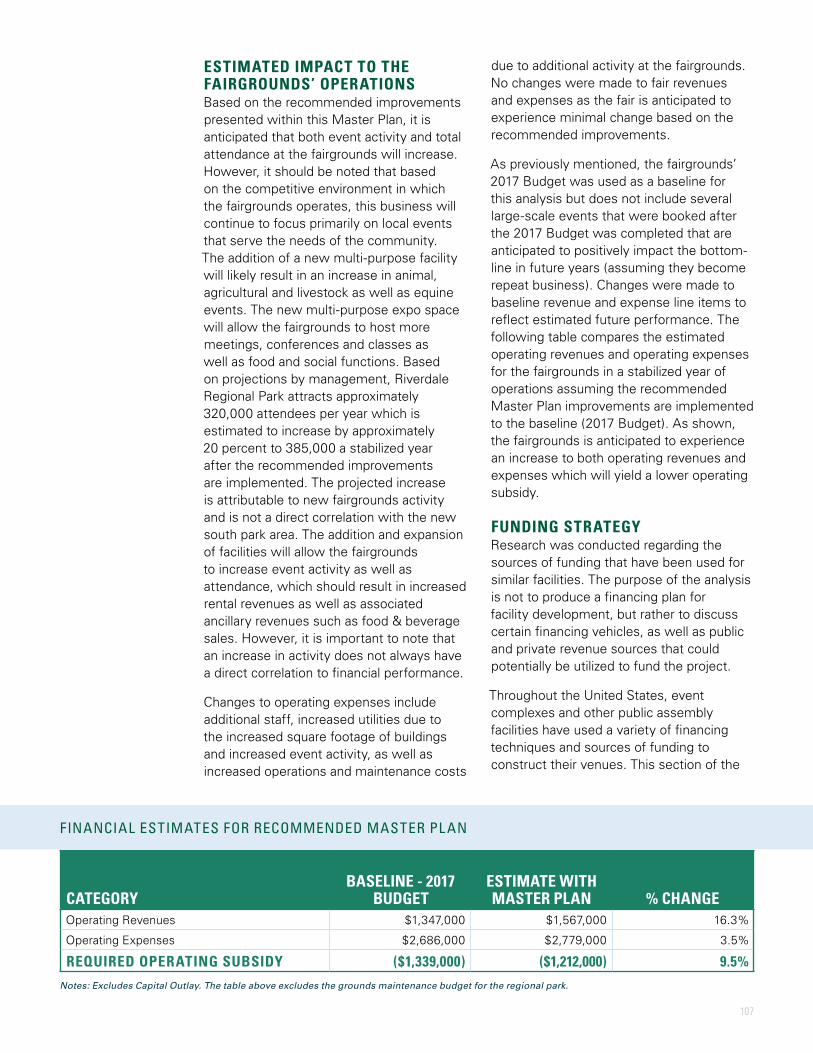
107
ESTIMATED IMPACT TO THE FAIRGROUNDS’ OPERATIONSBased on the recommended improvements presented within this Master Plan, it is anticipated that both event activity and total attendance at the fairgrounds will increase. However, it should be noted that based on the competitive environment in which the fairgrounds operates, this business will continue to focus primarily on local events that serve the needs of the community. The addition of a new multi-purpose facility will likely result in an increase in animal, agricultural and livestock as well as equine events. The new multi-purpose expo space will allow the fairgrounds to host more meetings, conferences and classes as well as food and social functions. Based on projections by management, Riverdale Regional Park attracts approximately 320,000 attendees per year which is estimated to increase by approximately 20 percent to 385,000 a stabilized year after the recommended improvements are implemented. The projected increase is attributable to new fairgrounds activity and is not a direct correlation with the new south park area. The addition and expansion of facilities will allow the fairgrounds to increase event activity as well as attendance, which should result in increased rental revenues as well as associated ancillary revenues such as food & beverage sales. However, it is important to note that an increase in activity does not always have a direct correlation to financial performance.
Changes to operating expenses include additional staff, increased utilities due to the increased square footage of buildings and increased event activity, as well as increased operations and maintenance costs
due to additional activity at the fairgrounds. No changes were made to fair revenues and expenses as the fair is anticipated to experience minimal change based on the recommended improvements.
As previously mentioned, the fairgrounds’ 2017 Budget was used as a baseline for this analysis but does not include several large-scale events that were booked after the 2017 Budget was completed that are anticipated to positively impact the bottom-line in future years (assuming they become repeat business). Changes were made to baseline revenue and expense line items to reflect estimated future performance. The following table compares the estimated operating revenues and operating expenses for the fairgrounds in a stabilized year of operations assuming the recommended Master Plan improvements are implemented to the baseline (2017 Budget). As shown, the fairgrounds is anticipated to experience an increase to both operating revenues and expenses which will yield a lower operating subsidy.
FUNDING STRATEGYResearch was conducted regarding the sources of funding that have been used for similar facilities. The purpose of the analysis is not to produce a financing plan for facility development, but rather to discuss certain financing vehicles, as well as public and private revenue sources that could potentially be utilized to fund the project.
Throughout the United States, event complexes and other public assembly facilities have used a variety of financing techniques and sources of funding to construct their venues. This section of the
CATEGORYBASELINE - 2017
BUDGETESTIMATE WITH MASTER PLAN % CHANGE
Operating Revenues $1,347,000 $1,567,000 16.3%
Operating Expenses $2,686,000 $2,779,000 3.5%
REQUIRED OPERATING SUBSIDY ($1,339,000) ($1,212,000) 9.5%
FINANCIAL ESTIMATES FOR RECOMMENDED MASTER PL AN
Notes: Excludes Capital Outlay. The table above excludes the grounds maintenance budget for the regional park.
108 | Financial Assessment
report presents a description of traditional financing instruments and funding sources used to fund other similar facilities. Each of these financing options impact the owner differently, as each will have its own cost structure, tax implications and cash flow considerations. Although the various alternatives presented in this section represent the most commonly used forms of financing, not all of them may be appropriate for the County and the fairgrounds. Local and State laws, fiscal sources and debt issuance capacity of governmental entities for bonding purposes all influence the ability to use any one of these financing methods or funding sources.
Public assembly facilities have been traditionally financed with a variety of public and private funds. Recent projects have increasingly sought to capitalize on private funding to assist in the overall financing plan. However, in many instances, the primary source of underwriting for debt service on construction is still derived from public sources.
FINANCING INSTRUMENTS This section summarizes traditional financing instruments. These financing instruments may or may not be applicable to financing the proposed enhancements at the fairgrounds.
General Obligation BondsHistorically, many public assembly facilities have been financed by general obligation bonds issued by city, county or state governments. General obligation bonds are backed by a pledge of ad valorem taxes of the issuer. Since the tax base and taxing authority of the government are pledged to the repayment of the bonds, these bonds typically have the lowest interest of all forms of bond financing. Interest rates vary depending on the existing bond indebtedness and credit rating of the public-sector entity. One disadvantage of using general obligation bonds is that the overall bond capacity for the issuing municipality is reduced. General obligation bonds issued by a city, county or by some state governments have to be coordinated with other government financing plans and
typically require voter approval through a public referendum.
Revenue BondsRevenue bonds are special obligations secured by one or more defined revenue sources. Most public assembly revenue bonds are based on a pledge of a dedicated revenue source such as facility revenues, hotel occupancy tax, admission tax, food and beverage tax, sales and use tax or other special assessments. The use of special purpose tax levies represents a means by which capital costs may be linked with recurring benefits and is typically directed at those sectors of the local economy which directly benefit from the facility(s) such as hotel room night stays, ticket sales, food, and/or alcohol sales. One of the primary advantages of revenue bonds is that the issue need only pledge specific revenues and not the full faith and credit of the issuer. However, because of this, revenue bonds can require a higher interest rate than general obligation debt.
Tax Increment FundingTax increment or tax allocation bonds are secured by a pledge of net increases in property and/or sales and use tax resulting from the development of an area within a defined development district. The success of this type of financing is dependent upon a development district being established and a strong market driven development atmosphere that would provide a constant source of new privately owned and financed projects within the district. This technique can be particularly useful in addressing infrastructure improvements needed for the construction of facilities. Often these “tax increment financing districts” are created in
“blighted” areas.
Certificates of ParticipationAnother funding alternative is the use of Certificates of Participation (COPs). Unlike general obligation or revenue bonds, this financing method does not legally pledge government money to pay the annual debt service. Under this method, COP holders are repaid through an annual lease appropriation by the sponsoring government agency. Because this agency does not
109
legally commit taxpayers over a long-term, funds can be obtained without voter approval. Further, COPs are not subject to many other statutory requirements applicable to bonds, including interest rate limitations, election requirements, competitive sales requirements, semi-annual or fixed-rate interest payment requirements. Consequently, a government agency can react quickly to favorable financial market conditions and structure a deal in a timely manner. On the other hand, because no funds are legally pledged beyond annual appropriations, COPs typically have a higher cost of debt in comparison to traditional bond issuances. A COP holder’s primary recourse upon default is the value of the asset (i.e., the facilities).
FUNDING SOURCESFunding sources can usually be defined as one of two types: one-time and recurring. The most common one-time source of funding is a grant or cash contribution. However, most funding sources are recurring in nature and include, but are not limited to, the following:
• Surplus revenue or designated operating revenues
• Lodging tax
• Food and beverage tax
• Special taxes (e.g., admission or ticket tax)
• Community development tax
• Ad valorem tax
• Sales and use tax
• State and local appropriations
• Governmental grants
• Tax increment revenues
These represent common means of funding sources for construction of/projects at public assembly facilities. Traditionally, these sources are paid into a fund account or are in some way dedicated or committed to the retirement of annual debt incurred through a particular financing medium.
A portion of the sources outlined above represent fiscal sources under the control of local and/or state government. Most facilities developed by local and/or state
governments rely on fiscal sources such as sales tax, hotel occupancy tax, admissions tax, food and beverage tax, or various redevelopment rebates. Increasingly, local governments have been able to capitalize on special funding that may require approval at the state level (e.g., changes in taxes imposed, rebates for collections within local jurisdictions or amounts on existing taxes) to assist in their project. In some instances, this may require approval of the State Legislature.
POTENTIAL FUNDING SOURCES The following were identified as potential funding sources for the proposed improvements to the fairgrounds.
• Adams County Open Space Sales Tax Competitive Grant Program
• Bonds
• Capital Construction Fee
• Capital Facilities Sales Tax
• Conservation Trust Fund (CTF)
• Great Outdoors Colorado (GOCO)
• Public Land Dedication Fees
• Scientific and Cultural Facilities District (SCFD) Funds
• Stormwater Utility Fee
In addition to the funding sources identified above, management should actively pursue grant opportunities at all levels. Because the proposed improvements to the fairgrounds could support agriculture, land management, and community development, as well as make the complex more energy efficient, there are a variety of organizations that offer grants that could be used to help fund these projects. These may include the Gates Foundation, USDA, Land and Water Conservation Fund and more. In addition, funding for a portion of the construction costs and/or ongoing operating requirements could potentially be addressed by private donations/endowments.
Many other communities contemplating similar development projects have noted the importance of harnessing multiple partners, leveraging Federal/State monies and private capital to create a viable funding plan. As the long-term development and funding
110 | Financial Assessment
plan progresses, it will be important to consider both the advantages and potential restrictions of any funding partnerships. As the Master Plan continues to evolve, all potential funding sources should be evaluated and potentially pursued.
ECONOMIC AND FISCAL BENEFITSAlthough not estimated as part of this analysis, the fairgrounds’ operations also generate qualitative and quantitative benefits for the County including, but not limited to:
• Drawing visitors to the fairgrounds that support area businesses
• Providing program elements to accommodate agricultural related activities such as youth development, 4-H and animal shows
• Improving the overall quality of life to area residents
• Enhancing the region’s image as a destination by providing a variety of amenities to accommodate diverse audiences
• Adding to the overall vibrancy and livability of the community
• Increasing economic and fiscal impacts for the County
Quantitative economic and fiscal benefits that are generated from operations of the fairgrounds include direct spending, indirect/induced spending, employment, and personal earnings as well as increased tax revenues for the local municipalities, special districts, Adams County and the State. Direct spending consists of both spending from the operations of the fairgrounds as well as spending by attendees at area businesses on items such as lodging, restaurants, recreation, shopping and transportation.
Recommended Master Plan improvements are envisioned to place the fairgrounds in a stronger position to attract more events and, as a result, more overnight attendees. This event activity could include multi-day events such as festivals, conferences/tradeshows and agricultural/equine events. While difficult to quantify these potential benefits at this stage of the planning process, implementing the Master Plan recommendations could increase the economic impact associated with on-going operations of the fairgrounds over current levels. In addition, spending by these incremental overnight visitors on items such as hotel stays, restaurants, and shopping is often taxable and, as such, the County would benefit from increased tax revenues.
OVERALL SUMMARYThe proposed Master Plan improvements represent an opportunity to better position the fairgrounds for future operations. Developing the proposed improvements will place the fairgrounds in a better position to effectively compete in a changing environment as well as accommodate residential needs. Once all Master Plan improvements have been implemented, it is estimated that the fairgrounds would reduce its required operating subsidy by approximately 10% in a stabilized year. These improvements could be funded through multiple sources including local fees, taxes, funds and various grants. In addition to the impact on the facility’s financial operations, these improvements could increase economic and fiscal contributions to the local economy.