Active Transportation Plan - Red Lodge,...
62
Active Transportation Plan Adopted by City Council December 12, 2016 LANDSCAPE ARCHITECTURE / PLANNING / CIVIL ENGINEERING Peaks to Plains Design P C
Transcript of Active Transportation Plan - Red Lodge,...

Active Transportation Plan
Adopted by City CouncilDecember 12, 2016
L A N D S C A P E A R C H I T E C T U R E / P L A N N I N G / C I V I L E N G I N E E R I N G
Peaks to Plains DesignPC


Parks BoardDan Seifert, ChairmanBob Matter , Vice-ChairmanCorey ThompsonRue FreemanPaul OtsuKelly HeatonBill Foisy
Planning BoardSandy Conlee, PresidentAl Bloomer, Vice-PresidentPolly RichterWarene WallJeff DiBenedettoMartha BrownDave Stauffer
Mayor & City CouncilMichael, Schoenike, MayorMaryvette Labrie, PresidentMartha BrownCorey ThompsonGlory MahanBill Foisy Anna Drew
Active Transportation Steering CommitteeJean AtherlyKelly HeatonLaurie BarnardJohn ClaytonTim WeamerSherry WeamerTom KohleyMartha BrownJames Caniglia
Peaks to Plains Design, PCJolene Rieck, PLAGordon Lemmel, PLAJames W. Papez, PE
Alta Planning + DesignJoe Gilpin, Principal
Cover Photo Credit: Terri Hoyt
City of Red Lodge Active Transportation Plan
Peaks to Plains Design & Alta Planning + Design | December 2016
Plan Adopted by City Council: December 12, 2016City of Red Lodge
Planning & Zoning Division1 Platt Avenue South
P.O. Box 9Red Lodge, Montana 59068
Acknowledgments
Table of Contents
The Importance of Active TransportationVision StatementThe Active Transportation Plan Process1 | Background 32 | Public Outreach and Engagement 4
Recommendations1 | Wayfinding 52 | Policy Recommendations 1 03 | Infrastructure Plan (Highest Priorities) 1 54 | Programs 2 25 | Evaluation 2 8
Inventory & Analysis1 | Inventory 3 02 | Connectivity Analysis 3 6
Demographics1 | Age 3 82 | Households 3 83 | Commuting Characteristics 3 84 | Bed Tax Revenue 3 95 | Tourism Opportunities 3 96 |Community Health 3 9
Related Documents1 | City of Red Lodge Growth Policy (2015) 4 02 | City of Red Lodge Capital Improvement Plan (2015) 4 03 | City of Red Lodge Zoning Ordinance (2016) 4 04 | City of Red Lodge Comprehensive Parks Plan (2015) 4 05 | City of Red Lodge Comprehensive Trails Plan (2006) 4 06 | Carbon County Community Health Assessment Report and Implementation Plan (2013) 4 17 | Downtown Red Lodge Assessment & Action Plan (2006) 4 1
AppendicesAction Plan - Tabular Form 4 2Recommended Engineering Projects 4 4Funding Mechanisms 4 6Key Themes from the Public Engagement Process 5 1Beartooth Front Community Forum on Active Transportation 5 4Red Lodge Comprehensive Trails Plan: Proposed Trail System 5 5

City of Red Lodge Active Transportation Plan
Peaks to Plains Design & Alta Planning + Design | December 2016
Summary of ContentsThis Active Transportation Plan describes how the City of Red Lodge can best develop both new and upgraded facilities that make it easier for residents and visitors to get around by foot, bike and/or mobility-assistance apparatus.
Active transportation is sometimes called “non-motorized transportation.” All of the ways people get around without the use of a motorized vehicle are included in active transportation “modes.” This includes wheelchairs, skates and rollerblades, skis, baby carriages and strollers and more; however, the predominant modes are walking (inclusive of jogging and running) and bicycling.
This document begins with background explaining why active transportation is important to Red Lodge. Then, the plan presents the vision statement and is followed by an overview of the process and people involved in creating this plan.
The bulk of the plan discusses recommended initiatives beginning with the development of a wayfinding master plan that would help motorists, pedestrians, bicyclists and others identify points of interest. Wayfinding takes a prominent place in this plan because it has already been identified as a community priority in the City’s Growth Policy and recent Red Lodge branding process. Similarly, wayfinding is a good example of how to effectively integrate active transportation with other transportation modes.
The next section outlines policy recommendations that include possible changes to city code and ordinances. Policies regarding sidewalks, crosswalks and snow removal can affect how residents and visitors perceive their available transportation options. The highest priority infrastructure recommendations are then described, including: developing the Civic Center parking lot to serve as a more functional parking spot for visitors and residents; improving sidewalks and crossings; and the top priorities for continued trail development in the city.
Program recommendations reflect an integrated approach to active transportation without solely relying on the built environment to achieve the community’s goals. Community events, educational opportunities and maintenance programs can, should and already are being implemented by entities other than city government. This is an important leadership model that reflects a community culture that embraces active transportation. The final section of recommendations discuss ongoing monitoring and evaluation methods that can help city leaders and citizens to know if this plan is succeeding.
Lastly, the plan includes existing trails and sidewalks inventories that emphasize typical and desired routes and destinations. This information was used as the basis for prioritizing recommended improvements. Relevant demographic information was reviewed to gain perspective on community trends. Related city and county documents are summarized to assure that this plan supports previously adopted plans.
The appendices include a tabular action plan, a summary of all recommended infrastructure projects, a description of potential funding sources and key themes that emerged during the public engagement process.


City of Red Lodge Active Transportation Plan
December 2016 1
Many studies and reports have established the benefits of improving active transportation to public health and safety and to the local economy. Recent research on public health has demonstrated the importance of active transportation in keeping populations healthy. People who are active are less likely to develop obesity, diabetes and other serious health concerns associated with inactivity; basically, when people exercise more, they are healthier. While these are individual choices, they are influenced by the options available in the built environment.
Furthermore, economic development experts are increasingly realizing that the ability of communities to compete for workers and new businesses is dependent on creating great places for people to live, work and play. Investments in active transportation can be a boon to local economies by attracting new residents, new employers, more visitors, and more and higher-paying jobs while making people safer, healthier and cutting healthcare spending by governments, employers, and individuals.
In a tourism-based economy, such as Red Lodge’s, the economic development benefits of active transportation include the ability to attract visitors who desire these amenities. Walking is the nation’s most popular leisure activity, and bicycling is, nationally, an extremely popular sport - more popular than, for example, skiing or fishing. Therefore, offering tourists a wide range of transportation choices may attract them to Red Lodge and encourage them to stay longer.
Red Lodge has a history of active transportation, as this coal mining town was built before the advent of the automobile, and all the miners walked or bicycled to work. As Red Lodge has grown, it has effectively incorporated motorized transportation, but walking and bicycling have remained popular choices for some people for daily errands, social outings and commutes to work. This is evidenced by Red Lodge’s 18 percent walking commute mode share, which is four times the state and national average.
Facilities that allow for and encourage active transportation include: sidewalks, paths and trails, bike lanes, pedestrian overpasses and underpasses and more. These alternative facilities seek to complement existing motorized transportation facilities, such as streets and highways.
When people have transportation mode options, the whole community benefits from reduced congestion, increased social interaction and increased economic viability. Individually, integrated transportation networks allows individuals to choose the mode of travel that best suits the specific purpose of the trip. For example, if someone needs to go to the grocery store, they have more options when their choices include sidewalks, trails and roads.
Over the past decade, the Red Lodge Parks Board and community organizations, such as the Beartooth Recreational Trails Association (BRTA), have worked to implement the 2006 Trails Plan and the 2015 Parks Plan. These groups, along with the Chamber, healthcare professionals and a wide variety of community members, have united behind an Active Transportation Plan that can help Red Lodge attract more visitors and improve the health and well-being of its citizens.
The Importance of Active Transportation

City of Red Lodge Active Transportation Plan
2 Peaks to Plains Design & Alta Planning + Design
Vision Statement
“Red Lodge is a dynamic community with well-connected neighborhoods and an attractive core area where non-motorized travel is safe, accessible and encouraged for people of all ages and abilities. A community that promotes social interaction, sustainability and economic viability that evokes civic pride from residents and appreciation from visitors.”
This vision statement captures the essence of the desires of Red Lodge citizens as expressed through community forums, focus groups and other planning processes. It is the basis for which recommendations are made in this document, contributing to the greater good for all those who enjoy what Red Lodge, Montana has to offer.
City of Red Lodge Active Transportation Plan
December 2016 3
The Active Transportation Plan Process
The process of the 2015 Comprehensive Parks Plan displayed a strong desire from Red Lodge residents to expedite City goals of improved walkability and trail corridors. The Building Active Communities Initiative (BACI) is a project of the Montana Nutrition and Physical Activity (NAPA) Program through the Montana Department of Public Health and Human Services in cooperation with Montana State University’s Office of Rural Health. BACI was viewed as the most effective organization to help Red Lodge further its goals of improved walkability and trail corridor expansion.
BACI selects five communities a year to participate in a conference that teaches communities how to make action plans which help communities improve issues such as walkability, bike riding and connectivity. The Red Lodge Community Development Department, with support of the City Council, successfully applied to participate in the 2015 BACI Conference and created an Active Transportation Steering Committee of six members. After attending the conference, the Steering Committee recognized several opportunities might exist to enhance some aspects of active transportation in Red Lodge and sought to create an Active Transportation Plan which would build upon its 2006 Trails Plan. The 2015 Comprehensive Parks Plan on-line polls showed enormous support for the expansion of trails. Seventy-five percent of respondents indicated that they would like more linear parks, trail corridors and pathways which was a higher percentage of support than any other type of park.
Fifty-eight percent of respondents felt connecting parks with trails is the most important policy for parks planning which was the highest percentage of the 16 listed categories. Red Lodge Comprehensive Parks Plan – 2015
Walking for pleasure is the most common outdoor activity for Red Lodge residents. Red Lodge Comprehensive Parks Plan - 2015
The desire and importance of extending trails to nearby/adjacent public lands that are outside of the City Limits remains a high priority. While the Active Transportation Plan specifically focuses on projects within the City limits, the goals of the 2006 Trails Plan seek to extend City trails beyond the City. Continued cooperation with appropriate Federal, State and County agencies will be necessary in order to further connect public lands outside of Red Lodge.
The Active Transportation Plan is a planning-level document that identifies potential active transportation programs and projects. While the inclusion of programs and projects may serve as opportunities for the City, this document creates no mandates nor obligations.
1 | Background

Strong leadership will be the essential ingredient for this plan’s success!
City of Red Lodge Active Transportation Plan
4 Peaks to Plains Design & Alta Planning + Design
2 | Public Outreach and EngagementEffective strategic processes ensure all interested participants the opportunity to fully engage in the planning process. An inclusive and engaged public may lead to a higher level of ownership and result in higher success in implementation. Active transportation planning principles have changed focus across the nation from serving only athletic bicycle riders to all people, from children to seniors who both may ride a bicycle or walk as their transportation mode choice. This planning endeavor involved over 300 participants who took advantage of the multiple outreach strategies to have their voices heard.
Active Transportation WebinarThis event was sponsored by the Active Transportation Steering Committee. The webinar introduced active transportation planning principles and provided the foundation for this plan.
Community WorkshopThe purpose of this meeting was to introduce the planning process to the public and solicit feedback on people’s current walking and bicycling habits. People provided feedback in written, graphic and video testimonials.
Focus GroupsThree focus groups allowed for qualitative feedback from people who may not otherwise participate by traditional means. Middle school and high school students discussed their needs, behaviors and attitudes towards walking and bicycling. A third adult focus group included people who represented underserved populations, including those with disabilities or limited mobility, local industry and economic development.
Online Crowd Sourcing DataA mobile-friendly application was developed to allow people to identify areas of concern and opportunity.
Beartooth Front Community ForumWalkability advocate, Mark Fenton, led a community leaders event, public forum and breakout sessions regarding strategic planning for active transportation.
Walking and Sidewalk AuditsLocal advocates led tours to assess the current infrastructure and level of comfort that currently exists in Red Lodge.
Town Hall MeetingThis public meeting revealed all of the information collected about the project, and attendees provided feedback on their priorities, which is included in this document.
Parks Board MeetingsThe Parks Board received two updates on this plan, and board members had an opportunity to comment on the plan’s direction and content, which has been incorporated into this document.
Planning Board MeetingsThe Planning Board had the opportunity to discuss this plan at three meetings. Comments from the planning board have been incorporated into this document.
Project-Dedicated Website A website with an unique URL served as a portal to disseminate information and receive comments.
Project-Dedicated Facebook PageThe Red Lodge Active Transportation Plan Facebook page had the most effective means of outreach. Posts, articles and participation opportunities were shared on other social media sites.

City of Red Lodge Active Transportation Plan
December 2016 5
The following wayfinding guidance has been developed as a framework to developing a wayfinding plan to navigate through Red Lodge to popular destinations and public parking facilities. Wayfinding is a multi-tiered strategy with many options to achieve success. Public meeting participants indicated that vehicular wayfinding followed by pedestrian wayfinding were the priorities. Maps and brochures along with on-line applications were a lower priority for implementation.
Goal: Prepare a wayfinding master plan that addresses vehicular orientation, parking area guidance, pedestrian wayfinding, maps and on-line applications.
1 | Wayfinding
Vehicular Wayfinding Guidance
Vehicle Wayfinding Guide SignsFunctionVehicle wayfinding guide signs direct tourists and other road users to districts, neighborhoods, parking facilities and key civic, cultural, visitor recreational attractions and other destinations.
PlacementTo determine locations where signs will most effectively direct visitors to destinations, major gateways and popular routes through Red Lodge should be identified. In addition to obvious routes, Google Maps and other navigation applications can be utilized to identify routes that visitors unfamiliar with Red Lodge are directed to take to popular destinations and through the City.
Regulatory, warning and guide signs have priority over community wayfinding signs. The Manual of Uniform Traffic Control Devices (MUTCD) indicates that community wayfinding guide signs are not to be mounted overhead.
Sign DesignSign design should comply with standards established in the MUTCD, current edition, Section 2d.50: Community Wayfinding Signs and City sign code. The Signage Foundation, Inc. has published a manual that recommends several steps to a successful wayfinding system. Charlotte, North Carolina has an extensive wayfinding system that is considered the benchmark for success.
Recommendations
Example of a Vehicular Wayfinding Master Plan
Deadwood, South Dakota customized
vehicular wayfinding sign
to local areas of interest, placed in a highway right-of-
way

City of Red Lodge Active Transportation Plan
6 Peaks to Plains Design & Alta Planning + Design
Parking Area Guide SignsFunctionParking area guide signs are used to show the direction to a nearby public parking area or parking facility.
PlacementAs a lack of directional signs and awareness of public parking facilities have resulted in confusion between visitor and residential parking demands, guide signs to public parking should be placed in a logical sequence to:
• Direct drivers to areas or districts where public parking facilities exist
• Direct drivers to a specific parking facility within a few blocks’ proximity
• Direct drivers to parking facility entrances
The parking area guide sign should be installed at the nearest point of access to the parking facility where it can alert drivers of parking.
Sign DesignParking area guide signs vary from the MUTCD D4-1 parking area guide sign to custom signs (see right).
Customized vehicular wayfinding signs for parking
areas (above & left)
MUTCD D4-1 sign
The Montana Department of Transportation will need to be involved in any signage placement along Highways 212,78 and 308. Special restrictions apply.

WALKYOUR C I TY
Back Pocket GuideWALK [YOUR CITY]
Planning/Production 3hrsExecution 2hrs
We recommend that anyone planning to install signs should check with the local planning o�ce to see what type of sign ordinances are already in place. However, asking for foregiveness seemed to work too.
1 Back Pocket Guide (5g)
Time Cost 5hrs 20%% Daily Hours
Impact per ServingWalkers Raised Obesity Battled
12%8%
Signs (5)Zip Ties (6)
Intersection (1) ~$40Expected Cost
~$35~$5
A foldable guide to starting yourown guerilla way�nding campaign
it’s not too far.....
Now, let’s talk strategy.
COLORA sign’s color is based on
the type of destination:Public / Open Space
TIMEBased on Google Maps’
walk data and 20 min/mile
Links to a speci�c walking route via Google Maps
ARROW
QR CODE
Points in the direction of the destination
To attach to the pole—we recommend zip ties
URLPromotes Walk [Your City] so others can get involved
HOLES
BRING: signs, zip ties, a camera, your team. DON’T BRING: an air horn, a ski mask, a six pack.
KEEP IT LOCAL!If you make your own signs, produce locally. We use corrugated plastic and zip ties.
SHARE YOUR PICS! Capture the campaign! Share it on Facebook! Tell us about it—we’d love to hear.
What’s your plan for getting in, getting the signs up, and getting out?
www.walk-yourcity.com
TEAMWORK!WHAT IF I’MSTOPPED?
You should get a group of 3-4. The chief instigator should have an intersection chart (available on our website) and be directing the others, who will put up the signs.
It’s possible that bystanders or the police will stop to ask what you’re doing. In that case, be honest! Tell them about how your walking campaign helps the city.
ANATOMY OF A SIGN
IT ’S18 MINUTESON FOOT TOGLENWOODSOUTH
walk-yourcity.com
Civic / InstitutionalCommercial Center
WHO ISYOUR AUDIENCE?
Neighbors? Visitors from out of town? Young? Old? Who do you know that could stand to walk more?
WHICHDESTINATIONS?
Look for public spaces, commercial districts, civic landmarks, or schools. We’re staying away from speci�c restaurants or bars.
HOWMANY SIGNS?One sign? Five? Grab a team and make signs for �ve intersections!Get ambitious!
* Okay, we made that up. ONE DAY, though.
So you want to start a campaign!Great! Here are a few things to consider before you get started...
“Walk Your City™changed my life.
Like, forever.”-BARACK OBAMA*
?
www.walk-yourcity.com
City of Red Lodge Active Transportation Plan
December 2016 7
Pedestrian Wayfinding Guidance
Directional SignsFunctionDirectional signs direct pedestrians to districts, neighborhoods and key civic, cultural, visitor, and recreational attractions.
PlacementDirectional signs are intended for pedestrian use and should be located to reduce confusion by minimizing their visibility to vehicular traffic.
Directional signs should be placed in key locations where they will be highly visible and enable visitors to orient themselves and easily navigate to their destination. Signs should also be located prior to decision making points and at major pedestrian intersections.
Directional signs should reflect technical guidance from the Americans with Disability Act so that signs and other elements do not impede travel or create unsafe situations for pedestrians and/or those with disabilities.
Sign DesignDirection signs typically consist of a system brand mark, space for destinations and often distance in miles and/or time. Signs often include icons for services, i.e. restrooms, drinking water, parking, etc.
Temporary SignsFunctionTemporary signs can be used for special events to orient pedestrians to event activities or destinations.
PlacementPlace signs on existing poles through the use of zip ties. A time limit of 48 hours for removal after the event could be required. A security/damage deposit during the use of City-owned land can be a tool to ensure timely removal.
Sign DesignA template for these signs is available at https://walkyourcity.org. Use minutes instead of distance measurements.
Pedestrian wayfinding sign from Missoula, Montana
Coordinate with the City on the placement of any sign, temporary or permanent
City of Red Lodge Active Transportation Plan
8 Peaks to Plains Design & Alta Planning + Design
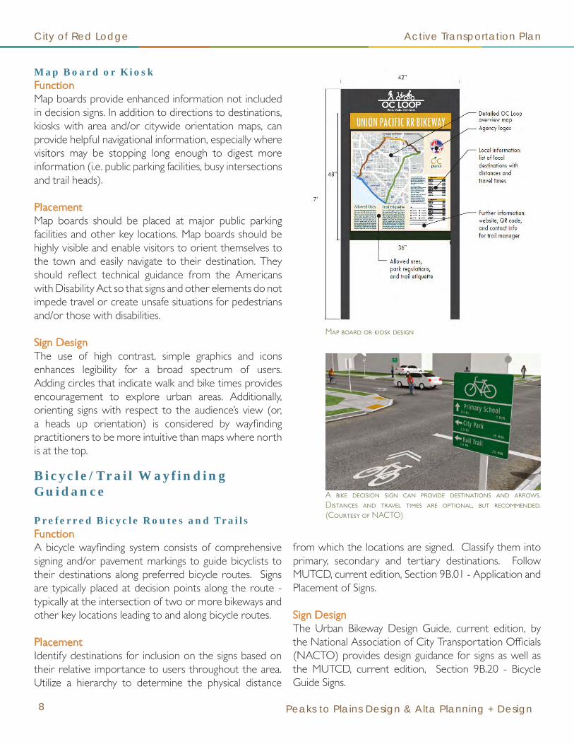
Map Board or KioskFunctionMap boards provide enhanced information not included in decision signs. In addition to directions to destinations, kiosks with area and/or citywide orientation maps, can provide helpful navigational information, especially where visitors may be stopping long enough to digest more information (i.e. public parking facilities, busy intersections and trail heads).
PlacementMap boards should be placed at major public parking facilities and other key locations. Map boards should be highly visible and enable visitors to orient themselves to the town and easily navigate to their destination. They should reflect technical guidance from the Americans with Disability Act so that signs and other elements do not impede travel or create unsafe situations for pedestrians and/or those with disabilities.
Sign DesignThe use of high contrast, simple graphics and icons enhances legibility for a broad spectrum of users. Adding circles that indicate walk and bike times provides encouragement to explore urban areas. Additionally, orienting signs with respect to the audience’s view (or, a heads up orientation) is considered by wayfinding practitioners to be more intuitive than maps where north is at the top.
Bicycle/Trail Wayfinding Guidance
Preferred Bicycle Routes and TrailsFunctionA bicycle wayfinding system consists of comprehensive signing and/or pavement markings to guide bicyclists to their destinations along preferred bicycle routes. Signs are typically placed at decision points along the route - typically at the intersection of two or more bikeways and other key locations leading to and along bicycle routes.
PlacementIdentify destinations for inclusion on the signs based on their relative importance to users throughout the area. Utilize a hierarchy to determine the physical distance
from which the locations are signed. Classify them into primary, secondary and tertiary destinations. Follow MUTCD, current edition, Section 9B.01 - Application and Placement of Signs.
Sign DesignThe Urban Bikeway Design Guide, current edition, by the National Association of City Transportation Officials (NACTO) provides design guidance for signs as well as the MUTCD, current edition, Section 9B.20 - Bicycle Guide Signs.
Map board or kiosk design
A bike decision sign can provide destinations and arrows. Distances and travel times are optional, but recommended. (Courtesy of NACTO)
5th
6th
5th
6th
use ped. x-walkwestbound
Waterfront Bicycles
Bike Central
PedalBike Tours
The Recyclery
Veloshop
lowerdeck
SEE SOUTH DOWNTOWN MAP
Alder
REI
PortlandBike Tours
streetcar
streetcar
streetcar
W i l l a m e t t e
R i v e r
8th
City of Red Lodge Active Transportation Plan
December 2016 9
Additional Wayfinding Tools
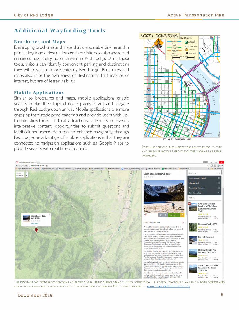
Brochures and MapsDeveloping brochures and maps that are available on-line and in print at key tourist destinations enables visitors to plan ahead and enhances navigability upon arriving in Red Lodge. Using these tools, visitors can identify convenient parking and destinations they will travel to before entering Red Lodge. Brochures and maps also raise the awareness of destinations that may be of interest, but are of lesser visibility.
Mobile ApplicationsSimilar to brochures and maps, mobile applications enable visitors to plan their trips, discover places to visit and navigate through Red Lodge upon arrival. Mobile applications are more engaging than static print materials and provide users with up-to-date directories of local attractions, calendars of events, interpretive content, opportunities to submit questions and feedback and more. As a tool to enhance navigability through Red Lodge, an advantage of mobile applications is that they are connected to navigation applications such as Google Maps to provide visitors with real time directions. Portland’s bicycle maps indicate bike routes by facility type
and relevant bicycle support facilities such as bike repair or parking.
The Montana Wilderness Association has mapped several trails surrounding the Red Lodge Area. This digital platform is available in both desktop and mobile applications and may be a resource to promote trails within the Red Lodge community. www.hike.wildmontana.org

City of Red Lodge Active Transportation Plan
10 Peaks to Plains Design & Alta Planning + Design
Why are Policies Important?
Walking is the simplest form of transportation and a predictable and well-maintained sidewalk network encourages people to walk more, thereby decreasing reliance on motor vehicles, improving physical activity, and, ultimately, maintaining the rural, cohesive, friendly, and accessible nature of Red Lodge.
According to the Red Lodge Growth Policy:
“The City of Red Lodge must balance residential infrastructure concerns with the quality and affordability of residential areas. Residential neighborhoods need sidewalks and other non-motorized ways and Red Lodge residents want them.”
Improving policies and programs related to walking and bicycling will ensure that future improvements and developments within the City will include safe and comfortable places for people to walk or ride, that existing and future sidewalks and trails will be well-maintained, and that people of all ages and abilities will be encouraged to walk or ride a bicycle.
It is much easier to implement standards and policies now than to pay for the retrofit of a sidewalk or bicycle network in the future. The intent of this section is to include policies that the City of Red Lodge can use to address issues that they face, such as incomplete networks, snow removal from sidewalks, maintenance of existing sidewalks, and installation of missing sidewalks or sidewalks that were not included in original developments.
2 | Policy Recommendations
The Montana Building Active Communities Resource Guide (2014) is available on-line at:
http://dphhs.mt.gov/Portals/85/publichealth/documents/Nutrit ionAndPhysicalActivity/BACIResourceGuide2014.pdf
Goal: Within two years of adopting this plan, provide recommendations on proposed changes or additions to policies, codes and ordinances identified in this section.
New Policies, Codes and Ordinances
Complete Streets Policy
Complete streets policies provide guidance to policy makers, planners and engineers to routinely design and operate the entire right-of-way to enable safe access for all users, regardless of age, ability or mode of transportation. Eleven Montana local governments have adopted a complete streets policy. Each policy is different based upon the local customs and needs for the jurisdiction.
Red Lodge references a complete streets paradigm in several existing policy documents; although no formal policy currently exists. The adoption of a formal policy would provide an outline of the intent and definition of complete streets.
Implementation Ideas:• Research other Montana communities that have
passed policies to see what is included. Follow up with those communities to find out what aspects of the policy have been successful or not.
• Utilizing information from those sources and the National Complete Streets Coalition, write a policy that reflects the needs and values of Red Lodge. (http://www.smartgrowthamerica.org/complete-streets)
• Meet with neighborhood residents, advisory boards and elected officials to present the benefits of having a policy and be prepared to make modifications based upon their feedback.
• Submit the resolution and policy to the Red Lodge City Council for adoption.

City of Red Lodge Active Transportation Plan
December 2016 11
Pedestrian Zone Policy for Sidewalk Infill
An area or areas where accelerated sidewalk construction and maintenance are desired can be officially designated and overlaid as Pedestrian Zones, similar to a Business Improvement District, in order to concentrate available resources on areas urgently needing sidewalk improvements, either because of deferred maintenance, lack of existing sidewalks, heavy existing or latent pedestrian demand, or a combination of all of these factors.
In Perinton, New York, the town’s zoning code includes pedestrian zone policies that require sidewalks to be built as part of developments and within 4,000 feet of schools, public parks, or active commercial areas, working in conjunction with the municipal sidewalk fund. The policy has resulted in a relatively extensive sidewalk network (over time), especially considering the rural nature of much of the town.
Pedestrian zones may also be linear, the boundaries of which should be determined based on need, land use, and community input.
Implementation Ideas:• Adopt pedestrian overlay zones as part of the zoning
regulations (12-4) in order to build the walkability network in areas of Red Lodge needing sidewalks or sidewalk maintenance the most. Examples include schools, parks, commercial destinations or areas with high walking probability.
Sidewalk Maintenance and Infill Strategies
Although cost-sharing maintenance and infill strategies, like those included in the Montana Active Living Guide, help reduce the burden on individual property owners of replacing or structurally maintaining sidewalks, cities that use cost-sharing strategies and rely on property owners to repair sidewalks still often have a significant backlog of needed infill segments of sidewalk or sidewalk maintenance. Communities that front the costs of sidewalk infill and maintenance, 100 percent through local funding measures, are completing the missing pieces of their systems much faster, thereby benefiting the community as a whole. The key to completing and maintaining a complete sidewalk network is to create a local and sustainable funding source dedicated to sidewalks.
Implementation Ideas:• Dedicate a portion of existing resort tax funds to
sidewalk reconstruction and expansion. • Consider a voter-approved special tax district, with
the Red Lodge city limits as the district boundary, where funds are dedicated to the sidewalk infill and maintenance program.
• Leverage the local funding sources to apply and provide match for grants from other agencies or private organizations.
Example of a sidewalk in Red Lodge that has exceeded its useful lifespan (approximately 50 years) and should be replaced.
Bikeway Design Guidelines
Adopt the “Urban Bikeway Design Guide,” latest edition by the National Association of City Transportation Officials (NACTO) as the basis for the state-of-the-practice solutions that help create complete streets that are safe and enjoyable for bicyclists. Note that in all cases, engineering judgment should be used to ensure that the application makes sense for the context of each treatment, given the diversity of community street networks.
http://nacto.org/publication/urban-bikeway-design-guide/

People surveyed as a part of this plan development overwhelmingly supported a residential snow removal ordinance and enforcement.
City of Red Lodge Active Transportation Plan
12 Peaks to Plains Design & Alta Planning + Design
Crosswalk Standards Policy
Adopt a crosswalk standards policy that establishes appropriate crosswalk types for specific roadway crossing types. The Manual of Uniform Traffic Control Devices (MUTCD) allows for two basic types of crosswalk designs. Apply high-visibility crosswalk markings at school crossings, downtown crossings, busy intersections, key safety hot spots, and mid-block crossings. Traditional parallel line markings may be installed at other acceptable locations. Crosswalks are important at all opportunities to cross a roadway, but especially where sidewalks are present on both sides. Curb ramps compliant with the Americans with Disabilities Act (ADA) should also be installed or retrofitted when crosswalks are installed.
Implementation Ideas:• Include a crosswalk standards policy as part of the
City Code or departmental policies and procedures in order to standardize crosswalks used throughout the City. http://guide.saferoutesinfo.org/engineering/marked_crosswalks.cfm
program staffed by able-bodied Red Lodge residents who assist mobility-impaired residents.
• Snow removal can be encouraged and storm warnings advertised via radio ads, and social media.
• RLMC 4-4-1 through 4-4-3 contain policies regulating snow removal on sidewalks in Red Lodge. The following changes to these sections could be made:• Include all residential uses in the list of areas that
require snow removal from sidewalks, in addition to commercial, multi-family properties as well as those adjoining US Highway 212 or Montana Highway 78. Remove the “strong encouragement” paragraph at the end of RLMC 4-4-1 pertaining to snow removal in residential areas or areas not required earlier in the existing code language.
• Elevate the enforcement of sidewalk snow removal guidelines.
Existing Policy, Ordinances and Code Revisions Red Lodge Municipal Code (RLMC)
Traditional parallel line crosswalk example
high-visibility crosswalk (ladder, continental design or diagonal marking) example
Curb extensions improve visibility between pedestrians and motorists in combination with parking setback requirements. This may be a consideration for the 14th Street/Highway 212 intersection due to its school crossing presence.Source:h t t p s : / / w w w. f h w a . d o t .gov/environment/bicycle_pedestr ian/pub l i cat ions/sidewalk2/sidewalks208.cfm
Snow Removal Policies and Programs (RLMC 4-4)
Improving the maintenance of sidewalks in the winter will improve walking conditions in Red Lodge and encourage more people to be active in winter. Additionally, mobility impaired residents are more susceptible to falls and are often not physically able to clear snow from their own sidewalks and driveways.
Implementation Ideas:• Establish a program like Helena, where the City’s
Public Works Department provides assistance to those who are not physically able to remove snow berms that may be left by snow plows after roadway snow removal. Another option is to create a volunteer

The development of a dedicated local funding source for sidewalk maintenance and construction was highly supported by people who were surveyed as a part of this planning process.
City of Red Lodge Active Transportation Plan
December 2016 13
Sidewalks and Curbs (RLMC 8-2)
Most of the codes in RLMC 8-2 were adopted in 1980. Consider a re-write of the entire chapter to update language (i.e. street commissioner versus public works director). Changes to the RLMC help connect the existing sidewalk network and will ensure that future sidewalks are installed with new development.
Implementation Ideas:• RLMC 8-2-6, 8-2-9, 8-2-20, 8-2-22, and 8-2-23 states
that all sidewalk maintenance and capital costs will be assessed and collected as a special tax solely against the property in front of or along which any sidewalk or curb, or repairs thereon shall be made. • Implement a cost-share program and replace
these sections with new language that represents this shared-cost benefit.
• Sidewalks are intended for use by all community members and requiring one property owner, especially in existing subdivisions, to pay for a new sidewalk places the burden on the property owner and not on the original developer.
• Modify RLMC 8-2-21 to specify that notice of defective or unsafe sidewalks should be reported to the City staff person in charge of a newly created sidewalk maintenance and capital construction program.
• Modify RLMC 8-2-12.F (Specifications) to increase strength and concrete thickness in order to accommodate drive-over or snow removal equipment.
• Modify RLMC 8-2-24 to clarify whether or not bicycles can be driven (or ridden, in this case) on sidewalks. Note most state and local ordinances prohibit bicyclists over a certain age from biking on sidewalks.
Subdivision Regulations (RLMC 12-2)
Modify RLMC 12-2-3-7, Transportation Corridors, upon the passage of the Complete Streets Policy. The “road network” will then include non-motorized transportation facilities.
Implementation Ideas:• Add a classification table to RLMC 12-2-3-7-B for non-
motorized transportation definitions and standards.• Multi-Use Path: Hard surface, 10-foot minimum
width.• Trail: Hard or soft surface, 6-foot minimum width.• Foot Path: Soft surface, 3-foot minimum width
with turn-outs.• Sidewalk: Hard surface (concrete), 5-foot
minimum width when possible.• Shared Lane Markings: Sharrows or other
symbols painted on a paved road surface.• Share the Road: Signs indicating multi-modal
modes without street markings.• Bike Lanes: Linear lines placed on paved roads
dedicating a specific aisle for bicycles or walking.• Update Table 12-2-3-7-C-b to reflect the changes in
definitions outlined above.• Update Figure 12-3-7-C-c to include a standard
section showing a complete streets section, including surfacing for sidewalks or trails.
• Modify 12-2-3-11 to include a watercourse setback from Rock Creek in order to allow for public access parallel to Rock Creek.
Example Communities and/or Resources: Helena, MT; Cary, NC; Collier County, FL (the latter two communities have exceptionally stringent requirements and enforcement in their land development codes that have resulted in rapid development of new walking facilities and infill of missing segments of sidewalk). Bozeman, Montana has a watercourse setback regulation that would be an example for Rock Creek.

City of Red Lodge Active Transportation Plan
14 Peaks to Plains Design & Alta Planning + Design
Zoning Regulations (RLMC 12-4)
• The sidewalk(s) shall be within the public right-of-way at a location approved by the Red Lodge Public Works Director and extended to connect to existing sidewalks if present at the lot boundary,” and that “all sidewalks shall be constructed in compliance with the Americans with Disabilities Act (ADA).”
Growth Policy
• Establish a Sidewalk Improvement District, as recommended on page 35 in the Growth Policy, to build a comprehensive system of well-maintained sidewalks.
• The City should not accept cash-in-lieu of sidewalk improvements when development occurs near existing sidewalks. Cash-in-lieu of sidewalks may be a better option in cases where it can be used to connect missing links. The terminology “cash-in-lieu” should be more appropriately called impact fees.
Example of a relatively new sidewalk installation that does not accommodate a safe, street intersection crossing for those with limited mobility or disabilities.

City of Red Lodge Active Transportation Plan
December 2016 15
Basis of Recommendations
A list of recommended infrastructure projects has been developed from the site inventory and connectivity analysis, public input and projects identified from the 2006 Trails Master Plan. At a public meeting, participants were asked to rank a list of recommended projects by their priority. The recommendations outlined in this chapter are organized by those results. However, the actual implementation may occur in a different order because some projects are integrated with other road or other infrastructure work. Sometimes funding opportunities may lend themselves to particular project segments that may achieve built status before others.
People felt that it was most logical to prioritize around popular destinations and then expand to the City fringes. In particular, the schools, post office and local coffee and pub establishments were top destinations. Then, the priority shifts to connectivity, connecting existing sidewalks and trails to other segments. Finally, new routes were deemed the lowest priority from a priority-based perspective. The Parks Board should investigate the use of unused rights-of-way for the use of trails.
The project numbers correspond with the engineering project list in the appendix.
3 | Infrastructure Plan (Highest Priorities)
Top Priority Projects as Indicated by the Public
Civic Center/Post Office Area Sidewalk Infill (ENG #3)(5th Street W to 14th Street W, Adams Ave. N. to alley east of Broadway)Opinion of Budgetary Cost: $332,000 for the sidewalk infill, an additional $150,000 for the parking lot
The post office was cited as one of the most frequent destinations for people in Red Lodge. The Civic Center and Lions Park are also places of public gathering, with the blocks in between used heavily by children walking or biking to the elementary and middle schools, the Boys and Girls Club, the Skate Park, and Field School Park. Therefore, it is a priority to improve the sidewalks in this corridor.
The Civic Center parking lot could serve as a major public parking area for Red Lodge residents and visitors who want to spend time and money in the adjacent Downtown Business District. In addition, this area could become the place for RV’s and other large vehicles to park, instead of their drivers continuing through town because they don’t see a place they can easily park without taking up multiple parking spots on Broadway. The wayfinding plan will be a necessary element to direct people to the parking area and to various destinations throughout town. Minor cosmetic changes to the lot may incur a $5,000 to $10,000 cost. Full reconstruction of the lot, including curbing, landscaping, and paving improvements may be an additional $150,000.
Visual simulation of improvements to the civic center (public) parking lot
City of Red Lodge Active Transportation Plan
16 Peaks to Plains Design & Alta Planning + Design
Multi-Use Trail from the top of Brewery Hill to US 212/Highway 78 Interchange (ENG#16A)(Separated trail from the highway alignment)Opinion of Budgetary Cost: $425,000 (Does not include land acquisition)
People were disappointed when the new highway was completed without the multi-use path extension to the new roundabout. This link provides a critical connection from the west bench to valley floor for users of the multi-use path and trail head on Highway 78. Project “ENG#16A” is an alternative to the placement of a pathway adjacent to Highway 78 from the top of the hill to the interchange. Segments for this alignment would need to be placed on private property. Negotiations with the property owners for easements, dedicated right-of-way or a recreational license agreement would need to commence prior to construction. This alternate path would connect into existing platted right-of-way that feeds into 2nd Street West area.
Highway 212 Multi-use Path (ENG #14)(Beartooth Lane to Two Mile Bridge Road)Opinion of Budgetary Cost: $600,000 (Does not include land acquisition)
A connection to the Beartooth Billings Clinic was important for patients and employees alike. Many people indicated that they were already walking and bicycling on Highway 212, but had serious safety concerns in doing so. A sidewalk will be paid for and constructed on the west side of Highway 212 as a part of Montana Department of Transportation’s “Robinson to Two Mile Road” reconstruction project. The 2015 Red Lodge Growth Policy states “The City will work with MDT to incorporate a multi-use path into the reconstruction of Highway 212.” The 2009 MDT Environmental Assessment & Decision Notice selected construction of a 10-foot multi-use path along the east side of Highway 212 for approximately one mile as the preferred alternative.
Recreational Trail from the West Bench to Downtown (ENG #22)(Airport Loop Trail to 10th Street West)Opinion of Budgetary Cost: $30,000
People cited difficulty of accessing the Airport Loop Trail from the valley. A foot path currently exists from the terminus of McGillen Avenue, but it is not conducive to a bicycle or those with limited mobility. Extensive study will be needed to find the best route to traverse the west bench hill from an accessibility and hillside stability analysis as well as property acquisition or legal access. Narrower and separated up and down hill single-track trails may be less expensive to construct than a multi-use path. Steeper trail segments could be built to provide greater in-town mountain biking opportunities. A larger quantity of narrow trails could provide access to areas of the community currently not served with trail connections.
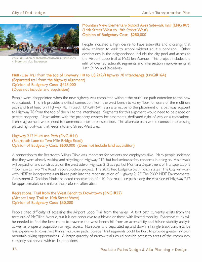
Mountain View Elementary School Area Sidewalk Infill (ENG #7)(14th Street West to 19th Street West)Opinion of Budgetary Cost: $280,000
People indicated a high desire to have sidewalks and crossings that allow children to walk to school without adult supervision. Other destinations in the neighborhood include the city pool and access to the Airport Loop trail at McGillen Avenue. This project includes the infill of over 20 sidewalk segments and intersection improvements at 14th St. W and Broadway.
Visual simulation of proposed crosswalk improvements at Mountain View Elementary.

City of Red Lodge Active Transportation Plan
December 2016 17
Recreation Trail from the Wildlife Sanctuary to Two Mile Bridge Road (ENG #13)(Generally following Rock Creek towards the City lagoons)Opinion of Budgetary Cost: $225,000
This trail would commence at the north property boundary of the Yellowstone Wildlife Sanctuary, cross Rock Creek to the east and generally extend north past the city lagoons and terminate at Two Mile Bridge Road. This recreational loop extends the existing trails at the High School and, in combination with Highway 212 improvements, could become a popular loop for residents and tourists alike. Portions of this route would require private land owner negotiations for easements, right-of-way or a recreational license agreement.
Platt Avenue Corridor Sidewalks (PW(STR)10)
This project is already programmed in the City’s Capital Improvement Plan for road reconstruction. As a part of the recommendation to build this road to a “complete streets” section, the sidewalks in this corridor will include the infill needs to the alleys extending east and west of the road.
Haggin Avenue Corridor New Sidewalk Extension (ENG #1) + (PW(STR) 12)(3rd Street East to Beartooth Lane)Opinion of Budgetary Cost: $220,000
Haggin Avenue is scheduled for reconstruction in 2018 as a part of the City’s Capital Improvement Plan (PW(STR)12). This project is an add-on to the existing road reconstruction, already budgeted to be built to a “complete streets” section. This project adds new sidewalks extending north of 3rd Street East, past the ball fields to Beartooth Lane. Haggin Avenue should be designated as a bike route with a shared lane marking from 14th Street to 3rd Street.
High School Area Sidewalk Infill (ENG #4)(Cooper Avenue, Chambers Avenue and 5th Street East)Opinion of Budgetary Cost: $196,000
High School students indicated a desire to have a safe route between the school and downtown restaurant and coffee shop destinations. This project would also reconstruct the trail head at the east end of 5th Street. The trail head is a key destination point for tourists who could then enjoy the existing trails along Rock Creek and connect to vacation homes farther south. Trails along and access to Rock Creek were highly desired by residents.
This is the location of the end of the existing trail along Rock Creek at the Wildlife Sanctuary border. A new bridge crossing would be required.
Visual simulation of trail head improvements: designated parking area, map board and shelter
City of Red Lodge Active Transportation Plan
18 Peaks to Plains Design & Alta Planning + Design
Adams Avenue Corridor (ENG #6)(19th Street West to Highway 212)Opinion of Budgetary Cost: $175,000
Adams Avenue from 19th Street West to Highway 212 suffers from linear sidewalk gap. The entire neighborhood from 19th Street West to 22nd Street West has a very minimal amount of sidewalks. Adding sidewalks along Adams Avenue would facilitate a safe route from local hotels, a convenience store and a specialty eatery back towards the downtown area without having to walk along Highway 212.
White Avenue Corridor (ENG #8)(Ski Run road to South Airport Road, including 19th Street West)Opinion of Budgetary Cost: $231,000
This neighborhood suffers from a system-wide gap. Very few residential streets have sidewalks. White Avenue is the primary route for the south valley traffic to get to the Airport Loop. This road also connects to Ski Run Road/Highway 212 at the south end. This is also the terminus for existing sidewalks end along Highway 212. The completion of sidewalks along this route would allow for a city-wide loop, north to south.
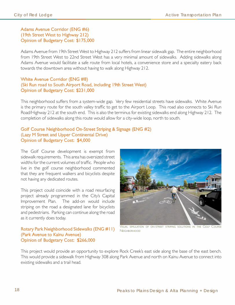
Golf Course Neighborhood On-Street Striping & Signage (ENG #2)(Lazy M Street and Upper Continental Drive)Opinion of Budgetary Cost: $4,000
The Golf Course development is exempt from sidewalk requirements. This area has oversized street widths for the current volumes of traffic. People who live in the golf course neighborhood commented that they are frequent walkers and bicyclists despite not having any dedicated routes.
This project could coincide with a road resurfacing project already programmed in the City’s Capital Improvement Plan. The add-on would include striping on the road a designated lane for bicyclists and pedestrians. Parking can continue along the road as it currently does today.
Rotary Park Neighborhood Sidewalks (ENG #11)(Park Avenue to Kainu Avenue)Opinion of Budgetary Cost: $266,000
This project would provide an opportunity to explore Rock Creek’s east side along the base of the east bench. This would provide a sidewalk from Highway 308 along Park Avenue and north on Kainu Avenue to connect into existing sidewalks and a trail head.
Visual simulation of on-street striping solutions in the Golf Course Neighborhood

5
13
20
3
7
19
11
4
9
6
12
23
22
21
2
8
18
10
15
1
16A
PW(S
TR)1
0
PW(S
TR)1
2
16
17
20
13
14
5
5
11
3
4
116A
16A2
22
20
20
18
9
14
10
PW(S
TR)1
0
PW(S
TR)1
2
8
8
Sources: Esri, HERE, DeLorme, Intermap, increment P Corp., GEBCO, USGS, FAO, NPS, NRCAN, GeoBase, IGN, Kadaster NL, Ordnance Survey, Esri Japan, METI, Esri China (Hong Kong), swisstopo, MapmyIndia, © OpenStreetMapcontributors, and the GIS User Community
LegendProposed Improvements
Proposed Shared Lane Markings / Signs
Proposed Sidewalk
Proposed Multi-Use Path or Trail
Existing Multi-Use Paths or Trails
Existing Multi-Use Paths or Trails
Existing Sidewalks
Existing Sidewalks
Engineering Projects
Haggin Avenue Sidewalks
Lazy M & Upper Continental Shared Lane Markings
Civic Center/Post Office Neighborhood Sidewalks
High School Neighborhood Sidewalks
Highway 308 (Bear Creek Hill) & East Bench Trail
Adams Street Sidewalks
Mountain View Elementary Neighborhood Sidewalks
White Ave Sidewalks
Pine Ridge Rd. to Spire Trails
Highway 212 Sidewalk
Rotary Park Neighborhood Sidewalks
Willow Creek Road Multi-Use Path
Rock Creek Trail & 2 Mile Bridge Road Signage
Highway 212 Multi-use Path
Beartooth Billings Clinic to Pine Ridge Trail
Highway 78 Multi-Use Path & Sidewalks
Highway 78 Multi-use Path Alt. & Sidewalks
Kane Cir. to Robinson Ln. Trail
Larkspur St Multi-Use Trail
Spires Trails
Pine Ridge Road Shared Lane Markings
Raven Hill Ln Trail
Airport Rd to 10th St West Trail
Pine Ridge Rd. to Highway 212 Trail
Haggin Avenue Reconstruction
Platte Avenue Reconstruction
¯Re
d Lo
dge
ATP
| R
ecom
men
ded
Proj
ects
1 inch = 700 feet
1
2
3
4
5
6
7
8
9
10
12
13
14
15
16
16A
17
18
19
20
21
22
23
11
City of Red Lodge Active Transportation Plan
December 2016 19

City of Red Lodge Active Transportation Plan
20 Peaks to Plains Design & Alta Planning + Design
On-Street Bicycle Facilities
On-street bikeways refer to improvements made to streets that benefit or designate road space for the purposes of accommodating or encouraging bicycling. On-street bikeways fall into several categories and may look different depending on their rural/small town or urban context. All street markings and signage shall be consistent with MUTCD, current edition, standards and approved by the Red Lodge Public Works Director.
Shared LanesThis type of bikeway is generally appropriate where vehicle speeds and volumes are low. This type of bikeway is designated through pavement markings such as shared lane markings and signage which could include the ‘Bikes May Use Full Lane’ signage. This sign is well suited to lower speed narrower streets like those in Red Lodge.
Shared Lane Markings have the following applications:
• To assist in lateral positioning within the lane to avoid door zone hazard caused by on-street parking lanes• To assist in position to prevent side-by-side operation of vehicles and bicycles in a narrow lane• To alert drivers that bicyclists may be present• To reduce the incidence of wrong-way-riding or sidewalk riding
Case Study: Ennis MontanaEnnis has local streets very similar to Red Lodge. Most lack sidewalks and have shoulder vehicle parking. The community wanted increased awareness for bicyclists and pedestrians using local streets to reach downtown and the local schools, which all share a common site. As a cost effective solution, several routes were chosen and treated with shared lane markings immediately following the adoption of the ‘Safe Routes to School Plan.’ The goal of the markings was to identify and concentrate bicycle and pedestrian activity on a number of chosen streets to raise awareness and consideration by drivers.
Bike LanesA bike lane uses signage, striping, and stenciling to designate a portion of the roadway for the preferential or exclusive use of bicyclists. Bike lanes allow bicyclists to ride at their preferred speed without interference from prevailing traffic conditions. Bicycle lanes are typically found on collector or arterial streets with more moderate motor vehicle speeds (25+ mph) and volumes (3,000 vehicles per day and higher with greater than 6,000 more typical). A bike lane must be at least five feet wide where there is a curb or on-street parking present. If there is no curb and no parking a bike lane may be four feet in width. Bike lanes are not typically installed on local streets unless there is a compelling reason for doing so.
Bike lanes have the following benefits:
• Increases bicyclist comfort and confidence on busier streets• Creates separation between bicyclists and vehicles• Increases predictability of bicyclist and motorist positioning and interaction• Increases awareness of bicyclists to drivers
Shared lane markings in Ennis, Montana
Bike lane in Shelby, Montana

RE
D L
OD
GE
ATP
|
RE
CO
MM
EN
DE
D O
N-S
TRE
ET
BIC
YC
LE R
OU
TES
Shared Lane MarkingBike Route S ignage
Bike LanesExist ing Trai ls
City of Red Lodge Active Transportation Plan
December 2016 21

City of Red Lodge Active Transportation Plan
22 Peaks to Plains Design & Alta Planning + Design
4 | ProgramsThis section outlines potential programs and investigates the paths to successful implementation of each program. Several public meetings and focus groups helped shape the list of potential programs. While this section provides a good starting point for programming efforts, it is by no means exhaustive. Programs are an excellent way to engage citizens who want to volunteer their time and talents and can reach many different demographics.
The programs can be generally organized into one of the following categories of programming:
Encouragement: includes activities that promote active transportation;
Education: targets all ages and abilities and teaches the best safety and awareness practices;
Maintenance: addresses the built environment, infrastructure and maintenance; and,
Enforcement: includes methods to promote compliance with laws that pertain to the roadway, especially those that make active transportation safe.
Encouragement ProgramsEncouragement solutions are used to make active transportation more exciting or interesting. Such programs are often quick and easy to set up and often require little funding. Encouragement programs not only teach the best safety and awareness practices, but the programs also provide people with incentives to actively participate. The following programs vary in their ease of implementation.
Walking School Bus Program
According to the National Safe Routes to School Partnership, the rate of children walking to school is at an all-time low, and parents have become wary of allowing children to walk alone, in part, due to traffic concerns. Walking School Buses help alleviate the fear – and the time constraints for parents – associated with children walking to school. They may be stand-alone efforts or part of a broader Safe Routes to School program.
Volunteers take turns leading the “bus”, which follows the same route every time and picks up children from their homes or designated “bus stops” at designated times. A Walking School Bus can be as informal as a few parents alternating to walk their children to and from school, but often it is a well-organized effort led by the PTA or a local agency or organization. http://www.walkingschoolbus.org/
Implementation Ideas:
• Organize and recruit volunteers
• Designate meet-up points along a safe route to school
• Coordinate with school administration as necessary for arrival times

City of Red Lodge Active Transportation Plan
December 2016 23
Community Events
Community events is a broad category that includes the organization of new events, such as a “Find Your Trail Day,” a “Community Bike Days” or a scavenger hunt, as well as working with and expanding on existing community events, such as the “Fun Run.” The idea behind these events is to encourage citizens to explore their community by participating in an event. The events would be hosted in a variety of locations, such as downtown or local trails. They should also be advertised throughout both the community and the region to draw regional citizens and tourists to participate, generating revenue for local businesses.
Implementation Ideas:
• Find an organization to develop a new community event, such as a scavenger hunt within the trail system, and include an event chair or committee to plan and execute the event
• Provide facilities or resources, as needed, for the event through fundraising or donations
• Advertise the event both locally and regionally, capturing a broader participation market
• Coordinate with the City and local organizations for assistance, as necessary
• Recruit volunteers to help run the event (students indicated they enjoy these types of events)
Self-Guided Activities
A self-guided activity is where one navigates a route(s) oneself as opposed to having a tour guide, which reduces personnel commitments. Easy-to-use maps, apps or tour booklet can be developed to make sightseeing, nature viewing or historic exploring easy. Activities such as a self-guided historic walk, geocaching, or developing apps/integrating QR-codes at kiosks around town could be implemented under this program. Audio touring could also be incorporated using smart phone or kiosks.
Implementation Ideas:
• Community businesses, non-profits, City, Chamber of Commerce or tourism committee/board to develop self-guided maps, device applications, tour booklets and/or audio tours within Red Lodge
• Provide physical and digital copies of maps and booklets in an accessible format (PDF)
• Determine points-of-interest (e.g. nature, history, exercise) and develop easily navigable tour routes
• Advertise the self-guided programs through tourism funds
• Start small to gauge interest and increase, as demand exists
The 2016 Turkey Trot attracted 180 people.Photo credit: Terri Hoyt

City of Red Lodge Active Transportation Plan
24 Peaks to Plains Design & Alta Planning + Design
Fix Your Bike Programs
An event created that involves local biking organizations and/or bike shops hosting informative bike repair workshops or providing tune-up services to people getting ready to ride their bikes. While this event is meant to provide simple bike services to citizens, the event can be used as a community learning experience for people interested in learning how to work on their own equipment.
Implementation Ideas:
• Determine which organization would be the event lead
• Work with other interested organizations to assist with event
• Provide facility to host event, as well as and tools and equipment for repairs
• Provide free tune-up services or low-cost materials for tune-up classes
Helmet Giveaway / Helmet Programs
Programs designed to help increase safety for bicyclists by providing free helmets. While this program can be executed in numerous ways, it is typically targeted at school-aged children as a reward for biking to school. One option is to purchase the helmets, using private, public or grant funds, to give away to children that ride their bikes to school. Another method could be a program, funded in a similar manner, that provides helmets to any individual at community events. It is noted that these types of programs require significant funds, but grant sources exist.
Implementation Ideas:
• Determine who the lead organization will be (e.g. special interest groups, trail groups, hospital or school district)
• Raise funds to provide helmets free-of-charge (grants, private sponsorships, etc)
• Look for cooperative opportunities between local organizations
• Continue the program where police officers give out rewards to children who wear a bicycle helmet
5-Minute Dismissal Delay for Students Program
This program works to alleviate conflicts around school zones to allow for students who walk or ride their bicycle to school a chance to depart from the school grounds without the interference of vehicle movements. Students who walk or bike to school will be dismissed five minutes earlier than those using buses or vehicles.
Implementation Ideas:
• Evaluate and align dismissal times between all classes at a school.
• Identify a preferred route for student departures.
• Coordinate with crossing guards.
Teachers are integral partners in determining who may need a bicycle and/or helmet
Be simple in the bicycle repair: how to put a chain back on, adjusting your seat, etc.

City of Red Lodge Active Transportation Plan
December 2016 25
Education ProgramsEducation solutions should be among the first initiatives implemented under this plan. Education activities provide education and resources to participants on how to conduct themselves in a safe manner. Such programs need to identify target audiences, what information to provide and how to deliver the information. These solutions should be developed to target citizens of all ages.
Walking / Biking Education Curriculum
Provide training to physical education instructors (at schools) or individuals at local organizations to become instructors of safe biking and walking. The school district would implement lessons into their physical education curriculum, while local organizations would host community learning events.
Implementation Ideas:
• Provide training to teachers to conduct courses (Journeys from Home curriculum or Traffic Skills 101)
• Incorporate and continue existing courses in the school curricula and community events
• Provide education opportunities at locations in the city throughout the year
• Provide learning opportunities at community events
Develop Recommended Routes Guidebook
Provide a physical or digital guidebook of the recommended (safe) routes around town for walking and biking. This guide would help people determine the best and safest routes to walk. It also provides an opportunity to teach tips on being a safe pedestrian or bicyclist.
Implementation Ideas:
• Agency or local organization to develop and/or host (if digital) the guidebook
• Provide recommended routes and safety information in the guidebook
• Have local experts provide safety tips
• Work with the school district, community organizations, special interest groups and enforcement officials to identify the routes
Temporary Pin-down Curb Extensions
Utilize rubber pin-down curbs to create curb extensions that allow for greater visibility of pedestrians at busy intersections.
Implementation Ideas:
• Coordinate with City Public Works and the Montana Department of Transportation on the locations and design of the curb extension.
• Remove the curb extension prior to the winter season.
Temporary Pin-down Curb ExtensionImage Courtesy of Mark Fenton
Temporary Pin-down Curb ExtensionImage Courtesy of Mark Fenton
Bicycle Skills Class: 3rd Grade Audience

City of Red Lodge Active Transportation Plan
26 Peaks to Plains Design & Alta Planning + Design
Maintenance ProgramsSnow Removal Assistance for the Mobility Impaired
According to the 2015 U.S. Consumer Product Safety Commission (NEISS, 2016), approximately 34,000 people in the United States are treated in emergency rooms in 2015 for injuries sustained when trying to remove snow, many of whom may underestimate the time, strength and stamina it takes to shovel snow. This program would be designed to offer assistance to help seniors citizens and disabled residents who are unable to remove significant amounts of snow accumulation from their properties. Ultimately, the program will provide safety benefits to the greater community by reducing potential slip-fall hazards, preventing pedestrians and bicyclists from leaving the sidewalks and ensuring that emergency personnel have the best access possible to the residences.
Implementation Ideas:
• Volunteer-Matching Service (Denver Snow Buddies, Chicago Snow Corps) – a partnership between the City and a non-profit volunteer organization that connects healthy volunteers with elderly and disabled individuals who cannot clear their own properties
• Non-Profit Organizations – Non-profits or church organizations match property owners with volunteers or work within their determined “service area”
Adopt-a-Sidewalk/Adopt-a-Trail Program
An Adopt-a-Sidewalk/Trail Program is where citizens or businesses adopt a segment of sidewalk to maintain throughout the year (e.g. providing snow shoveling and shrub maintenance). A non-profit organization would typically be the manager of such a program; however, it is not uncommon for cities to manage such programs. This is the approach that the Beartooth Recreational Trails Association has recently created.
Programs throughout the United States vary their methods for determining which sidewalks are considered for adoption. Most use an application-based system in which citizens may request assistance clearing their sidewalk; however, some programs focus on areas of town and divide up all of the sidewalks.
Implementation Ideas:
• Non-profit organizations and volunteers
• Develop how the program will function (e.g. can anyone request for assistance?)
• Coordinate with City, school programs, other civic-minded organizations or businesses to execute program
• Start small and expand

City of Red Lodge Active Transportation Plan
December 2016 27
Enforcement OpportunitiesThe goal of enforcement is to discourage unsafe behaviors of motorists, pedestrians and bicyclists while encouraging compliance of traffic laws and safe behaviors. These efforts go much further than writing tickets or disciplining negative behaviors. Enforcement strategies may include large networks of people such as law enforcement, crossing guards, school officials, parents, student and community members. Each group has their own responsibilities, but they are all equally important in ensuring the overall safety of the community.
Increase Positive Police Presence
An increase of police presence within school zones or the downtown region would make motorists more aware of their speed and traffic laws. The police should not only focus on poor behavior, they should also reward good behaviors, such as giving out “bonus bucks” or gift cards.
Implementation Ideas:
• This solution is completely contingent on the amount of time officers spend around schools or areas of importance (i.e. Downtown)
• Consider developing an officer on a bicycle program
• Develop a rewards program or work with local businesses to develop a reward-based system
Crossing Guard Program
Beartooth Industries and Homes (BIH) currently provides three crossing guards for Mountain View Elementary School. Under contract with the School District, BIH provides both morning and afternoon guards from their organization. A job coach is responsible for training the crossing guards and supervises all three locations. The School District and the City provide materials (vests, hand signs, etc.)
Implementation Ideas:
• Continue the crossing guard program with the School District as the lead agency. Contract with local organizations to provide the service.
• Resources for crossing guard programs can be found at: http://guide.saferoutesinfo.org/crossing_guard/pdf/crossing_guard_guidelines_web.pdf
Enforce Existing Ordinances in the Red Lodge Municipal Code (RLMC)
Currently, there are many ordinances and codes that exist that can improve active transportation. When asked why these were not enforced, it was indicated that often times the elected officials have requested to not enforce a particular law or staff did not have the resources or procedures in place to properly enforce the law.
Implementation Ideas:
• Review the enforcement procedures for the ordinances and codes already in-place. Staff should identify a list of laws that are in-place, but not enforced.
• Convene a working group consisting of elected officials, city staff and local citizens to review the list and make recommendations to the City Council as to whether or not the law should remain on the books.
• Ordinances and codes that are affirmed by the City Council, but need a procedural improvement, should require an implementation plan for enforcement developed by City staff.

City of Red Lodge Active Transportation Plan
28 Peaks to Plains Design & Alta Planning + Design
Executing a non-motorized transportation plan should be viewed as an effort similar to that of a road, water, sewer or parks plan. It is important to evaluate efforts for both infrastructure and non-infrastructure projects and programs for their effectiveness and efficiency of the use of both human and fiscal resources.
It is just as important to find an opportunity to celebrate the successful outcomes of the plan! In an increasingly competitive environment for funding, having quantifiable data, supported with first-hand testimonials will ultimately place Red Lodge at the top list of performing communities. The more the City can demonstrate the achievable benefits resulting from the plan, the easier it will be to garner support for activities.
Conduct Pedestrian and Bicycle CountsManual CountsA manual count program should occur twice per year through the use of volunteers at the same location during the same calendar week. The type of data collected is quantity of users, type of user (pedestrian, bicyclist, etc.), gender and time of day.
Permanent CountsInfrared counters should be placed at high use locations and mounted to a permanent post or pole. This data will most likely only provide count and time data, with no qualifiers as to the type of user. The Airport Loop Trail and the Rock Creek Trail are two locations that would be ideal for permanent counters.
5 | Evaluation
This infrared trail counter by TRAFx is an example of a permanent device with a web-based software solutions to view and manage the data.

City of Red Lodge Active Transportation Plan
December 2016 29
Safe Routes to School Parent SurveyAs a part of this planning process, Mountain View Elementary and Roosevelt Junior High School conducted the National Safe Routes to School Parent Survey. The schools are entered into the national database and annual efforts to conduct the survey can provide a solid foundation for benchmarking success. The 2016 Red Lodge schools’ principals are registered with the Safe Routes to School Partnership. Existing and new surveys can be administered at any time. www.saferoutesdata.org.
Collect Fatality, Serious Injury and Injury Crash DataThe Montana Department of Transportation (MDT) collects crash data for all accidents occurring on Montana roadways. However, an analysis of the data for Red Lodge in the past ten years indicates zero serious injury or fatality incidents between drivers of vehicles and people walking or bicycling. Through community outreach, several people indicated knowledge about known incidents. Implement improved reporting processes and information sharing between the Montana Department of Transportation, Montana Highway Patrol and local law enforcement.
Conduct Statistically Valid Surveys Regarding Non-Motorized Transportation UseEvery five years, conduct a randomly selected household survey that queries residents on their non-motorized transportation use. Utilize this opportunity to reassess priority infrastructure projects and gauge interest in current and potential programs. The results from this survey can be used for grant writing and public support purposes.

City of Red Lodge Active Transportation Plan
30 Peaks to Plains Design & Alta Planning + Design
Inventory & Analysis
The inventory of existing sidewalks and trails has been done by local volunteers and the Department of Commerce. The steering committee has been conducting walk audits of sidewalk conditions throughout this process.
Through the public engagement process, participants were asked to map their usual routes and destinations. Many people indicated that they are often walking on streets, trespassing on private property or meandering via the safest route. The inventory concluded that people are already active, despite the lack of infrastructure. Red Lodge’s compact size also allows for people to traverse all throughout the city limits and beyond.
1 | Inventory

Sources: Esri, HERE, DeLorme, Intermap, increment P Corp., GEBCO, USGS,FAO, NPS, NRCAN, GeoBase, IGN, Kadaster NL, Ordnance Survey, EsriJapan, METI, Esri China (Hong Kong), swisstopo, MapmyIndia, ©OpenStreetMap contributors, and the GIS User Community
LegendOccurence
Low Use
--
Medium Use
--
High Use
Red
Lodg
e A
TP |
Bic
yclin
g Ro
utes
1 inch = 3,000 feet
City of Red Lodge Active Transportation Plan
December 2016 31

Sources: Esri, HERE, DeLorme, Intermap, increment P Corp., GEBCO, USGS,FAO, NPS, NRCAN, GeoBase, IGN, Kadaster NL, Ordnance Survey, EsriJapan, METI, Esri China (Hong Kong), swisstopo, MapmyIndia, ©OpenStreetMap contributors, and the GIS User Community
LegendOccurence
Low Use
--
--
Medium Use
--
--
High Use
Red
Lodg
e A
TP |
Wal
king
Rou
tes
1 inch = 3,000 feet
City of Red Lodge Active Transportation Plan
32 Peaks to Plains Design & Alta Planning + Design
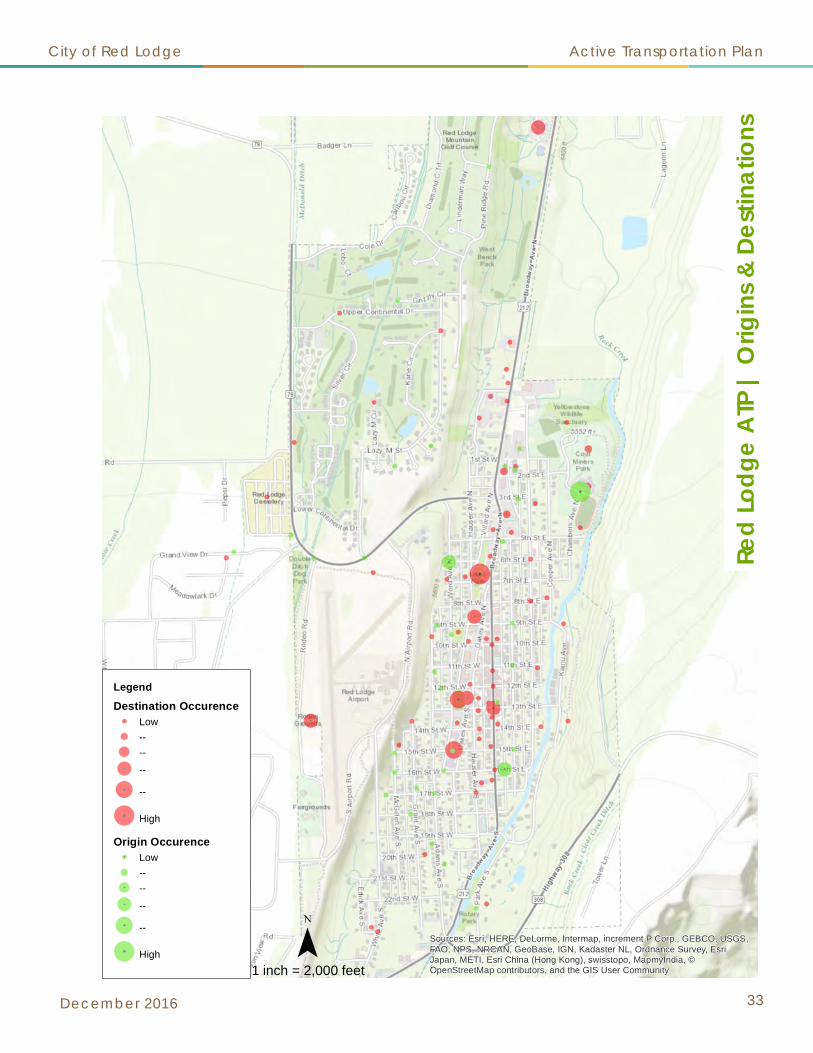
Sources: Esri, HERE, DeLorme, Intermap, increment P Corp., GEBCO, USGS,FAO, NPS, NRCAN, GeoBase, IGN, Kadaster NL, Ordnance Survey, EsriJapan, METI, Esri China (Hong Kong), swisstopo, MapmyIndia, ©OpenStreetMap contributors, and the GIS User Community
Legend
Destination OccurenceLow----
--
--
High
Origin OccurenceLow----
--
--
High
Red
Lodg
e A
TP |
Orig
ins
& De
stin
atio
ns
1 inch = 2,000 feet
City of Red Lodge Active Transportation Plan
December 2016 33
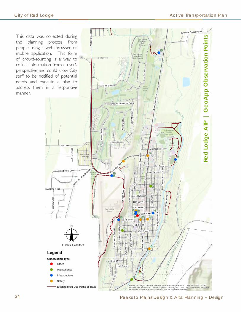
State Highway 78
Broa
dway
Ave
nue
Willo
w C
reek
Roa
d
Fox Lane
Lazy
M S
treet
Cole Drive
Kainu Avenue
Airp
ort R
oad
Grant Avenue
Silv
er C
ircle
Sout
h W
hite
Ave
nue
Plat
t Ave
nue
Hwy 78
Sout
h M
c G
illen
Willow Bend Road
Park Avenue
Big
Sky
Loop
Kane
Circ
le
Wor
d Av
enue
Grand View Drive
14th Street
Adams Avenue
Hauser Avenue
Coo
per A
venu
e
2nd Street
Upper Continental Drive
15th Street
16th Street
11th Street
12th Street
6th Street
Peps
i Roa
d
5th Street
Remington Ran
ch Roa
d
21st Street
22nd Street
Hau
ser A
venu
e
10th Street
Adam
s Av
enue
13th Street
Two Mile Bridge Road
Hag
gin
Aven
ue!
!
!
!
!
!
!
!!
!
!!
!
!
!
!
!
!!
98
7
5
4
3
2
1
19 17
16
15 13
1211
10
6
1814
Sources: Esri, HERE, DeLorme, Intermap, increment P Corp., GEBCO, USGS, FAO, NPS, NRCAN,GeoBase, IGN, Kadaster NL, Ordnance Survey, Esri Japan, METI, Esri China (Hong Kong), swisstopo,MapmyIndia, © OpenStreetMap contributors, and the GIS User Community
Red
Lodg
e A
TP |
Geo
App
Obs
erva
tion
Poin
ts
o1 inch = 1,400 feet
LegendObservation Type
! Other
! Maintenance
! Infrastructure
! Safety
Existing Multi-Use Paths or Trails
City of Red Lodge Active Transportation Plan
34 Peaks to Plains Design & Alta Planning + Design
This data was collected during the planning process from people using a web browser or mobile application. This form of crowd-sourcing is a way to collect information from a user’s perspective and could allow City staff to be notified of potential needs and execute a plan to address them in a responsive manner.

GeoApp Tabular ResultsCurrent As Of 8/2/2016
Observation Point Age Gender Observation Type Comment
1 6 Male Infrastructure Issue< No Comment Provided >
2 N/A Not Provided Maintenance Issuetrailer parked on sidewalk. tree limbs hang about 2' off the sidewalk.
3 N/A Not Provided Safety Issueno pedestrian lane designated. no ped-safe guard rails on the bridge. easily remedied. difficult situation; bridge is under the authority of Carbon Co Commission, but is in the City limits of Red Lodge. resistance to improve by Commissioner.
4 34 Male Safety IssueMinimal side walks for families outside of downtown. Poor snow removal on N end of town causing foot traffic into the roundabout
5 27 Female Maintenance IssueSidewalk is deteriorating.
6 27 Female Infrastructure IssueNo sidewalk from Civic Center parking lot to Club/Park/Skate Park on Word and Villard. Word has one on the west side but as kids come from school they are walking on the east side of the street.
7 71 Male Safety IssueMy daily trip to town by foot or bike is perilous down the final mile of Hiway 78. "Brewery Hill" requires great vigilance to survive the trips!
8 53 Female Maintenance IssueMost of the sidewalks around town~ outside the downtown district are awful~ broken, covered with bushes or were never constructed. The kids at the High school have to walk in the street to get to school.
9 53 Female Maintenance IssueA few years ago the city council voted to change the sidewalk ordinance and take out the shoveling requirement~ for those of us who live in town~ made no sense at the time as we had just gotten a grant for safe sidewalks to school~
10 58 Male Infrastructure IssueLimited sidewalks in town.
11 52 Female Infrastructure IssueNow that Lazy M Street connects directly with Airport Road, would it be possible to connect the Airport Trail to Airport Road in this vicinity?
12 38 Female Safety IssueHwy 212/Broadway and 14th is selected as a school/pedestrian crossing. On the southeast side of 14th, there is NOT a sidewalk. This is a significant problem. Just look at it. Not enough room in this area to explain it.
13 38 Female Safety IssueLack of sidewalk leading to school crossing area on Word Ave S. between 12th and Civic Center. Crossing guard is on the east side of Word/14th, so it is a used corridor. But children are often riding/walking in the street (even groups like B&G and BCC
14 38 Female Infrastructure IssuePoorly constructed trail from town to a trail/area that is being advertised by Red Lodge as a great trail to use and other events. The only alternative is a no-shoulder road - Hwy 78.
15 38 Female Infrastructure IssueThe school does not maintain this trail in which they claim in their property. Embarrassing that it is an advertised trailhead.
16 69 Not Provided Safety IssueNo sidewalk on north side of 14th Street between Hauser and Oakes
17 49 Male Infrastructure IssueIn need of sidewalk between 12th and 13th Streets. Major corridor for students.
18 49 Male OtherNeed to examine this under-utilized parking area. Could serve as off-street parking for downtown area. Suggest "enclosing" parking area with curb, gutter and sidewalks (defined entrance/exits) to extend safe pedestrian travel to/from school facilities.
StatisticsAverage Age 44Most Common Gender Female
Most Common Observation Type Infrastructure Issue
Red Lodge Active Transportation Plan
City of Red Lodge Active Transportation Plan
December 2016 35
This data was collected during the planning process from people using a web browser or mobile application. This form of crowd-sourcing is a way to collect information from a user’s perspective and could allow City staff to be notified of potential needs and execute a plan to address them in a responsive manner.

City of Red Lodge Active Transportation Plan
36 Peaks to Plains Design & Alta Planning + Design
A connectivity analysis evaluates the locations of existing infrastructure compared to current use patterns and frequency of destinations. When conducting the analysis, the types of gaps can be divided into categories.
A spot gap occurs when a sidewalk (for example) is missing on one lot, while the other lots have sidewalks. A linear gap occurs when there is a continuous missing sidewalk along one particular roadway, and it may continue for several blocks. A neighborhood gap is an entire district that is generally without sidewalk infrastructure.
The results from this analysis help to identify potential projects that will benefit the most people.
2 | Connectivity Analysis

City of Red Lodge Active Transportation Plan
December 2016 37

0%
10%
20%
30%
40%
50%
60%
70%
People under18
People under25
Peoplebetween 25
and 65
People over65
Red LodgeCarbon CountyMontana
0%10%20%30%40%50%60%70%80%90%
Red Lodge HouseholdsMontana Average
0%10%20%30%40%50%60%70%80%90%
100%
Red LodgeHamiltonLivingstonMissoulaMontana
City of Red Lodge Active Transportation Plan
38 Peaks to Plains Design & Alta Planning + Design
Demographics1 | Age
Red Lodge has a higher percentage of people between the ages of 25 and 65 and over the age of 65 than Carbon County or Montana.
2 | Households
Red Lodge has an exceptionally high number of vacant homes. This is most likely due to a high number of vacation or short-term rental units in the community. This leads well to the idea that walking and bicycling is a tourist activity for those staying in those types of units.
3 | Commuting Characteristics
Red Lodge’s commuting mode share for walking is 18 percent!
Source: U.S. Census Bureau, 2010 Census
Source: U.S. Census Bureau, 2010 Census
Source: U.S. Census Bureau, 2010-2014 American Community Survey 5-Year Estimates

$150,000
$155,000
$160,000
$165,000
$170,000
$175,000
$180,000
$185,000
$190,000
$195,000
2011 2012 2013 2014 2015
Red Lodge Bed Tax Revenue*
0%
10%
20%
30%
40%
50%
60%
70%
80%
2015201420132012
22.0%
6.9%
24.2%
38.3%
20.7%
6.2%
21.6%
37.8%
8.3%
35.7% 35.2%
0.0%
5.0%
10.0%
15.0%
20.0%
25.0%
30.0%
35.0%
40.0%
45.0%
No leisure time for physicalactivity
Diabetes prevalence Obsesity rate Overweight rate
Region 3 Montana National
City of Red Lodge Active Transportation Plan
December 2016 39
4 | Bed Tax Revenue
Red Lodge’s Bed Tax Revenues have fluctuated throughout the past five years. Improved bicycle and pedestrian facilities may entice visitors to stay longer in Red Lodge.
5 | Tourism Opportunities
Non-resident tourists who stayed overnight in Red Lodge did the following activities on their trip (although the activity may not have necessarily occurred in Red Lodge).
6 |Community Health
In a recent survey of Red Lodge residents, 33.7 percent indicated that obesity/overweight issues is a top community health concern, up from 17.9% in 2008.Health statistics are broken down by region. Region 3 consists of Judith Basin, Fergus, Petroleum, Wheatland, Golden Valley, Musselshell, Sweet Grass, Stillwater, Yellowstone, Big Horn & Carbon Counties
Source: Institute for Tourism & Recreation Research
Source: Red Lodge Area Chamber of Commerce, 2016

City of Red Lodge Active Transportation Plan
40 Peaks to Plains Design & Alta Planning + Design
Related Documents1 | City of Red Lodge Growth Policy (2015)
The 2015 Growth Policy has over four pages of references to action items related to active transportation. The references include strategies for a healthy central business district and quality community entrances. Strategies that are recommended include the design of residential neighborhoods so that non-motorized use can flow through from neighborhood to neighborhood without the development of gated communities.
Additionally, the development of a quality trail system will enhance the parks and open space in and surrounding Red Lodge.
2 | City of Red Lodge Capital Improvement Plan (2015)
The Capital Improvement Plan (CIP) does not mention sidewalk improvements as a stand alone component of project priorities. However, it does indicate that when several main roads are reconstructed that they must be built to a “Complete Streets” section, meaning that all modes of transportation are accommodated.
Two trail projects are called out in the CIP: Rock Creek Linear Park development and land acquisition and the West Bench Linear Park development and land acquisition. Neither of these projects made it to the top priority ranking list for the Active Transportation Plan.
3 | City of Red Lodge Zoning Ordinance (2016)
Several of the zoning ordinances indicate that sidewalks are only required when they connect to an existing sidewalk system. This language could be problematic because it only leads to neighborhood gaps that will be more costly to retrofit later than to require now. Refer to the work plan section on policies for recommendations for changes to the zoning ordinance.
4 | City of Red Lodge Comprehensive Parks Plan (2015)
This plan includes a community survey where citizens indicated a desire for linear parks with trails. Trails do not necessarily need to be included in dedicated park land, trails can be placed on easements, rights-of-way and on private property through license agreements. People indicated a high desire to connect parks to trails, citing parks as a major destination point.
5 | City of Red Lodge Comprehensive Trails Plan (2006)
This plan proposed trail segments in Red Lodge and beyond city limits. It includes trail standards and specifications for trails. The recommendations from this plan will continue to be valid with the adoption of the Active Transportation Plan.

City of Red Lodge Active Transportation Plan
December 2016 41
6 | Carbon County Community Health Assessment Report and Implementation Plan (2013)
The first goal in this plan is to promote healthy behaviors and lifestyles in the community. This includes the development of a walking trail from Beartooth Billings Clinic to Country Club Estates as a vital link in the Rocky Fork Trail system. Over one-third of the respondents to a survey conducted for this report indicated that obesity and overweight issues area top community health concern.
7 | Downtown Red Lodge Assessment & Action Plan (2006)
This document outlines a multi-strategic approach to innovate and activate Downtown Red Lodge. In the “design” section of the report, it indicates a lack of parking management and the need for pedestrian comfort in Red Lodge. This document recommends connectivity to trails, public gathering spaces and streetscape improvements.
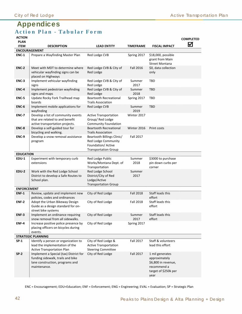
City of Red Lodge Active Transportation Plan
42 Peaks to Plains Design & Alta Planning + Design
Appendices
ENC = Encouragement; EDU=Education; ENF = Enforcement; ENG = Engineering; EVAL = Evaluation; SP = Strategic Plan
ACTION PLAN ITEM DESCRIPTION LEAD ENTITY TIMEFRAME FISCAL IMPACT
COMPLETED
ENCOURAGEMENT ENC-1 Prepare a Wayfinding Master Plan Red Lodge CVB Spring 2017 $18,000, possible
grant from Main Street Montana
ENC-2 Meet with MDT to determine where vehicular wayfinding signs can be placed on Highways
Red Lodge CVB & City of Red Lodge
Fall 2016 $0, data collection only
ENC-3 Implement vehicular wayfinding signs
Red Lodge CVB & City of Red Lodge
Summer 2017
TBD
ENC-4 Implement pedestrian wayfinding signs and maps
Red Lodge CVB & City of Red Lodge
Summer 2018
TBD
ENC-5 Update Rocky Fork Trailhead map boards
Beartooth Recreational Trails Association
Spring 2017 TBD
ENC-6 Implement mobile applications for wayfinding
Red Lodge CVB Summer 2019
TBD
ENC-7 Develop a list of community events that are related to and benefit active transportation projects.
Active Transportation Group/ Red Lodge Community Foundation
Winter 2017
ENC-8 Develop a self-guided tour for bicycling and walking.
Beartooth Recreational Trails Association
Winter 2016 Print costs
ENC-9 Develop a snow removal assistance program
Beartooth Billings Clinic/ Red Lodge Community Foundation/ Active Transportation Group
Fall 2017
EDUCATION EDU-1 Experiment with temporary curb
extensions Red Lodge Public Works/Montana Dept. of Transportation
Summer 2018
$3000 to purchase pin down curbs per corner
EDU-2 Work with the Red Lodge School District to develop a Safe Routes to School plan.
Red Lodge School District/City of Red Lodge/Active Transportation Group
Summer 2017
ENFORCEMENT ENF-1 Review, update and implement new
policies, codes and ordinances City of Red Lodge Fall 2018 Staff leads this
effort
ENF-2 Adopt the Urban Bikeway Design Guide as a design standard for on-street bike systems
City of Red Lodge Fall 2018 Staff leads this effort
ENF-3 Implement an ordinance requiring snow removal from all sidewalks.
City of Red Lodge Summer 2017
Staff leads this effort
ENF-4 Increase positive police presence by placing officers on bicycles during events.
City of Red Lodge Spring 2017
STRATEGIC PLANNING SP-1 Identify a person or organization to
lead the implementation of the Active Transportation Plan
City of Red Lodge & Active Transportation Steering Committee
Fall 2017 Staff & volunteers lead this effort
SP-2 Implement a Special (tax) District for funding sidewalk, trails and bike lane construction, programs and maintenance.
City of Red Lodge Fall 2017 1 mil generates approximately $6,800 in revenue, recommend a target of $250k per year
Action Plan - Tabular Form

City of Red Lodge Active Transportation Plan
December 2016 43
ENC = Encouragement; EDU=Education; ENF = Enforcement; ENG = Engineering; EVAL = Evaluation; SP = Strategic Plan
ACTION PLAN ITEM Description Lead Entity Timeframe Fiscal Impact
Completed
SP-3 Develop a comprehensive email list
of community supporters for active transportation. This list will be used to call for letters of support for grant applications.
Red Lodge Community Foundation
Summer 2017
SP-4 Form an acknowledgements and gratitude committee to celebrate completions
Active Transportation Group
Winter 2016 $150 per each acknowledgement
ENGINEERING (INFRASTRUCTURE) ENG-1 Add the sidewalks to the Haggin
Avenue Reconstruction Project (CIP #1)
City of Red Lodge Fall 2016 $220,000
ENG-2 Add on-street striping to the Golf Course subdivision
City of Red Lodge Fall 2016 $4,000
ENG-3 Commence design services for the Civic Center/Post Office neighborhood sidewalk infill and parking lot project
City of Red Lodge Spring 2017 $332,000 to $500,000
ENG-4 Commence negotiations with property owners along Brewery Hill and Highway 212 projects (CIP #16A & CIP #14) as well as the trail from the Wildlife Sanctuary to the lagoons (CIP #13)
Beartooth Recreational Trails Association/ City of Red Lodge
Winter 2017 Work to secure easements/use licenses or dedicated land.
ENG-5 Commence design services for the Mountain View Elementary School neighborhood
City of Red Lodge/Red Lodge School District
Fall 2018 $280,000
ENG-6 Install shared lane markings on the on-street bike route
City of Red Lodge/ Carbon County
Spring 2017 $5,000
EVALUATION EVAL-1 Purchase and install counters and
coordinate manual count days Beartooth Recreational Trails Association
Summer 2017
$2500
EVAL-2 Conduct the Parent Survey from the Safe Routes to School Partnership
Red Lodge School District Spring 2018, 2020, etc.
EVAL-3 Work with local law enforcement officials to ensure that crash data is collected properly
City of Red Lodge, Carbon County Sheriff and Montana Department of Transportation
Spring 2019 Consider doing a Community Transportation Safety Plan through MDT
EVAL-4 Conduct a randomly selected household survey of residents on their non-motorized use every five years.
City of Red Lodge Spring 2020 $10,000

City of Red Lodge Active Transportation Plan
44 Peaks to Plains Design & Alta Planning + Design
Peaks to Plains Design, PC Non-Motorized Capital Improvement Project List
Red Lodge Active Transportation PlanEngineering Infrastructure Project Description Estimated Cost
ENG No. 1 Haggin Avenue Sidewalks: North of 3rd Street $219,010
ENG No. 2Lazy M Street & Upper Continental Drive: Shared
Lane Markings $3,982
ENG No. 3 Civic Center/Post Office Neighborhood Sidewalks $332,359ENG No. 4 High School Neighborhood Sidewalks $195,516
ENG No. 5 Highway 308 (Bear Creek Hill) and East Bench Trail $572,976ENG No. 6 Adams Avenue Sidewalks $174,071
ENG No. 7 Mountain View Elementary Neighborhood Sidewalks $279,193ENG No. 8 White Avenue Sidewalks $230,992ENG No. 9 Pine Ridge Road to Spire Trails $83,520
ENG No. 10 Highway 212 Sidewalk MDT ProjectENG No. 11 Rotary Park Neighborhood Sidewalks $265,504ENG No. 12 Willow Creek Road Multi-Use Path $65,952
ENG No. 13Rock Creek Trail & 2Mile Bridge Road Share the Road
Signage $226,080ENG No. 14 Highway 212 Multi-use Path $601,344ENG No. 15 Beartooth Billings Clinic to Pine Ridge Trail $97,056ENG No. 16 Highway 78 Multi-use Path (road adjacent) $359,597
ENG No. 16a Highway 78 Multi-use Path Alt. Route $425,837ENG No. 17 Kane Circle to Robinson Lane Trail $23,040ENG No. 18 Larkspur Street Multi-use Path $391,680ENG No. 19 Spires Trails $128,160ENG No. 20 Pine Ridge Road: Shared Lane Markings $5,771ENG No. 21 Raven Hill Lane Trail $37,440ENG No. 22 Airport Road to 10th Street West Trail $27,360ENG No. 23 Pine Ridge Road to Highway 212 Trail $29,520ENG No. 24 On-Street Bicycle Lanes TBD
TOTAL $4,775,959
DefinitionsMulti-Use Path 8' to 10' wide paved separated trail
Trail 6' wide gravel surface trailSidewalk 5' wide concrete surface
Shared Lane Markings Sharrows painted on the streetShare the Road Signage only
Bike Lanes Dedicated bicycle lanes (on-street markings)
NOTE:Costs include: Estimated labor and materials, engineering and design services, and insurance(s) and bonding.
Recommended Engineering ProjectsIn no particular order

5
13
20
3
7
19
11
4
9
6
12
23
22
21
2
8
18
10
15
1
16A
PW(S
TR)1
0
PW(S
TR)1
2
16
17
20
13
14
5
5
11
3
4
116A
16A2
22
20
20
18
9
14
10
PW(S
TR)1
0
PW(S
TR)1
2
8
8
Sources: Esri, HERE, DeLorme, Intermap, increment P Corp., GEBCO, USGS, FAO, NPS, NRCAN, GeoBase, IGN, Kadaster NL, Ordnance Survey, Esri Japan, METI, Esri China (Hong Kong), swisstopo, MapmyIndia, © OpenStreetMapcontributors, and the GIS User Community
LegendProposed Improvements
Proposed Shared Lane Markings / Signs
Proposed Sidewalk
Proposed Multi-Use Path or Trail
Existing Multi-Use Paths or Trails
Existing Multi-Use Paths or Trails
Existing Sidewalks
Existing Sidewalks
Engineering Projects
Haggin Avenue Sidewalks
Lazy M & Upper Continental Shared Lane Markings
Civic Center/Post Office Neighborhood Sidewalks
High School Neighborhood Sidewalks
Highway 308 (Bear Creek Hill) & East Bench Trail
Adams Street Sidewalks
Mountain View Elementary Neighborhood Sidewalks
White Ave Sidewalks
Pine Ridge Rd. to Spire Trails
Highway 212 Sidewalk
Rotary Park Neighborhood Sidewalks
Willow Creek Road Multi-Use Path
Rock Creek Trail & 2 Mile Bridge Road Signage
Highway 212 Multi-use Path
Beartooth Billings Clinic to Pine Ridge Trail
Highway 78 Multi-Use Path & Sidewalks
Highway 78 Multi-use Path Alt. & Sidewalks
Kane Cir. to Robinson Ln. Trail
Larkspur St Multi-Use Trail
Spires Trails
Pine Ridge Road Shared Lane Markings
Raven Hill Ln Trail
Airport Rd to 10th St West Trail
Pine Ridge Rd. to Highway 212 Trail
Haggin Avenue Reconstruction
Platte Avenue Reconstruction
¯Re
d Lo
dge
ATP
| R
ecom
men
ded
Proj
ects
1 inch = 700 feet
1
2
3
4
5
6
7
8
9
10
12
13
14
15
16
16A
17
18
19
20
21
22
23
11
City of Red Lodge Active Transportation Plan
December 2016 45

City of Red Lodge Active Transportation Plan
46 Peaks to Plains Design & Alta Planning + Design
Funding for non-motorized transportation facilities has become increasingly difficult in the past decade due to key funding allocation mechanisms from the federal transportation legislation. The most successful communities who are achieving their non-motorized transportation goals are leveraging funds, being creative with funding sources and exerting unbelievable political pressure through massive letter writing campaigns. It truly takes the whole community to help achieve success!
Special District The unincorporated community of Lockwood, Montana was one of the first to pass a special property tax district solely dedicated to non-motorized transportation safety. Administered by Yellowstone County, a District Advisory Board carries out most of the daily activities with the help of a paid consultant. It is a model that has caught the attention of several communities as a way to have a stable funding source dedicated to non-motorized transportation.
Pursuant to Sections 7-11-1001 through 7-11-1029 of the Montana Code Annotated, a local government has the authority to create special (property tax) districts for various purposes. This can be done by resolutions, referendum or petitioners may initiate the creation of the district. A multi-jurisdictional special district can be created with an inter-local agreement. In the resolution and/or ballot language to create the district, ensure that the funds can be used for non-motorized transportation: infrastructure (construction), maintenance, programs and operations.
At a public meeting for the Red Lodge Active Transportation Plan, thirty-two (32) people indicated a willingness to support a special tax district, with two no’s and two maybe’s. Of those who were willing to support the district, the average dollar amount that they supported was $105 per year. This feedback signals the need for further vetting of property owners throughout Red Lodge for their willingness to pay as a consideration for this mechanism.
Lodging Facility Use Tax (“Bed Tax”)Montana’s 4 percent Lodging Facility Use Tax (unofficially known as the “Bed Tax”) is charged on overnight lodging by facilities such as hotels, motels, bed & breakfast inns, guest ranches, resorts, vacation rental properties and campgrounds. In June of 2003, an additional 3 percent Lodging Facility Sales and Use tax was enacted and applies to fees collected for accommodations and campgrounds. This results in a total of 7 percent for the Lodging Facility Sales & Use Tax. The revenues from the 4 percent Lodging Facility Use Tax are directed to the Montana Historical Society, the University System, the Department of Fish, Wildlife & Parks, Montana’s tourism regions and visitor bureaus, and the Department of Commerce for tourism promotion and promotion of the state as a location for the production of motion pictures and television commercials. A portion of the bed tax currently supports tourism-related infrastructure around the state. The 3 percent tax goes to Montana’s General Fund.
Revenues from Red Lodge in 2015 were $192,783. Only approximately 6 percent of those funds are allocated back to the local Chamber and Visitors Bureau. Possible uses of these funds include promotion for walking or bicycling events and wayfinding.
Funding Mechanisms

City of Red Lodge Active Transportation Plan
December 2016 47
Resort TaxRed Lodge has a 3 percent resort tax that is levied against the retail value of all good and services sold, except for goods and services sold for resale, by the following establishments:
1. Hotels, motels and other lodging facilities2. Restaurants, fast food stores and other food service establishments;3. Taverns, bars, nightclubs, lounges and other public establishments that serve beer, wine, liquor or other
alcoholic beverages by the drink; and 4. Destination ski resorts and other destination recreational facilities.
This tax is set to sunset on December 31, 2022 unless it is reauthorized by the voters in Red Lodge. This is a major source of annual income for the City of Red Lodge. It nets an average annual revenue of $750,000. Fifteen percent of the funds collected are used for a property tax reduction, 5 percent to vendors for collection, one percent for the City to administer the tax and 79 percent for capital improvements to streets, alleys, roads, municipal water system, sewer system, parks and recreational facilities or emergency services. The funds can be used for infrastructure or to make payments on loans. The capital improvement must have a life expectancy of at least five years and cost in excess of $5,000. The eligible items are listed in Ordinance No. 901 adopted on December 10, 2013. It should be noted that most of those funds are already committed to other capital improvement projects (i.e. streets, water, sewer, etc.). In order to reallocate funds towards non-motorized transportation, the projects listed herein should be included in the next CIP update.
Centers for Disease Control and Prevention (CDC)The CDC’s Built Environment and Health Initiative works to improve public health by linking public health data collection with community design decisions, improving community design decisions through the use of tools such as Health Impact Assessments, educating decision-makers on the health impact of community design and conducting research to identify the links between health and community design. The CDC offers grant opportunities for the research, assessments and tools to develop a Health Impact Assessment (HIA). An HIA evaluates objectively the potential health effects of a policy or project before it begins. The health effect may be physical, mental or emotional. The CDC’s Healthy Places initiative provides tools for transportation, parks, trails, children’s health and community design.
Community Development Block Grant Program (CDBG)The Montana Department of Commerce administers US Department of Housing and Urban Development (HUD) funds to cities, towns and counties with populations fewer than 50,000 residents on behalf of the State of Montana. CDBG provides funding and technical assistance to help local governments plan for future growth and development, develop specific plans for individual projects and to take action to address community needs.
INTERCAP LoanThe Montana Department of Commerce/Montana Board of Investments manages this variable rate loan program. This program provides loans to eligible credit worthy government units, of which the City of Red Lodge is in good standing. One hundred percent financing is available with no up-front cost, equity or matching funds required. The use of the loan funds has significant flexibility (new and used equipment and vehicles, real property improvements, preliminary engineering and grant writing.) The maximum term of the loan is 15 years or useful life of the project, whichever is less. The current interest rate is 1.55 percent, which is adjusted annually on February 16. Interest and principal payments are due semi-annually on February 15 and August 15.

City of Red Lodge Active Transportation Plan
48 Peaks to Plains Design & Alta Planning + Design
Land & Water Conservation Fund (LWCF)The LWCF was established in 1965 and is a federal reimbursement grants program administered by the Montana State Parks. Eligible projects include ball fields, open space acquisitions, public parks, swimming pools, playgrounds, picnic facilities and walking trails. Facilities directly supporting outdoor recreation areas, such as restrooms and maintenance sheds are also eligible. The maximum grant per project is $75,000, and the grant may provide up to 50 percent of the project’s total costs.
Fixing America’s Surface Transportation Act or “FAST Act”This is the federal legislation that funds and authorizes federal dollar spending on surface transportation. The $305 billion, five year bill expires in 2020. Bicycle and pedestrian projects are broadly eligible throughout the Federal-Aid and Federal Lands programs. The FAST Act now requires that the designs on the National Highway System shall consider “access for other modes of transportation,” among other criteria in its funding.
The FAST Act requires DOT to encourage States and MPOs to adopt design standards for Federal surface transportation projects that provide for the safe and adequate accommodation (as determined by the State) of all users of the surface transportation network, including motorized and non-motorized users in all stages of project planning, development, and operation. Additionally, no later than 2 years after the enactment of the FAST Act, DOT must release a report identifying examples of State laws and policies in this area and examples of best practices. [FAST Act § 1442]
Montana Main Street ProgramThe Montana Main Street Program is a collaborative effort between the Community Development Division and the Montana Office of Tourism and the Montana Department of Commerce. The program helps communities strengthen and preserve their historic downtown commercial districts by focusing on economic development, urban revitalization and long-range planning, design and promotion.
National Highway Performance Program (NHPP)NHPP funds may be used for the construction of pedestrian walkways and bicycle transportation facilities on land adjacent to any highway on the National Highway System. Highway 212 is on the National Highway System.
Transportation Alternatives Program (TAP)TAP was authorized under MAP-21 and provides funding for programs and projects defined as transportation alternatives, including on and off road pedestrian and bicycle facilities, infrastructure projects for improving non-drive access to public transportation and enhanced mobility, community improvement activities, and environmental mitigation; recreational trail program projects; safe routes to school projects; and projects for the planning, design or construction of boulevards and other roadways largely in the right-of-way of former Interstate System routes or other divided highways. This competitive grant program requires a local match of 13.42 percent.
Non-Profit Donation Restricted Funds AccountWorking with an established or new 501(c)3 organization, the City of Red Lodge could acquire charitable donations through a restricted funds account that is dedicated to non-motorized transportation activities. Utilizing an existing organization would relieve the City of the administrative burden.

City of Red Lodge Active Transportation Plan
December 2016 49
Payments in Lieu of Taxes (PILT)PILT funds are payments to local governments that help offset losses in property taxes due to nontaxable Federal lands within their jurisdictions. These funds may be used at the County’s discretion for any governmental purpose. Carbon County received $966,654 in PILT funds in June 2016.
Private Grant SourcesSeveral foundations and charitable arms of businesses provide opportunities to contribute to non-motorized transportation activities. Healthcare organizations, insurance companies, oil and gas companies are all possibilities that a dedicated team of grant writers could be researching and applying for on a regular basis.
Recreation Trails Program (RTP)This is a sub-category of the TAP funding, with dedicated funding to RTP. Montana State Parks administers the reimbursement grant program. Eligible projects include urban trail development, basic front and backcountry trail maintenance, restoration of areas damaged by trail use development of trailside facilities and educational and safety projects related to trails. This program requires a 20 percent match. Equipment purchases are eligible. Unlike the base TAP program, the RTP program will fund unpaved trails.
Special Improvement District (SID)A city or town council is authorized and empowered to order and create special improvement districts whenever the public interest or convenience may require (§ 7-12-4101-4198 M.C.A.). The purpose of a Special Improvement District is to provide funding for improvements and maintenance of pre-existing improvements including, but not limited to streets (avenues, highways, lanes, alleys, crossings or intersections, courts, and places which have been dedicated and accepted according to the law or in common and undisputed use by the public for a period of not less than 5 years next preceding), ditches, bridges, culverts, curbs, gutters, sewers, and waterworks. A petition to create a Special Improvement District must have the consent of at least 60 percent of the land owners located in the proposed District.
Surface Transportation Program (STP)STP funds may be used for the construction of pedestrian walkways and bicycle transportation facilities and for carrying out non-construction projects related to safe bicycle use.
Tourism Infrastructure GrantThe Montana Office of Tourism and Business Development Tourism Grant Program awards funds to projects that strengthen Montana’s economy through the development and enhancement of the state’s tourism industry. Eligible projects must be “shovel ready” and completed within approximately one year. Eligible projects may include project “brick and mortar” costs associated with building new, remodeling old or preserving existing tourism and recreation attractions, historical sites and artifacts or visitor way finding signage production or installation.

City of Red Lodge Active Transportation Plan
50 Peaks to Plains Design & Alta Planning + Design
Treasure State Endowment Program (TSEP)This grant program is administered by the Montana Department of Commerce with a maximum grant amount of $750,000 with applications due in the spring of even years with legislative action in the following odd year. This grant program process entails a 2-3 year process and requires a 50 percent match. Eligible uses include drinking water systems, wastewater treatment facilities, sanitary or storm sewer systems, solid waste disposal & separation systems and bridges. TSEP applications are evaluated, scored and ranked based upon seven statutory priorities. In general, projects that solve serious health and safety threats, and have a serious financial need are likely to be more competitive and ranked higher than other proposed projects. This program would only apply to bridges. Financial need for bridge projects is determined by evaluating the amount of funds available to the county that could be used towards bridges and the number of bridges that the county is responsible for maintaining.
Red Lodge Tourism Business Improvement District (TBID)The Red Lodge Tourism Improvement District was established in 2011 for the general purpose of tourism promotion within Red Lodge. The specific uses and projects are outlined in an annual work plan and budget. The TBID Board of Trustees, comprised of property owners in the district guide the work plan and budget, and that plan is adopted by the Red Lodge City Council. The TBID collects one dollar ($1.00) per occupied room per night. The uses of the funds include, but are not limited to, the marketing of Red Lodge at convention and trade shows, to the travel industry generally, and the marketing of Red Lodge as a viable location for major events.
Transportation Investment Generating Economic Recovery (TIGER)The Transportation Investment Generating Economic Recovery, or TIGER Discretionary Grant program is sponsored by the U.S. Department of Transportation to invest in road, rail, transit and port projects that promise to achieve national objectives. The eligibility requirements allow for funding for multi-modal, multi-jurisdictional projects that are more difficult to support through traditional DOT programs. This is a highly competitive national grant. However, Missoula County, Kalispell and Whitefish have benefited from this program for non-motorized transportation.

City of Red Lodge Active Transportation Plan
December 2016 51
L A N D S C A P E AR C H I T E C T U R E / P L A N N I N G / C I V I L E N G I N E E R I N G
Peaks to Plains DesignPC
MEMORANDUM ON KEY THEMES FROM COMMUNIT Y FEEDBACK
SUBJECT: KEY THEMES FROM THE FOCUS GROUPS AND COMMUNITY MEETING
DATE: APRIL 15, 2016 REVISED NOVEMBER 30, 2016
TOPIC AREA #1: ACTIVITIES OUTSIDE OF THE HOME, BUT WITHIN RED LODGE
The top two activities citied by all were walking and bicycling. Almost everyone had some sort of aspect of walking beyond their home property boundaries whether for pleasure or purpose. According to the maps in which people indicated their typical routes, participants were generally covering almost all of the community on foot. The higher concentrations of areas covered generally included the Airport Loop Trail, Broadway Avenue and the area east of Broadway Avenue. For people under the age of 18, the school served as a point of origin and destination, with businesses offering food or coffee services as the most popular. The least popular area is west of South Adams Avenue and south of 16th Street West.
Many participants indicated that they bicycle often or at least as often as weather permits. Weather is often the detriment to many people’s choice. The lack of owning a (functioning) bicycle and some with distance issues to Red Lodge were often cited as a secondary reason for not bicycling. Highway 78 was indicated as the most popular route for bicycling as well as Oakes Avenue.
Bicycling seemed most important to the middle school students as they are too young to drive and still have the desire to be active. This age group was keenly interested in destinations and risk-focused. They felt that a lack of places to ride to and test their skills made them less interested than what they could be in bicycling. The high school students were the least interested in bicycling and the community at large (adults) seemed to utilize almost all of Red Lodge’s real estate for meaningful routes.
Additional activities cited were walking the dog, hiking and running. Many people liked to attend concerts, community gatherings and presentations. Cross-country skiing (not downhill skiing) was in the mid-range of activities (but could have been influenced by those not present skiing that day), along with swimming and skateboarding. Approximately 36 other activities were cited from sports to destinations like the post office and hobbies.
TOPIC AREA #2: ASPECTS OF THE CURRENT SITUATION THAT ARE CURRENTLY WORKING WELL
The Airport Loop Trail is well used and received by the community. Rock Creek is considered an opportunity for a trail with solitude and was cited as a desirable route for many reasons. Short of having a corridor directly along Rock Creek, Haggin Avenue was cited as a second-best alternative. The golf course is most likely the next most popular area, due to its low traffic volumes. The lack of sidewalk infrastructure doesn’t seem to affect people’s ability to walk or bike there.
Key Themes from the Public Engagement Process

City of Red Lodge Active Transportation Plan
52 Peaks to Plains Design & Alta Planning + Design2
Many people cited their pleasure with Airport Road Hill for the views and for the thrill of the ride with the elevation changes. The low traffic volumes provide a perception of safety and solitude.
TOPIC AREA #3: ACTIVITIES, PROGRAMS OR BUSINESS VENTURES
Encouraging parents to let their kids walk or bicycle to school was a primary activity many people desired. Many people offered different approaches to accomplish this activity.
A new bicycle shop is opening, and people are generally excited about what they have to offer. Various suggestions included bicycle rentals, repair and purchasing.
Many cited their familiarity with events that are dedicated to running, walking or bicycling. These events were viewed favorably for activities that locals could participate in and activities that draw people to the community. Be sure to consider a range of events that appeal to many age groups, including those under the age of 18.
A map, either printed or digital was indicated as a desirable item that is currently lacking from the system. Be sure that the map indicates connections to trails outside of the Red Lodge city limits.
A shuttle or bus system was suggested to connect with those citizens who may live in Belfry or farther away who wanted to come into Red Lodge for the day. Others suggested that the same shuttle could get people from the valley to the ridges due to the topographical challenges. This shuttle could get people to the mountain bike trail heads outside of town.
Middle school students often suggested a progressive bike area, where one could sharpen their skillsets for dirt bikes or other challenging obstacle course-like adventure. Pizza was a good incentive for this same group of students.
TOPIC AREA #4: BICYCLE RIDING HABITS
Many participates cited riding a bicycle anywhere from 2-4 times per week. Common destinations like the post office, library, work and grocery store were cited. The weather is often a deciding factor in whether or not people decide to ride a bicycle. Those who lived outside of city limits felt it was difficult to get to town on a bicycle.
Highway 212 was not a desirable route for bicyclists, mainly due to the high speeds and traffic volume. Many acknowledged, however, that this was the only route to utilize if going south.
Airport Road near White Avenue is a thrill-seekers ride! Many cited that this hill was thrilling, while acknowledging that in combination with vehicular traffic, and could pose a dangerous situation.
Many students indicated that law enforcement discouraged bike riding because the students were riding on the sidewalks.
TOPIC AREA #5: WALKING HABITS
People are walking for pleasure or purpose on five to seven days per week. Many indicated that if relatives are visiting from out-of-town, the ability to walk around many parts of Red Lodge was important to them. Words like “fun,” “enjoy” and “health” was used to describe their walking habits.

City of Red Lodge Active Transportation Plan
December 2016 533
TOPIC AREA #6: AREAS OF CONCERN AND OPPORTUNITY
Many participants acknowledged the poor condition of the existing sidewalks. This includes the sidewalk surface itself, overgrown vegetation and the lack of snow removal. Additional concern was identified at the intersections, particularly as they approached Broadway Avenue. The location of parked cars from the corners made it difficult to see traffic and vice versa.
Brewery Hill (Highway 78) was perceived as a missed opportunity for a desirable route from the valley to the west bench. Participants suggested finding another (close) route to get people up and down that area. Several people acknowledged the extension of the multi-use path to the north to Two-Mile Bridge as a positive addition.
For those whose destination is the Broadway Avenue business area, participants felt a lack of a group parking lot, particularly for visitors, impacted the amount of foot or bicycle traffic. Several suggested that the Civic Center, IGA or Library parking lots could be utilized for events. They acknowledged that visitors staying in the hotels seem to be well-positioned to encourage walking.
Residents are generally encouraging friends, family and other visitors to not utilize their vehicles once they come to Red Lodge. Many visitors are there for a nature connection, and this is a way to do that. Some people indicated that they would be interested in a way to network to go on group rides or a “buddy” to walk. Otherwise, the lack of parking in the business district just makes it easier to walk there.
TOPIC AREA #7: SUGGESTIONS FOR DECISION-MAKERS (GENERAL COMMENTS)
The mud boulevards are a challenge for people on foot, bike or in a vehicle. People recognize that the street fix is a comprehensive overhaul.
Trail mapping and signage is very important.
Include more bicycle racks at common destinations.
Focus first on connectivity, then on expansion.
Don’t be afraid to ask people to pay for implementation and enforce zoning and limit variances.
Connect public works and city officials with the residents and community-members.
The streets one to two blocks off of Broadway Avenue seem ideal for priorities.

City of Red Lodge Active Transportation Plan
54 Peaks to Plains Design & Alta Planning + Design
Beartooth Front Community Forum on Active Transportation
Mark Fenton, Facilitator, May 7, 2016Break-out session: Project Priorities
Top Two Highest priorities: Trails? Sidewalks? On-street issues? Top Two Specific Projects?
Objective: Identify Active Transportation projects and prioritize them.
• Parking lot behind Civic Center• Bike route one or two blocks off of Broadway (Platt
Ave?)• Sidewalks along Doug Brown Field and behind Cedar
Wood Villa• Wayfinding signs on Broadway• Bumpouts on Broadway (especially on school routes
and at 11th and 13th• Expand Pride Park into 12th Street• Acquire private property along Rock Creek through
trade, purchase and donation to expand trails• Prioritize Sidewalks: Connect schools to Boys and
Girls Club including along Doug Brown Field and behind Cedar Wood Villa
• Connect a trail from to town to the National Forest• Improve design and safety of Civic Center parking lot • Add bumpout to 14th and Broadway• Wayfinding Signage, Maps and Apps for trails, stores
and parking• Civic Center Parking Lot: add planters to delineate
routes, temporary landscaping (ie. trees in pots), street art projects
• Temporary Bumpouts with planters• Parklets• Bike lanes on Oakes and at the Golf Course• Connectors between Trails with Maps• Information Kiosks in downtown with walking
directions and estimated time to walk for destinations
• Safe Route to School to Boys & Girls Club and other destinations for kids
• Civic Center Parking Lot: landscaping, RV parking signs, traffic controlled delineated route/tourist parking, drop off/pick up area for kids,
• Walking/biking maps and apps• Indoor walking area for seniors• Sidewalks: shoveling and maintenance of trees and
shrubs tie the benches to town• Inventory goat trails• Bumpouts on Broadway• Civic Center Parking Lot: safe walking route, traffic
route with slower speed, parking, sidewalk to post office, wayfinding signage, landscaping, seating, resurfacing, pick up/drop off area for kids
• Temporary Bumpouts• Informational kiosk with volunteers that give
information• Tie trails to golf course and 2 Mile Bridge• Planters on ADA corners• Bike Routes to Schools• Sidewalks to schools• Seasonal Parklets (could be combined with bumpouts)• 11th & Hauser: mini-roundabout• Moving pedestrian safety signs to the side of the road

City of Red Lodge Active Transportation Plan
December 2016 55
Red Lodge Comprehensive Trails Plan: Proposed Trails
Red Lodge Comprehensive Trails Plan - Page 20
6. Proposed Trails System The proposed trail system for the Red Lodge area consists of 11 trail segments. Four of these segments fall mostly within the City limits, while the other seven exist outside the City but within Carbon County (Figure 5.1). Some of these segments overlap with one another to form loops. Each segment is given a descriptive name for the purpose of identification and summary of trail information for this plan (Table 5.1). The trail segment names are not intended to be a formal designated name.
Table 5.1. Proposed trail segments for Red Lodge including their geographic extent and distance in miles.
Trail Segment
Geographic Extent
Trail Distance (Mi)
Airport Alley City 2.5
Historic Downtown Trails City 4.5
Rock Creek Pathway City 10.6
West Rim Loop City 3.8
Bridle Trail County 2.5
Brophy Mine Ride County 8.3
Clear Creek Loop County 15.6
Meadow Overlook County 5.1
Meeteetse Pinnacles County 13.4
Palisades View County 7.7
Remington Rim County 6.1
Each trail segment is described below with an accompanying map denoting the proposed trail use and features that exist (or should be developed) along the trail. The map symbols and the features they represent are listed in Table 5.2. The large format map in Appendix E uses red symbols to illustrate trail users and blue symbols for trail features.
This excerpt is from the 2006 Comprehensive Trails Plan and is included by the Parks Board request to maintain the information within the context of this Active Transportation Plan. The 2006 Trails Plan identified trail systems within the City limits and beyond, extending into Carbon County. The Active Transportation Plan only covers activities within the Red Lodge city limits; however, the Parks Board felt that including a vision for the larger system, connecting to nearby County and Federal lands is appropriate for this document.

City of Red Lodge Active Transportation Plan
56 Peaks to Plains Design & Alta Planning + Design
Red Lodge Comprehensive Trails Plan - Page 21
Figure 5.1. Map of proposed Red Lodge trail system