Acronyms in Report 16, 2nd Edition: Guidebook for Managing ... · FLT/PLN flight plan FMV fair...
24
Acronyms in Report 16, 2 nd Edition: Guidebook for Managing Small Airports A4A Airlines for America A/A air/air A/C aircraft A/G air to ground A/I accident(s)/incident(s) AAAE American Association of Airport Executives AAC aircraft approach category AAE accredited airport executive AALS advanced approach and landing system AASR airways and airport surveillance radar ABT about ABV above AC advisory circular ACAD auto computer-aided design (operator-input+display system) ACE Army Corps of Engineers ACI Airports Council International ACID aircraft identification (ICAO) ACI-NA Airports Council International–North America ACIP Airports Capital Improvement Plan ACL altimeter check location ACM airport certification manual
Transcript of Acronyms in Report 16, 2nd Edition: Guidebook for Managing ... · FLT/PLN flight plan FMV fair...

Acronyms in Report 16, 2nd Edition: Guidebook for Managing Small Airports
A4A Airlines for America
A/A air/air
A/C aircraft
A/G air to ground
A/I accident(s)/incident(s)
AAAE American Association of Airport Executives
AAC aircraft approach category
AAE accredited airport executive
AALS advanced approach and landing system
AASR airways and airport surveillance radar
ABT about
ABV above
AC advisory circular
ACAD auto computer-aided design (operator-input+display system)
ACE Army Corps of Engineers
ACI Airports Council International
ACID aircraft identification (ICAO)
ACI-NA Airports Council International–North America
ACIP Airports Capital Improvement Plan
ACL altimeter check location
ACM airport certification manual
ACPT accept or accepted
ACR air carrier
ACRP Airport Cooperative Research Program
ACS airport certification specifications
AD airworthiness directive
ADA Americans with Disabilities Act of 1990
ADF automatic direction finding
ADG airplane design group
ADM administrative/administration
ADO Airports district office
ADPG ATM data processing sub-group
ADS-B automatic dependent surveillance–broadcast
ADZ advise
ADZD advised
ADZY advisory
AEP airport emergency plan
AFB Air Force base
AFFF aqueous film-forming foam
AFSS automated flight service station
AGL above ground level
AIM Aeronautical Information Manual
AIP Airport Improvement Program
ALP airport layout plan

ALPA Air Line Pilots Association, International
ALRT alert
ALS approach lighting system
ALT alternate
ALT altitude
AMGR airport manager
AMP airport master plan
AOA air operations area
AOC airport operating certificate
AOCI Airport Operators Council International
AOPA Aircraft Owners and Pilots Association
AOZO airport overlay zoning ordinance
AP airport
APAPI abbreviated precision approach path indicator
APCH approach
APL aircraft parking line limit
APLGT airport lighting
APP approach center/control (office/service)
APRC approach reference code
APRT airport
APT airport(s)
APV approach with vertical guidance (for GPS approaches)
ARC airport reference code

ARFF aircraft rescue and firefighting
ARINC Aeronautical Radio Incorporated (a nonprofit corporation owned by member
airlines to define form, fit and functions of avionics equipment)
ARP airport reference point
ARTCC air route traffic control center
ARTS automated radar terminal system
ASC airport security coordinator
ASD air service development
ASDA accelerate stop distance available
ASMGCS advanced surface movement guidance and control systems
ASOS automated surface observation system
ASPH asphalt
ASR airport surveillance radar
ATA actual time of arrival
ATC air traffic control
ATCT airport traffic control tower
ATIS automatic terminal information service
ATO Air Traffic Organization
ATP airline transport pilot
AUTH authority
AUTH authorized or authorization
AUTOCAD automatic computer-aided design
AVAIL available

AVBL available
AVG average
AVGAS aviation gasoline
AWOS Automated Weather Observing System
BAS building automation system
BASE cloud base
BASH bird aircraft strike hazard
BC patches (meteo)
BCN beacon
BKN broken (meteo)
BL blowing (meteo)
BRL building restriction line
BYD beyond
CAP civil air patrol
CAT Ex categorical exclusion
CAT I Facility providing operation down to 200 feet decision height and runway
visual range not less than 2,600 feet
CAT II a Facility providing operation with no decision height limit to and along the
surface of the runway, with external visual reference during final phase of
landing and with a runway visual range not less than 700 feet
CAT II Facility providing operation down to 100 feet decision height and runway
visual range not less than 1,200 feet
CAT x Category x precision approach (I, II or III)
Cat category
CBP Customs and Border Protection
CCTV closed-circuit television
CEQ Council on Environmental Quality
CFC customer facility charge
CFI certified flight instructor
CFR Code of Federal Regulations
CHRC fingerprint-based criminal history records checks
CIG(s) ceiling(s)
CIP capital improvement program
CMG cockpit to main gear
CMSND commissioned
COM communications (ICAO)
CONC concrete
CONDAR conflict detection and resolution
CONDOR confidential direct occurrence report
CONF conflict
CONFACP conflict accept
CONOPS Concept of Operations Mode S in Europe
CONP connection-oriented network protocol
ConRACs consolidated rental car facilities
CONS continuous
CONST construction or constructed
CSPP construction safety and phasing plan
CTAF common traffic advisory frequency
DA decision altitude
dB decibel
DBE disadvantaged business enterprise
DEL delete
DEP depart, departure
DIS distance
DME distance measuring equipment
DNL day-night average sound level
DOT department of transportation
DR low drifting (followed by DU SA or SN)
DS dust storm (meteo)
DSPLCD displaced
DTG distance-to-go
DU dust (meteo)
DUATS Direct User Access Terminal Service
DW dual wheels
DZ drizzle
EA environmental assessment
EAA Experimental Aircraft Association
EAS essential air service
EDDA environmental due diligence audit
EFAS En Route Flight Advisory Service
EIS environmental impact statement
ELT emergency locator transmitter
EMAS engineered materials arresting system
EMMP equipment maintenance management program
END stop-end (related to RVR)
EPA Environmental Protection Agency
EST estimated
ETA estimated time of arrival/estimating arrival
ETD estimated time of departure
ETE estimated time of entry
FAA Federal Aviation Administration
FARs Federal Aviation Regulations
FBO fixed-base operator
FCC Federal Communications Commission
FDR full-depth reclamation
FEMA Federal Emergency Management Agency
FG fog (meteo)
FICON field condition
FIDS flight information display system
FIMs facility improvement measures
FLD field
FLT flight

FLT/PLN flight plan
FMV fair market value
FNS Federal NOTAM System
FOD foreign object damage (debris)
FONSI finding of no significant impact
FRONT front (relating to weather)
FRQ frequent
FSD federal security director
FSDO Flight Standards District Office
FSL full stop landing
FSS flight service station
FU smoke (meteo)
FZ freezing (meteo)
FZDZ freezing drizzle
FZFG freezing fog
FZRA freezing rain
G gusts (meteo)
G/G ground/ground
GA general aviation
GAMA General Aviation Manufacturers Association
GHG greenhouse gases
GIS Geographic Information System
GMT Greenwich Mean Time

GND ground level
GOVT government
GP glide path
GPS Global Positioning System
GPU ground power unit
GQS glideslope qualification surface
GR hail > 5 mm (meteo)
GRASS grass landing area
GRVL gravel
GS glide slope indicator
GS small hail or snow pellets (meteo)
GW gross weight
HDG heading
HIRL high intensity runway lights
HURCN hurricane
HVY heavy
IAAE International Association of Airport Executives
IC ice crystals (meteo) (very small; also known as diamond dust)
ICAA International Civil Airports Association
ICAO International Civil Aviation Organization
IFE independent fee estimate
IFR instrument flight rules
ILS instrument landing system
IM inner marker
INOP inoperative
INSTR instrument
INTST intensity
IROPS irregular operations
ITP into plane
KPI key performance indicators
LAA local airport advisory
LAAS local area augmentation system
LAHSO land and hold short operations
LCTD located
LDA landing distance available
LDI landing direction indicator
LED light-emitting diode
LEED® Leadership in Energy and Environmental Design
LF low frequency
LGT light or lighting
LGTD lighted
LIH light intensity high
LIL light intensity low
LIM light intensity medium
LLWAS low-level windshear alert system
LNAV lateral navigation (for GPS approaches)
LOA letter of agreement
LOC localizer (part of an ILS system)
LPV localizer performance with vertical guidance (for GPS approaches)
LSA light sport aircraft
LVL level
LVP low-visibility procedure
LYR layer or layered
MAG magnetic
MAGVAR magnetic variation
MAINT maintenance
MALS medium intensity approach lighting system
MALSF medium intensity approach lighting system with sequenced flashers
MALSR medium intensity approach lighting system with runway alignment indicator
lights
MAP missed approach point
MAP military airport program
Mb millibars
MDA minimum descent altitude
MET meteorological (office)
MET meteorological or request METAR
METAR meteorological aviation routine weather report/actual report
MHVDF medium, high and very high frequency direction-finding station (at the same
location)

MHz megahertz
MID mid-point (related to RVR)
MIL military
MIN minimum
Min minutes
MIRL medium intensity runway light
MLS microwave landing system
MM middle marker
MN magnetic north
MOA memorandum of agreement
MOA military operations area
MOD moderate (used to indicate the intensity of weather phenomena, interference or
static reports, e.g., MOD RA = moderate rain)
MOGAS motor gasoline
MOS minimum operating strip
MOS modification to standards
MOU memorandum of understanding
MPH statute miles per hour
MPO metropolitan planning organization
MSL mean sea level
MTOW maximum takeoff weight
MUNI municipal
MVAR magnetic variation
NAAQS National Ambient Air Quality Standards
NAS National Airspace System
NASA National Aeronautics and Space Administration (U.S.)
NASAO National Association of State Aviation Officials
NAS-Plan National Airspace System Plan
NATA National Air Transportation Association
NAV navigation
NAVAID navigational aid
NBAA National Business Aviation Association
NDB nondirectional beacon
NEPA National Environmental Policy Act
NextGen Next Generation Air Transportation System
NFPA National Fire Protection Association
NIMS National Incident Management System
NM nautical mile = 1.1508 statute miles
NOAA National Oceanic and Atmospheric Administration
NONSTD nonstandard
NOSIG no significant change (used in trend-type landing forecasts)
NOTAM Notice to Airmen
NOTAMC NOTAM cancelling another NOTAM
NOTAMN new NOTAM
NOTAMR NOTAM replacing another NOTAM
NPA nonprecision Approach
NPDES National Pollutant Discharge Elimination System
NPE nonprimary entitlement
NPIAS National Plan of Integrated Airport Systems
NPRM notice of proposed rulemaking (FAA)
NTAP Notice to Airmen publication
NTSB National Transportation Safety Board (U.S.)
NWS National Weather Service
OBSC obscured, obscure or obscuring
OBST obstacle, obstruction
OBSTL obstruction Lights
OCS obstacle clearance surface
OE/AAA Obstruction Evaluation/Airport Airspace Analysis
OFA object-free area
OFZ obstacle-free zone
OJT on-the-job training
OPLAN operational plan
OPS operations
OTS out of service
OVC overcast (meteo)
OVR over
PA precision approach
PAPI precision approach path indicator
PAT pattern

PAX passengers
PBN performance-based navigation
PCI pavement condition index
PCL pilot-controlled lighting
PE ice pellets
PFC passenger facility charges
PIREP pilot weather report (ICAO)
PMP pavement management program or pavement maintenance management
program
PNR prior notice required
PPR prior permission required
PRKG parking
PRL pilot request, level (service)
PRM precision runway monitor
PROP propeller
R right (runway identification)
RADAR radio detecting and ranging
RAG runway arresting gear
RAI runway alignment indicator
RAIL runway alignment indicator lights
RAPCON radar approach control facility
RCAM runway condition assessments matrix
RCL runway center line
RCLL runway center line lights
RCMT regulation compliance management tool
RCR runway condition reading
RDC runway design code
REDL runway edge light(s)
REIL runway end identifier lights
RENL runway end light(s)
RESA runway end safety area (ICAO)
RF radio frequency
RFF rescue and firefighting
RFI request for information
RFQ request for qualifications
RL runway lights
RMK remark(s)
RNAV area navigation (generic acronym for any device capable of aircraft guidance
between pilot-defined waypoints)
RNP required navigation performance
ROD record of decision
RPZ runway protection zone
RQRD required
RSA runway safety area
RTE route
RTHL runway threshold light(s)
RTN return or returned or returning
RTO reduced takeoff and landing
RTS return to service
RVR runway visual range
RVRM runway visual range midpoint
RVRR runway visual range rollout
RVRT runway visual range touchdown
RW runway
RWEWP runway end waypoint
RWIWP runway intercept waypoint
RWY WP runway waypoint
RWY runway
SA sand (meteo)
SASO specialized aviation service operation
SCASDP Small Community Air Service Development Program
SG snow grains (meteo)
SGHAT Solar Glare Hazard Analysis Tool
SICP snow and ice control plan
SID standard instrument departure (route)
SIDA secure identification display area
SIGMET significant meteorological information (broadcast warnings of weather hazards)
SIGWX significant Weather
SIR packed or compacted snow and ice on runway(s)
SMGC surface movement guidance and control
SMO FAA system management office
SMS safety management system
SN snow (meteo)
SNOWTAM A special series NOTAM noting the presence or removal of hazardous
conditions due to snow, ice, slush or standing water associated with snow, slush
and ice on the movement area, by means of a specific pro forma.
SOP standard operating procedures
SOQ statements of qualifications
SPCC Spill Prevention, Control and Countermeasure Plan
SRA safety risk assessment
SRE snow removal equipment
SRM safety risk management
SS sand storm (meteo)
SSI sensitive security information
STA sequence/scheduled time of arrival
STA straight-in approach
STAR standard terminal arrival route
STD scheduled time of departure
STD standard (altimeter setting)
STN station
STOL short takeoff and landing
SUA special use airspace
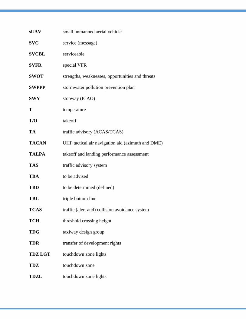
sUAV small unmanned aerial vehicle
SVC service (message)
SVCBL serviceable
SVFR special VFR
SWOT strengths, weaknesses, opportunities and threats
SWPPP stormwater pollution prevention plan
SWY stopway (ICAO)
T temperature
T/O takeoff
TA traffic advisory (ACAS/TCAS)
TACAN UHF tactical air navigation aid (azimuth and DME)
TALPA takeoff and landing performance assessment
TAS traffic advisory system
TBA to be advised
TBD to be determined (defined)
TBL triple bottom line
TCAS traffic (alert and) collision avoidance system
TCH threshold crossing height
TDG taxiway design group
TDR transfer of development rights
TDZ LGT touchdown zone lights
TDZ touchdown zone
TDZL touchdown zone lights
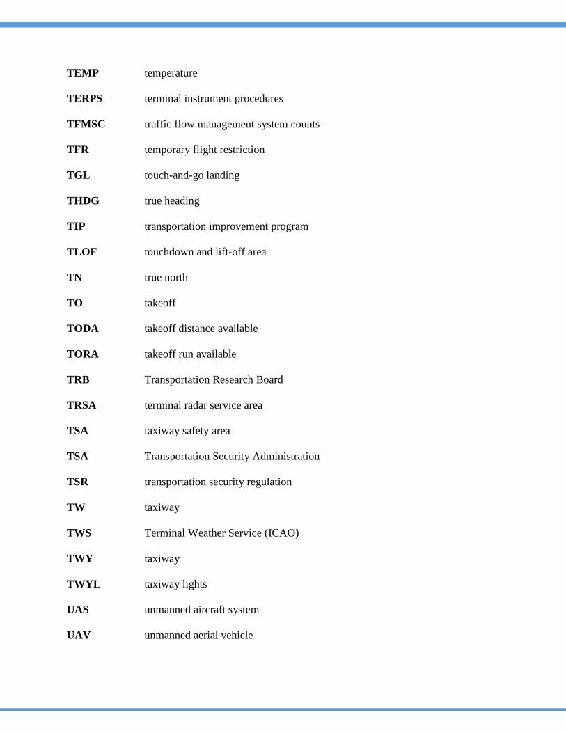
TEMP temperature
TERPS terminal instrument procedures
TFMSC traffic flow management system counts
TFR temporary flight restriction
TGL touch-and-go landing
THDG true heading
TIP transportation improvement program
TLOF touchdown and lift-off area
TN true north
TO takeoff
TODA takeoff distance available
TORA takeoff run available
TRB Transportation Research Board
TRSA terminal radar service area
TSA taxiway safety area
TSA Transportation Security Administration
TSR transportation security regulation
TW taxiway
TWS Terminal Weather Service (ICAO)
TWY taxiway
TWYL taxiway lights
UAS unmanned aircraft system
UAV unmanned aerial vehicle
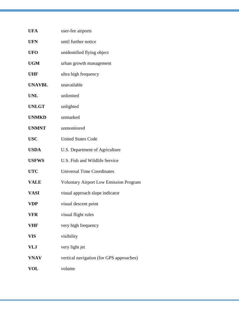
UFA user-fee airports
UFN until further notice
UFO unidentified flying object
UGM urban growth management
UHF ultra high frequency
UNAVBL unavailable
UNL unlimited
UNLGT unlighted
UNMKD unmarked
UNMNT unmonitored
USC United States Code
USDA U.S. Department of Agriculture
USFWS U.S. Fish and Wildlife Service
UTC Universal Time Coordinates
VALE Voluntary Airport Low Emission Program
VASI visual approach slope indicator
VDP visual descent point
VFR visual flight rules
VHF very high frequency
VIS visibility
VLJ very light jet
VNAV vertical navigation (for GPS approaches)
VOL volume
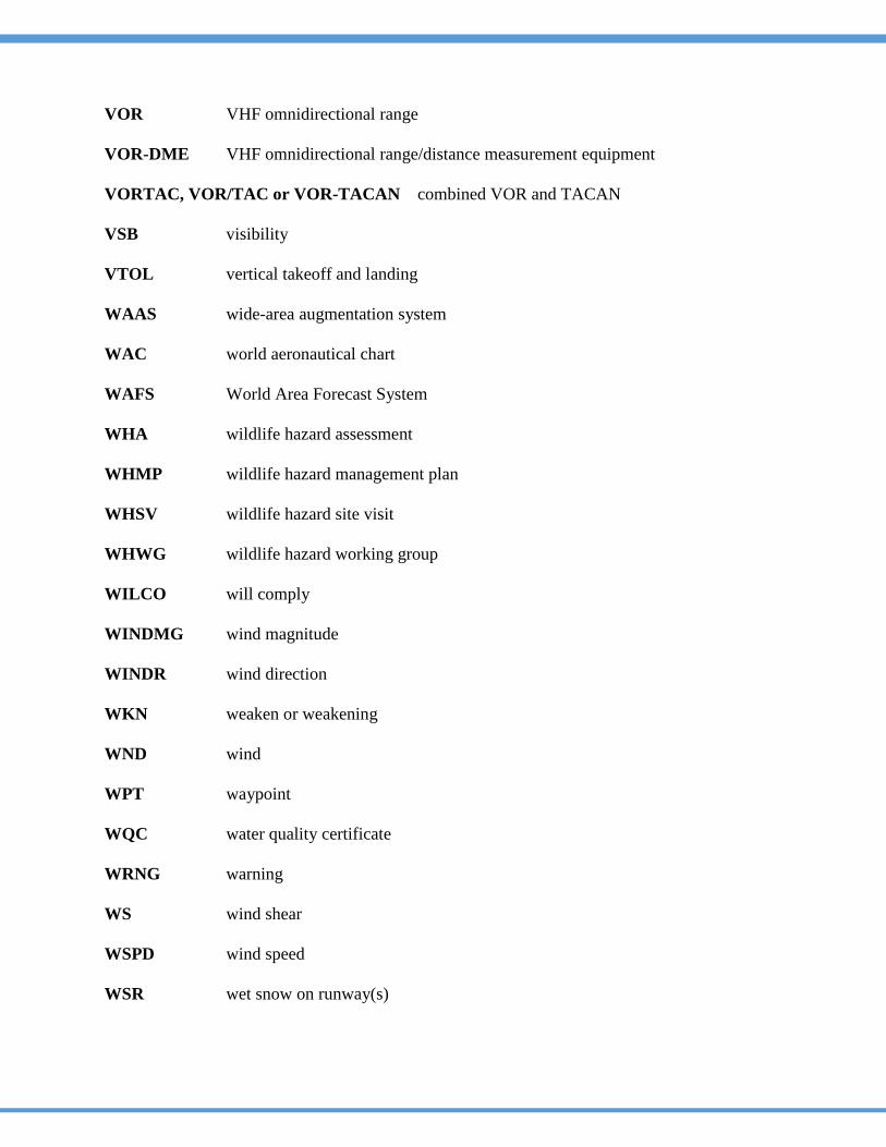
VOR VHF omnidirectional range
VOR-DME VHF omnidirectional range/distance measurement equipment
VORTAC, VOR/TAC or VOR-TACAN combined VOR and TACAN
VSB visibility
VTOL vertical takeoff and landing
WAAS wide-area augmentation system
WAC world aeronautical chart
WAFS World Area Forecast System
WHA wildlife hazard assessment
WHMP wildlife hazard management plan
WHSV wildlife hazard site visit
WHWG wildlife hazard working group
WILCO will comply
WINDMG wind magnitude
WINDR wind direction
WKN weaken or weakening
WND wind
WPT waypoint
WQC water quality certificate
WRNG warning
WS wind shear
WSPD wind speed
WSR wet snow on runway(s)
WT weight
WTR water on runway(s)
WTWS wind shear and turbulence warning system
WWW World Wide Web (Internet)
WX weather
X-BAND frequency range between 8000 and 12500 MHz
XFSS auxiliary flight service station
XMIT transmit
X-Wind crosswind
XX heavy (used to qualify weather such as rain; e.g., heavy rain = XXRA)
Z Zulu time (Greenwich Mean Time)