
Achany Windfarm, Lairg, Sutherland Underground Grid Connection … · 2018-06-19 · 3 Achany...
14
Achany Windfarm, Lairg, Sutherland Underground Grid Connection Archaeological Monitoring Catherine Dagg for ASH design+assessment 21 Gordon Street GLASGOW G1 3PL
Transcript of Achany Windfarm, Lairg, Sutherland Underground Grid Connection … · 2018-06-19 · 3 Achany...
Achany Windfarm, Lairg, Sutherland Underground Grid Connection
Archaeological Monitoring
Catherine Dagg
for
ASH design+assessment 21 Gordon Street
GLASGOW G1 3PL
2
Achany Windfarm, Lairg, Sutherland: Underground Grid Connection Archaeological Monitoring
3
Achany Windfarm, Lairg, Sutherland: Underground Grid Connection Archaeological Monitoring 1.0 Executive Summary An archaeological watching brief, carried out along three sections of the undergrounding of an electricity cable between Achany windfarm and Lairg Muir substation, revealed one minor archaeological feature in the form of a possible pit infilled with charcoal-rich soil associated with the hut circle settlement of The Cashel
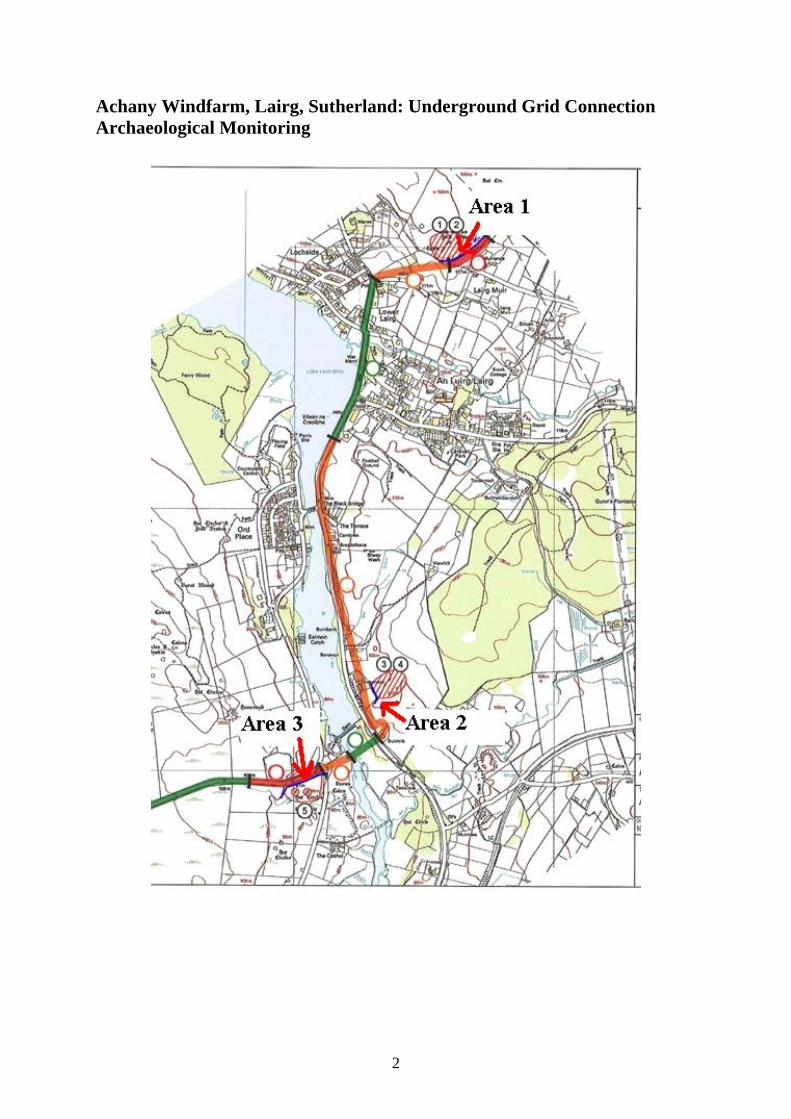
2.0 Background In April 2009 an archaeological evaluation was carried out along the proposed route of an underground cable connection between Achany windfarm at NC 5350 0250 and the Lairg Muir grid substation at NC 5875 0810. This evaluation, consisting of a desk-based evaluation and rapid walk-over survey, did not locate any new, previously unrecorded sites, but visited and evaluated the sites recorded on the Highland Historic Environment Record (HER), noting minor associated features such as field systems, and assessing the potential for sub-surface features. For the most part, the cable route runs alongside the road, where there is little likelihood of unrecorded archaeological features surviving. The evaluation highlighted three areas considered to be archaeologically sensitive and recommended a watching brief on ground breaking work associated with the insertion of the underground cable at these three locations:
1. Lairg Muir NC 5875 0810 to NC 5860 0798: Open, unimproved moorland with
heather cover, contains recorded sites 1 and 2 Potential: high
Site 1. Muirlands: kerb cairn at NC 5850 0700 HER ref MHG11996 Recorded variously as two hut circles with field clearance piles to the east and south on a prominent false crest, and as three cairns surrounded by a minor field system. Site 2. Muirlands Hut circle at NC 5856 0698 HER ref MHG9477 Recorded as a circular depression 8m from the cairn (Site no. 1) Occupying a level terrace are four circular features, visible as low grassy mounds with regular depressions standing out from the surrounding heather. These are not obviously cairns or hut circles but would appear to be contemporary with the surrounding field system. Approximately 6 conical field clearance piles and a stony bank are spaced along the edge of the terrace. Another clearance pile is at the bottom

4
of the slope above the field boundary and another possible pile is in the lower field. An old trackway, recorded on the 1st edition OS map, curves around the base of slope. (Photos 1-4) The cable route appears to run below the crest of the terrace and will therefore not directly affect any of the visible features. There remains the possibility of associated sub-surface associated features and deposits
2. Rhinamain. NC 5830 0532 Undulating, heather-covered low ground containing
recorded sites 3 and 4 Potential: low
Site 3. Rhinamain Hut Circle at NC 5838 0530 HER ref MHG11510 Recorded as on a knoll with, along a ridge to the SW, 5-6 field clearance piles Site 4 Rhinamain , possible cairn at NC 5838 0525 HER ref. MHG11843 Recorded as a circular stony mound on a ridge The hut circle occupies a separate knoll to the NE, while the field clearance piles appear to arrange in two rows, one on the top of the ridge consisting of four low heather covered mounds and at the base of slope to the north a row of three more. Immediately to the west of these runs a recently inserted water main (Photos 5-7) The cable route, originally planned to be adjacent to the water main, now follows the field boundary to the west, skirting round the property adjacent to the road. While no visible features of this settlement will be affected, there remains the low possibility of associated sub-surface associated features and deposits
3. The Cashel, Enclosed land from NC 5612 0598 to NC 5776 0594 Improved grazing although not ploughed, possibly an apportionment. Includes a large, probably glacial mound. Contains recorded site 5. Potential: high
Site 5.The Cashel: Two Hut circles and field system at NC 5800 0490 HER ref, MHG12205, MHG33747 and MHG33746 Recorded as two hut circles, at NC 5801 0491 and NC 5805 0491 and a dozen field clearance piles The hut circles are prominent grass-covered structures occupying level ground to the west of the road junction. These are marked on the 1st edition OS map, with the field system shown as being to the SE, but there are also field clearance piles and possible field boundary rickles to the north, adjacent to the embankment of the road. Some of these may be contemporary with what appears to be a truncated early modern enclosure north of the road but it is most likely that this ground was under cultivation during both time periods. The cable route curves south away from the road to skirt a large, prominent natural knoll and therefore crosses the area of field clearance piles and stony rickles.
5
The evaluation concluded: Sites 1,2,3,4,5, although not directly on the route of the cable, all have minor associated features which may be affected and the surrounding area of each site has the potential for sub-surface features or deposits which may be damaged or destroyed during ground breaking work. An archaeological watching brief during excavation along the sections passing these sites will allow any such features or deposits to be quickly identified, evaluated and recorded while minimising delay to the project. A watching brief was therefore recommended for these three locations: (see separate plan) Area 1: NC 5875 0710 to NC 5860 0698: The entire section between the boundary with the present sub-station and the point at which the ground drops away steeply to the west. Although the cable route is over the brow of the hill from the built structures, there remains the possibility of washed down deposits, midden material etc Area 2. NC 5830 0532: running adjacent to the west boundary of the roadside property. This is the least likely to produce archaeological results as the amended route is some distance from the nearest cairn, but precautionary monitoring is still advisable. Area 3. NC 5810 0500 to NC 5794 0494, from where the cable route skirts round to the west of the large glacial mound to the B864 road crossing, running parallel to the fence and passing through an area of rickles and field clearance contemporary with the adjacent hut circles. Monitoring here will allow the investigation of possible buried ground surfaces under the field clearance. There is also the possibility of contemporary storage pits and foundations.
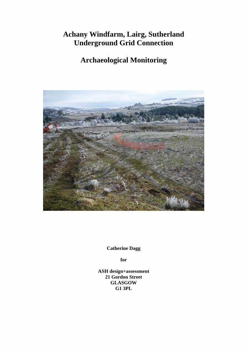
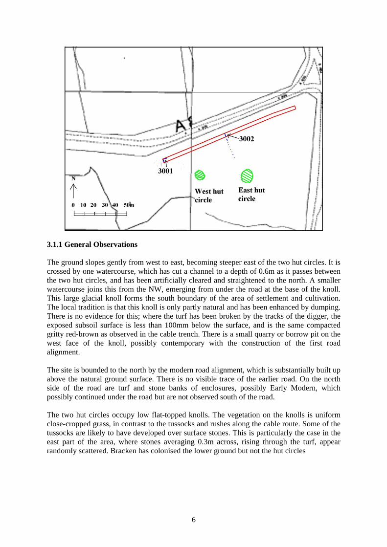
3.0 Watching Brief 3.1 Area 3 This watching brief was carried out on 19.2.10 in cold but dry and clear weather conditions. In advance of any work in the vicinity of the archaeological features, these were fenced off to prevent accidental damage. The precise route of the cable trench was agreed on site to maximise the distance from the hut circles, and the method of laying the cable was changed from ploughing, which would have damaged any sub-surface features but not exposed them for evaluation, to open-trench excavation to allow features to be investigated and recorded. A section 100m in length , aligned ENE-WSW and with a minimum width of 1m at the base was covered by the watching brief.
6
3.1.1 General Observations The ground slopes gently from west to east, becoming steeper east of the two hut circles. It is crossed by one watercourse, which has cut a channel to a depth of 0.6m as it passes between the two hut circles, and has been artificially cleared and straightened to the north. A smaller watercourse joins this from the NW, emerging from under the road at the base of the knoll. This large glacial knoll forms the south boundary of the area of settlement and cultivation. The local tradition is that this knoll is only partly natural and has been enhanced by dumping. There is no evidence for this; where the turf has been broken by the tracks of the digger, the exposed subsoil surface is less than 100mm below the surface, and is the same compacted gritty red-brown as observed in the cable trench. There is a small quarry or borrow pit on the west face of the knoll, possibly contemporary with the construction of the first road alignment. The site is bounded to the north by the modern road alignment, which is substantially built up above the natural ground surface. There is no visible trace of the earlier road. On the north side of the road are turf and stone banks of enclosures, possibly Early Modern, which possibly continued under the road but are not observed south of the road. The two hut circles occupy low flat-topped knolls. The vegetation on the knolls is uniform close-cropped grass, in contrast to the tussocks and rushes along the cable route. Some of the tussocks are likely to have developed over surface stones. This is particularly the case in the east part of the area, where stones averaging 0.3m across, rising through the turf, appear randomly scattered. Bracken has colonised the lower ground but not the hut circles
7
3.1.2 Stratigraphy The following natural stratigraphy was noted in the trench sections:
No. Type Description Depth Location 1 Topsoil Dark brown gritty loam containing
bracken roots, matrix to mid-sized stones
100-200mm
Across entire trench
2 Soil Black, containing charcoal, decayed granite
300-500mm
West end of trench, at base of lope of knoll
3 Peat Mid-brown fine-fibred peat containing small quantity of probable birch wood
750mm Shelving down from east end of knoll, terminating at main watercourse
4 Subsoil a.
Compacted, orange, gritty and stony Knoll and east of main watercourse
5 Subsoil b.
Soft, fine-particled grey and silty Under peat
The peat deposit, covering 35m NE-SW between the base of the knoll and the main watercourse crossing the cable route, probably represents deposits laid down by water trapped by poor drainage until the enhancement of the watercourse. There appeared to be no original ground surface between the peat and the subsoil and this may have been waterlogged ground at the time of prehistoric settlement. A small amount of wood, likely to be birch, was recovered from the peat but this did not form a layer which might represent felling and ground clearance. The black soil, no. 2, was present only at the base of slope of the knoll and appears, from examination of eroded faces on the knoll, not to have extended up the knoll face. It formed a deposit between the topsoil, 1. and the subsoil surface, 4. This layer was a maximum of 200mm deep at the NE end, its surface being approximately horizontal, and extended 2m from the SW end of the trench. This soil also formed the fill of archaeological feature 3001, located 200mm to the NE of the end of the layer. Wet sieving of samples of this soil taken from both the layer and feature 3001 produced identical results. The soil contained significant quantities of small particles of charcoal, the largest being 5mm in diameter. The soil also contained probably natural inclusions of grains of decayed granite. 3.1.3 Archaeological Features Two possible features were noted in this section of trench:

8
Feature no.
Type Description Dimensions Location
3001 Pit (possible) Shallow cut into subsoil (4) infilled with black soil (2)
1.5m wide at top 300mm deep at centre
Observed in SE-facing section only, 2.3m from SW end of trench
3002 Stone setting Linear accumulation of medium-sized stones, aligned NW-SE
Full width of trench Spread to 0.5m NE-SW
NW of centre point of east hut circle
The shallow cut infilled with black soil, 3001, may be the infilling of a natural depression with the same deposit as is spread across 2m immediately to the SW. However, it appears to be sealed by a layer of loose subsoil (4) suggesting that this was re-deposited to seal the infilled cut. This suggests a deliberately dug pit. There is no evidence for an actual hearth within the cut, but this may be located within the undisturbed part of the pit north of the trench. The soil fill included a number of possibly deliberately placed stones on the NE side of the pit, but these are all decayed granite and no deliberate placement can now be observed. However, the stones do appear to be clustered at the NE side of the pit, and may be the remains of a hearth surround.
South facing section of west end of trench: Feature 3001, possible pit
9
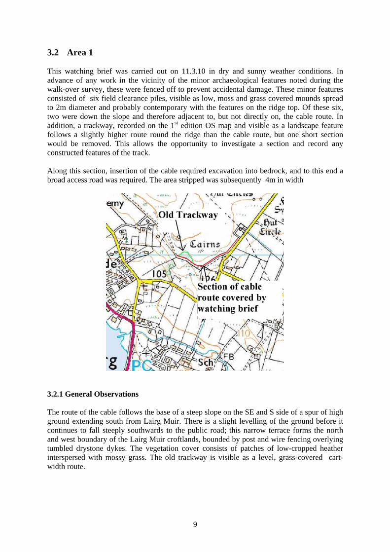
3.2 Area 1 This watching brief was carried out on 11.3.10 in dry and sunny weather conditions. In advance of any work in the vicinity of the minor archaeological features noted during the walk-over survey, these were fenced off to prevent accidental damage. These minor features consisted of six field clearance piles, visible as low, moss and grass covered mounds spread to 2m diameter and probably contemporary with the features on the ridge top. Of these six, two were down the slope and therefore adjacent to, but not directly on, the cable route. In addition, a trackway, recorded on the 1st edition OS map and visible as a landscape feature follows a slightly higher route round the ridge than the cable route, but one short section would be removed. This allows the opportunity to investigate a section and record any constructed features of the track. Along this section, insertion of the cable required excavation into bedrock, and to this end a broad access road was required. The area stripped was subsequently 4m in width
3.2.1 General Observations The route of the cable follows the base of a steep slope on the SE and S side of a spur of high ground extending south from Lairg Muir. There is a slight levelling of the ground before it continues to fall steeply southwards to the public road; this narrow terrace forms the north and west boundary of the Lairg Muir croftlands, bounded by post and wire fencing overlying tumbled drystone dykes. The vegetation cover consists of patches of low-cropped heather interspersed with mossy grass. The old trackway is visible as a level, grass-covered cart-width route.
10
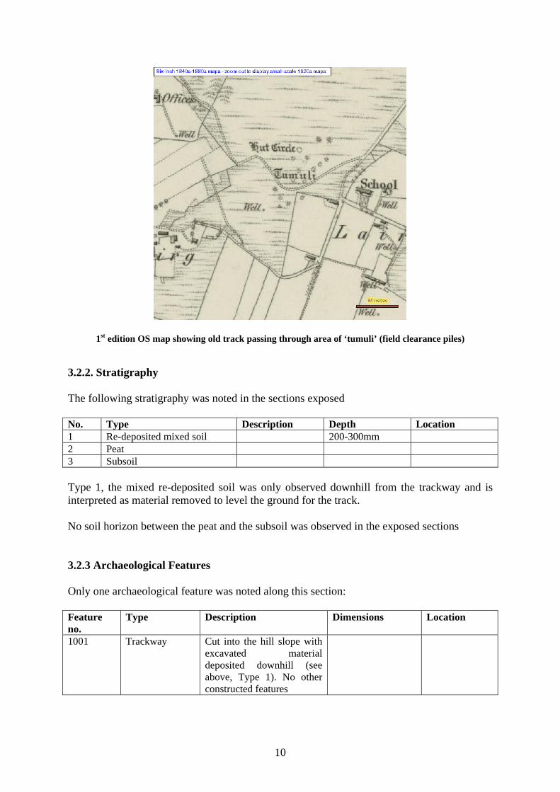
1st edition OS map showing old track passing through area of ‘tumuli’ (field clearance piles)
3.2.2. Stratigraphy The following stratigraphy was noted in the sections exposed No. Type Description Depth Location 1 Re-deposited mixed soil 200-300mm 2 Peat 3 Subsoil Type 1, the mixed re-deposited soil was only observed downhill from the trackway and is interpreted as material removed to level the ground for the track. No soil horizon between the peat and the subsoil was observed in the exposed sections 3.2.3 Archaeological Features Only one archaeological feature was noted along this section: Feature no.
Type Description Dimensions Location
1001 Trackway Cut into the hill slope with excavated material deposited downhill (see above, Type 1). No other constructed features
11
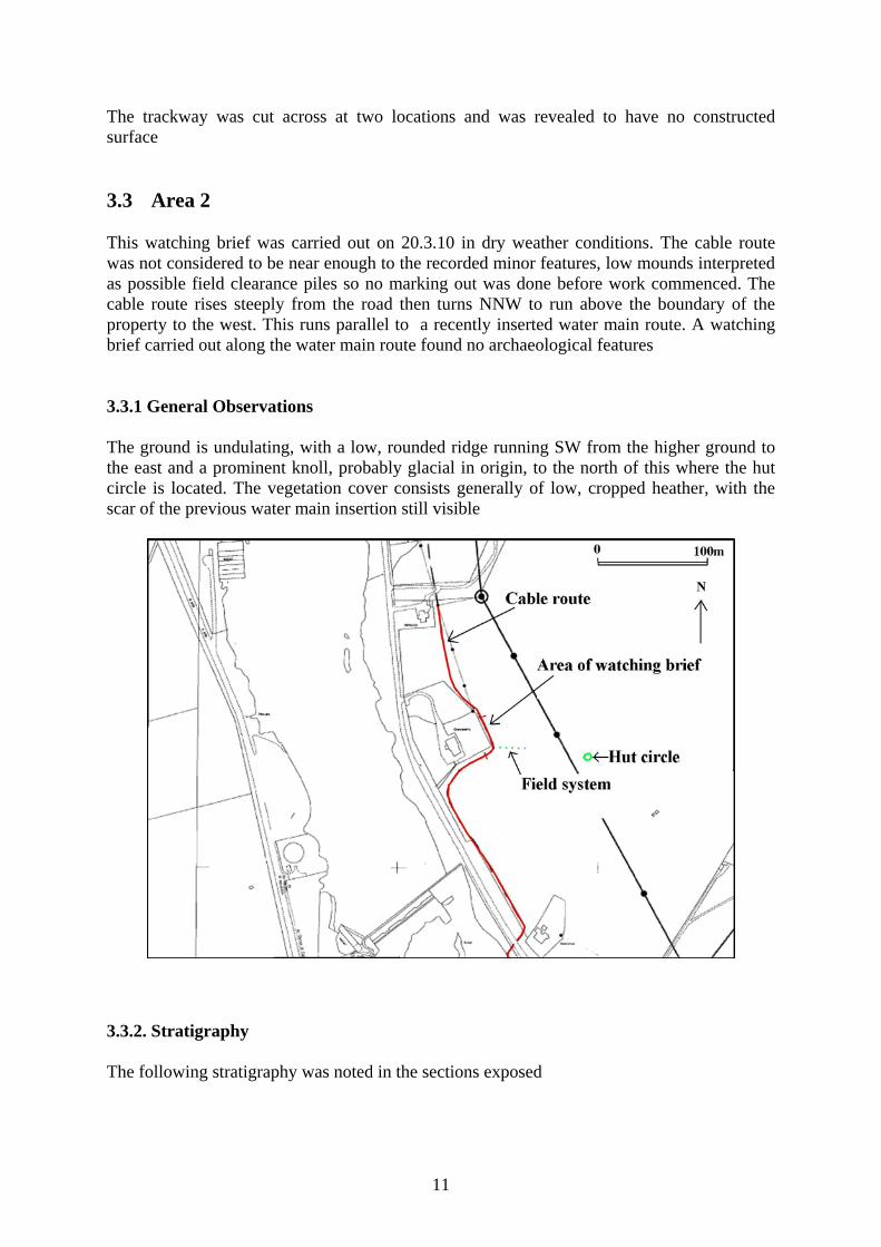
The trackway was cut across at two locations and was revealed to have no constructed surface 3.3 Area 2
This watching brief was carried out on 20.3.10 in dry weather conditions. The cable route was not considered to be near enough to the recorded minor features, low mounds interpreted as possible field clearance piles so no marking out was done before work commenced. The cable route rises steeply from the road then turns NNW to run above the boundary of the property to the west. This runs parallel to a recently inserted water main route. A watching brief carried out along the water main route found no archaeological features 3.3.1 General Observations The ground is undulating, with a low, rounded ridge running SW from the higher ground to the east and a prominent knoll, probably glacial in origin, to the north of this where the hut circle is located. The vegetation cover consists generally of low, cropped heather, with the scar of the previous water main insertion still visible
3.3.2. Stratigraphy The following stratigraphy was noted in the sections exposed

12
No. Type Description Depth Location 1 Peat Shallow,
fibrous, red-brown
150-200mm All exposed areas
2 Subsoil Compacted, pale yellow-grey gravel rich sand
All exposed areas
3.3.3. Archaeological Features No archaeological features were observed along this section. 4.0 Conclusions One new feature of archaeological interest was located and recorded during the three watching briefs. This is the possible pit in Area 3, the full extent of which is unknown and survives undisturbed for further archaeological investigation if required. Its location and nature do suggest an association with the hut circles. The conclusion of the evaluation is that good design of the cable route, informed by an initial archaeological survey, has minimised the impact on the archaeological record Catherine Dagg, BA, AIfA 20.10.10 Appendix 1. Environmental Samples One sample was retained from feature 3001, possible pit: soil type 2, charcoal rich black soil fill of possible pit. The charcoal content of this was investigated but no single entity suitable for C14 dating was evident. The charcoal fragments were no more than 5mm in diameter and therefore unlikely to be identifiable by species. They have, however, been retained Appendix 2. Photographic record (digital) Photo no.
Area no.
Feature Description Viewpoint
1 3 general View of site and route of cable trench before work commenced. Route of trench is through area of rushes to left, hut circles are on right
From W
2 3 general View of two hut circles. Route of trench is out of picture to left
From W
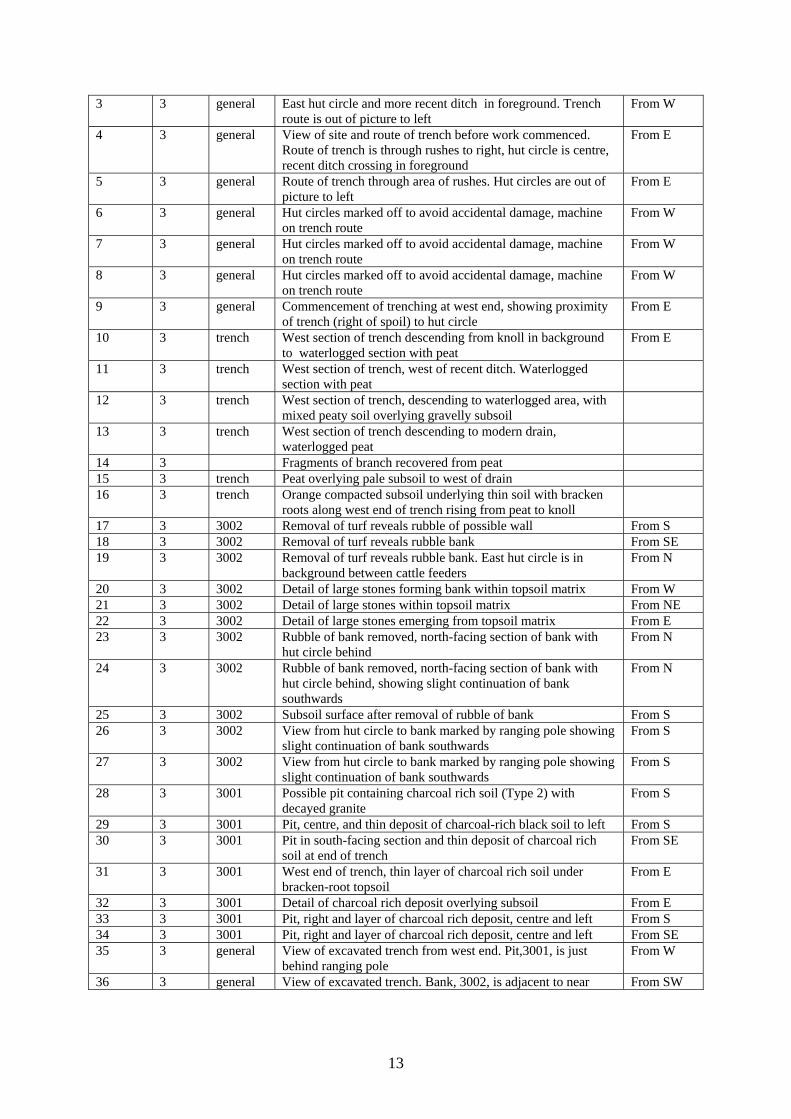
13
3 3 general East hut circle and more recent ditch in foreground. Trench route is out of picture to left
From W
4 3 general View of site and route of trench before work commenced. Route of trench is through rushes to right, hut circle is centre, recent ditch crossing in foreground
From E
5 3 general Route of trench through area of rushes. Hut circles are out of picture to left
From E
6 3 general Hut circles marked off to avoid accidental damage, machine on trench route
From W
7 3 general Hut circles marked off to avoid accidental damage, machine on trench route
From W
8 3 general Hut circles marked off to avoid accidental damage, machine on trench route
From W
9 3 general Commencement of trenching at west end, showing proximity of trench (right of spoil) to hut circle
From E
10 3 trench West section of trench descending from knoll in background to waterlogged section with peat
From E
11 3 trench West section of trench, west of recent ditch. Waterlogged section with peat
12 3 trench West section of trench, descending to waterlogged area, with mixed peaty soil overlying gravelly subsoil
13 3 trench West section of trench descending to modern drain, waterlogged peat
14 3 Fragments of branch recovered from peat 15 3 trench Peat overlying pale subsoil to west of drain 16 3 trench Orange compacted subsoil underlying thin soil with bracken
roots along west end of trench rising from peat to knoll
17 3 3002 Removal of turf reveals rubble of possible wall From S 18 3 3002 Removal of turf reveals rubble bank From SE 19 3 3002 Removal of turf reveals rubble bank. East hut circle is in
background between cattle feeders From N
20 3 3002 Detail of large stones forming bank within topsoil matrix From W 21 3 3002 Detail of large stones within topsoil matrix From NE 22 3 3002 Detail of large stones emerging from topsoil matrix From E 23 3 3002 Rubble of bank removed, north-facing section of bank with
hut circle behind From N
24 3 3002 Rubble of bank removed, north-facing section of bank with hut circle behind, showing slight continuation of bank southwards
From N
25 3 3002 Subsoil surface after removal of rubble of bank From S 26 3 3002 View from hut circle to bank marked by ranging pole showing
slight continuation of bank southwards From S
27 3 3002 View from hut circle to bank marked by ranging pole showing slight continuation of bank southwards
From S
28 3 3001 Possible pit containing charcoal rich soil (Type 2) with decayed granite
From S
29 3 3001 Pit, centre, and thin deposit of charcoal-rich black soil to left From S 30 3 3001 Pit in south-facing section and thin deposit of charcoal rich
soil at end of trench From SE
31 3 3001 West end of trench, thin layer of charcoal rich soil under bracken-root topsoil
From E
32 3 3001 Detail of charcoal rich deposit overlying subsoil From E 33 3 3001 Pit, right and layer of charcoal rich deposit, centre and left From S 34 3 3001 Pit, right and layer of charcoal rich deposit, centre and left From SE 35 3 general View of excavated trench from west end. Pit,3001, is just
behind ranging pole From W
36 3 general View of excavated trench. Bank, 3002, is adjacent to near From SW
14
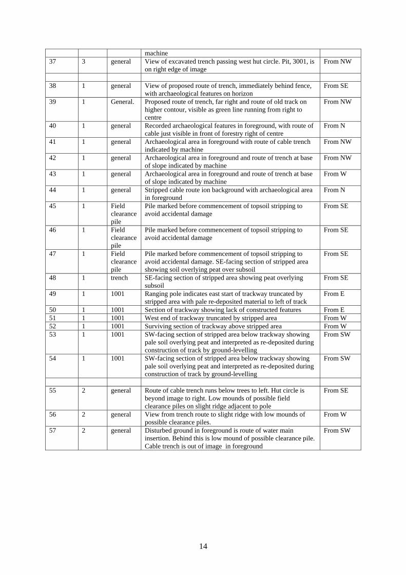
machine 37 3 general View of excavated trench passing west hut circle. Pit, 3001, is
on right edge of image From NW
38 1 general View of proposed route of trench, immediately behind fence,
with archaeological features on horizon From SE
39 1 General. Proposed route of trench, far right and route of old track on higher contour, visible as green line running from right to centre
From NW
40 1 general Recorded archaeological features in foreground, with route of cable just visible in front of forestry right of centre
From N
41 1 general Archaeological area in foreground with route of cable trench indicated by machine
From NW
42 1 general Archaeological area in foreground and route of trench at base of slope indicated by machine
From NW
43 1 general Archaeological area in foreground and route of trench at base of slope indicated by machine
From W
44 1 general Stripped cable route ion background with archaeological area in foreground
From N
45 1 Field clearance pile
Pile marked before commencement of topsoil stripping to avoid accidental damage
From SE
46 1 Field clearance pile
Pile marked before commencement of topsoil stripping to avoid accidental damage
From SE
47 1 Field clearance pile
Pile marked before commencement of topsoil stripping to avoid accidental damage. SE-facing section of stripped area showing soil overlying peat over subsoil
From SE
48 1 trench SE-facing section of stripped area showing peat overlying subsoil
From SE
49 1 1001 Ranging pole indicates east start of trackway truncated by stripped area with pale re-deposited material to left of track
From E
50 1 1001 Section of trackway showing lack of constructed features From E 51 1 1001 West end of trackway truncated by stripped area From W 52 1 1001 Surviving section of trackway above stripped area From W 53 1 1001 SW-facing section of stripped area below trackway showing
pale soil overlying peat and interpreted as re-deposited during construction of track by ground-levelling
From SW
54 1 1001 SW-facing section of stripped area below trackway showing pale soil overlying peat and interpreted as re-deposited during construction of track by ground-levelling
From SW
55 2 general Route of cable trench runs below trees to left. Hut circle is
beyond image to right. Low mounds of possible field clearance piles on slight ridge adjacent to pole
From SE
56 2 general View from trench route to slight ridge with low mounds of possible clearance piles.
From W
57 2 general Disturbed ground in foreground is route of water main insertion. Behind this is low mound of possible clearance pile. Cable trench is out of image in foreground
From SW