GE 11a, 2014, Lecture 1 Time, stratigraphy and relative dating.

Abstracts Volume
FORCE: Predictive Biostratigraphy Wednesday September 27th and Thursday September 28th 2017


Day 1 Wednesday 27th September 2017
Hall Toll

Strategies in stratigraphic prediction Felix M. Gradstein, University of Oslo, Norway and SEES, Portsmouth, UK
Simple, fast and well understood strategies exist to:
A. Predict the stratigraphic order of local microfossil events in the next well to be drilled.
B. Rank the stratigraphic fidelity (non-cross-over) of local events in a multi-well correlation
framework.
C. Solve the issue that conventional zonations do not rank the degree of
mismatch (diachroneity) of microfossil range endpoints in a correlation scheme.
Five large, carefully assembled data sets of nannofossils, benthic and planktonic foraminifera and
dinoflagelates in groups of between 15 and 30 wells from the Gulf of Mexico, onshore Louisiana and
offshore Norway were analysed for quality in stratigraphic prediction. Figure 1 shows the simple
features utilized.
Between 60 and 75% of microfossils could be classified as reliable markers in zonation and
correlation. ‘Bad’ events were grouped in those with often too low tops or often too high bases. The
Louisiana zonation improved resolution and chronostratigraphic calibration of an existing local
consultant zonal scheme.
Figure1. Stratigraphic properties of microfossil events and ranges in 8 wells or outcrop sections.

The Mississippian palynological assemblages in Spitsbergen and its
correlation with Finnmark Platform, Barents Sea
Lopes, Gilda.1, Clayton, G.2, Mangerud, G.1
1University of Bergen, Department of Earth Science, PO Box 7803, N-5020 Bergen, Norway;
[email protected], [email protected] 2Department of Animal and Plant Sciences, University of Sheffield, Sheffield S10 2TN, UK;
Keywords: Palynomorphs; Viséan; Billefjorden Group; Svalbard
The geology of Svalbard has been the subject of many studies since the last part of the nineteenth
century due to scientific, as well as economic interests. The study of the Svalbard sections is crucial
as an analogue for the offshore Barents Sea successions including the depositional environments and
the source rock- and reservoir characteristics. This work provides important data to improve the
regional correlation and dating based on the new palynological zonation developed for Finnmark
Platform (Lopes et al., 2016; Lopes et al., submitted). The palynological study of an outcrop section
in the Birger Johnsonfjellet area, from the inner part of Billefjorden, near the abandoned Russian
settlement of Pyramiden. Spitsbergen, was therefore studied and correlated with the material from the
Finnmark Platform. Thirty-eight samples were collected and analysed from the ca. 260 m of
continental, siliciclastic rocks comprising the Hørbyebreen and Mumien formations. The
palynological assemblages comprises abundant, moderately preserved palynomorphs and are more
diverse than those described by Playford (62/63) from the same area, indicating that more productive
levels can be found in the various sections. The assemblages seem no younger than late Viséan. The
comparative aspect and correlation of the two areas will be presented.

Late Triassic (late Carnian – Rhaetian) megaspores and associated
palynofloras of the Kapp Toscana Group on Hopen, Svalbard
Archipelago
Niall W. Paterson 1 *, Peter H. Morris 2 & Gunn Mangerud 1
1 Department of Earth Science, University of Bergen, Allégaten 41, 5020 Bergen, Norway
2 Microstrat Services, Southcott, Buckland Brewer, Bideford, Devon EX39 5LU, UK
* Corresponding author (e-mail: [email protected])
The island of Hopen represents an excellent stratigraphic reference locality for the Upper Triassic
succession in the Barents Sea area. The island is located in the southeastern-most corner of Svalbard
and is composed entirely of Upper Triassic strata of the Kapp Toscana Group, including in ascending
stratigraphic order, the De Geerdalen, Flatsalen and Svenskøya formations. The sedimentology and
palynostratigraphy of Hopen has been well documented by previous studies, with the latter correlated
to regional zones and calibrated by an early Norian ammonoid fauna from the Flatsalen Formation. In
contrast, there is very little documentation of Triassic megaspores in the region, with the only
published account restricted to specimens recovered from a single ex situ sample discovered on the
SW coast of the island. Despite its vague provenance, this sample has been extensively described by
previous authors, yielding a single megaspore taxon, Triletes hopeniensis, in association with
autochthonous roots and stems of bennettitaleans and lycopsids, and the parautochthonous leaves,
sporangia, spores and pollen of pteridophytes and gymnosperms.
The present study aims to document the stratigraphical distribution of megaspores through the Upper
Triassic succession on Hopen using in situ samples, and to integrate this with the existing
palynological, palaeobotanical and micropalaeontological data. Megaspore assemblages from the De
Geerdalen Formation were dominated mainly by Dijkstraisporites beutleri and Echitriletes spp., with
localised influxes of Nathorstisporites aff. hopliticus. Such assemblages correspond with the
dominance of the fern spore Leschikisporis aduncus and the sphenopsid Calamospora tener in
palynological preparations. The micro-biofacies evidence from the formation is generally consistent
with the previously inferred fluvio-deltaic palaeoenvironment. However, the intermittent presence of
marine elements, including agglutinated foraminifera and sponge spicules, may be indicative of
shallow marine or prodeltaic deposition, therefore suggesting a greater variation in palaeoenvironment
than was previously supposed. Megaspores were notably absent in assemblages from the uppermost
De Geerdalen Formation (Hopen Member) and the overlying Flatsalen Formation. The latter were
found to be dominated by agglutinated foraminifera, and support previous interpretations of a shallow
marine depositional environment, as indicated by the dominance of the dinoflagellate cyst
Rhaetogonyaulax rhaetica. A marked change in the micro-biofacies was observed within the overlying
Svenskøya Formation, including an increase in phytoclasts and the super-abundant occurrence of
megaspores including Dijkstraisporites beutleri, Verrutriletes preutilis and V. utilis. This corresponds
to the dominance of fern spores in palynological preparations, similar to the association noted in the
De Geerdalen Formation. Collectively, the micro-biofacies evidence is considered as indicative of a
delta-plain peat-mire environment, and is generally consistent with earlier interpretations.

The results of this investigation complement the previous palynological and palynofacies analyses,
and contribute to a growing understanding of the palaeoenvironments in the region during the Late
Triassic. This study provides the first in situ record of Triassic megaspores on Svalbard and therefore
offers important new data concerning the Triassic plant communities of the northern Pangaea.

Integrated Early Triassic silici‐clastic palynostratigraphy and XRF
analysis of the Alta‐Gohta wells on the Loppa High, Barents Sea
Marianne Ask, Applied Petroleum Technology (APT)*
Ingar Throndsen, Lundin Norway*
Emails: [email protected] and Ingar.Throndsen@lundin‐norway.no
The Gohta and Alta discoveries in PL492 and PL609 on the southern part of the Loppa High in the
Barents Sea were made by Lundin Norway in 2013 (7120/1‐3) and 2014 (7220/11‐1) respectively.
The reservoirs consist of Triassic silici‐clastics ('Permo‐Triassic' conglomerate), Permian karstified
carbonate deposits (Ørn Fm.) and mixed carbonates and silici‐clastics of Carboniferous age (Falk
Fm.).
They are formed as a result of uplift, tilting, erosion and karstification of pre‐ Triassic rocks followed
by irregular infill and transgressive onlap of Triassic silici‐clastic deposits.
Dating of the reservoir deposits above the Base Triassic unconformity is difficult as they have
different sources (some carbonate, some silici‐clastic and some combinations). They have different
sediment directions and some probably represent isolated sub basins while others represent
amalgamated fan deltas.
The source of sediment of these conglomeratic deposits is partly Permian and Carboniferous
carbonates (Ørn and Falk Formations) which are partly karstified with caves filled in by younger
material, silici‐clastics of the Falk Formation, partly Lower Paleozoic sandstones (Ugle and Billefjord
Gp.) and basement.
The 'status' of the fossils (in situ, reworked, reworked cave fill) and the type of fossils all has to be
taken into consideration when interpreting the fossil data. Is there any pattern that might help to
distinguish or subdivide the conglomeratic deposit?
Micropaleontology, palynology and XRF analyses have been carried out. Sampling is critical and to
achieve as reliable dating as possible and be able to solve the in situ versus reworking status of the
fossils it is important to know what lithology your samples come from.
A palynostratigraphic zonation of the lower part of the Triassic (Kobbe, Klappmyss, Havert
Formations and the' Permo‐Triassic' conglomerate) and correlation between selected wells will be
presented together with photographs of typical palynological assemblages.

Integrated automated mineralogical (QEMSCAN) analysis and
biostratigraphic study of the Permo‐Carboniferous sequences
on the Loppa High, Barents Sea
Jawad Afzal 1 *, Dean Rigby 1 *, Barbara Rich1 and Mike Charnock2
1 Robertson, Llandudno, North Wales LL30 1SA, United Kingdom
2 Lundin Norway, Strandveien 4, PO Box 247, N‐1326 Norway
Emails (*presenters): [email protected] and [email protected]
Automated mineralogical (QEMSCAN) analyses and micropalaeontological studies of the same thin
sections (T/S) together with selective palynological analyses have proved invaluable in
understanding the pre‐Triassic sequences of Lundin Norway's recent oil discoveries (Alta, Gohta and
Neiden) on the Loppa High, Barents Sea, in terms of age, facies and reservoir quality.
The Permo‐Triassic (P‐Tr) boundary on the Loppa High is an angular unconformity and the underlying
strata dip at an angle of approximately 12°, whereas the overlying Triassic is a near‐horizontalsequence. Below the P‐Tr unconformity, the units that subcrop a complex basal
conglomerate vary in a broadly west to east pattern. Metamorphosed 'Basement' in the west and north
e.g. 7220/11‐2 (Alta) gives way to Carboniferous ‐ Lower Permian Gipsdalen Group, consisting of
either predominantly mixed silici‐clastics and carbonates (e.g. Falk Formation) in e.g. 7220/11‐1 (Alta
Discovery well) or predominantly thick carbonates (e.g. Ørn Formation) in e.g. 7220/11‐3, and then
to the Bjarmeland Group and more siliceous Upper Permian Tempelfjorden Group in e.g. 7120/1‐3
(Gohta) in the south and east, where the P‐Tr unconformity passes laterally into a correlatable
conformity off‐structure and eastwards over large areas of the Barents Sea e.g. 7130/4‐1 (Ørnen).
Significantly, on the Loppa High, in the area of these discoveries, all the above‐named units may lie
within the oil zone, i.e. above the oil‐water contact (OWC), so an understanding of the stratigraphic
relationships, reservoir characteristics and potential of each unit is very important.
'Hotshot' QEMSCAN analyses of core chips, sent directly from the rig, or core rounds (prior to
conventional slabbing) provided an important 'heads up', allowing the sub‐unconformity geology to
be deduced. This permitted real‐time determination of the optimum placement of sidetracks during
the G & G decision‐making process, prior to detailed studies of the cores being performed.
The study area is characterised by a complex sub‐surface geology, where karst features are
developed within the carbonates. The apparent ‘conflicts’ between host Permian carbonate
microfacies and 'contradictory' Triassic palynomorphs sourced from karst infill units have been
resolved, giving meaningful data to deduce the geology. Within the Ørn carbonates are a series of
micro‐biofacies that have been deduced from the thin section analyses that suggest both vertical
and lateral palaeoenvironmental trends and positions relative to the main reef builders: bryozoans
and Palaeoaplysina. Superimposed on the complex geology are Permo‐Carboniferous climatic and
sea level changes, and rapid lateral microfacies changes of extinct biotic groups, such as the fusulinid
foraminifera. With theworld suffering 90% mass extinction at the end of the Permian, this gives a
geological ‘puzzle' as challenging as the most difficult cryptic crossword or murder mystery 'who‐dunnit'!
Acknowledgements
This paper is based on ongoing project work related to the Gohta (Pl492) and Alta (Pl609) field
appraisal programme by Lundin Norway and their respective licence partners.
Lundin Norway and Robertson CGG are thanked for permission to publish results and data from
selected released wells.

The evolution of the Triassic bivalve Daonella into Halobia in the
Botneheia Formation of Svalbard, a sedimentological and
palaeoenvironmental interpretation.
Nina Bakke Norwegian University of Science and Technology (NTNU), Trondheim
Email address: [email protected]
The Svalbard Triassic succession represents an uplifted section of a broad epicontinental shelf at the
north-eastern margin of Pangea. The Botneheia Fm. of the Middle Triassic is an carbon-rich
bituminous shale, which records a second order transgressive−regressive cycle. The deterioration of
oxygen levels in the bottom waters of the open shelf environment and widespread preservation of
organic material, makes the Botneheia Fm. an important source rock in the region, containing up to
12 % organic carbon.
The anoxic/oxic bottom environment switching events that occurred during the deposition of the
uppermost part of the Botneheia Fm., the Blanknuten Mb., are reflected in the marine fauna; abrupt
mass mortality events are represented by marine reptilian bone fragments hosted in coquina shell beds,
dominated by the bivalve Daonella. These events are closely followed by periods of oxygenated
waters, a flourishing Thalassinoides tracefossil assemblage interbedded with thin fossil-free
laminations.
Daonella were remarkably widely distributed across the Tethys, Panthalassa and Boreal regions and
therefore serve as an excellent index fossils. The evolution of Daonella into Halobia, marking the
Ladinian-Carnian boundary is well documented however the systematics are incoherent. In addition
to this, the mode of life for the Daonella is still disputed. They have been interpreted as
pseudoplanktonic, nektonic and epibenthic chemosymbionts, amongst several other theories.
Detailed field observations and measurements of the Botneheia Fm. were collected by the author in
2015 and 2016 as a part of the Svalbard Triassic Research Group, a cooperation between NTNU and
UNIS. A total of 18 sections in central and eastern Svalbard were logged and sampled for fossil
content. Numerous samples of different species of the bivalve Daonella where taken throughout each
section, as well as other fossils, including ammonoids.
Fossil material from the 2015/2016 field season has helped to refine the halobiid biostratigraphical
scheme on Svalbard and suggests a reclining epibenthic mode of life on soft, soupy sediments, in oxic
to dysoxic milieus. Samples of Daonella collected for this study have been compared to images of
holotypes and identified specimens from various museum collections. Species identification and age
estimates have contributed to a better understanding of facies dependence and shed light on the causes
for change in paleoenvironment within the Botneheia Fm. Unidirectional orientation in Daonella
indicates the presence of currents on the sea floor which is in support of the theory of a Triassic
upwelling zone along the north-eastern shelf edge of Pangea during the Middle Triassic.

Interregional correlation of the Late Jurassic–Early Cretaceous
Kimmeridge Clay Formation: an integrated approach (bio-, cyclo- and
chemostratigraphy) and palaeoclimatic implications
Holly E. Turner1*, Andy Gale1, Felix Gradstein2 and Sietske Batenburg3
1School of Earth and Environmental Sciences, University of Portsmouth, UK.
2Natural History Museum, University of Oslo, Norway.
3University of Oxford, Department of Earth Sciences, Oxford, UK
*Corresponding author and presenter: [email protected]
The latest Jurassic–Early Cretaceous interval was characterised by a number of carbon cycle
perturbations. The simultaneous occurrence of these events offer precise tie-points in
chemostratigraphic correlation across broad distances, however, their temporal and geographic extent
are poorly understood. This is due to a scarcity of high resolution records and difficulties in correlation
because of faunal provincialism and insufficiently constrained chronostratigraphy. We identify and
correlate a number of isotope excursions from several biostratigraphically-constrained organic carbon-
isotope records from the Norwegian Continental Shelf with the Kimmeridgian‒Tithonian (Upper
Jurassic) Kimmeridge Clay Formation of the Dorset type area, and with Late Tithonian‒Berriasian
(Upper Jurassic‒Lower Cretaceous) records of Svalbard and Siberia. Our regional-scale correlation
reflects the consistency of the C-isotope signal in the seas of north-western Europe at the time of
deposition, and a high correlation potential across significant distances.
Precise correlation is critical for stratigraphic fidelity and for assessing the nature of widespread
organic matter deposition. Whereas physical properties or biostratigraphic data alone usually do not
allow precise correlation, our integrated approach enables us to identify and correlate synchronous
events amongst inter-regional sections. Time series analyses of TOC records from two wells reveal
cycles that strongly resemble those of the 405-kyr and 100-kyr eccentricity components recorded in
Dorset. Correlation to the cyclostratigraphic framework of Dorset provides independent support of our
age model, which provides a basis for understanding the timing and extent of Late Jurassic climate
change. As the clay mineral kaolinite is deposited in humid environments, the Late Jurassic climatic
shift from warm–dry conditions is suggested by its abundance. Tracing this shift across a Boreal–High
Boreal transect may show a broad perspective of the timing of this event, and the relationship to a
presented 𝛿13Corg stack of the studied wells.
Funding bodies: This project is funded by NORLEX, the Geologic TimeScale Foundation and Lundin
Norway. Thanks to Lundin Norway for permission to publish data and results.

Micropalaeontology of Middle Jurassic – Early Cretaceous
hydrocarbon seeps in Svalbard and comparison with assemblages in
SW Barents Sea. Hanna Rosa Hjalmarsdottir 1 * and Claudia Cetean 2
1 The University Centre in Svalbard (UNIS), PO box 156 N‐9171, Longyearbyen [*presenter],
email: [email protected]
2 Robertson CGG Llandudno, North Wales, LL30 1 SA, United Kingdom
Onshore Spitsbergen, hydrocarbon seep carbonate structures in the Agardhfjellet Formation have been
sampled and processed for foraminiferal study, and found to contain excellently preserved
agglutinated assemblages, in contrast to the diagenetically deformed assemblages in the adjacent
shales, previously reported from Svalbard.
The pristine condition of the foraminiferal tests allows for detailed morphological documentation of
21 species, and proposal of a new species Labrospira discus. The foraminifera date the hydrocarbon
seeps as Early Cretaceous, Berriasian (Late Volgian – Late Ryazanian), and the ages for each seep
structure are constrained by diverse ammonite faunas.
The pristine preservation of the foraminiferal assemblages indicates that the preservation of the
material took place in‐situ, and that the precipitation of carbonate led to early cementation of the
sediment, protecting the foraminiferal tests from compression and deformation.
The agglutinated assemblage from shales surrounding the carbonate seep bodies, are closely related
or identical to species previously reported from Spitsbergen, the Barents Sea and Siberia. Close
similarities are also observed with species from elsewhere in Spitsbergen, the North‐American Arctic
and the North Sea. The shale assemblage contains a foraminiferal assemblage that ranges from Middle
Jurassic (Early Callovian) ‐ Early Cretaceous, Berriasian (late Ryazanian). This assemblage can be
compared with Lundin Norway well 7120/2‐3 S (Skalle gas discovery) on the southern margin of the
Loppa High, SW‐ Barents Sea. The foraminiferal assemblages in this well are better preserved than
the Svalbard shale assemblages, but an unconformity is observed between Late Jurassic (Late – Middle
Kimmeridgian) and Early Cretaceous (Early Barremian).
One of the goals of this project is to compare and contrast the assemblages from Svalbard and SW‐Barents Sea where possible, in terms of biostratigraphy, palaeoecology, and palaeoenvironments.
Identification of biostratigraphic events will aid in the integration with sequence stratigraphy of the
Lower Cretaceous successions on the Barents shelf will be made, as well as palynological studies and
carbon isotope studies.
Acknowledgements
This project is sponsored by LoCrA – Lower Cretaceous basin studies in the Arctic.
Lundin Norway and Robertson CGG are thanked for permission to publish results and data from SW
Barents Sea well 7120/2‐2 S.

A comparison of bulk versus compound specific C-isotope and
palynological data from core 7128/12-U-01: implications for the use of
C-isotope chemostratigraphic correlation of the Permian-Triassic
boundary interval on the Barents shelf.
E.E. van Soelen1, F. Peterse2, W.M. Kürschner1
1University of Oslo, Department of Geosciences, 0371 Oslo
2University of Utrecht, Department of Earth Sciences, Utrecht, the Netherlands
The end Permian biotic crisis is one of the most severe extinction events in the history of the earth. A
carbon isotope shift near the Permian-Triassic boundary is an important global stratigraphical tool,
showing a negative shift of 5-10‰ over the late Permian extinction phase. However, most records
displaying this shift are based bulk carbon isotope values. Since the start of the extinction is
characterized in many marine settings by the onset of anoxia, it coincides with a sharp increase in
marine derived organic matter. Such a change in palynofacies affects also the δ13CTOC record.
Compound, specific isotope analysis (CSIA) can help to improve the δ13C curve and help to estimate
the size of the atmospheric carbon-isotope shift, which is thought to result from CO2 release by a large
ingenous province (LIP) in Siberia. However, the high maturity, for example of sedimentary OM in
the PT boundary of Spitsbergen (such as studied in the Deltadalen core) hampers lipid biomarker
work, especially if oil has migrated into the study section. We present data from low mature sediments
covering the late Permian to Early Triassic from Finnmark platform cores core 7128/12-U-01 and
7129. Long chain n-alkanes (C25-C35) show a strong odd-over-even dominance, and the alkanes
likely derive from the leave-waxes of higher terrestrial plants. CSIA shows two shifts in the carbon
isotope curve of long chain alkanes, like the bulk record which exists mainly of terrestrial OM. The
short chain alkanes, likely algae derived, show only one negative shift. The terrestrial lipid C isotope
record may be biased by vegetation changes due to climate and/or environmental changes. Three
groups of vegetation at the time may have contributed leaf waxes, the lycopsids, pteridosperms and
conifers. Changes in relative abundances of these three groups have been found in earlier studies and
may explain the difference between the terrestrial and marine alkane based C-isotope records. We
conclude from the current study that the marine C-isotope records represents better the global
perturbation in the isotope composition of the atmospheric C reservoir.

Palynological characterization of the the Carnian Pluvial Episode in
the British Keuper (Late Triassic) Viktória Baranyi1, Wolfram M. Kürschner1
1 Department of Geosciences, University of Oslo
The generally arid Late Triassic climate in NW Europe was interrupted by a wet phase during the
Carnian termed Carnian Pluvial Episode (CPE). The palynological analyses across Europe have shown
a shift towards hygrophyte vegetation with the increase of ferns, equisetaleans, cycads and
Bennettitales. Aulisporites astigmosus is the pollen grain of the Bennettitalean Williamsonianthus
keuperianus and is considered to be an important regional stratigraphic marker during the CPE in NW
Europe and the Tethyan realm. The widespread distribution of the species in the Julian was among the
key arguments for the global scale of the CPE and the synchronicity of the humid climatic phase.
Four successions within the Mercia Mudstone Group (MMG) in the SW UK (Devon, Somerset) were
studied in order to trace the Aulisporites acme within the British Keuper. Our new palynological data
could not prove the occurrence of the Aulisporites astigmosus acme in the studied age-equivalent
sections. The species was recorded only in few samples and in low abundance. In addition, the
quantitative palynological record from the British Keuper suggests the predominance of the xerophyte
floral elements throughout the whole CPE. The xerophytes are composed of conifer and seed fern
pollen, which are considered to represent the regional pollen rain from the hinterlands.
The pollen Aulisporites has been considered to be highly facies dependent confined to depositional
settings adjacent to the habitat of the parent plant. Bennettitales grew in warm lowlands and preferred
deltaic settings explaining the high abundance of the species in the fluvial-deltaic Schilfsandstein
depositional area in Central Europe and in the Tethyan realm which had connection to deltaic facies.
By contrast, the British Keuper is characterized by lacustrine facies especially in the successions from
the Devon coastal area. The succession in Somerset with stronger fluvial influence contains more A.
astigmosus. However, the abundance of the species still fails to reach the frequency characteristic for
the Schilfsandstein. The occurrences in Devon are confined to isolated thin greenish-grey layers within
a playa-lake succession with red mudstones. These occurrences represent local wet environments e.g.,
ponds and marshes where the parent plants of A. astigmosus together with other hygrophyte plants
found a preferable habitat. In the longer lacustrine successions the palynological assemblages are
biased towards the regional pollen rain. The bias towards regional pollen rain is further enhanced by
the potential increase in continental runoff related to more humid conditions during the CPE.
The lack of A. astigmous acme in the British Keuper supports the strong facies control of this marker
species. It can be applied for correlation only between similar depositional settings (fluvial-deltaic and
marine).

52 More Things you should know about Palaeontology
Alex Cullum, Statoil, Svanholmen 8, Forus, Norway
In 2014 we published a book that contained 52 short essays on a wide range of paleontological
subjects. It’s an entertaining read and easy to pick up and enjoy in short chunks or as a longer
exploration. We received much feedback, most of it positive, though some didn’t like that it couldn’t
cover all the major fossil groups. Our response was that we hadn’t set out to create a text book and
that we chose the essays by how interesting and fun they were to read rather than trying to cover a
logical plan or curriculum. However, the only real solution was to start building another book and
collect even more stories to further showcase the thrill that so many palaeontologists experience from
their work and the unbridled enthusiasm this builds for their chosen studies. At the end of all this, we
still haven’t covered everything, sorry. Maybe next time.
52 more essays on palaeontology takes us on a discovery journey through animal kingdoms and
paleaogeography to reveal a wide range of characters. From the fantastic re-discovery of tiny
Palaeocene frogs in the middle of Bombay, to Balearic Mouse Goats, snakes with four legs, and the
beautiful insects preserved in Cretaceous amber. It illustrates how far our analytical techniques, based
on indirect information have developed by contrasting the legend of the Virgin Mary ascending a
vertical rock face in Portugal with the exciting application of the rapidly developing field of extracting
genomic information from extant organisms. In the Carboniferous, it takes us out on a swim in a
shrimp-infested and thermally-stratified freshwater lake, and a walk through arborescent swamp
forests conquered by lycophyte. According to one of the contributors, you don’t even have to get out
of your mother-in-law’s shower to study some of the world’s finest palaeontology.
Agile Libre is a small independent publisher of technical books in Nova Scotia,Canada. These books
are part of a series, others include: 52 ThingsYou Should Know About Geophysics, 52 Things You
Should Know About Geology, and 52 Things You Should Know About Rock Physics. The publisher
has a passion is for sharing, so the books are openly licensed, inexpensive to buy and a sum from each
sale goes to a range of geological education funds, see each of the book backs for more details.
You’ll find them for sale at agilelibre.com and on Amazon’s various stores worldwide. Get in touch
with Kara at Agile if you would like the full set or multiple copies at a discounted price.
In this presentation and poster session I’ll try and give some highlights of the series so far and
showcase some of the many brilliant authors who have been involved with these books.
https://www.agilelibre.com https://www.amazon.co.uk/dp/0987959476

Day 2 Wednesday 28th September 2017

The Geologic Time Scale 2016 - Why, How and Where Next Felix M. Gradstein1, James Ogg2 and Gabi Ogg3 1. University of Oslo, Norway and SEES, Portsmouth, UK
2. Purdue University, West Lafayette IN 47907, USA
3. 1224 Salisbury, West Lafayette IN 47906, USA
A standardized geologic time scale is the framework for deciphering and understanding the long and
complex history of our planet Earth. A Concise Geologic Time Scale 2016 proposes 25, mostly minor,
updates relative to Geologic Time Scale 2012 (GTS2012). Age changes are the result of updated stage
boundary definition or improved age dating and orbital tuning.
Calibration to linear time of the succession of events recorded in the rocks on Earth has three
components:
(1) The standard stratigraphic divisions and their correlation in the global rock record,
(2) The means of measuring linear time or elapsed durations from the rock record, and
(3) The methods of effectively joining the two scales, the stratigraphic and the linear one.
Over 65% of international stratigraphic divisions and their correlative events are
now standardized, using the GSSP (Global Stratigraphic Section and Point) concept.
The radiometric (U-Pb and Ar/Ar) and orbital tuning methods are becoming better calibrated, and
external error analysis improved. The Earth Time and GTS Next Projects are vital contributors.
Resolution of age dating exceeds that of biochronology, but not of orbital tuning.
Selected examples will be given of progress and issues with the GTS. The ultimate goal is an orbitally
tuned GTS for Cenozoic (done) and Mesozoic, with partial application in Paleozoic Periods. The
Precambrian scale is a major challenge, awaiting change from a geochronology to a
chronostratigraphy.
Tired of drawing time scales by hand? Use the Time Scale Creator software!
References: GTS2016 = Ogg, J.G., Ogg, G.M. and Gradstein, F.M., 2016. A Concise Geologic Time Scale 2016. Elsevier Publ. Co., 234 p.
GTS2012 = Gradstein, et al., 2012. The Geologic Time Scale 2012. Elsevier Publ. Co., 1174 p. (2 volumes book).

The Late Jurassic – earliest Early Cretaceous J Sequences of the northern
North Sea
Robin Dyer. GeoStrat Consultants Limited
Publications in 1993 of the J Sequences of the northern North Sea are considered almost 25 years on
in the context of regional stratigraphic knowledge and alternative published schemes. The application
of the sequences is presented against biostratigraphic data in a number of key wells in the UK and
Norwegian sectors in order to assess the viability of the scheme and assess its role in the prediction of
reservoir facies and fairways.

Abstract - Evaluation of young sediments west of the Nordland Ridge
Peter Lucas, Manager sedimentology/Reservoir Geology, PetroStrat Ltd, Tan-y-Graig, Conwy, UK,
LL32 8FA
Jozef Dziegielowski, Deputy Exploration Manager, PGNiG Upstream Norway AS, Vestre Svanholmen
4, 4313 Sandnes, Norway
This presentation is about young sediments just to the west of the Nordland Ridge, Northern offshore
Norway. An interval had been identified at around 1500m TVD that had been assumed to be within
the Miocene to Pliocene Kai Formation (~23 to 2.6 million years old) and within which there were
local indications of channel and lobe-like features on the seismic, that swept round the base of the
Nordland Ridge. Logs, a cored interval and cuttings samples were used, together with selected seismic
images. The core contained very silty and commonly sandy mudstones, which were mostly highly
bioturbated, with burrow fabrics consistent with a deeper shelfal setting, an interpretation later
confirmed by microfossil analysis. The cored interval contained no discrete sandstone beds or thinner
sand stringers, but did contain locally sandier mudstones and locally common outsized angular grains
up to pebble sized, which were interpreted as glacial drop-stones. Petrography showed they included
a very wide range of fresh basement clasts, plus angular mudclasts, dolerites, marble, metamorphosed
sandstone, etc. which had also presumably been dropped from floating ice sheets. The interval was
dated, on microfossil evidence, as Quaternary, Early Pleistocene (Gelasian), about 2 million years old,
and coincident with major phases of glaciation. As such the interval was re-assigned as within the
lower part of the Pleistocene Naust Formation, which was around 1200m thick over much of the study
area. These mostly glacially-related sediments dip off the Nordland Ridge in such a way as to suggest
major subsidence was on-going during deposition, and are themselves erosively truncated later in the
Pleistocene; some of the apparent dip off the ridge was therefore tectonic; rather than simply
depositional.
During the last Ice-age glaciers eroded into the shelf down to around 400m water depth (present day)
right to the shelf-edge, and have scoured many features in the sea bed; locally going around, rather
than over, positive features such as islands.
With regards to apparent channels and lobes indicated by the seismic, no discrete sandstones were
identified from logs in any of the basinal study wells, though biostratigraphy did identify intervals rich
in diatoms and sponge spicules. A well to the south, on the flanks of the Nordland Ridge however,
did contain a sand body that again consisted largely of very immature basement material and reworked
sand grains. Its location and composition suggested that it could relate to deposition from a disgorging
sub-glacial channel, perhaps from an ice-sheet scraping over the ridge. Such sediment could flow
down-slope and accumulate in hollows as gravity flows, but in such a setting these are unlikely to have
had sufficient energy to cause much erosion. Some of the irregularities in the seismic could relate to
local ice-nudge or shear on the sea-bed. Clinoforms in the Kai and Lower Naust suggest some of the
sediments built into the area from the south-west, possibly into a relatively sediment-starved area
behind the Nordland Ridge. Later glacial flows may have swept around, rather than simply over, the
Norland Ridge, and these perhaps were periodically grounded, and developed sub-ice channels (later
eskers) on the seabed, which could appear like channels in a turbidite system on seismic.

Integrating palynology and chemostratigraphy for improved dating,
correlation, and sea-level reconstruction: a Cretaceous case study
Ian Jarvis and Kate Olde
Kingston University London
Palynological and geochemical and records are presented for an Upper Cretaceous (Turonian–
Coniacian) hemipelagic core in the central Bohemian Cretaceous Basin. A high-resolution
stratigraphic framework is provided by macrofossil, nannofossil and dinoflagellate cyst
biostratigraphy combined with carbonate (δ13Ccarb) and organic carbon stable-isotope (δ13Corg)
chemostratigraphy. The carbonate and organic carbon isotope profiles show good agreement,
including 12 named carbon isotope events (CIEs), and are correlated to coeval marine and non-marine
isotope records from Europe to North America and Japan. Elemental chemostratigraphy is
demonstrated to offer a means of determining medium- to long-term (0.4 – 2.4 Myr) sea-level trends,
and identifying key transgressive surfaces.
Long-term δ13Corg variation and dinoflagellate cyst species richness are positively correlated and show
similarities to the sea-level curve. Dinocyst species richness closely follows short-term changes in sea
level, with marked increases in dinocyst diversity coincident with most short-term flooding events.
Periods of rapid sea-level rise caused an influx of a more diverse ‘outer shelf’ assemblage into the
study area, together with the addition of shallower water species, some of which may have been
transported into the central basin by hypopycnal flows. Changes in the proportion and abundance of
peridinioid dinoflagellate cysts (principally Palaeohystrichophora infusorioides) were controlled by
changing nutrient levels. Correlation of the Bohemia dinocyst data to the English Chalk provides a
basis for defining a regional dinocyst event stratigraphy with 22 datum levels, and a revised dinocyst
zonation scheme constrained within a chemostratigraphic framework of major CIEs.

A new high resolution mid-Cretaceous palynostratigraphy linking East
Greenland, Barents Sea and southeastern England.
Henrik Nøhr-Hansena, Lucy I. Costab, Martin A. Pearcec and Peter Alsena
a Geological Survey & Denmark and Greenland, Øster Voldgade 10, DK-1350 Copenhagen K,
Denmark Phone +45 91 33 37 15, e-mail: [email protected].
b St. Davids Lodge, Pandy Tudur, Abergele, Conwy LL22 8UE, United Kingdom,
c Evolution Applied Limited, Horseshoe Lodge, Horseshoe Lake, Little Farringdon, Gloucestershire,
GL7 3QQ, United Kingdom.
High-resolution palyno-biostratigraphical studies of upper Albian to Lower Cenomanian successions
from East Greenland, southwestern Barents Sea and southeastern England have revealed new
dinoflagellate cyst taxa of clear or questioned ovoidinioid affinities. The present study was instigated
by observations reported by Costa (1985) on Early and Late Cretaceous sections from the Barents Sea,
Norwegian Sea and northern North Sea. One of the forms first reported by Costa (1985) became
established as a particularly useful marker species for the Early Cenomanian due to its abundance and
short stratigraphic range. Despite remaining formally undescribed, this species became well known to
biostratigrapers in the oil industry for over 30 years as “Sidridinium borealis”. It has subsequently
been informally recognised in the literature as Ovoidinium? sp. 1 by Nøhr-Hansen (1993, 2012) and
Radmacher et al. (2014) but is now formally described (Nøhr-Hansen et al 2017).
The new genus Sindridinium, and the four new species: Ovoidinium epelidosphaeroides sp. nov,
Epelidosphaeridia manifesta sp. nov, Sindridinium borealis gen. et sp. nov, Sindridinium anaanae
gen. et sp. nov. are illustrated and the short stratigraphic ranges recorded for these taxa are calibrated
to other stratigraphic dinoflagellate cyst markers and ammonites of mid-Cretaceous age.
Costa LI. 1985. The Ascodinium plexus in the latest Albian to earliest Cenomanian offshore Arctic
Norway. In: Third International Conference on Modern and Fossil Dinoflagellates, Egham, August,
1985, Abstracts, unnumbered page.
Nøhr-Hansen H. 1993. Dinoflagellate cyst stratigraphy of the Barremian to Albian Lower
Cretaceous, north-east Greenland. Bulletin Grønlands Geologiske Undersøgelse 166:171 p.
Nøhr-Hansen H. 2012. Palynostratigraphy of the Cretaceous – lower Palaeogene sedimentary
succession in the Kangerlussuaq Basin, southern East Greenland. Review of Palaeobotany and
Palynology 178:59–90.
Nøhr-Hansen H, Costa LI, Pearce MA, Alsen P. 2017. New Albian to Cenomanian (Cretaceous)
dinoflagellate cysts taxa of ovoidinioid affinities from East Greenland, Barents Sea and England.
Palynology. http://dx.doi.org/10.1080/01916122.2017.1351006

How to use biostratigraphy to enhance exploration and production
activities on the Norwegian Continental Shelf.
Natalie Caughtry 1 *, Jim Fenton 1, Anna Rumyantseva 2 and Jaswinder Mann 2
1 CGG Robertson, Llandudno, North Wales LL30 1SA, United Kingdom
2 CGG MCNV, Lilleakerveien 6A, 0216 Oslo, Norway
Emails (*presenter): [email protected]
The on-going interpretation of a BroadSeis seismic survey over the Northern Viking Graben, by CGG,
has stimulated various projects to accompany and enhance the seismic dataset. Integration of
geophysics, petrophysics and geology, specifically biostratigraphy, has highlighted the benefits of
such a study that can be used to provide the best possible interpretation of the 3D seismic volume.
Ultimately, this can lead to the de-risking of prospects and determining increased prospectivity.
Biostratigraphic investigation of 50 wells, via the review of varying vintages of data and new analyses,
has resulted in consistent lithostratigraphic and depositional sequence frameworks, leading to the
establishment of a regional stratigraphic framework for the area.
This has been used to support seismic interpretation by enhancing velocity models and age / depth
calibrations, through an iterative process. Subsequently, the project has allowed for better
differentiation and confidence of key seismic reflectors. Biostratigraphic analysis of such a large
number of wells, using seismic as a QC, has led to discovery of interesting stratigraphic case studies,
for example in the Neogene and Late Jurassic.
The project also highlights the pivotal role the NPD data archive (Diskos and palynology slides) plays
in improved interpretation of the subsurface of the Norwegian Continental Shelf, and how legacy data
can be updated and integrated with new.

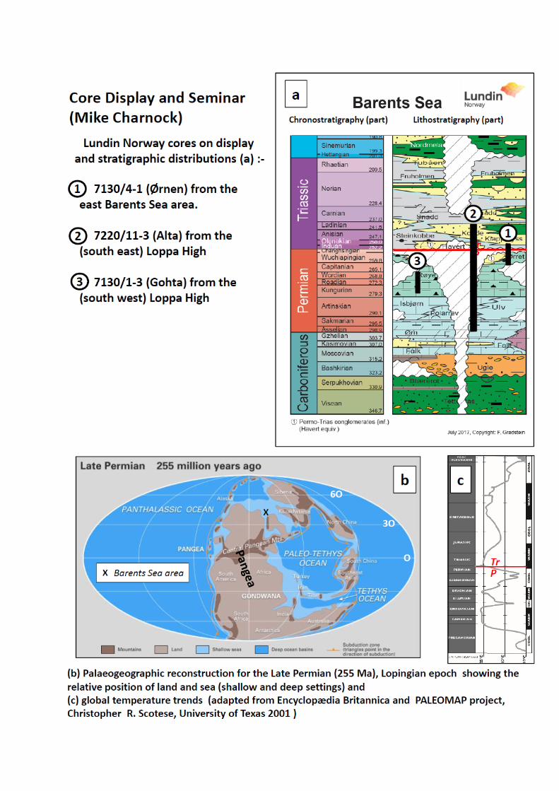
Core viewing and discussion seminar: Permo‐Triassic sediments in the
Barent Sea: The P‐Tr boundary, biofacies and development of karst
features
When reworkings are 'cavings' how can we predict the stratigraphy? Mike Charnock 1 *
1 Lundin Norway, Strandveien 4, PO Box 247, N‐1326 Norway, macharnock@lundin‐norway.no
Three cored wells covering the Permo‐Triassic boundary, Barents Sea: A session in complex
stratigraphic and depositional relationships inviting active discussion and participation.
This core session attempts to demonstrate some of the results presented in related earlier oral
presentations and to highlight the value of integrated studies of both biostratigraphic analysis and
other techniques and to initiate informal discussions on the potential for biostratigraphers to have
input on important aspects of reservoir development and predictive stratigraphy. Palaeontological
input related to palaeoenvironment and climate are also key in development depositional models.
The three cores chosen show different stratigraphy trends across the Permo‐Triassic (P‐Tr) boundary
in the Barents Sea and pose questions for the participants to try answer.
The core session is therefore not intended to be a passive demonstration but encorages active
participation. The core session also attempts to show aspects the structural evolution of the Loppa
High and the impact of the palaeo‐climate on the development of karst (cave) systems in the pre
boundary succession.
Three cored wells are on display:‐
Core 1: Lundin Norway 7130/4‐1 (Ørnen) from the east Barents Sea. This unique core of 54 m
core
shows the complete P/Tr boundary section and like the equivalent Festingen section on Spitzbergen
shows an abrupt but apparent quiescent facies change from Permian carbonates to Triassic
siliciclastic
sediments. With these two sections one could be be forgiven for considering the boundary to
be spectacular but essentially non‐ prospective from a reservoir point of view. Details of the
biofacies
and sedimentology will be shown of this apparently conformable boundary section. This is a good
example of the value of intergrated biostratigraphy and Qemscan analysis.
• What was the climatic change that controlled this abrupt facies change?

Core 2: Lundin Norway 7220/11‐3 (Alta) from the Loppa High. This core will only have been
releasedearlier in the month (2 September 2017) and therefore this FORCE viewing is a
CONFERENCE FIRST EXCLUSIVE. Only parts of the whole cored interval of 131 m will be
shown covering the unconformable Triassic silici‐clastic sediments resting unconformably upon
Lower Permian carbonates and deep karst features. The cored interval covers the Kobbe to Ørn Fms
interval and a Permo‐Triassic basal conglomerate. This core highlights the value of integrated 'hot
shot' XRF and biostratigraphic studies of core chip ends from the rig to define a preliminary model.
Participant questions:
• How important is it to have integrated studies of cores like these and how does one devise
an effective sampling programme?
• How important are the bio facies controlling porosity and reservoir development?
• How can stratigraphers recognise karst systems?
Core 3: Lundin Norway 7130/1‐3 (Gohta) from the Loppa High.
Sedimentologically and biostratigraphically this is an extremely difficult core of 57m to interpret but
with the participants 'new found knowledge' from the previous two cores, three questions are asked:
• What are the host rocks and karstified intervals and where are the best reservoir facies?
• Why is this core so complex compared with core 1 (7130/4‐1)?
• From a biostratigraphic point of view the question is posed 'How do we recognise cave
• systems in the fossil record when reworked 'cavings' are in situ?
Finally, and a more general question: How should we as biostratigraphers approach the study of
these cores and what are the major problems in attempting to get realistic results?
Acknowledgements
Lundin Norway and PL708, PL609 and PL492 partners are thanked for permission to present these
cores at this FORCE workshop.
PARTICIPANTS PLEASE NOTE THE FOLLOWING:‐
1. Participants are asked to assemble in the NPD core viewing reception (across the road from
the Conference Hall) promptly so the group can enter the viewing rooms collectively.
2. We kindly ask participants not to take photographs of the cores or any display data.

1000+ meters of shallow cores in the Northern Barents Sea
Robert Williams
NPD Stavanger Norway
1048 metres of shallow cores in the north-eastern Barents Sea
Following the 2011 ratification of the boundary treaty with Russia, the Norwegian Petroleum
Directorate (NPD) received funds over the government budget for 2D-seismic surveying in the new
areas. Knowledge of the geology in the north-eastern Barents Sea was hitherto limited. Acquiring
shallow cores was therefore crucial for mapping the Norwegian sector along the boundary with
Russia.
Funds were appropriated in the 2015 government budget for shallow drilling, allowing the NPD to
carry out a shallow coring program. The primary area for this work lay 40 to 100 kilometres south-
east and 50 kilometres north of Kvitøya. The NPD drilled seven cores with depths varying from 52
to 200 metres. The objective was to retrieve cores from stratigraphic boundaries which are found
at shallow depths in the survey area. The drillship Bucentaur acquired a total of 1048 metres of
core.
Three diverse assemblages of small foraminifera and fusulinids from shallow core 7933/4-U-3, 43
km south of Kvitøya, show that the oldest carbonates, cherts and calcareous mudstones span the
Carboniferous-Permian boundary, and include the uppermost Gzhelian, Asselian and Sakmarian of
the Ørn Formation. In addition, the same core contains the Permian-Triassic boundary. The
Vikinghøgda Formation in this core consists of grey shales assigned an Early Triassic, Induan,
Olenekian to Late Permian, Late Changhsingian age.
Under the contact with Pleistocene overburden, the borehole drilled north of Kvitøya, 8034/5-U-1,
recovered dolomites of probable Carboniferous age. Palynology and thin section studies have
shown these to be barren.
Core 7933/4-U-1 recovered fifty metres of Anisian and Ladinian shales of the Botneheia Formation,
whereas the remainder of the coring program retrieved a thick succession of Carnian clastics and
Norian shales.
Three laboratories carried out the biostratigraphic analyses: PetroStrat Ltd., Vladimir I. Davydov
and the NPD.

Afternoon Energiser
Alex Cullum
1) Go online with your phone, tablet or laptop.
WiFi or data connection. NPD free guest WiFi (password is on the wall outside the auditorium)
2) GO to the website https://kahoot.it/
3) Entre the pin code I will give you.
4) Entre your name, or just a name we will know you by i.e. Alex
5) When the quiz starts we will all play simultaneously. Multi choice questions should be on the
screen at the front of the hall and on your phone. Pick the right answer/colour as quick as you
can. Points are not just for correct answers, but for speed of answering.
To win you need to answer correctly and answer first.
Good luck!
If you have an old (3+ years old) Android phone, then go to the Google App store and down load the FREE
Kahoots app. Then just install and use that.
https://kahoot.it/

The application of megaspore biostratigraphy to the evaluation of the
Late Triassic – Early Jurassic reservoir sequence in The Johan
Sverdrup Field
Peter H. Morris1
1Microstrat Services, Southcott, Buckland Brewer, Bideford, Devon EX39 5LU, UK:
The sedimentological similarities of the lower reservoir sequence in the Johan Sverdrup Field with
that of the Statfjord Group in the Gullfaks Field has led to a two phase study based on
micropalaeontological/ megaspore analysis of core in key wells across the field. Abundant, well
preserved megaspore assemblages were recovered which confirmed the presence of Statfjord Group
sediments in the lower reservoir, with megaspores and associated palynofloras occurring consistently
in biostratigraphic sequence : four regional megaspore biozones are identified which can be closely
tied to key miospore events across the field :- Erlansonisporites lobatus (Middle – Late Norian),
Verrutriletes utilis (Early Rhaetian), Banksisporites pinguis (Middle – Late Rhaetian) and
Nathorstisporites hopliticus (Early – Middle Hettangian). The stratigraphic value of applying these
biozones to the Statfjord reservoir sequence is demonstrated using selected wells. The
palaeoecological value of megaspore assemblages in characterizing a range of non-marine, delta/braid
plain environments, is also shown to be of value in reservoir modelling.
Despite low recovery levels from of the overlying Jurassic sequence, marine, microfaunal zones can
also be recognized, which used in conjunction with the megaspore scheme, assist in evaluating the
nature of the M. Jurassic, ‘mid-Cimmerian’ unconformity and the extent of erosion of the underlying
reservoir section.
This study of the Johan Sverdrup reservoir shows that a range of microfossil groups including
megaspores can be applied effectively to reduce the stratigraphic uncertainty associated with complex
phases of regressive – transgressive deposition and erosion.

Automatic identification of nannofossil species using convolution
neural networks
Bernard Lee Innova Plex, Inc. [email protected]
Wellsite biostratigraphy monitoring using species of fossils as biomarker is important in assessing
stratigraphic information and confirmation of well prognosis. The traditional way of manually
identifying fossils was time-consuming and bias prone. A new automatic identification system using
a miniaturized 5d (x, y, z, and multiple fields of view in different optical modes) fossil slide scanner
has been designed to acquire fossil images remotely and recognize nannofossil species in a fraction of
time. The automatic classification system integrates multiple image processing tools to cookie-cut the
potential fossils and extract the geometry, morphology, and texture of the images. Convolutional
neural networks using YOLO-Darknet hybrid algorithm were used as the pattern recognition method.
We tested a data set that included 35 calcareous nannofossil from Gulf of Mexico. Our results show
that the system performed with high accuracy as long as enough training sets are provided per species,
reaching average of nearly 92% of true positive fossil identifications. The automated process even
with partial training provides a real-time result, which vastly aides in decision making and reduces
cost, time, and safety concerns. Our results highlight how the neural networks are complementary
to traditional fossil species identification.

Another view of your data?
Erik Anthonissen and Alex Cullum, Statoil, Svanholmen 8, Forus, Norway
Data things are moving forward fast and in the geological sciences we’re all working hard to keep
up.
We’ll present some of the new ideas, we’re looking into when we can. We are not presenting this
because we think we’re ahead or that we are in any way the only people trying these things.
However, it’s hard to get permission to present things, harder still to present ideas, things in progress
and stuff you are not sure is even working. This presentation is intended as a way to instigate
discussion, invite future collaboration and help us all to identify what methods and technologies are
going to help us move biostratigraphy forward.
If you’ve seen it all before, then good. If you’re doing all this already even better.