Abstracts of papers presented at the 2012 meeting on BLOOD ...

ABSTRACTS OF PAPERS PRESENTED AT THE
STAR* SESSION 2009
26th STAR Session is held in conjunction with the SOPAC 38th Session (21-30 October 2009)
Hosted by the Government of Vanuatu at the
Le Lagon Resort, Port Vila
SOPAC Miscellaneous Report 700b
December 2009
*Science, Technology and Resources Network

[STAR Abstracts 2009 – 2]
[SOPAC Miscellaneous Report 700b – Collen & Bukarau (Compilers & Editors)]
Compiled and edited by:
John Collen1 & Lala Bukarau2 1Victoria University of Wellington & 2SOPAC Secretariat
Post-Session Version December 2009
You can download this report at this online location http://www.sopac.org/tiki-sopac_reportsindex.php?ss=type&vv=MR :
SOPAC Secretariat Private Mail Bag
GPO, Suva Fiji Islands
Phone: (679) 338 1377 Fax: (679) 337 0040
http://www.sopac.org

[STAR Abstracts 2009 – 3]
[SOPAC Miscellaneous Report 700b – Collen & Bukarau (Compilers & Editors)]
CONTENTS FOREWORD...............................................................................................................................4 ABSTRACTS OF PAPERS (arranged alphabetically by author(s)) ....................................................5
Anton......................................................5 Ballu, Bouin & Others ...............................7 Bani, Vergniolle & Others ..........................8 Battaglia, Métaxian & Garaebiti..................9 Beaudoin & Baker...................................10 Begg, Pohler & Others ............................11 Bouin, Ballu & Others .............................14 Chand, Gienko & Pohler ..........................14 Chapman...............................................19 Chaput, Dumont & Others.......................20 Collen, Baker & Others............................21 Crawford, Pelletier & Others ....................21 Crawford, Regnier & Others ....................22 Cronan, Rothwell & Croudace ..................23 Cummins, Damlamian & Sagar ................23 Damlamian & Kruger ..............................24 Donnadieu.............................................25 Duncan & Patterson................................25 Etuati, Krishna & Others..........................26 Forstreuter ............................................26 Fukao, Suetsugu & Kodaira .....................28 Ganachaud & Sen Gupta .........................29 Garaebiti & Todman ...............................29 Gardner, Garton & Collen ........................30 Gledhill ..................................................30 Goff, Bonte-Grapentin & Others...............31 Gonelevu, Singh & Others .......................32 Gorman, Popinet & Ramsay.....................33 Greene ..................................................33 Hall, Maas & Ramsay ..............................34 Harris....................................................34 Helsley ..................................................35 Heron, Glassey & Chiesa .........................36 Holland .................................................37
Howorth ............................................... 37 Kalmet.................................................. 38 Kissun, Anderson & Pohler...................... 38 Koltermann & Yamamoto ....................... 42 Kuchinke & Tilbrook............................... 43 Kumar .................................................. 43 Mario.................................................... 44 May...................................................... 45 McMurtry .............................................. 47 McMurtry, Fryer & Others ....................... 48 O’Brien ................................................. 49 Ota, Ichioka & Others ............................ 50 Overmars.............................................. 50 Parker .................................................. 51 Pelletier, Vergniolle & Others .................. 52 Piotrowicz ............................................. 55 Pratap, Terry & Others ........................... 55 Robinson .............................................. 56 Smith (L.) ............................................. 57 Smith (R.) ............................................. 59 Smith (S) .............................................. 60 Smith, Bolalailai & Others ....................... 61 Talia ..................................................... 62 Tawake................................................. 62 Todman, Garaebiti & Charley .................. 66 Varner, Dunbar & Kong .......................... 67 Webb ................................................... 67 Webb, Lal & Artack ................................ 68 Weinstein & Kong .................................. 69 Winder ................................................. 70 Wolff .................................................... 71 Wolff & Sinclair...................................... 71
THE RIF PROCESS AND STAR ................................................................................................... 73 FINAL PROGRAMME ................................................................................................................. 77 ----------- Note from compilers
This Post-Session version of the Abstract volume contains all the abstracts of papers, posters and presentations submitted and heard at the STAR 2009 meeting.

[STAR Abstracts 2009 – 4]
[SOPAC Miscellaneous Report 700b – Collen & Bukarau (Compilers & Editors)]
FOREWORD STAR (SOPAC's Science, Technology and Resources network) was founded in 1985 in collaboration with the International Oceanographic Commission. STAR was formed to assist the international geoscience community to continue to provide advice to SOPAC, particularly during the intervals between SOPAC International Workshops. The first Chairman of STAR, Dr Charles Helsley, then Director of the Hawaii Institute of Geophysics, guided STAR until 1992. He was succeeded by Keith Crook from the Hawaii Undersea Research Laboratory. Keith served until the end of 1999 when John Collen from Victoria University became Chair. STAR meetings have not been simply technical conferences at which individuals present scientific papers and discuss their results and implications. Participants have had the additional responsibility to formulate advice to SOPAC about its work program and to highlight technical and scientific issues of particular importance or urgency to the region. This advice, in the form of reports and recommendations from STAR Working Groups and reports on highlights of STAR technical presentations, has been tendered to Council by way of an address in Plenary by the Chair of STAR and during the Governing Council/Technical Advisory Group (GC/TAG) segment of the Annual Session. The participation of all STAR delegates in this phase of the meeting has been welcomed. One of the great strengths of SOPAC has been its ability to mobilize excellent and multidisciplinary science and bring it to bear so as to address the national needs of SOPAC's island member countries. The long-established working relationship between SOPAC and the international research community was a vital element in this endeavor, which STAR was charged to nurture. This relationship stimulated an order-of-magnitude change in the geoscience database in the SOPAC region during the 1980's. During the 1990's it supported the changes in SOPAC's scope and focus that led to the development of the three major work programmes and that are still continuing. Since 2005, Programme Monitoring and Evaluation Groups (PMEGs) comprised of TAG scientists, have met with SOPAC Programme Managers prior to the STAR Meeting and then reported directly to Council as independent advisers during the joint TAG/Council deliberations. In earlier years STAR was primarily concerned with "blue-water" marine geoscience, tectonics and resource exploration and evaluation. However, as national needs and priorities changed, the scope of STAR similarly expanded, partly to reflect changes in focus of international science but also to ensure that SOPAC's Work Program and its forward planning were influenced by international science that was both excellent and relevant. The wide scope of the work outlined by the abstracts in this volume is a clear indication that this evolution was successful. The overall aim of the 2009 STAR conference is to examine the scientific challenges in assisting the futures of developing Pacific Island Nations. Within this, special attention is paid to the themes of exploiting and managing resources to enhance economic development, with focus on sea bed minerals, water and renewable energy, and reducing disaster risk. As the future of STAR beyond this meeting is uncertain, a session will be devoted to the past contributions of STAR and SOPAC.
John Collen Chair, Science Technology and Resources Network Centre for Marine Environmental & Economic Research Victoria University of Wellington Wellington New Zealand October 2009

[STAR Abstracts 2009 – 5]
[SOPAC Miscellaneous Report 700b – Collen & Bukarau (Compilers & Editors)]
ABSTRACTS OF PAPERS ------------------
ANTON Earthquake hazard of Papua New Guinea Lawrence Anton Port Moresby Geophysical Observatory, P.O. Box 323, Port Moresby, National Capital District, Papua New Guinea. Email: [email protected], [email protected] Earthquake activity in Papua New Guinea (PNG) is amongst the most intense in the world. The activity is a result of the existence and interaction of lithospheric tectonic plates in the region. Within the collision zone of the major India-Australian and Pacific Plates, there exist numerous minor plates or buffer plates. Included are the well-recognised Solomon Plate which lies to the southeast, the South Bismarck Plate which lies in the centre and the North Bismarck Plate to the northwest. Further northwest and to the west of the Pacific Plate is the Caroline Plate, north of Papua Province in Indonesia. The eastern border of this plate with the Pacific or the North Bismarck Plate in PNG is not clearly defined by seismicity, which is not continuous and scattered, but shows a clear bathymetry depression indicative of a trench and thus a boundary. In the southeast and dominating the east of the India-Australia Plate in the Solomon Islands and Bougainville Island is the Ontong Java Plateau (OJP) in the plate boundary front of the Pacific Plate. The largest in thickness and size oceanic plateau on the planet, exists as the eastern front and border of the Pacific Plate with the buffer plates existing within the collision zone with the India-Australia Plate. This huge mass of oceanic crust approached from the east-northeast, with the subduction front facing in that direction, and docked at the subduction zone thus causing a reversal of subduction polarity due to its’ inability to submerge – being too buoyant. The sheer size of the plateau covering the entire eastern PNG plate front of the Pacific Plate is currently the result of active tectonism by way of deformation due to compressional stress that is being exerted on the island terrains of this segment of the Melanesian Arc system. The near-vertical subduction of Solomon Plate slab, especially in the region of western Bougainville shown by the trend of earthquakes is the result of collision with the thick oceanic (OJP) crust. The search is continuing on the identification and distribution of, and the nature of plates and their boundaries. GPS observations have made it possible for monitoring tectonic motions and regions of crustal stress identified by deforming regions, and the establishment of crustal blocks not known previously. Earthquakes occur along most coastlines where communities have built and settled, making them vulnerable to ground shaking, and to secondary hazards in tsunami, landslides and floods. It is therefore imperative that seismic stations deployed in the country and in the global network are maintained, not only to properly monitor earthquake activity and research into the nature of their occurrences, but also for the long-term purposes of determination of earthquake hazard parameters resulting from improved and complete earthquake catalogues. Earthquake awareness and early warning to coastal communities does have positive benefits resulting from readily available systems for earthquake information dissemination. Intense tectonic activity has resulted in rapid uplift rates, rapid erosion, landslides, floods and intense volcanic activity. Two tectonic events of significant effects are noted to have occurred within the region. The first was the obduction of the Papuan Ophiolites during Oligocene causing metamorphism of continental margin sediments, and the second was the arc-continental collision during Pliocene which resulted in intra-continental deformation. The effects of tectonic activity
[STAR Abstracts 2009 – 6]
[SOPAC Miscellaneous Report 700b – Collen & Bukarau (Compilers & Editors)]
are evidenced in the landscape that was shaped by these events and exists today, and that is evolving. As the nation of Papua New Guinea develops, the dangers of living in the tectonically intense region becomes more and more evident, as the need for improved infrastructure planning becomes apparent. The need for the revision of the existing building code seismic zoning maps developed in the 1970s was realised in recent times. The maps were noted for inadequacies, having been formulated using insufficient data, and not so compatible area/region data. The code as a result does not genuinely represent Papua New Guinea conditions. Better methods for determining the seismic hazard, even with data from abroad (particularly from similar tectonic environments) are now available. A project based on data now existing is embarked on, making possible a review of the hazard maps. Reasons guaranteeing the review would include the seismicity having long been studied, especially within the last four decades, and thus widely understood as one of the worlds’ active regions. Earthquakes are known to be associated with regional lithospheric plate movements, and large earthquakes, those with magnitudes ≥ 7.0, are frequent – about two every year. The geology of the region is not only better understood, but appears to correlate well with the seismicity. The existing data is used with now-available regional geology, geophysics and geodesy data to assist in determining seismotectonic source zones of the region. Shallow earthquakes posing danger and risk to existing cities and towns, especially infrastructure occur either on plate boundaries or in the vicinity of plate boundaries and, also along areas of crustal deformation where stress build-up is released. In the current hazard map, the highest risk zone is that corresponding to highest activity around the northeast Solomon Sea, and the lowest risk zone is that area in the south and southwest of PNG. But, the adequately recognised plate boundaries and seismic zones of the Bismarck and Solomon Seas are not reflected in the seismic zone map. It is also noted that the eastern coast Bougainville zone should be narrower as attenuation of intensity is very rapid across the Bougainville arc as shown from known isoseismal maps. ------------------ Tsunami Warning System in Papua New Guinea Lawrence Anton Port Moresby Geophysical Observatory, P.O. Box 323, Port Moresby, National Capital District, Papua New Guinea. Email: [email protected], [email protected] Most PNG tsunamis have been generated by earthquakes, either co-seismically or by submarine slumps caused by earthquake shaking. The 1998 Aitape Tsunami was caused by slumping due to shaking associated with a magnitude 7.1 earthquake. Some tsunamis have been generated by volcanic activity. The 1888 Ritter Island volcanic cone collapse caused a tsunami which devastated the northern New Guinea coastlines, and killed thousands of inhabitants. The tsunami was devastating locally on Umboi (Siassi) Island and neighbouring islands, eastern New Guinea and on New Britain Island. There used to be a network of seismic stations but now a skeletal network which formed a system used to monitor local earthquakes, but the system does not meet the requirements for early warning of tsunamis. As well, a small number of tide gauges are in use but they are not configured for tsunami monitoring. Inadequate monitoring equipment has resulted in poor monitoring of tsunamis. We currently rely on the Pacific Tsunami Warning Centre (PTWC), for earthquake information and tsunami bulletins for events that occur anywhere in the Pacific basin. For such events, we in PNG will have time to issue warnings to coastal communities, authorities and news media. For example, the tsunami associated with the 1960 Chilean Magnitude 9.5 (Mw 8.2) Earthquake which took almost 24 hours to reach PNG.

[STAR Abstracts 2009 – 7]
[SOPAC Miscellaneous Report 700b – Collen & Bukarau (Compilers & Editors)]
PNG is also a beneficiary of the West Coast/Alaska and Northwest Pacific Tsunami Information Centre (Japanese Meteorological Agency) tsunami warning systems. For locally generated tsunamis, we advise local coastal communities through continuing awareness that the best warning of a tsunami may be the earthquake shaking itself. Tsunamis resulting from local earthquakes do not take long to strike coastlines, thus making it almost impossible to issue an effective warning. For example, the Aitape Tsunami of 1998 occurred about 20 minutes after the magnitude 7.1 earthquake nearby. It is also known from our historical records that much smaller earthquakes have generated tsunamis in PNG. In 1930, a 10.5 m tsunami was generated by a magnitude 5.8 earthquake which occurred in the Bismarck Sea. We rely on information dissemination and community awareness work to properly mitigate the impact of locally devastating tsunamis. We also would like to see new monitoring equipment, installed to replace aging or non-existing equipment. Upgrading of existing monitoring facilities that can form the basis of a tsunami warning system is required. The country’s current earthquake monitoring facility needs to be upgraded or replacement and processes have started with an EU funding under EDF9. Sea-level monitoring equipment must be upgraded, expanded and the viability of a local tsunami monitoring/warning network must be assessed. The worry to have maintenance and operation of an expensive network of equipment sustained is putting us off to even dare venture in to committing ourselves (and government) of the huge costs that may come back biting. Because of inadequate equipment for establishment of a local tsunami warning system relevant authorities have embarked on tsunami awareness. Information programs and other means have been initiated to educate the public about the risks of earthquakes and related hazards such as tsunamis and landslides. In coastal localities where tsunami awareness has been carried out, residents have been informed to move quickly to higher ground when they feel a strong earthquake. Residents are encouraged to live more than 3 metres about the high water level, and have been advised that special attention must be paid to the siting of public buildings and those housing essential services. Tsunami hazard research needs to be encouraged and facilitated. In particular, bathymetric data for the entire PNG coastal areas needs to be collected in order for inundation modeling, evacuation mapping, etc. to be conducted. Palaeo-tsunami and routine tsunami research is encouraged. PNG needs to develop policy and procedures for tsunami response that must be included in the overall disasters management strategy for the country. ITIC and PTWC have started the process. ------------------
BALLU, BOUIN & OTHERS A land and seafloor geodesy experiment in Vanuatu to study the seismic cycle in a partially locked subduction zone Ballu, Valerie1,2, Marie-Noelle Bouin3, Stéphane Calmant4, Bernard Pelletier1, Nicolas Bergeot5, Aline Peltier2, Moses Kalsale6, Tony Kanas6, Jean-Claude Willy6, Philippe Koroka6, Wayne Crawford1,2, Esline Garaebiti7, Sylvain Todman7, Janvion Cuevard7, Athanase Worwor7, Sophie Jimmykone7, David Nakedau7 & Michel Diament2 1 GéoAzur, IRD, Port-Vila, Vanuatu 2 IPGP, Paris, France 3 Centre de Recherche de MétéoFrance, Brest, France 4 Legos, Brasilia, Brazil 5 Observatoire Royal de Belgique, Brussels, Belgium 6 Topographic service, DLS, Port-Vila, Vanuatu 7 Geo-hazards, DGMWR, Port-Vila, Vanuatu. Email: [email protected]

[STAR Abstracts 2009 – 8]
[SOPAC Miscellaneous Report 700b – Collen & Bukarau (Compilers & Editors)]
The Vanuatu archipelago is part of the Pacific Ring of Fire, where numerous earthquakes occur along subducting tectonic plate boundaries. The archipelago sits at the western edge of the North-Fiji and the Australian plate subducts beneath it. The convergence rate exceeds 10 cm/yr in most places, but slows down to 2-3 cm/yr in the central part of the archipelago (around Santo and Malekula islands), where topographic features on the subducting seafloor partially locks the subduction. This partial locking results in strong vertical movements and is responsible for the emergence of both Santo and Malekula, which, even though they are not created by present-day volcanism, are the largest islands of the archipelago. As part of the ANR “Arc Vanuatu” program, we are continuing work initiated more than a decade ago to measure the motion of the islands with time, using GPS. We have installed 8 new continuously recording GPS stations in the central part of the archipelago on the islands of Santo, Malekula, Malo, Ambae, Maewo and Pentecost, and we have re-measured many benchmark sites throughout the archipelago. These data will be crucial for understanding the seismic cycle and for detecting silent earthquakes and aseismic deformation, if indeed they occur in Vanuatu. Measuring and modelling deformation in subduction zones is very challenging, because a significant part of the deformation occurs underwater; in particular, it is hard to monitor deformation close to the plate boundary on either the subducting or the over-riding plate. Thanks to the presence of Santo and Malekula islands near the plate boundary and the presence of two shallow seamounts on each side of the plate boundary, Vanuatu offers a unique opportunity to measure motion up to and across the plate boundary. We developed new geodesy methods for underwater vertical monitoring, using a combination of seafloor pressure, sea level kinematic GPS and satellite altimetric data. The velocity profile obtained from the land and seafloor stations will then be modelled to investigate the role played by the subducting plate’s topographic features on the locking of the subduction, the vertical uplift of the overriding plate (Santo and Malekula islands) and the whole seismic cycle. ------------------
BANI, VERGNIOLLE & OTHERS Probing the magma plumbing of Ambrym volcano, by a triangular acoustic network P.Bani1, S.Vergniolle2, C.Zielinkski2, M.Lardy1, A.Le-Pichon3, D.Ponceau3, F.Gallois1 P.Henry3 & S.Todman4 1 Institut de Recherche pour le Développement, B.P.A5, 98848 Nouméa Cedex, Nouvelle Calédonie. 2 Dynamique des Fluides Géologique, Institut Physique du Globe de Paris, 4 place Jussieu, 75252 Paris Cedex 05, France 3 Commissariat à l’Energie Atomique, Departement Analyse, Surveillance, Environnement, Bruyeres Le Chatel, 91680, France 4 Geo-Hazards, Department of Geology, Mines water Resources, PMB 001, Port Vila, Vanuatu Email: [email protected] An acoustic triangular network installed in 2008 on Ambrym volcano has been proven suitable to distinguish the volcanic activity in Benbow and Marum. More than one hundred thousand acoustic events have been recorded within a 6-month period (the longest data series ever obtained on Ambrym) indicating a quasi-continuous magmatic activity in both Benbow and Marum craters. 60 % of the acoustic events occurred in Marum with several periods marked by significant bursts and some periods of quiescence, while Benbow exhibits minor explosions continuously. The first period with strong explosions at Marum is preceded by an increase in number and duration of acoustic events in both craters as well as a shift in frequency. This suggests that either both volcanic edifices share the same magma reservoir or that an efficient connection exists in their magma plumbing systems. The rapid return of Benbow to its normal activity after a period of strong explosions at Marum compared to that of Marum may indicate that Benbow crater is the closest to the magmatic source, hence probably directly above it. This is also compatible with the existence of periods of quiescence solely at Marum and not at Benbow. This new approach in volcanic studies and monitoring has revealed valuable information on the edifice plumbing system of Ambrym, which is a key to understanding its eruptive behaviour. It is also a promising tool for

[STAR Abstracts 2009 – 9]
[SOPAC Miscellaneous Report 700b – Collen & Bukarau (Compilers & Editors)]
Figure 1: Seismic stations around Yasur volcano, seismic antennas are represented as red dots and broadband stations as blue dots.
volcanic monitoring as our acoustic network detects precursory events 1-2 days prior to major explosions. ------------------
BATTAGLIA, MÉTAXIAN & GARAEBITI Preliminary results from seismic experiments around Yasur (Tanna Island) and Marum and Benbow volcanoes (Ambrym Island) Jean Battaglia1, Jean-Philippe Métaxian2 & Esline Garaebiti3 1 Laboratoire Magmas et Volcans, CNRS UMR 6524, Univ. B. Pascal, 5 rue Kessler, 63038 Clermont-Ferrand, France 2 Laboratoire de Géophysique Interne et Tectonophysique, IRD, Univ. de Savoie, 73376 Le Bourget du Lac, France 3 Department of Geology, Mines and Water Resources, George Pompidou Building, SPR 001, Port Vila, Vanuatu Email: [email protected] From January 2008 to February 2009 we carried out two seismic deployments on the islands of Tanna and Ambrym to study the activity of their volcanoes. On the island of Tanna, in the southern part of the Vanuatu arc, we installed a temporary seismic network around Yasur volcano. The volcano is characterized by a permanent Strombolian activity with tens of explosions per hour. Our network included up to 22 stations spread in the southern part of the island (Figure 1). Twelve antennas were first installed in January 2008, each including up to 7 short period sensors: one 3-component surrounded by 6 single-component vertical sensors. In May, 10 broadband stations equipped with 30 s Guralp CMG-40 seismometers were added. In September, 10 stations were unmounted (4 antennas and 6 broadband) and finally in February the remaining stations were dismantled. From January to August the volcanic activity was at a relatively high level and then slowed down toward the end of the experiment. This activity was accompanied by an intense short period seismicity with up to 2000 transient signals per day as well as by an intense very long period seismicity below 1 Hz. To search for characteristic events among the hundreds of thousand events recorded during the experiment we first applied an LTA/STA algorithm to data from station Y05 located close to the eruptive vents. The detected events have been classified on a daily basis and the result indicates the presence of dominant families of similar signals grouping a significant part of the seismicity. Most of the families group explosion quakes directly related to the Strombolian explosions. These families suggest the explosive activity is characterized by the presence of dominant modes of resonance of the conduit in response to the gas slug ascents

[STAR Abstracts 2009 – 10]
[SOPAC Miscellaneous Report 700b – Collen & Bukarau (Compilers & Editors)]
causing the explosions. These modes may persist for weeks or months. However, they were affected by the occurrence of a M=7.3 earthquake on April 9, 2008 about 80 km offshore of the island as none of the families is active both before and after the distal earthquake. An important family of signals which are not accompanied by any surface activity is also observed. These LP events are related to a deeper process and are systematically followed by explosions with a 10-15 second delay. They appear as short-term precursors of Strombolian explosions. In Ambrym, from October 2008 until the end of January 2009, 10 seismic stations were installed around Marum and Benbow craters (4 antennas and 6 broadband, Figure 2). Most of them have been set on the ash plains covering the summit caldera to record in a close range the seismicity generated by the volcanoes. The activity of Marum and Benbow craters is characterized by the presence of quasi-permanent lava lakes and strong continuous emission of gases with occasional explosions. In addition to an intense tremor related to the degasing observed at the surface as well as to some underground fluid movements, the network recorded signals related to several explosions which occurred at Marum crater during the experiment. The study of those signals will bring information about the plumbing system of the volcanoes.
Figure 2: Seismic stations around Marum and Benbow volcanoes in Ambrym. Stations A01, A02, A03 and A04 are seismic antennas and the others broadband stations. ------------------
BEAUDOIN & BAKER South Pacific marine mineral assessment: Providing environmental information for sustainable development Yannick Beaudoin & Elaine Baker [email protected] [email protected] The exploitation of deep sea marine minerals, including polymetallic sulphides formed at hydrothermal sites, is now a near-term prospect. A number of private sector and State-sponsored interests are actively examining these potential resources, having identified them as partial replacements for dwindling land-based reserves. Exploration work in the Exclusive Economic
[STAR Abstracts 2009 – 11]
[SOPAC Miscellaneous Report 700b – Collen & Bukarau (Compilers & Editors)]
Zones of many Pacific Island States has increased dramatically over the past decade, with key sites having undergone advanced exploration work and environmental impact assessments, leaving them on the verge of development. States are now in a position where it is important to develop the specific policy, legislation and regulatory framework necessary for the governance and sustainable development of deep sea mineral deposits. UNEP/GRID-Arendal’s expertise lies in assisting States to bridge the gap between science and policy. Our experience is in linking environmental information with socio-economic issues and sustainable resource development. UNEP/GRID-Arendal has proposed to support the Pacific Islands Applied Geoscience Commission in producing a regional Pacific Islands deep sea minerals assessment that would serve as a model for an eventual global assessment. Key themes to be addressed could include: 1) a synthesis of scientific knowledge pertaining to the geology of deep sea marine minerals; 2) an examination of potential adverse environmental impacts of improperly regulated development; and 3) an examination of the socio-economic benefits and consequences of marine mineral resource development. This style of regional assessment is targeted primarily at decision makers tasked with developing national policies for regulating deep sea mineral resource development. It is therefore formulated as a stand-alone compilation providing a concise, science-based foundation upon which balanced policy development can take place, incorporating input from all appropriate stakeholders. Secondary target groups could include: 1) private sector and commercial interests logistically supporting the development work; and 2) the local communities which, through good governance, could ultimately benefit economically from development activities, but who alternately could, under poorly regulated regimes, suffer from the effects of the degradation of their environment. UNEP/GRID Arendal routinely invites scientific experts to assist in providing the content for environmental assessment reporting. UNEP/GRID-Arendal’s mission is to provide environmental information, communications and capacity building services for information management and assessment. Established to strengthen the United Nations through its Environment Programme (UNEP), our focus is to make credible, science-based knowledge understandable to the public and to decision-makers to promote sustainable development. We are dedicated to making a difference by exploring how environmental information impacts on decision-making and the environment. We seek to bridge the gap between science and politics. ------------------
BEGG, POHLER & OTHERS (POSTER) Investigation of alcyonarian spiculites as reef building agents and possible proxy climate archives Zulfikar Begg1, Susanne Pohler1, Kifle Kahsai2 & John Collen3
1 Division of Marine Studies, School of Islands and Oceans, Faculty of Science, Technology and Environment, University of the South Pacific, Private Mail Bag, Suva, Fiji Islands 2 Faculty of Science Technology and Environment, University of the South Pacific, Private Mail Bag, Suva, Fiji Islands 3 Centre for marine Environmental & Economic Reserch, Victoria University of Wellington, Wellington New Zealand Emails: [email protected]; [email protected]; [email protected]; [email protected] Research is underway to understand the contribution of Alcyonarian spiculites towards reef development and to investigate if spiculites can be used as climate proxies. Alcyonarian spiculite (Konishi, 1981) is a substrate or rock which is built by the soft coral species Sinularia polydactyla

[STAR Abstracts 2009 – 12]
[SOPAC Miscellaneous Report 700b – Collen & Bukarau (Compilers & Editors)]
(Ehrenberg, 1834) as they grow upwards. The coral is known to build pedestals up to 1.5 m high from secretion of high Mg calcite spicules. The spicules (or sclerites) are cemented soon after deposition by several generations of aragonite and high-Mg calcite cements. X-ray analysis of sawn slabs of spiculite rock shows that layering and growth bands are present, consequently the different layers may contain paleoclimate information enclosed in either cements or spicules or both. The aerial extent of Sinularia polydactyla (Ehrenberg, 1834) colonies was mapped at three different sites, Caqalai, Nananu-i-ra and Nukubuco. It was observed that soft corals could grow in harsher environments such as high energy wave zones compared to other corals such as Porites and Acropora. The maps of soft coral cover at the three different sites show that soft corals make up to 30 to 40 percent of the reefs’ coral cover in certain areas. The tallest pedestals were found on Caqalai Island’s reef flat where they are 90 to 100 cm high. Core Scientific International in Canada dated a 60 cm long spiculite sample uprooted from the Nukubuco site using stable 210Pb. The age was determined as older than 110 years. If an age of at least 110 years old is assumed for the 60 cm high column then the coral grew about 5 mm per year. Schuhmacher (1997) calculated a growth rate of 3-8 mm per year from the banding pattern in a spiculite he investigated which is in line with the value found here. The banding pattern observed from x-ray results in the Nukubuco specimen showed ten bands in the upper portion (20 cm long) equating to approximately 30 bands in a 60 cm long column. This wide spacing suggests that the banding is not related to annual growth which is estimated as being only around 0.5 cm. What exactly causes the banding needs further study. Future investigations will also focus on the measurement of Mg/Ca and/or Sr/Ca ratios to possibly assess paleo-temperatures (via laser ablation ICP-MS at Victoria University of Wellington) the carbon 13 isotope signature of cements and sclerites to assess the animals influence on early diagenesis (at the GNS Stable Isotope Laboratory in Wellington, New Zealand). Polished thin sections will be used to unravel the sequence of cementation which enables the build up of spiculitic rock. References
Ehrenberg,C.G, (1834): Beitrage zur physiologischen Kentriss der Corallenthiere im Allgemeinen, und besonders des Rothen Meeres nebst einem Versuche zur physiologischen Systematic derselben. Abhandlungen der kaiserlichen Akademie der Wissenschaften, Berlin, 1832(1), 225-350.
Konishi, K. (1981): Alcyonarian spiculite: limestone of soft corals. In: E.D. Gomez, C.E. Birkeland, R.W. Buddemeier, R.E. Johannes, J.A. Marsh, Jr. and R.T. Tsuda (eds.). Proceedings of the 4th International Coral Reef Symposium 1: 643-649. Marine Sciences Center, University of the Philippines, Manila, Philippines.
Schuhmacher. H, (1997): Soft corals as reef builders, Proc 8th International Coral Reef Symposium 1:499-502.

[STAR Abstracts 2009 – 13]
[SOPAC Miscellaneous Report 700b – Collen & Bukarau (Compilers & Editors)]
Figure 2. A colony of Sinularia polydactyla on a short (about 20 cm high) pedestal of spiculite. The sclerites in the pedestal (spiculite) are oriented sub-parallel to the substrate (black ellipsoids) whereas those in the stalk of the living animal are oriented perpendicular to the stalk’s surface (white ellipsoids). The small inset (right) shows sclerites with the different types of cements that bind them together to form a hard limestone. The hard substrate at the base is probably also spiculite possibly formed by an earlier animal.
1.0 mm Scale
Figure 1. Sclerites from the coenenchym of Sinularia polydactyla are large, complexly warted spindles. The spindles, also called spicules are excreted at the base of the colony and cemented together with early diagenetic aragonite and high-Mg cements.

[STAR Abstracts 2009 – 14]
[SOPAC Miscellaneous Report 700b – Collen & Bukarau (Compilers & Editors)]
------------------
BOUIN, BALLU & OTHERS Towards seafloor geodesy using GPS and satellite altimetry in Wusi Bank, Santo Island, Vanuatu M.N. Bouin1, V. Ballu2, 3, S. Calmant4, J.M. Boré5, E. Folcher5 & J. Ammann2 1 CMM/CNRM, Meteo France, Brest 2 CNRS/IPG, Paris, France 3 IRD/CNRS GeoAzur, Port-Vila, Vanuatu 4 IRD, Brasilia, Brazil 5 IRD, Nouméa, New Caledonia Email: [email protected] We present here the two first steps of measuring underwater height changes on the Santo west coast, Vanuatu. The Santo Island is located in the central part of the Vanuatu subduction zone, where convergence rates reduce from 12 cm/yr to 3 to 4 cm/yr due to a major ridge entering the subduction trench. This results in strong earthquakes with potential damages and a better knowledge of the seismic cycle may help to prevent the societal impacts. Recent GPS measurements showed that present-day vertical motion in Santo varies spatially over tens of kilometers and differs from long-term trends. The west coast especially is locally uplifting whereas interseismic deformation models predict subsidence. Extending the measurement area at sea by monitoring the sea bottom vertical deformation in Wusi Bank, close to the trench, should help to complete the vertical deformation field and better understand the seismic cycle. For that, it is mandatory to get collocated measurements of the water height (by permanent pressure gauge), and the ellipsoidal sea surface height (SSH) either by GPS or satellite altimetry. The main uncertainty comes from the SSH measurements (GPS accuracy or large mean sea surface undulations). We first present the methodology we developed for measuring the SSH using shipborne GPS recorded during 3 scientific cruises in 2004, 2006 and 2007, and the precision obtained. We then review the different MSS obtained from altimetry or gravimetry on the area and assess their accuracy using GPS surveys. We show that even by rough sea, the accuracy of the SSH measurements is in the range of 10 to 15 cm. ------------------
CHAND, GIENKO & POHLER (POSTER) Identifying and analyzing coastline changes along Coral Coast, Sigatoka, Fiji Islands via multi-temporal image analysis and coastal processes research
Prerna Chand1,
Gennady Gienko2 & Susanne Pohler
1
1The School of Islands and Oceans, The Faculty of Science, Technology and Environment, The University of the South Pacific, Privae
Bag Suva, Fiji Islands 2School of Engineering, University of Alaska Anchorage, 3211 Providence Drive, ENGR 201, Anchorage, AK 99508 U.S.A. Email addresses: [email protected]; [email protected]; [email protected] Research is underway to identify the nature of temporal coastline changes along the Coral Coast, Sigatoka (Fiji Islands) between the Fijian Resort and Naboutini Village (Figure 1). Prograding, resilient and eroding coastlines are identified by comparison of historical aerial photographs and satellite images. For this study 1967 aerial photographs and 2002 IKONOS satellite images were compared to observe and classify the coastline changes over the 35-year period. Subsequently, a ground truthing exercise along the Coral Coast was carrying out to re-evaluate the results obtained from the desktop study of historical aerial photographs and satellite images. The desktop comparison did not reveal any prominent coherent coastline change patterns. However,

[STAR Abstracts 2009 – 15]
[SOPAC Miscellaneous Report 700b – Collen & Bukarau (Compilers & Editors)]
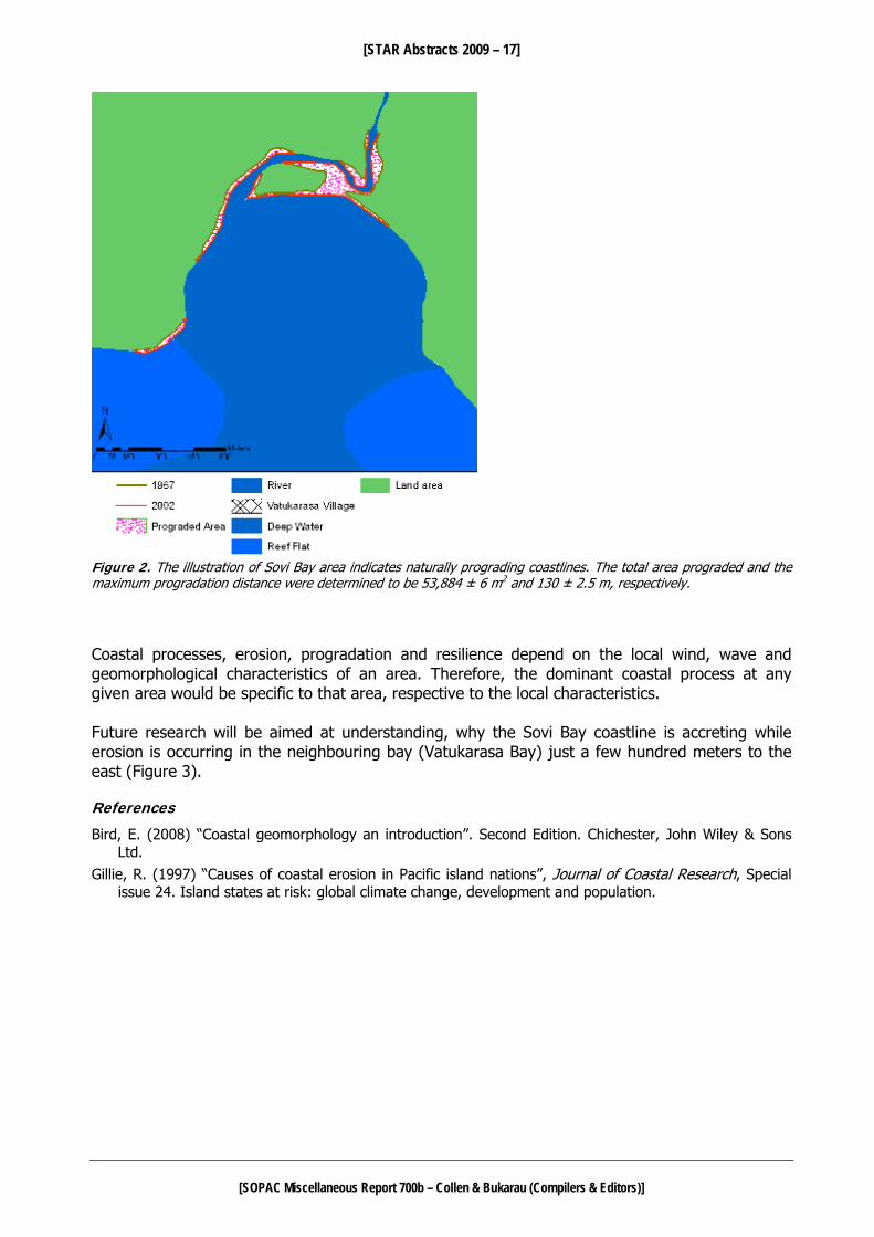
a vague pattern is evident; the far west (Fijian Resort area) and the far east (Naboutini Village area) sides of the study area generally indicate resilient and prograding coastlines. Along the shoreline in the central region it was found that stretches of prograding coastlines alternate with resilient and eroding coastlines. The rates of coastline change for prograding and eroding coastlines were quantified in terms of area (in square meters) and maximum distance (in meters) of landward and seaward movement. For prograding coastline segments the area advancement ranged from 1,564 ± 6 m2 to 97,285 ± 6 m2 and the maximum distance of progradation ranged from 13 ± 2.5 m to 400 ± 2.5 m. For eroding coastline segments the area recession ranged from 840 ± 6 m2 to 21,487 ± 6 m2 and the maximum distance of coastline recession ranged from 14 ± 2.5 m to 40 ± 2.5 m. The area and maximum distance values for progradation and erosion indicate that the Coral Coast coastline is influenced more by progradation than erosion. However, the ground truthing exercise revealed only one section of the study area to be naturally prograding; the region at the head of Sovi Bay (Figure 2). All other prograding and resilient coastlines had been fortified by coastal engineering structures; indicating artificial progradation and foreshore reclamation. Beach erosion was prominent on most of the beaches with prograding and resilient coastlines. The wave energy along Coral Coast, set up by the dominant southeast trade winds is relatively high. Since this area only possesses a narrow fringing reef system, interrupted by numerous channels, the wave energy does not dissipate significantly upon reaching the shore (Bird, 2008). Hence, the Coral Coast coastline is subjected to continuous erosion by high energy waves. However, due to fortification of the coastline by the construction of seawalls, a large portion of the Coral Coast coastline is showing signs of progradation (Gillie, 1997).

[STAR Abstracts 2009 – 16]
[SOPAC Miscellaneous Report 700b – Collen & Bukarau (Compilers & Editors)]
10km Figure 1. Topographical map of the coastline under investigation between Fijian Resort and Naboutini Village along the south coast of Viti Levu. Source: South Pacific Maps Pty Limited 2002
Fig. 2
Fig. 3
Fijian Resort
Naboutini Village
[STAR Abstracts 2009 – 17]
[SOPAC Miscellaneous Report 700b – Collen & Bukarau (Compilers & Editors)]
Figure 2. The illustration of Sovi Bay area indicates naturally prograding coastlines. The total area prograded and the maximum progradation distance were determined to be 53,884 ± 6 m2 and 130 ± 2.5 m, respectively. Coastal processes, erosion, progradation and resilience depend on the local wind, wave and geomorphological characteristics of an area. Therefore, the dominant coastal process at any given area would be specific to that area, respective to the local characteristics. Future research will be aimed at understanding, why the Sovi Bay coastline is accreting while erosion is occurring in the neighbouring bay (Vatukarasa Bay) just a few hundred meters to the east (Figure 3). References
Bird, E. (2008) “Coastal geomorphology an introduction”. Second Edition. Chichester, John Wiley & Sons Ltd.
Gillie, R. (1997) “Causes of coastal erosion in Pacific island nations”, Journal of Coastal Research, Special issue 24. Island states at risk: global climate change, development and population.

[STAR Abstracts 2009 – 18]
[SOPAC Miscellaneous Report 700b – Collen & Bukarau (Compilers & Editors)]
Figure 3. The above map indicates alternating segments of eroding and prograding coastlines. The total eroding area and the maximum erosion distance were determined to be 12,498 ± 6 m2 and 38 ± 2.5 m, respectively. Whereas, the total prograding area was 4,372 ± 6 m2 and the maximum prograding distance was 67 ± 2.5 m.
Eroding Areas

[STAR Abstracts 2009 – 19]
[SOPAC Miscellaneous Report 700b – Collen & Bukarau (Compilers & Editors)]
----------------------------
CHAPMAN PACTAM NIUE – Achieving Best Practice Outcomes in Small Island Developing States Clinton Chapman PACTAM Niue – Water Supply Operations Adviser (AusAID/PACTAM) Email: [email protected] Best Practice is prerequisite in the implementation of projects in developed nations, such as Australia and New Zealand. With more resources and more developed Standards, Guidelines, Regulations and Codes of Practice, all readily available, achieving Best Practice outcomes should be comparatively easier in Australia and New Zealand than in a small island nation, such as Niue. Resources, be it human, physical or economic, are scarce in nations such as Niue so naturally, completion of projects let alone completion to best practice, can be difficult and frustrating. The core business of the Niue Water Division PWD is to provide a continuous and safe supply of water to consumers. With water being provided free to consumers, Niue has to look for donor funding to implement its maintenance, augmentation and asset replacement program. Ideally, it is Best Practice to service assets on a regular basis and not wait for failure. The Drinking Water Safety Plan process for Niue aims to address asset maintenance issues by developing standard operating procedures, best practice guidelines and improvement schedules for the maintenance and operation of the Niue water supply system. Water Demand Management is an ongoing project in Niue. Bulk metering and sample household metering has been progressed and the data attained from these meters will enable development of efficient water use policies. System Loss Management has identified losses and a program for household leak repairs has been instigated. Reduction of system leaks is a relatively easy task to carry out and it is a strategy that will guarantee immediate benefits by way of reduction in pumping energy costs. In terms of Water Resource Management, the regional HYCOS project has rolled out rainfall and groundwater monitoring equipment which will enable Niue to monitor use and protect the quality of the resource by way of regulations. The IWRM demonstration project ($500K USD) funded by GEF through UNDP and managed by SOPAC, is a critical project to develop strategies to adopt nation wide. Similarly with the PACC project ($750K USD) whereby the strategy is to reinstate household rainwater catchments in order to reduce use of fossil fuel for power generation to pump water, increase drought security and provide disaster emergency supply. SOPAC and other regional organisations, by way of technical assistance, development of guidelines and capacity building, can kick start projects but often maintaining momentum can be a problem, given the limited resources available to local counterparts and isolation of pacific island countries. The deployment of PACTAM officers over a period of two years can help maintain momentum in projects. Technical advice is offered wherever possible and hands-on involvement is very important. A bottom up approach is taken in capacity building so that the core business objectives, operation and maintenance, continue to be met. Capacity building for local counterparts is vital and one should never assume anything in this regard. Unnecessary maintenance and operation costs can be avoided by building and installing assets that will stand the test of time and be fit for purpose. Working to best practice can achieve this but in the end local conditions, priorities and culture prevail and the outcome may not be as exact as one may want it to be.

[STAR Abstracts 2009 – 20]
[SOPAC Miscellaneous Report 700b – Collen & Bukarau (Compilers & Editors)]
------------------
CHAPUT, DUMONT & OTHERS Structure and hydrothermal system of Yasur volcano (Vanuatu archipelago) inferred from gravimetry, electric resistivity tomography, time domain electro-magnetism, self-potential, subsurface temperature and soil CO2 concentration Marie Chaput1, Stéphanie Dumont2, Jean-François Lénat3, Anthony Finizola1, Lydie Gailler3, Stéphanie Barde Cabusson4, Svetlana Byrdina3, Philippe Menny3, Aline Peltier5, Julien Colonge6, Guilhem Douillet6, Jean Letort6, Patrick Bachèlery1, David Nakedau7 & Esline Garaebiti7 1 Laboratoire GéoSciences Réunion-IPGP, Réunion, France 2 Laboratoire de Tectonique, IPGP, Paris, France 3 LMV, Clermont-Ferrand, France 4 Università di Firenze, Firenze, Italia 5 IPGP-Paris, France 6 EOST, Strasbourg, France 7 DGMWR, Port Vila, Vanuatu Email: [email protected] Tanna Island, located on the Vanuatu archipelago, is renowned for its important volcanic and tectonic activity. The activity is concentrated inside the Siwi caldera on the active Yenkahe dome, which is growing at a rate of 15 cm.yr-1 (Chen and al., 1995), and on the Yasur active volcano, located on the north-western side of this resurgent block. This resurgence located inside a caldera, while poorly documented, is extremely interesting for its high uplift rate, its coexistence with an exceptionally active volcano, and with the important hydrothermal manifestations on its surface. We carried out gravity (350 stations) and geo-electrical surveys in July 2008 to study this complex structure. The residual Bouguer gravity anomaly shows clear, although small amplitude (between – 5 and 5 mGal), anomalies. The Siwi caldera corresponds to a negative anomaly, indicating a filling with a lower density than that of the basement. The Yasur and Ombus cones create short wavelength negative anomalies. A positive, short wavelength anomaly is observed beneath the N-NE, horst-like, border of the Yenkahe dome. The depth of the caldera (between about 150 to 300 m, depending upon the models and the zones) is difficult to estimate because of the lack of constraints on the density contrasts and of the presence of the Yenkahe dome which occupies a large part of the caldera. The anomaly pattern of the latter can be explained by the bulging of the caldera floor with or without a contribution from small dense intrusive bodies. However, no shallow, dense intrusive body, with an extent comparable to that of the Yenkahe dome, is found. We also note that external zone of the SE border of the caldera is characterized by a strong positive anomaly which requires high density values (2.8-2.9) in the models. The geological nature of this feature is not known. Geo-electrical surveys have been performed to study the hydrothermal system geometry at depth and its connections with the resurgent block structure. In a multidisciplinary approach we have mapped self potential (SP) anomalies, subsurface temperature and soil CO2 concentration to better constrain the hydrothermal activity, while ERT (Electrical Resistivity Tomography) and TDEM (Time Domain Electro-Magnetism) measurements allowed us to determine 2D deep resistivity structure of the Yasur volcano and the Yenkahe resurgent dome. The hydrothermal system is characterized by low resistivity values at depth (3-50 Ω.m), SP positive anomalies, high temperatures and fumaroles in surface. The hydrothermal system would be located at about 150 meters of depth under resurgent dome surface and would be associated with high hydrothermal alteration. As a result, an impermeable cap may have formed. This would explain the low CO2 values (magmatic origin) at the surface, where hydrothermal activity (positive SP and temperature anomalies) is high.

[STAR Abstracts 2009 – 21]
[SOPAC Miscellaneous Report 700b – Collen & Bukarau (Compilers & Editors)]
The large scale argilization of the interior of the dome by hydrothermal activity constitutes a potential hazard of gravitational spreading and/or flank sliding on the Yasur and the resurgent dome. Accordingly, the evolution of the hydrothermal system and the surface deformation should be closely monitored in order to anticipate catastrophic volcano-tectonic events. ------------------
COLLEN, BAKER & OTHERS Development of euxinic lagoon bottom waters recorded by minor and trace metal sedimentation at a remote Pacific atoll John Collen1,2, Joel Baker2, Rob Dunbar3, Kylie Christiansen2, Jonathan Gardner1 & Dave Garton 4 1 Centre for Marine Environmental & Economic research, Victoria University of Wellington, P.O. Box 600, Wellington, New Zealand 2 School of Geography, Environment & Earth Sciences, Victoria University of Wellington, P.O. Box 600, Wellington, New Zealand 3 Department of Environmental Earth System Science, Stanford University, CA USA 4 School of Biology, Georgia Institute of Technology, Ferst Avenue, Atlanta, Georgia Email: [email protected] Disturbance to the ecosystems and lagoon environments of Palmyra Atoll in the northern Line Islands, central Pacific Ocean resulting from military construction and occupation between 1940 and 1945 led to the development of euxinic conditions in the deeper bottom waters of much of the lagoons. Here we present data from a piston core recovered from the atoll’s West Lagoon that penetrated the military disturbance layer. CaCO3, organic carbon and 21 trace metals (Li, Mg, Al, Ti, V, Mn, Fe, Ni, Cu, Rb, Sr, Y, Zr, Mo, Cd, Cs, Ba, La, Yb, Pb, and U) were measured, and are a proxy for the lagoon bottom water oxygenation history. Using the pre-1940 period when the lagoon is considered to have been essentially pristine as the baseline condition, our results show that between 1941 and about 1945, disturbances to the lagoon system and the redeposition of older material exhumed by dredging increased carbonate sedimentation and reduced the organic carbon content. After this the lagoon water developed strongly euxinic conditions at the bottom and, by inference, must have become stratified. The reducing conditions allowed increase in the redox-sensitive trace metal content, especially Mn, Pb, Al, Fe, Ti, Cu and Mo, which show up to a 5-fold increase in abundance. ------------------
CRAWFORD, PELLETIER & OTHERS The Port Vila, Vanuatu seismological network Wayne C. Crawford1,2, Bernard Pelletier1, Sophie Jimmykone3, Marc Regnier4, Esline Garaebiti3, David Nakedau3, Janvion Cevuard3 & Athanase Worwor3 1 GeoAzur, IRD, Port Vila, Vanuatu 2 IPGP, Paris, France 3 Geo-hazards, DGMWR, Port Vila, Vanuatu 4 Géoazur, IRD, Sophia-Antipolis, France Email: [email protected] Port Vila has the highest earthquake risk in Vanuatu, not because of the number or intensity of earthquakes but because it has the country’s highest density of people and multi-story buildings. The largest nearby recorded earthquake was a magnitude 8.1 about 100 km to the southwest in 1950. The largest recent quake was a magnitude 7.2 about 40 km NNW in January 2002, which caused light damage to many buildings and generated a tsunami with a maximum run-up of 3

[STAR Abstracts 2009 – 22]
[SOPAC Miscellaneous Report 700b – Collen & Bukarau (Compilers & Editors)]
meters. There are usually several earthquakes each year that can be felt by the inhabitants (3 earthquakes with M>5 in 2007, 6 more in 2008 and 14 so far in 2009). Thousands more, much smaller, earthquakes are detectable only by locally installed seismometers. Some of these smaller earthquakes occur just after a larger quake and indicate the geometry of the fault, which part gave way during the earthquake and which part is under more stress since the earthquake. Others indicate small-scale movements that can reduce stress that might otherwise generate larger earthquakes. To locate these earthquakes and to identify the nature of seismicity around Port Vila, the French Institute of Research for Development (IRD) and the Vanuatu Geo-hazards Department have installed a real-time seismometer network around Port Vila. Consisting of only a few sites spaced around the city and sending their data by radio, the network allows us to locate and estimate the magnitude of 200-400 earthquakes per month around Efate. We will show the distribution of stations, results for recent months, and our projects to upgrade the network by adding 2 stations (one of which will serve as a global broadband station) and to speed up the identification and processing of earthquakes. A more accurate location of local earthquakes combined with a detailed picture of fault scarps from topography and detailed swath bathymetry carried out offshore Port Vila will allow us to map the active faults in and around the capital. ------------------
CRAWFORD, REGNIER & OTHERS The ARC-VANUATU study of seismicity beneath Santo and Mallicolo Islands Wayne C. Crawford1,2, Marc Regnier3, David Nakedau4, Bernard Pelletier1, Esline Garaebiti4 & Janvion Cevuard4 1 GeoAzur, IRD, Port Vila, Vanuatu 2 IPGP, Paris, France 3 Géoazur, IRD, Sophia-Antipolis, France 4 Geo-hazards, DGMWR, Port Vila, Vanuatu. Email: [email protected] The central section of the Vanuatu archipelago, underneath the islands of Santo and Mallicolo, has one of the world’s shortest intervals between major earthquakes. While most subduction zones have large earthquakes every several hundred to thousands of years, the seismic cycle beneath northern Malekula has been estimated as only 30-50 years long. Beneath northern Malekula and southern Santo, two mountain chains on the Australian plate partially block subduction. This blockage appears to strongly segment seismicity and motion along the Vanuatu archipelago, to create the short seismic cycle, and to strongly uplift Santo and Malekula. The existence of Santo and Malekula is due to this uplift, as opposed to the volcanism that created most of Vanuatu’s other islands. The strongest earthquake recorded in this region was a magnitude 7.5, in 1965, which emerged southern Santo by 0.2 m and northwestern Malekula by 1.2 m. Although there is no record of human lives lost due to an earthquake in the region, studies of this region may provide information about subduction-zone earthquakes that are applicable to more dangerous subduction zones. Furthermore, the increase of multi-story buildings in Santo and Mallicolo increases the risk of casualties and property damage during a strong earthquake (most deaths directly due to earthquakes are caused by the collapse of manmade structures). In 2008, we deployed a temporary network of 30 land and ocean seismometers over southern Santo and northern Malekula. The land seismometers were deployed for 10 months while the ocean seismometers recorded for 3-4 months. Even though there was only one earthquake recorded by the global network in this region during our experiment, we were able to record more than 100 earthquakes a day, of which about 40/day are well-located beneath our network. We will show our preliminary results on the distribution of earthquakes and what they reveal about the state of stress beneath this region.
[STAR Abstracts 2009 – 23]
[SOPAC Miscellaneous Report 700b – Collen & Bukarau (Compilers & Editors)]
------------------
CRONAN, ROTHWELL & CROUDACE (NO SHOW) Depositional Environments of Manganese Nodules in the Cook Islands EEZ David S Cronan1, Guy Rothwell2 & Ian Croudace2 1 Department of Earth Science and Engineering, Imperial College, London, SW 2AZ, United Kingdom 2 National Oceanography Centre, Empress Dock, Southampton SO14 3ZH, United Kingdom Email: [email protected] Manganese nodules reach abundances in excess of 30 kg per square meter in the Penryhn Basin central equatorial South Pacific. In the south of the Basin they rest on dark brown ferromanganiferous clays, whereas in its northern parts the substrate becomes more calcareous and siliceous. Nine box cores representing this variability, each up to about one half meter in length, have been subjected to ITRAX, XRF measurement, calibrated by laboratory WD-XRF analysis. ITRAX is an automated core scanning instrument that records optical, radiographic elemental variations in sediment cores at a resolution as fine as 200 microns using photography, x-radiography and XRF analysis. Additional piston and gravity cores have been studied lithostratigraphically. As the sediment in the Penryhn Basin will be badly disturbed during any future manganese nodule mining there, a detailed knowledge of their nature is a prerequisite to environmentally sound nodule recovery. The cores studied were mainly collected along transect at about 158.5’, W between 12’S and the equator. South of about 4’S sediments are uniform brown to dark brown ferromanganiferous pelagic clays averaging about 5-7.5%Al,17-21%Si, 4-7% Fe, and 1-2% Mn. North of about 4’S the sediments becomes progressively more calcareous, initially in the upper parts of the cores as biological productivity increases towards the equator, but by 2.20’S they are calcareous throughout. Finally, north of 2.20’S the cores have increased Si and decreased Ca in their upper parts as biogenic silica co-exists with calcium carbonate as an important sediment builder under highest productivity waters at the equator. Most trace elements are higher in the clays than in the biogenic sediments and show little variation downcore. The sediments studied from the Penryhn Basin exhibit important differences from those in other projected Pacific manganese nodule mining areas such as the Clarion-Clipperton Zone and the Peru Basin. In the former, siliceous, sediment is the main substrate in areas of high nodule abundance, whereas pelagic clay fills this role in the Penryhn Basin. In the latter, 5-15 cm of oxic brown mud overlies sub-oxic siliceous/calcareous ooze down to below 50 cm. ------------------
CUMMINS, DAMLAMIAN & SAGAR Tsunami modelling for risk assessment in Pacific island countries Phil Cummins1, Herve Damlamian2 & Stephen Sagar1 1 Geoscience Australia GPO Box 378. Canberra ACT 2601, Australia 2 SOPAC Secretariat, Private Bag, GPO, Suva, Fiji Islands Email: [email protected] Pacific island countries face a tsunami threat that consists of a complex mix of tsunami from local, regional and distant sources. Assessment of risk on these islands requires the ability to model tsunami inundation, and such modelling is complicated by the fact that they are often surrounded by shallow coral reef systems whose influence on tsunami propagation is poorly understood. These islands also suffer from a lack of both bathymetry and topography data of

[STAR Abstracts 2009 – 24]
[SOPAC Miscellaneous Report 700b – Collen & Bukarau (Compilers & Editors)]
sufficient resolution to accurately model tsunami inundation. Geoscience Australia and the Pacific Islands Applied Geoscience Commission (SOPAC) have been developing a capacity for tsunami inundation modelling in support of risk assessment for Pacific islands that relies on remote sensing for nearshore bathymetric data coverage, including shallow reef platforms. This technique uses a physics-based modelling approach that estimates bathymetry from multispectral imagery, based on an optimisation driven per-pixel estimation of a set of environmental variables, including water column depth, from a semi-analytical expression of sub-surface remote sensing reflectance. Using this approach we have developed models for shallow bathymetry for off Nuku'alofa in Tongatapu and Gizo in the Solomon Islands, and merged these models with available swath bathymetry and global bathymetry data to produce bathymetry grids suitable for modelling tsunami inundation. We have attempted to validate these models against data for the 2006 Tonga (Mw=8.0) and 2007 Solomon Islands (MW=8.1) earthquakes, respectively. Results for the tide gauge recording of the 2006 tsunami in Nuku'alofa predict timing and amplitude reasonably well, but we speculate that the poor match of computed to observed waveforms is due to the influence of a section of offshore bathymetry for which data could not be obtained. Further modelling of inundation based on hypothetical earthquake scenarios in the Tonga Trench opposite Nuku'alofa suggest high potential for substantial inundation, but these results are tentative because they rely on coarsely sampled topography. For the case of the Solomon Islands, a relatively high-resolution topography data set has been obtained from airborne radar data for coastal areas inundated by the 2007 tsunami. Preliminary simulations based on a model of earthquake rupture obtained from far field seismic data suggests that the computations under-predict run-up levels by about a factor of 2. We speculate that this is due to the fact that the earthquake rupture model derived using seismic data has insufficient resolution to accurately account for the observed inundation. ------------------
DAMLAMIAN & KRUGER Advancement on numerical modelling tasks: Aitutaki Harbour Development Herve Damlamian & Jens Kruger SOPAC Secretariat, Private Bag, GPO, Suva, Fiji Islands Email: [email protected] The almost-atoll of Aitutaki, one of Cook Island's tourism hot spots, features an enclosed lagoon that is only open to the ocean through the Arutanga Passage, a narrow and shallow navigational channel. The channel and harbour are to be developed to open up Aitutaki as a destination for yacht tourism. The shipping channel will be deepened and extended while the wharf will be re-designed to enable bigger ship to moor on Aitutaki’s shore. SOPAC is using numerical modelling tools to evaluate possible impacts from such a project, which may include change in water circulation, surface elevation and wave disturbance in the harbour. A wave model has been developed and calibrated to couple with a water circulation model that is in the process of being calibrated. A Boussinesq wave model is being developed to look at wave disturbance changes and act as a guide for a new harbour design.

[STAR Abstracts 2009 – 25]
[SOPAC Miscellaneous Report 700b – Collen & Bukarau (Compilers & Editors)]
------------------
DONNADIEU Quantifying the dynamics of Yasur volcano explosive activity: preliminary results from Doppler radar measurements Franck Donnadieu Laboratoire Magmas et Volcans, OPGC, Université Blaise Pascal, Clermont-Ferrand, France Email: [email protected] In the framework of the French CNRS-INSU project « ARC-VANUATU », we carried out a unique multi-method remote-sensing experiment at Yasur volcano (Tanna island, Vanuatu) in September 2008 to characterize the variety of its degassing and quantify gas and magma fluxes. Instruments simultaneously at work included a volcano Doppler radar (VOLDORAD 2), 2 infrared radiometers, FTIR spectroscopy, DOAS measurements, a network of broadband seismometers, and video footage (weather permitting). During this period, the explosive activity mainly consisted of lava jets, dense ash plumes and gas-rich plumes often accompanied by violent deflagrations. They were emitted either by several vents of the southern crater with a rapidly evolving configuration, or more scarcely from the northern crater and ash was generally blown to the SSW by the wind. The preliminary results acquired by means of the Doppler radar are presented. The radar was set up on the crater rim and the beam aimed downward at the most active vents located in the southern crater. Eruptive signals were detected in 3 successive sampling volumes 60 m-deep inside the beam at 404, 344 and 284 m from the antenna, with the most powerful echoes at 344 m. Doppler spectra, acquired at 14 Hz, provide directly two sets of quantitative measurements in each range gate: the along-beam ejection velocities and the power backscattered by particles crossing the 9°-wide beam, indicative of the ejecta mass flux. Eruptions from the southern crater occurred on average every 2, 5 mn. Measured radial ejection velocities varied from a few tens of m/s to over 120 m/s. Maximum radial velocities will be used to constrain gas fluxes during explosive degassing and compared to gas fluxes from passive degassing, as deduced from DOAS and FTIR measurements. In addition, the measured radar power will be inverted to obtain estimates of the mass of tephra emitted per explosion and in total. ----------------------------
DUNCAN & PATTERSON Monitoring and Evaluation as a Driver for Integrated Water Resource Management David Duncan & Christopher Paterson SOPAC Secretariat, Private bag, GPO, Fiji Islands Email: [email protected] Monitoring and evaluation has long been recognised as an important component of any resource management programme, and necessary to inform ongoing management decisions. However, good participatory monitoring and evaluation, supported by appropriate indicators can be an effective driver for sustainable change. This presentation will look at an approach to use the indicators being developed for the Global Environment Facility (GEF) Pacific Integrated Water Resource Management (IWRM) project help drive improved IWRM management in the Pacific. Component 2 of the GEF Pacific IWRM project requires the development of a Regional Indicator Framework based on demonstration project implementation, and other national and regional lessons and experience. This framework will be based on Participatory Monitoring and Evaluation (PM&E), with the capacity to

[STAR Abstracts 2009 – 26]
[SOPAC Miscellaneous Report 700b – Collen & Bukarau (Compilers & Editors)]
aggregate indicators from the project to the national, sub-regional, regional and ultimately, to inform global level indicators such as the Millenium Development Goals. The challenges of the Pacific in establishing a PM&E framework for water resources are well documented, including limited data sets for establishing baselines, limited financial and technical resources for collection and interpretation of data, high natural variability, remote locations and a climate harsh on monitoring equipment. Several approaches for establishing a PM&E framework will be considered in this context, including UNEP’s guidelines on freshwater vulnerability assessment. Data driven quantitative methods to quality assurance type approaches commonly used in other sectors will be explored. Further, approaches to mainstream PM&E nationally and regionally will be discussed, with the intention of ultimately using indicator targets as meaningful drivers for positive change in regional and national IWRM. ------------------
ETUATI, KRISHNA & OTHERS (POSTER) Solar cookers offer alternatives for cooking in atoll countries Koin Etuati1, Ivan Krishna1, Akira Sato2 & Ryoko Matsumoto2 1 SOPAC Secretariat, Private Bag, GPO, Suva, Fiji Islands 2 Ferris University, 4-5-3 Ryokuen, Izumi-ku, Yokohama, 245-8650 Japan Email: [email protected] Solar cookers are renewable energy technologies for cooking and heating. The demonstration and performance monitoring of two types of solar cookers in Kiribati, Fiji and Tuvalu emanated through a partnership between SOPAC and Ferris University of Japan. The demonstration of a Parabolic and a Box Solar Cooker was carried out in Kiribati and Tuvalu in 2008. This provided an opportunity for the locals to observe first-hand how the technology works and gauge its usefulness particularly for atoll countries where there is limited biodiversity and fuel wood for cooking. The high cost of kerosene and LPG has further added burden to the atoll-country households’ energy budget. The monitoring results of the solar cooker made in Kiribati showed that during a good day a savings of 0.3 litres of kerosene was made. With the cost of a litre of kerosene at AUD$1.30, this saving would equate to AUD$0.43 or a reduction of 9 litres of kerosene per month equivalent to about 22.401 kg of CO2. Food cooked included, rice, fish, breadfruit, pumpkin, shell fish and octopus. Factors such as temperature, wind and cloud cover affected the performance of the solar cookers. The poster presentation will include a manual on the construction of a Box Solar Cooker. ------------------
FORSTREUTER GIS as Management Support for Telecommunication Utilities Wolf Forstreuter SOPAC Secretariat, Private Bag, GPO, Suva, Fiji Islands Email: [email protected] SOPAC has established and enhanced GIS Units with special emphasis for Pacific utilities where mainly power utilities have accessed this service. During 2009 three telecommunication utilities 1 SOPAC – Project Officers, Energy Section

[STAR Abstracts 2009 – 27]
[SOPAC Miscellaneous Report 700b – Collen & Bukarau (Compilers & Editors)]
sought assistance in establishing and enhancing their GIS. These included TSKL (Kiribati), Telikom-PNG and TCC (Tonga). The application of GIS for the telecommunication utilities included the adoption of an overall GIS structure similar to that used in the power and water utilities, where the primary objective is to utilise GIS to enhance the life cycle management of assets. The presentation will highlight the GIS and database customisation necessary to meet the special needs of telecommunication management of Pacific Island Countries. ------------------ New satellite image data for Pacific Island Countries Wolf Forstreuter SOPAC Secretariat, Private Bag, GPO, Suva, Fiji Islands Email: [email protected] When the SOPAC-EU Project started after the new millennium; the first high-resolution image data was also on the market and for the first time it was possible to re-map low-lying islands in the Pacific without employing companies recording aerial photographs which is an expensive operation for Pacific Island Countries. In the last few years and over the next, the market for space-borne high-resolution image data will expand and image data recorded at a faster rate, of different nature and of better quality is already, and will be, available soon. The presentation will highlight these new types of image data and its possible applications in the Pacific Islands region. ------------------ Space-borne radar image data for fast disaster response to map flooded areas or coastal erosion Wolf Forstreuter SOPAC Secretariat, Private Bag, GPO, Suva, Fiji Islands Email: [email protected] In January 2009 two low pressure zones approached Nadi and flooded the town and surrounding low-lying areas. SOPAC ordered space borne radar image to be recorded during the short period of flood peak. Unfortunately this did not fully coincide with the peak of the flooding but it was still possible to map flooded areas 12 hours later while the area was still under thick cloud cover. A corresponding map showing the flooded areas at 1:10,000 scale was available four days later. Now, the response time to program satellites has been reduced from several days to 6 hours. The time to analyse the data and produce a detailed map has also reduced from four days to two hours. The establishment of contacts with new companies by SOPAC has provided access to a satellite system COSMO SkyMed which currently has 3 high-resolution satellites operating simultaneously in space with a fourth to be launched by the end of 2009. The presentation explains the process and how the response time can be reduced and the impact for Pacific Island Countries. ------------------ Vegetation mapping for low-lying islands Wolf Forstreuter SOPAC Secretariat, Private Bag, GPO, Suva, Fiji Islands Email: [email protected] In general forest inventories have been compiled for the bigger islands like Fiji and Samoa. Vegetation of low-lying islands like in Tuvalu, Kiribati, Marshall Islands and Tonga have not been

[STAR Abstracts 2009 – 28]
[SOPAC Miscellaneous Report 700b – Collen & Bukarau (Compilers & Editors)]
mapped since the seventies, where mapping is now being requested and driven by a number of the following parameters.
O The need to document the current status/baseline for monitoring climate change. O Provide a quantitative response to FAO FRA initiative (Forest Reporting and Assessment)
linked to agriculture, forestry and environment departments in the Pacific. O Have a clear assessment of the available coconut resources as it relates to the
opportunities for establishing biofuel related projects. O Able to respond and advise in respect to available resources as they relate to food
security. Additionally parameters like the following also come into play: rapidly evolving technology and the availability of high resolution datal; the development of new methodologies; and the broadening of assistance to take into account living resources (within the context of the RIF and the imminent SOPAC/SPC merger). An engagement for up-skilling/capacity building of representatives from the Lands, Environment and Agriculture departments of Tuvalu, Kiribati and Tonga to enable them to map vegetation at 1:10,000 scale with the minimum of hardware and software was implemented as a joint initiative among SOPAC, SPC and GTZ. ------------------
FUKAO, SUETSUGU & KODAIRA Present and past activities of the Pacific superplume: Inference from passive and active seismic experiments Yoshio Fukao, Daisuke Suetsugu and Shuichi Kodaira IFREE/JAMSTEC (Japan Agency for Marine-Earth Science and Technology), 2-15 Natsushima, Yokosuka, Japan (237-0061) Email: [email protected], [email protected], [email protected] The South Pacific Superswell centered in French Polynesia and the Ontong Java Plateau (OJP) to the north of the Solomon Islands are the surface expressions of the present and past (~100Ma) activities of the Pacific superplume. In an attempt to understand the present activity we deployed about 10 broadband ocean bottom seismometers (OBS) on the seafloor of French Polynesia for a two-year period in collaboration with the French university group who deployed broadband seismometers on the islands of French Polynesia. The records were entered into tomographic analyses of P and S waves for lower mantle structure, tomographic analyses of surface waves for upper mantle structure and receiver function analyses of converted waves for precise depths of mantle discontinuities. The Pacific superplume was imaged to be a very broad feature in the lower mantle at depths below 1000 km, above which the image is distinctively different, rich in shorter wavelength components. This shallower feature appears to continue upward through the transition zone to the uppermost mantle, where images of narrow plumes reach the surface near the hotspot volcanic islands of the Pacific Superswell. Geodynamic modelling of the upper mantle structure suggests that the unique topography of Pacific Superswell is dynamically supported from below by plume-related mantle flow. The relevant plumes appear to originate from the head of the Pacific superplume at depths around 1000 km. The OJP is the world’s largest province of submarine flood basalt and is thought to be a product of the Pacific superplume activity at its culminated stage (~100Ma), where the climate was extremely warm and the ocean ecosystem was significantly different from the present. Although many models in basically three categories have been proposed, there is still no consensus about the origin of the OJP. This is due in large part to our lack of knowledge of how different the OJP

[STAR Abstracts 2009 – 29]
[SOPAC Miscellaneous Report 700b – Collen & Bukarau (Compilers & Editors)]
crust-uppermost system is from the normal oceanic system. We plan to fill this gap by conducting high resolution OBS and MCS (multichannel seismic system) surveys in the OJP in February 2010 (tentative). For the OBS survey we will use 100 short-period OBSs and tuned air-gun array of the R/V Kairei of JAMSTEC to observe seismic refracted wave turning through the crust and uppermost mantle as well as seismic reflected wave from geological boundaries, such as Moho. For the MCS survey we will use a multi-channel streamer cable and a tuned air-gun array of the R/V Kairei to record the reflections from geological boundaries. The planned seismic survey using JAMSTEC’s seismic instrument is anticipated to provide critical data for solving the outstanding issue concerning the origin of the OJP. ------------------
GANACHAUD & SEN GUPTA Projected changes to the tropical Pacific over the 21st Century Alexandre Ganachaud & A. Sen Gupta Institut de Recherche pour le Developpement BP A5, 98848 Noumea, New Caledonia Email: [email protected] Physical and chemical changes to the tropical Pacific Ocean will play a vital role in controlling future shifts in the biology of the region. Changes in water properties and circulation will impact on nutrient supply, larval dispersal and the distribution of habitable zones. Reliable future projections of these changes are of particular importance for the livelihood, security and economy of the region. A recently initiated, cross-disciplinary project headed by AusAID will investigate the future of regional fisheries in light of projected changes to the environment. Here we focus on the physical system. Fidelity and projected changes in the climate models, used for the Intergovernmental Panel on Climate Change (IPCC) Fourth Assessment Report (AR4), are assessed with regard to biologically important physical features of the tropical Pacific. Three 20-year periods are investigated centred on 1990, 2035 and 2090 under both low emission (SRES B1) and high emission (SRES A2) scenarios. The discussion includes future changes in ocean currents, temperatures, wave climate, sea level rise, biological activity and ocean acidification. ------------------
GARAEBITI & TODMAN Ambrym volcanic activity response, May 2009: A regional assistance approach Esline Garaebiti & Sylvain Todman Geo-hazards Section, Department of Geology, Mines & Water Resources, Port-Vila, Vanuatu Email: [email protected] On January 29th, 2009 an increase in the activity of the Ambrym volcano was observed by the Geo-hazards team. A preliminary assessment of the impacts on the island has shown that sulphur dioxide gas emissions caused acid rain which contaminated water sources, such as water tanks, wells and garden crops. The increase of Ambrym volcanic activity had set an alarm to the Government on the importance for monitoring the volcanoes of Vanuatu and to establish strategies and procedures for rapid response to volcanic eruptions. Different institutions responded to the call of assistance from the Government of Vanuatu.

[STAR Abstracts 2009 – 30]
[SOPAC Miscellaneous Report 700b – Collen & Bukarau (Compilers & Editors)]
The Rabaul Volcano Observatory through SOPAC funding support and the Institute of Research and Development (IRD) responded to carry out the seismic and the gas flux measurements to understand the magmatic feeding in volcano conduits. The Lands Survey Department and the IRD GeoAzur local scientist assisted in assessing the volcano deformation by GPS measurements. Intervention of such teams from different backgrounds is favourable for the sharing of resources and expertise with the local scientists. The data collected show that the scientists responded to the volcano activity in its declining phase. Though being delayed, the intervention of the various internal and external monitoring teams on the volcano validates the possibility for regional effort from the regional network as the Melanesian Volcano Network to respond to volcanic crisis. ------------------
GARDNER, GARTON & COLLEN Pronounced dissolved oxygen stratification in a compartmentalized atoll lagoon system Jonathan P.A. Gardner1, David W. Garton2 & John D. Collen1
1 Centre for Marine Environmental & Economic Research, Victoria University of Wellington, PO Box 600, Wellington, New Zealand 2 School of Biology, Georgia Institute of Technology, Ferst Avenue, Atlanta, Georgia 30332, USA Email: [email protected] Palmyra Atoll, northern Line Islands, has four partially isolated lagoons up to 50 m in depth, each with complex and variable bottom topographies. For the first time in a tropical atoll we report pronounced stratification of dissolved oxygen (DO) in the absence of a distinct pycnocline. For all deep sections of the lagoon complex (> 30 m) DO declined uniformly to 0% oxygen saturation. This stratification is stable at different temporal scales, including day versus night, weekly and annually (2007, 2008 and 2009). To explain these observations we propose a model in which lagoon circulation can be represented by a shallow, westward-moving surface layer of water with high DO and low turbidity, underlain by a relatively static and temporally stable layer with low to zero DO and elevated turbidity. Deep water dysaerobia and anoxia cause high organic content and H2S in the lower part of the water column and in bottom sediments. Stable euxinic conditions are constrained within silled basins and may contribute to the paucity of macroinvertebrate taxa in this lagoon system, particularly if there is mixing of deep water, even if only infrequently. Investigations of deep lagoons are few, so it is uncertain whether our observations represent an unusual site-specific phenomenon or are representative of other deep lagoon systems. At Palmyra Atoll the occurrence of large volumes of sediment laden and dysoxic / anoxic water will need to be considered in any management proposals designed to increase water flow through the lagoon system. ------------------
GLEDHILL Regional collaboration and data sharing for geological hazards monitoring Ken Gledhill GNS Science, Avalon, PO Box 30 368, Lower Hutt, New Zealand Email: [email protected] The Southwest Pacific encompasses many nations exposed to a variety of natural hazards, including earthquakes, tsunami and volcanism. This region is the most seismically active on the planet, and a number of volcanoes pose potential ash plume threats to aircraft on trans-Pacific and regional flight paths. Monitoring is sparse in parts of the region and much could be gained

[STAR Abstracts 2009 – 31]
[SOPAC Miscellaneous Report 700b – Collen & Bukarau (Compilers & Editors)]
from enhanced collaboration and data sharing to form a wider network of local observing stations. Various initiatives in recent years have been launched to facilitate the sharing of hazard information in the region to improve the monitoring of geological hazards. With the new emphasis on geological hazards caused by recent disasters, it is time to mount a big push to ensure the collected data on regional events is shared. For example, new and upgraded seismograph networks are planned or being built in Fiji, Tonga, Samoa, Vanuatu and Papua New Guinea. If these new and upgraded networks are linked with the existing regional and global systems then the rapid characterization of earthquakes, tsunami and volcanic activity will be greatly enhanced. The mode of operation of the seismic stations has changed greatly because of wide scale Internet communication and the almost universal adoption of continuous data transmission in seismology. This trend accelerated following the 2004 Indian Ocean earthquake and resulting tsunami, and now huge amounts of seismic data are exchanged internationally in real time for research and event alerting. The aim is to allow the existing and new networks to seamlessly share data in real-time to improve the usefulness of the data, and also to ensure the data is available to the international warning centres such as the Pacific Tsunami Warning Centre in Hawaii. Achieving effective utilisation of these new resources for geological hazards monitoring and research requires collaboration between all network operators and the international community of warning centres and researchers. Data sharing requires the adoption of common standards and training, and this can be difficult when funding for equipment and software comes from a number of donors. There are existing standards for data sharing, but software for data analysis varies widely from expensive proprietary systems to open source, freely available solutions. Donors need to be encouraged to support common methods of data analysis and data sharing and the necessary training, not just equipment and software. This will lead to effective regional and international collaborations in hazards monitoring and research which benefit us all. ----------------------------
GOFF, BONTE-GRAPENTIN & OTHERS Geological Evidence and Oral History of Tsunamis in Vanuatu James Goff1, Michael Bonte-Grapentin2, Christy Haruel3, Charley Douglas3 & Shane Cronin4 1 Natural Hazards Research Laboratory and Australian Tsunami Research Centre, University of New South Wales, Australia 2 SOPAC Secretariat, Private Bag, GPO, Suva, Fiji Islands 3 Geohazards, Department of Geology, Mines and Water Resources, Government of Vanuatu 4 Volcanic Risk Solutions, Massey University, Palmerston North, New Zealand Email: [email protected]
This preliminary survey has focussed primarily on a search for the evidence of past tsunamis in the geological record. During visits to Epi and Tongoa however, we took advantage of the opportunity to find out about kastom stories and noted their details.
The research approach of focussing on sites close to the Kuwae caldera, and those in more distant sites on Efate seems to have worked. Sites on southern Epi and eastern Tongoa appear to preserve evidence for one event. The nature and extent of the eruption means that ignimbrite deposits and their subsequent reworking by sub-aerial processes dominate the landscape. This is particularly evident on eastern Tongoa where only a thin tsunami deposit seems to occur. It is however highly likely than the deposit would have been considerable thicker prior to reworking. The presence of such vast quantities of ignimbrite makes it difficult to identify the relatively thin palaeotsunami deposits. This has led to the general belief that there are no Kuwae palaeotsunami deposits. This makes the findings at southern Epi both exciting and important. In southern Epi, the initial interpretation is that most of the material that comprises the ridge between two

[STAR Abstracts 2009 – 32]
[SOPAC Miscellaneous Report 700b – Collen & Bukarau (Compilers & Editors)]
boulder banks (towards the eastern side of the area) is composed of tsunami deposit. The overall extent of the deposit is unknown, and it may be underlain by a considerable thickness of ignimbrite material infilling what could have been open water between the point of the peninsula and mainland Epi. Radiocarbon dated material from Tongoa places the age of this event around 500 years BP which approximates the age of the Kuwae eruption.
The work on Efate has, like Epi and Tongoa, sampled a small fraction of the available information. To the north, around Baufatu and Tankanas, there is evidence for a single event that overlies a buried forest dated to 1200 years BP. Sites on the west coast at Mangaasi and Lelepas are only exposed to SW events. Archaeological work in the area has placed tsunami inundation at around the time of the Kuwae eruption, however preliminary work in this study links an event at Mangaasi with sediments in Lelepas Cave and Devil’s Point. Radiocarbon dating places this event around 2800 years BP. Another event around 4000 years BP in northern and southern Efate is also proposed.
This is the first dated evidence for a Kuwae-related tsunami. ‘Kastom’ stories for the event were also collected.
------------------
GONELEVU, SINGH & OTHERS (POSTER) CATD1 Biofuel Project Arieta Gonelevu, Reshika Singh, Frank Vukikomoala & Ivan Krishna SOPAC Secretariat, Private Bag, GPO, Suva, Fiji Islands Email: [email protected] Fossil fuel-based energy imposes huge costs to the domestic economy. These include, risk from volatility of oil prices, trade deficits due to high energy imports, and Greenhouse Gas emissions which contribute to global warming. Rural electrification projects in remote areas in Fiji have been predominantly diesel-based. Under the Fiji Rural Electrification Policy, Government will contribute up to 95% of project cost whilst the community/village provide the 5%. Rural electrification also faces a great deal of challenges due to transportation difficulties and lack of income generating opportunities. SOPAC and CTA [The Technical Centre for Agricultural and Rural Cooperation, based in the Netherlands] jointly funded a biofuel (coconut oil) project. Utilising the local coconut supply as biofuel for rural electrification is perceived as a viable and sustainable option. The project is a full package of a mini oil mill, settling tanks, other accessories to blend the coconut oil with diesel, and a 18 kVA indirect injection diesel engine. These have been installed and commissioned at the Centre for Appropriate Technology and Development (CATD) in Nausori. CATD is a government training centre that provides training to rural and remote island communities in a wide range of areas such as carpentry, small engine repairs, energy, and small /micro business management up-skilling. The posters will present the preliminary economic analysis, the technical specifications, biofuel (coconut oil) production capacity, and the challenges (operational and management) associated with such set-ups.
1 Centre for Appropriate Technology and Development, Nausori, Fiji Islands

[STAR Abstracts 2009 – 33]
[SOPAC Miscellaneous Report 700b – Collen & Bukarau (Compilers & Editors)]
----------------------------
GORMAN, POPINET & RAMSAY Using adaptive models to improve the prediction of waves generated by cyclones Richard Gorman1 Stephane Popinet2 & Doug Ramsay1 1 NIWA, PO Box 11115, Hamilton, 3251 New Zealand 2 NIWA, Private Bag 1490, Wellington 6021, New Zealand Email: [email protected] Many Pacific Island communities are faced with the hazard of inundation during cyclones due to the combined effects of waves and storm surge. One of the limiting factors in our ability to characterise and predict this hazard is that the numerical models used to predict wave conditions in these events need to have very fine spatial resolution around the cyclone. But the models are very numerically intensive, and if we try to cover a large region of the tropical Pacific (not knowing in advance where the next cyclone might go), even with major computing resources the wave model will run too slowly to provide an accurate but timely forecast. As a way to address this problem, an adaptive-grid wave model is being developed that can automatically provide high spatial resolution in a dynamic way under intense, moving storm systems, while only requiring low resolution in regions away from the storm. We present some initial results from applications of this model to a test case with an idealised "cyclone". It was found that the adaptive-grid model gives results in close agreement with a standard fixed grid, but with run times an order of magnitude faster. ----------------------------
GREENE Political Science or Science for Politics: A STAR/TAG Dilemma H. Gary Greene Tombolo, Ocas Island, Washington, USA Email: [email protected] With the rationalization of SOPAC and the potential demise of STAR it is appropriate to reflect upon the past and speculate on the future. Often science is intermingled with politics and the situation that STAR finds itself in today in regard to how science will be used politically in the future is no exception. In the past STAR and TAG scientists brought to the SOPAC table considerable information that was supported by TAG advisory countries and individuals. Both TAG countries and individuals supported much of the scientific effort provided to SOPAC. In addition, extensive TAG-government supported geophysical and geological data collection has been undertaken to assist SOPAC member countries in the evaluation of their marine resources and geohazards, albeit with political bents. However, the science generated from such programs has been good and unbiased providing member countries with solid scientific information that they can use for management of marine resources and protection of their populations. If such contributions are to continue for the SOPAC countries, clear and concise directions need to be given. Although the scientific community considers the mixture of science and politics as unethical, there are times when political science and science should be brought together for the benefit of civilization, and the application of the two sciences openly communicated. Past TAG and STAR scientific contributions will be briefly reviewed and a dialog initiated for the consideration by the STAR scientific community in regard to how and why STAR should continue, or not, as an advisory body to Pacific Island Countries.

[STAR Abstracts 2009 – 34]
[SOPAC Miscellaneous Report 700b – Collen & Bukarau (Compilers & Editors)]
------------------
HALL, MAAS & RAMSAY Building capacity in water quality monitoring and testing in the Cook Islands
Julie Hall1, Els Maas1 and Doug Ramsay2 1NIWA, Private Bag 1490, Wellington 6021, New Zealand 2NIWA, PO Box 11115, Hamilton, 3251, New Zealand Sustainability of the tourist and aquaculture industries in the Cook Islands is critically dependent on good water quality. However, rapid development is putting pressure on the lagoons and reefs which are essential to the health and well-being of local communities and socio-economic development. Activities such as pig farming, cutting down trees and farming of crops close to streams can increase the levels of nutrients such as nitrogen and phosphate, found in fertilisers, and human and animal waste, in streams flowing into lagoons. This may lead to promotion of algal growth and decreased water quality. The Cook Islands Ministry of Marine Resources (MMR) and NIWA are working in collaboration to develop a network to monitor lagoon water quality on the main islands of Rarotonga and Aitutaki, where tourism is the mainstay of economic activity, and the islands of Manihiki and Penrhyn, where pearl oyster cultivation is a primary source of income. The network provides an early warning system when there are water quality issues that could impact on coral reef health. It also enables assessment and monitoring of the potential impacts of new developments such as aquaculture and tourism ventures in the Cook Islands. A programme of monthly sampling of lagoon waters at 14 sites on Rarotonga and 15 on Aitutaki to measure water temperature, nutrients, chlorophyll a, suspended solids and bacteria is now well-established. The monitoring has revealed low levels of indicator bacteria, which indicates good or excellent water quality. However, at all but three sites on Rarotonga and five at Aitutaki, nutrient levels were above those recommended for the protection of coral reefs, and water clarity was poor. In addition to training MMR staff, the project has improved and extended local initiatives to develop an integrated water quality monitoring network to provide baseline information to MMR, and the Cook Island’s Ministries of Environment and Health to inform future decision-making. ------------------
HARRIS Geoscience for ocean management: an overview and Australian perspective Peter T. Harris Marine and Coastal Environment Group, Geoscience Australia, GPO Box 378, Canberra ACT 2601, Australia Email: [email protected] Management of the world’s ocean environment is a complex process that intersects with several industry groups including fishing, shipping, oil and gas and seabed mining. Ocean managers are tasked, generally, with implementing government polices that aim to limit the impact of human activities on the environment; their jobs may involve one or more industry sectors and their responsibilities may involve a range of legislation enacted to meet different conservation goals. The geosciences play an important role in ocean management by providing a broad-scale context for understanding marine ecosystems and the spatial distribution of benthic communities. Geological processes span the full range of depths, from the coast to the abyss, and are in many cases also ecological drivers that underpin an ecosystem’s occurrence and spatial/temporal

[STAR Abstracts 2009 – 35]
[SOPAC Miscellaneous Report 700b – Collen & Bukarau (Compilers & Editors)]
nature. In Australia’s coastal zone, the geomorphic classification of estuaries is the foundation of a management framework that is being utilised by state and local authorities to make management decisions. Management of Australia’s continental shelf and ocean environments is guided by a national bioregionalisation that is fundamentally based upon seabed geomorphology. Furthermore, in designing a national representative system of marine protected areas, guiding principles used by the Australian Government include direct reference to seabed sediment type and benthic habitats that are defined based on a combination of biological and physical parameters. Research currently underway by many nations seeks to improve our capability to understand and better predict the occurrence of benthic communities based on the use of quantitative measures of the physical attributes that characterize seafloor as surrogates for different habitat types. These include acoustic measures of seafloor roughness and hardness, bathymetry, sediment texture and geochemistry, near-bed current regime and physical processes that cause ecological disturbances. Recent applications of the surrogacy technique have included characterizing the global ocean to support the design of high seas marine protected areas. This is a new and emerging field of research that promises exciting future discoveries and an improved capability to better manage the earth’s fragile ocean environment. ----------------------------
HELSLEY Open ocean aquaculture Charles E. Helsley School of Earth and Ocean Sciences, University of Hawaii at Manoa, 2525 Correa Road, Rm 314, Honolulu, HI 96822 Email: [email protected] Although not a topic of direct concern to most geoscientists, aquaculture in the open ocean could become a significant export industry activity in the South Pacific. Efforts in Hawai’i to examine the economic benefits vs environmental detriments have lead to the conclusion that the growing of native fish in the open ocean can be a viable and profitable industry. The environmental effects are small and generally negligible in open ocean conditions. Using the Hawai’i experience as a guide, this could be an activity that would provide a locally-grown protein resource and conceivably a significant export product. ---------------------------- Resource Issues in the 21st Century Charles E. Helsley School of Earth and Ocean Sciences, University of Hawaii at Manoa, 2525 Correa Road, Rm 314, Honolulu, HI 96822 Email: [email protected] Analysis of global resources on a per-capita basis yields the startling revelation that all resource abundances turned negative approximately 20 years ago having been in the ascendancy for all times in the past. This implies that global usage of resources has exceeded our rate of discovery and development for nearly 20 years. Yet society is only now beginning to comprehend the consequences of this systematic change. If future analyses confirm this observation, and there is no doubt that they will for resources like oil, gas, coal and other natural resources all of which are finite and thus their abundance must peak and then decline even under steady state usage conditions, then society is in for major change. The use by society of these resources is not constant however, and in most cases the usage of resource is increasing with the

[STAR Abstracts 2009 – 36]
[SOPAC Miscellaneous Report 700b – Collen & Bukarau (Compilers & Editors)]
growth in population. Economic growth of the LDC's also leads to greater use of resources and hastens the day where inadequate resources become a stifling deterrent to economic growth. The consequences of these observations for the South Pacific nations is unclear. The South Pacific is one of the less explored and developed portions of the world and thus it may be able to benefit from the increasing demand for resources elsewhere. But it is also a region of limited resources and thus it may be that its import needs will continue to outpace the regions ability to prosper by exporting its excess resources. Awareness of the limitation on resources facing all the world is essential for the long range planning for the South Pacific States. It may not be possible to import the necessary liquid fuels in the coming decades and thus expansion of economic activities needs to observe globally and think locally. By this I mean analyze what the global economy wants but husband the resources that you have at hand. Energy, water, waste disposal, mineral exploration and development are all key to the regions survival. It is necessary that the region preserve its ability to act wisely, using the local view and lifestyles as a guide, in the coming decades. SOPAC and STAR have served the region well for many decades and they can continue to do so in the coming decades. ------------------
HERON, GLASSEY & CHIESA Hazard and risk in the Pacific: towards an understanding of exposure with Riskscape and the development of a Pacific exposure database Dave Heron1, Phil Glassey2 & Chris Chiesa3 1GNS Science, Avalon, PO Box 30 368, Lower Hutt, New Zealand 2 GNS Science, Dunedin, Private Bag 1930, Lower Hutt, New Zealand
3 Pacific Disaster Centre, 1305 North Holopono St, Kihei, Hawai’i Email: [email protected] Pacific island nations are at risk from a range of climate and geological hazards. Seasonal events such as cyclones are sometimes devastating but the more irregular events such as earthquake, volcanic eruption and tsunami can be more destructive. In a period of changing and unstable climate, both climate and geological hazards are likely to increase in occurrence and/or magnitude. With more intense periods of rain, landslides are likely to become more frequent. With increasing sea levels, the impacts of tsunami and storm surge are expected to be greater. Against this backdrop, continued development and the need to preserve arable land sees communities expanding onto hazard-prone areas such as estuaries and lagoons. To understand the exposure of the Pacific Island nations to hazards requires information on the frequency and severity of the hazards and details on the assets (buildings and infrastructure) exposed to the hazards. It is also necessary to understand the fragility of the assets when impacted by each of the hazards. The ADB are funding a Climate Change Adaptation and Disaster Preparedness project that will see hazard and asset data collected for 8 Pacific Island nations (Papua New Guinea, Solomon Islands, Vanuatu, Fiji, Samoa, Tonga, Cook Islands, and Tuvalu). GNS Science will be working with the Pacific Disaster Centre and SOPAC to collect and selectively update SOPAC’s Pacific Cities data. It will develop a regional database server cluster accessible by Pacific Island nations and load the available data. In addition existing natural hazard information will be loaded and made available. RiskScape is a joint venture research programme funded by the New Zealand Government which has developed software that can estimate probable losses from multiple hazards. Currently Riskscape can create hazard models for scenario earthquakes and volcanic ash-fall given user
[STAR Abstracts 2009 – 37]
[SOPAC Miscellaneous Report 700b – Collen & Bukarau (Compilers & Editors)]
defined [parameter]. It is also able to read in the results of flood, tsunami and wind hazard models developed with other software. Over the next few years Riskscape will be extended so that it will be able to model local volcanic hazards such as lahar and lava flows and landslide. Riskscape will be able to load asset and hazard data from the database being generated by the ADB project and display simple exposure information such as the number of buildings subject to MM 8 shaking in a particular earthquake or the parts of a road network subject to inundation given a particular tsunami inundation model. With the development of suitable fragility functions, losses could be estimated and displayed using charts, reports and through Google Earth. ------------------
HOLLAND (NOT PRESENTED) Economic assessment of the Nadi and Ba floods Paula Holland SOPAC Secretariat, Private Bag, GPO, Suva, Fiji Islands Email: [email protected] In January 2009, heavy rain resulting from a tropical depression caused severe flooding across much of Fiji. Floods in Nadi and Ba led to death, severe damage and major disruption to services. This paper presents the findings of a socioeconomic assessment of gross losses sustained by the local community in Nadi and Ba as a result of those floods. It provides estimates of the scale of losses incurred and policy implications for disaster risk management. [paper not presented] ------------------
HOWORTH Metamorphism of SOPAC: 1972-2009. A short history of change in a Pacific Regional Organization Russell Howorth Matadrevula Estate, PO Box 14-841, Suva, Fiji Islands Email: [email protected] On the 1st of January 2010, SOPAC (currently the Pacific Islands Applied Geoscience Commission) will become a division of the Pacific Community as a result of a decision by Pacific Islands Forum leaders. SOPAC will in effect cease to operate as an independent intergovernmental regional organization. The paper traces the history of SOPAC over nearly four decades from 1972 to 2009. As the reference to the geological term “metamorphism” in the title alludes, it has been a history of change of form of the Commission without so much a change in overall substance or purpose. It was established as a geoscientific and geotechnical organization to assist its Pacific Island member states. The Commission has remained so throughout, but within a broader context of the role of the earth sciences in sustainable development of its Pacific Island members. The paper highlights key scientific and technical successes and failures as well as identifies individuals and their roles as key to the overall history of SOPAC. It very much is a personal view seen through the lens of 30 years of association with the organization. However, I hope the format I have chosen will encourage others to submit short

[STAR Abstracts 2009 – 38]
[SOPAC Miscellaneous Report 700b – Collen & Bukarau (Compilers & Editors)]
anecdotes to me so that the presentation grows to become a substantive volume recording the history of SOPAC thus far. There is no doubt further metamorphism of SOPAC lies ahead, but recording the story of those changes will remain to be told by others in the future. ----------------------------
KALMET Integrated Water Resources Management in Vanuatu Rossette Kalmet Department of Geology, Mines and Water Resources, Vanuatu Email: [email protected] Integrated Water Resources Management (IWRM) is a planning and management approach which aims to manage water and land resources through improved sectoral collaboration and partnership between the government functions and those of civil society. It focuses on establishing and improving the linkages between land and water management, competing sectors, government agencies, civil society, and the private sector. The Pacific Integrated Water Resources Management Programme will assist Pacific Island Countries to establish and implement effective IWRM and Water Use Efficiency (WUE) plans based on best practices and demonstrations. It consists of two main projects: 1) The EU funded “IWRM National Planning Programme” and 2) the GEF funded “Sustainable Integrated Water Resources and Wastewater Management Project in Pacific Island Countries”. The Inception Meeting for the GEF project was recently held in Nadi. Within Vanuatu, the IWRM National Planning Programme is following through with initial work carried out under NZAID funding, supporting the development of our national water and sanitation strategy. The Vanuatu demonstration project, Sustainable Management of Sarakata Watershed, focuses on stakeholder engagement to develop and implement an integrated watershed management plan. This presentation will outline the Pacific IWRM Programme in Vanuatu, including an outline of IWRM challenges, our journey to date, and the way forward for Vanuatu to deliver IWRM outcomes within the programme and beyond. ------------------
KISSUN, ANDERSON & POHLER (POSTER) Coastal processes and beach erosion study of Nananu-i-ra Island, RakiRaki, Viti Levu, Fiji Deepak Kissun, Edward Anderson & Susanne Pohler
Division of Marine Studies, School of Islands and Oceans, Faculty of Science, Technology and Environment, University of the South Pacific, Private Mail Bag Suva, Fiji Islands Emails: [email protected]; [email protected]; [email protected] Coasts, according to Viles and Spencer (1995), are dynamic interface zones involving the meeting of atmosphere, land and sea. They are also referred to as the buffer zones between the land and the sea (Conaway and Wells, 2005 and Hsu et al, 2007). In recent decades, the concern for future coastline changes has increased (Pye and Blott, 2006). Hsu et al (2007) divided factors affecting the shoreline into two main categories: natural causes which included short-term beach dynamics, long-term natural shoreline evolution, sea-level rise, catastrophic geohazards, and human-induced causes which included mining from riverbeds and beaches, construction of coastal structures, reclamation of shorefronts and land subsidence.

[STAR Abstracts 2009 – 39]
[SOPAC Miscellaneous Report 700b – Collen & Bukarau (Compilers & Editors)]
Humans have impacted coastal areas due to lack of flat land, conflict with recreational activities, shipping and fishing. White sandy beaches are central to tourism activities as evidenced by the construction of numerous resorts all around the world. According to Turner et al (1998), changes in sporting and leisure activities and increasing demands in the tourism sector result in increased facilities for visitor accommodation which in turn causes erosion or degradation of existing habitats, reducing the coastlines’ resilience to change. Currently there is no universal coastal protection system available that is suitable for Pacific Islands. The causes of erosion at each site have to be determined first in order to develop a cost effective protective system that is suitable for that site. According to SOPAC (1994), cost of coastal protection could vary from A$500 to $5000 per meter length. Some methods of coastal protection include building of groynes, offshore breakwaters, seawalls, undertaking artificial nourishment and undertaking relocation of settlements (Gillie, 1997). Nananu-i-ra Island, an island in the Fiji Group about 1.5 kilometers off the coast of the main island of Viti Levu, in the Ra Province is one such island experiencing noticeable changes to its coastline. Nananu-i-ra Island is a popular tourist destination due to its white sandy beaches, the most famous one being the back beach (also called “mile long beach”). At this location recent shoreline retreat (Figure 1) has raised concerns for the future of the local tourism industry hence the need for this study. This study incorporates several different approaches to determine causes of erosion. (1) To assess the extent of the beach erosion at Nananu-i-Ra’s mile-long beach, multi-temporal image analyses will be used. (2) To study the extent, composition and status of reefs in the near shore zone a boat has been provided by a local Resort owner for visual estimation of reef cover and health. (3) Beach profiles were already measured at several locations along the beach to determine beach angle and length (Figure 2). The profiles can also later be used as a base line for future surveys to see possible beach deflation and other changes. (4) Sediment samples were taken from the beach surface and at 60 cm depth to determine the dominant sources for sediment production and possible changes in beach sand composition over time. (5) Drogues were used to chart the currents movement under different weather conditions and tide levels. (6) The impact of man-made modifications of the coastline will be surveyed using questionnaires to interview local residents. Preliminary results Extent of coastal erosion from the available aerial photos and GIS technology Black and white aerial photographs from 1952 and 1994 have been obtained and will be digitized and overlain to see the extent of coastal movement between 1952, 1994 and 2006 (using the Google Earth image). The air photos show the reef locations and forest cover well. No difference can be seen between 1952 and 2006 in the existing reef. The forest cover shows significant increase with many grasslands being now covered by trees. The island was previously used for cattle grazing which has ceased allowing the vegetation to recover. Another notable change is the development of housing and hotels mostly on the south part of the island. Reef flat morphology and state of reefs on the island General observations of reefs reveal that the corals are in a healthy state, mostly on the south reef end of the beach while the northern part of the beach shows some dead corals which can be linked to two minor seasonal creeks and dynamite fishing which took place some years ago (Anonymous source, 2009). Residents of the island relate that the northern part of the reef flat

[STAR Abstracts 2009 – 40]
[SOPAC Miscellaneous Report 700b – Collen & Bukarau (Compilers & Editors)]
has been and still is being used as a favorite fishing ground compared to the southern part of the reef flat which is narrow and used by tourists as a recreational part of the beach. The overall reef flat is unique as it is quite narrow in the south and slightly wider on the north. In the middle part the reef flat is narrow with a series of spurs jutting out. Between the spurs deep water comes quite close to the shore. Current movements and beach sediment transfer The drogue study reveals long shore current movements in two directions depending on the wind direction. The two major wind directions are east-south-east and east-north-east winds. The occurrence of east-south-east winds sets up a long shore current flowing from the southern to the northern end of the beach. This current is responsible for movement of beach sediments towards the northern part of the beach. The east-north-east wind sets up a long shore current in the opposite direction whereby the sand beach sediments are transported from the north part of the beach towards the south (Figures 3 and 4). Sediment composition The sand is mostly carbonate sand with very minor terrestrial input. Reef debris is conspicuously absent which is surprising in view of the closeness of the fringing reef. Possibly the medium sand contains highly degraded fragments of reef skeletons. Skeletons of large benthic foraminifera such as Marginopora vertebralis comprise a large fraction of the sand. Beach sediments were collected from marked locations along the beach to monitor sand movements. Preliminarily results indicate a trend of finer sand in the south of the beach compared to the north. This could be a result of the dominant current being the one heading north to south. The finer grain sands being lighter would show greater mobility. It was also found that sand from the sub-surface are coarser than those from the surface. Future analyses will reveal if the source material has changed over time. Human-induced and natural causes on the coastal processes/erosion Recent development on the beach include construction of groynes and a jetty which is yet to be completed. These structures restrict sediment movement via longshore currents thus affecting beach nourishment and leading to erosion on the down-drift side of the structure. Some form of sand mining was previously practised by extracting sand from this beach and transferring it to an adjacent beach. The transferred sand has been subsequently lost to the sea (anonymous resort owner, pers. com. to D. Kissun, 2009). Other potential causes of coastal erosion such as cyclones, sea-level rise and geohazards will also be covered as part of the study. The initial study suggests that sediment deficiencies caused by an unfavourable reef morphology and nearshore bathymetry may be the cause for the beach budget being on the negative (erosional) side. This hypothesis will be tested in future studies. This study is still in its initial stage with one out of three samplings completed thus no generalizations could be made on why the shoreline is receding until the final report is presented in June 2010.

[STAR Abstracts 2009 – 41]
[SOPAC Miscellaneous Report 700b – Collen & Bukarau (Compilers & Editors)]
Pictures from initial study on the ‘back beach’, Nananu-i-ra Island
Figure 1: This fence post (arrowed) was initially sitting on the mainland marking the outside boundary of the compound but now sits on the mid beach as shoreline has shifted landwards.
Figure 2: Beach profiles were measured using an automatic level. The data when plotted on graph reveal the steepness or the slope of the beach. Shoreline alteration can be recorded over time and vertical changes in beach height can be measured.
Figure 3: The impact of current direction (red arrow) resulting in beach sediments being piled on to the left of this groyne while the right side remains starved of sediments. This picture was taken in May 2009.

[STAR Abstracts 2009 – 42]
[SOPAC Miscellaneous Report 700b – Collen & Bukarau (Compilers & Editors)]
Figure 4: The change of current to the opposite direction (red arrow) as from Figure 3 reveals sand being piled on the right side of the groyne and leaving the left devoid of any beach sand nourishment. This picture was taken in August 2009. References
Conway, C.A and Wells, J.T. 2005. Aeolian Dynamics along Scraped Shorelines, Bogue Banks, North Carolina. Journal of Coastal Research.
Gillie, R.D. 1997. Distinctive Physical Features Of Pacific Island Coastal Zones, in: Sherwood, A.M (comp) Coastal and Environment Geoscience Studies Of The Southwest Pacific Islands. SOPAC Technical Bulletin 9: 1 - 10
Hsu, T., Lin T and Tseng, I. 2007. Human Impact on Coastal Erosion in Taiwan. Journal of Coastal Research, 23, 4. pp 961-973 Lorenzo, F., Alonso, A and Pages, J.L. 2005. Erosion and Accretion of Beach and Spit Systems in Northwest Spain: A Response to Human Activity. Journal of Coastal Research. Vol 23, No. 4, pp 834-845.
Pye, K and Blott, S.J. 2006. Coastal Processes and Morphological Change in the Dunwich-Sizewell Area, Suffolk, UK. Journal of Coastal Research.
Turner, R.K., Lorenzoni, I., Beaumont, N., Bateman, I.J., Langford, I.H and McDonald, A.L. 1998. Coastal Management for Sustainable Development: Analyzing Environmental and Socio-Economic Changes on the UK Coast. The Geographical Journal, Vol 164, No. 3, Pp269-281
SOPAC. 1994. Coastal Protection in the South Pacific. SOPAC Technical Report 190.
Viles, H., Spencer, T. 1995. Coastal Problems: Geomorphology, Ecology and Society at the Coast. St Edmunsbury Press, Bury St, Edmonds, Suffolk, Great Britain.
----------------------------
KOLTERMANN & YAMAMOTO Enhancing Tsunami Detection Capabilities in the South West Pacific - PTWS going regional Peter Koltermann & Masahiro Yamamoto Tsunami Unit, Intergovernmental Oceanographic Commission, UNESCO, 1, rue Miollis, 75732 Paris cedex 15, France Email: [email protected] The Pacific Tsunami Warning System PTWS for more than 40 years has been providing cover for the countries and people around the Pacific Ocean. Designed as a central system after the 1960 Chilean earthquake and tsunami it focused on the threat posed by tsunami waves generated by distant seismic sources that travel across the entire Pacific. The state of technology at that time favoured this concept. Learning from the recently established tsunami warning systems for the other oceans, today nationally owned end-to-end systems cover most of the ranges of tsunamis, and ensure that people on the beach are

[STAR Abstracts 2009 – 43]
[SOPAC Miscellaneous Report 700b – Collen & Bukarau (Compilers & Editors)]
adequately aware of the threat, and well prepared. The threat of near-field tsunamis can now be better addressed, and technology and observing practices promise early and detailed information The Intergovernmental Coordination Group ICG of the PTWS decided to re-shape its Working Group structure and especially address the regional aspects in the otherwise central PTWS. The 2007 event in the Solomon Islands was a clear signal of what needs urgently to be done. In particular the near-field sources that can generate tsunamis with less than 30 min advance notice have to be better quantified in terms of location and magnitude of the seismic event and confirmation of the tsunami generation by sea-level measurements. Here improvements are sought by enhancing the seismic and sea-level networks in terms of additional sensors, improved data communication links and adhering to an open data sharing policy. The PTWS Regional Working Group for the Southwest Pacific, chaired by Ken Gledhill/NZ, has developed a clear strategy to identify the needs of the region and combine them with today’s technical possibilities. An enhanced regional network for improved tsunami detection will allow the PTWC to fine-tune its products, and in addition on the regional level generate more opportunities for strengthening awareness and preparedness. The success of a tsunami warning system lies in part also resilient communities meet the threat. ------------------
KUCHINKE & TILBROOK Ocean acidification in the South Pacific Island region Mareva Kuchinke & Bronte Tilbrook
CSIRO Marine and Atmospheric Research, Castray Esplanade, Hobart, TAS 7001, Australia Email: [email protected] The ocean is becoming more acidic due to the uptake of anthropogenic CO2 from the atmosphere. Ocean acidification has implications for the health and sustainability of reef ecosystems, with potential flow on effects for fisheries, aquaculture, tourism, and coastal protection. This talk describes the research effort being undertaken in the Pacific Climate Change Science Program to determine the risk of acidification in the Pacific Island region. We give an assessment and the controlling factors of the carbonate chemistry in the West Pacific region (120°E:180°E and 30°S:30°N) that determine the acidification change, and the possible consequences for the reef ecosystems. ------------------
KUMAR Pacific Island Countries’ bulk procurement of petroleum initiative challenges and benefits Shakil Kumar SOPAC Secretariat, Private Bag, GPO, Suva, Fiji Islands Email: [email protected] The Pacific Island Countries (PICs) remain heavily dependent on fossil-fuel based systems of energy generation. Petroleum imports account for well over 90% of those requirements overall where these are often environmentally and economically unsustainable and are not equitably available to remote populations. This dependence makes the PICs vulnerable to increasing and fluctuating global costs, along with the uncertainty of and security of supply which impacts economic development. In an effort to mitigate these issues the 2008 Pacific Island Forum Leaders underlined the need for urgent action to bring the bulk petroleum procurement initiative to fruition. This was further addressed at the 2009 Energy Ministers Meeting (PEMM) where
[STAR Abstracts 2009 – 44]
[SOPAC Miscellaneous Report 700b – Collen & Bukarau (Compilers & Editors)]
Energy Ministers acknowledged progress in the implementation of the regional bulk fuel procurement initiative and called upon the Council of Regional Organisations of the Pacific (CROP) agencies to continue to support PICs to move the initiative to implementation. This paper provides an overview of recent developments in progressing the bulk petroleum procurement initiative, assessing the markets and the rationale for a package of measures establishing a mechanism to strengthen regional cooperation and collaboration on the bulk procurement of petroleum products by PICs. It also highlights the challenges and benefits of implementing a bulk procurement initiative and how PICs can work towards ensuring that the cost of supply of petroleum products is most cost effective, meets quality specifications and provides an acceptable level of security. ------------------
MARIO Promoting Renewable Energy – the Pacific Experience Rupeni Mario SOPAC Secretariat, Private Bag, GPO, Suva, Fiji Islands Email: Rupeni @ sopac.org The majority of people without access to modern energy services live in rural areas or remote islands. They often rely on biomass as their primary energy source since petroleum products are often not available at affordable prices or supply chains are irregular and unreliable. Issues confronting rural commercial energy supplies are wide-ranging. The provision of energy services to rural areas and remote islands remains inadequate due to the often dispersed and isolated nature of their populations. Access to these rural areas or remote islands can be difficult due to the lack of adequate infrastructure or services, and the ability to contribute towards the payment for these services is hindered by low income levels. Although there has been an integrated approach to rural development (energy, health, education, agriculture and environment) in a number of Pacific Island Countries and Territories (PICTs), successes and penetration are still relatively limited. As the Pacific region remains predominantly reliant on fossil fuels as its primary source of energy, particularly for electricity generation and transport, there has been an ongoing sequence of activities over the past two to three decades that have tended to focus towards the reduction in the use of fossil fuels. These activities have ranged from the identification and quantification of potential renewable resources such as hydropower, wind, solar, geothermal, biomass and ocean-based renewable energy, through to the development of demonstration projects. These efforts to develop and integrate renewable energy technologies into the energy mix used within the PICTs have been relatively slow for a wide range of reasons. The presentation will highlight the engineering, policy and other challenges drawn from lessons learned over the past years. It will conclude with a forward looking approach towards enhancing economic development through the application of renewable energy technologies.
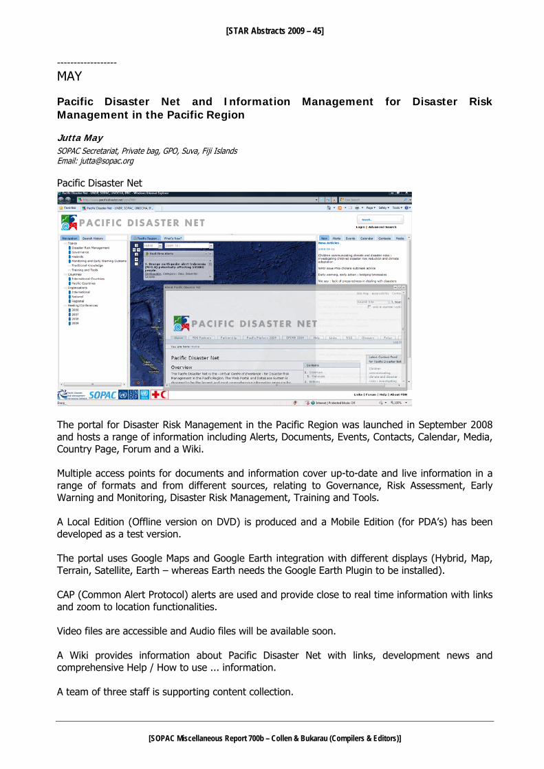
[STAR Abstracts 2009 – 45]
[SOPAC Miscellaneous Report 700b – Collen & Bukarau (Compilers & Editors)]
------------------
MAY Pacific Disaster Net and Information Management for Disaster Risk Management in the Pacific Region Jutta May SOPAC Secretariat, Private bag, GPO, Suva, Fiji Islands Email: [email protected] Pacific Disaster Net
The portal for Disaster Risk Management in the Pacific Region was launched in September 2008 and hosts a range of information including Alerts, Documents, Events, Contacts, Calendar, Media, Country Page, Forum and a Wiki. Multiple access points for documents and information cover up-to-date and live information in a range of formats and from different sources, relating to Governance, Risk Assessment, Early Warning and Monitoring, Disaster Risk Management, Training and Tools. A Local Edition (Offline version on DVD) is produced and a Mobile Edition (for PDA’s) has been developed as a test version. The portal uses Google Maps and Google Earth integration with different displays (Hybrid, Map, Terrain, Satellite, Earth – whereas Earth needs the Google Earth Plugin to be installed). CAP (Common Alert Protocol) alerts are used and provide close to real time information with links and zoom to location functionalities. Video files are accessible and Audio files will be available soon. A Wiki provides information about Pacific Disaster Net with links, development news and comprehensive Help / How to use ... information. A team of three staff is supporting content collection.

[STAR Abstracts 2009 – 46]
[SOPAC Miscellaneous Report 700b – Collen & Bukarau (Compilers & Editors)]
Future plans include country missions with training and content collection, Image archive, CAP alerts for the Pacific region and the integration in a framework with more Information Management for DRM tools. Pacific Disaster Net is developed by SOPAC, IFRC, UNDP-PC and OCHA as an initiative under the Pacific Disaster Risk Management Partnership Network. Information Management for Disaster Risk Management in the Pacific Region – future plans
Based on the experience with Pacific Disaster Net and following a growing request for information management and online tools, CRP has developed further systems like the RFA Monitoring tool, Projects and Capability Portal and the Development Partners for Climate Change Projects Matrix. More systems are planned and to be integrated under the new overarching Partnership portal and including NDMO Websites, systems for Baseline data and Assessments (supporting as well PDA access during disasters) and National Observatories. CAP alerts in collaboration with regional Meteorology Services are in discussion to enhance Early Warning Systems and alert distribution by SMS. The above will be supported by a future Search Engine and a frequent Newsletter. A strong focus on evaluation and user integration during the development is maintained and realized with several meetings, workshops, working groups and the pilot project to Strengthen Disaster Information Management Systems in Fiji, towards capacity building and the implementation of relevant online systems to improve information management. All systems are using Free Open Source Software.

[STAR Abstracts 2009 – 47]
[SOPAC Miscellaneous Report 700b – Collen & Bukarau (Compilers & Editors)]
------------------
McMURTRY Development of a high-speed, low-power miniature deep-ocean mass spectrometer system for in situ chemical analysis in defense, security, and environmental applications Gary McMurtry School of Ocean and Earth Science and Technology University of Hawai‘i, Manoa Honolulu, Hawai‘i 96822, USA Email: [email protected] Mass spectrometers are extremely analytically powerful instruments that can analyze a wide range of volatile and semi-volatile organic compounds (VOC). Methods such as Membrane Introduction Mass Spectrometry (MIMS) are at the forefront of many on-line analytical approaches for quantitative determinations of trace aqueous VOC, dissolved gases, and other compounds in the lab and in portable, terrestrial applications. Very few instruments are capable of such analysis in situ, underwater, especially in deep waters. Based upon the previous experience of the PI, the University of Hawaii successfully obtained a grant from the National Science Foundation (NSF) in 2003 to develop and test deploy a deep-ocean capability underwater mass spectrometer system. The Deep-Ocean Mass Spectrometer (DOMS) prototype was fabricated in the UH School of Ocean and Earth Sciences and Technology (SOEST) Engineering Support Facility (ESF). It was bench and pressure tested to 4000 m equivalent water depth and successfully test deployed at 1000 m water depth for four months in a methane gas-rich cold seep area off the Costa Rica Pacific margin in 2005, using the UNOLS DSV Alvin and the German ROV Quest. We have recently secured a contract with CEROS (Center of Excellence for Research in Ocean Sciences) to develop and test a new, compact and analytically powerful version of the DOMS system. A primary upgrade will be inclusion of the new ASML-McKinley ion trap mass spectrometer recently developed by Brooks Automation, who has selected us as an alpha tester. This new component will replace the existing SRS quadrupole MS and will offer a number of system enhancements, among them compact size, power reduction, greatly increased MS scan speed (by up to 1000X), and extended mass range, to >1000 AMU (atomic mass units or Daltons). Additional proposed improvements will be made to the system operating software and documentation for client use, plus multiple hardware enhancements to improve the prototype’s membrane introduction sample inlet, and upgrade the present turbo pumped vacuum to a NEG-Ion pumped system. The MIMS effort will improve instrumental sensitivity and reliability for sub-ppb detection of aqueous dissolved volatile organic compounds and gases in situ. The NEG-Ion effort will greatly lower the power of the instrument while improving the high vacuum from 10-6 millibar to 10-8 millibar. We anticipate that the project will last for 12 months. Our goals are to make the field prototype we have developed every bit as capable as the lab bench and portable, terrestrial versions. If we are successful, then all other, previous military, security, and environmental applications are within our grasp as simple downgrades of our deep-sea designs. We will develop and test two field-deployable mini-DOMS instruments, a deep-ocean version capable of operations at water depths to 6000 m and a shallow-water version capable of operations to at least 1000 m water depth. A third unit will be used for bench-top calibrations, trouble-shooting, and any further tests of the several system enhancements proposed. Transition plans include providing a more viable, capable instrument for the US Deep Water Munitions Monitoring Program, for AUV, ROV and various underwater platforms of the US Navy via SPAWAR, as potential tools for the US Dept. of

[STAR Abstracts 2009 – 48]
[SOPAC Miscellaneous Report 700b – Collen & Bukarau (Compilers & Editors)]
Homeland Security via the UH National Center for Island, Maritime and Extreme Environment Security (CIMES), and for the national Ocean Observing Initiative program via the UH Center for Microbial Oceanography: Research and Education (CMORE). ------------------
McMURTRY, FRYER & OTHERS Massive volcanic flank failure and megatsunami generation evolve in response to Quaternary climate change G. M. McMurtry1, G. J. Fryer2, D. R. Tappin3 & J. Fietzke4 1 School of Ocean and Earth Science and Technology, University of Hawai‘i, Manoa, Honolulu, Hawai‘i 96822, USA 2 Pacific Tsunami Warning Center, 91-270 Fort Weaver Road, Ewa Beach, HI 96706-2928, USA 3 British Geological Survey, Kingsley Dunham Centre, Keyworth, Nottingham NG 12 5GG, UK 4 Biogeochemie Leibniz-Institut für Meereswissenschaften, IFM-GEOMAR Dienstgebäude Ostufer, 8E-105 Wischhofstraße 1-3 , D-24148 Kiel, Germany Emails: [email protected]; [email protected]; [email protected]; [email protected] Oceanic volcanoes have erupted and created landslides throughout time, but within the Quaternary, flank failures have responded to changing climate in the orbitally-forced glacial-interglacial transition period. They not only respond to the 100-ka orbital eccentricity cycle, but in the case of very large shield volcanoes like Mauna Loa in Hawai’i, failures appear to correlate with the finer abrupt transitions from cooler-dry to warmer-wet climate within an interglacial period. We present evidence for this in MIS-5 and 7, where Mauna Loa's west flank failed in a series of sections with a ca. 25,000-year recurrence, similar to Earth’s precession cycle. Mauna Loa's flank failure started soon after its emergence from the sea at about 250 ka, probably manifested as the morphologically-oldest Punaluu landslide. Two subsequent “megatsunamigenic” South Kona landslide events at 225 and 200 ka were followed by a 65,000-year "rest period" associated with the MIS-6 glacial, when it was probably too dry to trigger a landslide. Flank failure resumed at 135 ka, followed 25,000 years later by the last megatsunami-generating failure at 110 ka (Alika phase 1 and 2 landslides). The most recent Mauna Loa landslides appear to be the Ka Lae East and West, that likely occurred >32 to 60 ka, but no tsunami deposits have yet been found for them. Globally, oceanic volcanoes are now recognized to have undergone flank failures at the 100-ka glacial-interglacial transition period back to nearly 1 Ma. These include other hotspot and island arc volcanoes within the Pacific (Tahiti), Indian (Reunion) and Atlantic Oceans (Canary Islands, Guadeloupe and Martinique). They imply a global megatsunami hazard, although their deposits are not well known outside of Hawai’i. Possible exceptions are deposits described on Bermuda and the Bahamas, and in the Canary Islands of the Atlantic.

[STAR Abstracts 2009 – 49]
[SOPAC Miscellaneous Report 700b – Collen & Bukarau (Compilers & Editors)]
------------------
O’BRIEN National Capacity Assessment of SOPAC Member Countries: Tsunami Warning and Mitigation Systems Cherie O’Brien Australian Bureau of Meteorology, GPO Box 1289 Melbourne VIC 3001 Australia Email: c.o’[email protected] The National Capacity Assessment of Pacific Islands Applied Geoscience Commission (SOPAC) Member Countries: Tsunami Warning and Mitigation Systems project works in collaboration with the member countries of SOPAC to assess their capacity to prepare for, receive, communicate and respond effectively to tsunami warnings. The project is led by the Australian Bureau of Meteorology, in partnership with the Australian Attorney-General’s Department (AGD), SOPAC, and with the assistance of various other international agencies. The project is funded by the Australian Agency for International Development (AusAID) as part of their Pacific Governance Support Programme (PGSP). By undertaking an assessment of the capacity of individual nations to manage tsunami events, the project aims to:
1. Better guide national strategic effort and donor funding towards achieving targeted improvements in the tsunami warning and mitigation systems in the respective countries.
2. Provide a baseline of information by which to measure tsunami capacity of Pacific Island Countries (PICs) in the future.
The 14 SOPAC member countries participating in the project are the Cook Islands, the Federated States of Micronesia, Fiji, Kiribati, the Marshall Islands, Nauru, Niue, Palau, Papua New Guinea, Samoa, the Solomon Islands, Tonga, Tuvalu and Vanuatu. Currently, all assessment trips are completed. To date, the project has brought together over 700 government, private sector, non-government, regional and international organisations throughout the Pacific to discuss preparedness for the tsunami hazard. The project team is now finalising individual country reports. A regional report, compiling the results of all 14 PICs, will also be completed around the end of 2009. Vital to the success of the project is the exposure of the assessment results to the countries themselves, donors and the regional and international disaster management and scientific community. The aim of this engagement is to encourage countries and international partners to recognise the benefits to multi-hazard early warning systems that implementing the recommendations made by the tsunami assessment process would bring.

[STAR Abstracts 2009 – 50]
[SOPAC Miscellaneous Report 700b – Collen & Bukarau (Compilers & Editors)]
------------------
OTA, ICHIOKA & OTHERS
Management and conservation of islands and their surrounding ocean areas Yoshitaka Ota, Takashi Ichioka, Kazuyuki Maiwa, Hiroko Sasaki, Rieko Suzuki & Hiroshi Terashima Policy Research Department, Ocean Policy Research Foundation, Kaiyo Senpaku Bldg., 1-15-16, Toranomon, Minato-Ku, Tokyo 105-000, Japan Email: [email protected] Today, islands which are dependent on the sea are faced with various problems accompanying climate change, such as the increasing intensity of natural disasters, sea-level rise and even land submersion. Problems concerned with urbanization and waste management have also been increasing. Island life and the ocean are closely connected in many ways. Nonetheless, in terms of the responsibility to manage and conserve their surrounding ocean areas, island states have difficulty in fulfilling the task on their own. Therefore, both integrated management and sustainable development of ocean areas surrounding islands should be supported by the international community through the coordination and cooperation between states who share concerns over the islands and their waters. Based on this principle, OPRF has started a 3-year project titled ‘Management and Conservation of Islands and their surrounding Ocean Areas’ from 2009. The themes of this research project are as follows:
1) The management and conservation of islands and their surrounding ocean areas. 2) Climate change and problems of island life, the environment and the surrounding ocean
areas. 3) Management of islands and their surrounding ocean areas.
In this project, we aim to promote the idea of integrated ocean management and to propose practical suggestions to solve various environmental and social problems concerning ocean management, which Pacific Islands currently face. ----------------------------
OVERMARS Maintaining Drinking Water Safety in Pacific Island Countries Marc Overmars SOPAC Secretariat, Private Bag, GPO, Fiji Islands Email: [email protected] Access to safe drinking water is a basic human need and essential to public health. Illness and death arising from drinking unsafe water has continuing impact on communities throughout the Pacific. A recent report Sanitation, Hygiene and Drinking water in Pacific Island countries: Converting Commitment into Action (WHO/SOPAC, 2008), states that every year 2800 deaths in Pacific island countries (PICs) result from diarrhoea, and most are children under five years of age. These tragic diarrhoeal deaths are preventable as they are often linked to unsafe water, lack of proper sanitation facilities and poor hygienic practices. In 2006, only 46% of people in PICs had access to any type of improved drinking water facility.

[STAR Abstracts 2009 – 51]
[SOPAC Miscellaneous Report 700b – Collen & Bukarau (Compilers & Editors)]
A regional workshop on Drinking Water Quality Standards and Monitoring in Pacific Island Countries (7-10 Feb 2005, Nadi Fiji), developed the Framework for Action on Drinking Water Quality and Health, designed to support the implementation of drinking water quality actions as envisioned in the overarching Regional Action Plan on Sustainable Water Management. One of the actions formulated under this framework is the introduction, development and implementation of Drinking Water Safety Plans in the Pacific region. Effective preventive management through a framework for Drinking Water Safety Planning (DWSP) is an efficient mechanism for ensuring the safe quality of drinking water. Drinking water safety planning is a comprehensive risk assessment approach that encompasses all aspects of a drinking water supply, from catchment to consumer, to consistently ensure the safety of drinking water supplies. The Pacific DWSP programme, supported by the Australian government, commenced in late 2005. It is being implemented by SOPAC and WHO, with ‘in-kind’ technical support from the New Zealand Ministry of Health. The DWSP programme is providing support to participating countries to build their capacity in developing system-specific drinking water safety plans and implement subsequent improvement schedules which will increase the safety of drinking water supplies. Four Pacific Island Countries have piloted the DWSP approach through the AusAID funded programme and their experiences and lessons learned are being shared within the region. Whereas four other countries have replicated this approach on their own accord other countries have shown interested in further adoption of the DWSP concept. ------------------
PARKER The South Pacific Sea Level & Climate Monitoring Project: an improved observing network and future long-term operations Phil Parker South Pacific Sea Level & Climate Monitoring Project, Bureau of Meteorology, PO Box 1289K, Melbourne Victoria, Australia Email: [email protected] The South Pacific Sea Level & Climate Monitoring Project (SPSLCMP) provides sea-level observations for real-time and climate monitoring applications from its 12-station tide gauge network from mainly SW Pacific locations. The project has been operating since 1991 and has since maintained the major source of high quality sea level data in the region. It is now in its 4th Phase (running 2006-2010). Funding for the project has been provided by the Australian Agency for International Development (AusAID). A strategic review of Phase 4, and looking beyond Phase 4, was carried out in 2007 to re-evaluate long-term project directions and priorities and needs of the project’s clients – the 12 partner Pacific Island countries. A review focusing on more specific project deliverables from Phase 4 was undertaken in mid 2009. The strategic review recommended, inter alia, renewal of the project’s observing network infrastructure and that a Phase 5 should be established to follow Phase 4. This presentation provides an overview of plans for the observing network upgrade, including the introduction of new sensors and enhanced geodetic and communications elements. Directions for Phase 5 of the project will also be discussed. The latest evaluation of trends in regional sea levels will also be presented.

[STAR Abstracts 2009 – 52]
[SOPAC Miscellaneous Report 700b – Collen & Bukarau (Compilers & Editors)]
------------------
PELLETIER, VERGNIOLLE & OTHERS The “Arc Vanuatu” program: state of work and preliminary results Bernard Pelletier1, Sylvie Vergniolle2, Gilles Chazot3, Patrick Allard4, Esline Garaebiti5, Alexandro Aiuppa6, Serge Andrefouet7, Hélène Balcone2, Valérie Ballu1,2, Philipson Bani7, Jean Battaglia8, Antonella Bertagnini9, Hervé Bertrand1, Marie-Noelle Bouin11, Georges Boudon2, Guy Cabioch7, Marie Chaput12, Janvion Cuevard5, Wayne C. Crawford1,2, Franck Donnadieu8, Charley Douglas5, Stéphanie Dumont8, Anthony Finizola12, Francis Gallois7, Pierre-Jean Gauthier8, Morris Harrison5, Philippe Jean-Baptiste13, Sophie Jimmikone5, Moses Kalsale14, Tony Kanas14, Philippe Koroka14, Michel Lardy7, Anne-Marie Lejeune15, Jean-François Lénat8, Alexis Le Pichon16, Jean-Philippe Métaxian (17), David Nakedau (5), Nicole Métrich (4), Franco Parello6, Damien Ponceau15, Marc Régnier18, Claude Robin8, Sylvain Todman5, Jean-Claude Willy13, Athanase Worwor5 & Christelle Zielinski2 1 GéoAzur, IRD, Port-Vila, Vanuatu 2 IPGP, Paris, France 3 IUEM, UBO, Plouzane, France 4 Laboratoire Pierre Sue, CNRS-CEA, Saclay, France 5 Geo-hazards, DGMWR, Port-Vila, Vanuatu 6 CFTA, Palermo University, Italy 7 IRD Nouméa, Nouvelle-Calédonie, France 8 LMV, Clermont-Ferrand, France 9 INGV Pisa, Italy 10 Université de Lyon, France
11 CMM/CNRM, Meteo France, Brest 12 Laboratoire GéoSciences Réunion-IPGP, France 13 LSCE, CEA-CNRS-UVSQ, Gif-sur-Yvette, France 14 Topographic service, DLS, Port-Vila, Vanuatu 15 Université Paris VI, Paris, France 16 CEA/DASE, Bruyères le Chatel, France 17 LGIT, Chambéry, France 18 Géoazur, IRD, Sophia-Antipolis, France. Emai: [email protected]
The “Arc Vanuatu” program is a 3-year (mid 2007 to 2009-2010) multidisciplinary research program devoted to studying eruption dynamics and seismic cycles in the Vanuatu arc. The program, mainly funded by the French National Research Agency, is undertaken in collaboration with the Geohazard Section of the Department of Geology, Mines and Water Resources and the Topography Service of the Land and Survey Department of Vanuatu. On the French side, it unites scientists from several institutions (CEA, CNRS, IPG, IRD, Météo France, Universities), the main partners being Géoazur-IRD Nouméa and Vanuatu, IPG Paris, LMV Clermont-Ferrand and LPS Saclay. Italian colleagues from INGV Pisa and Palermo University also participate in the gas studies. In addition to funding by the French National Agency for Research, the research is also supported by IRD, CEA and the French Pacific Funds through the French Embassy in Port Vila, Vanuatu. The « Arc Vanuatu » program addresses two themes: one dealing with Strombolian to Plinian basaltic eruptions (dynamics of degassing, nature and role of gas and magma, formation of plumes, cyclicity of eruptions, hydrothermal systems and structuration of volcanic edifices); the other concerns large earthquakes (seismogenic zones, stress accumulation and relaxation, relationship between seismic cycle and relief building), the ultimate goal being to better understand the mechanisms behind these destructive events and to identify precursors.
The program is focused on two areas of the Vanuatu arc, each in a different geodynamic setting. The first is the central part of the arc and includes the Lopevi, Ambrym and Aoba volcanoes. This part, sitting in front of ridge entering into subduction, is characterized by a strong coupling at the trench, back-arc and intra-arc shortening, strong vertical uplift, high earthquake recurrence rate, and large explosive volcanoes. The presence of islands at the front and back of this arc and of shallow waters near to and on both sides of the trench offer an exceptional opportunity to study the seismicity and the geometry of the subduction interface and seismogenic zones and to measure the stress accumulation across the entire margin. The active Ambrym and Lopevi volcanoes generate strong eruptive plumes and are ideal sites for studying gas accumulation and the source mechanisms for plinian eruptions, to better understand precursory phenomena and forecast eruptions. The second study area is the Yasur volcano in the southern part of the arc.
[STAR Abstracts 2009 – 53]
[SOPAC Miscellaneous Report 700b – Collen & Bukarau (Compilers & Editors)]
Permanent activity, strong fluctuations in strombolian eruption intensity and easy access make this an ideal site for a multidisciplinary study of the eruptive cycle. With its resurgent dome and associated hydrothermal system, it also offers the opportunity to study the processes controlling dome resurgence in calderas. The following geophysical, geochemical, petrological and geological works have been done for the volcanology and eruption dynamics study: • Acoustic signals are being recorded on Yasur (from October 2004 to July 2006 and then since
August 2007), Ambrym (3 microbarographs deployed since August 2008) and Lopevi (since April 2009) volcanoes (Vergniolle, Zielinski, Bani et al.). The acoustic pressure sensors are now complemented at each site by a broad-band seismometer (since February 2009 at Ambrym and Yasur). At Yasur, the estimated gas flux ranges from 250 to 1000 m3/s and correlates with the number of explosions, which vary from 20 to 250 per hour (Zielinski et al.). The mean acoustic pressure, ranging from 25 to 200 Pa, is inversely proportional to the number of explosions. Different types of activity with rapid transition between them reflect instabilities of bubble flow in the conduit. At Ambrym, acoustic events from Benbow and Marum calderas can be distinguished and used to characterize the activity and the relationship between the plumbing systems of the two edifices (Bani et al.).
• Ejecta velocity and content have been measured using Doppler radar and infra-red radiometer measurements on Yasur in September 2008 (Donnadieu et al.). Initial data analysis indicates emission velocities up to 430 km/h for the strongest explosions.
• Seimological networks were deployed on and around Yasur from late January 2008 to early February 2009 and over the Ambrym caldeira from late October 2008 to late January 2009 (Battaglia, Metaxian et al.). On Yasur, the network included up to 22 stations with 10 broad-band sensors and 12 seismic antennas composed of one central 3-component short period seismometer and up to 6 short period vertical seismometers. On Ambrym, the network was composed of 6 broad-band sensors and 4 antennas. The Yasur network recorded intense activity, with thousands of transients per day, mostly related to explosions. The explosive activity can be divided in several families of events, reflecting different modes of conduit resonance. One interesting result is that the explosion signal changed just after a large (M 7.3) earthquake about 80 km offshore, indicating that the earthquake probably changed the conduit morphology.
• Electric resistivity tomography combined with self potential, temperature and soil CO2 concentration measurements, as well as electromagnetic soundings and 350 gravity measurements were performed in July 2008 to understand the structures of the system of Siwi caldera-Yenkahe dome-Yasur volcano (Lenat, Finizola, Chaput, Dumont et al.). The system is characterized by very low values of resistivity and CO2 emanations, suggesting strong alteration of the volcanic rocks beneath the caldera. The measured negative gravity anomaly does not support the presence of a large intrusive body below the Yenkahe resurgent dome.
• Real-time multi-gas measurements and filter-pack plume samples were collected on Yasur and Ambrym volcanoes in October 2007 and October 2008 (Allard, Aiuppa, Bani, Gauthier et al.). Average SO2 fluxes were also measured several times in 2007 and 2008. These data allow us to quantify the volatile emissions from both volcanoes and to demonstrate that Ambrym is one of the strongest sources on the earth for gases (SO2, H2O, CO2, HCl, HF, HBr), trace metals (Se, As, Sn, Tl, Cu, Pb, Rb, Cd, Ag) and radioactive 210Po.
• A first measurement of dissolved volatiles in olivine melt inclusions for recent Yasur and Ambrym volcanic products allows estimations of the depth of the magma reservoir and, combined with gas emissions, the magma degassing rate (Metrich, Bertagnini, et al.).

[STAR Abstracts 2009 – 54]
[SOPAC Miscellaneous Report 700b – Collen & Bukarau (Compilers & Editors)]
• Complementary studies of volatiles and texture on plinian and recent products of Yasur and Ambrym volcanos sampled in July 2009 will help to understand the mechanisms of the rare basaltic plinian eruptions (Boudon, Balcone, Lejeune et al).
• Helium isotopes of hot spring waters sampled in 2008 and June 2009 from Tanna, Efate, Ambrym, South Pentecost and Aoba have been analysed in order to better characterize the source of volcanism along the arc (Jean-Baptiste et al.). Results indicate a high spatial variability of helium isotope ratios from 4.4 Ra to 10 Ra, with a possible plume influence confined to northern Ambrym.
• Other geochemical and petrological studies concerning the magma source have been devoted to lavas previously sampled on Ambrym, Gaua and Aoba, and to lavas of Lopevi volcano newly sampled during field work in September 2008 (Chazot, Bertrand, Robin et al.) The large set of data indicates a high variability both in space and time of the magma compositions in the Vanuatu arc. For example, Lopevi lavas include, in addition to basic and intermediate previously-known lavas, differentiated rocks, and young lavas emitted during the last 1963 eruption are enriched in K2O in comparison to older lavas, suggesting a change in the composition of the magma source.
For the second part of the program (tectonics and seismic cycle) the following seismology,
geodesy and neotectonic measurements have been made on the central segment of the arc. • 20 broad-band seismometers were deployed over southern Santo and northern Malekula from
May 2008 to February 2009, and 10 ocean bottom seismometers completed the network offshore west of the land study area from late May to early September 2008 (Crawford, Regnier et al.). The network allows us to locate about 40 earthquakes/day (to compare to 1 event detected by the global network beneath the study area during the experiment) and to image the shape of the plate interface and intracrustal seismogenic zones. At the end of the temporary experiment, a network of 5 broad-band seismometers was installed to continue recording the micro-seismicity in this area over several years.
• 8 GPS receivers for continuous geodetic measurements were installed at the end of 2007 and during the first part of 2008 over the entire central segment of the arc, from west Santo and Malekula to Maewo and Pentecost (Ballu, Bouin et al). The network extends also at sea where vertical deformation is monitored on Wusi and Sabine Banks, west of Santo, using pressure gauges, shipborn GPS measurements and altimetric data. The last cruises were in October 2007 and April 2009. These data will give crucial information on the buildup and relaxation of stress throughout the seismic cycle, and may allow to identify transient deformations and precursor signals to cataclysmic events. In addition to these continuous measurements, most of the GPS reference sites on the Vanuatu archipelago were re-measured in 2008 and 2009.
• The coastal morphology, age of the lowest uplifted reef terraces and morphology of living coral colonies were studied along the shore of islands of the central part of Vanuatu arc in order to estimate margin segmentation, current and recent vertical ground motions and seismic hazards (Pelletier, Cabioch, Andrefouet et al.). Landsat and Quickbird satellite images over the shores of the islands of the central arc segment and a collection of aerial photographs taken in June 2008 along the coasts of Pentecost, Maewo and West Epi were used to identify lengthwise morphological variations and define morphological characteristics of reef and outer slope in the different sub-segments. Then we visited selected portions of the shore to measure offsets and to sample corals: in north Pentecost (June 2008), south Pentecost (June 2009), north Maewo (August 2008), central Maewo (September 2008), east Ambrym (June 2009), Southwest Malekula (June 2008), northwest Malekuka (May 2009) and west Epi (September 2009). First results indicate uplift in southwest Malekula likely to be associated with the 1994 earthquake, current subsidence after the coseismic uplifts in northwest Malekula and east Ambrym associated with the 1965 and 1999 major earthquakes, respectively, and current stability and/or slow subsidence along the shores of Maewo and

[STAR Abstracts 2009 – 55]
[SOPAC Miscellaneous Report 700b – Collen & Bukarau (Compilers & Editors)]
Pentecost as indicated by the morphology of the living coral and the Holocene age and the altitude of the lowest reef terrace.
------------------
PIOTROWICZ Argo profiling floats – observing the ocean interior Steve Piotrowicz US National Oceanic and Atmospheric Administration, 1305 East West Hwy, Silver Spring, Maryland 20910, USA Email: [email protected] Over the past decade, Argo floats have provided an unprecedented number of profiles of temperature and salinity of the global oceans (to 2000 m depth) without temporal and seasonal biases, far surpassing the number collected historically from ship-based hydrography. The original design of the Argo mission specified nominal 3° x 3° spacing, with a 10 day sampling interval, of the oceans between 60 °N and 60 °S, excluding the high latitudes and marginal seas. A PC-based data viewer has been developed for easy display of horizontal maps, vertical sections, time-series plots, and line drawings from gridded Argo data. An installation file is available, including the global Argo gridded dataset described above, at: ftp://kakapo.ucsd.edu/pub/argo/Pacific_Marine_Atlas ------------------
PRATAP, TERRY & OTHERS Climatic variability: a study of cyclone-track regimes in the tropical South Pacific Arti Pratap1, James P. Terry2, Gennady Gienko1 & M.G.M Khan1
1 Faculty of Science and Technology, The University of the South Pacific, Private Mail Bag, Suva, Fiji 2 Department of Geography, National University of Singapore, AS2, 1 Arts Link, Kent Ridge, Singapore 117570; Email: [email protected] Email: [email protected] Tropical cyclones are one of the most destructive natural hazards for the tropical Pacific, having a large impact on socio-economic and environmental sectors of island nations. In response, scientific study should continue to strive for improved understanding of the characteristics of these intense storms. A continuing problem lies in forecasting cyclone movement after formation. One way to add to existing knowledge in this area is to analyse available data on cyclone track shape, in order to identify any special patterns. In this context, this study examines the statistical characteristics of several tropical cyclone track parameters, using archive data from 1970 to 2008 for the South Pacific region. The dataset includes information on 292 tropical cyclones, which includes all storms with intensity of 35 knots and above that have their genesis in tropical waters. Cyclone paths are analysed within the geographical grid covered by 0 – 25°S and 160° E – 120° W. The particular focus is on track sinuosity values and how these may be characterized and grouped. Sinuosity values for all cyclone tracks were calculated by measuring the total distance travelled by each cyclone and then dividing this by the vector displacement between cyclogenesis and decay positions. A boxplot analysis was then performed to define the boundaries of the data and to separate outliers. The resultant group was tested against various statistical distributions. Preliminary findings suggest that cyclone track sinuosity data fits the Pareto distribution most closely, as is seen in the P–P plot in Figure 1. This distribution may therefore be used to

[STAR Abstracts 2009 – 56]
[SOPAC Miscellaneous Report 700b – Collen & Bukarau (Compilers & Editors)]
categorize four separate classes for track sinuosity and also to suggest sensible terminology for these different sinuosity ranges.
0.0 0.2 0.4 0.6 0.8 1.0
Observed Cum Prob
0.0
0.2
0.4
0.6
0.8
1.0
Expe
cted
Cum
Pro
b
Figure 1: Pareto P-P plot of track sinuosity values for tropical cyclones in the South Pacific since 1970. Alternative solutions to categorizing cyclone track sinuosity involve using hierarchical cluster analysis (here, employing Ward’s method in the software package SPSS). Four homogeneous groups based on sinuosity values can be determined, as shown in the table below.
Finally, how average track sinuosity may have changed over space and time is an important consideration in the context of climate change. The average initial and final latitude/longitude position for each sinuosity category may be plotted and analysed using GIS. This allows investigation of the distribution of track sinuosity across the South Pacific. Several implications of this work for cyclone hazard studies in the region will be discussed. ----------------------------
ROBINSON The Pacific Integrated Water Resources Management Programme Rhonda Robinson SOPAC Secretariat, Private Bag, GPO, Fiji Islands Email: [email protected] Integrated Water Resources Management (IWRM) is a planning and management process which looks at a whole island ecosystem approach to managing water and land resources using key principles such as multi-stakeholder collaboration and participation horizontally across sectors and vertically across various scales,
Group Cyclone track sinuosity values 1 1 – 1.1257 2 1.1305 – 1.2805 3 1.2924 – 1.5148 4 1.5374 – 1.6902 5 (outliers) 1.7066 – 2.7960 6 (outliers) 4.3564 – 4.5039 7 (outliers) 52.7437

[STAR Abstracts 2009 – 57]
[SOPAC Miscellaneous Report 700b – Collen & Bukarau (Compilers & Editors)]
information sharing, using open and transparent systems to water management which consider the environment, economic and financial sustainability of the entire system. Local approaches to Integrated Water Resources Management (IWRM) have been practiced in the Pacific Islands region for centuries by local communities through their observations of traditional coastal, land and water resources management measures which have sustained islands’ resources for hundreds of years. However, our islands have changed with issues such as rapid population growth, increasing urbanisation, damage to water catchments resulting from deforestation, poor waste management practices leading to water pollution, and climate change posing serious challenges to Pacific Island Countries in respect of how they achieve sustainable management of their water resources. Consequently, the European Union (EU) and the Global Environment Facility (GEF) have provided funding support through their partners the United Nations Development Programme (UNDP), United Nations Environment Programme (UNEP) and the Pacific Islands Applied Geoscience Commission (SOPAC) to develop and implement the Pacific IWRM Programme consisting of two separate projects which are outlined below:
1. The “Pacific IWRM National Planning Programme” is funded for three years (2008-2010) by the European Union, and focuses on strengthening governance structures (coordinating national water committees) and frameworks (policy, legislation, action plans) to mainstream IWRM and WUE in to national planning processes.
2. The “Sustainable Integrated Water Resources and Wastewater Management Project in Pacific
Island Countries” (Pacific IWRM Project for short) is funded for five years (2009-2014) by the Global Environment Facility and implemented in collaboration with the United Nations Environment and Development Programmes (UNEP and UNDP). It focuses on practically demonstrating and developing IWRM best practice to address national priority water issues.
The Pacific IWRM Programme to be implemented in fourteen (14) Pacific Island Countries provides the region with an opportunity to build on the successful practices from the past whilst addressing the complexities of sustainable development in this modern age and developing and implementing dynamic and innovative IWRM approaches. It also represents the first strategic step in the development of IWRM planning and implementation in the Pacific Islands region. ------------------
SMITH (L) You can’t manage what you don’t measure – HYCOS in the Pacific Llyod Smith Pacific Islands Applied Geoscience Commission (SOPAC) Private Mail Bag, GPO, Suva, Fiji Email: [email protected] Pacific HYCOS (Hydrological Cycle Observing System) was implemented in all PIC’s under EU funding in late 2006 to provide assistance to all National Hydrological Services (NHS’s) to better monitor and assess their water resources for surface and groundwater availability. Initiatives have included provision of state-of-the-art instrumentation, equipment, software and technologies coupled with on going training in field measurements, office and analysis procedures. The HYCOS supported pilot basins in time will collect robust long-term hydrological datasets allowing for more informed decision making for water resource development for a broad range of infrastructure design, catchment and aquifer management and planning. Data will also allow for the climatic extremes of floods and droughts to be measured thereby allowing for disaster risk management to be better informed for possible mitigation options, especially for flood warning. Progress to date has been positive with old hydrological stations being rejuvenated, new ones installed and human resource capacity steadily improving.

[STAR Abstracts 2009 – 58]
[SOPAC Miscellaneous Report 700b – Collen & Bukarau (Compilers & Editors)]
Figure 1: Discharge measurement on Navua River Fiji. The diverse stakeholders in water resource data have recognized a deficiency for many years in such data and it is hoped with increasing visibility for hydrological data and the NHS’s developed through Pacific HYCOS initiatives, that NHS’s and monitoring programs will be far better supported and transposed into other important catchments earmarked for future development opportunities. Increasing levels of investment in this type of long-term monitoring now, will pay dividends for the economic design, benefit and water security of our children and future generations.
0
200
400
600
800
1000
1200
Flow
Cum
ecs
Jan-1992 Feb-92 Apr-92 May-92 Jun-92 Jul-92 Aug-92 Sep-92 Oct-92 Nov-92 Dec-92site 5004601 Lungga River at Bridge Flow Cumecs
Figure 2: Annual discharge hydrograph Lungga River, Solomon Islands, 1992.
Figure 3: Servicing flood warning station, Navua River, Fiji. Pacific HYCOS is the first basin-wide initiative ever undertaken looking in particular at surface water assessment where there has been a diminishing investment over many years. Perhaps the capital cost in setting up and mobilizing to collect this type of data, often undertaken in remote and difficult areas (particularly for flood measurement), has been a deterring factor evident in the lack of investment and a loss of data and skills. HYCOS is optimistic that these initiatives will bear fruit through the benefits of collection of data being better recognized by governments, stakeholders and communities at large. It also needs to be considered that many international

[STAR Abstracts 2009 – 59]
[SOPAC Miscellaneous Report 700b – Collen & Bukarau (Compilers & Editors)]
donor-supported programs including those of SOPAC undertaken throughout the Pacific have a water focus, especially on groundwater and are effectively a significant stakeholder in Pacific HYCOS initiatives. ------------------
SMITH (R) Outer and remote islands’ investigations needs for effective locations of port and jetty infrastructure development Robert Smith Pacific Islands Applied Geoscience Commission (SOPAC) Private Mail Bag, GPO, Suva, Fiji Email: [email protected] One thing common with Pacific islands, being a sizable maritime zone, is the need for infrastructure to accommodate the principal movement of people and goods. Building ports is an expensive business and often the construction is stalled through the lack of appropriate data for engineering design and location. On the other hand they are built without due respect to the geological, physical oceanographic and existing coastal processes at work resulting in infrastructure that can often be under utilised. The remoteness of certain locations often precludes the existence of important datasets, even the collection. With the right approach and planning, investigations can indeed be accomplished. A four-island site investigation covering some 300 nm is one such example in the outer islands of Fiji. Here four separate localities on the islands of Gau, Nairai, Rabi and Batiki were investigated in one ten-day survey. Data collected included multibeam, sidescan, backscatter, single channel seismic tides and current data. An interpretation of the data collected for each location is presented. ------------------ Sedimentation in tropical dams, water resource and renewable energy issues Surinumu and Yonki Dams, Papua New Guinea Robert Smith Pacific Islands Applied Geoscience Commission (SOPAC) Private Mail Bag, GPO, Suva, Fiji Email: [email protected] Sirinumu Reservoir covering an estimated area of 28.6 km2 occupies a natural depression of the Sogeri Plateau. The reservoir floor is characterized by deep gullies and ridges many of which are structurally controlled by fracture and fault patterns. The deepest section of the reservoir noted was 30 m with an average depth of 13 m based on a dataset of 35 000 soundings. The natural setting of the reservoir in country rock comprising good outcrop of agglomerate of basalt and andesite, having a generally weathered sedimentary layer some 5 m thick and a catchment area that is still well forested has resulted in little sedimentation impacting the overall volume of the reservoir. It was noted during the survey that even after heavy rainfall no turbid water was seen to enter the lake indicating most source creeks and rivers into the reservoir bring sediment free water. For Sirinumu there are no pre-survey reservoir profiles to allow before and after analysis of changes in the reservoir due to sedimentation and as such, the analysis was based on the interpretation of the morphology of the bathymetry profiles. Here the bathymetric profiles surveyed show many small and former shallow watercourses on the reservoir floor. In many instances these have very distinct profiles indicating channels that were formed in rock outcrop of agglomerate. The persistent presence of these channels throughout the 123 bathymetry profiles collected is a good indication that sedimentation rates in the reservoir are low.
[STAR Abstracts 2009 – 60]
[SOPAC Miscellaneous Report 700b – Collen & Bukarau (Compilers & Editors)]
The Yonki Reservoir is an important renewable energy resource providing hydroelectric power for the Papua New Guinea (PNG) mining industry, and in that regard is infrastructure that fuels the PNG economy. The impacts of sedimentation on its sustainability cannot be underestimated. Sediment deposition in the order of 10 m has been estimated close to the major intake areas of the lake. This is based on the comparative analysis of original land-based survey profiles with the recent bathymetric survey profiles. This is however only indicative of sedimentation since the dam became operational and represents localised zones. The analysis of the 11 original profiles clearly shows sedimentation is a growing issue and further work is required to ensure sustainability of this resource. Based on the analysis some conclusions and recommendations have been drawn from the interpretation of the bathymetric survey results. ------------------
SMITH (S) Unlocking mineral resources from the deep seafloor: Opportunities for the South Pacific Samantha Smith Nautilus Minerals Inc., PO Box 1213, Milton, Queensland 4064, Australia Email: [email protected] Nautilus Minerals Inc (Nautilus) is following the lead of the petroleum industry as it attempts to tap into offshore resources. Planning is well underway for the high grade Solwara 1 Seafloor Massive Sulphide Project in the Bismarck Sea, Papua New Guinea (PNG). The deposit contains an average copper grade more than an order of magnitude higher than a typical land-based porphyry copper mine. The high grades, combined with a relatively small amount of overburden/waste, ensure the Solwara 1 Project will have a significantly smaller physical footprint than its land-based counterparts. Other advantages include limited social disturbance, increased worker safety (no one is at the mine face; all operations will be carried out remotely) and the development of previously unutilized “zero value” resources. Other deposits, like Solwara 1, are thought to be present on the seafloor throughout the South Pacific and Nautilus’ exploration efforts over the past two years have identified a number of potential mineralized zones in the region. The mineralized zones typically reside in water depths in excess of 1500 m. Recent advances in technology have enabled scientists and companies to explore for these deposits, potentially unlocking resources on the seafloor that would have otherwise remained hidden and unutilized. The industry of deep seafloor mineral extraction opens up a number of opportunities for South Pacific nations. Exploration itself offers many advantages, including large amounts of data collection in the form of bathymetric maps, water analysis and other environmental knowledge, as well as employment and training opportunities for South Pacific peoples.
[STAR Abstracts 2009 – 61]
[SOPAC Miscellaneous Report 700b – Collen & Bukarau (Compilers & Editors)]
------------------
SMITH, BOLALAILAI & OTHERS Coastal Geological Hazard Mapping, Navua Delta and Rovodrau Bay, Fiji Islands Robert Smith1, Ratu Semi Bolalailai2, Lai Rawace2, Sakiusa Waqanisau2 1Pacific Islands Applied Geoscience Commission (SOPAC) Private Mail Bag, GPO, Suva, Fiji 2Fiji Mineral Resources Department, Private Mail Bag, GPO, Suva, Fiji Islands Email: [email protected] The coastal areas of the southern coast of Viti Levu often called the “Coral Coast” sited between Navua River just east of Rovodrau Bay in the East and Momi Bay in the west have numerous tourist developments in place or planned; often located adjacent to coastal village communities. With development continuing unabated in recent years; the associated increase in coastal erosion issues has given rise to mounting animosity amongst the many users of the coastal resources. Increasing coastal populations in villages, towns, rapid coastal development associated with tourism and increasing utilisation of coastal resources have resulted in numerous impacts threatening coastal infrastructure. The lack of contemporary baseline data in GIS, suitable geomorphological maps depicting coastal geology, geological hazards and processes at scales to match topographical mapping products of 1:50,000 scale, is a constraint to managers, policy makers and planners recommending the most appropriate management strategies to minimise the impact of any coastal development or mitigation strategy such as dredging for flood relief. Coastal geological hazard mapping of the Navua River delta and Rovodrau Bay is one such area which is under assessment representing some 40 kilometers of coastline within this zone. Field survey activities thus far completed in this area include beach profiling, offshore multibeam bathymetric mapping and single-channel seismic profiling in the coastal and offshore of the study area. Preliminary insight into the offshore stratigraphy and slope stability of the Navua delta and adjacent submarine canyons of Togoro and Vidilo Passage and Rovodrau Bay are presented. It is known that unstable reef front slopes contribute to tsunamigenic failures, however, the reef also acts as a natural breakwater protecting the coast from the approaching waves once the tsunami is generated (Rahiman 2006). Multibeam and side-scan inviestigations of the Navua delta and river mouth examine the impact and effectiveness of dredging as a mitigating strategy for flooding. Geo-rectification of historical and recent satellite imagery datasets to map shoreline change, changes in land use and bathymetry continue to be assessed with GIS techniques with some interesting changes in river and coastal morphology revealed. This project aims to support the capacity building of Fijian researchers to improve their skills in conducting coastal geological surveys through cooperative mapping with Korean experts under KIGAM’s “Assessment of Coastal Geohazards in Asia and South Pacific (GeoCoast)” project. Reference: Rahiman, Tariq 2006. Neotectonics, Seismic and Tsunami Hazards, Viti Levu, Fiji : 312 p.
[STAR Abstracts 2009 – 62]
[SOPAC Miscellaneous Report 700b – Collen & Bukarau (Compilers & Editors)]
------------------
TALIA Coastal geological mapping of the northern coast of Upolu Island, Samoa Lameko Talia Ministry of Natural Resources and Environment, Samoa Email: [email protected] Global climate change has given rise to extremely high rainfall events, high sea levels, damaging winds and extremely high temperatures. According to the Climate Risk Profile of Samoa prepared by the Samoa Meteorology Division 2007, by the year 2050, sea level is likely to be increased by 36 centimeters, rainfall by 1.2 percent, extreme wind gusts by 7 percent and maximum temperature by 0.7 degrees Celsius. Recent updated available information on coastal geology enables coastal managers to develop long-term coastal management strategies and plans against coastal disasters and for the protection of community livelihood from the perspective of coastal environment security. The two main islands of Samoa are Savai’i and Upolu which are high volcanic islands with well-developed reefs on older volcanic rocks and fringing or no reefs on recent volcanic deposits. The main source of sediments and aggregate of the coastal areas are the reef and volcanic rocks of the inland areas. The coastal geological mapping of the Northern Coast of Upolu Island has identified and updated existing information on the coastal features including sand beaches, alluvium deposits, swamps, river deltas, erosive scarps, type of coastline and storm deposits. It also provided crucial information for the quality of aggregate material of the coastal areas. Rock and sand samples have been collected and analyzed to give a better description of the types of sediments available in the coastal areas. ------------------
TAWAKE Geological and geotechnical assessment of coastal sand resources in Mele and Teouma Bays and Pango, Efate Island, Vanuatu Akuila K. Tawake SOPAC Secretariat, Private Bag, GPO, Suva, Fiji Islands Email: [email protected] Beach sand mining is an ongoing and persistent problem in coastal strips near Port Vila, Vanuatu, particularly along the Mele and Teouma Bay coasts. According to the Department of Geology, Mines and Water Resources (DGMWR), approximately 90 % of sand that are used for construction in Port Vila and the nearby areas is extracted from the Mele Bay coast. For most private operators and peri-urban dwellers, the Mele coastal sand resource has been their traditional source of construction sand for a long time. The ongoing removal of large amounts of sand has significantly contributed to coastal degradation along these two coasts hence the DGMWR is determined to minimize sand extraction particularly along the Mele coast through the identification of alternative sources. During the 2004 site inspection of the sand resources that occur along the Mele beach, it was discovered that about two third of the beach (i.e. the eastern and middle portion) is almost

[STAR Abstracts 2009 – 63]
[SOPAC Miscellaneous Report 700b – Collen & Bukarau (Compilers & Editors)]
entirely composed of massive amounts of pumice material. This significant presence of pumice material, derived from the inland Pumice Formation, along the Mele Bay coast is an inevitable reality that is and will continue to feature prominently along the Mele Bay coast in the future. Vanuatu lies in a tectonically active region of the Southwest Pacific hence the geotechnical characterization of not only the site that needs to be developed but also of the aggregate material that will be used for construction is essential. It is therefore crucial to determine the geotechnical performance of aggregate being used for construction purposes in Port Vila that will subsequently ascertain the range of applications any particular aggregate type is suitable for. At the request of the DGMWR, the sand resources assessment at Mele and Teouma coasts and at Pango Quarry was carried out to determine the quality of sand material that occurs in these areas. The assessment was performed in two phases: the first phase was carried out in October 2004 whilst the second phase was conducted in August 2007. Additionally, crushed coarse aggregate from the Pango Quarry and the Shepherd Islands were also collected and tested. This paper will highlight the geological and engineering assessment approach being adopted to address the sand mining issues in the Mele and Teouma coasts and at Pango Quarry and subsequently presents the assessment results. The analyses and test results have reaffirmed that there are two distinct types of sand resources that occur along the Mele coast: (i) the inferior quality pumice-rich sand that occur at the eastern and middle section of the beach, and (ii) the reasonably good quality black sand that are present at the western part of the coast. Due to the significant reduction in the pumice material and the increasing presence of the more competent volcanic rock and mineral fragments at the Teouma beach, the Teouma sand is generally of better quality than that of Mele. In addition, the Shepherd gravel exhibit excellent geotechnical performance compared to the average quality Pango gravel. The compressive strength tests of concrete show that the Shepherd gravel and the black sand at Mele are better sources of construction gravel and sand respectively. In comparison, the Pango gravel and the pumice-rich sand of the Mele coast are of inferior quality. Pumice-rich sand can be used for low-stress applications hence suitable locations within the inland pumice deposit can be identified and developed as opposed to beach mining. Additionally, the Pango inland sand deposit has displayed reasonably good behaviour hence inland coastal sand resources can be used as one of the alternative sources of sand for the Port Vila area. In addition, crushed limestone can also provide alternative source of sand for the Port Vila area to replace the sand that are being extracted from the Mele and Teouma coasts. Reference: Tawake A. K. 2009. Technical Report on the Assessment of Coastal Sand Resources in Mele and Teouma
Bays and Pango Efate Island Vanuatu. EU EDF8 – SOPAC Project Report 150. ------------------ Proposed implementation strategy of the SOPAC-EU EDF10 Deep Sea Minerals Project Akuila K. Tawake SOPAC Secretariat, Private Bag, GPO, Suva, Fiji Islands Email: [email protected] The regional approach concept for the management of offshore mineral resources was conceived during the early consultation meetings within SOPAC and the follow-up meetings with the World Bank and the Pacific Islands Forum Secretariat (PIFS) in 2008. Subsequently, the support of the SOPAC Governing Council on this concept was sought during the 37th Annual Session that was

[STAR Abstracts 2009 – 64]
[SOPAC Miscellaneous Report 700b – Collen & Bukarau (Compilers & Editors)]
held in Funafuti, Tuvalu in October 2008. In response, representatives of member countries have endorsed this regional approach enabling SOPAC to pursue potential funding opportunities. SOPAC in consultation with other partners had put together a proposal seeking financial assistance from the European Union (EU) under the European Development Fund (EDF) 10 Envelop A. The Deep Sea Minerals (DSM) project proposal had been through various assessment stages prior to its approval hence the EU will provide financial support for all project initiatives. The overall objective of the project is to expand the economic resource base of Pacific ACP States by facilitating the development of a viable and sustainable marine minerals industry. This project will have four Key Result Areas: (1) Development of Regional Legislative and Regulatory Framework(s) (RLRF) for offshore minerals exploration and mining; (2) Formulation of National policy, legislation and regulations; (3) Building national capacities; and (4) Effective management and monitoring of offshore exploration and mining operations. The project will be focusing on two main beneficiary stakeholder groups. Firstly, the national governments of PICs particularly relevant government agencies that deal with minerals exploration and exploitation, environmental management, fisheries and fiscal matters. Secondly, local communities, particularly those that are most likely to be impacted will benefit from: enhanced and more sustainably distributed royalties, better managed employment and business opportunities that will ultimately contribute to better living standards, and better environment conservation initiatives to avoid adverse impacts on ocean and coastal resources. This paper will present the proposed implementation strategy of the DSM Project as outlined in the Project Logical Framework that will ensure effective task delivery. In order to realize this, a stakeholder participatory approach will be advocated in all aspects of project implementation. The activities/actions of each of the four Result Areas will be presented as well as the expected results and linkages with the SOPAC Maritime Boundaries Project. Additionally, the risks and challenges associated with the implementation of project activities will be highlighted together with cross-cutting issues such as gender and good governance. Under this Project, SOPAC will work in partnership with national, regional and international organizations together with Non State Actors (NSAs). Implementation partners include the World Bank, the International Seabed Authority (ISA), PIFS, the Forum Fisheries Agency (FFA), Geoscience Australia, the Commonwealth Secretariat, and UNEP-GRID Arendal. Initial discussions have already commenced with some of these organizations regarding collaboration opportunities. References: Concept Note for Deep Sea Minerals in the Pacific Islands Region: Legal Framework and Resource
Management. Pacific Islands Applied Geoscience Commission (SOPAC).
Action Fiche for Deep Sea Minerals in the Pacific Islands Region: a Legal and Fiscal Framework for Sustainable Resource Management. Pacific Islands Applied Geoscience Commission (SOPAC).
------------------ Seabed mineral resources potential within the Exclusive Economic Zone of Pacific Island Countries Akuila K. Tawake SOPAC Secretariat, Private Bag, GPO, Suva, Fiji Islands Email: [email protected] Deep-sea minerals have been identified within the EEZs of a number of Pacific Island Countries (PICs), and are increasingly being recognized by nations as a future potential source of revenue

[STAR Abstracts 2009 – 65]
[SOPAC Miscellaneous Report 700b – Collen & Bukarau (Compilers & Editors)]
and economic development. For many of the smaller PICs, this may represent the only exploitable natural resource sector apart from fish. SOPAC (then under the CCOP/SOPAC) was actively involved with deep sea mineral exploration in many countries in the South Pacific between the 1970s and early 1980s that led to the discovery of a number of seabed mineral occurrences within the Exclusive Economic Zone (EEZ) of these countries. In collaboration with SOPAC, a number of multi-national consortia and national agencies were involved in this early stage of seabed mineral prospecting in the region including the International Cooperative Investigation of Manganese Nodule Environments (ICIME), the Geological Survey of Japan, Australian Bureau of Mineral Resources (BMR), and the New Zealand Oceanographic Institute (NZOI). This was followed by a twenty-year marine mineral prospecting in the Pacific through the collaborative effort of the Government of Japan and SOPAC. Pursuant to the request of SOPAC, the Government of Japan had appointed the Japan International Cooperation Agency (JICA) to implement the survey program. Considering the technical nature of the survey, the JICA commissioned the Metal Mining Agency of Japan (MMAJ) to undertake studies relating to mineral prospecting such as marine geological studies to assess the seabed mineral resources potential of twelve Pacific Island Countries (PICs); however, it must be realized that only a tiny portion of the seafloor in the region had been investigated and the bulk of it remains unexplored. With a collective 38.5 million km2 of EEZ, the PICs collectively have the most extensive ocean space in the world with unknown mineral potential. With the renewed interests in deep sea minerals exploration in the region in recent years, investment in the marine mineral industry is crucial, and will allow intensive and detailed exploration activities. Similar to on-land exploration, this will eventually lead to resource quantification of a number of mineral deposits that may become minable. Additionally, more exploration activities will provide the much needed baseline data for future prospecting activities. It is therefore important to highlight the mineral potential of each country based on previous survey data. These data will be compared with available data from other regions and similar on-land type deposits in order to gauge the offshore mineral prospectivity of the Pacific Islands region. With improved mining technology, the mining of deep sea mineral deposits will soon be realized hence the region is keeping a watchful eye on the Nautilus Minerals Solwara 1 advanced exploration Project in the Manus Basin Papua New Guinea (PNG). If offshore mining occurs in PNG, it will provide the benchmark for the improvement of future offshore mineral exploitation in the region and beyond. Reference: JICA and MMAJ. 2005. Reports on the Cooperative Study Project on the Deep Sea Mineral Resources in
Selected Offshore Areas of the SOPAC Region.

[STAR Abstracts 2009 – 66]
[SOPAC Miscellaneous Report 700b – Collen & Bukarau (Compilers & Editors)]
------------------
TODMAN, GARAEBITI & CHARLEY Real-time data retrieval: problems in application to Ambrym Volcano Sylvain Todman, Esline Garaebiti & Douglas Takae Charley Geo-hazards Section, Department of Geology, Mines & Water Resources, Port-Vila, Vanuatu Email: [email protected] Monitoring volcanic activity is one of the most difficult responsibilities for a National Observatory. Due to the extreme conditions and to the remote location of the volcanoes it is difficult to set up a permanent monitoring station, especially to retrieve data in real-time or in near real-time at the observatory (Geo-hazards Head office). The Ambrym volcano has had its own permanent monitoring station since July 2009. Equipped with seismic broadband station and a permanent GPS system, this station records more than 1GB of data every month. Frequency of station visits (around 3 times a year) does not allow the Geo-hazards Section to monitor those volcanoes efficiently. Adding a Real-Time system is the next aim of the section to monitor the volcanic activity and to detect the permanent station services needs. Since May 2009, General Packet Radio Service (GPRS) radio coverage is available over Ambrym Island. Using this new radio waves technology the Geo-hazards Section could, at relatively low cost, ensure real-time data retrieval. With an average bandwidth of 40 kb/s and a cost of 400 Vt/Mb, this solution is even cheaper than the satellite VSAT system which is often costly in maintenance and has high power consumption. To avoid disconnection, buffering problems and data collapse, a low-power PC should be added to ensure the continuity of data retrieval and to optimize the data transfer. ------------------ Vanuatu Geo-hazards Website Sylvain Todman, Esline Garaebiti & Douglas Takae Charley Geo-hazards Section, Department of Geology, Mines & Water Resources, Port-Vila, Vanuatu Email: [email protected] Vanuatu lies in an extremely active tectonic environment. The boundary between the Pacific and Australian tectonic plates passes along the archipelago. This tectonic setting is favourable to volcanic eruptions, damaging earthquakes and tsunami. The relative motion between the plates is high in global terms, as are the frequency of geologic hazards. One of the Geo-hazards Section’s responsibilities is to provide official information regarding the Vanuatu geological risks to the people of Vanuatu. Schools, local communities, government agencies, media or international scientists are looking for this information for prevention and decision making. Moreover, during geological crisis, a website is indispensable to centralize accurate information (e.g. Governmental Meteorological website during Cyclone Alert). The Geo-hazards website was newly created with the provision of the following:
• Updated information on Vanuatu geodynamical events locally, and globally. • Educational presentations of the different types of Geological hazards in Vanuatu. • Significant historical, recent and updated Geo-hazards events (volcanoes, earthquakes,
tsunami). • Situation reports on the Vanuatu Geophysical Network (Volcano webcams, Real-Time
seismic data, GPS deformation). • Access to Vanuatu scientific publications under an electronic library database.
[STAR Abstracts 2009 – 67]
[SOPAC Miscellaneous Report 700b – Collen & Bukarau (Compilers & Editors)]
----------------------------
VARNER, DUNBAR & KONG Tsudig historical hazards GIS database Jesse Varner1, Paula Dunbar2 & Laura Kong3
1 Cooperative Institute for Research in Environmental Sciences, University of Colorado, Denver, Colorado, USA 2 NOAA/National Geophysical Data Center (NGDC), Boulder, Colorado, USA 3 UNESCO/IOC – NOAA International Tsunami Information Center (ITIC), Honolulu, Hawaii, USA Emails: [email protected]; [email protected]; [email protected], [email protected] The World Data Center for Marine Geology and Geophysics -Tsunamis (WDC), hosted by the National Geophysical Data Center, maintains a database of information about historical hazards on tsunamis, significant earthquakes, and volcanic eruptions from ancient times (2000 B.C.) to the present. Long-term data from these events can be used to establish the past record of natural hazard event occurrences, which is important for planning, response, and mitigation of future events. In order to meet the needs of local authorities and tsunami warning centers from countries around the world, we have developed TsuDig, a standalone GIS application that interacts with a local copy of the historical hazards database. The software is based on uDig (User-friendly Desktop Internet GIS), an open-source GIS framework written in Java that is built upon the well-established Eclipse Rich Client Platform (RCP). TsuDig mimics many of the features found on the online, Web-based WDC/NGDC tool, including database querying using many different search parameters, and display of the event information on a map and in a table format. The tool also includes a plug-in that allows the user to generate and display tsunami travel maps from a user-defined point or set of points. TsuDig complements the Global Tsunami Sources, 1650 B.C. to A.D. 2008 from Earthquakes, Volcano, Landslides, and Other Causes poster published by WDC/NGDC and ITIC by allowing the user to extract detailed historical information for each event on the poster. ----------------------------
WEBB Atoll shoreline response to sea level rise over the last 50 years - Pingelap and Mokil, Federated States of Micronesia Arthur Webb SOPAC Secretariat, Private bag, GPO, Suva, Fiji Islands Email: [email protected] Given current IPCC 2007 research and projections, the premise that low-lying atolls and the cultures and communities they sustain are in a extremely vulnerable position can not be over emphasised. Predicted climate change impacts of shifting weather patterns, accelerating sea level rise and the distinct possibility of perturbation of tropical reef ecosystems through change in physiochemical parameters of surface water quality (e.g. temperature and CO2 concentration) provides a sobering vision of the future for atoll environments. Significant progress has been achieved in efforts to understand and monitor weather patterns and sea level across our region. Additionally, important parameters such as sea surface temperature and oceanic currents are also being routinely monitored largely due to advances in remote sensing technology, (e.g. SEAFRAME, TOPEX/Poseidon-Jason, ARGO, NOAA Bleach Watch Systems, etc.). Whilst the information these systems supply has (and continues to) greatly advance understanding of Pacific and global oceanic and weather systems, its direct relevance to small communities of the developing

[STAR Abstracts 2009 – 68]
[SOPAC Miscellaneous Report 700b – Collen & Bukarau (Compilers & Editors)]
Pacific Island nations may not always be readily apparent. One issue of central importance to all Pacific coastal communities especially on atolls, is how these changing processes are affecting shorelines, agricultural systems, scant land resources and vulnerable groundwater systems. SOPAC has instigated the first Pacific Regional Island Shoreline Monitoring System (PRISMS) to provide clear empirical facts to decision makers regarding shoreline response to stress such as sea level rise. At this time atolls are the primary target for this work since these shores are widely seen as the most fragile in the region and atoll shoreline dynamics are not complicated by terrigenous (land derived via rivers) sediment processes. The preliminary results of PRISMS has provided new insights into the nature of atoll shoreline dynamics over the last half centaury of sea level rise and where not disturbed by development pressures the results indicate Pacific Island shorelines show a surprising degree of robustness and stability. Additionally, that products from PRISMS has been found to have wide ranging environmental application beyond shoreline monitoring. ------------------
WEBB, LAL & ARTACK Declaration of National Maritime Boundaries for the SOPAC member countries – under the UN Law of the Sea Convention Arthur Webb, Andrick Lal & Emily Artack SOPAC Secretariat, Private Bag, GPO, Suva, Fiji Islands Email: [email protected] The manner in which national maritime boundaries are drawn follows legal and technical guidelines of the United Nations Law of the Sea Convention (UNCLOS) and in the Pacific, the Secretariat of Pacific Islands Applied Geoscience Commission (SOPAC) has been playing a major technical role in training the SOPAC member countries in the procedure of defining national baselines, and computing national maritime boundaries. The AusAID-funded Pacific Islands Regional Maritime Boundaries Project was established in 2002 to design and develop a comprehensive Geographic Information System (GIS) MapInfo database (Pacific Islands Maritime Boundaries Information System – PIRMBIS). This database contains a regional coverage of the maritime limits of the participating 14 Pacific Island Countries – the Cook Islands, Fiji, Federated States of Micronesia (FSM), Kiribati, Marshall Islands, Nauru, Niue, Palau, Papua New Guinea (PNG), Samoa, Solomon Islands, Tonga, Tuvalu and Vanuatu. In light of new mapping systems and the latest surveying technology, SOPAC have been either defining new baselines or maritime boundaries where they previously did not exist, or updating the archipelagic baselines and normal baselines to an internationally referenced datum system. The Global Positioning Systems (GPS) high accuracy survey campaigns have also been conducted in Fiji (in 2007 and 2008) and in Papua New Guinea (in 2009) to completely fill in data gaps, and update the now obsolete reference (datum or grid) systems. This presentation will discuss the Project achievements to date and highlight the challenges of implementing UNCLOS, as well as to discuss the future directions whereby the coastal states are obligated as State parties to the UNCLOS to deposit the coordinates or charts showing their national baselines and maritime limits in the United Nations office in New York. Since 2002, SOPAC has been working in close collaboration with technical expertise from Geoscience Australia, and technical focal representatives from each of the 14 project countries in a regional partnership to promote the settlement of maritime boundaries, where it exists, as well as to promote the overall marine resource management in the Pacific.

[STAR Abstracts 2009 – 69]
[SOPAC Miscellaneous Report 700b – Collen & Bukarau (Compilers & Editors)]
------------------ Implementation of Article 76 of the UN Law of the Sea Convention for SOPAC member countries – securing the future economic potential for the Pacific Arthur Webb, Andrick Lal & Emily Artack SOPAC Secretariat, Private bag, GPO, Suva, Fiji Islands Email: [email protected] Over the last couple of years, there has been a regional effort coordinated by SOPAC to ensure that every member country which has extended continental shelf (eCS) potential had the capacity to lodge a submission (or partial submission) and secure its rights to claim an extended Continental Shelf (eCS). These claims are made under Article 76 of the International Law of the Sea known as the United Nations Convention on Law of the Sea (UNCLOS). By the deadline, 13th of May, 2009, eight Pacific Island Countries (PICs) had successfully lodged their submissions to the United Nations for about 1.8 million square kilometres of additional seabed territory. Over the last 22 months, SOPAC coordinated five intensive regional training workshops that brought together country teams from Cook Islands, Fiji, Federated States of Micronesia, Papua New Guinea, Solomon Islands, Palau, Tonga, Vanuatu, as well as international and regional technical experts to develop joint and individual submission documents. These workshops were coordinated by SOPAC and its technical partners, Geoscience Australia (GA) and the UNEP Shelf Programme, the Commonwealth Secretariat, Geolimits and GeoCap. The capacity building technical workshops as well as SOPAC’s ongoing eCS efforts have been largely funded by the Government of Australia (AusAID) Grant in 2008 and by the Pacific Governance Support Programme (PGSP). Even though PICs have successfully met the May 13th deadline, much work remains as partial submissions will need to be completed and all claims must be successfully defended when reviewed by the UN Commission on the Limits of the Continental Shelf. The eCS territory does not include the water column but rather these claims, if successful, give the countries sovereign rights to explore and possibly exploit non-living resources from the seabed, subsoil (e.g. oil, gas, minerals) and associated sedentary living organisms (e.g. bio-prospecting or research for new active compounds for medical and industrial use). There would also be obligations for each successful Nation to ensure the responsible management and governance of these new seafloor territories and their possible resources. The presentation will discuss the challenges faced by the Project, as well as the future directions of the regional partnership that has been established between the Project technical partners and teams from the PICs. There are direct linkages to the other upcoming projects within the SOPAC Ocean & Islands Programme such as the Deep Sea Minerals Project. ----------------------------
WEINSTEIN & KONG Tide Tool: Software to Analyze GTS Sea-Level Data Stuart A.Weinstein1 & Laura S.L. Kong2 1 NOAA Pacific Tsunami Warning Center, Ewa Beach, Hawaii, USA, 2 UNESCO/IOC – NOAA International Tsunami Information Center, Honolulu, Hawaii, USA Emails: [email protected], [email protected], [email protected] Seismic source parameter estimation, upon which the decision to issue initial warning bulletins is based, can only be used to infer that conditions may exist for tsunami genesis. The Tsunami Warning Centers

[STAR Abstracts 2009 – 70]
[SOPAC Miscellaneous Report 700b – Collen & Bukarau (Compilers & Editors)]
(TWC) rely on sea-level data to provide prima facie evidence for the existence or non-existence of tsunami waves and to constrain tsunami wave height forecast models. The US and other TWCs use near real-time sea-level data carried by the WMO Global Telecommunications System (GTS) to monitor sea-level variations world-wide. The processing of GTS sea-level messages is complicated because sea-level messages are structured in a rich variety of formats. In the aftermath of the Sumatra disaster, the International Tsunami Information Center approached PTWC about developing a platform independent, “easy” to use software package to give nascent warning centers the ability to process GTS sea-level messages and examine the resulting sea-level curves. The result is Tide Tool which has steadily grown in sophistication to become the operational sea-level processing system at the PTWC. Tide Tool continuously decodes sea-level messages in real-time and displays the time series using the open source platform independent graphical toolkit scripting language Tcl/Tk. Mouse clickable functions include removal of the tide signal from the time series, expansion of the time series, and measurement of arrival time, period, amplitude of tsunamis plus a number of other features; a station location map showing reverse tsunami travel time contours adds to the tool's usefulness as a decision-making tool for warning centers. Tide Tool consists of two main parts, the decoder which reads log files of GTS sea-level messages and dynamic map based clients that allow the user to select a single station or groups of stations to display and analyze. De-tiding of the time series is necessary to obtain accurate measurements of tsunami waves parameters and to maintain accurate historical tsunami databases. With Tide Tool, de-tiding is accomplished via the use of a set of tide harmonic coefficients routinely computed and updated at PTWC for many of the stations in PTWC’s inventory (~400). Tide Tool is accompanied by a metadata set COMP_META that contains all of the information needed by Tide Tool to decode the sea-level messages and basic information such as the geographical coordinates of the station. The COMP_META dataset can be viewed graphically with GoogleEarth using a kml file obtained from the website www.sealevelstations.org. ----------------------------
WINDER The Pacific Technical Assistance Mechanism (PACTAM) Heidi Winder Australian Volunteers International, PO Box 350 (71 Argyle Street), Fitzroy VIC 3065, Australia Email: [email protected] PACTAM is an Australian Government, AusAID initiative that responds to requests for technical assistance from Pacific governments, regional organisations and other development partners. PACTAM is managed by Australian Volunteers International (AVI) and provides skilled international deployees to work with Pacific Island nations. PACTAM deployees offer experience that is not available locally and they develop the skills and capacity of the organisations that they work within. During this session, Heidi Winder, the Project Coordinator, will explain how the mechanism has been utilised over the past 3 years and detail how organisations can apply for their own PACTAM deployee.

[STAR Abstracts 2009 – 71]
[SOPAC Miscellaneous Report 700b – Collen & Bukarau (Compilers & Editors)]
----------------------------
WOLFF Towards Composting Toilets for Tuvalu Greg Wolff Government of Tuvalu, Ministry of Public Utilities and Industries, Government Buildings, Vaiaku, Funafuti, Tuvalu Email: [email protected] Tuvalu (especially Funafuti the capital and population centre) relies almost exclusively on rainwater harvesting for its water supply. The use of septic toilets established progressively over the past 20 years has resulted in stress on household water supplies (toilet flushing) and has resulted in significant impacts on public health and the environment from substandard effluent disposal. In 2006, a “with and without” benefit–cost analytical framework was used to determine economic costs associated with the current poor liquid waste management and alternative waste management options. The study concluded that based on economic and environmental considerations, and using economic net benefits as the criteria for selection, that composting toilets best addressed both the financial and environmental limitations present in Tuvalu. Further the economic costs associated with human health and preventative costs and losses in coastal fisheries productivity would be significantly reduced. The study provided the basis for the development of the IWRM demonstration project for Tuvalu (Integrated Sustainable Wastewater Management (Ecosan) for Tuvalu). A further project (PACC) is also incorporating ‘composting toilets for Tuvalu’ as a major component of the project. Introducing composting toilets as the preferred sanitation system in any setting provides considerable challenge. PIC’s have been far from enthusiastic in embracing composting toilets and the challenge is therefore amplified. The IWRM & PACC team understands the challenge and are determined to progress the aim ‘to promote composting toilets as the preferred sanitation system for Tuvalu’, recognising the public health, environmental and economic benefits that will ensue for their country. The presentation presents an overview of the issues, challenges and benefits, “Towards Composting Toilets for Tuvalu”. ----------------------------
WOLFF & SINCLAIR Win, Win, Win Implementation in Pacific Island Countries Greg Wolff1 & Peter Sinclair2 1 Government of Tuvalu, Ministry of Public Utilities and Industries, Government Buildings, Vaiaku, Funafuti, Tuvalu 2 SOPAC Secretariat, Private Bag, GPO, Suva, Fiji Islands Email: [email protected]; [email protected] Successful implementation of aid and development projects in Pacific Island Countries requires understanding of the people, culture, and the environment matched against the donor’s needs and expectations. Many projects have expectations that existing personnel in each country will be responsible for the implementation of the project in country. This requires resources, time and skills that are not always readily available, thereby placing additional demands on already stretched resources. Regional organisations, donor agencies and countries, private organisations as well as NGO’s compete against each other for time from their country counterpart to implement their “important” project or research.

[STAR Abstracts 2009 – 72]
[SOPAC Miscellaneous Report 700b – Collen & Bukarau (Compilers & Editors)]
The result is often that donors become increasingly worried about their investment, project advisers become increasingly frustrated about the project progress, and country counterparts become increasingly overworked. Of course many projects recognise the value where expert advice and empathetic support is available to the country staff supporting the project. Even better, where that expert advice is available in the country and dedicated during the life of the project to help drive the project, but few can afford having professional staff, and there are always questions of sustainability at the end of the project. SOPAC has projects in countries which rely on implementation by the same country staff, or focal point. This was the case in Niue and Tuvalu where the demands placed on the focal point and therefore risk of failure to the project in these countries was considered high. Additional in-country support was considered critical to the success of the project. A partnership with AusAID, SOPAC and governments of both Niue and Tuvalu allowed for a mutually benefiting arrangement to be undertaken or “win, win, win” between donors, regional organisations and country beneficiaries. The model uses the AusAID-funded Pacific Technical Assistance Mechanism PACTAM to support professional staff to be available in country for two years to work on regional and bilateral projects in specific sectors. PACTAM is a program that allows professional staff from Australia and other countries to support Pacific government and agencies which can not be found locally. The benefits extend out from the expected results of in country capacity building, to include donor and regional organisation harmonisation where the same PACTAM deployee acts as a focus providing advice and support in country to a range of different projects and thereby becoming a link between projects and initiatives to ensure continuity and minimise duplication. Regional organisations are well placed to provide some additional structure and technical support to the PACTAM whilst they are in country and focus for initiatives with specific projects Greg Wolff a PACTAM deployee with PWD in Tuvalu will share his experiences of the successful implementation of a range of SOPAC projects, AusAID and European Union funded bilateral projects.

[STAR Abstracts 2009 – 73]
[SOPAC Miscellaneous Report 700b – Collen & Bukarau (Compilers & Editors)]
THE RIF PROCESS AND STAR Over the past 3 years the future of SOPAC (and by implication, that of STAR, TAG and the PMEGs) has been debated as part of the Regional Institutional Framework (RIF) process. The major decisions regarding the future of SOPAC have now been made and my summary of the process follows. At the 37th Pacific Forum meeting in 2006, Pacific leaders agreed to establish a taskforce to work through issues relating to the Regional Institutional Framework (RIF) Review and report back to the 2007 meeting. The review was to cover political, educational and technical agencies, and the time for any transition period was to be left open. However, in 2007, Pacific leaders at the Pacific Islands Forum meeting in Tonga presented the following statement with respect to RIF:
19. (b) the need to rationalise the functions of the Pacific Islands Applied Geoscience Commission (SOPAC) with the work programmes of the Secretariat of the Pacific Community (SPC) and the Secretariat of the Pacific Regional Environment Programme (SPREP) with the view to absorbing those functions of SOPAC into SPC and SPREP.
(see http://www.forumsec.org/pages.cfm/documents/other under 2007 Forum Communiqué Tonga.) Despite the serious implications in this for the future of SOPAC (and hence geoscience in the Pacific), no timeframe or other details were given, and the intent of the statement was quite different from earlier ideas conveyed to us regarding RIF. The issue was discussed at length at the 2007 and 2008 SOPAC Annual Sessions, where it became increasingly clear that the leaders of the Pacific nations were determined that changes outlined in Paragraph 19b above would be made. The 2007 meeting was addressed by the late Greg Urwin, then Secretary General of the Pacific Islands Forum Secretariat, who stressed that the will of the leaders must be followed but also that there was no intention to fragment SOPAC and its services. Numerous Council members reiterated the latter statement (and also spoke about the value of the STAR/SOPAC relationship). However, it was never made clear to us what was driving the rationalization, why it was SOPAC of the three technical institutions that was to be “rationalized”, and why there was need for haste. The issue was discussed at length during the STAR Business Meetings in 2007 and 2008, and Gary Greene and I conveyed the thoughts of STAR and TAG delegates to SOPAC’s Council in our addresses to them. We reviewed the contribution that these two voluntary groups had made to SOPAC and to the Pacific over the years. I stated that it was not our place to comment on the organization or governance of SOPAC, as that was a decision for Council and for the leaders of the region, but that we did have legitimate concerns about the continuation of the link between our organization of international scientists and SOPAC, and with the efficient delivery of geoscience to the region. Early this year, the CEOs of SOPAC, SPC and SPREP commissioned three independent consultants to analyze ways forward for the RIF process. Their report suggested that SOPAC’s ICT-Outreach components be taken over by SPC and the Energy component by either SPC or SPREP, and they strongly recommended that the balance of SOPAC’s functions and programmes be retained as a core grouping when absorbed into either of the other institutions.

[STAR Abstracts 2009 – 74]
[SOPAC Miscellaneous Report 700b – Collen & Bukarau (Compilers & Editors)]
Advice was also requested from STAR and TAG, and in May of this year several of us met in Suva to review the situation for SOPAC’s Council from the viewpoint of external scientists. That group consisted of Gary Greene, Andrew Matthews, Matt Segal (from K & L Gates LLP, Seattle) and myself. We interviewed staff, received briefings and reviewed documents on the process. In the report that we made to SOPAC’s Council, we expressed concern about the lack of instructions given to the 3 entities involved as to how rationalization should take place. In our evaluation of the various options available we concurred with the concept of retaining the bulk of SOPAC’s expertise within a core grouping. Overall, we felt that the spirit of the Leaders’ directive could be best accomplished by merging SPREP into SOPAC. Alternatively, we noted that this could be achieved, though with less promise, by transfer of the SOPAC core into SPC. A joint meeting of the governing councils of SOPAC, SPC and SPREP in July 2009 agreed that from January 1st, 2010, the bulk of the functions of SOPAC should become a division of SPC, with the ITC-Outreach programmes being integrated into SPC, a new energy agency being developed, and some programmes relating to the environment being transferred to SPREP. These recommendations were endorsed by the Pacific Island Leaders at their summit in Cairns in August of this year. For the full Leaders’ Statement, see: http://www.forumsec.org.fj/pages.cfm/newsroom/press-statements/2009/final-communique-of-40th-pacific-islands-forum-cairns.html. The details are in Annex D of that statement. The Future
The SOPAC Governing Council will consider this decision at this year’s Annual Session, and SOPAC will become a division of SPC in January 2010. We have been given to understand that most of its functions will remain based at the Suva campus.
And so what of TAG and STAR? TAG (Technical Advisory Group) was organized soon after the formation of CCOP/SOPAC in 1972 and is enshrined in the SOPAC Constitution. It has grown into a major international expertise group that not only assists the SOPAC Secretariat but has bilaterally assisted individual member countries. We do not yet know details of the new organizational structure of SOPAC as a division of SPC, nor whether there will be a role for TAG in the future. There appears, though, a very real risk that this unique service will be lost to the Pacific region. STAR (Science, Technology & Resources Network) was formed in 1985 in collaboration with IOC to assist the international scientific community to provide advice to SOPAC. It is a completely voluntary and altruistic entity. Unlike TAG it has no constitutional role in SOPAC but has similarly provided expertise to SOPAC and the region throughout the year, as well as organizing the annual conference in conjunction with SOPAC’s Annual Session. With TAG, it provides a resource base for the Programme Monitoring Groups (PMEG’s) that have provided independent scientific auditing of SOPAC’s work programmes. Whether STAR continues depends initially on whether the governing body of the new division wishes to retain and support it, and whether the STAR community wishes to remain engaged. It is possible that the broader scientific mandate provided by the SPC-SOPAC integration could bring increased potential and opportunity for STAR. However, although the role of STAR was lauded frequently by Council Members during the RIF debate, there has been no comment on or discussion about its future from SPC or SPREP to date. My own feeling is that, even if there were

[STAR Abstracts 2009 – 75]
[SOPAC Miscellaneous Report 700b – Collen & Bukarau (Compilers & Editors)]
a sincere wish to retain STAR or something like it by the incoming administration, most researchers would need evidence of the successful functioning of the new division before again committing their time and support. John Collen Chair, Science Technology & Resources Network October 2009 ================================= Address by the Chair of STAR to Council Agenda Item 10.3.4 – Future of STAR I’ll give some thoughts on the future of STAR but please bear in mind that the situation is evolving even as we talk, with possibilities affected by the discussions around this table and the comments emailed to me from elsewhere. Can I also remind you that when we talk about the possible future of STAR, we have to realise that we are dealing with a very diverse group of people bound by quite different rules to those of you here. Our membership includes not only scientists but economists, managers, politicians, lawyers and many other professional groups. Our diversity and differences inevitably lead to some tension when issues such as RIF are being discussed. As I’ve stated to Council in past years, the governance of the region’s technical organisations is the province of the region’s governments, not STAR’s. However, the membership is of course extremely interested in the end results of the discussions, how they were arrived at, and the impact on our own activities that are concerned with the delivery of geoscience outcomes to the region.. Overall, the senses that I’ve got from the membership with respect to RIF are predominantly anger, sadness and cynicism. Now these may be inappropriate feelings but perception is everything in a voluntary organisation. Their views break down into the 3 obvious options – to continue STAR no matter what and hope a suitable framework is eventually built, to put it into hibernation until that framework is clarified, or to close it down completely at this point. My preference going into the STAR Business Meeting was the hibernation option, given all the uncertainties, and I still believe this would have been the safest option. In a year or two the membership could have been presented with suggestions that had all the details sorted out. However, I’ve followed the will of Business Meeting that we attempt to restructure STAR within the evolving situation. There are three issues relating to the continuation of STAR. The first is that there needs to be a desire within the region for its continuance, and a mechanism to allow that. I was heartened by the representations from many of the member nations and one of the major uncertainties was removed with the assurance relayed from the Director-General of SPC of his continued support – an assurance that he has since conveyed to this meeting and to me personally. We have had a similar assurance from the Director of SPREP, and again I thank him for that. However, the second issue and the other essential part of the equation is that of the commitment of the STAR membership. When STAR began, the voluntary involvement of many of its scientists to the region was encouraged by their organisations. Not so today –it is now much

[STAR Abstracts 2009 – 76]
[SOPAC Miscellaneous Report 700b – Collen & Bukarau (Compilers & Editors)]
harder for scientists to devote time to altruistic projects, although this is in fact intrinsic to STAR’s work. It gives me no pleasure to state that STAR seems to be tracking right along the lines I’ve warned Council about at the previous two meetings. I’ve mentioned the feelings of anger that many have expressed - such feelings are very important in a voluntary organisation and we have seen the complete disengagement of some members. Even though our meeting last week appeared healthy, in fact appearances are deceptive. Through the period 1995 to 1999, between 90 and 100% of the papers at the STAR conference were presented by person from outside the region. When I took over ten years ago, I deliberately encouraged SOPAC staff and other local scientists to present, for the reasons I advanced on Monday. The makeup of individual conferences varies considerably, of course, because of factors such as the timing and amount of advance notice, ease of travel and so on, but 2 years ago the local presentations had climbed to about 40% (that is, about 60% from outside), which to my mind was about optimum. Now in contrast this year, despite my personal emails to many individuals, the ease of travel to Vanuatu and the attractions of this location, only 1/3 of the papers were presented by persons outside the region. If we then take away those persons who were already in Vanuatu for workshops, the percentage drops even further. It is hard to accept that this does not signal a general disengagement from the organisation. Finally, the details of the future mechanism or mechanisms remain to be resolved. If STAR continues, there is the potential for greatly expanded activity if we encompass the work of both SPC and SPREP, as elements of SOPAC will be going to both organisations. Do we attempt to relate to all aspects of Pacific science or is that impractical? It has been interesting to plot the changes of STAR’s science over the years and in fact there is not much that we don’t include at our meetings now, so it is theoretically possible but may be unwieldy. While the brand of “STAR associated with SOPAC” is widely known, can we sell “STAR associated with the Science and Technology Division of SPC” as easily? Should we meet annually or less frequently? For the next year the process is over to myself as Chair of STAR. Despite my reservations, you have my assurance that I will convey the situation accurately and fairly to the membership. I will report to them those comments regarding STAR that have been to me directly and those decisions of Council that are public information. I am in the process of convening a transitional committee to help me come up with a range of suggestions for the future, as clearly changes to STAR are required. My initial thoughts are that it is important to involve both technical organisations from the start, especially as an important part of STAR will be in SPREPs domain and I will of course keep in close touch with Directors of SPC and SPREP as well as the new head of SOPAC. After that, it is in the hands (or minds) of individual members of the STAR network to commit to one or more of our suggestions, or remain disengaged. Should continuation of STAR not be feasible, not all is lost, of course. You will still retain access on a personal level to many of us. Some persons have come to STAR only long enough to set up research projects, others because their organisation sees commercial advantage in it, and those initiatives will no doubt continue. The main loss will be STAR Conference and the opportunity it brings for the personal exchange of ideas, and I’m sure that that gap could be filled in other ways. John Collen Chair of STAR

[STAR Abstracts 2009 – 77]
[SOPAC Miscellaneous Report 700b – Collen & Bukarau (Compilers & Editors)]
FINAL PROGRAMME – 26th SCIENCE, TECHNOLOGY & RESOURCES NETWORK MEETING, 21st – 23rd OCTOBER, 2009 Time Theme Authors & Presenter Title Chair Wednesday, October 21st Venue: Le Lagon Resort Hotel, Port Vila, Vanuatu 09:00-09:20 STAR Opening John Collen, Chair, STAR SESSION 1 09:20-09:40 Bernard Pelletier & others The “Arc Vanuatu” program: state of work and preliminary results 09:40-10:00 Philipson Bani & others
Probing the magma plumbing of Ambrym volcano, by a triangular acoustic network
10:00-10:20
Vanuatu Volcanism & Tectonics Wayne Crawford & others The ARC-VANUATU study of seismicity beneath Santo and Mallicolo Islands Jo
hn
Colle
n
10:20-10:50 REFRESHMENT BREAK 10:50-11:10 Valerie Ballu & others A land and seafloor geodesy experiment in Vanuatu to study the seismic cycle
in a partially locked subduction zone 11:10-11:30 Esline Garaebiti & Sylvain
Todman Ambrym volcanic activity response, May 2009: A regional assistance approach
11:30-11:50 Wayne Crawford & others The Port Vila, Vanuatu seismological network 11:50-12:10 Sylvain Todman, Esline
Garaebiti & Douglas Charley Vanuatu Geo-hazards Website
12:10-12:30
Volcanism & Tectonics
Yoshio Fukao, Daisuke Suetsugu & Shuichi Kodaira
Present and past activities of the Pacific superplume: Inference from passive and active seismic experiments Ch
ris Io
an
12:30-13:30 LUNCH SESSION 2 13:30-13:50 Akuila Tawake Seabed mineral resources potential within the Exclusive Economic Zone of
Pacific Island Countries 13:50-14:10 Samatha Smith Unlocking mineral resources from the deep seafloor: Opportunities for the
South Pacific 14:10-14:30 Akuila Tawake Proposed implementation strategy of the SOPAC-EU EDF10 Deep Sea
Minerals Project 14:30-14:50 Yannnick Beaudoin & Elaine
Baker South Pacific marine mineral assessment: providing environmental information for sustainable development
14:50-15:10
Sea Bed Minerals & Aggregates
Bhas
kar R
ao
1510-15:40 REFRESHMENT BREAK 15:40-16:00
Aggregates Akuila Tawake Geological and geotechnical assessment of coastal sand resources in Mele and
Teouma Bays and Pango Efate Island Vanuatu 16:00-16:20 Arthur Webb, Andrick Lal &
Emily Artack Declaration of National Maritime Boundaries for the SOPAC member countries –under the UN Law of the Sea Convention
16:20-16:40 Arthur Webb, Andrick Lal & Emily Artack
Implementation of the Article 76 of the UN Law of the Sea Convention for SOPAC member countries - securing future economic potential for the Pacific
16:40-17:00 Yoshitaka Ota, Takashi Ichioka, Kazuyuki Maiwa, Hiroko Sasaki, Rieko Suzuki & Hiroshi Terashima
Management and conservation of islands and their surrounding ocean areas
17:00-17:20
Marine Management & Maritime Boundaries
Peter Harris Geoscience for ocean management: an overview and Australian perspective Kazu
Kita
zawa
17:20-18:00 STAR Business Meeting Time Theme Authors & Presenter Title Chair Thursday October 22nd JOINT SESSION 3A 09:00-09:20 Alexandre Ganachaud & A.
Sen Gupta Projected changes to the tropical Pacific over the 21st century
09:20-09:40 Arti Pratap, James Terry, Gennady Gienko & M. Khan
Climatic variability: a study of cyclone-track regimes in the tropical South Pacific
09:40-10:00 Phil Parker The South Pacific Sea Level & Climate Monitoring Project: An improved observing network etc
10:00-10:20
Oceans & Climate Change
Mareva Kuchinke Ocean acidification in the South Pacific islands region Mike
Batt
y
10:20-10:50 REFRESHMENT BREAK 10:50-11:10
Oceans Steve Piotrowicz Argo profiling floats – observing the ocean interior
11:10-11:30 Heidi Winder The Pacific Technical Assistance Mechanism (PACTAM) 11:30-11:50 Greg Wolff Towards Composting Toilets for Tuvalu 11:50-12:10 Clinton Chapman PACTAM Niue – Achieving Best Practice outcomes in Small Island Developing
States 12:10-12:30
Technical Assistance
Greg Wolff & Peter Sinclair Win, Win, Win Implementation in Pacific Island Countries John
Coll
en
12:30-13:30 LUNCH

[STAR Abstracts 2009 – 78]
[SOPAC Miscellaneous Report 700b – Collen & Bukarau (Compilers & Editors)]
JOINT SESSION 4A 13:30-13:50 Julie Hall, Doug Ramsay &
Els Maas Building capacity in water quality monitoring and testing in the Cook Islands
13:50-14:10 Rhonda Robinson The Pacific Integrated Water Resources Management Programme 14:10-14:30 Llyod Smith You can’t manage what you don’t measure – HYCOS in the Pacific 14:30-14:50 Marc Overmars Maintaining drinking water safety in Pacific Island Countries 14:50-15:10
Technical Assistance & Water Resources
Rossette Kalmet Integrated water resources management in Vanuatu Russ
ell
Howo
rth
15:10-15:40 REFRESHMENT BREAK 15:40-16:00 Erikson Sami Drinking water safety planning in Vanuatu 16:00-16:20 Stephen Morris Hydrology monitoring in Vanuatu 16:20-16:40
Water Resources
David Duncan & Christopher Paterson
Monitoring and evaluation as a driver for Integrated Water Resource Management
16:40-17:00 Chuck Helsley Resources in the 21st Century 17:00-17:20 Rupeni Mario Promoting renewable energy – the Pacific experience 17:20-17:40
Energy
Shakil Kumar Pacific island countries’ bulk procurement of petroleum initiative: challenges and benefits
17:40-18:00 Fisheries Frank Magron Synergies between SOPAC Ocean & Islands and SPC Coastal Fisheries Programmes Pa
ul Fa
irbur
n
Time Theme Authors & Presenter Title Chair Thursday, October 22nd JOINT SESSION 3B 09:00-09:20 Koltermann, Peter & Masahiro
Yamamoto, Enhancing tsunami detection capabilities in the South West Pacific - PTWS going regional
09:20-09:40 Ken Gledhill Regional collaboration and data sharing for geological hazards monitoring 09:40-10:00 Trevor Jones SW Pacific tsunami hazard map 10:00-10:20
Tsunami Jessie Varner, Laura Kong &
Paula Dunbar TsuDig Historical Hazards GIS Database La
ura K
ong
10:20-10:50 REFRESHMENT BREAK 10:50-11:10 Stuart Weinstein & Laura
Kong Tide Tool: Software to Analyze GTS Sea-Level Data
11:10-12:30 Salesa Kaniaha & Jotham Napat
Use of RANET Communications in Vanuatu for Early Warning
11:30-11:50 Esline Garaebiti Tsunami in Vanuatu 11:50-12:10 James Goff, Michael Bonte-
Grapentin, Christy Haruel, Charley Douglas & Shane Cronin
Geological Evidence and Oral History of Tsunamis in Vanuatu
12:10-12:30
Tsunami
Lasarusa Vuetibau & Kelepi Mafi
Real-time Earthquake Monitoring for Tsunami Warning in Fiji and Tonga Ken G
ledhil
l
LUNCH

[STAR Abstracts 2009 – 79]
[SOPAC Miscellaneous Report 700b – Collen & Bukarau (Compilers & Editors)]
JOINT SESSION 4B 13:30-13:50 Lawrence Anton Tsunami warning system in Papua New Guinea 13:50-14:10 Phil Cummins, Herve
Damlamian & Stephen Sagar Tsunami modeling for risk assessment in Pacific island countries
14:10-14:30
Tsunami Cherie O’Brien National Capacity Assessment of SOPAC Member Countries: Tsunami Warning
and Mitigation Systems 14:30-14:50 Gary McMurtry Massive volcanic flank failure and megatsunami generation evolve in response
to Quaternary climate change 14:50-15:10
Hazards & DRM
David Heron, Phil Glassey & Chris Chiesa
Hazard and risk in the Pacific: towards an understanding of exposure with Riskscape and the development of a Pacific exposure database La
ura K
ong
REFRESHMENT BREAK 15:40-16:00 Jutta May Pacific Disaster Net and Information Management for DRM 16:00-16:20 Christy Haruel & others The Vanuatu Disaster and Hazard Inventory Project 16:20-16:40 Lawrence Anton Earthquake Hazard of Papua New Guinea 16:40-17:00 Michael Bonte-Grapentin &
Marc Wilson Lessons learnt of the January 2009 floods and ways of integrated flood management in the Pacific
17:00-17:20 Wolf Forstreuter Space borne radar image data for fast disaster response to map flooded areas or coastal erosion
17:20-17:40 Richard Gorman, Stephane Popinet & Doug Ramsay
Using adaptive models to improve the prediction of waves generated by cyclones
17:40-18:00
Hazards & DRM
Gary
McMu
rtry
Time Theme Authors & Presenter Title Chair Friday, October 23rd SESSION 5 09:00-09:20 Arthur Webb Atoll shoreline response to sea level rise over the last 50 years - Pingelap and
Mokil, FSM 09:20-09:40 Wolf Forstreuter Vegetation mapping for low lying islands 09:40-10:00 Lameko Talia Coastal geological mapping of the northern coast of Upolu Island, Samoa 10:00-10:20
Coastal & Nearshore Processes Robert Smith, Ratu Semi
Bolalaila, Lai Rawace & Sakiusa Waqnisau
Coastal geological hazard mapping, Navua Delta & Rovodrau Bay, Fiji Islands
Gary
Gree
ne
10:20-10:50 REFRESHMENT BREAK 10:50-11:10 Wolf Forstreuter New satellite image data for Pacific Island Countries 11:10-11:30 Jonathan Gardner, David
Garton & John Collen Pronounced dissolved oxygen stratification in a compartmentalized atoll lagoon system
11:30-11:50 John Collen, Joel Baker, Rob Dunbar, Kylie Christiansen, Jonathan Gardner & Dave Garton
Minor and trace metal sedimentation and the development of euxinic conditions in an atoll lagoon
11:50-12:10 Hervé Damlamian & Jens Kruger
Advancement on numerical modelling tasks: Aitutaki Harbour Development
12:10-12:30
Coastal & Nearshore Processes
Robert Smith Developing Island infrastructure port and jetty location investigations needs in outer islands Ar
thur W
ebb
12:30-13:30 LUNCH SESSION 6 13:30-13:50 Robert Smith Sedimentation in tropical dams, water resource & renewable energy issues
Surinamu & Yonki Dams, Papua New Guinea 13:50-14:10 Wolf Forstreuter GIS as management support for telecommunication utilities 14:10-14:30 Chuck Helsley Open ocean aquaculture 14:30-14:50 Gary McMurtry Development of a high-speed, low-power miniature deep-ocean mass
spectrometer system for in situ analysis 14:50-15:10
Marine & Terrestrial Processes & Technology
Doug
Ram
say
15:10-15:40 REFRESHMENT BREAK 15:40-16:00 16:00-16:25
Russell Howorth
Metamorphism of SOPAC: 1972-2009. A short history of change in a Pacific Regional Organisation [Paper] [Presentation]
16:25-16:45 Chuck Helsley History and value of STAR 16:45-17:05
The STAR/TAG/ SOPAC Legacy
Gary Greene Political science or science for politics: A STAR dilemma John
Co
llen
17:00-17:20 Discussion & Closing Session Session Chairs:
Mike Batty John Collen
Paul Fairburn Ken Gledhill Gary Greene
Chuck Helsley Russell Howorth
Chris Ioan Kazu Kitazawa
Laura Kong Gary McMurtry
Doug Ramsay Bhaskar Rao Arthur Webb