
ABSTRACTS - igig.up.wroc.pl - 16th Cz-P Workshop 2015... · Prof. Dr. Bernard Kontny 1 Chairman Dr....
76
Institute of Geodesy and Geoinformatics, Wrocław University of Environmental and Life Sciences Institute of Rock Structure and Mechanics, Academy of Sciences of the Czech Republic Committee of Geodesy, Polish Academy of Sciences Association of Students and PhD Students “Zenit -Nadir” 16 th CZECH–POLISH WORKSHOP ON RECENT GEODYNAMICS OF THE SUDETY MTS. AND ADJACENT AREAS ABSTRACTS Srebrna Góra, Poland November 5-7, 2015
Transcript of ABSTRACTS - igig.up.wroc.pl - 16th Cz-P Workshop 2015... · Prof. Dr. Bernard Kontny 1 Chairman Dr....

Institute of Geodesy and Geoinformatics, Wrocław University of Environmental and Life Sciences
Institute of Rock Structure and Mechanics, Academy of Sciences of the Czech Republic
Committee of Geodesy, Polish Academy of Sciences
Association of Students and PhD Students “Zenit-Nadir”
16th CZECH–POLISH WORKSHOP
ON RECENT GEODYNAMICS
OF THE SUDETY MTS.
AND ADJACENT AREAS
ABSTRACTS
Srebrna Góra, Poland
November 5-7, 2015
2
Organizing and Scientific Committee
of the
16th Czech–Polish Workshop
ON RECENT GEODYNAMICS OF THE SUDETY MTS.
AND ADJACENT AREAS
Srebrna Góra, Poland
November 5-7, 2015
Institute of Geodesy and Geoinformatics
Wrocław University of Environmental and Life Sciences, Poland
Institute of Rock Structure and Mechanics
Academy of Sciences of the Czech Republic, v.v.i.
Committee of Geodesy
Polish Academy of Sciences
Association of Students and PhD Students “Zenit-Nadir”
Prof. Dr. Bernard Kontny 1 Chairman
Dr. Josef Stemberk Dr Sc. 2 Vice Chairman
MSc. Wojciech Sowa 1 Secretary
Prof. Dr. Jarosław Bosy 1
Prof. Dr. Andrzej Borkowski 1
Dr. Zdenka Schenková CSc. 2
Dr. Vladimír Schenk Dr. Sc. 2
Dr. Petra Štěpančíková Ph.D 2
MSc. Marcin Ziaja 1
MSc. Wojciech Dach 1
1 Institute of Geodesy and Geoinformatics, Wrocław University
of Environmental and Life Sciences, Poland 2 Institute of Rock Structure and Mechanics, Academy of Sciences
of the Czech Republic, v.v.i., Prague
Typesetting – Wojciech Dach, MSc. | Graphics – Stanisław Rogowski, MSc.
Wrocław University of Environmental and Life Sciences, Poland, Institute of Geodesy and Geoinformatics
Print in 70 copies

3
ABSTRACTS
Contents (in alphabetical order)
Paweł Aleksandrowski, Janusz Badura, Szymon Ostrowski,
Agnieszka Bochnacka, Marcin Lasocki, Magdalena Pańczyk,
Bogusław Przybylski, Olga Rosowiecka, Katarzyna Sobień
FIRST RESULTS OF THE POLISH GEOLOGICAL SURVEY’S PROJECT
“RECENT FAULTS AND GEOTHERMAL WATERS IN THE SUDETES
AND THEIR FORELAND IN THE LIGHT OF STRUCTURAL,
GEOCHRONOLOGICAL AND THERMOMETRIC INVESTIGATIONS” .......... 9
Ewa Andrasik, Tomasz Olszak, Marcin Barlik, Piotr Spadarzewski
CORRELATION BETWEEN OBSERVED GRAVITY CHANGES
AND TIME SERIES DERIVED FROM SATELLITE GRAVIMETRY
IN SUDETEN REGION ......................................................................................... 11
Monika Biryło, Katarzyna Pająk, Jolanta Nastula
THE YANGTZE DAM IFLUENCE ON A LOCAL AND REGIONAL
GEODYNAMICAL FLUCTUATIONS ................................................................. 12
Jan Blachowski, Piotr Grzempowski, Wojciech Milczarek
MODELLING OF SURFACE DEFORMATIONS ON TERRAINS UNDER
THE INFLUENCE OF MINING ............................................................................ 13
Janusz Bogusz, Anna Kłos, Jean-Paul Boy
TIME DOMAIN CROSS-CORRELATION ANALYSIS
FOR INVESTIGATION OF ATMOSPHERIC AND HYDROSPHERIC
SIGNALS IN GPS TIME SERIES ......................................................................... 14
Stefan Cacoń, Dawid Strączkowski
RECENT VERTICAL MOVEMENTS OF GEOLOGICAL STRUCTURES
ALONG A SUDETEN MARGINAL FAULT ........................................................ 15
Sławomir Cellmer, Krzysztof Nowel, Dawid Kwaśniak
THE PRECISE POSITIONING IN GEODYNAMIC RESEARCH USING
THE MODIFIED AMBIGUITY FUNCTION APPROACH ................................. 16
Yavor Chapanov, Cyril Ron, Jan Vondrák
ACCURACY AND SENSITIVITY OF A METHOD OF IMPULSE
DETECTION, EVALUATED BY SIMULATED TIME SERIES .......................... 17
Marcin Dąbrowski, Janusz Badura, Paweł Aleksandrowski
ROCK FAILURE DUE TO TOPOGRAPHIC STRESS IN THE SUDETES
MTS: A THREE-DIMENSIONAL NUMERICAL MODEL ................................. 18
4
Daria Filipiak-Kowszyk, Artur Janowski, Waldemar Kamiński,
Karolina Makowska, Jakub Szulwic, Krzysztof Wilde
THE GEODETIC MONITORING OF THE FOREST OPERA IN SOPOT
A PRACTICAL SOLUTION OF THE PROBLEM IN 3D SPACE .................... 19
Rafał Gawałkiewicz, Anna Szafarczyk
DETERMINATION OF CHANGES IN THE CHARACTERISTICS
IN SELECTED CRACOW’S MOUNDS ON THE BASIS OF GEODETIC
SPOT MONITORING RESULTS .......................................................................... 20
Piotr Gołuch, Kazimierz Ćmielewski, Janusz Kuchmister
APPLICATIONS OF LEICA DNA03 DIGITAL LEVEL TO THE PRECISE
VERTICAL AND HORIZONTAL MEASUREMENTS OF INANIMATE
NATURE OBJECTS ............................................................................................... 21
Piotr Gołuch, Kazimierz Ćmielewski, Janusz Kuchmister
PRECISE MEASUREMENTS OF ROCK BLOCKS MOVEMENTS
WITH THE USE OF LEICA NOVA MS50 MULTISTATION
AND AUTOREFLECTION METHOD .................................................................. 22
Roman Gotowała, Aleksander Kowalski, Artur Sobczyk, Jurand Wojewoda
STRUCTURALLY CONTROLLED LANDSLIDE
(TOCZEK MT., INTRASUDETIC SHEAR ZONE) .............................................. 23
Władysław Góral, Bogdan Skorupa
FIRST INTEGRALS IN THEORY OF MOTION OF GNSS SATELLITE
BASED ON THE GPTFC ....................................................................................... 24
Marta Gruszczyńska, Janusz Bogusz, Anna Kłos
APPLICATION OF SINGULAR SPECTRUM ANALYSIS
FOR DETERMINATION OF THE GPS TIME SERIES SEASONAL
COMPONENTS ...................................................................................................... 25
Maciej Gruszczyński, Janusz Bogusz, Anna Kłos
ORTHOGONAL TRANSFORMATION IN EXTRACTING OF COMMON
MODE ERRORS FROM CONTINOUS GPS NETWORKS ................................ 26
Piotr Grzempowski, Janusz Badura, Wojciech Milczarek
RESEARCH OF THE VERTICAL GROUND SURFACE
DISPLACEMENTS USING INSAR TECHNIQUE
ON THE SOUTH-EASTERN PART OF THE CENTRAL EUROPEAN
SUBSIDENCE ZONE ............................................................................................. 27
Ján Hefty, ĽubomíraGerhátová, Peter Špánik
USING GNSS REMOTE SENSING FOR COMPLEX REPRESENTATION
OF STATION ENVIRONMENT ............................................................................ 28
5
Adrian Kaczmarek, Bernard Kontny
ANALYSIS OF THE IMPACT OF METEOROLOGICAL FACTORS
ON THE TIME SERIES OF GNSS COORDINATES ........................................... 29
Marek Kaczorowski, Zbigniew Szczerbowski, Damian Kasza, Ryszard Zdunek,
Mieczysław Jóźwik, Roman Wronowski
TECTONIC ACTIVITY OF ŚWIEBODZICE DEPRESSION AND THEIR
PROBABLY CONNECTIONS IN TIME-DOMAIN WITH STRONG
AND DEEP SEISMIC EVENTS IN LUBIN COPPER MINING REGION ......... 30
Damian Kasza, Marek Kaczorowski, Ryszard Zdunek, Roman Wronowski
CHANGE OF THE CHARACTERISTICS OF THE TECTONIC EVENTS
EFFECTS RECORDED BY INSTRUMENTS OF THE GEODYNAMIC
LABORATORY IN KSIĄŻ (CENTRAL SUDETES, SW POLAND)
IN THE CONTEXT OF IMPACT ON THE ARCHITECTURE
OF THE KSIĄŻ CASTLE ...................................................................................... 31
Anna Kłos, Janusz Bogusz
ACCELERATION OF GNSS STATIONS IN NOISE ANALYSIS ....................... 33
Kamil Kowalczyk, Jacek Rapiński
VERIFICATION OF THE ALGORITHM TO IDENTIFY
DISCONTINUITIES IN TIME SERIES DATA ON THE EXAMPLE
OF GNSS DATA ..................................................................................................... 34
Aleksander Kowalski
GEODYNAMICALLY ACTIVE FAULT-RELATED LANDSLIDE ON THE
DROGOSZ HILL (INTRASUDETIC SYNCLINORIUM) ................................... 35
Aleksander Kowalski
“ŁĄCZNA ANTICLINE” (INTRASUDETIC SYNCLINORIUM)
– A NEW STRUCTURAL AND GEODYNAMIC INTERPRETATION .............. 36
Anna Krypiak-Gregorczyk, Jan Kapłon, Paweł Wielgosz, Krzysztof Sośnica,
Tomasz Hadaś, Dawid Kwaśniak
PROCESSING OF REGIONAL NETWORKS WITH
SINGLE-FREQUENCY GPS DATA SUPPORTED WITH
HIGH-RESOLUTION REGIONAL IONOSPHERE MODEL .............................. 37
Michał Lupa, Andrzej Leśniak
NEW PROSPECTS FOR AUTOMATED GEOLOGICAL MAPPING
WITH SENTINEL-2 MULTISPECTRAL INSTRUMENT ................................... 38

6
Krzysztof Mąkolski, Stefan Cacoń, Blahoslav Košťák, Mirosław Kaczałek,
Wojciech Sowa, Magdalena Bachorska, Kinga Gancarek
THE STUDY OF MASS MOVEMENT OF ROCK BLOCKS
ON STOŁOWE MOUNTAINS AREA ................................................................... 39
Krzysztof Mąkolski, Piotr Grzempowski, Beata Gońda
RESEARCH OF BENCHMARK HEIGHTS CHANGES
ON THE WROCŁAW AREA ................................................................................. 40
Krzysztof Mąkolski, Mirosław Kaczałek, Anna Libront
THE STUDY OF VERTICAL DISPLACEMENT OF THE BEAR CAVE
ROCK MASS SURROUNDINGS IN THE AREA OF “ŚNIEŻNIK
KŁODZKI”.............................................................................................................. 41
Krzysztof Mąkolski, Wojciech Sowa, Grzegorz Bury, Aleksander Łotecki
ANALYSE OF GEODYNAMIC RESEARCH RESULTS BASED ON GNSS
MEASUREMENTS OF “STOŁOWE MTS.” NETWORK ................................... 42
Katarzyna Mirek
SENTINEL-1 SAR INTERFEROMETRY FOR SUBSIDENCE
MONITORING ON MINING AREAS, USCB CASE STUDY ............................ 43
Kamila Pawłuszek, Andrzej Borkowski
LANDSLIDE SUSCEPTIBILITY MAPPING USING STATISTICAL
METHOD WEIGHT OF EVIDENCE .................................................................... 44
Jacek Paziewski, Pawel Wielgosz
COMBINED BDS + GPS PRECISE RELATIVE POSITIONING ....................... 45
Renata Pelc-Mieczkowska, Dariusz Tomaszewski, Michał Bednarczyk
MULTIPATH DETECTION AND MITIGATION METHOD WITH DIRECT
(ON POINT) MODELS OF TERRAIN OBSTACLES .......................................... 46
Magdalena Pieniak
RESEARCH ON RIVER TERRACES SEMI-AUTOMATIC DETECTION
BASED ON DATA FROM AIRBORNE LASER SCANNING ............................. 47
Lubomil Pospíšil, Otakar Švábenský, Josef Weigel
NOVELTIES ON RECENT ACTIVITY AT THE DIENDORF–ČEBÍN
TECTONIC ZONE .................................................................................................. 48
Jacek Rapiński, Kamil Kowalczyk
STEP DETECTION IN GNSS TIME SERIES FOR ESTIMATION
OF VERTICAL CRUSTAL MOVEMENTS .......................................................... 49

7
Vladimír Schenk, Richard Pichl, Zdenka Schenková, Bernard Kontny
INTRA-PLATE AND INTRA-MASSIF MOVEMENTS
OF THE BOHEMIAN MASSIF ............................................................................. 50
Rafał Sieradzki, Jacek Paziewski
AN EVALUATION OF MEASUREMENT NOISE AND MULTIPATH
EFFECT FOR DIFFERENT GNSS SYSTEMS ..................................................... 51
Rafał Sikora
STRUCTURAL AND MORPHOLOGICAL MARKERS FOR
NEOTECTONIC DYNAMICS OF THE VISTULA RIVER SOURCE AREA .... 52
Jakub Stemberk, Petr Tábořík, Petra Štěpančíková
VALLEY EVOLUTION OF THE BIAŁA LĄDECKA RIVER –
PRELIMINARY RESULTS FROM UPPER ADM MIDDLE PART
OF THE BASIN ...................................................................................................... 53
Katarzyna Stępniak, Paweł Gołaszewski, Radosław Baryła, Jacek Paziewski,
Paweł Wielgosz, Grzegorz Kurpiński, Edward Osada
VALIDATION OF REGIONAL GEOID MODELS FOR POLAND: LOWER
SILESIA CASE STUDY ......................................................................................... 55
Katarzyna Stępniak, Anna Kłos, Janusz Bogusz
IMPACT OF TROPOSPHERE ESTIMATION METHODS ON PRECISE
POINT POSITIONING TIME SERIES IN MOUNTAINOUS AREA .................. 56
Anna Szafarczyk, Rafał Gawałkiewicz
THE POSSIBILITIES OF THE APPLICATION OF GYROSCOPE
INSTRUMENTS IN THE ASSESMENT OF THE ROCK MASS
STABILITY ............................................................................................................. 57
Zbigniew Szczerbowski
INVESTIGATION ON REFLECTION OF TECTONIC PATTERN IN SOME
GNSS DATA ........................................................................................................... 58
Zbigniew Szczerbowski, Olgierd Jamroz, Maciej Walicki
A SHORT STUDY OF THE ORTHOMETRIC HEIGHS APPLICATION
IN SOME LEVELING SURVEYS ......................................................................... 59
Dariusz Tomaszewski, Renata Pelc-Mieczkowska
CONCEPT OF AHRS ALGORITHM DESIGNED FOR PLATFORM
INDEPENDENT IMU ATTITUDE ALIGNMENT ................................................ 60
Marcin Uradziński, Adam Doskocz
CERTAIN SURVEYING LIMITATIONS IN GNSS RTK POSITIONING .......... 61
8
Marcin Uradziński, Hang Guo
THE PROCESSING AND ANALYSIS OF MTI IMU SENSOR DATA
IN INDOOR POSITIONING .................................................................................. 62
Jan Vondrák, Cyril Ron
GEOPHYSICAL FLUIDS FROM DIFFERENT SOURCES, AND THEIR
IMPACT ON EARTH’S ORIENTATION .............................................................. 63
Janusz Walo, Dominik Próchniewicz, Tomasz Olszak, Andrzej Pachuta,
Ewa Andrasik, Ryszard Szpunar
GEODYNAMIC STUDIES IN THE PIENINY KLIPPEN BELT
IN 2001–2015 .......................................................................................................... 64
Beata Wieczorek, Katarzyna Pająk, Anna Sobieraj, Dariusz Tomaszewski
LASER SCANNING TECHNOLOGIES FOR RIVER AREA
REGISTRATION .................................................................................................... 65
Jurand Wojewoda
GEODYNAMIC VERSUS ENVIRONMENTAL CAUSES OF FACIAL
ARCHITECTURE STYLE – TWO EXAMPLES FROM PERMIAN
AND CRETACEOUS SEDIMENTS (INTRASUDETIC BASIN) ........................ 66
Jurand Wojewoda
PHYSICAL VERSUS GEOLOGICAL TIME ........................................................ 67
Ryszard Zdunek, Marek Kaczorowski, Roman Wronowski, Damian Kasza,
Zbigniew Szczerbowski
ANALYSIS OF GNSS OBSERVATIONS IN LOCAL AND REGIONAL
SCALES FOR SUPPORTING GEODYNAMICAL INTERPRETATION
OF STRONG NON-TIDAL SIGNALS OBSERVED BY TILTING
INSTRUMENTS IN KSIĄŻ GEODYNAMIC LABORATORY ........................... 69
PROGRAMME OF THE 16th
CZECH–POLISH WORKSHOP ......................... 71

9
FIRST RESULTS OF THE POLISH GEOLOGICAL SURVEY’S PROJECT
“RECENT FAULTS AND GEOTHERMAL WATERS IN THE SUDETES
AND THEIR FORELAND IN THE LIGHT OF STRUCTURAL,
GEOCHRONOLOGICAL AND THERMOMETRIC INVESTIGATIONS”
Paweł Aleksandrowski1, Janusz Badura
1, Szymon Ostrowski
2,
Agnieszka Bochnacka2, Marcin Lasocki
2, Magdalena Pańczyk
2,
Bogusław Przybylski1, Olga Rosowiecka
2, Katarzyna Sobień
2
1 Polish Geological Institute – National Research Institute, The Henryk Teisseyre
Lower Silesian Branch in Wrocław, al. Jaworowa 19, 53-122 Wrocław, Poland
[email protected] 2 Polish Geological Institute – National Research Institute, Rakowiecka 4,
00-975 Warszawa, Poland
ABSTRACT
The goal of the 2.5-years’ (2014–2016) project is to localize, select and prelimi-
narily explore several examples of sub-recent brittle faults and fault zones in the
Polish Sudetes and the Fore-Sudetic block, using a number of geological and geo-
physical methods. The ultimate aim of the exploration is recognition of a potential
capacity of the fault zones to serve as conduits for thermal waters of deep circulation.
An number of geophysical methods were applied along more than 20 survey
profile lines of total length of c. 30 km, transecting most prominent topography
discontinuities, considered to represent young fault zones. The investigation aimed to
establish the precise position of fault planes as well as to recognize the geometry of
geological bodies adjoining the hypothesized fault zones.
The VLF (Very Low Frequency) electromagnetic method was applied to prelim-
inarily scan each of the survey lines. The VLF method yields one-dimensional scalar
data, which, when put together, allows precise location of faults and aids planning
and focusing further survey works.
2D seismic survey, locally supplemented with electric resistivity tomography,
constituted the main part of the geophysical investigations. Seismic acquisition layout
was optimized for obtaining shallow (down to ca. 300–400 m) reflection image. The
method yielded satisfactory results that could be successfully interpreted over the
Fore-Sudetic block where flat-lying Cenozoic sediments occurred, however over the
Sudetic block reflection seismic images were mostly unsatisfactory due to the lack of
significant reflectors in homogeneous rock media or in rocks with steeply dipping
beds or foliation. The results of reflection seismic were supported by applying the
seismic refraction tomography method to processing the data. The electric resistivity
tomography (ERT) method was used in rough terrain conditions of limited accessibil-
ity. The ERT allowed imaging the electric properties of geological bodies in 2D
sections, mostly reflecting the lithology.
The geophysical survey is complemented with experimental thermometric sur-
vey, which is still in progress. Simple temperature sensors were installed in the
ground, at the depth of 1.5 to 2 m along six survey lines, at a distance interval of
10
50 m. Temperature of the ground is recorded monthly at each sensor. Statistical
approach allows to reduce an impact of seasonal and local variations of the tempera-
ture in the ground and to determine zones of increased heat flow by simple means.
Until now, 6 of the planned 12 measurement cycles were performed and in one
location persistent thermal anomaly was identified.
Radiometric profiling was made along most of the survey lines, estimating the
total value of gamma radiation for three energy levels (windows), assumed to repre-
sent the emissions of radioactive isotopes of K, Th and U, respectively. Out of these,
it is mostly the potassium K40 isotope, whose concentration seem to record either the
position of the fault zones or differences between unlike rock suites on both sides of
the faults.
A systematic study of the available published and archival recent geological and
geomorphological materials, including remote sensing data, has been performed in
order to effectively plan our survey. The study revealed that manifestations of the
present-day neotectonic mobility in Lower Silesia are not as widespread and ubiqui-
tous as it was believed in the 1970’s and 1980’s. The main pulse of sub-recent
tectonic activity was completed between Oligocene and Pliocene times. Rather
insignificant Pleistocene mobility affected the major Sudetic faults and the course of
a few rivers on the Fore-Sudetic block, whereas no direct symptoms of fault motions
can be detected in the Pleistocene sediments. On indirect premises, the northern and
central areas of Lower Silesia, both north of the Sudetes, can be inferred to have
undergone minor uplifting motions during the Pleistocene, reflected mostly in a small
thickness of Pleistocene deposits. Their average thickness does not exceed 15–20 m,
except within frontal moraines and subglacial channels. The mountainous Sudetic
area has been differentially uplifted during the Quaternary. Since the Pliocene, some
mountain ranges became elevated by as much as 50–60 m, but the lack of correlative
sediments significantly hampers precise estimation of the magnitude of vertical
motions.
11
CORRELATION BETWEEN OBSERVED GRAVITY CHANGES
AND TIME SERIES DERIVED FROM SATELLITE GRAVIMETRY
IN SUDETEN REGION
Ewa Andrasik, Tomasz Olszak, Marcin Barlik, Piotr Spadarzewski
Warsaw University of Technology, pl. Politechniki 1, 00-661 Warsaw
[email protected], [email protected], [email protected]
ABSTRACT
Measurements of gravity change plays an important role in contemporary geo-
dynamics. Dedicated satellite gravity missions are used successfully to track these
temporal changes of Earth's gravity. In areas with clear trend they allow precise
monitoring as well as terrestrial methods. Since 1992 gravity measurements at
geodynamical test fields in Sudeten Region were carried out. In 2005 reference points
of those fields were connected to Polish Gravity Control (POGK).
The presentation will be focused on identification of trends in the absolute val-
ues of gravity in Sudeten region and indicating whether these trends are reflected in
the observations of temporal changes performed using satellite techniques. For this
purpose the products of GRACE (Gravity Recovery and Climate Experiment) and
CHAMP (Challenging Minisatellite Payload) missions are used.
12
THE YANGTZE DAM IFLUENCE ON A LOCAL AND REGIONAL
GEODYNAMICAL FLUCTUATIONS
Monika Biryło1, Katarzyna Pająk
1, Jolanta Nastula
2
1 University of Warmia and Mazury in Olsztyn, Chair of Land Surveying
and Geomatics, Heweliusza St. 12, Olsztyn, Poland,
[email protected], [email protected] 2
Polish Academy of Science, Space Research Center, Bartycka St. 18A, Warsaw,
Poland, [email protected]
ABSTRACT
Due to the Three Gorges Dam appearance and fulfilling it with a 40 billion tons
of water many geodynamical consequences are still observed. It is obvious, that
global geodynamical changes are noticable, and, as well, exactly at Yangtze river
area. Instead of the two mentioned, the authors also wanted to measure geoid changes
for Europe and for Sudeten and adjacent areas. Globally such changes can be easily
noticed and measured with the GRACE (Gravity Recovery and Climate Experiment)
gradiometric satellites. As the data available thanks to GRACE is in a form of an
expansion of a spherical harmonics, by adding a special filter ones can compute geoid
changes in a specific locations. As a reference, EGM2008 model was used, on its
basis geoid changes were determined.
On a basis of the research we were able to conclude that geoid at the Yangtze
river become more stable after fulfilling the Dam. In Europe only small changes were
denoted at the Scandinavia region.
13
MODELLING OF SURFACE DEFORMATIONS ON TERRAINS
UNDER THE INFLUENCE OF MINING
Jan Blachowski, Piotr Grzempowski, Wojciech Milczarek
Wrocław University of Technology, Faculty of Geoengineering, Mining and Geology,
Na Grobli 15, 50-421 Wrocław, Poland, [email protected],
[email protected], [email protected]
ABSTRACT
The paper presents the most important stages of modelling ground surface spa-
tial deformations on mining terrains using GIS tools. Two types of deformation
models were developed: a model based on the determined displacements only (the
approximation model) and a model based on the determined displacements, and data
describing the mining-geological conditions(the regression model).
Approximation modelling of ground surface deformations caused by mining ac-
tivities comprises of a number of steps, which include: data analysis, study of the
displacements’ distribution, analysis of the controlled points locations, choice of the
grid size, analysis of the quality and accuracy of interpolated displacements and of
calculated deformation parameters. In the multiple regression model the correlation
between the explanatory variables (independent variables describing the mining-
geological conditions) and the dependent variable (deformation parameters) were also
examined. The study included selection of an appropriate regression model. The
deformation models were developed for data obtained from selected mines in Lower
Silesia (SW Poland).
Acknowledgments
This work has been financed from the National Science Centre Project “Development of a numeri-
cal method of mining ground deformation modelling in complex geological and mining conditions”
UMO-2012/07/B/ST10/04297 executed at the Faculty of Geoengineering, Mining and Geology of
the Wroclaw University of Technology (Poland).
14
TIME DOMAIN CROSS-CORRELATION ANALYSIS
FOR INVESTIGATION OF ATMOSPHERIC AND HYDROSPHERIC
SIGNALS IN GPS TIME SERIES
Janusz Bogusz1, Anna Kłos
1, Jean-Paul Boy
2
1 Military University of Technology, Faculty of Civil Engineering and Geodesy,
Warsaw, Poland, [email protected] 2 University of Strasbourg, France, [email protected]
ABSTRACT
Keywords: GPS, periodic signals, atmosphere, hydrosphere, cross-correlation
The circulation of surface geophysical fluids (e.g. atmosphere, ocean, continen-
tal hydrology, etc.) induces global mass redistribution at the Earth’s surface, and then
surface deformations and gravity variations. The deformations can be reliably record-
ed by permanent GPS observations nowadays. The loading effects can be precisely
modelled by convolving outputs from global general circulation models and Green’s
functions describing the Earth’s response. Previously published papers showed that
either surface gravity records or space-based observations can be efficiently corrected
for atmospheric loading effects using surface pressure fields from atmospheric
models. In a similar way, loading effects due to continental hydrology can be correct-
ed from precise positioning observations. We evaluated 3-D displacement at the
selected ITRF2008 core sites that belong to IGS network due to atmospheric, oceanic
and hydrological circulation using different models. Atmospheric and induced
oceanic loading estimates were computed using the ECMWF operational and reanal-
ysis (ERA Interim) surface pressure fields, assuming an inverted barometer ocean
response or a barotropic ocean model forced by air pressure and winds (MOG2D).
Hydrological loadings were provided using MERRA land (Modern-Era Retrospective
Analysis for Research and Applications), NASA reanalysis for the satellite era using a
major new version of the Goddard Earth Observing System Data Assimilation System
Version 5 (GEOS-5)) for each station. After that we compared the results to the GPS
time series of North, East and Up components from PPP (Precise Point Positioning)
solution (JPL processing) with GIPSY-OASIS software. The time series were mod-
elled with wavelet decomposition using Meyer orthogonal mother wavelet. Here,
nine levels of decomposition were applied and eighth detail of it was interpreted as
changes close to one year. PPP time series were presented as curves with amplitudes
and phases being time changeable. The same analysis was performed for atmospheric
(ATM) and hydrospheric (HYDR) models. All quasi-annual curves (modelled from
GPS, ATM and HYDR) were then compared to each other using cross-correlation
analysis to investigate whether GPS observations contain or not the atmosphere and
hydrosphere correlated signals and in what way they may disrupt the GPS-derived
time series.

15
RECENT VERTICAL MOVEMENTS OF GEOLOGICAL
STRUCTURES ALONG A SUDETEN MARGINAL FAULT
Stefan Cacoń, Dawid Strączkowski
Wrocław University of Environmental and Life Sciences, Institute of Geodesy
and Geoinformatics, ul. Grunwaldzka 53, 50-357 Wrocław, Poland,
[email protected], [email protected]
ABSTRACT
The paper presents the results of investigations of vertical movements along ge-
ological structures Sudeten Marginal Fault (SMF) during the last half-century. The
study used the results of repeated measurements leveling nine lines 1 and 2 class
crossing SMF. In each analysed leveling line ware determined relatively stable
benchmark. In relation to its defined vertical displacement and the speed of move-
ments (mm/year) remaining points located on the wing hanging and thrown to SMF.
Average speed change points on both wings fault was the basis for the separation of
the three segments of geological structures along SMF.
These considerations are also an attempt to refer the findings to the Sudeten
terranes.
16
THE PRECISE POSITIONING IN GEODYNAMIC RESEARCH
USING THE MODIFIED AMBIGUITY FUNCTION APPROACH
Sławomir Cellmer, Krzysztof Nowel, Dawid Kwaśniak
University of Warmia and Mazury in Olsztyn, Poland
ABSTRACT
The Modified Ambiguity Function Approach (MAFA) method can be applied to
precise positioning in geodynamic research. The significant advantage of this method
is its robustness to the “cycle slip” effect in subsequent observation epochs. An
algorithm of this method does not include the separate step of ambiguity resolution
although the final results take into account their integer nature. This is guaranteed
through the formulation of the appropriate mathematical model of precise position-
ing. The conditions included in that model ensure that ambiguities are integer.
However by ensuring only the integer value of ambiguities, it cannot be guaranteed
that the solution is correct. The ambiguities should take the correct integer values. In
the case of single-epoch positioning the functional model is relatively weak. There-
fore different techniques for optimizing computational process were developed.
These techniques guarantee appropriate convergence of the computational process
and reduce the number of computations. The optimization techniques are presently an
integral parts of the MAFA method. The paper contains detailed description of each
of them. The MAFA method, complemented with the optimization techniques, is an
efficient tool for single-epoch positioning. In the paper the foundations of this method
are presented. Feasibility of a single-epoch precise positioning has been tested. The
results of numerical tests based on a real data are presented. The results are discussed
and finally some conclusions are derived.

17
ACCURACY AND SENSITIVITY OF A METHOD OF IMPULSE
DETECTION, EVALUATED BY SIMULATED TIME SERIES
Yavor Chapanov1, Cyril Ron
2, Jan Vondrák
2
1 National Institute of Geophysics, Geodesy and Geography BAS, Sofia 1113,
Bulgaria, [email protected] 2 Astronomical Institute CAS, Boční II, 141 00 Praha 4, Czech Republic
[email protected], [email protected]
ABSTRACT
The modern knowledge in geosciences is based on permanent observations dur-
ing the last decades. They consist mainly of quasi harmonic oscillations with variable
phases and amplitudes and small irregular variations, containing abrupt changes due
to several natural sources of impulse excitations. These small irregular variations may
be due to various geophysical impulses and in some cases to the observation inaccu-
racy of data consisting from many different instruments spread all over the world.
The natural sources of the observed quasi impulse variations with duration from
seconds to days are earthquakes, hurricanes and tornadoes, geomagnetic jerks,
landslides, solar eruptions etc. The data jumps in the long time series may due be to
the inaccuracy of classical instrumental techniques or to the changes of the networks
arising from the adding and removing of the observational stations and replacement
of the instruments. The direct determination of the data jumps is difficult, because
their values are very small in relation to the amplitudes of the seasonal, interannual,
short and long terms of the observed periodical variations. A new high-sensitive
method of small jumps determination in long time series has been formulated recent-
ly (Chapanov et al. 2014). This method detects any sudden changes of the mean data
value and velocity, whose magnitude is significantly less than the level of the random
noise. The accuracy and sensitivity of this method is evaluated by simulated time
series of Earth orientation parameters and climatic data. The accuracy of the method
is determined by the differences between the initial and estimated values of data
jumps. The sensitivity of the method is determined as a level of jumps, detectable for
any specific technique of data collection. The possibility of application of the method
in the field of geodesy, geophysics and other geosciences is discussed.
18
ROCK FAILURE DUE TO TOPOGRAPHIC STRESS IN THE SUDETES
MTS: A THREE-DIMENSIONAL NUMERICAL MODEL
Marcin Dąbrowski, Janusz Badura, Paweł Aleksandrowski
Polish Geological Institute – National Research Institute, The Henryk Teisseyre
Lower Silesian Branch in Wrocław, al. Jaworowa 19, 53-122 Wrocław, Poland,
ABSTRACT
The ambient tectonic stress can be largely perturbed close to the Earth’s surface
due to the effect of gravity and topography. Theoretical models show that stress
perturbation can be large enough to induce additional failure and influence regional
fracture patterns. The near-surface distribution of rock fractures controls land-shaping
processes such as slope stability, erosion and groundwater circulation. Few studies
have considered the effect of measured three-dimensional topography on the shallow
stress field.
We present a three-dimensional numerical model of the shallow stress field be-
neath the Sudetes Mts. including the effect of topographic and tectonic loads. The
surface mesh is refined towards the region of interest and we construct it by adaptive-
ly resampling the data from the global SRTM database and high-resolution LiDAR
data for the Sudetes Mts. The rock medium is treated as elastic and we use a self-
developed finite element method code to compute the stress field. The results are
analyzed to assess the distribution of potential failure and a comparison is made with
the observed fracture patterns.

19
THE GEODETIC MONITORING OF THE FOREST OPERA IN SOPOT
A PRACTICAL SOLUTION OF THE PROBLEM IN 3D SPACE
Daria Filipiak-Kowszyk1, Artur Janowski
2, Waldemar Kamiński
2,
Karolina Makowska1, Jakub Szulwic
1, Krzysztof Wilde
1
1 Gdansk University of Technology, Faculty of Civil and Environmental Engineering,
Narutowicza 11-12, 80-233 Gdańsk, Poland, [email protected],
[email protected], [email protected],
[email protected] 2 University of Warmia and Mazury, Faculty of Geodesy, Geospatial and Civil
Engineering, Institute of Geodesy. Oczapowskiego 11/12, Olsztyn, Poland,
[email protected], [email protected]
ABSTRACT
Keywords: measurement of displacement, instability of the test stand, alignment
lattice
The paper will present issues related to automated monitoring systems measur-
ing movements in 3D space. Special attention was focused on the problem of instabil-
ity of the position of mark systems, and the manner in which we may limit the impact
of this phenomenon on the results of measurements.
This article presents the solution implemented in the Forest Opera in Sopot. The
main element of the monitoring system is a Total Station used to measure the dis-
placement of a roof. Due to spatial reasons it was decided to place the system on
a specific platform attached to the facilitated structure. In many ways it is a custom
action because usually engineers prefer stable system, free from displacements.
The article deals also with analysis related to the appointment of the position
total station and change this position based on fixed points of reference.
Proposed solution assumes that determine the position of the position based on
the alignment of angular-linear spatial networks. In the various measurements epochs
total station performs observations of angles and distances related to the reference
points and on this basis are calculated its current coordinates. Such an approach
allows for a reasonable estimation of the accuracy and reliability of the obtained
values of displacements that are not affected by changing the position of TPS. The
principal assumption adopted during calculations assumes full stability of the refer-
ence points.
The article presents the analysis performed for the data obtained from the moni-
toring system installed in the Forest Opera in one day.
In summary, the solution presented in the article is a universal method, possible
to apply to each object in which there is a problem of instability of the test stand.
A prerequisite is the only appropriate choice of reference points.

20
DETERMINATION OF CHANGES IN THE CHARACTERISTICS
IN SELECTED CRACOW’S MOUNDS ON THE BASIS OF GEODETIC
SPOT MONITORING RESULTS
Rafał Gawałkiewicz, Anna Szafarczyk
AGH University of Science and Technology, Cracow, Poland
ABSTRACT
Historic Krakow mounds (prehistoric: Krakus and Wanda and relatively recent:
Kościuszko and Piłsudski) make a group of the largest anthropogenic objects of this
type in Poland. The monuments of Krakow, despite their size, only superficially
cause the impression of stable constructions, resistant to outside factors. Made from
the grounds of loess-originating bulk, they are very susceptible to atmospheric
factors, i.e. showers and wind, which cause serious damage making the mounds
temporarily out of use. First of all it refers to relatively new mounds (Kościuszko and
Piłsudski), often described as “made of heart”. It means that despite good projects, at
the stage of their construction, people often did not stick to important for the mounds’
stability directives. This caused damage over the time. Carried out so far ways of
stabilizing the slopes, despite large costs and implementation of many modern
geotechnical measures did not bring a desired result. Particular susceptibility to the
forces of nature requires detail analyses of preventive measures. Both plunge meth-
ods and surveying methods enable geotechnical services to take measures aimed at
halting deformation in zones particularly threatened by landslide. Geodetic point
monitoring based on classical measurement methods, i.e.: traverses and precise
levelling, sometimes supplemented by GNSS and the network of control points
located on the surface of ground cones, facilitates defining the temporal changes in
geometry and the directions of these changes. Surveying has been carried out for
several years in the framework of geodetic monitoring. Surveying data confirm and
explain specific characteristics of these changes. Apart from subsidence of the surface
and the phenomenon of torsion of the solids marked based on the vectors of horizon-
tal dislocations, one can make attempts to define the correlation of the magnitude of
these changes with the sum of atmospheric precipitation and mean directions of wind.
In the article the authors presented similarities in the characteristics of these changes
in the relation to the main atmospheric factors such as precipitation and wind.
21
APPLICATIONS OF LEICA DNA03 DIGITAL LEVEL
TO THE PRECISE VERTICAL AND HORIZONTAL MEASUREMENTS
OF INANIMATE NATURE OBJECTS
Piotr Gołuch, Kazimierz Ćmielewski, Janusz Kuchmister
Wrocław University of Environmental and Life Sciences, Institute of Geodesy
and Geoinformatics, ul. Grunwaldzka 53, 50-357 Wrocław, Poland,
[email protected], [email protected],
ABSTRACT
During surveying on inanimate or engineering objects are very common nui-
sances of observations. The source of these nuisances may be the following reasons:
environment:
difficult access to the measurement points due to some overrides;
instruments:
the impact of instrumental errors (eg. different length intentional) on the results
of observation;
equipment:
dimensions and shapes of geodetic equipment unsuited to the conditions of the
measuring space occurring on the measuring object.
Geodetic observations are performed often on small areas of closed objects. The
most common shortcoming is varied conditions of access to place on the object of
measurement points. In these cases, often it is necessary to determine horizontal
distances and height measurements with an accuracy of at hundredths of a millimeter.
In order to increase the possibility of measuring the authors developed the pro-
ject and built the prototype of the device mirror that could be used to perform level-
ing observations using the broken (polygonal) lines of sight into points directly
unavailable. Also the authors developed the project and built a prototype prismatic
adapter, which was used together with the DNA03 leveling to measure the horizontal
distances between the marks mounted on the examined object.
22
PRECISE MEASUREMENTS OF ROCK BLOCKS MOVEMENTS
WITH THE USE OF LEICA NOVA MS50 MULTISTATION
AND AUTOREFLECTION METHOD
Piotr Gołuch, Kazimierz Ćmielewski, Janusz Kuchmister
Wrocław University of Environmental and Life Sciences, Institute of Geodesy
and Geoinformatics, ul. Grunwaldzka 53, 50-357 Wrocław, Poland,
[email protected], [email protected],
ABSTRACT
Autoreflection (self-reflection) is currently one of the most accurate methods of
measuring of angles. This method is used to check the geometry of engineering and
inanimate objects. The measuring range of this method is limited to several tens of
meters. The accuracy of angle measurement is at the level of individual seconds of
arc. Autoreflection method relies on observations image of a target plate on the
background of telescope crosshairs of surveying instrument.
In the proposed solution we used:
precise multistation Leica MS50,
the author's self-reflection plate,
and high-quality prismatic reflector.
Using this equipment allows you to take images of the autoreflective plate after
reflection from the surface of the prism. The recorded images after working enable us
to determine displacement of a point controlled object with a submillimetre accuracy.
The work presents the construction of a set of MEASUREMENT, the principle
of measurement and the results of the preliminary experimental research. The study
confirmed the functionality and very high measuring accuracy (± 0.02 mm), deter-
mined on the basis of multiple observations.

23
STRUCTURALLY CONTROLLED LANDSLIDE
(TOCZEK MT., INTRASUDETIC SHEAR ZONE)
Roman Gotowała, Aleksander Kowalski, Artur Sobczyk, Jurand Wojewoda
Wrocław University, Department of Structural Geology and Geological Mapping,
ul. Cybulskiego 32, 50-205 Wrocław, Poland, [email protected]
ABSTRACT
During mapping of the western part of the Upper Nysa Kłodzka Trough, on the
northern slopes of the Toczek hill a vast landslide colluvium was stated. The extent of
the last has been determined based on LIDAR derived Digital Elevation Model as
well as detailed geological mapping and shallow geophysical prospection using
ground penetrating radar. In the course of works at least 3 colluvial lobs were deter-
mined and a source zone supplying landslide was located. There was however not
confirmed the thesis about the existence of 3 independent landslides in the study area
(see Różycka et al., 2015).
The source zone creates a steep escarpment founded on a system of fractures
and faults that cut sedimentary cover composed mostly of middle Turonian sand-
stones and calcareous siltstones and marls of middle and lower Turonian age. On the
back of the main escarpment, there are recently forming opened cracks and hollows,
what facilitates intensive infiltration of the rain and snowmelt waters into the
bedrock and lead to formation of rotational and blocky landslides. Rock blocks
become more and more crumbled downslope and next they often are redeposited
forming debris flows.
A few different methods were used to the 3D reconstruction of the landslide
zone (Fig. 1). The kriging and minimal curvature, usually recommended methods for
interpolation of irregular nets of points (cf. Goldsztejn & Fiddler, 2004) were used, as
well as the natural neighbor, and triangulation with linear interpolation to the
regular grids were applied. The calculations of volume in the two applications gave
similar results (Tab. 1). Estimated colluvium area is ca. 655 000 m2. The maximum
thickness of colluvium is in the southern part of app. 70 m, while the northern parts
app. 35 m.

24
FIRST INTEGRALS IN THEORY OF MOTION OF GNSS SATELLITE
BASED ON THE GPTFC
Władysław Góral, Bogdan Skorupa
AGH University of Science and Technology, Department of Geomatics,
Al. Mickiewicza 30, 30-059 Cracow, Poland, [email protected]
ABSTRACT
The presented algorithms of computation of orbital elements of the GNSS satel-
lite are based on the asymmetric variant of the Generalized Problem of Two Fixed
Centers (GPTFC). The force function of this problem provides a good approximation
of the gravitational potential of the Earth and the equations of motion can be integrat-
ed analytically by using the separation of variables. First, the canonical equations of
Hamilton in oblate spheroidal coordinates are derived. Next, the solution of these
equations is obtained with the help of the Hamilton–Jacobi method. The formulae of
the three first integrals (integral constants) and their derivatives with respect to the
time are discussed. Knowing the independent first integrals we can draw some
important conclusions concerning the behavior of solutions without completing the
integrals. The expressions for integral constants give also a convenient way for
calculation of the orbital elements. Moreover, the formulae of Gaussian form of
perturbation equations are presented. The elegance of derived formulae is emphasized
by the fact of their precise inversion into formulae of Keplerian motion, if small
parameters, lead to zero.
25
APPLICATION OF SINGULAR SPECTRUM ANALYSIS
FOR DETERMINATION OF THE GPS TIME SERIES
SEASONAL COMPONENTS
Marta Gruszczyńska, Janusz Bogusz, Anna Kłos
Military University of Technology, Faculty of Civil Engineering and Geodesy,
Warsaw, Poland, [email protected]
ABSTRACT
Seasonal variations in GPS time series have significant impact on reliable de-
termination of station’s velocity. Incorrectly defined seasonal signals for stations
which data was used during reference frame processing can bias the frame realiza-
tion. The aim of this research is to extract seasonal oscillations from GPS time series
in order to better investigate on spectral content of the non-linear station movements.
In this research, the authors used daily position time series of Central European
stations. Time series are from PPP (Precise Point Positioning) solution produced by
the JPL (Jet Propulsion Laboratory) which uses GIPSY-OASIS software. The authors
tested two different approaches to seasonal signal extraction: the Singular Spectrum
Analysis (SSA) and Least-Squares Estimation (LSE). SSA is a non-parametric
method which can be applied to short or long data without prior knowledge about
dynamics of movements within. In contrast to LSE, it describes seasonal signal as the
one with varying amplitudes and phases over time, which is undisputable advantage.
In this presentation, the authors focus on the comparison of SSA and LSE in terms of
reliable investigation of seasonal components with varying amplitudes. A simultane-
ous extraction of complex trends and periodicities will be given. It is shown, that
seasonal signal identified for vertical component with the SSA using first six recon-
structed components has larger correlation than LSE extracted signal with respect to
the original time series. Correlation coefficient is greater for SSA-determined curves
by 0.03 to 0.10 depending on time series characteristic. The root-mean-square
deviation between seasonal signal and original time series is lower by 0.1 to 0.6 mm
when SSA approach is applied.
26
ORTHOGONAL TRANSFORMATION
IN EXTRACTING OF COMMON MODE ERRORS
FROM CONTINOUS GPS NETWORKS
Maciej Gruszczyński, Janusz Bogusz, Anna Kłos
Military University of Technology, Faculty of Civil Engineering and Geodesy,
Warsaw, Poland, [email protected]
ABSTRACT
Common mode errors (CMEs) are the sum of environmental and technique-
dependent systematic errors in GPS position time series. The CME, which is a kind of
the noise correlated in time, can be seen in the time series from regional GNSS
networks of hundreds of kilometres extent. This presentation concerns the results of
studies regarding to necessity of spatiotemporal filtration of time series to determine
highly reliable velocities of permanent stations for the geophysical (plate motion or
earthquakes) studies or to maintain the kinematic reference frames. In this research
the JPL (Jet Propulsion Laboratory) PPP solutions processed in GIPSY-OASIS
software were taken. Trend and seasonal signals were removed with least-squares
estimation to form the residual time series. Then, the internal structure of residual
time series with orthogonal transformations was revealed. This structure of spatially
and temporally correlated residuals of GPS time series can be identified with CME.
The authors examined two methods of multivariate analysis: the Principal Compo-
nent Analysis (PCA) and Karhunen-Loève Expansion (KLE). These will be compared
with stacking and spatial filtering approach. The results confirmed the theoretical
assumptions of advantage of KLE approach when stations with local effects are
located in network. The results of noise analysis performed on residual time series
show that spatial filtering using PCA and KLE approaches reduces noise amplitudes
from 1 to 3 mm for horizontal components and from 3 to 7 mm for Up component.
The uncertainty of velocity decreases by 20 or even 60% for North, East and Up.

27
RESEARCH OF THE VERTICAL GROUND SURFACE
DISPLACEMENTS USING INSAR TECHNIQUE
ON THE SOUTH-EASTERN PART OF THE CENTRAL EUROPEAN
SUBSIDENCE ZONE
Piotr Grzempowski1, Janusz Badura
2, Wojciech Milczarek
1
1 Wrocław University of Technology, Faculty of Geoengineering, Mining
and Geology, Na Grobli 15, 50-421 Wrocław, Poland,
[email protected], [email protected] 2 Polish Geological Institute – National Research Institute, The Henryk Teisseyre
Lower Silesian Branch in Wrocław, al. Jaworowa 19, 53-122 Wrocław, Poland,
ABSTRACT
The study is a continuation of the geodynamic research in the south-eastern part
of the Central European Subsidence Zone (CESZ). This zone extends from the North
Sea along the Hamburg – Berlin – Wrocław line and coincides with The Elbe Fault
System (EFS) that also includes the Middle Odra Fault Zone (MOFZ) in SW Poland.
Width of the MOFZ in the analyzed part of the area is approx. 20 km, and the length
approx. 100 km.
Current state of knowledge on the tectonic activity in this region is based on the
analysis of measurements in national levelling lines and GNSS epoch measurements
carried out in the 1998–2010 period. The research carried out in the 1956–2000
period on the border of the Fore-Sudetic Block and Fore-Sudetic Monocline (south-
ern boundaries of the MOFZ) and on the MOFZ’s northern border in the area of the
Poznań – Oleśnica faults, indicate significant vertical displacements. GNSS epoch
measurements from the 1998–2010 period revealed horizontal intraplate velocity of
approximately 0.5 mm/year.
Currently, analyses of vertical height changes using radar interferometry tech-
nique (INSAR) have been carried out. Calculations of the vertical displacements
based on data from the 1995–2010 period have been done. Velocities of vertical
displacements range up from - 6 to + 6 mm/year. In the paper a model of vertical
displacements determined using INSAR techniques in relation to the geological-
tectonic conditions and results of previous geodynamic studies have been presented.
28
USING GNSS REMOTE SENSING FOR COMPLEX
REPRESENTATION OF STATION ENVIRONMENT
Ján Hefty, ĽubomíraGerhátová, Peter Špánik
Slovak University of Technology, Radlinskeho 11, 810 05 Bratislava, Slovak Republic,
[email protected], [email protected], [email protected]
ABSTRACT
Keywords: GNSS remote sensing, multipath, Signal-to-noise ratio
The current demands on reliability and accuracy of the results from processing
of GNSS permanent stations require the greatest possible knowledge of disturbing
effects. Regarding to station dependent errors it means mainly knowledge about
GNSS multipath effect and relevant time variations. Presented article is focused on
possibilities to use GNSS reflected signals to determine the complex characteristics
of station vicinity. Computation of multipath observable variable MP was performed
at selected GNSS permanent sites in Slovakia, namely at GANP, LIE1 and KAME.
These values can be used to identify obstacles in the vicinity of the station or for
monitoring temporal changes in multipath effect due to different weather conditions
(rain, drought, or snow cover). Snow cover depth calculation based on analysis of the
SNR (signal-to-noise ratio) values was performed and the existing calculation using
the GPS signal was extended to navigation satellite systems GLONASS and Galileo.
Results from GNSS reflected signals were compared with data from meteorological
service.
29
ANALYSIS OF THE IMPACT OF METEOROLOGICAL FACTORS
ON THE TIME SERIES OF GNSS COORDINATES
Adrian Kaczmarek, Bernard Kontny
Wrocław University of Environmental and Life Sciences, Institute of Geodesy
and Geoinformatics, ul. Grunwaldzka 53, 50-357 Wrocław, Poland
[email protected]; [email protected]
ABSTRACT
Keywords: time series, coordinates, correlation
The aim of the analysis is an attempt to determine the impact of changes in tem-
perature, pressure and humidity, as well as changes in the level of groundwater at the
coordinates (N, E, Up) permanent stations GNSS. These analyses will be realized by
using correlation function. In this analysis used coordinates time series from EPN
stations (LAC WUT) located on area of Poland, meteorological data (data from EPN
stations) and precise of piezometer data which located near WROC station (Institute
of Geodesy and Geoinformatics).

30
TECTONIC ACTIVITY OF ŚWIEBODZICE DEPRESSION
AND THEIR PROBABLY CONNECTIONS IN TIME-DOMAIN
WITH STRONG AND DEEP SEISMIC EVENTS
IN LUBIN COPPER MINING REGION
Marek Kaczorowski1, Zbigniew Szczerbowski
2, Damian Kasza
3,
Ryszard Zdunek1, Mieczysław Jóźwik
2, Roman Wronowski
1
1 Space Research Centre, Polish Academy of Sciences, Geodynamic Laboratory
in Książ, Warszawa, Poland 2 AGH University of Science and Technology, Faculty of Mining Surveying
and Environmental Engineering, Department of Mining Areas Protection,
Geoinformatics and Mining Surveying, Kraków, Poland 3 Wrocław University of Technology, Institute of Mining Engineering,
Na Grobli 15 St., 50-421 Wrocław, Poland
ABSTRACT
Keywords: geodynamics, tectonic activity, mine surveying, tectonics of the Sudetic
region, geodetic and geophysical measuring system
Recent tectonic activity of Świebodzice Depression is observed since seventies years
of the last century. In this time in Książ was constructed Geodynamic Observatory of Space
Research Center (SRC). Permanent clinometric observations executed since 1975 with use
of quartz horizontal pendulums (KW) as well as measurements of tiltings and vertical
motions executed since 2003 by two long water-tubes tiltmeters provided numerous obser-
vations of tectonic activity. Collected observations contain irregularly occurring events (lack
of seasonality) of rapid variations of equilibrium position of KW as well as large variations
of water level in KH hydrodynamic systems.
For quite different tiltmeters (KW and KH) the magnitudes of registered tectonic ef-
fects achieve 10 times of tidal signals magnitudes. The executed investigations allow us to
eliminate all non-tectonic effects as a possible reason of these phenomena. The source of
strong signals observed by KH and KW are recent tectonic motions in Sudetic region.
Additionally, tectonic activity is confirmed by system of secondary faults visible in un-
derground corridors of Książ massive as well as characteristic pictures of deformations of
Pełcznica river meander which result from present activity of a lot of faults.
Permanent observations provide data of various effects of irregularly occurred epochs
of cinematic activity of Świebodzice Depression orogen.
This activity is produced by approach of stress waves to the Świebodzice Depression
area. Observations in similar time epoch of activity in the Bohemian-Sudetian missives
suggest that the stresses waves are of large dimension. We expect that epoch of activity in
Książ massive is correlated with cinematic activity of adjacent areas among others in copper
mining region of Fore-Sudetic monocline.
The high energy seismic events from Lubin as well as depths of hypocenters 3–4 km are
difficult to be explained by post-mining compensation effects only. Strong seismic events
indicate on natural origin of seismic effects which are associated with natural activity of the
massif. Therefore, the epoch of strong cinematic activity of orogen in Świebodzice Depres-
sion can be applied as indicator of increasing of probability of seismic event approached.
31
CHANGE OF THE CHARACTERISTICS OF THE TECTONIC EVENTS
EFFECTS RECORDED BY INSTRUMENTS OF THE GEODYNAMIC
LABORATORY IN KSIĄŻ (CENTRAL SUDETES, SW POLAND)
IN THE CONTEXT OF IMPACT ON THE ARCHITECTURE
OF THE KSIĄŻ CASTLE
Damian Kasza1, Marek Kaczorowski
2, Ryszard Zdunek
2, Roman Wronowski
2
1 Wrocław University of Technology, Faculty of Geoengineering, Mining
and Geology, Na Grobli 15 St., 50-421 Wrocław, Poland, [email protected] 2 Polish Academy of Sciences, Space Research Centre, Bartycka 18A St.,
00-716 Warsaw, Poland, [email protected], [email protected],
ABSTRACT
Recent tectonic activity in the Książ area (area of geological-structural unit of
Świebodzice Depression, SW Poland) is a phenomenon confirmed by many years of
clinometric observations (over 40-year-old series of measurements coming from
quartz horizontal pendulums). Qualitatively and quantitatively best source of infor-
mation about tectonic movements are indications of new instruments installed in the
Geodynamic Laboratory in Książ – two arms of water-tube tiltmeter. They provide
permanent data on vertical movements and tiltings of blocks of rock on which the
apparatus is installed (Chojnicki and Blum, 1996; Kaczorowski, 2006, 2007, 2009;
Kaczorowski and Wojewoda, 2011).
Records using water-tube tiltmeters began in 2002. With over 10 years of con-
tinuous observations tens of events characterized by large ground tiltings and vertical
movements have been separated. They are identified by amplitude much larger than
tidal and random moments of appearance, not correlated with the changes of the
seasons or physicochemical conditions of the Laboratory microenvironment (temper-
ature, pressure, humidity). These observations provide the basis for the interpretation
of these phenomena as geodynamic effects generated by recent tectonic activity in the
region of the Sudetes. Sudetes tectonic activity occurs by displacement of rock blocks
on the surfaces of discontinuity identified in the Książ area (Kaczorowski and
Wojewoda, 2011; Kasza et al., 2014).
All tectonic events recorded until 2008 had similar characteristics, amplitude
and duration. Moreover, after every event, an compensation effect of rock blocks
displacements occurred. Between 2007 and 2008 the tectonic movements softened.
Strong tectonic effects were observed again in 2009, but their nature has changed
significantly. The observations clearly indicate a change of movements and tiltings of
foundation image, suggesting activation of a class of faults with different orientation
than ever before (Kasza et al., 2014). The dislocation zones of generalized course
SW–NE used up have been replaced by faults of the course E–W. Another change is
the very nature of the signal. The originally recorded results in the form of asymmet-
rical clear changes of the vertical line lasting over dozen days have been replaced by
signals of smaller amplitude and of much longer duration (till several months).

32
Different course of both classes of faults under the castle buildings suggests the
possibility of other than previously observed damages (cracks).
References
Chojnicki T. and Blum P. A., 1996. Analysis of ground movements at the Książ observatory in
1974–1993, Artificial Satellites, vol. 31, no. 3, pp. 123–129.
Kaczorowski M., 2006. High-Resolution Wide-Range Tiltmeter: Observations of Earth Free
Oscillations Excited by the 26 December 2004 Sumatra – Andaman Earthquake. Monograph:
Earthquake Source Asymmetry, Structural Media and Rotation Effects. pp. 493–520, Springer-
Verlag Berlin Heidelberg.
Kaczorowski M., 2007. Preliminary results of investigations of long lasting non-tidal signals
observed by horizontal pendulums and long water tube tiltmeters in Low Silesian Geodynamic
Laboratory of PAS in Ksiaz, Acta Geodyn. Geomater., Vol. 4, No 4 (148), pp. 1–11.
Kaczorowski M., 2009. Discussion on strong non-tidal signals registered by horizontal pendulums
and water tube tiltmeters in Geodynamic Laboratory of PAS in Książ, Acta Geodyn. et
Geomater. Vol. 6, No. 3 (155), pp. 369–381.
Kaczorowski M. and Wojewoda, J., 2011. Neotectonic activity interpreted from a long water-tube
tiltmeter record at the SRC Geodynamic Laboratory in Książ, Central Sudetes, SW Poland, Acta
et Geodyn. Geomater. Vol. 8, No. 3 (163), pp. 249–261.
Kasza D., Kaczorowski M., Zdunek R., Wronowski R., 2014. The damages of Ksiaz Castle
architecture in relation to routes of recognized tectonic faults and indications of recent tectonic
activity of Świebodzice Depression orogen – Central Sudetes, SW Poland, Acta Geodyn. et
Geomater. Vol. 11, No. 3 (175), pp. 225–234.
33
ACCELERATION OF GNSS STATIONS IN NOISE ANALYSIS
Anna Kłos, Janusz Bogusz
Military University of Technology, Faculty of Civil Engineering and Geodesy,
Warsaw, Poland, [email protected]
ABSTRACT
The plate motion models are being created basing on horizontal velocities of
GNSS permanent stations placed on stable parts of tectonic plates. These, when not
interrupted by any local condition, linearly move together with tectonic plate. The
ones, which are seated in the subduction zones are being rarely characterized by such
linear trend (velocity) and often show a non-linear behavior for entire period of
observations. Moreover, it does not only refer to horizontal velocities, but also
vertical can be affected, e.g. for antennas near active ice sheets. These non-linearity
or so-called acceleration of GNSS stations may be modeled with different methods as
piece-wise functions or wavelet decomposition. Unfortunately, when above are not
being implemented together with least-squares model describing the data, but just
fixed at the beginning of analyses, they may cause that uncertainties of determined
parameters are underestimated. In this presentation the authors focus on the GNSS
stations processed by the Jet Propulsion Laboratory (JPL) in a PPP mode, which
behave in non-linear way. We will show how to implement the acceleration term in
least-squares model and what impact it has on determined uncertainties of estimated
parameters upon the colored noise assumption. At the end, the comparison of com-
monly implemented linear as well as proposed non-linear approach in terms of noise
analysis will be given.

34
VERIFICATION OF THE ALGORITHM TO IDENTIFY
DISCONTINUITIES IN TIME SERIES DATA ON THE EXAMPLE
OF GNSS DATA
Kamil Kowalczyk, Jacek Rapiński
University of Warmia and Mazury in Olsztyn, Poland, [email protected],
ABSTRACT
Determination of the rate of height change based on GNSS data requires reliable
data. One of the products being created on the basis of GNSS data are time series. In
those time series we can identify some discontinuities both in time and in data values.
The quality of determined speeds depends on correction of discontinuities, caused by
the vertical jump in the data. Those jumps are caused by changes of: antennas,
software, stabilization and coordinate systems, and other, undefined reasons. Several
solutions of identifying locations of vertical data jump have been evolved. The main
aim of the article is verification of the algorithm which identifies data discontinuities
in time series on the GNSS data example. The article also shows solution of how the
value of the jump can be determined.
35
GEODYNAMICALLY ACTIVE FAULT-RELATED LANDSLIDE
ON THE DROGOSZ HILL (INTRASUDETIC SYNCLINORIUM)
Aleksander Kowalski
Department of Structural Geology and Geological Mapping, Institute of Geological
Sciences, Wrocław University, Poland, [email protected]
ABSTRACT
The structures indicative for a landslide colluvium were recognized on the
northern slope of the Drogosz Hill located in the area of the “Łączna
Brachyanticline”, a geological regional unit distinguished by Jerzykiewicz (1969).
The landslide colluvium has an area of c.a. 8,7 ha. Its presumable thickness, as
determined from the geomorphometric data, does not exceed 24 m. The Drogosz
Landslide occurs in the close vicinity of NW branch of the Lipienica–Łączna Fault
(Don et. al. 1981), within the tectonic zone interpreted earlier as the “Southern
Marginal Flexure” of the Krzeszów Brachysyncline (Jerzykiewicz op. cit.). Detailed
mapping and structural measurments suggest that outcrops of redeposited and slightly
rotated blocks of calcareous sandstones within the colluvium, were probably a reason
of misleading interpretations of the area discussed. A sinistrial oblique-normal slip
fault trending NW–SE constitutes a continuation of the main scarp of the landslide.
This fault was probably the main factor that influenced the development of the slip
surface within strongly fractured glauconitic and siliceous mudstones of Cenomanian
age. A strike of fractures in these rocks coincides with orientation of the main land-
slide scarp. The area affected by mass movements including the main scarp of the
landslide, reflects a high recent geodynamic activity. This is evidenced by: (1) debris
slides below the upper edge of the main scarp, (2) fractures and slides on the road
pavement transcutting the central part of the landslide colluvium and (3) well pre-
served subordinary scarps and extension cracks within the colluvium.
References
DON, J., JERZYKIEWICZ, T., TEISSEYRE, A. K. & WOJCIECHOWSKA, I. 1981. Objaśnienia do Szczegó-
łowej Mapy Geologicznej Sudetów Arkusz Lubawka 1:25 000. Wydawnictwa Geologiczne
Warszawa.
JERZYKIEWICZ, T. 1969. The brachysyncline of Krzeszów as a Tectonic Unit (Middle Sudetes).
Bulletin de l’Academie Polonaise des Sciences Serie des Sciences Geologiques et Geographi-
ques, XVII, 37–41.

36
“ŁĄCZNA ANTICLINE” (INTRASUDETIC SYNCLINORIUM)
– A NEW STRUCTURAL AND GEODYNAMIC INTERPRETATION
Aleksander Kowalski
Department of Structural Geology and Geological Mapping, Institute of Geological
Sciences, Wrocław University, Poland, [email protected]
ABSTRACT
Permian, Triassic and Cretaceous sediments build a morphological elevation on the
boundary of two regional structural units within the Intrasudetic Synclinorium – the Police
and Krzeszów subbasins. The pointed area was traditionally considered as a structural
tectonic elevation and it was named by Petrascheck (1933) as “Łączna Aticline” and also
by Jerzykiewicz (1969) as “Łączna Brachyanticline”. Detailed mappings as well as
structural/sedimentological investigations were carried out. Studies did not confirm the
occurence of continous deformations such as marginal flexures, which were postulated
among others on the northern slope of the Drogosz Hill (Jerzykiewicz op. cit.). Existance
of relatively large in amount landslide colluvium was probably a main reason of mislead-
ing previous interpretations of geology of this area (Kowalski 2015, this paper). Changes
in orientation and dip angles of sedimentary rocks are strictly related to main tectonic
zones. This is also confirmed by the change of joints orientation within sandstones.
Conjugate sets of normal and oblique-normal slip faults trending NW–SE or NNW–SSE,
results in formation of negative flower structures (among others Róg Flower Structure or
Łączna Flower Structure). Strike-slip faults are accompanied by low-angle Riedel Shears
(R') and slickensides with slickenfibres indicating dextral strike-slip movements.
In the the Upper Cenomanian sediments, synsedimentary deformation structures
were recognized. Their distribution directly coincides with modern tectonic zones,
especially in the Libna region (ČR). Preservation of the saprolite-type Triassic
deposits in the top of the Buntsandstein and the aluvial, Middle Cenomanian sand-
stones, which are not present in adjacent depressions, may suggest tectonic activity
and migration of maximum subsidence centres. Intensified mass movements within
tectonic zones delimited by cartographic methods well preserved fault scarps and
privileged orientation of dry valleys, which locally constitute the watershed zone (!),
can also indicate contemporary geodynamic activity of the area.
The area between Krzeszów and Police Subbasins constitutes a structural and mor-
phological elevation, which developed due to propagation of faults. This elevation forms
an intrabasinal high which usually develop in the central parts of extensional basins, in
particular within the strike-slip style. The term “elevation” is applied to areas which are
in similar tectonic position in the Intrasudetic Synclinorium (Wojewoda 2007).
References
JERZYKIEWICZ, T. 1969. The brachysyncline of Krzeszów as a Tectonic Unit (Middle Sudetes). Bulletin de
l’Academie Polonaise des Sciences Serie des Sciences Geologiques et Geographiques, XVII, 37–41.
PETRASCHECK, W. 1933. Der böhmische Anteil der Mittelsudeten und sein Vorland. Mitteilungen
der Geologischen Gesellschaft, XXVI, 1–136.
WOJEWODA, J. 2007. Neotectonic aspect of the Intrasudetic Shear Zone. Acta Geodynamica
Geomaterialia, 4, 31–41.

37
PROCESSING OF REGIONAL NETWORKS
WITH SINGLE-FREQUENCY GPS DATA SUPPORTED
WITH HIGH-RESOLUTION REGIONAL IONOSPHERE MODEL
Anna Krypiak-Gregorczyk1, Jan Kapłon
2, Paweł Wielgosz
1, Krzysztof Sośnica
2,
Tomasz Hadaś2, Dawid Kwaśniak
1
1 University of Warmia and Mazury in Olsztyn, Poland, [email protected]
2 Wrocław University of Environmental and Life Sciences, Institute of Geodesy
and Geoinformatics, ul. Grunwaldzka 53, 50-357 Wrocław, Poland
[email protected]; [email protected],
ABSTRACT
National, regional and global continuously operating GNSS reference station
networks are usually equipped with multi-frequency receivers. These networks are
used for a number of applications, including reference frame maintenance, position-
ing and navigation, estimation of atmospheric parameters, etc. Also, regional perma-
nent monitoring networks are being established for geodynamic studies. In this study
we evaluate the possibility of employing lower cost single-frequency GNSS receivers
to establish such regional networks for geodynamic studies. It is assumed that the
processed baselines in such networks are usually of several tens of km and rarely
exceed 100 km. Therefore, processing of such baselines requires accurate ionosphere
models in order to reduce the adverse influence of the ionospheric delay.
In this study a high-resolution regional ionosphere model is developed and ap-
plied to processing of the single-frequency GPS data from regional geodynamic
network. In particular, resulting ambiguity resolution success, coordinate repeatabil-
ity, and tropospheric ZTD estimates are analyzed. The processing is carried out in
Bernese GNSS Software 5.2 using modified GPSEST module that allows importing
IONEX files. The results are compared to those obtained with the application of
global and regional CODE models.
38
NEW PROSPECTS FOR AUTOMATED GEOLOGICAL MAPPING
WITH SENTINEL-2 MULTISPECTRAL INSTRUMENT
Michał Lupa, Andrzej Leśniak
AGH University of Science and Technology, Department of Geoinformatics
and Applied Computer Science, Mickiewicza 30 av., 30-059 Cracow, Poland,
[email protected], [email protected]
ABSTRACT
This paper introduces the new prospects for the automated geological mapping
using Sentinel-2 Multispectral Instrument data. The Sentinel-2 was launched on June
2015 as a second mission for Europe's Copernicus environment monitoring pro-
gramme. The multispectral imager provides no-cost, high-resolution data in 13
spectral bands, including the visible, near infrared and shortwave infrared bands.
Based on the early sample products, the authors have analysed the possible uses of
the data for mineral prospection. As an example of Sentinel data interpretation, an
automatic identification of rocks, mineral groups and dense green vegetation for the
areas of North part of Republic of Austria was performed.
In the performed analysis the laboratory reference spectra obtained for Landsat 7
cameras were used for evaluation of indexes necessary for mineral identification.
These indexes are related to particular groups of minerals. They were prepared for
Landsat 7 data and then converted to Landsat 8 and Sentinel spectral bands. The
obtained results were compared to Landsat 7 ETM+ and Landsat 8 OLI data for the
same area. The detailed comparison of all results was presented and discussed in
details. The main differences are result of higher spatial resolution of Sentinel imagi-
nary and additional channels located in short infrared band.

39
THE STUDY OF MASS MOVEMENT OF ROCK BLOCKS
ON STOŁOWE MOUNTAINS AREA
Krzysztof Mąkolski1, Stefan Cacoń
1, Blahoslav Košťák
2, Mirosław Kaczałek
1,
Wojciech Sowa1, Magdalena Bachorska
3, Kinga Gancarek
3
1 Wrocław University of Environmental and Life Sciences, Institute of Geodesy
and Geoinformatics, ul. Grunwaldzka 53, 50-357 Wrocław, Poland,
[email protected], [email protected],
[email protected] 2 Czech Academy of Sciences, v.v.i., Institute of Rock Structure and Mechanics,
V Holešovičkách 41, Praha 8, Czech Republic 3 Wrocław University of Environmental and Life Sciences, Institute of Geodesy
and Geoinformatics, Students Scientific Association “Geodetów”,
ul. Grunwaldzka 53, 50-357 Wrocław, Poland
ABSTRACT
The movements of rock blocks of the Stołowe Mountains are caused by different
processes: exo- and endogenous. Beginning of these movements took place in the
Upper Cretaceous and their culmination was in the late Tertiary. Results of geodetic
and geodynamic studies testify to the fact, that these movements are also present
nowadays. The study will present the results of periodic measurements of horizontal
and vertical movements, measured on small networks localized in both the Polish and
Czech parts of Stołowe Mountains. These measurements were performed using the
precise leveling and precise tachymetric measurements. They have been performed at
three locations on the “Szczeliniec Wielki” (near the mountain shelter, in the area
“Piekiełko” and southern terraces) and in the Czech part of the Stołowe Mountains on
Ostaš.
The results of measurements carried out in difficult terrain conditions will be
compared with results obtained from control network. Shape and observations
structure of control network is close to optimal.
40
RESEARCH OF BENCHMARK HEIGHTS CHANGES ON THE
WROCŁAW AREA
Krzysztof Mąkolski1, Piotr Grzempowski
2, Beata Gońda
3
1 Wrocław University of Environmental and Life Sciences, Institute of Geodesy
and Geoinformatics, Grunwaldzka 53, 50-357 Wrocław, Poland,
[email protected] 2 Wrocław University of Technology, Faculty of Geoengineering, Mining
and Geology, Na Grobli 15, 50-421 Wrocław, Poland,
[email protected] 3 Wrocław University of Environmental and Life Sciences, Institute of Geodesy
and Geoinformatics, Students Science Association “Geodetów”,
ul. Grunwaldzka 53, 50-357 Wrocław, Poland
ABSTRACT
Geodetic networks should be continuously controlled as the spatial reference in
the geodetic task. Monitoring should take into account current state of the coordinates
and technical condition of the points. It is particularly important for levelling net-
work, where the benchmarks elevations may change due to anthropopression and
geodynamic movements. The current benchmarks heights are necessary for large
scale maps updating, geodetic investments service and for research of ground surface
deformations.
In the paper the change of benchmarks height in the levelling network on the ar-
ea of Wrocław have been presented. The base of vertical displacements calculation
were data from archival catalogues from years 1931, 1979 and 1999, and recent
precise levelling measurements from 2013–2015 period. Levelling measurements
were made by students of Wrocław University of Environmental and Life Sciences
and partly by GRADUS, WROGEO and ARGEOM surveying companies. The results
of analysis of benchmark height changes may provide arguments to decide about the
next levelling network modernization on the area of Wrocław. Network adjustment,
displacements calculation and visualization were made in C-GEO, Matlab and
ArcGIS software.

41
THE STUDY OF VERTICAL DISPLACEMENT OF THE BEAR CAVE
ROCK MASS SURROUNDINGS IN THE AREA OF
“ŚNIEŻNIK KŁODZKI”
Krzysztof Mąkolski1, Mirosław Kaczałek
1, Anna Libront
2
1 Wrocław University of Environmental and Life Sciences, Institute of Geodesy
and Geoinformatics, ul. Grunwaldzka 53, 50-357 Wrocław, Poland,
[email protected], [email protected] 2 Wrocław University of Environmental and Life Sciences, Institute of Geodesy
and Geoinformatics, Students Scientific Association “Geodetów”,
ul. Grunwaldzka 53, 50-357 Wrocław, Poland
ABSTRACT
To study vertical displacements in the area of the “Jaskinia Niedźwiedzia”, in
1984 a network of research benchmarks was founded, covering both the interior and
surroundings of the Cave. The main reason for taking up the research were visible
damage and cracking of the rock formations inside the cave, probably caused by
mining works carried out in a nearby quarry. The measurements of vertical displace-
ments of controlled benchmarks are performed annually to this day. Last measure-
ment was taken in summer 2014. Precise leveling measurements were carried out
initially using conventional self-leveling levels: Ni007, Ni002, Ni005, and now are
conducted using precise code levels: DNA03 and DiNi03. The results of these
measurements were one of reason to suspend the works at a nearby quarry in 1993.
Since that time stabilization of vertical changes of controlled benchmarks can be
observed.

42
ANALYSE OF GEODYNAMIC RESEARCH RESULTS BASED
ON GNSS MEASUREMENTS OF “STOŁOWE MTS.” NETWORK
Krzysztof Mąkolski1, Wojciech Sowa
1, Grzegorz Bury
2, Aleksander Łotecki
2
1 Wrocław University of Environmental and Life Sciences, Institute of Geodesy
and Geoinformatics, ul. Grunwaldzka 53, 50-357 Wrocław, Poland,
[email protected], [email protected] 2 Wrocław University of Environmental and Life Sciences, Institute of Geodesy
and Geoinformatics, Students Scientific Association “Geodetów”,
ul. Grunwaldzka 53, 50-357 Wrocław, Poland
ABSTRACT
The area of the “Stołowe Góry” is the object of many studies, geodetic and geo-
dynamic, for decades. Geological history of the area, the atmospheric, tectonic and
seismic factors influence, forces to proceed geodetic and geodynamic research in this
area. “Góry Stołowe” measurement network, which consists points on both the Polish
and Czech side, is observed by GNSS technique since 1993. Authors use the results
of the measurements made during sessions held in the years 1993, 1994, 1996, 2002,
and 2015 and presents the analysis of geodynamic activity of the tested area of “Góry
Stołowe”. The study will present spatial displacement eight points, two of which
(204, 205) are located in the upper parts on the Czech side and the other two (110,
113), also in upper parts, but on the Polish side. Other points (202, 203, 204, 206) are
located at the foot of the “Góry Stołowe”, and their localization was chosen by taking
into account the geological - tectonic situation.

43
SENTINEL-1 SAR INTERFEROMETRY FOR SUBSIDENCE
MONITORING ON MINING AREAS, USCB CASE STUDY
Katarzyna Mirek
AGH University of Science and Technology, Department of Geoinformatics
and Applied Computer Science, Cracow, Poland, [email protected]
ABSTRACT
The paper presents preliminary analysis of SAR interferometry data from Senti-
nel-1 satellite. The Sentinel-1 is radar imaging satellite launched in 2014. It is the first
Sentinel-1 satellite launched as part of the European Space Agency’s Copernicus
programme. The aim of Sentinel-1 programme is land monitoring, marine monitoring
and emergency services. A single Sentinel-1 satellite is potentially able to map the
global landmasses in the Interferometric Wide swath mode once every 12 days, in a
single pass (ascending or descending). The two-satellite constellation will offer a 6
day exact repeat cycle.
The investigation area is Upper Silesian Coal Basin which is characterized by a
complicated geological structure as well as affected by the over 200-year hard coal
mining. The negative aspect of such a magnitude of exploitation is visible on the
surface in the form of surface deformation, subsidence and induced seismicity and it
necessitate monitoring the USCB area. With the use of an established geodetic
network in the first case, and by means of a seismic network in the second case. The
availability of satellite data resulted in the development of novel methods, which can
significantly affect the monitoring quality of an endangered area.
The main aim of this paper was preliminary analysis of possibilities for monitor-
ing subsidence on mining areas with new Sentinel-1 data. There were analyze subsid-
ence through development but without connect to mining exploitation.
44
LANDSLIDE SUSCEPTIBILITY MAPPING USING STATISTICAL
METHOD WEIGHT OF EVIDENCE
Kamila Pawłuszek, Andrzej Borkowski
Wrocław University of Environmental and Life Sciences, Institute of Geodesy
and Geoinformatics, ul. Grunwaldzka 53, 50-357 Wrocław, Poland
[email protected], [email protected]
ABSTRACT
Landslides belong to the most common geohazards in Poland having even fea-
tures of natural disasters. Mass movements occur mainly in the Carpathian Moun-
tains. In this region over 95% of all landslides in Poland are located. Up to 30–40%
of the whole Carpathian Mountains areas are considered as the most prone areas to
mass movement.
In the mountains, the activation of mass movements takes place almost every
year and causes injuries and damage to buildings and infrastructure. Landslide
susceptibility mapping is very essential for warming against the dangers of landslide
rational risk management.
Airborne laser scanning (ALS) is meanwhile almost standard technique widely
used in geological research. Spatial analysis performed using digital elevation model
(DEM) interpolated from ALS data are very helpful in landslide studies. In this work
we used more than 20 factors (layers), which characterized the topographic terrain
surface and which can indicate on the landslide activity or on the landslide suscepti-
bility of the area under investigation. Among them we can distinguish: elevation,
slope aspect, hillshade, isolines density, semivariogram, topographic position index,
topographic wetness index, gradient of the slope, area solar radiation, offset from the
surface fitted into the DEM, roughness, slope orientation. Furthermore, we included
factors, such as: distance from waterways and water reservoirs, distance from roads,
land use and geological structure.
For landslide susceptibility mapping we used the statistical method weight of
evidence. Our investigation was performed on the study area that is very prone to
mass movement. This area with size of 30km2 is located in the central part of the
Outer West Carpathians within the Ciężkowice Foothills, along the eastern bank of
Roznów Lake. The study area is covered by ALS data with resolution of 4 points
per m2.
A landslide susceptibility map was created using a statistical indicator calculated
based on the density of existing landslides in the specific class and in the specific
layer. On the map five classes of landslide susceptibility were distinguished: very
high, high, medium, low and very low. The vast majority of existing landslides are
located in very high and high susceptible areas which indicates that the proposed
method is correct.

45
COMBINED BDS + GPS PRECISE RELATIVE POSITIONING
Jacek Paziewski, Pawel Wielgosz
University of Warmia and Mazury in Olsztyn, Poland, [email protected]
ABSTRACT
Development of new GNSS systems makes possibility of integration of multi
system observations in one relative positioning functional model. Combined multi-
GNSS positioning has undeniable advantage over standard single GNSS system
utilization in terms of accuracy, reliability, availability and convergence of position
solution. Benefit of multisystem observations is especially visible in obstructed
environments. Thus, integration of multiple GNSS systems signals is nowadays the
crucial issue in the development of satellite positioning algorithms. Chinese GNSS
system – BDS has become regionally operational and it is expected that it will reach
its full operational status in the next few years. Therefore application of fully opera-
tional and well recognized GPS system together with dynamically developed BDS
may be of interest for scientific as well as for land surveying community. Separate
GNSS system signals integration may be performed in a loose combining approach.
In this method, mathematical model requires separate reference satellites – one for
each system. This decreases the number of the unknown parameters in the least
squares adjustment in contrary to tightly combined approach due to absence of the
additional inter system biases parameters. On the other hand, additional reference
satellite decreases the number of double-differenced observations. This study investi-
gates combining of multi-GNSS observations on the basis of GPS and BDS systems.
Quality assessment of both strategies based on kinematic and static positioning
results is presented. The observational data were obtained from GNSS stations
located at the area of China.

46
MULTIPATH DETECTION AND MITIGATION METHOD
WITH DIRECT (ON POINT) MODELS OF TERRAIN OBSTACLES
Renata Pelc-Mieczkowska1, Dariusz Tomaszewski
2, Michał Bednarczyk
1
1 University of Warmia and Mazury in Olsztyn, Poland, Department of Land
Surveying and Geomatics, [email protected],l
[email protected] 2 University of Warmia and Mazury in Olsztyn, Poland, Institute of Geodesy
ABSTRACT
The GNSS methods of precise positioning are nowadays widely used despite the
fact that the accuracy and reliability of those methods are limited to open sky locali-
zations. The presence of terrain obstacles, for instance in urban, mountain or forest
environments, significantly effects the accuracy of GNSS measurements due to signal
reception blockage and the multipath effect. The multipath remains a domain source
of ranging errors in satellite positioning and cannot be eliminated by differential
techniques because this error is time and space uncorrelated. In order to minimize the
influence of multipath, three categories of technologies and algorithms can be ap-
plied: antenna design, signal processing (or receiver design) and data processing. In
this paper the method of multipath detection and mitigation based on data processing
is presented. Because of the fact that the receiving of non-line-of-sight signals is
closely connected with the place of observation, the direct models of terrain obstacles
derived from on-point hemispherical images were applied.

47
RESEARCH ON RIVER TERRACES SEMI-AUTOMATIC DETECTION
BASED ON DATA FROM AIRBORNE LASER SCANNING
Magdalena Pieniak
Warsaw University of Technology, Pl. Politechniki 1, 00-661Warsaw, Poland
ABSTRACT
Shape of the land surface is not only a kind of trace of processes and phenomena
which happened on the Earth’s surface but also it has a significant impact on the
phenomena observed and projected within a given area. Any kind of prediction of
behavior would not be possible without prior knowledge of the phenomenon, it’s
characteristics as well as tests on the experimental model. The key data in the analy-
sis modeling of this phenomenon or accompanying the process is a model of the form
field. First attempts at modeling forms of field data from DEM (Digital Elevation
Model) as well as their automatic detection has already been made. This task belongs
to the interdisciplinary issues on the border of two science fields: geodesy and
geomorphology. In this article attempts of modeling and semi-automatic detection of
river terraces, ie. fragments of the old, split den valley, were made.
The study was based on classified data from the Airborne Laser Scanning from
the area of Bug river. Method split-merge was used to scan for terraces on the de-
clared area. The analyzed cloud of points was divided into voxel consisting of
identical cuboids. In each voxel, based on the point clouds, a plain was generated. By
analyzing individual surfaces slump, azimuth as well as the accuracy of the fit surface
approximating a cloud of points and the distribution of residues, the aggregation of
individual voxels was made.
48
NOVELTIES ON RECENT ACTIVITY AT THE DIENDORF–ČEBÍN
TECTONIC ZONE
Lubomil Pospíšil, Otakar Švábenský, Josef Weigel
Institute of Geodesy, Faculty of Civil Engineering, Brno University of Technology,
Veveří 95, 602 00 Brno, Czech Republic, [email protected]
ABSTRACT
Repeated GNSS measurements on points of the MORAVA network confirmed
earlier assumptions about recent activity at the Diendorf–Čebín tectonic zone
(DCTZ). Complex evaluation of geodetic measurements with geophysical and
geomorphological data confirmed reasonable movement tendencies at marginal fault
of the Boskovice Furrow and at the Waitzendorf and Diendorf faults too. It was
confirmed also by newly appeared earthquakes in all area of the DCTZ. In the
contribution latest results and findings about movement tendencies in the subject area
are presented.
49
STEP DETECTION IN GNSS TIME SERIES FOR ESTIMATION
OF VERTICAL CRUSTAL MOVEMENTS
Jacek Rapiński1, Kamil Kowalczyk
2
1 University of Warmia and Mazury in Olsztyn, Institute of Geodesy,
Oczapowskiego 1, Olsztyn, Poland, [email protected] 2 University of Warmia and Mazury in Olsztyn, Department of Land Surveying
and Geomatics, Heweliusza 12, Olsztyn, Poland
ABSTRACT
Networks of permanent GNSS stations give the opportunity to use its data in
many applications. One of them is calculation of the speed of vertical crustal move-
ments. Evaluation of height component of vectors between adjacent stations calculat-
ed in regular time grid can be used to accomplish this task if enough data is available.
The requirement for a long time series is caused by high standard deviation of the
height component relatively to the expected vertical velocity.
One of the main issues is that the GNSS stations are suffering from occasional
GNSS receiver malfunctions. This is resulting in changes of the GNSS antennas or
receivers, which is causing discontinuities and “steps” in the time series.
This paper presents an automated approach to estimate vertical crustal speed in
the presence of “steps” in the GNSS data. It presents the algorithm description and
the example of the results on the example data set.
50
INTRA-PLATE AND INTRA-MASSIF MOVEMENTS
OF THE BOHEMIAN MASSIF
Vladimír Schenk1, Richard Pichl
2, Zdenka Schenková
1, Bernard Kontny
3
1 Institute of Rock Structure and Mechanics, Czech Academy of Sciences,
182 09 Praha 8, Czech Republic, [email protected]; [email protected] 2 Air Navigation Services of the Czech Republic, 252 61 Jeneč, Czech Republic,
Wrocław University of Environmental and Life Sciences, Institute of Geodesy
and Geoinformatics, 50 357 Wrocław, Poland, [email protected]
ABSTRACT
The recent dynamics of the Bohemian Massif was revealed on the base of posi-
tion data obtained from 15 years monitoring of GNSS/GPS signals on 129 stations.
The calculated intra-plate site movements were analysed. It was found that the whole
Massif moves northward approximately at the rate of 1 cm per year with counter-
clockwise declination of 1.5 to 3 degrees relating to the Eurasian continental plate
motion. After the elimination of the mean intra-plate motion trend, the intra-massif
site movements were studied and correlated with known geological phenomena and
historical and recent earthquake occurrences. Delineation of the Bohemian Massif
into the blocks of similar dynamics and assessments of the movement types along
main tectonic fault zones were accomplished.
51
AN EVALUATION OF MEASUREMENT NOISE AND MULTIPATH
EFFECT FOR DIFFERENT GNSS SYSTEMS
Rafał Sieradzki, Jacek Paziewski
University of Warmia and Mazury in Olsztyn, Poland, [email protected]
ABSTRACT
The rapid development of GNSS technology, including the emergence of new
systems (Galileo, BDS) and modernisation of previously implemented (GPS,
Glonass), gives users the opportunity for combined processing of satellite observa-
tions. However, the common use of measurements from different systems should be
preceded by the detailed analysis of various intersystem effects. One of significant
aspect of GNSS observations, which affects the results of positioning, are stochastic
properties of pseudorange measurements for particular satellite constellations.
The presented work is focused on the analysis of code measurements noise and
multipath effect detected in pseudorange observations. The study demonstrates the
impact of both aforementioned factors observed in signals for four GNSS systems
(GPS, Glonass, Galileo, BDS) and all available signals. The measurements from
selected stations participated in multi-GNSS experiment (MGEX) were used in order
to estimate the parameters describing properties of code observations.
52
STRUCTURAL AND MORPHOLOGICAL MARKERS
FOR NEOTECTONIC DYNAMICS
OF THE VISTULA RIVER SOURCE AREA
Rafał Sikora
Polish Geological Institute – National Research Institute, Geohazards Program,
ul. Królowej Jadwigi 1, 41-200 Sosnowiec, Poland, [email protected]
ABSTRACT
The morphology of the Vistula River source area (Silesian Beskid, Outer Carpa-
thian) is rebuilt by more than 170 landslides. Largest of these landslides are a com-
plex or compound type with many morphological elements of the colluviums. High
(up to 40 m) major scarps, a large number of minor scarps, trenches, large size blocks
of rock and in some cases crevice-type caves are characteristic for them. Structural
research of the joints and faults in outcrops and analysis of the Digital Elevation
Model (DEM) show relationship between landslides development and structure of the
basement. The problem has been particularly studied on slopes of the Cienków –
Wisznia – Zielony Kopiec Ridge between Biała Wisełka and Malinka creeks valleys.
Two large landslides complexes are situated on southern and southwestern slopes of
this range. The Biała Wisełka Lanslide Complex (BWLC) covered central part and
the Czarna Wisełka Landslide Complex (CWLC) developed in the western part of the
range.
The BWLC developed along the ENE – WSW normal fault, which is parallel to
regional scale fold axis. Upper part of the fault surface was a major scarp of the
landslide. The minor scarp and trenches represent synthetic faults surfaces and
tension cracks between slided blocks on the hanging wall of the fault. The major fault
surface and the landslide are transformed by NW – SE trending, dextral oblique-slip
faults also clearly visible as the displacement of the ridge. Furthermore, the CWLC
was developed along NW – SE trending faults.
Development of the landslides complexes along analysed fault zones and dis-
placement of the Cienków – Wisznia – Zielony Kopiec Ridge suggest neotectonic
activity research area in extensional regime of deformation. The scale of mass
movements shows the catastrophic processes related to post – orogenic uplift of the
massif. High dynamics of these processes could be controlled by seismic activity of
the region.

53
VALLEY EVOLUTION OF THE BIAŁA LĄDECKA RIVER –
PRELIMINARY RESULTS FROM UPPER ADM MIDDLE PART
OF THE BASIN
Jakub Stemberk1,2
, Petr Tábořík2,3
, Petra Štěpančíková2
1 Department of Physical Geography and Geoecology, Faculty of Science,
Charles University in Prague, Albertov 6, Prague 2, 128 43, Czech Republic,
[email protected] 2 Institute of Rock Structure and Mechanics, Academy of Sciences of the Czech
Republic, Department of Neotectonics and Thermochronology, V Holešovičkách 41,
Prague 8, 182 09, Czech Republic 3 Institute of Hydrogeology, Engineering Geology and Applied Geophysics,
Faculty of Science, Charles University in Prague, Albertov 6, Prague 2,
128 43, Czech Republic
ABSTRACT
Keywords: Biała Lądecka river, active tectonics, geophysical research, Góry
Bialskie, Góry Złote Mts. (Rychlebské hory Mts.), Sudetic Marginal
Fault, Bohemian Massif, Lower Silesia
Biała Lądecka (Biała Kłodzka) river is located in Lower Silesia (Poland) and its
valley separates Góry Złote Mts. (Rychlebské hory Mts.) on the northeast from Góry
Bialskie Mts. on the southwest. During last year we dealt with geomorphology
research in Biała Lądecka river basin, which has a noticeably asymmetrical river
basin, probably due to Quaternary tectonic activity of the Sudetic Marginal Fault.
According to old research provided in this area by L. Finckh and G. Götzinger (1931),
W. Walczak (1954) and A. Ivan (1966), Biała Lądecka river used to flow across the
Góry Złote Mts. directly to Oderská nížina Lowland during Pliocene; currently it
flows to Nysa Kłodzka Basin. Our research was focused on analysis of all available
cartographic materials (geological and topographic maps), available literature and
own detail geomorphological mapping of selected landforms. Spatial distribution of
these landforms such as gullies, erosion trenches, dellens, alluvial plains, alluvial
fans, springs, swamps, river terraces, could potentially indicate recent tectonic
activity in the studied area. Moreover, stream network parameters (based on LIDAR
data) such as changes in erosion intensity indicated in longitudinal profiles, slope
gradient and Stream Length (SL) index (Hack 1973) for upper and middle river basin
were analyzed. On selected localities ERT profiles were performed. Some prelimi-
nary results will be presented.
The results will also complete the research focused on tectonics in the adjacent
areas, e.g. paleoseismologic studies on the SMF (Štěpančíková et al. 2010, 2011),
monitoring using dilatometric gauges TM71 installed on the SMF (Stemberk et al.
2010), etc. Some of preliminary results will be presented.

54
References
FINCKH, L., GÖTZINGER, G. (1931): Erläuterungen zur geologischen Karte des Richensteiner
Gebirges, des Neselkoppenkammes und des Neisse-Vorlandes. Wien, 108p.
HACK, J.T. (1973): Stream-profile analysis and stream-gradient index. U.S. Geological Survey
Journal of Research 1, p. 421–429.
IVAN, A. (1966) Geomorfologické poměry severozápadní části Rychlebských hor. Kandidátská
práce, GÚ ČSAV, Brno, 120p.
STEMBERK, J., KOŠŤÁK, B., CACOŃ, S. (2010): A tectonic pressure pulse and increased
geodynamic activity recorded from the long-term monitoring of faults in Europe.
Tectonophysics, 487, p. 1–12.
ŠTĚPANČÍKOVÁ, P., HÓK, J., NÝVLT, D., DOHNAL, J., SÝKOROVÁ, I., STEMBERK, J. (2010):
Active tectonics research using trenching technique on the south-eastern section of the Sudetic
Marginal Fault (NE Bohemian Massif, central, Europe). Tectonophysics, 485, p. 269–282.
ŠTĚPANČÍKOVÁ, P., DOHNAL, J., PÁNEK, T., ŁOJ, M., SMOLKOVÁ, V., ŠILHÁN, K. (2011):
The application of electrical resistivity tomography and gravimetric survey as useful tools in an
active tectonics study of the Sudetic Marginal Fault (Bohemian Massif, central Europe). Journal
of Applied Geophysics, 74, p. 69–80.
WALCZAK, W. (1954): Pradolina Nysy i plejstoceńskie zmiany hydrograficzne na przedpolu
Sudetów wschodnich. Polska Akademia Nauk, Instytut Geografii, Warszawa, 52 p.

55
VALIDATION OF REGIONAL GEOID MODELS FOR POLAND:
LOWER SILESIA CASE STUDY
Katarzyna Stępniak1, Paweł Gołaszewski
1, Radosław Baryła
1, Jacek Paziewski
1,
Paweł Wielgosz1, Grzegorz Kurpiński
2, Edward Osada
3
1 University of Warmia and Mazury in Olsztyn, Poland,
[email protected] 2 KGHM Cuprum Ltd. Research and Development Centre, Wrocław, Poland
3 Wrocław University of Environmental and Life Sciences, Institute of Geodesy
and Geoinformatics, ul. Grunwaldzka 53, 50-357 Wrocław, Poland,
ABSTRACT
Nowadays, the high accuracy of the horizontal coordinates obtained from GNSS
measurements is easily achievable. On the other hand, the precision of GNSS-derived
heights is clearly lower comparing to the horizontal components. Nevertheless, state
of the art measurements technique, field surveying equipment, data processing
software and algorithms allow to achieve millimeter-level accuracy for ellipsoidal
heights. In order to obtain the normal heights from GPS measurement, application of
precise quasigeoid model is necessary. There are several available models covering
the territorial of Poland, e.g. PL-geoid-2011; EGM2008; “leveling geoid 2001”;
European Gravimetric Quasigeoid model EGG2008. In addition, a high-accuracy
regional quasigeoid model for the Lower Silesia region was developed in 2015.
In this paper we investigate performance of the application of the current geoid
models to the satellite leveling in precise test leveling network in the area of Lower
Silesia in Poland. In this region, simultaneous precise geometric and satellite leveling
measurements were carried out on over 1000 km of leveling lines and over 100
GNSS benchmarks. The results show that the current relative accuracy of the most
accurate geoid models is better than 10 mm.
56
IMPACT OF TROPOSPHERE ESTIMATION METHODS
ON PRECISE POINT POSITIONING TIME SERIES
IN MOUNTAINOUS AREA
Katarzyna Stępniak1, Anna Kłos
2, Janusz Bogusz
2
1 University of Warmia and Mazury in Olsztyn, Poland
[email protected] 2 Military University of Technology, Faculty of Civil Engineering and Geodesy,
Warsaw, Poland, [email protected]
ABSTRACT
Keywords: PPP, ZTD, MLE, noise analysis
We used GNSS data from 2008 till 2014 collected at 28 permanent EUPOS (Eu-
ropean Position Determination System) stations, including 9 EPN sites, located in the
Sudeten and Carpathians processed in PPP (Precise Point Positioning) mode using
Bernese 5.2 GNSS software to investigate impact of troposphere to the GNSS-
derived time series. At the processing stage, different troposphere mapping functions
and gradient models were applied. Among others, we evaluated application of the
newest: GMF (Global Mapping Function), VMF1 (Vienna Mapping Function) and
different approaches to gradient modeling as well, along with the final IGS (Interna-
tional GNSS Service) orbits and clocks. The resulting time series of station positions
(North, East and Up components) and respective velocity estimates were investigat-
ed. We focused on the different properties of the deterministic part of individual (4)
solutions (amplitudes and phases of annual and semiannual oscillations as well as
velocities of the permanent stations determined using Weighted Least Squares
Estimation). Then we applied Maximum Likelihood Estimation (MLE) using a noise
model being a combination of white and power-law to compare different properties of
the stochastic parts of the considered time series. Finally, we investigated the GPS
ZTDs (Zenith Total Delay) obtained from different processing strategies.
57
THE POSSIBILITIES OF THE APPLICATION
OF GYROSCOPE INSTRUMENTS IN THE ASSESMENT
OF THE ROCK MASS STABILITY
Anna Szafarczyk, Rafał Gawałkiewicz
AGH University of Science and Technology, Cracow, Poland
ABSTRACT
The studies of the rock mass movements on considerable depths can be carried
out based on the network of geodetic points, present in the mining excavations. Such
a network is very unfavourable in a sense of geometry, because it is, in a large part,
built of hanging polygonal series. Often the only way to raise the accuracy parame-
ters of such a network is making the azimuth measurements on selected sides of the
network with the use of gyrotheodolites. Applying the carried out gyroscopic obser-
vations in the levelling of the network gives base to select the regions, where the rock
mass is not stable and the dislocation of stabilized there geodetic points occurred. In
the article the stability of selected underground geodetic control line was assessed and
basic rules of using gyroscopic instruments, the way of determining the accuracy of
the measurement and the control of the correctness of their work were defined.

58
INVESTIGATION ON REFLECTION OF TECTONIC PATTERN
IN SOME GNSS DATA
Zbigniew Szczerbowski
AGH University of Science and Technology, Faculty of Mining Surveying
and Environmental Engineering, Department of Mining Areas Protection,
Geoinformatics and Mining Surveying, Al. A. Mickiewicza 30, 30-059 Kraków,
Poland, [email protected]
ABSTRACT
Keywords: GNSS surveying, neotectonics, lineaments, horizontal displacements
The problem of tectonic movements of Sudety Mts. was dealt with by a number
of many research activities. By years some progress was made in the investigation of
neotectonic activity in the Sudetes area: in surveys methods, techniques or in ap-
proach to geological or geodetic data. Especially application of GPS/GNSS data
pushes forward with the development of detection of neotectonic movements.
The GNSS data evaluated from on observation of ASG EUPOS stations in the
Sudety Mts. and in adjacent areas were analyzed in the scope of disturbances in daily
solutions that can be induced by tectonics stress. The horizontal displacements
provide probably effects that – due to area size and duration of the process and their
small size – can’t be detected by classical surveys. The daily position changes derived
from GNSS data demonstrate the long-term trends, which are affected by offsets of
different nature. Finally, some determinants were found and they are discussed in the
scope of tectonic setting. So, there are relations to orientations of tectonic lines
presented in the paper.
However derived results are less than a limitation error, temporal distributions of
coordinates are not random. The spatial-temporal evolution of horizontal displacements
of the stations is determined by expressions of underlying geological structures.
59
A SHORT STUDY OF THE ORTHOMETRIC HEIGHS APPLICATION
IN SOME LEVELING SURVEYS
Zbigniew Szczerbowski1, Olgierd Jamroz
2, Maciej Walicki
1
1 AGH University of Science and Technology, Faculty of Mining Surveying
and Environmental Engineering, Department of Mining Areas Protection,
Geoinformatics and Mining Surveying, Al. A. Mickiewicza 30, 30-059 Kraków,
Poland; [email protected], [email protected] 2 Wrocław University of Environmental and Life Sciences, Institute of Geodesy
and Geoinformatics, Grunwaldzka 53, 50-357 Wrocław, Poland,
ABSTRACT
Gravitational effect induced by salt diapir in the area of Inowrocław evokes
changes in plumb line directions. There were significant temporal changes of plumb
line which were induced by removal of much rock salt by mining activity. Many
geodetic methods or techniques, as gravimetric measurements, for studies on kine-
matics of Inowrocław salt diapir were applied. Among those the most important for
detection of vertical movements seems to be precise leveling. The results were
combined with GPS/GNSS observation for evaluation of plumb line deflection.
Although results of this examination were discussed before, now (in these work) the
authors study a problem of reliability of leveling measurements carried with respect
to the changes of gravity. We analyze results of leveling adjustment in regards to
combination of reference point’s geometry, orientation of leveling traverses, gravi-
metric data and plumb line deflections. Calculation of the survey data with applica-
tion of orthometric heights provided more reliable results. On the basis of obtained
results the authors conclude that in a particular area of Inowrocław because of gravity
anomaly and its spatial and temporal variability, leveling results expressed in physi-
cal/natural heights provide more reliable data. So, according to us in spite of country
regulation on obligatory height system application, application of geoid as a reference
surface in some scientific or engineering tasks is necessary.

60
CONCEPT OF AHRS ALGORITHM DESIGNED FOR PLATFORM
INDEPENDENT IMU ATTITUDE ALIGNMENT
Dariusz Tomaszewski1, Renata Pelc-Mieczkowska
2
1 University of Warmia and Mazury, Institute of Geodesy, Oczapowskiego 1,
10-719 Olsztyn, Poland, [email protected] 2 University of Warmia and Mazury, Department of Land Surveying and Geomatics,
ul. Heweliusza 12, 10-724 Olsztyn, Poland, [email protected]
ABSTRACT
Nowadays, along with the advancement of technology one can notice the rapid
development of various types of navigation systems. So far the most popular satellite
navigation, is now supported by positioning results calculated with use of other
measurement system. The method and manner of integration will depend directly on
the destination of system being developed. To increase the frequency of readings and
improve the operation of outdoor navigation systems, one will support satellite
navigation systems (GPS, GLONASS ect.) with inertial navigation. The most popular
way of supporting the measurements is the use on inertial measurement unit (IMU).
The band sensors implemented within systems of this type allows for position
determination on the basis of readings carried out without the involvement of external
signals. At the same time, due to the relatively high noise and the accumulation of
errors, the MEMS-based inertial navigation cannot be used as a standalone navigation
system. Such method of navigation consists of several steps. The first stage is the
determination of initial orientation of inertial measurement unit, called INS align-
ment. During this process, on the basis of acceleration and the angular velocity
readings, values of Euler angles (pitch, roll, yaw) are calculated allowing for unam-
biguous orientation of the sensor coordinate system relative to external coordinate
system. The following study presents the concept of AHRS (Attitude and heading
reference system) algorithm, allowing to define the Euler angles. The study were
conducted with the use of readings from low-cost MEMS-based IMU unit and an
ADIS 65134 unit. The results of the study were analyzed in order to determine the
accuracy of determinations made by developed algorithm.

61
CERTAIN SURVEYING LIMITATIONS IN GNSS RTK POSITIONING
Marcin Uradziński1, Adam Doskocz
2
1 University of Warmia and Mazury in Olsztyn, Faculty of Geodesy, Geospatial
and Civil Engineering, Institute of Geodesy, Oczapowskiego 2, 10-719 Olsztyn,
Poland, [email protected] 2 University of Warmia and Mazury in Olsztyn, Faculty of Geodesy, Geospatial
and Civil Engineering, Chair of Surveying, Oczapowskiego 2, 10-719 Olsztyn,
Poland, [email protected]
ABSTRACT
Satellite positioning allows quick and accurate determination of the horizontal
and vertical position of static and kinematic objects, and in particular control survey-
ing points. There are well known in the literature various satellite positioning limita-
tions to bear on the quality of survey, such as: precise satellite orbit determination,
activity of the ionosphere, multipath and issues of receiver’s initialization. In this
paper, reference is made to certain restrictions on GNSS positioning occurring in
engineering measurements. The authors analyzed the impact of the receiver’s position
determination on the location accuracy of intermediate terrain details. The size of the
possible errors in the vertical point measurements to be fixed due to the impact of
troposphere is also pointed. As a result of the study, in a GNSS horizontal position
determination of measured points one observed errors at the centimeter, and even
decimeter level. According to the authors, it gives certain limitations in the use of
kinematic measurements of satellite technology in engineering practice. In addition, it
seems reasonable to postulate these effects in the recommendations and technical
standards.

62
THE PROCESSING AND ANALYSIS OF MTI IMU SENSOR DATA
IN INDOOR POSITIONING
Marcin Uradziński1, Hang Guo
2
1 University of Warmia and Mazury in Olsztyn, Faculty of Geodesy, Geospatial
and Civil Engineering, Institute of Geodesy, Oczapowskiego 2, 10-719 Olsztyn,
Poland, [email protected] 2 Academy of Space Technology, Nanchang University, P.O. Box 21-1-8,
202 West Beijing Rd., Nanchang, China, [email protected]
ABSTRACT
The conventional pedestrian dead reckoning (PDR) solutions measure the accel-
eration from accelerometers to take the step count and to estimate the step length and
propagate the position with the heading from angular sensors such as magnetometers
or gyroscopes. PDR has a large range of applications, such as emergency rescue
workers, finding goods in a shopping mall, guiding blind pedestrians or even navi-
gating firefighters in a burning house. However, these signals are sensitive to the
alignment of sensor units, the inherent instrumental errors and disturbances from the
ambient environment.
In presented inertial pedestrian navigation system, MTI/IMU was used success-
fully by strapping the IMU on foot/shoe. The PDR indoor positioning method has
been implemented in a Kalman-based framework. The Extended Kalman Filter
(EKF) is updated with velocity and angular rate measurements by the Zero-Velocity-
Update (ZUPT) and Zero-Angular-Rate-Update (ZARU) separately. There is an
advantage of the step detection combined with ZUPT and ZARU for calculating the
actual position, distance travelled and estimating the IMU sensors’ inherent accumu-
lated error by EKF. Several tests with MTI/IMU device have been performed and
analyzed in order to evaluate the performance of the proposed methods.

63
GEOPHYSICAL FLUIDS FROM DIFFERENT SOURCES,
AND THEIR IMPACT ON EARTH’S ORIENTATION
Jan Vondrák, Cyril Ron
Astronomical Institute, Czech Academy of Sciences, Boční II, 141 00 Praha 4,
Czech Republic, [email protected], [email protected]
ABSTRACT
Recently we studied the effects of geophysical fluids and geomagnetic jerks in
Earth’s orientation in space. To this end, we used the American NCEP/NCAR model
of the atmosphere and ECCO model of the oceans, and demonstrated that their
influence alone cannot fully explain the observed variations of polar motion, length-
of-day and celestial pole offsets. The agreement improved substantially when the
modeled quasi-impulse effect of geomagnetic jerks was added. Now we concentrate
on other available models of geophysical fluids, such as ERA and MERRA for the
atmosphere, and OMCT for the oceans, and compare the results with the ones ob-
tained with NCEP/NCAR and ECCO. We also test the hypothetic effect of geomag-
netic jerks together with these alternative models and study how much the agreement
with the observed Earth Orientation Parameters is improved.

64
GEODYNAMIC STUDIES IN THE PIENINY KLIPPEN BELT
IN 2001–2015
Janusz Walo, Dominik Próchniewicz, Tomasz Olszak, Andrzej Pachuta,
Ewa Andrasik, Ryszard Szpunar
Warsaw University of Technology, Faculty of Geodesy and Cartography,
Pl. Politechniki 1, 00-661 Warsaw, Poland, [email protected]
ABSTRACT
The Pieniny Klippen Belt (PKB), which is situated in Southern Poland, is one of
the main fault zones on the boundary of the outer and inner Carpathians. The geody-
namical investigations which have been carried out since 1960s indicate that PKB
demonstrates neo-tectonic activity. In 1990s, the Dunajec river dam and the water
reservoirs in Czorsztyn and Sromowce Wyżne have been built. This has created a
new aspect in investigations related to the effect of tectonic movements on the dam.
In 2001, after few years break, the investigations were revived. Current the measure-
ments are performed annually, at the beginning of September and contain GNSS and
gravimetric measurements. In this paper the results of horizontal displacement in the
PKB area based on GNSS measurements as well as gravity changes obtained from
relative and absolute measurements in 2001–2015 are presented and discussed.

65
LASER SCANNING TECHNOLOGIES FOR RIVER AREA
REGISTRATION
Beata Wieczorek1, Katarzyna Pająk
1, Anna Sobieraj
2, Dariusz Tomaszewski
3
1 University of Warmia and Mazury in Olsztyn, Chair of Land Surveying
and Geomatics, Heweliusza St. 12, Olsztyn, Poland, [email protected],
2 Gdańsk University of Technology, Chair of Geodesy, Narutowicza St. 11-12,
80-233 Gdansk, Poland, [email protected] 3 University of Warmia and Mazury in Olsztyn, Institute of Geodesy,
Oczapowskiego St. 1, 10-719 Olsztyn, Poland, [email protected]
ABSTRACT
Laser scanning technologies are very popular and useful in acquiring a reliable
and accurate data in relatively short time. Terrestrial Laser Scanning (TLS) applied in
small areas enables to obtain high-resolution measurement of data with complex
structures. Airborne Laser Scanning (ALS) is used to conduct rapid measurement of
large area. However, the accuracy of the product derived from ALS is reduced, as
well as a representation of vertical surfaces. Typically, these two technologies are
used separately, but there are several possibilities, where they can effectively com-
plement each other. For example, the river and its surroundings where the terrain has
complex structures. It might be not easily accessible and therefore not all technolo-
gies can be take into consideration in data collection. In hydrological studies the
relief determines the dynamics of the water cycle and processes which are related to
it to a large extent. Ensuring the accuracy of the relief reconstruction (with striving to
minimize the number of necessary data) requires a rapid method of measuring relief
and rapid and reliable modeling algorithms.
In this article the analyses and fusion of TLS and ALS data are presented. It is
conducted in order to measure complex structures within the river area. The task is
taking into account differences in the density of points and scan directions. In addi-
tion, a proposal concerning the methodology of data processing is also developed.

66
GEODYNAMIC VERSUS ENVIRONMENTAL CAUSES OF FACIAL
ARCHITECTURE STYLE – TWO EXAMPLES FROM PERMIAN AND
CRETACEOUS SEDIMENTS (INTRASUDETIC BASIN)
Jurand Wojewoda
Wrocław University, Department of Structural Geology and Geological Mapping,
ul. Cybulskiego 32, 50-205 Wrocław, Poland, [email protected]
ABSTRACT
During the early Permian, on the area of the Intrasudetic Synclinorium, there ex-
isted periodic lakes. In periods of seasonal rainfalls the water suddenly invaded the
vast and flat bottom of the dried-up lakes. Water flowing in such conditions made in
lake sediments or dried-up lakes numerous incisions and highly meandering channels,
whose migration led to formation of characteristic microcyclothems. These deposits
outcrop nearby Hincyce on the Stenava River.
During the Triassic (Jurassic?) the area of the Sudetes was highly leveled due to
a long-term denudation and then it had been flooded. The shallow reservoirs was
alternately filled with water and dried up. Sporadically the water flowed through
across the geodynamically elevated areas between the reservoirs (subbasins). One of
such elevations markedly had influenced on former landscape and, moreover it still
exists today and it separates the Nachod and Trutnov subbasins in the southern part,
as well as the Police and Krzeszów subbasins in the northern part of the Intrasudetic
Basin. Within the sedimentary succession of this elevation coexist quite different
facially deposits, which point alternately aggradation and transportation conditions
during the sedimentation.

67
PHYSICAL VERSUS GEOLOGICAL TIME
Jurand Wojewoda
Wrocław University, Department of Structural Geology and Geological Mapping,
ul. Cybulskiego 32, 50-205 Wrocław, Poland, [email protected]
ABSTRACT
Physical time is an a priori conventional dimension necessary for the under-
standing of the physical space-time. Units of measurement of physical time are
contractual (SI) and relate to the phenomena and processes, whose values or speeds
were assumed and are constant. Geologic time is a stochastic concept and consti-
tutes proof of existence of the physical time, however it does not fill the entire scale
of physical time. Methods for measuring geologic time are absolute (point) or
relative (sequentional). The most accurate methods of measuring the absolute
geological time are not more accurate than 1 year. Methods for measuring geological
sequenced time are at the level of resolution of 0.5 day. Methods for measuring the
relative time can reach a resolution of seconds. A comparison of the physical and
geological times requires knowledge about how to measure them and what is ability
to measure both.
Fig. 1. 3-D model of the Toczek hill lanslide

68
Table 1. Total volume and thickness analysis of the Toczek landslide interpolated by chosen
methods available in Surfer (Golden Software) and Move (midland Valley)
Interpolation method Total volume of the landslide
colluvial fill [m3]
Maximal thickness of the
landslide colluvial fill [m]
kriging 23 028 717 70,02
minimum curvature 23 440 356 69,88
natural neighbor 23 334 430 69,86
triangulation with linear
interpolation 23 354 849 69,87
GeoCellular Volumes (Move) 23 089 477 –
TetraVolumes (Move) 23 028 463 –
References
Goldsztejn, P., Skrzypek, G., 2004. Wykorzystanie metod interpolacji do numerycznego kreślenia
map powierzchni geologicznych na podstawie nieregularnie rozmieszczonych danych (in Po-
lish). Przegląd Geologiczny, 52 (3): 233–236.
Różycka, M., Michniewicz, A., Migoń, P., Kasprzak, M., 2015. Identification and morphometric
properties of landslides in the Bystrzyckie Mountains (Sudetes, SW Poland) based on data de-
rived from airborne LiDAR. Geomorphometry for Geosciences, 1: 247–250.

69
ANALYSIS OF GNSS OBSERVATIONS IN LOCAL AND REGIONAL
SCALES FOR SUPPORTING GEODYNAMICAL INTERPRETATION
OF STRONG NON-TIDAL SIGNALS OBSERVED BY TILTING
INSTRUMENTS IN KSIĄŻ GEODYNAMIC LABORATORY
Ryszard Zdunek1, Marek Kaczorowski
1, Roman Wronowski
1,
Damian Kasza2, Zbigniew Szczerbowski
3
1 Space Research Centre, Polish Academy of Sciences, Bartycka 18A Street,
00-716 Warsaw, Poland, [email protected], [email protected],
[email protected] 2 Wrocław University of Technology, Institute of Mining Engineering, Na Grobli 15
Street, 50-421 Wrocław, Poland, [email protected] 3 AGH University of Science and Technology, Faculty of Mining Surveying
and Environmental Engineering, Department of Mining Areas Protection,
Geoinformatics and Mining Surveing, Cracow, Mickiewicza 30 Street,
30-059 Cracow, Poland, [email protected]
ABSTRACT
Permanent registration of tilting effects was launched in Książ Geodynamic
Laboratory (LGK) since 1975. In addition to pure tidal signal in optical registration,
episodic, non-periodic strong titling effects was observed causing dysfunctions of the
horizontal pendulums for few days. At that time we couldn’t observe the whole
amplitude and time interval of such phenomena. Situation changed in 2003 after the
launch of a new instrument – water-tube tiltmeters (WT), few orders more precise
and based on different observing technique, sensitive also to vertical movements of
the foundation along the instrument. In 2006 a new system of automatic registration
of horizontal pendulums titling signals was applied, which allows to observe signals
with larger amplitudes. Studies of registered signals on two different type of instru-
ments as well as geological data: shift of geological formations and horizontal stretch
of Pełcznica riverbed allowed us to conclude that their sources are geodynamic
phenomena. In cooperation with geologists faults inside and outside the Książ Massif
were recognized, measured and mapped. Because the main driving force of tectonic
events are horizontal crustal movements, for further analysis it was necessary to
extend the instrumentation of measurement techniques allowing the registration of
the horizontal component in the closer and further environment of the LGK. For this
purposes two GPS permanent stations were installed: in November 2010 station
KSIA and in May 2013 station KSI1. The first station was established directly above
the corridors of the laboratory for determination of the stations velocity vector and its
comparison with the velocity vectors of the neighboring permanent GNSS stations
and to compute infinitesimal strain rate between GNSS stations. Station KSI1 was
established 400 m from KSIA station on the opposite wing of the ‘main fault’ for
determination the relative motions of the wings of this fault. The results and first
analysis from reprocessing data from WT and GPS stations covering the period from
2010 to the mid-2015 are presented.


71
Programme of the 16th
Czech–Polish Workshop
ON RECENT GEODYNAMICS
OF THE SUDETY MTS. AND ADJACENT AREAS Srebrna Góra, 5-7 November 2015
Thursday, November 5, 2015
11:00–13:00 Registration
13:00–14:00 Lunch
14:00–14:15 Opening Session
Chairmen: Vladimír Schenk, Bernard Kontny
14:15–15:45 Session I
Chairmen: Władysław Góral, Jan Vondrák
14:15–14:30 Vladimír Schenk, Richard Pichl, Zdenka Schenková, Bernard Kontny
INTRA-PLATE AND INTRA-MASSIF MOVEMENTS
OF THE BOHEMIAN MASSIF
14:30–14:45 Paweł Aleksandrowski, Janusz Badura, Szymon Ostrowski,
Agnieszka Bochnacka, Marcin Lasocki, Magdalena Pańczyk,
Bogusław Przybylski, Olga Rosowiecka, Katarzyna Sobień
FIRST RESULTS OF THE POLISH GEOLOGICAL SURVEY’S
PROJECT “RECENT FAULTS AND GEOTHERMAL WATERS
IN THE SUDETES AND THEIR FORELAND IN THE LIGHT
OF STRUCTURAL, GEOCHRONOLOGICAL
AND THERMOMETRIC INVESTIGATIONS”
14:45–15:00 Jurand Wojewoda
PHYSICAL VERSUS GEOLOGICAL TIME
15:00–15:15 Jurand Wojewoda
GEODYNAMIC VERSUS ENVIRONMENTAL CAUSES OF FACIAL
ARCHITECTURE STYLE – TWO EXAMPLES FROM PERMIAN
AND CRETACEOUS SEDIMENTS (INTRASUDETIC BASIN)
15:15–15:30 Aleksander Kowalski
ŁĄCZNA ANTICLINE (INTRASUDETIC SYNCLINORIUM) – A
NEW STRUCTURAL AND GEODYNAMIC INTERPRETATION
15:30–15:45 Marcin Dąbrowski, Janusz Badura, Paweł Aleksandrowski
ROCK FAILURE DUE TO TOPOGRAPHIC STRESS IN THE
SUDETES MTS: A THREE-DIMENSIONAL NUMERICAL MODEL
15:45–16:15 Coffee break
16:15–17:45 Session II
Chairmen: Paweł Aleksandrowski, Zdenka Schenková
16:15–16:30 Otakar Švábenský, Lubomil Pospíšil, Josef Weigel
NOVELTIES ON RECENT ACTIVITY AT THE DIENDORF–
ČEBÍN TECTONIC ZONE

72
16:30–16:45 Ewa Andrasik, Tomasz Olszak, Marcin Barlik, Piotr Spadarzewski
CORRELATION BETWEEN OBSERVED GRAVITY CHANGES
AND TIME SERIES DERIVED FROM SATELLITE
GRAVIMETRY IN SUDETEN REGION
16:45–17:00 Marek Kaczorowski, Zbigniew Szczerbowski, Damian Kasza,
Ryszard Zdunek, Mieczysław Jóźwik, Roman Wronowski
TECTONIC ACTIVITY OF ŚWIEBODZICE DEPRESSION AND
THEIR PROBABLY CONNECTIONS IN TIME-DOMAIN WITH
STRONG AND DEEP SEISMIC EVENTS IN LUBIN COPPER
MINING REGION
17:00–17:15 Damian Kasza, Marek Kaczorowski, Ryszard Zdunek, Roman Wronowski
CHANGE OF THE CHARACTERISTICS OF THE TECTONIC
EVENTS EFFECTS RECORDED BY INSTRUMENTS OF THE
GEODYNAMIC LABORATORY IN KSIAZ (CENTRAL
SUDETES, SW POLAND) IN THE CONTEXT OF IMPACT ON
THE ARCHITECTURE OF THE KSIAZ CASTLE
17:15–17:30 Roman Gotowała, Aleksander Kowalski, Artur Sobczyk, Jurand Wojewoda
STRUCTURALLY CONTROLLED LANDSLIDE (TOCZEK MT.,
INTRASUDETIC SHEAR ZONE)
17:30–17:45 Rafał Sikora
STRUCTURAL AND MORPHOLOGICAL MARKERS FOR
NEOTECTONIC ACTIVITY OF THE VISTULA RIVER SOURCE AREA
17:45–18:15 Coffee break
18:15–19:30 Session III
Chairmen: Marek Kaczorowski, Josef Weigel
18:15–18:30 Zbigniew Szczerbowski, Olgierd Jamroz, Maciej Walicki
A SHORT STUDY OF THE ORTHOMETRIC HEIGHS
APPLICATION IN SOME LEVELING SURVEYS
18:30–18:45 Zbigniew Szczerbowski
INVESTIGATION ON REFLECTION OF TECTONIC PATTERN
IN SOME GNSS DATA
18:45–19:00 Janusz Walo, Dominik Próchniewicz, Tomasz Olszak,
Andrzej Pachuta, Ewa Andrasik, Ryszard Szpunar
GEODYNAMIC STUDIES IN THE PIENINY KLIPPEN BELT
IN 2001–2015
19:00–19:15 Ryszard Zdunek, Marek Kaczorowski, Roman Wronowski,
Damian Kasza, Zbigniew Szczerbowski
ANALYSIS OF GNSS OBSERVATIONS IN LOCAL AND REGIONAL
SCALES FOR SUPPORTING GEODYNAMICAL INTERPRETATION
OF STRONG NON-TIDAL SIGNALS OBSERVED BY TILTING
INSTRUMENTS IN KSIAZ GEODYNAMIC LABORATORY
19:15–19:30 INTRODUCTION TO FIELD SESSION
20:00–23:00 Grill dinner

73
Friday, November 6, 2015
07:00–08:00 Breakfast
08:00–14:00 FIELD SESSION – Książ Castle, Szczawno Zdrój
14:30–15:30 Lunch
15:30–17:00 Session IV
Chairmen: Andrzej Borkowski, Otakar Švábenský
15:30–15:45 Y. Chapanov, Cyril Ron, Jan Vondrák
ACCURACY AND SENSITIVITY OF A METHOD OF IMPULSE
DETECTION, EVALUATED BY SIMULATED TIME SERIES
15:45–16:00 Kamil Kowalczyk, Jacek Rapiński
VERIFICATION OF THE ALGORITHM TO IDENTIFY
DISCONTINUITIES IN TIME SERIES DATA ON THE EXAMPLE
OF GNSS DATA
16:00–16:15 Janusz Bogusz, Anna Kłos, Jean-Paul Boy
TIME DOMAIN CROSS-CORRELATION ANALYSIS FOR
INVESTIGATION OF ATMOSPHERIC AND HYDROSPHERIC
SIGNALS IN GPS TIME SERIES
16:15–16:30 Anna Kłos, Janusz Bogusz
ACCELERATION OF GNSS STATIONS IN NOISE ANALYSIS
16:30–16:45 Maciej Gruszczyński, Janusz Bogusz, Anna Kłos
ORTHOGONAL TRANSFORMATION IN EXTRACTING OF
COMMON MODE ERRORS FROM CONTINUOUS GPS
NETWORKS
16:45–17:00 Marta Gruszczyńska, Janusz Bogusz, Anna Kłos
APPLICATION OF SINGULAR SPECTRUM ANALYSIS FOR
DETERMINATION OF THE GPS TIME SERIES SEASONAL
COMPONENTS
17:00–17:30 Coffee break
17:30–18:45 Session V
Chairmen: Cyril Ron, Zbigniew Szczerbowski
17:30–17:45 Władysław Góral, Bogdan Skorupa
FIRST INTEGRALS IN THEORY OF MOTION OF GNSS
SATELLITE BASED ON THE GPTFC
17:45–18:00 Renata Pelc-Mieczkowska, Dariusz Tomaszewski,
Michał Bednarczyk
MULTIPATH DETECTION AND MITIGATION METHOD WITH
DIRECT (ON POINT) MODELS OF TERRAIN OBSTACLES
18:00–18:15 Ján Hefty, Ľubomíra Gerhátová, Peter Špánik
USING GNSS REMOTE SENSING FOR COMPLEX
REPRESENTATION OF STATION ENVIRONMENT
74
18:15–18:30 Katarzyna Stępniak, Anna Kłos, Janusz Bogusz
IMPACT OF TROPOSPHERE ESTIMATION METHODS
ON PRECISE POINT POSITIONING TIME SERIES
IN MOUNTAINOUS AREA
18:30–18:45 Adrian Kaczmarek, Bernard Kontny
ANALYSIS OF THE IMPACT OF METEOROLOGICAL
FACTORS ON THE TIME SERIES OF GNSS COORDINATES
18:45–19:30 POSTER SESSION
Friday, 6 November 2015
Chairmen: Sławomir Cellmer, Ľubomíra Gerhátová
Jan Blachowski, Piotr Grzempowski, Wojciech Milczarek
MODELLING OF SURFACE DEFORMATIONS ON TERRAINS UNDER
THE INFLUENCE OF MINING
Monika Biryło, Katarzyna Pająk, Jolanta Nastula
THE YANGTZE DAM IFLUENCE ON A LOCAL AND REGIONAL
GEODYNAMICAL FLUCTUATIONS
Sławomir Cellmer, Krzysztof Nowel, Dawid Kwaśniak
THE PRECISE POSITIONING IN GEODYNAMIC RESEARCH USING
THE MODIFIED AMBIGUITY FUNCTION APPROACH
Piotr Gołuch, Kazimierz Ćmielewski, Janusz Kuchmister
APPLICATIONS OF LEICA DNA03 DIGITAL LEVEL TO THE PRECISE
VERTICAL AND HORIZONTAL MEASUREMENTS OF INANIMATE
NATURE OBJECTS
Piotr Gołuch, Kazimierz Ćmielewski, Janusz Kuchmister
PRECISE MEASUREMENTS OF ROCK BLOCKS MOVEMENTS WITH
THE USE OF LEICA NOVA MS50 MULTISTATION AND
AUTOREFLECTION METHOD
Aleksander Kowalski
GEODYNAMICALLY ACTIVE FAULT-RELATED LANDSLIDE
ON THE DROGOSZ HILL (INTRASUDETIC SYNCLINORIUM)
Anna Krypiak-Gregorczyk, Jan Kapłon, Paweł Wielgosz, Krzysztof Sośnica,
Tomasz Hadaś, Dawid Kwaśniak
PROCESSING OF REGIONAL NETWORKS WITH SINGLE-FREQUENCY
GPS DATA SUPPORTED WITH HIGH-RESOLUTION REGIONAL
IONOSPHERE MODEL
Michał Lupa, Andrzej Leśniak
NEW PROSPECTS FOR AUTOMATED GEOLOGICAL MAPPING
WITH SENTINEL-2 MULTISPECTRAL INSTRUMENT
Krzysztof Mąkolski ,Stefan Cacoń, Blahoslav Košťák, Mirosław Kaczałek,
Wojciech Sowa, Magdalena Bachorska, Kinga Gancarek
THE STUDY OF MASS MOVEMENT OF ROCK BLOCKS ON STOŁOWE
MOUNTAINS AREA

75
Krzysztof Mąkolski, Piotr Grzempowski, Beata Gońda
RESEARCH OF BENCHMARK HEIGHTS CHANGES
ON THE WROCŁAW AREA
Krzysztof Mąkolski, Mirosław Kaczałek, Anna Libront
THE STUDY OF VERTICAL DISPLACEMENT OF THE BEAR CAVE
ROCK MASS SURROUNDINGS IN THE AREA OF “ŚNIEŻNIK
KŁODZKI”
Krzysztof Mąkolski, Wojciech Sowa, Grzegorz Bury, Aleksander Łotecki
ANALYSE OF GEODYNAMIC RESEARCH RESULTS BASED ON GNSS
MEASUREMENTS OF “STOŁOWE MTS” NETWORK
Katarzyna Mirek
SENTINEL-1 SAR INTERFEROMETRY FOR SUBSIDENCE
MONITORING ON MINING AREAS, USCB CASE STUDY
Jacek Paziewski, Paweł Wielgosz
COMBINED BDS + GPS PRECISE RELATIVE POSITIONING
Rafał Sieradzki, Jacek Paziewski
AN EVALUATION OF MEASUREMENT NOISE AND MULTIPATH
EFFECT FOR DIFFERENT GNSS SYSTEMS
Jakub Stemberk, Petr Tábořík, Petra Štěpančíková
VALLEY EVOLUTION OF THE BIALA LĄDECKA RIVER –
PRELIMINARY RESULTS FROM UPPER ADM MIDDLE PART
OF THE BASIN
Katarzyna Stępniak, Paweł Gołaszewski, Radosław Baryła, Jacek Paziewski,
Paweł Wielgosz, Grzegorz Kurpiński, Edward Osada
VALIDATION OF REGIONAL GEOID MODELS FOR POLAND: LOWER
SILESIA CASE STUDY
Marcin Uradziński, Adam Doskocz
CERTAIN SURVEYING LIMITATIONS IN GNSS RTK POSITIONING
Marcin Uradziński, Hang Guo
THE PROCESSING AND ANALYSIS OF MTI IMU SENSOR DATA
IN INDOOR POSITIONING
Jan Vondrák, Cyril Ron
GEOPHYSICAL FLUIDS FROM DIFFERENT SOURCES, AND THEIR
IMPACT ON EARTH’S ORIENTATION
Beata Wieczorek, Katarzyna Pająk, Anna Sobieraj, Dariusz Tomaszewski
LASER SCANNING TECHNOLOGIES FOR RIVER AREA
REGISTRATION
20:00–23:00 Gala Dinner
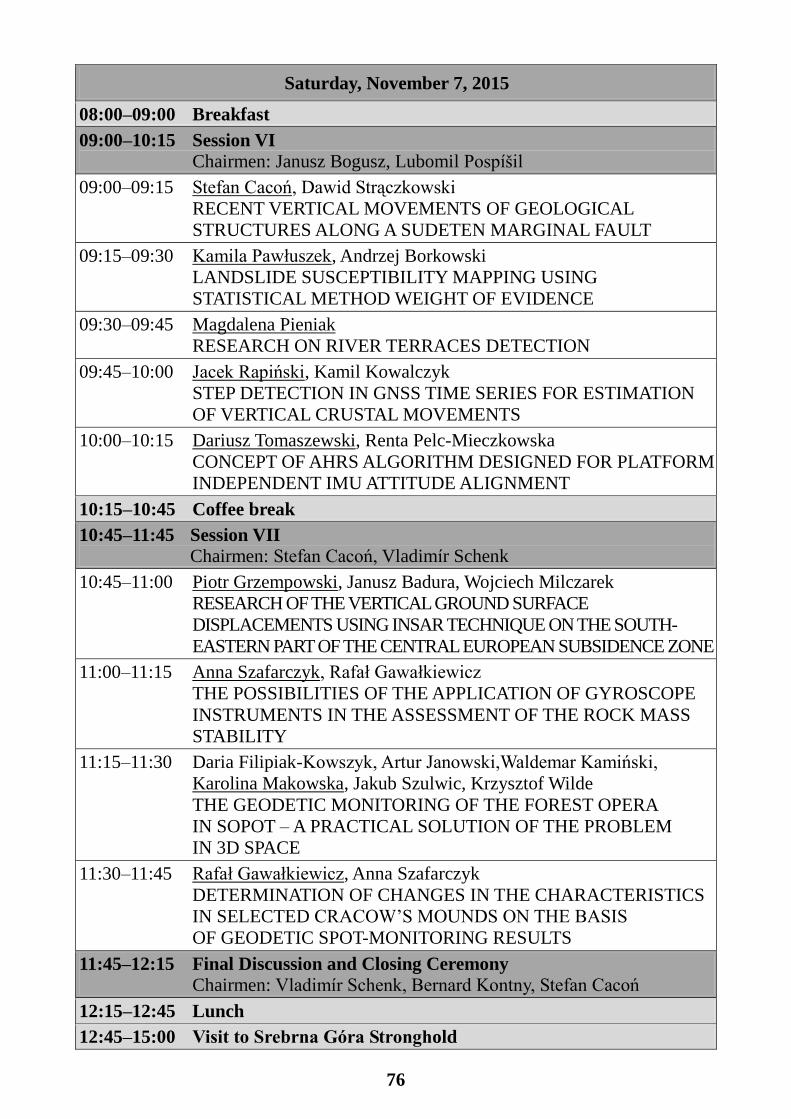
76
Saturday, November 7, 2015
08:00–09:00 Breakfast
09:00–10:15 Session VI
Chairmen: Janusz Bogusz, Lubomil Pospíšil
09:00–09:15 Stefan Cacoń, Dawid Strączkowski
RECENT VERTICAL MOVEMENTS OF GEOLOGICAL
STRUCTURES ALONG A SUDETEN MARGINAL FAULT
09:15–09:30 Kamila Pawłuszek, Andrzej Borkowski
LANDSLIDE SUSCEPTIBILITY MAPPING USING
STATISTICAL METHOD WEIGHT OF EVIDENCE
09:30–09:45 Magdalena Pieniak
RESEARCH ON RIVER TERRACES DETECTION
09:45–10:00 Jacek Rapiński, Kamil Kowalczyk
STEP DETECTION IN GNSS TIME SERIES FOR ESTIMATION
OF VERTICAL CRUSTAL MOVEMENTS
10:00–10:15 Dariusz Tomaszewski, Renta Pelc-Mieczkowska
CONCEPT OF AHRS ALGORITHM DESIGNED FOR PLATFORM
INDEPENDENT IMU ATTITUDE ALIGNMENT
10:15–10:45 Coffee break
10:45–11:45 Session VII
Chairmen: Stefan Cacoń, Vladimír Schenk
10:45–11:00 Piotr Grzempowski, Janusz Badura, Wojciech Milczarek
RESEARCH OF THE VERTICAL GROUND SURFACE
DISPLACEMENTS USING INSAR TECHNIQUE ON THE SOUTH-
EASTERN PART OF THE CENTRAL EUROPEAN SUBSIDENCE ZONE
11:00–11:15 Anna Szafarczyk, Rafał Gawałkiewicz
THE POSSIBILITIES OF THE APPLICATION OF GYROSCOPE
INSTRUMENTS IN THE ASSESSMENT OF THE ROCK MASS
STABILITY
11:15–11:30 Daria Filipiak-Kowszyk, Artur Janowski,Waldemar Kamiński,
Karolina Makowska, Jakub Szulwic, Krzysztof Wilde
THE GEODETIC MONITORING OF THE FOREST OPERA
IN SOPOT – A PRACTICAL SOLUTION OF THE PROBLEM
IN 3D SPACE
11:30–11:45 Rafał Gawałkiewicz, Anna Szafarczyk
DETERMINATION OF CHANGES IN THE CHARACTERISTICS
IN SELECTED CRACOW’S MOUNDS ON THE BASIS
OF GEODETIC SPOT-MONITORING RESULTS
11:45–12:15 Final Discussion and Closing Ceremony
Chairmen: Vladimír Schenk, Bernard Kontny, Stefan Cacoń
12:15–12:45 Lunch
12:45–15:00 Visit to Srebrna Góra Stronghold