ABORIGINAL CULTURAL HERITAGE MANAGEMENT · PDF fileABORIGINAL CULTURAL HERITAGE MANAGEMENT...
56
ABORIGINAL CULTURAL HERITAGE MANAGEMENT PLAN FOR SAND EXTRACTION OPERATIONS FROM LOT 218 DP 1044608 AND LOT 220 DP 1049608, SALT ASH FINAL July 2016
Transcript of ABORIGINAL CULTURAL HERITAGE MANAGEMENT · PDF fileABORIGINAL CULTURAL HERITAGE MANAGEMENT...

ABORIGINAL CULTURAL HERITAGE MANAGEMENT
PLAN
FOR SAND EXTRACTION OPERATIONS FROM
LOT 218 DP 1044608 AND LOT 220 DP 1049608, SALT ASH
FINAL July 2016

Newcastle
75 York Street Teralba NSW 2284
Ph. 02 4950 5322
www.umwelt.com.au
This report was prepared using Umwelt’s ISO 9001 certified Quality Management System.
ABORIGINAL CULTURAL HERITAGE MANAGEMENT PLAN
FOR SAND EXTRACTION OPERATIONS FROM LOT 218 DP 1044608 AND LOT 220 DP 1049608, SALT ASH
FINAL
Prepared by
Umwelt (Australia) Pty Limited on behalf of
Mackas Sand Pty Ltd
Project Director: Peter Jamieson Project Manager: Brendan Rice Report No. 1646/R64/V1 Date: July 2016

Disclaimer
This document has been prepared for the sole use of the authorised recipient and this document may not be used, copied or reproduced in whole or part for any purpose other than that for which it was supplied by Umwelt (Australia) Pty Ltd (Umwelt). No other party should rely on this document without the prior written consent of Umwelt.
Umwelt undertakes no duty, nor accepts any responsibility, to any third party who may rely upon or use this document. Umwelt assumes no liability to a third party for any inaccuracies in or omissions to that information. Where this document indicates that information has been provided by third parties, Umwelt has made no independent verification of this information except as expressly stated.
©Umwelt (Australia) Pty Ltd

ABORIGINAL CULTURAL HERITAGE MANAGEMENT PLAN 1646_R64_ACHMP_V1.docx
Table of Contents 1.0 Introduction 1
1.1 Mackas Sand Operations 1
1.2 Project Approval Requirements 3
1.3 Background Information 4
1.4 Purpose and Scope of the ACHMP 4
2.0 Consultation 6
2.1 Aboriginal Stakeholder Consultation 6
2.2 Department of Environment, Climate Change and Water Consultation 7
3.0 Legislative Context 8
3.1 EP&A Act 8
3.2 New South Wales National Parks and Wildlife Act 1974 8
3.3 Other Legislation 9
4.0 Contextual Information 11
4.1 Environmental Context 11
4.2 Archaeological Context 11
4.2.1 Archaeological Sites within the Approval Areas 12
4.2.2 Potential Archaeological Deposit (PAD) 15
4.2.3 Significance Assessment 16
5.0 Aboriginal Cultural Heritage Management Strategies 17
5.1 Establishment of the Aboriginal Heritage Management Group 17
5.2 Cultural Heritage Awareness Training 17
5.3 Strategies for Recorded Archaeological Sites and PADs 18
5.3.1 Mackas 1 and Associated PAD 18
5.3.2 MFMS1, MFMS2 and MFMS3 19
5.3.3 Lot 220 PAD 19
5.4 Strategy for Operations within the Lot 218 Approval Area 19
5.4.1 Access Route Construction 21
5.5 Strategy for Operations within the Lot 220 Approval Area 22
5.6 Collection and Inspection of Screen Reject Material 24
5.7 Monitoring Inspections by AHMG 24
5.8 Management of Unexpected Sub-Surface Deposits (other than Human Skeletal Material) 24
5.9 Human Skeletal Material 25
5.10 Analysis and Interpretation of Results of Mitigation Activities 26
5.11 Care and Control of Salvaged Materials 26
5.12 Activities outside Current Approval Areas 26
ABORIGINAL CULTURAL HERITAGE MANAGEMENT PLAN 1646_R64_ACHMP_V1.docx
5.13 Involvement of AHMG in any Salvage Activities 26
5.14 Site Rehabilitation, Bushfire Management, Weed and Feral Animal Control, Unexploded Ordnance Management Plan 27
5.15 Review of the ACHMP 27
5.16 Post-Operations 27
5.17 Methodology 27
5.17.1 Surface Collection 27
5.17.2 Methodology for Test Excavations 28
5.17.3 Methodology for Salvage Excavations 29
6.0 Roles, Responsibilities and Timeframes 30
7.0 References 34
ABORIGINAL CULTURAL HERITAGE MANAGEMENT PLAN 1646_R64_ACHMP_V1.docx
Introduction 1
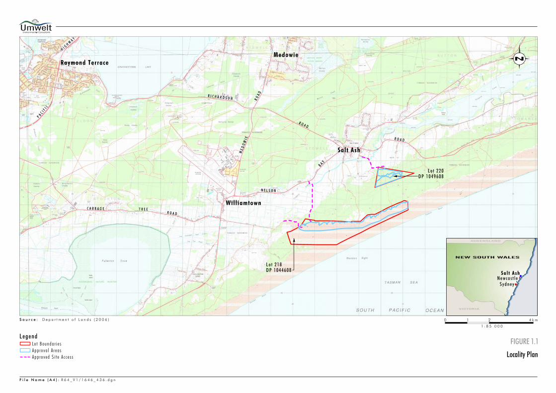
1.0 Introduction Mackas Sand Pty Ltd (Mackas Sand) operations on Lot 218 and Lot 220 are located approximately 25 kilometres north east of Newcastle near Salt Ash in the Port Stephens local government area (LGA), New South Wales (refer to Figure 1.1). Mackas Sand directors have operated sand extraction operations in the area since 1992. Lot 218 and Lot 220 are owned by the Worimi Local Aboriginal Lands Council.
Mackas Sand was granted Project Approval No. 08_0142 (PA 08_0142) on 20 September 2009 by the Minister for Planning under Part 3A of the Environmental Planning and Assessment Act 1979 to operate sand extraction operations at Lot 220 and Lot 218. It is estimated that in excess of 21 million tonnes of sand resource will be extracted from Lot 218 and Lot 220, with Lot 218 having an indefinite extraction life due to the ongoing movement of sand from the adjoining mobile dunes.
A modification to PA 08_0142 was approved on 30 September 2013 by the NSW Planning Assessment Commission (PAC) under delegation of the Minister for Planning and Infrastructure (now Minister for Planning and Environment-DP&E). The modification (PA 08_0142 MOD1) included approval to extract within 0.7 metres of the highest predicted groundwater level provided the final landform is at least 1 metre above the highest predicted groundwater level and the approval of an alternate route to access Lot 218. The alternate route connects directly from Lot 218, northward to Nelson Bay Road, as depicted within Figure 1.1.
A second modification to PA 08_0142, (MOD2), was approved by the PAC on 16 March 2016. The modification allows for an increase in maximum hourly truck movements (in and out) of Lot 218 via the approved alternate access road.
1.1 Mackas Sand Operations
Key operational features relevant to this Aboriginal Cultural Heritage Management Plan (ACHMP) are:
• The approved hours of extraction being 24 hours a day 7 days a week except for operations within 250 metres of the Hufnagl Residence (R27) when operations are limited to 7.00 am to 6.00 pm Monday to Friday with no operations within 250 metres of R27 outside these times.
• Transportation of sand from Lot 220 along Oakvale Drive between 5.00 am and 10.00 pm Monday to Saturday and 8.00 am to 12.00 pm Sundays and Public Holidays in accordance with provisions of Condition 9 (b) of Schedule 3 of PA 08_0142 as Mackas Sand has agreements with the owners of residences facing Oakvale Drive. Copies of these agreements have been provided to the DPE.
• Transportation of sand from Lot 218 along the Alternate Access Road between 5.00 am and 10.00 pm Monday to Saturday and 8.00 am to 12.00 pm Sundays and Public Holidays in accordance with provisions of Condition 9 (b) of Schedule 3 of PA 08_0142 as Mackas Sand has an agreement with the owners of 2344, 2353 and 2368 Nelson Bay Road. Copies of these agreements have been provided to the DPE.
ABORIGINAL CULTURAL HERITAGE MANAGEMENT PLAN 1646_R64_ACHMP_V1.docx
Introduction 3
1.2 Project Approval Requirements
Condition 29 of Project Approval 08_0142 requires that Mackas Sand prepares and implements an ACHMP that addresses Aboriginal heritage matters identified by the Department of Planning and Environment. Condition 29 is provided in full below:
The Proponent shall prepare and implement an Aboriginal Cultural Heritage Management Plan for the project to the satisfaction of the Secretary. This plan must:
a) be prepared in consultation with OEH and the Aboriginal community and be submitted to the Secretary for approval prior to the disturbance of any Aboriginal object or site; and
b) include a:
• detailed salvage program and management plan for all identified Aboriginal sites within the project disturbance area;
• detailed description of the measures that would be implemented to protect Aboriginal sites and PAD outside the project disturbance area;
• protocol for monitoring operations and vegetation removal on the site;
• protocol for undertaking additional archaeological investigation, and where warranted excavation and/or salvage, on:
o any identified stabilised soil surfaces on Lot 218 that are proposed to be disturbed; or
o any area of the identified PAD on Lot 220 that is proposed to be disturbed;
• Protocol for monitoring of reject material;
• description of the measures that would be implemented if any new Aboriginal objects or skeletal remains are discovered during the project; and
• protocol for the ongoing consultation and involvement of the Aboriginal community in the conservation and management of Aboriginal cultural heritage on the site, including the establishment of a management group comprising Aboriginal stakeholders and a suitably qualified archaeologist.
The Proponent shall implement the approved management plan as approved from time to time by the Secretary.
Mackas Sand has engaged Umwelt (Australia) Pty Limited (Umwelt) to prepare an ACHMP in accordance with Condition 29 of Project Approval 08_0142. Aboriginal stakeholder comments in regard to this ACHMP are provided in Appendix A.

ABORIGINAL CULTURAL HERITAGE MANAGEMENT PLAN 1646_R64_ACHMP_V1.docx
Introduction 4
1.3 Background Information
The approval areas consist of two areas of land (Lot 218 in DP 1044608, with adjoining access across Lot 227 in DP 1097995 and Lot 220 in DP 1049608, with access across Lot 3 in DP 739188 and Lot 8 in DP 833768). Both Lot 218 and Lot 220 are owned by Worimi Local Aboriginal Land Council. These two areas are located within the Stockton Bight dune system approximately 20 to 25 kilometres to the north-east of Newcastle, near Salt Ash. Lot 218 is comprised of approximately 412 hectares of mobile sand dune, of which the approved extraction area and related activities occupy an area of approximately 150 hectares (refer to Figure 1.1). Lot 218 is adjoined by the Worimi Conservation Lands to the north, south and east and the Quality Sands and Ceramics sand quarry to the north-west. An alternate access road connecting Lot 218 to Nelson Bay Road was approved (08_0142 MOD1) in September 2013. This ACHMP applies to the areas of Lot 218 and the alternate access route that will be subject to impact under Project Approval 08_0142 (MOD2).
Lot 220 has an area of approximately 76 hectares and will be accessed via an unsealed access road extending from an existing electricity easement across Lot 8 DP 833768 and Lot 3 DP 739188 (refer to Figure 1.1). This approval area adjoins an existing sand extraction operation immediately to the west, operated by Sibelco Australia Limited (previously Unimin). Mackas Sand & Soil is also located approximately 750 metres to the west. Rural land holdings and a sand quarry operated by Hunter Quarries adjoin the site to the north and vegetated sand dunes that form part of the Worimi Conservation Lands adjoin Lot 220 to the east and south.
The approval areas were the subject of an Aboriginal cultural heritage assessment conducted as a component of an Environmental Assessment (EA) (Umwelt 2009: Appendix 5 and Umwelt 2012: Appendix 4). The 2009 Environmental Assessment incorporates a Statement of Commitments, of which Section 5.3 relates to Aboriginal heritage and was developed on the basis of mitigation and management recommendations provided in the Aboriginal cultural heritage assessment. A modification was proposed to DA-08-0142 in November 2012 that was approved in September 2013 through the NSW Planning Assessment Commission (PAC). The proposal is for the temporary reduction in approved extraction height, and the development of an alternate haul road as depicted within Figure 1.1.
1.4 Purpose and Scope of the ACHMP
This ACHMP has been prepared in accordance with Condition 29 of Project Approval 08_0142 and the Statement of Commitments and Environmental Assessment (including an Aboriginal cultural heritage assessment) submitted to DPE as part of the approval process, including all modifications. The ACHMP is prepared in consultation with the relevant Aboriginal stakeholders and has been referred to the Office of Environment and Heritage (OEH – previously Department of Environment, Climate Change and Water) and DPE for review and comment. Any updates or revisions to the ACHMP will also be forwarded to OEH and DPE
In order to meet the requirements of Condition 29 of the Project Approval 08_0142 and to provide clear guidance to Mackas Sand regarding the management of Aboriginal cultural heritage within the approval areas, the ACHMP incorporates the following information:
• a review of relevant legislation
• a review of the cultural heritage context of the approval areas including the results of the Aboriginal cultural heritage assessment (Umwelt 2009: Appendix 5, Umwelt 2012: Appendix 4) of the approval areas

ABORIGINAL CULTURAL HERITAGE MANAGEMENT PLAN 1646_R64_ACHMP_V1.docx
Introduction 5
• a description of consultation that has been undertaken with the relevant Aboriginal stakeholders in relation to the approval areas
• the provision of detailed Aboriginal cultural heritage management strategies
• a clear outline of the roles and responsibilities of the entities involved in the ACHMP and its implementation.
An ACHMP will be in place for the duration of the project (unless otherwise directed by relevant legislation or approvals), with this ACHMP subject to review 12 months after the date of commencement of operations, and as required thereafter in consultation with the Aboriginal Heritage Management Group (AHMG).
ABORIGINAL CULTURAL HERITAGE MANAGEMENT PLAN 1646_R64_ACHMP_V1.docx
Consultation 6
2.0 Consultation
2.1 Aboriginal Stakeholder Consultation
The Aboriginal cultural heritage assessment of the approval areas (Umwelt 2009: Appendix 5) was completed in accordance with the Interim Community Consultation Requirements for Applicants (2004) (the requirements). Consultation undertaken in relation to the assessment is detailed in Appendix A and is summarised below.
Five Aboriginal stakeholder groups registered an interest in being consulted regarding the Aboriginal cultural heritage assessment of the approval areas. These groups are listed below and are referred to in this document as the relevant Aboriginal stakeholders:
• Worimi Local Aboriginal Land Council
• Nur-Run-Gee Pty Ltd (Nur-Run-Gee)
• Carol Ridgeway-Bissett (previously Maaiangal Aboriginal Heritage Co-operative)
• Mur-Roo-Ma Incorporated (Mur-Roo-Ma)
• Viola Brown.
Each of these stakeholder groups was provided with a draft of the Aboriginal cultural heritage assessment (and a subsequent minor modification to the assessment) and were requested to provide comment on the draft assessment. Comments were received from all relevant stakeholders.
A draft of this ACHMP was forwarded to all of the registered stakeholders on 7 October 2009. The draft ACHMP was accompanied by an invitation to a meeting to review and discuss the draft ACHMP.
Les Ridgeway (formerly of Worimi Traditional Aboriginal Elders and Owners Group) advised that he would be unable to attend the meeting but provided some comments during a telephone conversation with Nicola Roche on 14 October 2009. Mr Ridgeway stated that there was a known camping area at Tilligerry/Salt Ash in proximity to Lot 220 and that he felt that it was possible that burials associated with this camping area may be present in Lot 220. Mr Ridgeway recognised that the ACHMP contains procedures and protocols relating to skeletal material but indicated that he would prefer it if Aboriginal people were present during operations at Lot 220. In subsequent correspondence, Mr Ridgeway was informed that Aboriginal people would be employed by Mackas Sand and whilst they would be employed for operational purposes, they would be present should any skeletal material be uncovered during operations.
A meeting to discuss the draft ACHMP was held on 21 October 2009 and attended by the following Aboriginal stakeholders:
• Jamie Tarrant (Chair, Worimi Local Aboriginal Land Council)
• Val Merrick (Deputy Chair, Worimi Local Aboriginal Land Council)
• Andrew Smith (Chief Executive Officer, Worimi Local Aboriginal Land Council)
• Jamie Merrick (Senior Sites Officer, Worimi Local Aboriginal Land Council)
ABORIGINAL CULTURAL HERITAGE MANAGEMENT PLAN 1646_R64_ACHMP_V1.docx
Consultation 7
• Lennie Anderson (Nur-Run-Gee Pty Ltd)
• Anthony Anderson (Mur-Roo-Ma Inc).
The draft ACHMP was reviewed in its entirety during the meeting and the Aboriginal stakeholder representatives provided a number of comments. These comments were all addressed during the meeting and resulted in some alterations to the ACHMP, as described in the meeting summary provided in Appendix A. A summary of the meeting and the resultant alterations were sent to all Aboriginal stakeholder groups, with a request that those stakeholder groups attending the meeting review the summary. Endorsement of the comments and changes to the draft ACHMP included in the summary was received from all stakeholder groups attending the meeting (refer to Appendix A).
Carol Ridgeway-Bissett also met with Nicola Roche on 21 October 2009 to discuss the draft ACHMP and the results of the meeting described above. Ms Ridgeway-Bissett’s comments are included in Appendix A. Ms Ridgeway-Bissett maintained her objection to the approved project, stating that sand mining and extraction should not be permitted in Stockton Bight. She also objected to the structure and selection methods for the Aboriginal Heritage Management Group (AHMG) as discussed in Section 5.1 and proposed that the AHMG should be a group within DECCW (now OEH) and should involve consultation with relevant State Government advisory bodies. Ms Ridgeway-Bissett felt that the removal of vegetation within Lot 220 would result in the removal of a wildlife corridor and important plant species, which are an important consideration for Aboriginal cultural heritage. She did not consider that the remaining vegetation corridor within Lot 220 would be sufficient. During this meeting, Ms Ridgeway-Bissett was advised that her comments would be discussed with Mackas Sand but that it would be difficult to address them within the parameters of the approved project. However, she was informed that all comments would be included and discussed in the final ACHMP.
2.2 Department of Environment, Climate Change and Water Consultation
In accordance with Condition 29 of DA-08-0142 this ACHMP has been prepared in consultation with DECCW (now OEH). The EA for the project included details of the matters to be addressed by the ACHMP and this was the subject of substantial comments by DECCW (now OEH). These comments have been taken into consideration in the preparation of a draft ACHMP.
On 6 October 2009 an email was sent to Brett Nudd (Acting Manager Planning & Aboriginal Heritage Section, North-East Branch) advising him that the draft ACHMP was being completed. The email requested advice regarding DECCW (now OEH)’s preference for consultation regarding the draft ACHMP and the appropriate DECCW (now OEH) representative with whom to consult. On 23 October 2009 Nicola Roche contacted Sarah Paddington (Archaeologist, North-East Branch) by telephone to discuss the draft ACHMP. Ms Paddington provided some advice regarding elements that DECCW (now OEH) typically consider that an ACHMP should address. These elements have all been incorporated into this ACHMP.
ABORIGINAL CULTURAL HERITAGE MANAGEMENT PLAN 1646_R64_ACHMP_V1.docx
Legislative Context 8
3.0 Legislative Context Major Project Approval 08_0142 was granted to Mackas Sand under Part 3A of the EP&A Act and the proposed modification is sought under Section 75W of the EP&A Act.
3.1 EP&A Act
The EP&A Act regulates development activity in New South Wales. Part 3A of the EP&A Act (now repealed) previously applied to projects that were declared to be a ‘Major Project’ (in accordance with Section 75B of the EP&A Act) and the current approval was granted under Part 3A. The proposed modification will be considered under Section 75W of the EP&A Act and as the project approval was issued in accordance with Part 3A of the EP&A Act, the following provisions also apply to the proposed modification. Under Section 75U of the EP&A Act, it is not necessary to obtain an Aboriginal Heritage Impact Permit (AHIP) permit under the National Parks and Wildlife Act 1974 ((NPW Act) – as discussed below) in relation to activities approved under Part 3A of the EP&A Act. Projects approved under Part 3A of the EP&A Act are subject to conditions of approval issued by DPE and (where relevant) Aboriginal cultural heritage is addressed by appropriate conditions. Furthermore, Section 75J (5) of the EP&A Act states that conditions of approval for the carrying out of a project may require the proponent to comply with obligations made in a statement of commitments submitted by the proponent as part of the development approval process.
In relation to Aboriginal cultural heritage assessments, current DPE guidelines indicate that consultation should be undertaken in accordance with the Aboriginal Cultural Heritage Consultation Requirements for Proponents 2010 (Department of Environment, Climate Change and Water (DECCW)) as the established process for ongoing consultation for projects approved under Part 3A.
3.2 New South Wales National Parks and Wildlife Act 1974
OEH is primarily responsible for regulating the management of Aboriginal cultural heritage in New South Wales under the NPW Act (as amended October 2010). The NPW Act is accompanied by the National Parks and Wildlife Regulation 2009 (the Regulation), the Due Diligence Code of Practice for the Protection of Aboriginal Objects in New South Wales (DECCW 2010) and other industry-specific codes.
The objectives of the NPW Act include:
The conservation of objects, places or features (including biological diversity) of cultural value within the landscape, including, but not limited to: (i) places, objects and features of significance to Aboriginal people.
The NPW Act defines an Aboriginal object as:
any deposit, object or material evidence (not being a handicraft made for sale) relating to the Aboriginal habitation of the area that comprises New South Wales.
Under Section 84 of the NPW Act, an Aboriginal Place must be declared by the Minister as a place that, in the opinion of the Minister, is or was of special significance with respect to Aboriginal culture.
ABORIGINAL CULTURAL HERITAGE MANAGEMENT PLAN 1646_R64_ACHMP_V1.docx
Legislative Context 9
In accordance with Section 86(1) of the NPW Act, it is an offence to harm or desecrate a known Aboriginal object, whilst it is also an offence to harm an Aboriginal object under Section 86(2). Similarly, Section 86(4) states that a person must not harm or desecrate an Aboriginal place. Harm to an object or place is defined as any act or omission that:
a) destroys, defaces or damages an object or place, or
b) in relation to an object – moves the object from the land on which it had been situated, or
c) is specified by the regulations, or
d) causes or permits the object or place to be harmed in a manner referred to in paragraph (a), (b) or (c),
but does not include any act or omission that:
a) desecrates the object or place, or
b) is trivial or negligible, or
c) is excluded from this definition by the regulations.
Section 87(1) of the NPW Act specifies that it is a defence to prosecution under Section 86(1) and Section 86(2) if the harm or desecration of an Aboriginal object was authorised by an AHIP and the activities were carried out in accordance with that permit. As discussed above, the provisions of Part 3A of the EP&A Act can overrule the requirement for an AHIP under the NPW Act, with these provisions applying to activities approved under Part 3A only. However, the other provisions of the NPW Act are still applicable.
Consultation with the Aboriginal community is an integral part of identifying and assessing the significance of Aboriginal objects and/or places and determining and carrying out appropriate strategies to mitigate impacts upon Aboriginal heritage.
Furthermore, ongoing consultation with the Aboriginal community has been undertaken as part of Mackas Sand operations through the AHMG. The AHMG is guided by the ACHMP developed as part of Project Approval 08_0142. Consultation with regard to the project commenced on 27 February 2010 under the Interim Community Consultation Requirements for Applicants. However, in recognition of the change in consultation expectations, all consultation undertaken after November 2010 was generally in accordance with Section 80C (2-11) of the Regulation.
3.3 Other Legislation
There is a range of other legislation that establishes requirements and responsibilities that may affect Aboriginal cultural heritage and therefore are relevant to this ACHMP. These include:
• Noxious Weeds Act 1993 details the responsibilities of landholders to control specified and declared noxious weeds;
• Rural Fires Act 1997 delineates the circumstances under which the managers must undertake a hazard reduction burn;
• Native Vegetation Act 2003 relates to the sustainable management and conservation of native vegetation;

ABORIGINAL CULTURAL HERITAGE MANAGEMENT PLAN 1646_R64_ACHMP_V1.docx
Legislative Context 10
• Water Management Act 2000 relates to the sustainable and integrated management of water resources; and
• Hunter Water Act 1991 applies to water resources within the Chichester, Grahamstown, Nelsons Bay, North Stockton and Tomago Catchment Areas.
It is a requirement that the works necessary in relation to these Acts do not adversely impact Aboriginal cultural heritage and thus contravene the NPW Act.

ABORIGINAL CULTURAL HERITAGE MANAGEMENT PLAN 1646_R64_ACHMP_V1.docx
Contextual Information 11
4.0 Contextual Information The development and implementation of appropriate management strategies requires an understanding of contextual information relevant to Aboriginal cultural heritage within the approval areas. For this reason, information regarding the environmental and archaeological context of this management plan is provided below.
4.1 Environmental Context
The approval areas are located in dune fields that are part of the Outer Barrier of Stockton Bight. The Lot 220 approval area contains two major dune ridges that consist of high, comparatively steeply sloping dunes that were formed during two separate phases of dune formation and stabilisation and are referred to as Ridge I and Ridge II type dunes. The Ridge I and Ridge II dunes are separated by a system of low relief dunes and swales.
The Lot 218 approval area is located within an area that contains large quantities of recently deposited wind-blown sand. These sand deposits have transgressed over former Outer Barrier stabilised dunes that are similar in nature to those in the Lot 220 approval area. Wind action and sand movement in the Lot 218 approval area periodically results in the burial, exposure and, in some instances, deflation of former stabilised soil surfaces associated with these dunes.
The active movement of sand within the Lot 218 approval area dictates that vegetation coverage in this area is relatively sparse. In contrast, the Lot 220 approval area is very heavily vegetated.
4.2 Archaeological Context
The Stockton Bight area has been the subject of numerous archaeological investigations that have resulted in the identification of relatively high numbers of archaeological sites. This contextual information was reviewed in detail in Section 4 of the Aboriginal cultural heritage assessment (Umwelt 2009: Appendix 5). As a result, a number of trends were identified, as listed below:
• The majority of sites within the region consist of middens (containing beach and/or estuarine shell species) and stone artefact scatters, with sites varying from single artefacts to dense concentrations of material in both a surface and sub-surface context.
• Due to vegetation coverage and the nature of sand deposits, the detection of sites is directly related to levels of exposure and visibility. Sub-surface deposits may be at a considerable depth below the current mobile dune surface (in association with stabilised soil surfaces) and therefore are unlikely to be detectable unless significant disturbance has occurred.
• The Outer Barrier of Stockton Bight has undergone significant transformation over the last 6000 years comprising at least two major periods of stabilisation, resulting in the formation of stabilised soil surfaces across dune fields that include elevated areas (dunes), adjoining slopes and a former deflation basin. In some areas, the Ridge I and Ridge II stabilised surfaces have undergone a cycle of burial, deflation and sometimes reburial, resulting in a discontinuous and unpredictable distribution of stabilised soil surfaces beneath wind-blown sand deposits.
ABORIGINAL CULTURAL HERITAGE MANAGEMENT PLAN 1646_R64_ACHMP_V1.docx
Contextual Information 12
• Archaeological material (including burials) within the active transgressive dune field and current deflation basin primarily consist of exposed and/or deflated deposits that were once associated with former stabilised surfaces linked to Ridge II and presumably Ridge I periods of stabilisation. Although some archaeological material may have been deposited during periods of instability (i.e. not in association with a stabile soil surface), this material is likely to have been limited in both extent and distribution.
• Within the stabilised dune fields, it is suggested that greater concentrations of archaeological material (in terms of site numbers and artefact densities) are located on low ridgelines, spurs and low dunes associated with wetland resources.
These trends were used to develop a predictive model and to inform the survey of the approval areas. The survey was conducted in consultation with the relevant Aboriginal stakeholders and resulted in the identification of archaeological sites and areas of Potential Archaeological Deposit (PAD), as discussed below.
4.2.1 Archaeological Sites within the Approval Areas
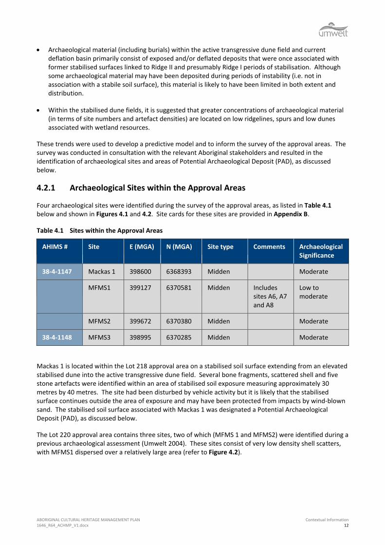
Four archaeological sites were identified during the survey of the approval areas, as listed in Table 4.1 below and shown in Figures 4.1 and 4.2. Site cards for these sites are provided in Appendix B.
Table 4.1 Sites within the Approval Areas
AHIMS # Site E (MGA) N (MGA) Site type Comments Archaeological Significance
38-4-1147 Mackas 1 398600 6368393 Midden Moderate
MFMS1 399127 6370581 Midden Includes sites A6, A7 and A8
Low to moderate
MFMS2 399672 6370380 Midden Moderate
38-4-1148 MFMS3 398995 6370285 Midden Moderate
Mackas 1 is located within the Lot 218 approval area on a stabilised soil surface extending from an elevated stabilised dune into the active transgressive dune field. Several bone fragments, scattered shell and five stone artefacts were identified within an area of stabilised soil exposure measuring approximately 30 metres by 40 metres. The site had been disturbed by vehicle activity but it is likely that the stabilised surface continues outside the area of exposure and may have been protected from impacts by wind-blown sand. The stabilised soil surface associated with Mackas 1 was designated a Potential Archaeological Deposit (PAD), as discussed below.
The Lot 220 approval area contains three sites, two of which (MFMS 1 and MFMS2) were identified during a previous archaeological assessment (Umwelt 2004). These sites consist of very low density shell scatters, with MFMS1 dispersed over a relatively large area (refer to Figure 4.2).

ABORIGINAL CULTURAL HERITAGE MANAGEMENT PLAN 1646_R64_ACHMP_V1.docx
Contextual Information 15
A new site, MFMS3 was identified within the central portion of Lot 220. It consists of a low density scatter of fragmented shell dispersed along a track exposure and also contained one area of concentrated shell deposit (including whole pipi shell) associated with dark grey black sand exposed via animal burrowing. The area of concentrated shell deposit was on a low relief dune and it is likely that the other shell fragments within this site also originated from this landform and had subsequently been dispersed by use of the track. Importantly, the presence of a concentration of pipi shell in association with small amounts of a sand matrix typical of stabilised soil surfaces indicates that relatively intact and possibly comparatively dense midden deposits may be present in a sub-surface context within this area. Furthermore, the site contains fragments of cockle and whelk in addition to pipi shell, indicating that MFMS3 contains evidence of the use of both beach and estuarine resources.
4.2.2 Potential Archaeological Deposit (PAD)
The term ‘potential archaeological deposit’ (PAD) can be defined in a number of different ways. For the purposes of the assessment of the approval areas, a landform or area was only designated as a PAD if it met one or more of the following criteria:
• it was likely that the PAD will contain enough archaeological material to allow for statistically viable detailed analysis and comparison of the artefact assemblage both within and between sites
• the PAD had not significantly disturbed and was likely to retain a degree of archaeological integrity
• it was predicted that the PAD should contain materials that can be dated, either in relative or absolute terms.
When assessed against these criteria, the area of stabilised soil surface in the Lot 218 approval area that is associated with Mackas 1 was identified as a PAD. Furthermore, based on the findings of previous assessments, it was considered likely that additional areas of stabilised soil surface would be present below the active transgressive dune. Due to the complex geomorphic history of this region, it was not possible to predict with any certainty where such soil surfaces would be located nor was it possible to determine their original landform context and therefore their archaeological potential. Consequently, the identification of areas of PAD (with the exception of that associated with Mackas 1) within the Lot 218 proposal area was and is extremely problematic. For this reason, no areas of PAD (except that associated with Mackas 1) have yet been identified within the Lot 218 proposal area. However, as the approved operations proceed, it is likely that stabilised soil surfaces will be exposed to a greater extent and can be assessed as to whether they constitute a PAD. This management plan provides a series of mechanisms and protocols with which to manage this process.
Lot 220 is primarily comprised of Ridge I and Ridge II dunes of relatively high elevation with slopes of an inclination that makes them unsuitable for occupation. Thus, whilst archaeological material may be present across these landforms (as evidenced by MFMS1), it is unlikely that it will occur in sufficient densities to warrant designation as a PAD. In contrast, low relief dunes that provide access to low-lying areas and associated freshwater resources have been identified as having a high likelihood of containing concentrated deposits of archaeological material that may retain a degree of stratification. Landforms of this type are present throughout the central portion of Lot 220 and the presence of associated archaeological material in a sub-surface context is demonstrated at site MFMS 3. As the level of topographic information was not sufficient to distinguish the low relief dunes from adjoining swales, this central area (refer to Figure 4.2) was designated as a PAD however it was noted that it is the low-relief dune ridges and not the swales that comprise the PAD.
ABORIGINAL CULTURAL HERITAGE MANAGEMENT PLAN 1646_R64_ACHMP_V1.docx
Contextual Information 16
4.2.3 Significance Assessment
The significance of the approval areas and the sites and PADs they contain were assessed in terms of both Aboriginal cultural significance and archaeological significance. Based on the information provided by the relevant Aboriginal stakeholders, the approval areas were assessed as being of high Aboriginal cultural significance.
As shown in Table 4.1, the sites within the approval areas were assessed as being of moderate or low to moderate archaeological significance. When assessed in landscape terms, the Lot 218 approval area was assessed as being of low to moderate archaeological significance and the Lot 220 approval area was assessed as being of moderate to high archaeological significance.

ABORIGINAL CULTURAL HERITAGE MANAGEMENT PLAN 1646_R64_ACHMP_V1.docx
Aboriginal Cultural Heritage Management Strategies 17
5.0 Aboriginal Cultural Heritage Management Strategies
This section of the management plan establishes strategies for the effective management of Aboriginal cultural heritage within the approval areas. These strategies have been developed in accordance with Condition 29 of DA-08-0142, the Statement of Commitments and recommendations provided as part of Environmental Assessment (incorporating the recommendations of the Aboriginal Cultural Heritage Assessment of the approval areas), the EP&A Act, the NPW Act and the requirements of the relevant Aboriginal stakeholders, OEH and DPE.
5.1 Establishment of the Aboriginal Heritage Management Group
Mackas Sand will form an Aboriginal Heritage Management Group (AHMG) that will oversee the implementation and ongoing application of the ACHMP. For the first year of operation, the AHMG will be comprised of up to five Aboriginal stakeholder representatives and the Mackas Sand Quarry Manager, with a qualified archaeologist included on an on-call basis. The Aboriginal stakeholder representatives will be selected by Mackas Sand on the basis of the following criteria:
• Aboriginal descent
• relevant experience and qualifications in working with the management of Aboriginal cultural heritage
• ability to communicate information relating to the management of Aboriginal cultural heritage within the approval areas with the broader Aboriginal community
• ability to interact and work effectively in group situations.
In relation to the selection of the initial AHMG, Mackas Sand will invite each of the five registered stakeholder groups to submit Expressions of Interest that address the selection criteria. Representation on the AHMG will be subject to review on an annual basis or at other intervals determined by the AHMG.
Decisions made by the AHMG will be made on the basis of the opinion of the majority of the AHMG.
The roles and responsibilities of the AHMG will be discussed in greater detail for each of the additional management strategies outlined in this document.
5.2 Cultural Heritage Awareness Training
Mackas Sand has developed a brief Aboriginal cultural heritage awareness training package in consultation with the AHMG, and it has been incorporated into the induction for Mackas Sand employees and contractors. The training package includes information on the following:
• types and locations of Aboriginal sites and artefacts that are present within the approval areas, with clear discussion of the potential for other sites to be identified during the course of operations
• the diagnostic features of scarred trees, midden material and stone artefacts and the procedure to follow should any of these be identified
ABORIGINAL CULTURAL HERITAGE MANAGEMENT PLAN 1646_R64_ACHMP_V1.docx
Aboriginal Cultural Heritage Management Strategies 18
• the Aboriginal cultural heritage value and archaeological significance of sites and the general landscape of the approval areas
• the identifying characteristics of a former stabilised soil surface
• the obligation to ensure that recorded archaeological sites and areas of PAD are protected from impacts until such time as impact becomes necessary and the appropriate actions have been carried out
• procedures to follow should a former stabilised soil surface or archaeological material be identified during the course of operations
• a general summary of relevant aspects of this ACHMP
• the relevant aspects of the NPW Act in relation to the protection of Aboriginal cultural heritage, in particular, the potential for prosecution should sites be subject to impacts that are not in accordance with the procedures outlined in this ACHMP.
The Aboriginal cultural heritage awareness training package is subject to review when deemed necessary by the AHMG.
5.3 Strategies for Recorded Archaeological Sites and PADs
Mackas Sand (in consultation with the AHMG) will be responsible for ensuring that recorded archaeological sites and areas of PAD are protected from impacts associated with the approved activities until such time as impact becomes necessary. Cultural heritage awareness training will be used as a mechanism to advise all staff and contractors of the obligation to protect recorded sites and PADs unless appropriate actions have been taken in accordance with the management strategies outlined below.
5.3.1 Mackas 1 and Associated PAD
Should Mackas 1 and the associated area of PAD be subject to impact, a surface collection of Mackas 1 will be conducted in accordance with the methodology provided in (Umwelt 2009: Appendix 5), and reproduced in Section 5.17. The stabilised soil surface associated with Mackas 1 and currently identified as PAD will be reassessed as outlined in Section 5.5. If it remains defined as a PAD, it will be test excavated in accordance with the methodology provided in Section 5.17. Should test excavation identify any of the following, salvage excavations will be conducted in accordance with the methodology outlined in Section 5.17:
• consolidated shell midden deposits (comprising packed shell as opposed to dispersed shell fragments)
• stone artefact scatters that contain high densities of artefacts (greater than three artefacts per test pit, or as otherwise agreed by the relevant stakeholders and an archaeologist, if required) and/or an artefact assemblage of notable complexity or research value
• hearth or heat treatment feature.

ABORIGINAL CULTURAL HERITAGE MANAGEMENT PLAN 1646_R64_ACHMP_V1.docx
Aboriginal Cultural Heritage Management Strategies 19
5.3.2 MFMS1, MFMS2 and MFMS3
Surface artefacts within sites MFMS1, MFMS2 and MFMS3 will be subject to surface collection prior to initial vegetation clearance in the area surrounding these sites. The surface collection will be conducted by the AHMG (including an on-call archaeologist, if required) in accordance with the methodology provided in Section 5.17.
5.3.3 Lot 220 PAD
In accordance with the recommendations of the Aboriginal cultural heritage assessment (Umwelt 2009: Appendix 5), no sand extraction will be undertaken in the central area of Lot 220, which contains areas of PAD. Mackas Sand (in consultation with the AHMG) will ensure that the central area of the Lot 220 approval area that contains areas of PAD is clearly demarcated to prevent unintentional impacts during operations. However, it will be necessary to construct up to three access roads in this area. The location of these access roads will be determined in consultation with the AHMG (including an on-call archaeologist, if required) and if the construction of access roads will result in impacts to the low dune ridge landforms identified as PAD, these areas will be subject to test excavation in accordance with the methodology provided in Section 5.17. Should test excavation identify any of the following, salvage excavations will be conducted in accordance with the research design and methodology outlined in Section 5.17:
• consolidated shell midden deposits (comprising packed shell as opposed to dispersed shell fragments)
• stone artefact scatters that contain high densities of artefacts (greater than three artefacts per test pit, or as otherwise agreed by the relevant stakeholders and an archaeologist, if required) and/or an artefact assemblage of notable complexity or research value
• hearth or heat treatment feature.
5.4 Strategy for Operations within the Lot 218 Approval Area
The Lot 218 proposal area is comprised primarily of wind-blown sand that has been deposited within the last 50 years and therefore will not contain archaeological materials in their original depositional context. However, former stabilised soil surfaces that are typically associated with archaeological materials are likely to be present beneath the wind-blown sands in a discontinuous and unpredictable distribution. The approved activities have been designed to minimise impacts to Aboriginal cultural heritage by avoiding disturbance of former stabilised soil surfaces, where possible. Due to operational requirements, it may be necessary to disturb stabilised soil profiles in some areas. The alternate haul route extends from the wind-blown dunes to Nelson Bay Road across the Inter-Barrier depression as depicted within Figure 1.1.
The management strategy outlined below for operations within the Lot 218 approval area and alternate haul route will provide an informal conservation outcome (for the majority of stabilised soil surfaces where impacts can be avoided) whilst also providing a mechanism for the appropriate salvage (involving surface collection and/or sub-surface salvage) of archaeological material subject to impacts.
Mackas Sand will ensure that operations in the Lot 218 approval area and alternate haul route are undertaken in accordance with the strategy outlined below:
• Within the extraction area, an initial ‘first workings’ path approximately 12 metres in width at the base will be developed for each section of operations. Earth-moving equipment will be utilised to remove wind-blown sand in the first workings path until a former stabilised soil surface is exposed OR a suitable working depth is reached (whichever comes first).
ABORIGINAL CULTURAL HERITAGE MANAGEMENT PLAN 1646_R64_ACHMP_V1.docx
Aboriginal Cultural Heritage Management Strategies 20
• If a stabilised soil surface is exposed within the first workings path, an archaeologist will be contacted to record its location in three dimensions (easting, northing and elevation) with a hand-held GPS. Following recording, subsequent operations will adhere to the following process.
o Where disturbance of the stabilised soil surface is not essential to operations, once the stabilised soil surface or suitable working depth is reached, a sand buffer of at least 50 centimetres in thickness will be created above the surface and, if it is an area to be trafficked by road-going vehicles, an additional layer of soil topped by roadbase will be laid down to provide a working surface and a buffer above the stabilised soil surface (if present).
o Subsequent sand extraction will then proceed from the first workings path at approximately the same depth.
o Should a stabilised soil surface be exposed at any time during extraction, works will cease at that depth and if possible, extraction will only occur to within fifty centimetres of the stabilised soil surface.
o Should it be necessary to undertake disturbance to a stabilised soil surface, the AHMG and an on-call archaeologist will be contacted and the soil surface will be assessed to determine whether it constitutes a PAD under the definition provided in Section 4.2.2. This allows flexibility throughout the life of the proposal because as works proceed and a greater understanding of archaeological expectations within Lot 218 is obtained, it is likely that the identification of PADs will be more refined and mitigation strategies will therefore be more targeted. If the stabilised soil surface is not considered a PAD but archaeological material is visible, a surface collection will be conducted in accordance with the methodology provided in Section 5.17 and works may proceed following completion of the surface collection. If the soil surface is identified as a PAD, surface collection and test excavation of the stabilised soil surface (within the area to be impacted) will be conducted in accordance with the methodology outlined in Section 5.17.
• Should test excavations identify any of the following, salvage excavations will be conducted in accordance with the research design and methodology outlined in Section 5.17:
o consolidated shell midden deposits (comprising packed shell as opposed to dispersed shell fragments)
o stone artefact scatters that contain high densities of artefacts (greater than three artefacts per test pit, or as otherwise agreed by the relevant stakeholders and an archaeologist, if required) and/or an artefact assemblage of notable complexity or research value
o hearth or heat treatment feature.
ABORIGINAL CULTURAL HERITAGE MANAGEMENT PLAN 1646_R64_ACHMP_V1.docx
Aboriginal Cultural Heritage Management Strategies 21
5.4.1 Access Route Construction
During the construction of the alternate haul route, the procedure outlined above has also been followed:
1. In consultation with the AHMG, demarcate the route boundary from the edge of the Inter-Barrier Depression south to the intersection with the Lot 218 approved operational area (i.e. within the area identified as PAD). This demarcation should be done prior to route construction and any surface artefacts within the demarcated area should be collected in consultation with the AHMG (refer to Figure 5.1) and in accordance with the approved methodology detailed in Section 5.17.
2. Vegetation clearance from the edge of the Inter-Barrier Depression south to the intersection with the Lot 218 approved operational area (i.e. within the area identified as PAD) will occur as a staged process in accordance with the following methodology:
• understorey vegetation and all trees smaller than approximately 50 centimetres diameter at chest height will be removed by earth-moving equipment or similar and placed outside the newly cleared area so that all of the newly cleared area is visible. At this stage, the AHMG will be invited to undertake an inspection of the newly cleared area;
• following the initial inspection, the remaining large trees will be cleared by machinery (in accordance with ecological tree clearance procedures) and the AHMG will be invited to inspect the additional area of ground disturbance resulting from large tree clearance at a time determined in consultation with the AHMG; and
• during vegetation clearance inspections (as discussed above), any Aboriginal objects such as stone artefacts and shell) will be collected in accordance with the approved methodology detailed in Section 5.17.
3. Following vegetation clearance, construction of the alternate haul route from the edge of the Inter-Barrier Depression south to the intersection with the Lot 218 approved operational area should proceed by creating a level surface of approximately 8 metres in width along the length of the alternate haul route, with a turning bay of approximately 30 metres by 30 metres located in the area adjoining Lot 218 and an overall potential construction width of 10 metres; and
4. laying geotextile material over the natural ground surface and introducing additional fill material (i.e. not sand from other sections of the alternate haul route) over the geotextile to provide a suitable road surface. This will be done after surface artefacts have been collected and in a progressive fashion so that all heavy vehicle movement associated with road construction and subsequent use is confined to the area in which geotextile and fill have already been introduced.


ABORIGINAL CULTURAL HERITAGE MANAGEMENT PLAN 1646_R64_ACHMP_V1.docx
Aboriginal Cultural Heritage Management Strategies 23
5.5 Strategy for Operations within the Lot 220 Approval Area
Within the Lot 220 area, operations cannot be undertaken without impacting stabilised soil surfaces and the associated archaeological material (if present). The Lot 220 proposal area contains considerable areas of PAD that are likely to have very high research value and therefore it is not archaeologically justifiable to recommend the destruction of this area without undertaking mitigating activities involving salvage of archaeological materials (including surface collection and potentially sub-surface salvage). Mackas Sand will ensure that all operations within the Lot 220 approval area are conducted in accordance with the strategy provided below.
• As part of the Aboriginal cultural heritage awareness training and prior to removal of any vegetation, all staff and contractors will be made aware of the diagnostic features of Aboriginal scarred trees and advised that should any possible Aboriginal scarred trees be identified during vegetation clearance, all clearance in the immediate vicinity of the possible scarred tree should cease until it can be inspected by the AHMG (including an on-call archaeologist, if required).
• Vegetation clearance will occur as a staged process, with the aim of minimising ground surface disturbance resulting from vegetation clearance. Vegetation clearance will be undertaken in accordance with the following methodology:
o during undergrowth clearance activities the AHMG will be provided with the opportunity to inspect the area following the removal of vegetation. During the inspection, the stakeholders may collect surface archaeological materials (such as stone artefacts and shell) in accordance with the research design and methodology provided in Attachment 3 of Appendix 5 of the EA (Umwelt, 2009).
o understorey vegetation and all trees smaller than approximately 50 centimetres diameter at chest height will be removed by earth-moving equipment or similar and placed outside the newly cleared area so that all of the newly cleared area is visible. At this stage, the AHMG will be invited to undertake an inspection of the newly cleared area
o following the initial inspection, the remaining large trees will be cleared by machinery (in accordance with ecological tree clearance procedures) and the AHMG will be invited to inspect the additional area of ground disturbance resulting from large tree clearance at a time determined in consultation with the AHMG.
• If determined appropriate by the AHMG, inspections of ground disturbance resulting from large tree clearance may be delegated to a Mackas Sand employee who has undergone sufficient training. If artefactual material is found during inspections after ground disturbance resulting from large tree clearance, the AHMG will be contacted to organise for the collection of material in accordance with Section 5.17.
• During vegetation clearance inspections (as discussed above), any surface archaeological materials such as stone artefacts and shell) will be collected in accordance with the methodology provided in Section 5.17.
• Should any of the following be identified during vegetation clearance inspections within Lot 220, test excavations will be conducted in accordance with the methodology provided in Section 5.17:
o high densities of stone artefacts, shell or bone fragments (as assessed by the AHMG including an on-call archaeologist, if required).
ABORIGINAL CULTURAL HERITAGE MANAGEMENT PLAN 1646_R64_ACHMP_V1.docx
Aboriginal Cultural Heritage Management Strategies 24
• Should test excavations identify any of the following, salvage excavations will be conducted in accordance with the methodology provided in Section 5.17:
o consolidated shell midden deposits (comprising packed shell as opposed to dispersed shell fragments)
o stone artefact scatters that contain high densities of artefacts (greater than three artefacts per test pit, or as otherwise agreed by the relevant stakeholders and an archaeologist, if required) and/or an artefact assemblage of notable complexity or research value
o hearth or heat treatment feature.
5.6 Collection and Inspection of Screen Reject Material
Mackas Sand will ensure that all reject material from the coarse screen will be stockpiled within the Lot 218 and Lot 220 approval areas. The reject material will be provided to AHMG on a monthly basis for inspection to be conducted in conjunction with the monthly monitoring inspection for the Lot 218 approval area (as discussed in Section 5.7). Should the samples contain shell material or stone artefacts, the AHMG (and an on-call archaeologist, if required) will be contacted as material is identified in order that they may further record and assess these materials. Should the proportion of archaeological material within the screen reject material be considered high by the AHMG (including an on-call archaeologist, if required), the source of the material and the possible presence of additional concentrated archaeological deposits will be discussed by the AHMG and an inspection of the relevant approval area may be undertaken.
5.7 Monitoring Inspections by AHMG
Mackas Sand will coordinate monitoring inspections by the AHMG of both the Lot 218 and Lot 220 approval areas. Inspections of the Lot 218 approval area will be conducted on a monthly basis for the first 12 months of operation in conjunction with inspection of screen reject material from the Lot 218 and Lot 220 approval areas (in accordance with Section 5.6 above). Inspections of the Lot 220 approval area will be conducted on a biannual basis for the first 12 months of operation. The inspection periods for both approval areas will be subject to alteration after 12 months of operation at Lot 218.
During the inspections the AHMG will be provided within the opportunity to inspect all aspects of operations that can be safely accessed including the active extraction area, the reject screening area and any associated reject piles.
5.8 Management of Unexpected Sub-Surface Deposits (other than Human Skeletal Material)
Mackas Sand will ensure that, should operations result in the exposure of compact shell midden, animal bones with potential cultural significance or suspected hearth or heat treatment features within the approval areas, works will cease and the area will be cordoned off for 10 metres from all edges of the archaeological material. The AHMG (including an on-call archaeologist, if required) will be notified and provided with the opportunity to inspect the material.
The AHMG will assess the significance of the material in accordance with significance assessment criteria in Table 6.1 of Umwelt 2009, Appendix 5. The material will then be salvaged in accordance with the sub-surface salvage methodology provided in Section 5.17.
ABORIGINAL CULTURAL HERITAGE MANAGEMENT PLAN 1646_R64_ACHMP_V1.docx
Aboriginal Cultural Heritage Management Strategies 25
Works will not proceed in the identified area until approval has been provided by the AHMG (including an on-call archaeologist, if required).
A site card will be lodged with OEH for any new site identified and will provide details of the site and the salvage activities undertaken at the site.
5.9 Human Skeletal Material
Human skeletal material has been found within the active transgressive dune field on Stockton Bight and it is not possible to rule out the possibility that human skeletal material may be present in the approval areas. Human skeletal material is generally of very high archaeological significance and is of particular significance to Aboriginal people. It is not possible to predict the location, condition or nature of human skeletal that may be present within the approval areas. The following recommendations are therefore provided to give certainty that if human/possible human skeletal material is found, it will be managed in accordance with legal requirements, the wishes of the relevant Aboriginal stakeholders and OEH requirements.
In the unlikely event that a potential burial site or potential human skeletal material is exposed within the Project area, the following procedure should be followed in accordance with the Policy Directive – Exhumation of Human Remains (NSW Department of Health 2013), Skeletal Remains – Guidelines for the Management of Human Skeletal Remains under the Heritage Act 1977 (NSW Heritage Office 1998) and the Aboriginal Cultural Heritage Standards and Guidelines Kit (NPWS 1997):
• if the skeletal remains suspected to be human are exposed, work in the vicinity of the remains is to halt immediately to allow assessment and management
• Mackas Sand Manager and/or Environmental Representative (if applicable) will be informed and will contact local police, OEH and the Heritage Branch
• a physical or forensic anthropologist should inspect the remains in situ, and make a determination of whether the remains are human and if so, the likely ancestry (Aboriginal or non-Aboriginal) and antiquity (pre-contact, historic or forensic)
• if the remains are identified as forensic the area is deemed as a crime scene
• if the remains are identified as Aboriginal, the site is to be secured and OEH and all registered Aboriginal parties are to be notified in writing
• if the remains are non-Aboriginal (historical) remains, the site is to be secured and the Heritage Branch is to be contacted.
The above process functions only to appropriately identify the remains and secure the site. From this time, the management of the remains is to be determined through liaison with the appropriate stakeholders (New South Wales Police Force, forensic anthropologist, OEH, Heritage Branch, registered Aboriginal parties etc) and in accordance with the Public Health Act 1991.
If the skeletal material is not human, mitigation activities or works can proceed in accordance with the other strategies outlined in this ACHMP.
ABORIGINAL CULTURAL HERITAGE MANAGEMENT PLAN 1646_R64_ACHMP_V1.docx
Aboriginal Cultural Heritage Management Strategies 26
5.10 Analysis and Interpretation of Results of Mitigation Activities
The mitigation activities to be undertaken under this ACHMP will result in the salvage of archaeological material, namely stone artefacts and shell. The mitigation strategies have been developed to assist in increasing our knowledge of how Aboriginal people used this area. The analysis and interpretation of the results of the mitigation activities is an integral component of this process. Following each major stage of mitigation activities, the following activities will be completed:
• the salvaged stone artefacts will be subject to detailed analysis in accordance with the methodology provided in Section 5.17. Shell will be identified to species (where possible) and weighed
• a report will be compiled that presents the findings of the activities. Reports will be completed in accordance with OEH guidelines and requirements and will include:
o a description of the results of the activities including general environmental information, landscape information, soil descriptions and excavation profiles (where applicable)
o the results of detailed artefact recording and analysis of salvaged archaeological material
o the use of recovered data (artefact analysis and environmental information) to address the research questions identified in Section 5.17.
5.11 Care and Control of Salvaged Materials
An area within Lot 220 that will not be subject to further impact was decided to be a suitable location for reburial of the archaeological material by the AHMG on 4 September 2013. All materials collected previously (e.g. screened material from MFMS1) will be deposited at this artefact reburial location. Following reburial of the archaeological material, an updated site card will be submitted to OEH.
An additional artefact reburial location was identified for the deposition of material collected in relation to the construction of the alternate haul route to Lot 218 on 4 November 2013 by the AHMG. All material collected in relation to access route construction will be deposited within the artefact reburial location. Following reburial of the archaeological material, an updated site card will be submitted to OEH.
5.12 Activities outside Current Approval Areas
Should Mackas Sand need to conduct activities resulting in vegetation clearance or ground surface disturbance outside the current approval areas, these activities will be discussed with the AHMG (including an on-call archaeologist, if required). The AHMG will provide advice regarding any requirements for additional cultural heritage inspections/investigations and/or the need to obtain appropriate permits or consents from OEH prior to undertaking any such activities outside the current approval areas.
5.13 Involvement of AHMG in any Salvage Activities
Mackas Sand will be responsible for ensuring that all salvage activities are discussed with the AHMG prior to commencement. Aboriginal stakeholder representatives (as determined in consultation with the AHMG) will be offered the opportunity to be involved in all salvage activities.
ABORIGINAL CULTURAL HERITAGE MANAGEMENT PLAN 1646_R64_ACHMP_V1.docx
Aboriginal Cultural Heritage Management Strategies 27
5.14 Site Rehabilitation, Bushfire Management, Weed and Feral Animal Control, Unexploded Ordnance Management Plan
The Lot 220 approval area will be subject to rehabilitation on the basis of a comprehensive Landscape Management Plan that will be prepared in consultation with OEH and DPE. The Landscape Management Plan will also provide mechanisms for bushfire management and weed and feral pest control. The requirements of the Landscape Management Plan will be consistent with the ACHMP.
It is intended that the rehabilitation of the Lot 220 approval area will achieve a final landform that is similar to the surrounding topography in that it will be shaped, where possible, in undulating profiles in keeping with natural landforms of the surrounding environment. Rehabilitation will result in the re-establishment of similar vegetation communities to those currently present within the approval area. Where feasible, the AHMG will be consulted regarding progressive rehabilitation and will be provided with the opportunity to have input into the re-establishment of vegetation communities that contain valuable Aboriginal resource plants and that may attract Aboriginal faunal resources.
An Unexploded Ordnance Management Plan will also be completed for Lot 218. Any excavations conducted under the ACHMP on Lot 218 will be consistent with the requirements of the Unexploded Ordnance Management Plan.
5.15 Review of the ACHMP
The review of the ACHMP will reflect any changes or modification to approved activities or areas and any improvements to or refinements of the proposed management strategies. Ongoing review of the ACHMP will be undertaken in accordance with Condition 4a and Condition 7 of Schedule 5 of PA 08_0142, in consultation with the AHMG.
5.16 Post-Operations
At the conclusion of operations, Lot 220 and Lot 218 will be subject to final rehabilitation in accordance with the Landscape Management Plan. This ACHMP applies only to the period of operations and will require review at the cessation of operations in relation to any future land use.
5.17 Methodology
The methodology provided in this section relates specifically to mitigation activities within the approval areas. The recommended mitigation activities include: surface collection; test excavation and sub-surface salvage. The mitigation activities are tiered, with specified outcomes leading to a requirement for further mitigation activities, resulting in the maximum archaeological benefit from these activities. Artefacts salvaged will be recorded in accordance with Attachment 2 of Appendix 5 of the Environmental Assessment (Umwelt 2009).
5.17.1 Surface Collection
Surface collection will be undertaken within the Lot 218 approved extraction area at any exposed stabilised soil surface subject to impact and within the Lot 220 approved extraction area at any location where surface archaeological material is identified during post-clearance inspection. Surface collection will also be undertaken where surface archaeological material is exposed in the access route to Lot 218. The spatial recording, collection and subsequent analysis of surface archaeological material within these areas will provide information about the distribution of archaeological material and may provide information

ABORIGINAL CULTURAL HERITAGE MANAGEMENT PLAN 1646_R64_ACHMP_V1.docx
Aboriginal Cultural Heritage Management Strategies 28
regarding the location of specific activity areas. The proposed surface collection methodology is provided below.
• The distribution of surface archaeological material will be assessed and where appropriate, archaeological material will be grouped into loci for the purposes of recording and analysis.
• All surface archaeological material and/or loci of surface archaeological material will be flagged and photographed.
• The location of each loci or isolated area of surface archaeological material will be recorded and mapped using a hand-held 12 channel GPS, with records to be taken in three dimensions (easting, northing and elevation).
5.17.2 Methodology for Test Excavations
Test excavations have been recommended for any area of stabilised soil surface within the Lot 218 approved extraction area that is subject to impact and is identified as a PAD and within any area of the Lot 220 approved extraction area that contains high densities of stone artefacts, shell or bone fragments as assessed by the AHMG and an archaeologist (if required). The proposed methodology for test excavations is provided below.
• The area of stabilised soil surface subject to impact (in relation to the Lot 218 approved extraction area) or containing a high density of archaeological material (in relation to the Lot 220 approved extraction area) will be clearly defined and demarcated by an archaeologist and the AHMG.
• The defined area will then be divided into a grid with 10 metre intervals, or if the dimensions of the area to be impacted are not sufficient, a grid with 5 metre intervals.
• A pit measuring approximately 50 centimetres by 50 centimetres will be excavated at the intersection of each of the 10 metre intervals (or 5 metre intervals for areas on a 5 metre grid), with the exact spacing and location of the pits to be determined in the field in order to avoid excavating in areas of localised disturbance.
• All pits will be excavated in approximately five centimetre spits to a minimum depth of 30 centimetres but may continue to the top of the B horizon or to the maximum achievable depth within a 50 centimetre by 50 centimetre pit (taking into account WHS restrictions and the inherent difficulties of excavating in sand). It is unlikely that the B horizon will be reached in test pits however it is argued that excavation to a depth of 30 centimetres within a stabilised soil surface will provide a very good indication of the nature of any archaeological materials it may contain.
• All excavated materials (with the exception of sediments from a hearth or heat treatment pit) will be passed through a five millimetre and two millimetre gauge sieve (where soil texture and level of moisture allows) in order to ensure that all archaeological material is retained.
• Should a possible hearth or heat treatment pit be identified during salvage activities, the following methodology will be followed:
o the surface of the feature will be cleaned by hand (using trowels, hand shovels and brushes as required) to allow the edges of the feature to be identified

ABORIGINAL CULTURAL HERITAGE MANAGEMENT PLAN 1646_R64_ACHMP_V1.docx
Aboriginal Cultural Heritage Management Strategies 29
o the feature will then be excavated in cross-section (half-sectioned) to investigate the dimensions and orientation of the feature to more accurately assess whether it is a cultural feature or the result of natural process (for example, a burnt tree root/stump). The excavation will proceed according to the stratigraphy (if any) of the in-filling materials
o if it is identified as a hearth/heat treatment pit, it will be photographed in cross-section and a stratigraphic profile of the cross-section will be recorded
o if it is identified as a hearth/heat treatment pit, it will then be excavated in its entirety. All excavated materials (including those from original cross-sectional excavation) will be retained for analysis and samples of relevant materials will be sent for additional analysis, including radio-carbon dating
o if the feature is identified as a hearth or heat treatment pit, the excavation of the feature will continue until the AHMG and the archaeologists agree that the entire feature has been removed
o following the removal of all in-filling material within a hearth or heat treatment pit, the remaining cut feature will be planned to scale and photographed
o following this excavation can resume in the vicinity of the excavated feature.
5.17.3 Methodology for Salvage Excavations
Salvage excavations will be undertaken within areas of Lot 218 and Lot 220 approved extraction areas where test excavations have identified consolidated shell midden deposits, artefact assemblages of a specific nature and/or hearths/heat treatment features. The proposed methodology for salvage excavations is outlined below:
• The area to be subject to salvage excavation will be clearly defined and demarcated by an archaeologist and the AHMG.
• The defined area will then be divided into a grid with one metre intervals.
• A number of one metre by one metre squares equivalent to at least 40% of the defined salvage area will then be selected by an archaeologist and the AHMG in order to include the portions of the salvage excavation area most closely associated with the identified archaeological materials discussed above. These squares will constitute the initial excavation squares. Additional squares may be excavated if necessary to obtain a representative sample of consolidated shell material or stone artefact scatters or to complete the excavation of a hearth or heat treatment feature (refer to Section 5.17.2 above). The location of any additional squares will be determined by an archaeologist and the AHMG.
• The squares will be one metre by one metre in size and will be excavated in 50 centimetre quadrants using five centimetre spits until the B horizon is reached or the excavation becomes unsafe, whichever comes first (it may be necessary to step or shore the excavation if the sand becomes unconsolidated).
• All excavated materials (with the exception of sediments from a hearth or heat treatment pit) will be passed through a five millimetre and two millimetre gauge sieve (where soil texture and level of moisture allows) in order to ensure that all archaeological material is retained.
• Should any features (such as a hearth or heat treatment pit) be identified, they will be excavated in accordance with the methodology provided in Section 5.17.2.
ABORIGINAL CULTURAL HERITAGE MANAGEMENT PLAN 1646_R64_ACHMP_V1.docx
Roles, Responsibilities and Timeframes 30
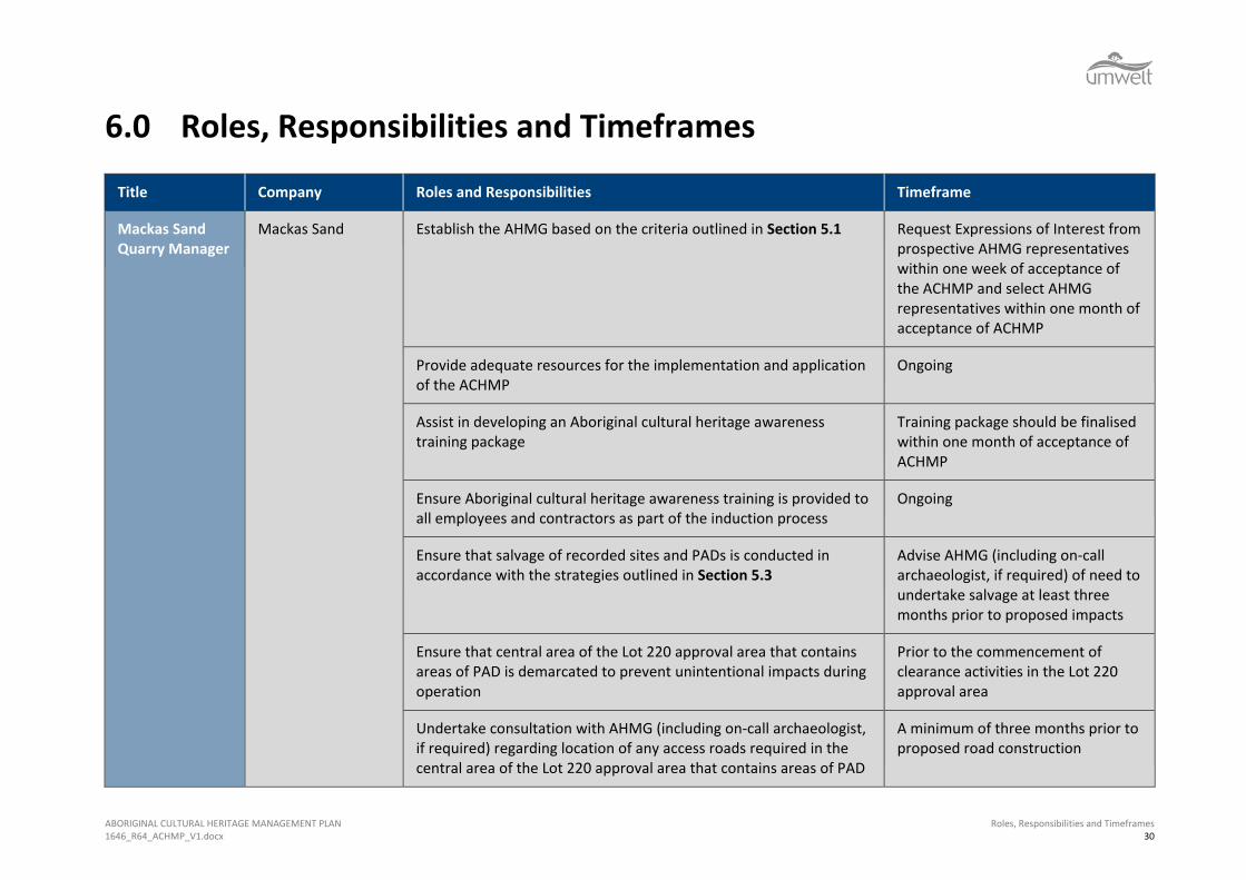
6.0 Roles, Responsibilities and Timeframes
Title Company Roles and Responsibilities Timeframe
Mackas Sand Quarry Manager
Mackas Sand Establish the AHMG based on the criteria outlined in Section 5.1 Request Expressions of Interest from prospective AHMG representatives within one week of acceptance of the ACHMP and select AHMG representatives within one month of acceptance of ACHMP
Provide adequate resources for the implementation and application of the ACHMP
Ongoing
Assist in developing an Aboriginal cultural heritage awareness training package
Training package should be finalised within one month of acceptance of ACHMP
Ensure Aboriginal cultural heritage awareness training is provided to all employees and contractors as part of the induction process
Ongoing
Ensure that salvage of recorded sites and PADs is conducted in accordance with the strategies outlined in Section 5.3
Advise AHMG (including on-call archaeologist, if required) of need to undertake salvage at least three months prior to proposed impacts
Ensure that central area of the Lot 220 approval area that contains areas of PAD is demarcated to prevent unintentional impacts during operation
Prior to the commencement of clearance activities in the Lot 220 approval area
Undertake consultation with AHMG (including on-call archaeologist, if required) regarding location of any access roads required in the central area of the Lot 220 approval area that contains areas of PAD
A minimum of three months prior to proposed road construction
ABORIGINAL CULTURAL HERITAGE MANAGEMENT PLAN 1646_R64_ACHMP_V1.docx
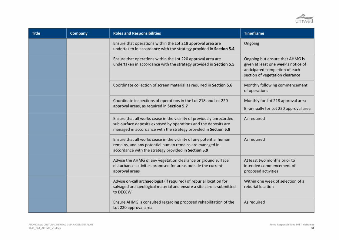
Roles, Responsibilities and Timeframes 31
Title Company Roles and Responsibilities Timeframe
Ensure that operations within the Lot 218 approval area are undertaken in accordance with the strategy provided in Section 5.4
Ongoing
Ensure that operations within the Lot 220 approval area are undertaken in accordance with the strategy provided in Section 5.5
Ongoing but ensure that AHMG is given at least one week’s notice of anticipated completion of each section of vegetation clearance
Coordinate collection of screen material as required in Section 5.6 Monthly following commencement of operations
Coordinate inspections of operations in the Lot 218 and Lot 220 approval areas, as required in Section 5.7
Monthly for Lot 218 approval area
Bi-annually for Lot 220 approval area
Ensure that all works cease in the vicinity of previously unrecorded sub-surface deposits exposed by operations and the deposits are managed in accordance with the strategy provided in Section 5.8
As required
Ensure that all works cease in the vicinity of any potential human remains, and any potential human remains are managed in accordance with the strategy provided in Section 5.9
As required
Advise the AHMG of any vegetation clearance or ground surface disturbance activities proposed for areas outside the current approval areas
At least two months prior to intended commencement of proposed activities
Advise on-call archaeologist (if required) of reburial location for salvaged archaeological material and ensure a site card is submitted to DECCW
Within one week of selection of a reburial location
Ensure AHMG is consulted regarding proposed rehabilitation of the Lot 220 approval area
As required
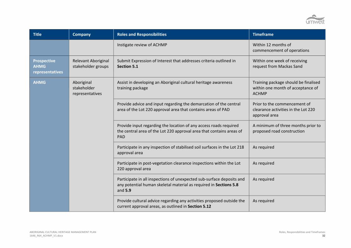
ABORIGINAL CULTURAL HERITAGE MANAGEMENT PLAN 1646_R64_ACHMP_V1.docx
Roles, Responsibilities and Timeframes 32
Title Company Roles and Responsibilities Timeframe
Instigate review of ACHMP Within 12 months of commencement of operations
Prospective AHMG representatives
Relevant Aboriginal stakeholder groups
Submit Expression of Interest that addresses criteria outlined in Section 5.1
Within one week of receiving request from Mackas Sand
AHMG Aboriginal stakeholder representatives
Assist in developing an Aboriginal cultural heritage awareness training package
Training package should be finalised within one month of acceptance of ACHMP
Provide advice and input regarding the demarcation of the central area of the Lot 220 approval area that contains areas of PAD
Prior to the commencement of clearance activities in the Lot 220 approval area
Provide input regarding the location of any access roads required the central area of the Lot 220 approval area that contains areas of PAD
A minimum of three months prior to proposed road construction
Participate in any inspection of stabilised soil surfaces in the Lot 218 approval area
As required
Participate in post-vegetation clearance inspections within the Lot 220 approval area
As required
Participate in all inspections of unexpected sub-surface deposits and any potential human skeletal material as required in Sections 5.8 and 5.9
As required
Provide cultural advice regarding any activities proposed outside the current approval areas, as outlined in Section 5.12
As required

ABORIGINAL CULTURAL HERITAGE MANAGEMENT PLAN 1646_R64_ACHMP_V1.docx
Roles, Responsibilities and Timeframes 33
Title Company Roles and Responsibilities Timeframe
Assist in determining Aboriginal stakeholder representation in all salvage activities
Establish representation requirements at least one month prior to proposed salvage activity
AHMG On-call archaeologist
Submit site card to OEH for reburial location of salvaged archaeological material (if required)
Within one month of reburial of salvaged archaeological material
Participate in post-vegetation clearance inspections within the Lot 220 approval area (if required)
As required
Provide expert advice regarding the identification and recording of archaeological material and PAD (if required)
As required
Participate in all inspections of any sub-surface deposits and any potential human skeletal material uncovered by operations as required in Sections 5.8 and 5.9 (if required)
As required
Provide archaeological advice regarding any activities proposed outside the current approval areas, as outlined in Section 5.12 (if required)
As required
ABORIGINAL CULTURAL HERITAGE MANAGEMENT PLAN 1646_R64_ACHMP_V1.docx
References 34
7.0 References Department of Environment and Conservation, 2004. Interim Community Consultation Requirements for
Applicants. National Parks and Wildlife Service (NSW NPWS), 1997. Aboriginal Cultural Heritage: Standards and
Guidelines Kit. NPWS, Hurstville. NSW Department of Health, 2008. Policy Directive – Exhumation of Human Remains. NSW Heritage Office, 1998. Skeletal Remains – Guidelines for the Management of Human Skeletal Remains
under the Heritage Act 1977. Department of Environment, Climate Change and Water, 2010. Aboriginal Heritage Consultation Guidelines
for Proponents 2010. Sydney, NSW. Umwelt (Australia) Pty Limited, 2004. Archaeological and Aboriginal Cultural Heritage Survey and
Assessment of Lot 220 in DP 1049608, Stockton Bight. Draft Report prepared for Worimi Local Aboriginal Land Council.
Umwelt (Australia) Pty Limited, 2009. Environmental Assessment of Sand Extraction Operations from Lot
218 DP 1044608 and Lot 220 DP 1049608, Salt Ash Report to Mackas Sand. Umwelt (Australia) Pty Limited, 2012. Aboriginal Cultural Heritage Assessment of Alternate Haul Route to Lot 218 DP 1044608, Salt Ash, Report to Mackas Sand.

APPENDIX A Aboriginal Stakeholder Comments
1646/Stakeholder_comment_summary 1
Draft ACHMP Stakeholder Meeting Summary
Wednesday 21 October 2009
Attendees: Jamie Tarrant (Chair, Worimi Local Aboriginal Land Council) Val Merrick (Deputy Chair, Worimi Local Aboriginal Land Council) Andrew Smith (Chief Executive Officer, Worimi Local Aboriginal Land Council) Jamie Merrick (Senior Sites Officer, Worimi Local Aboriginal Land Council) Lennie Anderson (Nur-Run-Gee Pty Ltd) Anthony Anderson (Mur-Roo-Ma Inc) Bruce Mackenzie (Mackas Sand) Robert Mackenzie (Mackas Sand) Nicola Roche (Umwelt)
Format of the meeting The meeting followed a discussion format where each section of the ACHMP was briefly reviewed and discussed amongst all present. Where particular matters were raised, these were addressed as detailed below. Except where comments/proposed alterations were noted, all stakeholder representatives present indicated that they agreed with the information and management strategies provided in the draft ACHMP. Matters addressed relating to the ACHMP Section 5.1 Establishment of Aboriginal Heritage Management Group It was agreed that Mackas Sand should invite each of the five registered stakeholder groups to submit an Expression of Interest (EOI) for participating in the Aboriginal Heritage Management Group (AHMG). It was agreed that the criteria for selection for the AHMG should include being of Aboriginal descent. It was reiterated that Mackas Sand (namely Robert and Bruce Mackenzie) will be responsible for assessing the EOIs against the criteria in order to select the AHMG. It was agreed that the AHMG should operate on a consensus basis, with decisions to be made on the basis of the opinions of the majority of the AHMG. Section 5.4 Strategy for Operations within the Lot 218 Approval Area It was stated that windblown sand can include fragments of windblown shell and bone and that the on-site operators should be aware of this. It was agreed that the material provided in the induction package would be sufficient to ensure that operators are aware of their responsibilities. Section 5.5 Strategy for Operations within the Lot 220 Approval Area The methods for vegetation clearance were reviewed in detail. It was agreed that inspection following felling of large trees was necessary but that it may not necessarily have to occur immediately after tree clearance. It was agreed that the timing of the inspection after felling of large trees should be determined by Mackas Sand and the AHMG. Section 5.6 Collection and Inspection of Screen Reject Material The methods and practicalities of collection and inspection of screen reject material were discussed. It was agreed that it would be helpful if each bag of sample reject material was marked with the date of collection as this would assist in determining the origins of artefactual material if any was to be present in the screen reject sample.
1646/Stakeholder_comment_summary 2
Section 5.8 Management of Unexpected Sub-Surface Deposits (other than Human Skeletal Material) The possibility that animal bone can also be of high archaeological and cultural significance was discussed in relation to animal skeletal remains previously excavated in the local area. It was agreed that Section 5.8 should include a provision for animal bones that may have cultural significance, with this obviously excluding non-native animal bones. Section 5.9 Human Skeletal Material It was agreed that it should be specified (rather than implied) that, if possible human skeletal remains are identified, the AHMG should be contacted in conjunction with the cessation of works in the vicinity of the skeletal material. Section 5.14 Site Rehabilitation, Bushfire Management, Weed and Feral Animal Control, Unexploded Ordnance Management Plan It was agreed that the statement that ‘the rehabilitation of the Lot 220 approval area will achieve a final landform that is compatible with the slopes and vegetation communities of the surrounding area..’ may give an unrealistic expectation that the rehabilitated area will be the same as the surrounding area. It was agreed that this wording should be changed and this section of the management plan should be more specific about the end product of landform rehabilitation. General The Aboriginal stakeholder representatives stated that they felt that the AHMG would have sufficient experience and understanding of archaeology within the region that the AHMG would be qualified to determine when the assistance of an archaeologist was required. It was therefore agreed that any reference to an on-call archaeologist include the phrase ‘as required’. Outcomes The changes to the draft ACHMP resulting from the above discussions are provided below, with the changes highlighted. Section 5.1 Establishment of Aboriginal Heritage Management Group Mackas Sand will form an Aboriginal Heritage Management Group (AHMG) that will oversee the implementation and ongoing application of the ACHMP. For the first year of operation, the AHMG will be comprised of up to five Aboriginal stakeholder representatives and the Mackas Sand Quarry Manager, with a qualified archaeologist included on an on-call basis. The Aboriginal stakeholder representatives will be selected by Mackas Sand on the basis of the following criteria: • Aboriginal descent;
• relevant experience and qualifications in working with the management of Aboriginal cultural heritage;
• ability to communicate information relating to the management of Aboriginal cultural heritage within the approval areas with the broader Aboriginal community; and
• ability to interact and work effectively in group situations.
In relation to the selection of the initial AHMG, Mackas Sand will invite each of the five registered stakeholder groups to submit Expressions of Interest that address the selection criteria. Representation on the AHMG will be subject to review on an annual basis or at other intervals determined by the AHMG. Decisions made by the AHMG will be made on the basis of the opinion of the majority of the AHMG.
1646/Stakeholder_comment_summary 3
The roles and responsibilities of the AHMG will be discussed in greater detail for each of the additional management strategies outlined in this document. Section 5.5 Strategy for Operations within the Lot 220 Approval Area Within the Lot 220 area, operations cannot be undertaken without impacting stabilised soil surfaces and the associated archaeological material (if present). The Lot 220 proposal area contains considerable areas of PAD that are likely to have very high research value and therefore it is not archaeologically justifiable to recommend the destruction of this area without undertaking mitigating activities involving salvage of archaeological materials (including surface collection and potentially sub-surface salvage). Mackas Sand will ensure that all operations within the Lot 220 approval area are conducted in accordance with the strategy provided below. • As part of the Aboriginal cultural heritage awareness training and prior to removal of any
vegetation, all staff and contractors will be made aware of the diagnostic features of Aboriginal scarred trees and advised that should any possible Aboriginal scarred trees be identified during vegetation clearance, all clearance in the immediate vicinity of the possible scarred tree should cease until it can be inspected by the AHMG (including the on-call archaeologist).
• Vegetation clearance will occur as a staged process, with the aim of minimising ground surface disturbance resulting from vegetation clearance. Vegetation clearance will be undertaken in accordance with the following methodology:
understorey vegetation and all trees smaller than approximately 50 centimetres diameter at chest height will be removed by earth-moving equipment or similar and placed outside the newly cleared area so that all of the newly cleared area is visible. At this stage, the AHMG will be invited to undertake an inspection of the newly cleared area; and
following the initial inspection, the remaining large trees will be cleared by machinery (in accordance with ecological tree clearance procedures) and the AHMG will be invited to inspect the additional area of ground disturbance resulting from large tree clearance at a time determined in consultation with the AHMG.
• During vegetation clearance inspections (as discussed above), any surface archaeological materials such as stone artefacts and shell) will be collected in accordance with the methodology provided in Attachment 3 of Appendix 2.
• Should any of the following be identified during vegetation clearance inspections within Lot 220, test excavations will be conducted in accordance with the methodology provided in Attachment 3 of Appendix 2:
high densities of stone artefacts, shell or bone fragments (as assessed by the AHMG including the on-call archaeologist).
• Should test excavations identify any of the following, salvage excavations will be conducted in accordance with the methodology provided in Attachment 3 of Appendix 2:
consolidated shell midden deposits (comprising packed shell as opposed to dispersed shell fragments);
stone artefact scatters that contain high densities of artefacts (greater than three artefacts per test pit, or as otherwise agreed by the relevant stakeholders and an archaeologist) and/or an artefact assemblage of notable complexity or research value; and/or
hearth or heat treatment feature.

1646/Stakeholder_comment_summary 4
Section 5.6 Collection and Inspection of Screen Reject Material Mackas Sand will ensure that a sample of the reject material from the coarse screen will be bagged each day of operations within the Lot 218 and Lot 220 approval areas and labelled with the date of collection. The bagged samples will be provided to AHMG on a monthly basis for inspection to be conducted in conjunction with the monthly monitoring inspection for the Lot 218 approval area (as discussed in Section 5.7). Should the samples contain shell material or stone artefacts, the AHMG on-call archaeologist will further record and assess these materials. Should the proportion of archaeological material within the screen reject sample be considered high by the AHMG (including the on-call archaeologist), the source of the material and the possible presence of additional concentrated archaeological deposits will be discussed by the AHMG and an inspection of the relevant approval area may be undertaken. Section 5.8 Management of Unexpected Sub-Surface Deposits (other than Human Skeletal Material) Mackas Sand will ensure that, should operations result in the exposure of compact shell midden, animal bones with potential cultural significance or suspected hearth or heat treatment features within the approval areas, works will cease and the area will be cordoned off for 10 metres from all edges of the archaeological material. The AHMG (including an on-call archaeologist, if required) will be notified and provided with the opportunity to inspect the material. The AHMG will assess the significance of the material in accordance with significance assessment criteria in Table 6.1 of Appendix 2. The material will then be salvaged in accordance with the sub-surface salvage methodology provided in Attachment 3 of Appendix 2. Works will not proceed in the identified area until approval has been provided by the AHMG (including an on-call archaeologist, if required). A site card will be lodged with DECCW providing details of the site and the salvage activities undertaken at the site. Section 5.9 Human Skeletal Material Human skeletal material has been found within the active transgressive dune field on Stockton Bight however it is not possible to rule out the possibility that human skeletal material may be present in the approval areas. Human skeletal material is generally of very high archaeological significance and is of particular significance to Aboriginal people. It is not possible to predict the location, condition or nature of human skeletal that may be present within the approval areas. The following recommendations are therefore provided to give certainty that if human/possible human skeletal material is found, it will be managed in accordance with legal requirements, the wishes of the relevant Aboriginal stakeholders and DECCW requirements. Should human/possible human skeletal material (single bones or an intact burial) be located within any area, it will be managed in accordance with the following strategy: • Excavation works within the immediate vicinity of the skeletal material will cease, the
AHMG will be contacted and the area will be cordoned off for 10 metres from all edges of the skeletal material.
• The skeletal material will be inspected to determine whether it is human or animal. If necessary, advice will be sought from a forensic specialist.
• If the skeletal material is human, DECCW and NSW Police will be contacted. No further works will proceed until an appropriate course of action has been determined in consultation with DECCW, NSW Police and the relevant Aboriginal stakeholders. Works will not proceed within the identified area until written approval has been received from DECCW and NSW Police.

1646/Stakeholder_comment_summary 5
If the skeletal material is not human, mitigation activities or works can proceed in accordance with the other strategies outlined in this ACHMP. Section 5.14 Site Rehabilitation, Bushfire Management, Weed and Feral Animal Control, Unexploded Ordnance Management Plan The Lot 220 approval area will be subject to rehabilitation on the basis of a comprehensive Landscape Management Plan that will be prepared in consultation with DECCW and DoP. The Landscape Management Plan will also provide mechanisms for bushfire management and weed and feral pest control. The requirements of the Landscape Management Plan will be consistent with the ACHMP. It is intended that the rehabilitation of the Lot 220 approval area will achieve a final landform that is similar to the surrounding topography in that it will be shaped, where possible, in undulating profiles in keeping with natural landforms of the surrounding environment. Rehabilitation will result in the re-establishment of similar vegetation communities to those currently present within the approval area. Where feasible, the AHMG will be consulted regarding progressive rehabilitation and will be provided with the opportunity to have input into the re-establishment of vegetation communities that contain valuable Aboriginal resource plants and that may attract Aboriginal faunal resources. An Unexploded Ordnance Management Plan will also be completed for Lot 218. Any excavations conducted under the ACHMP on Lot 218 will be consistent with the requirements of the Unexploded Ordnance Management Plan. General Throughout the document, the reference to the involvement of an on-call archaeologist has been modified. References to the involvement of an on-call archaeologist now include the phrase ‘as required’. Acknowledgement of Consensus among Meeting Attendees At the conclusion of the meeting it was agreed that, in order to facilitate the consultation process, a copy of the above information should be provided to all of the registered stakeholder groups for their review. It was agreed that, should the above record be an accurate one, the meeting attendees would endorse their comments and that this should constitute their feedback to the draft ACHMP. A declaration to this effect and space for endorsement is provided below. I, _____________________________(insert name) am authorised to provide feedback on the draft ACHMP on behalf of ________________________________(insert stakeholder group name). I acknowledge that this is a true and accurate account of the meeting conducted on 21 October 2009 to review the draft ACHMP for Mackas Sand. I endorse the comments and changes to the draft ACHMP provided above. Signed ____________________________________________________________________
1646/Stakeholder_comment_summary 6
Comments received from Carol Ridgeway-Bissett (Worimi Knowledgeholders Aboriginal Corporation – formerly Maaiangal
Aboriginal Heritage Corporation)
21 October 2009
Carol Ridgeway-Bissett provided verbal comment to Nicola Roche (Senior Archaeologist, Umwelt) on 21 October 2009. Carol indicated that she would like the following comments included as her response to the draft ACHMP. Carol’s direct comments are shown in italics. Carol fundamentally objects to the approved project. Stockton Bight is the largest moving sand mass in the southern hemisphere it should be federally listed for its natural and cultural heritage values. Sand mining and sand extraction should not be allow to proceed in this area. Carol stated that Aboriginal artefacts will not always be present on the surface. As dunes build up over years and years, there could be artefacts present at great depth, including human remains. Carol objects to the structure and selection methods for the AHMG. She objects to Mackas Sand selecting the AHMG and stated that DECCW should be responsible for selecting the AHMG. The AHMG can’t be associated with the mine and should be a group within DECCW that considers broader heritage issues for the Worimi area. The AHMG should involve consultation with a wider proportion of the Aboriginal community via public meetings. Carol also suggested that there is a relevant Aboriginal body that advises State Government on issues to do with Aboriginal cultural and heritage and that this body should be consulted regarding the Mackas Sand approval. Carol also objected to the ‘majority rules’ aspect of the AHMG. Carol indicated that she would like to see any salvaged artefacts reburied close to the area in which they were found and thought that the Lot 220 area would be suitable for this purpose. Carol is concerned that the removal of vegetation in Lot 220 will result in the removal of a wildlife corridor and important plant species. The corridor that will not be mined in Lot 220 is not enough to guarantee that wildlife will be able to pass through and that important plant species will be preserved. Carol feels that it is important that the rehabilitation of Lot 220 involves consultation with local Dune Care groups who have experience in rehabilitating dunes. She agreed that it is important that Aboriginal resource plants and those that attract fauna that would have been targeted by Aboriginal people are used in the rehabilitation. Carol discussed the importance of flora, fauna and the landscape in considerations of Aboriginal heritage and emphasised that any impacts to these elements are also impacts to Aboriginal heritage. I, Carol Ridgeway-Bissett, am authorised to provide feedback on the draft ACHMP on behalf of ________________________________(insert stakeholder group name). I acknowledge that this is a true and accurate account of the comments regarding the draft ACHMP for Mackas Sand that I provided to Nicola Roche on 21 October 2009. I endorse the comments provided above. Signed ____________________________________________________________________
APPENDIX B Site Cards
Aboriginal Sites Register of NSW NPWS, PO Box 1967, Hurstville NSW 2220 Standard Site Recording Form
Version: June 1998 Data entered by: Date entered:
New Recording Additional
information SITE IDENTIFICATION
Site name Majors Flat Macka’s Sand 2 (MFMS 2) NPWS Site Number
Owner/manager Mr Lennie Anderson
Owner Address Worimi Local Aboriginal Land Council 'Murrook' 173 Nelsons Bay Road Williamtown NSW 2318
LOCATION Location The site is located within Lot 220 in DP 1049608 (originally Lot 8 in Water Reserve 57573, Salt
Ash) South of Nelson Bay Road
How to get to the site See attached Figure 1.1.
1:250,000 map name Newcastle
NPWS map code
AMG Zone 56
AMG Easting 399567 AMG Northing 6370190
Method for grid reference Hand-held GPS Map scale (if method = map)
1:25,000 Map name Wiliamtown 9232-2-N
NPWS District Name (see map)
NPWS Zone (see map)
Northern Zone Portion no. Lot 220 DP1049608
Parish Stowell
SITE DESCRIPTION Site type(s)
Midden Site type code (NPWS use only)
Description of site and contents CHECKLIST: eg. length, width, depth, height of site, shelter, deposit, structure, element eg. tree scar, grooves in rock. DEPOSIT: colour, texture, estimated depth, stratigraphy, contents-shell, bone, stone, charcoal, density & distribution of these, stone types, artefact types. ART: area of decorated surface, motifs, colours, wet,/dry pigment, engraving technique, no. of figures, sizes, patination. BURIALS: number & condition of bone, position, age, sex, associated artefacts. TREES: number, alive, dead. likely age, scar shape, position, size, patterns, axe marks, regrowth. QUARRIES: rock type, debris, recognisable artefacts, percentage quarried
The site is located on a vehicle track in a low lying area between two ENE/WSW trending sand dunes (Plate 5), approximately one kilometre southeast of Tilligerry Creek and seven and a half kilometres east of the township of Williamtown. A lens of whole shells and fragments of weathered pipi and cockle were eroding out of the soil profile (5 to 15 cm below the surface and less than one metre in length) on the southern edge of a vehicle track (Plate 6). The soil was a dark grey/black over a powdery, bleached sand. The shells are eroding from below the dark/grey humic layer in the A Horizon, within the top layer of the the A2 horizon. A light density scatter of shell is distributed across the surface south of the road over an area of approximately five metres by five metres. One shell fragment was found one metre to the north of the road. The sand dune is part of the Outer Holocene Barrier System of Stockton Bight and is located south of the Interbarrier Depression that separates it from the Inner Pleistocene Barrier. Three shell midden sites, recorded by McCardle (2002), are located 600 m to the NNE of this site (A6, A7 and A8, NPWS # 38-4-0651 to 0653). The sites contain low density scatters of pipi, cockle and mud whelk over an area of approximately 300 m x 60 m. The shell extended over the fence to the south where stone artefacts can be observed over the fenceline. A large midden site (A5, NPWS #38-4-0650) containing a buried soil profile and stone artefacts is located 300 metres to the NNW of the site. Visibility within the site was limited to 5% away from the vehicle track due to thick vegetation cover (predominantly bracken fern) and leaf litter. The area has been disturbed by the construction of a vehicle track through the centre of the site. Horse riding is a favourite pastime in the area. The area was burnt in a bush fire late last year (2002).

Aboriginal Sites Register of NSW NPWS, PO Box 1967, Hurstville NSW 2220 Standard Site Recording Form
Version: June 1998 Data entered by: Date entered:
Attach photographs and sketches, eg. plan & section of shelter. Do NOT dig, disturb or damage site or contents.
Aboriginal Sites Register of NSW NPWS, PO Box 1967, Hurstville NSW 2220 Standard Site Recording Form
Version: June 1998 Data entered by: Date entered:
SITE ENVIRONMENT
Land form low lying depression between two dune ridges
Aspect SSE Slope <1 degree
Mark position of the site
Local rock type Sandy podzol
Land use/effect previously Crown Land, now owned by Worimi Local Aboriginal Land Council
Distance from drinking water
300 m from permanent spring Source Tillberry Creek 1.5 km to the NW
Resource zone (eg. estuarine, river, forest)
Estuarine Vegetation Coastal Sands Apple Blackbutt Woodland
Edible plants Bracken fern, Macrozamia, kangaroo grass, Dianella, bladey grass, geebung, Acacia, Banksia, sarsaparilla plant
Faunal resources (include shellfish)
Pipi, cockle, mud whelk, mud crabs, fish, kangaroo, goanna, snake
Other exploitable resources (eg. ochre)
Are there other sites in the locality
Yes Are they in the Sites Register
Yes Other site types include
Shell midden with stone artefacts
SITE MANAGEMENT Site condition Disturbed Disturbed by tree clearing, bush fires, construction of a vehicle track
and tank traps (WWII).
Management recommendations
A Section 90 Heritage Impact Permit with Salvage (subsurface investigation) is sought for site Majors Flat Macka’s Sand 2. The extent and methodology of the subsurface investigation to be decided in consultation with Worimi LALC, Worimi TAE&OG and NPWS.
Have artefacts been removed from site
No When
By whom Deposited at
Consent applied for Consent issued Date of issue
Consent number
SITE INSPECTION AND RECORDING Reason for investigation Archaeological investigation for a proposed sand mine
Were local Aborigines contacted or present for the recording
Not contacted Contacted and
present Contacted but
not present
Names and addresses
Anthony Anderson Worimi Local Aboriginal Land Council 'Murrook' 173 Nelsons Bay Road Williamtown NSW 2318
Is the site important to local Aborigines
Yes

Aboriginal Sites Register of NSW NPWS, PO Box 1967, Hurstville NSW 2220 Standard Site Recording Form
Version: June 1998 Data entered by: Date entered:
Verbal/written reference sources
Archaeological and Aboriginal Cultural Heritage Assessment of Lot 220, DP 1049608. A Report to Macka's Sand and Soil
ASR report number(s) (or title)
C- 0 C-
Photographs taken Yes No. of Photos attached
2 (Plates 5 & 6)
Site recorded by Leila McAdam
Date of recording
14 November, 2003
Address/institution Umwelt (Australia) Pty Limited
Aboriginal Sites Register of NSW NPWS, PO Box 1967, Hurstville NSW 2220 Standard Site Recording Form
Version: June 1998 Data entered by: Date entered:
New Recording Additional
information SITE IDENTIFICATION
Site name Majors Flat Macka’s Sand 1 (MFMS 1) – (additional information for Sites A6, A7 and A8 recorded by P McCardle NPWS #38-4-0651-0653 on 7.11.2002)
NPWS Site Number
Owner/manager Mr Lennie Anderson
Owner Address Worimi Local Aboriginal Land Council 'Murrook' 173 Nelsons Bay Road Williamtown NSW 2318
LOCATION Location The site is located within Lot 220 in DP 1049608 (originally Lot 8 in Water Reserve 57573, Salt
Ash) South of Nelson Bay Road
How to get to the site See Figures 1.1 and 5.1.
1:250,000 map name Newcastle
NPWS map code
AMG Zone 56
AMG Easting 399020 AMG Northing 6370390
Method for grid reference Hand-held GPS Map scale (if method = map)
1:25,000 Map name Wiliamtown 9232-2-N
NPWS District Name (see map)
NPWS Zone (see map)
Northern Zone Portion no. Lot 220 DP1049608
Parish Stowell
SITE DESCRIPTION Site type(s)
Midden Site type code (NPWS use only)
Description of site and contents CHECKLIST: eg. length, width, depth, height of site, shelter, deposit, structure, element eg. tree scar, grooves in rock. DEPOSIT: colour, texture, estimated depth, stratigraphy, contents-shell, bone, stone, charcoal, density & distribution of these, stone types, artefact types. ART: area of decorated surface, motifs, colours, wet,/dry pigment, engraving technique, no. of figures, sizes, patination. BURIALS: number & condition of bone, position, age, sex, associated artefacts. TREES: number, alive, dead. likely age, scar shape, position, size, patterns, axe marks, regrowth. QUARRIES: rock type, debris, recognisable artefacts, percentage quarried
The site is located on several crests on a minor sand ridge, above a permanent spring, 600 metres southeast of Tilligerry Creek and approximately seven kilometres east of the township of Williamtown (Figure 5.1). The dune is part of the Outer Holocene Barrier System of Stockton Bight and is located south of the Interbarrier Depression that separates the Outer Barrier from the Inner, Pleistocene Barrier. Fragments of weathered Plebidonax deltoids (pipi), Anadara sp. (cockle) and Pyrazus ebeninus (mud whelk) and occasional whole shells are thinly scattered over several crests and upper slopes of the ridgeline. Plate 2 shows shell fragments in a clearing of vegetation within the site. The site area extends from AMG 398770E 6370390N to 399060E 6370390N. Small fragments of shell are continuous over an area of approximately 100 metres in length and 50 metres in width. The site includes the three sites (A6, A7 and A8) recorded by P McCardle in 2002 during her Survey incorporates from Tomago to Tomaree, for Energy Australia (ERM 2003). Stone artefacts can be observed over the fenceline (Site SA1, NPWS # 38-4-0298), outside the project area for this investigation. It is assumed that site Majors Flat Macka’s Sand 1 is an extension of a general light scatter of highly weathered and fragmented marine and estuarine shells that extend from Site SA1, however, no stone artefacts were found within the project area. Majors Flat Macka’s Sand 1 (MFMS 1) is located in a resource rich area and provides a good lookout point. Plate 3 shows the outlook across the swampy Interbarrier Depression towards Tilligerry Creek. Tilligerry Creek is reported by local residents to have contained a good supply of mud crabs and fish in the past. Visibility within the site was limited to 5% due to thick vegetation cover (predominantly bracken fern) and leaf litter (Plate 4). The soil consists of a slightly darker, humic five cm layer of sand
Aboriginal Sites Register of NSW NPWS, PO Box 1967, Hurstville NSW 2220 Standard Site Recording Form
Version: June 1998 Data entered by: Date entered:
over loose yellow sand. The area has been disturbed by the construction of a vehicle track through the eastern end of the site and several rows of cement tank traps (WWII) are located along the boundary of the site. Horse riding is a favourite pastime in the area. The area was burnt in a bush fire in January this year exposing the surface to further erosion.. Attach photographs and sketches, eg. plan & section of shelter. Do NOT dig, disturb or damage site or contents.

Aboriginal Sites Register of NSW NPWS, PO Box 1967, Hurstville NSW 2220 Standard Site Recording Form
Version: June 1998 Data entered by: Date entered:
SITE ENVIRONMENT
Land form crest, saddle and upper slope of dune ride
Aspect Mainly N & S but in all directions away from crests
Slope Varies from 360 degrees to 4-5 degrees
Mark position of the site
Local rock type Sandy podzol
Land use/effect previously Crown Land, now owned by Worimi Local Aboriginal Land Council
Distance from drinking water
50 m from permanent spring Source Tillberry Creek 600 m to the NW
Resource zone (eg. estuarine, river, forest)
Estuarine Vegetation Coastal Sands Apple Blackbutt Woodland
Edible plants Bracken fern, Macrozamia, kangaroo grass, Dianella, bladey grass, geebung, Acacia, Banksia, sarsaparilla plant
Faunal resources (include shellfish)
Pipi, cockle, mud whelk, mud crabs, fish, kangaroo, goanna, snake
Other exploitable resources (eg. ochre)
Are there other sites in the locality
Yes Are they in the Sites Register
Yes Other site types include
Shell midden with stone artefacts
SITE MANAGEMENT Site condition Disturbed Disturbed by tree clearing, bush fires, construction of a vehicle track
and tank traps (WW2).
Management recommendations
Section 90 Heritage Impact Permit with Salvage (surface collection) for Majors Flat Macka’s Sand 1. The surface collection should be undertaken by Worimi LALC and Worimi TAE&OG, the material collected to be reburied at a location chosen by Worimi LALC and Worimi TAE&OG in consultation with NPWS
Have artefacts been removed from site
No When
By whom Deposited at
Consent applied for Consent issued Date of issue
Consent number
SITE INSPECTION AND RECORDING Reason for investigation Archaeological investigation for a proposed sand mine
Were local Aborigines contacted or present for the recording
Not contacted Contacted and
present Contacted but
not present
Names and addresses
Lennie Anderson and Anthony Anderson Worimi Local Aboriginal Land Council 'Murrook' 173 Nelsons Bay Road Williamtown NSW 2318
Aboriginal Sites Register of NSW NPWS, PO Box 1967, Hurstville NSW 2220 Standard Site Recording Form
Version: June 1998 Data entered by: Date entered:
Is the site important to local Aborigines
Yes
Verbal/written reference sources
Archaeological and Aboriginal Cultural Heritage Assessment of Lot 220, DP 1049608. A Report to Macka's Sand and Soil
ASR report number(s) (or title)
C- 0 C-
Photographs taken Yes No. of Photos attached
3 (Plates 2-4 in Report)
Site recorded by Leila McAdam
Date of recording
13 November, 2003
Address/institution Umwelt (Australia) Pty Limited
Newcastle
75 York Street Teralba NSW 2284
Perth
PO Box 8177 Subiaco East WA 6008 33 Ventnor Avenue West Perth WA 6005
Canberra
PO Box 6135 56 Bluebell Street O’Connor ACT 2602
Sydney
50 York Street Sydney NSW 2000
Brisbane
GPO Box 459 Brisbane QLD 4001
Ph. 02 4950 5322 Ph. 08 6260 0700 Ph. 02 6262 9484 Ph. 1300 793 267 Ph. 1300 793 267
www.umwelt.com.au