Aboriginal community are committed to working together in the
43
Transcript of Aboriginal community are committed to working together in the


Document History Doc No. Date Amended Details Comments eg Resolution No.
DM1148716 2011 Draft – including Appendix A #DM1146249 Res 11-851 Endorsed for public exhibition
DM1170366 15 December 2011 Draft for Ordinary Meeting 15 December 2011 -including Appendix A #DM1146249 Res 11-1031 - adopted
DM1178490 December 2011 Minor editorial amendments after Res 11-1031 Submitted to Minister for the Environment, including Appendix A #DM1146249
E2016/18752 April 2016 Draft for 7 April 2016 Council meeting
E2016/23724 April 2016 Res16-169 Draft for 12 May Extraordinary meeting
Cover photo: Main Beach, Byron Bay, ex Tropical Cyclone Winston swell, 27 February 2016 (Byron Shire Council)
Byron Shire Council recognises the Bundjalung of Byron Bay Aboriginal - Arakwal People as traditional owners and custodians within this local Government area. Byron Shire Council and the Aboriginal community are committed to working together in the process of reconciliation. Council recognises that the most enduring and relevant legacy the Indigenous people offer, is their understanding of the land and local and deep commitment to place.
Draft Coastal Zone Management Plan Byron Bay Embayment – Part E: Emergency Action Sub Plan
i

Contents E1 Introduction .......................................................................................................................... 1
E1.1 Scope of plan ............................................................................................................ 1 E1.2 Coastal Management Principles ............................................................................... 3 E1.3 Legal Framework ...................................................................................................... 4 E1.4 Consultation .............................................................................................................. 4 E1.5 Management Options Analysis ................................................................................. 5
E2 DISPLAN and NON-DISPLAN Emergencies ....................................................................... 6
E2.1 DISPLAN Emergency ............................................................................................... 6 E2.2 NON-DISPLAN Emergency ...................................................................................... 7
E3 Roles and Responsibilities .................................................................................................. 8
E4 Intended Emergency Actions ............................................................................................. 12
E4.1 Shire-wide intended emergency actions ................................................................. 12 E4.2 Implementation: safety and other constraints ......................................................... 12
E5 Landowner Temporary Coastal Protection Works ............................................................. 22
E5.1 Additional requirements for placing, maintaining and removing Temporary Coastal Protection Works .................................................................................................... 22
E6 Aboriginal Cultural Heritage considerations ...................................................................... 23
E7 EASP Implementation and Review .................................................................................... 23
Figures Figure 1-1 Locality and Management Areas ............................................................................ 2
Figure 1-2 Consideration of Coastal Management Principles .................................................. 3
Figure 3-1 Flow chart of Emergency Roles .............................................................................. 9
Figure 4-1 Management Area South Golden Beach – New Brighton .................................... 18
Figure 4-2 Management Area Brunswick Heads ................................................................... 19
Figure 4-3 Management Area Byron Bay ............................................................................... 20
Figure 4-4 Management Area Suffolk Park ............................................................................ 21
Tables Table 1-1 Summary of consultation carried out prior to the exhibition of the draft EASP (July
2011 to September 2011) ....................................................................................... 4
Table 1-2 Summary of public exhibition of the draft EASP ..................................................... 5
Table 2-1 Hazards identified in the DISPLAN ......................................................................... 6
Table 2-2 Scenarios under which a severe weather warning may not be issued by BOM and
where beach erosion may occur ............................................................................. 7
Draft Coastal Zone Management Plan Byron Bay Embayment – Part E: Emergency Action Sub Plan
ii

Table 3-1 Roles during an Emergency before or in the absence of a Combat Agency
managing the event .............................................................................................. 10
Table 3-2 Phases for the delivery of the Intended Emergency Actions for Emergencies ..... 11
Table 4-1 Preparedness Intended Emergency Actions ........................................................ 13
Table 4-2 Response Intended Emergency Actions ............................................................... 14
Table 4-3 Recovery Intended Emergency Actions ................................................................ 16
Table 4-4 Communication Intended Emergency Actions ...................................................... 17
Table 5-1 Extract of schedule showing authorised locations for placing works and associated
access (Code of Practice under the Coastal Protection Act 1979) ....................... 22
Appendices Appendix 1 Byron Shire Local Flood Plan (BSC #1146249) Appendix 2 Summary Management Options Analysis
Draft Coastal Zone Management Plan Byron Bay Embayment – Part E: Emergency Action Sub Plan
iii

Definitions Beach Has the same definition as the CP Act:
means the area of unconsolidated or other readily erodable material between the highest level reached by wave action and the place where tidal or lake waters reach a depth of 10 metres below Australian Height Datum.
Beach Erosion The offshore movement of sand from the sub-aerial beach during storms or an extreme or irregular event1.
BSC Byron Shire Council
BSC EASP Internal Support Procedure
BSC EASP internal support procedure provides further detail that could frequently change, including staff contacts, roles and responsibilities, sources and supplies, monitoring procedures
CERT Coastal Erosion Response Team (internal team – Byron Shire Council)
Coastal Protection Works
Activities or works to reduce the impact of coastal hazards on land adjacent to tidal waters and includes sea walls, revetment and beach nourishment
Code of Practice Code of Practice under the Coastal Protection Act 1979
Combat Agency The agency identified in the State Disaster Plan as the agency primarily responsible for responding to a particular emergency.
CP Act Coastal Protection Act 1979
CZMP BBE Coastal Zone Management Plan Byron Bay Embayment
DCP 2010 Byron Shire Development Control Plan 2010
DISPLAN The Byron Shire Council Local Disaster Plan prepared by the Byron Shire Local Emergency Management Committee in compliance with the State Emergency and Rescue Management Act, 1989 Section 29(1)
EASP Emergency Action Sub Plan
Emergency A situation in which Beach Erosion is imminent, occurring or has occurred, and the Beach Erosion endangers, or threatens to endanger the safety or health of people or destroys or damages, or threatens to destroy or damage any property and which requires a significant and coordinated response2
Temporary Coastal Protection Works (ECPW)
Temporary Coastal Protection Works as defined under the CP Act
Guidelines Guidelines for Preparing Coastal Zone Management Plans (OEH, July 2013) referred to in Section 55D CP Act
Intended Emergency Actions
Means the actions in Section 4 of this EASP subject to the provisions of this EASP.
1 Source adapted from s55C(1)(b) CP Act and the Guidelines. 2 Source adapted from definition in Byron Shire Local Disaster Plan September 2008.
Draft Coastal Zone Management Plan Byron Bay Embayment – Part E: Emergency Action Sub Plan
iv

Landowner Temporary Coastal Protection Works
Temporary coastal protection works are defined under Part 4C of the Coastal Protection Act 1979 and that may be placed by or on behalf of a landowner to reduce the impact of beach erosion in compliance with the requirements of that section
LEMC Local Emergency Management Committee (refer DISPLAN)
LEMO Local Emergency Management Officer (refer DISPLAN)
LEOCON Local Emergency Operations Controller (refer DISPLAN)
Local Flood Plan Byron Shire Local Flood Plan, February 2006 – A Sub-Plan of the Byron Shire Local Disaster Plan
OEH Office of Environment and Heritage (formerly DECCW – Department of Environment, Climate Change and Water)
SERM Act State Emergency and Rescue Management Act 1989
SES State Emergency Service
State Storm Plan 2012
New South Wales State Storm Sub Plan – A sub plan of the New South Wales Disaster Plan, June 2012
TCPW Guide Guide to the Statutory Requirements for Temporary Coastal Protection Works (OEH, August 2013)
Draft Coastal Zone Management Plan Byron Bay Embayment – Part E: Emergency Action Sub Plan
v

E1 Introduction E1.1 Scope of plan This Emergency Action Sub Plan (EASP) is a coastal zone management plan that details Intended Emergency Actions to be carried out by Byron Shire Council (BSC), subject to the provisions of this EASP, in response to an Emergency. This EASP is Part E of the Coastal Zone Management Plan Byron Bay Embayment (CZMP BBE), detailing intended actions as they relate to Management Objective 7 of the draft CZMP BBE, which is:
CZMP BBE Management Objective 7 To minimise and manage risks to beach access, recreational amenity and public safety by preparing for and responding to coastal erosion emergencies in a planned and coordinated manner.
The Intended Emergency Actions in this EASP will apply to the Byron Shire coastline. The Byron Shire coastline is depicted at Figure 1-1 which also shows a break down of the coastline into four management areas. In this EASP, Beach Erosion is defined as the offshore movement of sand from the sub-aerial beach during storms or an extreme or irregular event that may not involve a storm or severe weather, for example heavy ground swell, a low to moderate swell acting on a depleted beach profile, slumping of the erosion escarpment or erosion protection structures after an event has passed. The EASP is triggered in an Emergency, which is defined as a situation in which Beach Erosion is imminent, occurring or has occurred, and the Beach Erosion endangers, or threatens to endanger the safety or health of people or destroys or damages, or threatens to destroy or damage any property and which requires a significant and coordinated response3. The purpose of this EASP is to outline BSC’s Intended Emergency Actions, subject to the provisions of this EASP, before, during and after an Emergency. The Emergency may or may not have triggered Byron Shire Council’s Disaster Management Plan (DISPLAN) or the State Storm Plan 2012. The focus of this EASP is the expenditure of public funds on public assets to achieve the best cost-effective public benefit. Nothing in this EASP requires the expenditure of public funds on or for the sole benefit of private assets.
3 Source adapted from definition in Byron Shire Local Disaster Plan September 2008.
Draft Coastal Zone Management Plan Byron Bay Embayment – Part E: Emergency Action Sub Plan
Page 1

Figure 1-1 Locality and Management Areas
Draft Coastal Zone Management Plan Byron Bay Embayment – Part E: Emergency Action Sub Plan
Page 2

E1.2 Coastal Management Principles Relevant Coastal Management Principles, refer Figure 2 of the Guidelines, including the objects of the Coastal Protection Act, goals, objectives and principles of the NSW Coastal Policy 1997 have been considered in development of the Intended Emergency Actions in this EASP, seen in Figure 1-2.
Links between the State Storm Plan, DISPLAN and Local Flood Plan have
been optimised, sections 1.3 & 2. EASP is consistent with Council’s
planning instruments, strategic documents and policies.
Consultation is at section 1.4. Table 4-4 details a Communication
Strategy.Eligible landowners are encouraged to make early decisions about their
private properties in section 5.
EASP prepared using best available information and reasonable practice.
Relationships between processes acknowledged and Intended
Emergency Actions prepared so that they are not in conflict with these
processes.Review provisions are at section 7.
Intended Emergency Actions do not propose expenditure of public funds
on private assets. Achieving cost efficient public benefit is the focus of
section 4.
Intended Emergency Actions adopt a risk management approach to
managing risks to public safety and assets, section 4. The EASP outlines BSC’s approach to managing risks
during an Emergency whilst long term strategies and management actions are proposed in the CZM BBE and will be considered when developing the coastal zone management plan for the remainder of the Byron Shire
coastline. Adaptation can occur during short term review, section 7,
and is a key theme of the draft CZMP BBE.
Nothing in this EASP is inconsistent with these principles.
Beach access is addressed in Tables 4-1 to 4-3.
Figure 1-2 Consideration of Coastal Management Principles (sourced from the Guidelines)
Draft Coastal Zone Management Plan Byron Bay Embayment – Part E: Emergency Action Sub Plan
Page 3

E1.3 Legal Framework This EASP details BSC’s response to an Emergency in the Byron Shire. It addresses the CZMP BBE’s need to provide for the requirements under Section 55C(1)(b) of the CP Act. It also takes account of the requirements under 55C(2)(a) of the CP Act. This EASP has been prepared in response to the Direction issued by the then Minister for Environment and Heritage, the Hon Robyn Parker MP, under Section 55B of the Coastal Protection Act, 1979 (the CP Act). A copy of the Direction is provided at A1.2 of the CZMP BBE. Council adopted (Res 11-1031) and previously submitted an interim EASP to the Minister in December 2011, in response to a direction issued in May 2011. Section 7 of that EASP noted that it would be reviewed for inclusion as part of the broader CZMP BBE in due course. This EASP is a product of that review and inclusion. Its incorporation as part of the CZMP BBE means it supersedes the previously submitted EASP, which was not gazetted. There is a hierarchy of emergency plans and plans made under the SERM Act which take precedence over this EASP. In accordance with the CP Act, this EASP is consistent with plans prepared under the State Emergency and Rescue Management Act 1989 (SERM Act). The EASP does, however, provide additional detail not found in the DISPLAN and the Local Flood Plan regarding BSC’s intended response. Annex Q of the Local Flood Plan details emergency management of coastal erosion/oceanic inundation and is shown at Appendix 1. In addition this EASP details BSC’s intended response to a non-DISPLAN Emergency.
E1.4 Consultation Community and agency participation during the preparation of the draft EASP has exceeded the minimum requirements in the CP Act. The exhibition consultation activities carried out for the draft CZMP BBE are detailed in Part A. Table 1-1 details the consultation carried out prior to the exhibition of the draft EASP in 2011. Table 1-1 Summary of consultation carried out prior to the exhibition of the draft EASP (July
2011 to September 2011) Who How
Bundjalung of Byron Bay Aboriginal Corporation (Arakwal)
Information session – overview of proposals for EASP, feedback session
Belongil - Private landowners in immediate coastal hazard planning precinct (DCP 2010)
Community Information Workshop – overview of proposals for EASP, feedback session
South Golden Beach and New Brighton - Private landowners in immediate coastal hazard planning precinct (DCP 2010) and representatives from the South Golden Beach Community Association Inc.
Community Information Workshop – overview of proposals for EASP, feedback session
SES Agency Workshop – review of working draft EASP, feedback session
Draft Coastal Zone Management Plan Byron Bay Embayment – Part E: Emergency Action Sub Plan
Page 4

Who How
Police Agency Workshop – review of working draft EASP, feedback session
Crown Lands Emails, phone calls – review of working draft EASP, written feedback
Marine Parks Authority Emails, phone calls – review of working draft EASP, written feedback
Office of Environment and Heritage Meetings, Agency Workshop - review of working draft EASP, feedback session, written feedback
On 20 October 2011, Council endorsed the draft EASP for public exhibition in accordance with the CP Act and for a period of 21 days (res 11-851). Public exhibition took place from 24 October 2011 to 14 November 2011. A summary of the public exhibition process is at Table 1-2. Table 1-2 Summary of public exhibition of the draft EASP (2011) Activity Details
Notice of public exhibition and invitation for submissions
Northern Star 29/10/ 2011
Byron Shire News 27/10/11 and 3/11/11
Exhibition of draft EASP Council’s Community Access Points: Mullumbimby Administration Building Federal Store, Federal, Bangalow Post Office, Summerland Credit Union Ocean Shores, Suffolk Park Holiday Park, Council libraries.
Council’s website: www.byron.nsw.gov.au/PublicExhibition/
Community Information Stands New Brighton Beach 3/11/11
Brunswick Heads 3/11/11
Byron Bay 4/11/11
Suffolk Park 4/11/11
Ten submissions were received in response to the public exhibition of the draft EASP. These submissions were considered and reported to Council on the 15 December 2011.
E1.5 Management Options Analysis The process for evaluating the management options (pre the exhibition of the draft CZMP BBE) that underpin the Intended Emergency Actions in the draft EASP is at Appendix 2 .
Draft Coastal Zone Management Plan Byron Bay Embayment – Part E: Emergency Action Sub Plan
Page 5

E2 DISPLAN and NON-DISPLAN Emergencies Different Combat Agencies are designated for different types of emergencies. The SES is the designated Combat Agency for damage control from storms, including coastal erosion from storm activity. These are DISPLAN Emergencies. However, the “Role of the SES as the Combat Agency for storms does not include coastal erosion and inundation caused by astronomical high tides when severe weather is not actually developing or occurring”4. These are non-DISPLAN Emergencies.
E2.1 DISPLAN Emergency In most instances when the potential for local/regional scale beach erosion is identified, the Bureau of Meteorology (BOM) will issue a severe weather warning such as “Dangerous Surf” or “Damaging Surf”. Issuing of a BOM severe weather warning triggers involvement of the Combat Agency in accordance with plans made under the SERM Act for example the DISPLAN and the Local Flood Plan. Table 2-1 lists the five hazards or sources of risk5, which are relevant to coastline management, and the designated Combat Agency. Table 2-1 Hazards identified in the DISPLAN
Natural Hazards
Risk Rating Responsible Agency/comments
Likelihood Consequence
East Coast Low/Cyclone
Almost certain Moderate SES – refer Byron Shire Local Flood Plan Annex Q
Flood Almost certain Major SES – refer Byron Shire Local Flood Plan and Byron Shire Local DISPLAN
Severe Storm – wind, rain, hail, electricity
Almost certain Moderate SES – refer Byron Shire Local Flood Plan Annex Q and Byron Shire Local DISPLAN
Storm Surge/Heavy Swell
Likely Major SES – refer Byron Shire Local Flood Plan Annex Q
Tsunami Possible Catastrophic SES – Refer to NSW State Tsunami Sub-plan – available through the NSW State Emergency Service Website www.ses.nsw.gov.au/
The full extent of various agencies’ responsibilities after a severe weather warning has been issued by BOM is found in the Byron Shire Council DISPLAN and the Local Flood Plan Annex Q. – Emergency Management of Coastal Erosion/Oceanic Inundation.
4 Quote from the State Storm Plan 2012 5 Source – DISPLAN
Draft Coastal Zone Management Plan Byron Bay Embayment – Part E: Emergency Action Sub Plan
Page 6

E2.2 NON-DISPLAN Emergency There are four possible scenarios under which an Emergency may occur in the absence of a severe weather warning being issued by BOM. In this situation there would be no designated Combat Agency to manage the Emergency. The four identified beach erosion scenarios under which a severe weather warning may not be issued by BOM are described in Table 2-2. Table 2-2 Scenarios under which a severe weather warning may not be issued by BOM and
where beach erosion may occur
Scenario Scenario Description BOM Weather Warning likely?
Heavy swell
Ground swell formed at great distance from the coast, may impact on the coastline with little or no warning, and may result in damaging surf producing large-scale erosion and/or inundation. Long-range ground swell may erode the dune system resulting in landward recession of the erosion escarpment.
Possible
Depleted beach profile
Following beach erosion events the local beach profile may be severely depleted (lowered) such that even a low to moderate swell coinciding with a high tide may erode the dune system resulting in landward recession of the erosion escarpment.
Unlikely
Slumping of the erosion escarpment
Following erosion of the dune system a sheer and near vertical erosion escarpment may remain. As the sand dries out the escarpment will slump to a more stable slope of about 1V:1.5H. Natural processes may further flatten the escarpment. Slumping induced landward recession of the erosion escarpment may occur several weeks after a coastal erosion event.
Unlikely
Slumping of coastal protection works
Large coastal erosion events may undermine the structural stability of coastal protection works. Slumping of coastal protection works may occur some time after the event has passed and may result in landward recession of the erosion escarpment.
Unlikely
Draft Coastal Zone Management Plan Byron Bay Embayment – Part E: Emergency Action Sub Plan
Page 7

E3 Roles and Responsibilities In the event of an Emergency triggered by any of the scenarios listed at Table 2-1, and the associated declaration of a weather warning by BOM, the SES is the designated Combat Agency for managing the event, with BSC implementing the Intended Emergency Actions of this EASP, and any relevant actions under the DISPLAN and Local Flood Plan, under the direction of the Combat Agency. In the event that an Emergency is triggered by any of the four scenarios listed at Table 2-2, and in the absence of a Combat Agency managing the response, it is BSC’s responsibility to manage the response and implement the Intended Emergency Actions of this EASP, subject to the provisions of this EASP. Figure 3-1 provides a simplified flow chart establishing the lead Combat Agency during an Emergency, with or without the issuing of a severe weather warning by BOM. Seven major agencies may have roles and responsibilities during emergency events:
• Commonwealth Bureau of Meteorology (BOM) • NSW State Emergency Service (SES) • NSW Police • Office of Environment and Heritage (OEH) • Byron Shire Council (BSC) • NSW Ambulance Service • Surf Life Saving NSW
Table 3-1 identifies roles for each of the major agencies during coastal erosion events prior to or in the absence of a Combat Agency managing the event. Table 3-2 illustrates the phases that BSC goes through in implementing this EASP. This does not mean that BSC will always be the lead agency or be required to manage the response in all circumstances, refer to Section 2 (E2) and the provisions of this EASP.
Draft Coastal Zone Management Plan Byron Bay Embayment – Part E: Emergency Action Sub Plan
Page 8

Potential Emergency identified with predicted increase in erosion threat?
Is there currently a Combat Agency managing this event?
DISPLAN
YES
SES is the Combat Agency.
BSC is responsible for actions in accordance with the Local Flood Plan, DISPLAN and Section 4 of
this EASP.
EASP
NO
BSC is the lead agency.
Has the interagency meeting successfully requested BOM
to issue a severe weather warning?
YES NO
BSC to manage the response, assisted by NSW
Police, SES and other emergency services.
BSC to implement Section 4 Intended Emergency Actions.
Figure 3-1 Flow chart of Emergency Roles
Draft Coastal Zone Management Plan Byron Bay Embayment – Part E: Emergency Action Sub Plan
Page 9

Table 3-1 Roles during an Emergency before or in the absence of a Combat Agency managing
the event
Agency Role Trigger for action
Bureau of Meteorology (BOM)
Formulate weather forecasts.
Formulate, issue and disseminate information regarding a weather warning declaration, when applicable.
Normal operations
Office of Environment and Heritage (OEH)
Assist in the monitoring and evaluation of the coastal erosion escarpment, sea and beach conditions as appropriate.
Request for assistance from BSC
Provide information and advice to BSC on hazard threat and potential mitigation measures.
Request for assistance from BSC
Byron Shire Council (BSC)
Monitor coastal weather and processes and the beach erosion escarpment.
Normal operations
Advise LEOCON of Emergency.
Manage the response in cooperation from other agencies.
Implement Intended Emergency Actions in accordance with this EASP.
Emergency
Local Emergency Operations Controller (LEOCON)
Advisory role only Emergency
NSW Police Police have statutory powers to implement actions under the State Emergency and Rescue Management Act 1989
The Police may consider providing assistance to BSC upon request
As per SERM Act
Request for assistance from BSC
State Emergency Services (SES)
The SES may consider providing assistance to BSC upon request
Request for assistance from BSC
NSW Ambulance Service
The NSW Ambulance Service may consider providing assistance to BSC upon request
Request for assistance from BSC
Draft Coastal Zone Management Plan Byron Bay Embayment – Part E: Emergency Action Sub Plan
Page 10

Table 3-2 Phases for the delivery of the Intended Emergency Actions for Emergencies
Prep
ared
ness
Phases Phase Actions
Phase 1 (pre-erosion, desk top analysis)
Normal Operations Undertake regular desktop monitoring of coastal weather and processes, including severe weather warnings.
If severe weather warning issued or potential Emergency identified, determine if internal advice should be issued as per BSC EASP Internal Support Procedure.
Where possible, implement relevant ‘Preparedness’ actions in Section 4 (E4) and Table 4-1and Table 4-4.
Phase 2 (preliminary field monitoring)
Has a severe weather warning or internal advice been issued?
Undertake field inspections, collect data and report on the extent of beach erosion.
Note: If DISPLAN triggered, subject to the provisions of this EASP implementation of Phase 2 to Phase 6 and actions in Table 4-1 to Table 4-4 will be under the direction of the Combat Agency.
Where possible, implement relevant ‘Preparedness’ actions in Section 4 (E4) and Table 4-1and Table 4-4.
Phase 3 (detailed field monitoring)
Has significant beach erosion occurred with a predicted increase in erosion threat?
Continue to undertake field inspections, collect data and report.
Review extent of implementation of ‘Preparedness’ actions in Section 4 (E4) and Table 4-1and Table 4-4, and where possible, implement any outstanding Preparedness actions.
Call an internal emergency management meeting to assess data and determine if to move to standby.
Phase 4 (standby)
Did the emergency meeting decide to proceed to standby for implementation of intended response actions?
Continue to undertake field inspections, collect data and report.
Organise interagency emergency meeting (including SES, Police, OEH) to determine appropriate response strategy.
Has a severe weather warning been issued already or did the meeting decide to request a BOM severe weather warning?
Res
pons
e
Phase 5
Does beach erosion pose a risk to life and property and/or there is a predicted increase in erosion threat?
Where possible, coordinate the implementation of ‘Response’ actions in Section 4 (E4) and Table 4-2 and Table 4-4.
Note: If DISPLAN triggered, subject to the provisions of this EASP, implementation of Phase 5 to Phase 6 and actions as per Section 4 (E4) and Table 4-2 and Table 4-4 will be under the direction of the Combat Agency.
Rec
over
y
Phase 6 Erosion threat has abated and it is safe to conduct
post-erosion activities?
Where possible, coordinate implementation of ‘Recovery’ actions in Section 4 (E4) and Table 4-3 and Table 4-4.
Coordinate the preparation of a de-brief report including review of the EASP.
No – remain in Phase 1
Yes – Phase 2 initiated
No – remain in Phase 2
No – remain in Phase 3
No – remain in Phase 4
No – remain in Phase 5
Yes – Phase 3 initiated
Yes – Phase 5 initiated
Yes – Phase 6 initiated
Yes – Phase 4 initiated
Yes – • SES to manage response as Combat Agency • BSC to proceed to Phase 5 under the direction of the Combat
Agency
No – proceed to Phase 5
Draft Coastal Zone Management Plan Byron Bay Embayment – Part E: Emergency Action Sub Plan
Page 11

E4 Intended Emergency Actions E4.1 Shire-wide intended emergency actions Intended Emergency Actions are detailed in Table 4-1, Table 4-2, Table 4-3 and Table 4-4. Any actions specific to particular management areas, Figure 1-1 and Figure 4-1, Figure 4-2, Figure 4-3 and Figure 4-4, are detailed in these tables. If the DISPLAN is triggered, Intended Emergency Actions will be undertaken at the direction of the Combat Agency, subject to the provisions of this EASP.
E4.2 Implementation: safety and other constraints The implementation of the Intended Emergency Actions detailed in Table 4-1, Table 4-2, Table 4-3 and Table 4-4 will be dependent upon a number of factors including ensuring the occupational health and safety of personnel, competing priorities, available resources, obtaining necessary agreements and approvals from landowners such as Crown Lands or relevant State Government agencies, and Council budgetary and time constraints. All factors will be taken into account in determining whether Intended Emergency Actions can and will be feasible and reasonable to implement. See further discussion regarding the strategic nature of the CZMP at Part A, Section A1.2.1
Draft Coastal Zone Management Plan Byron Bay Embayment – Part E: Emergency Action Sub Plan
Page 12
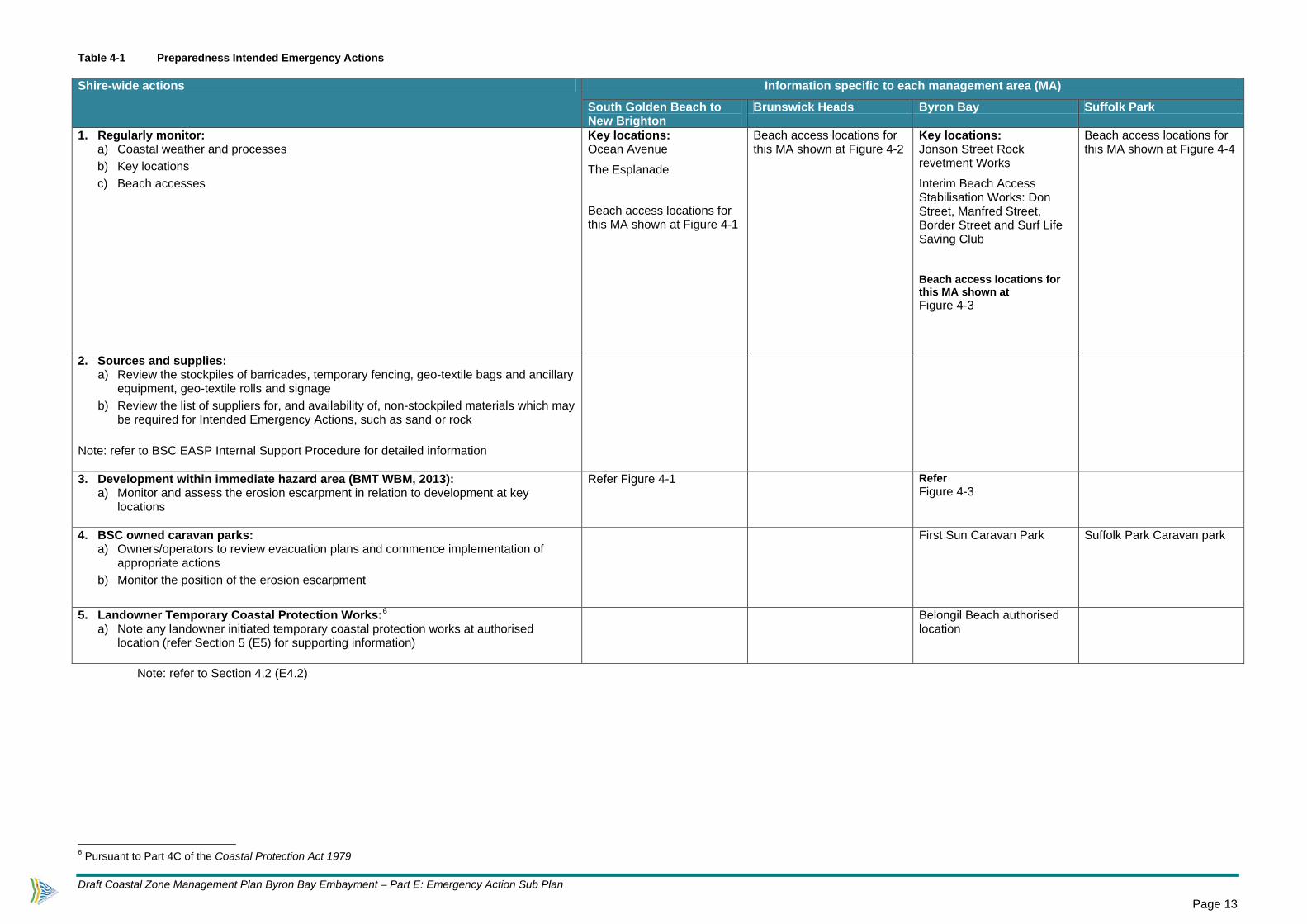
Table 4-1 Preparedness Intended Emergency Actions Shire-wide actions Information specific to each management area (MA)
South Golden Beach to New Brighton
Brunswick Heads Byron Bay Suffolk Park
1. Regularly monitor: a) Coastal weather and processes b) Key locations c) Beach accesses
Key locations: Ocean Avenue
The Esplanade
Beach access locations for this MA shown at Figure 4-1
Beach access locations for this MA shown at Figure 4-2
Key locations: Jonson Street Rock revetment Works
Interim Beach Access Stabilisation Works: Don Street, Manfred Street, Border Street and Surf Life Saving Club
Beach access locations for this MA shown at Figure 4-3
Beach access locations for this MA shown at Figure 4-4
2. Sources and supplies: a) Review the stockpiles of barricades, temporary fencing, geo-textile bags and ancillary
equipment, geo-textile rolls and signage b) Review the list of suppliers for, and availability of, non-stockpiled materials which may
be required for Intended Emergency Actions, such as sand or rock Note: refer to BSC EASP Internal Support Procedure for detailed information
3. Development within immediate hazard area (BMT WBM, 2013): a) Monitor and assess the erosion escarpment in relation to development at key
locations
Refer Figure 4-1 Refer Figure 4-3
4. BSC owned caravan parks: a) Owners/operators to review evacuation plans and commence implementation of
appropriate actions b) Monitor the position of the erosion escarpment
First Sun Caravan Park Suffolk Park Caravan park
5. Landowner Temporary Coastal Protection Works:6 a) Note any landowner initiated temporary coastal protection works at authorised
location (refer Section 5 (E5) for supporting information)
Belongil Beach authorised location
Note: refer to Section 4.2 (E4.2)
6 Pursuant to Part 4C of the Coastal Protection Act 1979
Draft Coastal Zone Management Plan Byron Bay Embayment – Part E: Emergency Action Sub Plan
Page 13

Table 4-2 Response Intended Emergency Actions Shire-wide actions Information specific to each management area (MA)
South Golden Beach to New Brighton
Brunswick Heads Byron Bay Suffolk Park
1. Beach accesses: a) Monitor and assess b) Where accesses are considered unsafe:
(i) temporarily close and/or (ii) erect appropriate signage
c) where accesses are required to facilitate Intended Emergency Actions or actions under the direction of the Combat Agency, implement necessary temporary access works if required
Beach access locations for this MA shown at Figure 4-1
Beach access locations for this MA shown at Figure 4-2
Beach access locations for this MA shown at Figure 4-3
Beach access locations for this MA shown at Figure 4-4
2. Roads: a) Monitor and assess b) Where roads are considered unsafe:
(i) temporarily close and/or (ii) erect appropriate signage
c) where accesses are required to facilitate Intended Emergency Actions or actions under the direction of the Combat Agency, implement necessary temporary access works if required where appropriate
Key locations: South Golden Beach – Pacific Esplanade
New Brighton Beach – Esplanade Road, Strand Avenue (eastern end), North Head Road (mid-southern section), Ocean Avenue (eastern end)
Key locations: Belongil Beach - Manfred Street, Don Street, Border Street, Childe Street
3. BSC owned caravan parks: a) Liaise with caravan park managers b) Assist with barricading and fencing the caravan park’s beach accesses c) Assist with traffic management d) Authorise closure and opening of caravan parks in coordination with caravan park
managers e) Assist the NSW Police, if requested, in the evacuation of residents as required
First Sun Caravan Park Suffolk Park Caravan Park
4. Services and associated infrastructure: a) If required, ensure all sewerage and water services are safely disconnected b) If required, contact utility service providers to request disconnection of electrical
services to the affected area
5. Jonson St rock revetment works and interim beach access stabilisation works: a) Monitor works and any associated risks with beach erosion b) Restrict public access to mitigate any risks associated with failure/wave
overtopping c) Repair as necessary and if appropriate d) Notify SES/Police if evacuation required as a result of failure/wave overtopping
Jonson Street car park
Interim Beach Access Stabilisation Works: Manfred Street, Don Street, Border Street and Surf Life Saving Club
6. Other BSC assets a) Monitor the integrity of BSC assets at risk and if necessary take appropriate
action to repair assets and/or mitigate any associated risks
High risk assets: Clarkes Beach stormwater outlet
Wategos Beach stormwater outlet
Wategos Beach revetment wall and Marine Parade
Draft Coastal Zone Management Plan Byron Bay Embayment – Part E: Emergency Action Sub Plan
Page 14

Shire-wide actions Information specific to each management area (MA)
South Golden Beach to New Brighton
Brunswick Heads Byron Bay Suffolk Park
7. Temporary access works on public land: a) Implement temporary access works to facilitate Intended Emergency Actions or
actions under the direction of the Combat Agency if required
Key locations: New Brighton Beach
Key locations: Belongil - Manfred Street, Don Street, Border Street
Jonson Street car park
Surf Life Saving Club beach access area
First Sun Caravan Park beach access track
North Beach machinery access (refer supporting information below)
Key locations: Tallow Beach
8. Development within immediate coastal hazard planning precinct on public lands: a) If required, engage a coastal/geotechnical engineer to conduct site inspections b) Initiate assessment of risk of collapse of structures c) If collapse likely, liaise with NSW Police or SES to initiate evacuation procedures,
provide assistance as required noting that BSC does not have the authority to mandate evacuation (refer State Emergency and Rescue Management Act, 1989)
d) Mitigate risks to public safety e.g. erect barricades and warning signs e) Disseminate available information to members of the public as required
Key locations: New Brighton Beach
Key locations: First Sun Caravan Park
Key locations: Suffolk Park Caravan Park
9. Development within immediate coastal hazard planning precinct on private lands: a) Encourage landowners to engage a coastal/geotechnical engineer to assess risk
of collapse of structures b) Mitigate risks to public safety e.g. erect barricades and warning signs c) Disseminate relevant information to affected private landowners
Key locations: New Brighton Beach
Key locations: Belongil
Note: refer to Section 4.2 (E4.2)
Supporting Information:
7. Temporary access works on public land Certain temporary access works may be required before, during or after storm events on Council owned or controlled or occupied land (this may include Crown Land with appropriate permissions). Temporary access works may include placing sand filled geotextile bags or erecting temporary barriers. Emergency vehicle access may need to be maintained using machinery to regrade the dune and by laying a gravel base to provide a firm vehicle base for access through the dune. These works are not expected to become permanent and generally should be removed as soon as possible. North Beach machinery access Machinery access to the beach can also be gained at North Beach (Lots 11 and 12 DP 243218, Bayshore Drive). There is a public covenant on this land that allows Council to use this access. Note: Belongil Estuary is opened by BSC when the intervention level of 1.0m at the Belongil Bridge (Ewingsdale Road) is reached and it is deemed safe to do so, to alleviate the potential for flooding on Byron township and surrounds.
Draft Coastal Zone Management Plan Byron Bay Embayment – Part E: Emergency Action Sub Plan
Page 15

Table 4-3 Recovery Intended Emergency Actions Shire-wide actions Information specific to each management area (MA)
South Golden Beach to New Brighton
Brunswick Heads Byron Bay Suffolk Park
1. Beach debris a) Assess beach debris priority and initiate clearing
2. Beach access a) Repair and rebuild beach access points in accordance with the Coastal Dune
Management: A manual of Coastal Dune Management and Rehabilitation Techniques (Department of Land and Water Conservation, 2001) and the estimated medium-term beach alignment (it is not recommended to have the geo-bag structures protrude substantially onto the active beach - obtain specialist technical advice where appropriate)
b) Reopening of beach accesses is not to occur until safe to do so c) Geotextile bags may need to be installed at key locations after the event to ensure
public safety and access on and off the beach
Key locations: Fern Beach
South Golden Beach
New Brighton Beach
Key locations: South Beach
Torakina Beach
Key locations: Belongil Beach Main Beach Surf Life Saving Club
Main Beach/Clarkes Beach
Key locations: Tallow Beach
3. Roads a) Assess roads b) Reopening of roads is not to occur until safe to do so c) Initiate reestablishment or relocation where appropriate
4. BSC owned caravan parks a) Assess infrastructure and services b) Reopening of caravan parks not to occur until safe to do so c) Initiate reestablishment or relocation where appropriate
First Sun Caravan Park Suffolk Park Caravan Park
5. Services and associated infrastructure a) Assess infrastructure and services b) Reopening of services and associated infrastructure not to occur until safe to do so c) Initiate reestablishment or relocation where appropriate
6. Jonson St rock revetment works and interim beach access stabilisation works: a) Assess b) Repair as necessary
7. Other BSC assets a) Assess b) Repair as necessary
8. Temporary access works on public land: a) Continue temporary safety fencing and associated warning signage as necessary b) Where and when appropriate, remove any temporary works, restore beach or land
9. Sources and Supplies a) Replenish any emergency materials and supplies stockpiles
10. Data Collection a) Collect data on beach profile to inform this EASP.
Note: refer to Section 4.2 (E4.2)
Draft Coastal Zone Management Plan Byron Bay Embayment – Part E: Emergency Action Sub Plan
Page 16

Table 4-4 Communication Intended Emergency Actions
Phase Intended Emergency Actions
Preparedness
1. Liaise with the SES and other emergency services to avoid confusion, duplication of messages and ensure consistency, noting that during a DISPLAN event, the role of the SES includes:
• advising the community at risk of the problem and actions they should take • protection of life through the warning and evacuation of residents at risk
2. Provide information to the community, including community groups, visitors and tourists, on:
• risks associated with beach erosion
• conditions that could bring about an Emergency
• the contents of this EASP
Response
1. Liaise with the SES and other emergency services to avoid confusion, duplication of messages and ensure consistency, noting that during a DISPLAN event, the role of the SES includes:
• advising the community at risk of the problem and actions they should take • protection of life through the warning and evacuation of residents at risk
2. Release information to the community, including community groups, visitors and tourists, regarding:
a) nature and extent of the Emergency
b) BSC’s Intended Emergency Actions and likely impacts e.g. closure/loss of beach access
c) risks associated with the Emergency e.g. collapse of sand dunes, wave overtopping
d) ways to minimise risk to personal and public safety e.g. avoid the hazard areas, heed safety warnings
3. Erect appropriate signage, including where temporary access works, barricades and fencing are in place
Recovery 1. Liaise with emergency services to avoid confusion, duplication of messages and ensure consistency
2. Debrief the community on outcomes and actions to be undertaken
Note: refer to Section 4.2 (E4.2)
Supporting Information:
Media The specific media to be used in implementing the communication strategy have not been detailed in Table 4-4 Communication Intended Emergency Actions, however it is envisaged that the following media/outlets will be utilised, depending on their suitability at the time: BSC’s website Local radio Local newspapers Signage Hard copy fact sheets/brochures Community group contacts
Consultation In addition before, during or after an Emergency, Council may need to communicate with various State Government agencies or particular community groups to seek necessary agreements or approvals and exchange information regarding implementing policies and plans for managing impacts from emergencies.
Draft Coastal Zone Management Plan Byron Bay Embayment – Part E: Emergency Action Sub Plan
Page 17

Figure 4-1 South Golden Beach – New Brighton, immediate hazard area includes 11m allowance for the zone of reduced foundation capacity
(2015 aerial photography).
Draft Coastal Zone Management Plan Byron Bay Embayment – Part E: Emergency Action Sub Plan
Page 18

Figure 4-2 Brunswick Heads, immediate hazard area includes 11m allowance for the zone of reduced foundation capacity (2015 aerial
photography).
Draft Coastal Zone Management Plan Byron Bay Embayment – Part E: Emergency Action Sub Plan
Page 19

Figure 4-3 Byron Bay Embayment, immediate hazard area includes 11m allowance for the zone of reduced foundation capacity (2015 aerial photography).
Draft Coastal Zone Management Plan Byron Bay Embayment – Part E: Emergency Action Sub Plan
Page 20

Figure 4-4 Suffolk Park, immediate hazard area includes 11m allowance for the zone of reduced foundation capacity (2015 aerial photography).
Draft Coastal Zone Management Plan Byron Bay Embayment – Part E: Emergency Action Sub Plan
Page 21

E5 Landowner Temporary Coastal Protection Works
Belongil Beach has been identified as an authorised location for the placement of landowner initiated Temporary Coastal Protection Works pursuant to Section 4C of the CP Act. Landowners in this location need to be proactive prior to an emergency occurring and consult the CP Act and other relevant documents for the requirements and the process involved for placing Temporary Coastal Protection Works. Childe Street, Manfred Street and Don Street are authorised beach access locations for the purpose of placing Temporary Coastal Protection Works. An extract of the relevant schedule in the Code of Practice under the Coastal Protection Act 1979 is at Table 5-1. Table 5-1 Extract of schedule showing authorised locations for placing works and associated
access (Code of Practice under the Coastal Protection Act 1979) Authorised locations for placing works Authorised beach access
Belongil Beach, Byron Bay Childe Street; Manfred Street; Don Street
The CP Act and the Code of Practice under the Coastal Protection Act 1979 detail the statutory requirements for obtaining a certificate to place Temporary Coastal Protection Works and for installing, maintaining and removing these works. The Office of Environment and Heritage has also developed the Guide to the Statutory Requirements for Temporary Coastal Protection Works, which provides further information for landowners. These documents can be accessed at:
• www.austlii.edu.au (Coastal Protection Act 1979) • www.environment.nsw.gov.au (Code of Practice Coastal Protection Act 1979) • www.environment.nsw.gov.au (Guide to the Statutory Requirements for Temporary Coastal
Protection Works) • In addition, the Office of Environment and Heritage website has a webpage dedicated to
Temporary Coastal Protection Works: www.environment.nsw.gov.au
E5.1 Additional requirements for placing, maintaining and removing Temporary Coastal Protection Works
Additional requirements for placing, maintaining and removing Temporary Coastal Protection Works are as follows:
• Cumbebin Swamp Nature Reserve is not to be disturbed • Shorebird and turtle nesting sites are not to be disturbed • Aboriginal cultural heritage sites are not to be disturbed
Draft Coastal Zone Management Plan Byron Bay Embayment – Part E: Emergency Action Sub Plan
Page 22

E6 Aboriginal Cultural Heritage considerations It is acknowledged that Byron Shire contains a wealth of Aboriginal cultural sites; these include middens, stone arrangements, rock shelters and tool-making sites. Several of these sites, notably middens, are located in the Shire’s beach and dune systems.
Protection and preservation of culturally significant areas is very important to the Bundjalung of Byron Bay and the wider Bundjalung people with some aspects of Aboriginal cultural heritage protected in New South Wales, under the National Parks and Wildlife Act 1974 (NPW Act). Disturbance of Aboriginal cultural heritage should be avoided when implementing any of the Intended Emergency Actions in Section 4 (E4) and the correct protocols and processes observed if works or beach erosion reveals Aboriginal cultural heritage. Further information is provided in the Due Diligence Code of Practice for the Protection of Aboriginal Objects in New South Wales, at: www.environment.nsw.gov.au
E7 EASP Implementation and Review This EASP applies from the date of gazettal. The EASP will be reviewed at least annually or following each Emergency.
Draft Coastal Zone Management Plan Byron Bay Embayment – Part E: Emergency Action Sub Plan
Page 23

Appendix 1 Byron Shire Local Flood Plan, Annexure Q (BSC #DM1146249)

Byron Shire Local Flood Plan, February 2006. A Sub-Plan of the Byron Shire Local Disaster Plan
Q-1
ANNEX Q - EMERGENCY MANAGEMENT OF COASTAL
EROSION/ OCEANIC INUNDATION
Background The Byron Shire Council area is bordered by the Pacific Ocean to the east. There are three main types of beach units within the Shire boundaries: compartmentalised, sheltered, and exposed. The coastal areas are subject to natural coastal processes and resultant coastline hazards that include coastal erosion, oceanic inundation, and shoreline recession. The major coastline hazards occur from Broken Head in the south to South Golden Beach in the North.
1. The coastal erosion/oceanic inundation problem in the Byron Shire takes two forms:
a. Undercutting of dunes on their seaward sides, threatening the collapse of dwellings and other infrastructure (Belongil Spit and New Brighton Beach).
b. The potential breaking through of the dunes by sea water, causing flooding and isolation of property on the landward side of the dunes (Belongil Spit, South Golden Beach, New Brighton Beach, Main Beach).
2. The most severe problems of coastal erosion/inundation occur as a result of oceanic storm conditions associated with the passage of ex-tropical cyclones and temperate-zone low-pressure systems. These storms may cause temporary sea level rises with large associated waves. The worst erosion/inundation is likely when severe weather conditions occur in conjunction with high tides.
3. The main beach units within the Byron Shire Council area are: Tallow Beach Unit, Cape Byron to The Pass Unit, The Pass to Belongil Creek Unit, Belongil Creek to Brunswick River, and North of the Brunswick River including Crabbes Creek Beach.
AREAS AT RISK
Tallow Beach and Broken Head
4. In this beach unit an undeveloped buffer zone exists seaward of infrastructure and development that can accommodate short term coastal erosion impacts. The Byron Shire Coastline Hazard Definition Study (WBM Oceanics, 2000) estimates shoreline recession for this unit at 0.1 m per year with 0.3m per year in the southern hook at Broken Head. If this recession is realised then sections of Suffolk Park community may come under coastal erosion threat in 50-100 years.

Byron Shire Local Flood Plan, February 2006. A Sub-Plan of the Byron Shire Local Disaster Plan
Q-2
Image 1, Tallow Creek-Broken Head Coastline
Broken Head

Byron Shire Local Flood Plan, February 2006. A Sub-Plan of the Byron Shire Local Disaster Plan
Q-3
Table 13, Streets affected by coastal erosion.
Road Name Town Coastal Area Manfred Street Belongil Spit The Pass to Belongil Creek Don Street Belongil Spit The Pass to Belongil CreekBorder Street Belongil Spit The Pass to Belongil Creek North Head Road New Brighton North of Brunswick River The Esplanade New Brighton North of Brunswick RiverStrand Avenue New Brighton North of Brunswick RiverRiver Street New Brighton North of Brunswick River Pacific Esplanade South Golden Beach North of Brunswick River
Cape Byron to The Pass
5. This beach unit is protected from severe coastal erosion by Cape Byron. At Wategoes Beach a seawall constructed along Marine Parade limits shoreline recession.
The Pass to Belongil Creek (Spit)
6. This area has over the years experienced significant fluctuations in the shoreline. The area between The Pass and the Memorial Pool has become more stable since the construction of rock protection works at the northern end of Jonson Street in the 1960s. North of the Memorial Pool to Belongil Creek is the area of highest risk in the Shire because of its location in the southern hook of the embayment and the associated shoreline recession that is occurring there.
7. Storms in 1999 caused severe erosion, especially along Belongil Spit. Several houses were threatened with collapse and the dune system was nearly breached at Manfred Street.
8. Although protection measures are in place along Belongil Spit there is significant development and infrastructure at immediate threat from coastal erosion should these measures fail. Development and infrastructure at threat includes dwellings (approximately 15), the First Sun Holiday Park and the Byron Bay Surf Life Saving Club. The northern bend of Border Street may also be cut by coastal erosion which could cause access problems to Belongil Spit.
9. Storm activity is sometimes accompanied by heavy rain causing flooding on the creeks behind the sand dunes (for example Marshalls Creek and Belongil Creek). This flooding can be exacerbated by an elevated sea level preventing the escape of floodwaters to the sea. Flooding in Belongil Creek combined with oceanic inundation could restrict access to properties north of Manfred Street.
10. Evidence exists of the sea breaking through the dunes at Jonson St, Byron Bay, in 1954. This caused flooding on the leeward side of the dunes. Waves also broke over the dunes and caused flooding in the CBD.

Byron Shire Local Flood Plan, February 2006. A Sub-Plan of the Byron Shire Local Disaster Plan
Q-4
Image 2, Cape Byron -Belongil Spit coastline under threat from coastal erosion/inundation
Belongil Creek (Spit) to Brunswick River
11. The coastline from Belongil Creek to Brunswick River is relatively undeveloped, apart from a low density resort and golf course immediately north of the Belongil Creek entrance. The Tyagarah Nature Reserve occupies a large section of this coastal area.
12. When the Belongil Creek entrance channel migrates north sections of the resort and golf course come under threat.
13. Construction of the Brunswick River training walls has resulted in accretion of Brunswick South Beach at Brunswick Heads.

Byron Shire Local Flood Plan, February 2006. A Sub-Plan of the Byron Shire Local Disaster Plan
Q-5
Image 3, Belongil Spit-Brunswick Heads
North of the Brunswick River (including Crabbes Beach)
14. Storms from 1967-1974 combined with the Brunswick River training walls caused significant erosion in this area. Sheltering Palms (also known as North Beach), located north of the Brunswick River, was lost to the sea in 1974 and subsequently abandoned.
15. New Brighton has experienced historical shoreline recession and was under threat during the storms between 1967-74. However, in recent years, the re-establishment of the sand transport system around the Brunswick River entrance has seen a period of shoreline stability. This has been aided by dune stabilisation works in the area.
16. At South Golden Beach extensive sand mining and urban development of the area caused damage to the frontal dunes and a reduction in the buffering capacity of the dunes to large storm events. Dune care works have since enhanced the capacity of the dunes to accommodate erosion.
17. Some of the easternmost roads at New Brighton and South Golden Beach are within the immediate hazard zone of coastal erosion. There is an identified oceanic inundation threat in an area of low dunes north of New Brighton village and at South Golden Beach. There is also a potential for breakthrough of Marshalls Creek south of New Brighton.

Byron Shire Local Flood Plan, February 2006. A Sub-Plan of the Byron Shire Local Disaster Plan
Q-6
Image 4, North of Brunswick Heads coastline under threat from coastal erosion/inundation
CONCEPT OF OPERATIONS
18. Control. The SES is the designated combat agency for damage control from storms, including coastal erosion from storm activity.
19. The Coastal Erosion Annex details all of the arrangements for the emergency management of coastal erosion.
20. Within this role and as specified under the State Storm Plan the SES is responsible for the following during and in the period immediately prior to a storm event occurring out at sea:
a. Advising the community at risk of the likely problem and actions they should take;
b. The protection of life through the warning and evacuation of residents at risk; and
c. The coordination of the lifting and/or relocation of readily movable household items and commercial stock and equipment.
21. The role of the SES as the combat agency for storms does not include coastal erosion and inundation caused by astronomical high tides when severe weather is not actually developing or occurring.

Byron Shire Local Flood Plan, February 2006. A Sub-Plan of the Byron Shire Local Disaster Plan
Q-7
22. DNR will provide ongoing advice to local councils and coastal zone management committees on the formulation and implementation of coastal zone management plans including procedures for addressing coastal processes, coastline hazards and risks, management options and coastal policies.
23. BoM will provide Severe Weather Warnings as a product to assist the SES in determining triggers for action.
RESPONSIBILITIES
Before the Storm
24. The SES will:
a. Conduct educational activities to ensure that people in locations potentially threatened by coastal erosion and associated flooding can understand the threat and its management.
b. Consult with councils, coastal zone management committees, DNR, and other agencies during the development of emergency management arrangements for the management of coastal erosion.
c. Work with BoM to keep updated on developments in severe weather science and warning.
25. BoM will:
a. Formulate and issue official forecasts and Severe Weather Warnings and provide them to the SES, radio stations and other organisations prior to and during potential and actual coastal erosion events. (Note: Severe Weather Warnings for dangerous surf are issued when onshore waves in the surf zone are expected to reach at least 5 metres within the following 24 hours or when a storm surge of 0.5 metres or greater is anticipated).
26. DNR will:
a. Develop and advise on state wide coastal policy, planning and management.
b. Provide ongoing advice to local councils and Coastal Zone Management Committees on coast and estuary management including procedures for addressing coastal hazards, coastal processes and risks, management options and coastal policies.
c. Provide the SES and councils with advice on likely erosion ‘hotspots’ along the New South Wales coastline.
27. Byron Shire Council will:

Byron Shire Local Flood Plan, February 2006. A Sub-Plan of the Byron Shire Local Disaster Plan
Q-8
a. Carry out ecologically sustainable planning and management of the coastal zone.
b. Prepare Coastal Zone Management Plans in accordance with the Coastal Protection Act, 1979 including arrangements for the emergency management of coastal erosion.
c. Consult with the communities at risk, Coastal Zone Management Committees, DNR and other agencies during the development of emergency management arrangements for the management of coastal erosion for inclusion in council Coastal Zone Management Plans and SES Local Flood Plans.
d. Establish and maintain Coastal Zone Management Committees to facilitate the development of the Coastal Zone Management Plans and ensure that key agencies are represented on such committees.
e. Participate in education campaigns and assist the SES in the development and delivery of educational material to ensure that people in areas potentially threatened by coastal erosion understand the threat and its management.
28. Other supporting agencies responsibilities are listed in section 1.5, and in Byron Shire DISPLAN.
During the Storm
29. Response operations will be initiated when:
a. The BoM issues a severe weather warning for dangerous waves or storm surge (forecast on-shore waves of 5 metres or more, or storm surge of 0.5 metres or more) for the NSW north coast.
b. Response operations may also be initiated by the SES when large storm induced waves are observed locally and no BoM warning has been issued.
30. The SES will:
a. Advise local council and other emergency agencies of the likelihood of coastal erosion in the council area.
b. Coordinate the conduct of regular reconnaissance at locations identified as being susceptible to coastal erosion.
c. Coordinate the provision of advice to the community at risk regarding the likely problem and the actions they should take. These actions may include evacuation and/or removal of portable property from households and businesses.
d. Coordinate the evacuation of people at risk.

Byron Shire Local Flood Plan, February 2006. A Sub-Plan of the Byron Shire Local Disaster Plan
Q-9
e. Coordinate transport of removal household possessions and stock, records and equipment from business premises (if time and resources permit).
f. Provide a phone in service for the local community to take requests for assistance and give advice as necessary.
31. The SES is not responsible for controlling or conducting any physical mitigation works to protect properties or structures at risk from coastal erosion/inundation, either during or outside the period of storm activity. This includes, but is not limited to:
a. The placement of rocks or other materials on beaches or foreshore areas
b. The construction of temporary walls made of sandbags, geotechnical tubes, or other material.
32. Byron Shire Council will:
a. Conduct reconnaissance at coastal erosion trouble spots in consultation with the SES.
b. Liaise with the SES Local Controller to determine the need for any response actions by the SES such as evacuation of residents at risk and any support that may be required to carry out these measures as detailed in the Local Flood Plan.
c. Enact any relevant provisions as detailed in the relevant Coastal Emergency Action Plan.
33. DNR will provide advice and approval to councils regarding the most appropriate methods of dealing with coastal erosion and placement of temporary mitigation measures during storm events, via the Engineering Services Functional Area Coordinator (ESFAC).
34. BoM will formulate and issue official forecasts and Severe Weather Warnings and provide them to the SES, radio stations and other organisations prior to and during potential and actual coastal erosion events.
35. Other supporting agencies responsibilities are listed in section 1.5, and in Byron Shire DISPLAN.
After the Storm
36. The SES will:
a. Assign personnel to gather intelligence in areas susceptible to coastal erosion/inundation.
b. Review and update the arrangements for managing coastal erosion/inundation.

Byron Shire Local Flood Plan, February 2006. A Sub-Plan of the Byron Shire Local Disaster Plan
Q-10
c. Liaise with DNR to obtain information on the impact of storm events on coastal properties, once the storm has abated.
d. Liaise with DoCs regarding the return of evacuees.
37. Byron Shire Council will:
a. Liaise with DNR to determine any changes to the coastal zone and any new areas at risk following storms at sea.
b. Maintain and review council Coastal Zone Management Plans in consultation with other stakeholders.
c. Review and update changes to the emergency action plan for coastal erosion in the Coastal Zone Management Plan.
38. DNR will provide the SES and council with updates on the current state of the coastal zone and any new areas at risk following a storm event.
39. A summary of agencies responsibilities and support agencies for coastal erosion are listed in Table 14.

Byr
on S
hire
Loc
al F
lood
Pla
n, F
ebru
ary
2006
. A
Sub
-Pla
n of
the
Byr
on S
hire
Loc
al D
isas
ter
Plan
Q-1
1
Tab
le 1
4, R
espo
nsib
iliti
es E
mer
genc
y M
itig
atio
n of
Coa
stal
Ero
sion
Act
ion
A
gen
cy R
esp
on
sib
le
Su
pp
ort
1.
Bef
ore
th
e S
torm
1.1
Mon
itor
mai
nten
ance
and
str
uctu
ral i
nteg
rity
of in
terim
mea
sure
s fo
llow
ing
impl
emen
tatio
n as
sta
ted
in th
e E
AP
B
yron
Shi
re C
ounc
il (B
SC
) D
NR
1.2
Mon
itor
pote
ntia
l coa
stal
sto
rms
B
urea
u of
Met
eoro
log
y S
ES
, DN
R,
BS
C
2. D
uri
ng
th
e S
torm
2.
1 Is
sue
Sev
ere
Wea
ther
War
ning
s B
oM
2.2
Con
duct
rec
onna
issa
nce
of a
t ris
k ar
eas
SE
S
Oth
er
Em
erge
ncy
Ser
vice
s, B
SC
2.3
Mon
itor
eros
ion
at d
une
esca
rpm
ent a
t Bor
der
Str
eet b
end
on B
elon
gil S
pit.
Re-
alig
n an
d re
form
roa
d so
uthw
ards
if
nece
ssar
y fo
r ev
acua
tion
BS
C
2.
4 C
ontr
ol E
vacu
atio
ns
SE
S
2.5
Con
duct
Eva
cuat
ions
S
ES
Oth
er
Em
erge
ncy
Ser
vice
s
2.6
Coo
rdin
ate
rem
oval
of e
vacu
ated
peo
ples
bel
ongi
ngs
to s
afet
y
SE
S
Oth
er
Em
erge
ncy
Ser
vice
s 2.
7 C
oord
inat
e w
elfa
re fo
r do
mes
tic p
ets
and
com
pani
on a
nim
als
from
eva
cuat
ed a
reas
. D
PI
2.
8 R
egis
ter
Eva
cuat
ed P
eopl
e P
olic
e
2.9
Pro
vide
wel
fare
sup
port
to e
vacu
ated
peo
ple
DoC
S
2.
10 M
anag
e tr
affic
and
con
trol
eva
cuat
ion
rout
es
Pol
ice
2.
11 P
rovi
de s
ecur
ity to
eva
cuat
ed a
reas
P
olic
e
2.12
Res
uppl
y A
rea
isol
ated
by
coas
tal s
torm
s/flo
ods
SE
S
RF
S
3.
Rec
ove
ry A
fter
th
e S
torm
3.
1 A
sses
s da
mag
e to
pro
pert
y, r
oads
, coa
stal
pro
tect
ion
wor
ks
BS
C

Byr
on S
hire
Loc
al F
lood
Pla
n, F
ebru
ary
2006
. A
Sub
-Pla
n of
the
Byr
on S
hire
Loc
al D
isas
ter
Plan
Q-1
2
Act
ion
A
gen
cy R
esp
on
sib
le
Su
pp
ort
3.
2 E
stab
lish
Rec
over
y C
omm
ittee
s as
req
uire
d LE
OC
ON
3.3
Co-
ordi
nate
ret
urn
of e
vacu
ated
peo
ple
Rec
over
y C
oord
inat
ion
C
omm
ittee
3.4
Ass
ess
hous
es in
imm
inen
t dan
ger
of c
olla
pse
beca
use
of p
roxi
mity
to e
rode
d du
ne e
scar
pmen
t B
SC
, SE
S
3.5
Ret
urn
mov
eabl
e dw
ellin
gs b
ack
on-s
ite fr
om th
e ho
ldin
g lo
catio
ns
Res
iden
ts
3.
6 R
emov
e ex
pose
d ha
zard
mat
eria
l fro
m b
each
(e.
g. c
ar b
odie
s)
BS
C
3.
7 E
rect
rel
evan
t saf
ety
war
ning
sig
ns w
here
uns
tabl
e du
ne e
scar
pmen
ts p
rese
nt a
pub
lic s
afet
y ha
zard
. In
high
use
ar
eas
(e.g
. Byr
on M
ain
Bea
ch)
the
eros
ion
esca
rpm
ent m
ay b
e co
llaps
ed to
a m
ore
stab
le s
lope
by
mac
hine
ry
BS
C
3.
8 R
epai
r an
d re
-est
ablis
h in
terim
mea
sure
s at
Mai
n an
d B
elon
gil B
each
es
BS
C
3.9
Re-
inst
ate
dam
aged
bea
ch a
cces
s B
SC

Appendix 2 Summary Management Options Analysis Table 1 Summary Management Options Analysis Council’s Management Option
Council’s Management Option Examples1
Affordability Criteria
Feasibility Criteria Reasonableness Criteria Evaluation Outcome
Framework of consideration
The scale of the management option proposed should be consistent with the amount of funding likely to be available over the CZMP’s implementation period2. Where the construction of coastal protection works are proposed, this criteria should also consider the adequate maintenance of these works, and the management of any associated impacts3.
Is the management option technically and physically possible to safely implement and maintain?2
Is the management option reasonable2 with reference to: - coastal management principles4 (CMPs) - social impacts - environmental impacts - economic impacts - cultural values - the views of the community/stakeholders (P1 = Coastal Management Principle 1, P2 = Coastal Management Principle 2 etc)
1) Avoid risks to public health and safety
(a) communication strategy (b) temporarily close beach access, roads, disconnect services (b) temporary access works on public land to facilitate emergency responses (c) mitigate risks to public safety e.g. barricades, signage
Consistent with the amount of funding available
Likely to be technically feasible Reasonable - accords with CMPs (P5 and P6) - may have temporary social impacts - has minimal environmental impact - minimal economic impact - accords with cultural values - accords with the views of the majority of stakeholders (based on 2011 consultation for then draft EASP)
Include applicable Intended Emergency Actions in EASP
2) Maintain Council’s current level of coastal protection
(a) Monitor and repair Jonson Street works (b) Monitor and repair interim beach access stabilisation works
Consistent with the amount of funding available
May be physically and technically feasible within the context of an emergency
Reasonable - accords with CMPs (P5, P6, P10) - provides social and economic benefit to Byron Bay CBD, net public benefit - no new impact on cultural values
Include applicable Intended Emergency Actions in EASP
3) Increase the level of protection afforded by existing Council protection works
(a) Increase the level of protection afforded by the Jonson St rock revetment works (b) Increase the level of protection afforded by Council’s interim beach access stabilisation works
Inconsistent with the amount of funding available, especially as an emergency measure
Unlikely to be feasible within the context of an emergency (long term measures outside the scope of an EASP)
- may accord with CMPs (P5, P6) - may minimise social and economic costs in short term by providing additional protection - may have environmental costs - may impact on cultural values
Do not include applicable Intended Emergency Actions in EASP
4) Provide additional/new coastal protection works on public land
(a) The Esplanade (b) South Golden beach Community Centre (c) Belongil Beach public lots (d) Beach nourishment or beach scraping at New Brighton (e) To protect Council assets e.g. major access roads
Inconsistent with the amount of funding available, especially as an emergency measure
Unlikely to be feasible within the context of an emergency situation (long term measures outside the scope of an EASP)
- may accord with CMP - P6 - may impact on cultural values - accords with the views of the majority of stakeholders (based on 2011 consultation for then draft EASP, regarding non BBE coastline)
Do not include applicable Intended Emergency Actions in EASP
5) Provide protection works on private land
(a) Repair private protection works (b) Shore-up/increase the level of protection afforded by the private coastal protection works (c) Provide protection to areas not currently protected
Inconsistent with the amount of funding available, especially as an emergency measure
Unlikely to be feasible within the context of an emergency situation (long term measures outside the scope of an EASP)
- may accord with CMP - P6 - may not accord with cultural values
Do not include applicable Intended Emergency Actions in EASP
1 Derived in-house, through the preliminary consultation phase and through the public submission phase (2011) 2 Guidelines, Section 2.2.3 3 Refer Section 55C(1)(g) of the Coastal Protection Act 1979 and Section 3.2.2 of the Guidelines for Preparing Coastal Zone Management Plans (OEH, 2013) 4 Refer Figure 2 in Guidelines for Preparing Coastal Zone Management Plans (OEH, 2013) - note, the CMPs are also detailed at Figure 1-2 (EASP)