AASHTO, 2001. - Alaska DOT&PFdot.alaska.gov/nreg/KivalinaEvacRd/files/kivevac-dsr.pdf · AASHTO...
60
Transcript of AASHTO, 2001. - Alaska DOT&PFdot.alaska.gov/nreg/KivalinaEvacRd/files/kivevac-dsr.pdf · AASHTO...

Kivalina Evacuation & School Site Access Road 2 July 9, 2018 0002384/NFHWY00162
influenced channel that parallels Kivalina Barrier Island to the east. Overflow pipes, situated above mean high tide level, will provide conveyance during high water events. See the attached Project Overview Map. Design Standards Design standards and guidelines which apply to the Kivalina Evacuation and School Site Access Road are contained in the following publications:
Guidelines for Geometric Design of Very Low-Volume Local Roads (GDVLVLR). AASHTO, 2001.
A Policy on Geometric Design of Highways and Streets (PGDHS or “Green Book”). American Association of State Highway and Transportation Officials (AASHTO), 2011.
Alaska Highway Preconstruction Manual (HPCM). State of Alaska Department of Transportation and Public Facilities.
AASHTO LRFD Bridge Design Specifications, Sixth Edition. AASHTO, 2012.
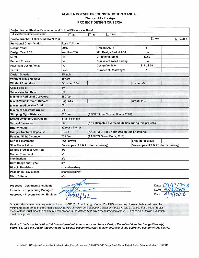
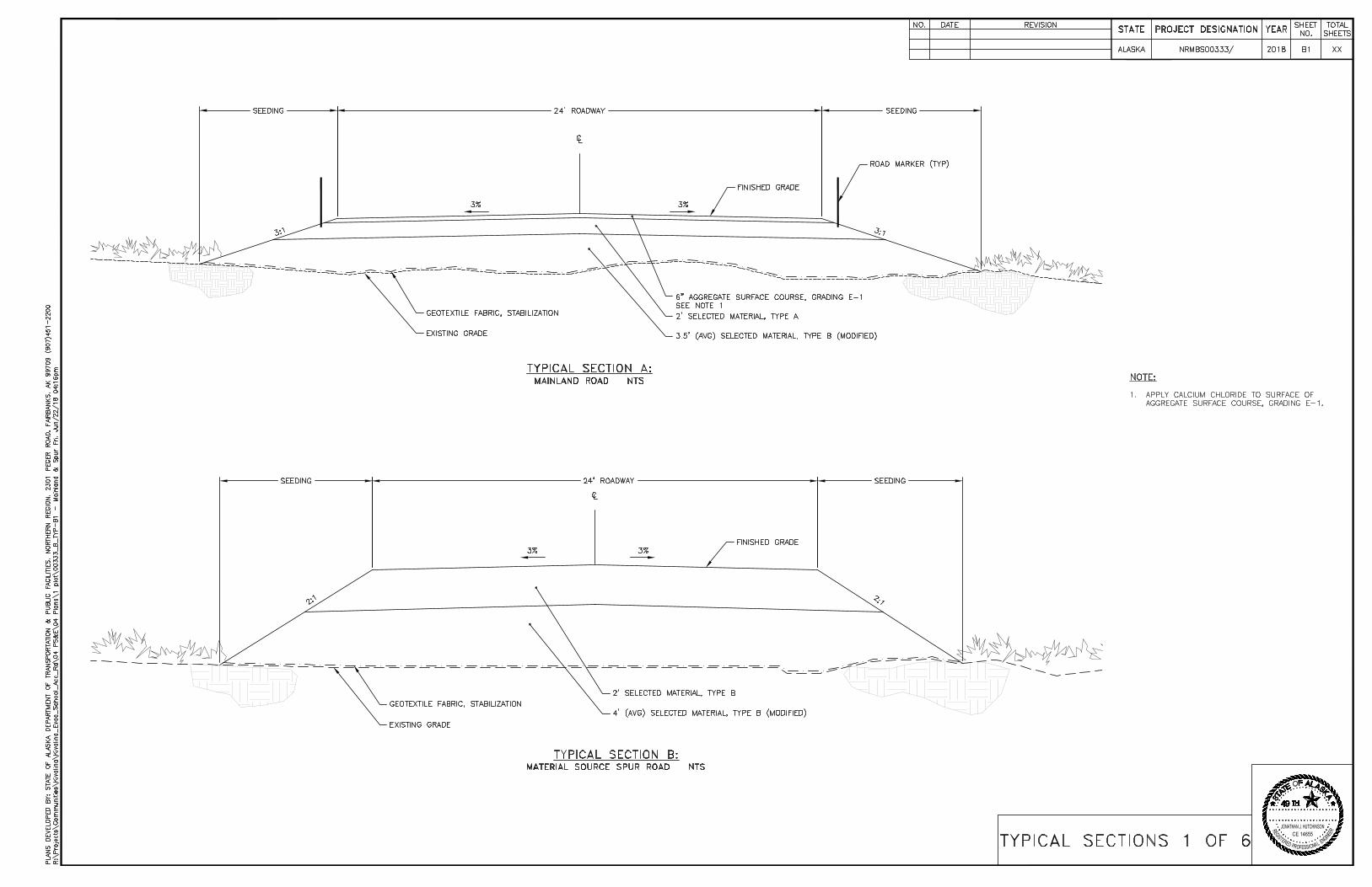
A design speed of 45 miles per hour was selected for this road. The terrain allows curvatures to meet this design speed and there are no limiting factors requiring a reduced speed. The project will not require the information from the Design Designation process and will be designed to the approved design criteria. The Design Criteria worksheet is attached. Design Exceptions and Design Waivers A waiver of the Highway Preconstruction Manual requirement for a Design Designation (HPM 1100.4.1) has been approved. There are no additional design exceptions or waivers for this project. The Design Designation Waiver is attached. Design Alternatives Multiple design alternatives were considered for various components of the project design, including the causeway, mainland road, and bridge. Mainland Road: Design alternatives considered for the mainland roadway included 2:1 and 3:1 embankment side slopes. Embankment side slopes of 3:1 are traversable for vehicles leaving the traveled way, and therefore enhance driver safety. Shallower side slopes also provide increased thermal stability at the embankment toe and thereby reduce settlement at the roadway shoulders. Embankment side slopes of 2:1 were considered in order to minimize the roadway footprint, embankment fill and associated cost, however 3:1 side slopes are preferred due to the advantages of increased driver safety and embankment stability. Different roadway embankment thicknesses were also considered. A 6 foot thick embankment would minimize thermal degradation of the underlying permafrost and mitigate the effects of snow drifting, while a thinner, 4’ thick embankment incorporating insulation board in the embankment would maintain thermal stability while minimizing borrow needs. A thicker, 6 foot minimum embankment thickness is preferred over a thinner embankment for its added ability to mitigate the effects of snow drifting.
Kivalina Evacuation & School Site Access Road 3 July 9, 2018 0002384/NFHWY00162
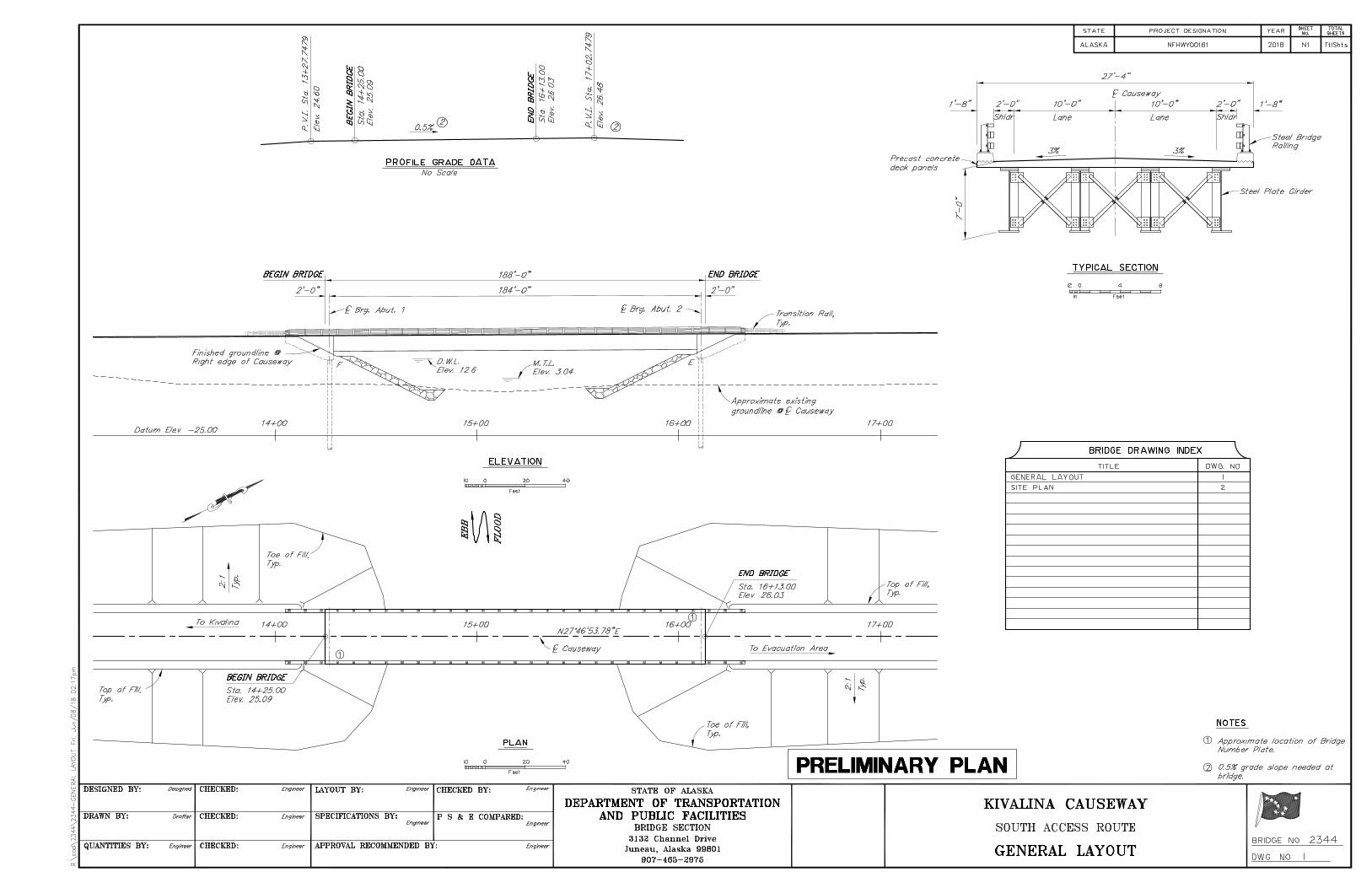
Bridge: Three bridge alternatives were proposed. Option 1 proposed a 188 foot single-span steel girder bridge, Option 2 proposed a 190 foot two-span steel girder bridge, and Option 3 proposed a 190 foot two-span concrete girder bridge. Option 3 would require large equipment to transport and erect the heavy concrete superstructure. Shallow barge draft limitations in Kivalina render Option 3 infeasible or impractical. Options 2 and 3 would both require a center pier and associated in-water supports during construction. During agency scoping and coordination, in-water piers were not favored by National Marine Fisheries Service (NMFS) due to their potential to impact seals both temporarily during construction as well as through the life of the structure. In-water piers would also be subject to scour during storm surge events. The single-span steel girder option proposed in Option 1 would not require a center pier, and was therefore preferred by NMFS. The steel girders, while larger than those proposed in Option 3, can be transported and constructed in shorter, lighter segments utilizing smaller equipment capable of being barged into Kivalina. Causeway: Design alternatives considered for the causeway included 1.5:1, 2:1, and 3:1 side slopes. While a steeper side slope of 1.5:1 would effectively reduce the amount of embankment material, armor stone, and associated costs, the long term stability of the armoring required to protect the causeway from riverine and tidal erosion would be negatively affected. A 3:1 side slope would provide increased armor stone stability and allow for a reduction in overall stone thickness, but would require significantly more embankment and armor stone material. A 2:1 side slope in the causeway is preferred to optimize both cost and longevity concerns. Preferred Design Alternative
Mainland Road: The preferred alternative for the mainland road includes 3:1 embankment side slopes, and an average embankment thickness of 6 feet. The 3:1 embankment sideslopes provide enhanced user safety and increased thermal stability, thereby reducing settlement at the roadway shoulders. The average 6 foot thick embankment will effectively minimize thermal degradation of the underlying permafrost and limit the effects of snow drifting.
Bridge: Option 1 is the preferred bridge option and consist of an approximately 188-feet long by 27-feet wide, single-span bridge with steel girders and precast concrete deck members and driving surface. The steel girders can be transported and erected in smaller, lighter segments and with smaller equipment capable of being barged into Kivalina. See attached Preliminary Bridge Plan.
Causeway: The causeway will have two 10 foot lanes with 2 foot shoulders, 3 percent cross-slopes, and 2:1 side-slopes. A 2:1 side slope in the causeway was selected to optimize both cost and longevity concerns.
3R Analysis
N/A
Traffic Analysis
N/A

Kivalina Evacuation & School Site Access Road 4 July 9, 2018 0002384/NFHWY00162
Horizontal/Vertical Alignment
The grades and all the horizontal and vertical curves for the entire project will meet AASHTO design standards for a design speed of 45 mph. The maximum grade on this project will be 7 percent, and the minimum radius of curvature will be 380 feet. See the attached project Design Criteria Worksheet.
Typical Section(s) The following typical sections are used in this project (See attached Typical Section Sheets):
Mainland Road Section – Typical A The Mainland Road typical is the primary typical section used for this project. The mainland road will be constructed to 24 feet wide, consisting of two 10 foot lanes and 2 foot shoulders with a 3% crown along the alignment centerline. Embankment side slopes will be 3:1. Average embankment thickness will be 6 feet, consisting of 6” of Aggregate Surface Course, 2 feet of Selected Material, Type A, underlain by a variable thickness of Selected Material, Type B (Modified). The roadway embankment fill will be underlain by geotextile, separation fabric placed on top of the natural vegetative mat. The natural vegetative mat is to remain undisturbed to the extent practicable. It may be necessary to place fill during frozen conditions, given the terrain is mostly underlain by permafrost and thaw unstable material.
C CAUSEWAY 10 + 00 56 + 50 ‐‐ 4650
G STAGING PAD 56 + 50 61 + 50 ‐‐ 500
C CAUSEWAY 61 + 50 75 + 00 ‐‐ 1350
D CAUSEWAY‐MAINLAND TRANSITION 1 75 + 00 94 + 00 ‐‐ 1900
E CAUSEWAY‐MAINLAND TRANSITION 2 94 + 00 111 + 00 ‐‐ 1700
F ROADWAY TURNOUT 111 + 00 113 + 00 LEFT 200
E CAUSEWAY‐MAINLAND TRANSITION 2 113 + 00 117 + 00 ‐‐ 400
A MAINLAND ROAD 117 + 00 161 + 00 ‐‐ 4400
F ROADWAY TURNOUT 161 + 00 163 + 00 RIGHT 200
A MAINLAND ROAD 163 + 00 211 + 00 ‐‐ 4800
F ROADWAY TURNOUT 211 + 00 213 + 00 LEFT 200
A MAINLAND ROAD 213 + 00 253 + 00 ‐‐ 4000
F ROADWAY TURNOUT 253 + 00 255 + 00 LEFT 200
A MAINLAND ROAD 255 + 00 279 + 00 ‐‐ 2400
F ROADWAY TURNOUT 279 + 00 281 + 00 RIGHT 200
A MAINLAND ROAD 281 + 00 322 + 00 ‐‐ 4100
F ROADWAY TURNOUT 322 + 00 324 + 00 RIGHT 200
A MAINLAND ROAD 324 + 00 366 + 00 ‐‐ 4200
F ROADWAY TURNOUT 366 + 00 368 + 00 LEFT 200
A MAINLAND ROAD 368 + 00 404 + 00 ‐‐ 3600
H TERMINUS PAD 404 + 00 410 + 00 ‐‐ 600
ORIENTATION LENGTH (FT)TYPICALSTATION
START ENDDESCRIPTION

Kivalina Evacuation & School Site Access Road 5 July 9, 2018 0002384/NFHWY00162
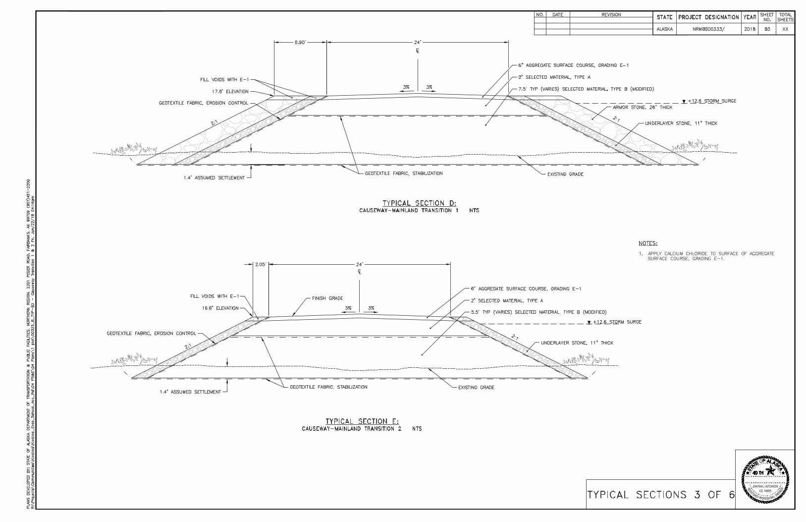
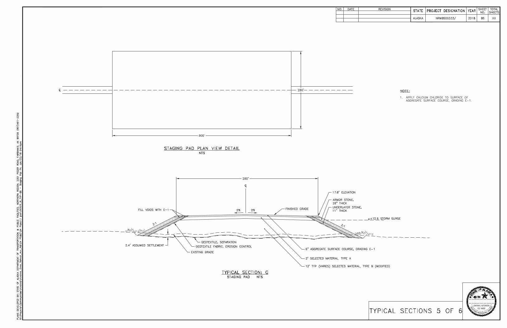
Causeway Section – Typical C The Causeway typical will be used in constructing the lagoon crossing. The causeway will be constructed to 24 feet wide, consisting of two 10 foot lanes and 2 foot shoulders with a 3% crown along the alignment. Embankment side slopes will be 2:1. The causeway embankment will typically be 19 feet thick, and be constructed to a minimum elevation of 17.6 feet to prevent overtopping in the event of a 100 year recurrence ocean surge. Embankment material will consist of 6 inches of aggregate surface course, 2 feet of Selected Material, Type A, underlain by a variable thickness of selected material, Type B (Modified). Surface course will be extended to the outside edge of armor stone to maximize the clear zone. Approximately 3 feet of armor stone will be placed along the side slopes to prevent erosion to the embankment. Geotextile fabric will be placed above the existing lagoon bottom to improve embankment stability and reduce settlement in the underlying unconsolidated lagoon silts. Causeway embankment may need to be constructed over the course of multiple seasons to achieve adequate embankment height and compaction as the underlying lagoon silts are allowed to settle. Causeway-Mainland Transition Section – Typical D & E Portions of the road will be subject to flooding during high water events off the Wulik River in the spring and fall, as well as during ocean surges typically occurring in late fall. The transitional portion of the road will therefore be constructed to prevent overtopping during high water events and will also require rock armoring between 1-3 feet thick. The Causeway-Mainland Transition Sections will be constructed the same as the Causeway typical, except the settlement is anticipated to be less than in the causeway section. Causeway-Mainland Transition 1 (Typical D) will be constructed to an elevation of 17.6 foot with 3 feet thick armoring. Due to reduced wave height and subsequent reduction in wave energy and erosion, Causeway-Mainland Transition 2 (Typical E) will be constructed to an elevation of 16.6 feet with 1 foot thick armoring. Staging Pad Section – Typical G The Staging Pad Section will be constructed the same as the Causeway typical, except the dimensions will be approximately 260' wide by 500' long with a 2% crown along the alignment. This typical will be built on the mainland, across Kivalina Lagoon adjacent the east end of the Causeway. The purpose of this pad is to provide a construction staging area and intermediary community evacuation staging area. The pad will be subject to flooding during storm surges, and will therefore be armored with approximately 3 feet thick armor stone, and will be constructed to a minimum elevation of 17.6 feet to prevent overtopping in the event of a 100 year recurrence ocean surge. Roadway Turnout Section – Typical F The Roadway Turnout Section will be constructed the same as the Mainland Road typical, except it will include a 25 foot wide by 100 foot long turnout section with 50 foot tapers on one side of the roadway. Turnouts will be placed periodically along the mainland portion of the road, at a frequency of approximately one per mile. The purpose of this typical is to allow space for vehicle turnaround, recreational vehicle ramps, passing of slow vehicles, and temporary parking.
Kivalina Evacuation & School Site Access Road 6 July 9, 2018 0002384/NFHWY00162
Terminus Pad Section – Typical H The Terminus Pad Section will be 260’ wide and 600’ long with a 3% cross slope. Embankment side slopes will be 3:1. Average embankment thickness will vary between 4.5 and 10 feet, consisting of 6” of Aggregate Surface Course, 2 feet of Selected Material, Type A, underlain by a variable thickness of Selected Material, Type B. The embankment fill will be underlain by geotextile, separation fabric placed on top of the natural vegetative mat. The natural vegetative mat is to remain undisturbed to the extent practicable. It may be necessary to place fill during frozen conditions, given the terrain is mostly underlain by permafrost and thaw unstable material. This typical will be constructed at the project terminus on K-Hill. The purpose of this typical is to provide a construction staging area and community evacuation pad. The pad is dimensioned to support a helipad, modular buildings for evacuees, and other temporary evacuation and emergency support infrastructure. Pavement Design N/A Preliminary Bridge Layout A new bridge will be constructed over the existing 110 foot wide lagoon channel, located within Kivalina Lagoon approximately 160 feet east of the barrier island. The bridge will be approximately 184-feet long by 27-feet wide, single-span, with steel girders, precast deck members and a precast concrete driving surface. The bridge deck will be constructed to an average elevation of 25.5 feet, or as necessary to keep the bottom of the girders above the 100 year recurrence ocean surge. Attached are the preliminary bridge plans. Right-of-Way Requirements Land interest sufficient for a dedicated 300-foot public ROW will be conveyed by NANA to a government entity currently identified as the City of Kivalina. An easement will need to be acquired from the State of Alaska DNR for tidelands associated with the lagoon crossing. An easement for non-aeronautical use will be required from FAA for those portions of the road lying within airport property. The majority of the proposed ROW for the project lies outside of the community of Kivalina in an area designated as a Subsistence Conservation District by the Northwest Arctic Borough. These lands will need to be permitted as Conditional Use under Title 9 of the NAB Code and will require rezoning by the NAB Planning Commission (Title 9, Article VIII, Section 9.28.220) prior to construction. Maintenance Considerations Maintenance and management responsibility of the Kivalina Evacuation and School Site Access Road will be with a local entity, currently identified as the Northwest Arctic Borough. DOT&PF will retain maintenance of the Kivalina Lagoon Bridge. This project will add approximately 16 lane miles of new road. Potential maintenance concerns will include:
Kivalina Evacuation & School Site Access Road 7 July 9, 2018 0002384/NFHWY00162
Snow removal: The road will be constructed to an average height of 6 feet to alleviate the effects of snow drifting.
Differential settlement from seasonal thaw of foundation soils: The road will be constructed of sufficient height to minimize thawing of the underlying permafrost and maintain structural integrity of the road embankment.
Dust control: calcium chloride or similar will be applied once the road is constructed. Additional dust suppression may be needed in the future.
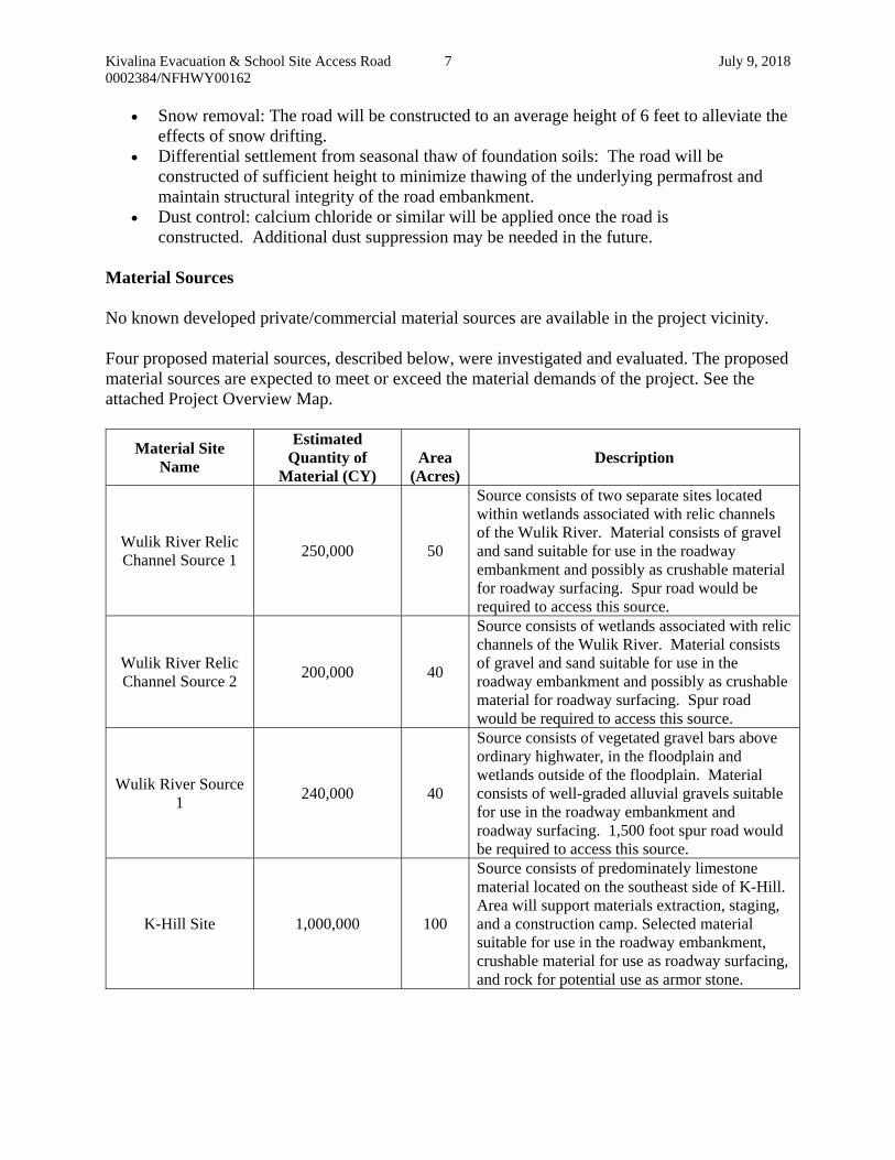
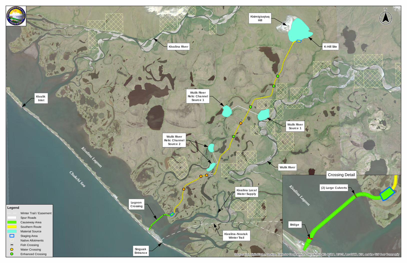
Material Sources No known developed private/commercial material sources are available in the project vicinity. Four proposed material sources, described below, were investigated and evaluated. The proposed material sources are expected to meet or exceed the material demands of the project. See the attached Project Overview Map.
Material Site Name
Estimated Quantity of
Material (CY) Area
(Acres) Description
Wulik River Relic Channel Source 1
250,000 50
Source consists of two separate sites located within wetlands associated with relic channels of the Wulik River. Material consists of gravel and sand suitable for use in the roadway embankment and possibly as crushable material for roadway surfacing. Spur road would be required to access this source.
Wulik River Relic Channel Source 2
200,000 40
Source consists of wetlands associated with relic channels of the Wulik River. Material consists of gravel and sand suitable for use in the roadway embankment and possibly as crushable material for roadway surfacing. Spur road would be required to access this source.
Wulik River Source 1
240,000 40
Source consists of vegetated gravel bars above ordinary highwater, in the floodplain and wetlands outside of the floodplain. Material consists of well-graded alluvial gravels suitable for use in the roadway embankment and roadway surfacing. 1,500 foot spur road would be required to access this source.
K-Hill Site 1,000,000 100
Source consists of predominately limestone material located on the southeast side of K-Hill. Area will support materials extraction, staging, and a construction camp. Selected material suitable for use in the roadway embankment, crushable material for use as roadway surfacing, and rock for potential use as armor stone.

Kivalina Evacuation & School Site Access Road 8 July 9, 2018 0002384/NFHWY00162
Utility Relocation & Coordination There are existing underground power and telephone lines that run from Kivalina out to the snow removal equipment building (SREB) that may be impacted by the proposed road. DOT&PF will coordinate with the regional power and telephone companies to relocate these utilities if they deem it necessary. Access Control Features N/A Pedestrian/Bicycle (ADA) Provisions No separate facilities will be included for bicycle and pedestrian traffic. Pedestrians and bicycles will share the road with vehicular traffic. Safety Improvements The road will provide Kivalina residents a safe and reliable evacuation route in the event of a catastrophic storm or ocean surge, allowing evacuees to temporarily mobilize to safe refuge at an assembly site on K-Hill. Intelligent Transportation System Features N/A Drainage The project area lies primarily within the Wulik River drainage. The Wulik River drainage area consists of approximately 903 square miles and stretches nearly 65 miles inland reaching into the western edge of the Brooks Range. It generally drains from northeast to southwest into Kivalina Lagoon. Because the roadway bisects the Wulik River floodplain, multiple culverts will be required to convey water through the roadway embankment during highwater events, into adjacent remnant channels, wetlands, and lakes. Kivalina lagoon is approximately 3,200’ wide and 3’ deep within the project area, and will require construction of an earthen causeway protected with armor stone, a single span bridge, and multiple overflow culverts to span it. Conveyance through the armored causeway will be maintained by constructing two large structural plate pipes adjacent the east end of the causeway, and a single span steel girder bridge spanning a narrow, tidally influenced channel that parallels Kivalina Barrier Island to the east. The bridge will be constructed to allow for marine mammal and fish passage. Overflow pipes, situated above mean high tide level, will provide additional relief during high water events. Multiple culverts will be placed at locations along the mainland roadway to accommodate cross drainage, with larger culverts placed along identified permanent and intermittent water crossings. General design parameters for the mainland culverts will include:
Culverts shall be embedded 0%-20% of their diameter to convey groundwater and promote fish passage,

Kivalina Evacuation & School Site Access Road 9 July 9, 2018 0002384/NFHWY00162
Culverts 6 ft. or smaller shall be corrugated metal pipe, Culverts within the tidal and storm surge range shall be aluminum, Culverts over 6 ft. should be structural plate pipe, A Minimum 12 gage culvert material thickness is recommended due to icing,
See hydrology summary table below.
Pipe No. Drainage Area (mi2)
50 Year Q50 100 Year Q100 Anticipated Additional
Backwater (ft.)Design Discharge
(cfs)
Design High Water Elev. (ft.)
Design Discharge
(cfs)
Design High Water Elev. (ft.)
P-100 0.001 3.6 10.57 18.7 11.6 1.45
P-101 0.003 6.8 11.77 21.3 12.51 1.17
P-102* 0.002 0.6 - 3.6 12.66 0.78
P-103* 0.02 3.0 - 3.9 14.11 0.37
P-105 0.17 60.0 14.13 95.8 14.85 -0.06
P-106 0.17 134.6 14.18 181.3 14.9 -0.1
P-107 0.17 140.0 14.31 187.9 15.04 -0.01
P-108 0.14 159.8 18.99 234.6 20.14 2.14
P-109 0.12 165.2 22.78 208.0 23.51 2.48
P-110 0.12 165.2 22.79 208.0 23.54 2.49
P-111 0.12 165.2 22.84 208.0 23.59 2.52
P-112 0.007 43.3 25.45 63.8 26.1 1.68
P-113 0.09 507.3 25.76 570.1 26.45 1.04
P-114 0.7 68.4 28.61 94.3 29.47 2.05
P-115** 1.04 95.0 - 108.0 - -
P-116** 0.01 2.0 - 2.0 - -
P-117** 0.07 9.0 - 11.0 - -
* - Local Drainage basin 50-year flow is greater than Wulik River 50-year event overflow
** - Local Drainage basin 100-year and 50-year flow is greater than Wulik River 100-year and 50-year event overflow.
The project area is undeveloped, and there are no known contaminant sources that would cause water quality degradation. There are no impaired water bodies in the project area. There is no municipal storm water system in the project area, and there would be no mix of discharges from a permitted industrial facility.
Soil Conditions
Kivalina is located in coastal northwestern Alaska, north of the Arctic Circle and adjacent to Brooks Range. Situated on a small barrier island between the Kivalina Lagoon and the Chukchi Sea. Kivalina’s climate is transitional between maritime to continental.
The road will cross the Kivalina Lagoon and then traverse northeast through relatively flat, wet tundra to the base of K-Hill. The majority of the project is underlain by permafrost. Subsurface conditions under the roadbed will consist primarily of fine grained and organic deposits, undifferentiated alluvium deposits and outwash deposits.
Kivalina Evacuation & School Site Access Road 10 July 9, 2018 0002384/NFHWY00162
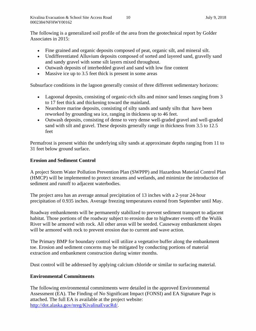
The following is a generalized soil profile of the area from the geotechnical report by Golder Associates in 2015:
Fine grained and organic deposits composed of peat, organic silt, and mineral silt. Undifferentiated Alluvium deposits composed of sorted and layered sand, gravelly sand
and sandy gravel with some silt layers mixed throughout. Outwash deposits of interbedded gravel and sand with low fine content Massive ice up to 3.5 feet thick is present in some areas
Subsurface conditions in the lagoon generally consist of three different sedimentary horizons:
Lagoonal deposits, consisting of organic-rich silts and minor sand lenses ranging from 3 to 17 feet thick and thickening toward the mainland.
Nearshore marine deposits, consisting of silty sands and sandy silts that have been reworked by grounding sea ice, ranging in thickness up to 46 feet.
Outwash deposits, consisting of dense to very dense well-graded gravel and well-graded sand with silt and gravel. These deposits generally range in thickness from 3.5 to 12.5 feet
Permafrost is present within the underlying silty sands at approximate depths ranging from 11 to 31 feet below ground surface.
Erosion and Sediment Control
A project Storm Water Pollution Prevention Plan (SWPPP) and Hazardous Material Control Plan (HMCP) will be implemented to protect streams and wetlands, and minimize the introduction of sediment and runoff to adjacent waterbodies.
The project area has an average annual precipitation of 13 inches with a 2-year 24-hour precipitation of 0.935 inches. Average freezing temperatures extend from September until May.
Roadway embankments will be permanently stabilized to prevent sediment transport to adjacent habitat. Those portions of the roadway subject to erosion due to highwater events off the Wulik River will be armored with rock. All other areas will be seeded. Causeway embankment slopes will be armored with rock to prevent erosion due to current and wave action.
The Primary BMP for boundary control will utilize a vegetative buffer along the embankment toe. Erosion and sediment concerns may be mitigated by conducting portions of material extraction and embankment construction during winter months.
Dust control will be addressed by applying calcium chloride or similar to surfacing material.
Environmental Commitments
The following environmental commitments were detailed in the approved Environmental Assessment (EA). The Finding of No Significant Impact (FONSI) and EA Signature Page is attached. The full EA is available at the project website: http://dot.alaska.gov/nreg/KivalinaEvacRd/.
Kivalina Evacuation & School Site Access Road 11 July 9, 2018 0002384/NFHWY00162
Individual material source reclamation plans would be developed, in consultation with appropriate agencies, local government, and landowners. Potential reclamation options may include flooding for creation of wetland and waterfowl/fish habitat, which may support increased subsistence use at these locations.
Prior to construction, the contractor would develop a best management practices (BMP) based Solid Waste and Hazardous Materials Control Plan to address contaminant spill response, storage, management, and handling of hazardous materials, including fuel and lubricants. If leaks or spills occur, contaminated material and soils would be contained and disposed of properly.
The construction contractor would be required to stop work and notify the DOT&PF Project Engineer if suspected contaminated soil or water is encountered. DOT&PF would notify the Alaska Department of Environmental Conservation (ADEC) in compliance with 18 AAC 75.300. Any contamination encountered would be handled and disposed of in an ADEC-approved manner.
Measures to minimize releases of sediment to water bodies would be implemented during construction as part of compliance with the Alaska Pollution Discharge Elimination System (APDES) Construction General Permit (CGP). Compliance with the CGP includes preparation of a Storm Water Pollution Prevention Plan (SWPPP) and implementation and monitoring of erosion and sediment control BMPs.
Construction of a bridge or causeway in tidal waters falls under the jurisdiction of the U.S. Coast Guard (USCG) Office of Bridge Programs (33C.F.R. Chapter I, Subchapter J, Part 115) and all necessary USCG authorizations would be obtained prior to construction.
Construction materials would be stockpiled within existing fills and/or developed staging areas to minimize construction disturbance and avoid impacting additional wetland acreage.
Setbacks from surface waters would be maintained for refueling and vehicle maintenance activities to reduce the likelihood of hazardous substances entering waterbodies from accidental spills or releases.
Construction of all crossing structures would adhere to appropriate BMPs for in-water works to minimize potential effects to fish or fish habitats from sediment mobilization and transport, and accidental contaminant spills. During in-water construction activities, monitoring may be required onsite to implement site specific BMPs.
In-water work associated with the lagoon crossing would be scheduled to reduce impacts to fish.
Pile driving would be conducted through constructed embankment, to limit impacts to salmon juveniles and adults (NMFS, 2017a).
During construction occurring concurrent with critical timing windows, appropriate measures would be implemented (e.g., construction of a diversion channel) to maintain fish migration and passage.
DOT&PF will coordinate with ADF&G to mitigate impacts to fish during water withdrawal activity and ice harvest that may be needed for construction of ice roads.
Coordination with ADF&G and NMFS would be conducted during design to develop an adequately sized material source at the selected location, maintain adequate setbacks from the river, and avoid adverse impacts to Essential Fish Habitat (EFH).
Temporary disturbance, reclaimed land, and other areas of ground disturbance would be revegetated with regionally appropriate seed mix that minimizes introduction of noxious weeds where practicable.
Kivalina Evacuation & School Site Access Road 12 July 9, 2018 0002384/NFHWY00162
Where possible, vegetation clearing, site preparation, and construction activities would adhere to the recommended periods to avoid vegetation clearing from June 1–July 31 for Northern Alaska.
Project specific Barges and Small Boats: o If project specific barges are required, operators would be required to follow the
best practices and safety regulations required of barge operators which regularly service the communities.
o Barges that may provide some incremental project support but are not strictly under project control will be encouraged to avoid designated (73 FR 19000) North Pacific right whale critical habitat or maintain vigilant watch while under way in order to avoid vessel strikes to individuals of the Critically Endangered population frequenting the Bering Sea.
o If project specific barges are required, during vessel transit, the project will follow 50 CFR 224.103 regulations and NMFS marine mammal viewing guidelines.
o Small project-specific boats will move at less than 10 knots (18.52 km/h) when in the Kivalina Lagoon to reduce noise impacts and for safe vessel maneuverability to avoid obstacles and marine mammals in the water.
o If project specific barges are required and practicable vessel operation requires purposely approaching within 1.6 km (1 mi) of observed whales, except in emergency situations, the vessel operator will take reasonable precautions to avoid potential interaction with the whales.
o Reducing vessel speed to less than 5 knots (9.26 km/h) within 300 yards (274 m) of pinnipeds.
o If project specific barges are required, they will avoid transiting through identified (73 FR 19000) North Pacific right whale critical habitat. Protected Species Observers (PSOs) are not required if barges do not enter designated North Pacific right whale critical habitat.
o If project specific barges are required to transit through North Pacific right whale critical habitat, the following will be implemented:
Vessels will not make way in excess of 10 knots (18.52 km/h) while travelling within the boundaries of designated North Pacific right whale critical habitat.
Dedicated PSOs will be on board all motorized vessels travelling through designated North Pacific right whale critical habitat. PSOs are not required if barges transit around North Pacific right whale critical habitat. PSOs will maintain a constant watch for all marine mammals from the bridge or other similar vantage point. PSOs will maintain direct contact with the vessel pilot, advising the pilot/operator of the position of all observed marine mammals as soon as they are observed.
The vessel pilot/operator will maneuver vessels to the extent practicable to:
o Remain further than 874 yds (800 m) from North Pacific right whales,
o Remain further than 100 yds from other marine mammal species, and
o Avoid approaching any species of whale head-on. Vessels will adjust speed and heading as needed to avoid disturbance of all
marine mammals, provided vessel speed and heading adjustments are consistent with maintaining vessel safety.
Kivalina Evacuation & School Site Access Road 13 July 9, 2018 0002384/NFHWY00162
If material is being placed in Kivalina Lagoon in summer during ice-free conditions, a qualified PSO will monitor for marine mammal presence and implement a 50 m (164 ft) exclusion zone around the material placement site to avoid physical harm, direct, and indirect takes by construction equipment. If material is being placed in the winter, a PSO is only needed if there are areas of naturally occurring open water within 50 m (164 ft) of construction activities. If there is no naturally occurring open water within 50 m (164 ft) of construction activities, no PSO is required and no exclusion zone is necessary.
If an observed marine mammal is likely to approach within 50 m (164 ft) of the fill placement site, fill placement will stop until the marine mammal is farther than 50 m (164 ft) from the fill placement site, or is not seen for 15 minutes. The PSO will continuously scan the activity-specific monitoring zone for the presence of species for 30 min before any fill placement activities take place.
o If any species are present within the exclusion zone, fill placement activities will not begin until such animal(s) has left the exclusion zone or no species have been observed in the exclusion zone for 15 min (for pinnipeds) or 30 min (for cetaceans).
o If any species enter, or appear likely to enter, the exclusion zone during fill placement, all inwater activities will cease immediately. Fill placement activities may resume when the animal(s) has been observed leaving the area on its own accord. If the animal(s) is not observed leaving the area, fill placement activities may begin 15 min (for pinnipeds) or 30 min (for cetaceans) after the animal is last observed in the area.
A polar bear interaction plan would be developed as required by USFWS. Vehicles traveling the project road would be required to stop when they are within sight
of migrating caribou either approaching or actively crossing the road. Vehicles would not be permitted to proceed until all caribou have crossed the road. Road closures may last anywhere from 30 minutes to multiple days depending on the number of caribou and speed of travel (USEPA 2009; Teck 2013).
A bear-human conflict management plan would be developed to reduce potential mortality risk of bears during construction activities. Such a plan would include, among other considerations, measures to manage waste disposal and reduce bear attractants at camps or temporary works sites.
An Archaeological Monitoring Procedures and Inadvertent Discovery Plan has been developed in consultation between DOT&PF, State Historic Preservation Office (SHPO), National Park Service (NPS), and local consulting parties to be implemented during the continued planning and execution of the project, including ground-disturbing work associated with construction and material source development.
A professional archaeologist would monitor vegetation removal and stripping of fine-grained sediments possibly capping buried gravel deposits within Relic Channel Source 1, and north of the exposed gravel bar within the Wulik River Source 1 area.
Work Zone Traffic Control This project will be a new road with no existing traffic. Where project BOP ties into existing community roads, the contractor shall be required to submit for approval a traffic maintenance plan detailing traffic control features during construction. Special traffic control requirements will be addressed in the plans and special provisions, including traffic control and construction activity potentially affecting safe airport operation. The road will remain closed to public traffic
Kivalina Evacuation & School Site Access Road 15 July 9, 2018 0002384/NFHWY00162
cc by e-mail: Daniel Adamczak, P.E., Regional M&O Engineer Penny Adler, Northern Region Chief, Aviation Leasing Ryan F. Anderson, P.E., Regional Director Albert M.L. Beck, P.E., Design Group Chief Matthew Billings, P.E., Assistant GeoTechnical Engineer Judy Chapman, Acting Director of Program Development Jeff Currey, P.E., Regional Materials Engineer Ken Fisher, P.E., Chief Engineer Frank Ganley, P.E., Regional Construction Engineer Gail Gardner, P.E., Regional Utilities Engineer Pam Golden, P.E., Regional Traffic & Safety Engineer Barry Hooper, P.E., PD&E Chief Jonathan Hutchinson, P.E., Engineering Manager Rashaud Joseph, Title VI Specialist, ADA Officer Steve McGroarty, P.E., Regional Geotechnical Engineer Brett Nelson, Regional Environmental Manager Jason Sakalaskas, P.E., M&O Chief Sarah E. Schacher, P.E., Preconstruction Engineer Calvin Schaeffer, Western District Superintendent Cora Shook, Negotiations Supervisor Jeff Stutzke, P.E., Regional Hydraulics Engineer Martin D. Shurr, PLS, Right of Way Chief Kahlil Wilson, Materials Site Coordinator
[¡
[¡ [¡[¡[¡
[¡
[¡
[¡
[¡
[¡
[¡[¡
Chukchi Sea
Kivalina Lagoon
Wulik RiverRelic Channel
Source 1
Wulik RiverRelic Channel
Source 2
Wulik RiverRelic Channel
Source 2
Wulik River
Wulik RiverSource 1
K-Hill Site
KisimigiuqtuqHill
Kivalina River
Singuak Entrance
Lagoon Crossing
Kivalina-Noatak Winter Trail
Kivalik Inlet
Kivalina LocalWater Supply
Source: Esri, DigitalGlobe, GeoEye, Earthstar Geographics, CNES/Airbus DS, USDA, USGS, AeroGRID, IGN, and the GIS User Community
($$¯
LegendWinter Trail / Easement
Spur Roads
Causeway Area
Southern Route
Material Source
Staging Area
Native Allotments
[¡ Fish Crossing
Water Crossing
Enhanced Crossing
Bridge
Crossing Detail
(2) Large CulvertsKivalina Lagoon
Source: Esri, DigitalGlobe, GeoEye, Earthstar Geographics, CNES/Airbus DS, USDA, USGS, AeroGRID, IGN, and the GIS User Community


N
I
G
N
R
D
E
R
E
S
I
G
E
T
S
P
O
R
SEF
E
L
A
N
IO
R
E
E
JONATHAN J. HUTCHINSONCE 14655
AutoCAD SHX Text
TYPICAL SECTIONS 1 OF 6
AutoCAD SHX Text
ALASKA
AutoCAD SHX Text
STATE
AutoCAD SHX Text
YEAR
AutoCAD SHX Text
PROJECT DESIGNATION
AutoCAD SHX Text
SHEET NO.
AutoCAD SHX Text
TOTAL SHEETS
AutoCAD SHX Text
NRMBS00333/
AutoCAD SHX Text
2018
AutoCAD SHX Text
B1
AutoCAD SHX Text
XX
AutoCAD SHX Text
PLANS DEVELOPED BY: STATE OF ALASKA DEPARTMENT OF TRANSPORTATION & PUBLIC FACILITIES, NORTHERN REGION, 2301 PEGER ROAD, FAIRBANKS, AK 99709 (907)451-2200
AutoCAD SHX Text
REVISION
AutoCAD SHX Text
DATE
AutoCAD SHX Text
NO.
AutoCAD SHX Text
3:1
AutoCAD SHX Text
AutoCAD SHX Text
3%%%
AutoCAD SHX Text
TYPICAL SECTION A: MAINLAND ROAD NTS
AutoCAD SHX Text
3:1
AutoCAD SHX Text
3%%%
AutoCAD SHX Text
NOTE: 1.APPLY CALCIUM CHLORIDE TO SURFACE OF APPLY CALCIUM CHLORIDE TO SURFACE OF AGGREGATE SURFACE COURSE, GRADING E-1.
AutoCAD SHX Text
K
AutoCAD SHX Text
49
AutoCAD SHX Text
E
AutoCAD SHX Text
S
AutoCAD SHX Text
T
AutoCAD SHX Text
T
AutoCAD SHX Text
A
AutoCAD SHX Text
TH
AutoCAD SHX Text
A
AutoCAD SHX Text
O
AutoCAD SHX Text
F
AutoCAD SHX Text
L
AutoCAD SHX Text
A
AutoCAD SHX Text
S
AutoCAD SHX Text
A
AutoCAD SHX Text
EXISTING GRADE
AutoCAD SHX Text
GEOTEXTILE FABRIC, STABILIZATION
AutoCAD SHX Text
ROAD MARKER (TYP)
AutoCAD SHX Text
FINISHED GRADE
AutoCAD SHX Text
2:1
AutoCAD SHX Text
TYPICAL SECTION B: MATERIAL SOURCE SPUR ROAD NTS
AutoCAD SHX Text
AutoCAD SHX Text
3%%%
AutoCAD SHX Text
3%%%
AutoCAD SHX Text
2:1
AutoCAD SHX Text
EXISTING GRADE
AutoCAD SHX Text
GEOTEXTILE FABRIC, STABILIZATION
AutoCAD SHX Text
FINISHED GRADE

N
I
G
N
R
D
E
R
E
S
I
G
E
T
S
P
O
R
SEF
E
L
A
N
IO
R
E
E
JONATHAN J. HUTCHINSONCE 14655
AutoCAD SHX Text
TYPICAL SECTIONS 2 OF 6
AutoCAD SHX Text
ALASKA
AutoCAD SHX Text
STATE
AutoCAD SHX Text
YEAR
AutoCAD SHX Text
PROJECT DESIGNATION
AutoCAD SHX Text
SHEET NO.
AutoCAD SHX Text
TOTAL SHEETS
AutoCAD SHX Text
NRMBS00333/
AutoCAD SHX Text
2018
AutoCAD SHX Text
B2
AutoCAD SHX Text
XX
AutoCAD SHX Text
PLANS DEVELOPED BY: STATE OF ALASKA DEPARTMENT OF TRANSPORTATION & PUBLIC FACILITIES, NORTHERN REGION, 2301 PEGER ROAD, FAIRBANKS, AK 99709 (907)451-2200
AutoCAD SHX Text
REVISION
AutoCAD SHX Text
DATE
AutoCAD SHX Text
NO.
AutoCAD SHX Text
AutoCAD SHX Text
3%%%
AutoCAD SHX Text
NOTES: 1.OVERFLOW PIPES TO BE PLACED WITHIN THE EMBANKMENT OVER THE LENGTH OF THE OVERFLOW PIPES TO BE PLACED WITHIN THE EMBANKMENT OVER THE LENGTH OF THE CAUSEWAY. 2.TOP OF CAUSEWAY ELEVATION VARIES FROM 17.6 TO 26.5' AT BRIDGE APPROACHES. TOP OF CAUSEWAY ELEVATION VARIES FROM 17.6 TO 26.5' AT BRIDGE APPROACHES. 3.APPLY CALCIUM CHLORIDE TO SURFACE OF AGGREGATE SURFACE COURSE, GRADING APPLY CALCIUM CHLORIDE TO SURFACE OF AGGREGATE SURFACE COURSE, GRADING E-1.
AutoCAD SHX Text
3%%%
AutoCAD SHX Text
+17.6' CAUSEWAY ELEVATION, SEE NOTE 2
AutoCAD SHX Text
+3.375' MHW
AutoCAD SHX Text
+12.6' STORM SURGE
AutoCAD SHX Text
K
AutoCAD SHX Text
49
AutoCAD SHX Text
E
AutoCAD SHX Text
S
AutoCAD SHX Text
T
AutoCAD SHX Text
T
AutoCAD SHX Text
A
AutoCAD SHX Text
TH
AutoCAD SHX Text
A
AutoCAD SHX Text
O
AutoCAD SHX Text
F
AutoCAD SHX Text
L
AutoCAD SHX Text
A
AutoCAD SHX Text
S
AutoCAD SHX Text
A
AutoCAD SHX Text
EXISTING GRADE/BOTTOM OF LAGOON
AutoCAD SHX Text
GEOTEXTILE FABRIC, STABILIZATION
AutoCAD SHX Text
2:1
AutoCAD SHX Text
2:1
AutoCAD SHX Text
GEOTEXTILE FABRIC, EROSION CONTROL
AutoCAD SHX Text
TYPICAL SECTION C: CAUSEWAY NTS
N
I
G
N
R
D
E
R
E
S
I
G
E
T
S
P
O
R
SEF
E
L
A
N
IO
R
E
E
JONATHAN J. HUTCHINSONCE 14655
AutoCAD SHX Text
TYPICAL SECTIONS 3 OF 6
AutoCAD SHX Text
ALASKA
AutoCAD SHX Text
STATE
AutoCAD SHX Text
YEAR
AutoCAD SHX Text
PROJECT DESIGNATION
AutoCAD SHX Text
SHEET NO.
AutoCAD SHX Text
TOTAL SHEETS
AutoCAD SHX Text
NRMBS00333/
AutoCAD SHX Text
2018
AutoCAD SHX Text
B3
AutoCAD SHX Text
XX
AutoCAD SHX Text
PLANS DEVELOPED BY: STATE OF ALASKA DEPARTMENT OF TRANSPORTATION & PUBLIC FACILITIES, NORTHERN REGION, 2301 PEGER ROAD, FAIRBANKS, AK 99709 (907)451-2200
AutoCAD SHX Text
REVISION
AutoCAD SHX Text
DATE
AutoCAD SHX Text
NO.
AutoCAD SHX Text
AutoCAD SHX Text
3%%%
AutoCAD SHX Text
3%%%
AutoCAD SHX Text
K
AutoCAD SHX Text
49
AutoCAD SHX Text
E
AutoCAD SHX Text
S
AutoCAD SHX Text
T
AutoCAD SHX Text
T
AutoCAD SHX Text
A
AutoCAD SHX Text
TH
AutoCAD SHX Text
A
AutoCAD SHX Text
O
AutoCAD SHX Text
F
AutoCAD SHX Text
L
AutoCAD SHX Text
A
AutoCAD SHX Text
S
AutoCAD SHX Text
A
AutoCAD SHX Text
GEOTEXTILE FABRIC, STABILIZATION
AutoCAD SHX Text
2:1
AutoCAD SHX Text
2:1
AutoCAD SHX Text
AutoCAD SHX Text
3%%%
AutoCAD SHX Text
3%%%
AutoCAD SHX Text
GEOTEXTILE FABRIC, EROSION CONTROL
AutoCAD SHX Text
17.6' ELEVATION
AutoCAD SHX Text
GEOTEXTILE FABRIC, STABILIZATION
AutoCAD SHX Text
2:1
AutoCAD SHX Text
2:1
AutoCAD SHX Text
16.6' ELEVATION
AutoCAD SHX Text
GEOTEXTILE FABRIC, EROSION CONTROL
AutoCAD SHX Text
NOTES: 1.APPLY CALCIUM CHLORIDE TO SURFACE OF AGGREGATE APPLY CALCIUM CHLORIDE TO SURFACE OF AGGREGATE SURFACE COURSE, GRADING E-1.
AutoCAD SHX Text
TYPICAL SECTION D: CAUSEWAY-MAINLAND TRANSITION 1 NTS
AutoCAD SHX Text
TYPICAL SECTION E: CAUSEWAY-MAINLAND TRANSITION 2 NTS
AutoCAD SHX Text
FINISH GRADE
AutoCAD SHX Text
EXISTING GRADE
AutoCAD SHX Text
EXISTING GRADE
AutoCAD SHX Text
+12.6 STORM SURGE
AutoCAD SHX Text
+12.6 STORM SURGE

N
I
G
N
R
D
E
R
E
S
I
G
E
T
S
P
O
R
SEF
E
L
A
N
IO
R
E
E
JONATHAN J. HUTCHINSONCE 14655
AutoCAD SHX Text
TYPICAL SECTIONS 4 OF 6
AutoCAD SHX Text
ALASKA
AutoCAD SHX Text
STATE
AutoCAD SHX Text
YEAR
AutoCAD SHX Text
PROJECT DESIGNATION
AutoCAD SHX Text
SHEET NO.
AutoCAD SHX Text
TOTAL SHEETS
AutoCAD SHX Text
NRMBS00333/
AutoCAD SHX Text
2018
AutoCAD SHX Text
B4
AutoCAD SHX Text
XX
AutoCAD SHX Text
PLANS DEVELOPED BY: STATE OF ALASKA DEPARTMENT OF TRANSPORTATION & PUBLIC FACILITIES, NORTHERN REGION, 2301 PEGER ROAD, FAIRBANKS, AK 99709 (907)451-2200
AutoCAD SHX Text
REVISION
AutoCAD SHX Text
DATE
AutoCAD SHX Text
NO.
AutoCAD SHX Text
3:1
AutoCAD SHX Text
TYPICAL SECTION: F ROADWAY TURNOUT NTS
AutoCAD SHX Text
3:1
AutoCAD SHX Text
ROADWAY TURNOUT PLAN VIEW DETAIL NTS
AutoCAD SHX Text
AutoCAD SHX Text
3%%%
AutoCAD SHX Text
3%%%
AutoCAD SHX Text
AutoCAD SHX Text
K
AutoCAD SHX Text
49
AutoCAD SHX Text
E
AutoCAD SHX Text
S
AutoCAD SHX Text
T
AutoCAD SHX Text
T
AutoCAD SHX Text
A
AutoCAD SHX Text
TH
AutoCAD SHX Text
A
AutoCAD SHX Text
O
AutoCAD SHX Text
F
AutoCAD SHX Text
L
AutoCAD SHX Text
A
AutoCAD SHX Text
S
AutoCAD SHX Text
A
AutoCAD SHX Text
EXISTING GRADE
AutoCAD SHX Text
GEOTEXTILE FABRIC, STABILIZATION
AutoCAD SHX Text
FINISH GRADE
AutoCAD SHX Text
NOTE: 1.APPLY CALCIUM CHLORIDE TO SURFACE OF APPLY CALCIUM CHLORIDE TO SURFACE OF AGGREGATE SURFACE COURSE, GRADING E-1. 2.CONSTRUCT ROADWAY TURNOUTS AT LOCATIONS CONSTRUCT ROADWAY TURNOUTS AT LOCATIONS AND ORIENTATION SHOWN IN TYPICAL SECTION SUMMARY. ROADWAY TURNOUT TYPICAL SECTION SHOWN IS ORIENTED RIGHT OF THE PROJECT ALIGNMENT. 3.TAPERS SHOWN IN ROADWAY TURNOUT PLAN TAPERS SHOWN IN ROADWAY TURNOUT PLAN VIEW ARE INCLUDED IN THE STATION RANGES FOR TYPICAL SECTION F (ROADWAY TURNOUT) IN THE TYPICAL SECTION SUMMARY TABLE.
N
I
G
N
R
D
E
R
E
S
I
G
E
T
S
P
O
R
SEF
E
L
A
N
IO
R
E
E
JONATHAN J. HUTCHINSONCE 14655
AutoCAD SHX Text
TYPICAL SECTIONS 5 OF 6
AutoCAD SHX Text
ALASKA
AutoCAD SHX Text
STATE
AutoCAD SHX Text
YEAR
AutoCAD SHX Text
PROJECT DESIGNATION
AutoCAD SHX Text
SHEET NO.
AutoCAD SHX Text
TOTAL SHEETS
AutoCAD SHX Text
NRMBS00333/
AutoCAD SHX Text
2018
AutoCAD SHX Text
B5
AutoCAD SHX Text
XX
AutoCAD SHX Text
PLANS DEVELOPED BY: STATE OF ALASKA DEPARTMENT OF TRANSPORTATION & PUBLIC FACILITIES, NORTHERN REGION, 2301 PEGER ROAD, FAIRBANKS, AK 99709 (907)451-2200
AutoCAD SHX Text
REVISION
AutoCAD SHX Text
DATE
AutoCAD SHX Text
NO.
AutoCAD SHX Text
2:1
AutoCAD SHX Text
TYPICAL SECTION: G STAGING PAD NTS
AutoCAD SHX Text
2:1
AutoCAD SHX Text
STAGING PAD PLAN VIEW DETAIL NTS
AutoCAD SHX Text
K
AutoCAD SHX Text
49
AutoCAD SHX Text
E
AutoCAD SHX Text
S
AutoCAD SHX Text
T
AutoCAD SHX Text
T
AutoCAD SHX Text
A
AutoCAD SHX Text
TH
AutoCAD SHX Text
A
AutoCAD SHX Text
O
AutoCAD SHX Text
F
AutoCAD SHX Text
L
AutoCAD SHX Text
A
AutoCAD SHX Text
S
AutoCAD SHX Text
A
AutoCAD SHX Text
AutoCAD SHX Text
FINISHED GRADE
AutoCAD SHX Text
EXISTING GRADE
AutoCAD SHX Text
GEOTEXTILE, SEPARATION
AutoCAD SHX Text
AutoCAD SHX Text
NOTE: 1.APPLY CALCIUM CHLORIDE TO SURFACE OF APPLY CALCIUM CHLORIDE TO SURFACE OF AGGREGATE SURFACE COURSE, GRADING E-1.
AutoCAD SHX Text
GEOTEXTILE FABRIC, EROSION CONTROL
AutoCAD SHX Text
2%%%
AutoCAD SHX Text
2%%%
AutoCAD SHX Text
17.6' ELEVATION
AutoCAD SHX Text
+12.6 STORM SURGE

N
I
G
N
R
D
E
R
E
S
I
G
E
T
S
P
O
R
SEF
E
L
A
N
IO
R
E
E
JONATHAN J. HUTCHINSONCE 14655
AutoCAD SHX Text
TYPICAL SECTIONS 6 OF 6
AutoCAD SHX Text
ALASKA
AutoCAD SHX Text
STATE
AutoCAD SHX Text
YEAR
AutoCAD SHX Text
PROJECT DESIGNATION
AutoCAD SHX Text
SHEET NO.
AutoCAD SHX Text
TOTAL SHEETS
AutoCAD SHX Text
NRMBS00333/
AutoCAD SHX Text
2018
AutoCAD SHX Text
B6
AutoCAD SHX Text
XX
AutoCAD SHX Text
PLANS DEVELOPED BY: STATE OF ALASKA DEPARTMENT OF TRANSPORTATION & PUBLIC FACILITIES, NORTHERN REGION, 2301 PEGER ROAD, FAIRBANKS, AK 99709 (907)451-2200
AutoCAD SHX Text
REVISION
AutoCAD SHX Text
DATE
AutoCAD SHX Text
NO.
AutoCAD SHX Text
TYPICAL SECTION H: TERMINUS PAD NTS
AutoCAD SHX Text
3%%%
AutoCAD SHX Text
TERMINUS PAD PLAN VIEW DETAIL NTS
AutoCAD SHX Text
K
AutoCAD SHX Text
49
AutoCAD SHX Text
E
AutoCAD SHX Text
S
AutoCAD SHX Text
T
AutoCAD SHX Text
T
AutoCAD SHX Text
A
AutoCAD SHX Text
TH
AutoCAD SHX Text
A
AutoCAD SHX Text
O
AutoCAD SHX Text
F
AutoCAD SHX Text
L
AutoCAD SHX Text
A
AutoCAD SHX Text
S
AutoCAD SHX Text
A
AutoCAD SHX Text
FINISHED GRADE
AutoCAD SHX Text
EXISTING GRADE
AutoCAD SHX Text
GEOTEXTILE FABRIC, SEPARATION
AutoCAD SHX Text
AutoCAD SHX Text
AutoCAD SHX Text
3:1
AutoCAD SHX Text
3:1
AutoCAD SHX Text
NOTE: 1.APPLY CALCIUM CHLORIDE TO SURFACE OF APPLY CALCIUM CHLORIDE TO SURFACE OF AGGREGATE SURFACE COURSE, GRADING E-1.
Alaska Department of Transportation & Public Facilities, Statewide Environmental Office
FINDING OF NO SIGNIFICANT IMPACT
KIVALINA EVACUATION AND SCHOOL SITE ACCESS ROAD
Project Number: 0002384/NFHWY00162
The environmental review, consultation, and other actions required by applicable Federal environmental laws for this project are being, or have been, carried out by DOT&PF pursuant to
23 U.S.C. 327 and a Memorandum of Understanding dated November 3, 2017 and executed by FHWA and DOT&PF.
Purpose and Need
Purpose
The Alaska Department of Transportation and Public Facilities (DOT&PF) proposes to construct a safe,
reliable, all-season evacuation road between the community of Kivalina, Alaska, and Kisimigiuqtuq Hill
(K-Hill). The Kivalina Evacuation and School Site Access Road project would provide Kivalina
residents a safe and reliable evacuation route in the event of a catastrophic storm or ocean surge, allowing
evacuees to temporarily mobilize to safe refuge at an assembly site on K-Hill. This site is also identified
by the Northwest Arctic Borough (NAB) School District, and approved by the community, as a preferred
new location for the community school. While school construction is remote and speculative1, if
constructed within the vicinity of the project terminus, the school could augment the undeveloped
evacuation site by serving as a full-service community emergency shelter with all-season support
capabilities.
Need
Recent climate data has indicated that arctic sea ice is forming later in the season, increasing fall and
winter storm duration and intensity along the Northwest Arctic coast (Simmonds and Keay 2009; Screen
et al. 2013). Consequently, residents of Kivalina face significant and increasing risks to life, health, and
safety by storm systems predicted to further intensify over time (Brubaker et al. 2010). The need for a
concerted effort to mitigate these risks became more evident during an evacuation event in October 2007,
when debris-laden storm waves overtopped the barrier island. The event resulted in the need for
1 An action or impact occurring at some distance or time in the future that depends on assumptions or events that are contingent, conjectural, or problematic [Eccleston, 2000]
2
helicopters to carry evacuees off the island, and illustrated that Kivalina currently has no safe method of
evacuation in the event of a catastrophic storm surge. In the face of this increased threat, Kivalina needs a
safe and reliable means of evacuation.
Requested Federal Action
The DOT&PF is requesting the following federal action from the Federal Highway Administration
(FWHA): (1) participation in funding the proposed project.
As part of the FHWA Surface Transportation Project Delivery Program (23 U.S. Code [USC] 327),
commonly known as the NEPA Assignment Program, the DOT&PF has assumed the FHWA’s
responsibilities for complying with the National Environmental Policy Act (NEPA) and for the
environmental review, consultation, or other actions as required by Federal environmental laws on
FHWA-funded projects under a Memorandum of Understanding (MOU) with FHWA executed on
November 3, 2017.
Selected Alternative
The DOT&PF selected causeway construction across the Kivalina Lagoon; evacuation road construction
connecting the Kivalina Lagoon causeway to the K-Hill evacuation site; and development of up to four
material source alternatives to supply the project. The selected causeway and evacuation road alternative
is the Southern Route with Lagoon Crossing D. The selected material source alternatives are the K-Hill
Site, Wulik River Source 1, Relic Channel Source 1, and Relic Channel Source 2 with the K-Hill site and
Relic Channel sources given highest priority, and the Wulik River Source used last, if needed, once the
other sites have been exhausted of the needed material. The Southern Route is 7.7 miles long and would
begin adjacent to the Kivalina Airport, immediately cross the lagoon with a 3,020-foot long causeway,
and follow lowlands and relic channels of the Wulik River to a permanent 5-acre gravel staging pad on K-
Hill configured to not preclude later development of a community evacuation site. The selected
alternative also includes construction of a second permanent pad near the inland side of the lagoon
crossing used for contractor staging. The DOT&PF has selected the Southern Route with Lagoon
Crossing D based on its ability to best meet the project’s purpose while minimizing environmental
impacts and addressing the concerns of the public and agencies.
Reasonable Alternatives
For over a decade, Kivalina and the NAB have evaluated the feasibility of numerous road routes, lagoon
crossing options, and material source locations that could provide for evacuation road construction as well
3
as other infrastructure or general material needs. DOT&PF has been working with the community, local
and regional government stakeholders, and state and federal agencies to refine evacuation road
alternatives to be evaluated under the National Environmental Policy Act (NEPA).
Under the No-Action Alternative, an evacuation road would not be constructed from Kivalina to K-Hill.
Residents would continue to be exposed to environmental threats with no safe way to evacuate during
storm events with the potential to detrimentally impact the community over time. As a consequence, there
would remain severe risk to life, health, and safety of residents during a storm surge event. This does not
meet the purpose and need of the project.
Road Route Alternatives: Three preliminary route options (Northern, Southern, and Combined Route A)
were independently proposed by Kivalina and the NAB within the Study Area (Community Proposed
Alternatives). These community initiated route concepts were refined and a fourth route was developed
(Combined Route B) based on feedback received during public and agency scoping efforts in the fall of
2016. Route alternatives were evaluated for feasibility based on purpose and need; engineering
considerations; wetland, fish, and wildlife impacts; number and type of water crossing structures;
proximity to material sources; and cost. After evaluation (detailed in Section 3 of the attached Final
Environmental Assessment (EA)), the Southern Route and Combined Route B were determined feasible
and carried forward for further evaluation.
Lagoon Crossing Alternatives: Four lagoon crossing alternatives (Solid Causeway, Solid Causeway with
Culverts, Solid Causeway with Culverts and Bridge, and Full Span Bridge) were considered and
developed in collaboration with the community of Kivalina, agency stakeholders, and other local and
regional stakeholders. After evaluation, only the Lagoon Crossing D (Solid Causeway with Culverts and
Bridge) was determined feasible and carried forward for further evaluation (detailed in Section 3 of the
Final EA).
Material Source Location Alternatives: Four general areas known to contain potentially viable sources of
various project materials were evaluated in past studies. Several material source locations within these
areas were evaluated for feasibility based on proximity to potential routes, quantity and quality of
material, access constraints, and potential impacts to protected resources (Golder Associates 2013). After
evaluation, four potential sources within these areas have been determined feasible and are carried
forward for further evaluation (K-Hill, Wulik River Channel Source 1, Wulik Relic Chanel Source 1 and
2).

4
Coordination
DOT&PF initiated public involvement and agency coordination for the Kivalina Evacuation and School
Site Access Road Project in fall 2016. DOT&PF held multiple public and working group meetings in
Kivalina, Noatak, and Kotzebue during November 2016, July 2017, and August 2017. Letters and emails
were sent to Federal, State and local agencies, City of Kivalina, NAB and surrounding Villages, Native
Village of Kivalina, Alaska Native Claims Settlement Act (ANCSA) Corporations, and other interested
parties beginning on November 10, 2016. Individual agency scoping meetings were held with interested
agencies beginning on December 19, 2016.
On December 5, 2017, DOT&PF held public meetings in Kivalina, Noatak, and Kotzebue to announce
Draft Environmental Assessment (EA) availability and request comments. In addition, DOT&PF held
several individual agency meetings from December 11-19, 2017 to gather comments. Prior to the
meetings, notices and Draft EA copies were provided to the City of Kivalina, NAB, and surrounding
Villages, Native Village of Kivalina, ANCSA Corporations, and other interested parties announcing Draft
EA availability and comments request. Letters and comments received during the comment period are
included in Appendix D and E.
Impact Assessment
The selected alternative (the Southern Route with Lagoon Crossing D) is 1.2 miles shorter than Combined
Route B, providing a more efficient route to the evacuation site in an emergency. The selected alternative
therefore requires less right-of-way from NANA compared to the Combined Route B (280 acres
compared to 324 acres, respectively).
Project impacts include a loss of uplands and Section 404/10 waters and wetlands, which provide fish,
migratory bird, and wildlife habitat.
The selected alternative would impact 147.3 acres of wetland for the construction of the Southern Route
with Lagoon Crossing D, compared to 171.3 acres for the construction of the Combined Route B with
Lagoon Crossing D. Both alternatives would impact a total of 1.3 acres of uplands for the construction of
the evacuation route, and a total of 233.6 acres of wetland and 20.1 acres of upland for material source
development. There is no practicable alternative to building on wetlands due to their prevalence in the
area.
The selected alternative includes constructing a causeway across Kivalina Lagoon, with a bridge and
multiple culverts. This has the potential to impact marine mammal and fish movement, reduce

5
navigability, and alter floodplains or hydraulic regimes. The bridge and culverts will be designed to
accommodate fish and marine mammal movement, and the bridge will also allow personal boats sized to
support subsistence activities to access both sides of the lagoon.
With the exception of the lagoon crossing, no other portions of the proposed route alternatives would
cross anadromous and/or Essential Fish Habitat (EFH) waterbodies. The selected alternative, the Southern
Route, would require a total of nine water crossings: two fish passage crossings, four non-fish passage
crossings, three enhanced design crossings. This is less than the 12 water crossings that would be
required for the Combined Route B, which includes three fish passage crossings (one of which is a
crossing of the Wulik River relic channel), six non-fish passage crossings, and three enhanced design
crossings. The crossing types are described in Section 4.8.2.2 of the attached Final EA.
The polar bear, spectacled eider and Steller’s eider are listed as threatened under the Endangered Species
Act (ESA) and are under U.S. Fish and Wildlife Service (USFWS) jurisdiction. These species are
recorded infrequently as they migrate through the region. The selected alternative would impact less of
the Closed Low Scrub habitat identified by USFWS as important bird habitat compared to the Combined
Route B with Lagoon Crossing D alternative (2.3 acres compared to 6.3 acres respectively). Impacts are
expected to not be significant as there is alternative preferred habitat available.
Marine mammals typically seen in Kivalina Lagoon include spotted seals, bearded seals, ringed seals, and
polar bears. Bearded seals and ringed seals are listed as threatened under the ESA and are under National
Marine Fisheries Service jurisdiction. These seals may be present in the Kivalina Lagoon, and could be
disturbed by underwater noise associated with construction activities, primarily pile driving, in the
lagoon. Compared to the alternatives presented in the 2017 Draft EA, DOT&PF avoided underwater noise
impacts resulting from in-water pile driving by committing to pile driving through the constructed
embankment.
If project specific barges are required, other listed species may be encountered along the vessel routes.
These species include Western DPS Steller sea lions, North Pacific right whales, Western North Pacific
and Mexico DPS humpback whales, fin whales, sperm whales and bowhead whales. Mitigation measures
(Section 4.12.3 of the Final EA) would limit potential residual adverse effects of the project on marine
mammal species exposed to underwater noise.
The evacuation route may cause impacts to wildlife and marine mammals due to vehicle noise and
creating a visual barrier along the corridor. These are expected to not be significant due to the low number

6
of vehicles anticipated to use the route as compared to roads in other similar locations, as well as
accommodation for fish and marine mammal passage incorporated into the design.
The project will cross lands in the Cape Krusenstern National Historic Landmark (CKNHL), a historic
property. The project may disturb unknown cultural, historical, and archeological resources in the
CKNHL. Cultural resource surveys have been conducted, and no eligible resources have been recorded in
the project’s Area of Potential Effect (APE). Two AHRS-reported sites are on the periphery of the APE.
No ground disturbing activities are planned for the portions of the APE containing these two sites. If a
resource is inadvertently discovered during construction, measures will be taken to mitigate potential
impacts. As a result of consultation under 23 CFR 800.5 (Section 106), DOT&PF has determined that no
historic properties will be adversely affected from the proposed project. The National Park Service (NPS)
agreed with and State Historic Preservation Officer (SHPO) concurred with this finding (Appendix F).
As a historic property, the CKNHL is also protected under Section 4(f) of the Department of
Transportation Act. Based on the SHPO’s concurrence with a finding that no historic properties will be
adversely affected from the proposed project, the DOT&PF has approved a Section 4(f) De Minimis
Impact Finding (Section 5 and Appendix K of the attached Final EA).
Temporary construction impacts will predominantly occur due to material source development and
material placement into wetlands and waters. These activities will potentially discharge sediment to
adjacent waterways, and impact fish habitat, including EFH. These impacts are expected to not be
significant with proper implementation of construction best management practices and compliance with
permit requirements.
Construction noise associated with material placement, and material source development have the
potential to temporarily disturb wildlife, marine mammals, birds, and fish, either resulting in temporary
relocation to other habitats, or mortality. Implementation of construction best management practices, and
proper activity scheduling during low risk seasons, is expected to result in no significant impacts.
Secondary and Cumulative Impacts: The project would open access to the Wulik River for subsistence
and possible development of adjacent public and private lands. These impacts are anticipated to not be
significant as the area is already a travel corridor for subsistence use and the anticipated increase in
activity is expected to be relatively small compared to the levels of existing traffic and noise along the
corridor.
7
Avoidance, Minimization, and Mitigation Measures
Conditions of approval associated with this project are detailed in the Final EA and project permits and
requirements will be included in the construction contract documents. The project has been coordinated
with the appropriate agencies and the local Tribe, and includes measures to avoid and minimize impacts.
The following commitments will be included in the project to reduce environmental impacts.
Land Use and Transportation
• Wulik River Source 1 is adjacent to and includes a portion of a Native allotment (less than a
quarter of the proposed material site); however, use of this material source has been given lower
priority as described in Section 4.3.4 of the EA, and the material source may be developed
outside of the Native allotment if a material sales agreement with the owner cannot be reached.
All other material sources and route alternatives avoid development in Native allotments; and
• Material sources near Native allotments would be designed to not block access to these areas.
• During permitting of the Wulik Relic Channel Source 2, DOT&PF will work with the Alaska
Department of Natural Resources (DNR) to avoid the use of state-owned submerged lands.
Social and Economic Environment
• Individual material source reclamation plans would be developed, in consultation with
appropriate agencies, local government, and landowners. Potential reclamation options may
include flooding for creation of wetland and waterfowl/fish habitat, which may support increased
subsistence use at these locations.
Hazardous Materials, Pollution Prevention, and Solid Waste
• Prior to construction, the contractor would develop a best management practices (BMP) based
Solid Waste and Hazardous Materials Control Plan to address contaminant spill response, storage,
management, and handling of hazardous materials, including fuel and lubricants. If leaks or spills
occur, contaminated material and soils would be contained and disposed of properly; and
• The construction contractor would be required to stop work and notify the DOT&PF Project
Engineer if suspected contaminated soil or water is encountered. DOT&PF would notify the
Alaska Department of Environmental Conservation (ADEC) in compliance with 18 AAC 75.300.
Any contamination encountered would be handled and disposed of in an ADEC-approved
manner.

8
Water Resources and Water Quality
• Water Quality:
o Measures to minimize releases of sediment to water bodies would be implemented during
construction as part of compliance with the Alaska Pollution Discharge Elimination System
(APDES) Construction General Permit (CGP). Compliance with the CGP includes
preparation of a Storm Water Pollution Prevention Plan (SWPPP) and implementation and
monitoring of erosion and sediment control BMPs;
o Utilization of low erodible material and armor rock placed in the Kivalina Lagoon would
minimize sedimentation to these waterbodies. Sediment entrainment measures would further
reduce impacts to water quality; and
o Water withdrawal requires permitting through DNR and Alaska Department of Fish and
Game (ADF&G), which would specify appropriate BMPs. BMPs, including water
withdrawal volume limitations, would reduce the potential effects on stream flows during
construction.
• Floodplain:
o Material sites would be constructed to avoid river capture, floodplain widening, and increased
erosion;
o The road would be designed above the 100-year flood elevation.
o Causeway bridge and culverts would be designed for adequate flows through the causeway at
flood stage.
• Hydrology:
o Roadway and causeway embankments would be protected from erosion to prevent sediment
transport to adjacent habitats; and
o Construction of a bridge or causeway in tidal waters falls under the jurisdiction of the U.S.
Coast Guard (USCG) Office of Bridge Programs (33C.F.R. Chapter I, Subchapter J, Part 115)
and all necessary USCG authorizations would be obtained prior to construction.
9
Wetlands and Vegetation
Executive Order 11990, “Protection of Wetlands,” issued May 24, 1977, requires there be no practicable
alternative to a Proposed Action if such action affects wetlands, and that any proposed federally funded
action include all practicable measures to avoid and minimize harm to wetlands. As the majority of the
Study Area is dominated by high functioning wetlands and waters, construction of an evacuation route
from Kivalina to K-Hill would cause impacts to high value wetlands, and a USACE Section 404/10
Individual Permit would be required.
Avoidance, minimization and, if required, either compensatory or sponsor-proposed mitigation are the
primary measures available to offset wetland losses for the proposed project. In fulfillment of Executive
Order 11990, the following avoidance and minimization measures would be implemented to reduce the
impacts to wetlands:
• The proposed route alternatives are routed to avoid and minimize impacts to Waters of the U.S.
and the higher Category I+ wetlands. Upland areas are utilized as possible, while avoiding upland
important bird habitat (Closed Low Scrub) at the same priority as Category I+ wetlands;
• Project elements (e.g., road embankment geometry, vehicle turn outs, water crossings) are
designed to safely incorporate the minimal dimensions necessary to serve the project purpose and
need to minimize required wetland fill;
• Staking or otherwise delineating the road embankment footprint and associated temporary impact
areas would be completed prior to construction;
• Construction materials would be stockpiled within existing fills and/or developed staging areas to
minimize construction disturbance and avoid impacting additional wetland acreage;
• Setbacks from surface waters would be maintained for refueling and vehicle maintenance
activities to reduce the likelihood of hazardous substances entering waterbodies from accidental
spills or releases; and
• A project Erosion and Sediment Control Plan, SWPPP, and Hazardous Material Control Plan
would be implemented to protect streams and wetlands, and minimize the introduction of
sediment and runoff to adjacent waterbodies.
10
Fish and Fish Habitat
• All Features
o Compliance with the APDES CGP, and implementation of the required SWPPP and BMPs
during construction, to reduce the potential for sediment laden storm water runoff during
construction. Stabilization of side slopes with vegetation or non-erodible material would also
be implemented as part of CGP compliance to further reduce the potential for sedimentation
of nearby streams;
o Construction of all crossing structures would adhere to appropriate BMPs for in-water works
to minimize potential effects to fish or fish habitats from sediment mobilization and transport,
and accidental contaminant spills;
o During in-water construction activities, monitoring may be required onsite to implement site
specific BMPs and other potential permit requirements; and
o Obtain Fish Habitat Permit from ADF&G.
• Lagoon Crossing:
o In-water work associated with the lagoon crossing would be scheduled to reduce impacts to
fish;
o Implementation of BMPs that avoid or minimize adverse impacts to water quality and marine
habitats;
o The causeway’s northeastern culvert(s) will be designed to be easily maintained as an open
water passage at mean tide and accommodate anticipated debris and icing mitigation to
prevent flow blockage; and
o Pile driving would be conducted through constructed embankment, to limit impacts to salmon
juveniles and adults (NMFS, 2017a).

11
• Road Construction:
o During construction occurring concurrent with critical timing windows, appropriate measures
would be implemented (e.g., construction of a diversion channel) to maintain fish migration
and passage
o DOT&PF will coordinate with ADF&G to mitigate impacts to fish during water withdrawal
activity and ice harvest that may be needed for construction of ice roads; and
o DOT&PF and the construction contractor would coordinate with ADF&G to identify and
implement appropriate migration measures.
• Material Sources:
o Material source selection, site specific mining plan design, permitting, and reclamation would
reduce the potential for adverse impacts and could enhance fish habitats in some drainages,
such as the Wulik Relic Channel;
o Reclamation plans may include developing shallow littoral zones and shrubby riparian areas
for migratory bird habitat;
o Site specific material site plans will incorporate work timing windows to work around
sensitivities for salmon and Dolly Varden;
o Material sites will be prioritized for use: 1) K-Hill and Relic Channel sources and 2) Wulik
River 1 (only after other sites are exhausted);
If the Wulik River Material Site 1 is constructed, maintain a connection to the Wulik
River; and
o Coordination with ADF&G and NMFS would be conducted during design to develop an
adequately sized material source at the selected location, maintain adequate setbacks from the
river, and avoid adverse impacts to EFH.
12
Terrestrial and Aquatic Birds
• The Proposed Action alternatives have been routed to minimize interactions with waterbodies
(i.e., aquatic bird habitat) wherever feasible. Where possible, the road alignment would approach
the waterbody perpendicularly to minimize impacts to the riparian habitats;
• Temporary disturbance, reclaimed land, and other areas of ground disturbance would be
revegetated with regionally appropriate seed mix that minimizes introduction of noxious weeds
where practicable;
• Where possible, vegetation clearing, site preparation, and construction activities would adhere to
the recommended periods to avoid vegetation clearing from June 1–July 31 for Northern Alaska.
If vegetation clearing, site preparation, and construction occurs within these periods, pre-
construction nest surveys would be conducted by qualified personnel and appropriate mitigation
developed in consultation with the USFWS; and
• High-disturbance project-related activities (e.g., blasting, pile driving) would be avoided where
practicable during the nesting and peak migration window.
Marine Mammals
• Pile driving would will occur through constructed embankment;
• Project specific Barges and Small Boats:
o If project specific barges are required, operators would be required to follow the best
practices and safety regulations required of barge operators which regularly service the
communities.
o Barges that may provide some incremental project support but are not strictly under project
control will be encouraged to avoid designated (73 FR 19000) North Pacific right whale
critical habitat or maintain vigilant watch while under way in order to avoid vessel strikes to
individuals of the Critically Endangered population frequenting the Bering Sea.
o If project specific barges are required, during vessel transit, the project will follow 50 CFR
224.103 regulations and NMFS marine mammal viewing guidelines.
o Small project-specific boats will move at less than 10 knots (kn; 18.52 km/h) when in the
Kivalina Lagoon to reduce noise impacts and for safe vessel maneuverability to avoid
obstacles and marine mammals in the water.
13
o If project specific barges are required and practicable vessel operation requires purposely
approaching within 1.6 km (1 mi) of observed whales, except in emergency situations, the
vessel operator will take reasonable precautions to avoid potential interaction with the whales
o Reducing vessel speed to less than 5 kn (9.26 km/h) within 300 yards (274 m) of pinnipeds
o If project specific barges are required, they will avoid transiting through identified (73 FR
19000) North Pacific right whale critical habitat. Protected Species Observers (PSOs) are not
required if barges do not enter designated North Pacific right whale critical habitat.
o If project specific barges are required to transit through North Pacific right whale critical
habitat, the following will be implemented:
• Vessels will not make way in excess of 10 kn (18.52 km/h) while travelling within the
boundaries of designated North Pacific right whale critical habitat.
• Dedicated PSOs will be on board all motorized vessels travelling through designated
North Pacific right whale critical habitat. PSOs are not required if barges transit around
North Pacific right whale critical habitat. PSOs will maintain a constant watch for all
marine mammals from the bridge or other similar vantage point. PSOs will maintain
direct contact with the vessel pilot, advising the pilot/operator of the position of all
observed marine mammals as soon as they are observed.
• The vessel pilot/operator will maneuver vessels to the extent practicable to:
• Remain further than 874 yds (800 m) from North Pacific right whales,
• Remain further than 100 yds from other marine mammal species, and
• Avoid approaching any species of whale head-on.
• Vessels will adjust speed and heading as needed to avoid disturbance of all marine
mammals, provided vessel speed and heading adjustments are consistent with
maintaining vessel safety.
• Fill Placement:
o If material is being placed in summer during ice-free conditions, a qualified PSO will monitor
for marine mammal presence and implement a 50 m (164 ft) exclusion zone around the
material placement site to avoid physical harm, direct, and indirect takes by construction
equipment.
o If material is being placed in the winter, a PSO is only needed if there are areas of naturally
occurring open water within 50 m (164 ft) of construction activities. If there is no naturally
occurring open water within 50 m (164 ft) of construction activities, no PSO is required and
no exclusion zone is necessary.
14
o If an observed marine mammal is likely to approach within 50 m (164 ft) of the fill placement
site, fill placement will stop until the marine mammal is farther than 50 m (164 ft) from the
fill placement site, or is not seen for 15 minutes. The PSO will continuously scan the activity-
specific monitoring zone for the presence of species for 30 min before any fill placement
activities take place.
• If any species are present within the exclusion zone, fill placement activities will not
begin until such animal(s) has left the exclusion zone or no species have been observed
in the exclusion zone for 15 min (for pinnipeds) or 30 min (for cetaceans).
• If any species enter, or appear likely to enter, the exclusion zone during fill placement,
all inwater activities will cease immediately. Fill placement activities may resume
when the animal(s) has been observed leaving the area on its own accord. If the
animal(s) is not observed leaving the area, fill placement activities may begin 15 min
(for pinnipeds) or 30 min (for cetaceans) after the animal is last observed in the area.
• Subsistence Activities
o Signs will be installed reminding the public that State of Alaska Fish and Game regulations
prohibit shooting from, on, or across a highway (5 AAC 92.080; ADF&G 2006).
• A polar bear interaction plan would be developed as required by USFWS.
Wildlife—Terrestrial Mammals
• To reduce potential disturbance to caribou during migration, mitigation measures such as those
applied at the Red Dog Mine are recommended during construction. Vehicles traveling the
project road would be required to stop when they are within sight of migrating caribou either
approaching or actively crossing the road. Vehicles would not be permitted to proceed until all
caribou have crossed the road. Road closures may last anywhere from 30 minutes to multiple
days depending on the number of caribou and speed of travel (USEPA 2009; Teck 2013);
• Reduce speed limit along the project road as well as any temporary spur roads; and
• A bear-human conflict management plan would be developed to reduce potential mortality risk of
bears during construction activities. Such a plan would include, among other considerations,
measures to manage waste disposal and reduce bear attractants at camps or temporary works
sites.

15
Historic, Architectural, Archaeological, and Cultural Resources
• An Archaeological Monitoring Procedures and Inadvertent Discovery Plan has been developed in
consultation between DOT&PF, SHPO, NPS, and local consulting parties to be implemented
during the continued planning and execution of the project, including ground-disturbing work
associated with construction and material source development; and
• A professional archaeologist would monitor vegetation removal and stripping of fine-grained
sediments possibly capping buried gravel deposits within Relic Channel Source 1, and north of
the exposed gravel bar within the Wulik River Source 1 area.
Required Permits and/or Approvals
This Finding of No Significant Impact (FONSI) is based on:
• ESA (Section 7 Informal Consultation) and Marine Mammal Protection Act (MMPA): The
National Marine Fisheries Service and US Fish and Wildlife Service provided concurrence under
informal consultation that the project with mitigation measures was not likely to adversely affect
Endangered Species or Marine Mammals.
• EFH: Concurrence from the NMFS (12/14/17) that the project with mitigation measures was not
likely to adversely affect EFH or that adverse effects to EFH would be minimal, with
incorporation of specific conservation recommendations.
• National Historic Preservation Act (NHPA; Section 106): Concurrence from the SHPO
(10/9/17) of no historic properties adversely affected for the proposed project.
• Department of Transportation Act (Section 4[f]): Based on concurrence from the NPS
(10/6/17) and SHPO (10/9/17) with the finding that no historic properties under NHPA Section
106 will be adversely affected, it is DOT&PF’s finding that the project’s use of the CKNHL
would only result in a de minimis impact, and DOT&PF documented its determination in a De
Minimis Impact Finding (Appendix K).
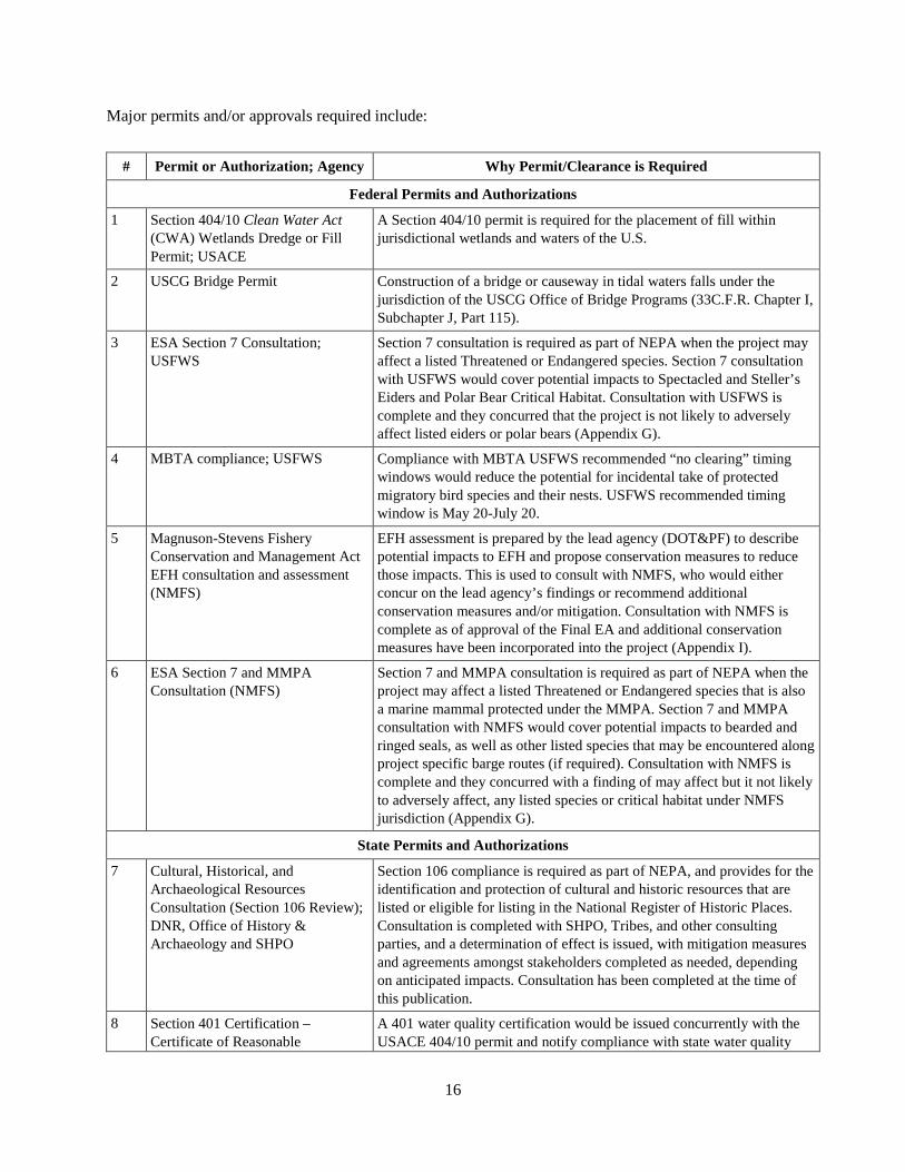
16
Major permits and/or approvals required include:
# Permit or Authorization; Agency Why Permit/Clearance is Required
Federal Permits and Authorizations
1 Section 404/10 Clean Water Act (CWA) Wetlands Dredge or Fill Permit; USACE
A Section 404/10 permit is required for the placement of fill within jurisdictional wetlands and waters of the U.S.
2 USCG Bridge Permit Construction of a bridge or causeway in tidal waters falls under the jurisdiction of the USCG Office of Bridge Programs (33C.F.R. Chapter I, Subchapter J, Part 115).
3 ESA Section 7 Consultation; USFWS
Section 7 consultation is required as part of NEPA when the project may affect a listed Threatened or Endangered species. Section 7 consultation with USFWS would cover potential impacts to Spectacled and Steller’s Eiders and Polar Bear Critical Habitat. Consultation with USFWS is complete and they concurred that the project is not likely to adversely affect listed eiders or polar bears (Appendix G).
4 MBTA compliance; USFWS Compliance with MBTA USFWS recommended “no clearing” timing windows would reduce the potential for incidental take of protected migratory bird species and their nests. USFWS recommended timing window is May 20-July 20.
5 Magnuson-Stevens Fishery Conservation and Management Act EFH consultation and assessment (NMFS)
EFH assessment is prepared by the lead agency (DOT&PF) to describe potential impacts to EFH and propose conservation measures to reduce those impacts. This is used to consult with NMFS, who would either concur on the lead agency’s findings or recommend additional conservation measures and/or mitigation. Consultation with NMFS is complete as of approval of the Final EA and additional conservation measures have been incorporated into the project (Appendix I).
6 ESA Section 7 and MMPA Consultation (NMFS)
Section 7 and MMPA consultation is required as part of NEPA when the project may affect a listed Threatened or Endangered species that is also a marine mammal protected under the MMPA. Section 7 and MMPA consultation with NMFS would cover potential impacts to bearded and ringed seals, as well as other listed species that may be encountered along project specific barge routes (if required). Consultation with NMFS is complete and they concurred with a finding of may affect but it not likely to adversely affect, any listed species or critical habitat under NMFS jurisdiction (Appendix G).
State Permits and Authorizations
7 Cultural, Historical, and Archaeological Resources Consultation (Section 106 Review); DNR, Office of History & Archaeology and SHPO
Section 106 compliance is required as part of NEPA, and provides for the identification and protection of cultural and historic resources that are listed or eligible for listing in the National Register of Historic Places. Consultation is completed with SHPO, Tribes, and other consulting parties, and a determination of effect is issued, with mitigation measures and agreements amongst stakeholders completed as needed, depending on anticipated impacts. Consultation has been completed at the time of this publication.
8 Section 401 Certification – Certificate of Reasonable
A 401 water quality certification would be issued concurrently with the USACE 404/10 permit and notify compliance with state water quality
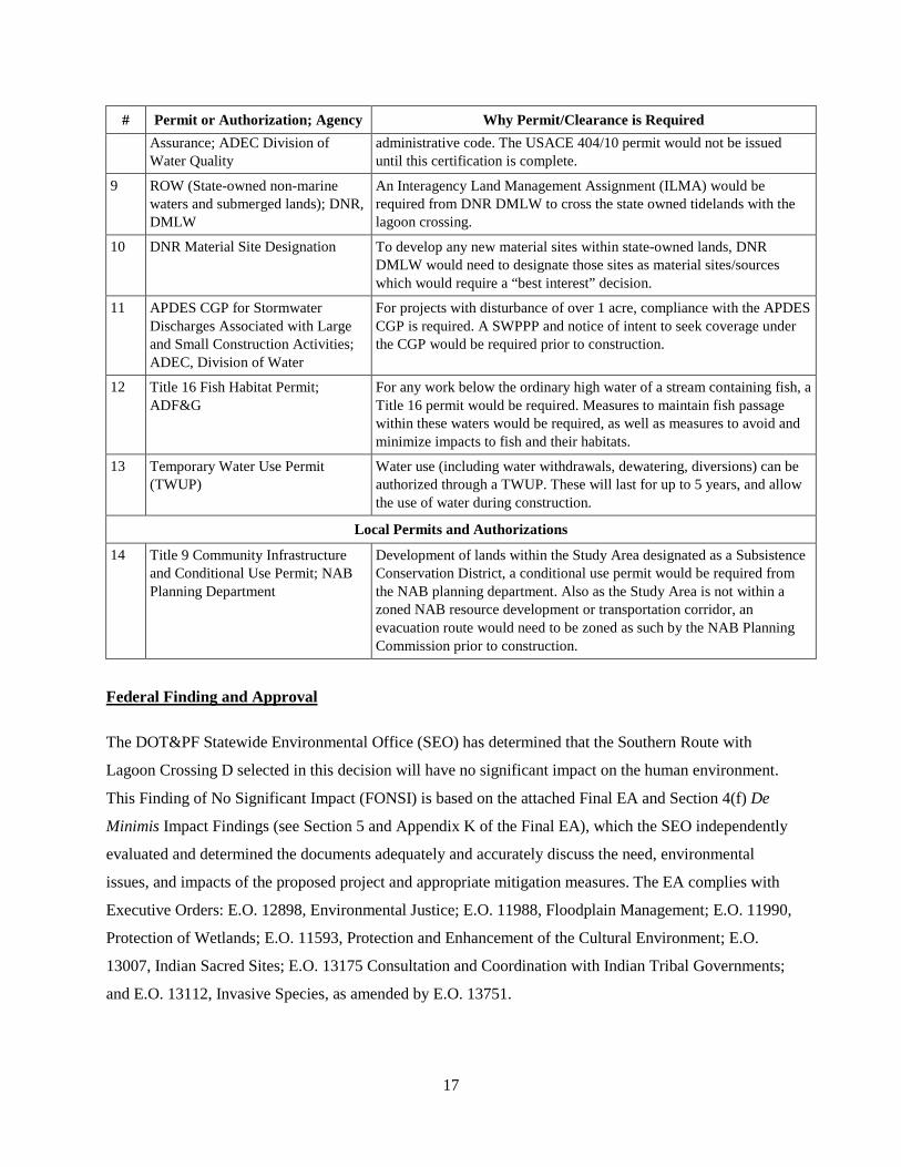
17
# Permit or Authorization; Agency Why Permit/Clearance is Required
Assurance; ADEC Division of Water Quality
administrative code. The USACE 404/10 permit would not be issued until this certification is complete.
9 ROW (State-owned non-marine waters and submerged lands); DNR, DMLW
An Interagency Land Management Assignment (ILMA) would be required from DNR DMLW to cross the state owned tidelands with the lagoon crossing.
10 DNR Material Site Designation To develop any new material sites within state-owned lands, DNR DMLW would need to designate those sites as material sites/sources which would require a “best interest” decision.
11 APDES CGP for Stormwater Discharges Associated with Large and Small Construction Activities; ADEC, Division of Water
For projects with disturbance of over 1 acre, compliance with the APDES CGP is required. A SWPPP and notice of intent to seek coverage under the CGP would be required prior to construction.
12 Title 16 Fish Habitat Permit; ADF&G
For any work below the ordinary high water of a stream containing fish, a Title 16 permit would be required. Measures to maintain fish passage within these waters would be required, as well as measures to avoid and minimize impacts to fish and their habitats.
13 Temporary Water Use Permit (TWUP)
Water use (including water withdrawals, dewatering, diversions) can be authorized through a TWUP. These will last for up to 5 years, and allow the use of water during construction.
Local Permits and Authorizations
14 Title 9 Community Infrastructure and Conditional Use Permit; NAB Planning Department
Development of lands within the Study Area designated as a Subsistence Conservation District, a conditional use permit would be required from the NAB planning department. Also as the Study Area is not within a zoned NAB resource development or transportation corridor, an evacuation route would need to be zoned as such by the NAB Planning Commission prior to construction.
Federal Finding and Approval
The DOT&PF Statewide Environmental Office (SEO) has determined that the Southern Route with
Lagoon Crossing D selected in this decision will have no significant impact on the human environment.
This Finding of No Significant Impact (FONSI) is based on the attached Final EA and Section 4(f) De
Minimis Impact Findings (see Section 5 and Appendix K of the Final EA), which the SEO independently
evaluated and determined the documents adequately and accurately discuss the need, environmental
issues, and impacts of the proposed project and appropriate mitigation measures. The EA complies with
Executive Orders: E.O. 12898, Environmental Justice; E.O. 11988, Floodplain Management; E.O. 11990,
Protection of Wetlands; E.O. 11593, Protection and Enhancement of the Cultural Environment; E.O.
13007, Indian Sacred Sites; E.O. 13175 Consultation and Coordination with Indian Tribal Governments;
and E.O. 13112, Invasive Species, as amended by E.O. 13751.

The EA and concurrence documents provide sufficient evidence and analysis for determining an
Environmental Impact Statement is not required. The DOT&PF SEO takes full responsibility for the
accuracy, scope and content of the attached Final EA, and the ESA, MMPA, NHPA, and Department of
Transportation Act consultations. A full list of required permits and compliance activities is included in
Section 4.15 of the EA.
I have carefully and thoroughly considered the facts contained in the attached EA. Based on that
informatiorl I have found the proposed Federal action is consistent with existing national environmental
policies and objectives as set forth in Section l0l(a) of the National Environmental Policy Act and other
applicable environmental requirements. I also find the proposed Federal action will not significantly
affect the quahfy of the human environment or include any condition requiring consultation pursuant to
Section 102(2)(c) of NEPA. As a result, DOT&PF Statewide Environmental Office will not prepare an
EIS for this action.
/rr/zonDate Amy Sumner
Acting Statewide Environmental Program Manager
DOT&PF Statewide Environmental Office
18
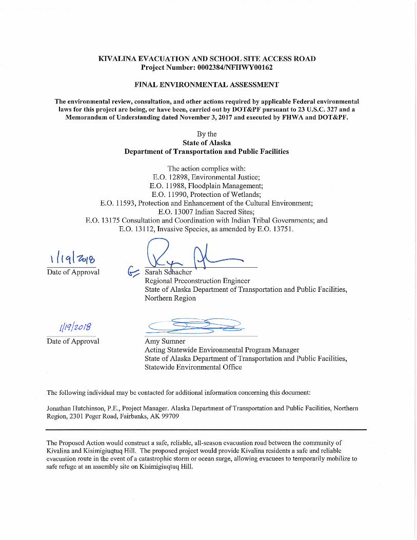
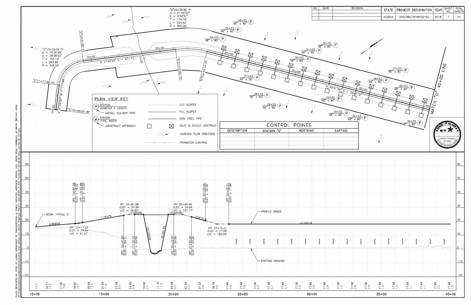
N
I
G
N
R
D
E
R
E
S
I
G
E
T
S
P
O
R
SEF
E
L
A
N
IO
R
E
E
JONATHAN J. HUTCHINSONCE 14655
AutoCAD SHX Text
CONTROL POINTS
AutoCAD SHX Text
DESCRIPTION
AutoCAD SHX Text
STATION 'O'
AutoCAD SHX Text
NORTHING
AutoCAD SHX Text
EASTING
AutoCAD SHX Text
PLAN VIEW KEY
AutoCAD SHX Text
A
AutoCAD SHX Text
TYPE, WIDTH
AutoCAD SHX Text
STATION
AutoCAD SHX Text
CONSTRUCT APPROACH
AutoCAD SHX Text
P
AutoCAD SHX Text
DIAMETER X LENGTH
AutoCAD SHX Text
STATION
AutoCAD SHX Text
INSTALL CULVERT PIPE
AutoCAD SHX Text
CUT SLOPES
AutoCAD SHX Text
FILL SLOPES
AutoCAD SHX Text
NEW STEEL PIPE
AutoCAD SHX Text
INLET & OUTLET CONTROLS
AutoCAD SHX Text
PERIMETER CONTROL
AutoCAD SHX Text
SURFACE FLOW DIRECTION
AutoCAD SHX Text
K
AutoCAD SHX Text
49
AutoCAD SHX Text
E
AutoCAD SHX Text
S
AutoCAD SHX Text
T
AutoCAD SHX Text
T
AutoCAD SHX Text
A
AutoCAD SHX Text
TH
AutoCAD SHX Text
A
AutoCAD SHX Text
O
AutoCAD SHX Text
F
AutoCAD SHX Text
L
AutoCAD SHX Text
A
AutoCAD SHX Text
S
AutoCAD SHX Text
A
AutoCAD SHX Text
ALASKA
AutoCAD SHX Text
STATE
AutoCAD SHX Text
YEAR
AutoCAD SHX Text
PROJECT DESIGNATION
AutoCAD SHX Text
SHEET NO.
AutoCAD SHX Text
TOTAL SHEETS
AutoCAD SHX Text
0002384/NFHWY00162
AutoCAD SHX Text
2018
AutoCAD SHX Text
1
AutoCAD SHX Text
XX
AutoCAD SHX Text
EXISTING GROUND
AutoCAD SHX Text
PROFILE GRADE
AutoCAD SHX Text
PLANS DEVELOPED BY: STATE OF ALASKA DEPARTMENT OF TRANSPORTATION & PUBLIC FACILITIES, NORTHERN REGION, 2301 PEGER ROAD, FAIRBANKS, AK 99709 (907)451-2200
AutoCAD SHX Text
REVISION
AutoCAD SHX Text
DATE
AutoCAD SHX Text
NO.
AutoCAD SHX Text
BEGIN TYPICAL C

N
I
G
N
R
D
E
R
E
S
I
G
E
T
S
P
O
R
SEF
E
L
A
N
IO
R
E
E
JONATHAN J. HUTCHINSONCE 14655
AutoCAD SHX Text
ALASKA
AutoCAD SHX Text
STATE
AutoCAD SHX Text
YEAR
AutoCAD SHX Text
PROJECT DESIGNATION
AutoCAD SHX Text
SHEET NO.
AutoCAD SHX Text
TOTAL SHEETS
AutoCAD SHX Text
0002384/NFHWY00162
AutoCAD SHX Text
2018
AutoCAD SHX Text
2
AutoCAD SHX Text
XX
AutoCAD SHX Text
EXISTING GROUND
AutoCAD SHX Text
PROFILE GRADE
AutoCAD SHX Text
PLANS DEVELOPED BY: STATE OF ALASKA DEPARTMENT OF TRANSPORTATION & PUBLIC FACILITIES, NORTHERN REGION, 2301 PEGER ROAD, FAIRBANKS, AK 99709 (907)451-2200
AutoCAD SHX Text
REVISION
AutoCAD SHX Text
DATE
AutoCAD SHX Text
NO.
AutoCAD SHX Text
K
AutoCAD SHX Text
49
AutoCAD SHX Text
E
AutoCAD SHX Text
S
AutoCAD SHX Text
T
AutoCAD SHX Text
T
AutoCAD SHX Text
A
AutoCAD SHX Text
TH
AutoCAD SHX Text
A
AutoCAD SHX Text
O
AutoCAD SHX Text
F
AutoCAD SHX Text
L
AutoCAD SHX Text
A
AutoCAD SHX Text
S
AutoCAD SHX Text
A
AutoCAD SHX Text
END TYPICAL C BEGIN TYPICAL G
AutoCAD SHX Text
END TYPICAL G BEGIN TYPICAL C

N
I
G
N
R
D
E
R
E
S
I
G
E
T
S
P
O
R
SEF
E
L
A
N
IO
R
E
E
JONATHAN J. HUTCHINSONCE 14655
AutoCAD SHX Text
ALASKA
AutoCAD SHX Text
STATE
AutoCAD SHX Text
YEAR
AutoCAD SHX Text
PROJECT DESIGNATION
AutoCAD SHX Text
SHEET NO.
AutoCAD SHX Text
TOTAL SHEETS
AutoCAD SHX Text
0002384/NFHWY00162
AutoCAD SHX Text
2018
AutoCAD SHX Text
3
AutoCAD SHX Text
XX
AutoCAD SHX Text
EXISTING GROUND
AutoCAD SHX Text
PLANS DEVELOPED BY: STATE OF ALASKA DEPARTMENT OF TRANSPORTATION & PUBLIC FACILITIES, NORTHERN REGION, 2301 PEGER ROAD, FAIRBANKS, AK 99709 (907)451-2200
AutoCAD SHX Text
REVISION
AutoCAD SHX Text
DATE
AutoCAD SHX Text
NO.
AutoCAD SHX Text
K
AutoCAD SHX Text
49
AutoCAD SHX Text
E
AutoCAD SHX Text
S
AutoCAD SHX Text
T
AutoCAD SHX Text
T
AutoCAD SHX Text
A
AutoCAD SHX Text
TH
AutoCAD SHX Text
A
AutoCAD SHX Text
O
AutoCAD SHX Text
F
AutoCAD SHX Text
L
AutoCAD SHX Text
A
AutoCAD SHX Text
S
AutoCAD SHX Text
A
AutoCAD SHX Text
END TYPICAL C BEGIN TYPICAL D
AutoCAD SHX Text
END TYPICAL D BEGIN TYPICAL E
AutoCAD SHX Text
PROFILE GRADE
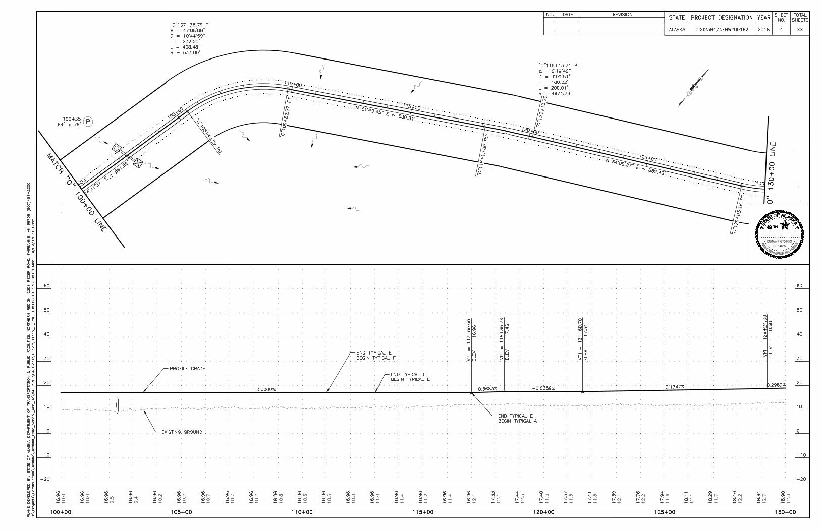
N
I
G
N
R
D
E
R
E
S
I
G
E
T
S
P
O
R
SEF
E
L
A
N
IO
R
E
E
JONATHAN J. HUTCHINSONCE 14655
AutoCAD SHX Text
ALASKA
AutoCAD SHX Text
STATE
AutoCAD SHX Text
YEAR
AutoCAD SHX Text
PROJECT DESIGNATION
AutoCAD SHX Text
SHEET NO.
AutoCAD SHX Text
TOTAL SHEETS
AutoCAD SHX Text
0002384/NFHWY00162
AutoCAD SHX Text
2018
AutoCAD SHX Text
4
AutoCAD SHX Text
XX
AutoCAD SHX Text
EXISTING GROUND
AutoCAD SHX Text
PLANS DEVELOPED BY: STATE OF ALASKA DEPARTMENT OF TRANSPORTATION & PUBLIC FACILITIES, NORTHERN REGION, 2301 PEGER ROAD, FAIRBANKS, AK 99709 (907)451-2200
AutoCAD SHX Text
REVISION
AutoCAD SHX Text
DATE
AutoCAD SHX Text
NO.
AutoCAD SHX Text
K
AutoCAD SHX Text
49
AutoCAD SHX Text
E
AutoCAD SHX Text
S
AutoCAD SHX Text
T
AutoCAD SHX Text
T
AutoCAD SHX Text
A
AutoCAD SHX Text
TH
AutoCAD SHX Text
A
AutoCAD SHX Text
O
AutoCAD SHX Text
F
AutoCAD SHX Text
L
AutoCAD SHX Text
A
AutoCAD SHX Text
S
AutoCAD SHX Text
A
AutoCAD SHX Text
END TYPICAL E BEGIN TYPICAL F
AutoCAD SHX Text
PROFILE GRADE
AutoCAD SHX Text
END TYPICAL F BEGIN TYPICAL E
AutoCAD SHX Text
END TYPICAL E BEGIN TYPICAL A

N
I
G
N
R
D
E
R
E
S
I
G
E
T
S
P
O
R
SEF
E
L
A
N
IO
R
E
E
JONATHAN J. HUTCHINSONCE 14655
AutoCAD SHX Text
ALASKA
AutoCAD SHX Text
STATE
AutoCAD SHX Text
YEAR
AutoCAD SHX Text
PROJECT DESIGNATION
AutoCAD SHX Text
SHEET NO.
AutoCAD SHX Text
TOTAL SHEETS
AutoCAD SHX Text
0002384/NFHWY00162
AutoCAD SHX Text
2018
AutoCAD SHX Text
5
AutoCAD SHX Text
XX
AutoCAD SHX Text
EXISTING GROUND
AutoCAD SHX Text
PROFILE GRADE
AutoCAD SHX Text
PLANS DEVELOPED BY: STATE OF ALASKA DEPARTMENT OF TRANSPORTATION & PUBLIC FACILITIES, NORTHERN REGION, 2301 PEGER ROAD, FAIRBANKS, AK 99709 (907)451-2200
AutoCAD SHX Text
REVISION
AutoCAD SHX Text
DATE
AutoCAD SHX Text
NO.
AutoCAD SHX Text
K
AutoCAD SHX Text
49
AutoCAD SHX Text
E
AutoCAD SHX Text
S
AutoCAD SHX Text
T
AutoCAD SHX Text
T
AutoCAD SHX Text
A
AutoCAD SHX Text
TH
AutoCAD SHX Text
A
AutoCAD SHX Text
O
AutoCAD SHX Text
F
AutoCAD SHX Text
L
AutoCAD SHX Text
A
AutoCAD SHX Text
S
AutoCAD SHX Text
A
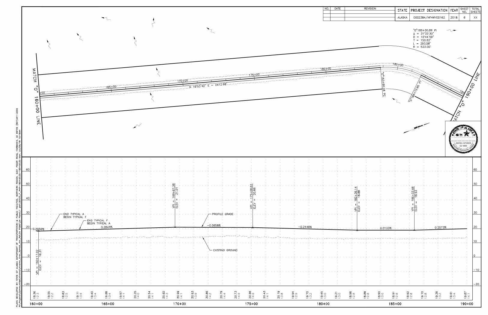
N
I
G
N
R
D
E
R
E
S
I
G
E
T
S
P
O
R
SEF
E
L
A
N
IO
R
E
E
JONATHAN J. HUTCHINSONCE 14655
AutoCAD SHX Text
ALASKA
AutoCAD SHX Text
STATE
AutoCAD SHX Text
YEAR
AutoCAD SHX Text
PROJECT DESIGNATION
AutoCAD SHX Text
SHEET NO.
AutoCAD SHX Text
TOTAL SHEETS
AutoCAD SHX Text
0002384/NFHWY00162
AutoCAD SHX Text
2018
AutoCAD SHX Text
6
AutoCAD SHX Text
XX
AutoCAD SHX Text
EXISTING GROUND
AutoCAD SHX Text
PROFILE GRADE
AutoCAD SHX Text
PLANS DEVELOPED BY: STATE OF ALASKA DEPARTMENT OF TRANSPORTATION & PUBLIC FACILITIES, NORTHERN REGION, 2301 PEGER ROAD, FAIRBANKS, AK 99709 (907)451-2200
AutoCAD SHX Text
REVISION
AutoCAD SHX Text
DATE
AutoCAD SHX Text
NO.
AutoCAD SHX Text
K
AutoCAD SHX Text
49
AutoCAD SHX Text
E
AutoCAD SHX Text
S
AutoCAD SHX Text
T
AutoCAD SHX Text
T
AutoCAD SHX Text
A
AutoCAD SHX Text
TH
AutoCAD SHX Text
A
AutoCAD SHX Text
O
AutoCAD SHX Text
F
AutoCAD SHX Text
L
AutoCAD SHX Text
A
AutoCAD SHX Text
S
AutoCAD SHX Text
A
AutoCAD SHX Text
END TYPICAL A BEGIN TYPICAL F
AutoCAD SHX Text
END TYPICAL F BEGIN TYPICAL A

N
I
G
N
R
D
E
R
E
S
I
G
E
T
S
P
O
R
SEF
E
L
A
N
IO
R
E
E
JONATHAN J. HUTCHINSONCE 14655
AutoCAD SHX Text
ALASKA
AutoCAD SHX Text
STATE
AutoCAD SHX Text
YEAR
AutoCAD SHX Text
PROJECT DESIGNATION
AutoCAD SHX Text
SHEET NO.
AutoCAD SHX Text
TOTAL SHEETS
AutoCAD SHX Text
0002384/NFHWY00162
AutoCAD SHX Text
2018
AutoCAD SHX Text
7
AutoCAD SHX Text
XX
AutoCAD SHX Text
EXISTING GROUND
AutoCAD SHX Text
PROFILE GRADE
AutoCAD SHX Text
PLANS DEVELOPED BY: STATE OF ALASKA DEPARTMENT OF TRANSPORTATION & PUBLIC FACILITIES, NORTHERN REGION, 2301 PEGER ROAD, FAIRBANKS, AK 99709 (907)451-2200
AutoCAD SHX Text
REVISION
AutoCAD SHX Text
DATE
AutoCAD SHX Text
NO.
AutoCAD SHX Text
K
AutoCAD SHX Text
49
AutoCAD SHX Text
E
AutoCAD SHX Text
S
AutoCAD SHX Text
T
AutoCAD SHX Text
T
AutoCAD SHX Text
A
AutoCAD SHX Text
TH
AutoCAD SHX Text
A
AutoCAD SHX Text
O
AutoCAD SHX Text
F
AutoCAD SHX Text
L
AutoCAD SHX Text
A
AutoCAD SHX Text
S
AutoCAD SHX Text
A
AutoCAD SHX Text
END TYPICAL A BEGIN TYPICAL F
AutoCAD SHX Text
END TYPICAL F BEGIN TYPICAL A
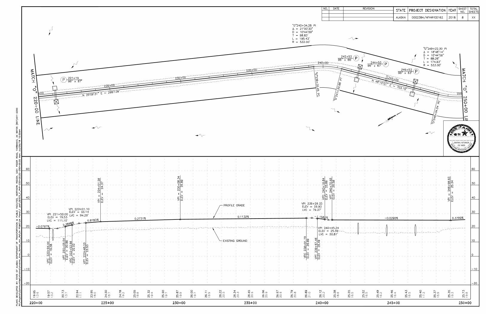
N
I
G
N
R
D
E
R
E
S
I
G
E
T
S
P
O
R
SEF
E
L
A
N
IO
R
E
E
JONATHAN J. HUTCHINSONCE 14655
AutoCAD SHX Text
ALASKA
AutoCAD SHX Text
STATE
AutoCAD SHX Text
YEAR
AutoCAD SHX Text
PROJECT DESIGNATION
AutoCAD SHX Text
SHEET NO.
AutoCAD SHX Text
TOTAL SHEETS
AutoCAD SHX Text
0002384/NFHWY00162
AutoCAD SHX Text
2018
AutoCAD SHX Text
8
AutoCAD SHX Text
XX
AutoCAD SHX Text
EXISTING GROUND
AutoCAD SHX Text
PROFILE GRADE
AutoCAD SHX Text
PLANS DEVELOPED BY: STATE OF ALASKA DEPARTMENT OF TRANSPORTATION & PUBLIC FACILITIES, NORTHERN REGION, 2301 PEGER ROAD, FAIRBANKS, AK 99709 (907)451-2200
AutoCAD SHX Text
REVISION
AutoCAD SHX Text
DATE
AutoCAD SHX Text
NO.
AutoCAD SHX Text
K
AutoCAD SHX Text
49
AutoCAD SHX Text
E
AutoCAD SHX Text
S
AutoCAD SHX Text
T
AutoCAD SHX Text
T
AutoCAD SHX Text
A
AutoCAD SHX Text
TH
AutoCAD SHX Text
A
AutoCAD SHX Text
O
AutoCAD SHX Text
F
AutoCAD SHX Text
L
AutoCAD SHX Text
A
AutoCAD SHX Text
S
AutoCAD SHX Text
A

N
I
G
N
R
D
E
R
E
S
I
G
E
T
S
P
O
R
SEF
E
L
A
N
IO
R
E
E
JONATHAN J. HUTCHINSONCE 14655
AutoCAD SHX Text
ALASKA
AutoCAD SHX Text
STATE
AutoCAD SHX Text
YEAR
AutoCAD SHX Text
PROJECT DESIGNATION
AutoCAD SHX Text
SHEET NO.
AutoCAD SHX Text
TOTAL SHEETS
AutoCAD SHX Text
0002384/NFHWY00162
AutoCAD SHX Text
2018
AutoCAD SHX Text
9
AutoCAD SHX Text
XX
AutoCAD SHX Text
EXISTING GROUND
AutoCAD SHX Text
PLANS DEVELOPED BY: STATE OF ALASKA DEPARTMENT OF TRANSPORTATION & PUBLIC FACILITIES, NORTHERN REGION, 2301 PEGER ROAD, FAIRBANKS, AK 99709 (907)451-2200
AutoCAD SHX Text
REVISION
AutoCAD SHX Text
DATE
AutoCAD SHX Text
NO.
AutoCAD SHX Text
K
AutoCAD SHX Text
49
AutoCAD SHX Text
E
AutoCAD SHX Text
S
AutoCAD SHX Text
T
AutoCAD SHX Text
T
AutoCAD SHX Text
A
AutoCAD SHX Text
TH
AutoCAD SHX Text
A
AutoCAD SHX Text
O
AutoCAD SHX Text
F
AutoCAD SHX Text
L
AutoCAD SHX Text
A
AutoCAD SHX Text
S
AutoCAD SHX Text
A
AutoCAD SHX Text
END TYPICAL A BEGIN TYPICAL F
AutoCAD SHX Text
END TYPICAL F BEGIN TYPICAL A
AutoCAD SHX Text
PROFILE GRADE
AutoCAD SHX Text
END TYPICAL A BEGIN TYPICAL F
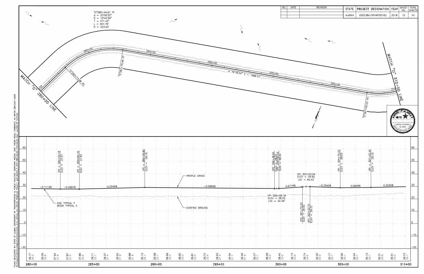
N
I
G
N
R
D
E
R
E
S
I
G
E
T
S
P
O
R
SEF
E
L
A
N
IO
R
E
E
JONATHAN J. HUTCHINSONCE 14655
AutoCAD SHX Text
ALASKA
AutoCAD SHX Text
STATE
AutoCAD SHX Text
YEAR
AutoCAD SHX Text
PROJECT DESIGNATION
AutoCAD SHX Text
SHEET NO.
AutoCAD SHX Text
TOTAL SHEETS
AutoCAD SHX Text
0002384/NFHWY00162
AutoCAD SHX Text
2018
AutoCAD SHX Text
10
AutoCAD SHX Text
XX
AutoCAD SHX Text
EXISTING GROUND
AutoCAD SHX Text
PROFILE GRADE
AutoCAD SHX Text
PLANS DEVELOPED BY: STATE OF ALASKA DEPARTMENT OF TRANSPORTATION & PUBLIC FACILITIES, NORTHERN REGION, 2301 PEGER ROAD, FAIRBANKS, AK 99709 (907)451-2200
AutoCAD SHX Text
REVISION
AutoCAD SHX Text
DATE
AutoCAD SHX Text
NO.
AutoCAD SHX Text
K
AutoCAD SHX Text
49
AutoCAD SHX Text
E
AutoCAD SHX Text
S
AutoCAD SHX Text
T
AutoCAD SHX Text
T
AutoCAD SHX Text
A
AutoCAD SHX Text
TH
AutoCAD SHX Text
A
AutoCAD SHX Text
O
AutoCAD SHX Text
F
AutoCAD SHX Text
L
AutoCAD SHX Text
A
AutoCAD SHX Text
S
AutoCAD SHX Text
A
AutoCAD SHX Text
END TYPICAL F BEGIN TYPICAL A

N
I
G
N
R
D
E
R
E
S
I
G
E
T
S
P
O
R
SEF
E
L
A
N
IO
R
E
E
JONATHAN J. HUTCHINSONCE 14655
AutoCAD SHX Text
ALASKA
AutoCAD SHX Text
STATE
AutoCAD SHX Text
YEAR
AutoCAD SHX Text
PROJECT DESIGNATION
AutoCAD SHX Text
SHEET NO.
AutoCAD SHX Text
TOTAL SHEETS
AutoCAD SHX Text
0002384/NFHWY00162
AutoCAD SHX Text
2018
AutoCAD SHX Text
11
AutoCAD SHX Text
XX
AutoCAD SHX Text
PLANS DEVELOPED BY: STATE OF ALASKA DEPARTMENT OF TRANSPORTATION & PUBLIC FACILITIES, NORTHERN REGION, 2301 PEGER ROAD, FAIRBANKS, AK 99709 (907)451-2200
AutoCAD SHX Text
REVISION
AutoCAD SHX Text
DATE
AutoCAD SHX Text
NO.
AutoCAD SHX Text
K
AutoCAD SHX Text
49
AutoCAD SHX Text
E
AutoCAD SHX Text
S
AutoCAD SHX Text
T
AutoCAD SHX Text
T
AutoCAD SHX Text
A
AutoCAD SHX Text
TH
AutoCAD SHX Text
A
AutoCAD SHX Text
O
AutoCAD SHX Text
F
AutoCAD SHX Text
L
AutoCAD SHX Text
A
AutoCAD SHX Text
S
AutoCAD SHX Text
A
AutoCAD SHX Text
END TYPICAL A BEGIN TYPICAL F
AutoCAD SHX Text
END TYPICAL F BEGIN TYPICAL A
AutoCAD SHX Text
EXISTING GROUND
AutoCAD SHX Text
PROFILE GRADE
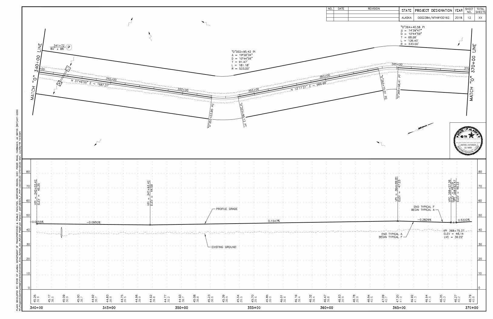
N
I
G
N
R
D
E
R
E
S
I
G
E
T
S
P
O
R
SEF
E
L
A
N
IO
R
E
E
JONATHAN J. HUTCHINSONCE 14655
AutoCAD SHX Text
ALASKA
AutoCAD SHX Text
STATE
AutoCAD SHX Text
YEAR
AutoCAD SHX Text
PROJECT DESIGNATION
AutoCAD SHX Text
SHEET NO.
AutoCAD SHX Text
TOTAL SHEETS
AutoCAD SHX Text
0002384/NFHWY00162
AutoCAD SHX Text
2018
AutoCAD SHX Text
12
AutoCAD SHX Text
XX
AutoCAD SHX Text
EXISTING GROUND
AutoCAD SHX Text
PROFILE GRADE
AutoCAD SHX Text
PLANS DEVELOPED BY: STATE OF ALASKA DEPARTMENT OF TRANSPORTATION & PUBLIC FACILITIES, NORTHERN REGION, 2301 PEGER ROAD, FAIRBANKS, AK 99709 (907)451-2200
AutoCAD SHX Text
REVISION
AutoCAD SHX Text
DATE
AutoCAD SHX Text
NO.
AutoCAD SHX Text
K
AutoCAD SHX Text
49
AutoCAD SHX Text
E
AutoCAD SHX Text
S
AutoCAD SHX Text
T
AutoCAD SHX Text
T
AutoCAD SHX Text
A
AutoCAD SHX Text
TH
AutoCAD SHX Text
A
AutoCAD SHX Text
O
AutoCAD SHX Text
F
AutoCAD SHX Text
L
AutoCAD SHX Text
A
AutoCAD SHX Text
S
AutoCAD SHX Text
A
AutoCAD SHX Text
END TYPICAL A BEGIN TYPICAL F
AutoCAD SHX Text
END TYPICAL F BEGIN TYPICAL A
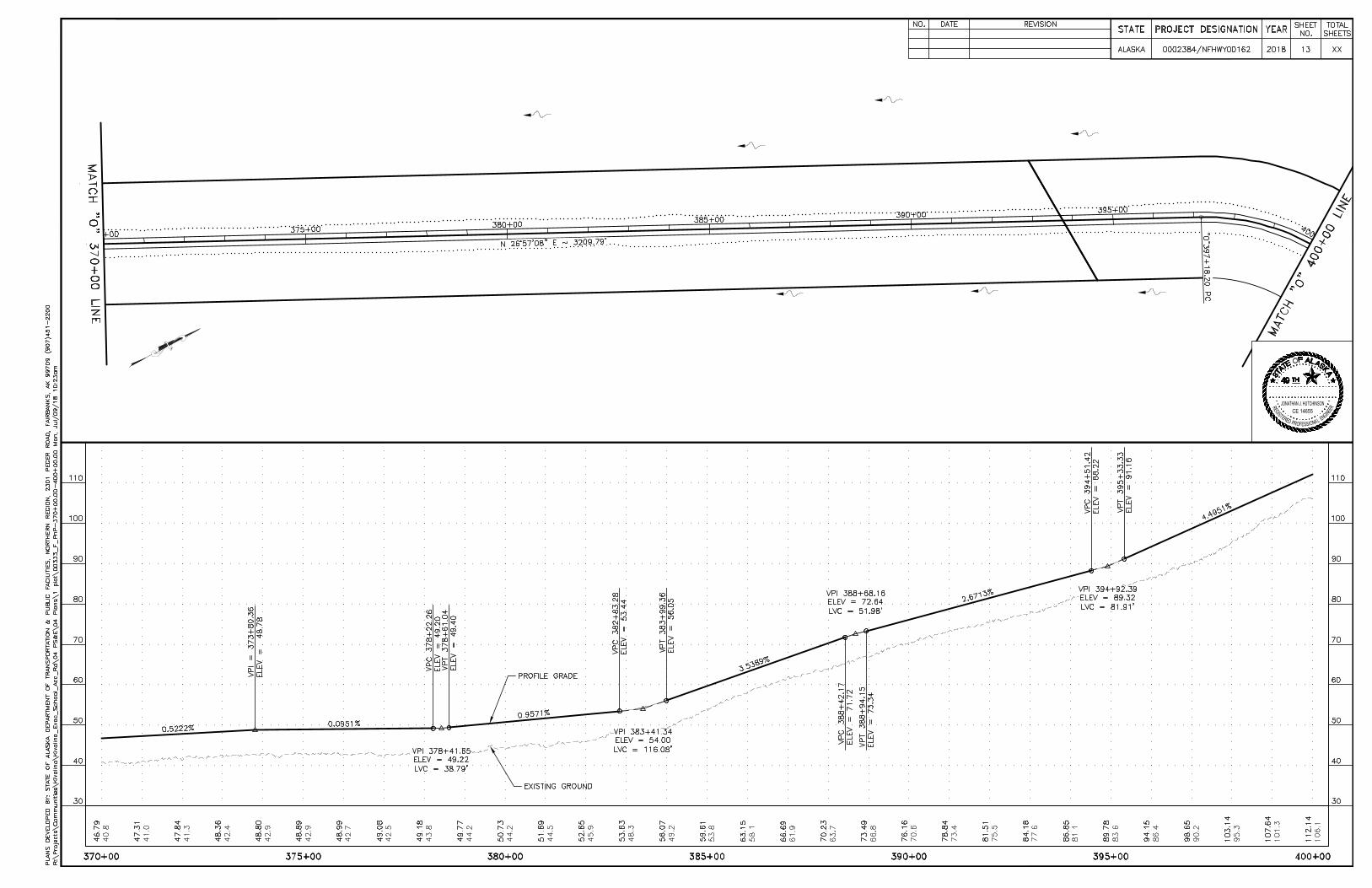
N
I
G
N
R
D
E
R
E
S
I
G
E
T
S
P
O
R
SEF
E
L
A
N
IO
R
E
E
JONATHAN J. HUTCHINSONCE 14655
AutoCAD SHX Text
ALASKA
AutoCAD SHX Text
STATE
AutoCAD SHX Text
YEAR
AutoCAD SHX Text
PROJECT DESIGNATION
AutoCAD SHX Text
SHEET NO.
AutoCAD SHX Text
TOTAL SHEETS
AutoCAD SHX Text
0002384/NFHWY00162
AutoCAD SHX Text
2018
AutoCAD SHX Text
13
AutoCAD SHX Text
XX
AutoCAD SHX Text
EXISTING GROUND
AutoCAD SHX Text
PROFILE GRADE
AutoCAD SHX Text
PLANS DEVELOPED BY: STATE OF ALASKA DEPARTMENT OF TRANSPORTATION & PUBLIC FACILITIES, NORTHERN REGION, 2301 PEGER ROAD, FAIRBANKS, AK 99709 (907)451-2200
AutoCAD SHX Text
REVISION
AutoCAD SHX Text
DATE
AutoCAD SHX Text
NO.
AutoCAD SHX Text
K
AutoCAD SHX Text
49
AutoCAD SHX Text
E
AutoCAD SHX Text
S
AutoCAD SHX Text
T
AutoCAD SHX Text
T
AutoCAD SHX Text
A
AutoCAD SHX Text
TH
AutoCAD SHX Text
A
AutoCAD SHX Text
O
AutoCAD SHX Text
F
AutoCAD SHX Text
L
AutoCAD SHX Text
A
AutoCAD SHX Text
S
AutoCAD SHX Text
A

N
I
G
N
R
D
E
R
E
S
I
G
E
T
S
P
O
R
SEF
E
L
A
N
IO
R
E
E
JONATHAN J. HUTCHINSONCE 14655
AutoCAD SHX Text
ALASKA
AutoCAD SHX Text
STATE
AutoCAD SHX Text
YEAR
AutoCAD SHX Text
PROJECT DESIGNATION
AutoCAD SHX Text
SHEET NO.
AutoCAD SHX Text
TOTAL SHEETS
AutoCAD SHX Text
0002384/NFHWY00162
AutoCAD SHX Text
2018
AutoCAD SHX Text
14
AutoCAD SHX Text
XX
AutoCAD SHX Text
EXISTING GROUND
AutoCAD SHX Text
PROFILE GRADE
AutoCAD SHX Text
PLANS DEVELOPED BY: STATE OF ALASKA DEPARTMENT OF TRANSPORTATION & PUBLIC FACILITIES, NORTHERN REGION, 2301 PEGER ROAD, FAIRBANKS, AK 99709 (907)451-2200
AutoCAD SHX Text
REVISION
AutoCAD SHX Text
DATE
AutoCAD SHX Text
NO.
AutoCAD SHX Text
K
AutoCAD SHX Text
49
AutoCAD SHX Text
E
AutoCAD SHX Text
S
AutoCAD SHX Text
T
AutoCAD SHX Text
T
AutoCAD SHX Text
A
AutoCAD SHX Text
TH
AutoCAD SHX Text
A
AutoCAD SHX Text
O
AutoCAD SHX Text
F
AutoCAD SHX Text
L
AutoCAD SHX Text
A
AutoCAD SHX Text
S
AutoCAD SHX Text
A
AutoCAD SHX Text
END TYPICAL A BEGIN TYPICAL H
AutoCAD SHX Text
END TYPICAL H
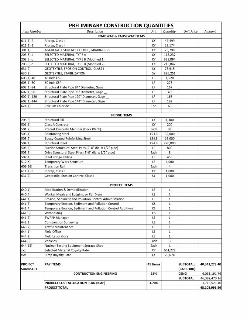
Item Number Description Unit Quantity Unit Price Amount
611(1)‐2 Riprap, Class II CY 47,499
611(1)‐1 Riprap, Class I CY 22,174
301(4) AGGREGATE SURFACE COURSE, GRADING E‐1 CY 23,798
203(5)‐a SELECTED MATERIAL, TYPE A CY 115,237
203(5)‐b SELECTED MATERIAL, TYPE B (Modified 1) CY 329,094
203(5)‐c SELECTED MATERIAL, TYPE B (Modified 2) CY 215,847
631(2) GEOTEXTILE, EROSION CONTROL, CLASS I SY 73,915
630(2) GEOTEXTILE, STABILIZATION SY 386,251
603(1)‐48 48 Inch CSP LF 1,520
603(1)‐60 60 Inch CSP LF 276
602(1)‐84 Structural Plate Pipe 84" Diameter, Gage __ LF 167
602(1)‐96 Structural Plate Pipe 96" Diameter, Gage __ LF 375
602(1)‐120 Structural Plate Pipe 120" Diameter, Gage __ LF 163
602(1)‐144 Structural Plate Pipe 144" Diameter, Gage __ LF 192
624(1) Calcium Chloride Ton 69
205(6) Structural Fill CY 1,100
501(1) Class A Concrete CY 200
501(7) Precast Concrete Member (Deck Plank) Each 38
503(1) Reinforcing Steel LS‐LB 32,000
503(2) Epoxy‐Coated Reinforicing Steel LS‐LB 16,000
504(1) Structural Steel LS‐LB 270,000
505(5) Furnish Structural Steel Piles (2'‐0" dia. x 1/2" pipe) LF 800
505(6) Drive Structural Steel Piles (2'‐0" dia. x 1/2" pipe) Each 8
507(1) Steel Bridge Railing LF 456
512(X) Temporary Work Structure LS 4,080
606(16) Transition Rail Each 4
611(1)‐3 Riprap, Class III CY 1,000
631(2) Geotextile, Erosion Control, Class I SY 1,000
640(1) Mobilization & Demobilization LS 1
640(4) Worker Meals and Lodging, or Per Diem LS 1
641(1) Erosion, Sediment and Pollution Control Administration LS 1
641(3) Temporary Erosion, Sediment and Pollution Control CS 1
641(4) Temporary Erosion, Sediment and Pollution Control Additives CS 1
641(6) Withholding CS 1
641(7) SWPPP Manager LS 1
642(1) Construction Surveying LS 1
643(2) Traffic Maintenance LS 1
644(1) Field Office LS 1
644(2) Field Laboratory LS 1
644(6) Vehicles Each 3
644(15) Nuclear Testing Equipment Storage Shed Each 1
xxx Selected Material Royalty Rate CY 661,279
xxx Rirap Royalty Rate CY 70,674
PROJECT
SUMMARY
PAY ITEMS: 41 Items SUBTOTAL:
(BASIC BID)
40,341,278.40
CENG 6,051,191.76
SUBTOTAL 46,392,470.16
INDIRECT COST ALLOCATION PLAN (ICAP) 3.70% 1,716,521.40
PROJECT TOTAL 48,108,991.56
PRELIMINARY CONSTRUCTION QUANTITIES
ROADWAY & CAUSEWAY ITEMS
BRIDGE ITEMS
PROJECT ITEMS
CONTRUCTION ENGINEERING 15%