A Holocene Geoarchaeological Record for the Upper Willamette

APFP Regulation 5(2)(a)
Planning Act 2008
Infrastructure Planning (Applications: Prescribed Forms and Procedure) Regulations 2009
Volume 6
October 2018
A585 Windy Harbour to Skippool Improvement Scheme
TR010035
6.7.3 ES Appendix 7.3: Geoarchaeological Assessment
A585 Windy Harbour to Skippool Improvement Scheme Appendix 7.3: Geoarchaeological Assessment
Planning Inspectorate Scheme Ref: TR010035 Application Document Ref: TR010035/APP/6.7.3
Page Left Intentionally Blank
A585 Windy Harbour to Skippool Improvement Scheme Appendix 7.3: Geoarchaeological Assessment
Planning Inspectorate Scheme Ref: TR010035 Application Document Ref: TR010035/APP/6.7.3
Infrastructure Planning
Planning Act 2008
The Infrastructure Planning (Applications: Prescribed Forms and
Procedure) Regulations 2009
A585 Windy Harbour to Skippool Improvement Scheme
Development Consent Order 201[ ]
ES APPENDIX 7.3: GEOARCHAEOLOGICAL ASSESSMENT
Regulation Number: Regulation 5(2)(a) Planning Inspectorate Scheme Reference
TR010035
Application Document Reference TR010035/APP/6.7.3
Author: A585 Windy Harbour to Skippool Improvement Scheme Project Team, Highways England
Version Date Status of Version Rev 0 October 2018 DCO submission

A585 Windy Harbour to Skippool Improvement Scheme Appendix 7.3: Geoarchaeological Assessment
Planning Inspectorate Scheme Ref: TR010035 Application Document Ref: TR010035/APP/6.7.3
Page Left Intentionally Blank

©Oxford Archaeology Ltd 13 July 2018
Windy Harbour to Skippool, Lancashire
Deposit Model Report
July 2018
Client: Arcadis
Issue No: V01 OA Reference No: L11131 NGR: SD 354405 to SD 376395


A585 Windy Harbour to Skippool improvements, Lancashire V01A
©Oxford Archaeology Ltd 13 July 2018
Client Name: Arcadis Consulting
Document Title: A585 Windy Harbour to Skippool Improvements, Lancashire
Document Type: Deposit Model Report
Report No.:
Grid Reference: NGR SD 354405 to SD 376395
Planning Reference: -
Site Code: -
Invoice Code: L11131
Receiving Body: -
Accession No.: -
OA Document File Location: \oau\GeoarchaeologicalServices\GEOARCHREPORTS\LANCASHIRE\ WINDY_HARBOUR_SKIPPOOL_LANCS\REPORT
OA Graphics File Location: \oau\GeoarchaeologicalServices\GEOARCHREPORTS\LANCASHIRE\ WINDY_HARBOUR_SKIPPOOL_LANCS\REPORT
Issue No: V01A
Date: July 2018
Prepared by: (Geoarchaeologist), (Palynologist)
Checked by: (Head of Geoarchaeological Services)
Edited by: (Senior Project Manager)
Approved for Issue by: (Operations Manager, OAN)
Signature:
……………………………………….. Disclaimer: This document has been prepared for the titled project or named part thereof and should not be relied upon or used for any other project without an independent check being carried out as to its suitability and prior written authority of Oxford Archaeology being obtained. Oxford Archaeology accepts no responsibility or liability for the consequences of this document being used for a purpose other than the purposes for which it was commissioned. Any person/party using or relying on the document for such other purposes agrees and will by such use or reliance be taken to confirm their agreement to indemnify Oxford Archaeology for all loss or damage resulting therefrom. Oxford Archaeology accepts no responsibility or liability for this document to any party other than the person/party by whom it was commissioned.
OA South
OA East
OA North
e.
w. Oxford Archaeology is a registered Charity: No. 285627

A585 Windy Harbour to Skippool Improvements, Lancashire Deposit Model Report V01A
©Oxford Archaeology Ltd iv 13 July 2018
A585 Windy Harbour to Skippool Improvements, Lancashire Deposit Model Report
Written by
Contents
Summary ............................................................................................................................................................... vii
Acknowledgements ............................................................................................................................................... viii
1 INTRODUCTION ....................................................................................................... 1
1.1 Scope of work............................................................................................................................................... 1
1.2 Location, topography and geology................................................................................................................ 1
1.3 Archaeological background .......................................................................................................................... 2
1.4 Regional vegetation history .......................................................................................................................... 3
1.5 Sea-level changes in northern England ......................................................................................................... 4
2 AIMS AND METHODOLOGY ..................................................................................... 6
2.1 Aims ............................................................................................................................................................. 6
2.2 Methodology ................................................................................................................................................ 6
3 RESULTS .................................................................................................................. 8
3.1 Introduction and presentation of results ...................................................................................................... 8
3.2 Stratigraphic sequence ................................................................................................................................. 8
4 DISCUSSION .......................................................................................................... 11
5 RECOMMENDATIONS ........................................................................................... 13
APPENDIX A DEPOSIT MODEL DATASET ....................................................................... 14
Location Details ..................................................................................................................................................... 14
Correlated Stratigraphy ......................................................................................................................................... 17
APPENDIX B PLATES .................................................................................................... 26
APPENDIX B BIBLIOGRAPHY ......................................................................................... 27
A585 Windy Harbour to Skippool improvements, Lancashire V01A
©Oxford Archaeology Ltd v 13 July 2018
List of Figures
Fig. 1 Site location plan Fig. 2 Borehole location plan Fig. 3 Borehole location and LiDAR elevation data Fig. 4 Superficial surface geology mapped by the BGS Fig. 5 Stratigraphic transect Fig. 6 Modelled thickness of Holocene deposits in metres (including made ground)


A585 Windy Harbour to Skippool improvements, Lancashire V01A
©Oxford Archaeology Ltd vii 13 July 2018
Summary
Oxford Archaeology were commissioned by Arcadis Consulting to undertake geoarchaeological deposit modelling along the route of the proposed A585 Windy Harbour to Skippool Improvement Scheme, Lancashire. The Scheme covers an area of c 106,200 hectares, stretching c 5km along the south of the A585 and to the east of Skippool, between Skippool and Windy Harbour junction.
The primary aim of the deposit modelling was to provide preliminary base-line data on the nature of the sub-surface sediment sequences and their geoarchaeological and palaeoenvironmental potential, and to identify any horizons within these deposits with the potential to preserve evidence of human occupation.
Records from a total of 85 recent geotechnical interventions, supplemented by historical borehole data, have been used to compile the deposit model. The modelling revealed a basal sequence of mudstone bedrock overlain by Glacial Till and Glaciofluvial Deposits, probably dating to the last glacial period, the Devensian (> 12, 000 years BP). The surface of these deposits essentially defines the topography of the early Holocene landscape (<12, 000 years BP), which undulates locally within four valley areas (Valleys 1-4), separated by high ground. Two of these (Valleys 1 and 2) are associated with the Main Dyke and are filled by substantial depths of interbedded tidal flat deposits. Two smaller tributary valleys have been identified, one of which (Valley 3) is infilled with substantial thicknesses of peat. Thinner localised peat deposits are located in the easternmost tributary (Valley 4). The peat deposits have high potential for radiocarbon dating and palaeoenvironmental work and may be found associated with in situ archaeological remains in marginal ecotonal locations. Thick deposits of recent made ground are present overlying the natural sequences at the eastern and western extents of the Scheme, although the majority of the remainder has only a thin covering of topsoil.
A585 Windy Harbour to Skippool Improvements, Lancashire Deposit Model Report V01A
©Oxford Archaeology Ltd viii 13 July 2018
Acknowledgements
Oxford Archaeology would like to thank Arcadis Consulting for commissioning this project. The project was managed for Oxford Archaeology by
and . The deposit model was compiled by and

A585 Windy Harbour to Skippool improvements, Lancashire V01A
©Oxford Archaeology Ltd 1 13 July 2018
1 INTRODUCTION
1.1 Scope of work
1.1.1 Oxford Archaeology were commissioned by Arcadis Consulting to undertake geoarchaeological deposit modelling along the route of the proposed A585 Windy Harbour to Skippool Improvement Scheme, Lancashire (Fig. 1).
1.1.2 The A585 Windy Harbour to Skippool Improvement Scheme is a Nationally Significant Infrastructure Project (NSIP) under the Planning Act 2008. The proposed Improvement Scheme (“the Scheme”) is a 4.86km double-carriageway road scheme located between the Windy Harbour junction and the Skippool junction near Poulton-le-Fylde. The aim of the proposed road is to alleviate a major bottle neck along the A585, between the two junctions.
1.1.3 Currently the A585 is a single-carriageway trunk road, providing the only viable access from junction 3 of the M55 into Fleetwood and the associated urban areas. As a result, the A585 suffers from extreme congestion. The Government’s 2014 Autumn Statement consequently identified the need for an improvement scheme along the A585, to ameliorate the impact of traffic on the route between the two villages and remove the bottleneck.
1.1.4 It is proposed that the Scheme will provide a bypass for the village of Little Singleton, by following a route to the south of the existing A585 between Skippool and Little Singleton. Consequently, the Scheme will bypass two of the significant ‘pinch points’ to improve traffic flow and reduce the congestion affecting commuters and local residents.
1.1.5 The purpose of this report is to supplement the Cultural Heritage Desk-based Assessment (DBA) currently being prepared by Arcadis. The DBA is intended to inform the Scheme design and the Environmental Impact Assessment (EIA) with regard to Cultural Heritage constraints present within the draft order limits.
1.2 Location, topography and geology
1.2.1 The site lies to the south of the A585 and to the east of Skippool, between the Skippool and Windy Harbour junctions (Fig. 1). It is 7.5 km northeast of Blackpool town centre between NGR SD 354405 and SD 376395. To the north is the River Wyre, which at this location is tidal. The tidal limit of the river lies approximately 5km upstream to the west. Downstream the estuary veers north, entering Morecambe Bay at Fleetwood c 10km to the northwest.
1.2.2 The area of proposed development consists of a c 5km parcel of land, roughly linear in shape, crossing agricultural fields and a number of roads including Mains Lane, Garstang Road, Lodge Lane and Garstang New Road. In the vicinity of Skippool, the route crosses an area of infilled ground through which the Main Dyke discharges into the River Wyre. Between Skippool and Little Singleton the corridor runs adjacent to the Main Dyke. From Little Singleton to Bankfield Manor the corridor crosses undulating ground that rises above the Main Dyke (Figs 2 and 3).

A585 Windy Harbour to Skippool Improvements, Lancashire Deposit Model Report V01A
©Oxford Archaeology Ltd 2 13 July 2018
1.2.3 The bedrock geology of the area comprises the Singleton Mudstone Member with the Tarporley Siltstone Formation and the Sherwood Sandstone Group to the north. Superficial deposits along the estuary are mapped as tidal flat deposits (clay and silt) with peat and Devensian Glaciofluvial Deposits and Glacial Till along the Main Dyke which joins the River Wyre from the south at Skippool (Fig. 4).
1.3 Archaeological background
1.3.1 Details of the archaeological background to the Scheme are provided in the DBA currently being prepared by Arcadis. The numbers associated with heritage assets quoted below derive from the gazetteer included in the DBA.
1.3.2 There are 12 designated and 118 known non-designated heritage assets within a 1km study area of the Scheme. A further 33 assets have been identified through a walkover survey, LiDAR, aerial photographic and cartographic analysis within the draft order limits. There are no designated heritage assets located within the draft order limits, but there are 51 non-designated heritage assets. The baseline conditions and the predominantly agricultural nature of the land use across the draft order limits indicate that there is the potential for previously unrecorded archaeological remains to be present.
1.3.3 In summary, the DBA concludes there is a medium to low potential for prehistoric remains to be located within the Scheme. This potential is focused primarily to the south of Garstang Road, where several prehistoric find spots (126 and 158), a flint scatter (157), and an undated circular enclosure (60) have suggested the presence of early human activity close to the Scheme. Furthermore, potential areas of peat within the Scheme to the south of Garstang Road highlight the potential for the survival of early organic archaeological deposits. This potential is also likely in areas of peat to the north of Garstang Road, particularly following the identification of a possible Romano-British enclosed settlement (112) immediately to the west. There is, however, the potential for post-medieval activity such as quarrying and modern drainage to have impacted below ground archaeological remains. Their full impact on earlier archaeological deposits are, however, not known.
1.3.4 There is also thought to be a medium potential for Roman remains to be located within the Scheme. This potential is primarily thought to lie to the north of Garstang Road and may represent an extension to, or have been associated with, the phased Roman settlement activity (112) identified in excavations (ELA2408/ELA2409) to the west of the Main Dyke. A known area of peat in this area of the Scheme reflects the conditions found when the Roman settlement was excavated.
1.3.5 The potential for previously unrecorded Roman archaeology to be identified within the Scheme is also supported by the projected line of Ribchester Roman road (139) to the west. The area with the highest potential for archaeological remains associated with this road to occur in the Scheme is to the south west of Skippool roundabout.
1.3.6 There is negligible potential for previously unrecorded early medieval archaeological remains to be located within the Scheme. There is no known early medieval activity within the draft order limits or the 1km study area. Archaeological remains of early
A585 Windy Harbour to Skippool improvements, Lancashire V01A
©Oxford Archaeology Ltd 3 13 July 2018
medieval date are, however, relatively scarce nationwide, and should further investigations of the Scheme locate such remains, these will be at least of medium value due to their potential to contribute to regional and national research objectives.
1.3.7 There is a medium potential for both medieval and post-medieval remains to be located within the Scheme. Baseline conditions have illustrated an extensive agricultural resource from both periods and some post-medieval industrial evidence within the draft order limits.
1.3.8 There is a negligible potential for modern remains to be located within the Scheme. Baseline conditions have presented no evidence for modern activity within the draft order limits other than that of land use.
1.3.9 The overall archaeological potential for currently unknown archaeological remains to be present within the Scheme is considered to be medium.
1.4 Regional vegetation history
1.4.1 The Over Wyre area (the northern part of the Fylde) is distinguished from the southern part which is the area between the Wyre and the Ribble (and includes Poulton-le-Fylde). Peat deposits formerly dominated this landscape with mires occupying the waterlogged marine clay flats and Glacial Till hollows, from the salt marshes of the northern shore of Over Wyre to the River Wyre in the south (Middleton et al. 1995). In the south Fylde, valley and raised mires occupied low-lying topography between till uplands, forming a mosaic of open wetland and initially afforested, then cultivated ground (ibid.). The Lower Wyre Valley district is low lying and has been wet throughout the Holocene, submerged at times by marine flooding or with extensive areas of raised mires (ibid.).
1.4.2 The work of Barnes (1975) established beyond doubt that human activity had played a major role in shaping the Over Wyre landscape from the Mesolithic onwards. Environmental data spanning the second half of the Holocene have been obtained from an Over Wyre site at Fenton Cottage (Wells et al. 1997). These data, including palynology and plant macrofossil analysis, demonstrate that there has been a continuous human influence on the development of the landscape since the mire began growing, with a particularly significant deforestation episode commencing in the late Iron Age (ibid.). A major expansion of the mire system began in the late Bronze Age/early Iron Age and may have led to the abandonment of settlement in and around the peatlands during much of the Iron Age (ibid.). Wells et al. (2001) described a human skull discovered within the basal sediments of a relict mire at Poulton-le-Fylde, dating to the later Bronze Age. The find was located within a layer of silty wood peat, approximately 1m deep, representing the ancient root system of a hazel copse and containing many hazelnuts and some charcoal.
1.4.3 Previous palaeoenvironmental work by Oxford Archaeology (OA North 2010) on a Russian core adjacent to Holt’s Lane, Poulton-le-Fylde suggested that the deposits accumulated when the site lay within an area of floodplain largely occupied by alder carr, adjacent to the River Wyre. The earliest sediments date to the Mesolithic period (SUERC 33859: 5640-5510 cal BC; 6650±35 BP). These deposits were succeeded by a marine blue/grey clay, containing foraminiferal test linings and dinoflagellate cysts.

A585 Windy Harbour to Skippool Improvements, Lancashire Deposit Model Report V01A
©Oxford Archaeology Ltd 4 13 July 2018
This deposit was overlain by peat, which has been dated to the earliest Bronze Age to latest Iron Age (SUERC 37121: 734-690 cal BC; 2405±30 BP). Pollen from the peat has been interpreted as suggesting a disturbed landscape, with evidence that the landscape was utilised and managed by people both as a source of wood and for farming (both pastoral and arable).
1.4.4 Pollen from two ditches from an enclosed settlement at Poulton-le-Fylde (OA North 2010) span Romano-British, medieval and post-medieval periods, and provide evidence for human impact on the landscape. Open areas of grassland together with records of cereal-type pollen have been interpreted as suggesting mixed farming economies.
1.5 Sea-level changes in northern England
1.5.1 During the last three decades detailed investigations dealing with Holocene vegetational history, the stratigraphy of coastal sediments and sea-level changes have been carried out on sites around Morecambe Bay. Marine inundation of Morecambe Bay began during the early Holocene, the rapidly rising sea-level allowing a great amount of marine sediment to infill the lower valleys - the present estuaries in Morecambe Bay. The work of Tooley (1982) has shown that areas open to the coasts of the Fylde and southern Lancashire were filled with marine sediments during several phases of sea-level rise which have occurred since the early Holocene.
1.5.2 Tooley (1982) used data from this work to reconstruct Holocene sea-level history, which shows a rapid rise in sea-level at around 7800 BP followed by a fluctuating and slowly rising sea-level for the rest of the Holocene (Zong and Tooley 1996). Since the mid-Holocene, as the rate at which sea-level rose decreased, marine sediments have accumulated to seaward, and the coastal lowlands have gradually formed.
1.5.3 Tooley’s work (1982) identified a series of 12 transgressive and regressive tendencies for the whole of Northwest England. A transgressive tendency or positive sea-level tendency is when the sea advances landward over a former land surface and the water deepens, so terrestrial sediments are replaced by littoral facies which are succeeded by deepening water facies. The converse is referred to as a regressive or negative sea-level tendency. For purposes of correlation, Tooley proposed that previously referred to transgressive sequences, Lythum I-IX, should not now be used, and they have been superseded by the 12 transgressive and regressive overlap sequences.
1.5.4 Barnes (1975) described a Bronze Age transgressive overlap and a regressive overlap sequence from Lousanna, and a Neolithic regressive overlap from Moss Farm, both sites adjacent to the River Wyre and Poulton-le-Fylde.
1.5.5 Wells et al. (1997) recorded a silty clay beneath wood peat at the base of the stratigraphic profile for Fenton Cottage. This silty clay unit contains high levels of Chenopodiaceae pollen, and records the natural development of salt marsh to reedswamp following marine transgression. The top of the silty clay (regressive
overlap) has been dated from 3950-3370 to 3350-2900 cal BC (GU 5146: 4860110
and GU 5148: 441080BP). Beneath this silty clay, marine silts and clays occur, which
A585 Windy Harbour to Skippool improvements, Lancashire V01A
©Oxford Archaeology Ltd 5 13 July 2018
are thought to correspond to a marine transgression, dated to the Late Mesolithic (c 5570-4897 BP).
1.5.6 The rate of sea-level rise for the last 3500 years is probably around 2mm/year, although a rise of over 4mm/year may have resulted in extensive inundation of coastal lowlands and shoreline retreat in Morecambe Bay (Zong and Tooley 1996). Archaeological evidence suggests that during the final marine inundation within this area, after the late Roman period but before the early medieval period, the sea encroached at least as far as the village of Pilling. This is based on finds of late Roman pottery from a deposit underneath a clay thought to be of possible marine origin (Middleton et al. 1995).
A585 Windy Harbour to Skippool Improvements, Lancashire Deposit Model Report V01A
©Oxford Archaeology Ltd 6 13 July 2018
2 AIMS AND METHODOLOGY
2.1 Aims
2.1.1 The project aims and objectives were to supplement the geotechnical sediment logs with archaeologically relevant detail to provide additional base-line data for assessing the archaeological and palaeoenvironmental potential of sub-surface deposits that may be impacted on by the Scheme. Specifically:
i. To characterise the sequence of sediments and patterns of accumulation along the route, including the depth and lateral extent of major stratigraphic units through a review of geotechnical logs and examination of samples.
ii. To identify significant variations in the deposit sequence indicative of localised features such as palaeochannels, topographic highs or buried 'islands'.
iii. To identify the location and extent of any waterlogged organic deposits and/or buried soils or land-surfaces and address the potential for the preservation and the likely location of archaeological and palaeoenvironmental remains.
iv. To clarify the relationships between sediment sequences and other deposit types, including periods of 'soil' or peat growth, and the effects of relatively recent human disturbance, including the location, extent and date of 'made ground'.
v. To discuss the sequence of sediments within the wider landscape context of known quaternary geology and geomorphology, referencing previous geoarchaeological and palaeoenvironmental work carried out in the vicinity.
2.2 Methodology
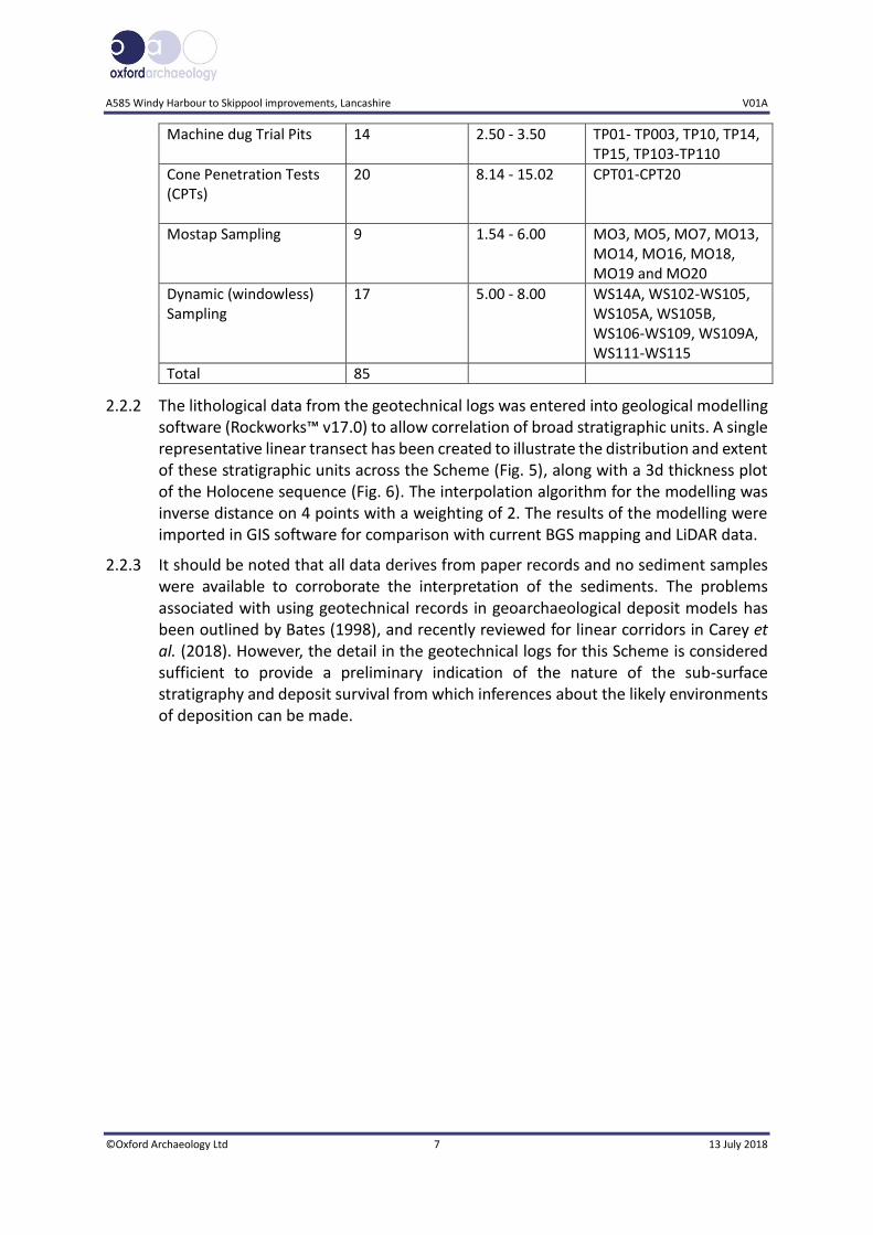
2.2.1 The geotechnical ground investigation comprised excavation of cable percussion and rotary boreholes, trial pits, dynamic (windowless) sampling and cone penetration testing, some of which included Mostap sampling. This report covers the stratigraphic sequences revealed by the boreholes from which a deposit model has been compiled. A summary of the geotechnical interventions is provided in Table 1 and the array is illustrated in Figures 2-4.
Table 1: Summary of geotechnical interventions
Type Quantity Depth range (m)
Exploratory hole IDs
Cable Percussion Boring 21 0.70 - 30.15 BH01-BH06, BH06-1, BH07, BH08, BH10, BH10A, BH11, BH11A, BH12, BH14, BH15 BH17, BH18, BH19, BH103, BH105, BH106, BH107
Cable Percussion Boring extended by Rotary Core Drilling/Open Hole Drilling
4 24.70 - 36.50 BH01A, BH13, BH101 and BH104
A585 Windy Harbour to Skippool improvements, Lancashire V01A
©Oxford Archaeology Ltd 7 13 July 2018
2.2.2 The lithological data from the geotechnical logs was entered into geological modelling software (Rockworks™ v17.0) to allow correlation of broad stratigraphic units. A single representative linear transect has been created to illustrate the distribution and extent of these stratigraphic units across the Scheme (Fig. 5), along with a 3d thickness plot of the Holocene sequence (Fig. 6). The interpolation algorithm for the modelling was inverse distance on 4 points with a weighting of 2. The results of the modelling were imported in GIS software for comparison with current BGS mapping and LiDAR data.
2.2.3 It should be noted that all data derives from paper records and no sediment samples were available to corroborate the interpretation of the sediments. The problems associated with using geotechnical records in geoarchaeological deposit models has been outlined by Bates (1998), and recently reviewed for linear corridors in Carey et al. (2018). However, the detail in the geotechnical logs for this Scheme is considered sufficient to provide a preliminary indication of the nature of the sub-surface stratigraphy and deposit survival from which inferences about the likely environments of deposition can be made.
Machine dug Trial Pits 14 2.50 - 3.50 TP01- TP003, TP10, TP14, TP15, TP103-TP110
Cone Penetration Tests (CPTs)
20 8.14 - 15.02 CPT01-CPT20
Mostap Sampling 9 1.54 - 6.00 MO3, MO5, MO7, MO13, MO14, MO16, MO18, MO19 and MO20
Dynamic (windowless) Sampling
17 5.00 - 8.00 WS14A, WS102-WS105, WS105A, WS105B, WS106-WS109, WS109A, WS111-WS115
Total 85
A585 Windy Harbour to Skippool Improvements, Lancashire Deposit Model Report V01A
©Oxford Archaeology Ltd 8 13 July 2018
3 RESULTS
3.1 Introduction and presentation of results
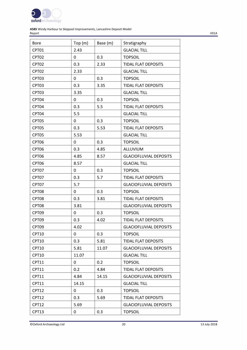
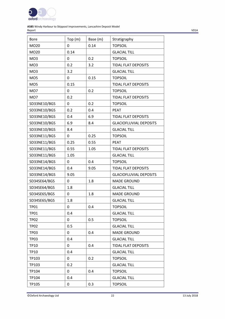
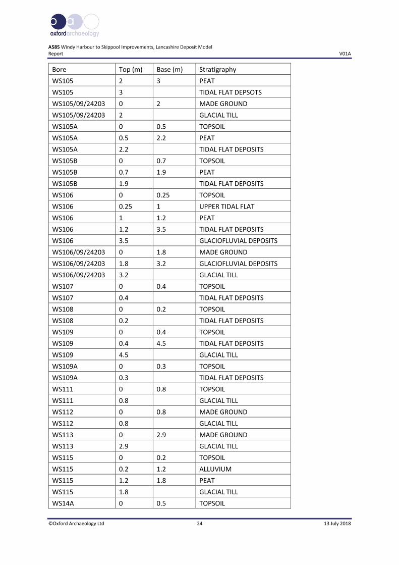
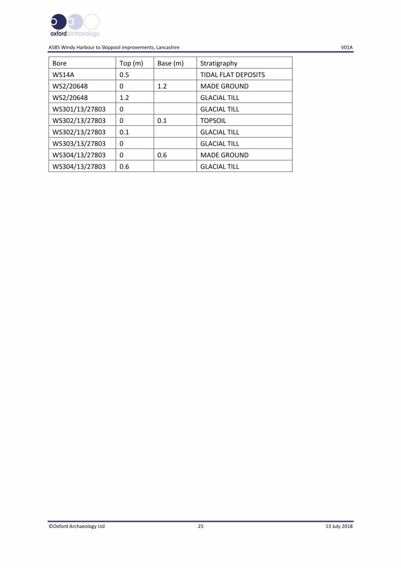
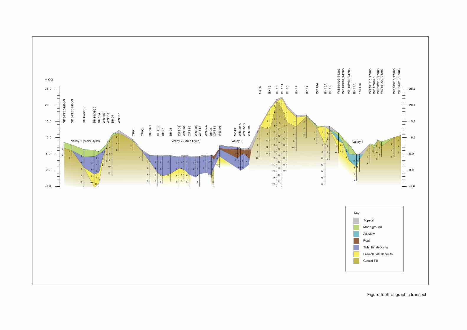
3.1.1 A deposit model has been created from the geotechnical logs outlined above and is presented as a stratigraphic transect (Fig. 5) and 3d thickness plot of the Holocene sequence (Fig. 6). Appendix A provides details of the geotechnical locations and the correlated stratigraphy for each intervention. Appendix B includes a small number of images extracted from the geotechnical report illustrating the character of the peat deposits encountered (SOCOTEC 2018).
3.1.2 The following stratigraphic sequence has been identified:
Bedrock (Singleton Mudstone Member)
Glacial Till (Devensian)
Glaciofluvial Deposits (Devensian)
Tidal flat deposits
Peat
Alluvium
Made ground
Topsoil
3.2 Stratigraphic sequence
Pre-Holocene deposits
3.2.1 Bedrock in the area comprises the Singleton Mudstone Member and was encountered in the deeper interventions (BH01A, BH13 and BH101) at c -5m OD (15.45m, 27.2m and 26.9m below ground level (BGL) respectively).
3.2.2 The bedrock is in turn overlain by Pleistocene Glacial Till and Glaciofluvial Deposits, both units dating to the last glacial period (Devensian). The Glacial Till (Boulder Clay) is extensive in the area and was deposited through the action of ice and meltwater. It is generally described as very stiff red brown, locally grey, slightly sandy, slightly gravelly, clay with occasional sub-rounded cobbles of sandstone and mudstone. The Glaciofluvial Deposits are more localised, comprising beds, channels, plains and fans of coarse-grained sediment, deposited by meltwater, generally described as loose brown sand and gravel with lenses of clay and clayey zones. These deposits are recorded both beneath the Holocene valley sequences and capping some of the higher ground areas.
3.2.3 The surface of the Pleistocene deposits essentially defines the topography of the early Holocene landscape. The shape of this surface would have affected sedimentation patterns throughout the Holocene and influenced the site's unique sedimentary sequence. By understanding the nature of this surface, it is possible to develop a better understanding of landscape evolution and archaeological potential. The modelled surface of the Pleistocene deposits is shown in Figure 5. Areas of higher ground are
A585 Windy Harbour to Skippool improvements, Lancashire V01A
©Oxford Archaeology Ltd 9 13 July 2018
apparent, separating four valleys (Valleys 1-4). Two (Valleys 1 and 2) relate to the main drainage system associated with the Main Dyke, one a minor tributary (Valley 3) and the fourth a separate system draining into the River Wyre (Valley 4). All four are visible on surface LiDAR (Fig. 3).
3.2.4 In the northwest, BGS boreholes SD34SE64/BGS and SD34SE65/BGS show the surface of the Pleistocene deposits at c 7m OD (1.8m BGL). This drops to c -1m OD (7.5m BGL) at BH14/3936, into the valley of the Main Dyke (Valley 1). The low elevation here along with the presence of Glaciofluvial Deposits indicates that this was a substantial channel during the late Devensian and at the beginning of the Holocene.
3.2.5 The land to the west reaches an elevation of approximately 12m OD (0.8m BGL) at WS111, before the route then rejoins the Main Dyke valley (Valley 2) and runs along the northeastern edge of the valley as it veers southeast between TP02 and WS105. The surface of the Pleistocene deposits is relatively constant at an elevation of c -1 to -2m OD (5.53m and 3.57m BGL) between CPT05 and CPT15 respectively. The surface of the Glaciofluvial Deposits in WS106 lies at higher elevations at c 4m OD (3.5m BGL) which marks the location edge of a minor tributary (Valley 3) running into the Main Dyke from the east (which is visible on the LiDAR plot: Fig. 3). However, MO19, WS105A, WS105B and WS105, penetrating to a maximum depth of 7m, did not reach Pleistocene deposits.
3.2.6 The land to the east of the Main Dyke has the highest surface elevation across the site (Fig. 3). This is reflected in the deposit model, with the highest elevations of the surface of the Pleistocene deposits reaching c 22m OD (0.4m BGL) in BH101.
3.2.7 Valley 4 represents a small north-south tributary draining into the River Wyre, to the east of the high ground between BH10 and WS301/13/27803. The surface of the Pleistocene deposits is lower in this valley, the lowest being c 1m OD. Again, Glaciofluvial Deposits are present at the base of the channel suggesting it was active during the Late Devensian and early Holocene.
Holocene sedimentary sequence
3.2.8 Following the end of the Devensian glacial period, as the climate ameliorated, sea-levels began to rise, depositing fine grained sediment in lower lying areas. Extensive tidal flat deposits infilling the Main Dyke valley (Valleys 1 and 2) have an average thickness of c 6m (with a maximum thickness of 7.7m at BH649/1/SB), generally between elevations of c -2m and 5m OD but rising to c 7m OD at the valley edge. It is likely that they were deposited under a mixed energy regime, and are described as grey soft to firm silty or sandy clay varying to silty sand, often with fibrous plant inclusions and organic detritus.
3.2.9 The tidal deposits are overlain by a substantial peat unit in the vicinity of Valley 3, between CPT15 (also MO15) and WS105. This unit is thickest, between -1m and +2m OD (0.7m to 3.55m BGL) in MO19 (Plate 2). It is described as firm and spongy dark brown, slightly clayey, pseudo fibrous, locally amorphous peat with frequent fibrous plant material and moderate organic (humic) odour. The sequence in WS105 appeared a little more complex with a 0.20m bed of silty sand within the peat unit at 4.76m OD.

A585 Windy Harbour to Skippool Improvements, Lancashire Deposit Model Report V01A
©Oxford Archaeology Ltd 10 13 July 2018
The lower part of the peat here is described as plastic dark brown slightly clayey and amorphous (Plate 1).
3.2.10 Elsewhere, the peat deposits tend to be quite localised, and in addition to those shown in Figure 5, peat was also present in SD33NE10/BGS, SD33NE11/BGS and WS106 (Fig. 6). The majority of the peat deposits recorded are close to the valley edges in the vicinity of Valley 3. A thin unit of peat is also present in WS115 in Valley 4. Here it sits directly on the Glacial Till at c 3m OD (1.2-1.8m BGL).
3.2.11 Between WS106 and MO19 in Valley 3, further tidal flat deposits overlie the peat. They occur at c 7m OD, slightly higher than the other tidal flat deposits and may have been deposited during spring or other extreme high tides.
3.2.12 The fine-grained sediment infilling Valley 4 has been classified as Alluvium in the geotechnical log. This sediment unit occurs at relatively high elevations of up to +11m OD, so it is likely that part of this sediment body was deposited above the tidal limit for the area.
3.2.13 In the vicinity of Valley 1 the tidal flat deposits are sealed by relatively thick (c 2m) deposits of recent made ground, varying in composition from concrete to brown gravelly clayey fine and medium sand with a low cobble content including brick, limestone and mudstone.
3.2.14 Made ground deposits are also present in the vicinity of and east of Valley 4, although they are more localised in this area, clustering along the A585 (Fig. 6). Elsewhere the natural sequence is sealed by much thinner deposits of topsoil, described as soft, dark brown, slightly sandy, slightly gravelly clay with frequent rootlets, with a maximum thickness of 0.5m at WS14A and 0.7m at WS105B.
A585 Windy Harbour to Skippool improvements, Lancashire V01A
©Oxford Archaeology Ltd 11 13 July 2018
4 DISCUSSION
4.1.1 Overall the deposit modelling has served well in broadly characterising the nature and extent of the sub-surface stratigraphy along the route of the proposed Scheme. In summary:
The sediment sequences on a superficial level are relatively consistent with the BGS mapping of the area and are comparable with other sites investigated in the vicinity.
Four valley areas (Valleys 1-4) have been identified, infilled with mainly fine grained minerogenic sediments, probably deposited in a brackish water environment of tidal mud flats, creeks and saltmarsh. Two of these valleys (Valleys 1 and 2) are directly associated with the Main Dyke, whereas the other two are smaller tributary systems.
Substantial waterlogged peat deposits up to c 2.75m thick were found to be associated with one of the tributaries (Valley 3) and at its confluence with the Main Dyke (Valley 2). A thin localised peat was also identified in Valley 4.
No Holocene sediments were found to be present on the areas of high ground where topsoil directly overlies Pleistocene glacial deposits.
Substantial made ground deposits overlying Holocene sediments were identified in the vicinity of the Main Dyke at the north-western of the route (Valley 1) and along the line of the A585 at the eastern extent.
4.1.2 By nature, peat accumulates in stable low-energy conditions, and consequently any archaeological remains found in association are likely to be stratified and preserved in situ. The marginal location of the peat deposits, associated with a tributary valley is archaeologically significant, occupying an ecotonal zone at the interface between dry ground and wetland. Such areas may have provided a focus for activity in the past due to the abundance of natural resources available for exploitation, and preserved remains could include waterlogged timber structures.
4.1.3 The peat deposits are generally sealed beneath 0.3m to 0.7m of topsoil and/or tidal flat deposits, and those in the Valley 4 to the east are sealed by 1.0m of alluvium and 0.2m of topsoil. Where alluvium or tidal flat deposits are present overlying the peat, it is unlikely that the organic deposits have been subject to recent human disturbance, although some erosion of the upper surface may have occurred. In addition, agricultural activity in the vicinity of WS105, WS105A and WS105B may have truncated some of the peat where it is directly overlain by topsoil.
4.1.4 Any archaeological remains associated with the tidal flat deposits have the potential to have undergone a degree of reworking, particularly within the lower reaches of the Main Dyke valley (eg Valley 1) which is likely to have been influenced by marine conditions to a greater extent than other areas. The environment of deposition would suggest that activity was low-level, perhaps seasonal (eg salt-making or fish traps). There is the potential for stabilisation horizons to occur within these deposits, particularly towards the feather-edge at valley margins and in the tributary valleys away from major scour processes.
A585 Windy Harbour to Skippool Improvements, Lancashire Deposit Model Report V01A
©Oxford Archaeology Ltd 12 13 July 2018
4.1.5 Due to the thin cover of topsoil over higher ground areas, it is likely that archaeological features and artefacts has suffered a degree of disturbance and/or truncation in these areas, depending on the distribution of past land-use (eg arable and/or pastoral agriculture) and the effects of deep ploughing. However, deeper features should survive beyond the plough zone.
4.1.6 The peat deposits are considered to have high potential for the preservation of palaeoenvironmental remains (eg pollen, plant remains and insects) analysis of which could complement other studies carried out in the region (see sections 1.4 and 1.5). This is especially the case around WS105 where interdigitating layers of peat and tidal flat deposits have the potential to provide a high resolution record of past vegetation and hydrological change, the latter through the study of microfossils such as diatoms, ostracods and foraminifera. The peat deposits have excellent potential for radiocarbon dating which can provide a chronological framework for palaeoenvironmental work and any associated archaeological remains. The tidal flat deposits also offer potential for luminescence dating.
A585 Windy Harbour to Skippool improvements, Lancashire V01A
©Oxford Archaeology Ltd 13 13 July 2018
5 RECOMMENDATIONS
5.1.1 It is recommended the next stage of work includes a programme of purposive boreholes, specifically to recover high quality cores suitable for palaeoenvironmental assessment and dating work. The boreholes should aim to fill data gaps, but also target representative sequences from each of the valley locations, both at the deepest points and where the peat deposits are known to be thickest. Boreholes along the valley margins may look for indicators of human activity such as charcoal inclusions, micro-artefacts or evidence of disturbance/trampling, although shallower depths at the feather-edge should be accessible by test-pitting and/or evaluation trenching which are more reliable methods of detecting stratified archaeological remains due to the greater visibility and access to section faces they provide.
5.1.2 Boreholes targeting peat deposits should employ a coring technique that minimises compaction during drilling. This may include the use of a Russian corer or a hydraulic system such as a Mostap or Delft sampler. Should sediments be excavated during test-pitting and/or evaluation trenching, a geoarchaeologist should attend site to record the sequences and advise on sampling in line with Historic England guidelines (2015). Both borehole and trench stratigraphy should be integrated to allow the current deposit model to be updated as part of any forthcoming evaluation works.

A585 Windy Harbour to Skippool Improvements, Lancashire Deposit Model Report V01A
©Oxford Archaeology Ltd 14 13 July 2018
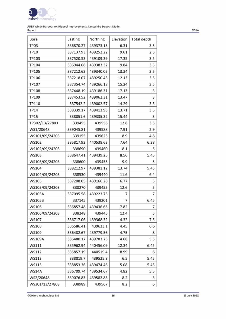
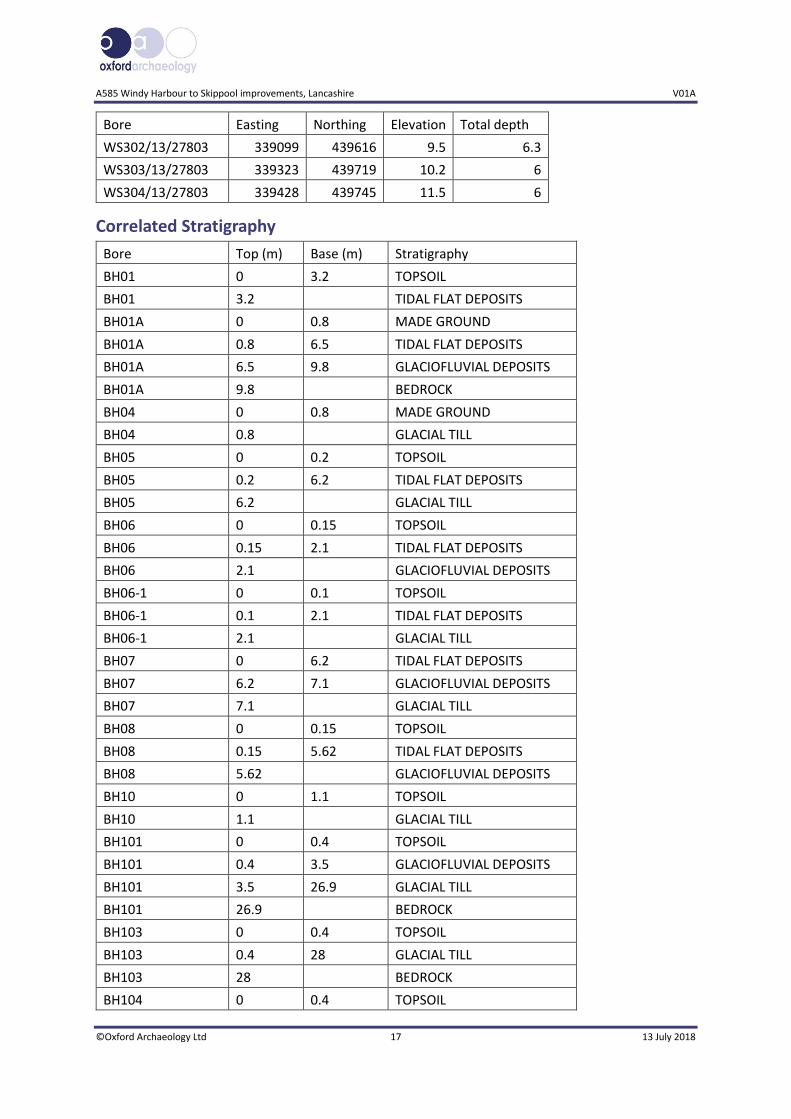
APPENDIX A DEPOSIT MODEL DATASET
Location Details
Bore Easting Northing Elevation Total depth
BH01 335746.72 440586.05 6.11 5.3
BH01A 335736 440588.05 5.87 27.5
BH04 335859.94 440453.94 11.19 12.85
BH05 336735.3 439459.45 4.78 7
BH06 336062.06 440067.23 4.77 4.95
BH06-1 336063.66 440067.83 4.77 8.95
BH07 336209 439939.04 4.51 8.55
BH08 336285.47 439846.76 4.62 7.95
BH10 338402.73 439400.1 13.62 10.5
BH101 337713.85 439181.99 22.67 33
BH103 337633.6 439123.73 20.8 30.15
BH104 335735.06 440547.86 5.35 24.7
BH105 337275.39 439256.97 13.26 10.15
BH106 337460.36 439226.88 18.25 15.15
BH107 337520.18 439069.87 15.64 10.15
BH10A 338334.11 439416.14 13.77 18.15
BH11 338811.31 439472.18 4.97 0.7
BH11A 338809.59 439470.58 4.93 8.05
BH12 337536.11 439152.41 19.25 15.15
BH12/3936 336768 439384 8.06 13.2
BH13 337640.3 439150.57 21.86 36.5
BH13/3936 338839 439488 6.4 13.2
BH14 337758.72 439159.72 21.08 19.6
BH14/3936 335664 440602 6.32 15.8
BH15 337789.09 439205.78 19.84 20
BH15/3936 335503 440595 6.49 15.45
BH17 337927.63 439234.41 17.1 11.15
BH18 338068.69 439305.32 17.04 7.05
BH19 337383.92 439151.58 13.83 10.15
BH5/2/28880 335870 440514 8.3 15
BH5/3/28880 335847 440480 10.43 14
BH649/1/SB 335739 440558 5.75 16.3
CP101/Rec 335746 440595 4.2 8.55
CP102/Rec 335733 440600 4.3 9.88
CP103/Rec 335761 440615 4.5 5.45

A585 Windy Harbour to Skippool improvements, Lancashire V01A
©Oxford Archaeology Ltd 15 13 July 2018
Bore Easting Northing Elevation Total depth
CPT01 336017.06 440080.06 4.83 8.14
CPT02 336082 440074 4.75 15
CPT03 336050.01 440048 4.7 10
CPT04 336173.92 439982.03 4.71 13.11
CPT05 336144.92 439977.93 4.71 13.45
CPT06 336287 439895 4.7 12.5
CPT07 336291.68 439850.11 4.69 10.42
CPT08 336407.88 439790.16 4.45 13.33
CPT09 336370.45 439770.22 4.17 13.03
CPT10 336515.71 439706.23 4.54 12
CPT11 336490.99 439673.63 4.33 15
CPT12 336628.83 439593.98 4.54 10.96
CPT13 336603.85 439568.92 4.49 13.04
CPT14 336707 439531 4.48 11.95
CPT15 336777.51 439462.28 4.48 10
CPT16 336735.63 439463.53 4.51 8.22
CPT17 336876.84 439450.29 8.53 9.06
CPT18 336872 439373 8 8.42
CPT19 337050.39 439234.82 7.22 15.02
CPT20 336921.34 439309.47 8.12 8.15
HDTP201/09/24203 339205 439625 9.2 0.8
HDTP202/09/24203 338835 439505 6.1 1.2
HDTP203/09/24203 338575 439445 10.5 1.2
HDTP204/09/24203 338465 439440 12.6 1.2
HDTP205/09/24203 338345 439455 12.9 1.2
MO13 336603.85 439568.92 4.49 5
MO16 336735.63 439463.53 4.51 5
MO19 337050.39 439234.82 7.22 3.55
MO20 336921.34 439309.47 8.12 1.54
MO3 336050.01 440048 4.7 3.6
MO5 336144.92 439977.93 4.71 6
MO7 336291.68 439850.11 4.69 5
SD33NE10/BGS 336600 439340 4.4 9
SD33NE11/BGS 336840 439340 5.1 9.55
SD33NE14/BGS 336720 439250 4.7 14.7
SD34SE64/BGS 335202 440605 8.69 4
SD34SE65/BGS 335322 440579.9 7.92 4
TP01 335883.58 440250.04 9.46 3.5
TP02 335972.77 440143.61 6.25 3.3
A585 Windy Harbour to Skippool Improvements, Lancashire Deposit Model Report V01A
©Oxford Archaeology Ltd 16 13 July 2018
Bore Easting Northing Elevation Total depth
TP03 336870.27 439373.15 6.31 3.5
TP10 337137.93 439252.22 9.61 2.5
TP103 337520.53 439109.39 17.35 3.5
TP104 336944.68 439383.32 9.84 3.5
TP105 337212.63 439340.05 13.34 3.5
TP106 337218.07 439250.43 12.13 3.5
TP107 337354.74 439266.18 15.24 3.5
TP108 337448.19 439186.31 17.13 3
TP109 337453.52 439062.31 13.47 3
TP110 337542.2 439002.57 14.29 3.5
TP14 338339.17 439413.93 13.71 3.5
TP15 338051.6 439335.32 15.44 3
TP302/13/27803 339455 439556 12.8 3.5
WS1/20648 339045.81 439588 7.91 2.9
WS101/09/24203 339155 439625 8.9 4.8
WS102 335817.92 440538.63 7.64 6.28
WS102/09/24203 338690 439460 8.1 5
WS103 338647.41 439439.25 8.56 5.45
WS103/09/24203 338600 439455 9.9 5
WS104 338212.97 439381.12 13.74 5.45
WS104/09/24203 338530 439440 11.6 6.4
WS105 337208.05 439166.28 6.77 5
WS105/09/24203 338270 439455 12.6 5
WS105A 337095.58 439223.75 7 7
WS105B 337145 439201 7 6.45
WS106 336857.48 439436.65 7.82 7
WS106/09/24203 338248 439445 12.4 5
WS107 336717.06 439368.32 4.32 7.5
WS108 336586.41 439633.1 4.45 6.6
WS109 336482.67 439779.56 4.75 8
WS109A 336480.17 439783.75 4.68 5.5
WS111 335962.94 440456.09 12.34 6.45
WS112 335857.19 440519.4 8.99 6
WS113 338819.7 439525.8 6.5 5.45
WS115 338853.36 439474.46 5.08 5.45
WS14A 336709.74 439534.67 4.82 5.5
WS2/20648 339076.83 439582.83 8.2 3
WS301/13/27803 338989 439567 8.2 6
A585 Windy Harbour to Skippool improvements, Lancashire V01A
©Oxford Archaeology Ltd 17 13 July 2018
Bore Easting Northing Elevation Total depth
WS302/13/27803 339099 439616 9.5 6.3
WS303/13/27803 339323 439719 10.2 6
WS304/13/27803 339428 439745 11.5 6
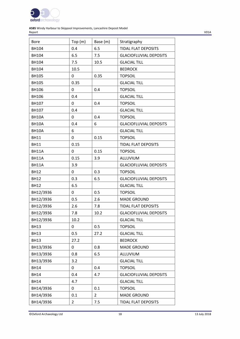
Correlated Stratigraphy
Bore Top (m) Base (m) Stratigraphy
BH01 0 3.2 TOPSOIL
BH01 3.2 TIDAL FLAT DEPOSITS
BH01A 0 0.8 MADE GROUND
BH01A 0.8 6.5 TIDAL FLAT DEPOSITS
BH01A 6.5 9.8 GLACIOFLUVIAL DEPOSITS
BH01A 9.8 BEDROCK
BH04 0 0.8 MADE GROUND
BH04 0.8 GLACIAL TILL
BH05 0 0.2 TOPSOIL
BH05 0.2 6.2 TIDAL FLAT DEPOSITS
BH05 6.2 GLACIAL TILL
BH06 0 0.15 TOPSOIL
BH06 0.15 2.1 TIDAL FLAT DEPOSITS
BH06 2.1 GLACIOFLUVIAL DEPOSITS
BH06-1 0 0.1 TOPSOIL
BH06-1 0.1 2.1 TIDAL FLAT DEPOSITS
BH06-1 2.1 GLACIAL TILL
BH07 0 6.2 TIDAL FLAT DEPOSITS
BH07 6.2 7.1 GLACIOFLUVIAL DEPOSITS
BH07 7.1 GLACIAL TILL
BH08 0 0.15 TOPSOIL
BH08 0.15 5.62 TIDAL FLAT DEPOSITS
BH08 5.62 GLACIOFLUVIAL DEPOSITS
BH10 0 1.1 TOPSOIL
BH10 1.1 GLACIAL TILL
BH101 0 0.4 TOPSOIL
BH101 0.4 3.5 GLACIOFLUVIAL DEPOSITS
BH101 3.5 26.9 GLACIAL TILL
BH101 26.9 BEDROCK
BH103 0 0.4 TOPSOIL
BH103 0.4 28 GLACIAL TILL
BH103 28 BEDROCK
BH104 0 0.4 TOPSOIL
A585 Windy Harbour to Skippool Improvements, Lancashire Deposit Model Report V01A
©Oxford Archaeology Ltd 18 13 July 2018
Bore Top (m) Base (m) Stratigraphy
BH104 0.4 6.5 TIDAL FLAT DEPOSITS
BH104 6.5 7.5 GLACIOFLUVIAL DEPOSITS
BH104 7.5 10.5 GLACIAL TILL
BH104 10.5 BEDROCK
BH105 0 0.35 TOPSOIL
BH105 0.35 GLACIAL TILL
BH106 0 0.4 TOPSOIL
BH106 0.4 GLACIAL TILL
BH107 0 0.4 TOPSOIL
BH107 0.4 GLACIAL TILL
BH10A 0 0.4 TOPSOIL
BH10A 0.4 6 GLACIOFLUVIAL DEPOSITS
BH10A 6 GLACIAL TILL
BH11 0 0.15 TOPSOIL
BH11 0.15 TIDAL FLAT DEPOSITS
BH11A 0 0.15 TOPSOIL
BH11A 0.15 3.9 ALLUVIUM
BH11A 3.9 GLACIOFLUVIAL DEPOSITS
BH12 0 0.3 TOPSOIL
BH12 0.3 6.5 GLACIOFLUVIAL DEPOSITS
BH12 6.5 GLACIAL TILL
BH12/3936 0 0.5 TOPSOIL
BH12/3936 0.5 2.6 MADE GROUND
BH12/3936 2.6 7.8 TIDAL FLAT DEPOSITS
BH12/3936 7.8 10.2 GLACIOFLUVIAL DEPOSITS
BH12/3936 10.2 GLACIAL TILL
BH13 0 0.5 TOPSOIL
BH13 0.5 27.2 GLACIAL TILL
BH13 27.2 BEDROCK
BH13/3936 0 0.8 MADE GROUND
BH13/3936 0.8 6.5 ALLUVIUM
BH13/3936 3.2 GLACIAL TILL
BH14 0 0.4 TOPSOIL
BH14 0.4 4.7 GLACIOFLUVIAL DEPOSITS
BH14 4.7 GLACIAL TILL
BH14/3936 0 0.1 TOPSOIL
BH14/3936 0.1 2 MADE GROUND
BH14/3936 2 7.5 TIDAL FLAT DEPOSITS

A585 Windy Harbour to Skippool improvements, Lancashire V01A
©Oxford Archaeology Ltd 19 13 July 2018
Bore Top (m) Base (m) Stratigraphy
BH14/3936 7.5 11.6 GLACIOFLUVIAL DEPOSITS
BH14/3936 11.6 12 GLACIAL TILL
BH14/3936 12 15.8 BEDROCK
BH15 0 0.6 TOPSOIL
BH15 0.6 5 GLACIOFLUVIAL DEPOSITS
BH15 5 GLACIAL TILL
BH15/3936 0 2.3 MADE GROUND
BH15/3936 2.3 5.6 TIDAL FLAT DEPOSITS
BH15/3936 5.6 GLACIAL TILL
BH17 0 0.7 TOPSOIL
BH17 0.7 3.7 GLACIOFLUVIAL DEPOSITS
BH17 3.7 GLACIAL TILL
BH18 0 0.3 TOPSOIL
BH18 0.3 GLACIAL TILL
BH19 0 0.4 TOPSOIL
BH19 0.4 GLACIAL TILL
BH5/2/28880 0 0.4 TOPSOIL
BH5/2/28880 0.4 GLACIAL TILL
BH5/3/28880 0 0.5 TOPSOIL
BH5/3/28880 0.5 GLACIAL TILL
BH649/1/SB 0 0.3 TOPSOIL
BH649/1/SB 0.3 8 TIDAL FLAT DEPOSITS
BH649/1/SB 8 8.6 GLACIOFLUVIAL DEPOSITS
BH649/1/SB 8.6 11.8 GLACIAL TILL
BH649/1/SB 11.8 BEDROCK
CP101/Rec 0 0.2 TOPSOIL
CP101/Rec 0.2 5.3 TIDAL FLAT DEPOSITS
CP101/Rec 5.3 7.7 GLACIOFLUVIAL DEPOSITS
CP101/Rec 7.7 GLACIAL TILL
CP102/Rec 0 0.6 TOPSOIL
CP102/Rec 0.6 5.2 TIDAL FLAT DEPOSITS
CP102/Rec 5.2 7.8 GLACIOFLUVIAL DEPOSITS
CP102/Rec 7.8 9.2 GLACIAL TILL
CP102/Rec 9.2 BEDROCK
CP103/Rec 0 0.3 TOPSOIL
CP103/Rec 0.3 4.5 TIDAL FLAT DEPOSITS
CP103/Rec 4.5 GLACIOFLUVIAL DEPOSITS
CPT01 0 0.3 TOPSOIL
CPT01 0.3 2.43 TIDAL FLAT DEPOSITS
A585 Windy Harbour to Skippool Improvements, Lancashire Deposit Model Report V01A
©Oxford Archaeology Ltd 20 13 July 2018
Bore Top (m) Base (m) Stratigraphy
CPT01 2.43 GLACIAL TILL
CPT02 0 0.3 TOPSOIL
CPT02 0.3 2.33 TIDAL FLAT DEPOSITS
CPT02 2.33 GLACIAL TILL
CPT03 0 0.3 TOPSOIL
CPT03 0.3 3.35 TIDAL FLAT DEPOSITS
CPT03 3.35 GLACIAL TILL
CPT04 0 0.3 TOPSOIL
CPT04 0.3 5.5 TIDAL FLAT DEPOSITS
CPT04 5.5 GLACIAL TILL
CPT05 0 0.3 TOPSOIL
CPT05 0.3 5.53 TIDAL FLAT DEPOSITS
CPT05 5.53 GLACIAL TILL
CPT06 0 0.3 TOPSOIL
CPT06 0.3 4.85 ALLUVIUM
CPT06 4.85 8.57 GLACIOFLUVIAL DEPOSITS
CPT06 8.57 GLACIAL TILL
CPT07 0 0.3 TOPSOIL
CPT07 0.3 5.7 TIDAL FLAT DEPOSITS
CPT07 5.7 GLACIOFLUVIAL DEPOSITS
CPT08 0 0.3 TOPSOIL
CPT08 0.3 3.81 TIDAL FLAT DEPOSITS
CPT08 3.81 GLACIOFLUVIAL DEPOSITS
CPT09 0 0.3 TOPSOIL
CPT09 0.3 4.02 TIDAL FLAT DEPOSITS
CPT09 4.02 GLACIOFLUVIAL DEPOSITS
CPT10 0 0.3 TOPSOIL
CPT10 0.3 5.81 TIDAL FLAT DEPOSITS
CPT10 5.81 11.07 GLACIOFLUVIAL DEPOSITS
CPT10 11.07 GLACIAL TILL
CPT11 0 0.2 TOPSOIL
CPT11 0.2 4.84 TIDAL FLAT DEPOSITS
CPT11 4.84 14.15 GLACIOFLUVIAL DEPOSITS
CPT11 14.15 GLACIAL TILL
CPT12 0 0.3 TOPSOIL
CPT12 0.3 5.69 TIDAL FLAT DEPOSITS
CPT12 5.69 GLACIOFLUVIAL DEPOSITS
CPT13 0 0.3 TOPSOIL

A585 Windy Harbour to Skippool improvements, Lancashire V01A
©Oxford Archaeology Ltd 21 13 July 2018
Bore Top (m) Base (m) Stratigraphy
CPT13 0.3 3.77 TIDAL FLAT DEPOSITS
CPT13 3.77 12.88 GLACIOFLUVIAL DEPOSITS
CPT13 12.88 GLACIAL TILL
CPT14 0 0.4 TOPSOIL
CPT14 0.4 5.38 TIDAL FLAT DEPOSITS
CPT14 5.38 GLACIOFLUVIAL DEPOSITS
CPT15 0 1.2 PEAT
CPT15 1.2 3.57 TIDAL FLAT DEPOSITS
CPT15 3.57 GLACIAL TILL
CPT16 0 0.4 TOPSOIL
CPT16 0.4 5.32 TIDAL FLAT DEPOSITS
CPT16 5.32 6.24 GLACIOFLUVIAL DEPOSITS
CPT16 6.24 GLACIAL TILL
CPT17 0 0.3 TOPSOIL
CPT17 0.3 2 TIDAL FLAT DEPOSITS
CPT17 2 GLACIOFLUVIAL DEPOSITS
CPT18 0 0.5 TOPSOIL
CPT18 0.5 1.2 TIDAL FLAT DEPOSITS
CPT18 1.2 GLACIAL TILL
CPT19 0 0.3 TOPSOIL
CPT19 0.3 3.76 TIDAL FLAT DEPOSITS
CPT19 3.76 GLACIOFLUVIAL DEPOSITS
CPT20 0 0.4 TOPSOIL
CPT20 0.4 GLACIAL TILL
HDTP201/09/24203 0 MADE GROUND
HDTP202/09/24203 0 MADE GROUND
HDTP203/09/24203 0 0.8 MADE GROUND
HDTP203/09/24203 0.8 GLACIAL TILL
HDTP204/09/24203 0 0.7 MADE GROUND
HDTP204/09/24203 0.7 1.2 GLACIAL TILL
HDTP205/09/24203 0 MADE GROUND
MO13 0 0.35 TOPSOIL
MO13 0.35 TIDAL FLAT DEPOSITS
MO16 0 0.4 TOPSOIL
MO16 0.4 TIDAL FLAT DEPOSITS
MO19 0 0.18 TOPSOIL
MO19 0.18 0.7 UPPER TIDAL FLAT
MO19 0.7 3.45 PEAT
MO19 3.45 TIDAL FLAT DEPOSITS
A585 Windy Harbour to Skippool Improvements, Lancashire Deposit Model Report V01A
©Oxford Archaeology Ltd 22 13 July 2018
Bore Top (m) Base (m) Stratigraphy
MO20 0 0.14 TOPSOIL
MO20 0.14 GLACIAL TILL
MO3 0 0.2 TOPSOIL
MO3 0.2 3.2 TIDAL FLAT DEPOSITS
MO3 3.2 GLACIAL TILL
MO5 0 0.15 TOPSOIL
MO5 0.15 TIDAL FLAT DEPOSITS
MO7 0 0.2 TOPSOIL
MO7 0.2 TIDAL FLAT DEPOSITS
SD33NE10/BGS 0 0.2 TOPSOIL
SD33NE10/BGS 0.2 0.4 PEAT
SD33NE10/BGS 0.4 6.9 TIDAL FLAT DEPOSITS
SD33NE10/BGS 6.9 8.4 GLACIOFLUVIAL DEPOSITS
SD33NE10/BGS 8.4 GLACIAL TILL
SD33NE11/BGS 0 0.25 TOPSOIL
SD33NE11/BGS 0.25 0.55 PEAT
SD33NE11/BGS 0.55 1.05 TIDAL FLAT DEPOSITS
SD33NE11/BGS 1.05 GLACIAL TILL
SD33NE14/BGS 0 0.4 TOPSOIL
SD33NE14/BGS 0.4 9.05 TIDAL FLAT DEPOSITS
SD33NE14/BGS 9.05 GLACIOFLUVIAL DEPOSITS
SD34SE64/BGS 0 1.8 MADE GROUND
SD34SE64/BGS 1.8 GLACIAL TILL
SD34SE65/BGS 0 1.8 MADE GROUND
SD34SE65/BGS 1.8 GLACIAL TILL
TP01 0 0.4 TOPSOIL
TP01 0.4 GLACIAL TILL
TP02 0 0.5 TOPSOIL
TP02 0.5 GLACIAL TILL
TP03 0 0.4 MADE GROUND
TP03 0.4 GLACIAL TILL
TP10 0 0.4 TIDAL FLAT DEPOSITS
TP10 0.4 GLACIAL TILL
TP103 0 0.2 TOPSOIL
TP103 0.2 GLACIAL TILL
TP104 0 0.4 TOPSOIL
TP104 0.4 GLACIAL TILL
TP105 0 0.3 TOPSOIL

A585 Windy Harbour to Skippool improvements, Lancashire V01A
©Oxford Archaeology Ltd 23 13 July 2018
Bore Top (m) Base (m) Stratigraphy
TP105 0.3 GLACIAL TILL
TP106 0 0.3 TOPSOIL
TP106 0.3 GLACIAL TILL
TP107 0 0.3 TOPSOIL
TP107 0.3 GLACIAL TILL
TP108 0 0.3 TOPSOIL
TP108 0.3 GLACIAL TILL
TP109 0 0.5 TOPSOIL
TP109 0.5 GLACIAL TILL
TP110 0 0.2 TOPSOIL
TP110 0.8 GLACIAL TILL
TP14 0 0.35 TOPSOIL
TP14 0.35 GLACIAL TILL
TP15 0 0.3 TOPSOIL
TP15 0.3 GLACIAL TILL
TP302/13/27803 0 0.35 TOPSOIL
TP302/13/27803 0.35 GLACIAL TILL
WS1/20648 0 1.2 MADE GROUND
WS1/20648 1.2 GLACIAL TILL
WS101/09/24203 0 1.4 MADE GROUND
WS101/09/24203 1.4 GLACIAL TILL
WS102 0 1 MADE GROUND
WS102 1 GLACIAL TILL
WS102/09/24203 0 3 MADE GROUND
WS102/09/24203 3 ALLUVIUM
WS103 0 0.2 TOPSOIL
WS103 0.2 3.6 GLACIOFLUVIAL DEPOSITS
WS103 3.6 GLACIAL TILL
WS103/09/24203 0 1.5 MADE GROUND
WS103/09/24203 1.5 GLACIOFLUVIAL DEPOSITS
WS104 0 0.55 MADE GROUND
WS104 0.55 GLACIAL TILL
WS104/09/24203 0 0.85 MADE GROUND
WS104/09/24203 0.85 2.5 ALLUVIUM
WS104/09/24203 2.5 4.7 GLACIOFLUVIAL DEPOSITS
WS104/09/24203 4.7 GLACIAL TILL
WS105 0 0.3 TOPSOIL
WS105 0.3 1.8 PEAT
WS105 1.8 2 TIDAL FLAT DEPOSITS
A585 Windy Harbour to Skippool Improvements, Lancashire Deposit Model Report V01A
©Oxford Archaeology Ltd 24 13 July 2018
Bore Top (m) Base (m) Stratigraphy
WS105 2 3 PEAT
WS105 3 TIDAL FLAT DEPSOTS
WS105/09/24203 0 2 MADE GROUND
WS105/09/24203 2 GLACIAL TILL
WS105A 0 0.5 TOPSOIL
WS105A 0.5 2.2 PEAT
WS105A 2.2 TIDAL FLAT DEPOSITS
WS105B 0 0.7 TOPSOIL
WS105B 0.7 1.9 PEAT
WS105B 1.9 TIDAL FLAT DEPOSITS
WS106 0 0.25 TOPSOIL
WS106 0.25 1 UPPER TIDAL FLAT
WS106 1 1.2 PEAT
WS106 1.2 3.5 TIDAL FLAT DEPOSITS
WS106 3.5 GLACIOFLUVIAL DEPOSITS
WS106/09/24203 0 1.8 MADE GROUND
WS106/09/24203 1.8 3.2 GLACIOFLUVIAL DEPOSITS
WS106/09/24203 3.2 GLACIAL TILL
WS107 0 0.4 TOPSOIL
WS107 0.4 TIDAL FLAT DEPOSITS
WS108 0 0.2 TOPSOIL
WS108 0.2 TIDAL FLAT DEPOSITS
WS109 0 0.4 TOPSOIL
WS109 0.4 4.5 TIDAL FLAT DEPOSITS
WS109 4.5 GLACIAL TILL
WS109A 0 0.3 TOPSOIL
WS109A 0.3 TIDAL FLAT DEPOSITS
WS111 0 0.8 TOPSOIL
WS111 0.8 GLACIAL TILL
WS112 0 0.8 MADE GROUND
WS112 0.8 GLACIAL TILL
WS113 0 2.9 MADE GROUND
WS113 2.9 GLACIAL TILL
WS115 0 0.2 TOPSOIL
WS115 0.2 1.2 ALLUVIUM
WS115 1.2 1.8 PEAT
WS115 1.8 GLACIAL TILL
WS14A 0 0.5 TOPSOIL
A585 Windy Harbour to Skippool improvements, Lancashire V01A
©Oxford Archaeology Ltd 25 13 July 2018
Bore Top (m) Base (m) Stratigraphy
WS14A 0.5 TIDAL FLAT DEPOSITS
WS2/20648 0 1.2 MADE GROUND
WS2/20648 1.2 GLACIAL TILL
WS301/13/27803 0 GLACIAL TILL
WS302/13/27803 0 0.1 TOPSOIL
WS302/13/27803 0.1 GLACIAL TILL
WS303/13/27803 0 GLACIAL TILL
WS304/13/27803 0 0.6 MADE GROUND
WS304/13/27803 0.6 GLACIAL TILL

A585 Windy Harbour to Skippool Improvements, Lancashire Deposit Model Report V01A
©Oxford Archaeology Ltd 26 13 July 2018
APPENDIX B PLATES
Plate 1: WS105B 1.2-1.7m BGL, peat deposit (image from SOCOTEC 2018)
Plate 2: MO19 0-3.5m BGL, peat deposit at 0.7-3.45m BGL (image from SOCOTEC 2018)

A585 Windy Harbour to Skippool improvements, Lancashire V01A
©Oxford Archaeology Ltd 27 13 July 2018
APPENDIX B BIBLIOGRAPHY
Arcadis (UK) Consulting Ltd, 2018 A585 Windy Harbour to Skippool Improvement Scheme (Draft) Appendix 7.1: Cultural Heritage Desk-Based Assessment
Barnes, B, 1975 Palaeoecological studies of the late Quaternary period in the Northwest Lancashire Lowlands, Unpublished PhD thesis, University of Lancaster Bates, M R, 1998, Locating and evaluating archaeology below the alluvium: the role of sub-surface stratigraphical modelling, Lithics 19, 4-18 Brennand, M, et al, 2006, An Archaeological Research Framework for North West England: Volume 1 Resource Assessment, North West. Brennand, M, et al, 2007, An Archaeological Research Framework for North West England: Volume 2 Research Agenda and Strategy, North West.
British Geological Survey http://www.bgs.ac.uk/discoveringGeology/geologyOfBritain/viewer.html Historic England, 2015 Geoarchaeology: Using an earth sciences approach to understand the archaeological record Carey C, Howard, A, Corcoran, J, Knight, D and Heathcote, J, (eds) 2018, Deposit Modelling and Archaeology, University of Brighton
Jones, R T, Marshall, J D, Fisher, E, Hatton, J, Patrick, C, Anderson, K, Lang, B, Bedford, A and Oldfield, F 2011 ‘Controls on lake level in the early to mid Holocene, Hawes Water, Lancashire, UK’. The Holocene 21(7), 1061–1072 Middleton, R, Wells, C E, and Huckerby, E, 1995 The Wetlands of North Lancashire, NWWS 3, Lancaster Imprints, 4, Lancaster
OA and PCA, 2013 Stoke Quay, Ipswich, Part I: Assessment and Updated Project design, Oxford. Unpublished client report OA North 2010 Wyre Estuary Pipeline, Poulton-le-Fylde, Lancashire, Archaeological post-excavation report SOCOTEC, 2018 A585 Windy Harbour to Skippool improvements, Lancashire; Factual report on ground investigation, Report No F7059-17 Tooley, M J, 1978 Sea-level changes in northwest England during the Flandrian stage, Oxford Tooley, M J, 1982 Sea-level change in northern England, Proceedings of the Geologists’ Association 93, 43-51
A585 Windy Harbour to Skippool Improvements, Lancashire Deposit Model Report V01A
©Oxford Archaeology Ltd 28 13 July 2018
Wells, C, Huckerby, E, and Hall, V, 1997 Mid-and late-Holocene vegetation history and tephra studies at Fenton Cottage, Lancashire, UK, Vegetation History and Archaeobotany 6, 153-166
Wells, C, E, and Hodgkinson, D, 2001 A Late Bronze Age Human Skull and Associated Worked Wood from a Lancashire Wetland, Proceedings of the Prehistoric Society 67, 163-174 Zong, Y, and Tooley, M, J 1994 Holocene sea-level changes and crustal movements in Morecambe Bay, northwest England, Journal of Quaternary Science 11, 43-58


Figure 1: Site location
LONDON
OXFORD
BIRMINGHAM
CAMBRIDGE
LANCASTER
MANCHESTER
CARDIFF
33
40
00
33
60
00
33
80
00
34
00
00
436000
438000
440000
442000
1:50,000
0 2km
Contains OS data © Crown Copyright and database right 2017
Study Area
\\1
0.0
.0.3
\oa
u\G
eo
arc
ha
eo
log
ica
l S
erv
ice
s\G
EO
AR
CH
RE
PO
RT
S\L
AN
CA
SH
IRE
\WIN
DY
_H
AR
BO
UR
_S
KIP
PO
OL
_L
AN
CS
\01
0G
eo
ma
tics\0
3 G
IS P
roje
cts
\L1
11
31
_F
igu
re1
_2
01
8-0
6-0
1.m
xd
*ga
ry.jo
ne
s*0
4/0
6/2
01
8
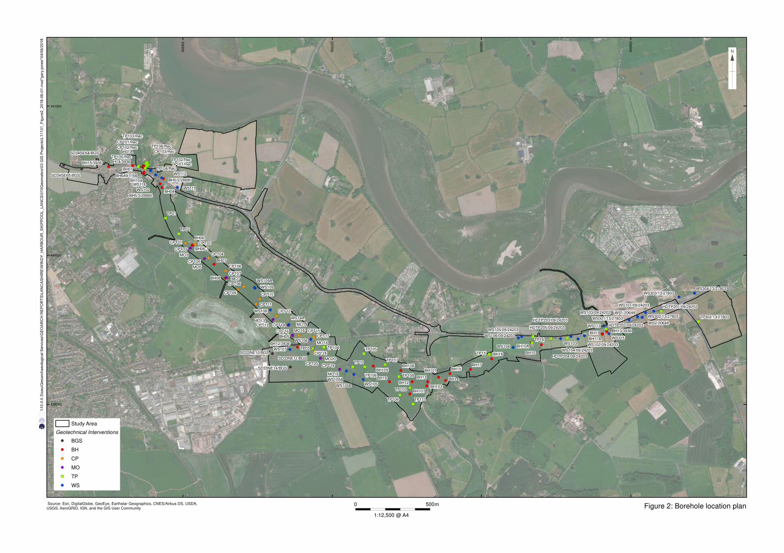
Figure 2: Borehole location plan
!(!(
!(
!(
!(!(
!(
!(
!(
!(
!(
!(
!(
!(
!(
!(
!(!(
!(
!(
!(
!(
!(
!(
!(
!(
!(
!(
!(
!(
!(
!(
!(!(!(
!( !(
!(
!(!(
!(
!(
!(!(
!(
!(
!(
!(
!(
!(!(!(
!(
!(
!(
")
")
")")")
!(
!(
!(
!(
!(
!(
!(
!(
!(
!( !(
!(
!(
!(
")
")
")
")
")")
")
")
")
")
")
")
")
")
")
")
")
")
")
")
")
!(
!(
!(
!(!(
!(
!(
!(
!(
!(
!(!(
!( !(
!(
!(
!(!(
!(
!(
!(
!(
!(
!(
!(!(
!(
!(
!(
BH01
BH06
CP101/Rec
HDTP203/09/24203
TP14
BH01A
BH04
BH05
BH06-1
BH07
BH08
BH10
BH101
BH103
BH104
BH105
BH106
BH107
BH10A
BH11
BH11A
BH12
BH12/3936
BH13
BH13/3936
BH14
BH14/3936
BH15
BH15/3936
BH17
BH18
BH19
BH5/2/28880
BH5/3/28880
BH649/1/SB
CP102/Rec
CP103/Rec
CPT01
CPT02
CPT03
CPT04
CPT05
CPT06
CPT07
CPT08
CPT09
CPT10
CPT11
CPT12
CPT13 CPT14
CPT15
CPT16
CPT17
CPT18
CPT19
CPT20
HDTP201/09/24203
HDTP202/09/24203
HDTP204/09/24203
HDTP205/09/24203
MO13
MO14
MO16
MO18
MO19
MO20
MO3
MO5
MO7
SD33NE10/BGS
SD33NE11/BGS
SD33NE14/BGS
SD34SE64/BGS
SD34SE65/BGS
TP01
TP02
TP03
TP10
TP101/Rec
TP102/Rec
TP103
TP103/Rec
TP104
TP104/Rec
TP105
TP105/Rec
TP106
TP106/Rec
TP107
TP108
TP109
TP110
TP15
TP302/13/27803
WS1/20648
WS101/09/24203
WS102
WS102/09/24203
WS103
WS103/09/24203
WS104
WS104/09/24203
WS105
WS105/09/24203
WS105A
WS105B
WS106
WS106/09/24203
WS107
WS108
WS109
WS109A
WS111
WS112
WS113
WS114
WS115
WS14A
WS2/20648 WS301/13/27803
WS302/13/27803
WS303/13/27803
WS304/13/27803
33
60
00
33
70
00
33
80
00
33
90
00
439000
440000
441000
Source: Esri, DigitalGlobe, GeoEye, Earthstar Geographics, CNES/Airbus DS, USDA,USGS, AeroGRID, IGN, and the GIS User Community
Study Area
Geotechnical Interventions
!( BGS
!( BH
!( CP
!( MO
") TP
!( WS
\\1
0.0
.0.3
\oa
u\G
eo
arc
ha
eo
log
ica
l S
erv
ice
s\G
EO
AR
CH
RE
PO
RT
S\L
AN
CA
SH
IRE
\WIN
DY
_H
AR
BO
UR
_S
KIP
PO
OL
_L
AN
CS
\01
0G
eo
ma
tics\0
3 G
IS P
roje
cts
\L1
11
31
_F
igu
re2
_2
01
8-0
6-0
1.m
xd
*ga
ry.jo
ne
s*0
4/0
6/2
01
8
0 500m
1:12,500 @ A4

Figure 3: Borehole location and Lidar elevation data
!(!(
!(
!(
!(!(
!(
!(
!(
!(
!(
!(
!(
!(
!(
!(
!(!(
!(
!(
!(
!(
!(
!(
!(
!(
!(
!(
!(
!(
!(
!(
!(!(!(
!( !(
!(
!(!(
!(
!(
!(!(
!(
!(
!(
!(
!(
!(!(!(
!(
!(
!(
")
")
")")")
!(
!(
!(
!(
!(
!(
!(
!(
!(
!( !(
!(
!(
!(
")
")
")
")
")")
")
")
")
")
")
")
")
")
")
")
")
")
")
")
")
!(
!(
!(
!(!(
!(
!(
!(
!(
!(
!(!(
!( !(
!(
!(
!(!(
!(
!(
!(
!(
!(
!(
!(!(
!(
!(
!(
BH01
BH06
CP101/Rec
HDTP203/09/24203
TP14
BH01A
BH04
BH05
BH06-1
BH07
BH08
BH10
BH101
BH103
BH104
BH105
BH106
BH107
BH10A
BH11
BH11A
BH12
BH12/3936
BH13
BH13/3936
BH14
BH14/3936
BH15
BH15/3936
BH17
BH18
BH19
BH5/2/28880
BH5/3/28880
BH649/1/SB
CP102/Rec
CP103/Rec
CPT01
CPT02
CPT03
CPT04
CPT05
CPT06
CPT07
CPT08
CPT09
CPT10
CPT11
CPT12
CPT13 CPT14
CPT15
CPT16
CPT17
CPT18
CPT19
CPT20
HDTP201/09/24203
HDTP202/09/24203
HDTP204/09/24203
HDTP205/09/24203
MO13
MO14
MO16
MO18
MO19
MO20
MO3
MO5
MO7
SD33NE10/BGS
SD33NE11/BGS
SD33NE14/BGS
SD34SE64/BGS
SD34SE65/BGS
TP01
TP02
TP03
TP10
TP101/Rec
TP102/Rec
TP103
TP103/Rec
TP104
TP104/Rec
TP105
TP105/Rec
TP106
TP106/Rec
TP107
TP108
TP109
TP110
TP15
TP302/13/27803
WS1/20648
WS101/09/24203
WS102
WS102/09/24203
WS103
WS103/09/24203
WS104
WS104/09/24203
WS105
WS105/09/24203
WS105A
WS105B
WS106
WS106/09/24203
WS107
WS108
WS109
WS109A
WS111
WS112
WS113
WS114
WS115
WS14A
WS2/20648 WS301/13/27803
WS302/13/27803
WS303/13/27803
WS304/13/27803
33
60
00
33
70
00
33
80
00
33
90
00
439000
440000
441000
© Environment Agency copyright and/or database right 2018
Study Area
Geotechnical Interventions
!( BGS
!( BH
!( CP
!( MO
") TP
!( WS
\\1
0.0
.0.3
\oa
u\G
eo
arc
ha
eo
log
ica
l S
erv
ice
s\G
EO
AR
CH
RE
PO
RT
S\L
AN
CA
SH
IRE
\WIN
DY
_H
AR
BO
UR
_S
KIP
PO
OL
_L
AN
CS
\01
0G
eo
ma
tics\0
3 G
IS P
roje
cts
\L1
11
31
_F
igu
re3
_2
01
8-0
6-0
1.m
xd
*ga
ry.jo
ne
s*0
4/0
6/2
01
8
0 500m
1:12,500 @ A4

Figure 4: Superfical surface geology mapped by the BGS
!(!(
!(
!(
!(!(
!(
!(
!(
!(
!(
!(
!(
!(
!(
!(
!(!(
!(
!(
!(
!(
!(
!(
!(
!(
!(
!(
!(
!(
!(
!(
!(!(!(
!( !(
!(
!(!(
!(
!(
!(!(
!(
!(
!(
!(
!(
!(!(!(
!(
!(
!(
")
")
")")")
!(
!(
!(
!(
!(
!(
!(
!(
!(
!( !(
!(
!(
!(
")
")
")
")
")")
")
")
")
")
")
")
")
")
")
")
")
")
")
")
")
!(
!(
!(
!(!(
!(
!(
!(
!(
!(
!(!(
!( !(
!(
!(
!(!(
!(
!(
!(
!(
!(
!(
!(!(
!(
!(
!(
BH01
BH06
CP101/Rec
HDTP203/09/24203
TP14
BH01A
BH04
BH05
BH06-1
BH07
BH08
BH10
BH101
BH103
BH104
BH105
BH106
BH107
BH10A
BH11
BH11A
BH12
BH12/3936
BH13
BH13/3936
BH14
BH14/3936
BH15
BH15/3936
BH17
BH18
BH19
BH5/2/28880
BH5/3/28880
BH649/1/SB
CP102/Rec
CP103/Rec
CPT01
CPT02
CPT03
CPT04
CPT05
CPT06
CPT07
CPT08
CPT09
CPT10
CPT11
CPT12
CPT13 CPT14
CPT15
CPT16
CPT17
CPT18
CPT19
CPT20
HDTP201/09/24203
HDTP202/09/24203
HDTP204/09/24203
HDTP205/09/24203
MO13
MO14
MO16
MO18
MO19
MO20
MO3
MO5
MO7
SD33NE10/BGS
SD33NE11/BGS
SD33NE14/BGS
SD34SE64/BGS
SD34SE65/BGS
TP01
TP02
TP03
TP10
TP101/Rec
TP102/Rec
TP103
TP103/Rec
TP104
TP104/Rec
TP105
TP105/Rec
TP106
TP106/Rec
TP107
TP108
TP109
TP110
TP15
TP302/13/27803
WS1/20648
WS101/09/24203
WS102
WS102/09/24203
WS103
WS103/09/24203
WS104
WS104/09/24203
WS105
WS105/09/24203
WS105A
WS105B
WS106
WS106/09/24203
WS107
WS108
WS109
WS109A
WS111
WS112
WS113
WS114
WS115
WS14A
WS2/20648 WS301/13/27803
WS302/13/27803
WS303/13/27803
WS304/13/27803
33
60
00
33
70
00
33
80
00
33
90
00
439000
440000
441000
BGS geological data Copyright NERC 2018
Study Area
Geotechnical Interventions
!( BGS
!( BH
!( CP
!( MO
") TP
!( WS
\\1
0.0
.0.3
\oa
u\G
eo
arc
ha
eo
log
ica
l S
erv
ice
s\G
EO
AR
CH
RE
PO
RT
S\L
AN
CA
SH
IRE
\WIN
DY
_H
AR
BO
UR
_S
KIP
PO
OL
_L
AN
CS
\01
0G
eo
ma
tics\0
3 G
IS P
roje
cts
\L1
11
31
_F
igu
re4
_2
01
8-0
7-1
0.m
xd
*ga
ry.jo
ne
s*1
0/0
7/2
01
8
0 500m
1:12,500 @ A4
Tidal flat deposits
Glacial till
Glaciofluvial deposits
Peat
2
4
2
42
4
6
8
10
2
4
6
8
10
2
4
6
8
10
2
4
6
2
4
6
2
4
6
8
10
12
2
4
6
2
2
2
4
6
8
2
4
6
8
2
4
6
8
2
4
6
2
4
6
8
2
4
6
8
2
4
6
8
2
4
6
2
4
6
8
2
4
2
4
6
2
4
6
8
2
4
6
2
4
2
4
6
2
4
6
2
4
2
4
6
8
10
2
4
6
8
10
12
14
2
4
6
8
10
12
14
16
18
20
22
24
26
2
4
6
8
10
12
14
16
18
20
22
24
26
2
4
6
8
10
12
14
16
18
20
2
4
6
8
10
2
4
62
4
2
4
6
8
10
12
14
16
18
2
4
6
8
10
2
4
6
2
4 2
4
2
4
6
8
2
4
2
4
6
2
2
4
6
2
4
2
4
6
2
4
6
-5 .0
0.0
5.0
10.0
15.0
20.0
25.0
WS
304/
13/2
7803
SD
34S
E64
/BG
S
SD
34S
E65
/BG
S
BH
15/3
936
BH
14/3
936
BH
01A
WS
102
WS
112
BH
04
WS
111
TP
01
TP
02
BH
06-1
CP
T05
BH
07
BH
08
CP
T08
WS
109
CP
T10
WS
108
CP
T12
WS
14A
BH
05C
PT
15
WS
106
MO
19W
S10
5AW
S10
5BW
S10
5
BH
19
BH
12
BH
13
BH
101
BH
15
BH
17
BH
18
WS
104
BH
10A
BH
10
WS
104/
09/2
4203
WS
103/
09/2
4203
WS
102/
09/2
4203
BH
11A
WS
115
WS
301/
13/2
7803
WS
1/20
648
WS
302/
13/2
7803
WS
101/
09/2
4203
WS
303/
13/2
7803
-5 .0
0.0
5.0
10.0
15.0
20.0
25.0
m OD
Key
Topsoil
Made ground
Alluvium
Peat
Tidal flat deposits
Glaciofluvial deposits
Glacial Till
Figure 5: Stratigraphic transect
Valley 2 (Main Dyke)Valley 1 (Main Dyke) Valley 4Valley 3

336000
337000
338000
339000
439000
440000
441000
Figure 6: Modelled thickness of Holocene deposits in metres (including made ground)© Environment Agency copyright and/or database right 2018 m0050
1:12,500 @ A4
Key:
Borehole with peat
Borehole with made ground