A27 Polegate Bypass - Highways...
99
POST OPENING PROJECT EVALUATION FIVE YEAR AFTER STUDY A27 Polegate Bypass APRIL 2009
-
Upload
duongthuan -
Category
Documents
-
view
244 -
download
2
Transcript of A27 Polegate Bypass - Highways...
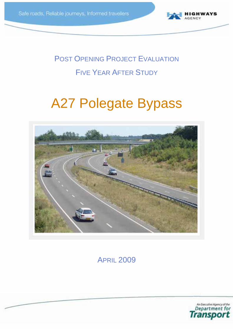
POST OPENING PROJECT EVALUATION
FIVE YEAR AFTER STUDY
A27 Polegate Bypass
APRIL 2009
POST OPENING PROJECT EVALUATION A27 Polegate Bypass – 5YA Study
i
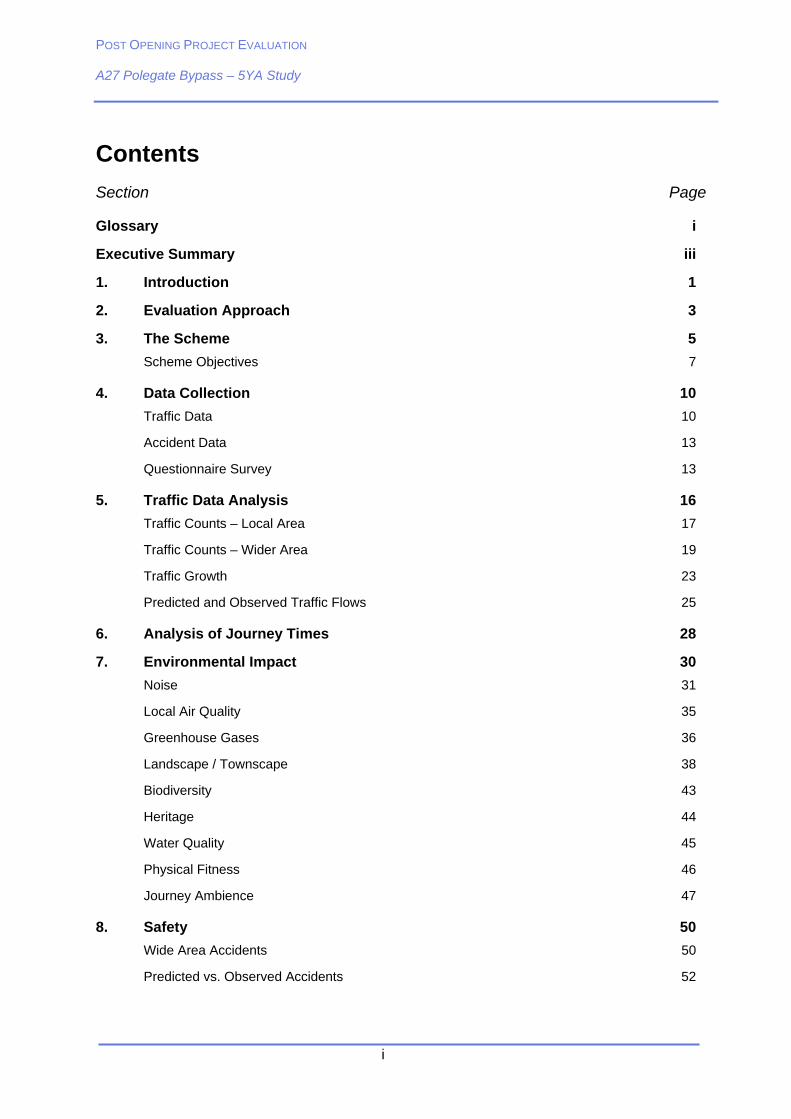
Contents
Section Page
Glossary i
Executive Summary iii
1. Introduction 1
2. Evaluation Approach 3
3. The Scheme 5
Scheme Objectives 7
4. Data Collection 10
Traffic Data 10
Accident Data 13
Questionnaire Survey 13
5. Traffic Data Analysis 16
Traffic Counts – Local Area 17
Traffic Counts – Wider Area 19
Traffic Growth 23
Predicted and Observed Traffic Flows 25
6. Analysis of Journey Times 28
7. Environmental Impact 30
Noise 31
Local Air Quality 35
Greenhouse Gases 36
Landscape / Townscape 38
Biodiversity 43
Heritage 44
Water Quality 45
Physical Fitness 46
Journey Ambience 47
8. Safety 50
Wide Area Accidents 50
Predicted vs. Observed Accidents 52
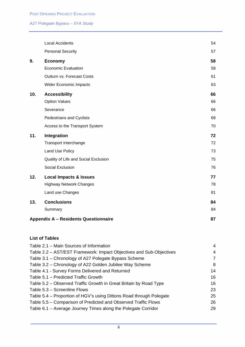
POST OPENING PROJECT EVALUATION A27 Polegate Bypass – 5YA Study
ii
Local Accidents 54
Personal Security 57
9. Economy 58
Economic Evaluation 58
Outturn vs. Forecast Costs 61
Wider Economic Impacts 63
10. Accessibility 66
Option Values 66
Severance 66
Pedestrians and Cyclists 68
Access to the Transport System 70
11. Integration 72
Transport Interchange 72
Land Use Policy 73
Quality of Life and Social Exclusion 75
Social Exclusion 76
12. Local Impacts & Issues 77
Highway Network Changes 78
Land use Changes 81
13. Conclusions 84
Summary 84
Appendix A – Residents Questionnaire 87
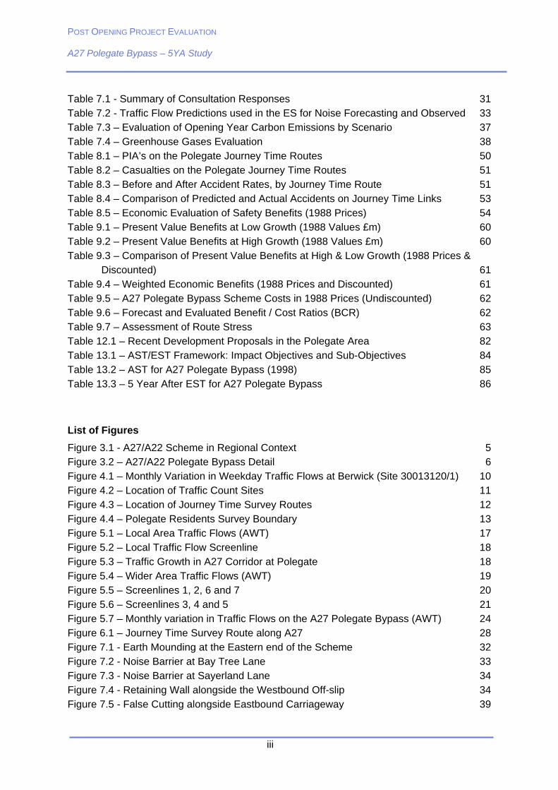
List of Tables
Table 2.1 – Main Sources of Information 4 Table 2.2 – AST/EST Framework: Impact Objectives and Sub-Objectives 4 Table 3.1 – Chronology of A27 Polegate Bypass Scheme 7 Table 3.2 – Chronology of A22 Golden Jubilee Way Scheme 8 Table 4.1 - Survey Forms Delivered and Returned 14 Table 5.1 – Predicted Traffic Growth 16 Table 5.2 – Observed Traffic Growth in Great Britain by Road Type 16 Table 5.3 – Screenline Flows 23 Table 5.4 – Proportion of HGV’s using Dittons Road through Polegate 25 Table 5.5 – Comparison of Predicted and Observed Traffic Flows 26 Table 6.1 – Average Journey Times along the Polegate Corridor 29
POST OPENING PROJECT EVALUATION A27 Polegate Bypass – 5YA Study
iii
Table 7.1 - Summary of Consultation Responses 31 Table 7.2 - Traffic Flow Predictions used in the ES for Noise Forecasting and Observed 33 Table 7.3 – Evaluation of Opening Year Carbon Emissions by Scenario 37 Table 7.4 – Greenhouse Gases Evaluation 38 Table 8.1 – PIA’s on the Polegate Journey Time Routes 50 Table 8.2 – Casualties on the Polegate Journey Time Routes 51 Table 8.3 – Before and After Accident Rates, by Journey Time Route 51 Table 8.4 – Comparison of Predicted and Actual Accidents on Journey Time Links 53 Table 8.5 – Economic Evaluation of Safety Benefits (1988 Prices) 54 Table 9.1 – Present Value Benefits at Low Growth (1988 Values £m) 60 Table 9.2 – Present Value Benefits at High Growth (1988 Values £m) 60 Table 9.3 – Comparison of Present Value Benefits at High & Low Growth (1988 Prices &
Discounted) 61 Table 9.4 – Weighted Economic Benefits (1988 Prices and Discounted) 61 Table 9.5 – A27 Polegate Bypass Scheme Costs in 1988 Prices (Undiscounted) 62 Table 9.6 – Forecast and Evaluated Benefit / Cost Ratios (BCR) 62 Table 9.7 – Assessment of Route Stress 63 Table 12.1 – Recent Development Proposals in the Polegate Area 82 Table 13.1 – AST/EST Framework: Impact Objectives and Sub-Objectives 84 Table 13.2 – AST for A27 Polegate Bypass (1998) 85 Table 13.3 – 5 Year After EST for A27 Polegate Bypass 86
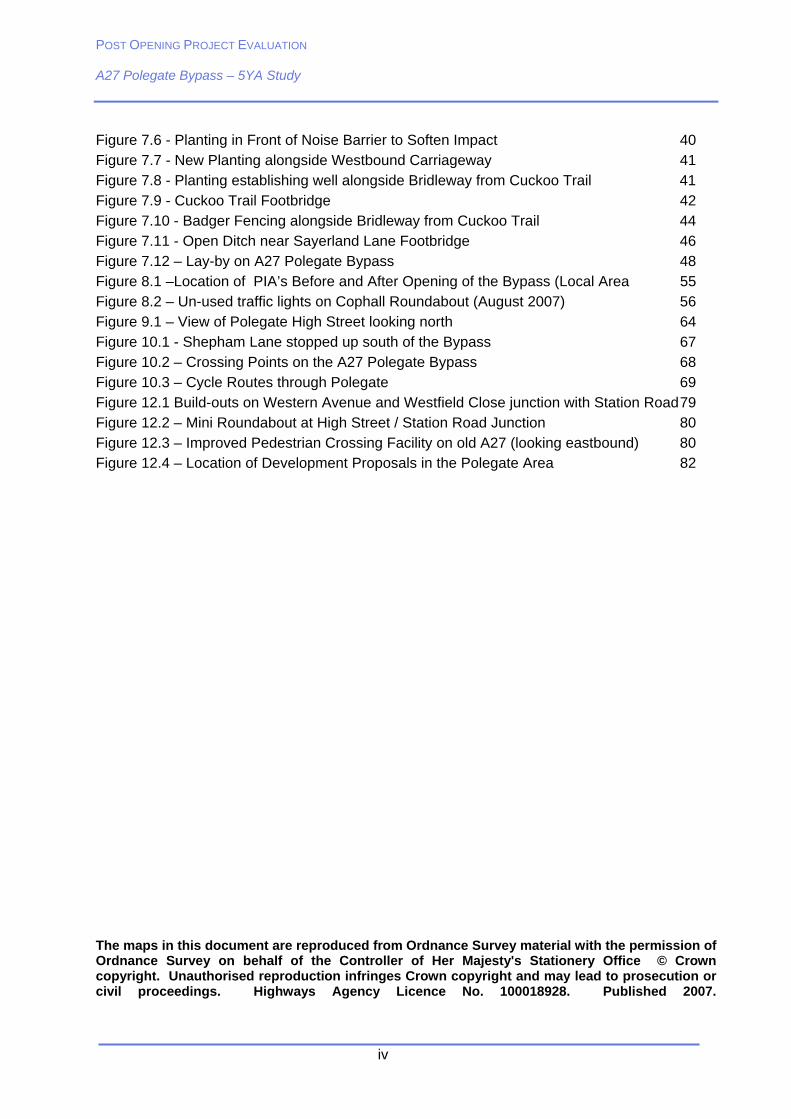
List of Figures
Figure 3.1 - A27/A22 Scheme in Regional Context 5 Figure 3.2 – A27/A22 Polegate Bypass Detail 6 Figure 4.1 – Monthly Variation in Weekday Traffic Flows at Berwick (Site 30013120/1) 10 Figure 4.2 – Location of Traffic Count Sites 11 Figure 4.3 – Location of Journey Time Survey Routes 12 Figure 4.4 – Polegate Residents Survey Boundary 13 Figure 5.1 – Local Area Traffic Flows (AWT) 17 Figure 5.2 – Local Traffic Flow Screenline 18 Figure 5.3 – Traffic Growth in A27 Corridor at Polegate 18 Figure 5.4 – Wider Area Traffic Flows (AWT) 19 Figure 5.5 – Screenlines 1, 2, 6 and 7 20 Figure 5.6 – Screenlines 3, 4 and 5 21 Figure 5.7 – Monthly variation in Traffic Flows on the A27 Polegate Bypass (AWT) 24 Figure 6.1 – Journey Time Survey Route along A27 28 Figure 7.1 - Earth Mounding at the Eastern end of the Scheme 32 Figure 7.2 - Noise Barrier at Bay Tree Lane 33 Figure 7.3 - Noise Barrier at Sayerland Lane 34 Figure 7.4 - Retaining Wall alongside the Westbound Off-slip 34 Figure 7.5 - False Cutting alongside Eastbound Carriageway 39
POST OPENING PROJECT EVALUATION A27 Polegate Bypass – 5YA Study
iv
Figure 7.6 - Planting in Front of Noise Barrier to Soften Impact 40 Figure 7.7 - New Planting alongside Westbound Carriageway 41 Figure 7.8 - Planting establishing well alongside Bridleway from Cuckoo Trail 41 Figure 7.9 - Cuckoo Trail Footbridge 42 Figure 7.10 - Badger Fencing alongside Bridleway from Cuckoo Trail 44 Figure 7.11 - Open Ditch near Sayerland Lane Footbridge 46 Figure 7.12 – Lay-by on A27 Polegate Bypass 48 Figure 8.1 –Location of PIA’s Before and After Opening of the Bypass (Local Area 55 Figure 8.2 – Un-used traffic lights on Cophall Roundabout (August 2007) 56 Figure 9.1 – View of Polegate High Street looking north 64 Figure 10.1 - Shepham Lane stopped up south of the Bypass 67 Figure 10.2 – Crossing Points on the A27 Polegate Bypass 68 Figure 10.3 – Cycle Routes through Polegate 69 Figure 12.1 Build-outs on Western Avenue and Westfield Close junction with Station Road 79 Figure 12.2 – Mini Roundabout at High Street / Station Road Junction 80 Figure 12.3 – Improved Pedestrian Crossing Facility on old A27 (looking eastbound) 80 Figure 12.4 – Location of Development Proposals in the Polegate Area 82
The maps in this document are reproduced from Ordnance Survey material with the permission of Ordnance Survey on behalf of the Controller of Her Majesty's Stationery Office © Crown copyright. Unauthorised reproduction infringes Crown copyright and may lead to prosecution or civil proceedings. Highways Agency Licence No. 100018928. Published 2007.
POST OPENING PROJECT EVALUATION A27 Polegate Bypass – 5YA Study
i
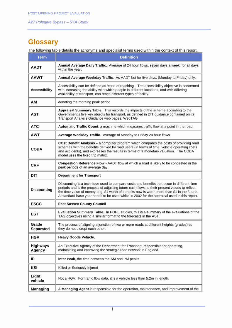
Glossary The following table details the acronyms and specialist terms used within the context of this report.
Term Definition
AADT Annual Average Daily Traffic. Average of 24 hour flows, seven days a week, for all days within the year.
AAWT Annual Average Weekday Traffic. As AADT but for five days, (Monday to Friday) only.
Accessibility Accessibility can be defined as ‘ease of reaching’. The accessibility objective is concerned with increasing the ability with which people in different locations, and with differing availability of transport, can reach different types of facility.
AM denoting the morning peak period
AST Appraisal Summary Table. This records the impacts of the scheme according to the Government’s five key objects for transport, as defined in DfT guidance contained on its Transport Analysis Guidance web pages, WebTAG
ATC Automatic Traffic Count, a machine which measures traffic flow at a point in the road.
AWT Average Weekday Traffic. Average of Monday to Friday 24 hour flows.
COBA
COst Benefit Analysis – a computer program which compares the costs of providing road schemes with the benefits derived by road users (in terms of time, vehicle operating costs and accidents), and expresses the results in terms of a monetary valuation. The COBA model uses the fixed trip matrix.
CRF Congestion Reference Flow - AADT flow at which a road is likely to be congested in the peak periods of an average day.
DfT Department for Transport
Discounting
Discounting is a technique used to compare costs and benefits that occur in different time periods and is the process of adjusting future cash flows to their present values to reflect the time value of money, e.g. £1 worth of benefits now is worth more than £1 in the future. A standard base year needs to be used which is 2002 for the appraisal used in this report.
ESCC East Sussex County Council
EST Evaluation Summary Table. In POPE studies, this is a summary of the evaluations of the TAG objectives using a similar format to the forecasts in the AST.
Grade Separated
The process of aligning a junction of two or more roads at different heights (grades) so they do not disrupt each other.
HGV Heavy Goods Vehicle.
Highways Agency
An Executive Agency of the Department for Transport, responsible for operating, maintaining and improving the strategic road network in England.
IP Inter Peak, the time between the AM and PM peaks
KSI Killed or Seriously Injured
Light vehicle
Not a HGV. For traffic flow data, it is a vehicle less than 5.2m in length.
Managing A Managing Agent is responsible for the operation, maintenance, and improvement of the
POST OPENING PROJECT EVALUATION A27 Polegate Bypass – 5YA Study
ii
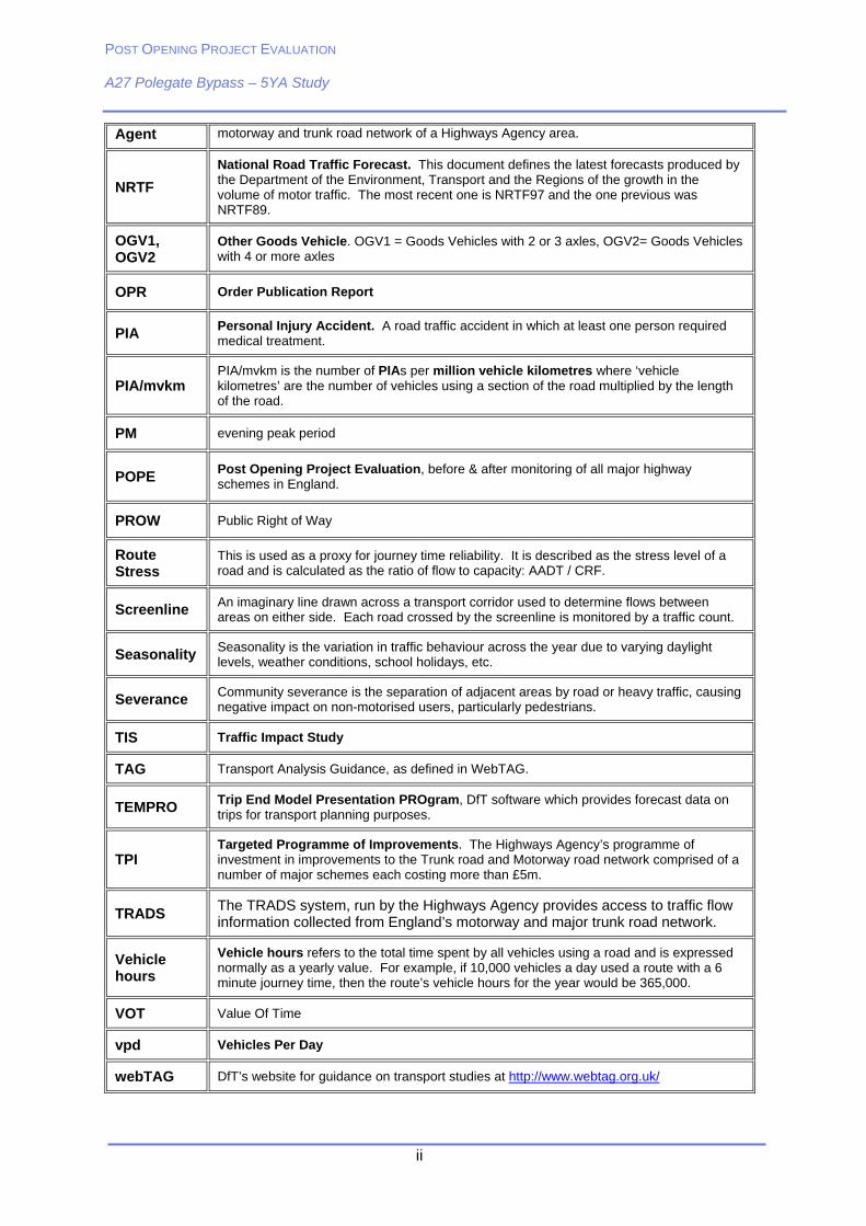
Agent motorway and trunk road network of a Highways Agency area.
NRTF
National Road Traffic Forecast. This document defines the latest forecasts produced by the Department of the Environment, Transport and the Regions of the growth in the volume of motor traffic. The most recent one is NRTF97 and the one previous was NRTF89.
OGV1, OGV2
Other Goods Vehicle. OGV1 = Goods Vehicles with 2 or 3 axles, OGV2= Goods Vehicles with 4 or more axles
OPR Order Publication Report
PIA Personal Injury Accident. A road traffic accident in which at least one person required medical treatment.
PIA/mvkm PIA/mvkm is the number of PIAs per million vehicle kilometres where ‘vehicle kilometres’ are the number of vehicles using a section of the road multiplied by the length of the road.
PM evening peak period
POPE Post Opening Project Evaluation, before & after monitoring of all major highway schemes in England.
PROW Public Right of Way
Route Stress
This is used as a proxy for journey time reliability. It is described as the stress level of a road and is calculated as the ratio of flow to capacity: AADT / CRF.
Screenline An imaginary line drawn across a transport corridor used to determine flows between areas on either side. Each road crossed by the screenline is monitored by a traffic count.
Seasonality Seasonality is the variation in traffic behaviour across the year due to varying daylight levels, weather conditions, school holidays, etc.
Severance Community severance is the separation of adjacent areas by road or heavy traffic, causing negative impact on non-motorised users, particularly pedestrians.
TIS Traffic Impact Study
TAG Transport Analysis Guidance, as defined in WebTAG.
TEMPRO Trip End Model Presentation PROgram, DfT software which provides forecast data on trips for transport planning purposes.
TPI Targeted Programme of Improvements. The Highways Agency’s programme of investment in improvements to the Trunk road and Motorway road network comprised of a number of major schemes each costing more than £5m.
TRADS The TRADS system, run by the Highways Agency provides access to traffic flow information collected from England’s motorway and major trunk road network.
Vehicle hours
Vehicle hours refers to the total time spent by all vehicles using a road and is expressed normally as a yearly value. For example, if 10,000 vehicles a day used a route with a 6 minute journey time, then the route’s vehicle hours for the year would be 365,000.
VOT Value Of Time
vpd Vehicles Per Day
webTAG DfT’s website for guidance on transport studies at http://www.webtag.org.uk/

POST OPENING PROJECT EVALUATION A27 Polegate Bypass – 5YA Study
iii
Executive Summary
The A27 Polegate Bypass opened on 19th June 2002. The A22 Golden Jubilee Way (formerly A22 New Route) which connects to the Bypass at its eastern end is an East Sussex County Council scheme, and opened on the same day.
The purpose of this report is to identify and quantify (where feasible) the effects of the schemes five years after opening in accordance with the Highways Agency’s procedures for Post Opening Project Evaluation (POPE). The locations of the schemes are shown below.
This study reports the main outcomes from a consultation exercise undertaken and also considers traffic volumes recorded ‘before’ and ‘after’ the Bypass scheme opened to traffic and makes comparisons with those predicted during the appraisal process. Assessments are also made about the degree to which the forecast transport benefits of the scheme have been realised against the five Government objectives for transport, namely: Environment, Safety, Economy, Accessibility, and Integration. A separate report has been produced which details the results of a public consultation which was undertaken as part of this study entitled ‘A27 Polegate Bypass Residents Survey’.
POST OPENING PROJECT EVALUATION A27 Polegate Bypass – 5YA Study
iv
The objectives of the A27 Polegate Bypass, according to the Roads Review – What role for trunk roads in England (1997), are:
Remove through traffic from Polegate;
Reduce congestion in Polegate; and
Cater for future traffic growth in Polegate.
The key results are as follows:
Impacts on Traffic
Local Impacts
AWT on the A27 Polegate Bypass is now over 30,000vpd – An increase of 26% since the scheme opened;
Traffic flows on the B2247 through Polegate are 49% lower than pre-opening levels. However, there has been a 7% increase since the scheme opened.
AWT on the A22 Golden Jubilee Way is 30,000vpd, representing an increase of 28% since opening; and
HGV levels have remained fairly constant in Polegate since the bypass opened despite media reports to the contrary.
Strategic Impacts:
East of the Polegate Bypass, flows on the A27 have increased by 78% from before opening levels. This is due to re-routing from the B2191 and A259 into Eastbourne.
North of Polegate, traffic flows have increased by 18% from pre-opening levels on the A22; and
The A22 Golden Jubilee Way has contributed to a reduction in traffic on the other routes into Eastbourne (A259 Pevensey Bay Road, B2191 Langney, B2104 Friday Street, and A2270 Willingdon).
Forecast vs. Outturn Traffic Impacts:
Observed traffic flows on the A27 Polegate Bypass five years after opening were roughly in-between the low growth and high growth forecasts;
The A22 Golden Jubilee Way flows almost exactly match the high growth forecast; and
Traffic flows remaining on the B2247 through Polegate were underestimated. Observed flows in 2007 were 27% higher than the low growth and 10% higher than the high growth forecast.
Impacts on Journey Times
Journey times on the A27 Polegate Bypass are half that of the parallel B2247 through Polegate;
Journey times through Polegate on the B2247 have reduced slightly since the scheme opened; and
The journey time savings experienced one year after opening have been maintained 5 years after on the A27 Polegate Bypass.
POST OPENING PROJECT EVALUATION A27 Polegate Bypass – 5YA Study
v
Environment
Noise levels in Polegate are slightly worse than predicted due to higher then predicted traffic volumes, and the increase in noise near the Bypass is in line with predictions;
Local air quality impacts are broadly as expected in the Environmental Statement (ES) near the Bypass. However, in Polegate air quality can be assumed to be slightly worse than predicted due to an underestimation of traffic flows on the old route. However, this still represents a considerable improvement from the before situation;
Carbon emissions in the opening year were slightly higher than the AST forecast;
The adverse impact of the A27 Polegate Bypass on the landscape and for properties close to it is partially balanced by the benefits in visual amenity for Polegate which is as predicted in the ES;
The planting mitigation measures appear to have been implemented as intended;
With regard to cultural heritage it would appear that the impacts on the listed building Otham Court were as expected;
There is no evidence to suggest that the water mitigation measures are performing other than as expected; and
Journey ambience has improved following opening of the A27 scheme due to the removal of traffic congestion and the provision of lay-bys on the Bypass.
Safety
In Polegate, the number of accidents on the B2247 through the Town Centre has decreased significantly since opening, reflecting the decreased traffic volumes. However, there has been a cluster of minor accidents on the Cophall Roundabout at the western end of the Bypass;
There has been a 12% decrease in the number of accidents on the main routes in the Eastbourne area in the five years since the scheme opened, with a 7% decrease in the number of casualties;
Comparisons of the predicted against outturn accidents as a result of the scheme show a good correlation;
Half of questionnaire respondents believed that safety for road users and pedestrians has improved in Polegate whilst a third thought it had had not improved; and
Slight adverse effect in terms of personal security due to the lack of street lighting on the new routes.
Economy
The re-forecast present value benefits are £32.7m compared to the predicted benefits of £22.8m, representing an increase of 43%;
The as-spent outturn cost of the scheme was £31m. To compare this with the forecast cost, the costs were converted to 1988 prices. In 1988 prices the scheme cost is £19.5m, 25% higher than the predicted cost of £15.6m. The main reason for this increase was the change in land prices;
The outturn Benefit-Cost Ratio (BCR) is 4.4 against 2.8 as forecast in the AST due to higher than forecast journey time benefits;
The positive BCR shows that despite the increased costs, the scheme still represents good value for money;

POST OPENING PROJECT EVALUATION A27 Polegate Bypass – 5YA Study
vi
There has been a slightly beneficial impact in terms of journey time reliability for A27 traffic as a result of the scheme;
Regeneration areas served by the A27 would have been impacted by the infrastructure improvements resulting from the scheme. However, the actual level of benefit or dis-benefit has not been quantified; and
The majority of questionnaire respondents do not believe that Polegate town centre amenities have improved following opening of the scheme.
Accessibility
The reduction in traffic volumes in Polegate have resulted in a moderate reduction in community severance;
Rights of Way and cycle routes have been maintained by the provision of overbridges at Sayerland Lane and the Cuckoo Trail crossing; and
There has been no improvement in public transport services as a direct result of the scheme.
Integration
Reduced traffic volumes through Polegate have facilitated indirect improvements for public transport interchange in Polegate. Most notably the removal of through traffic improving the ambience of the waiting environment giving rise to a slightly beneficial impact;
The Polegate Bypass and Golden Jubilee Way integrate well with objectives set out in local and sub-regional policies; and
Nearly half of questionnaire respondents agree or strongly agree that Polegate is a better place to live as a result of the schemes. However, a quarter disagrees or strongly disagree that this is the case.
Therefore the impacts of the scheme on quality of life can be considered slightly beneficial.
Local Issues
38% of residents who had moved to Polegate in the last 5 years cited the Bypass as a factor in deciding to move to the town;
Only 8% of questionnaire respondents were opposed to the construction of the Polegate Bypass;
43% of questionnaire respondents believe that speeding traffic is a problem on the B2247 through Polegate since opening; and
55% of questionnaire respondents believe that car parking in Polegate is a problem following the opening of the schemes.
Summary
The performance of the A27 Polegate Bypass against the objectives set out in The Roads Review is as follows:
Objective Objective Achieved?
Remove through traffic from Polegate Yes
Reduce congestion in Polegate Yes
Cater for future traffic growth in Polegate Yes
POST OPENING PROJECT EVALUATION A27 Polegate Bypass and A22 Golden Jubilee Way – 5YA Study
1 POPE _ A27 Polegate Bypass FYA report _ final
1. Introduction
Purpose of the Report
1.1 This report represents the ‘Five Year After’ (5YA) study for the A27 Polegate Bypass and A22 Golden Jubilee Way (formerly A22 New Route) which opened in June 2002, and has been prepared as part of the Post Opening Project Evaluation (POPE) commission for the Highways Agency. It builds on the Traffic Impact Study (TIS) report prepared in May 2003 and the One Year After (OYA) report published in January 2007.
Overview of Pope
1.2 The Highways Agency (HA) is responsible for improving the strategic highway network (motorways and trunk roads) by delivering Major Schemes (formerly Targeted Programme of Improvements or TPI). At each key decision stage through the planning process schemes are subject to a rigorous appraisal process to provide a justification for the project’s continued development. An Appraisal Summary Table (AST) is produced which records the degree to which the five Central Government objectives for Transport (Environment, Safety, Economy, Accessibility and Integration) will be achieved. The contents of the AST (and where necessary more detailed supporting documentation) allow judgements to be made about the overall value for money and non monetary impacts of the scheme.
1.3 During the planning process scheme effects are based on well informed predictions. However, it is vital to identify the strengths and weaknesses in the techniques used for appraising schemes so that improvements can be made in the future. For POPE this is achieved by comparing information collected ‘before’ and ‘after’ a scheme opens to traffic with predictions made during the planning process. Outturn impacts are summarised in an Evaluation Summary Table (EST).
1.4 POPE is mandatory for all Major Schemes and is carried out generally at one year and five years after opening.
Organisations Involved In This Study
1.5 The parties interested in monitoring the effects of the A27 Polegate Bypass and A22 Golden Jubilee Way are the Highways Agency and East Sussex County Council (ESCC).These organisations have worked together to provide information, ensuring that the data collected is accurate and comprehensive. The primary focus of each organisation is as follows:
Highways Agency
1.6 As stated above, the HA is interested in monitoring the effects of the A27 Polegate Bypass as part of POPE which is mandatory for all schemes on the strategic highway network (motorways and trunk roads) with a value greater than £5 million.
East Sussex County Council
1.7 ESCC are interested in examining the traffic flow changes brought about by the A27 and A22 schemes, together with the associated implications for transport in general, and local social and economic factors. However, it is important to note that the main focus of this report is the A27 Polegate Bypass. The two schemes are assessed together when the impacts cannot be isolated, for example, changes in traffic flows.
POST OPENING PROJECT EVALUATION A27 Polegate Bypass and A22 Golden Jubilee Way – 5YA Study
2 POPE _ A27 Polegate Bypass FYA report _ final
1.8 It is important to note at this stage that ESCC was not required to assess the A22 Golden Jubilee Way in the same way as the Highways Agency had to assess the A27 Polegate Bypass, because the approval of the A22 scheme preceded the introduction of the DfT’s New Approach to Appraisal (NATA) approach.
The Evaluation
1.9 In line with the POPE procedures, this report compares traffic conditions in 2002 ‘before’ the bypass opened with those ‘after’ in both 2003 (one year after) and 2007 (five years after). The report summarises traffic impacts as well as the five DfT appraisal objectives.
1.10 The main areas covered include:
Traffic volumes in the A27(T) and A22 corridors, and wider area;
Journey times along the old route through Polegate and the Bypass;
Accident Analysis;
Outturn versus predicted economic forecasts;
Outturn versus predicted scheme costs;
Consideration of the longer term effects of this scheme. Including new development, land use and road network changes; and
An examination of the impact of the scheme on the environment, including landscape, townscape, heritage, biodiversity and water.
Report Structure
1.11 Following this brief introduction, the report is divided into 12 further sections as follows:
Section 2 – Evaluation Approach;
Section 3 – The Scheme;
Section 4 – Data Collection;
Section 5 – Changes in Traffic Volumes;
Section 6 – Changes in Journey Times;
Section 7 – The Environment Objective;
Section 8 – The Safety Objective;
Section 9 – The Economy Objective;
Section 10 – The Accessibility Objective;
Section 11 – The Integration Objective;
Section 12 – Local Impacts and Issues; and
Section 13 – Evaluation Summary Table.
POST OPENING PROJECT EVALUATION A27 Polegate Bypass and A22 Golden Jubilee Way – 5YA Study
3 POPE _ A27 Polegate Bypass FYA report _ final
2. Evaluation Approach
Introduction
2.1 This report pays close attention to the findings of the OXERA report prepared for the DfT titled ‘How should the ex post evaluation of trunk road schemes be enhanced?’ (June 2005). This study uses the OYA evaluation of the A27 Polegate Bypass as a case study, with a series of recommendations on how future evaluations can be modified or improved.
2.2 The report recommended a tool-kit approach in deciding the level of evaluation against each Government Objective (listed in Table 2.2). The intention is to make evaluations more specific to the scheme rather than the generic approach used in the past, on the basis that the scale of the different impacts and the needs of stakeholders vary.
2.3 For this evaluation, a meeting was held with East Sussex County Council (ESCC), the HA and the Maintenance Area Contractor (MAC) in order to define the level of detail required in the assessment of the Government objectives for transport schemes. These will be discussed in the relevant sections of this report.
Data and Information Sources
2.4 Information for this study was assembled from a range of sources as summarised in Table 2.1. When interpreting Table 2.1, it should be noted that predictions for this scheme were based largely on the results from a transport model developed when the scheme was originally appraised to show how traffic might use the road network in the future. These results were used to predict the impact of the scheme across a range of operational, environmental, social and economic criteria.
2.5 Analysis of the Economy criteria was undertaken using the Department for Transport’s (DfT) computer program COBA (COst Benefit Analysis) which compares the situations with (Do Something) and without (Do Minimum) the new scheme. Further details about COBA are contained in the Agency’s Design Manual for Roads and Bridges (DMRB) Volume 13, entitled ‘Economic Assessment of Road Schemes’. The report uses traffic count data obtained from the HA, as well as that supplied by East Sussex County Council. Further information about the data collected for this study is contained in Chapter 4 - Data Collection.
Appraisal and Evaluation Summary Tables (AST/EST)
2.6 When submitting a proposal for a major transport scheme, the DfT specifies that an AST is produced which records the predicted impacts against the five Central Government Objectives for transport. The AST for the A27 Polegate Bypass scheme is shown in Table 13.2 later in this report. As the A22 Golden Jubilee Way is a County scheme, it did not go through the same type of appraisal; therefore an AST was not produced for this scheme. Also, as stated earlier, the scheme predates the introduction of AST’s
2.7 Under the POPE methodology, an EST is drawn up and compared with the AST. The EST summarises the findings of the POPE study by displaying outturn effects of the scheme. The EST which essentially summarises the main findings of this report is shown in Table 13.3.
2.8 Since the scheme was appraised in 1998, the guidance on appraisal has evolved to include a number of additional sub-objectives. The most recent objectives and sub-objectives are shown in Table 2.2. Quality of Life and Social Exclusion are not specific appraisal objectives. However, these have been included in more recent POPE evaluations.
POST OPENING PROJECT EVALUATION A27 Polegate Bypass and A22 Golden Jubilee Way – 5YA Study
4 POPE _ A27 Polegate Bypass FYA report _ final
Table 2.1 – Main Sources of Information
‘Before’ ‘After’ (2007)
Traffic Volumes
Road Traffic Counts
Road Traffic Counts
A27 Polegate Bypass and A22 New Route - Traffic Impact Study (May 2003)
A27 Polegate Bypass and A22 New Route - One Year After Study (January 2007)
Journey Times Journey time surveys
Estimates, using COBA Journey time surveys
Accidents 5 year ‘before’ STATS 19 data 5 year ‘after’ STATS 19 data
Vehicle Operating Costs
COBA COBA (unchanged)
Economic Impact
AST, COBA Consultation with local authority
Environmental Impact
Environmental Statement
Public inquiry documents; other documents.
Visual inspection / site visit.
Consultations with local authority, Environment Agency, Natural England, Managing Agent
Scheme Costs COBA Outturn costs from Highways Agency
Table 2.2 – AST/EST Framework: Impact Objectives and Sub-Objectives
Objective Sub-Objectives
Noise Local Air Quality Greenhouse Gases Landscape Townscape Biodiversity Heritage Water Physical Fitness
Environment
Journey Ambience
Accidents Safety Personal Security
Transport Economic Efficiency Reliability Economy
Wider Economic Impacts
Option Values Severance Accessibility
Access to the Transport System
Transport Interchange Land Use Policy Integration
Other Government Policies
Quality of Life Other Objectives resulting from OXERA report Social Exclusion
POST OPENING PROJECT EVALUATION A27 Polegate Bypass and A22 Golden Jubilee Way – 5YA Study
5 POPE _ A27 Polegate Bypass FYA report _ final
3. The Scheme
Introduction
3.1 The A27 Polegate Bypass officially opened on the 19th June 2002, providing an alternative route for east-west traffic through Polegate in East Sussex. The Bypass connects with the A22 County scheme to Eastbourne at its eastern end. The A22 Golden Jubilee Way opened on the same day. The two schemes therefore provide for strategic movements as well as providing a new access into Eastbourne.
Scheme Location
3.2 The scheme falls within East Sussex and is covered by Highways Agency Area 4. The location of the scheme in the wider regional context is shown in Figure 3.1. This section of the A27 forms part of the South Coast Trunk Road linking Eastbourne with Southampton. The route runs from the A22 in the west to the western end of the A27 Pevensey Bypass at where it links with the A22 Golden Jubilee Way into Eastbourne.
Figure 3.1 - A27/A22 Scheme in Regional Context
POST OPENING PROJECT EVALUATION A27 Polegate Bypass and A22 Golden Jubilee Way – 5YA Study
6 POPE _ A27 Polegate Bypass FYA report _ final
3.3 Figure 3.2 shows the location of the schemes in more detail:
Figure 3.2 – A27/A22 Polegate Bypass Detail
Scheme Description
3.4 The A27 Polegate Bypass is dual carriageway standard and largely passes through open countryside in shallow cuttings and embankments to the north of the town of Polegate. The scheme included the following works:
3km of new dual carriageway;
3 overbridges, and 1 underpass; and
New roundabouts at either end of the scheme.
3.5 The A22 Golden Jubilee Way is also a dual carriageway with the majority built on an embankment running through the floodplain. A Transport Supplementary Grant from the Government provided half of the funding whilst the County Council funded the rest. The scheme included the following works:
3.5km of new dual carriageway;
Crosses the railway line on a five span bridge; and
A new roundabout at the north of the scheme where it joins with the B2247.
POST OPENING PROJECT EVALUATION A27 Polegate Bypass and A22 Golden Jubilee Way – 5YA Study
7 POPE _ A27 Polegate Bypass FYA report _ final
SCHEME OBJECTIVES
3.6 The A27 Polegate Bypass was included in the Targeted Programme of Improvements (now called Programme of Major Schemes) announced in 1998, and was the first to be delivered. A number of objectives were identified in: Roads Review – What role for trunk roads in England? (1997) and are listed below:
Remove through traffic from Polegate;
Reduce congestion in Polegate; and
Cater for predicted future traffic growth.
3.7 A number of problems were also raised in the Appraisal Summary Table (AST) which the Bypass aimed to alleviate:
Local air quality;
Noise levels;
Accidents; and
Journey time reliability.
3.8 The A22 Golden Jubilee Way was in East Sussex County Council’s Highway Capital Programme. The objectives of this scheme were:
To connect the A27 Polegate Bypass to Eastbourne;
To provide direct access to the A27/A259 South Coast Trunk Road for traffic and in particular heavy goods vehicles;
To accommodate for further traffic growth generated in the area due to major new developments; and
To provide relief to the A2270 through Willingdon.
History of the Schemes
The major events are summarised in Table 3.1 for the A27 and
3.9 Table 3.2 for the A22:
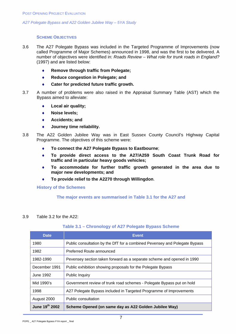
Table 3.1 – Chronology of A27 Polegate Bypass Scheme
Date Event
1980 Public consultation by the DfT for a combined Pevensey and Polegate Bypass
1982 Preferred Route announced
1982-1990 Pevensey section taken forward as a separate scheme and opened in 1990
December 1991 Public exhibition showing proposals for the Polegate Bypass
June 1992 Public Inquiry
Mid 1990’s Government review of trunk road schemes - Polegate Bypass put on hold
1998 A27 Polegate Bypass included in Targeted Programme of Improvements
August 2000 Public consultation
June 19th 2002 Scheme Opened (on same day as A22 Golden Jubilee Way)
POST OPENING PROJECT EVALUATION A27 Polegate Bypass and A22 Golden Jubilee Way – 5YA Study
8 POPE _ A27 Polegate Bypass FYA report _ final
Case Study 1 – Media Reports of Scheme Opening
EASTBOURNE’S NEW ‘FRONT DOOR’ ‘It is hoped the road (A22) will relieve the bottleneck through Polegate and Willingdon and give an impressive entrance to holiday makers visiting the town’. Eastbourne News (2002)
BYPASS OPENS FOR BUSINESS
‘A multi-million pound bypass opens today after almost two years of delayed construction (A27)…It is hoped the new road will take away about two-thirds of the 18,000 vehicles that pass through Polegate town centre every day…The opening should come as a relief to the residents in Polegate, who have had to endure years of lorries thundering past their homes’. Eastbourne News (19/06/2002)
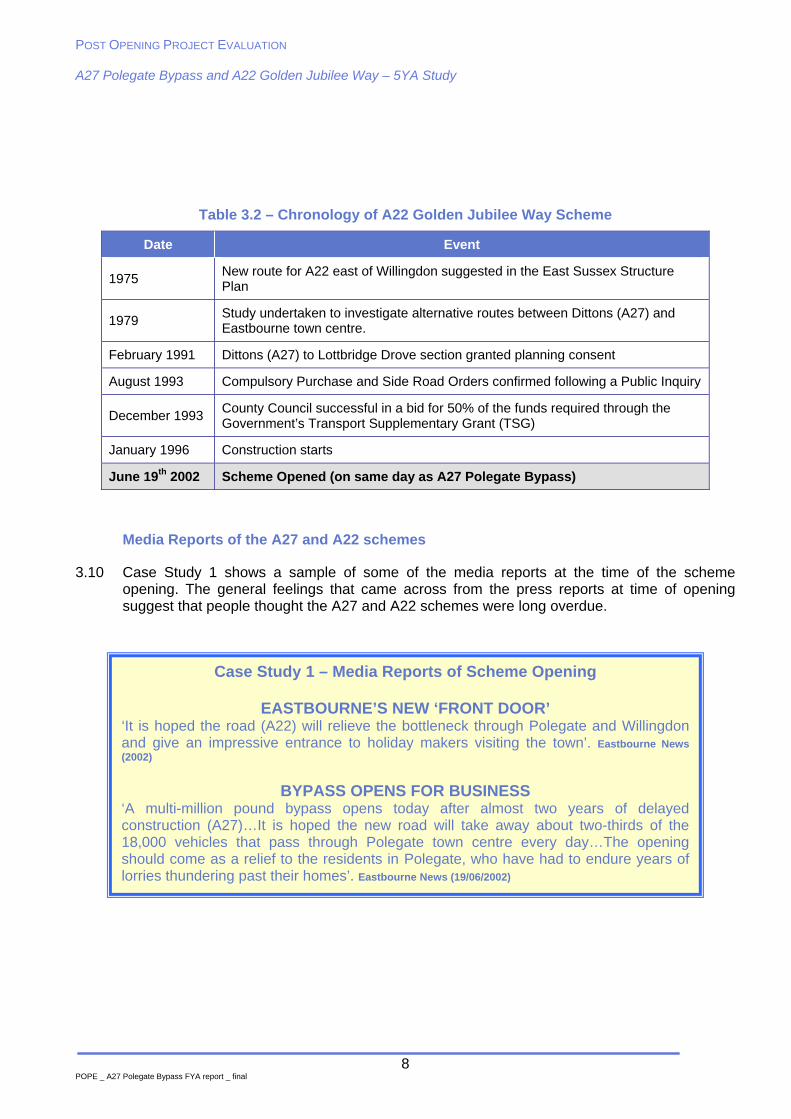
Table 3.2 – Chronology of A22 Golden Jubilee Way Scheme
Date Event
1975 New route for A22 east of Willingdon suggested in the East Sussex Structure Plan
1979 Study undertaken to investigate alternative routes between Dittons (A27) and Eastbourne town centre.
February 1991 Dittons (A27) to Lottbridge Drove section granted planning consent
August 1993 Compulsory Purchase and Side Road Orders confirmed following a Public Inquiry
December 1993 County Council successful in a bid for 50% of the funds required through the Government’s Transport Supplementary Grant (TSG)
January 1996 Construction starts
June 19th 2002 Scheme Opened (on same day as A27 Polegate Bypass)
Media Reports of the A27 and A22 schemes
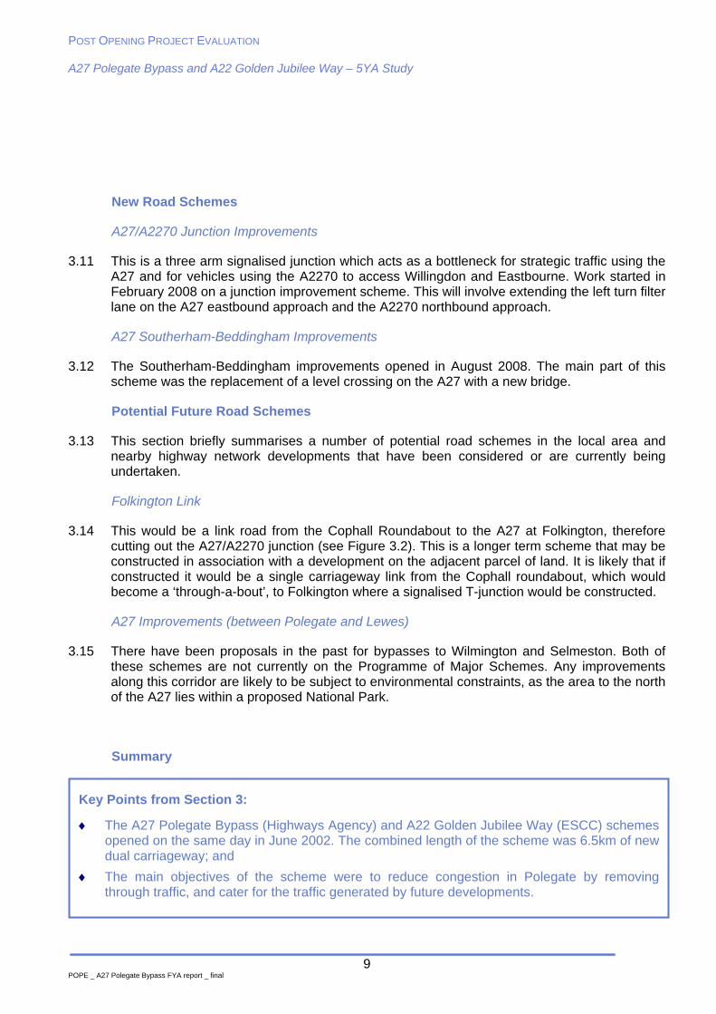
3.10 Case Study 1 shows a sample of some of the media reports at the time of the scheme opening. The general feelings that came across from the press reports at time of opening suggest that people thought the A27 and A22 schemes were long overdue.
POST OPENING PROJECT EVALUATION A27 Polegate Bypass and A22 Golden Jubilee Way – 5YA Study
9 POPE _ A27 Polegate Bypass FYA report _ final
New Road Schemes
A27/A2270 Junction Improvements
3.11 This is a three arm signalised junction which acts as a bottleneck for strategic traffic using the A27 and for vehicles using the A2270 to access Willingdon and Eastbourne. Work started in February 2008 on a junction improvement scheme. This will involve extending the left turn filter lane on the A27 eastbound approach and the A2270 northbound approach.
A27 Southerham-Beddingham Improvements
3.12 The Southerham-Beddingham improvements opened in August 2008. The main part of this scheme was the replacement of a level crossing on the A27 with a new bridge.
Potential Future Road Schemes
3.13 This section briefly summarises a number of potential road schemes in the local area and nearby highway network developments that have been considered or are currently being undertaken.
Folkington Link
3.14 This would be a link road from the Cophall Roundabout to the A27 at Folkington, therefore cutting out the A27/A2270 junction (see Figure 3.2). This is a longer term scheme that may be constructed in association with a development on the adjacent parcel of land. It is likely that if constructed it would be a single carriageway link from the Cophall roundabout, which would become a ‘through-a-bout’, to Folkington where a signalised T-junction would be constructed.
A27 Improvements (between Polegate and Lewes)
3.15 There have been proposals in the past for bypasses to Wilmington and Selmeston. Both of these schemes are not currently on the Programme of Major Schemes. Any improvements along this corridor are likely to be subject to environmental constraints, as the area to the north of the A27 lies within a proposed National Park.
Summary
Key Points from Section 3:
The A27 Polegate Bypass (Highways Agency) and A22 Golden Jubilee Way (ESCC) schemes opened on the same day in June 2002. The combined length of the scheme was 6.5km of new dual carriageway; and
The main objectives of the scheme were to reduce congestion in Polegate by removing through traffic, and cater for the traffic generated by future developments.
POST OPENING PROJECT EVALUATION A27 Polegate Bypass and A22 Golden Jubilee Way – 5YA Study
10
4. Data Collection
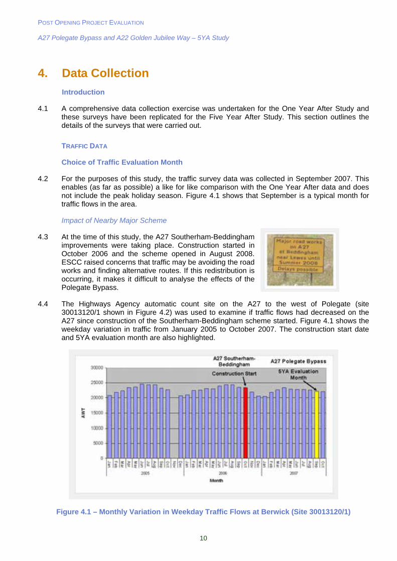
Introduction
4.1 A comprehensive data collection exercise was undertaken for the One Year After Study and these surveys have been replicated for the Five Year After Study. This section outlines the details of the surveys that were carried out.
TRAFFIC DATA
Choice of Traffic Evaluation Month
4.2 For the purposes of this study, the traffic survey data was collected in September 2007. This enables (as far as possible) a like for like comparison with the One Year After data and does not include the peak holiday season. Figure 4.1 shows that September is a typical month for traffic flows in the area.
Impact of Nearby Major Scheme
4.3 At the time of this study, the A27 Southerham-Beddingham improvements were taking place. Construction started in October 2006 and the scheme opened in August 2008. ESCC raised concerns that traffic may be avoiding the road works and finding alternative routes. If this redistribution is occurring, it makes it difficult to analyse the effects of the Polegate Bypass.
4.4 The Highways Agency automatic count site on the A27 to the west of Polegate (site 30013120/1 shown in Figure 4.2) was used to examine if traffic flows had decreased on the A27 since construction of the Southerham-Beddingham scheme started. Figure 4.1 shows the weekday variation in traffic from January 2005 to October 2007. The construction start date and 5YA evaluation month are also highlighted.
Figure 4.1 – Monthly Variation in Weekday Traffic Flows at Berwick (Site 30013120/1)
POST OPENING PROJECT EVALUATION A27 Polegate Bypass and A22 Golden Jubilee Way – 5YA Study
11
4.5 Figure 4.1 shows that there has been a slight decrease in traffic using the A27 west of Polegate since construction started. Due to the time constraints of this study it was decided to continue with September 2007 as the survey month. Any redistribution of traffic is covered by the screenline analysis which is undertaken later in this report. Also when analysing the traffic data from the sites west of Polegate, a series of logic checks has been undertaken. This has involved removing any counts which are significantly lower or higher than the ‘normal’ flows for September 2007 to account for any unusual conditions resulting from the road works.
Highways Agency Traffic Count Sites
4.6 Count data was obtained from the permanent Automatic Traffic Count (ATC) sites maintained by the HA from 2002 to 2007 on the A27 which is the only trunk road likely to be affected by the scheme. This data has been extracted from the HA TRADS database.
Local Authority Traffic Count Sites
4.7 East Sussex County Council has supplied traffic count data from a number of permanent sites in and around Eastbourne.
4.8 The locations of the HA and ESCC count site locations used in this report are shown in Figure 4.2. The numbers on the diagram refer to the ESCC and HA site reference codes.
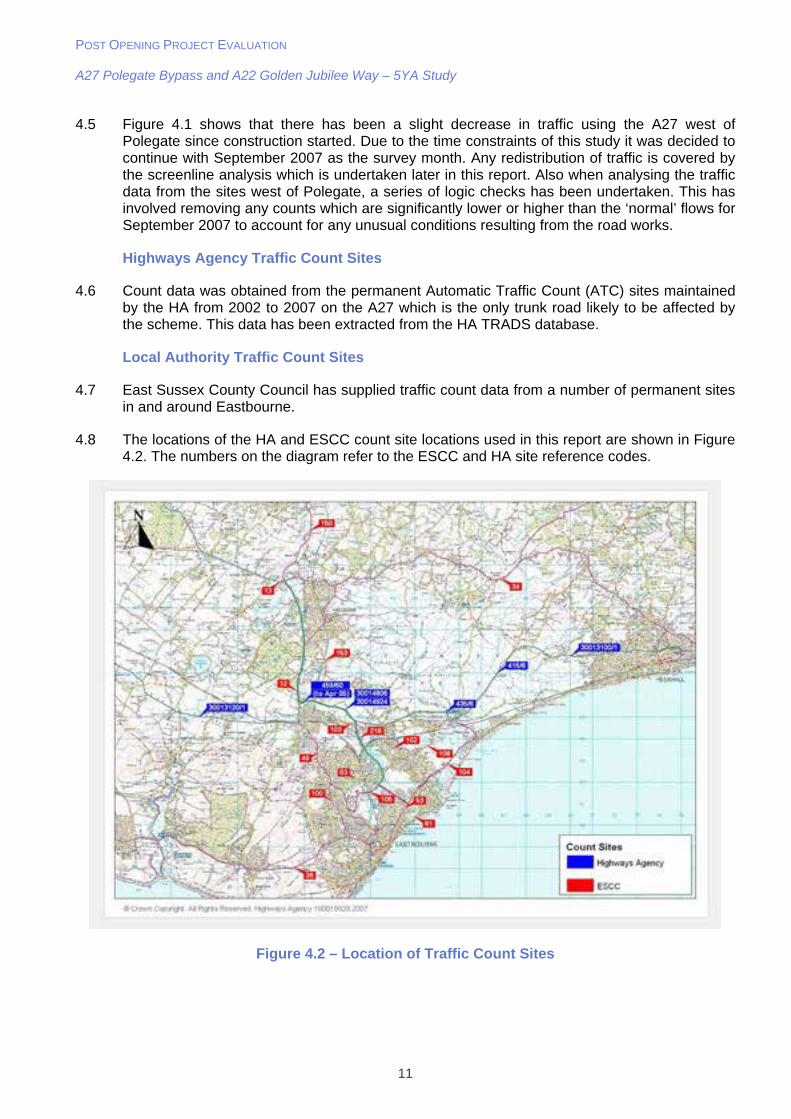
Figure 4.2 – Location of Traffic Count Sites
POST OPENING PROJECT EVALUATION A27 Polegate Bypass and A22 Golden Jubilee Way – 5YA Study
12
Journey Time Surveys
4.9 In order to assess the effects of the new routes, one year after opening journey time surveys were undertaken in September 2003, using the same routes as those used for the ‘before’ surveys undertaken in February 2001:
Green Route – A27 Polegate Bypass between A22 and A259 at Pevensey; and
Purple Route – B2247 (old A27) between A22 and B2104 at Stone Cross.
4.10 A further seven routes were assessed for the OYA study to be used as an assessment of economic benefit. These are listed below:
Blue Route – A22 Golden Jubilee Way & A2280 Cross Levels Way between A27 Polegate Bypass and A2021;
Red Route – A22 between Boship Roundabout (Hailsham) and A27 Polegate Bypass;
Pink Route – B2191 between Pevensey and A22 Golden Jubilee Way;
Orange Route – A259 between Pevensey and Susan’s Road/Seaside Road (Eastbourne Town Centre Ring Road);
Yellow Route – B2104 between Hailsham and A259 St Anthony's Ave (Langney Roundabout);
Turquoise Route – A2270 & A2040 & A2021 between Willingdon Roundabout and A259 Seaside; and
Peach Route – A22 & A2270 & A2021 between A22/A27 and A2040 Upper Avenue.
4.11 These form a total of 9 journey time routes and are shown in Figure 4.3. In order to re-assess the effects of the scheme 5 years after opening these surveys were replicated in September 2007. A total of 6 runs were carried out in each direction during the following time periods:
AM (07:30-09:00);
Inter peak (10:00-11:30); and
PM (16:30-18:00).
Figure 4.3 – Location of Journey Time Survey Routes
POST OPENING PROJECT EVALUATION A27 Polegate Bypass and A22 Golden Jubilee Way – 5YA Study
13
4.12 In summary, the traffic volumes used in the evaluation of this scheme have been based on long term counts on both the trunk road and local road networks. These long term counts enable traffic volumes to be determined for:
Annual Average Daily Traffic (AADT), which represents an average day including weekends; and
Annual Average Weekday Traffic (AAWT), which represents an average day, excluding weekends, hence the AAWT traffic volumes tend to be higher than AADT.
ACCIDENT DATA
4.13 East Sussex County Council has provided accident data for the five years prior to scheme opening and five years after. This takes the form of number of accidents on each of the routes used for the journey time surveys (shown in Figure 4.3).
4.14 The accident data covers all recorded Personal Injury Accidents (PIAs), including details of the severity of casualty injuries (slight, serious, fatal). It should be noted at this stage that the accident data has not been independantly validated by the DfT.
QUESTIONNAIRE SURVEY
4.15 A number of the DfT’s appraisal objectives are difficult to quantify. In order to address this, a questionnaire survey was designed to elicit the views of the local residents in Polegate on a number of issues relating to quality of life, severance, accessibility, and environmental impacts.
4.16 Figure 4.1 shows the area covered by the questionnaire survey. This is split into three zones so that it is possible to determine the views of residents living close to the Bypass (Polegate North), close to the old A27 (Polegate Central) and those who live south of the railway line (Polegate South).
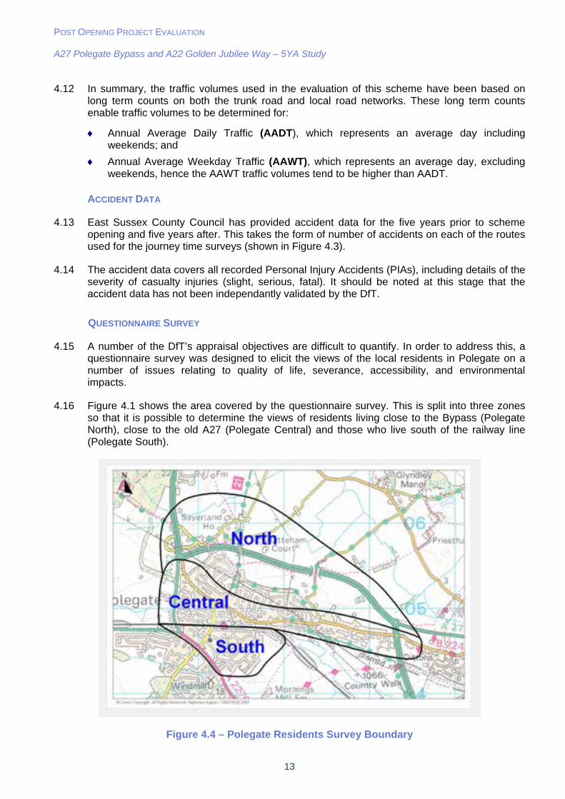
Figure 4.4 – Polegate Residents Survey Boundary
POST OPENING PROJECT EVALUATION A27 Polegate Bypass and A22 Golden Jubilee Way – 5YA Study
14
4.17 Nearly 3000 questionnaires were distributed in November 2007. A copy of the survey form and publicity material is contained in Appendix A. Table 4.1 shows the number of survey forms returned in total and also by zone.
Table 4.1 - Survey Forms Delivered and Returned
Zone Forms Delivered Forms Received % of Forms Returned
North Polegate 509 161 31%
Central Polegate 1568 408 26%
South Polegate 736 170 23%
TOTAL 2813 739 26%
4.18 The questions and responses have been included below because they do not necessarily fall under an appraisal sub-objective, and serve as a useful background for the rest of this report.
4.19 Question 1 was required to filter those residents who moved to the Polegate area since the scheme opened. It can be seen that 82% of Polegate residents who responded have lived in the area for over five years.
Question 1. How long have you lived in the Polegate area?
North Polegate Central
Polegate South Polegate TOTAL
More than 5 years 127 338 142 607 (82%)
Less than 5 years 34 70 28 132 (17%)
4.20 Of those residents who have lived in the area for less than 5 years, 95% were aware that Polegate had a Bypass when they moved (see Question 2 below).
Question 2. Were you aware that Polegate had a Bypass when you moved here?
North Polegate Central
Polegate South Polegate TOTAL
Yes 32 (94%) 68 (97%) 26 (93%) 126 (95%)
No 2 (6%) 2 (3%) 2 (7%) 6 (5%)
4.21 In addition 38% of residents cited the existence of the Bypass as a factor in the decision to move to the area (see Question 3 below).
Question 3. Did the fact that Polegate had a Bypass influence your decision to move here?
North Polegate Central
Polegate South Polegate TOTAL
Yes 10 (31%) 31 (46%) 7 (27%) 48 (38%)
No 22 (69%) 37 (54%) 19 (73%) 78 (62%)
4.22 Questions 4 and 5 were aimed at those who have lived in Polegate for more than 5 years and therefore remember what the area was like before the scheme opened. It can be seen from the results below that only 8% of residents were opposed to the Polegate Bypass and 4%
POST OPENING PROJECT EVALUATION A27 Polegate Bypass and A22 Golden Jubilee Way – 5YA Study
15
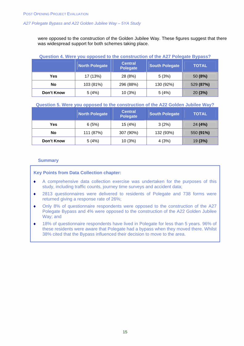
were opposed to the construction of the Golden Jubilee Way. These figures suggest that there was widespread support for both schemes taking place.
Question 4. Were you opposed to the construction of the A27 Polegate Bypass?
North Polegate Central
Polegate South Polegate TOTAL
Yes 17 (13%) 28 (8%) 5 (3%) 50 (8%)
No 103 (81%) 296 (88%) 130 (92%) 529 (87%)
Don’t Know 5 (4%) 10 (3%) 5 (4%) 20 (3%)
Question 5. Were you opposed to the construction of the A22 Golden Jubilee Way?
North Polegate Central
Polegate South Polegate TOTAL
Yes 6 (5%) 15 (4%) 3 (2%) 24 (4%)
No 111 (87%) 307 (90%) 132 (93%) 550 (91%)
Don’t Know 5 (4%) 10 (3%) 4 (3%) 19 (3%)
Summary
Key Points from Data Collection chapter:
A comprehensive data collection exercise was undertaken for the purposes of this study, including traffic counts, journey time surveys and accident data;
2813 questionnaires were delivered to residents of Polegate and 738 forms were returned giving a response rate of 26%;
Only 8% of questionnaire respondents were opposed to the construction of the A27 Polegate Bypass and 4% were opposed to the construction of the A22 Golden Jubilee Way; and
18% of questionnaire respondents have lived in Polegate for less than 5 years. 96% of these residents were aware that Polegate had a bypass when they moved there. Whilst 38% cited that the Bypass influenced their decision to move to the area.
POST OPENING PROJECT EVALUATION A27 Polegate Bypass and A22 Golden Jubilee Way – 5YA Study
16
5. Traffic Data Analysis
Introduction
5.1 This Chapter describes the main traffic volume changes that have taken place in the A27(T) and A22 corridors before and after the new routes opened to traffic, including one year after and five years after. Comparisons are also made with predictions where data is available.
Background Traffic Growth
5.2 When making comparisons between the ‘before’ and ‘after’ situation, consideration should be given to the level of natural traffic growth likely to occur in the area between 2001 (the year before opening), 2002 (opening year), 2003 (one year after), and 2007 (5 years after).
5.3 There are two sources of national and regional traffic growth information. These have been extracted such that any traffic volume changes as a result of the scheme are put into context against ‘background’ traffic growth (i.e. growth that would have occurred regardless of whether the scheme was built).
5.4 Predicted percentage increases in traffic by year are published in the National Road Traffic Forecasts (NRTF) which is amended periodically. The latest available version of NRTF was published by the DfT in 1997.
5.5 TEMPRO (Trip End Model Presentation Program) is a DfT package that provides local and regional projections of growth over time. The current version is TEMPRO 5.3. TEMPRO is able to produce growth factors that are region specific, taking into account population trends, allocated development sites and the associated growth in traffic.
5.6 In order to make estimates of likely traffic growth specific to the Eastbourne area, predictions from NRTF were adjusted to reflect local conditions using figures from TEMPRO (details of the method are contained in the TEMPRO Guidance Note on the TEMPRO website). Table 5.1 shows the predicted traffic growth for Eastbourne and Great Britain.
Table 5.1 – Predicted Traffic Growth
Period Eastbourne NRTF Central Forecast for
Great Britain
2002-2007 6.5% 8.6%
2003-2007 5.4% 6.8%
5.7 Statistics on observed road traffic growth by vehicle type are available in the Transport Statistics Bulletin: Traffic in Great Britain. National growth for the periods covered in this report is shown in Table 5.2.
Table 5.2 – Observed Traffic Growth in Great Britain by Road Type
Year Motorway Rural A Roads Urban A Roads All Roads
2002-2007 7% 7% -1% 5%
2003-2007 7% 5% 0% 4%
5.8 These figures show that the predicted levels of traffic growth for East Sussex and Great Britain are higher than those actually observed over the same period in the ‘All Roads’ category.
POST OPENING PROJECT EVALUATION A27 Polegate Bypass and A22 Golden Jubilee Way – 5YA Study
17
5.9 The figures in this section have been provided to show the predicted and observed traffic growth in East Sussex over the last few years. For the purposes of this study, the traffic flows have not been factored to account for background traffic growth. However, these factors were used when undertaking the re-assessment of economic benefits discussed later in this report.
TRAFFIC COUNTS – LOCAL AREA
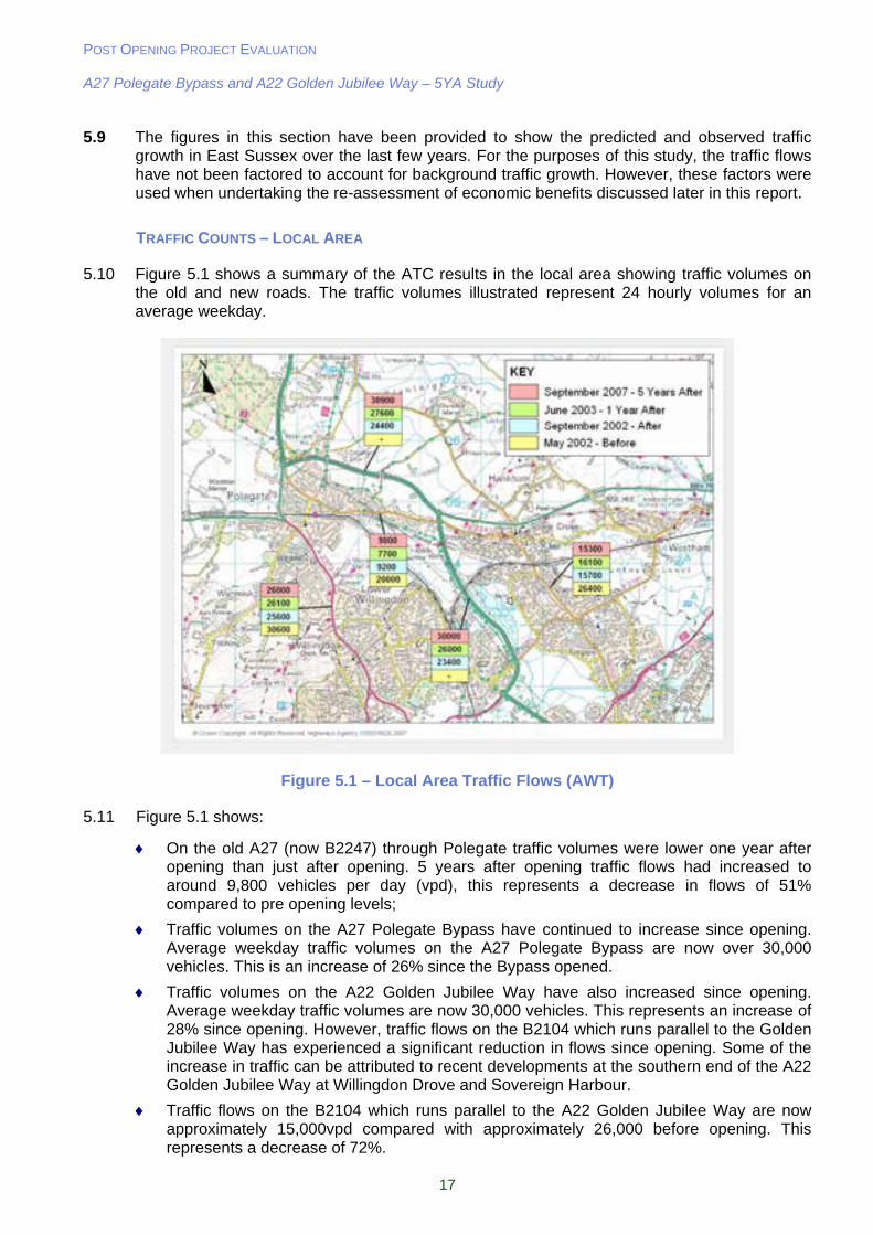
5.10 Figure 5.1 shows a summary of the ATC results in the local area showing traffic volumes on the old and new roads. The traffic volumes illustrated represent 24 hourly volumes for an average weekday.
Figure 5.1 – Local Area Traffic Flows (AWT)
5.11 Figure 5.1 shows:
On the old A27 (now B2247) through Polegate traffic volumes were lower one year after opening than just after opening. 5 years after opening traffic flows had increased to around 9,800 vehicles per day (vpd), this represents a decrease in flows of 51% compared to pre opening levels;
Traffic volumes on the A27 Polegate Bypass have continued to increase since opening. Average weekday traffic volumes on the A27 Polegate Bypass are now over 30,000 vehicles. This is an increase of 26% since the Bypass opened.
Traffic volumes on the A22 Golden Jubilee Way have also increased since opening. Average weekday traffic volumes are now 30,000 vehicles. This represents an increase of 28% since opening. However, traffic flows on the B2104 which runs parallel to the Golden Jubilee Way has experienced a significant reduction in flows since opening. Some of the increase in traffic can be attributed to recent developments at the southern end of the A22 Golden Jubilee Way at Willingdon Drove and Sovereign Harbour.
Traffic flows on the B2104 which runs parallel to the A22 Golden Jubilee Way are now approximately 15,000vpd compared with approximately 26,000 before opening. This represents a decrease of 72%.
POST OPENING PROJECT EVALUATION A27 Polegate Bypass and A22 Golden Jubilee Way – 5YA Study
18
On the A2270 through Willingdon, traffic volumes have remained fairly constant at around 26,000vpd. This represents a decrease of 18% compared to pre-opening traffic levels, and shows that some north-south traffic to and from Eastbourne has re-routed onto the new A22.
Local Corridor Flow Analysis
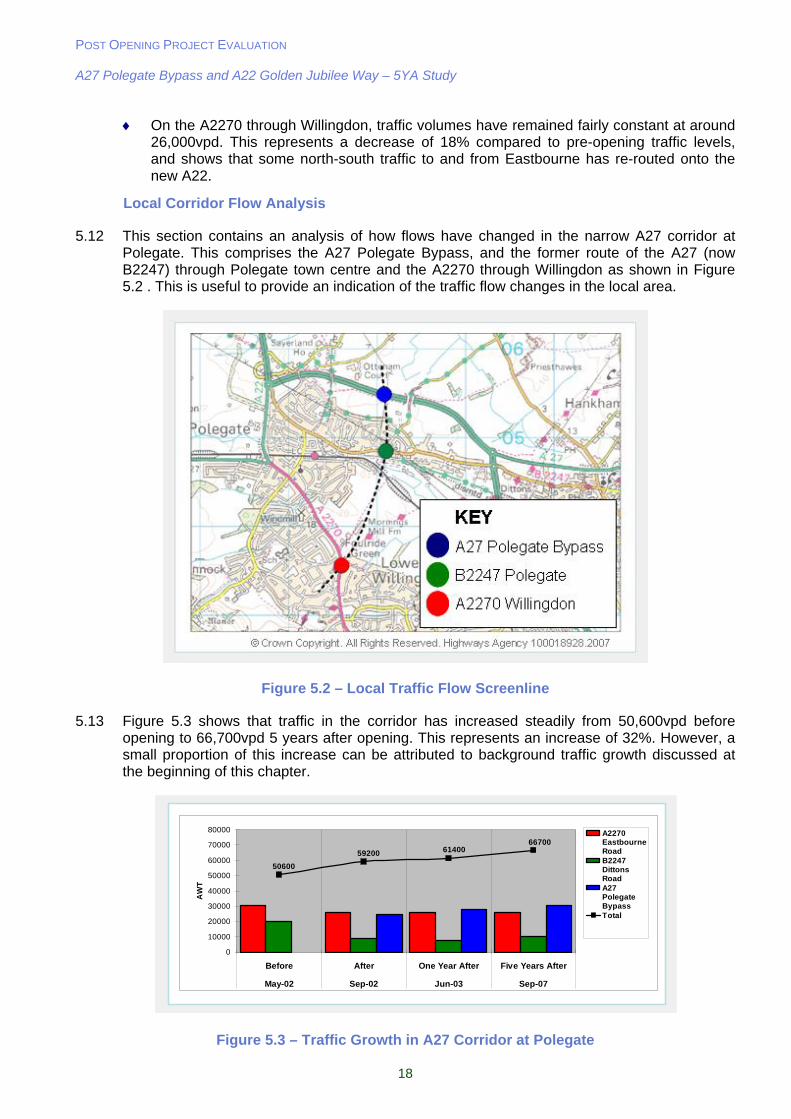
5.12 This section contains an analysis of how flows have changed in the narrow A27 corridor at Polegate. This comprises the A27 Polegate Bypass, and the former route of the A27 (now B2247) through Polegate town centre and the A2270 through Willingdon as shown in Figure 5.2 . This is useful to provide an indication of the traffic flow changes in the local area.
Figure 5.2 – Local Traffic Flow Screenline
5.13 Figure 5.3 shows that traffic in the corridor has increased steadily from 50,600vpd before opening to 66,700vpd 5 years after opening. This represents an increase of 32%. However, a small proportion of this increase can be attributed to background traffic growth discussed at the beginning of this chapter.
667006140059200
50600
0
10000
20000
30000
40000
50000
60000
70000
80000
Before After One Year After Five Years After
May-02 Sep-02 Jun-03 Sep-07
AW
T
A2270EastbourneRoadB2247DittonsRoadA27PolegateBypassTotal
667006140059200
50600
0
10000
20000
30000
40000
50000
60000
70000
80000
Before After One Year After Five Years After
May-02 Sep-02 Jun-03 Sep-07
AW
T
A2270EastbourneRoadB2247DittonsRoadA27PolegateBypassTotal
Figure 5.3 – Traffic Growth in A27 Corridor at Polegate
POST OPENING PROJECT EVALUATION A27 Polegate Bypass and A22 Golden Jubilee Way – 5YA Study
19
TRAFFIC COUNTS – WIDER AREA
5.14 Figure 5.4 shows the changes in daily traffic volumes around Polegate and Eastbourne, and other routes in the area. Examining traffic flows over a wider area is carried out to establish wider re-routing patterns as a result of the scheme. This is achieved by undertaking screenline analysis which is shown in the following section.
5.15 Figure 5.4 shows:
Traffic flows on the A27 at Pevensey (east of Polegate) have increased from 9300vpd before opening to 16,600vpd five years after opening. This represents an increase of 78%. However, flows on the A259 Pevensey Bay Road and B2191 have decreased since opening. The cause of this will be assessed in the following section;
Traffic flows on the A27 west of Polegate remain virtually unchanged with a slight increase from 21,700vpd before opening to 22,200vpd after opening. This increase is likely to be due to background traffic growth, and coupled with an expected drop in flows due to re-routing to avoid the roadworks at Southerham-Beddingham this would bring the increase close to the 6% increase predicted by TEMPRO; and
A significant increase in traffic flows on the A22 north of Polegate of which a large proportion can be attributed to traffic reassigning from the parallel B2104.
Figure 5.4 – Wider Area Traffic Flows (AWT)
Screenlines
5.16 Traffic data from permanent count sites maintained by ESCC and the HA has been used to make up seven screenlines in the Polegate and Eastbourne area to evaluate any changes to
POST OPENING PROJECT EVALUATION A27 Polegate Bypass and A22 Golden Jubilee Way – 5YA Study
20
strategic and local traffic patterns. Traffic crossing these screenlines represents vehicular movement across a wide corridor and therefore can show traffic flow changes in a complex network better than analysing individual roads. The traffic counts used to make up the screenlines are shown in Figure 4.2 previously.
5.17 The screenlines are defined as:
Screenline 1 - West of Polegate / Eastbourne: A259, A27, A22;
Screenline 2 - East of Pevensey: A271, A259 (Middle Bridge);
Screenline 3 - West of Pevensey: A27, B2191, A259
Screenline 4 - North of Polegate: A22, B2104
Screenline 5 - South of Polegate: A2270, A22 (Golden Jubilee Way), B2104:
Screenline 6 - North East of Eastbourne Town Centre: U2236 (Neville Avenue, Hampden Park), A2280, A259, U2180 (Royal Parade); and
Screenline 7 - North and East of Eastbourne / South of Polegate: (A2270, A22 Golden Jubilee Way), B2104, B2191, A259.
5.18 The screenlines are shown in Figure 5.5 and Figure 5.6. A number of the count sites in these screenlines are near to Eastbourne and thus are likely to experience increased traffic volumes in the months of July and August, due to tourism. A comparison of flows across the screenlines has therefore been made in the following months:
‘Before Opening’ – May 2002; and
‘Five Year After’ – September 2007.
Figure 5.5 – Screenlines 1, 2, 6 and 7
POST OPENING PROJECT EVALUATION A27 Polegate Bypass and A22 Golden Jubilee Way – 5YA Study
21
Figure 5.6 – Screenlines 3, 4 and 5
5.19 The changes in flow on the screenlines are listed in Table 5.3. The major impacts can be summarised as follows:
Screenline 1 – West of Polegate/Eastbourne
There has been little overall change across this screenline since the scheme opened with a 1% increase in traffic compared to before opening levels. This is lower than would be expected for background traffic growth and suggests that the roadworks further west on the A27 at Southerham-Beddingham may have had an influence on flows across this screenline. This is supported by the fact that the One Year After Opening study showed a slight increase across this screenline.
Screenline 2 – East of Pevensey
Screenline 2 has experienced a growth in traffic of approximately 5%, in line with background traffic growth predictions. However, it also appears that there has been some reassignment of trips from the A271 onto the A259 which becomes the A27. This suggests that the improvement at Polegate may have attracted more trips into this corridor
Screenline 3 – West of Pevensey
There has been an increase of approximately 7,000 vehicles on the A27 compared to the before opening situation. However, the majority of this increase can be attributed to re-assignment from the B2191 (3,200 vehicles) and A259 Pevensey Bay Road (2,700 vehicles). This information, along with the results from Screenline 7 suggests that more traffic from the east is using the A22 Golden Jubilee Way to enter Eastbourne rather than using the A259 through Pevensey Bay. The overall increase in flows across the screenline is 4%, again in line with background traffic growth predictions.

POST OPENING PROJECT EVALUATION A27 Polegate Bypass and A22 Golden Jubilee Way – 5YA Study
22
Screenline 4 – North of Polegate
There has been an increase of 12,100 vehicles on the A22 north of Polegate since before the scheme opened. However, the traffic flows suggest that approximately 5,000 of those trips have reassigned from the parallel B2104 now that there is a higher quality route to and from Eastbourne via the A27/A22 routes.
Screenline 5 – South of Polegate
Traffic flows have continued to increase across this screenline with 14,300 extra vehicles compared to the before situation representing an increase of 25%. This high increase can be attributed to the introduction of the A22 Golden Jubilee Way. However, this route has also contributed to considerable reductions on A2270 (4,600 vehicles) and B2104 (11,100 vehicles)
Screenline 6 – North East of Eastbourne Town Centre
Screenline 6 shows a decrease of 1,500 vehicles from before opening. The major decreases are on B2103 Royal Parade (-1,000) and A259 Seaside (-900). These are small changes given the traffic flows on these routes which suggest that the schemes have not had a significant impact on traffic movements in this area.
Screenline 7 – North and East of Eastbourne / South of Polegate
The results for screenline 7 show that the A22 Golden Jubilee Way remains successful in taking traffic from the other main routes into Eastbourne from the north and east.
Traffic flows have decreased on all routes across the screenline except the A22 between before opening and five years after opening. This represents a 10% increase across the screenline and shows that the A22 has become the main route for vehicles entering the east of Eastbourne.

POST OPENING PROJECT EVALUATION A27 Polegate Bypass and A22 Golden Jubilee Way – 5YA Study
23
Table 5.3 – Screenline Flows
May-02 Sep-07
Location
Before 5YA
Change % Change
Screenline 1 – West of Polegate and Eastbourne (strategic) A259 East Dean 14,200 13,300 -900 -6% A27 West of Polegate 21,700 22,200 500 2% A22 West of Hailsham 25,500 26,700 1,200 5% Total 61,400 62,200 800 1%
Screenline 2- East of Polegate and Eastbourne (strategic) A271 Boreham Street 11,200 10,400 -800 -7% A259 Middle Bridge 20,400 22,700 2,300 11% Total 31,600 33,100 1,500 5%
Screenline 3 – East of Polegate and Eastbourne (local) A27 West of Pevensey 9,300 16,600 7,300 78% B2191 Langney 11,200 8,000 -3,200 -29% A259 Pevensey Bay Road 17,200 14,500 -2,700 -16% Total 37,700 39,100 1,400 4%
Screenline 4 – North of Polegate A22 North of Polegate 26,400 38,500 12,100 46% B2104 Ersham Road 11,100 5,700 -5,400 -49% Total 37,500 44,200 6,700 18%
Screenline 5 – South of Polegate A2270 N of Willingdon 30,600 26,000 -4,600 -15% A22 Golden Jubilee Way n/a 30,000 30,000 N/A B2104 Friday Street 26,400 15,300 -11,100 -42% Total 57,000 71,300 14,300 25%
Screenline 6 – Through Eastbourne B2103 Royal Parade 22,000 21,300 -700 -3% A259 Seaside 31,000 31,300 300 1% A2280 Cross Levels Way 29,900 29,700 -200 -1% U2236 Hampden Park 7,800 6,900 -900 -12% Total 90,700 89,200 -1,500 -2%
Screenline 7 – North of Eastbourne, South of Polegate A2270 N of Willingdon 30,600 26,000 -4,600 -15% A22 Golden Jubilee Way n/a 30,000 30,000 N/A B2104 Friday Street 26,400 15,300 -11,100 -42% B2191 Langney 11,200 8,000 -3,200 -29% A259 Pevensey Bay Road 17,200 14,800 -2,700 -16% Total 85,400 94,100 8,400 10%
5.20 The main summary to draw from this screenline analysis is that there has been an overall increase in traffic movements from the before opening situation. North to south movements tend to have seen the highest percentage increase, reflecting the popularity of the A27/A22 routes into Eastbourne.
TRAFFIC GROWTH
5.21 Error! Reference source not found. below shows the monthly variation in average weekday traffic on the A27 Polegate Bypass from July 2002, the 1st month after opening, to September
POST OPENING PROJECT EVALUATION A27 Polegate Bypass and A22 Golden Jubilee Way – 5YA Study
24
2007, the latest date for which data is available. This clearly shows the following trends in traffic volumes on the Polegate Bypass since opening:
There are seasonal trends in traffic flows with lowest volumes occurring during the middle of winter and the highest during the summer and early autumn; and
Overall traffic levels have shown a steady increase since the scheme opened. Between 2003 and 2004 there was a 4% increase. Between 2003 and 2005 this rose to 8% and by 2006 this was 9%. At the time of this study, data for the whole of 2007 was not available, however, traffic flows from the first six months of 2007 shows an increase of 13% from the same period in 2003.
The gradual increase in traffic flows on the Polegate Bypass is consistent with the increases in flows on the A22 north of Polegate and the A27 at Pevensey, east of the Bypass as reported in the screenlines section previously.
0
5000
10000
15000
20000
25000
30000
35000
JulA
ugS
epO
ctN
ovD
ecJanF
ebM
arA
prM
ayJunJulA
ugS
epO
ctN
ovD
ecJanF
ebM
arA
prM
ayJunJulA
ugS
epO
ctN
ovD
ecJanF
ebM
arA
prM
ayJunJulA
ugS
epO
ctN
ovD
ecJanF
ebM
arA
prM
ayJunJulA
ugS
epO
ctN
ovD
ecJanF
ebM
arA
prM
ayJunJulA
ugS
ep
2002 2003 2004 2005 2006 2007
Month
AW
T
Five Years AfterOne Year After
0
5000
10000
15000
20000
25000
30000
35000
JulA
ugS
epO
ctN
ovD
ecJanF
ebM
arA
prM
ayJunJulA
ugS
epO
ctN
ovD
ecJanF
ebM
arA
prM
ayJunJulA
ugS
epO
ctN
ovD
ecJanF
ebM
arA
prM
ayJunJulA
ugS
epO
ctN
ovD
ecJanF
ebM
arA
prM
ayJunJulA
ugS
epO
ctN
ovD
ecJanF
ebM
arA
prM
ayJunJulA
ugS
ep
2002 2003 2004 2005 2006 2007
Month
AW
T
Five Years AfterOne Year AfterOne Year After
Figure 5.7 – Monthly variation in Traffic Flows on the A27 Polegate Bypass (AWT)
Heavy Goods Vehicle Flows
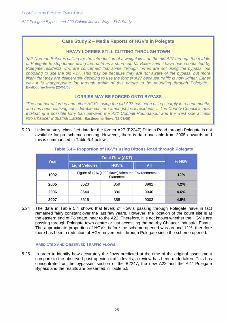
5.22 One of the main aims of the Polegate Bypass was to remove the heavy volume of traffic from Polegate Town Centre. In particular HGV’s cause noise and safety issues over and above those produced by light vehicles. Case Study 2 highlights the reported issues that have arisen since the Bypass opened. This section will analyse the effect of the Polegate Bypass on HGV flows through Polegate itself.
POST OPENING PROJECT EVALUATION A27 Polegate Bypass and A22 Golden Jubilee Way – 5YA Study
25
5.23 Unfortunately, classified data for the former A27 (B2247) Dittons Road through Polegate is not available for pre-scheme opening. However, there is data available from 2005 onwards and this is summarised in Table 5.4 below.
Table 5.4 – Proportion of HGV’s using Dittons Road through Polegate
Total Flow (ADT) Year
Light Vehicles HGV’s All % HGV
1992 Figure of 12% (1992 flows) taken the Environmental Statement 12%
2005 8623 359 8982 4.2%
2006 8644 396 9040 4.6%
2007 8615 388 9003 4.5%
5.24 The data in Table 5.4 shows that levels of HGV’s passing through Polegate have in fact remained fairly constant over the last few years. However, the location of the count site is at the eastern end of Polegate, near to the A22. Therefore, it is not known whether the HGV’s are passing through Polegate town centre or just accessing the nearby Chaucer Industrial Estate. The approximate proportion of HGV’s before the scheme opened was around 12%, therefore there has been a reduction of HGV movements through Polegate since the scheme opened.
PREDICTED AND OBSERVED TRAFFIC FLOWS
5.25 In order to identify how accurately the flows predicted at the time of the original assessment compare to the observed post opening traffic levels, a review has been undertaken. This has concentrated on the bypassed section of the B2247, the new A22 and the A27 Polegate Bypass and the results are presented in Table 5.5:
Case Study 2 – Media Reports of HGV’s in Polegate
HEAVY LORRIES STILL CUTTING THROUGH TOWN
‘MP Norman Baker is calling for the introduction of a weight limit on the old A27 through the middle of Polegate to stop lorries using the route as a short cut. Mr Baker said ‘I have been contacted by Polegate residents who are concerned that some through lorries are not using the bypass, but choosing to use the old A27. This may be because they are not aware of the bypass, but more likely that they are deliberately deciding to use the former A27 because traffic is now lighter. Either way it is inappropriate for through traffic of this nature to be pounding through Polegate.’’ Eastbourne News (25/01/05)
LORRIES MAY BE FORCED ONTO BYPASS
‘The number of lorries and other HGV’s using the old A27 has been rising sharply in recent months and has been causing considerable concern amongst local residents… The County Council is now evaluating a possible lorry ban between the A22 Cophall Roundabout and the west side access into Chaucer Industrial Estate.’ Eastbourne News (16/03/05)
POST OPENING PROJECT EVALUATION A27 Polegate Bypass and A22 Golden Jubilee Way – 5YA Study
26
Table 5.5 – Comparison of Predicted and Observed Traffic Flows
B2247 (Dittons Road)
A27 Polegate Bypass
A22 Golden Jubilee Way
Low Growth
High Growth
Low Growth
High Growth
Low Growth
High Growth
Predicted Flow (2010 AWT) 7,700 8,900 28,200 36,300 21,400 30,700
Observed Flow (2003 AWT) 7,700 27,600 26,000
Difference 0 -1,200 -600 -8,700 +4,600 -4,700
On
e Y
ear
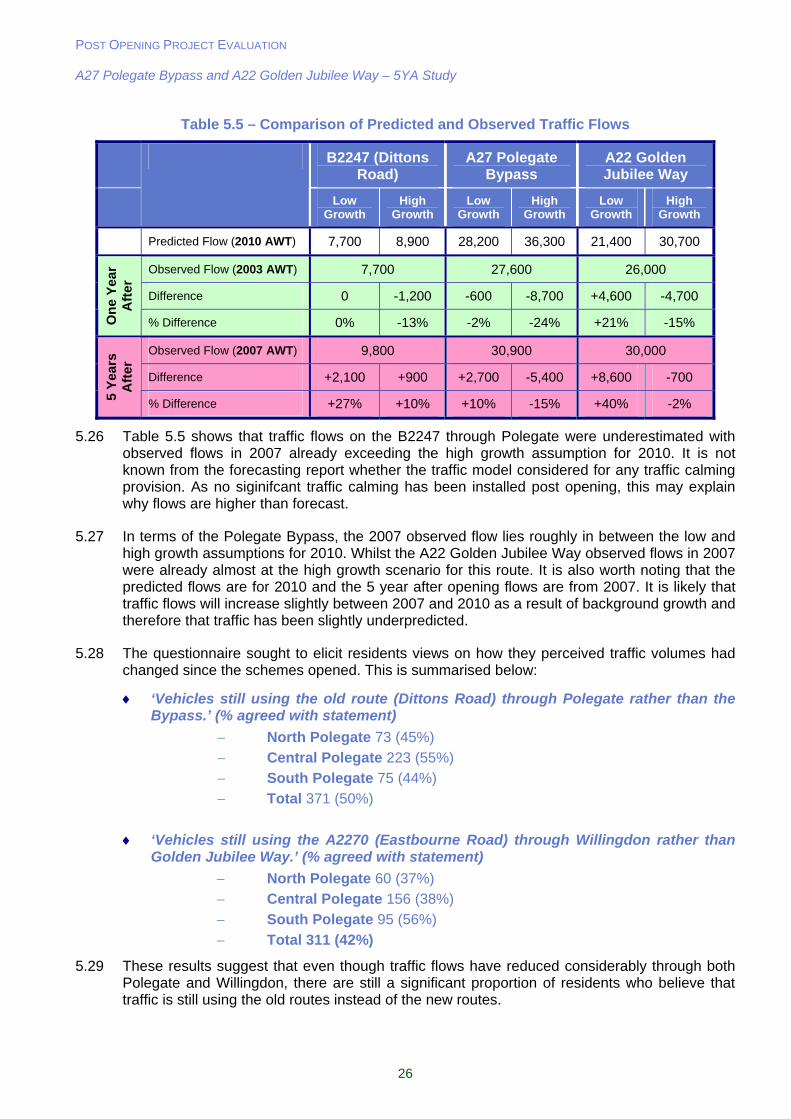
Aft
er
% Difference 0% -13% -2% -24% +21% -15%
Observed Flow (2007 AWT) 9,800 30,900 30,000
Difference +2,100 +900 +2,700 -5,400 +8,600 -700
5 Y
ears
A
fter
% Difference +27% +10% +10% -15% +40% -2%
5.26 Table 5.5 shows that traffic flows on the B2247 through Polegate were underestimated with observed flows in 2007 already exceeding the high growth assumption for 2010. It is not known from the forecasting report whether the traffic model considered for any traffic calming provision. As no siginifcant traffic calming has been installed post opening, this may explain why flows are higher than forecast.
5.27 In terms of the Polegate Bypass, the 2007 observed flow lies roughly in between the low and high growth assumptions for 2010. Whilst the A22 Golden Jubilee Way observed flows in 2007 were already almost at the high growth scenario for this route. It is also worth noting that the predicted flows are for 2010 and the 5 year after opening flows are from 2007. It is likely that traffic flows will increase slightly between 2007 and 2010 as a result of background growth and therefore that traffic has been slightly underpredicted.
5.28 The questionnaire sought to elicit residents views on how they perceived traffic volumes had changed since the schemes opened. This is summarised below:
‘Vehicles still using the old route (Dittons Road) through Polegate rather than the Bypass.’ (% agreed with statement)
North Polegate 73 (45%)
Central Polegate 223 (55%)
South Polegate 75 (44%)
Total 371 (50%)
‘Vehicles still using the A2270 (Eastbourne Road) through Willingdon rather than Golden Jubilee Way.’ (% agreed with statement)
North Polegate 60 (37%)
Central Polegate 156 (38%)
South Polegate 95 (56%)
Total 311 (42%)
5.29 These results suggest that even though traffic flows have reduced considerably through both Polegate and Willingdon, there are still a significant proportion of residents who believe that traffic is still using the old routes instead of the new routes.
POST OPENING PROJECT EVALUATION A27 Polegate Bypass and A22 Golden Jubilee Way – 5YA Study
27
Key Points from Traffic Data Analysis chapter:
Local Impacts:
Traffic has steadily grown on the A27 Polegate Bypass since the scheme opened;
AWT on the A27 Polegate Bypass is now over 30,000vpd – 26% increase since opening;
Traffic flows on the B2247 through Polegate are 49% lower than pre-opening levels. However, there has been a 7% increase since the scheme opened, higher than predicted;
HGV levels have remained fairly constant in Polegate since the bypass opened despite media reports to the contrary;
AWT on the A22 Golden Jubilee Way is 30,000vpd, an increase of 28% since opening;
Traffic levels on the A2270 have decreased by 18% compared to pre-opening levels, and has remained constant since the parallel A22 scheme opened; and
Traffic flows in the A27 corridor (Bypass, B2247 Dittons Road, and A2270 through Willingdon) have increased by 32% since before the scheme opened. Some of this increase is likely to be as a result of background traffic growth and the recent developments at the southern end of the A22 Golden Jubilee Way (Willingdon Drove and Sovereign Harbour).
Strategic Impacts:
East of Polegate, flows on the A27 have increased by 78% from before opening levels. However, this increase is balanced by reductions in flows on the B2191 and A259 into Eastbourne.
West of Polegate, this increase is 3%. This smaller increase is likely to be due to some re-routing resulting from the Southerham - Beddingham road works and the lack of alternative parallel routes in the area for traffic to re-assign from.
North of Polegate, traffic flows have increased by 18% from pre-opening levels on the A22;
The A22 Golden Jubilee Way has contributed to a reduction in traffic on the other routes into Eastbourne (A259 Pevensey Bay Road, B2191 Langley, B2104 Friday Street, A2270 Willingdon);
Screenline analysis shows a general increase in traffic in the Eastbourne area, particulary with regard to north-south movements, reflecting the popularity of the A27 Polegate Bypass and A22 Golden Jubilee Way; and
The A22 Golden Jubilee Way appears to have become a more attractive route for vehicles entering Eastbourne than it was when the scheme opened.
Predictions:
Observed traffic flows on the A27 Polegate Bypass were roughly in-between the low growth and high growth assumptions, therefore showing a favourable comparison;
The A22 Golden Jubilee Way flows almost exactly match the high growth assumption for 2010; and
Traffic flows remaining on the B2247 through Polegate were underestimated. Observed flows in 2007 were 27% higher than the 2010 low growth and 10% higher than the high growth assumption.
Public Consultation:
50% of respondents believe vehicles still use the old route (Dittons Road) through Polegate instead of the Bypass; and
42% of respondents believe vehicles still use the A2270 (Eastbourne Road) through Willingdon instead of the Golden Jubilee Way.
POST OPENING PROJECT EVALUATION A27 Polegate Bypass and A22 Golden Jubilee Way – 5YA Study
28
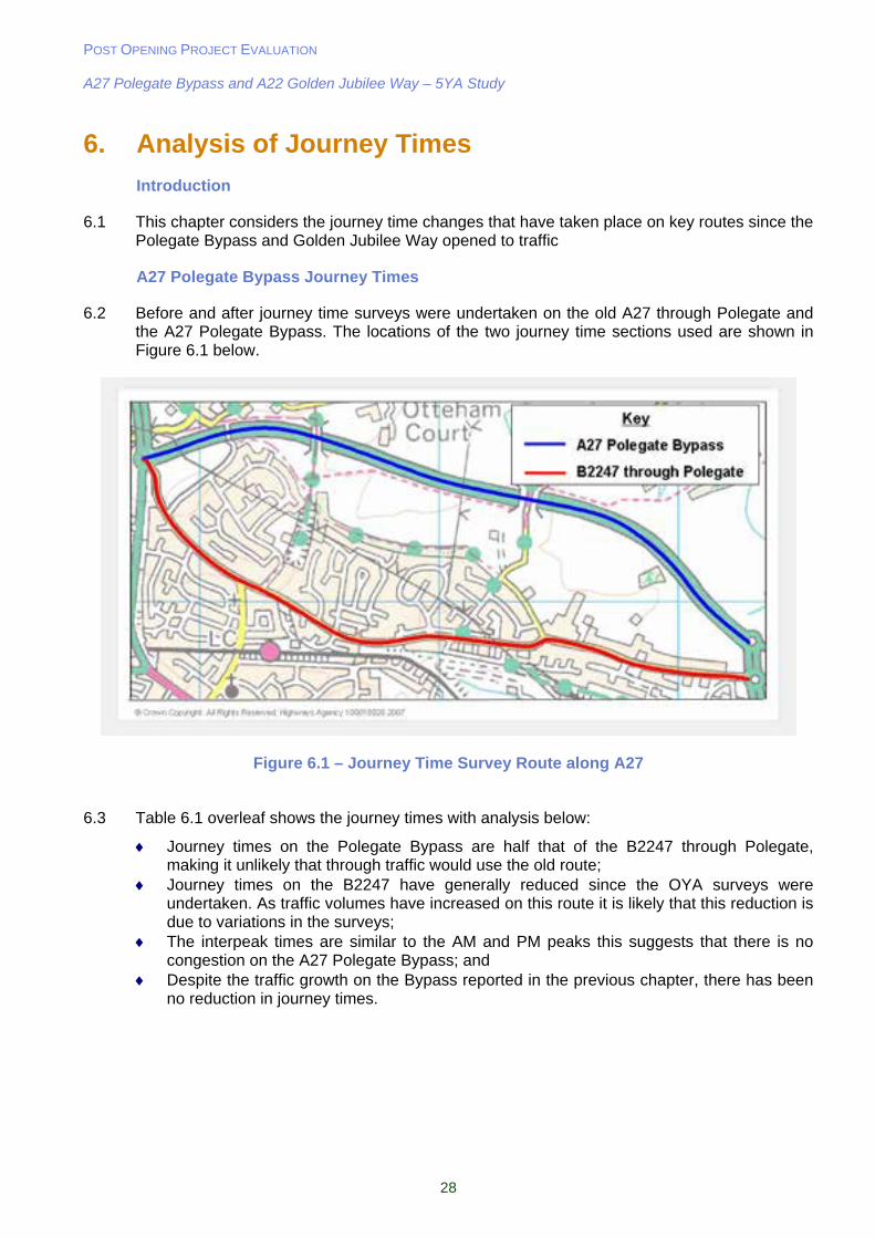
6. Analysis of Journey Times
Introduction
6.1 This chapter considers the journey time changes that have taken place on key routes since the Polegate Bypass and Golden Jubilee Way opened to traffic
A27 Polegate Bypass Journey Times
6.2 Before and after journey time surveys were undertaken on the old A27 through Polegate and the A27 Polegate Bypass. The locations of the two journey time sections used are shown in Figure 6.1 below.
Figure 6.1 – Journey Time Survey Route along A27
6.3 Table 6.1 overleaf shows the journey times with analysis below:
Journey times on the Polegate Bypass are half that of the B2247 through Polegate, making it unlikely that through traffic would use the old route;
Journey times on the B2247 have generally reduced since the OYA surveys were undertaken. As traffic volumes have increased on this route it is likely that this reduction is due to variations in the surveys;
The interpeak times are similar to the AM and PM peaks this suggests that there is no congestion on the A27 Polegate Bypass; and
Despite the traffic growth on the Bypass reported in the previous chapter, there has been no reduction in journey times.
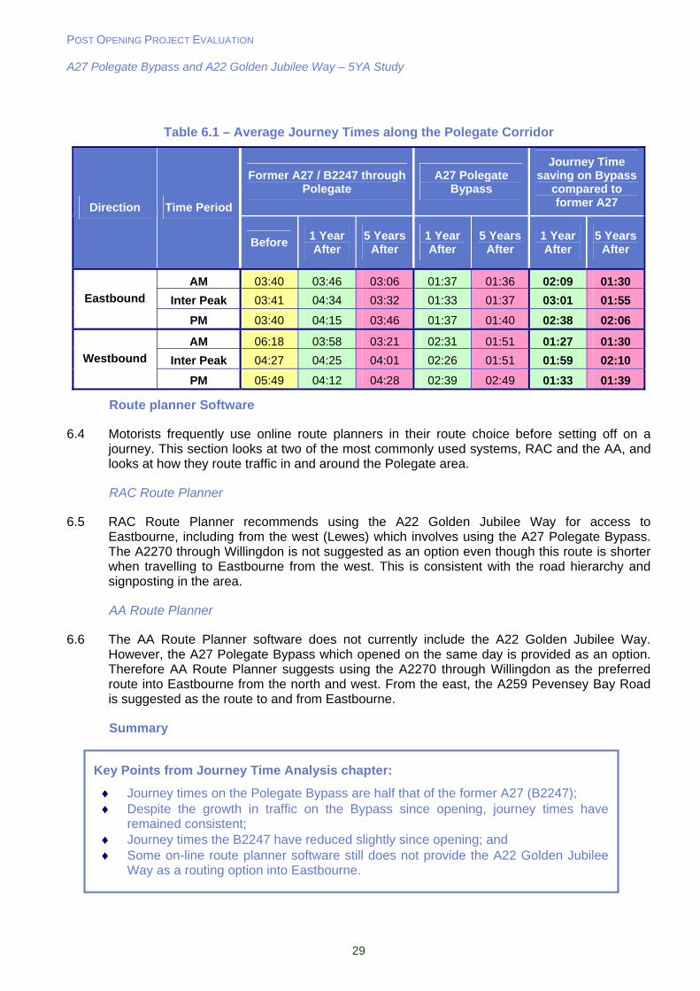
POST OPENING PROJECT EVALUATION A27 Polegate Bypass and A22 Golden Jubilee Way – 5YA Study
29
Table 6.1 – Average Journey Times along the Polegate Corridor
Former A27 / B2247 through Polegate
A27 Polegate Bypass
Journey Time saving on Bypass
compared to former A27 Direction Time Period
Before 1 Year After
5 Years After
1 Year After
5 Years After
1 Year After
5 Years After
AM 03:40 03:46 03:06 01:37 01:36 02:09 01:30
Inter Peak 03:41 04:34 03:32 01:33 01:37 03:01 01:55 Eastbound
PM 03:40 04:15 03:46 01:37 01:40 02:38 02:06
AM 06:18 03:58 03:21 02:31 01:51 01:27 01:30
Inter Peak 04:27 04:25 04:01 02:26 01:51 01:59 02:10 Westbound
PM 05:49 04:12 04:28 02:39 02:49 01:33 01:39
Route planner Software
6.4 Motorists frequently use online route planners in their route choice before setting off on a journey. This section looks at two of the most commonly used systems, RAC and the AA, and looks at how they route traffic in and around the Polegate area.
RAC Route Planner
6.5 RAC Route Planner recommends using the A22 Golden Jubilee Way for access to Eastbourne, including from the west (Lewes) which involves using the A27 Polegate Bypass. The A2270 through Willingdon is not suggested as an option even though this route is shorter when travelling to Eastbourne from the west. This is consistent with the road hierarchy and signposting in the area.
AA Route Planner
6.6 The AA Route Planner software does not currently include the A22 Golden Jubilee Way. However, the A27 Polegate Bypass which opened on the same day is provided as an option. Therefore AA Route Planner suggests using the A2270 through Willingdon as the preferred route into Eastbourne from the north and west. From the east, the A259 Pevensey Bay Road is suggested as the route to and from Eastbourne.
Summary
Key Points from Journey Time Analysis chapter:
Journey times on the Polegate Bypass are half that of the former A27 (B2247); Despite the growth in traffic on the Bypass since opening, journey times have
remained consistent; Journey times the B2247 have reduced slightly since opening; and Some on-line route planner software still does not provide the A22 Golden Jubilee
Way as a routing option into Eastbourne.
POST OPENING PROJECT EVALUATION A27 Polegate Bypass and A22 Golden Jubilee Way – 5YA Study
30
7. Environmental Impact
7.1 The Environment objective in the current WebTAG guidance consists of the following sub objectives:
Noise; Local air quality; Greenhouse gases; Landscape; Townscape; Biodiversity; Heritage; Water quality; Physical fitness; and Journey ambience.
7.2 This section contains an analysis of each of these sub-objectives in relation to the A27 Polegate Bypass and compares the impacts to those which were forecast. It is important to note that the A22 Golden Jubilee Way has not been assessed in this chapter as the majority of the environmental impacts can be differentiated by scheme.
7.3 A detailed evaluation of the environmental effects of the scheme was not undertaken for the One Year After Opening Study as detailed environmental evaluation has only recently become a part of the POPE process.
Data Collection
7.4 The following documents have been used in the preparation of this section of the report:
Appraisal Summary Table; A27 Trunk Road Polegate Bypass Environmental Statement (ES) dated November 1991; ‘As Built’ drawings for Landscape Design, Balancing Ponds and Offsite Planting; and A27 Polegate Bypass Landscape handover Report – May 2003.
Environmental Effects
7.5 The scheme mitigation measures were designed to provide visual and aural separation between the bypass and the community in Polegate. The principles for mitigation were:
Careful route alignment to avoid sensitive areas of residential development and features of ecological and heritage value, and minimise the loss of valuable agricultural land. Cuttings would be used to minimise visual intrusion in open countryside;
Provision of screening mounds and noise barriers or screen fences to help screen the road and reduce the impact of traffic noise; and
Landscape planting proposals to reduce visual impact on properties and integrate the road into the surrounding landscape.
Site Visit
7.6 A site visit was undertaken in August 2007 which allowed a general overview of the scheme from the main line and side roads as well as footpaths and bridleways.
Consultation
7.7 The following organisations have been consulted regarding their views on the impacts that the scheme has had on the environment, and whether they feel that the mitigation measures have been effective.
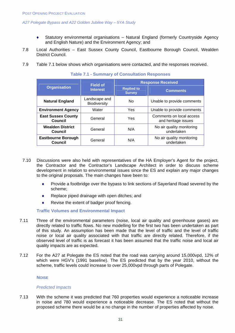
POST OPENING PROJECT EVALUATION A27 Polegate Bypass and A22 Golden Jubilee Way – 5YA Study
31
Statutory environmental organisations – Natural England (formerly Countryside Agency and English Nature) and the Environment Agency; and
7.8 Local Authorities – East Sussex County Council, Eastbourne Borough Council, Wealden District Council.
7.9 Table 7.1 below shows which organisations were contacted, and the responses received.
Table 7.1 - Summary of Consultation Responses
Response Received Organisation
Field of Interest Replied to
Survey Comments
Natural England Landscape and
Biodiversity No Unable to provide comments
Environment Agency Water Yes Unable to provide comments
East Sussex County Council
General Yes Comments on local access
and heritage issues
Wealden District Council
General N/A No air quality monitoring
undertaken
Eastbourne Borough Council
General N/A No air quality monitoring
undertaken
7.10 Discussions were also held with representatives of the HA Employer’s Agent for the project, the Contractor and the Contractor’s Landscape Architect in order to discuss scheme development in relation to environmental issues since the ES and explain any major changes to the original proposals. The main changes have been to:
Provide a footbridge over the bypass to link sections of Sayerland Road severed by the scheme;
Replace piped drainage with open ditches; and
Revise the extent of badger proof fencing.
Traffic Volumes and Environmental Impact
7.11 Three of the environmental parameters (noise, local air quality and greenhouse gases) are directly related to traffic flows. No new modelling for the first two has been undertaken as part of this study. An assumption has been made that the level of traffic and the level of traffic noise or local air quality associated with that traffic are directly related. Therefore, if the observed level of traffic is as forecast it has been assumed that the traffic noise and local air quality impacts are as expected.
7.12 For the A27 at Polegate the ES noted that the road was carrying around 15,000vpd, 12% of which were HGV’s (1991 baseline). The ES predicted that by the year 2010, without the scheme, traffic levels could increase to over 25,000vpd through parts of Polegate.
NOISE
Predicted Impacts
7.13 With the scheme it was predicted that 760 properties would experience a noticeable increase in noise and 780 would experience a noticeable decrease. The ES noted that without the proposed scheme there would be a no change in the number of properties affected by noise.
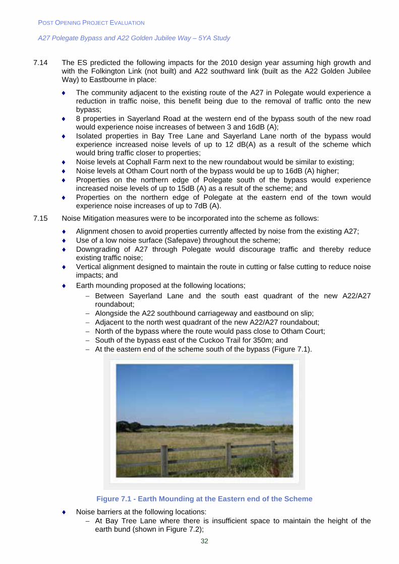
POST OPENING PROJECT EVALUATION A27 Polegate Bypass and A22 Golden Jubilee Way – 5YA Study
32
7.14 The ES predicted the following impacts for the 2010 design year assuming high growth and with the Folkington Link (not built) and A22 southward link (built as the A22 Golden Jubilee Way) to Eastbourne in place:
The community adjacent to the existing route of the A27 in Polegate would experience a reduction in traffic noise, this benefit being due to the removal of traffic onto the new bypass;
8 properties in Sayerland Road at the western end of the bypass south of the new road would experience noise increases of between 3 and 16dB (A);
Isolated properties in Bay Tree Lane and Sayerland Lane north of the bypass would experience increased noise levels of up to 12 dB(A) as a result of the scheme which would bring traffic closer to properties;
Noise levels at Cophall Farm next to the new roundabout would be similar to existing; Noise levels at Otham Court north of the bypass would be up to 16dB (A) higher; Properties on the northern edge of Polegate south of the bypass would experience
increased noise levels of up to 15dB (A) as a result of the scheme; and Properties on the northern edge of Polegate at the eastern end of the town would
experience noise increases of up to 7dB (A).
7.15 Noise Mitigation measures were to be incorporated into the scheme as follows:
Alignment chosen to avoid properties currently affected by noise from the existing A27; Use of a low noise surface (Safepave) throughout the scheme; Downgrading of A27 through Polegate would discourage traffic and thereby reduce
existing traffic noise; Vertical alignment designed to maintain the route in cutting or false cutting to reduce noise
impacts; and
Earth mounding proposed at the following locations;
Between Sayerland Lane and the south east quadrant of the new A22/A27 roundabout;
Alongside the A22 southbound carriageway and eastbound on slip; Adjacent to the north west quadrant of the new A22/A27 roundabout; North of the bypass where the route would pass close to Otham Court; South of the bypass east of the Cuckoo Trail for 350m; and At the eastern end of the scheme south of the bypass (Figure 7.1).
Figure 7.1 - Earth Mounding at the Eastern end of the Scheme
Noise barriers at the following locations: At Bay Tree Lane where there is insufficient space to maintain the height of the
earth bund (shown in Figure 7.2);
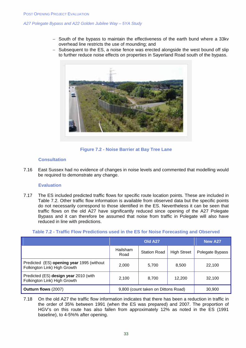
POST OPENING PROJECT EVALUATION A27 Polegate Bypass and A22 Golden Jubilee Way – 5YA Study
33
South of the bypass to maintain the effectiveness of the earth bund where a 33kv overhead line restricts the use of mounding; and
Subsequent to the ES, a noise fence was erected alongside the west bound off slip to further reduce noise effects on properties in Sayerland Road south of the bypass.
Figure 7.2 - Noise Barrier at Bay Tree Lane
Consultation
7.16 East Sussex had no evidence of changes in noise levels and commented that modelling would be required to demonstrate any change.
Evaluation
7.17 The ES included predicted traffic flows for specific route location points. These are included in Table 7.2. Other traffic flow information is available from observed data but the specific points do not necessarily correspond to those identified in the ES. Nevertheless it can be seen that traffic flows on the old A27 have significantly reduced since opening of the A27 Polegate Bypass and it can therefore be assumed that noise from traffic in Polegate will also have reduced in line with predictions.
Table 7.2 - Traffic Flow Predictions used in the ES for Noise Forecasting and Observed
Old A27 New A27
Hailsham Road
Station Road High Street Polegate Bypass
Predicted (ES) opening year 1995 (without Folkington Link) High Growth
2,000 5,700 8,500 22,100
Predicted (ES) design year 2010 (with Folkington Link) High Growth
2,100 8,700 12,200 32,100
Outturn flows (2007) 9,800 (count taken on Dittons Road) 30,900
7.18 On the old A27 the traffic flow information indicates that there has been a reduction in traffic in the order of 35% between 1991 (when the ES was prepared) and 2007. The proportion of HGV’s on this route has also fallen from approximately 12% as noted in the ES (1991 baseline), to 4-5%% after opening.
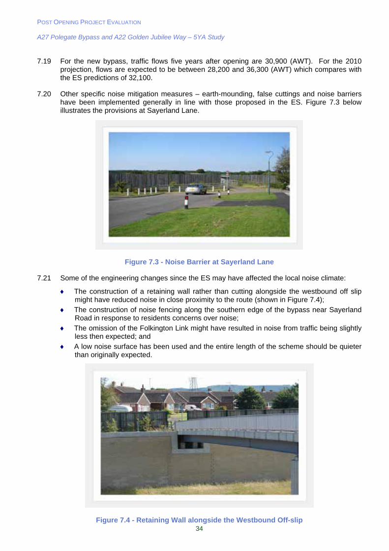
POST OPENING PROJECT EVALUATION A27 Polegate Bypass and A22 Golden Jubilee Way – 5YA Study
34
7.19 For the new bypass, traffic flows five years after opening are 30,900 (AWT). For the 2010 projection, flows are expected to be between 28,200 and 36,300 (AWT) which compares with the ES predictions of 32,100.
7.20 Other specific noise mitigation measures – earth-mounding, false cuttings and noise barriers have been implemented generally in line with those proposed in the ES. Figure 7.3 below illustrates the provisions at Sayerland Lane.
Figure 7.3 - Noise Barrier at Sayerland Lane
7.21 Some of the engineering changes since the ES may have affected the local noise climate:
The construction of a retaining wall rather than cutting alongside the westbound off slip might have reduced noise in close proximity to the route (shown in Figure 7.4);
The construction of noise fencing along the southern edge of the bypass near Sayerland Road in response to residents concerns over noise;
The omission of the Folkington Link might have resulted in noise from traffic being slightly less then expected; and
A low noise surface has been used and the entire length of the scheme should be quieter than originally expected.
Figure 7.4 - Retaining Wall alongside the Westbound Off-slip

POST OPENING PROJECT EVALUATION A27 Polegate Bypass and A22 Golden Jubilee Way – 5YA Study
35
7.22 With regard to Part 1 Claims for Compensation in relation to traffic noise we have no information on this subject but it is known that 11 properties were eligible for noise insulation under the Noise Insulation Regulations.
Summary
7.23 As a result of the scheme there has been a significant reduction in traffic through Polegate on the old A27 and this can be assumed to have improved the local noise environment. However, as the decrease in traffic flows on this route is slightly less than predicted, it can be assumed that the noise reduction is slightly less than predicted.
7.24 The increases in the noise environment for properties not previously affected by the ‘old’ A27 are likely to be in line with predictions. However, the differences in traffic flows from those forecast, changes to the scheme, and the use of a low noise surface, would need to be taken into account and modelled to fully evaluate the local noise climate.
7.25 Traffic noise has also been introduced into the countryside and this is likely to affect users of the local Public Rights Of Way. A detailed noise study was not carried out as part of this report. There are six PROW within 300m of the Bypass, noise levels will vary with distance from the road.
LOCAL AIR QUALITY
Predicted Impacts
7.26 The ES predicted that the carbon monoxide (CO) concentrations would be reduced for all but one receptor identified. The ES also predicted that 7 receptors would experience better air quality and 1 receptor worse air quality. The assessment also noted that all properties would have CO levels well below the levels at which air pollution was considered a problem in the then current Manual of Environmental Appraisal for both the do minimum and with scheme scenarios.
7.27 The ES predicted that the adverse effects of the scheme on local air quality would be minimal:
Levels of carbon monoxide predicted to remain below the relevant standards and guidelines;
Adverse effect on air quality on Bay Tree House, but the increases in emissions would remain below the limits set to protect human health;
Communities close to the existing A27 in Polegate would experience an improvement in their current air quality due to the reduction in traffic levels on this road;
The overall effects of the scheme would be that a greater number of properties would experience an improvement in their air quality than would be disadvantaged by the new bypass; and
Total emissions of vehicle pollutants were predicted to fall progressively with or without the scheme due to the effectiveness of catalytic converters.
Consultation
7.28 ESCC has been monitoring nitrogen dioxide at various locations within its area over the last few years and was able to provide air quality monitoring data.
7.29 The results are broadly as follows:
Worsened air quality at properties adjacent to the new A27; and
Improved air quality adjacent to the ‘old’ A27 in Polegate.
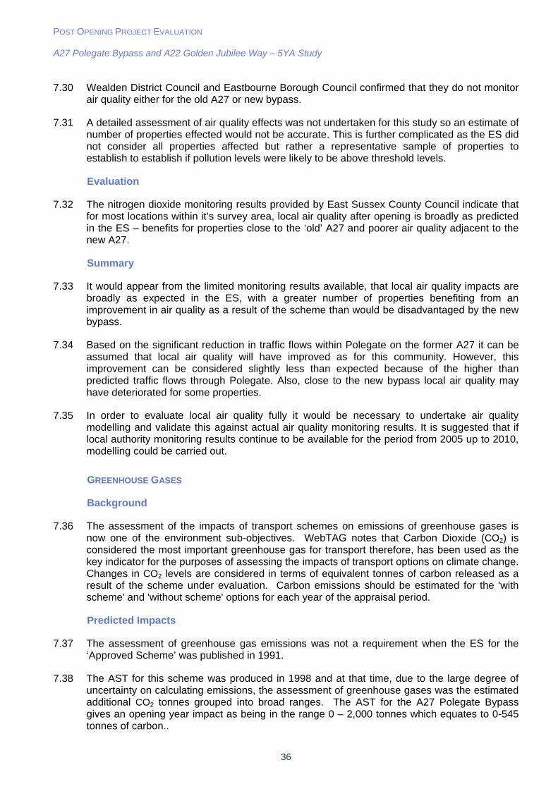
POST OPENING PROJECT EVALUATION A27 Polegate Bypass and A22 Golden Jubilee Way – 5YA Study
36
7.30 Wealden District Council and Eastbourne Borough Council confirmed that they do not monitor air quality either for the old A27 or new bypass.
7.31 A detailed assessment of air quality effects was not undertaken for this study so an estimate of number of properties effected would not be accurate. This is further complicated as the ES did not consider all properties affected but rather a representative sample of properties to establish to establish if pollution levels were likely to be above threshold levels.
Evaluation
7.32 The nitrogen dioxide monitoring results provided by East Sussex County Council indicate that for most locations within it’s survey area, local air quality after opening is broadly as predicted in the ES – benefits for properties close to the ‘old’ A27 and poorer air quality adjacent to the new A27.
Summary
7.33 It would appear from the limited monitoring results available, that local air quality impacts are broadly as expected in the ES, with a greater number of properties benefiting from an improvement in air quality as a result of the scheme than would be disadvantaged by the new bypass.
7.34 Based on the significant reduction in traffic flows within Polegate on the former A27 it can be assumed that local air quality will have improved as for this community. However, this improvement can be considered slightly less than expected because of the higher than predicted traffic flows through Polegate. Also, close to the new bypass local air quality may have deteriorated for some properties.
7.35 In order to evaluate local air quality fully it would be necessary to undertake air quality modelling and validate this against actual air quality monitoring results. It is suggested that if local authority monitoring results continue to be available for the period from 2005 up to 2010, modelling could be carried out.
GREENHOUSE GASES
Background
7.36 The assessment of the impacts of transport schemes on emissions of greenhouse gases is now one of the environment sub-objectives. WebTAG notes that Carbon Dioxide (CO2) is considered the most important greenhouse gas for transport therefore, has been used as the key indicator for the purposes of assessing the impacts of transport options on climate change. Changes in CO2 levels are considered in terms of equivalent tonnes of carbon released as a result of the scheme under evaluation. Carbon emissions should be estimated for the 'with scheme' and 'without scheme' options for each year of the appraisal period.
Predicted Impacts
7.37 The assessment of greenhouse gas emissions was not a requirement when the ES for the ‘Approved Scheme’ was published in 1991.
7.38 The AST for this scheme was produced in 1998 and at that time, due to the large degree of uncertainty on calculating emissions, the assessment of greenhouse gases was the estimated additional CO2 tonnes grouped into broad ranges. The AST for the A27 Polegate Bypass gives an opening year impact as being in the range 0 – 2,000 tonnes which equates to 0-545 tonnes of carbon..
POST OPENING PROJECT EVALUATION A27 Polegate Bypass and A22 Golden Jubilee Way – 5YA Study
37
Evaluation
Opening Year Evaluation based on DMRB Method
7.39 The POPE evaluation of the carbon emissions of this scheme is based on the methodology given in DMRB Volume 11 Section 3 Part 1 and supported by a spreadsheet1. The spreadsheet method calculates Carbon emission values from the fuel consumption values using average densities for petrol and diesel and carbon proportions by mass. Fuel consumption is calculated for the key links in the network around the scheme based on: link length, AADT, average speed, road type, and proportion of HGV’s. It is also possible to use the COBA model to predict greenhouse gas emissions. However the Polegate appraisal was undertaken using COBA9 which pre-dates the introduction of greenhouse gas analysis.
7.40 The DMRB methodology is used to calculate carbon emissions for the ‘Do Minimum’ and ‘Do Something’ scenarios for the opening year using outturn data on flows and speeds before (as a proxy for the ‘Do-Minimum’) and one year after scheme opening. The scheme impact is then calculated from the difference between the two scenarios.
7.41 Due to the availability of data the following assumptions have been made in the assessment.
One year after opening journey times and traffic volumes have been used for the ‘do-something’ scenario as a full set of observed flows and journey times is available;
Classified count data for the majority of links is not available. Therefore, in order to maintain consistency, the proportions of HGV’s have been obtained from DMRB Volume 13 – the COBA Manual. These figures are as follows;
‘Non Built up Trunk’ – 10.3% (Used for the A27); and
‘Built up Principal’ – 4.9% (Used for all remaining links).
Where available, average speeds have been obtained from the OYA journey time surveys. An average of the AM, IP and PM for both directions has been used. If observed average speeds were not available, these were taken from the COBA file for the appropriate link; and
There are no ‘do minimum’ journey speeds available. Therefore the average journey speeds are assumed to be the same as the ‘do something’ speeds.
Table 7.3 – Evaluation of Opening Year Carbon Emissions by Scenario
Scenario Carbon
(tonnes/year)
Do Something – With scheme 14,175
Do Minimum – No scheme 11,914
Difference 2,261
% Difference +19%
7.42 The carbon emissions of vehicles using the network in 2002 with and without the bypass scheme are shown in Table 7.3. The difference between the emissions calculated for the modelled scenarios with and without the scheme shows the net impact is 2,261 tonnes of carbon in the opening year, a 19% increase compared to if the bypass had not been built.
7.43 This increase in emissions appears to be due to an increase in traffic volumes using the A27 corridor, as well as an increase in vehicles entering Eastbourne on the A22 Golden Jubilee Way and the A2270 through Willingdon.
1 DMRB Air Quality Spreadsheet, latest version, July 2007: DMRB Screening Method V1.03c (12-07-07) locked.xls
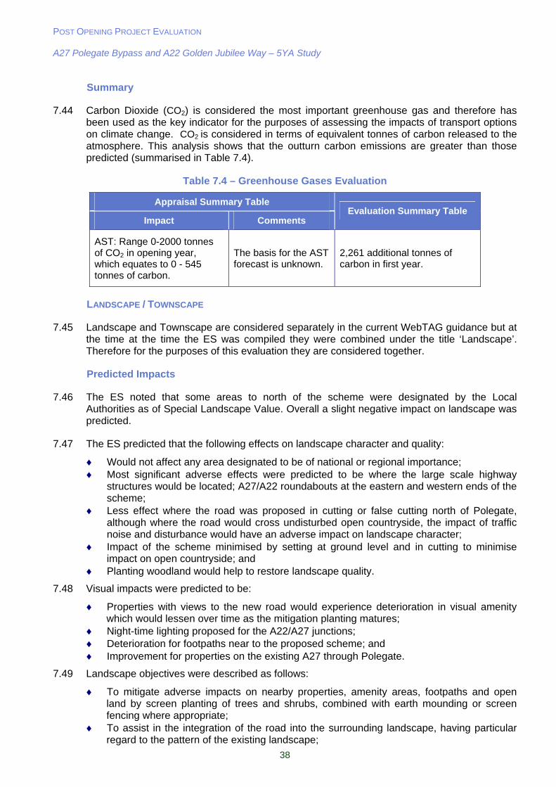
POST OPENING PROJECT EVALUATION A27 Polegate Bypass and A22 Golden Jubilee Way – 5YA Study
38
Summary
7.44 Carbon Dioxide (CO2) is considered the most important greenhouse gas and therefore has been used as the key indicator for the purposes of assessing the impacts of transport options on climate change. CO2
is considered in terms of equivalent tonnes of carbon released to the atmosphere. This analysis shows that the outturn carbon emissions are greater than those predicted (summarised in Table 7.4).
Table 7.4 – Greenhouse Gases Evaluation
Appraisal Summary Table
Impact Comments Evaluation Summary Table
AST: Range 0-2000 tonnes of CO2 in opening year, which equates to 0 - 545 tonnes of carbon.
The basis for the AST forecast is unknown.
2,261 additional tonnes of carbon in first year.
LANDSCAPE / TOWNSCAPE
7.45 Landscape and Townscape are considered separately in the current WebTAG guidance but at the time at the time the ES was compiled they were combined under the title ‘Landscape’. Therefore for the purposes of this evaluation they are considered together.
Predicted Impacts
7.46 The ES noted that some areas to north of the scheme were designated by the Local Authorities as of Special Landscape Value. Overall a slight negative impact on landscape was predicted.
7.47 The ES predicted that the following effects on landscape character and quality:
Would not affect any area designated to be of national or regional importance; Most significant adverse effects were predicted to be where the large scale highway
structures would be located; A27/A22 roundabouts at the eastern and western ends of the scheme;
Less effect where the road was proposed in cutting or false cutting north of Polegate, although where the road would cross undisturbed open countryside, the impact of traffic noise and disturbance would have an adverse impact on landscape character;
Impact of the scheme minimised by setting at ground level and in cutting to minimise impact on open countryside; and
Planting woodland would help to restore landscape quality.
7.48 Visual impacts were predicted to be:
Properties with views to the new road would experience deterioration in visual amenity which would lessen over time as the mitigation planting matures;
Night-time lighting proposed for the A22/A27 junctions; Deterioration for footpaths near to the proposed scheme; and Improvement for properties on the existing A27 through Polegate.
7.49 Landscape objectives were described as follows:
To mitigate adverse impacts on nearby properties, amenity areas, footpaths and open land by screen planting of trees and shrubs, combined with earth mounding or screen fencing where appropriate;
To assist in the integration of the road into the surrounding landscape, having particular regard to the pattern of the existing landscape;
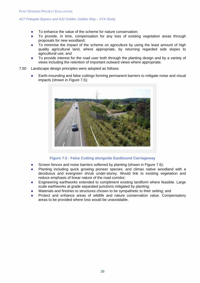
POST OPENING PROJECT EVALUATION A27 Polegate Bypass and A22 Golden Jubilee Way – 5YA Study
39
To enhance the value of the scheme for nature conservation; To provide, in time, compensation for any loss of existing vegetation areas through
proposals for new woodland; To minimise the impact of the scheme on agriculture by using the least amount of high
quality agricultural land, where appropriate, by returning regarded side slopes to agricultural use; and
To provide interest for the road user both through the planting design and by a variety of views including the retention of important outward views where appropriate.
7.50 Landscape design principles were adopted as follows:
Earth-mounding and false cuttings forming permanent barriers to mitigate noise and visual impacts (shown in Figure 7.5);
Figure 7.5 - False Cutting alongside Eastbound Carriageway
Screen fences and noise barriers softened by planting (shown in Figure 7.6); Planting including quick growing pioneer species, and climax native woodland with a
deciduous and evergreen shrub under-storey. Would link to existing vegetation and reduce emphasis of linear nature of the road corridor;
Engineering earthworks extended to compliment existing landform where feasible. Large scale earthworks at grade separated junctions mitigated by planting;
Materials and finishes to structures chosen to be sympathetic to their setting; and Protect and enhance areas of wildlife and nature conservation value. Compensatory
areas to be provided where loss would be unavoidable.

POST OPENING PROJECT EVALUATION A27 Polegate Bypass and A22 Golden Jubilee Way – 5YA Study
40
Figure 7.6 - Planting in Front of Noise Barrier to Soften Impact
7.51 Landscape mitigation measures to be implemented included:
Dense tree and shrub planting; Woodland planting; Offsite planting by agreement; Hedgerow planting; and Intermittent trees.
7.52 The ES section on Landscape did not include landscape proposals for the existing A27 in Polegate.
Consultation
7.53 ESCC commented that it considered the scheme impacts on landscape to be as expected.
Evaluation
7.54 The ES did not predict an overall affect on the landscape or visual amenity. Bearing in mind that a new bypass has been located within the countryside, the planting associated with the scheme is in line with the as built drawings and will need to continue to establish satisfactorily for the A27 to be screened and integrated into the local landscape.
7.55 The impacts on landscape character and quality, and visual impacts would appear to be generally as expected and with the mitigation measures implemented in line with the proposals outlined in the ES. Changes to the ES proposals are outlined below.
7.56 Planting was carried out over two seasons in 2001/2 and 2002/3 due to poor weather conditions delaying the works and resulting in planting areas being unavailable. The heavy clay soils of the area make earthworks difficult in wet weather and conditions can be difficult for planting on placed soils. Although nutrient rich, the soils can suffer from compaction and are susceptible to extremes of wet and dry weather. The planting on south facing slopes in particular has done less well due to drying out in prolonged periods of little rainfall. This is shown in Figure 7.7.
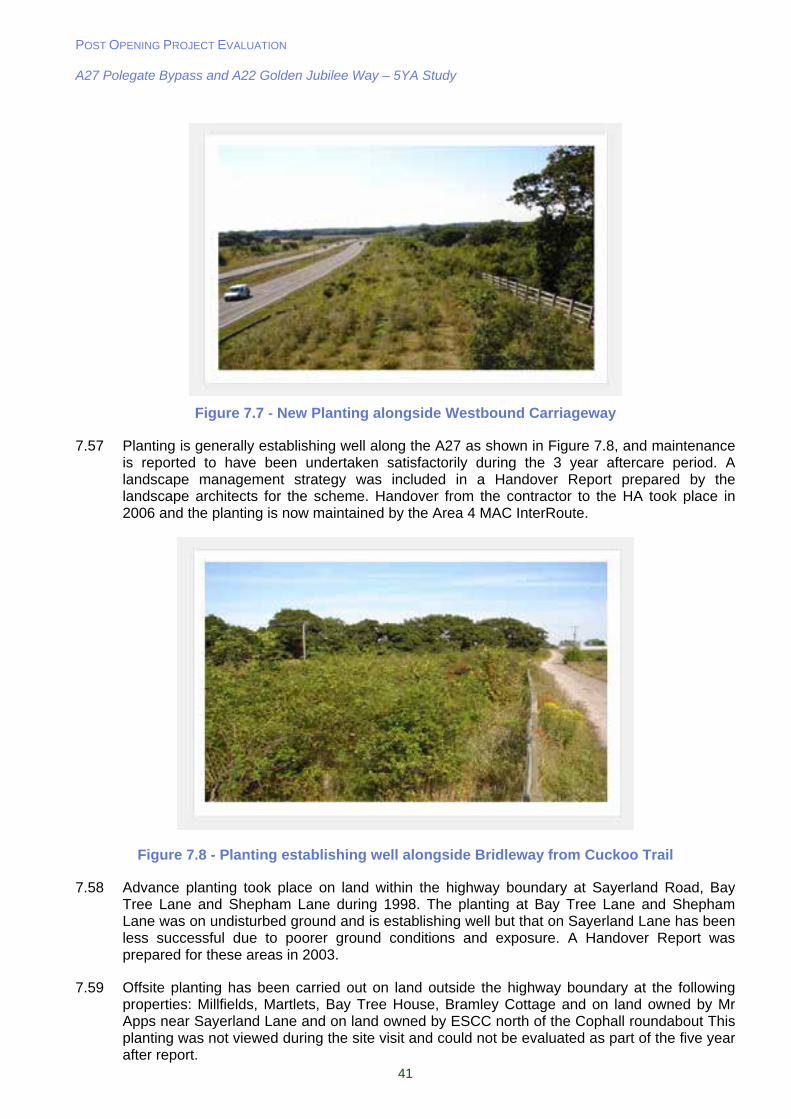
POST OPENING PROJECT EVALUATION A27 Polegate Bypass and A22 Golden Jubilee Way – 5YA Study
41
Figure 7.7 - New Planting alongside Westbound Carriageway
7.57 Planting is generally establishing well along the A27 as shown in Figure 7.8, and maintenance is reported to have been undertaken satisfactorily during the 3 year aftercare period. A landscape management strategy was included in a Handover Report prepared by the landscape architects for the scheme. Handover from the contractor to the HA took place in 2006 and the planting is now maintained by the Area 4 MAC InterRoute.
Figure 7.8 - Planting establishing well alongside Bridleway from Cuckoo Trail
7.58 Advance planting took place on land within the highway boundary at Sayerland Road, Bay Tree Lane and Shepham Lane during 1998. The planting at Bay Tree Lane and Shepham Lane was on undisturbed ground and is establishing well but that on Sayerland Lane has been less successful due to poorer ground conditions and exposure. A Handover Report was prepared for these areas in 2003.
7.59 Offsite planting has been carried out on land outside the highway boundary at the following properties: Millfields, Martlets, Bay Tree House, Bramley Cottage and on land owned by Mr Apps near Sayerland Lane and on land owned by ESCC north of the Cophall roundabout This planting was not viewed during the site visit and could not be evaluated as part of the five year after report.

POST OPENING PROJECT EVALUATION A27 Polegate Bypass and A22 Golden Jubilee Way – 5YA Study
42
7.60 Wildflower grass seeding was included as part of the works alongside the westbound off slip and at the Dittons roundabouts. Due to the fertility of the soils this has not been successful and the sward is dominated by clover.
7.61 Earth-mounding, false cuttings and environmental barriers have been successfully incorporated into the scheme to help screen traffic using the dual carriageway, and cuttings have also reduced the visual impact of traffic shown in Figure 7.5 previously.
7.62 A borrow pit was created to provide fill for the scheme on land to the north of the bypass at its eastern end. This was subsequently turned into a fishing lake and landscaped separately to the bypass works. As was common at the time the arrangements for borrow pits were a matter for the contractor at the start of construction so were not assessed.
7.63 Along the ‘old’ A27 through Polegate the reduction in traffic flows has significantly improved the local environment. Physical improvements to the townscape in Polegate have however been restricted to minor alterations of side roads with the old A27. These alterations are considered later in this report and are shown in Figure 12.1.
7.64 As can be seen in Figure 7.7 some of the new tree planting may not be establishing as well as others and it would be expected that this issue would be addressed as part of the ongoing landscape aftercare operations.
7.65 As expected, the A22/A27 roundabout has had a major impact on the local landscape and the Sayerland Lane and Cuckoo Trail footbridges are also major features in the landscape. The Cuckoo Trail footbridge is shown in Figure 7.9 below.
Figure 7.9 - Cuckoo Trail Footbridge
7.66 The impact of signs and gantries can be significant where located close to properties. The ES may not have recognised the visual implications of current highways signs. Signs may also be visible in the open countryside in the short term, until new planting matures sufficiently to provide a screen.
Summary
7.67 The adverse impact of the new bypass within the local landscape and for properties close to it is partially balanced by the benefits in visual amenity for Polegate which is as predicted in the ES.

POST OPENING PROJECT EVALUATION A27 Polegate Bypass and A22 Golden Jubilee Way – 5YA Study
43
7.68 The new planting will need to continue to establish satisfactorily and within another 10 years will be providing effective screening, including the highway signs.
BIODIVERSITY
Predicted Impacts
7.69 The ES stated that the scheme would result in the loss and fragmentation of small sections of mature hedgerow, scrub and trees. The overall impact was not predicted.
7.70 The ES showed that the proposals would not directly affect any site designated as nationally or regionally important for ecology and nature conservation or any sites of county and local importance.
7.71 Most of the route passes through intensively farmed arable land of low ecological importance. Some watercourse habitats would be lost to construction and diversions but the impact of these was not recorded in the ES.
7.72 Mitigation measures were identified as:
Extensive planting of locally occurring native broadleaved trees and shrubs; Enhancement of the nature conservation value of the scheme through the creation of new
wildlife corridors; and Providing links across the bypass between existing badger paths and foraging areas.
7.73 The ES made no reference to monitoring or management of these mitigation measures.
Consultation
7.74 ESCC commented that there were no County Wildlife Sites in the vicinity of the bypass and it considered the scheme impacts on protected species to be as expected.
Evaluation
7.75 The planting mitigation measures would appear to have been generally implemented as intended. The contractor’s original proposal was to badger fence the length of the bypass but this was subsequently amended during construction. It was contended that the majority of the badger activity was at the western end so badger fencing was erected between Sayerland Lane and Shepham Lane where a badger tunnel was constructed (Figure 7.10). The contractor carried out a badger survey after opening to demonstrate the success of these mitigation measures. In the time frame that this report was written the contractor could not retrieve the document for our use.
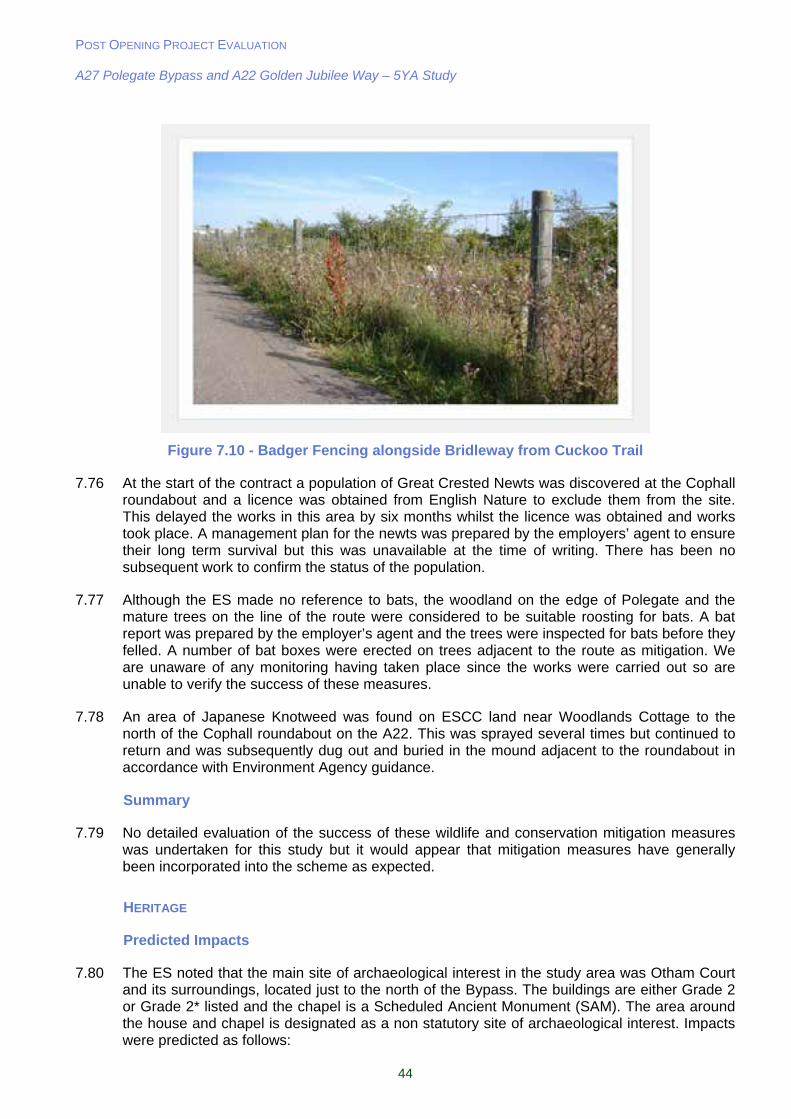
POST OPENING PROJECT EVALUATION A27 Polegate Bypass and A22 Golden Jubilee Way – 5YA Study
44
Figure 7.10 - Badger Fencing alongside Bridleway from Cuckoo Trail
7.76 At the start of the contract a population of Great Crested Newts was discovered at the Cophall roundabout and a licence was obtained from English Nature to exclude them from the site. This delayed the works in this area by six months whilst the licence was obtained and works took place. A management plan for the newts was prepared by the employers’ agent to ensure their long term survival but this was unavailable at the time of writing. There has been no subsequent work to confirm the status of the population.
7.77 Although the ES made no reference to bats, the woodland on the edge of Polegate and the mature trees on the line of the route were considered to be suitable roosting for bats. A bat report was prepared by the employer’s agent and the trees were inspected for bats before they felled. A number of bat boxes were erected on trees adjacent to the route as mitigation. We are unaware of any monitoring having taken place since the works were carried out so are unable to verify the success of these measures.
7.78 An area of Japanese Knotweed was found on ESCC land near Woodlands Cottage to the north of the Cophall roundabout on the A22. This was sprayed several times but continued to return and was subsequently dug out and buried in the mound adjacent to the roundabout in accordance with Environment Agency guidance.
Summary
7.79 No detailed evaluation of the success of these wildlife and conservation mitigation measures was undertaken for this study but it would appear that mitigation measures have generally been incorporated into the scheme as expected.
HERITAGE
Predicted Impacts
7.80 The ES noted that the main site of archaeological interest in the study area was Otham Court and its surroundings, located just to the north of the Bypass. The buildings are either Grade 2 or Grade 2* listed and the chapel is a Scheduled Ancient Monument (SAM). The area around the house and chapel is designated as a non statutory site of archaeological interest. Impacts were predicted as follows:
POST OPENING PROJECT EVALUATION A27 Polegate Bypass and A22 Golden Jubilee Way – 5YA Study
45
The Scheduled Monument was not expected to be directly affected but its setting would be as the proposed road would run very close. The scheme would affect the peripheral sites surrounding and associated with Otham Court and would thus affect its archaeological significance;
Outlying features of the area of archaeological interest would be directly affected by the construction of the road and embankments;
Views from Otham Court would be affected by the road and in time the mitigation planting that would curtail views towards Polegate; and
Increase in traffic noise for Otham Court.
7.81 Recommendations for specific mitigation were as follows:
Planting of trees and shrubs to screen views of the road; and
Earth mounding to reduce the effects of noise from traffic.
Consultation
7.82 East Sussex County Council had no comments on the effect on heritage resources but noted that an article describing the archaeological recording was being prepared in the Sussex Archaeological Collections and that they believed that Otham Court and Sayerland House were screened from the bypass.
Evaluation
Archaeology
7.83 During the works a brick kiln was excavated in the grounds of Otham Court and the site of a medieval house was excavated near to Bramley Cottage. All the works were recorded under an archaeological certification process.
Built Heritage
7.84 With regard to listed buildings, the ES predicted adverse effects for Otham Court (also a SAM). There has been an increase in noise due to the traffic on the new bypass as well as visual impacts from the scheme.
Summary
7.85 With regard to cultural heritage it would appear that the impacts on Otham Court were as expected. The edge of the site of archaeological interest has been encroached on but screen mounding and planting is becoming effective. It is understood that a post construction archaeological report for this scheme was not prepared.
WATER QUALITY
Predicted Impacts
7.86 The scheme crossed over several small watercourses or ditches which generally flow north east to the Glynleigh and Pevensey Levels. The only named watercourse was the Drockmill Hill Gut at the eastern end of the scheme. The ES made no reference to the nature or water quality of these watercourses.
7.87 The ES noted however that the scheme would require the enlargement or improvement of lengths of two of the watercourses (including the Drockmill Hill Gut) which highway run off would be discharged into and the diversion of a number of others. It noted that the scheme would require the culverting of streams where they passed under the bypass. No specific
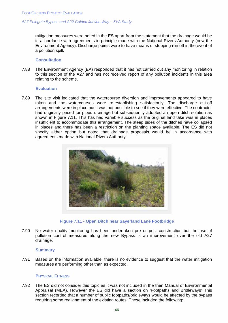
POST OPENING PROJECT EVALUATION A27 Polegate Bypass and A22 Golden Jubilee Way – 5YA Study
46
mitigation measures were noted in the ES apart from the statement that the drainage would be in accordance with agreements in principle made with the National Rivers Authority (now the Environment Agency). Discharge points were to have means of stopping run off in the event of a pollution spill.
Consultation
7.88 The Environment Agency (EA) responded that it has not carried out any monitoring in relation to this section of the A27 and has not received report of any pollution incidents in this area relating to the scheme.
Evaluation
7.89 The site visit indicated that the watercourse diversion and improvements appeared to have taken and the watercourses were re-establishing satisfactorily. The discharge cut-off arrangements were in place but it was not possible to see if they were effective. The contractor had originally priced for piped drainage but subsequently adopted an open ditch solution as shown in Figure 7.11. This has had variable success as the original land take was in places insufficient to accommodate this arrangement. The steep sides of the ditches have collapsed in places and there has been a restriction on the planting space available. The ES did not specify either option but noted that drainage proposals would be in accordance with agreements made with National Rivers Authority.
Figure 7.11 - Open Ditch near Sayerland Lane Footbridge
7.90 No water quality monitoring has been undertaken pre or post construction but the use of pollution control measures along the new Bypass is an improvement over the old A27 drainage.
Summary
7.91 Based on the information available, there is no evidence to suggest that the water mitigation measures are performing other than as expected.
PHYSICAL FITNESS
7.92 The ES did not consider this topic as it was not included in the then Manual of Environmental Appraisal (MEA). However the ES did have a section on ‘Footpaths and Bridleways’ This section recorded that a number of public footpaths/bridleways would be affected by the bypass requiring some realignment of the existing routes. These included the following:
POST OPENING PROJECT EVALUATION A27 Polegate Bypass and A22 Golden Jubilee Way – 5YA Study
47
Footpath 6a stopped up and realigned over the Cuckoo Trail overbridge
Footpath 15 realigned along the southern boundary of the bridleway
Footpath 19 stopped up and realigned along the northern boundary of the bypass
Part of footpath 17b stopped up and realigned
A new footpath from the Cuckoo Trail to Sayerland Road along the northern boundary of the bypass
Consultation
7.93 No consultation on this aspect was undertaken
Evaluation
7.94 The site visit showed that the proposals for footpaths and bridleways were carried out as indicated in the ES. In addition to this a new footbridge was constructed over the bypass between Sayerland Lane to the south of the bypass and the junction of Bay Tree Lane and Sayerland Lane to the north. This was as a result of representations made at the Public Inquiry into the scheme. The constructed Shepham Lane bridge was noted as closed to vehicular traffic and was used as a bridleway.
Summary
7.95 The proposals for non motorised users have been implemented as noted in the ES and additional facilities have been provided. Journey times for users are the same or in some instances marginally longer but not so much longer as to discourage usage. On this basis the effect on physical fitness could be considered to be neutral.
JOURNEY AMBIENCE
7.96 This sub objective was not assessed in the ES or the AST, however, it is still possible to undertake an assessment of this based on current WebTAG guidelines.
7.97 Driver stress and journey ambience have improved along the old A27. A new roundabout has been constructed by ESCC on the old A27 to improve traffic movements into the High Street and a number of side roads connections with the old A27 have been improved. Traffic on the A27 Polegate Bypass is free flowing and driver stress is likely to be low (A separate assessment of route stress is contained in Section 10). The provision of lay-bys in both directions on the Bypass would also improve journey ambience (see Figure 7.12).
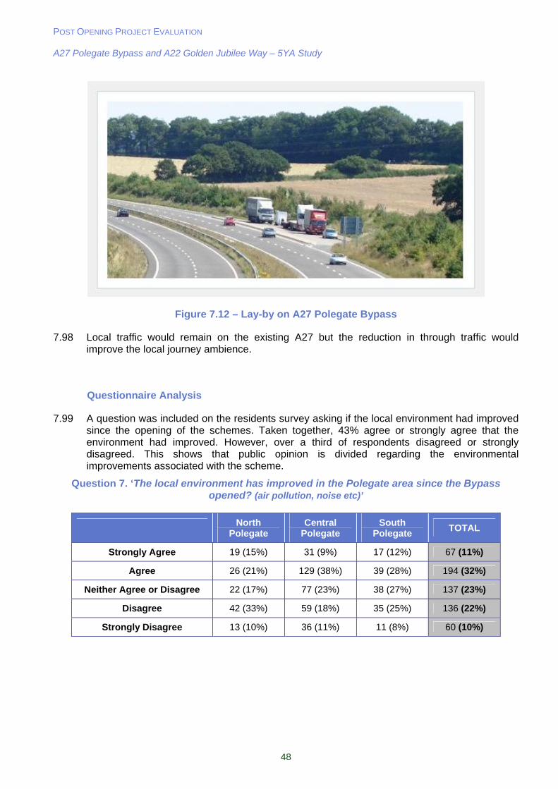
POST OPENING PROJECT EVALUATION A27 Polegate Bypass and A22 Golden Jubilee Way – 5YA Study
48
Figure 7.12 – Lay-by on A27 Polegate Bypass
7.98 Local traffic would remain on the existing A27 but the reduction in through traffic would improve the local journey ambience.
Questionnaire Analysis
7.99 A question was included on the residents survey asking if the local environment had improved since the opening of the schemes. Taken together, 43% agree or strongly agree that the environment had improved. However, over a third of respondents disagreed or strongly disagreed. This shows that public opinion is divided regarding the environmental improvements associated with the scheme.
Question 7. ‘The local environment has improved in the Polegate area since the Bypass opened? (air pollution, noise etc)’
North
Polegate Central
Polegate South
Polegate TOTAL
Strongly Agree 19 (15%) 31 (9%) 17 (12%) 67 (11%)
Agree 26 (21%) 129 (38%) 39 (28%) 194 (32%)
Neither Agree or Disagree 22 (17%) 77 (23%) 38 (27%) 137 (23%)
Disagree 42 (33%) 59 (18%) 35 (25%) 136 (22%)
Strongly Disagree 13 (10%) 36 (11%) 11 (8%) 60 (10%)
POST OPENING PROJECT EVALUATION A27 Polegate Bypass and A22 Golden Jubilee Way – 5YA Study
49
Summary
Key Points from Environmental Evaluation:
Noise levels in Polegate are slightly worse than expected, and the increase in noise near the Bypass is in line with predictions;
Local air quality impacts are broadly as expected in the ES close to the Bypass, but slightly worse than expected within Polegate;
Carbon emissions in the opening year are slightly higher than the AST forecast of 0- 2000 tonnes;
The adverse impact of the A27 Polegate Bypass on the landscape and for properties close to it is partially balanced by the benefits in visual amenity for Polegate which is as predicted in the ES;
The planting mitigation measures appear to have been implemented as intended;
With regard to cultural heritage it would appear that the impacts on Otham Court were as expected;
There is no evidence to suggest that the water mitigation measures are performing other than as expected;
Journey ambience has improved following opening of the scheme due to the removal of traffic congestion and the provision of lay-bys on the Bypass;
The effect of the scheme with regard to physical fitness can be considered neutral; and
43% of questionnaire respondents either agree or strongly agree that the local environment has improved in the Polegate area since the Bypass opened and 32% of questionnaire respondents either disagree or strongly disagree. This shows that
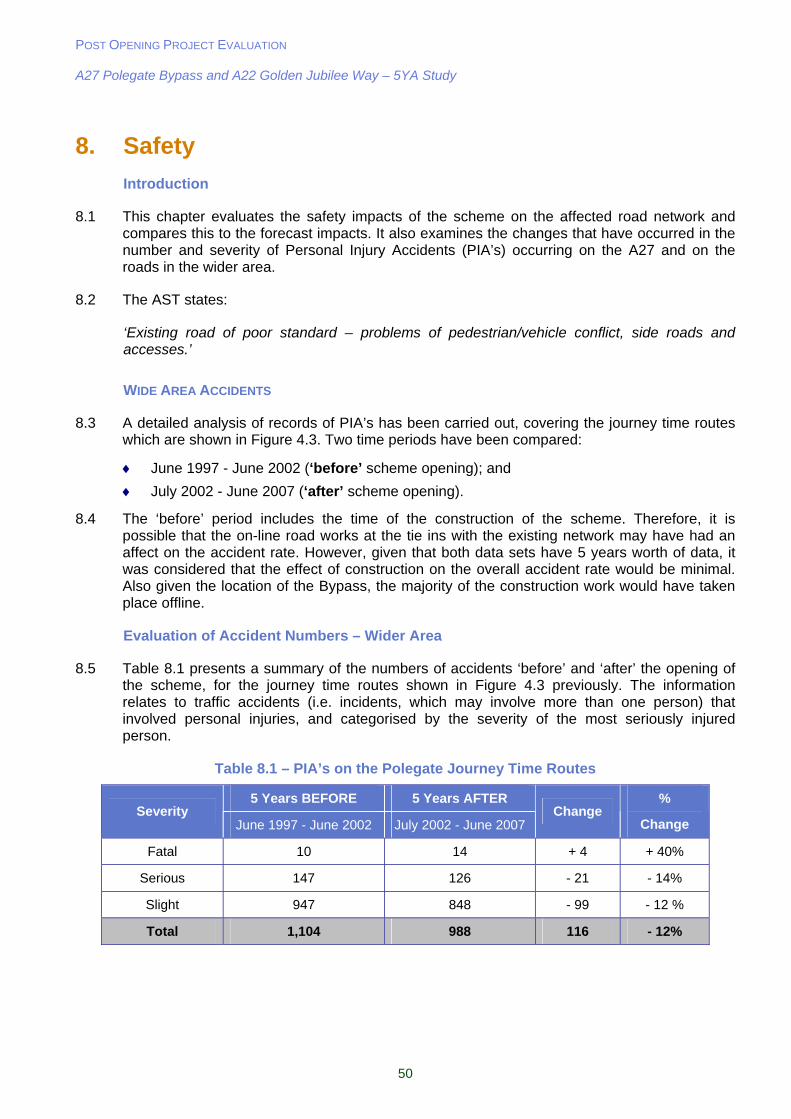
POST OPENING PROJECT EVALUATION A27 Polegate Bypass and A22 Golden Jubilee Way – 5YA Study
50
8. Safety
Introduction
8.1 This chapter evaluates the safety impacts of the scheme on the affected road network and compares this to the forecast impacts. It also examines the changes that have occurred in the number and severity of Personal Injury Accidents (PIA’s) occurring on the A27 and on the roads in the wider area.
8.2 The AST states:
‘Existing road of poor standard – problems of pedestrian/vehicle conflict, side roads and accesses.’
WIDE AREA ACCIDENTS
8.3 A detailed analysis of records of PIA’s has been carried out, covering the journey time routes which are shown in Figure 4.3. Two time periods have been compared:
June 1997 - June 2002 (‘before’ scheme opening); and
July 2002 - June 2007 (‘after’ scheme opening).
8.4 The ‘before’ period includes the time of the construction of the scheme. Therefore, it is possible that the on-line road works at the tie ins with the existing network may have had an affect on the accident rate. However, given that both data sets have 5 years worth of data, it was considered that the effect of construction on the overall accident rate would be minimal. Also given the location of the Bypass, the majority of the construction work would have taken place offline.
Evaluation of Accident Numbers – Wider Area
8.5 Table 8.1 presents a summary of the numbers of accidents ‘before’ and ‘after’ the opening of the scheme, for the journey time routes shown in Figure 4.3 previously. The information relates to traffic accidents (i.e. incidents, which may involve more than one person) that involved personal injuries, and categorised by the severity of the most seriously injured person.
Table 8.1 – PIA’s on the Polegate Journey Time Routes
5 Years BEFORE 5 Years AFTER Severity
June 1997 - June 2002 July 2002 - June 2007 Change
%
Change
Fatal 10 14 + 4 + 40%
Serious 147 126 - 21 - 14%
Slight 947 848 - 99 - 12 %
Total 1,104 988 116 - 12%
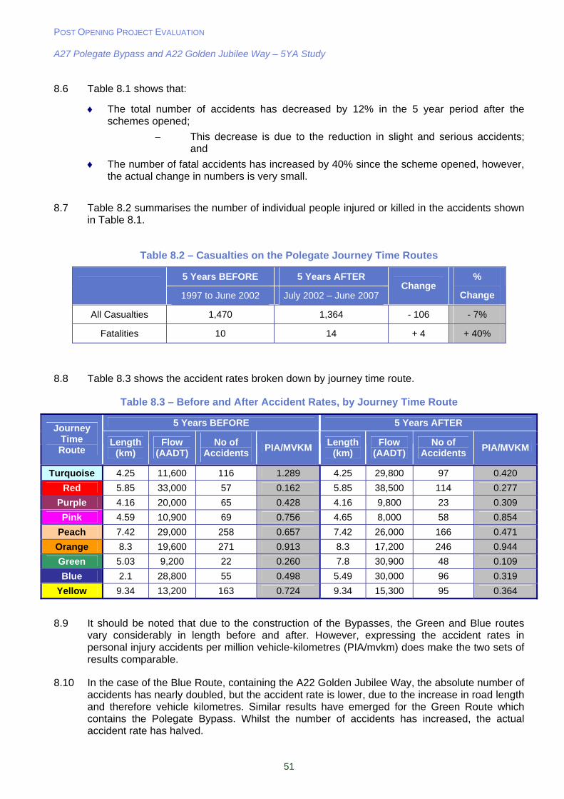
POST OPENING PROJECT EVALUATION A27 Polegate Bypass and A22 Golden Jubilee Way – 5YA Study
51
8.6 Table 8.1 shows that:
The total number of accidents has decreased by 12% in the 5 year period after the schemes opened;
This decrease is due to the reduction in slight and serious accidents; and
The number of fatal accidents has increased by 40% since the scheme opened, however, the actual change in numbers is very small.
8.7 Table 8.2 summarises the number of individual people injured or killed in the accidents shown in Table 8.1.
Table 8.2 – Casualties on the Polegate Journey Time Routes
5 Years BEFORE 5 Years AFTER
1997 to June 2002 July 2002 – June 2007 Change
%
Change
All Casualties 1,470 1,364 - 106 - 7%
Fatalities 10 14 + 4 + 40%
8.8 Table 8.3 shows the accident rates broken down by journey time route.
Table 8.3 – Before and After Accident Rates, by Journey Time Route
5 Years BEFORE 5 Years AFTER Journey
Time Route
Length (km)
Flow (AADT)
No of Accidents
PIA/MVKM Length
(km) Flow
(AADT) No of
Accidents PIA/MVKM
Turquoise 4.25 11,600 116 1.289 4.25 29,800 97 0.420
Red 5.85 33,000 57 0.162 5.85 38,500 114 0.277
Purple 4.16 20,000 65 0.428 4.16 9,800 23 0.309
Pink 4.59 10,900 69 0.756 4.65 8,000 58 0.854
Peach 7.42 29,000 258 0.657 7.42 26,000 166 0.471
Orange 8.3 19,600 271 0.913 8.3 17,200 246 0.944
Green 5.03 9,200 22 0.260 7.8 30,900 48 0.109
Blue 2.1 28,800 55 0.498 5.49 30,000 96 0.319
Yellow 9.34 13,200 163 0.724 9.34 15,300 95 0.364
8.9 It should be noted that due to the construction of the Bypasses, the Green and Blue routes vary considerably in length before and after. However, expressing the accident rates in personal injury accidents per million vehicle-kilometres (PIA/mvkm) does make the two sets of results comparable.
8.10 In the case of the Blue Route, containing the A22 Golden Jubilee Way, the absolute number of accidents has nearly doubled, but the accident rate is lower, due to the increase in road length and therefore vehicle kilometres. Similar results have emerged for the Green Route which contains the Polegate Bypass. Whilst the number of accidents has increased, the actual accident rate has halved.
POST OPENING PROJECT EVALUATION A27 Polegate Bypass and A22 Golden Jubilee Way – 5YA Study
52
8.11 The Purple Route which includes the B2247 through Polegate has experienced a decrease in the number of accidents and the accident rate. This shows that there has been an improvement in the number of accidents through Polegate. The peach route contains the A2270 into Eastbourne through Willingdon and this has also experienced a reduction in the accident rate. The Yellow Route contains the B2104 which runs parallel to the Golden Jubilee Way, and here a significant reduction in the accident rate is evident.
8.12 The accident analysis above relates to the journey time routes only. This is to maintain consistency with the figures reported in the OYA study. However, following consultation with ESCC, it was decided to analyse two additional routes as traffic flows on these roads have also been affected since the scheme opened. These routes are:
A2290 Lottbridge Drove; and
Rattle Road (minor road between B2104 Stonecross and B2247 Westham).
8.13 5 years before opening there were 25 accidents on Lottbridge Drove. In the 5 years after opening there were 34 accidents. This increase could be attributed to an increase in flows on this link due to the proximity of the A22 Golden Jubilee Way. However, there is no traffic data available to support this.
8.14 Accidents have also increased on Rattle Road between Stone Cross and Westham. There were 3 accidents 5 years before opening and 11 accidents 5 years after opening. The reason for this increase is unclear, as it would be expected that traffic flows on this route reduce slightly as a result of the parallel A27 Pevensey Bypass being a more attractive route since the Polegate Bypass opened.
8.15 A statistical test2 on the accidents in the area provides 99% confidence that the reduction in the number accidents in the five years after opening of the scheme is not a result of chance, therefore we can infer that the accident saving has occurred as a result of the scheme.
PREDICTED VS. OBSERVED ACCIDENTS
8.16 This section compares the number of actual accidents discussed above, with those actually predicted. The numbers of PIA’s predicted by COBA are based on figures extrapolated from the 1996 and 2010 predictions in the OPR. For the ‘Actual’ accidents the Do-Minimum (DM) figures are the annual average of five years’ data before the scheme was opened and the Do-Something (DS) figures are the annual average of 5 years data after the scheme opened.
2 A Chi-square test was used to compare the accident rates (number of accidents / traffic volume in the local area) before and after the scheme opened. This gives a Chi Square value of 6.635. Number of accidents shown in Table 8.3- Before: 184, and After: 142. Traffic volumes taken from sum of Green, Purple, and Peach journey time routes.
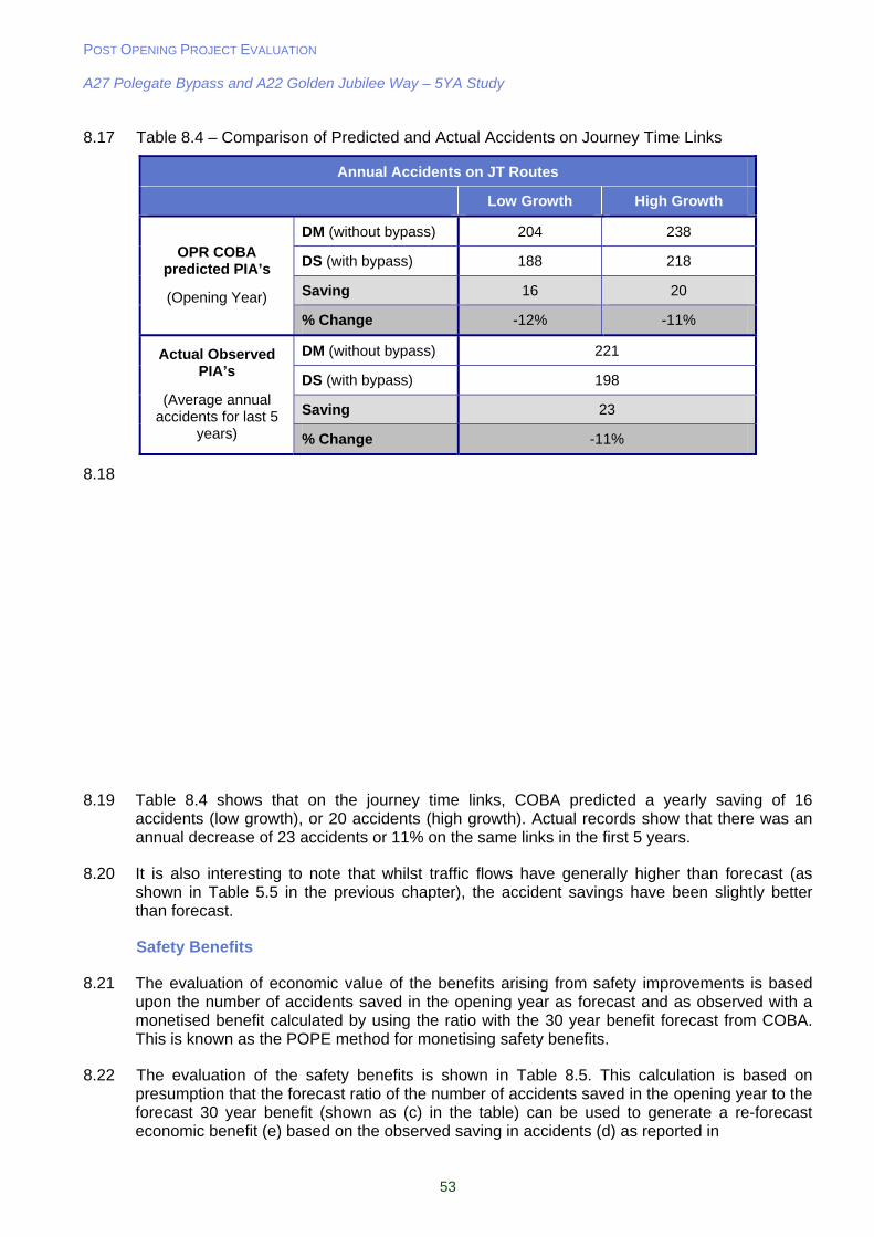
POST OPENING PROJECT EVALUATION A27 Polegate Bypass and A22 Golden Jubilee Way – 5YA Study
53
8.17 Table 8.4 – Comparison of Predicted and Actual Accidents on Journey Time Links
Annual Accidents on JT Routes
Low Growth High Growth
DM (without bypass) 204 238
DS (with bypass) 188 218
Saving 16 20
OPR COBA predicted PIA’s
(Opening Year)
% Change -12% -11%
DM (without bypass) 221
DS (with bypass) 198
Saving 23
Actual Observed PIA’s
(Average annual accidents for last 5
years) % Change -11%
8.18
8.19 Table 8.4 shows that on the journey time links, COBA predicted a yearly saving of 16 accidents (low growth), or 20 accidents (high growth). Actual records show that there was an annual decrease of 23 accidents or 11% on the same links in the first 5 years.
8.20 It is also interesting to note that whilst traffic flows have generally higher than forecast (as shown in Table 5.5 in the previous chapter), the accident savings have been slightly better than forecast.
Safety Benefits
8.21 The evaluation of economic value of the benefits arising from safety improvements is based upon the number of accidents saved in the opening year as forecast and as observed with a monetised benefit calculated by using the ratio with the 30 year benefit forecast from COBA. This is known as the POPE method for monetising safety benefits.
8.22 The evaluation of the safety benefits is shown in Table 8.5. This calculation is based on presumption that the forecast ratio of the number of accidents saved in the opening year to the forecast 30 year benefit (shown as (c) in the table) can be used to generate a re-forecast economic benefit (e) based on the observed saving in accidents (d) as reported in
POST OPENING PROJECT EVALUATION A27 Polegate Bypass and A22 Golden Jubilee Way – 5YA Study
54
8.23 Table 8.4.
8.24 This POPE evaluation of the re-forecast of 30 years of benefits indicates a benefit of £4.44m - £4.76, assuming that the accident pattern observed in the opening year is typical of the impact in the longer term.
Table 8.5 – Economic Evaluation of Safety Benefits (1988 Prices)
Low
growth High
Growth
Forecast number of accidents saved in opening Year
(a) 16 20
Forecast Benefit over 30 years (b) £3.09m £4.14m COBA forecast
Approx 30 year benefit per opening year accident saved
(c) = (b) / (a) £0.19m £0.21m
Observed Outturn number of accidents saved (d) 23
POPE Re-forecast
Reforecast 30 year accident benefit (e) = (d) x (c) £4.44m £4.76m
LOCAL ACCIDENTS
8.25 Figure 8.1 shows a more detailed examination of the before and after opening accidents in Polegate. Clearly the biggest impacts on traffic were in the immediate area around Polegate as shown in the traffic chapter earlier. It can be seen that there is a reduction in accidents on the B2247 through Polegate post opening, caused by the large reduction in traffic. After opening, however, there is a cluster of accidents around the Cophall roundabout to the west of the Bypass, the main causes being shunts on the junction approaches and the circulatory lanes.
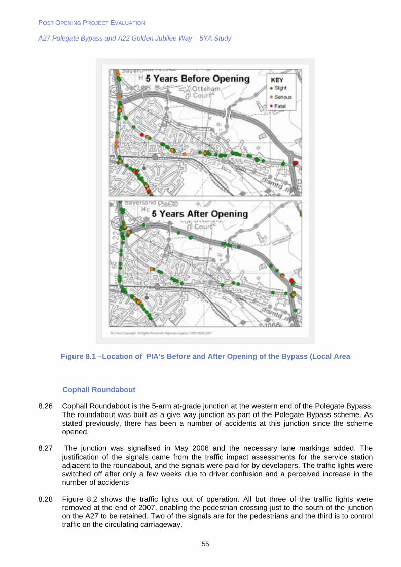
POST OPENING PROJECT EVALUATION A27 Polegate Bypass and A22 Golden Jubilee Way – 5YA Study
55
Figure 8.1 –Location of PIA’s Before and After Opening of the Bypass (Local Area
Cophall Roundabout
8.26 Cophall Roundabout is the 5-arm at-grade junction at the western end of the Polegate Bypass. The roundabout was built as a give way junction as part of the Polegate Bypass scheme. As stated previously, there has been a number of accidents at this junction since the scheme opened.
8.27 The junction was signalised in May 2006 and the necessary lane markings added. The justification of the signals came from the traffic impact assessments for the service station adjacent to the roundabout, and the signals were paid for by developers. The traffic lights were switched off after only a few weeks due to driver confusion and a perceived increase in the number of accidents
8.28 Figure 8.2 shows the traffic lights out of operation. All but three of the traffic lights were removed at the end of 2007, enabling the pedestrian crossing just to the south of the junction on the A27 to be retained. Two of the signals are for the pedestrians and the third is to control traffic on the circulating carriageway.
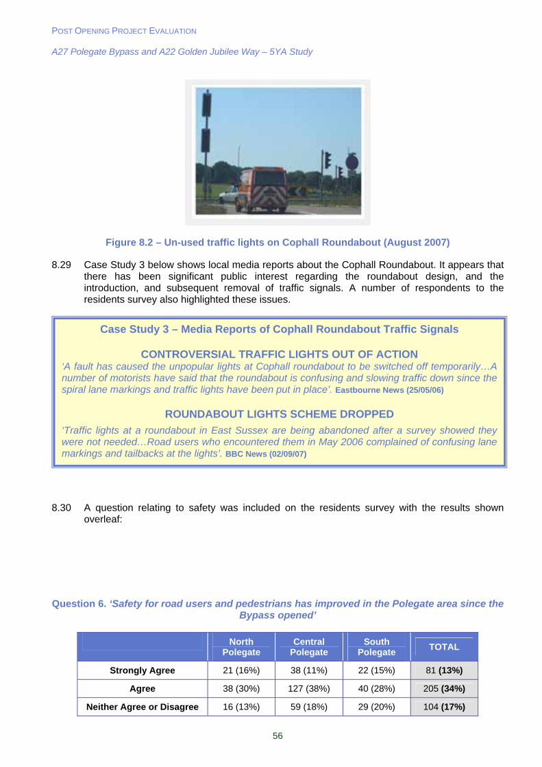
POST OPENING PROJECT EVALUATION A27 Polegate Bypass and A22 Golden Jubilee Way – 5YA Study
56
Figure 8.2 – Un-used traffic lights on Cophall Roundabout (August 2007)
8.29 Case Study 3 below shows local media reports about the Cophall Roundabout. It appears that there has been significant public interest regarding the roundabout design, and the introduction, and subsequent removal of traffic signals. A number of respondents to the residents survey also highlighted these issues.
8.30 A question relating to safety was included on the residents survey with the results shown overleaf:
Question 6. ‘Safety for road users and pedestrians has improved in the Polegate area since the Bypass opened’
North Polegate
Central Polegate
South Polegate
TOTAL
Strongly Agree 21 (16%) 38 (11%) 22 (15%) 81 (13%)
Agree 38 (30%) 127 (38%) 40 (28%) 205 (34%)
Neither Agree or Disagree 16 (13%) 59 (18%) 29 (20%) 104 (17%)
Case Study 3 – Media Reports of Cophall Roundabout Traffic Signals
CONTROVERSIAL TRAFFIC LIGHTS OUT OF ACTION ‘A fault has caused the unpopular lights at Cophall roundabout to be switched off temporarily…A number of motorists have said that the roundabout is confusing and slowing traffic down since the spiral lane markings and traffic lights have been put in place’. Eastbourne News (25/05/06)
ROUNDABOUT LIGHTS SCHEME DROPPED
‘Traffic lights at a roundabout in East Sussex are being abandoned after a survey showed they were not needed…Road users who encountered them in May 2006 complained of confusing lane markings and tailbacks at the lights’. BBC News (02/09/07)
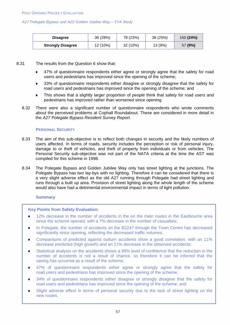
POST OPENING PROJECT EVALUATION A27 Polegate Bypass and A22 Golden Jubilee Way – 5YA Study
57
Disagree 36 (28%) 78 (23%) 36 (25%) 150 (24%)
Strongly Disagree 12 (10%) 32 (10%) 13 (9%) 57 (9%)
8.31 The results from the Question 6 show that:
47% of questionnaire respondents either agree or strongly agree that the safety for road users and pedestrians has improved since the opening of the scheme;
33% of questionnaire respondents either disagree or strongly disagree that the safety for road users and pedestrians has improved since the opening of the scheme; and
This shows that a slightly larger proportion of people think that safety for road users and pedestrians has improved rather than worsened since opening.
8.32 There were also a significant number of questionnaire respondents who wrote comments about the perceived problems at Cophall Roundabout. These are considered in more detail in the A27 Polegate Bypass Resident Survey Report.
PERSONAL SECURITY
8.33 The aim of this sub-objective is to reflect both changes in security and the likely numbers of users affected. In terms of roads, security includes the perception or risk of personal injury, damage to or theft of vehicles, and theft of property from individuals or from vehicles. The Personal Security sub-objective was not part of the NATA criteria at the time the AST was compiled for this scheme in 1998.
8.34 The Polegate Bypass and Golden Jubilee Way only has street lighting at the junctions. The Polegate Bypass has two lay-bys with no lighting. Therefore it can be considered that there is a very slight adverse effect as the old A27 running through Polegate had street lighting and runs through a built up area. Provision of street lighting along the whole length of the scheme would also have had a detrimental environmental impact in terms of light pollution.
Summary
Key Points from Safety Evaluation:
12% decrease in the number of accidents in the on the main routes in the Eastbourne area since the scheme opened, with a 7% decrease in the number of casualties;
In Polegate, the number of accidents on the B2247 through the Town Centre has decreased significantly since opening, reflecting the decreased traffic volumes;
Comparisons of predicted against outturn accidents show a good correlation, with an 11% decrease predicted (high growth) and an 11% decrease in the observed accidents;
Statistical analysis on the accidents shows a 99% level of confidence that the reduction in the number of accidents is not a result of chance, so therefore it can be inferred that the saving has occurred as a result of the scheme;
47% of questionnaire respondents either agree or strongly agree that the safety for road users and pedestrians has improved since the opening of the scheme;
34% of questionnaire respondents either disagree or strongly disagree that the safety for road users and pedestrians has improved since the opening of the scheme; and
Slight adverse effect in terms of personal security due to the lack of street lighting on the new routes.

POST OPENING PROJECT EVALUATION A27 Polegate Bypass and A22 Golden Jubilee Way – 5YA Study
58
9. Economy
Introduction
9.1 This section compares the original economic forecasts for the scheme with an evaluation of the actual costs and updated forecasts of the benefits based on observed data.
9.2 The financial benefits of the scheme, at the time that this scheme was approved were based on the impacts over 30 years following opening. At the five year after stage examined in this section, the economic evaluation is based around re-forecasting the benefits for the same time period based around the observed outcomes seen five years after opening.
9.3 A number of sources of information were used to inform this re-appraisal and are detailed below:
A27 Polegate Bypass, Order Publication Report (1991); and
A27 Polegate Bypass Traffic Study, Forecasting Report (October 1991).
Forecasting the 30 years Benefit Stream
9.4 When the scheme was appraised, benefits were forecast over a 30 year period in accordance with DMRB Volume 13, comparing the monetary costs of two scenarios: ‘do minimum’ i.e. retaining the A27 through Polegate with ‘do-something’ being the proposed scheme (Polegate Bypass and Golden Jubilee Way). Therefore the economic benefits presented here are for the both schemes, whilst the costs include the A27 Polegate Bypass only.
9.5 Economic benefits for the prior assessment of this scheme (before construction) were predicted using the Department of Transport’s COBA (Cost Benefit Analysis) program, which considers changes in:
Time for Link Transit and Junction Delay – The time on each affected link both before and after opening weighted by vehicle flows and the delays at junctions;
Vehicle Operating Costs (VOC) – Reflects fuel and other operating costs calculated by a change in total distance travelled on the affected links, but also considering vehicle speeds; and
Accident Statistics – These change after infrastructure improvements, as accidents are normally less frequent on new roads due to safer geometric design.
9.6 At the time of the inclusion of the A27 Polegate Bypass in the Targeted Programme of Improvements in 1998, an Appraisal Summary Table was prepared for the scheme. This records the predicted impacts of the scheme against Economy objectives in addition to environment, safety, accessibility and integration and is included in this report in Table 13.2. This section is only concerned with the impacts which are monetised.
ECONOMIC EVALUATION
9.7 The approach adopted is termed the Post Opening Project Evaluation (POPE) methodology. The basis of the POPE methodology is that, through previous economic evaluations (using COBA COst-Benefit Analysis software) it has been identified that the majority of benefits are derived primarily from two sources:
Link Transit Time (vehicle hour) benefits which provide economy benefits; and
Reduction in accident numbers, providing monetised safety benefits.
POST OPENING PROJECT EVALUATION A27 Polegate Bypass and A22 Golden Jubilee Way – 5YA Study
59
9.8 Essentially COBA calculates:
The perceived economic cost of the time spent travelling, the cost of accidents and the cost of running vehicles, both before and after the scheme is implemented;
The ‘after’ costs are subtracted from the ‘before’ costs to identify scheme benefits;
The benefits along with the scheme implementation costs, are discounted to a standard present value year to give the present value of costs (PVC) and the present value of benefits (PVB); and
The absolute difference between these values is the scheme’s net present value (NPV), while the ratio is the benefit to cost ratio (BCR).
9.9 Vehicle hour benefits (represented by traffic volumes multiplied by journey time savings) and the number of accidents can be collected before and after scheme opening and the difference between these observed values can be compared to the difference shown in time and accidents for the same links shown in the Order Publication Report (OPR) COBA. The premise of the POPE methodology used here is that the change in the observed flows, journey times and accidents over the last 5 years can be directly associated to the economic benefits predicted for this scheme over 30 years.
Re-Evaluation using COBA model
9.10 The COBA model developed for the Polegate scheme was used as a starting point for the re-evaluation of the 30 year benefits. Using the observed data collected for the traffic surveys detailed in Chapter 4, traffic volumes on the links were added to the model, replacing the forecast opening year data.
9.11 Before it was possible to re-evaluate the Present Value Benefits utilising the observed flow data, it was necessary to replicate the original OPR COBA. The OPR evaluations were undertaken in 1991 using COBA 9M2A. All costs are converted to 1998 values and cover an evaluation period of 30 years. The OPR specified an opening year of 1996, however, the road actually opened in 2002 so it was necessary to re-run the model with a revised opening year in order to achieve a balanced comparison with the outturn figures. The COBA model was then re-run with the five year after opening traffic data used to update the ‘do something flows’. Table 9.1 and Table 9.2 shows the 30 year benefits forecast by COBA for the low and high growth scenarios respectively. The following points should be noted regarding the COBA evaluation:
The ‘do-minimum’ flows used in the COBA model are observed flows from 2002 with background traffic growth applied using the methodology set out in the TEMPRO Guidance Note;
For links in the COBA network without directly observed flows, the originally predicted flow was factored by the observed/predicted ratio from an appropriate nearby link, giving the do-something flow; and
No outturn journey times were added because it is not possible to add this information to a COBA input.

POST OPENING PROJECT EVALUATION A27 Polegate Bypass and A22 Golden Jubilee Way – 5YA Study
60
Table 9.1 – Present Value Benefits at Low Growth (1988 Values £m)
Original COBA
OPR COBA Re-Run (2002 Opening Year)
5 Year After Re-Forecast (2007
flows)
Link Transit Time 13.4 11.7 19.5
Operating Costs – Fuel -2.2 -1.6 -0.5
Operating Costs – Other -3.7 -2.5 0.04
Junction Delay 6.9 8.9 8.0
Accidents 3.1 2.3 3.2
Maintenance Expenditure Saving -0.25 -0.15 -0.15
Total PVB 17.1 18.8 30.6
Table 9.2 – Present Value Benefits at High Growth (1988 Values £m)
Original COBA
OPR COBA Re-Run (2002 Opening Year)
5 Year After Re-Forecast (2007
flows)
Link Transit Time 16.2 15.3 20.5
Operating Costs – Fuel -1.9 -1.4 -0.6
Operating Costs – Other -5.5 -3.7 0.05
Junction Delay 18.8 18.9 10.7
Accidents 4.1 3.4 4.9
Maintenance Expenditure Saving -0.25 -0.16 -0.16
Total PVB 31.4 32.3 35.9
9.12 Table 9.2 shows that the predicted economic benefits for this scheme at the time of the Public Inquiry were estimated to be £17.1m for the low growth assumption. The high growth at this time was predicted to be £31.4m as shown in Table 9.2. These models were re-run with an updated opening year of 2002 as shown in column 3 of these tables. With the updated start date, the PVB’s become £18.8m and £32.3m for low and high growth respectively.
9.13 The final column of the Table 9.1 and Table 9.2 shows the predicted benefits when the actual outturn for both the do-minimum and do-something are inserted into the assessment and the COBA re-run with an opening year of 2002 and using 2007 outturn data.
9.14 Points to note are:
Higher than predicted journey time benefits. On closer examination the higher benefits are occurring on the links where flows are lower than the original COBA OPR a assessment. These roads include the A2270 through Willingdon, and Royal Parade on the seafront.
Vehicle operating costs are all showing a slight dis-benefit i.e. users will pay more as a result of the scheme. In the case of this scheme, this will be because of greater fuel usage due to the Bypass route being slightly longer than the route of the former A27 through Polegate, coupled with trips from the north using A22 Golden Jubilee Way to access
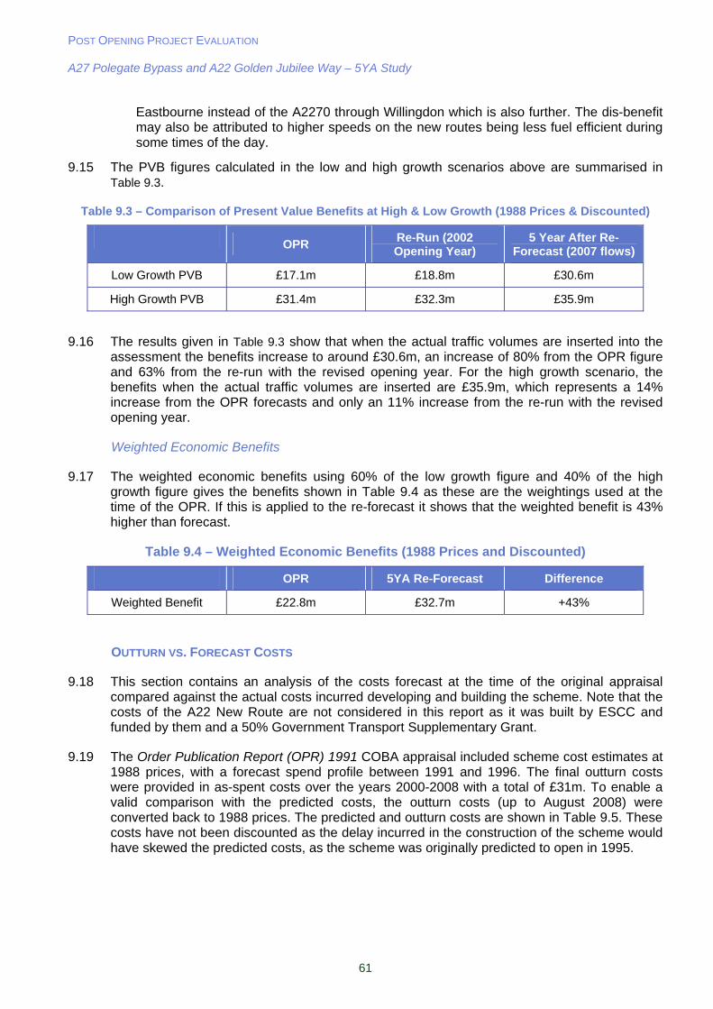
POST OPENING PROJECT EVALUATION A27 Polegate Bypass and A22 Golden Jubilee Way – 5YA Study
61
Eastbourne instead of the A2270 through Willingdon which is also further. The dis-benefit may also be attributed to higher speeds on the new routes being less fuel efficient during some times of the day.
9.15 The PVB figures calculated in the low and high growth scenarios above are summarised in Table 9.3.
Table 9.3 – Comparison of Present Value Benefits at High & Low Growth (1988 Prices & Discounted)
OPR
Re-Run (2002 Opening Year)
5 Year After Re-Forecast (2007 flows)
Low Growth PVB £17.1m £18.8m £30.6m
High Growth PVB £31.4m £32.3m £35.9m
9.16 The results given in Table 9.3 show that when the actual traffic volumes are inserted into the assessment the benefits increase to around £30.6m, an increase of 80% from the OPR figure and 63% from the re-run with the revised opening year. For the high growth scenario, the benefits when the actual traffic volumes are inserted are £35.9m, which represents a 14% increase from the OPR forecasts and only an 11% increase from the re-run with the revised opening year.
Weighted Economic Benefits
9.17 The weighted economic benefits using 60% of the low growth figure and 40% of the high growth figure gives the benefits shown in Table 9.4 as these are the weightings used at the time of the OPR. If this is applied to the re-forecast it shows that the weighted benefit is 43% higher than forecast.
Table 9.4 – Weighted Economic Benefits (1988 Prices and Discounted)
OPR 5YA Re-Forecast Difference
Weighted Benefit £22.8m £32.7m +43%
OUTTURN VS. FORECAST COSTS
9.18 This section contains an analysis of the costs forecast at the time of the original appraisal compared against the actual costs incurred developing and building the scheme. Note that the costs of the A22 New Route are not considered in this report as it was built by ESCC and funded by them and a 50% Government Transport Supplementary Grant.
9.19 The Order Publication Report (OPR) 1991 COBA appraisal included scheme cost estimates at 1988 prices, with a forecast spend profile between 1991 and 1996. The final outturn costs were provided in as-spent costs over the years 2000-2008 with a total of £31m. To enable a valid comparison with the predicted costs, the outturn costs (up to August 2008) were converted back to 1988 prices. The predicted and outturn costs are shown in Table 9.5. These costs have not been discounted as the delay incurred in the construction of the scheme would have skewed the predicted costs, as the scheme was originally predicted to open in 1995.

POST OPENING PROJECT EVALUATION A27 Polegate Bypass and A22 Golden Jubilee Way – 5YA Study
62
Table 9.5 – A27 Polegate Bypass Scheme Costs in 1988 Prices (Undiscounted)
Predicted Cost (£m) Outturn Cost (£m)
Construction 13.33 11.75
Land 1.10 6.73
Preparation 0.86 0.93
Supervision 0.43 0.096
Total 15.64 19.50
9.20 The comparison of the OPR and outturn costs show:
An outturn cost of £19.5m which is 25% higher than the predicted cost of £15.6m;
The primary reason for this increase is due to the increase in land costs which were over £5m higher than predicted. It is likely that this represents national trends in land prices over the period between the planned and actual dates of land purchase.
Benefit Cost Ratio
9.21 The Benefit Cost Ratio (BCR) for the scheme from the AST, OPR forecast, and the outturn are shown in Table 9.6. For the purposes of this assessment, the OPR and outturn costs have been discounted to 1988 to enable a valid comparison between the BCR values.
Table 9.6 – Forecast and Evaluated Benefit / Cost Ratios (BCR)
Predicted Outturn
AST (£1994) OPR (£1988) (£1988)
PVB £43m £22.8m £32.7m
PVC £16m £9.6m £7.4m
BCR 2.8 2.4 4.4
9.22 Table 9.6 shows that the outturn BCR is higher than the predicted which means that the scheme represents good value for money.
Reliability
9.23 Reliability of journey times is an important economic factor for travellers but is not simple to measure. The WebTAG guidance uses the measurement of the route stress as a reasonable proxy for measuring the reliability sub-objective; the concept of 'stress' has been developed to provide a broad indication of the relationship between volumes and capacity on a road.
9.24 The AST forecast that route stress on the A27 would improve considerably from 90% to 32% on the new route.
9.25 The calculation of stress is calculated to be the ratio of the AADT volume to the Congestion Reference Flow (CRF) expressed as a percentage. The lower the percentage, the higher the likelihood that journey time reliability is better. The CRF is defined in the DMRB Volume 5 Section 1 Part 3 as:
CRF = CAPACITY x No of Lanes x Width Factor x 100/PeakFlow x 100/PeakDirectionSplit x AADT/AAWT
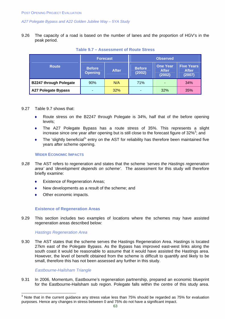
POST OPENING PROJECT EVALUATION A27 Polegate Bypass and A22 Golden Jubilee Way – 5YA Study
63
9.26 The capacity of a road is based on the number of lanes and the proportion of HGV’s in the peak period.
Table 9.7 – Assessment of Route Stress
Forecast Observed
Route Before Opening
After Before (2002)
One Year After (2002)
Five Years After
(2007)
B2247 through Polegate 90% N/A 71% - 34%
A27 Polegate Bypass - 32% - 32% 35%
9.27 Table 9.7 shows that:
Route stress on the B2247 through Polegate is 34%, half that of the before opening levels;
The A27 Polegate Bypass has a route stress of 35%. This represents a slight increase since one year after opening but is still close to the forecast figure of 32%3; and
The ‘slightly beneficial3’ entry on the AST for reliability has therefore been maintained five years after scheme opening.
WIDER ECONOMIC IMPACTS
9.28 The AST refers to regeneration and states that the scheme ‘serves the Hastings regeneration area’ and ‘development depends on scheme’. The assessment for this study will therefore briefly examine:
Existence of Regeneration Areas;
New developments as a result of the scheme; and
Other economic impacts.
Existence of Regeneration Areas
9.29 This section includes two examples of locations where the schemes may have assisted regeneration areas described below:
Hastings Regeneration Area
9.30 The AST states that the scheme serves the Hastings Regeneration Area. Hastings is located 27km east of the Polegate Bypass. As the Bypass has improved east-west links along the south coast it would be reasonable to assume that it would have assisted the Hastings area. However, the level of benefit obtained from the scheme is difficult to quantify and likely to be small, therefore this has not been assessed any further in this study.
Eastbourne-Hailsham Triangle
9.31 In 2006, Momentum, Eastbourne’s regeneration partnership, prepared an economic blueprint for the Eastbourne-Hailsham sub region. Polegate falls within the centre of this study area.
3 Note that in the current guidance any stress value less than 75% should be regarded as 75% for evaluation purposes. Hence any changes in stress between 0 and 75% do not have a significant impact.
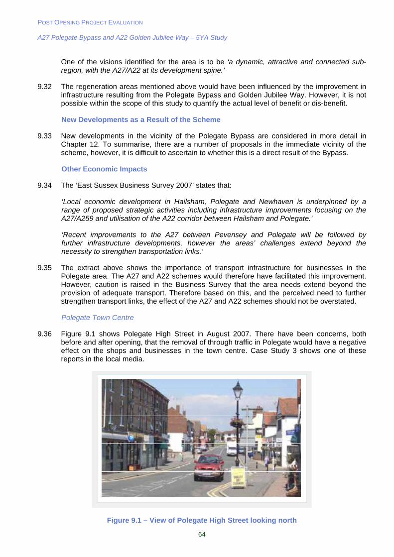
POST OPENING PROJECT EVALUATION A27 Polegate Bypass and A22 Golden Jubilee Way – 5YA Study
64
One of the visions identified for the area is to be ‘a dynamic, attractive and connected sub-region, with the A27/A22 at its development spine.’
9.32 The regeneration areas mentioned above would have been influenced by the improvement in infrastructure resulting from the Polegate Bypass and Golden Jubilee Way. However, it is not possible within the scope of this study to quantify the actual level of benefit or dis-benefit.
New Developments as a Result of the Scheme
9.33 New developments in the vicinity of the Polegate Bypass are considered in more detail in Chapter 12. To summarise, there are a number of proposals in the immediate vicinity of the scheme, however, it is difficult to ascertain to whether this is a direct result of the Bypass.
Other Economic Impacts
9.34 The ‘East Sussex Business Survey 2007’ states that:
‘Local economic development in Hailsham, Polegate and Newhaven is underpinned by a range of proposed strategic activities including infrastructure improvements focusing on the A27/A259 and utilisation of the A22 corridor between Hailsham and Polegate.’
‘Recent improvements to the A27 between Pevensey and Polegate will be followed by further infrastructure developments, however the areas’ challenges extend beyond the necessity to strengthen transportation links.’
9.35 The extract above shows the importance of transport infrastructure for businesses in the Polegate area. The A27 and A22 schemes would therefore have facilitated this improvement. However, caution is raised in the Business Survey that the area needs extend beyond the provision of adequate transport. Therefore based on this, and the perceived need to further strengthen transport links, the effect of the A27 and A22 schemes should not be overstated.
Polegate Town Centre
9.36 Figure 9.1 shows Polegate High Street in August 2007. There have been concerns, both before and after opening, that the removal of through traffic in Polegate would have a negative effect on the shops and businesses in the town centre. Case Study 3 shows one of these reports in the local media.
Figure 9.1 – View of Polegate High Street looking north
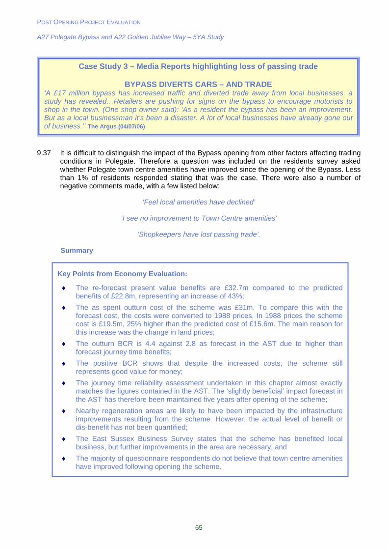
POST OPENING PROJECT EVALUATION A27 Polegate Bypass and A22 Golden Jubilee Way – 5YA Study
65
9.37 It is difficult to distinguish the impact of the Bypass opening from other factors affecting trading conditions in Polegate. Therefore a question was included on the residents survey asked whether Polegate town centre amenities have improved since the opening of the Bypass. Less than 1% of residents responded stating that was the case. There were also a number of negative comments made, with a few listed below:
‘Feel local amenities have declined’
‘I see no improvement to Town Centre amenities’
‘Shopkeepers have lost passing trade’.
Summary
Case Study 3 – Media Reports highlighting loss of passing trade
BYPASS DIVERTS CARS – AND TRADE ‘A £17 million bypass has increased traffic and diverted trade away from local businesses, a study has revealed…Retailers are pushing for signs on the bypass to encourage motorists to shop in the town. (One shop owner said): ‘As a resident the bypass has been an improvement. But as a local businessman it’s been a disaster. A lot of local businesses have already gone out of business.’’ The Argus (04/07/06)
Key Points from Economy Evaluation:
The re-forecast present value benefits are £32.7m compared to the predicted benefits of £22.8m, representing an increase of 43%;
The as spent outturn cost of the scheme was £31m. To compare this with the forecast cost, the costs were converted to 1988 prices. In 1988 prices the scheme cost is £19.5m, 25% higher than the predicted cost of £15.6m. The main reason for this increase was the change in land prices;
The outturn BCR is 4.4 against 2.8 as forecast in the AST due to higher than forecast journey time benefits;
The positive BCR shows that despite the increased costs, the scheme still represents good value for money;
The journey time reliability assessment undertaken in this chapter almost exactly matches the figures contained in the AST. The ‘slightly beneficial’ impact forecast in the AST has therefore been maintained five years after opening of the scheme;
Nearby regeneration areas are likely to have been impacted by the infrastructure improvements resulting from the scheme. However, the actual level of benefit or dis-benefit has not been quantified;
The East Sussex Business Survey states that the scheme has benefited local business, but further improvements in the area are necessary; and
The majority of questionnaire respondents do not believe that town centre amenities have improved following opening the scheme.

POST OPENING PROJECT EVALUATION A27 Polegate Bypass and A22 Golden Jubilee Way – 5YA Study
66
10. Accessibility
Introduction
10.1 The Accessibility objective consists of three sub-objectives:
Option values; Severance; and Access to the transport system.
OPTION VALUES
10.2 Option values is concerned with the availability of transport options even if is not used. For example a car user may value a bus service along their route even if they never used it because they have the option of another mode should their car be unavailable.
10.3 The ‘Access to the Transport System’ section later in this chapter states that bus service provision in Polegate has improved in the five years since opening. However this no evidence that this is a direct result of the scheme. Therefore the impact on option values can be considered neutral.
SEVERANCE
10.4 TAG recommends that:
This sub-objective is concerned with severance as it affects those using non-motorised modes, especially pedestrians (TAG Unit 3.6.2, Para 1.1.1). To ensure a consistent approach, classification should be based on pedestrians only (Para 1.1.3).
Predicted Impacts
10.5 The Environmental Statement (ES) noted that there was an extensive network of footpaths and bridleways throughout the route corridor including a disused railway line, and the Cuckoo Trail used by non motorised users (NMU’s). The proposals would result in a number of existing Public Rights Of Way (PROW) which crossed the proposed route being diverted:
A new link for Bay Tree Lane under the A22 which would also enable NMU’s to cross the busy road safely;
Footpath 6a stopped up between the junction with footpath 6b and Otham Court Lane with an alternative available via the Cuckoo Trail;
Cuckoo Trail maintained on existing alignment but on an overbridge over the new bypass; A link from the Cuckoo Trail west to Sayerland Lane and the new Bay Tree Lane link; Footpath 15 stopped up where severed by the bypass through to its terminus at Shepham
Lane and diverted along the southern edge of the bypass; Shepham Lane maintained on its existing alignment but on an overbridge over the
bypass; Footpath 19 stopped up where it leaves Shepham Lane (shown in Figure 10.1) and
diverted onto the new Shepham Lane Bridge then along the northern edge of the bypass to the existing alignment; and
Footpath 17 stopped up and diverted round the verges of the eastern roundabouts and along the northern edge of the Pevensey Bypass.
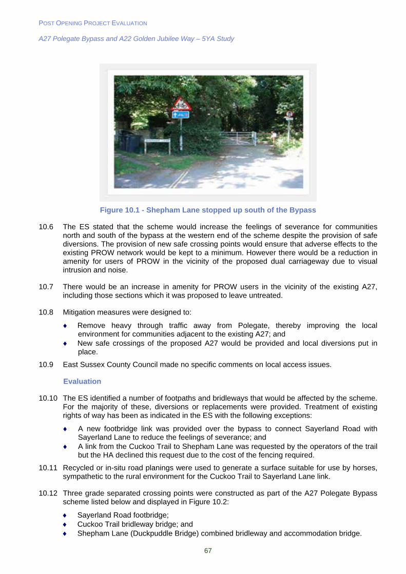
POST OPENING PROJECT EVALUATION A27 Polegate Bypass and A22 Golden Jubilee Way – 5YA Study
67
Figure 10.1 - Shepham Lane stopped up south of the Bypass
10.6 The ES stated that the scheme would increase the feelings of severance for communities north and south of the bypass at the western end of the scheme despite the provision of safe diversions. The provision of new safe crossing points would ensure that adverse effects to the existing PROW network would be kept to a minimum. However there would be a reduction in amenity for users of PROW in the vicinity of the proposed dual carriageway due to visual intrusion and noise.
10.7 There would be an increase in amenity for PROW users in the vicinity of the existing A27, including those sections which it was proposed to leave untreated.
10.8 Mitigation measures were designed to:
Remove heavy through traffic away from Polegate, thereby improving the local environment for communities adjacent to the existing A27; and
New safe crossings of the proposed A27 would be provided and local diversions put in place.
10.9 East Sussex County Council made no specific comments on local access issues.
Evaluation
10.10 The ES identified a number of footpaths and bridleways that would be affected by the scheme. For the majority of these, diversions or replacements were provided. Treatment of existing rights of way has been as indicated in the ES with the following exceptions:
A new footbridge link was provided over the bypass to connect Sayerland Road with Sayerland Lane to reduce the feelings of severance; and
A link from the Cuckoo Trail to Shepham Lane was requested by the operators of the trail but the HA declined this request due to the cost of the fencing required.
10.11 Recycled or in-situ road planings were used to generate a surface suitable for use by horses, sympathetic to the rural environment for the Cuckoo Trail to Sayerland Lane link.
10.12 Three grade separated crossing points were constructed as part of the A27 Polegate Bypass scheme listed below and displayed in Figure 10.2:
Sayerland Road footbridge; Cuckoo Trail bridleway bridge; and Shepham Lane (Duckpuddle Bridge) combined bridleway and accommodation bridge.
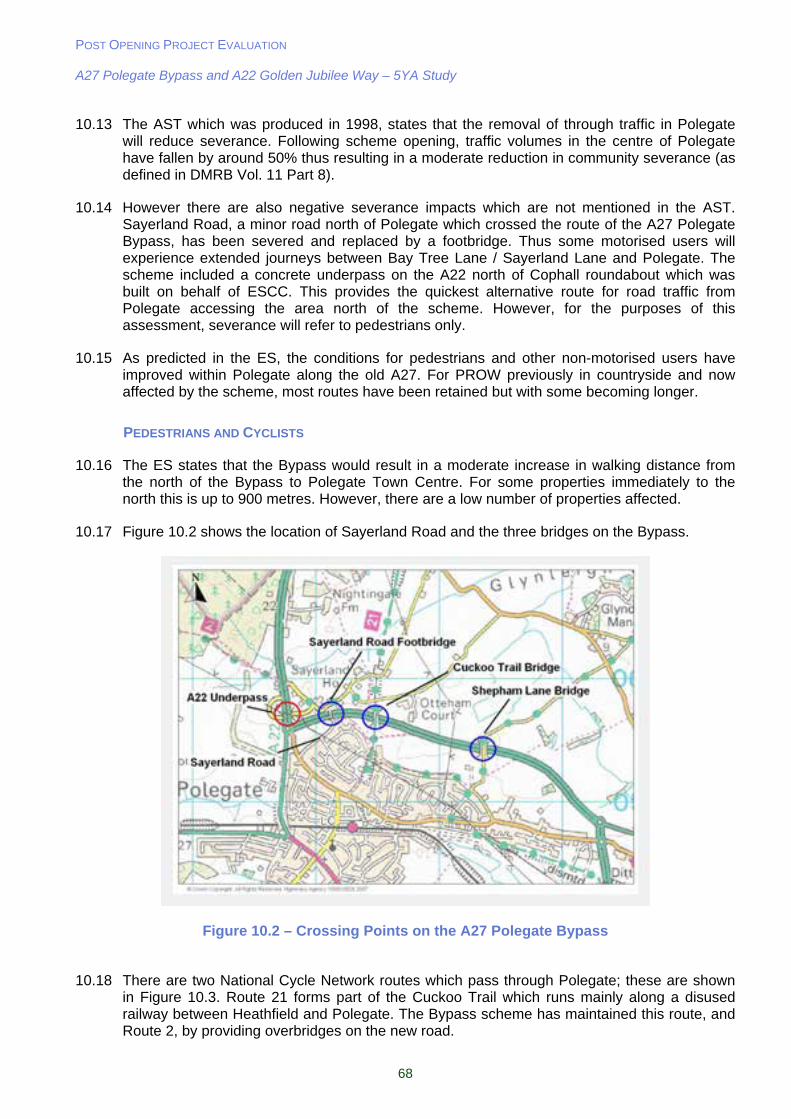
POST OPENING PROJECT EVALUATION A27 Polegate Bypass and A22 Golden Jubilee Way – 5YA Study
68
10.13 The AST which was produced in 1998, states that the removal of through traffic in Polegate will reduce severance. Following scheme opening, traffic volumes in the centre of Polegate have fallen by around 50% thus resulting in a moderate reduction in community severance (as defined in DMRB Vol. 11 Part 8).
10.14 However there are also negative severance impacts which are not mentioned in the AST. Sayerland Road, a minor road north of Polegate which crossed the route of the A27 Polegate Bypass, has been severed and replaced by a footbridge. Thus some motorised users will experience extended journeys between Bay Tree Lane / Sayerland Lane and Polegate. The scheme included a concrete underpass on the A22 north of Cophall roundabout which was built on behalf of ESCC. This provides the quickest alternative route for road traffic from Polegate accessing the area north of the scheme. However, for the purposes of this assessment, severance will refer to pedestrians only.
10.15 As predicted in the ES, the conditions for pedestrians and other non-motorised users have improved within Polegate along the old A27. For PROW previously in countryside and now affected by the scheme, most routes have been retained but with some becoming longer.
PEDESTRIANS AND CYCLISTS
10.16 The ES states that the Bypass would result in a moderate increase in walking distance from the north of the Bypass to Polegate Town Centre. For some properties immediately to the north this is up to 900 metres. However, there are a low number of properties affected.
10.17 Figure 10.2 shows the location of Sayerland Road and the three bridges on the Bypass.
Figure 10.2 – Crossing Points on the A27 Polegate Bypass
10.18 There are two National Cycle Network routes which pass through Polegate; these are shown in Figure 10.3. Route 21 forms part of the Cuckoo Trail which runs mainly along a disused railway between Heathfield and Polegate. The Bypass scheme has maintained this route, and Route 2, by providing overbridges on the new road.
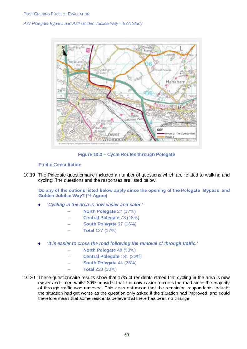
POST OPENING PROJECT EVALUATION A27 Polegate Bypass and A22 Golden Jubilee Way – 5YA Study
69
Figure 10.3 – Cycle Routes through Polegate
Public Consultation
10.19 The Polegate questionnaire included a number of questions which are related to walking and cycling: The questions and the responses are listed below:
Do any of the options listed below apply since the opening of the Polegate Bypass and Golden Jubilee Way? (% Agree)
‘Cycling in the area is now easier and safer.’
North Polegate 27 (17%)
Central Polegate 73 (18%)
South Polegate 27 (16%)
Total 127 (17%)
‘It is easier to cross the road following the removal of through traffic.’
North Polegate 48 (33%)
Central Polegate 131 (32%)
South Polegate 44 (26%)
Total 223 (30%)
10.20 These questionnaire results show that 17% of residents stated that cycling in the area is now easier and safer, whilst 30% consider that it is now easier to cross the road since the majority of through traffic was removed. This does not mean that the remaining respondents thought the situation had got worse as the question only asked if the situation had improved, and could therefore mean that some residents believe that there has been no change.

POST OPENING PROJECT EVALUATION A27 Polegate Bypass and A22 Golden Jubilee Way – 5YA Study
70
ACCESS TO THE TRANSPORT SYSTEM
10.21 Access to the transport system considers access to a car and access to the public transport system.
10.22 For this evaluation, consideration has been given to access to public transport. TAG recommends appraisal using distance or walk time from a public transport service, plus consideration to service frequency, speed of travel and quality of the public transport service.
10.23 Improving access to public transport was not a scheme objective for the Polegate Bypass or Golden Jubilee Way. However, this is not to say that there have not been indirect benefits resulting from the scheme.
Consultation with Bus Operator
10.24 Consultation with a representative from Eastbourne Buses (the main operator in Polegate at the time of this study) was undertaken in November 2007. Based on the views of the main operator through Polegate the following statements can be made:
Bus service provision is slightly better in the Polegate area as traffic is now flowing more freely;
There has been an increase in bus services through Polegate since opening. However, this is a result of market factors not related to the scheme;
Bus journey time reliability has not significantly improved on the A2270 through Willingdon. However, it has not deteriorated as they might have done given background traffic growth in Eastbourne; and
Large amounts of traffic entering Eastbourne on the A22 Golden Jubilee Way is causing congestion on the A259 / Lottbridge Road junction (Seaside Roundabout adjacent to Tesco). This is making it difficult to run reliable bus services on the eastern side of Eastbourne, particularly during peak times.
Public Consultation
10.25 The residents questionnaire included the following question:
Do any of the options listed below apply since the opening of the Polegate Bypass and Golden Jubilee Way? (% Agree)
‘Public transport is now more reliable.’
North Polegate 18 (11%)
Central Polegate 38 (9%)
South Polegate 20 (12%)
Total 76 (10%)
10.26 The responses to this question show that only a minority of questionnaire respondents believe that public transport reliability has improved since the scheme opened. Therefore the effect of the scheme on access to the transport system can be considered to be neutral.
POST OPENING PROJECT EVALUATION A27 Polegate Bypass and A22 Golden Jubilee Way – 5YA Study
71
Summary
Key Points from Accessibility Evaluation:
There has been a slightly positive impact in terms of option values since opening. However, this is not as a result of the scheme. Therefore the scoring for the EST is neutral;
The reduction in traffic volumes In Polegate town centre has resulted in a moderate reduction in community severance;
Rights of Way and cycle routes have been maintained by the provision of overbridges;
There have been no direct improvements in public transport as a result of the scheme. Therefore the effect on access to the transport system can be considered neutral;
17% of questionnaire respondents believe that cycling in the area is now easier and safer;
30% of questionnaire respondents state that it is now easier to cross the road following the removal of through traffic; and
Only 10% of questionnaire respondents believe public transport is now more reliable following scheme opening.
POST OPENING PROJECT EVALUATION A27 Polegate Bypass and A22 Golden Jubilee Way – 5YA Study
72
11. Integration
Introduction
11.1 The Integration Objective consists of two main elements:
Interchange with other transport modes; and Land Use Policy and integration with other Government policies.
11.2 This section will also look at the following objectives:
Quality of Life; and Social Exclusion.
11.3 The A27 Polegate Bypass and any relevant policies relating to the A22 Golden Jubilee Way will be assessed in this section.
TRANSPORT INTERCHANGE
11.4 TAG defines that for transport interchange the AST requires:
…a qualitative description of the ways in which passenger interchange would be improved by the strategy or plan in the study area and on particular modes should be given in the qualitative column. An entry in the quantitative column of the AST should include the number of interchanges improved, the number of new interchanges created and the approximate number of users affected (TAG Unit 3.7.1 section 1.2)
11.5 The AST states that the scheme will have minimal impact on public transport. It was not the intention of the scheme to directly improve public transport and public transport interchanges. However, the Bypass may have facilitated an improvement in this area due to less through traffic in Polegate. Following a site visit and consultation with Eastbourne Buses it appears that there have not been any changes to the bus stop provision in Polegate. However, reduced traffic volumes through Polegate have facilitated indirect public transport interchange improvements in a number of ways. Such improvements include the following:
Buses can now stop in Polegate without causing significant disruption to the flow of traffic passing through the town, and they can also find a gap in traffic easier after picking up or dropping off passengers;
Lighter traffic volumes have resulted in a more pleasant waiting environment for local bus users (largely through removal of traffic, reduced noise and improved roadside air quality); and
Reduced traffic volumes have helped to reduce the severance that previously affected Polegate; consequently the accessibility and safety of bus stops on both sides of the route appear to have improved significantly.
11.6 Therefore there has been a slight benefit in terms of transport interchange. This is not due to the improvement of facilities, purely the removal of through traffic improving the ambience of the waiting environment.
POST OPENING PROJECT EVALUATION A27 Polegate Bypass and A22 Golden Jubilee Way – 5YA Study
73
LAND USE POLICY
11.7 For land use policy, TAG defines that:
This sub-objective summarises the assessments made of the extent to which the proposal is integrated with land use proposals and policies and with proposals and policies concerning transport (all modes). The assessment of proposals in the context of national, regional, strategic and detailed local planning policies is included in current recommended appraisal practice (TAG Unit 3.7.2 Para 1.1.1).
11.8 The AST states that:
‘Land use and development policies (are) strongly reliant on scheme. Policies for shopping, commercial and housing developments depend on scheme, in conjunction with local network improvements.’
11.9 This section reviews all of the relevant policies and strategies in relation to the A27 and A22 schemes.
Regional Transport Strategy (RTS) 2003
11.10 The purpose of the Regional Transport Strategy is to progressively improve the existing transport network in the South East.
11.11 The schemes specifically contributes towards the delivery of Policy T2 (Key Management Issues) and T5 (Regional Spokes). The former supports:
Maintenance of the existing transport system; Improvements to overall safety; Reducing the environmental impact of movements on the natural and built environment;
and The need to ensure that the location, design and construction of all new transport
infrastructure projects enhances the environment and communities affected.
11.12 According to Policy T6, the A27 forms one of the regional spokes in the South East and links Hastings with Brighton. The function of the regional spokes is to:
Give priority to providing a level of service that supports the delivery of the spatial strategy;
Support the role of regional hubs as a focus of economic activity; Deliver and improvement in journey time reliability that supports the rebalancing of the
transport system; and Support the gateway function.
East Sussex Local Transport Plan (LTP) Delivery Report 2001-2006
11.13 This report summarises the impacts the first LTP between 2001 and 2006, thereby covering the period when the A27 and A22 schemes opened. A number of points are raised in this report relating to the schemes together rather than individually. The bullet points below show relevant extracts from the report:
‘(The schemes have) created the opportunity to implement Quality Bus Corridors to Serve Eastbourne, encouraging bus patronage, and has also reduced traffic congestion along parallel north/south routes linking Eastbourne with the A27 trunk road’;
‘(The schemes have) combined to deliver substantial new housing and economic development in the Eastbourne area’;
POST OPENING PROJECT EVALUATION A27 Polegate Bypass and A22 Golden Jubilee Way – 5YA Study
74
‘Enhanced by the implementation of a new signing strategy, the new roads have enabled a series of complementary traffic management measures including the designation of quality bus corridors along the A2270 (former A22) and the main A259 Seaside Road into the town’;
‘The A22 Golden Jubilee Way provides a direct link between the important commercial and retail areas adjacent to the A2280 Lottbridge Drove and the A27 trunk road’; and
‘Indirect benefits include facilitating the achievement of the major brownfield development at Sovereign Harbour with completion expected by 2011. Some 3500-4000 dwellings have been constructed at Sovereign Harbour since the year 2000 and approximately half of these have been completed since opening of A22 Golden Jubilee Way.’
11.14 The comments above show that the schemes appear to have had a positive impact and facilitated further development and network improvement opportunities. For example, it is understood that work is currently ongoing to implement Quality Bus Corridors.
East Sussex Local Transport Plan 2006-2011
11.15 In 2006, East Sussex County Council submitted its second Local Transport Plan 2006-2011. The completion of the A27 and A22 schemes has addressed a number of the strategy’s overarching objectives, including:
Reduce congestion and improve the efficiency of the transport network; and Improve access to services by providing greater travel choices and influencing land use
decisions.
East Sussex and Brighton and Hove Structure Plan 1991-2011
11.16 At the time of the appraisal to the opening of the schemes, the East Sussex and Brighton and Hove Structure Plan was current. However, it has now been superseded by the South East Plan. The completion of the A27 and A22 schemes has contributed towards tackling a number of transport issues specific to East Sussex. The objectives listed below are those that are affected by the schemes.
TR1(f) – The early completion of improvements to the trunk road network in East Sussex as part of the national road network. Longer distance traffic will be encouraged to use the trunk roads;
TR1(g) – Early provision of and/or improvement of links from the trunk road network into the main coastal towns;
TR5(a) – The provision and maintenance of safe and convenient cycle routes; TR5(b) – The improvement of roads and rights of way to provide for the needs of cyclists,
including the provision of priorities for cyclists at junctions and other appropriate locations; TR21 – The early implementation of the A27 Polegate Bypass in the National Roads
Programme is supported; TR30 – Lorries, in particular larger vehicles, will be encouraged to use the strategic road
network wherever possible and avoid unsuitable roads, villages, towns, and other sensitive locations, except as required for local access; and
TR38 – The construction of an extension to the A22 New Route to link to Eastbourne Town Centre is proposed.
Wealden Local Plan (December 2005)
11.17 Polegate is part of Wealden District and one of the objectives for the Polegate/Willingdon area is to:
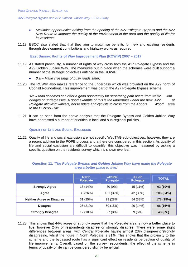
POST OPENING PROJECT EVALUATION A27 Polegate Bypass and A22 Golden Jubilee Way – 5YA Study
75
Maximise opportunities arising from the opening of the A27 Polegate By-pass and the A22 New Route to improve the quality of the environment in the area and the quality of life for its residents.
11.18 ESCC also stated that that they aim to maximise benefits for new and existing residents through development contributions and highway works as required.
East Sussex Rights of Way Improvement Plan (ROWIP) 2007 – 2017
11.19 As stated previously, a number of rights of way cross both the A27 Polegate Bypass and the A22 Golden Jubilee Way. The measures put in place when the schemes were built support a number of the strategic objectives outlined in the ROWIP.
3.a – Make crossings of busy roads safer;
11.20 The ROWIP also makes reference to the underpass which was provided on the A22 north of Cophall Roundabout. This improvement was part of the A27 Polegate Bypass scheme.
‘New road schemes can offer a good opportunity for separating path users from traffic with bridges or underpasses. A good example of this is the underpass under the new A22 at Polegate allowing walkers, horse riders and cyclists to cross from the Abbots Wood area to the Cuckoo Trail.’
11.21 It can be seen from the above analysis that the Polegate Bypass and Golden Jubilee Way have addressed a number of priorities in local and sub-regional policies.
QUALITY OF LIFE AND SOCIAL EXCLUSION
11.22 Quality of life and social exclusion are not specific WebTAG sub-objectives, however, they are a recent addition to the POPE process and a therefore considered in this section. As quality of life and social exclusion are difficult to quantify, this objective was measured by asking a specific question on the residents survey which is shown overleaf.
Question 11. ‘The Polegate Bypass and Golden Jubilee Way have made the Polegate area a better place to live.’
North Polegate
Central Polegate
South Polegate
TOTAL
Strongly Agree 18 (14%) 30 (9%) 15 (11%) 63 (10%)
Agree 33 (26%) 131 (39%) 42 (30%) 206 (34%)
Neither Agree or Disagree 31 (25%) 93 (28%) 54 (38%) 178 (29%)
Disagree 26 (21%) 50 (15%) 20 (14%) 96 (16%)
Strongly Disagree 12 (10%) 27 (8%) 9 (6%) 48 (8%)
11.23 This shows that 44% agree or strongly agree that the Polegate area is now a better place to live, however 24% of respondents disagree or strongly disagree. There were some slight differences between areas, with Central Polegate having almost 23% disagreeing/strongly disagreeing, whilst the figure in North Polegate is 31%. This shows that the proximity to the scheme and the bypassed route has a significant effect on residents perception of quality of life improvements. Overall, based on the survey respondents, the effect of the scheme in terms of quality of life can be considered slightly beneficial.
POST OPENING PROJECT EVALUATION A27 Polegate Bypass and A22 Golden Jubilee Way – 5YA Study
76
11.24 The analysis above shows that central Polegate has the highest proportion of residents who believe that quality of life has improved. This is where the greatest reduction in traffic has occurred as central Polegate contains the bypassed route. It would be expected that residents in north Polegate would have disagreed with the statement the most as the new route passes through this zone. However, more residents agree (40%) than disagree (30%) that quality of life has improved.
SOCIAL EXCLUSION
11.25 Social exclusion was not on the AST for the scheme and was not a specific scheme objective. Therefore this element has not been considered in detail as part of this evaluation.
11.26 One of the main ways of reducing social exclusion is to improve access to public transport services. This was considered in Section 10 previously, with only 10% of questionnaire respondents believing that public transport has improved since the scheme opened. Therefore the effect of scheme in reducing social exclusion can be considered neutral.
Summary
Key Points from Integration Evaluation:
Reduced traffic volumes through Polegate have facilitated indirect improvements for public transport interchange in Polegate. Most notably the removal of through traffic improving the ambience of the waiting environment giving rise to a slightly beneficial impact;
The Polegate Bypass and Golden Jubilee Way integrate well with objectives set out in local and sub-regional policies;
44% of questionnaire respondents agree or strongly agree that the Polegate area is a better place to live as a result of the schemes;
24% of questionnaire respondents disagree or strongly disagree that the Polegate area is a better place to live as a result of the schemes;
Therefore the impacts of the scheme on quality of life can be considered slightly beneficial; and
Social Exclusion impacts of the scheme can be considered to be neutral.
POST OPENING PROJECT EVALUATION A27 Polegate Bypass and A22 Golden Jubilee Way – 5YA Study
77
12. Local Impacts & Issues
Introduction
12.1 The previous sections of this report have dealt with the changes in traffic flows and the effect of the scheme in relation to the five Government objectives for transport schemes. This section is concerned with local issues, road network, and land use changes which do not necessarily fall under any one appraisal objective.
Questionnaire Responses
12.2 A number of questions were included on the residents questionnaire concerning traffic congestion and speeding. The results are summarised below:
Do any of the options listed below apply since the opening of the Polegate Bypass and Golden Jubilee Way? (% Agree)
‘Traffic congestion has improved in Polegate’
North Polegate 56 (35%)
Central Polegate 111 (27%)
South Polegate 49 (28%)
Total 216 (29%)
‘Traffic congestion has improved in Willingdon’
North Polegate 27 (17%)
Central Polegate 51 (13%)
South Polegate 35 (21%)
Total 113 (15%)
‘Traffic speeding through Polegate on the old route (Dittons Road)’
North Polegate 68 (42%)
Central Polegate 196 (48%)
South Polegate 51 (30%)
Total 315 (43%)
12.3 The responses to above questions show that nearly a third of questionnaire respondents believe that traffic congestion has improved in Polegate, which is more than those who thought the situation had improved in Willingdon. However, this could be a result of survey only covering Polegate and not Willingdon. Also 43% of respondents cited that traffic speeding through Polegate is a problem following opening of the scheme.
12.4 One of the main objectives of the A22 Golden Jubilee Way is to remove traffic from the A2270 through Willingdon. The questionnaire included two questions to establish whether there had been any shift to the new route or between modes for residents of Polegate. It is important to note that the residents were asked to tick all of the modes that apply rather than the predominant mode of transport. The results are shown in detail below:
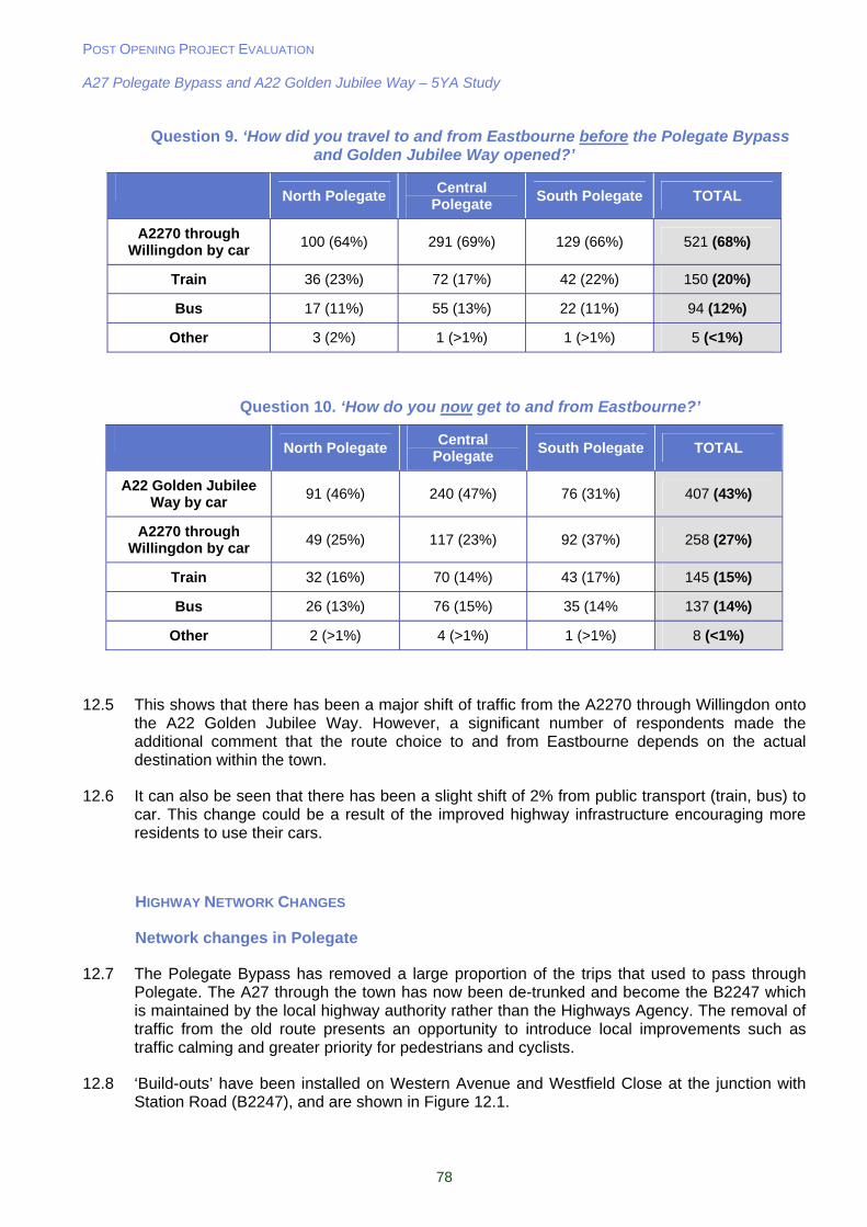
POST OPENING PROJECT EVALUATION A27 Polegate Bypass and A22 Golden Jubilee Way – 5YA Study
78
Question 9. ‘How did you travel to and from Eastbourne before the Polegate Bypass and Golden Jubilee Way opened?’
North Polegate
Central Polegate
South Polegate TOTAL
A2270 through Willingdon by car
100 (64%) 291 (69%) 129 (66%) 521 (68%)
Train 36 (23%) 72 (17%) 42 (22%) 150 (20%)
Bus 17 (11%) 55 (13%) 22 (11%) 94 (12%)
Other 3 (2%) 1 (>1%) 1 (>1%) 5 (<1%)
Question 10. ‘How do you now get to and from Eastbourne?’
North Polegate
Central Polegate
South Polegate TOTAL
A22 Golden Jubilee Way by car
91 (46%) 240 (47%) 76 (31%) 407 (43%)
A2270 through Willingdon by car
49 (25%) 117 (23%) 92 (37%) 258 (27%)
Train 32 (16%) 70 (14%) 43 (17%) 145 (15%)
Bus 26 (13%) 76 (15%) 35 (14% 137 (14%)
Other 2 (>1%) 4 (>1%) 1 (>1%) 8 (<1%)
12.5 This shows that there has been a major shift of traffic from the A2270 through Willingdon onto the A22 Golden Jubilee Way. However, a significant number of respondents made the additional comment that the route choice to and from Eastbourne depends on the actual destination within the town.
12.6 It can also be seen that there has been a slight shift of 2% from public transport (train, bus) to car. This change could be a result of the improved highway infrastructure encouraging more residents to use their cars.
HIGHWAY NETWORK CHANGES
Network changes in Polegate
12.7 The Polegate Bypass has removed a large proportion of the trips that used to pass through Polegate. The A27 through the town has now been de-trunked and become the B2247 which is maintained by the local highway authority rather than the Highways Agency. The removal of traffic from the old route presents an opportunity to introduce local improvements such as traffic calming and greater priority for pedestrians and cyclists.
12.8 ‘Build-outs’ have been installed on Western Avenue and Westfield Close at the junction with Station Road (B2247), and are shown in Figure 12.1.
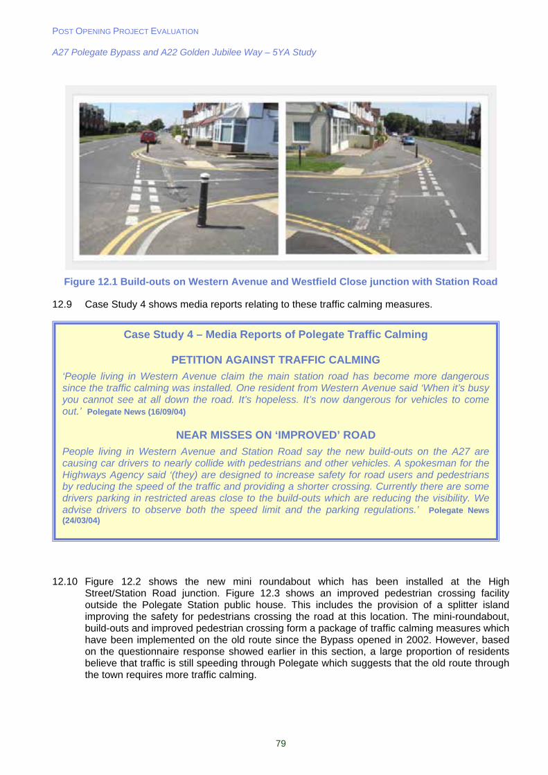
POST OPENING PROJECT EVALUATION A27 Polegate Bypass and A22 Golden Jubilee Way – 5YA Study
79
Figure 12.1 Build-outs on Western Avenue and Westfield Close junction with Station Road
12.9 Case Study 4 shows media reports relating to these traffic calming measures.
12.10 Figure 12.2 shows the new mini roundabout which has been installed at the High Street/Station Road junction. Figure 12.3 shows an improved pedestrian crossing facility outside the Polegate Station public house. This includes the provision of a splitter island improving the safety for pedestrians crossing the road at this location. The mini-roundabout, build-outs and improved pedestrian crossing form a package of traffic calming measures which have been implemented on the old route since the Bypass opened in 2002. However, based on the questionnaire response showed earlier in this section, a large proportion of residents believe that traffic is still speeding through Polegate which suggests that the old route through the town requires more traffic calming.
Case Study 4 – Media Reports of Polegate Traffic Calming
PETITION AGAINST TRAFFIC CALMING
‘People living in Western Avenue claim the main station road has become more dangerous since the traffic calming was installed. One resident from Western Avenue said ‘When it’s busy you cannot see at all down the road. It’s hopeless. It’s now dangerous for vehicles to come out.’ Polegate News (16/09/04)
NEAR MISSES ON ‘IMPROVED’ ROAD
People living in Western Avenue and Station Road say the new build-outs on the A27 are causing car drivers to nearly collide with pedestrians and other vehicles. A spokesman for the Highways Agency said ‘(they) are designed to increase safety for road users and pedestrians by reducing the speed of the traffic and providing a shorter crossing. Currently there are some drivers parking in restricted areas close to the build-outs which are reducing the visibility. We advise drivers to observe both the speed limit and the parking regulations.’ Polegate News (24/03/04)
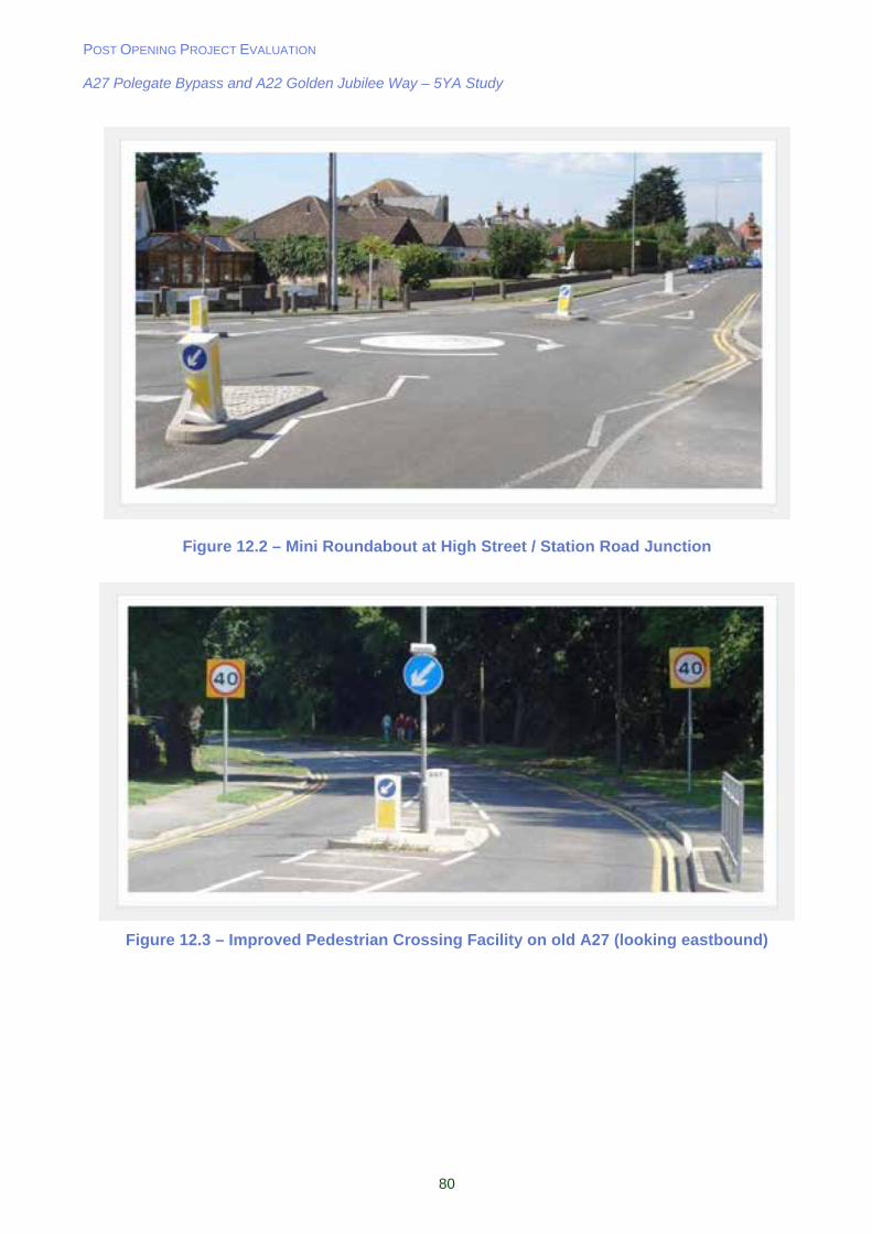
POST OPENING PROJECT EVALUATION A27 Polegate Bypass and A22 Golden Jubilee Way – 5YA Study
80
Figure 12.2 – Mini Roundabout at High Street / Station Road Junction
Figure 12.3 – Improved Pedestrian Crossing Facility on old A27 (looking eastbound)
POST OPENING PROJECT EVALUATION A27 Polegate Bypass and A22 Golden Jubilee Way – 5YA Study
81
Car Parking
12.11 The provision of parking on the old A27 through Polegate is a more recent issue. Case Study 5 shows a media report discussing the problem.
12.12 A question on the residents survey asked if there is a ‘lack of suitable car parking’ in Polegate following opening of the scheme, with the results shown below as follows (% agree):
North Polegate 85 (53%)
Central Polegate 223 (55%)
South Polegate 100 (59%)
Total 406 (55%)
12.13 This shows that over half of the residents who responded to the survey believe that there is a lack of suitable car parking in the town. A number of respondents also mentioned the problem of rail commuters using nearby streets for car parking. However, it is not known what the car parking situation was like before the scheme opened.
Network Changes in Willingdon
12.14 A cycle lane has recently been introduced in both directions of the A2270 through Willingdon. The reduction of traffic on this route since the A22 Golden Jubilee Way opened would have facilitated this improvement.
LAND USE CHANGES
12.15 The following extract is taken from the East Sussex LTP Delivery Report 2001-2006:
‘(The A22 Golden Jubilee Way) has enabled new development to proceed in the Willingdon Drove area, comprising a fitness suite, Toyota main dealership, Travel Lodge, Toby Inn, Audi main dealership, and Rok Llewellyn local headquarters. The new route has also had a positive effect on retention of existing businesses. For example, the largest book wholesaler in the UK, Gardners Books Limited, is looking to expand, relocated close to the A22 Jubilee Way rather than seek an alternative site away from Eastbourne. Proximity to the new route was an important factor in the decision not to leave Eastbourne.’
12.16 Table 12.1 summarises the local developments that have come forward in the last 5 years since the scheme opened. The locations of these in relation to the Polegate Bypass are shown in Figure 12.4:
Case Study 5 – Media Report of Polegate Car Parking
MP’s SEEK SHAKE UP OF VEHICLE RESTRICTIONS
‘Residents are being urged to let their views be known about waiting restrictions in Polegate. Restrictions were put in place when the A27 was a trunk road but many residents have argued that they have now become obsolete with the opening of the Polegate Bypass.’ Polegate News (07/06/07)
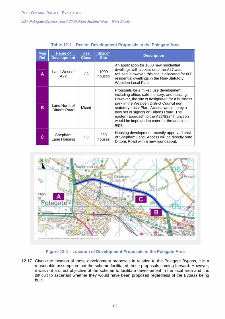
POST OPENING PROJECT EVALUATION A27 Polegate Bypass and A22 Golden Jubilee Way – 5YA Study
82
Table 12.1 – Recent Development Proposals in the Polegate Area
Map Ref
Name of Development
Use Class
Size of Site
Description
A Land West of A22
C3 1000
houses
An application for 1000 new residential dwellings with access onto the A27 was refused. However, this site is allocated for 600 residential dwellings in the Non-Statutory Wealden Local Plan
B Land North of Dittons Road
Mixed
Proposals for a mixed use development including office, café, nursery, and housing. However, the site is designated for a business park in the Wealden District Council non statutory Local Plan. Access would be by a new set of signals on Dittons Road. The eastern approach to the A22/B2247 junction would be improved to cater for the additional trips.
C Shepham Lane Housing
C3 260
houses
Housing development recently approved east of Shepham Lane. Access will be directly onto Dittons Road with a new roundabout.
Figure 12.4 – Location of Development Proposals in the Polegate Area
12.17 Given the location of these development proposals in relation to the Polegate Bypass, it is a reasonable assumption that the scheme facilitated these proposals coming forward. However, it was not a direct objective of the scheme to facilitate development in the local area and it is difficult to ascertain whether they would have been proposed regardless of the Bypass being built.
POST OPENING PROJECT EVALUATION A27 Polegate Bypass and A22 Golden Jubilee Way – 5YA Study
83
12.18 A question on the residents survey asked if residents believed that ‘new development had been attracted to the area as a result of the schemes.’ The results were as follows (% agree):
North Polegate 19 (12%)
Central Polegate 51 (13%)
South Polegate 17 (10%)
Total 87 (12%)
12.19 This shows that the vast majority of Polegate residents do not believe that the schemes are responsible for attracting new development to the area.
Summary
Key Points from Local Impacts Section:
29% of questionnaire respondents believe that traffic congestion has improved in Polegate since opening;
43% of questionnaire respondents believe that speeding traffic is a problem on the B2247 through Polegate since opening;
Only 15% of questionnaire respondents believe that traffic congestion has improved in Willingdon;
55% of questionnaire respondents believe that car parking in Polegate is a problem in Polegate, but this may also have been the case pre scheme opening; ;
A number of developments are planned in the vicinity of the Polegate Bypass. It is not possible to ascertain whether they are a direct result of the scheme; and
12% of questionnaire respondents believe that new development attracted to the area is as a result of the schemes.

POST OPENING PROJECT EVALUATION A27 Polegate Bypass and A22 Golden Jubilee Way – 5YA Study
84
13. Conclusions
13.1 In order to summarise the evaluation of the impacts of the A27 Polegate Bypass a review of the Appraisal Summary Table (AST) has been undertaken. The AST is re-produced in Table 13.2. (Note that many of the outturn impacts are due to the combined effect of the HA and LA schemes). The EST which summarises the findings from this 5YA report is shown in Table 13.3. Each objective and sub-objective has been assessed in this report. Table 13.1 shows the most recent appraisal sub-objectives (apart from quality of life and social exclusion) and the location of the analysis in the text.
Table 13.1 – AST/EST Framework: Impact Objectives and Sub-Objectives
Objective Sub-Objective Text Section
Noise 7.13
Local Air Quality 7.26
Greenhouse Gases 7.36
Landscape/Townscape 7.46
Biodiversity 7.69
Heritage 7.80
Water Quality 7.86
Environment
Journey Ambience 7.97
Accidents 8.3 Safety Personal Security 8.33
Transport Economic Efficiency 9.8
Reliability 9.23 Economy
Wider Economic Impacts 9.28
Option Values 10.2
Severance 10.4 Accessibility
Accessibility 10.21
Transport Interchange 11.4
Land Use Policy 11.7
Quality of Life 11.22 Integration
Social Exclusion 11.25
SUMMARY
13.2 Opened in June 2002, the A27 Polegate Bypass aimed to reduce congestion by removing through traffic from Polegate. The main conclusions from this study are:
Traffic volumes reduced by 49% in Polegate; Reduction in the number of accidents in Polegate; Improved journey times and reliability for A27 traffic; Compliments the A22 Golden Jubilee Way and together offer improved access to
Eastbourne; and Reduced community severance and improved environment shown by the
predominantly positive responses form the residents of Polegate.
13.3 It can therefore be concluded that the scheme has been successful in meeting its objectives.
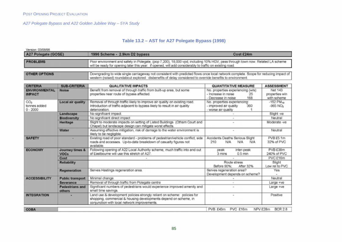
POST OPENING PROJECT EVALUATION A27 Polegate Bypass and A22 Golden Jubilee Way – 5YA Study
85
Table 13.2 – AST for A27 Polegate Bypass (1998)

POST OPENING PROJECT EVALUATION A27 Polegate Bypass and A22 Golden Jubilee Way – 5YA Study
86
Table 13.3 – 5 Year After EST for A27 Polegate Bypass
A27 Polegate (GOSE) Option: scheme opened June 2002 – 2.9 km D2 Bypass CRITERIA SUB-CRITERIA QUALITATIVE IMPACTS QUANTITATIVE MEASURE ASSESSMENT
Noise Noise levels slightly higher than predicted in Polegate but still lower than before opening. In line with predictions near the Bypass.
- Slightly Beneficial
Local air quality Noise levels slightly higher than predicted in Polegate but still lower than before opening. In line with predictions near the Bypass.
- Slightly Beneficial
Greenhouse Gases - 19% increase in carbon as a result of scheme (inc Golden
Jubilee Way). Adverse
Landscape/ Townscape Adverse impact of new bypass partially balanced by the benefits in visual amenity for Polegate. - Neutral
Biodiversity All mitigation measures proposed are in place. No detailed evaluation carried out. - -
Heritage Slight impact negative impact on listed building (Otham Court), but mitigation landscaping constructed as per the design.
- Slightly Adverse
Water Mitigation measures in place. No detailed assessment undertaken. - -
Physical Fitness Not assessed. - -
ENVIRONMENT
Journey Ambience Bypass traffic experiencing less driver stress compared to those using the old route through Polegate. Also, the provision of lay-bys on the Bypass improves journey ambience.
- Slightly Beneficial
Accidents Reduction of accidents in Polegate but cluster of accidents at Cophall Roundabout. 23 accidents saved in
opening year. £4m
Slightly Beneficial SAFETY Personal Security Slight adverse effect in terms of personal security due to lack of street lighting on the new route. - Slightly Adverse
Transport Economic Efficiency
Journey time savings for traffic on Bypass. PVB £32.7m, PVC £7.4m,
BCR 4.4 Beneficial
Reliability Through traffic no longer encounters traffic congestion in Polegate. Route Stress on A27 Before (71%) 5 Years After (35%).
Beneficial
ECONOMY
Wider Economic Impacts Access to regeneration areas will have been improved slightly, but not possible to quantify. -
Option Values Bus service provision improved but not as a result of the scheme. - Neutral
Severance 50% decrease in traffic in Polegate Town Centre, thus greatly reducing severance. New severance for motorised traffic on minor road (Sayerland Road).
- Slightly Beneficial ACCESSIBILITY Access to Transport
System Bus service provision improved but not as a result of the scheme.
Only 10% of respondents believe public transport has
improved. Neutral
Transport Interchange Removal of through traffic facilitating improvement in waiting environment. - Slightly Beneficial Land Use Policies Scheme well integrated with land use policy. - Slightly Beneficial
Quality of Life 44% of residents agree or
strongly agree that Polegate is a better place to live.
Slightly Beneficial INTEGRATION
Social Exclusion No significant improvement in access to public transport. - Neutral
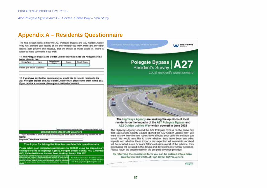
POST OPENING PROJECT EVALUATION A27 Polegate Bypass and A22 Golden Jubilee Way – 5YA Study
87
Appendix A – Residents Questionnaire
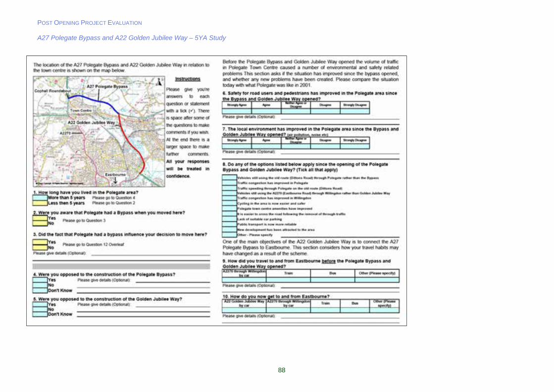
POST OPENING PROJECT EVALUATION A27 Polegate Bypass and A22 Golden Jubilee Way – 5YA Study
88


![Ppt a27.pptm [autosaved]](https://static.fdocuments.us/doc/165x107/559e92581a28ab173d8b45b7/ppt-a27pptm-autosaved.jpg)