A.1 List of Preparers and Reviewers...A-1 Appendix A. List of Preparers, Reviewers, and Repositories...
167
A-1 Appendix A. List of Preparers, Reviewers, and Repositories A.1 List of Preparers and Reviewers Agency/Firm Name Position State of Florida Florida Department of Environmental Protection Leslie Ames Office of the Secretary, Deputy Chief of Staff Florida Department of Environmental Protection Phil Coram Program Administrator, DWH Program Florida Department of Environmental Protection James Reynolds Environmental Consultant, DWH Program Florida Department of Environmental Protection Lisa Robertson Environmental Administrator, DWH Program Florida Fish and Wildlife Conservation Commission Gareth Leonard Gulf Restoration Coordinator Florida Fish and Wildlife Conservation Commission Amy Raker Assistant Gulf Restoration Coordinator NOAA National Oceanic and Atmospheric Administration/ ERT, Inc. Stella Wilson Marine Habitat Restoration Specialist National Oceanic and Atmospheric Administration Ramona Schreiber Marine Habitat Resource Specialist National Oceanic and Atmospheric Administration Laurie Rounds Marine Habitat Resource Specialist National Oceanic and Atmospheric Administration Christina Fellas Marine Habitat Resource Specialist National Oceanic and Atmospheric Administration Chauncey Kelly NOAA Office of the General Counsel U.S. Department of the Interior U.S. Department of the Interior Robin Renn DOI DWH NEPA Coordinator U.S. Department of the Interior Dianne Ingram DOI DWH Restoration Biologist U.S. Department of the Interior Ben Frater DOI DWH Assistant Restoration Manager U.S. Department of the Interior Erin Chandler Fish and Wildlife Biologist U.S. Department of the Interior Kevin Chapman DOI NHPA Consultation and Permits Coordinator U.S. Department of the Interior Lisa Stevens Attorney-Advisor U.S. Department of the Interior Sarah Shattuck Attorney-Advisor U.S. Department of the Interior Nanciann Regalado DOI DWH Public Affairs and Outreach Coordinator Industrial Economics, Incorporated Leslie Genova Principal Industrial Economics, Incorporated Nadia Martin Senior Associate Industrial Economics, Incorporated Heather Ballestero Associate Research Planning, Incorporated Pam Latham Senior Scientist Research Planning, Incorporated Hal Fravel Scientist U.S. Department of Agriculture U.S. Department of Agriculture Ron Howard Senior Technical Advisor U.S. Department of Agriculture Mark Defley Biologist, NRCS Gulf Coast Ecosystem Restoration Team U.S. Department of Agriculture Benjamin Battle FL TIG Member U.S. Environmental Protection Agency U.S. Environmental Protection Agency Amy Newbold FL TIG Member
Transcript of A.1 List of Preparers and Reviewers...A-1 Appendix A. List of Preparers, Reviewers, and Repositories...
A-1
Appendix A. List of Preparers, Reviewers, and Repositories
A.1 List of Preparers and Reviewers
Agency/Firm Name Position
State of Florida
Florida Department of Environmental Protection Leslie Ames Office of the Secretary, Deputy Chief of Staff
Florida Department of Environmental Protection Phil Coram Program Administrator, DWH Program
Florida Department of Environmental Protection James Reynolds Environmental Consultant, DWH Program
Florida Department of Environmental Protection Lisa Robertson Environmental Administrator, DWH Program
Florida Fish and Wildlife Conservation Commission Gareth Leonard Gulf Restoration Coordinator
Florida Fish and Wildlife Conservation Commission Amy Raker Assistant Gulf Restoration Coordinator
NOAA
National Oceanic and Atmospheric Administration/ ERT, Inc. Stella Wilson Marine Habitat Restoration Specialist
National Oceanic and Atmospheric Administration Ramona Schreiber Marine Habitat Resource Specialist
National Oceanic and Atmospheric Administration Laurie Rounds Marine Habitat Resource Specialist
National Oceanic and Atmospheric Administration Christina Fellas Marine Habitat Resource Specialist
National Oceanic and Atmospheric Administration Chauncey Kelly NOAA Office of the General Counsel
U.S. Department of the Interior
U.S. Department of the Interior Robin Renn DOI DWH NEPA Coordinator
U.S. Department of the Interior Dianne Ingram DOI DWH Restoration Biologist
U.S. Department of the Interior Ben Frater DOI DWH Assistant Restoration Manager
U.S. Department of the Interior Erin Chandler Fish and Wildlife Biologist
U.S. Department of the Interior Kevin Chapman DOI NHPA Consultation and Permits Coordinator
U.S. Department of the Interior Lisa Stevens Attorney-Advisor
U.S. Department of the Interior Sarah Shattuck Attorney-Advisor
U.S. Department of the Interior Nanciann Regalado DOI DWH Public Affairs and Outreach Coordinator
Industrial Economics, Incorporated Leslie Genova Principal
Industrial Economics, Incorporated Nadia Martin Senior Associate
Industrial Economics, Incorporated Heather Ballestero Associate
Research Planning, Incorporated Pam Latham Senior Scientist
Research Planning, Incorporated Hal Fravel Scientist
U.S. Department of Agriculture
U.S. Department of Agriculture Ron Howard Senior Technical Advisor
U.S. Department of Agriculture Mark Defley Biologist, NRCS Gulf Coast Ecosystem Restoration Team
U.S. Department of Agriculture Benjamin Battle FL TIG Member
U.S. Environmental Protection Agency
U.S. Environmental Protection Agency Amy Newbold FL TIG Member
A-2
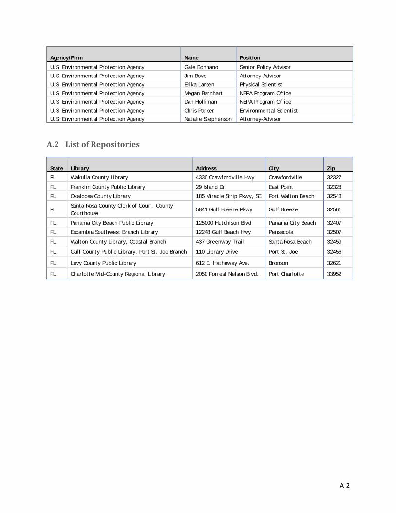
Agency/Firm Name Position
U.S. Environmental Protection Agency Gale Bonnano Senior Policy Advisor
U.S. Environmental Protection Agency Jim Bove Attorney-Advisor
U.S. Environmental Protection Agency Erika Larsen Physical Scientist
U.S. Environmental Protection Agency Megan Barnhart NEPA Program Office
U.S. Environmental Protection Agency Dan Holliman NEPA Program Office
U.S. Environmental Protection Agency Chris Parker Environmental Scientist
U.S. Environmental Protection Agency Natalie Stephenson Attorney-Advisor
A.2 List of Repositories
State Library Address City Zip
FL Wakulla County Library 4330 Crawfordville Hwy Crawfordville 32327
FL Franklin County Public Library 29 Island Dr. East Point 32328
FL Okaloosa County Library 185 Miracle Strip Pkwy, SE Fort Walton Beach 32548
FL Santa Rosa County Clerk of Court, County Courthouse
5841 Gulf Breeze Pkwy Gulf Breeze 32561
FL Panama City Beach Public Library 125000 Hutchison Blvd Panama City Beach 32407
FL Escambia Southwest Branch Library 12248 Gulf Beach Hwy Pensacola 32507
FL Walton County Library, Coastal Branch 437 Greenway Trail Santa Rosa Beach 32459
FL Gulf County Public Library, Port St. Joe Branch 110 Library Drive Port St. Joe 32456
FL Levy County Public Library 612 E. Hathaway Ave. Bronson 32621
FL Charlotte Mid-County Regional Library 2050 Forrest Nelson Blvd. Port Charlotte 33952
B-1
Appendix B. Monitoring and Adaptive Management Plans
MAM plans for each of the alternatives identified as a preferred, by the FL TIG at this time, are provided below.
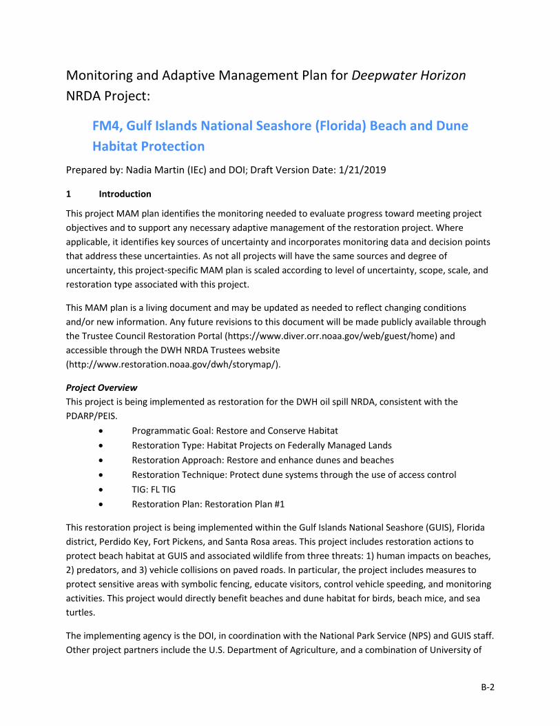
B-2
Monitoring and Adaptive Management Plan for Deepwater Horizon NRDA Project:
FM4, Gulf Islands National Seashore (Florida) Beach and Dune Habitat Protection
Prepared by: Nadia Martin (IEc) and DOI; Draft Version Date: 1/21/2019
1 Introduction
This project MAM plan identifies the monitoring needed to evaluate progress toward meeting project objectives and to support any necessary adaptive management of the restoration project. Where applicable, it identifies key sources of uncertainty and incorporates monitoring data and decision points that address these uncertainties. As not all projects will have the same sources and degree of uncertainty, this project-specific MAM plan is scaled according to level of uncertainty, scope, scale, and restoration type associated with this project.
This MAM plan is a living document and may be updated as needed to reflect changing conditions and/or new information. Any future revisions to this document will be made publicly available through the Trustee Council Restoration Portal (https://www.diver.orr.noaa.gov/web/guest/home) and accessible through the DWH NRDA Trustees website (http://www.restoration.noaa.gov/dwh/storymap/).
Project Overview This project is being implemented as restoration for the DWH oil spill NRDA, consistent with the PDARP/PEIS.
• Programmatic Goal: Restore and Conserve Habitat • Restoration Type: Habitat Projects on Federally Managed Lands • Restoration Approach: Restore and enhance dunes and beaches • Restoration Technique: Protect dune systems through the use of access control • TIG: FL TIG • Restoration Plan: Restoration Plan #1
This restoration project is being implemented within the Gulf Islands National Seashore (GUIS), Florida district, Perdido Key, Fort Pickens, and Santa Rosa areas. This project includes restoration actions to protect beach habitat at GUIS and associated wildlife from three threats: 1) human impacts on beaches, 2) predators, and 3) vehicle collisions on paved roads. In particular, the project includes measures to protect sensitive areas with symbolic fencing, educate visitors, control vehicle speeding, and monitoring activities. This project would directly benefit beaches and dune habitat for birds, beach mice, and sea turtles.
The implementing agency is the DOI, in coordination with the National Park Service (NPS) and GUIS staff. Other project partners include the U.S. Department of Agriculture, and a combination of University of
B-3
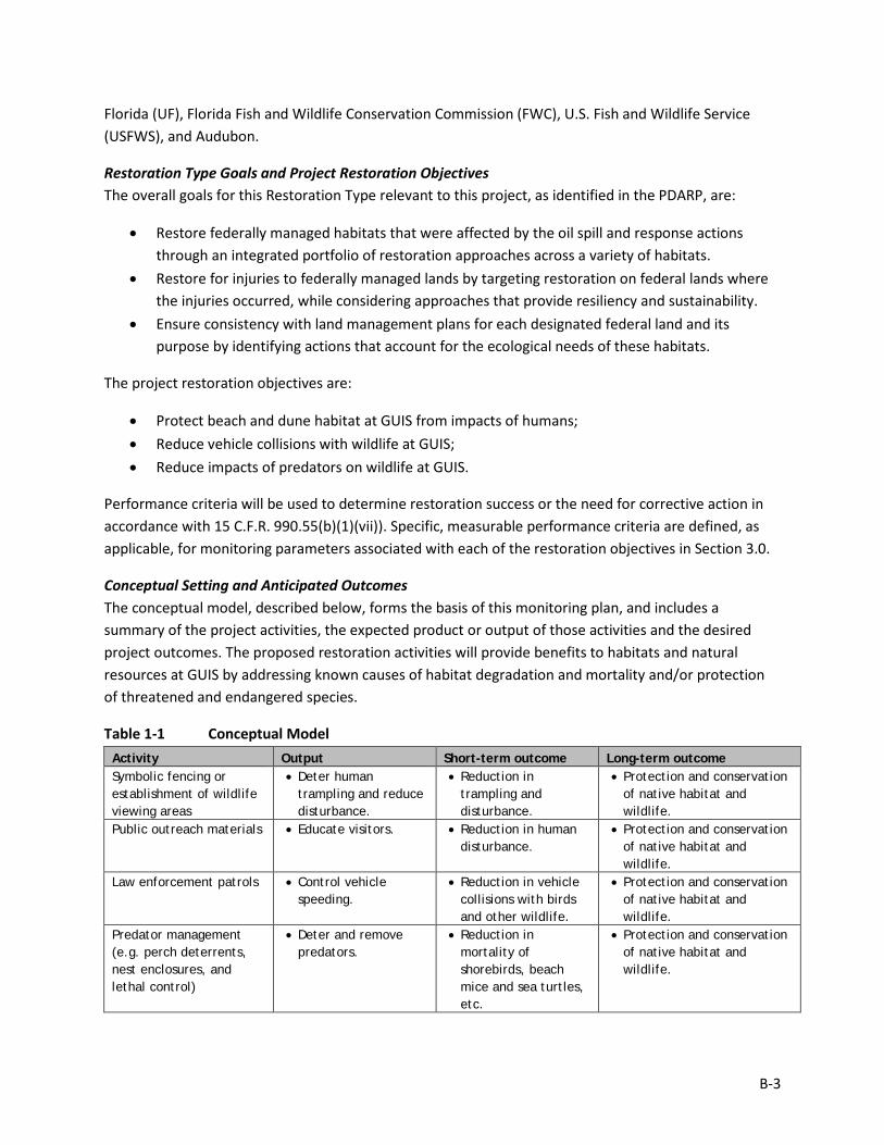
Florida (UF), Florida Fish and Wildlife Conservation Commission (FWC), U.S. Fish and Wildlife Service (USFWS), and Audubon.
Restoration Type Goals and Project Restoration Objectives The overall goals for this Restoration Type relevant to this project, as identified in the PDARP, are:
• Restore federally managed habitats that were affected by the oil spill and response actions through an integrated portfolio of restoration approaches across a variety of habitats.
• Restore for injuries to federally managed lands by targeting restoration on federal lands where the injuries occurred, while considering approaches that provide resiliency and sustainability.
• Ensure consistency with land management plans for each designated federal land and its purpose by identifying actions that account for the ecological needs of these habitats.
The project restoration objectives are:
• Protect beach and dune habitat at GUIS from impacts of humans; • Reduce vehicle collisions with wildlife at GUIS; • Reduce impacts of predators on wildlife at GUIS.
Performance criteria will be used to determine restoration success or the need for corrective action in accordance with 15 C.F.R. 990.55(b)(1)(vii)). Specific, measurable performance criteria are defined, as applicable, for monitoring parameters associated with each of the restoration objectives in Section 3.0.
Conceptual Setting and Anticipated Outcomes The conceptual model, described below, forms the basis of this monitoring plan, and includes a summary of the project activities, the expected product or output of those activities and the desired project outcomes. The proposed restoration activities will provide benefits to habitats and natural resources at GUIS by addressing known causes of habitat degradation and mortality and/or protection of threatened and endangered species.
Table 1-1 Conceptual Model Activity Output Short-term outcome Long-term outcome Symbolic fencing or establishment of wildlife viewing areas
• Deter human trampling and reduce disturbance.
• Reduction in trampling and disturbance.
• Protection and conservation of native habitat and wildlife.
Public outreach materials • Educate visitors. • Reduction in human disturbance.
• Protection and conservation of native habitat and wildlife.
Law enforcement patrols • Control vehicle speeding.
• Reduction in vehicle collisions with birds and other wildlife.
• Protection and conservation of native habitat and wildlife.
Predator management (e.g. perch deterrents, nest enclosures, and lethal control)
• Deter and remove predators.
• Reduction in mortality of shorebirds, beach mice and sea turtles, etc.
• Protection and conservation of native habitat and wildlife.
B-4
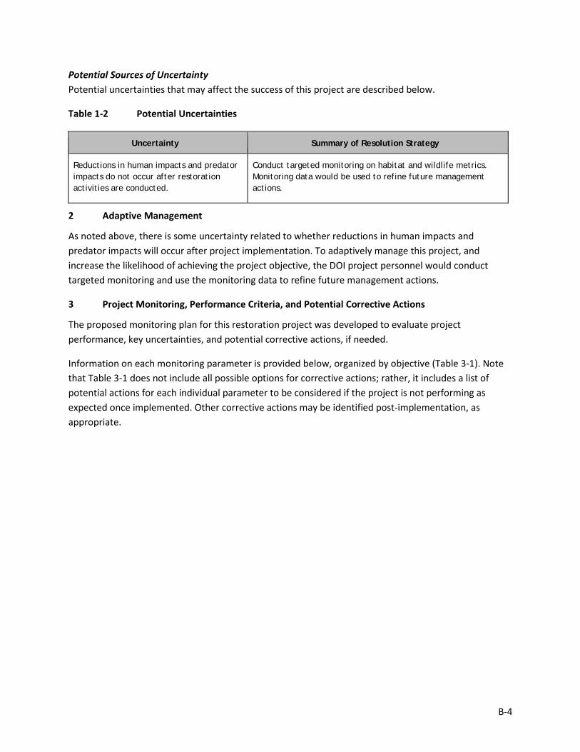
Potential Sources of Uncertainty Potential uncertainties that may affect the success of this project are described below.
Table 1-2 Potential Uncertainties
Uncertainty Summary of Resolution Strategy
Reductions in human impacts and predator impacts do not occur after restoration activities are conducted.
Conduct targeted monitoring on habitat and wildlife metrics. Monitoring data would be used to refine future management actions.
2 Adaptive Management
As noted above, there is some uncertainty related to whether reductions in human impacts and predator impacts will occur after project implementation. To adaptively manage this project, and increase the likelihood of achieving the project objective, the DOI project personnel would conduct targeted monitoring and use the monitoring data to refine future management actions.
3 Project Monitoring, Performance Criteria, and Potential Corrective Actions
The proposed monitoring plan for this restoration project was developed to evaluate project performance, key uncertainties, and potential corrective actions, if needed.
Information on each monitoring parameter is provided below, organized by objective (Table 3-1). Note that Table 3-1 does not include all possible options for corrective actions; rather, it includes a list of potential actions for each individual parameter to be considered if the project is not performing as expected once implemented. Other corrective actions may be identified post-implementation, as appropriate.
B-5
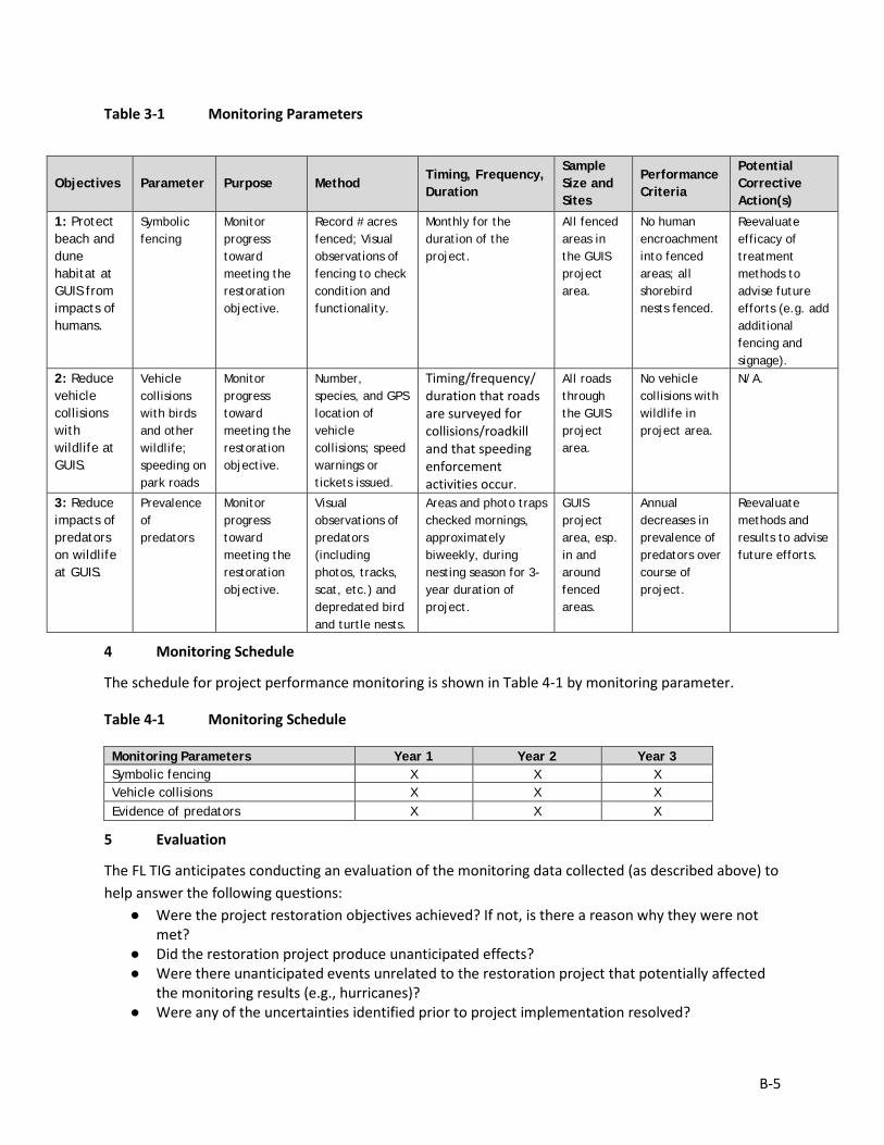
Table 3-1 Monitoring Parameters
4 Monitoring Schedule
The schedule for project performance monitoring is shown in Table 4-1 by monitoring parameter.
Table 4-1 Monitoring Schedule
Monitoring Parameters Year 1 Year 2 Year 3 Symbolic fencing X X X Vehicle collisions X X X Evidence of predators X X X
5 Evaluation
The FL TIG anticipates conducting an evaluation of the monitoring data collected (as described above) to help answer the following questions:
● Were the project restoration objectives achieved? If not, is there a reason why they were not met?
● Did the restoration project produce unanticipated effects? ● Were there unanticipated events unrelated to the restoration project that potentially affected
the monitoring results (e.g., hurricanes)? ● Were any of the uncertainties identified prior to project implementation resolved?
Objectives Parameter Purpose Method Timing, Frequency, Duration
Sample Size and Sites
Performance Criteria
Potential Corrective Action(s)
1: Protect beach and dune habitat at GUIS from impacts of humans.
Symbolic fencing
Monitor progress toward meeting the restoration objective.
Record # acres fenced; Visual observations of fencing to check condition and functionality.
Monthly for the duration of the project.
All fenced areas in the GUIS project area.
No human encroachment into fenced areas; all shorebird nests fenced.
Reevaluate efficacy of treatment methods to advise future efforts (e.g. add additional fencing and signage).
2: Reduce vehicle collisions with wildlife at GUIS.
Vehicle collisions with birds and other wildlife; speeding on park roads
Monitor progress toward meeting the restoration objective.
Number, species, and GPS location of vehicle collisions; speed warnings or tickets issued.
Timing/frequency/ duration that roads are surveyed for collisions/roadkill and that speeding enforcement activities occur.
All roads through the GUIS project area.
No vehicle collisions with wildlife in project area.
N/A.
3: Reduce impacts of predators on wildlife at GUIS.
Prevalence of predators
Monitor progress toward meeting the restoration objective.
Visual observations of predators (including photos, tracks, scat, etc.) and depredated bird and turtle nests.
Areas and photo traps checked mornings, approximately biweekly, during nesting season for 3-year duration of project.
GUIS project area, esp. in and around fenced areas.
Annual decreases in prevalence of predators over course of project.
Reevaluate methods and results to advise future efforts.
B-6
● Were any new uncertainties identified?
6 Data Management
Data Description Data collection will be compiled within 12 months after collection. To the extent practicable, all environmental and biological data generated during monitoring activities will be documented using standardized field datasheets. If standardized datasheets are unavailable or not readily amendable to record project-specific data, then project-specific datasheets will be drafted prior to conducting any project monitoring activities. Original hardcopy datasheets and notebooks and photographs will be retained by the Implementing Trustee.
Relevant project data that are handwritten on hardcopy datasheets or notebooks will be transcribed (entered) into standard digital format. All field datasheets and notebook entries will be scanned to PDF files. Electronic data files should be named with the date on which the file was created and should include a ReadMe file that describes when the file was created and by whom, and any explanatory notes on the file contents. If a data file is revised, a new copy should be made and the original preserved.
All data will have properly documented FGDC/ISO metadata, a data dictionary (defines codes and fields used in the dataset), and/or a Readme file as appropriate (e.g., how data was collected, QA/QC procedures, other information about data such as meaning, relationships to other data, origin, usage, and format – can reference different documents).
Data Review and Clearance Relevant project data that are handwritten on hardcopy datasheets or notebooks will be transcribed (entered) into standard digital format. After transcription of the data, the electronic data sheets will be verified against the original hardcopy datasheets and/or notebooks, and will make any corrections to transcription errors as appropriate before data are used for any analyses or distributed outside of the agency. Implementing Trustees will verify and validate MAM data and information and will ensure that all data are: i) entered or converted into agreed upon/commonly used digital format; ii) labeled with metadata following FGDC/ISO standards to the extent practicable and in accordance with Implementing Trustee agency requirements.
After any and all identified errors are addressed, data are considered to be QA/QC’ed. The implementing Trustee will give the other TIG members time to review the data before making such information publicly available (as described below). Before submitting the monitoring data and information package, co-Implementing Trustees shall confirm with one another that the package is approved for submission.
Data Storage and Accessibility Once all data has been QA/QC’ed it will be submitted to the Restoration Portal. Trustees will provide DWH NRDA MAM data and information to the Restoration Portal as soon as possible and no more than one year from when data are collected.
B-7
Data Sharing Data will be made publicly available, in accordance with the Federal Open Data Policy, through the DIVER Explorer Interface within one year of when the data collection occurred.
7 Reporting
All reporting would occur after field surveys are complete for each season annually. This report would summarize the findings for the sampling period including all worksheets transferred into digital format and presented in tabular and graphical formats. The data should be summarized in such a way that it is meaningful to the reader. Additionally, an annual report would be completed that includes:
• Summary data – synthesized data for all efforts during the year. • Graphics, if applicable, and associated interpretations of the data. • Comparisons of pre- and post-project conditions, as applicable. • Any uncertainties with management actions. • Potential data collection issues.
8 Roles and Responsibilities
Data will be reviewed and submitted to the Restoration Portal by DOI USFWS project personnel.
B-8
Monitoring and Adaptive Management Plan for Deepwater Horizon NRDA Project:
FM5, Gulf Islands National Seashore (Florida) Invasive Plant Removal
Prepared by: Nadia Martin (IEc) and DOI; Draft Version Date: 1/21/2019
1 Introduction
This project MAM plan identifies the monitoring needed to evaluate progress toward meeting project objectives and to support any necessary adaptive management of the restoration project. Where applicable, it identifies key sources of uncertainty and incorporates monitoring data and decision points that address these uncertainties. As not all projects will have the same sources and degree of uncertainty, this project-specific MAM plan is scaled according to level of uncertainty, scope, scale, and restoration type associated with this project.
This MAM plan is a living document and may be updated as needed to reflect changing conditions and/or new information. Any future revisions to this document will be made publicly available through the Trustee Council Restoration Portal (https://www.diver.orr.noaa.gov/web/guest/home) and accessible through the DWH NRDA Trustees website (http://www.restoration.noaa.gov/dwh/storymap/).
Project Overview This project is being implemented as restoration for the DWH oil spill NRDA, consistent with the PDARP/PEIS.
• Programmatic Goal: Restore and Conserve Habitat Restoration • Restoration Type: Habitat Projects on Federally Managed Lands • Restoration Approach: Protect and conserve marine, coastal, estuarine, and riparian
habitats • Restoration Technique: Develop and implement management actions in conservation
areas and/or restoration projects • TIG: FL TIG • Restoration Plan: Restoration Plan #1
This restoration project is being implemented within Gulf Islands National Seashore (GUIS), Florida district, in Escambia County. This project includes activities to treat five of the most problematic invasive species in the Fort Pickens, Santa Rosa, and Perdido Key areas of GUIS more comprehensively than they are currently and to collect information on the invasive species to protect and conserve habitat and wildlife resources in the area. This project would remove invasive species from natural areas at GUIS and gradually restore the coastal habitats as the unnatural pressure from the invasive species is reduced or
B-9
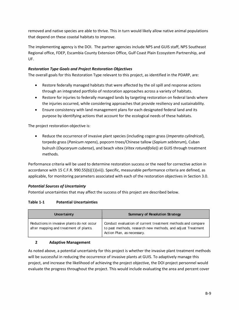
removed and native species are able to thrive. This in turn would likely allow native animal populations that depend on these coastal habitats to improve.
The implementing agency is the DOI. The partner agencies include NPS and GUIS staff, NPS Southeast Regional office, FDEP, Escambia County Extension Office, Gulf Coast Plain Ecosystem Partnership, and UF.
Restoration Type Goals and Project Restoration Objectives The overall goals for this Restoration Type relevant to this project, as identified in the PDARP, are:
• Restore federally managed habitats that were affected by the oil spill and response actions through an integrated portfolio of restoration approaches across a variety of habitats.
• Restore for injuries to federally managed lands by targeting restoration on federal lands where the injuries occurred, while considering approaches that provide resiliency and sustainability.
• Ensure consistency with land management plans for each designated federal land and its purpose by identifying actions that account for the ecological needs of these habitats.
The project restoration objective is:
• Reduce the occurrence of invasive plant species (including cogon grass (Imperata cylindrical), torpedo grass (Panicum repens), popcorn trees/Chinese tallow (Sapium sebiterum), Cuban bulrush (Oxycaryum cubense), and beach vitex (Vitex rotundifolia)) at GUIS through treatment methods.
Performance criteria will be used to determine restoration success or the need for corrective action in accordance with 15 C.F.R. 990.55(b)(1)(vii)). Specific, measurable performance criteria are defined, as applicable, for monitoring parameters associated with each of the restoration objectives in Section 3.0.
Potential Sources of Uncertainty Potential uncertainties that may affect the success of this project are described below.
Table 1-1 Potential Uncertainties
Uncertainty Summary of Resolution Strategy
Reductions in invasive plants do not occur after mapping and treatment of plants.
Conduct evaluation of current treatment methods and compare to past methods, research new methods, and adjust Treatment Action Plan, as necessary.
2 Adaptive Management
As noted above, a potential uncertainty for this project is whether the invasive plant treatment methods will be successful in reducing the occurrence of invasive plants at GUIS. To adaptively manage this project, and increase the likelihood of achieving the project objective, the DOI project personnel would evaluate the progress throughout the project. This would include evaluating the area and percent cover
B-10
of the invasive plants over time and comparing to pre-project conditions and use the monitoring data collected to refine future management actions, as necessary.
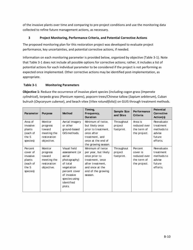
3 Project Monitoring, Performance Criteria, and Potential Corrective Actions
The proposed monitoring plan for this restoration project was developed to evaluate project performance, key uncertainties, and potential corrective actions, if needed.
Information on each monitoring parameter is provided below, organized by objective (Table 3-1). Note that Table 3-1 does not include all possible options for corrective actions; rather, it includes a list of potential actions for each individual parameter to be considered if the project is not performing as expected once implemented. Other corrective actions may be identified post-implementation, as appropriate.
Table 3-1 Monitoring Parameters
Objective 1: Reduce the occurrence of invasive plant species (including cogon grass (Imperata cylindrical), torpedo grass (Panicum repens), popcorn trees/Chinese tallow (Sapium sebiterum), Cuban bulrush (Oxycaryum cubense), and beach vitex (Vitex rotundifolia)) on GUIS through treatment methods.
Parameter Purpose Method Timing, Frequency, Duration
Sample Size and Sites
Performance Criteria
Potential Corrective Action(s)
Area of invasive plants (each of the 5 species)
Monitor progress toward meeting the restoration objective.
Aerial imagery or other ground-based GIS methods.
Minimum of twice, but likely once prior to treatment, once after treatment, and once at the end of the growing season.
Throughout project footprint.
Area is reduced over the term of the project.
Reevaluate treatment methods to advise future efforts.
Percent cover of invasive plants (each of the 5 species)
Monitor progress toward meeting the restoration objective.
Visual field assessment (or aerial photography) of total vegetation percent cover of invasive species using identified plots.
Minimum of twice per year, but likely once prior to treatment, once after treatment, and once at the end of the growing season.
Throughout project footprint.
Percent cover is reduced over the term of the project.
Reevaluate treatment methods to advise future efforts.
B-11
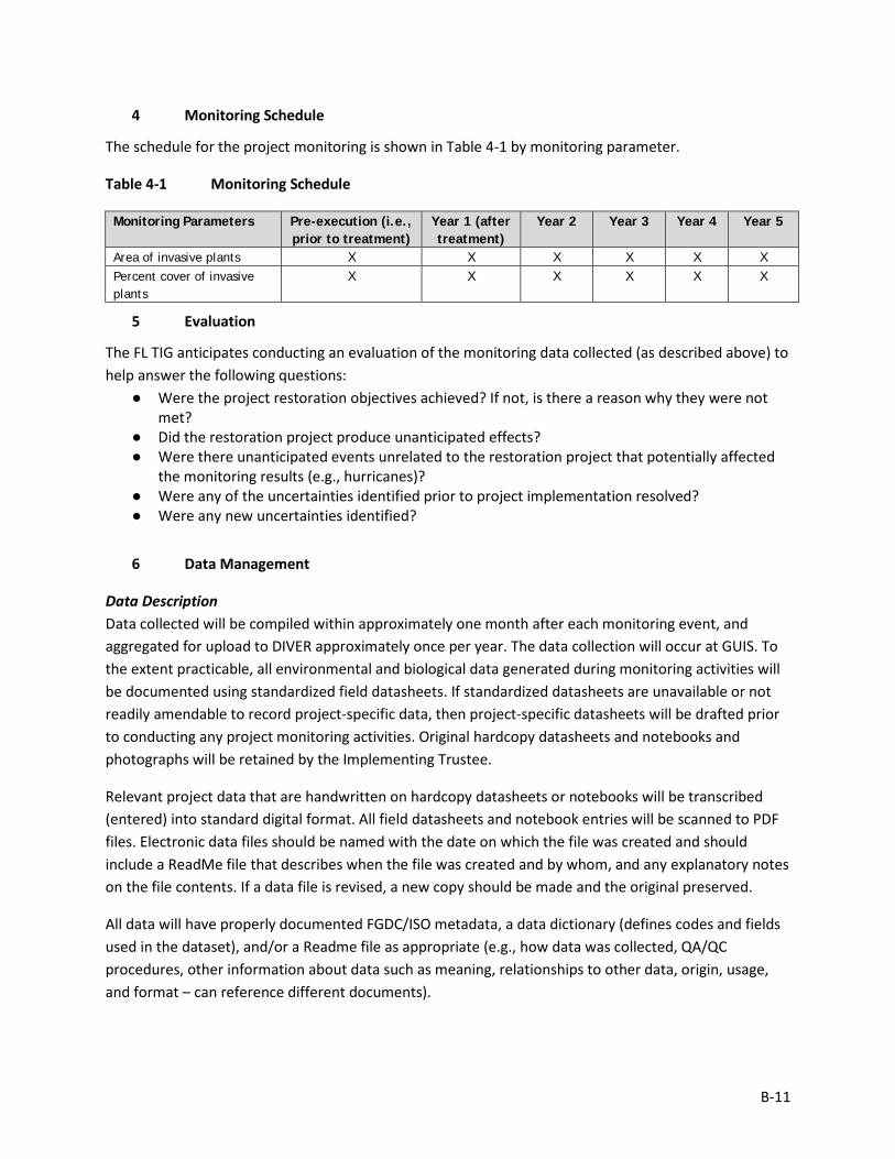
4 Monitoring Schedule
The schedule for the project monitoring is shown in Table 4-1 by monitoring parameter.
Table 4-1 Monitoring Schedule
Monitoring Parameters Pre-execution (i.e., prior to treatment)
Year 1 (after treatment)
Year 2 Year 3 Year 4 Year 5
Area of invasive plants X X X X X X Percent cover of invasive plants
X X X X X X
5 Evaluation
The FL TIG anticipates conducting an evaluation of the monitoring data collected (as described above) to help answer the following questions:
● Were the project restoration objectives achieved? If not, is there a reason why they were not met?
● Did the restoration project produce unanticipated effects? ● Were there unanticipated events unrelated to the restoration project that potentially affected
the monitoring results (e.g., hurricanes)? ● Were any of the uncertainties identified prior to project implementation resolved? ● Were any new uncertainties identified?
6 Data Management
Data Description Data collected will be compiled within approximately one month after each monitoring event, and aggregated for upload to DIVER approximately once per year. The data collection will occur at GUIS. To the extent practicable, all environmental and biological data generated during monitoring activities will be documented using standardized field datasheets. If standardized datasheets are unavailable or not readily amendable to record project-specific data, then project-specific datasheets will be drafted prior to conducting any project monitoring activities. Original hardcopy datasheets and notebooks and photographs will be retained by the Implementing Trustee.
Relevant project data that are handwritten on hardcopy datasheets or notebooks will be transcribed (entered) into standard digital format. All field datasheets and notebook entries will be scanned to PDF files. Electronic data files should be named with the date on which the file was created and should include a ReadMe file that describes when the file was created and by whom, and any explanatory notes on the file contents. If a data file is revised, a new copy should be made and the original preserved.
All data will have properly documented FGDC/ISO metadata, a data dictionary (defines codes and fields used in the dataset), and/or a Readme file as appropriate (e.g., how data was collected, QA/QC procedures, other information about data such as meaning, relationships to other data, origin, usage, and format – can reference different documents).
B-12
Data Review and Clearance Relevant project data that are handwritten on hardcopy datasheets or notebooks will be transcribed (entered) into standard digital format. After transcription of the data, the electronic data sheets will be verified against the original hardcopy datasheets and/or notebooks, and will make any corrections to transcription errors as appropriate before data are used for any analyses or distributed outside of the agency. Implementing Trustees will verify and validate MAM data and information and will ensure that all data are: i) entered or converted into agreed upon/commonly used digital format; ii) labeled with metadata following FGDC/ISO standards to the extent practicable and in accordance with Implementing Trustee agency requirements.
After any and all identified errors are addressed, data are considered to be QA/QC’ed. The implementing Trustee will give the other TIG members time to review the data before making such information publicly available (as described below). Before submitting the monitoring data and information package, co-Implementing Trustees shall confirm with one another that the package is approved for submission.
Data Storage and Accessibility Once all data has been QA/QC’ed it will be submitted to the Restoration Portal. Trustees will provide DWH NRDA MAM data and information to the Restoration Portal as soon as possible and no more than one year from when data are collected.
Data Sharing Data will be made publicly available, in accordance with the Federal Open Data Policy, through the DIVER Explorer Interface within one year of when the data collection occurred.
7 Reporting
All reporting would occur after field surveys are complete for each assessment effort. This report would summarize the findings for the sampling period including all worksheets transferred into digital format and presented in tabular and graphical formats. The data should be summarized in such a way that it is meaningful to the reader.
8 Roles and Responsibilities
Data will be reviewed and submitted to the Restoration Portal by DOI project personnel.
B-13
Monitoring and Adaptive Management Plan for Deepwater Horizon NRDA Project:
FM6, St. Vincent National Wildlife Refuge Predator Control Prepared by: Kate Healy (FWS) and Nadia Martin (IEc); Draft Version Date: 1/21/2019
1 Introduction
This project MAM plan identifies the monitoring needed to evaluate progress toward meeting project objectives and to support any necessary adaptive management of the restoration project. Where applicable, it identifies key sources of uncertainty and incorporates monitoring data and decision points that address these uncertainties. As not all projects will have the same sources and degree of uncertainty, this project-specific MAM plan is scaled according to level of uncertainty, scope, scale, and restoration type associated with this project.
This MAM plan is a living document and may be updated as needed to reflect changing conditions and/or new information. Any future revisions to this document will be made publicly available through the Trustee Council Restoration Portal (https://www.diver.orr.noaa.gov/web/guest/home) and accessible through the DWH NRDA Trustees website (http://www.restoration.noaa.gov/dwh/storymap/).
Project Overview This project is being implemented as restoration for the DWH oil spill NRDA, consistent with the PDARP/PEIS.
• Programmatic Goal: Restore and Conserve Habitat • Restoration Type: Habitat Projects on Federally Managed Lands • Restoration Approach: Protect and conserve marine, coastal, estuarine, and riparian
habitats • Restoration Technique: Develop and implement management actions in conservation
areas and/or restoration projects • TIG: FL TIG • Restoration Plan: Restoration Plan #1
This restoration project is being implemented within the St. Vincent National Wildlife Refuge (NWR), Apalachicola, FL. This project involves predator control activities to eradicate or control the feral hog and raccoon populations, including locating, trapping, eliminating, and monitoring. This project is intended to protect and conserve habitat on St. Vincent NWR through actions to mitigate the negative impacts of feral hogs and raccoons. This project would directly benefit the habitat in the NWR and wildlife that utilize the area such as shorebirds and sea turtles.
B-14
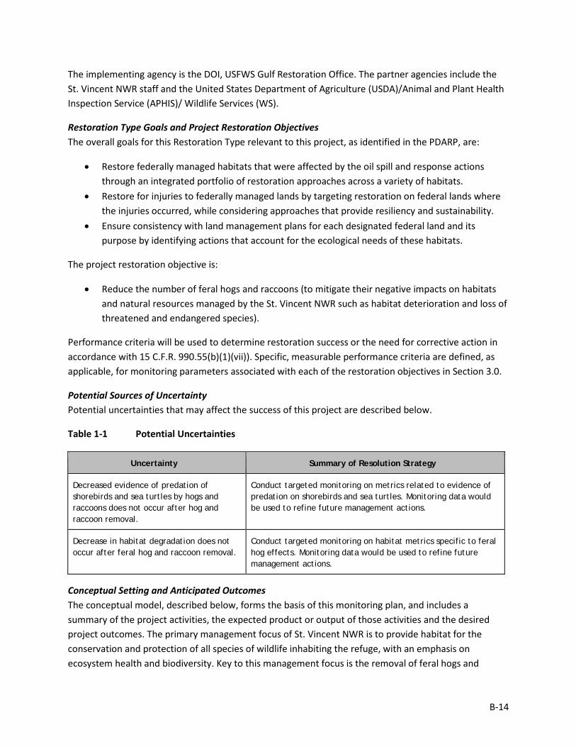
The implementing agency is the DOI, USFWS Gulf Restoration Office. The partner agencies include the St. Vincent NWR staff and the United States Department of Agriculture (USDA)/Animal and Plant Health Inspection Service (APHIS)/ Wildlife Services (WS).
Restoration Type Goals and Project Restoration Objectives The overall goals for this Restoration Type relevant to this project, as identified in the PDARP, are:
• Restore federally managed habitats that were affected by the oil spill and response actions through an integrated portfolio of restoration approaches across a variety of habitats.
• Restore for injuries to federally managed lands by targeting restoration on federal lands where the injuries occurred, while considering approaches that provide resiliency and sustainability.
• Ensure consistency with land management plans for each designated federal land and its purpose by identifying actions that account for the ecological needs of these habitats.
The project restoration objective is:
• Reduce the number of feral hogs and raccoons (to mitigate their negative impacts on habitats and natural resources managed by the St. Vincent NWR such as habitat deterioration and loss of threatened and endangered species).
Performance criteria will be used to determine restoration success or the need for corrective action in accordance with 15 C.F.R. 990.55(b)(1)(vii)). Specific, measurable performance criteria are defined, as applicable, for monitoring parameters associated with each of the restoration objectives in Section 3.0.
Potential Sources of Uncertainty Potential uncertainties that may affect the success of this project are described below.
Table 1-1 Potential Uncertainties
Uncertainty Summary of Resolution Strategy
Decreased evidence of predation of shorebirds and sea turtles by hogs and raccoons does not occur after hog and raccoon removal.
Conduct targeted monitoring on metrics related to evidence of predation on shorebirds and sea turtles. Monitoring data would be used to refine future management actions.
Decrease in habitat degradation does not occur after feral hog and raccoon removal.
Conduct targeted monitoring on habitat metrics specific to feral hog effects. Monitoring data would be used to refine future management actions.
Conceptual Setting and Anticipated Outcomes The conceptual model, described below, forms the basis of this monitoring plan, and includes a summary of the project activities, the expected product or output of those activities and the desired project outcomes. The primary management focus of St. Vincent NWR is to provide habitat for the conservation and protection of all species of wildlife inhabiting the refuge, with an emphasis on ecosystem health and biodiversity. Key to this management focus is the removal of feral hogs and
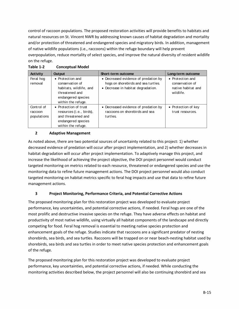
B-15
control of raccoon populations. The proposed restoration activities will provide benefits to habitats and natural resources on St. Vincent NWR by addressing known causes of habitat degradation and mortality and/or protection of threatened and endangered species and migratory birds. In addition, management of native wildlife populations (i.e., raccoons) within the refuge boundary will help prevent overpopulation, reduce mortality of select species, and improve the natural diversity of resident wildlife on the refuge. Table 1-2 Conceptual Model Activity Output Short-term outcome Long-term outcome Feral hog removal
• Protection and conservation of habitats, wildlife, and threatened and endangered species within the refuge.
• Decreased evidence of predation by hogs on shorebirds and sea turtles.
• Decrease in habitat degradation.
• Protection and conservation of native habitat and wildlife.
Control of raccoon populations
• Protection of trust resources (i.e., birds), and threatened and endangered species within the refuge.
• Decreased evidence of predation by raccoons on shorebirds and sea turtles.
• Protection of key trust resources.
2 Adaptive Management
As noted above, there are two potential sources of uncertainty related to this project: 1) whether decreased evidence of predation will occur after project implementation, and 2) whether decreases in habitat degradation will occur after project implementation. To adaptively manage this project, and increase the likelihood of achieving the project objective, the DOI project personnel would conduct targeted monitoring on metrics related to each resource, threatened or endangered species and use the monitoring data to refine future management actions. The DOI project personnel would also conduct targeted monitoring on habitat metrics specific to feral hog impacts and use that data to refine future management actions.
3 Project Monitoring, Performance Criteria, and Potential Corrective Actions
The proposed monitoring plan for this restoration project was developed to evaluate project performance, key uncertainties, and potential corrective actions, if needed. Feral hogs are one of the most prolific and destructive invasive species on the refuge. They have adverse effects on habitat and productivity of most native wildlife, using virtually all habitat components of the landscape and directly competing for food. Feral hog removal is essential to meeting native species protection and enhancement goals of the refuge. Studies indicate that raccoons are a significant predator of nesting shorebirds, sea birds, and sea turtles. Raccoons will be trapped on or near beach-nesting habitat used by shorebirds, sea birds and sea turtles in order to meet native species protection and enhancement goals of the refuge.
The proposed monitoring plan for this restoration project was developed to evaluate project performance, key uncertainties, and potential corrective actions, if needed. While conducting the monitoring activities described below, the project personnel will also be continuing shorebird and sea
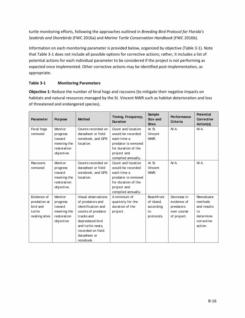
B-16
turtle monitoring efforts, following the approaches outlined in Breeding Bird Protocol for Florida’s Seabirds and Shorebirds (FWC 2016a) and Marine Turtle Conservation Handbook (FWC 2016b).
Information on each monitoring parameter is provided below, organized by objective (Table 3-1). Note that Table 3-1 does not include all possible options for corrective actions; rather, it includes a list of potential actions for each individual parameter to be considered if the project is not performing as expected once implemented. Other corrective actions may be identified post-implementation, as appropriate.
Table 3-1 Monitoring Parameters
Objective 1: Reduce the number of feral hogs and raccoons (to mitigate their negative impacts on habitats and natural resources managed by the St. Vincent NWR such as habitat deterioration and loss of threatened and endangered species).
Parameter Purpose Method Timing, Frequency, Duration
Sample Size and Sites
Performance Criteria
Potential Corrective Action(s)
Feral hogs removed
Monitor progress toward meeting the restoration objective.
Counts recorded on datasheet or field notebook, and GPS location.
Count and location would be recorded each time a predator is removed for duration of the project and compiled annually.
At St. Vincent NWR.
N/A. N/A.
Raccoons removed
Monitor progress toward meeting the restoration objective.
Counts recorded on datasheet or field notebook, and GPS location.
Count and location would be recorded each time a predator is removed for duration of the project and compiled annually.
At St. Vincent NWR.
N/A. N/A.
Evidence of predation at bird and turtle nesting sites
Monitor progress toward meeting the restoration objective
Visual observations of predators and identification and counts of predator tracks and depredated bird and turtle nests, recorded on field datasheet or notebook.
A minimum of quarterly for the duration of the project.
Beachfront of island, according to protocols.
Decrease in evidence of predators over course of project.
Reevaluate methods and results to determine corrective action.
B-17
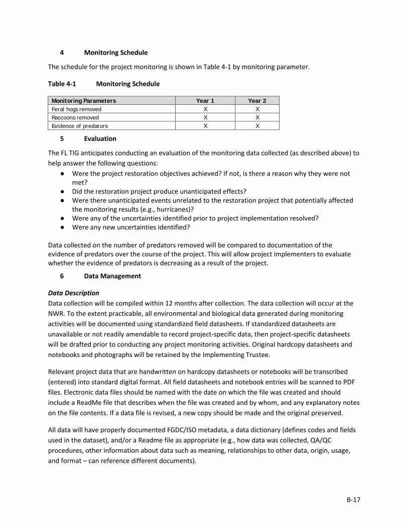
4 Monitoring Schedule
The schedule for the project monitoring is shown in Table 4-1 by monitoring parameter.
Table 4-1 Monitoring Schedule
Monitoring Parameters Year 1 Year 2 Feral hogs removed X X Raccoons removed X X Evidence of predators X X
5 Evaluation
The FL TIG anticipates conducting an evaluation of the monitoring data collected (as described above) to help answer the following questions:
● Were the project restoration objectives achieved? If not, is there a reason why they were not met?
● Did the restoration project produce unanticipated effects? ● Were there unanticipated events unrelated to the restoration project that potentially affected
the monitoring results (e.g., hurricanes)? ● Were any of the uncertainties identified prior to project implementation resolved? ● Were any new uncertainties identified?
Data collected on the number of predators removed will be compared to documentation of the evidence of predators over the course of the project. This will allow project implementers to evaluate whether the evidence of predators is decreasing as a result of the project.
6 Data Management
Data Description Data collection will be compiled within 12 months after collection. The data collection will occur at the NWR. To the extent practicable, all environmental and biological data generated during monitoring activities will be documented using standardized field datasheets. If standardized datasheets are unavailable or not readily amendable to record project-specific data, then project-specific datasheets will be drafted prior to conducting any project monitoring activities. Original hardcopy datasheets and notebooks and photographs will be retained by the Implementing Trustee.
Relevant project data that are handwritten on hardcopy datasheets or notebooks will be transcribed (entered) into standard digital format. All field datasheets and notebook entries will be scanned to PDF files. Electronic data files should be named with the date on which the file was created and should include a ReadMe file that describes when the file was created and by whom, and any explanatory notes on the file contents. If a data file is revised, a new copy should be made and the original preserved.
All data will have properly documented FGDC/ISO metadata, a data dictionary (defines codes and fields used in the dataset), and/or a Readme file as appropriate (e.g., how data was collected, QA/QC procedures, other information about data such as meaning, relationships to other data, origin, usage, and format – can reference different documents).
B-18
Data Review and Clearance Relevant project data that are handwritten on hardcopy datasheets or notebooks will be transcribed (entered) into standard digital format. After transcription of the data, the electronic data sheets will be verified against the original hardcopy datasheets and/or notebooks, and will make any corrections to transcription errors as appropriate before data are used for any analyses or distributed outside of the agency. Implementing Trustees will verify and validate MAM data and information and will ensure that all data are: i) entered or converted into agreed upon/commonly used digital format; ii) labeled with metadata following FGDC/ISO standards to the extent practicable and in accordance with Implementing Trustee agency requirements.
After any and all identified errors are addressed, data are considered to be QA/QC’ed. The implementing Trustee will give the other TIG members time to review the data before making such information publicly available (as described below). Before submitting the monitoring data and information package, co-Implementing Trustees shall confirm with one another that the package is approved for submission.
Data Storage and Accessibility Once all data has been QA/QC’ed it will be submitted to the Restoration Portal. Trustees will provide DWH NRDA MAM data and information to the Restoration Portal as soon as possible and no more than one year from when data are collected.
Data Sharing Data will be made publicly available, in accordance with the Federal Open Data Policy, through the DIVER Explorer Interface within one year of when the data collection occurred.
7 Reporting
All reporting would occur after field surveys are complete for each assessment effort. This report would summarize the findings for the sampling period including all worksheets transferred into digital format and presented in tabular and graphical formats. The data should be summarized in such a way that it is meaningful to the reader. Additionally, an annual report would be completed that includes:
• Summary data –synthesized data for all efforts during the year. • Graphics, if applicable, and associated interpretations of the data. • Comparisons of pre- and post-project conditions, as applicable. • Any uncertainties with management actions. • Potential data collection issues. • Issues to be resolved:
o Issues to improve data collection or cooperation in getting quality data. o Issues associated with data loss or inability to collect data for a time period.
8 Roles and Responsibilities
Data will be reviewed and submitted to the Restoration Portal by DOI USFWS or other project personnel.

B-19
9 References
FWC (Florida Fish and Wildlife Conservation Commission). 2016a. Breeding Bird Protocol for Florida’s Seabirds and Shorebirds. Tallahassee, Florida.
FWC (Florida Fish and Wildlife Conservation Commission). 2016b. Marine Turtle Conservation Handbook. Tallahassee, Florida.
B-20
Monitoring and Adaptive Management Plan for Deepwater Horizon NRDA Project:
NR1, Pensacola Bay and Perdido River Watersheds - Nutrient Reduction
Prepared by: Nadia Martin (IEc) and USDA; Draft Version Date: 1/21/2019
1 Introduction
This project MAM plan identifies the monitoring needed to evaluate progress toward meeting project objectives and to support any necessary adaptive management of the restoration project. Where applicable, it identifies key sources of uncertainty and incorporates monitoring data and decision points that address these uncertainties. As not all projects will have the same sources and degree of uncertainty, this project-specific MAM plan is scaled according to level of uncertainty, scope, scale, and restoration type associated with this project.
This MAM plan is a living document and may be updated as needed to reflect changing conditions and/or new information. Any future revisions to this document will be made publicly available through the Trustee Council Restoration Portal (https://www.diver.orr.noaa.gov/web/guest/home) and accessible through the DWH NRDA Trustees website (http://www.restoration.noaa.gov/dwh/storymap/).
Project Overview This project is being implemented as restoration for the DWH oil spill NRDA, consistent with the PDARP/PEIS.
• Programmatic Goal: Restore Water Quality • Restoration Type: Nutrient Reduction (non-point source) • Restoration Approach: Reduce nutrient loads to coastal watersheds • Restoration Technique: Agricultural conservation practices • TIG: FL TIG • Restoration Plan: Restoration Plan #1
This restoration project is being implemented within the Pensacola and Perdido Watersheds, Santa Rosa and Escambia Counties, Florida (HUC 12 Watersheds: (1) Moore Creek – Santa Rosa County and (2) Sandy Hollow-Pine Barren Creek - Escambia County). This project includes the development and implementation of conservation plans (CPs) on agricultural lands, outreach to identify willing landowners, and technical assistance for the participants. This project is intended to improve water quality through the implementation of CPs that include practices to reduce sediment and nutrient loads to coastal watersheds. The proposed CPs would reduce nutrient losses from the landscape, reduce nutrient loads to streams and downstream receiving waters, and reduce water quality degradation in watersheds that would provide benefits to coastal watersheds and marine resources.
B-21
The implementing agency is the USDA.
Restoration Type Goal and Project Restoration Objective The overall goals for this Restoration Type relevant to this project, as identified in the PDARP, are:
• Reduce nutrient loadings to Gulf Coast estuaries, habitats, and resources that are threatened by chronic eutrophication, hypoxia, or harmful algal blooms or that suffer habitat losses associated with water quality degradation.
The project restoration objective is:
• Reduce sediment, phosphorous and nitrogen loads leaving private lands during storm events in the watershed.
Performance criteria will be used to determine restoration success or the need for corrective action in accordance with 15 C.F.R. 990.55(b)(1)(vii)). Specific, measurable performance criteria are defined, as applicable, for monitoring parameters associated with each of the restoration objectives in Section 3.0.
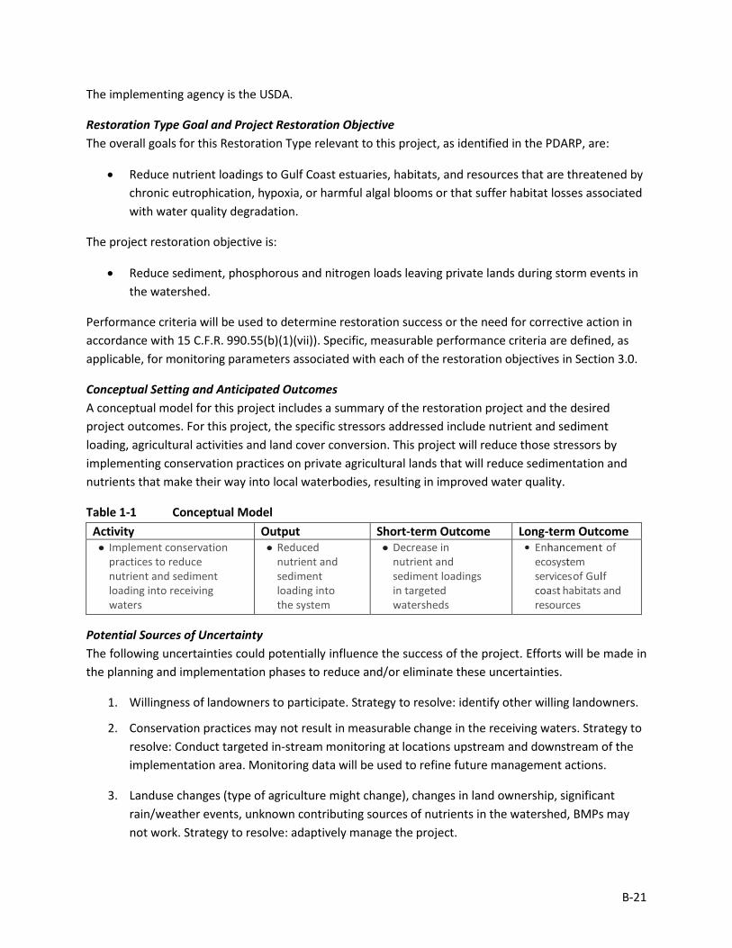
Conceptual Setting and Anticipated Outcomes A conceptual model for this project includes a summary of the restoration project and the desired project outcomes. For this project, the specific stressors addressed include nutrient and sediment loading, agricultural activities and land cover conversion. This project will reduce those stressors by implementing conservation practices on private agricultural lands that will reduce sedimentation and nutrients that make their way into local waterbodies, resulting in improved water quality.
Table 1-1 Conceptual Model Activity Output Short-term Outcome Long-term Outcome • Implement conservation
practices to reduce nutrient and sediment loading into receiving waters
• Reduced nutrient and sediment loading into the system
• Decrease in nutrient and sediment loadings in targeted watersheds
• Enhancement of ecosystem services of Gulf coast habitats and resources
Potential Sources of Uncertainty The following uncertainties could potentially influence the success of the project. Efforts will be made in the planning and implementation phases to reduce and/or eliminate these uncertainties.
1. Willingness of landowners to participate. Strategy to resolve: identify other willing landowners.
2. Conservation practices may not result in measurable change in the receiving waters. Strategy to resolve: Conduct targeted in-stream monitoring at locations upstream and downstream of the implementation area. Monitoring data will be used to refine future management actions.
3. Landuse changes (type of agriculture might change), changes in land ownership, significant rain/weather events, unknown contributing sources of nutrients in the watershed, BMPs may not work. Strategy to resolve: adaptively manage the project.
B-22
2 Adaptive Management
The need for adaptive management on specific CPs being implemented is unlikely to be needed due to the nature of the sampling approaches, the objectives of the project and the scales of the sites in which the data will be collected, and an understanding of the CPs that will be applied. However, adaptive management will be incorporated in the CPs, based on water quality monitoring, as described in Sections 3 and 4, above. Adaptive management will also be applied at the level of the watershed to ensure that the number of sites, locations, and total area subjected to the standard Restoration Techniques are sufficient to reduce the overall nutrient and sediment load, as described in Section 2, above. Situations that might lead to adaptive management include a farmer joining the program and then backing out, participants selling their property or changing farming practices. Adaptive management of specific CPs could be included in each CP, as appropriate. Data, analysis, and information obtained from this project will be used to help inform future Restoration Plan development, priorities and project selection and implementation.
3 Project Monitoring, Performance Criteria, and Potential Corrective Actions
The proposed monitoring for this restoration project was developed to evaluate project performance, key uncertainties, and potential corrective actions, if needed. Information on each monitoring parameter is provided below, organized by objective (Table 3-1). Note that Table 3-1 does not include all possible options for corrective actions; rather, it includes a list of potential actions for each individual parameter to be considered if the project is not performing as expected once implemented. Other corrective actions may be identified post-implementation, as appropriate.
These parameters will be monitored at the project site, in adjacent streams, and may also be monitored at appropriate reference and/or control sites to demonstrate how the project is trending toward the performance criteria.
Corrective actions that may be necessary include, but are not limited to, regrading/removing water control structures, planting/replanting desirable vegetation, and/or removing nuisance vegetation. Corrective actions will likely occur after implementation, but within the five-year time frame for this project. Corrective actions will be identified by USDA based on site evaluations and performance monitoring data and reports. Costs for addressing the corrective action will be evaluated by USDA to determine feasibility.
B-23
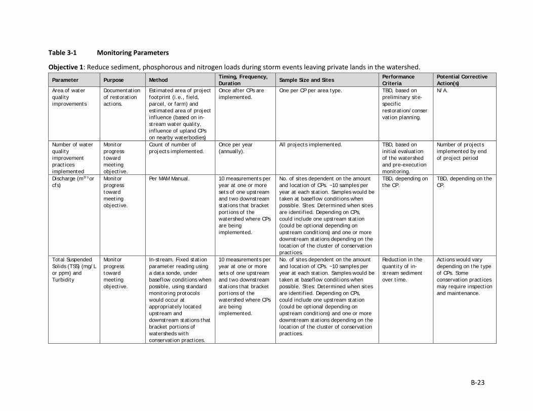
Table 3-1 Monitoring Parameters
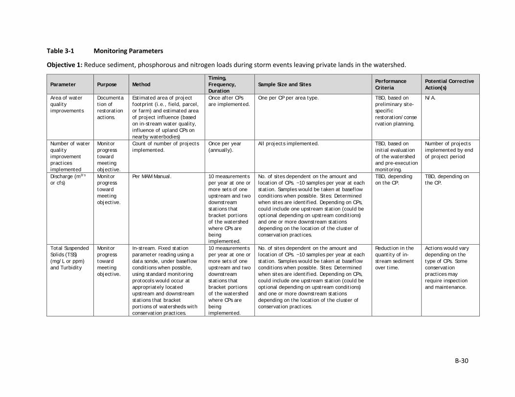
Objective 1: Reduce sediment, phosphorous and nitrogen loads during storm events leaving private lands in the watershed.
Parameter Purpose Method Timing, Frequency, Duration
Sample Size and Sites Performance Criteria
Potential Corrective Action(s)
Area of water quality improvements
Documentation of restoration actions.
Estimated area of project footprint (i.e., field, parcel, or farm) and estimated area of project influence (based on in-stream water quality, influence of upland CPs on nearby waterbodies)
Once after CPs are implemented.
One per CP per area type. TBD, based on preliminary site-specific restoration/conservation planning.
N/A.
Number of water quality improvement practices implemented
Monitor progress toward meeting objective.
Count of number of projects implemented.
Once per year (annually).
All projects implemented. TBD, based on initial evaluation of the watershed and pre-execution monitoring.
Number of projects implemented by end of project period
Discharge (m3/s or cfs)
Monitor progress toward meeting objective.
Per MAM Manual. 10 measurements per year at one or more sets of one upstream and two downstream stations that bracket portions of the watershed where CPs are being implemented.
No. of sites dependent on the amount and location of CPs. ~10 samples per year at each station. Samples would be taken at baseflow conditions when possible. Sites: Determined when sites are identified. Depending on CPs, could include one upstream station (could be optional depending on upstream conditions) and one or more downstream stations depending on the location of the cluster of conservation practices.
TBD, depending on the CP.
TBD, depending on the CP.
Total Suspended Solids (TSS) (mg/L or ppm) and Turbidity
Monitor progress toward meeting objective.
In-stream. Fixed station parameter reading using a data sonde, under baseflow conditions when possible, using standard monitoring protocols would occur at appropriately located upstream and downstream stations that bracket portions of watersheds with conservation practices.
10 measurements per year at one or more sets of one upstream and two downstream stations that bracket portions of the watershed where CPs are being implemented.
No. of sites dependent on the amount and location of CPs. ~10 samples per year at each station. Samples would be taken at baseflow conditions when possible. Sites: Determined when sites are identified. Depending on CPs, could include one upstream station (could be optional depending on upstream conditions) and one or more downstream stations depending on the location of the cluster of conservation practices.
Reduction in the quantity of in-stream sediment over time.
Actions would vary depending on the type of CPs. Some conservation practices may require inspection and maintenance.
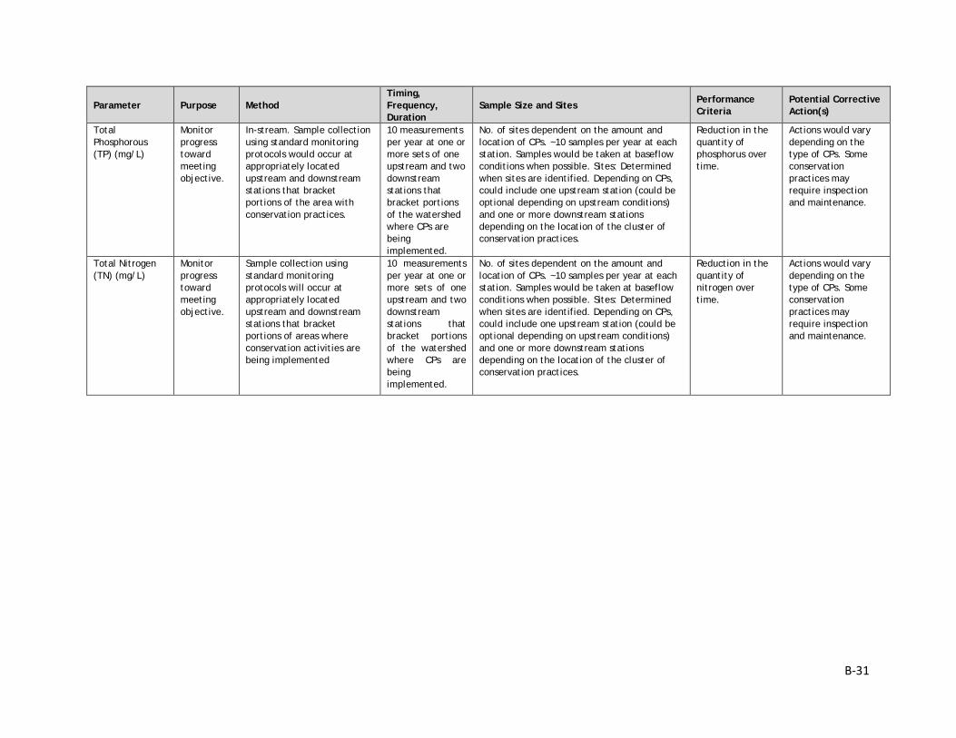
B-24
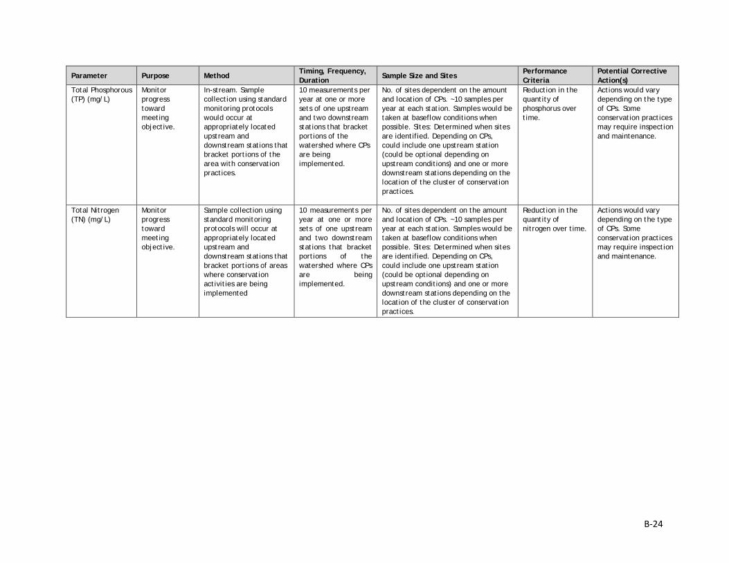
Parameter Purpose Method Timing, Frequency, Duration
Sample Size and Sites Performance Criteria
Potential Corrective Action(s)
Total Phosphorous (TP) (mg/L)
Monitor progress toward meeting objective.
In-stream. Sample collection using standard monitoring protocols would occur at appropriately located upstream and downstream stations that bracket portions of the area with conservation practices.
10 measurements per year at one or more sets of one upstream and two downstream stations that bracket portions of the watershed where CPs are being implemented.
No. of sites dependent on the amount and location of CPs. ~10 samples per year at each station. Samples would be taken at baseflow conditions when possible. Sites: Determined when sites are identified. Depending on CPs, could include one upstream station (could be optional depending on upstream conditions) and one or more downstream stations depending on the location of the cluster of conservation practices.
Reduction in the quantity of phosphorus over time.
Actions would vary depending on the type of CPs. Some conservation practices may require inspection and maintenance.
Total Nitrogen (TN) (mg/L)
Monitor progress toward meeting objective.
Sample collection using standard monitoring protocols will occur at appropriately located upstream and downstream stations that bracket portions of areas where conservation activities are being implemented
10 measurements per year at one or more sets of one upstream and two downstream stations that bracket portions of the watershed where CPs are being implemented.
No. of sites dependent on the amount and location of CPs. ~10 samples per year at each station. Samples would be taken at baseflow conditions when possible. Sites: Determined when sites are identified. Depending on CPs, could include one upstream station (could be optional depending on upstream conditions) and one or more downstream stations depending on the location of the cluster of conservation practices.
Reduction in the quantity of nitrogen over time.
Actions would vary depending on the type of CPs. Some conservation practices may require inspection and maintenance.
B-25
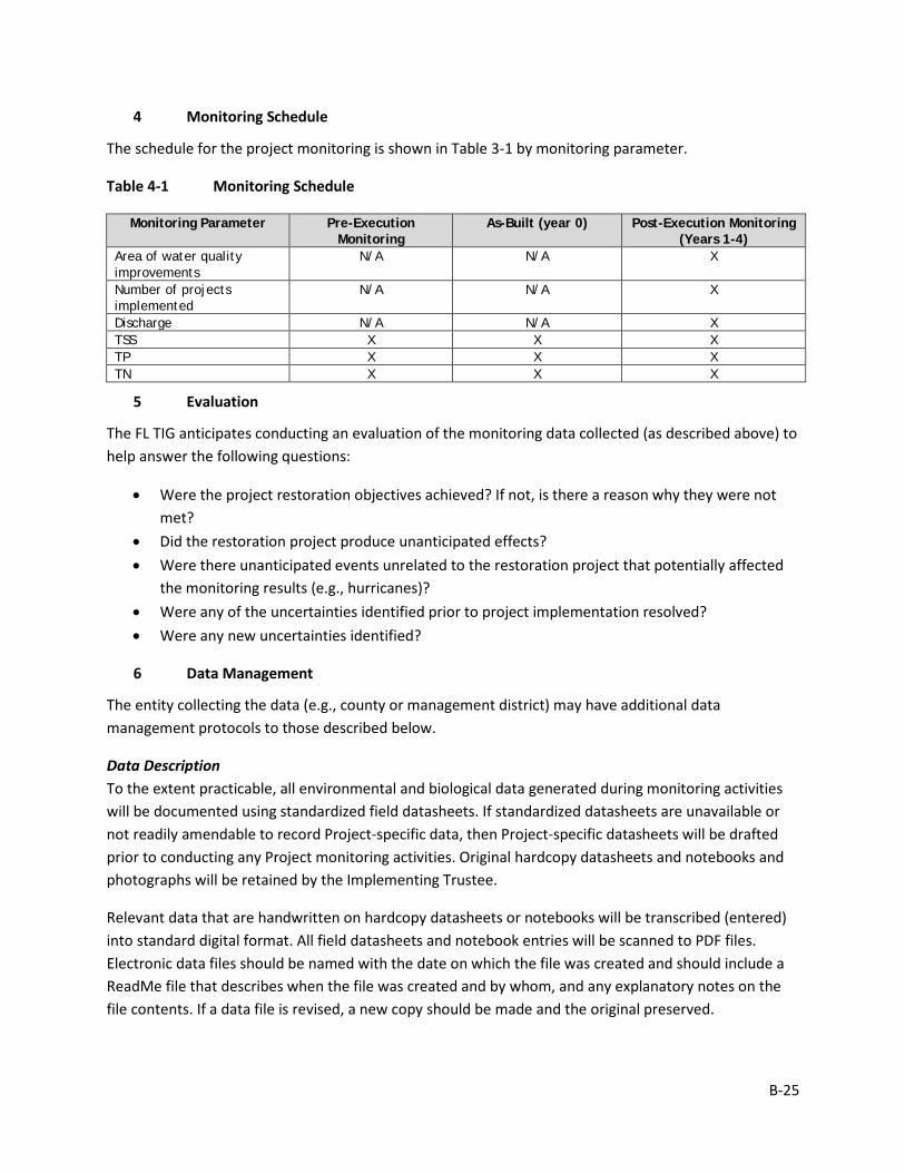
4 Monitoring Schedule
The schedule for the project monitoring is shown in Table 3-1 by monitoring parameter.
Table 4-1 Monitoring Schedule
Monitoring Parameter Pre-Execution Monitoring
As-Built (year 0) Post-Execution Monitoring (Years 1-4)
Area of water quality improvements
N/A N/A X
Number of projects implemented
N/A N/A X
Discharge N/A N/A X TSS X X X TP X X X TN X X X
5 Evaluation
The FL TIG anticipates conducting an evaluation of the monitoring data collected (as described above) to help answer the following questions:
• Were the project restoration objectives achieved? If not, is there a reason why they were not met?
• Did the restoration project produce unanticipated effects? • Were there unanticipated events unrelated to the restoration project that potentially affected
the monitoring results (e.g., hurricanes)? • Were any of the uncertainties identified prior to project implementation resolved? • Were any new uncertainties identified?
6 Data Management
The entity collecting the data (e.g., county or management district) may have additional data management protocols to those described below.
Data Description To the extent practicable, all environmental and biological data generated during monitoring activities will be documented using standardized field datasheets. If standardized datasheets are unavailable or not readily amendable to record Project-specific data, then Project-specific datasheets will be drafted prior to conducting any Project monitoring activities. Original hardcopy datasheets and notebooks and photographs will be retained by the Implementing Trustee.
Relevant data that are handwritten on hardcopy datasheets or notebooks will be transcribed (entered) into standard digital format. All field datasheets and notebook entries will be scanned to PDF files. Electronic data files should be named with the date on which the file was created and should include a ReadMe file that describes when the file was created and by whom, and any explanatory notes on the file contents. If a data file is revised, a new copy should be made and the original preserved.
B-26
All data will have properly documented FGDC/ISO metadata, a data dictionary (defines codes and fields used in the dataset), and/or a Readme file as appropriate (e.g., how data was collected, QA/QC procedures, other information about data such as meaning, relationships to other data, origin, usage, and format – can reference different documents).
Data Review and Clearance Relevant Project data that are handwritten on hardcopy datasheets or notebooks will be transcribed (entered) into standard digital format. After transcription of the data, the electronic data sheets will be verified against the original hardcopy datasheets and/or notebooks, and will make any corrections to transcription errors as appropriate before data are used for any analyses or distributed outside of the agency. Implementing Trustees will verify and validate MAM data and information and will ensure that all data is i) entered or converted into agreed upon/commonly used digital format; ii) labeled with metadata following FGDC/ISO standards to the extent practicable and in accordance with Implementing Trustee agency requirements.
After any and all identified errors are addressed, data are considered to be QA/QC’ed. The implementing Trustee will give the other TIG members time to review the data before making such information publicly available (as described below). Before submitting the monitoring data and information package, co-Implementing Trustees shall confirm with one another that the package is approved for submission.
Data Storage and Accessibility Once all data has been QA/QC’ed it will be submitted to the Restoration Portal. Trustees will provide DWH NRDA MAM data and information to the Restoration Portal as soon as possible and no more than one year from when data are collected.
Data Sharing Data will be made publicly available, in accordance with the Federal Open Data Policy, through the DIVER Explorer Interface within one year of when the data collection occurred.
7 Reporting
Once all data have been reviewed for accuracy and completeness, they will be submitted to the Restoration Portal. Data will be made publicly available through the DIVER Explorer Interface.
8 Roles and Responsibilities
Data will be reviewed and submitted to the Restoration Portal by USDA project personnel.
B-27
Monitoring and Adaptive Management Plan for Deepwater Horizon NRDA Project:
NR3, Lower Suwannee River Watershed - Nutrient Reduction Prepared by: Nadia Martin (IEc) and USDA; Draft Version Date: 1/21/2019
1 Introduction
This project MAM plan identifies the monitoring needed to evaluate progress toward meeting project objectives and to support any necessary adaptive management of the restoration project. Where applicable, it identifies key sources of uncertainty and incorporates monitoring data and decision points that address these uncertainties. As not all projects will have the same sources and degree of uncertainty, this project-specific MAM plan is scaled according to level of uncertainty, scope, scale, and restoration type associated with this project.
This MAM plan is a living document and may be updated as needed to reflect changing conditions and/or new information. Any future revisions to this document will be made publicly available through the Trustee Council Restoration Portal (https://www.diver.orr.noaa.gov/web/guest/home) and accessible through the DWH NRDA Trustees website (http://www.restoration.noaa.gov/dwh/storymap/).
Project Overview This project is being implemented as restoration for the DWH oil spill NRDA, consistent with the PDARP/PEIS.
• Programmatic Goal: Restore Water Quality • Restoration Type: Nutrient Reduction (non-point source) • Restoration Approach: Reduce nutrient loads to coastal watersheds • Restoration Technique: Agricultural conservation practices • TIG: FL TIG • Restoration Plan: Restoration Plan #1
This restoration project is being implemented within the Lower Suwannee River watershed in Levy County, Florida. This project includes the development and implementation of conservation plans (CPs) on agricultural lands, outreach to identify willing landowners, and technical assistance for the participants. This project is intended to improve water quality through the implementation of CPs that include practices to reduce sediment and nutrient loads to coastal watersheds. The proposed CPs would reduce nutrient losses from the landscape, reduce nutrient loads to streams and downstream receiving waters, and reduce water quality degradation in watersheds that would provide benefits to coastal watersheds and marine resources.
The implementing agency is the USDA.
B-28
Restoration Type Goal and Project Restoration Objective The overall goals for this Restoration Type relevant to this project, as identified in the PDARP, are:
• Reduce nutrient loadings to Gulf Coast estuaries, habitats, and resources that are threatened by chronic eutrophication, hypoxia, or harmful algal blooms or that suffer habitat losses associated with water quality degradation.
The project restoration objective is:
• Reduce sediment, phosphorous and nitrogen loads during storm events leaving private lands in the watershed.
Performance criteria will be used to determine restoration success or the need for corrective action in accordance with 15 C.F.R. 990.55(b)(1)(vii)). Specific, measurable performance criteria are defined, as applicable, for monitoring parameters associated with each of the restoration objectives in Section 3.0.
Conceptual Setting and Anticipated Outcomes A conceptual model for this project includes a summary of the restoration project and the desired project outcomes. For this project, the specific stressors addressed include nutrient and sediment loading, agricultural activities and land cover conversion. This project will reduce those stressors by implementing conservation practices on private agricultural lands that will reduce sedimentation and nutrients that make their way into local waterbodies, resulting in improved water quality.
Table 1-1 Conceptual Model Activity Output Short-term Outcome Long-term Outcome • Implement
conservation practices to reduce nutrient and sediment loading into receiving waters
• Reduced nutrient and sediment loading into the system
• Decrease in nutrient and sediment loadings in targeted watersheds
• Enhancement of ecosystem services of Gulf coast habitats and resources
Potential Sources of Uncertainty The following uncertainties could potentially influence the success of the project. Efforts will be made in the planning and implementation phases to reduce and/or eliminate these uncertainties.
4. Willingness of landowners to participate. Strategy to resolve: identify other willing landowners.
5. Conservation practices may not result in measurable change in the receiving waters. Strategy to resolve: Conduct targeted in-stream monitoring at locations upstream and downstream of the implementation area. Monitoring data will be used to refine future management actions.
6. Landuse changes (type of agriculture might change), changes in land ownership, significant rain/weather events, unknown contributing sources of nutrients in the watershed, BMPs may not work. Strategy to resolve: adaptively manage the project.
B-29
2 Adaptive Management
The need for adaptive management on specific CPs being implemented is unlikely to be needed due to the nature of the sampling approaches, the objectives of the project and the scales of the sites in which the data will be collected, and an understanding of the CPs that will be applied. However, adaptive management will be incorporated in the CPs, based on water quality monitoring, as described in Sections 3 and 4, above. Adaptive management will also be applied at the level of the watershed to ensure that the number of sites, locations, and total area subjected to the standard Restoration Techniques are sufficient to reduce the overall nutrient and sediment load, as described in Section 2, above. Situations that might lead to adaptive management include a farmer joining the program and then backing out, participants selling their property or changing farming practices. Adaptive management of specific CPs could be included in each CP, as appropriate. Data, analysis, and information obtained from this project will be used to help inform future Restoration Plan development, priorities and project selection and implementation.
3 Project Monitoring, Performance Criteria, and Potential Corrective Actions
The proposed monitoring for this restoration project was developed to evaluate project performance, key uncertainties, and potential corrective actions, if needed. Information on each monitoring parameter is provided below, organized by objective (Table 3-1). Note that Table 3-1 does not include all possible options for corrective actions; rather, it includes a list of potential actions for each individual parameter to be considered if the project is not performing as expected once implemented. Other corrective actions may be identified post-implementation, as appropriate.
These parameters will be monitored at the project site, in adjacent streams, and may also be monitored at appropriate reference and/or control sites to demonstrate how the project is trending toward the performance criteria.
Corrective actions that may be necessary include, but are not limited to, regrading/removing water control structures, planting/replanting desirable vegetation, and/or removing nuisance vegetation. Corrective actions will likely occur after implementation, but within the five-year time frame for this project. Corrective actions will be identified by USDA based on site evaluations and performance monitoring data and reports. Costs for addressing the corrective action will be evaluated by USDA to determine feasibility.
B-30
Table 3-1 Monitoring Parameters
Objective 1: Reduce sediment, phosphorous and nitrogen loads during storm events leaving private lands in the watershed.
Parameter Purpose Method Timing, Frequency, Duration
Sample Size and Sites Performance Criteria
Potential Corrective Action(s)
Area of water quality improvements
Documentation of restoration actions.
Estimated area of project footprint (i.e., field, parcel, or farm) and estimated area of project influence (based on in-stream water quality, influence of upland CPs on nearby waterbodies)
Once after CPs are implemented.
One per CP per area type. TBD, based on preliminary site-specific restoration/conservation planning.
N/A.
Number of water quality improvement practices implemented
Monitor progress toward meeting objective.
Count of number of projects implemented.
Once per year (annually).
All projects implemented. TBD, based on initial evaluation of the watershed and pre-execution monitoring.
Number of projects implemented by end of project period
Discharge (m3/s
or cfs) Monitor progress toward meeting objective.
Per MAM Manual. 10 measurements per year at one or more sets of one upstream and two downstream stations that bracket portions of the watershed where CPs are being implemented.
No. of sites dependent on the amount and location of CPs. ~10 samples per year at each station. Samples would be taken at baseflow conditions when possible. Sites: Determined when sites are identified. Depending on CPs, could include one upstream station (could be optional depending on upstream conditions) and one or more downstream stations depending on the location of the cluster of conservation practices.
TBD, depending on the CP.
TBD, depending on the CP.
Total Suspended Solids (TSS) (mg/L or ppm) and Turbidity
Monitor progress toward meeting objective.
In-stream. Fixed station parameter reading using a data sonde, under baseflow conditions when possible, using standard monitoring protocols would occur at appropriately located upstream and downstream stations that bracket portions of watersheds with conservation practices.
10 measurements per year at one or more sets of one upstream and two downstream stations that bracket portions of the watershed where CPs are being implemented.
No. of sites dependent on the amount and location of CPs. ~10 samples per year at each station. Samples would be taken at baseflow conditions when possible. Sites: Determined when sites are identified. Depending on CPs, could include one upstream station (could be optional depending on upstream conditions) and one or more downstream stations depending on the location of the cluster of conservation practices.
Reduction in the quantity of in-stream sediment over time.
Actions would vary depending on the type of CPs. Some conservation practices may require inspection and maintenance.
B-31
Parameter Purpose Method Timing, Frequency, Duration
Sample Size and Sites Performance Criteria
Potential Corrective Action(s)
Total Phosphorous (TP) (mg/L)
Monitor progress toward meeting objective.
In-stream. Sample collection using standard monitoring protocols would occur at appropriately located upstream and downstream stations that bracket portions of the area with conservation practices.
10 measurements per year at one or more sets of one upstream and two downstream stations that bracket portions of the watershed where CPs are being implemented.
No. of sites dependent on the amount and location of CPs. ~10 samples per year at each station. Samples would be taken at baseflow conditions when possible. Sites: Determined when sites are identified. Depending on CPs, could include one upstream station (could be optional depending on upstream conditions) and one or more downstream stations depending on the location of the cluster of conservation practices.
Reduction in the quantity of phosphorus over time.
Actions would vary depending on the type of CPs. Some conservation practices may require inspection and maintenance.
Total Nitrogen (TN) (mg/L)
Monitor progress toward meeting objective.
Sample collection using standard monitoring protocols will occur at appropriately located upstream and downstream stations that bracket portions of areas where conservation activities are being implemented
10 measurements per year at one or more sets of one upstream and two downstream stations that bracket portions of the watershed where CPs are being implemented.
No. of sites dependent on the amount and location of CPs. ~10 samples per year at each station. Samples would be taken at baseflow conditions when possible. Sites: Determined when sites are identified. Depending on CPs, could include one upstream station (could be optional depending on upstream conditions) and one or more downstream stations depending on the location of the cluster of conservation practices.
Reduction in the quantity of nitrogen over time.
Actions would vary depending on the type of CPs. Some conservation practices may require inspection and maintenance.
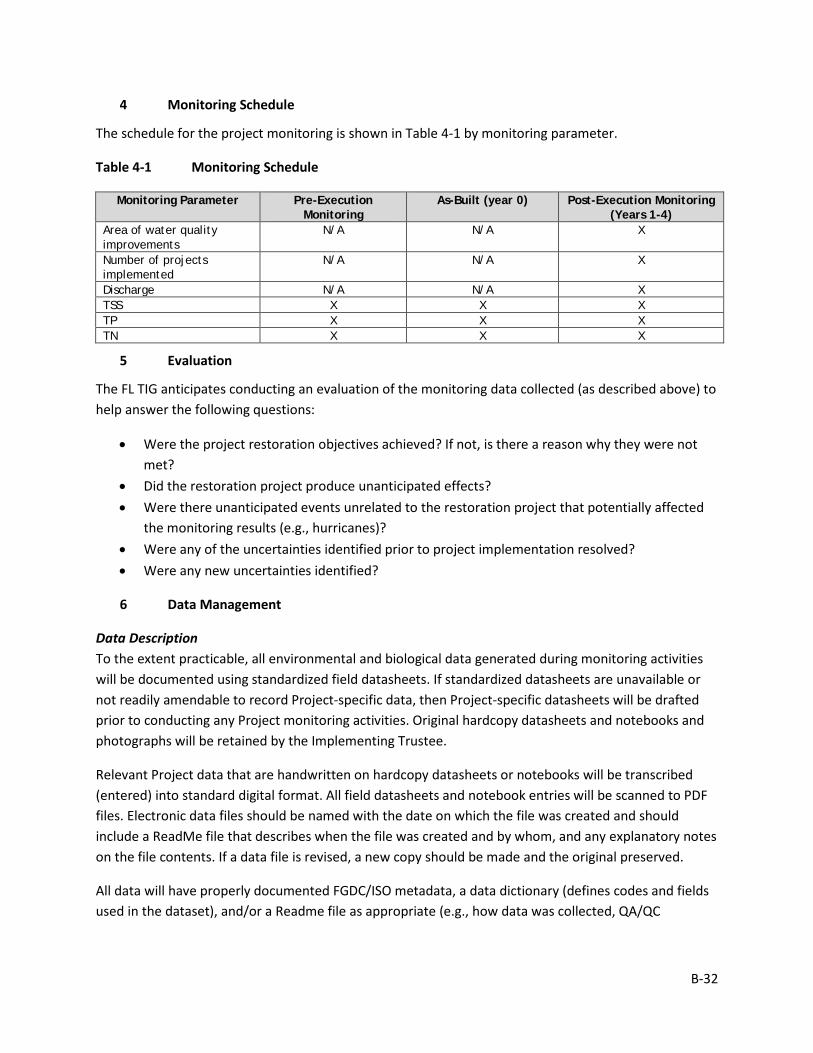
B-32
4 Monitoring Schedule
The schedule for the project monitoring is shown in Table 4-1 by monitoring parameter.
Table 4-1 Monitoring Schedule
Monitoring Parameter Pre-Execution Monitoring
As-Built (year 0) Post-Execution Monitoring (Years 1-4)
Area of water quality improvements
N/A N/A X
Number of projects implemented
N/A N/A X
Discharge N/A N/A X TSS X X X TP X X X TN X X X
5 Evaluation
The FL TIG anticipates conducting an evaluation of the monitoring data collected (as described above) to help answer the following questions:
• Were the project restoration objectives achieved? If not, is there a reason why they were not met?
• Did the restoration project produce unanticipated effects? • Were there unanticipated events unrelated to the restoration project that potentially affected
the monitoring results (e.g., hurricanes)? • Were any of the uncertainties identified prior to project implementation resolved? • Were any new uncertainties identified?
6 Data Management
Data Description To the extent practicable, all environmental and biological data generated during monitoring activities will be documented using standardized field datasheets. If standardized datasheets are unavailable or not readily amendable to record Project-specific data, then Project-specific datasheets will be drafted prior to conducting any Project monitoring activities. Original hardcopy datasheets and notebooks and photographs will be retained by the Implementing Trustee.
Relevant Project data that are handwritten on hardcopy datasheets or notebooks will be transcribed (entered) into standard digital format. All field datasheets and notebook entries will be scanned to PDF files. Electronic data files should be named with the date on which the file was created and should include a ReadMe file that describes when the file was created and by whom, and any explanatory notes on the file contents. If a data file is revised, a new copy should be made and the original preserved.
All data will have properly documented FGDC/ISO metadata, a data dictionary (defines codes and fields used in the dataset), and/or a Readme file as appropriate (e.g., how data was collected, QA/QC
B-33
procedures, other information about data such as meaning, relationships to other data, origin, usage, and format – can reference different documents).
Data Review and Clearance Relevant Project data that are handwritten on hardcopy datasheets or notebooks will be transcribed (entered) into standard digital format. After transcription of the data, the electronic data sheets will be verified against the original hardcopy datasheets and/or notebooks, and will make any corrections to transcription errors as appropriate before data are used for any analyses or distributed outside of the agency. Implementing Trustees will verify and validate MAM data and information and will ensure that all data is i) entered or converted into agreed upon/commonly used digital format; ii) labeled with metadata following FGDC/ISO standards to the extent practicable and in accordance with Implementing Trustee agency requirements.
After any and all identified errors are addressed, data are considered to be QA/QC’ed. The implementing Trustee will give the other TIG members time to review the data before making such information publicly available (as described below). Before submitting the monitoring data and information package, co-Implementing Trustees shall confirm with one another that the package is approved for submission.
Data Storage and Accessibility Once all data has been QA/QC’ed it will be submitted to the Restoration Portal. Trustees will provide DWH NRDA MAM data and information to the Restoration Portal as soon as possible and no more than one year from when data are collected.
Data Sharing Data will be made publicly available, in accordance with the Federal Open Data Policy, through the DIVER Explorer Interface within one year of when the data collection occurred.
7 Reporting
Once all data have been reviewed for accuracy and completeness, they will be submitted to the Restoration Portal. Data will be made publicly available through the DIVER Explorer Interface.
8 Roles and Responsibilities
USDA project personnel will be responsible for all aspects of data collection, data review, data management, data analysis, and submission to the Restoration Portal, project adaptive management, and reporting.
B-34
Monitoring and Adaptive Management Plan for Deepwater Horizon NRDA Project:
WQ1, Carpenter Creek Headwaters Water Quality Improvements Prepared by: Nadia Martin (IEc) and FDEP; Draft Version Date: 1/21/2019
1 Introduction
This project MAM plan identifies the monitoring needed to evaluate progress toward meeting project objectives and to support any necessary adaptive management of the restoration project. Where applicable, it identifies key sources of uncertainty and incorporates monitoring data and decision points that address these uncertainties. As not all projects will have the same sources and degree of uncertainty, this project-specific MAM plan is scaled according to level of uncertainty, scope, scale, and restoration type associated with this project.
This MAM plan is a living document and may be updated as needed to reflect changing conditions and/or new information. Any future revisions to this document will be made publicly available through the Trustee Council Restoration Portal (https://www.diver.orr.noaa.gov/web/guest/home) and accessible through the DWH NRDA Trustees website (http://www.restoration.noaa.gov/dwh/storymap/).
Project Overview This project is being implemented as restoration for the DWH oil spill NRDA, consistent with the PDARP/PEIS.
• Programmatic Goal: Restore Water Quality • Restoration Type Water Quality • Restoration Approach: Reduce pollution and hydrologic degradation to coastal
watersheds • Restoration Technique: Traditional stormwater control measures • TIG: FL TIG • Restoration Plan: Restoration Plan #1
This restoration project would be implemented within Escambia County, around Carpenter Creek, Bayou Texar, and the City of Pensacola. The project includes restoration of a county-owned wetland, acquisition of land, and construction of a stormwater treatment facility to capture and treat stormwater that flows off Olive Road into Carpenter Creek. The project would improve water quality in Carpenter Creek and Bayou Texar, which flow into Pensacola Bay.
The implementing agency is FDEP. Partner agencies include Escambia County, City of Pensacola, Pensacola and Perdido Bays Estuary Program, Emerald CoastKeeper, UWF, Bayou Texar Foundation, UF IFAS Extension, Washington High School Marine Science Academy, Bream Fishermen Association, and the Audubon Society (Florida chapter).
B-35
Restoration Type Goals and Project Restoration Objectives The overall goals for this Restoration Type relevant to this project, as identified in the PDARP, are:
• Reduce pollutant loadings, including nutrients and pathogens, to priority watersheds along the Florida coast that are threatened by chronic eutrophication, harmful algal blooms, hypoxia, habitat losses, or beach and shellfish closures associated with water quality degradation;
• Mitigate high-volume flows and prevent dramatic shifts in salinity that threaten many coastal habitats and resources along the Gulf Coast;
• Where appropriate, co-locate pollutant reduction projects with other restoration projects to enhance ecological services provided by other restoration approaches (PDARP/PEIS Section 5.5.5.1).
The project restoration objectives are:
• Engineer and construct traditional SCMs, including a stormwater treatment facility and restoration of a former wetland;
• Improve water quality in Carpenter Creek and Bayou Texar by providing additional water treatment and reducing pollution and hydrologic degradation.
Performance criteria will be used to determine restoration success or the need for corrective action in accordance with 15 C.F.R. 990.55(b)(1)(vii)). Specific, measurable performance criteria are defined, as applicable, for monitoring parameters associated with each of the restoration objectives in Section 3.0.
2 Adaptive Management
Due to the nature of this project, and the use of standard Restoration Techniques that have been used successfully in similar projects, the FL TIG determined that adaptive management is unlikely to be necessary for this project. However, monitoring would be conducted, as described in Section 3, below. If the SCMs do not meet the stated performance criteria, potential corrective actions would be identified.
3 Project Monitoring, Performance Criteria, and Potential Corrective Actions
The proposed monitoring for this restoration project was developed to evaluate project performance, key uncertainties, and potential corrective actions, if needed. Information on each monitoring parameter is provided below, organized by objective (Table 3-1). Note that Table 3-1 does not include all possible options for corrective actions; rather, it includes a list of potential actions for each individual parameter to be considered if the project is not performing as expected once implemented. Other corrective actions may be identified post-implementation, as appropriate.
Monitoring for this project would include sampling from seven to ten storm events. If possible, monitored events would be discrete rainfall events generally consisting of greater than 0.20 inches and less than 1.5 inches of rain. However, this would depend on field conditions and storm events; actual rainfall may vary as well as the drainage area, amount of impervious area, and time of concentration. Monitoring would generally be conducted at two locations: inflows and outflows.
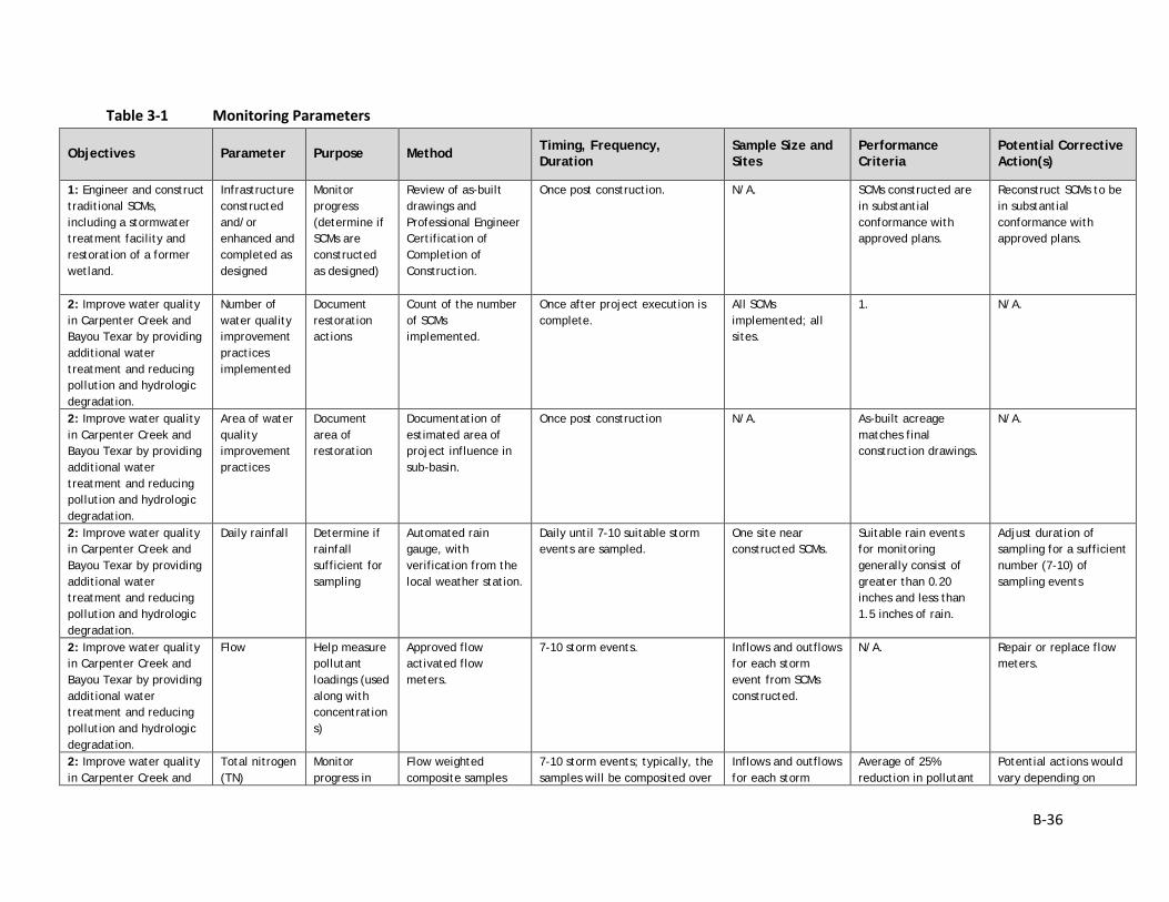
B-36
Table 3-1 Monitoring Parameters
Objectives Parameter Purpose Method Timing, Frequency, Duration
Sample Size and Sites
Performance Criteria
Potential Corrective Action(s)
1: Engineer and construct traditional SCMs, including a stormwater treatment facility and restoration of a former wetland.
Infrastructure constructed and/or enhanced and completed as designed
Monitor progress (determine if SCMs are constructed as designed)
Review of as-built drawings and Professional Engineer Certification of Completion of Construction.
Once post construction. N/A. SCMs constructed are in substantial conformance with approved plans.
Reconstruct SCMs to be in substantial conformance with approved plans.
2: Improve water quality in Carpenter Creek and Bayou Texar by providing additional water treatment and reducing pollution and hydrologic degradation.
Number of water quality improvement practices implemented
Document restoration actions
Count of the number of SCMs implemented.
Once after project execution is complete.
All SCMs implemented; all sites.
1. N/A.
2: Improve water quality in Carpenter Creek and Bayou Texar by providing additional water treatment and reducing pollution and hydrologic degradation.
Area of water quality improvement practices
Document area of restoration
Documentation of estimated area of project influence in sub-basin.
Once post construction N/A. As-built acreage matches final construction drawings.
N/A.
2: Improve water quality in Carpenter Creek and Bayou Texar by providing additional water treatment and reducing pollution and hydrologic degradation.
Daily rainfall Determine if rainfall sufficient for sampling
Automated rain gauge, with verification from the local weather station.
Daily until 7-10 suitable storm events are sampled.
One site near constructed SCMs.
Suitable rain events for monitoring generally consist of greater than 0.20 inches and less than 1.5 inches of rain.
Adjust duration of sampling for a sufficient number (7-10) of sampling events
2: Improve water quality in Carpenter Creek and Bayou Texar by providing additional water treatment and reducing pollution and hydrologic degradation.
Flow Help measure pollutant loadings (used along with concentrations)
Approved flow activated flow meters.
7-10 storm events. Inflows and outflows for each storm event from SCMs constructed.
N/A. Repair or replace flow meters.
2: Improve water quality in Carpenter Creek and
Total nitrogen (TN)
Monitor progress in
Flow weighted composite samples
7-10 storm events; typically, the samples will be composited over
Inflows and outflows for each storm
Average of 25% reduction in pollutant
Potential actions would vary depending on
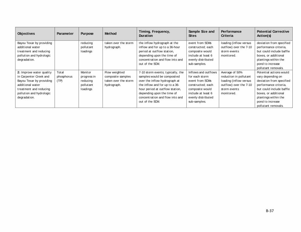
B-37
Objectives Parameter Purpose Method Timing, Frequency, Duration
Sample Size and Sites
Performance Criteria
Potential Corrective Action(s)
Bayou Texar by providing additional water treatment and reducing pollution and hydrologic degradation.
reducing pollutant loadings
taken over the storm hydrograph.
the inflow hydrograph at the inflow and for up to a 36-hour period at outflow station, depending upon the time of concentration and flow into and out of the SCM.
event from SCMs constructed; each composite would include at least 6 evenly distributed sub-samples.
loading (inflow versus outflow) over the 7-10 storm events monitored.
deviation from specified performance criteria, but could include baffle boxes, or additional plantings within the pond to increase pollutant removals.
2: Improve water quality in Carpenter Creek and Bayou Texar by providing additional water treatment and reducing pollution and hydrologic degradation.
Total phosphorus (TP)
Monitor progress in reducing pollutant loadings
Flow weighted composite samples taken over the storm hydrograph.
7-10 storm events; typically, the samples would be composited over the inflow hydrograph at the inflow and for up to a 36-hour period at outflow station, depending upon the time of concentration and flow into and out of the SCM.
Inflows and outflows for each storm event from SCMs constructed; each composite would include at least 6 evenly distributed sub-samples.
Average of 50% reduction in pollutant loading (inflow versus outflow) over the 7-10 storm events monitored.
Potential actions would vary depending on deviation from specified performance criteria, but could include baffle boxes, or additional plantings within the pond to increase pollutant removals.
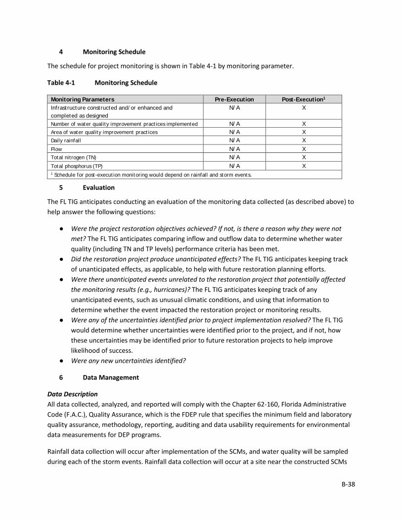
B-38
4 Monitoring Schedule
The schedule for project monitoring is shown in Table 4-1 by monitoring parameter.
Table 4-1 Monitoring Schedule
Monitoring Parameters Pre-Execution Post-Execution1 Infrastructure constructed and/or enhanced and completed as designed
N/A X
Number of water quality improvement practices implemented N/A X Area of water quality improvement practices N/A X Daily rainfall N/A X Flow N/A X Total nitrogen (TN) N/A X Total phosphorus (TP) N/A X 1 Schedule for post-execution monitoring would depend on rainfall and storm events.
5 Evaluation
The FL TIG anticipates conducting an evaluation of the monitoring data collected (as described above) to help answer the following questions:
● Were the project restoration objectives achieved? If not, is there a reason why they were not met? The FL TIG anticipates comparing inflow and outflow data to determine whether water quality (including TN and TP levels) performance criteria has been met.
● Did the restoration project produce unanticipated effects? The FL TIG anticipates keeping track of unanticipated effects, as applicable, to help with future restoration planning efforts.
● Were there unanticipated events unrelated to the restoration project that potentially affected the monitoring results (e.g., hurricanes)? The FL TIG anticipates keeping track of any unanticipated events, such as unusual climatic conditions, and using that information to determine whether the event impacted the restoration project or monitoring results.
● Were any of the uncertainties identified prior to project implementation resolved? The FL TIG would determine whether uncertainties were identified prior to the project, and if not, how these uncertainties may be identified prior to future restoration projects to help improve likelihood of success.
● Were any new uncertainties identified?
6 Data Management
Data Description All data collected, analyzed, and reported will comply with the Chapter 62-160, Florida Administrative Code (F.A.C.), Quality Assurance, which is the FDEP rule that specifies the minimum field and laboratory quality assurance, methodology, reporting, auditing and data usability requirements for environmental data measurements for DEP programs.
Rainfall data collection will occur after implementation of the SCMs, and water quality will be sampled during each of the storm events. Rainfall data collection will occur at a site near the constructed SCMs
B-39
and the flow-weighted water quality samples will be collected at suitable SCMs input and output location.
To the extent practicable, all environmental and biological data generated during monitoring activities will be documented using standardized field datasheets. If standardized datasheets are unavailable or not readily amendable to record Project-specific data, then Project-specific datasheets will be drafted prior to conducting any Project monitoring activities. Original hardcopy datasheets and notebooks and photographs will be retained by the Implementing Trustee.
Relevant Project data that are handwritten on hardcopy datasheets or notebooks will be transcribed (entered) into standard digital format. All field datasheets and notebook entries will be scanned to PDF files. Electronic data files should be named with the date on which the file was created and should include a ReadMe file that describes when the file was created and by whom, and any explanatory notes on the file contents. If a data file is revised, a new copy should be made and the original preserved.
All data will have properly documented FGDC/ISO metadata, a data dictionary (defines codes and fields used in the dataset), and/or a Readme file as appropriate (e.g., how data was collected, QA/QC procedures, other information about data such as meaning, relationships to other data, origin, usage, and format – can reference different documents).
Data Review and Clearance Relevant Project data that are handwritten on hardcopy datasheets or notebooks will be transcribed (entered) into standard digital format. After transcription of the data, the electronic data sheets will be verified against the original hardcopy datasheets and/or notebooks, and will make any corrections to transcription errors as appropriate before data are used for any analyses or distributed outside of the agency. Implementing Trustees will verify and validate MAM data and information and will ensure that all data is i) entered or converted into agreed upon/commonly used digital format; ii) labeled with metadata following FGDC/ISO standards to the extent practicable and in accordance with Implementing Trustee agency requirements.
After any and all identified errors are addressed, data are considered to be QA/QC’ed. The implementing Trustee will give the other TIG members time to review the data before making such information publicly available (as described below). Before submitting the monitoring data and information package, co-Implementing Trustees shall confirm with one another that the package is approved for submission.
Data Storage and Accessibility Once all data has been QA/QC’ed it will be submitted to the Restoration Portal. Trustees will provide DWH NRDA MAM data and information to the Restoration Portal as soon as possible and no more than one year from when data are collected.
Data Sharing Data will be made publicly available, in accordance with the Federal Open Data Policy, through the DIVER Explorer Interface within one year of when the data collection occurred.

B-40
7 Reporting
Once all data have been reviewed for accuracy and completeness, they will be submitted to the Restoration Portal. Data will be made publicly available through the DIVER Explorer Interface.
8 Roles and Responsibilities
Data will be reviewed and submitted to the Restoration Portal by FDEP project personnel.
B-41
Monitoring and Adaptive Management Plan for Deepwater Horizon NRDA Project:
WQ2, Pensacola Beach Reclaimed Water System Expansion Prepared by: Nadia Martin (IEc) and FDEP; Draft Version Date: 1/21/2019
1 Introduction
This project MAM plan identifies the monitoring needed to evaluate progress toward meeting project objectives and to support any necessary adaptive management of the restoration project. Where applicable, it identifies key sources of uncertainty and incorporates monitoring data and decision points that address these uncertainties. As not all projects will have the same sources and degree of uncertainty, this project-specific MAM plan is scaled according to level of uncertainty, scope, scale, and restoration type associated with this project.
This MAM plan is a living document and may be updated as needed to reflect changing conditions and/or new information. Any future revisions to this document will be made publicly available through the Trustee Council Restoration Portal (https://www.diver.orr.noaa.gov/web/guest/home) and accessible through the DWH NRDA Trustees website (http://www.restoration.noaa.gov/dwh/storymap/).
Project Overview This project is being implemented as restoration for the DWH oil spill NRDA, consistent with the PDARP/PEIS.
• Programmatic Goal: Restore Water Quality • Restoration Type Water Quality • Restoration Approach: Reduce pollution and hydrologic degradation to coastal
watersheds • Restoration Technique: Expand reclaimed water system • TIG: FL TIG • Restoration Plan: Restoration Plan #1
This restoration project would be implemented in Pensacola Beach, Escambia County, Florida. The project aims to reduce the discharge of nutrients and other pollutants into Santa Rosa Sound by expanding the ECUA’s Pensacola Beach Reclaimed Water System. This project includes making additional reclaimed water available to the Santa Rosa Island Authority for irrigation of more public rights-of-way and making reclaimed water available for irrigation of commercial and residential areas on Santa Rosa Island.
The implementing agency is FDEP. Partner agencies include Emerald Coast Utilities Authority (ECUA) and NWFWMD.
B-42
Restoration Type Goals and Project Restoration Objectives The overall goals for this Restoration Type relevant to this project, as identified in the PDARP, are:
• Reduce pollutant loadings, including nutrients and pathogens, to priority watersheds along the Florida coast that are threatened by chronic eutrophication, harmful algal blooms, hypoxia, habitat losses, or beach and shellfish closures associated with water quality degradation;
• Mitigate high-volume flows and prevent dramatic shifts in salinity that threaten many coastal habitats and resources along the Gulf Coast;
• Where appropriate, co-locate pollutant reduction projects with other restoration projects to enhance ecological services provided by other restoration approaches (PDARP/PEIS Section 5.5.5.1).
The project restoration objectives are:
• To reduce nutrient concentrations and loadings and improve water quality in the Santa Rosa Sound.
• To make additional reclaimed water available to the Santa Rosa Island Authority for irrigation of more public rights-of-way and make reclaimed water available for irrigation of commercial and residential areas on Santa Rosa Island.
Performance criteria will be used to determine restoration success or the need for corrective action in accordance with 15 C.F.R. 990.55(b)(1)(vii)). Specific, measurable performance criteria are defined, as applicable, for monitoring parameters associated with each of the restoration objectives in Section 3.0.
2 Adaptive Management
Due to the nature of this project, and the use of standard approaches and Restoration Techniques that have been successfully implemented in similar projects, the FL TIG does not anticipate the need for rigorous adaptive management of the project. If project objectives are not being met, the FL TIG will identify corrective actions as necessary.
3 Project Monitoring, Performance Criteria, and Potential Corrective Actions
The proposed monitoring for this restoration project was developed to evaluate project performance, key uncertainties, and potential corrective actions, if needed. Information on each monitoring parameter is provided below, organized by objective (Table 3-1). Note that Table 3-1 does not include all possible options for corrective actions; rather, it includes a list of potential actions for each individual parameter to be considered if the project is not performing as expected once implemented. Other corrective actions may be identified post-implementation, as appropriate.
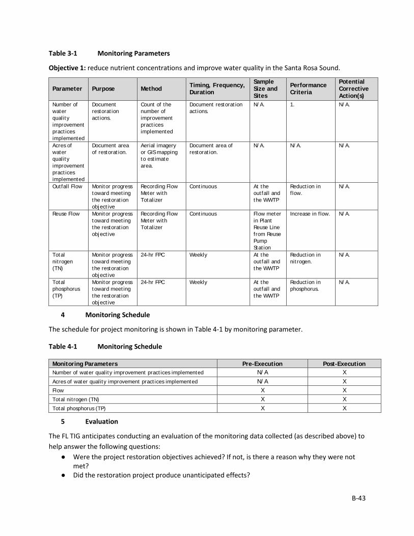
B-43
Table 3-1 Monitoring Parameters
Objective 1: reduce nutrient concentrations and improve water quality in the Santa Rosa Sound.
Parameter Purpose Method Timing, Frequency, Duration
Sample Size and Sites
Performance Criteria
Potential Corrective Action(s)
Number of water quality improvement practices implemented
Document restoration actions.
Count of the number of improvement practices implemented
Document restoration actions.
N/A. 1. N/A.
Acres of water quality improvement practices implemented
Document area of restoration.
Aerial imagery or GIS mapping to estimate area.
Document area of restoration.
N/A. N/A. N/A.
Outfall Flow Monitor progress toward meeting the restoration objective
Recording Flow Meter with Totalizer
Continuous At the outfall and the WWTP
Reduction in flow.
N/A.
Reuse Flow Monitor progress toward meeting the restoration objective
Recording Flow Meter with Totalizer
Continuous Flow meter in Plant Reuse Line from Reuse Pump Station
Increase in flow. N/A.
Total nitrogen (TN)
Monitor progress toward meeting the restoration objective
24-hr FPC Weekly At the outfall and the WWTP
Reduction in nitrogen.
N/A.
Total phosphorus (TP)
Monitor progress toward meeting the restoration objective
24-hr FPC Weekly At the outfall and the WWTP
Reduction in phosphorus.
N/A.
4 Monitoring Schedule
The schedule for project monitoring is shown in Table 4-1 by monitoring parameter.
Table 4-1 Monitoring Schedule
Monitoring Parameters Pre-Execution Post-Execution Number of water quality improvement practices implemented N/A X Acres of water quality improvement practices implemented N/A X Flow X X Total nitrogen (TN) X X Total phosphorus (TP) X X
5 Evaluation
The FL TIG anticipates conducting an evaluation of the monitoring data collected (as described above) to help answer the following questions:
● Were the project restoration objectives achieved? If not, is there a reason why they were not met?
● Did the restoration project produce unanticipated effects?
B-44
● Were there unanticipated events unrelated to the restoration project that potentially affected the monitoring results (e.g., hurricanes)?
● Were any of the uncertainties identified prior to project implementation resolved? ● Were any new uncertainties identified?
6 Data Management
Data Description This project will be monitored through the use of Discharge Monitoring Reports (DMRs) required by the NPDES permit for the ECUA WWTP. The permit requires ECUA to monitor flow and TN and TP concentrations from the outfall from the WWTP, from which TN and TP loadings can be calculated. In addition, reuse flows are also monitored. Flow and TN and TP loadings from the outfall will be compared over time as the reuse system is expanded to document the reductions of flow and pollutant loadings into Santa Rosa Sound. Reuse flows will also be monitored to document the increase in reuse. As an NPDES regulated entity ECUA is required to electronically submit DMRs, pursuant Title 40 Code of Federal Regulations (CFR) §127.16, and Rule 62-620.100, F.A.C.
The NPDES permit requires strict sampling, analytic methods, reporting, and data QA/QC requirements, and therefore the FL-TIG has a high level of confidence over the DMR information.
Data Review and Clearance As discussed above this project will be monitored through use of Discharge Monitoring Reports (DMRs) required by the NPDES permit for the ECUA WWTP. The NPDES permit includes specific provisions on sampling, analytic methods, reporting, and data QA/QC requirements (FDEP 2015). Use of electronic DMR reporting minimizes the potential for data transcription errors. Implementing Trustees will verify and validate MAM data and information and will ensure that all data are: i) entered or converted into agreed upon/commonly used digital format; ii) labeled with metadata following FGDC/ISO standards to the extent practicable and in accordance with Implementing Trustee agency requirements.
After any and all identified errors are addressed, data are considered to be QA/QC’ed. The implementing Trustee will give the other TIG members time to review the data before making such information publicly available (as described below). Before submitting the monitoring data and information package, co-Implementing Trustees shall confirm with one another that the package is approved for submission.
Data Storage and Accessibility Once all data has been QA/QC’ed it will be submitted to the Restoration Portal. Trustees will provide DWH NRDA MAM data and information to the Restoration Portal as soon as possible and no more than one year from when data are collected.
Data Sharing Data will be made publicly available, in accordance with the Federal Open Data Policy, through the DIVER Explorer Interface within one year of when the data collection occurred.
B-45
7 Reporting
Annual reports would summarize the findings for the reporting period in a digital format and presented in tabular and graphical formats.
8 Roles and Responsibilities
Data will be reviewed and submitted to the Restoration Portal by FDEP project personnel.
9 References
FDEP. 2018. FL0024007-009 permit to operate the Pensacola Beach WWTP, issued under Chapter 403, Florida Statutes.
B-46
Monitoring and Adaptive Management Plan for Deepwater Horizon NRDA Project:
WQ3, Rattlesnake Bluff Road and Riverbank Restoration Prepared by: Nadia Martin (IEc) and DOI; Draft Version Date: 1/21/2019
1 Introduction
This project MAM plan identifies the monitoring needed to evaluate progress toward meeting project objectives and to support any necessary adaptive management of the restoration project. Where applicable, it identifies key sources of uncertainty and incorporates monitoring data and decision points that address these uncertainties. As not all projects will have the same sources and degree of uncertainty, this project-specific MAM plan is scaled according to level of uncertainty, scope, scale, and restoration type associated with this project.
This MAM plan is a living document and may be updated as needed to reflect changing conditions and/or new information. Any future revisions to this document will be made publicly available through the Trustee Council Restoration Portal (https://www.diver.orr.noaa.gov/web/guest/home) and accessible through the DWH NRDA Trustees website (http://www.restoration.noaa.gov/dwh/storymap/).
Project Overview This project is being implemented as restoration for the DWH oil spill NRDA, consistent with the PDARP/PEIS.
• Programmatic Goal: Restore Water Quality • Restoration Type: Water Quality • Restoration Approach: Reduce sediment loads to coastal watersheds • Restoration Technique: Erosion and sediment control (ESC) practices • TIG: FL TIG • Restoration Plan: Restoration Plan #1
This restoration project would take place along Rattlesnake Bluff Road, in Santa Rosa and Okaloosa counties, Florida. Restoration activities would include, but are not limited to: replacement of undersized culverts at up to six priority stream crossings and stabilization of the roadway. These restoration activities are intended to provide increased retention and assimilation of runoff and reduce excessive sediment entering the Yellow River via Rattlesnake Bluff Road.
The implementing agency is the DOI. Partner agencies include the FDEP, USFWS, U.S. Department of Defense, Eglin Air Force Base, FWC, TNC, and Okaloosa County.
Rattlesnake Bluff Road was documented as a major contributor to altered hydrology and impaired water quality, and was among one of the highest priority areas for restoration in the Yellow River in a study conducted by The Nature Conservancy (Herrington et al., 2010). Twenty impaired unpaved road
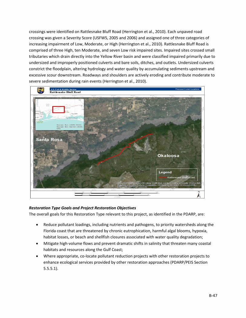
B-47
crossings were identified on Rattlesnake Bluff Road (Herrington et al., 2010). Each unpaved road crossing was given a Severity Score (USFWS, 2005 and 2006) and assigned one of three categories of increasing impairment of Low, Moderate, or High (Herrington et al., 2010). Rattlesnake Bluff Road is comprised of three High, ten Moderate, and seven Low risk impaired sites. Impaired sites crossed small tributaries which drain directly into the Yellow River basin and were classified impaired primarily due to undersized and improperly positioned culverts and bare soils, ditches, and outlets. Undersized culverts constrict the floodplain, altering hydrology and water quality by accumulating sediments upstream and excessive scour downstream. Roadways and shoulders are actively eroding and contribute moderate to severe sedimentation during rain events (Herrington et al., 2010).
Restoration Type Goals and Project Restoration Objectives The overall goals for this Restoration Type relevant to this project, as identified in the PDARP, are:
• Reduce pollutant loadings, including nutrients and pathogens, to priority watersheds along the Florida coast that are threatened by chronic eutrophication, harmful algal blooms, hypoxia, habitat losses, or beach and shellfish closures associated with water quality degradation;
• Mitigate high-volume flows and prevent dramatic shifts in salinity that threaten many coastal habitats and resources along the Gulf Coast;
• Where appropriate, co-locate pollutant reduction projects with other restoration projects to enhance ecological services provided by other restoration approaches (PDARP/PEIS Section 5.5.5.1).
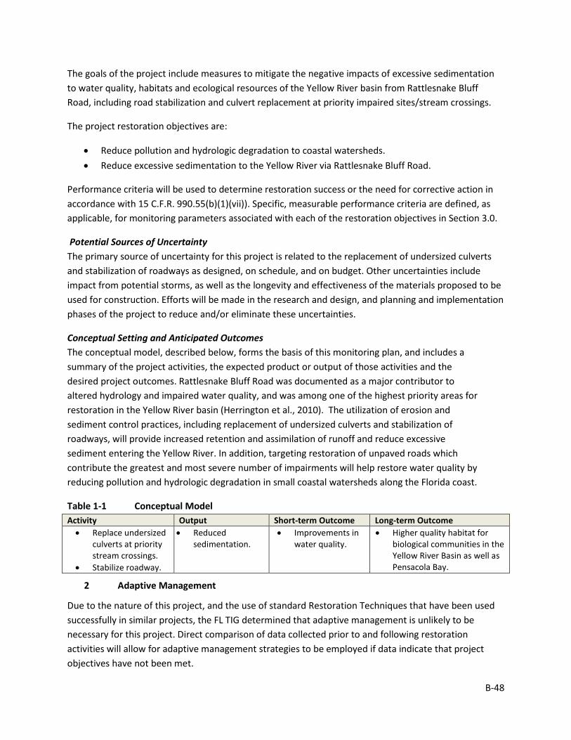
B-48
The goals of the project include measures to mitigate the negative impacts of excessive sedimentation to water quality, habitats and ecological resources of the Yellow River basin from Rattlesnake Bluff Road, including road stabilization and culvert replacement at priority impaired sites/stream crossings.
The project restoration objectives are:
• Reduce pollution and hydrologic degradation to coastal watersheds. • Reduce excessive sedimentation to the Yellow River via Rattlesnake Bluff Road.
Performance criteria will be used to determine restoration success or the need for corrective action in accordance with 15 C.F.R. 990.55(b)(1)(vii)). Specific, measurable performance criteria are defined, as applicable, for monitoring parameters associated with each of the restoration objectives in Section 3.0.
Potential Sources of Uncertainty The primary source of uncertainty for this project is related to the replacement of undersized culverts and stabilization of roadways as designed, on schedule, and on budget. Other uncertainties include impact from potential storms, as well as the longevity and effectiveness of the materials proposed to be used for construction. Efforts will be made in the research and design, and planning and implementation phases of the project to reduce and/or eliminate these uncertainties.
Conceptual Setting and Anticipated Outcomes The conceptual model, described below, forms the basis of this monitoring plan, and includes a summary of the project activities, the expected product or output of those activities and the desired project outcomes. Rattlesnake Bluff Road was documented as a major contributor to altered hydrology and impaired water quality, and was among one of the highest priority areas for restoration in the Yellow River basin (Herrington et al., 2010). The utilization of erosion and sediment control practices, including replacement of undersized culverts and stabilization of roadways, will provide increased retention and assimilation of runoff and reduce excessive sediment entering the Yellow River. In addition, targeting restoration of unpaved roads which contribute the greatest and most severe number of impairments will help restore water quality by reducing pollution and hydrologic degradation in small coastal watersheds along the Florida coast.
Table 1-1 Conceptual Model Activity Output Short-term Outcome Long-term Outcome • Replace undersized
culverts at priority stream crossings.
• Stabilize roadway.
• Reduced sedimentation.
• Improvements in water quality.
• Higher quality habitat for biological communities in the Yellow River Basin as well as Pensacola Bay.
2 Adaptive Management
Due to the nature of this project, and the use of standard Restoration Techniques that have been used successfully in similar projects, the FL TIG determined that adaptive management is unlikely to be necessary for this project. Direct comparison of data collected prior to and following restoration activities will allow for adaptive management strategies to be employed if data indicate that project objectives have not been met.
B-49
3 Project Monitoring, Performance Criteria, and Potential Corrective Actions
The proposed monitoring for this restoration project was developed to evaluate project performance, key uncertainties, and potential corrective actions, if needed. Information on each monitoring parameter is provided below, organized by objective (Table 3-1). Note that Table 3-1 does not include all possible options for corrective actions; rather, it includes a list of potential actions for each individual parameter to be considered if the project is not performing as expected once implemented. Other corrective actions may be identified post-implementation, as appropriate.
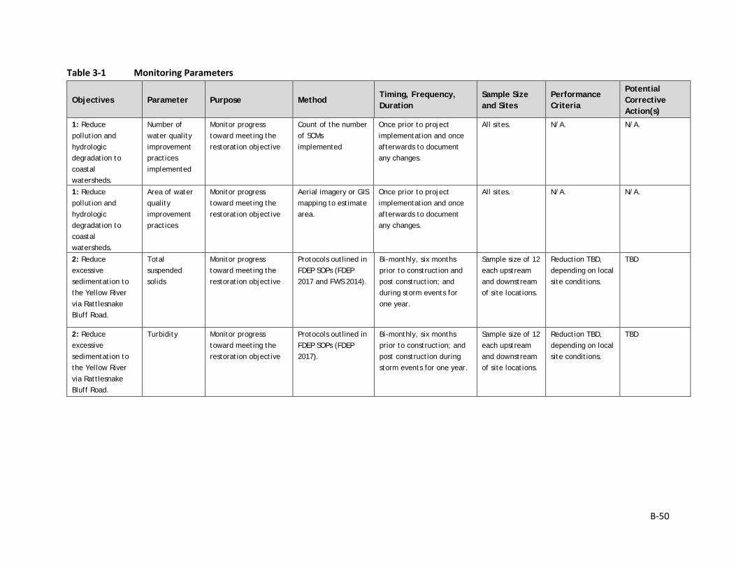
B-50
Table 3-1 Monitoring Parameters
Objectives Parameter Purpose Method Timing, Frequency, Duration
Sample Size and Sites
Performance Criteria
Potential Corrective Action(s)
1: Reduce pollution and hydrologic degradation to coastal watersheds.
Number of water quality improvement practices implemented
Monitor progress toward meeting the restoration objective
Count of the number of SCMs implemented
Once prior to project implementation and once afterwards to document any changes.
All sites. N/A. N/A.
1: Reduce pollution and hydrologic degradation to coastal watersheds.
Area of water quality improvement practices
Monitor progress toward meeting the restoration objective
Aerial imagery or GIS mapping to estimate area.
Once prior to project implementation and once afterwards to document any changes.
All sites. N/A. N/A.
2: Reduce excessive sedimentation to the Yellow River via Rattlesnake Bluff Road.
Total suspended solids
Monitor progress toward meeting the restoration objective
Protocols outlined in FDEP SOPs (FDEP 2017 and FWS 2014).
Bi-monthly, six months prior to construction and post construction; and during storm events for one year.
Sample size of 12 each upstream and downstream of site locations.
Reduction TBD, depending on local site conditions.
TBD
2: Reduce excessive sedimentation to the Yellow River via Rattlesnake Bluff Road.
Turbidity Monitor progress toward meeting the restoration objective
Protocols outlined in FDEP SOPs (FDEP 2017).
Bi-monthly, six months prior to construction; and post construction during storm events for one year.
Sample size of 12 each upstream and downstream of site locations.
Reduction TBD, depending on local site conditions.
TBD

B-51
4 Monitoring Schedule
The schedule for project monitoring is shown in Table 4-1 by monitoring parameter.
Table 4-1 Monitoring Schedule
Monitoring Parameters Pre-Execution Post-Execution Number of water quality improvement practices implemented X X Area of water quality improvement practices X X Total suspended solids X X Turbidity X X
5 Evaluation
The FL TIG anticipates conducting an evaluation of the monitoring data collected (as described above) to help answer the following questions:
• Were the project restoration objectives achieved? If not, is there a reason why they were not met?
• Did the restoration project produce unanticipated effects? • Were there unanticipated events unrelated to the restoration project that potentially affected
the monitoring results (e.g., hurricanes)? • Were any of the uncertainties identified prior to project implementation resolved? • Were any new uncertainties identified?
6 Data Management
Data Description Data collection will occur a week prior to the implementation of the SCMs and during each of the storm events. The data collection will occur at varying locations in the watershed.
To the extent practicable, all environmental and biological data generated during monitoring activities will be documented using standardized field datasheets. If standardized datasheets are unavailable or not readily amendable to record Project-specific data, then Project-specific datasheets will be drafted prior to conducting any Project monitoring activities. Original hardcopy datasheets and notebooks and photographs will be retained by the Implementing Trustee.
Relevant Project data that are handwritten on hardcopy datasheets or notebooks will be transcribed (entered) into standard digital format. All field datasheets and notebook entries will be scanned to PDF files. Electronic data files should be named with the date on which the file was created and should include a ReadMe file that describes when the file was created and by whom, and any explanatory notes on the file contents. If a data file is revised, a new copy should be made and the original preserved.
All data will have properly documented FGDC/ISO metadata, a data dictionary (defines codes and fields used in the dataset), and/or a Readme file as appropriate (e.g., how data were collected, QA/QC procedures, other information about data such as meaning, relationships to other data, origin, usage, and format – can reference different documents).
B-52
Data Review and Clearance Relevant Project data that are handwritten on hardcopy datasheets or notebooks will be transcribed (entered) into standard digital format. After transcription of the data, the electronic data sheets will be verified against the original hardcopy datasheets and/or notebooks, and will make any corrections to transcription errors as appropriate before data are used for any analyses or distributed outside of the agency. Implementing Trustees will verify and validate MAM data and information and will ensure that all data is i) entered or converted into agreed upon/commonly used digital format; ii) labeled with metadata following FGDC/ISO standards to the extent practicable and in accordance with Implementing Trustee agency requirements.
After any and all identified errors are addressed, data are considered to be QA/QC’ed. The implementing Trustee will give the other TIG members time to review the data before making such information publicly available (as described below). Before submitting the monitoring data and information package, co-Implementing Trustees shall confirm with one another that the package is approved for submission.
Data Storage and Accessibility Once all data has been QA/QC’ed it will be submitted to the Restoration Portal. Trustees will provide DWH NRDA MAM data and information to the Restoration Portal as soon as possible and no more than one year from when data are collected.
Data Sharing Data will be made publicly available, in accordance with the Federal Open Data Policy, through the DIVER Explorer Interface within one year of when the data collection occurred.
7 Reporting
Once all data have been reviewed for accuracy and completeness, they will be submitted to the Restoration Portal. Data will be made publicly available through the DIVER Explorer Interface.
8 Roles and Responsibilities
Data will be reviewed and submitted to the Restoration Portal by DOI project personnel.
9 References
FDEP (Florida Department of Environmental Protection). 2017. Standard Operating Procedures. DEP-SOP-001/01. FS 2000 General Aqueous Sampling. Available at: https://floridadep.gov/dear/quality-assurance/content/dep-sops
FWS (U.S. Fish and Wildlife Service). 2014. Panama City Fisheries Resource Office Habitat Evaluation Data Sheet. Field Survey Procedures.
B-53
Monitoring and Adaptive Management Plan for Deepwater Horizon NRDA Project:
WQ5, Alligator Lake Coastal Dune Lake Hydrologic Restoration Prepared by: Nadia Martin (IEc) and FDEP; Draft Version Date: 1/21/2019
1 Introduction
This project MAM plan identifies the monitoring needed to evaluate progress toward meeting project objectives and to support any necessary adaptive management of the restoration project. Where applicable, it identifies key sources of uncertainty and incorporates monitoring data and decision points that address these uncertainties. As not all projects will have the same sources and degree of uncertainty, this project-specific MAM plan is scaled according to level of uncertainty, scope, scale, and restoration type associated with this project.
This MAM plan is a living document and may be updated as needed to reflect changing conditions and/or new information. Any future revisions to this document will be made publicly available through the Trustee Council Restoration Portal (https://www.diver.orr.noaa.gov/web/guest/home) and accessible through the DWH NRDA Trustees website (http://www.restoration.noaa.gov/dwh/storymap/).
Project Overview This project is being implemented as restoration for the DWH oil spill NRDA, consistent with the PDARP/PEIS.
• Programmatic Goal: Restore Water Quality • Restoration Type Water Quality • Restoration Approach: Protect and conserve marine, coastal, estuarine, and riparian
habitats • Restoration Technique: Restore hydrologic connections to enhance coastal habitats • TIG: FL TIG • Restoration Plan: Restoration Plan #1
This restoration project would be implemented in Walton County, Florida. The project would reduce pollution and hydrologic degradation to coastal waters within Choctawhatchee Bay Watershed by removing culverts under CR 30A that are in disrepair or do not function. These culverts presently act as barriers separating the north and south portions of the lake rather than allowing the exchange of fresh and Gulf waters. Monitoring efforts for this project would follow existing protocols for water quality monitoring in Walton County that are conducted in cooperation with the Choctawhatchee Basin Alliance (CBA).
The implementing agency is FDEP in coordination with the Walton County Board of County Commissioners.
B-54
Restoration Type Goals and Project Restoration Objectives The overall goals for this Restoration Type relevant to this project, as identified in the PDARP, are:
• Reduce pollutant loadings, including nutrients and pathogens, to priority watersheds along the Florida coast that are threatened by chronic eutrophication, harmful algal blooms, hypoxia, habitat losses, or beach and shellfish closures associated with water quality degradation;
• Mitigate high-volume flows and prevent dramatic shifts in salinity that threaten many coastal habitats and resources along the Gulf Coast;
• Where appropriate, co-locate pollutant reduction projects with other restoration projects to enhance ecological services provided by other restoration approaches (PDARP/PEIS Section 5.5.5.1).
The project restoration objectives are:
• Remove culverts; and • Restore hydrologic connections to enhance coastal habitats.
Performance criteria will be used to determine restoration success or the need for corrective action in accordance with 15 C.F.R. 990.55(b)(1)(vii)). Specific, measurable performance criteria are defined, as applicable, for monitoring parameters associated with each of the restoration objectives in Section 3.0.
2 Adaptive Management
Due to the nature of this project, and the use of standard Restoration Techniques that have been used successfully in similar projects, the FL TIG determined that adaptive management is unlikely to be necessary for this project.
3 Project Monitoring, Performance Criteria, and Potential Corrective Actions
The proposed monitoring for this restoration project was developed to evaluate project performance, key uncertainties, and potential corrective actions, if needed. Information on each monitoring parameter is provided below, organized by objective (Table 3-1). Note that Table 3-1 does not include all possible options for corrective actions; rather, it includes a list of potential actions for each individual parameter to be considered if the project is not performing as expected once implemented. Other corrective actions may be identified post-implementation, as appropriate.
As noted above, monitoring efforts for this project would follow existing protocols for water quality monitoring in Walton County. For additional details on Walton County water quality monitoring, see http://www.basinalliance.org/page.cfm?articleID=4.
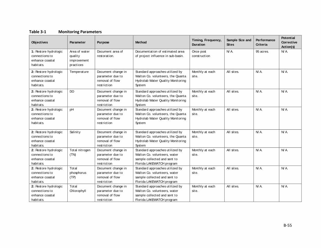
B-55
Table 3-1 Monitoring Parameters
Objectives Parameter Purpose Method Timing, Frequency, Duration
Sample Size and Sites
Performance Criteria
Potential Corrective Action(s)
1: Restore hydrologic connections to enhance coastal habitats.
Area of water quality improvement practices
Document area of restoration.
Documentation of estimated area of project influence in sub-basin.
Once post construction
N/A. 95 acres. N/A.
2: Restore hydrologic connections to enhance coastal habitats.
Temperature Document change in parameter due to removal of flow restriction
Standard approaches utilized by Walton Co. volunteers, the Quanta Hydrolab Water Quality Monitoring System
Monthly at each site.
All sites. N/A. N/A.
2: Restore hydrologic connections to enhance coastal habitats.
DO Document change in parameter due to removal of flow restriction
Standard approaches utilized by Walton Co. volunteers, the Quanta Hydrolab Water Quality Monitoring System
Monthly at each site.
All sites. N/A. N/A.
2: Restore hydrologic connections to enhance coastal habitats.
pH Document change in parameter due to removal of flow restriction
Standard approaches utilized by Walton Co. volunteers, the Quanta Hydrolab Water Quality Monitoring System
Monthly at each site.
All sites. N/A. N/A.
2: Restore hydrologic connections to enhance coastal habitats.
Salinity Document change in parameter due to removal of flow restriction
Standard approaches utilized by Walton Co. volunteers, the Quanta Hydrolab Water Quality Monitoring System
Monthly at each site.
All sites. N/A. N/A.
2: Restore hydrologic connections to enhance coastal habitats.
Total nitrogen (TN)
Document change in parameter due to removal of flow restriction
Standard approaches utilized by Walton Co. volunteers, water sample collected and sent to Florida LAKEWATCH program
Monthly at each site.
All sites. N/A. N/A.
2: Restore hydrologic connections to enhance coastal habitats.
Total phosphorus (TP)
Document change in parameter due to removal of flow restriction
Standard approaches utilized by Walton Co. volunteers, water sample collected and sent to Florida LAKEWATCH program
Monthly at each site.
All sites. N/A. N/A.
2: Restore hydrologic connections to enhance coastal habitats.
Total Chlorophyll
Document change in parameter due to removal of flow restriction
Standard approaches utilized by Walton Co. volunteers, water sample collected and sent to Florida LAKEWATCH program
Monthly at each site.
All sites. N/A. N/A.
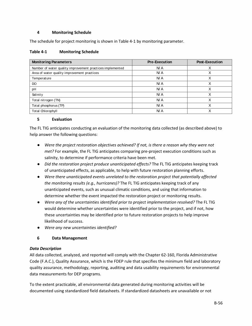
B-56
4 Monitoring Schedule
The schedule for project monitoring is shown in Table 4-1 by monitoring parameter.
Table 4-1 Monitoring Schedule
Monitoring Parameters Pre-Execution Post-Execution
Number of water quality improvement practices implemented N/A X Area of water quality improvement practices N/A X Temperature N/A X DO N/A X pH N/A X Salinity N/A X Total nitrogen (TN) N/A X Total phosphorus (TP) N/A X Total Chlorophyll N/A X
5 Evaluation
The FL TIG anticipates conducting an evaluation of the monitoring data collected (as described above) to help answer the following questions:
● Were the project restoration objectives achieved? If not, is there a reason why they were not met? For example, the FL TIG anticipates comparing pre-project execution conditions such as salinity, to determine if performance criteria have been met.
● Did the restoration project produce unanticipated effects? The FL TIG anticipates keeping track of unanticipated effects, as applicable, to help with future restoration planning efforts.
● Were there unanticipated events unrelated to the restoration project that potentially affected the monitoring results (e.g., hurricanes)? The FL TIG anticipates keeping track of any unanticipated events, such as unusual climatic conditions, and using that information to determine whether the event impacted the restoration project or monitoring results.
● Were any of the uncertainties identified prior to project implementation resolved? The FL TIG would determine whether uncertainties were identified prior to the project, and if not, how these uncertainties may be identified prior to future restoration projects to help improve likelihood of success.
● Were any new uncertainties identified?
6 Data Management
Data Description All data collected, analyzed, and reported will comply with the Chapter 62-160, Florida Administrative Code (F.A.C.), Quality Assurance, which is the FDEP rule that specifies the minimum field and laboratory quality assurance, methodology, reporting, auditing and data usability requirements for environmental data measurements for DEP programs.
To the extent practicable, all environmental data generated during monitoring activities will be documented using standardized field datasheets. If standardized datasheets are unavailable or not
B-57
readily amendable to record project-specific data, then project-specific datasheets will be drafted prior to conducting any project monitoring activities. Original hardcopy datasheets and notebooks and photographs will be retained by the Implementing Trustee.
Relevant project data that are handwritten on hardcopy datasheets or notebooks will be transcribed (entered) into standard digital format. All field datasheets and notebook entries will be scanned to PDF files. Electronic data files should be named with the date on which the file was created and should include a ReadMe file that describes when the file was created and by whom, and any explanatory notes on the file contents. If a data file is revised, a new copy should be made and the original preserved.
All data will have properly documented FGDC/ISO metadata, a data dictionary (defines codes and fields used in the dataset), and/or a Readme file as appropriate (e.g., how data was collected, QA/QC procedures, other information about data such as meaning, relationships to other data, origin, usage, and format – can reference different documents).
Data Review and Clearance Relevant project data that are handwritten on hardcopy datasheets or notebooks will be transcribed (entered) into standard digital format. After transcription of the data, the electronic data sheets will be verified against the original hardcopy datasheets and/or notebooks, and will make any corrections to transcription errors as appropriate before data are used for any analyses or distributed outside of the agency. Implementing Trustees will verify and validate MAM data and information and will ensure that all data are: i) entered or converted into agreed upon/commonly used digital format; ii) labeled with metadata following FGDC/ISO standards to the extent practicable and in accordance with Implementing Trustee agency requirements.
After any and all identified errors are addressed, data are considered to be QA/QC’ed. The implementing Trustee will give the other TIG members time to review the data before making such information publicly available (as described below). Before submitting the monitoring data and information package, co-Implementing Trustees shall confirm with one another that the package is approved for submission.
Data Storage and Accessibility Once all data has been QA/QC’ed it will be submitted to the Restoration Portal. Trustees will provide DWH NRDA MAM data and information to the Restoration Portal as soon as possible and no more than one year from when data are collected.
CBA currently houses water quality data in the Water Quality Portal.1 All of the data collected through 2015 is available in the portal. CBA is working to adjust the format of the data to be compatible with the Florida Watershed Information Network data management platform to allow for data publication in the Water Quality Portal moving forward.
1 https://www.epa.gov/waterdata/water-quality-data-wqx
B-58
Data Sharing Data will be made publicly available, in accordance with the Federal Open Data Policy, through the DIVER Explorer Interface within one year of when the data collection occurred.
7 Reporting
All reporting would occur after monitoring data collection efforts are complete. CBA provides annual reports to Walton County in June. The report would summarize the findings for the sampling period including all worksheets transferred into digital format and presented in tabular and graphical formats.
8 Roles and Responsibilities
Data will be reviewed and submitted to the Restoration Portal by FDEP project personnel.
B-59
Monitoring and Adaptive Management Plan for Deepwater Horizon NRDA Project:
WQ8, City of Port St. Joe Stormwater Improvements Prepared by: Nadia Martin (IEc) and FDEP; Draft Version Date: 1/21/2019
1 Introduction
This project MAM plan identifies the monitoring needed to evaluate progress toward meeting project objectives and to support any necessary adaptive management of the restoration project. Where applicable, it identifies key sources of uncertainty and incorporates monitoring data and decision points that address these uncertainties. As not all projects will have the same sources and degree of uncertainty, this project-specific MAM plan is scaled according to level of uncertainty, scope, scale, and restoration type associated with this project.
This MAM plan is a living document and may be updated as needed to reflect changing conditions and/or new information. Any future revisions to this document will be made publicly available through the Trustee Council Restoration Portal (https://www.diver.orr.noaa.gov/web/guest/home) and accessible through the DWH NRDA Trustees website (http://www.restoration.noaa.gov/dwh/storymap/).
Project Overview This project is being implemented as restoration for the DWH oil spill NRDA, consistent with the PDARP/PEIS.
• Programmatic Goal: Restore Water Quality • Restoration Type: Water Quality • Restoration Approach: Reduce pollution and hydrologic degradation to coastal
watersheds • Restoration Technique: Traditional stormwater control measures • TIG: FL TIG • Restoration Plan: Restoration Plan #1
This restoration project would be implemented within the City of Port St. Joe, Florida. Restoration activities include the engineering and design of traditional stormwater control measures (SCMs) and improvements to the existing conveyance system. Another objective of the project is to develop a stormwater master plan for the City of Port St. Joe, and the restoration actions and monitoring activities would help inform this master plan. SCMs are planned for a sub-basin covering approximately 280 acres draining to Patton Bayou and St. Joseph Bay. The project would include construction of approximately 2.5 acres of retrofit treatment pond area near 16th Street with an additional downstream outfall weir added to provide stormwater treatment capacity and improve water quality protection for St. Joseph Bay.
B-60
The implementing agency is FDEP. The partner agencies include the NWFWMD and the City of Port St. Joe.
Restoration Type Goals and Project Restoration Objectives The overall goals for this Restoration Type relevant to this project, as identified in the PDARP, are:
• Reduce pollutant loadings, including nutrients and pathogens, to priority watersheds along the Florida coast that are threatened by chronic eutrophication, harmful algal blooms, hypoxia, habitat losses, or beach and shellfish closures associated with water quality degradation;
• Mitigate high-volume flows and prevent dramatic shifts in salinity that threaten many coastal habitats and resources along the Gulf Coast;
• Where appropriate, co-locate pollutant reduction projects with other restoration projects to enhance ecological services provided by other restoration approaches (PDARP/PEIS Section 5.5.5.1).
The project restoration objectives are:
• Engineer and construct traditional SCMs and improvements within an existing conveyance system in the St. Joseph Bay watershed;
• Reduce pollutant loadings to specified performance criteria to improve water quality in the St. Joseph Bay watershed.
Performance criteria will be used to determine restoration success or the need for corrective action in accordance with 15 C.F.R. 990.55(b)(1)(vii)). Specific, measurable performance criteria are defined, as applicable, for monitoring parameters associated with each of the restoration objectives in Section 3.0.
2 Adaptive Management
Due to the nature of this project, and the use of standard Restoration Techniques that have been used successfully in similar projects, the FL TIG determined that adaptive management is unlikely to be necessary for this project. However, monitoring would be conducted, as described in Section 3, below. If the SCMs do not meet the stated performance criteria, potential corrective actions include the installation of additional SCMs, such as upstream baffle boxes, or additional littoral plantings within the pond to increase pollutant uptake. Additionally, the monitoring data collected and evaluated for this project component would be used in the development of the stormwater master plan for the City of St. Joe.
3 Project Monitoring, Performance Criteria, and Potential Corrective Actions
The proposed monitoring for this restoration project was developed to evaluate project performance, key uncertainties, and potential corrective actions, if needed. Information on each monitoring parameter is provided below, organized by objective (Table 3-1). Note that Table 3-1 does not include all possible options for corrective actions; rather, it includes a list of potential actions for each individual parameter to be considered if the project is not performing as expected once implemented. Other corrective actions may be identified post-implementation, as appropriate.
B-61
Table 3-1 Monitoring Parameters
Objectives Parameter Purpose Method Timing, Frequency, Duration
Sample Size and Sites
Performance Criteria
Potential Corrective Action(s)
1: Engineer and construct traditional SCMs and improvements within an existing conveyance system in the St. Joseph Bay watershed.
Infrastructure constructed and/or enhanced and completed as designed
Monitor progress (determine if SCMs are constructed as designed)
Review of as-built drawings and Professional Engineer Certification of Completion of Construction.
Once post construction. N/A. SCMs constructed are in substantial conformance with approved plans.
Reconstruct SCMs to be in substantial conformance with approved plans.
2: Reduce pollutant loadings to target levels and improve water quality in the St. Joseph Bay watershed.
Number of water quality improvement practices implemented
Document restoration actions
Count of the number of SCMs implemented.
Once after project execution is complete.
All SCMs implemented; all sites.
1. N/A.
2: Reduce pollutant loadings to target levels and improve water quality in the St. Joseph Bay watershed.
Area of water quality improvement practices
Document area of restoration
Documentation of estimated area of project influence in sub-basin.
Once post construction. N/A. N/A. N/A.
2: Reduce pollutant loadings to target levels and improve water quality in the St. Joseph Bay watershed.
Daily rainfall Determine if rainfall sufficient for sampling
Automated rain gauge, with verification from the local weather station.
Daily until 7-10 suitable storm events are sampled.
One site near constructed SCMs.
Suitable rain events for monitoring generally consist of greater than 0.20 inches and less than 1.5 inches of rain.
Adjust duration of sampling for a sufficient number (7-10) of sampling events
2: Reduce pollutant loadings to target levels and improve water quality in the St. Joseph Bay watershed.
Flow Help measure pollutant loadings (used along with concentrations)
Approved flow activated flow meters.
7-10 storm events. Inflows and outflows for each storm event from SCMs constructed.
N/A. Repair or replace flow meters.
2: Reduce pollutant loadings to target levels and improve water quality in the St. Joseph Bay
Total nitrogen (TN) Monitor progress in reducing pollutant loadings
Flow weighted composite samples taken over the storm hydrograph.
7-10 storm events; typically, the samples will be composited over the inflow hydrograph at the inflow and for up to a 36-
Inflows and outflows for each storm event from SCMs constructed; each composite
Average of 25% reduction in pollutant loading (inflow versus outflow) over the 7-
Potential actions would vary depending on deviation from specified performance criteria, but could include baffle
B-62
Objectives Parameter Purpose Method Timing, Frequency, Duration
Sample Size and Sites
Performance Criteria
Potential Corrective Action(s)
watershed. hour period at outflow station, depending upon the time of concentration and flow into and out of the SCM.
would include at least 6 evenly distributed sub-samples.
10 storm events monitored.
boxes, or additional plantings within the pond to increase pollutant removals.
2: Reduce pollutant loadings to target levels and improve water quality in the St. Joseph Bay watershed.
Total phosphorus (TP)
Monitor progress in reducing pollutant loadings
Flow weighted composite samples taken over the storm hydrograph.
7-10 storm events; typically, the samples would be composited over the inflow hydrograph at the inflow and for up to a 36-hour period at outflow station, depending upon the time of concentration and flow into and out of the SCM.
Inflows and outflows for each storm event from SCMs constructed; each composite would include at least 6 evenly distributed sub-samples.
Average of 50% reduction in pollutant loading (inflow versus outflow) over the 7-10 storm events monitored.
Potential actions would vary depending on deviation from specified performance criteria, but could include baffle boxes, or additional plantings within the pond to increase pollutant removals.
B-63
Monitoring for this project would include sampling from seven to ten storm events. If possible, monitored events would be discrete rainfall events generally consisting of greater than 0.20 inches and less than 1.5 inches of rain. However, this would depend on field conditions and storm events; actual rainfall may vary as well as the drainage area, amount of impervious area, and time of concentration. Monitoring would generally be conducted at two locations: inflows and outflows.
4 Monitoring Schedule
The schedule for project monitoring is shown in Table 4-1 by monitoring parameter.
Table 4-1 Monitoring Schedule
Monitoring Parameters Pre-Execution Post-Execution1
Infrastructure constructed and/or enhanced and completed as designed
N/A X
Number of water quality improvement practices implemented N/A X Area of water quality improvement practices N/A X Daily rainfall N/A X Flow N/A X Total nitrogen (TN) N/A X Total phosphorus (TP) N/A X 1 Schedule for post-execution monitoring would depend on rainfall and storm events.
5 Evaluation
As-built drawings would be compared to approved design drawings to determine the magnitude of any deviations from the approved plans. SCMs, total nitrogen and total phosphorus input and output loadings would be determined from the monitoring results and averaged over the 7-10 storm events to determine the percent reduction of pollutants across the SCMs. The calculated average percent reductions would be compared with the specified performance criteria.
The FL TIG anticipates conducting an evaluation of the monitoring data collected (as described above) to help answer the following questions:
• Were the project restoration objectives achieved? If not, is there a reason why they were not met? For example, the FL TIG anticipates comparing inflow and outflow data to determine whether water quality (including TN and TP levels) performance criteria has been met.
• Did the restoration project produce unanticipated effects? The FL TIG anticipates keeping track of unanticipated effects, as applicable, to help with future restoration planning efforts.
• Were there unanticipated events unrelated to the restoration project that potentially affected the monitoring results (e.g., hurricanes)? The FL TIG anticipates keeping track of any unanticipated events, such as unusual climatic conditions, and using that information to determine whether the event impacted the restoration project or monitoring results.
• Were any of the uncertainties identified prior to project implementation resolved? The FL TIG would determine whether uncertainties were identified prior to the project, and if not, how these uncertainties may be identified prior to future restoration projects to help improve
B-64
likelihood of success. • Were any new uncertainties identified?
6 Data Management
Data Description All data collected, analyzed, and reported will comply with the Chapter 62-160, Florida Administrative Code (F.A.C.), Quality Assurance, which is the FDEP rule that specifies the minimum field and laboratory quality assurance, methodology, reporting, auditing and data usability requirements for environmental data measurements for DEP programs.
Rainfall data collection will occur after implementation of the SCMs, and water quality will be sampled during each of the storm events. Rainfall data collection will occur at a site near the constructed SCMs and the flow-weighted water quality samples will be collected at suitable SCMs input and output location.
To the extent practicable, all environmental and biological data generated during monitoring activities will be documented using standardized field datasheets. If standardized datasheets are unavailable or not readily amendable to record Project-specific data, then Project-specific datasheets will be drafted prior to conducting any Project monitoring activities. Original hardcopy datasheets and notebooks and photographs will be retained by the Implementing Trustee.
Relevant Project data that are handwritten on hardcopy datasheets or notebooks will be transcribed (entered) into standard digital format. All field datasheets and notebook entries will be scanned to PDF files. Electronic data files should be named with the date on which the file was created and should include a ReadMe file that describes when the file was created and by whom, and any explanatory notes on the file contents. If a data file is revised, a new copy should be made and the original preserved.
All data will have properly documented FGDC/ISO metadata, a data dictionary (defines codes and fields used in the dataset), and/or a Readme file as appropriate (e.g., how data was collected, QA/QC procedures, other information about data such as meaning, relationships to other data, origin, usage, and format – can reference different documents).
Data Review and Clearance Relevant Project data that are handwritten on hardcopy datasheets or notebooks will be transcribed (entered) into standard digital format. After transcription of the data, the electronic data sheets will be verified against the original hardcopy datasheets and/or notebooks, and will make any corrections to transcription errors as appropriate before data are used for any analyses or distributed outside of the agency. Implementing Trustees will verify and validate MAM data and information and will ensure that all data is i) entered or converted into agreed upon/commonly used digital format; ii) labeled with metadata following FGDC/ISO standards to the extent practicable and in accordance with Implementing Trustee agency requirements.
B-65
After any and all identified errors are addressed, data are considered to be QA/QC’ed. The implementing Trustee will give the other TIG members time to review the data before making such information publicly available (as described below). Before submitting the monitoring data and information package, co-Implementing Trustees shall confirm with one another that the package is approved for submission.
Data Storage and Accessibility Once all data has been QA/QC’ed it will be submitted to the Restoration Portal. Trustees will provide DWH NRDA MAM data and information to the Restoration Portal as soon as possible and no more than one year from when data are collected.
Data Sharing Data will be made publicly available, in accordance with the Federal Open Data Policy, through the DIVER Explorer Interface within one year of when the data collection occurred.
7 Reporting
Once all data have been reviewed for accuracy and completeness, they will be submitted to the Restoration Portal. Data will be made publicly available through the DIVER Explorer Interface.
8 Roles and Responsibilities
Data will be reviewed and submitted to the Restoration Portal by FDEP project personnel.
B-66
Monitoring and Adaptive Management Plan for Deepwater Horizon NRDA Project:
WQ10, City of Carrabelle’s Lighthouse Estates: Septic Tank Abatement - Phase II
Prepared by: Nadia Martin (IEc) and FDEP; Draft Version Date: 1/21/2019
1 Introduction
This project MAM plan identifies the monitoring needed to evaluate progress toward meeting project objectives and to support any necessary adaptive management of the restoration project. Where applicable, it identifies key sources of uncertainty and incorporates monitoring data and decision points that address these uncertainties. As not all projects will have the same sources and degree of uncertainty, this project-specific MAM plan is scaled according to level of uncertainty, scope, scale, and restoration type associated with this project.
This MAM plan is a living document and may be updated as needed to reflect changing conditions and/or new information. Any future revisions to this document will be made publicly available through the Trustee Council Restoration Portal (https://www.diver.orr.noaa.gov/web/guest/home) and accessible through the DWH NRDA Trustees website (http://www.restoration.noaa.gov/dwh/storymap/).
Project Overview This project is being implemented as restoration for the DWH oil spill NRDA, consistent with the PDARP/PEIS.
• Programmatic Goal: Restore Water Quality • Restoration Type Water Quality • Restoration Approach: Reduce pollution and hydrologic degradation to coastal
watersheds • Restoration Technique: Septic tank abandonment and connection of homes to regional
sewage collection system • TIG: FL TIG • Restoration Plan: Restoration Plan #1
This restoration project would be implemented southwest of the City of Carrabelle, Franklin County, Florida. The project aims to improve water quality in Apalachicola Bay and St. George Sound by connecting homes near the bay currently served by septic systems to a central wastewater treatment system.
The implementing agency is FDEP. The other partner agency is City of Carrabelle and NWFWMD.
B-67
Restoration Type Goals and Project Restoration Objectives The overall goals for this Restoration Type relevant to this project, as identified in the PDARP, are:
• Reduce pollutant loadings, including nutrients and pathogens, to priority watersheds along the Florida coast that are threatened by chronic eutrophication, harmful algal blooms, hypoxia, habitat losses, or beach and shellfish closures associated with water quality degradation;
• Mitigate high-volume flows and prevent dramatic shifts in salinity that threaten many coastal habitats and resources along the Gulf Coast;
• Where appropriate, co-locate pollutant reduction projects with other restoration projects to enhance ecological services provided by other restoration approaches (PDARP/PEIS Section 5.5.5.1).
The project restoration objectives are:
• Reduce pollution to coastal watersheds. • Reduce pathogen concentrations and/or exposures.
Performance criteria will be used to determine restoration success or the need for corrective action in accordance with 15 C.F.R. 990.55(b)(1)(vii)). Specific, measurable performance criteria are defined, as applicable, for monitoring parameters associated with each of the restoration objectives in Section 3.0.
2 Adaptive Management
Due to the nature of this project, and the use of standard approaches and Restoration Techniques that have been successfully implemented in similar projects, the FL TIG does not anticipate the need for rigorous adaptive management of the project. If project objectives are not being met, the FL TIG will identify corrective actions as necessary.
3 Project Monitoring, Performance Criteria, and Potential Corrective Actions
The proposed monitoring plan for this restoration project was developed to evaluate project performance, key uncertainties, and potential corrective actions, if needed. For additional details on the sampling efforts at Carrabelle Beach, see the Florida Healthy Beaches Program website.2
The proposed monitoring for this restoration project was developed to evaluate project performance, key uncertainties, and potential corrective actions, if needed. Information on each monitoring parameter is provided below, organized by objective (Table 3-1). Note that Table 3-1 does not include all possible options for corrective actions; rather, it includes a list of potential actions for each individual parameter to be considered if the project is not performing as expected once implemented. Other corrective actions may be identified post-implementation, as appropriate.
2 http://www.floridahealth.gov/environmental-health/beach-water-quality/beach-detail.html?County=Franklin&SPLocation=CARRABELLE%20BEACH&SPNo=&SPLat=29.82905455&SPLong=-84.69273643 and for additional details see: http://www.floridahealth.gov/environmental-health/beach-water-quality/index.html
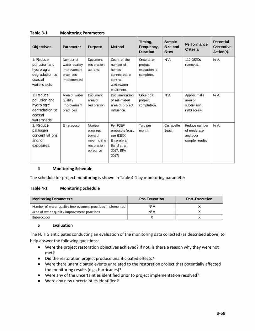
B-68
Table 3-1 Monitoring Parameters
Objectives Parameter Purpose Method Timing, Frequency, Duration
Sample Size and Sites
Performance Criteria
Potential Corrective Action(s)
1: Reduce pollution and hydrologic degradation to coastal watersheds.
Number of water quality improvement practices implemented
Document restoration actions.
Count of the number of homes connected to central wastewater treatment.
Once after project execution is complete.
N/A. 110 OSTDs removed.
N/A.
1: Reduce pollution and hydrologic degradation to coastal watersheds.
Area of water quality improvement practices
Document area of restoration.
Documentation of estimated area of project influence.
Once post project completion.
N/A. Approximate area of subdivision (900 acres).
N/A.
2: Reduce pathogen concentrations and/or exposures.
Enterococci Monitor progress toward meeting the restoration objective
Per FDEP protocols (e.g., see IDEXX Enterolert; Baird et al. 2017, EPA 2017)
Two per month.
Carrabelle Beach
Reduce number of moderate and poor sample results.
N/A.
4 Monitoring Schedule
The schedule for project monitoring is shown in Table 4-1 by monitoring parameter.
Table 4-1 Monitoring Schedule
Monitoring Parameters Pre-Execution Post-Execution
Number of water quality improvement practices implemented N/A X Area of water quality improvement practices N/A X Enterococci X X
5 Evaluation
The FL TIG anticipates conducting an evaluation of the monitoring data collected (as described above) to help answer the following questions:
● Were the project restoration objectives achieved? If not, is there a reason why they were not met?
● Did the restoration project produce unanticipated effects? ● Were there unanticipated events unrelated to the restoration project that potentially affected
the monitoring results (e.g., hurricanes)? ● Were any of the uncertainties identified prior to project implementation resolved? ● Were any new uncertainties identified?
B-69
6 Data Management
Data Description This project will use sample results from the Florida Department of Health (FDOH) Florida Healthy Beaches Program – see http://www.floridahealth.gov/environmental-health/beach-water-quality/index.html
This project will use sample results from the Carrabelle Beach sampling station, nearby to the Lighthouse Estates subdivision and the closest beach swimming area. Samples are collected at least twice per month. Sample results are reported as Enterococci per 100 milliliters of marine water.
Sample results are then categorized as good, moderate, or poor as follows:
Good = 0-35 Enterococci per 100 milliliters of marine water
Moderate = 36-70 Enterococci per 100 milliliters of marine water
Poor = 71 or greater Enterococci per 100 milliliters of marine water
The FL TIG will rely on the results presented from the DOH website to compare the frequency of moderate and poor sampling results pre-project to those post-project implementation.
Data Review and Clearance After transcription of the data into the summary reports, the data in the summary reports will be verified against the DOH website data, and will make any corrections to transcription errors as appropriate before data are used for any analyses or distributed outside of the agency. Implementing Trustees will verify and validate MAM data and information and will ensure that all data are: i) entered or converted into agreed upon/commonly used digital format; ii) labeled with metadata following FGDC/ISO standards to the extent practicable and in accordance with Implementing Trustee agency requirements.
After any and all identified errors are addressed, data are considered to be QA/QC’ed. The implementing Trustee will give the other TIG members time to review the data before making such information publicly available (as described below). Before submitting the monitoring data and information package, co-Implementing Trustees shall confirm with one another that the package is approved for submission.
Data Storage and Accessibility Once all data have been QA/QC’ed, they will be submitted to the Restoration Portal. Trustees will provide DWH NRDA MAM data and information to the Restoration Portal as soon as possible and no more than one year from when data are collected.
Data Sharing Data will be made publicly available, in accordance with the Federal Open Data Policy, through the DIVER Explorer Interface within one year of when the data collection occurred.
B-70
7 Reporting
Summary reports will be prepared from the sample results from the DOH website. The summary reports would include summaries of the findings for the reporting period, presented in narrative, tabular and graphical formats.
8 Roles and Responsibilities
Data will be reviewed and submitted to the Restoration Portal by FDEP project personnel.
9 References
Baird, E.W., A.D. Eaton, and E.W. Rice. 2017. Standard Methods for the Examination of Water and Wastewater, 23rd Edition. American Public Health Association, American Water Works Association, and Water Environmental Federation.
EPA (United States Environmental Protection Agency). 2017. Clean Water Act Methods Update Rule – Final Rule. Table 1H – List of Approved Microbiological Methods for Ambient Water. Federal Register, Vol. 82, No. 165, August 28. pp. 40867–408768.
B-71
Monitoring and Adaptive Management Plan for Deepwater Horizon NRDA Project:
REC3, Perdido River and Bay Paddle Trail Prepared by: Nadia Martin (IEc) and FDEP; Draft Version Date: 1/21/2019
1 Introduction
This project MAM plan identifies the monitoring needed to evaluate progress toward meeting project objectives and to support any necessary adaptive management of the restoration project. Where applicable, it identifies key sources of uncertainty and incorporates monitoring data and decision points that address these uncertainties. As not all projects will have the same sources and degree of uncertainty, this project-specific MAM plan is scaled according to level of uncertainty, scope, scale, and restoration type associated with this project.
This MAM plan is a living document and may be updated as needed to reflect changing conditions and/or new information. Any future revisions to this document will be made publicly available through the Trustee Council Restoration Portal (https://www.diver.orr.noaa.gov/web/guest/home) and accessible through the DWH NRDA Trustees website (http://www.restoration.noaa.gov/dwh/storymap/).
Project Overview This project is being implemented as restoration for the DWH oil spill NRDA, consistent with the PDARP/PEIS.
• Programmatic Goal: Provide and Enhance Recreational Opportunities • Restoration Type: Provide and Enhance Recreational Opportunities • Restoration Approach: Enhance public access to natural resources for recreational use • Restoration Technique: Construction or enhancement of recreational infrastructure • TIG: FL TIG • Restoration Plan: Restoration Plan #1
This restoration project would be implemented at multiple sites along the Perdido River, Escambia County, Florida. The project includes actions to provide and enhance recreational opportunities along Perdido River by constructing additional recreational access and amenities at multiple locations along the Florida side of the river. This project is intended to enhance public access by providing access to recreational areas with no existing recreational access (i.e., Heron Bayou), by providing improved water access amenities (i.e., shelters), and by providing water access in a location with no current public access (i.e., Heron Bayou).
The implementing agency is FDEP. The partner agencies include the Nature Conservancy (TNC, Florida), Northwest Florida Water Management District (NWFWMD), and Escambia County.
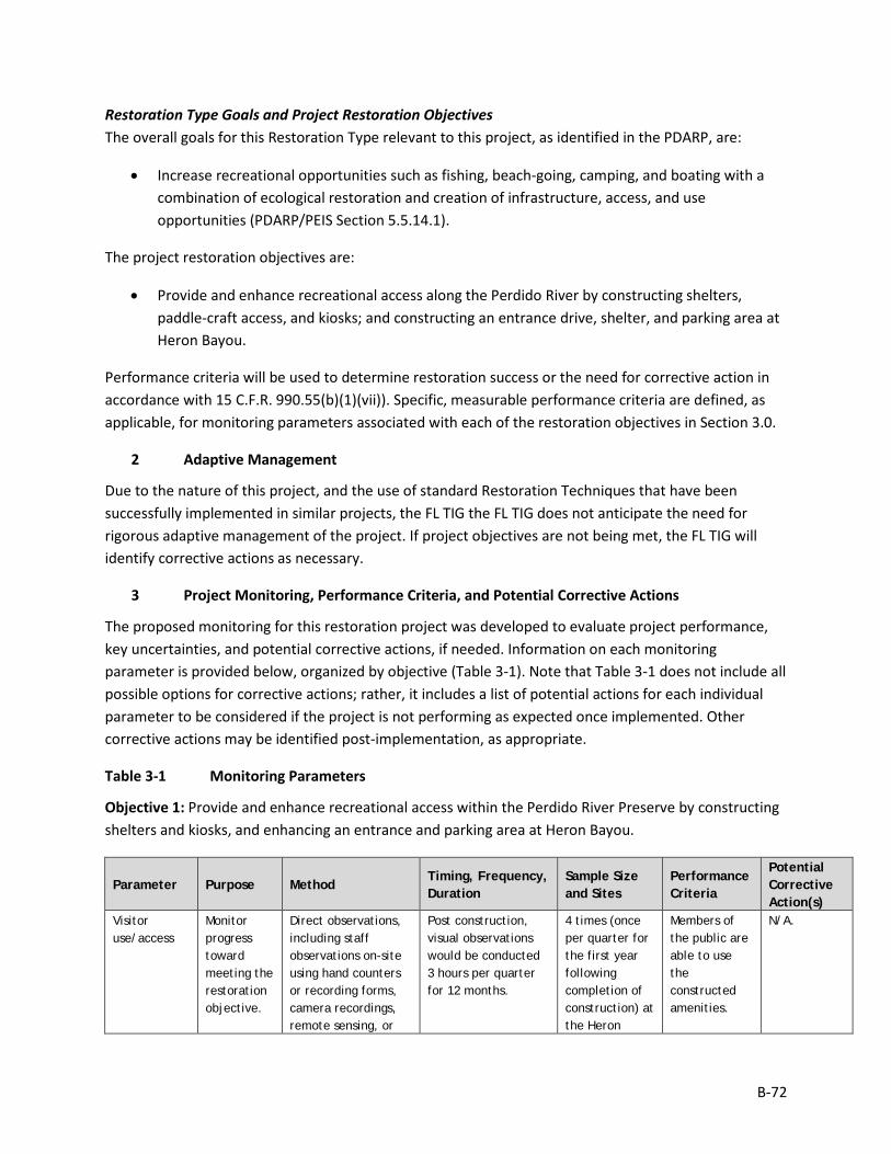
B-72
Restoration Type Goals and Project Restoration Objectives The overall goals for this Restoration Type relevant to this project, as identified in the PDARP, are:
• Increase recreational opportunities such as fishing, beach-going, camping, and boating with a combination of ecological restoration and creation of infrastructure, access, and use opportunities (PDARP/PEIS Section 5.5.14.1).
The project restoration objectives are:
• Provide and enhance recreational access along the Perdido River by constructing shelters, paddle-craft access, and kiosks; and constructing an entrance drive, shelter, and parking area at Heron Bayou.
Performance criteria will be used to determine restoration success or the need for corrective action in accordance with 15 C.F.R. 990.55(b)(1)(vii)). Specific, measurable performance criteria are defined, as applicable, for monitoring parameters associated with each of the restoration objectives in Section 3.0.
2 Adaptive Management
Due to the nature of this project, and the use of standard Restoration Techniques that have been successfully implemented in similar projects, the FL TIG the FL TIG does not anticipate the need for rigorous adaptive management of the project. If project objectives are not being met, the FL TIG will identify corrective actions as necessary.
3 Project Monitoring, Performance Criteria, and Potential Corrective Actions
The proposed monitoring for this restoration project was developed to evaluate project performance, key uncertainties, and potential corrective actions, if needed. Information on each monitoring parameter is provided below, organized by objective (Table 3-1). Note that Table 3-1 does not include all possible options for corrective actions; rather, it includes a list of potential actions for each individual parameter to be considered if the project is not performing as expected once implemented. Other corrective actions may be identified post-implementation, as appropriate.
Table 3-1 Monitoring Parameters
Objective 1: Provide and enhance recreational access within the Perdido River Preserve by constructing shelters and kiosks, and enhancing an entrance and parking area at Heron Bayou.
Parameter Purpose Method Timing, Frequency, Duration
Sample Size and Sites
Performance Criteria
Potential Corrective Action(s)
Visitor use/access
Monitor progress toward meeting the restoration objective.
Direct observations, including staff observations on-site using hand counters or recording forms, camera recordings, remote sensing, or
Post construction, visual observations would be conducted 3 hours per quarter for 12 months.
4 times (once per quarter for the first year following completion of construction) at the Heron
Members of the public are able to use the constructed amenities.
N/A.
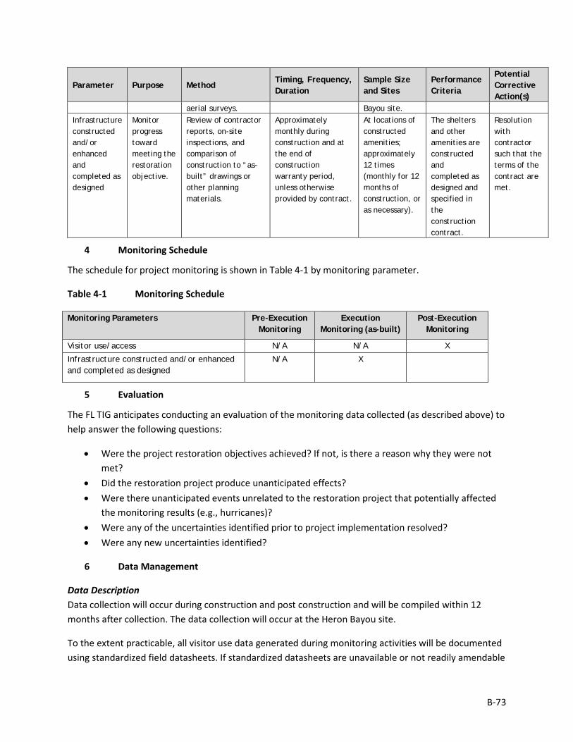
B-73
Parameter Purpose Method Timing, Frequency, Duration
Sample Size and Sites
Performance Criteria
Potential Corrective Action(s)
aerial surveys. Bayou site. Infrastructure constructed and/or enhanced and completed as designed
Monitor progress toward meeting the restoration objective.
Review of contractor reports, on-site inspections, and comparison of construction to “as-built” drawings or other planning materials.
Approximately monthly during construction and at the end of construction warranty period, unless otherwise provided by contract.
At locations of constructed amenities; approximately 12 times (monthly for 12 months of construction, or as necessary).
The shelters and other amenities are constructed and completed as designed and specified in the construction contract.
Resolution with contractor such that the terms of the contract are met.
4 Monitoring Schedule
The schedule for project monitoring is shown in Table 4-1 by monitoring parameter.
Table 4-1 Monitoring Schedule
Monitoring Parameters Pre-Execution Monitoring
Execution Monitoring (as-built)
Post-Execution Monitoring
Visitor use/access N/A N/A X
Infrastructure constructed and/or enhanced and completed as designed
N/A X
5 Evaluation
The FL TIG anticipates conducting an evaluation of the monitoring data collected (as described above) to help answer the following questions:
• Were the project restoration objectives achieved? If not, is there a reason why they were not met?
• Did the restoration project produce unanticipated effects? • Were there unanticipated events unrelated to the restoration project that potentially affected
the monitoring results (e.g., hurricanes)? • Were any of the uncertainties identified prior to project implementation resolved? • Were any new uncertainties identified?
6 Data Management
Data Description Data collection will occur during construction and post construction and will be compiled within 12 months after collection. The data collection will occur at the Heron Bayou site.
To the extent practicable, all visitor use data generated during monitoring activities will be documented using standardized field datasheets. If standardized datasheets are unavailable or not readily amendable

B-74
to record Project-specific data, then Project-specific datasheets will be drafted prior to conducting any Project monitoring activities. Original hardcopy datasheets and notebooks and photographs will be retained by the Implementing Trustee.
Relevant Project data that are handwritten on hardcopy datasheets or notebooks will be transcribed (entered) into standard digital format. All field datasheets and notebook entries will be scanned to PDF files. Electronic data files should be named with the date on which the file was created and should include a ReadMe file that describes when the file was created and by whom, and any explanatory notes on the file contents. If a data file is revised, a new copy should be made and the original preserved.
All data will have properly documented FGDC/ISO metadata, a data dictionary (defines codes and fields used in the dataset), and/or a Readme file as appropriate (e.g., how data was collected, QA/QC procedures, other information about data such as meaning, relationships to other data, origin, usage, and format – can reference different documents).
Data Review and Clearance Relevant Project data that are handwritten on hardcopy datasheets or notebooks will be transcribed (entered) into standard digital format. After transcription of the data, the electronic data sheets will be verified against the original hardcopy datasheets and/or notebooks, and will make any corrections to transcription errors as appropriate before data are used for any analyses or distributed outside of the agency. Implementing Trustees will verify and validate MAM data and information and will ensure that all data is i) entered or converted into agreed upon/commonly used digital format; ii) labeled with metadata following FGDC/ISO standards to the extent practicable and in accordance with Implementing Trustee agency requirements.
After any and all identified errors are addressed, data are considered to be QA/QC’ed. The implementing Trustee will give the other TIG members time to review the data before making such information publicly available (as described below). Before submitting the monitoring data and information package, co-Implementing Trustees shall confirm with one another that the package is approved for submission.
Data Storage and Accessibility Once all data has been QA/QC’ed it will be submitted to the Restoration Portal. Trustees will provide DWH NRDA MAM data and information to the Restoration Portal as soon as possible and no more than one year from when data are collected.
Data Sharing Data will be made publicly available, in accordance with the Federal Open Data Policy, through the DIVER Explorer Interface within one year of when the data collection occurred.
7 Reporting
Once all data have been reviewed for accuracy and completeness, they will be submitted to the Restoration Portal. Data will be made publicly available through the DIVER Explorer Interface.

B-75
8 Roles and Responsibilities
Data will be reviewed and submitted to the Restoration Portal by FDEP project personnel.
B-76
Monitoring and Adaptive Management Plan for Deepwater Horizon NRDA Project:
REC4, Carpenter Creek Headwaters Park Amenities Prepared by: Nadia Martin (IEc) and FDEP; Draft Version Date: 1/21/2019
1 Introduction
This project MAM plan identifies the monitoring needed to evaluate progress toward meeting project objectives and to support any necessary adaptive management of the restoration project. Where applicable, it identifies key sources of uncertainty and incorporates monitoring data and decision points that address these uncertainties. As not all projects will have the same sources and degree of uncertainty, this project-specific MAM plan is scaled according to level of uncertainty, scope, scale, and restoration type associated with this project.
This MAM plan is a living document and may be updated as needed to reflect changing conditions and/or new information. Any future revisions to this document will be made publicly available through the Trustee Council Restoration Portal (https://www.diver.orr.noaa.gov/web/guest/home) and accessible through the DWH NRDA Trustees website (http://www.restoration.noaa.gov/dwh/storymap/).
Project Overview This project is being implemented as restoration for the DWH oil spill NRDA, consistent with the PDARP/PEIS.
• Programmatic Goal: Provide and Enhance Recreational Opportunities • Restoration Type: Provide and Enhance Recreational Opportunities • Restoration Approach: Enhance public access to natural resources for recreational use • Restoration Technique: Construction or enhancement of recreational infrastructure • TIG: FL TIG • Restoration Plan: Restoration Plan #1
This restoration project would be implemented within the City of Pensacola, Escambia County, Florida. This project involves the construction of a public park at the headwaters of Carpenter Creek which includes a trail, paddle-craft launch, passive recreation area, parking area, and educational signage. This project is intended to provide and enhance public access to recreational opportunities by providing a new recreational opportunity in an area with no current recreational access.
The implementing agency is FDEP in coordination with Escambia County Natural Resources Management Department. Other project partners include the City of Pensacola, Pensacola and Perdido Bays Estuary Program, Emerald Coastkeeper, UWF, Bayou Texar Foundation, UF IFAS Extension, Washington High School Marine Science Academy, Bream Fishermen Association, and the Audubon Society (Florida Chapter).
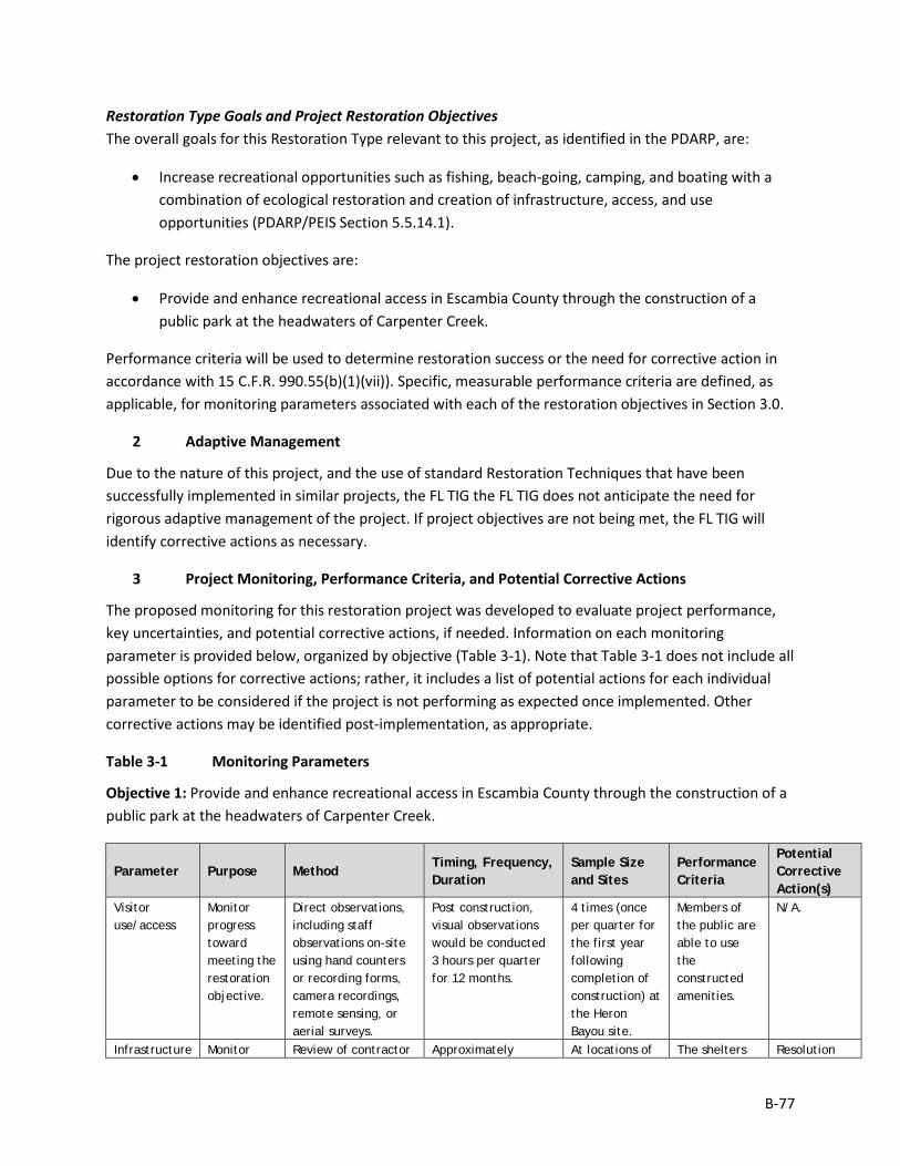
B-77
Restoration Type Goals and Project Restoration Objectives The overall goals for this Restoration Type relevant to this project, as identified in the PDARP, are:
• Increase recreational opportunities such as fishing, beach-going, camping, and boating with a combination of ecological restoration and creation of infrastructure, access, and use opportunities (PDARP/PEIS Section 5.5.14.1).
The project restoration objectives are:
• Provide and enhance recreational access in Escambia County through the construction of a public park at the headwaters of Carpenter Creek.
Performance criteria will be used to determine restoration success or the need for corrective action in accordance with 15 C.F.R. 990.55(b)(1)(vii)). Specific, measurable performance criteria are defined, as applicable, for monitoring parameters associated with each of the restoration objectives in Section 3.0.
2 Adaptive Management
Due to the nature of this project, and the use of standard Restoration Techniques that have been successfully implemented in similar projects, the FL TIG the FL TIG does not anticipate the need for rigorous adaptive management of the project. If project objectives are not being met, the FL TIG will identify corrective actions as necessary.
3 Project Monitoring, Performance Criteria, and Potential Corrective Actions
The proposed monitoring for this restoration project was developed to evaluate project performance, key uncertainties, and potential corrective actions, if needed. Information on each monitoring parameter is provided below, organized by objective (Table 3-1). Note that Table 3-1 does not include all possible options for corrective actions; rather, it includes a list of potential actions for each individual parameter to be considered if the project is not performing as expected once implemented. Other corrective actions may be identified post-implementation, as appropriate.
Table 3-1 Monitoring Parameters
Objective 1: Provide and enhance recreational access in Escambia County through the construction of a public park at the headwaters of Carpenter Creek.
Parameter Purpose Method Timing, Frequency, Duration
Sample Size and Sites
Performance Criteria
Potential Corrective Action(s)
Visitor use/access
Monitor progress toward meeting the restoration objective.
Direct observations, including staff observations on-site using hand counters or recording forms, camera recordings, remote sensing, or aerial surveys.
Post construction, visual observations would be conducted 3 hours per quarter for 12 months.
4 times (once per quarter for the first year following completion of construction) at the Heron Bayou site.
Members of the public are able to use the constructed amenities.
N/A.
Infrastructure Monitor Review of contractor Approximately At locations of The shelters Resolution

B-78
Parameter Purpose Method Timing, Frequency, Duration
Sample Size and Sites
Performance Criteria
Potential Corrective Action(s)
constructed and/or enhanced and completed as designed
progress toward meeting the restoration objective.
reports, on-site inspections, and comparison of construction to “as-built” drawings or other planning materials.
monthly during construction and at the end of construction warranty period, unless otherwise provided by contract.
constructed amenities; approximately 12 times (monthly for 12 months of construction, or as necessary).
and other amenities are constructed and completed as designed and specified in the construction contract.
with contractor such that the terms of the contract are met.
4 Monitoring Schedule
The schedule for project monitoring is shown in Table 4-1 by monitoring parameter.
Table 4-1 Monitoring Schedule
Monitoring Parameters Pre-Execution Monitoring
Execution Monitoring (as-built)
Post-Execution Monitoring
Visitor use/access N/A N/A X
Infrastructure constructed and/or enhanced and completed as designed
N/A X
5 Evaluation
The FL TIG anticipates conducting an evaluation of the monitoring data collected (as described above) to help answer the following questions:
• Were the project restoration objectives achieved? If not, is there a reason why they were not met?
• Did the restoration project produce unanticipated effects? • Were there unanticipated events unrelated to the restoration project that potentially affected
the monitoring results (e.g., hurricanes)? • Were any of the uncertainties identified prior to project implementation resolved? • Were any new uncertainties identified?
6 Data Management
Data Description Data collection will occur during construction and post construction and will be compiled within 12 months after collection. The data collection will occur within the Park.
To the extent practicable, all visitor use data generated during monitoring activities will be documented using standardized field datasheets. If standardized datasheets are unavailable or not readily amendable to record Project-specific data, then Project-specific datasheets will be drafted prior to conducting any
B-79
Project monitoring activities. Original hardcopy datasheets and notebooks and photographs will be retained by the Implementing Trustee.
Relevant Project data that are handwritten on hardcopy datasheets or notebooks will be transcribed (entered) into standard digital format. All field datasheets and notebook entries will be scanned to PDF files. Electronic data files should be named with the date on which the file was created and should include a ReadMe file that describes when the file was created and by whom, and any explanatory notes on the file contents. If a data file is revised, a new copy should be made and the original preserved.
All data will have properly documented FGDC/ISO metadata, a data dictionary (defines codes and fields used in the dataset), and/or a Readme file as appropriate (e.g., how data was collected, QA/QC procedures, other information about data such as meaning, relationships to other data, origin, usage, and format – can reference different documents).
Data Review and Clearance Relevant Project data that are handwritten on hardcopy datasheets or notebooks will be transcribed (entered) into standard digital format. After transcription of the data, the electronic data sheets will be verified against the original hardcopy datasheets and/or notebooks, and will make any corrections to transcription errors as appropriate before data are used for any analyses or distributed outside of the agency. Implementing Trustees will verify and validate MAM data and information and will ensure that all data is i) entered or converted into agreed upon/commonly used digital format; ii) labeled with metadata following FGDC/ISO standards to the extent practicable and in accordance with Implementing Trustee agency requirements.
After any and all identified errors are addressed, data are considered to be QA/QC’ed. The implementing Trustee will give the other TIG members time to review the data before making such information publicly available (as described below). Before submitting the monitoring data and information package, co-Implementing Trustees shall confirm with one another that the package is approved for submission.
Data Storage and Accessibility Once all data has been QA/QC’ed it will be submitted to the Restoration Portal. Trustees will provide DWH NRDA MAM data and information to the Restoration Portal as soon as possible and no more than one year from when data are collected.
Data Sharing Data will be made publicly available, in accordance with the Federal Open Data Policy, through the DIVER Explorer Interface within one year of when the data collection occurred.
7 Reporting
Once all data have been reviewed for accuracy and completeness, they will be submitted to the Restoration Portal. Data will be made publicly available through the DIVER Explorer Interface.

B-80
8 Roles and Responsibilities
Data will be reviewed and submitted to the Restoration Portal by FDEP project personnel.
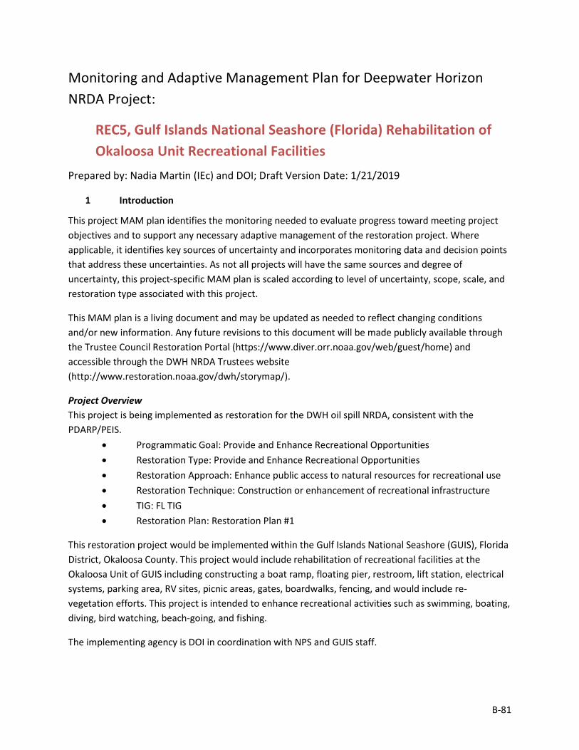
B-81
Monitoring and Adaptive Management Plan for Deepwater Horizon NRDA Project:
REC5, Gulf Islands National Seashore (Florida) Rehabilitation of Okaloosa Unit Recreational Facilities
Prepared by: Nadia Martin (IEc) and DOI; Draft Version Date: 1/21/2019
1 Introduction
This project MAM plan identifies the monitoring needed to evaluate progress toward meeting project objectives and to support any necessary adaptive management of the restoration project. Where applicable, it identifies key sources of uncertainty and incorporates monitoring data and decision points that address these uncertainties. As not all projects will have the same sources and degree of uncertainty, this project-specific MAM plan is scaled according to level of uncertainty, scope, scale, and restoration type associated with this project.
This MAM plan is a living document and may be updated as needed to reflect changing conditions and/or new information. Any future revisions to this document will be made publicly available through the Trustee Council Restoration Portal (https://www.diver.orr.noaa.gov/web/guest/home) and accessible through the DWH NRDA Trustees website (http://www.restoration.noaa.gov/dwh/storymap/).
Project Overview This project is being implemented as restoration for the DWH oil spill NRDA, consistent with the PDARP/PEIS.
• Programmatic Goal: Provide and Enhance Recreational Opportunities • Restoration Type: Provide and Enhance Recreational Opportunities • Restoration Approach: Enhance public access to natural resources for recreational use • Restoration Technique: Construction or enhancement of recreational infrastructure • TIG: FL TIG • Restoration Plan: Restoration Plan #1
This restoration project would be implemented within the Gulf Islands National Seashore (GUIS), Florida District, Okaloosa County. This project would include rehabilitation of recreational facilities at the Okaloosa Unit of GUIS including constructing a boat ramp, floating pier, restroom, lift station, electrical systems, parking area, RV sites, picnic areas, gates, boardwalks, fencing, and would include re-vegetation efforts. This project is intended to enhance recreational activities such as swimming, boating, diving, bird watching, beach-going, and fishing.
The implementing agency is DOI in coordination with NPS and GUIS staff.
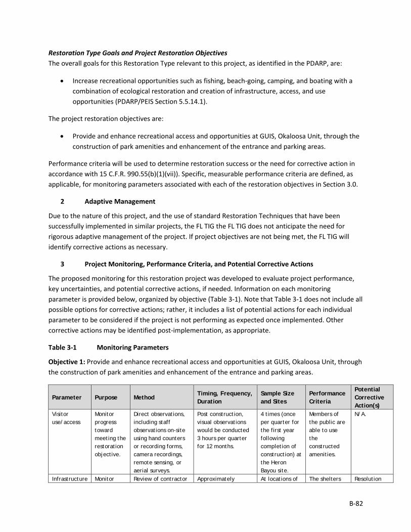
B-82
Restoration Type Goals and Project Restoration Objectives The overall goals for this Restoration Type relevant to this project, as identified in the PDARP, are:
• Increase recreational opportunities such as fishing, beach-going, camping, and boating with a combination of ecological restoration and creation of infrastructure, access, and use opportunities (PDARP/PEIS Section 5.5.14.1).
The project restoration objectives are:
• Provide and enhance recreational access and opportunities at GUIS, Okaloosa Unit, through the construction of park amenities and enhancement of the entrance and parking areas.
Performance criteria will be used to determine restoration success or the need for corrective action in accordance with 15 C.F.R. 990.55(b)(1)(vii)). Specific, measurable performance criteria are defined, as applicable, for monitoring parameters associated with each of the restoration objectives in Section 3.0.
2 Adaptive Management
Due to the nature of this project, and the use of standard Restoration Techniques that have been successfully implemented in similar projects, the FL TIG the FL TIG does not anticipate the need for rigorous adaptive management of the project. If project objectives are not being met, the FL TIG will identify corrective actions as necessary.
3 Project Monitoring, Performance Criteria, and Potential Corrective Actions
The proposed monitoring for this restoration project was developed to evaluate project performance, key uncertainties, and potential corrective actions, if needed. Information on each monitoring parameter is provided below, organized by objective (Table 3-1). Note that Table 3-1 does not include all possible options for corrective actions; rather, it includes a list of potential actions for each individual parameter to be considered if the project is not performing as expected once implemented. Other corrective actions may be identified post-implementation, as appropriate.
Table 3-1 Monitoring Parameters
Objective 1: Provide and enhance recreational access and opportunities at GUIS, Okaloosa Unit, through the construction of park amenities and enhancement of the entrance and parking areas.
Parameter Purpose Method Timing, Frequency, Duration
Sample Size and Sites
Performance Criteria
Potential Corrective Action(s)
Visitor use/access
Monitor progress toward meeting the restoration objective.
Direct observations, including staff observations on-site using hand counters or recording forms, camera recordings, remote sensing, or aerial surveys.
Post construction, visual observations would be conducted 3 hours per quarter for 12 months.
4 times (once per quarter for the first year following completion of construction) at the Heron Bayou site.
Members of the public are able to use the constructed amenities.
N/A.
Infrastructure Monitor Review of contractor Approximately At locations of The shelters Resolution
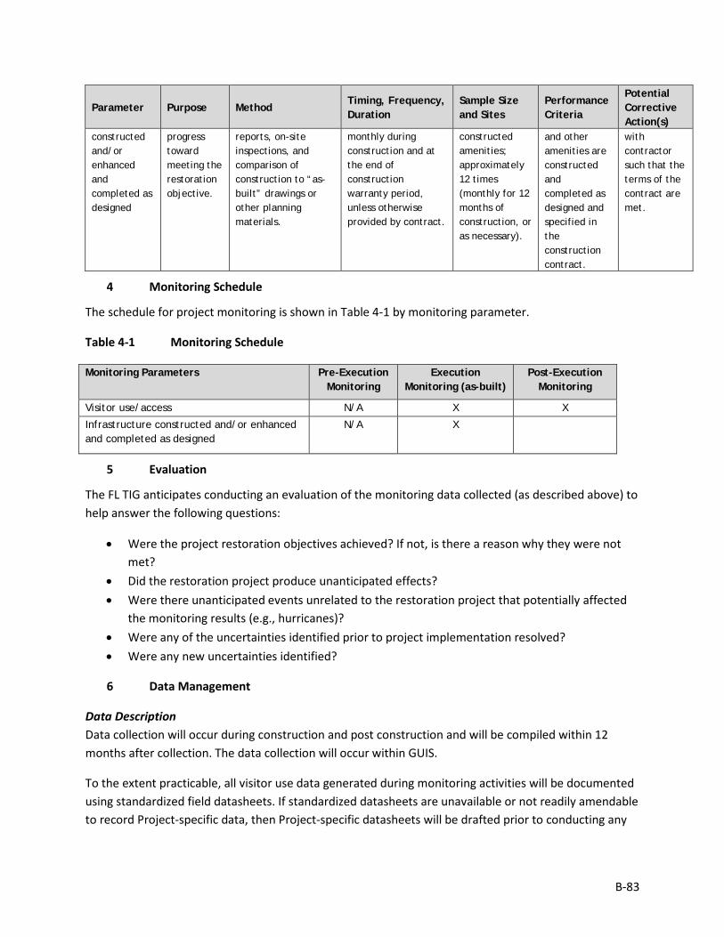
B-83
Parameter Purpose Method Timing, Frequency, Duration
Sample Size and Sites
Performance Criteria
Potential Corrective Action(s)
constructed and/or enhanced and completed as designed
progress toward meeting the restoration objective.
reports, on-site inspections, and comparison of construction to “as-built” drawings or other planning materials.
monthly during construction and at the end of construction warranty period, unless otherwise provided by contract.
constructed amenities; approximately 12 times (monthly for 12 months of construction, or as necessary).
and other amenities are constructed and completed as designed and specified in the construction contract.
with contractor such that the terms of the contract are met.
4 Monitoring Schedule
The schedule for project monitoring is shown in Table 4-1 by monitoring parameter.
Table 4-1 Monitoring Schedule
Monitoring Parameters Pre-Execution Monitoring
Execution Monitoring (as-built)
Post-Execution Monitoring
Visitor use/access N/A X X
Infrastructure constructed and/or enhanced and completed as designed
N/A X
5 Evaluation
The FL TIG anticipates conducting an evaluation of the monitoring data collected (as described above) to help answer the following questions:
• Were the project restoration objectives achieved? If not, is there a reason why they were not met?
• Did the restoration project produce unanticipated effects? • Were there unanticipated events unrelated to the restoration project that potentially affected
the monitoring results (e.g., hurricanes)? • Were any of the uncertainties identified prior to project implementation resolved? • Were any new uncertainties identified?
6 Data Management
Data Description Data collection will occur during construction and post construction and will be compiled within 12 months after collection. The data collection will occur within GUIS.
To the extent practicable, all visitor use data generated during monitoring activities will be documented using standardized field datasheets. If standardized datasheets are unavailable or not readily amendable to record Project-specific data, then Project-specific datasheets will be drafted prior to conducting any
B-84
Project monitoring activities. Original hardcopy datasheets and notebooks and photographs will be retained by the Implementing Trustee.
Relevant Project data that are handwritten on hardcopy datasheets or notebooks will be transcribed (entered) into standard digital format. All field datasheets and notebook entries will be scanned to PDF files. Electronic data files should be named with the date on which the file was created and should include a ReadMe file that describes when the file was created and by whom, and any explanatory notes on the file contents. If a data file is revised, a new copy should be made and the original preserved.
All data will have properly documented FGDC/ISO metadata, a data dictionary (defines codes and fields used in the dataset), and/or a Readme file as appropriate (e.g., how data was collected, QA/QC procedures, other information about data such as meaning, relationships to other data, origin, usage, and format – can reference different documents).
Data Review and Clearance Relevant Project data that are handwritten on hardcopy datasheets or notebooks will be transcribed (entered) into standard digital format. After transcription of the data, the electronic data sheets will be verified against the original hardcopy datasheets and/or notebooks, and will make any corrections to transcription errors as appropriate before data are used for any analyses or distributed outside of the agency. Implementing Trustees will verify and validate MAM data and information and will ensure that all data is i) entered or converted into agreed upon/commonly used digital format; ii) labeled with metadata following FGDC/ISO standards to the extent practicable and in accordance with Implementing Trustee agency requirements.
After any and all identified errors are addressed, data are considered to be QA/QC’ed. The implementing Trustee will give the other TIG members time to review the data before making such information publicly available (as described below). Before submitting the monitoring data and information package, co-Implementing Trustees shall confirm with one another that the package is approved for submission.
Data Storage and Accessibility Once all data has been QA/QC’ed it will be submitted to the Restoration Portal. Trustees will provide DWH NRDA MAM data and information to the Restoration Portal as soon as possible and no more than one year from when data are collected.
Data Sharing Data will be made publicly available, in accordance with the Federal Open Data Policy, through the DIVER Explorer Interface within one year of when the data collection occurred.
7 Reporting
Once all data have been reviewed for accuracy and completeness, they will be submitted to the Restoration Portal. Data will be made publicly available through the DIVER Explorer Interface.

B-85
8 Roles and Responsibilities
Data will be reviewed and submitted to the Restoration Portal by DOI project personnel.
B-86
Monitoring and Adaptive Management Plan for Deepwater Horizon NRDA Project:
REC6, Joe’s Bayou Recreation Area Improvements Prepared by: Nadia Martin (IEc) and FDEP; Draft Version Date: 1/21/2019
1 Introduction
This project MAM plan identifies the monitoring needed to evaluate progress toward meeting project objectives and to support any necessary adaptive management of the restoration project. Where applicable, it identifies key sources of uncertainty and incorporates monitoring data and decision points that address these uncertainties. As not all projects will have the same sources and degree of uncertainty, this project-specific MAM plan is scaled according to level of uncertainty, scope, scale, and restoration type associated with this project.
This MAM plan is a living document and may be updated as needed to reflect changing conditions and/or new information. Any future revisions to this document will be made publicly available through the Trustee Council Restoration Portal (https://www.diver.orr.noaa.gov/web/guest/home) and accessible through the DWH NRDA Trustees website (http://www.restoration.noaa.gov/dwh/storymap/).
Project Overview This project is being implemented as restoration for the DWH oil spill NRDA, consistent with the PDARP/PEIS.
• Programmatic Goal: Provide and Enhance Recreational Opportunities • Restoration Type: Provide and Enhance Recreational Opportunities • Restoration Approach: Enhance public access to natural resources for recreational use • Restoration Technique: Construction or enhancement of recreational infrastructure • TIG: FL TIG • Restoration Plan: Restoration Plan #1
This restoration project would be implemented within Joe’s Bayou Recreation Area, Destin, Okaloosa County, Florida. This project involves actions to improve access to the existing boat ramp; enhance recreational amenities; and enhance and restore the topography and natural resources at Joe’s Bayou Recreation Area and Mattie Kelly Park and Nature Walk. This project is intended to enhance public access by providing improved access and parking in a heavily-used recreational area, by creating additional boardwalks and trails, and by providing new water access amenities for paddle and power-craft.
The implementing agency is FDEP. The partner agency is the City of Destin and the Choctawhatchee Basin Alliance.
B-87
Restoration Type Goals and Project Restoration Objectives The overall goals for this Restoration Type relevant to this project, as identified in the PDARP, are:
• Increase recreational opportunities such as fishing, beach-going, camping, and boating with a combination of ecological restoration and creation of infrastructure, access, and use opportunities (PDARP/PEIS Section 5.5.14.1).
The project restoration objectives are:
• Provide and enhance recreational access at Joe’s Bayou Recreation Area by improving access to the existing boat ramp; enhancing recreational amenities; and enhancing and restoring the topography and natural resources.
Performance criteria will be used to determine restoration success or the need for corrective action in accordance with 15 C.F.R. 990.55(b)(1)(vii)). Specific, measurable performance criteria are defined, as applicable, for monitoring parameters associated with each of the restoration objectives in Section 3.0.
2 Adaptive Management
Due to the nature of this project, and the use of standard Restoration Techniques that have been successfully implemented in similar projects, the FL TIG the FL TIG does not anticipate the need for rigorous adaptive management of the project. If project objectives are not being met, the FL TIG will identify corrective actions as necessary.
3 Project Monitoring, Performance Criteria, and Potential Corrective Actions
The proposed monitoring for this restoration project was developed to evaluate project performance, key uncertainties, and potential corrective actions, if needed. Information on each monitoring parameter is provided below, organized by objective (Table 3-1). Note that Table 3-1 does not include all possible options for corrective actions; rather, it includes a list of potential actions for each individual parameter to be considered if the project is not performing as expected once implemented. Other corrective actions may be identified post-implementation, as appropriate.
Table 3-1 Monitoring Parameters
Objective 1: Provide and enhance recreational access at Joe’s Bayou Recreation Area by improving access to the existing boat ramp; enhancing recreational amenities; and enhancing and restoring the topography and natural resources.
Parameter Purpose Method Timing, Frequency, Duration
Sample Size and Sites
Performance Criteria
Potential Corrective Action(s)
Visitor use/access
Monitor progress toward meeting the restoration objective.
Direct observations, including staff observations on-site using hand counters or recording forms, camera recordings,
Post construction, visual observations would be conducted 3 hours per quarter for 12 months.
4 times (once per quarter for the first year following completion of construction) at
Members of the public are able to use the constructed amenities.
N/A.
B-88
Parameter Purpose Method Timing, Frequency, Duration
Sample Size and Sites
Performance Criteria
Potential Corrective Action(s)
remote sensing, or aerial surveys.
the Heron Bayou site.
Infrastructure constructed and/or enhanced and completed as designed
Monitor progress toward meeting the restoration objective.
Review of contractor reports, on-site inspections, and comparison of construction to “as-built” drawings or other planning materials.
Approximately monthly during construction and at the end of construction warranty period, unless otherwise provided by contract.
At locations of constructed amenities; approximately 12 times (monthly for 12 months of construction, or as necessary).
The shelters and other amenities are constructed and completed as designed and specified in the construction contract.
Resolution with contractor such that the terms of the contract are met.
4 Monitoring Schedule
The schedule for project monitoring is shown in Table 4-1 by monitoring parameter.
Table 4-1 Monitoring Schedule
Monitoring Parameters Pre-Execution Monitoring
Execution Monitoring (as-built)
Post-Execution Monitoring
Visitor use/access N/A N/A X
Infrastructure constructed and/or enhanced and completed as designed
N/A X
5 Evaluation
The FL TIG anticipates conducting an evaluation of the monitoring data collected (as described above) to help answer the following questions:
• Were the project restoration objectives achieved? If not, is there a reason why they were not met?
• Did the restoration project produce unanticipated effects? • Were there unanticipated events unrelated to the restoration project that potentially affected
the monitoring results (e.g., hurricanes)? • Were any of the uncertainties identified prior to project implementation resolved? • Were any new uncertainties identified?
6 Data Management
Data Description Data collection will occur during construction and post construction and will be compiled within 12 months after collection. The data collection will occur at the Park.
B-89
To the extent practicable, all visitor use data generated during monitoring activities will be documented using standardized field datasheets. If standardized datasheets are unavailable or not readily amendable to record Project-specific data, then Project-specific datasheets will be drafted prior to conducting any Project monitoring activities. Original hardcopy datasheets and notebooks and photographs will be retained by the Implementing Trustee.
Relevant Project data that are handwritten on hardcopy datasheets or notebooks will be transcribed (entered) into standard digital format. All field datasheets and notebook entries will be scanned to PDF files. Electronic data files should be named with the date on which the file was created and should include a ReadMe file that describes when the file was created and by whom, and any explanatory notes on the file contents. If a data file is revised, a new copy should be made and the original preserved.
All data will have properly documented FGDC/ISO metadata, a data dictionary (defines codes and fields used in the dataset), and/or a Readme file as appropriate (e.g., how data was collected, QA/QC procedures, other information about data such as meaning, relationships to other data, origin, usage, and format – can reference different documents).
Data Review and Clearance Relevant Project data that are handwritten on hardcopy datasheets or notebooks will be transcribed (entered) into standard digital format. After transcription of the data, the electronic data sheets will be verified against the original hardcopy datasheets and/or notebooks, and will make any corrections to transcription errors as appropriate before data are used for any analyses or distributed outside of the agency. Implementing Trustees will verify and validate MAM data and information and will ensure that all data is i) entered or converted into agreed upon/commonly used digital format; ii) labeled with metadata following FGDC/ISO standards to the extent practicable and in accordance with Implementing Trustee agency requirements.
After any and all identified errors are addressed, data are considered to be QA/QC’ed. The implementing Trustee will give the other TIG members time to review the data before making such information publicly available (as described below). Before submitting the monitoring data and information package, co-Implementing Trustees shall confirm with one another that the package is approved for submission.
Data Storage and Accessibility Once all data has been QA/QC’ed it will be submitted to the Restoration Portal. Trustees will provide DWH NRDA MAM data and information to the Restoration Portal as soon as possible and no more than one year from when data are collected.
Data Sharing Data will be made publicly available, in accordance with the Federal Open Data Policy, through the DIVER Explorer Interface within one year of when the data collection occurred.

B-90
7 Reporting
Once all data have been reviewed for accuracy and completeness, they will be submitted to the Restoration Portal. Data will be made publicly available through the DIVER Explorer Interface.
8 Roles and Responsibilities
Data will be reviewed and submitted to the Restoration Portal by FDEP project personnel.
B-91
Monitoring and Adaptive Management Plan for Deepwater Horizon NRDA Project:
REC7, Topsail Hill Preserve State Park Improvements Prepared by: Nadia Martin (IEc) and FDEP; Draft Version Date: 1/21/2019
1 Introduction
This project MAM plan identifies the monitoring needed to evaluate progress toward meeting project objectives and to support any necessary adaptive management of the restoration project. Where applicable, it identifies key sources of uncertainty and incorporates monitoring data and decision points that address these uncertainties. As not all projects will have the same sources and degree of uncertainty, this project-specific MAM plan is scaled according to level of uncertainty, scope, scale, and restoration type associated with this project.
This MAM plan is a living document and may be updated as needed to reflect changing conditions and/or new information. Any future revisions to this document will be made publicly available through the Trustee Council Restoration Portal (https://www.diver.orr.noaa.gov/web/guest/home) and accessible through the DWH NRDA Trustees website (http://www.restoration.noaa.gov/dwh/storymap/).
Project Overview This project is being implemented as restoration for the DWH oil spill NRDA, consistent with the PDARP/PEIS.
• Programmatic Goal: Provide and Enhance Recreational Opportunities • Restoration Type: Provide and Enhance Recreational Opportunities • Restoration Approach: Enhance public access to natural resources for recreational use • Restoration Technique: Construction or enhancement of recreational infrastructure • TIG: FL TIG • Restoration Plan: Restoration Plan #1
This restoration project would be implemented within the Topsail Hill Preserve State Park, Walton County, Florida. This project would enhance public access to the recreation area by providing a tram and bike-share stations; by improving access to the beach area and Campbell Lake; and by improving campground facilities. In addition, interpretive signage at the entrance and in other areas would increase awareness of the restoration efforts and of the rare coastal dune lake ecosystem.
The implementing agency is FDEP. The partner agency is the FDEP Division of Recreation and Parks.
Restoration Type Goals and Project Restoration Objectives The overall goals for this Restoration Type relevant to this project, as identified in the PDARP, are:
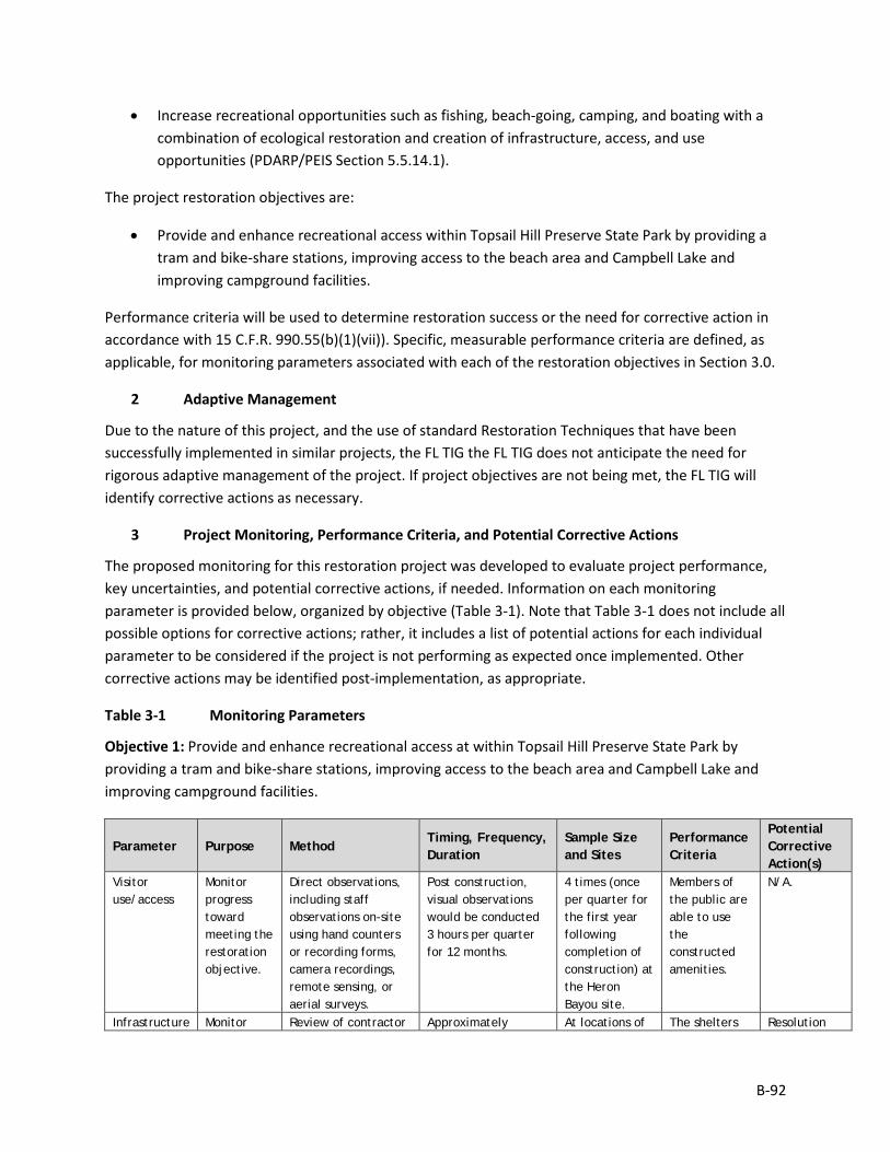
B-92
• Increase recreational opportunities such as fishing, beach-going, camping, and boating with a combination of ecological restoration and creation of infrastructure, access, and use opportunities (PDARP/PEIS Section 5.5.14.1).
The project restoration objectives are:
• Provide and enhance recreational access within Topsail Hill Preserve State Park by providing a tram and bike-share stations, improving access to the beach area and Campbell Lake and improving campground facilities.
Performance criteria will be used to determine restoration success or the need for corrective action in accordance with 15 C.F.R. 990.55(b)(1)(vii)). Specific, measurable performance criteria are defined, as applicable, for monitoring parameters associated with each of the restoration objectives in Section 3.0.
2 Adaptive Management
Due to the nature of this project, and the use of standard Restoration Techniques that have been successfully implemented in similar projects, the FL TIG the FL TIG does not anticipate the need for rigorous adaptive management of the project. If project objectives are not being met, the FL TIG will identify corrective actions as necessary.
3 Project Monitoring, Performance Criteria, and Potential Corrective Actions
The proposed monitoring for this restoration project was developed to evaluate project performance, key uncertainties, and potential corrective actions, if needed. Information on each monitoring parameter is provided below, organized by objective (Table 3-1). Note that Table 3-1 does not include all possible options for corrective actions; rather, it includes a list of potential actions for each individual parameter to be considered if the project is not performing as expected once implemented. Other corrective actions may be identified post-implementation, as appropriate.
Table 3-1 Monitoring Parameters
Objective 1: Provide and enhance recreational access at within Topsail Hill Preserve State Park by providing a tram and bike-share stations, improving access to the beach area and Campbell Lake and improving campground facilities.
Parameter Purpose Method Timing, Frequency, Duration
Sample Size and Sites
Performance Criteria
Potential Corrective Action(s)
Visitor use/access
Monitor progress toward meeting the restoration objective.
Direct observations, including staff observations on-site using hand counters or recording forms, camera recordings, remote sensing, or aerial surveys.
Post construction, visual observations would be conducted 3 hours per quarter for 12 months.
4 times (once per quarter for the first year following completion of construction) at the Heron Bayou site.
Members of the public are able to use the constructed amenities.
N/A.
Infrastructure Monitor Review of contractor Approximately At locations of The shelters Resolution
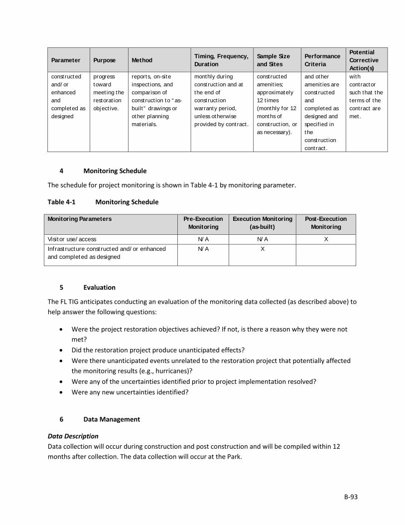
B-93
Parameter Purpose Method Timing, Frequency, Duration
Sample Size and Sites
Performance Criteria
Potential Corrective Action(s)
constructed and/or enhanced and completed as designed
progress toward meeting the restoration objective.
reports, on-site inspections, and comparison of construction to “as-built” drawings or other planning materials.
monthly during construction and at the end of construction warranty period, unless otherwise provided by contract.
constructed amenities; approximately 12 times (monthly for 12 months of construction, or as necessary).
and other amenities are constructed and completed as designed and specified in the construction contract.
with contractor such that the terms of the contract are met.
4 Monitoring Schedule
The schedule for project monitoring is shown in Table 4-1 by monitoring parameter.
Table 4-1 Monitoring Schedule
Monitoring Parameters Pre-Execution Monitoring
Execution Monitoring (as-built)
Post-Execution Monitoring
Visitor use/access N/A N/A X
Infrastructure constructed and/or enhanced and completed as designed
N/A X
5 Evaluation
The FL TIG anticipates conducting an evaluation of the monitoring data collected (as described above) to help answer the following questions:
• Were the project restoration objectives achieved? If not, is there a reason why they were not met?
• Did the restoration project produce unanticipated effects? • Were there unanticipated events unrelated to the restoration project that potentially affected
the monitoring results (e.g., hurricanes)? • Were any of the uncertainties identified prior to project implementation resolved? • Were any new uncertainties identified?
6 Data Management
Data Description Data collection will occur during construction and post construction and will be compiled within 12 months after collection. The data collection will occur at the Park.
B-94
To the extent practicable, all visitor use data generated during monitoring activities will be documented using standardized field datasheets. If standardized datasheets are unavailable or not readily amendable to record Project-specific data, then Project-specific datasheets will be drafted prior to conducting any Project monitoring activities. Original hardcopy datasheets and notebooks and photographs will be retained by the Implementing Trustee.
Relevant Project data that are handwritten on hardcopy datasheets or notebooks will be transcribed (entered) into standard digital format. All field datasheets and notebook entries will be scanned to PDF files. Electronic data files should be named with the date on which the file was created and should include a ReadMe file that describes when the file was created and by whom, and any explanatory notes on the file contents. If a data file is revised, a new copy should be made and the original preserved.
All data will have properly documented FGDC/ISO metadata, a data dictionary (defines codes and fields used in the dataset), and/or a Readme file as appropriate (e.g., how data was collected, QA/QC procedures, other information about data such as meaning, relationships to other data, origin, usage, and format – can reference different documents).
Data Review and Clearance Relevant Project data that are handwritten on hardcopy datasheets or notebooks will be transcribed (entered) into standard digital format. After transcription of the data, the electronic data sheets will be verified against the original hardcopy datasheets and/or notebooks, and will make any corrections to transcription errors as appropriate before data are used for any analyses or distributed outside of the agency. Implementing Trustees will verify and validate MAM data and information and will ensure that all data is i) entered or converted into agreed upon/commonly used digital format; ii) labeled with metadata following FGDC/ISO standards to the extent practicable and in accordance with Implementing Trustee agency requirements.
After any and all identified errors are addressed, data are considered to be QA/QC’ed. The implementing Trustee will give the other TIG members time to review the data before making such information publicly available (as described below). Before submitting the monitoring data and information package, co-Implementing Trustees shall confirm with one another that the package is approved for submission.
Data Storage and Accessibility Once all data has been QA/QC’ed it will be submitted to the Restoration Portal. Trustees will provide DWH NRDA MAM data and information to the Restoration Portal as soon as possible and no more than one year from when data are collected.
Data Sharing Data will be made publicly available, in accordance with the Federal Open Data Policy, through the DIVER Explorer Interface within one year of when the data collection occurred.

B-95
7 Reporting
Once all data have been reviewed for accuracy and completeness, they will be submitted to the Restoration Portal. Data will be made publicly available through the DIVER Explorer Interface.
8 Roles and Responsibilities
Data will be reviewed and submitted to the Restoration Portal by FDEP project personnel.
B-96
Monitoring and Adaptive Management Plan for Deepwater Horizon NRDA Project:
REC8, Camp Helen State Park Improvements Prepared by: Nadia Martin (IEc) and FDEP; Draft Version Date: 1/21/2019
1 Introduction
This project MAM plan identifies the monitoring needed to evaluate progress toward meeting project objectives and to support any necessary adaptive management of the restoration project. Where applicable, it identifies key sources of uncertainty and incorporates monitoring data and decision points that address these uncertainties. As not all projects will have the same sources and degree of uncertainty, this project-specific MAM plan is scaled according to level of uncertainty, scope, scale, and restoration type associated with this project.
This MAM plan is a living document and may be updated as needed to reflect changing conditions and/or new information. Any future revisions to this document will be made publicly available through the Trustee Council Restoration Portal (https://www.diver.orr.noaa.gov/web/guest/home) and accessible through the DWH NRDA Trustees website (http://www.restoration.noaa.gov/dwh/storymap/).
Project Overview This project is being implemented as restoration for the DWH oil spill NRDA, consistent with the PDARP/PEIS.
• Programmatic Goal: Provide and Enhance Recreational Opportunities Restoration • Restoration Type: Provide and Enhance Recreational Opportunities • Restoration Approach: Enhance public access to natural resources for recreational use • Restoration Technique: Construction or enhancement of recreational infrastructure • TIG: FL TIG • Restoration Plan: Restoration Plan #1
This restoration project would be implemented within the Camp Helen State Park, Bay County, Florida. This project would increase and enhance recreational opportunities at Camp Helen State Park. Specifically, the project would include the planning, design, permitting, and construction of various amenities in a new day-use area on the northern parcel of the park (north of US 98) and two docks and walkway extensions at the Lake Powell waterfront.
The implementing agency is FDEP in coordination with the Division of Recreation and Parks.
Restoration Type Goals and Project Restoration Objectives The overall goals for this Restoration Type relevant to this project, as identified in the PDARP, are:
B-97
• Increase recreational opportunities such as fishing, beach-going, camping, and boating with a combination of ecological restoration and creation of infrastructure, access, and use opportunities (PDARP/PEIS Section 5.5.14.1).
The project restoration objectives are:
• Provide and enhance recreational access within Camp Helen State Park by constructing amenities in a new day-use area and two docks and walkway extensions.
Performance criteria will be used to determine restoration success or the need for corrective action in accordance with 15 C.F.R. 990.55(b)(1)(vii)). Specific, measurable performance criteria are defined, as applicable, for monitoring parameters associated with each of the restoration objectives in Section 3.0.
2 Adaptive Management
Due to the nature of this project, and the use of standard Restoration Techniques that have been successfully implemented in similar projects, the FL TIG the FL TIG does not anticipate the need for rigorous adaptive management of the project. If project objectives are not being met, the FL TIG will identify corrective actions as necessary.
3 Project Monitoring, Performance Criteria, and Potential Corrective Actions
The proposed monitoring for this restoration project was developed to evaluate project performance, key uncertainties, and potential corrective actions, if needed. Information on each monitoring parameter is provided below, organized by objective (Table 3-1). Note that Table 3-1 does not include all possible options for corrective actions; rather, it includes a list of potential actions for each individual parameter to be considered if the project is not performing as expected once implemented. Other corrective actions may be identified post-implementation, as appropriate.
Table 3-1 Monitoring Parameters
Objective 1: Provide and enhance recreational access within Camp Helen State Park by constructing amenities in a new day-use area and two docks and walkway extensions.
Parameter Purpose Method Timing, Frequency, Duration
Sample Size and Sites
Performance Criteria
Potential Corrective Action(s)
Visitor use/access
Monitor progress toward meeting the restoration objective.
Direct observations, including staff observations on-site using hand counters or recording forms, camera recordings, remote sensing, or aerial surveys.
Post construction, visual observations would be conducted 3 hours per quarter for 12 months.
4 times (once per quarter for the first year following completion of construction) at the Heron Bayou site.
Members of the public are able to use the constructed amenities.
N/A.
Infrastructure constructed and/or enhanced
Monitor progress toward meeting the
Review of contractor reports, on-site inspections, and comparison of
Approximately monthly during construction and at the end of
At locations of constructed amenities; approximately
The shelters and other amenities are constructed
Resolution with contractor such that the
B-98
Parameter Purpose Method Timing, Frequency, Duration
Sample Size and Sites
Performance Criteria
Potential Corrective Action(s)
and completed as designed
restoration objective.
construction to “as-built” drawings or other planning materials.
construction warranty period, unless otherwise provided by contract.
12 times (monthly for 12 months of construction, or as necessary).
and completed as designed and specified in the construction contract.
terms of the contract are met.
4 Monitoring Schedule
The schedule for project monitoring is shown in Table 4-1 by monitoring parameter.
Table 4-1 Monitoring Schedule
Monitoring Parameters Pre-Execution Monitoring
Execution Monitoring (as-built)
Post-Execution Monitoring
Visitor use/access N/A N/A X
Infrastructure constructed and/or enhanced and completed as designed
N/A X
5 Evaluation
The FL TIG anticipates conducting an evaluation of the monitoring data collected (as described above) to help answer the following questions:
• Were the project restoration objectives achieved? If not, is there a reason why they were not met?
• Did the restoration project produce unanticipated effects? • Were there unanticipated events unrelated to the restoration project that potentially affected
the monitoring results (e.g., hurricanes)? • Were any of the uncertainties identified prior to project implementation resolved? • Were any new uncertainties identified?
6 Data Management
Data Description Data collection will occur during construction and post construction and will be compiled within 12 months after collection. The data collection will occur at the Park.
To the extent practicable, all visitor use data generated during monitoring activities will be documented using standardized field datasheets. If standardized datasheets are unavailable or not readily amendable to record Project-specific data, then Project-specific datasheets will be drafted prior to conducting any

B-99
Project monitoring activities. Original hardcopy datasheets and notebooks and photographs will be retained by the Implementing Trustee.
Relevant Project data that are handwritten on hardcopy datasheets or notebooks will be transcribed (entered) into standard digital format. All field datasheets and notebook entries will be scanned to PDF files. Electronic data files should be named with the date on which the file was created and should include a ReadMe file that describes when the file was created and by whom, and any explanatory notes on the file contents. If a data file is revised, a new copy should be made and the original preserved.
All data will have properly documented FGDC/ISO metadata, a data dictionary (defines codes and fields used in the dataset), and/or a Readme file as appropriate (e.g., how data was collected, QA/QC procedures, other information about data such as meaning, relationships to other data, origin, usage, and format – can reference different documents).
Data Review and Clearance Relevant Project data that are handwritten on hardcopy datasheets or notebooks will be transcribed (entered) into standard digital format. After transcription of the data, the electronic data sheets will be verified against the original hardcopy datasheets and/or notebooks, and will make any corrections to transcription errors as appropriate before data are used for any analyses or distributed outside of the agency. Implementing Trustees will verify and validate MAM data and information and will ensure that all data is i) entered or converted into agreed upon/commonly used digital format; ii) labeled with metadata following FGDC/ISO standards to the extent practicable and in accordance with Implementing Trustee agency requirements.
After any and all identified errors are addressed, data are considered to be QA/QC’ed. The implementing Trustee will give the other TIG members time to review the data before making such information publicly available (as described below). Before submitting the monitoring data and information package, co-Implementing Trustees shall confirm with one another that the package is approved for submission.
Data Storage and Accessibility Once all data has been QA/QC’ed it will be submitted to the Restoration Portal. Trustees will provide DWH NRDA MAM data and information to the Restoration Portal as soon as possible and no more than one year from when data are collected.
Data Sharing Data will be made publicly available, in accordance with the Federal Open Data Policy, through the DIVER Explorer Interface within one year of when the data collection occurred.
7 Reporting
Once all data have been reviewed for accuracy and completeness, they will be submitted to the Restoration Portal. Data will be made publicly available through the DIVER Explorer Interface.

B-100
8 Roles and Responsibilities
Data will be reviewed and submitted to the Restoration Portal by FDEP project personnel.
B-101
Monitoring and Adaptive Management Plan for Deepwater Horizon NRDA Project:
REC9, St. Andrews State Park Improvements Prepared by: Nadia Martin (IEc) and FDEP; Draft Version Date: 1/21/2019
1 Introduction
This project MAM plan identifies the monitoring needed to evaluate progress toward meeting project objectives and to support any necessary adaptive management of the restoration project. Where applicable, it identifies key sources of uncertainty and incorporates monitoring data and decision points that address these uncertainties. As not all projects will have the same sources and degree of uncertainty, this project-specific MAM plan is scaled according to level of uncertainty, scope, scale, and restoration type associated with this project.
This MAM plan is a living document and may be updated as needed to reflect changing conditions and/or new information. Any future revisions to this document will be made publicly available through the Trustee Council Restoration Portal (https://www.diver.orr.noaa.gov/web/guest/home) and accessible through the DWH NRDA Trustees website (http://www.restoration.noaa.gov/dwh/storymap/).
Project Overview This project is being implemented as restoration for the DWH oil spill NRDA, consistent with the PDARP/PEIS.
• Programmatic Goal: Provide and Enhance Recreational Opportunities Restoration • Restoration Type: Provide and Enhance Recreational Opportunities • Restoration Approach: Enhance public access to natural resources for recreational use • Restoration Technique: Construction or enhancement of recreational infrastructure • TIG: FL TIG • Restoration Plan: Restoration Plan #1
This restoration project would be implemented within the St. Andrews State Park, Bay County, Florida. This project would improve access to St. Andrews State Park’s use areas and construction of additional recreational amenities at the park. Specifically, the project would include redesigning the entrance area to facilitate access and egress of vehicles at the ranger station for day-use visitors and campers and to help alleviate traffic congestion during peak visitation periods; improvements to the Lagoon Use area; improvements to existing parking areas; and the repaving of existing roadways in the Park.
The implementing agency is FDEP in coordination with the Division of Recreation and Parks.
Restoration Type Goals and Project Restoration Objectives The overall goals for this Restoration Type relevant to this project, as identified in the PDARP, are:

B-102
• Increase recreational opportunities such as fishing, beach-going, camping, and boating with a combination of ecological restoration and creation of infrastructure, access, and use opportunities (PDARP/PEIS Section 5.5.14.1).
The project restoration objectives are:
• Provide and enhance recreational access within St. Andrews State Park by redesigning the entrance area, improving the Lagoon Use area, and improving existing parking areas and roads.
Performance criteria will be used to determine restoration success or the need for corrective action in accordance with 15 C.F.R. 990.55(b)(1)(vii)). Specific, measurable performance criteria are defined, as applicable, for monitoring parameters associated with each of the restoration objectives in Section 3.0.
2 Adaptive Management
Due to the nature of this project, and the use of standard Restoration Techniques that have been successfully implemented in similar projects, the FL TIG the FL TIG does not anticipate the need for rigorous adaptive management of the project. If project objectives are not being met, the FL TIG will identify corrective actions as necessary.
3 Project Monitoring, Performance Criteria, and Potential Corrective Actions
The proposed monitoring for this restoration project was developed to evaluate project performance, key uncertainties, and potential corrective actions, if needed. Information on each monitoring parameter is provided below, organized by objective (Table 3-1). Note that Table 3-1 does not include all possible options for corrective actions; rather, it includes a list of potential actions for each individual parameter to be considered if the project is not performing as expected once implemented. Other corrective actions may be identified post-implementation, as appropriate.
Table 3-1 Monitoring Parameters
Objective 1: Provide and enhance recreational access within St. Andrews State Park by redesigning the entrance area, improving the Lagoon Use area, and improving existing parking areas and roads.
Parameter Purpose Method Timing, Frequency, Duration
Sample Size and Sites
Performance Criteria
Potential Corrective Action(s)
Visitor use/access
Monitor progress toward meeting the restoration objective.
Direct observations, including staff observations on-site using hand counters or recording forms, camera recordings, remote sensing, or aerial surveys.
Post construction, visual observations would be conducted 3 hours per quarter for 12 months.
4 times (once per quarter for the first year following completion of construction) at the Heron Bayou site.
Members of the public are able to use the constructed amenities.
N/A.
Infrastructure constructed and/or enhanced
Monitor progress toward meeting the
Review of contractor reports, on-site inspections, and comparison of
Approximately monthly during construction and at the end of
At locations of constructed amenities; approximately
The shelters and other amenities are constructed
Resolution with contractor such that the
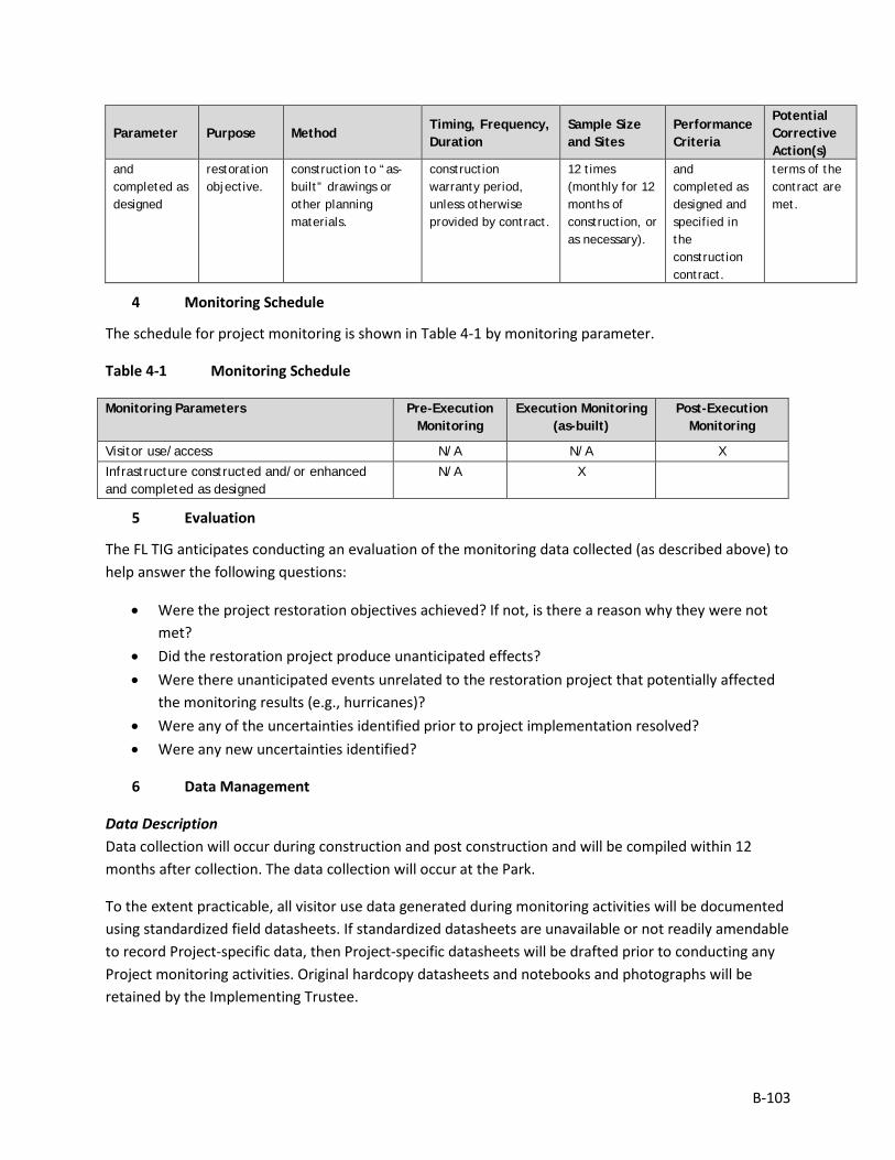
B-103
Parameter Purpose Method Timing, Frequency, Duration
Sample Size and Sites
Performance Criteria
Potential Corrective Action(s)
and completed as designed
restoration objective.
construction to “as-built” drawings or other planning materials.
construction warranty period, unless otherwise provided by contract.
12 times (monthly for 12 months of construction, or as necessary).
and completed as designed and specified in the construction contract.
terms of the contract are met.
4 Monitoring Schedule
The schedule for project monitoring is shown in Table 4-1 by monitoring parameter.
Table 4-1 Monitoring Schedule
Monitoring Parameters Pre-Execution Monitoring
Execution Monitoring (as-built)
Post-Execution Monitoring
Visitor use/access N/A N/A X Infrastructure constructed and/or enhanced and completed as designed
N/A X
5 Evaluation
The FL TIG anticipates conducting an evaluation of the monitoring data collected (as described above) to help answer the following questions:
• Were the project restoration objectives achieved? If not, is there a reason why they were not met?
• Did the restoration project produce unanticipated effects? • Were there unanticipated events unrelated to the restoration project that potentially affected
the monitoring results (e.g., hurricanes)? • Were any of the uncertainties identified prior to project implementation resolved? • Were any new uncertainties identified?
6 Data Management
Data Description Data collection will occur during construction and post construction and will be compiled within 12 months after collection. The data collection will occur at the Park.
To the extent practicable, all visitor use data generated during monitoring activities will be documented using standardized field datasheets. If standardized datasheets are unavailable or not readily amendable to record Project-specific data, then Project-specific datasheets will be drafted prior to conducting any Project monitoring activities. Original hardcopy datasheets and notebooks and photographs will be retained by the Implementing Trustee.
B-104
Relevant Project data that are handwritten on hardcopy datasheets or notebooks will be transcribed (entered) into standard digital format. All field datasheets and notebook entries will be scanned to PDF files. Electronic data files should be named with the date on which the file was created and should include a ReadMe file that describes when the file was created and by whom, and any explanatory notes on the file contents. If a data file is revised, a new copy should be made and the original preserved.
All data will have properly documented FGDC/ISO metadata, a data dictionary (defines codes and fields used in the dataset), and/or a Readme file as appropriate (e.g., how data was collected, QA/QC procedures, other information about data such as meaning, relationships to other data, origin, usage, and format – can reference different documents).
Data Review and Clearance Relevant Project data that are handwritten on hardcopy datasheets or notebooks will be transcribed (entered) into standard digital format. After transcription of the data, the electronic data sheets will be verified against the original hardcopy datasheets and/or notebooks, and will make any corrections to transcription errors as appropriate before data are used for any analyses or distributed outside of the agency. Implementing Trustees will verify and validate MAM data and information and will ensure that all data is i) entered or converted into agreed upon/commonly used digital format; ii) labeled with metadata following FGDC/ISO standards to the extent practicable and in accordance with Implementing Trustee agency requirements.
After any and all identified errors are addressed, data are considered to be QA/QC’ed. The implementing Trustee will give the other TIG members time to review the data before making such information publicly available (as described below). Before submitting the monitoring data and information package, co-Implementing Trustees shall confirm with one another that the package is approved for submission.
Data Storage and Accessibility Once all data has been QA/QC’ed it will be submitted to the Restoration Portal. Trustees will provide DWH NRDA MAM data and information to the Restoration Portal as soon as possible and no more than one year from when data are collected.
Data Sharing Data will be made publicly available, in accordance with the Federal Open Data Policy, through the DIVER Explorer Interface within one year of when the data collection occurred.
7 Reporting
Once all data have been reviewed for accuracy and completeness, they will be submitted to the Restoration Portal. Data will be made publicly available through the DIVER Explorer Interface.
8 Roles and Responsibilities
Data will be reviewed and submitted to the Restoration Portal by FDEP project personnel.
B-105
Monitoring and Adaptive Management Plan for Deepwater Horizon NRDA Project:
REC11, St. Marks National Wildlife Refuge Coastal Trail Connection, Spring Creek to Port Leon
Prepared by: Nadia Martin (IEc) and USDA; Draft Version Date: 1/21/2019
1 Introduction
This project MAM plan identifies the monitoring needed to evaluate progress toward meeting project objectives and to support any necessary adaptive management of the restoration project. Where applicable, it identifies key sources of uncertainty and incorporates monitoring data and decision points that address these uncertainties. As not all projects will have the same sources and degree of uncertainty, this project-specific MAM plan is scaled according to level of uncertainty, scope, scale, and restoration type associated with this project.
This MAM plan is a living document and may be updated as needed to reflect changing conditions and/or new information. Any future revisions to this document will be made publicly available through the Trustee Council Restoration Portal (https://www.diver.orr.noaa.gov/web/guest/home) and accessible through the DWH NRDA Trustees website (http://www.restoration.noaa.gov/dwh/storymap/).
Project Overview This project is being implemented as restoration for the DWH oil spill NRDA, consistent with the PDARP/PEIS.
• Programmatic Goal: Provide and Enhance Recreational Opportunities Restoration • Restoration Type: Provide and Enhance Recreational Opportunities • Restoration Approach: Enhance public access to natural resources for recreational use • Restoration Technique: Construction or enhancement of recreational infrastructure • TIG: FL TIG • Restoration Plan: Restoration Plan #1
This restoration project would be implemented within the St. Marks National Wildlife Refuge (NWR), Wakulla County, Florida. This project would provide and enhance recreational opportunities by improving access to and completing the Florida National Scenic Trail (FNST) at St. Marks NWR, a nationally recognized resource.
The implementing agency is the USDA, in coordination with the St. Marks NWR. Other project partners include the USFWS, Florida Trail Association (volunteer support organization), Framing Our Community (non-profit infrastructure support organization), and the NPS Southeast Archaeological Center.
B-106
Restoration Type Goals and Project Restoration Objectives The overall goals for this Restoration Type relevant to this project, as identified in the PDARP, are:
• Increase recreational opportunities such as fishing, beach-going, camping, and boating with a combination of ecological restoration and creation of infrastructure, access, and use opportunities (PDARP/PEIS Section 5.5.14.1).
The project restoration objectives are:
• Provide and enhance recreational access within St. Marks NWR through the completion of the Florida National Scenic Trail segment including two boardwalks and puncheon, 3-4 small-span bridges or boardwalks, suspension bridge, stringer bridge, and interpretive materials.
Performance criteria will be used to determine restoration success or the need for corrective action in accordance with 15 C.F.R. 990.55(b)(1)(vii)). Specific, measurable performance criteria are defined, as applicable, for monitoring parameters associated with each of the restoration objectives in Section 3.0.
2 Adaptive Management
Due to the nature of this project, and the use of standard Restoration Techniques that have been successfully implemented in similar projects, the FL TIG the FL TIG does not anticipate the need for rigorous adaptive management of the project. If project objectives are not being met, the FL TIG will identify corrective actions as necessary.
3 Project Monitoring, Performance Criteria, and Potential Corrective Actions
The proposed monitoring for this restoration project was developed to evaluate project performance, key uncertainties, and potential corrective actions, if needed. Information on each monitoring parameter is provided below, organized by objective (Table 3-1). Note that Table 3-1 does not include all possible options for corrective actions; rather, it includes a list of potential actions for each individual parameter to be considered if the project is not performing as expected once implemented. Other corrective actions may be identified post-implementation, as appropriate.
Table 3-1 Monitoring Parameters
Objective 1: Provide and enhance recreational access within St. Marks NWR through the completion of the Florida National Scenic Trail segment including two boardwalks and puncheon, 3-4 small-span bridges or boardwalks, suspension bridge, stringer bridge, and interpretive materials.
Parameter Purpose Method Timing, Frequency, Duration
Sample Size and Sites
Performance Criteria
Potential Corrective Action(s)
Visitor use/access
Monitor progress toward meeting the restoration objective.
Direct observations, including staff observations on-site using hand counters or recording forms, camera recordings,
Post construction, visual observations would be conducted 3 hours per quarter for 12 months.
4 times (once per quarter for the first year following completion of construction) at
Members of the public are able to use the constructed amenities.
N/A.
B-107
Parameter Purpose Method Timing, Frequency, Duration
Sample Size and Sites
Performance Criteria
Potential Corrective Action(s)
remote sensing, or aerial surveys.
the Heron Bayou site.
Infrastructure constructed and/or enhanced and completed as designed
Monitor progress toward meeting the restoration objective.
Review of contractor reports, on-site inspections, and comparison of construction to “as-built” drawings or other planning materials.
Approximately monthly during construction and at the end of construction warranty period, unless otherwise provided by contract.
At locations of constructed amenities; approximately 12 times (monthly for 12 months of construction, or as necessary).
The shelters and other amenities are constructed and completed as designed and specified in the construction contract.
Resolution with contractor such that the terms of the contract are met.
4 Monitoring Schedule
The schedule for project monitoring is shown in Table 4-1 by monitoring parameter.
Table 4-1 Monitoring Schedule
Monitoring Parameters Pre-Execution Monitoring
Execution Monitoring (as-built)
Post-Execution Monitoring
Visitor use/access N/A X X
Infrastructure constructed and/or enhanced and completed as designed
N/A X
5 Evaluation
The FL TIG anticipates conducting an evaluation of the monitoring data collected (as described above) to help answer the following questions:
• Were the project restoration objectives achieved? If not, is there a reason why they were not met?
• Did the restoration project produce unanticipated effects? • Were there unanticipated events unrelated to the restoration project that potentially affected
the monitoring results (e.g., hurricanes)? • Were any of the uncertainties identified prior to project implementation resolved? • Were any new uncertainties identified?
6 Data Management
Data Description Data collection will occur during construction and post construction and will be compiled within 12 months after collection. The data collection will occur at the NWR.
To the extent practicable, all data generated during monitoring activities will be documented using standardized field datasheets. If standardized datasheets are unavailable or not readily amendable to
B-108
record Project-specific data, then Project-specific datasheets will be drafted prior to conducting any Project monitoring activities. Original hardcopy datasheets and notebooks and photographs will be retained by the Implementing Trustee.
Relevant Project data that are handwritten on hardcopy datasheets or notebooks will be transcribed (entered) into standard digital format. All field datasheets and notebook entries will be scanned to PDF files. Electronic data files should be named with the date on which the file was created and should include a ReadMe file that describes when the file was created and by whom, and any explanatory notes on the file contents. If a data file is revised, a new copy should be made and the original preserved.
All data will have properly documented FGDC/ISO metadata, a data dictionary (defines codes and fields used in the dataset), and/or a Readme file as appropriate (e.g., how data was collected, QA/QC procedures, other information about data such as meaning, relationships to other data, origin, usage, and format – can reference different documents).
Data Review and Clearance Relevant Project data that are handwritten on hardcopy datasheets or notebooks will be transcribed (entered) into standard digital format. After transcription of the data, the electronic data sheets will be verified against the original hardcopy datasheets and/or notebooks, and will make any corrections to transcription errors as appropriate before data are used for any analyses or distributed outside of the agency. Implementing Trustees will verify and validate MAM data and information and will ensure that all data is i) entered or converted into agreed upon/commonly used digital format; ii) labeled with metadata following FGDC/ISO standards to the extent practicable and in accordance with Implementing Trustee agency requirements.
After any and all identified errors are addressed, data are considered to be QA/QC’ed. The implementing Trustee will give the other TIG members time to review the data before making such information publicly available (as described below). Before submitting the monitoring data and information package, co-Implementing Trustees shall confirm with one another that the package is approved for submission.
Data Storage and Accessibility Once all data has been QA/QC’ed it will be submitted to the Restoration Portal. Trustees will provide DWH NRDA MAM data and information to the Restoration Portal as soon as possible and no more than one year from when data are collected.
Data Sharing Data will be made publicly available, in accordance with the Federal Open Data Policy, through the DIVER Explorer Interface within one year of when the data collection occurred.
7 Reporting
Once all data have been reviewed for accuracy and completeness, they will be submitted to the Restoration Portal. Data will be made publicly available through the DIVER Explorer Interface.

B-109
8 Roles and Responsibilities
Data will be reviewed and submitted to the Restoration Portal by USDA project personnel.
C-1
Appendix C. Impact Intensity Definitions
The intensity definitions utilized in the evaluation of potential environmental impacts from the reasonable range of alternatives covered in this RP/EA are provided below. These definitions are also provided in Table 6.3-2 in the PDARP/PEIS.
Impact Intensity Definitions Impact Intensity Definitions Impact Intensity Definitions Resource Impact Duration Minor Moderate Major
Geology and Substrates
Short-term: During construction period. Long-term: Over the life of the project or longer.
Disturbance to geologic features or soils could be detectable, but could be small and localized. There could be no changes to local geologic features or soil characteristics. Erosion and/or compaction could occur in localized areas.
Disturbance could occur over local and immediately adjacent areas. Impacts to geology or soils could be readily apparent and result in changes to the soil character or local geologic characteristics. Erosion and compaction impacts could occur over local and immediately adjacent areas.
Disturbance could occur over a widespread area. Impacts to geology or soils could be readily apparent and could result in changes to the character of the geology or soils over a widespread area. Erosion and compaction could occur over a widespread area. Disruptions to substrates or soils may be permanent.
Hydrology and Water Quality
Short-term: During construction period. Long-term: Over the life of the project or longer.
Hydrology: The effect on hydrology could be measurable, but it could be small and localized. The effect could only temporarily alter the area’s hydrology, including surface and ground water flows. Water quality: Impacts could result in a detectable change to water quality, but the change could be expected to be small and localized. Impacts could quickly become undetectable. State water quality standards as required by the Clean Water Act could not be exceeded. Floodplains: Impacts may result in a detectable change to natural and beneficial floodplain values, but the change could be expected to be small, and localized. There could be no appreciable increased risk of flood loss
Hydrology: The effect on hydrology could be measurable, but small and limited to local and adjacent areas. The effect could permanently alter the area’s hydrology, including surface and ground water flows. Water quality: Effects to water quality could be observable over a relatively large area. Impacts could result in a change to water quality that could be readily detectable and limited to local and adjacent areas. Change in water quality could persist; however, it could likely not exceed state water quality standards as required by the Clean Water Act. Floodplains: Impacts could result in a change to natural and beneficial floodplain values and could be readily detectable, but limited to local and
Hydrology: The effect on hydrology could be measurable and widespread. The effect could permanently alter hydrologic patterns including surface and ground water flows. Water quality: Impacts could likely result in a change to water quality that could be readily detectable and widespread. Impacts could likely result in exceedance of state water quality standards and/or could impair designated uses of a water body. Floodplains: Impacts could result in a change to natural and beneficial floodplain values that could have substantial consequences over a widespread area. Location of operations could increase risk of flood loss, including impacts on human safety, health, and welfare.
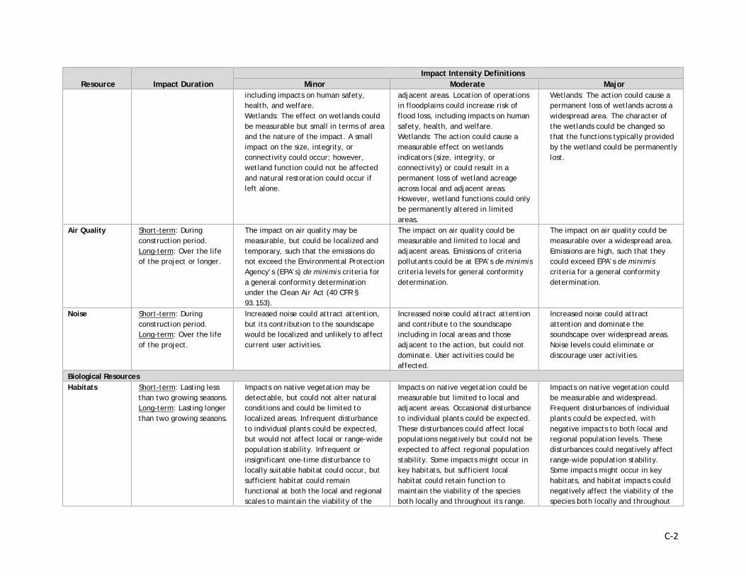
C-2
Impact Intensity Definitions Impact Intensity Definitions Impact Intensity Definitions Resource Impact Duration Minor Moderate Major
including impacts on human safety, health, and welfare. Wetlands: The effect on wetlands could be measurable but small in terms of area and the nature of the impact. A small impact on the size, integrity, or connectivity could occur; however, wetland function could not be affected and natural restoration could occur if left alone.
adjacent areas. Location of operations in floodplains could increase risk of flood loss, including impacts on human safety, health, and welfare. Wetlands: The action could cause a measurable effect on wetlands indicators (size, integrity, or connectivity) or could result in a permanent loss of wetland acreage across local and adjacent areas. However, wetland functions could only be permanently altered in limited areas.
Wetlands: The action could cause a permanent loss of wetlands across a widespread area. The character of the wetlands could be changed so that the functions typically provided by the wetland could be permanently lost.
Air Quality Short-term: During construction period. Long-term: Over the life of the project or longer.
The impact on air quality may be measurable, but could be localized and temporary, such that the emissions do not exceed the Environmental Protection Agency’s (EPA’s) de minimis criteria for a general conformity determination under the Clean Air Act (40 CFR § 93.153).
The impact on air quality could be measurable and limited to local and adjacent areas. Emissions of criteria pollutants could be at EPA’s de minimis criteria levels for general conformity determination.
The impact on air quality could be measurable over a widespread area. Emissions are high, such that they could exceed EPA’s de minimis criteria for a general conformity determination.
Noise Short-term: During construction period. Long-term: Over the life of the project.
Increased noise could attract attention, but its contribution to the soundscape would be localized and unlikely to affect current user activities.
Increased noise could attract attention and contribute to the soundscape including in local areas and those adjacent to the action, but could not dominate. User activities could be affected.
Increased noise could attract attention and dominate the soundscape over widespread areas. Noise levels could eliminate or discourage user activities.
Biological Resources Habitats Short-term: Lasting less
than two growing seasons. Long-term: Lasting longer than two growing seasons.
Impacts on native vegetation may be detectable, but could not alter natural conditions and could be limited to localized areas. Infrequent disturbance to individual plants could be expected, but would not affect local or range-wide population stability. Infrequent or insignificant one-time disturbance to locally suitable habitat could occur, but sufficient habitat could remain functional at both the local and regional scales to maintain the viability of the
Impacts on native vegetation could be measurable but limited to local and adjacent areas. Occasional disturbance to individual plants could be expected. These disturbances could affect local populations negatively but could not be expected to affect regional population stability. Some impacts might occur in key habitats, but sufficient local habitat could retain function to maintain the viability of the species both locally and throughout its range.
Impacts on native vegetation could be measurable and widespread. Frequent disturbances of individual plants could be expected, with negative impacts to both local and regional population levels. These disturbances could negatively affect range-wide population stability. Some impacts might occur in key habitats, and habitat impacts could negatively affect the viability of the species both locally and throughout
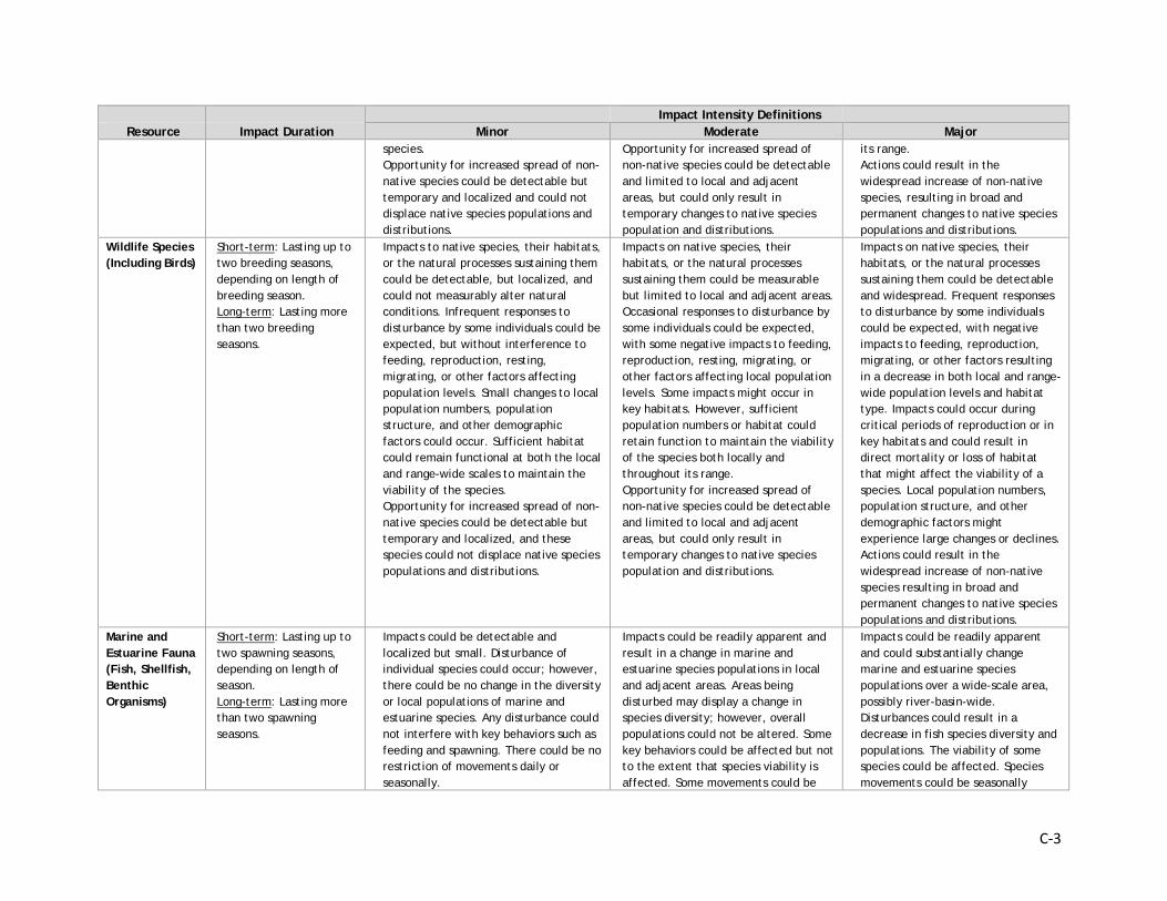
C-3
Impact Intensity Definitions Impact Intensity Definitions Impact Intensity Definitions Resource Impact Duration Minor Moderate Major
species. Opportunity for increased spread of non-native species could be detectable but temporary and localized and could not displace native species populations and distributions.
Opportunity for increased spread of non-native species could be detectable and limited to local and adjacent areas, but could only result in temporary changes to native species population and distributions.
its range. Actions could result in the widespread increase of non-native species, resulting in broad and permanent changes to native species populations and distributions.
Wildlife Species (Including Birds)
Short-term: Lasting up to two breeding seasons, depending on length of breeding season. Long-term: Lasting more than two breeding seasons.
Impacts to native species, their habitats, or the natural processes sustaining them could be detectable, but localized, and could not measurably alter natural conditions. Infrequent responses to disturbance by some individuals could be expected, but without interference to feeding, reproduction, resting, migrating, or other factors affecting population levels. Small changes to local population numbers, population structure, and other demographic factors could occur. Sufficient habitat could remain functional at both the local and range-wide scales to maintain the viability of the species. Opportunity for increased spread of non-native species could be detectable but temporary and localized, and these species could not displace native species populations and distributions.
Impacts on native species, their habitats, or the natural processes sustaining them could be measurable but limited to local and adjacent areas. Occasional responses to disturbance by some individuals could be expected, with some negative impacts to feeding, reproduction, resting, migrating, or other factors affecting local population levels. Some impacts might occur in key habitats. However, sufficient population numbers or habitat could retain function to maintain the viability of the species both locally and throughout its range. Opportunity for increased spread of non-native species could be detectable and limited to local and adjacent areas, but could only result in temporary changes to native species population and distributions.
Impacts on native species, their habitats, or the natural processes sustaining them could be detectable and widespread. Frequent responses to disturbance by some individuals could be expected, with negative impacts to feeding, reproduction, migrating, or other factors resulting in a decrease in both local and range-wide population levels and habitat type. Impacts could occur during critical periods of reproduction or in key habitats and could result in direct mortality or loss of habitat that might affect the viability of a species. Local population numbers, population structure, and other demographic factors might experience large changes or declines. Actions could result in the widespread increase of non-native species resulting in broad and permanent changes to native species populations and distributions.
Marine and Estuarine Fauna (Fish, Shellfish, Benthic Organisms)
Short-term: Lasting up to two spawning seasons, depending on length of season. Long-term: Lasting more than two spawning seasons.
Impacts could be detectable and localized but small. Disturbance of individual species could occur; however, there could be no change in the diversity or local populations of marine and estuarine species. Any disturbance could not interfere with key behaviors such as feeding and spawning. There could be no restriction of movements daily or seasonally.
Impacts could be readily apparent and result in a change in marine and estuarine species populations in local and adjacent areas. Areas being disturbed may display a change in species diversity; however, overall populations could not be altered. Some key behaviors could be affected but not to the extent that species viability is affected. Some movements could be
Impacts could be readily apparent and could substantially change marine and estuarine species populations over a wide-scale area, possibly river-basin-wide. Disturbances could result in a decrease in fish species diversity and populations. The viability of some species could be affected. Species movements could be seasonally
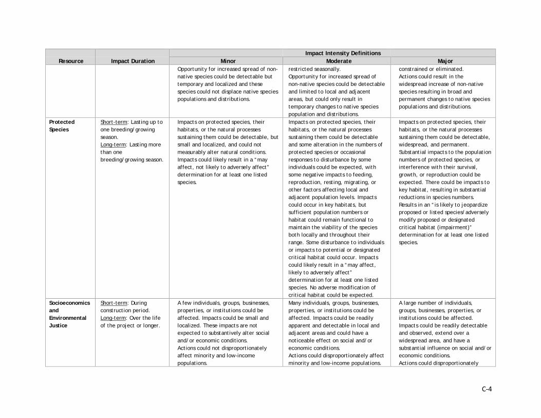
C-4
Impact Intensity Definitions Impact Intensity Definitions Impact Intensity Definitions Resource Impact Duration Minor Moderate Major
Opportunity for increased spread of non-native species could be detectable but temporary and localized and these species could not displace native species populations and distributions.
restricted seasonally. Opportunity for increased spread of non-native species could be detectable and limited to local and adjacent areas, but could only result in temporary changes to native species population and distributions.
constrained or eliminated. Actions could result in the widespread increase of non-native species resulting in broad and permanent changes to native species populations and distributions.
Protected Species
Short-term: Lasting up to one breeding/growing season. Long-term: Lasting more than one breeding/growing season.
Impacts on protected species, their habitats, or the natural processes sustaining them could be detectable, but small and localized, and could not measurably alter natural conditions. Impacts could likely result in a “may affect, not likely to adversely affect” determination for at least one listed species.
Impacts on protected species, their habitats, or the natural processes sustaining them could be detectable and some alteration in the numbers of protected species or occasional responses to disturbance by some individuals could be expected, with some negative impacts to feeding, reproduction, resting, migrating, or other factors affecting local and adjacent population levels. Impacts could occur in key habitats, but sufficient population numbers or habitat could remain functional to maintain the viability of the species both locally and throughout their range. Some disturbance to individuals or impacts to potential or designated critical habitat could occur. Impacts could likely result in a “may affect, likely to adversely affect” determination for at least one listed species. No adverse modification of critical habitat could be expected.
Impacts on protected species, their habitats, or the natural processes sustaining them could be detectable, widespread, and permanent. Substantial impacts to the population numbers of protected species, or interference with their survival, growth, or reproduction could be expected. There could be impacts to key habitat, resulting in substantial reductions in species numbers. Results in an “is likely to jeopardize proposed or listed species/adversely modify proposed or designated critical habitat (impairment)” determination for at least one listed species.
Socioeconomics and Environmental Justice
Short-term: During construction period. Long-term: Over the life of the project or longer.
A few individuals, groups, businesses, properties, or institutions could be affected. Impacts could be small and localized. These impacts are not expected to substantively alter social and/or economic conditions. Actions could not disproportionately affect minority and low-income populations.
Many individuals, groups, businesses, properties, or institutions could be affected. Impacts could be readily apparent and detectable in local and adjacent areas and could have a noticeable effect on social and/or economic conditions. Actions could disproportionately affect minority and low-income populations.
A large number of individuals, groups, businesses, properties, or institutions could be affected. Impacts could be readily detectable and observed, extend over a widespread area, and have a substantial influence on social and/or economic conditions. Actions could disproportionately
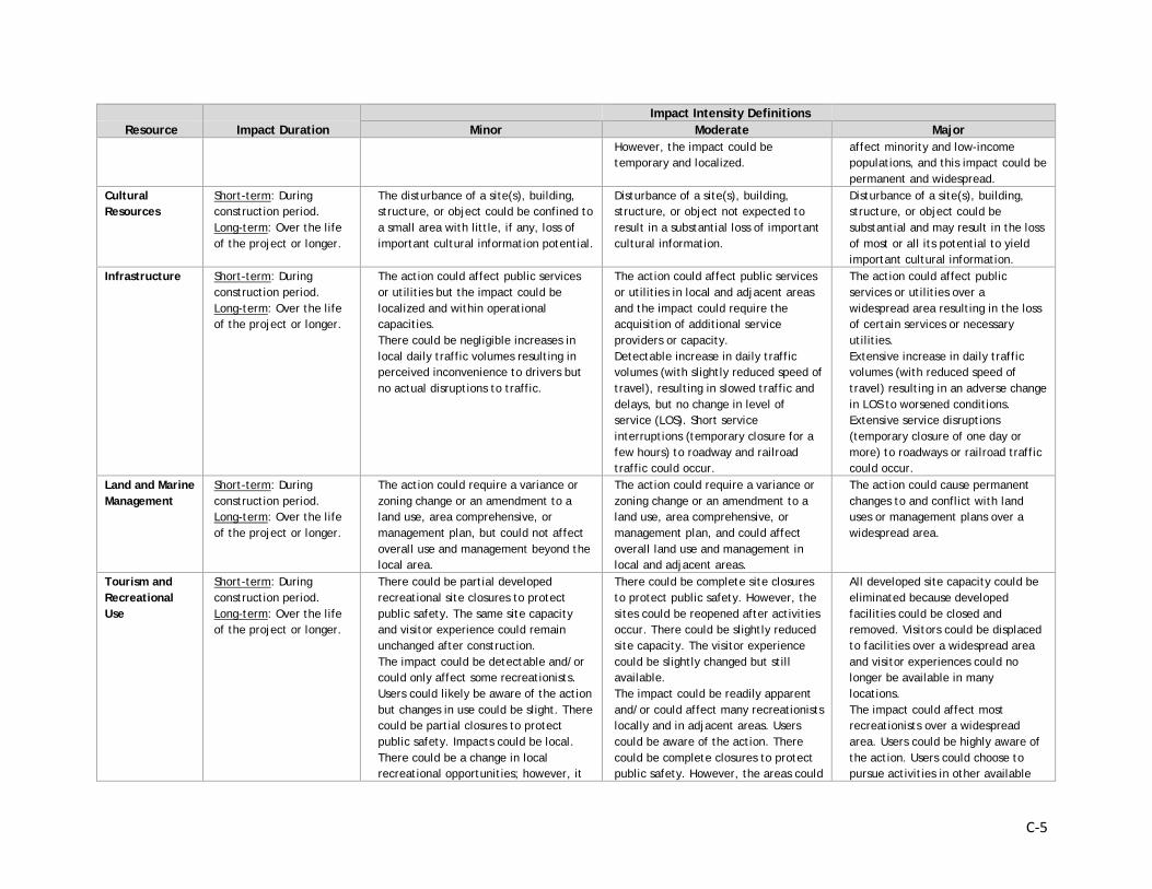
C-5
Impact Intensity Definitions Impact Intensity Definitions Impact Intensity Definitions Resource Impact Duration Minor Moderate Major
However, the impact could be temporary and localized.
affect minority and low-income populations, and this impact could be permanent and widespread.
Cultural Resources
Short-term: During construction period. Long-term: Over the life of the project or longer.
The disturbance of a site(s), building, structure, or object could be confined to a small area with little, if any, loss of important cultural information potential.
Disturbance of a site(s), building, structure, or object not expected to result in a substantial loss of important cultural information.
Disturbance of a site(s), building, structure, or object could be substantial and may result in the loss of most or all its potential to yield important cultural information.
Infrastructure Short-term: During construction period. Long-term: Over the life of the project or longer.
The action could affect public services or utilities but the impact could be localized and within operational capacities. There could be negligible increases in local daily traffic volumes resulting in perceived inconvenience to drivers but no actual disruptions to traffic.
The action could affect public services or utilities in local and adjacent areas and the impact could require the acquisition of additional service providers or capacity. Detectable increase in daily traffic volumes (with slightly reduced speed of travel), resulting in slowed traffic and delays, but no change in level of service (LOS). Short service interruptions (temporary closure for a few hours) to roadway and railroad traffic could occur.
The action could affect public services or utilities over a widespread area resulting in the loss of certain services or necessary utilities. Extensive increase in daily traffic volumes (with reduced speed of travel) resulting in an adverse change in LOS to worsened conditions. Extensive service disruptions (temporary closure of one day or more) to roadways or railroad traffic could occur.
Land and Marine Management
Short-term: During construction period. Long-term: Over the life of the project or longer.
The action could require a variance or zoning change or an amendment to a land use, area comprehensive, or management plan, but could not affect overall use and management beyond the local area.
The action could require a variance or zoning change or an amendment to a land use, area comprehensive, or management plan, and could affect overall land use and management in local and adjacent areas.
The action could cause permanent changes to and conflict with land uses or management plans over a widespread area.
Tourism and Recreational Use
Short-term: During construction period. Long-term: Over the life of the project or longer.
There could be partial developed recreational site closures to protect public safety. The same site capacity and visitor experience could remain unchanged after construction. The impact could be detectable and/or could only affect some recreationists. Users could likely be aware of the action but changes in use could be slight. There could be partial closures to protect public safety. Impacts could be local. There could be a change in local recreational opportunities; however, it
There could be complete site closures to protect public safety. However, the sites could be reopened after activities occur. There could be slightly reduced site capacity. The visitor experience could be slightly changed but still available. The impact could be readily apparent and/or could affect many recreationists locally and in adjacent areas. Users could be aware of the action. There could be complete closures to protect public safety. However, the areas could
All developed site capacity could be eliminated because developed facilities could be closed and removed. Visitors could be displaced to facilities over a widespread area and visitor experiences could no longer be available in many locations. The impact could affect most recreationists over a widespread area. Users could be highly aware of the action. Users could choose to pursue activities in other available
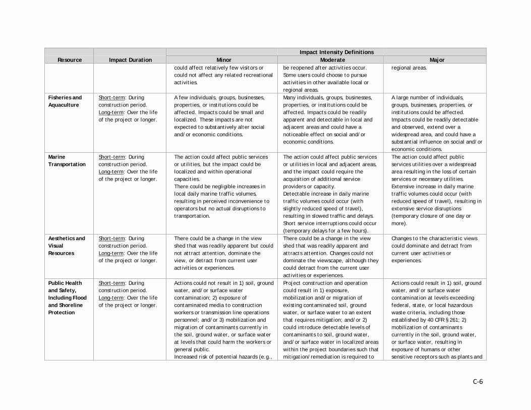
C-6
Impact Intensity Definitions Impact Intensity Definitions Impact Intensity Definitions Resource Impact Duration Minor Moderate Major
could affect relatively few visitors or could not affect any related recreational activities.
be reopened after activities occur. Some users could choose to pursue activities in other available local or regional areas.
regional areas.
Fisheries and Aquaculture
Short-term: During construction period. Long-term: Over the life of the project or longer.
A few individuals, groups, businesses, properties, or institutions could be affected. Impacts could be small and localized. These impacts are not expected to substantively alter social and/or economic conditions.
Many individuals, groups, businesses, properties, or institutions could be affected. Impacts could be readily apparent and detectable in local and adjacent areas and could have a noticeable effect on social and/or economic conditions.
A large number of individuals, groups, businesses, properties, or institutions could be affected. Impacts could be readily detectable and observed, extend over a widespread area, and could have a substantial influence on social and/or economic conditions.
Marine Transportation
Short-term: During construction period. Long-term: Over the life of the project or longer.
The action could affect public services or utilities, but the impact could be localized and within operational capacities. There could be negligible increases in local daily marine traffic volumes, resulting in perceived inconvenience to operators but no actual disruptions to transportation.
The action could affect public services or utilities in local and adjacent areas, and the impact could require the acquisition of additional service providers or capacity. Detectable increase in daily marine traffic volumes could occur (with slightly reduced speed of travel), resulting in slowed traffic and delays. Short service interruptions could occur (temporary delays for a few hours).
The action could affect public services utilities over a widespread area resulting in the loss of certain services or necessary utilities. Extensive increase in daily marine traffic volumes could occur (with reduced speed of travel), resulting in extensive service disruptions (temporary closure of one day or more).
Aesthetics and Visual Resources
Short-term: During construction period. Long-term: Over the life of the project or longer.
There could be a change in the view shed that was readily apparent but could not attract attention, dominate the view, or detract from current user activities or experiences.
There could be a change in the view shed that was readily apparent and attracts attention. Changes could not dominate the viewscape, although they could detract from the current user activities or experiences.
Changes to the characteristic views could dominate and detract from current user activities or experiences.
Public Health and Safety, Including Flood and Shoreline Protection
Short-term: During construction period. Long-term: Over the life of the project or longer.
Actions could not result in 1) soil, ground water, and/or surface water contamination; 2) exposure of contaminated media to construction workers or transmission line operations personnel; and/or 3) mobilization and migration of contaminants currently in the soil, ground water, or surface water at levels that could harm the workers or general public. Increased risk of potential hazards (e.g.,
Project construction and operation could result in 1) exposure, mobilization and/or migration of existing contaminated soil, ground water, or surface water to an extent that requires mitigation; and/or 2) could introduce detectable levels of contaminants to soil, ground water, and/or surface water in localized areas within the project boundaries such that mitigation/remediation is required to
Actions could result in 1) soil, ground water, and/or surface water contamination at levels exceeding federal, state, or local hazardous waste criteria, including those established by 40 CFR § 261; 2) mobilization of contaminants currently in the soil, ground water, or surface water, resulting in exposure of humans or other sensitive receptors such as plants and
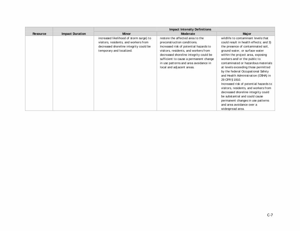
C-7
Impact Intensity Definitions Impact Intensity Definitions Impact Intensity Definitions Resource Impact Duration Minor Moderate Major
increased likelihood of storm surge) to visitors, residents, and workers from decreased shoreline integrity could be temporary and localized.
restore the affected area to the preconstruction conditions. Increased risk of potential hazards to visitors, residents, and workers from decreased shoreline integrity could be sufficient to cause a permanent change in use patterns and area avoidance in local and adjacent areas.
wildlife to contaminant levels that could result in health effects; and 3) the presence of contaminated soil, ground water, or surface water within the project area, exposing workers and/or the public to contaminated or hazardous materials at levels exceeding those permitted by the federal Occupational Safety and Health Administration (OSHA) in 29 CFR § 1910. Increased risk of potential hazards to visitors, residents, and workers from decreased shoreline integrity could be substantial and could cause permanent changes in use patterns and area avoidance over a widespread area.
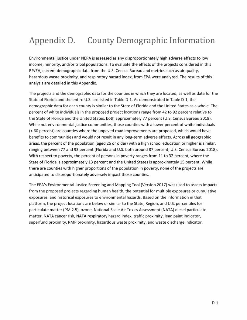
D-1
Appendix D. County Demographic Information
Environmental justice under NEPA is assessed as any disproportionately high adverse effects to low income, minority, and/or tribal populations. To evaluate the effects of the projects considered in this RP/EA, current demographic data from the U.S. Census Bureau and metrics such as air quality, hazardous waste proximity, and respiratory hazard index, from EPA were analyzed. The results of this analysis are detailed in this Appendix.
The projects and the demographic data for the counties in which they are located, as well as data for the State of Florida and the entire U.S. are listed in Table D-1. As demonstrated in Table D-1, the demographic data for each county is similar to the State of Florida and the United States as a whole. The percent of white individuals in the proposed project locations range from 42 to 92 percent relative to the State of Florida and the United States, both approximately 77 percent (U.S. Census Bureau 2018). While not environmental justice communities, those counties with a lower percent of white individuals (< 60 percent) are counties where the unpaved road improvements are proposed, which would have benefits to communities and would not result in any long-term adverse effects. Across all geographic areas, the percent of the population (aged 25 or older) with a high school education or higher is similar, ranging between 77 and 93 percent (Florida and U.S. both around 87 percent; U.S. Census Bureau 2018). With respect to poverty, the percent of persons in poverty ranges from 11 to 32 percent, where the State of Florida is approximately 13 percent and the United States is approximately 15 percent. While there are counties with higher proportions of the population in poverty, none of the projects are anticipated to disproportionately adversely impact those counties.
The EPA’s Environmental Justice Screening and Mapping Tool (Version 2017) was used to assess impacts from the proposed projects regarding human health, the potential for multiple exposures or cumulative exposures, and historical exposures to environmental hazards. Based on the information in that platform, the project locations are below or similar to the State, Region, and U.S. percentiles for particulate matter (PM 2.5), ozone, National-Scale Air Toxics Assessment (NATA) diesel particulate matter, NATA cancer risk, NATA respiratory hazard index, traffic proximity, lead paint indicator, superfund proximity, RMP proximity, hazardous waste proximity, and waste discharge indicator.
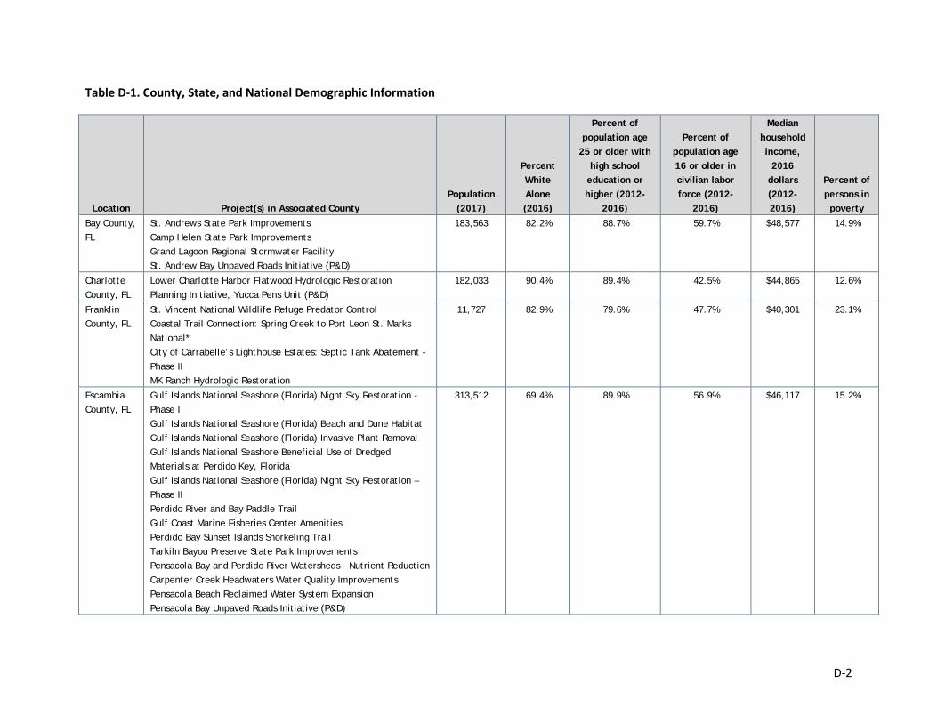
D-2
Table D-1. County, State, and National Demographic Information
Location Project(s) in Associated County Population
(2017)
Percent White Alone (2016)
Percent of population age
25 or older with high school
education or higher (2012-
2016)
Percent of population age 16 or older in civilian labor force (2012-
2016)
Median household income,
2016 dollars (2012-2016)
Percent of persons in poverty
Bay County, FL
St. Andrews State Park Improvements Camp Helen State Park Improvements Grand Lagoon Regional Stormwater Facility St. Andrew Bay Unpaved Roads Initiative (P&D)
183,563 82.2% 88.7% 59.7% $48,577 14.9%
Charlotte County, FL
Lower Charlotte Harbor Flatwood Hydrologic Restoration Planning Initiative, Yucca Pens Unit (P&D)
182,033 90.4% 89.4% 42.5% $44,865 12.6%
Franklin County, FL
St. Vincent National Wildlife Refuge Predator Control Coastal Trail Connection: Spring Creek to Port Leon St. Marks National* City of Carrabelle’s Lighthouse Estates: Septic Tank Abatement - Phase II MK Ranch Hydrologic Restoration
11,727 82.9% 79.6% 47.7% $40,301 23.1%
Escambia County, FL
Gulf Islands National Seashore (Florida) Night Sky Restoration - Phase I Gulf Islands National Seashore (Florida) Beach and Dune Habitat Gulf Islands National Seashore (Florida) Invasive Plant Removal Gulf Islands National Seashore Beneficial Use of Dredged Materials at Perdido Key, Florida Gulf Islands National Seashore (Florida) Night Sky Restoration – Phase II Perdido River and Bay Paddle Trail Gulf Coast Marine Fisheries Center Amenities Perdido Bay Sunset Islands Snorkeling Trail Tarkiln Bayou Preserve State Park Improvements Pensacola Bay and Perdido River Watersheds - Nutrient Reduction Carpenter Creek Headwaters Water Quality Improvements Pensacola Beach Reclaimed Water System Expansion Pensacola Bay Unpaved Roads Initiative (P&D)
313,512 69.4% 89.9% 56.9% $46,117 15.2%
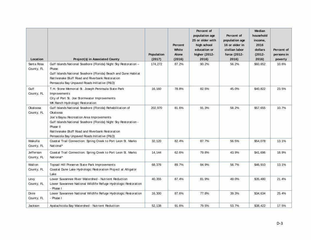
D-3
Location Project(s) in Associated County Population
(2017)
Percent White Alone (2016)
Percent of population age
25 or older with high school
education or higher (2012-
2016)
Percent of population age 16 or older in civilian labor force (2012-
2016)
Median household income,
2016 dollars (2012-2016)
Percent of persons in poverty
Santa Rosa County, FL
Gulf Islands National Seashore (Florida) Night Sky Restoration – Phase Gulf Islands National Seashore (Florida) Beach and Dune Habitat Rattlesnake Bluff Road and Riverbank Restoration Pensacola Bay Unpaved Roads Initiative (P&D)
174,272 87.2% 90.2% 56.2% $60,652 10.6%
Gulf County, FL
T.H. Stone Memorial St. Joseph Peninsula State Park Improvements City of Port St. Joe Stormwater Improvements MK Ranch Hydrologic Restoration
16,160 78.8% 82.5% 45.0% $40,822 23.5%
Okaloosa County, FL
Gulf Islands National Seashore (Florida) Rehabilitation of Okaloosa Joe’s Bayou Recreation Area Improvements Gulf Islands National Seashore (Florida) Night Sky Restoration - Phase II Rattlesnake Bluff Road and Riverbank Restoration Pensacola Bay Unpaved Roads Initiative (P&D)
202,970 81.6% 91.3% 58.2% $57,655 10.7%
Wakulla County, FL
Coastal Trail Connection: Spring Creek to Port Leon St. Marks National*
32,120 82.4% 87.7% 56.5% $54,078 13.1%
Jefferson County, FL
Coastal Trail Connection: Spring Creek to Port Leon St. Marks National*
14,144 62.6% 79.8% 43.9% $41,696 18.9%
Walton County, FL
Topsail Hill Preserve State Park Improvements Coastal Dune Lake Hydrologic Restoration Project at Alligator Lake
68,376 89.7% 84.9% 56.7% $46,910 13.1%
Levy County, FL
Lower Suwannee River Watershed - Nutrient Reduction Lower Suwannee National Wildlife Refuge Hydrologic Restoration - Phase I
40,355 87.4% 81.9% 49.0% $35,480 21.4%
Dixie County, FL
Lower Suwannee National Wildlife Refuge Hydrologic Restoration - Phase I
16,300 87.6% 77.8% 39.3% $34,634 25.4%
Jackson Apalachicola Bay Watershed - Nutrient Reduction 52,138 91.6% 79.5% 53.7% $38,422 17.5%
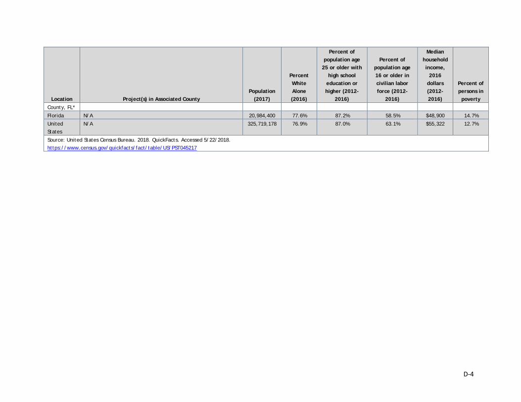
D-4
Location Project(s) in Associated County Population
(2017)
Percent White Alone (2016)
Percent of population age
25 or older with high school
education or higher (2012-
2016)
Percent of population age 16 or older in civilian labor force (2012-
2016)
Median household income,
2016 dollars (2012-2016)
Percent of persons in poverty
County, FL*
Florida N/A 20,984,400 77.6% 87.2% 58.5% $48,900 14.7% United States
N/A 325,719,178 76.9% 87.0% 63.1% $55,322 12.7%
Source: United States Census Bureau. 2018. QuickFacts. Accessed 5/22/2018. https://www.census.gov/quickfacts/fact/table/US/PST045217
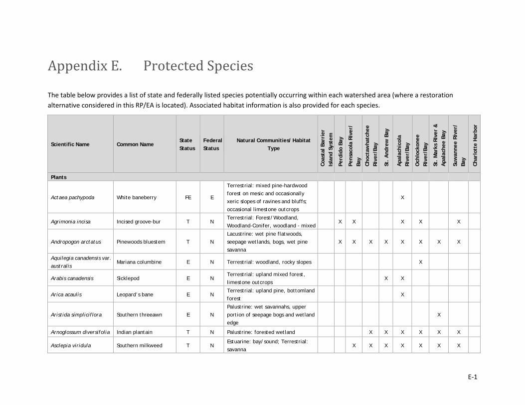
E-1
Appendix E. Protected Species
The table below provides a list of state and federally listed species potentially occurring within each watershed area (where a restoration alternative considered in this RP/EA is located). Associated habitat information is also provided for each species.
Scientific Name Common Name State Status
Federal Status
Natural Communities/ Habitat Type
Coas
tal B
arri
er
Isla
nd S
yste
m
Perd
ido
Bay
Pens
acol
a Ri
ver/
Ba
y
Choc
taw
hatc
hee
Rive
r/Ba
y
St.
And
rew
Bay
Apa
lach
icol
a Ri
ver/
Bay
Och
lock
onee
Ri
ver/
Bay
St.
Mar
ks R
iver
&
Apa
lach
ee B
ay
Suw
anne
e Ri
ver/
Ba
y
Char
lott
e H
arbo
r
Plants
Actaea pachypoda White baneberry FE E
Terrestrial: mixed pine-hardwood forest on mesic and occasionally xeric slopes of ravines and bluffs; occasional limestone outcrops
X
Agrimonia incisa Incised groove-bur T N Terrestrial: Forest/Woodland, Woodland-Conifer, woodland - mixed
X X X X X
Andropogon arctatus Pinewoods bluestem T N Lacustrine: wet pine flatwoods, seepage wetlands, bogs, wet pine savanna
X X X X X X X X
Aquilegia canadensis var. australis
Mariana columbine E N Terrestrial: woodland, rocky slopes X
Arabis canadensis Sicklepod E N Terrestrial: upland mixed forest, limestone outcrops
X X
Arica acaulis Leopard’s bane E N Terrestrial: upland pine, bottomland forest
X
Aristida simpliciflora Southern threeawn E N Palustrine: wet savannahs, upper portion of seepage bogs and wetland edge
X
Arnoglossum diversifolia Indian plantain T N Palustrine: forested wetland X X X X X X
Asclepia viridula Southern milkweed T N Estuarine: bay/sound; Terrestrial: savanna
X X X X X X X
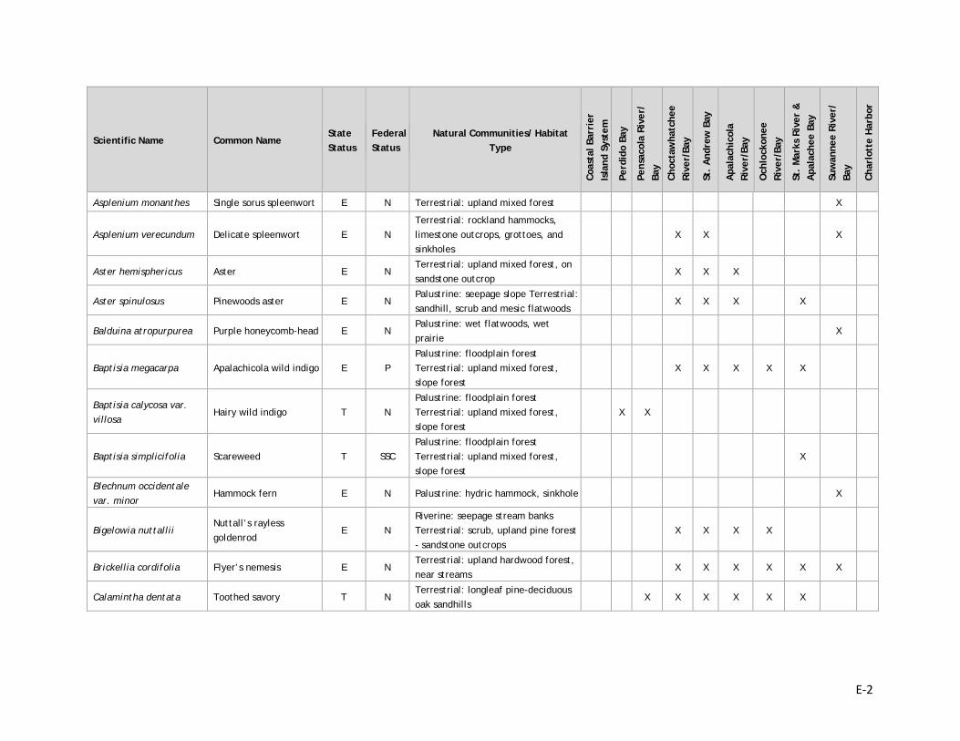
E-2
Scientific Name Common Name State Status
Federal Status
Natural Communities/ Habitat Type
Coas
tal B
arri
er
Isla
nd S
yste
m
Perd
ido
Bay
Pens
acol
a Ri
ver/
Ba
y
Choc
taw
hatc
hee
Rive
r/Ba
y
St.
And
rew
Bay
Apa
lach
icol
a Ri
ver/
Bay
Och
lock
onee
Ri
ver/
Bay
St.
Mar
ks R
iver
&
Apa
lach
ee B
ay
Suw
anne
e Ri
ver/
Ba
y
Char
lott
e H
arbo
r
Asplenium monanthes Single sorus spleenwort E N Terrestrial: upland mixed forest X
Asplenium verecundum Delicate spleenwort E N Terrestrial: rockland hammocks, limestone outcrops, grottoes, and sinkholes
X X X
Aster hemisphericus Aster E N Terrestrial: upland mixed forest, on sandstone outcrop
X X X
Aster spinulosus Pinewoods aster E N Palustrine: seepage slope Terrestrial: sandhill, scrub and mesic flatwoods
X X X X
Balduina atropurpurea Purple honeycomb-head E N Palustrine: wet flatwoods, wet prairie
X
Baptisia megacarpa Apalachicola wild indigo E P Palustrine: floodplain forest Terrestrial: upland mixed forest, slope forest
X X X X X
Baptisia calycosa var. villosa
Hairy wild indigo T N Palustrine: floodplain forest Terrestrial: upland mixed forest, slope forest
X X
Baptisia simplicifolia Scareweed T SSC Palustrine: floodplain forest Terrestrial: upland mixed forest, slope forest
X
Blechnum occidentale var. minor
Hammock fern E N Palustrine: hydric hammock, sinkhole X
Bigelowia nuttallii Nuttall’s rayless goldenrod
E N Riverine: seepage stream banks Terrestrial: scrub, upland pine forest - sandstone outcrops
X X X X
Brickellia cordifolia Flyer’s nemesis E N Terrestrial: upland hardwood forest, near streams
X X X X X X
Calamintha dentata Toothed savory T N Terrestrial: longleaf pine-deciduous oak sandhills
X X X X X X
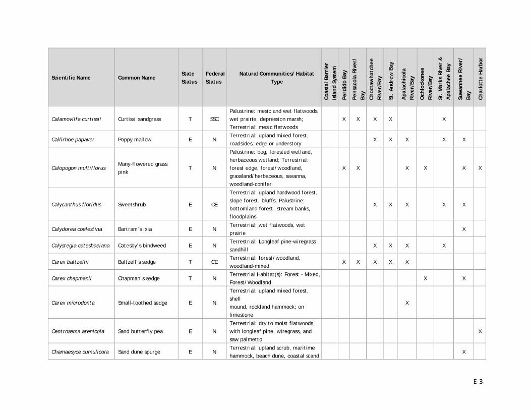
E-3
Scientific Name Common Name State Status
Federal Status
Natural Communities/ Habitat Type
Coas
tal B
arri
er
Isla
nd S
yste
m
Perd
ido
Bay
Pens
acol
a Ri
ver/
Ba
y
Choc
taw
hatc
hee
Rive
r/Ba
y
St.
And
rew
Bay
Apa
lach
icol
a Ri
ver/
Bay
Och
lock
onee
Ri
ver/
Bay
St.
Mar
ks R
iver
&
Apa
lach
ee B
ay
Suw
anne
e Ri
ver/
Ba
y
Char
lott
e H
arbo
r
Calamovilfa curtissii Curtiss’ sandgrass T SSC Palustrine: mesic and wet flatwoods, wet prairie, depression marsh; Terrestrial: mesic flatwoods
X X X X X
Callirhoe papaver Poppy mallow E N Terrestrial: upland mixed forest, roadsides; edge or understory
X X X X X
Calopogon multiflorus Many-flowered grass pink
T N
Palustrine: bog, forested wetland, herbaceous wetland; Terrestrial: forest edge, forest/woodland, grassland/herbaceous, savanna, woodland-conifer
X X X X X X
Calycanthus floridus Sweetshrub E CE
Terrestrial: upland hardwood forest, slope forest, bluffs; Palustrine: bottomland forest, stream banks, floodplains
X X X X X
Calydorea coelestina Bartram’s ixia E N Terrestrial: wet flatwoods, wet prairie
X
Calystegia catesbaeiana Catesby’s bindweed E N Terrestrial: Longleaf pine-wiregrass sandhill
X X X X
Carex baltzellii Baltzell’s sedge T CE Terrestrial: forest/woodland, woodland-mixed
X X X X X
Carex chapmanii Chapman’s sedge T N Terrestrial Habitat(s): Forest - Mixed, Forest/Woodland
X X
Carex microdonta Small-toothed sedge E N
Terrestrial: upland mixed forest, shell mound, rockland hammock; on limestone
X
Centrosema arenicola Sand butterfly pea E N Terrestrial: dry to moist flatwoods with longleaf pine, wiregrass, and saw palmetto
X
Chamaesyce cumulicola Sand dune spurge E N Terrestrial: upland scrub, maritime hammock, beach dune, coastal stand
X

E-4
Scientific Name Common Name State Status
Federal Status
Natural Communities/ Habitat Type
Coas
tal B
arri
er
Isla
nd S
yste
m
Perd
ido
Bay
Pens
acol
a Ri
ver/
Ba
y
Choc
taw
hatc
hee
Rive
r/Ba
y
St.
And
rew
Bay
Apa
lach
icol
a Ri
ver/
Bay
Och
lock
onee
Ri
ver/
Bay
St.
Mar
ks R
iver
&
Apa
lach
ee B
ay
Suw
anne
e Ri
ver/
Ba
y
Char
lott
e H
arbo
r
Cheilanthes microphylla Southern lip fern E N Terrestrial: upland mixed forest, shell mound, rockland hammock; on limestone
X X
Chrysopsis cruseana Cruise’s goldenaster E SSC Terrestrial: coastal dunes, coastal strand, coastal grassland; openings and blowouts
X X
Chrysopsis godfreyi Godfry’s goldenaster E N Terrestrial: grassland/herbaceous, sand/dune, shrubland/chaparral
X X X
Cladonia perforata Perforate reindeer lichen
E E Terrestrial: sand/dune, shrubland/chapparal
X X X X
Cleistes divaricata Spreading pogonia T N Palustrine: wet flatwoods X X X
Coelorachis tuberculosa Florida jointail T N Lacustrine: shallow water Palustrine: herbaceous wetland, temporary pool
X X X
Conrandina canescens Short-leaved rosemary N E Terrestrial: sandhill, scrub, oak scrub, upland habitats
X
Conradina glabra Apalachicola rosemary FE E
Terrestrial: sandhill dissected by ravines of the Sweetwater Creek system. Light shade to full sunlight; along edges of ravines, pine plantations, and roadsides
X X X
Corallorhiza odontorhiza Autumn coralroot E N Terrestrial: upland hardwood forest X
Coreopsis integrifolia Fringeleaf tickseed E P Lacustrine: forested wetland, riparian
X X X
Cornus alternifolia Pagoda dogwood E CE Palustrine: creek swamps Terrestrial: slope forest, upland hardwood forest, bluffs
X X X
Ctenium floridanum Florida toothache grass E N Terrestrial: wet flatwoods, depression marsh, mesic flatwoods, scrubby flatwoods
X
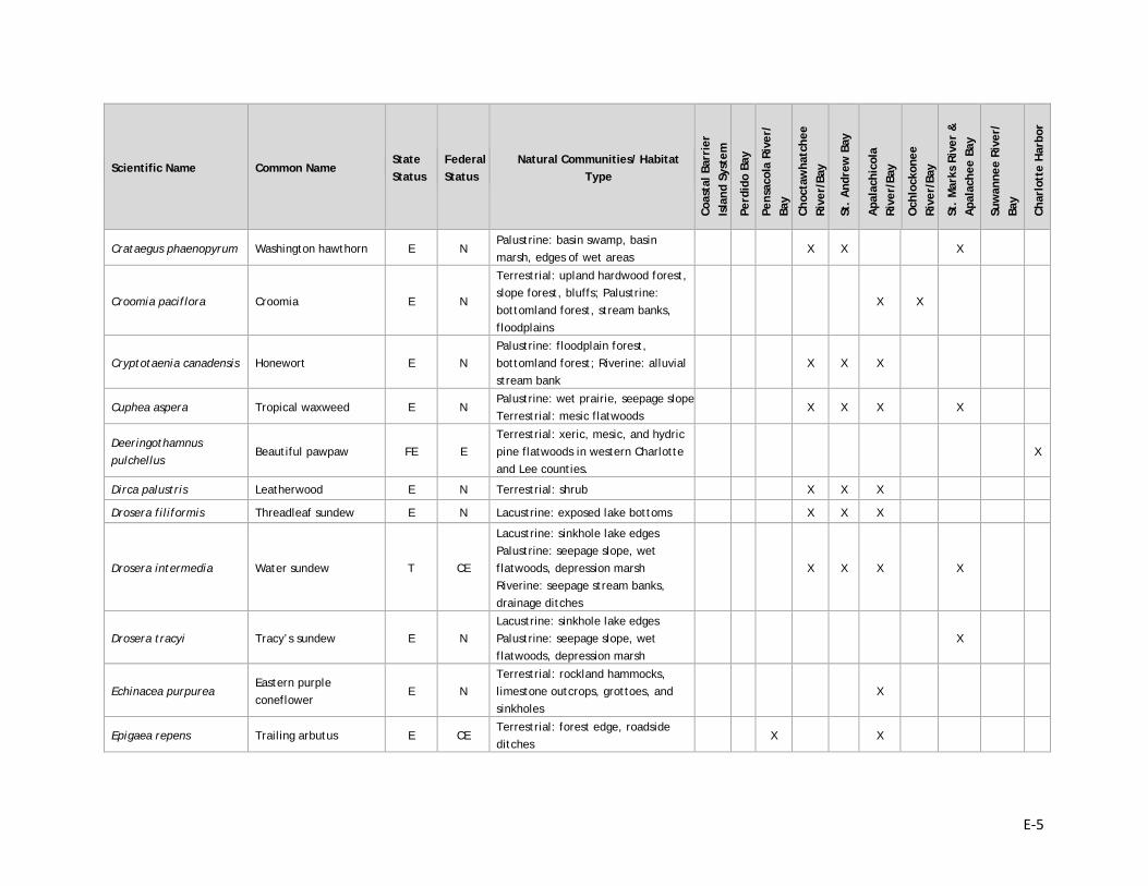
E-5
Scientific Name Common Name State Status
Federal Status
Natural Communities/ Habitat Type
Coas
tal B
arri
er
Isla
nd S
yste
m
Perd
ido
Bay
Pens
acol
a Ri
ver/
Ba
y
Choc
taw
hatc
hee
Rive
r/Ba
y
St.
And
rew
Bay
Apa
lach
icol
a Ri
ver/
Bay
Och
lock
onee
Ri
ver/
Bay
St.
Mar
ks R
iver
&
Apa
lach
ee B
ay
Suw
anne
e Ri
ver/
Ba
y
Char
lott
e H
arbo
r
Crataegus phaenopyrum Washington hawthorn E N Palustrine: basin swamp, basin marsh, edges of wet areas
X X X
Croomia paciflora Croomia E N
Terrestrial: upland hardwood forest, slope forest, bluffs; Palustrine: bottomland forest, stream banks, floodplains
X X
Cryptotaenia canadensis Honewort E N Palustrine: floodplain forest, bottomland forest; Riverine: alluvial stream bank
X X X
Cuphea aspera Tropical waxweed E N Palustrine: wet prairie, seepage slope Terrestrial: mesic flatwoods
X X X X
Deeringothamnus pulchellus
Beautiful pawpaw FE E Terrestrial: xeric, mesic, and hydric pine flatwoods in western Charlotte and Lee counties.
X
Dirca palustris Leatherwood E N Terrestrial: shrub X X X
Drosera filiformis Threadleaf sundew E N Lacustrine: exposed lake bottoms X X X
Drosera intermedia Water sundew T CE
Lacustrine: sinkhole lake edges Palustrine: seepage slope, wet flatwoods, depression marsh Riverine: seepage stream banks, drainage ditches
X X X X
Drosera tracyi Tracy’s sundew E N Lacustrine: sinkhole lake edges Palustrine: seepage slope, wet flatwoods, depression marsh
X
Echinacea purpurea Eastern purple coneflower
E N Terrestrial: rockland hammocks, limestone outcrops, grottoes, and sinkholes
X
Epigaea repens Trailing arbutus E CE Terrestrial: forest edge, roadside ditches
X X
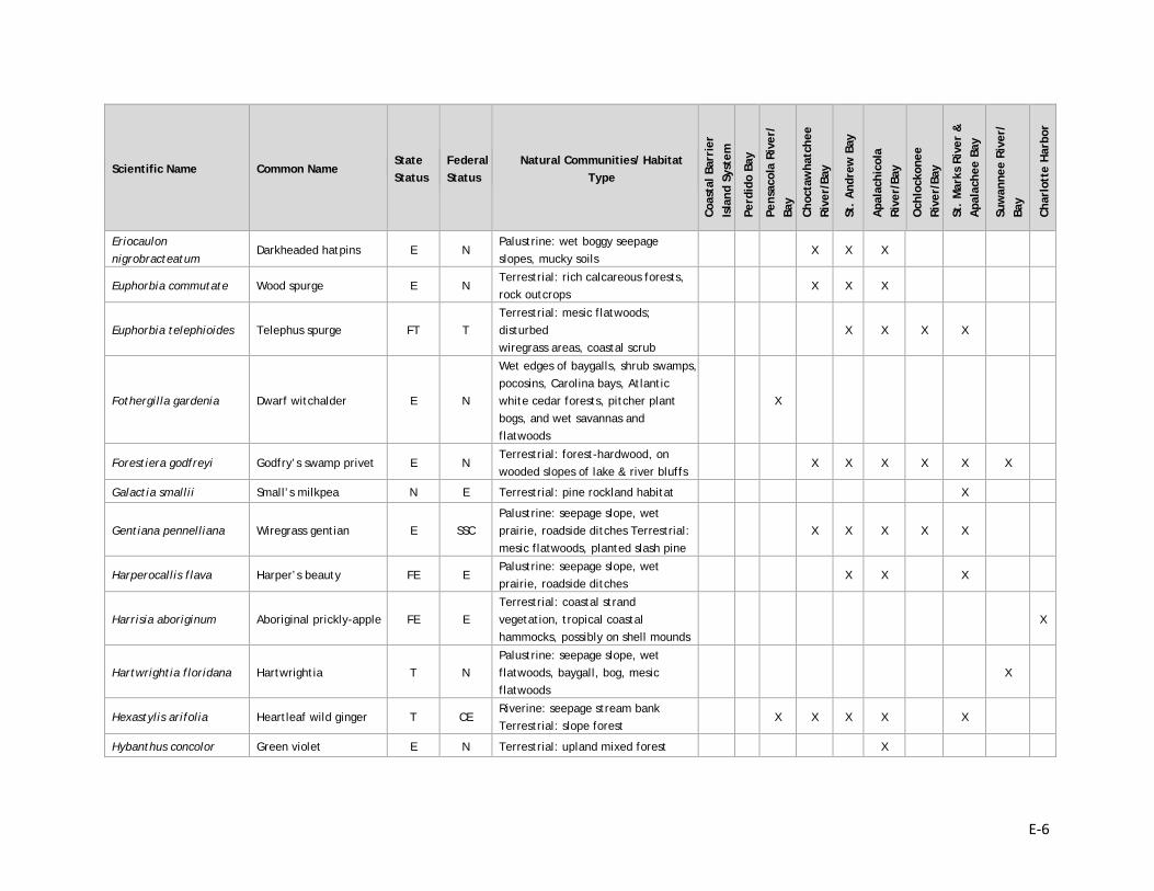
E-6
Scientific Name Common Name State Status
Federal Status
Natural Communities/ Habitat Type
Coas
tal B
arri
er
Isla
nd S
yste
m
Perd
ido
Bay
Pens
acol
a Ri
ver/
Ba
y
Choc
taw
hatc
hee
Rive
r/Ba
y
St.
And
rew
Bay
Apa
lach
icol
a Ri
ver/
Bay
Och
lock
onee
Ri
ver/
Bay
St.
Mar
ks R
iver
&
Apa
lach
ee B
ay
Suw
anne
e Ri
ver/
Ba
y
Char
lott
e H
arbo
r
Eriocaulon nigrobracteatum
Darkheaded hatpins E N Palustrine: wet boggy seepage slopes, mucky soils
X X X
Euphorbia commutate Wood spurge E N Terrestrial: rich calcareous forests, rock outcrops
X X X
Euphorbia telephioides Telephus spurge FT T Terrestrial: mesic flatwoods; disturbed wiregrass areas, coastal scrub
X X X X
Fothergilla gardenia Dwarf witchalder E N
Wet edges of baygalls, shrub swamps, pocosins, Carolina bays, Atlantic white cedar forests, pitcher plant bogs, and wet savannas and flatwoods
X
Forestiera godfreyi Godfry’s swamp privet E N Terrestrial: forest-hardwood, on wooded slopes of lake & river bluffs
X X X X X X
Galactia smallii Small’s milkpea N E Terrestrial: pine rockland habitat X
Gentiana pennelliana Wiregrass gentian E SSC Palustrine: seepage slope, wet prairie, roadside ditches Terrestrial: mesic flatwoods, planted slash pine
X X X X X
Harperocallis flava Harper’s beauty FE E Palustrine: seepage slope, wet prairie, roadside ditches
X X X
Harrisia aboriginum Aboriginal prickly-apple FE E Terrestrial: coastal strand vegetation, tropical coastal hammocks, possibly on shell mounds
X
Hartwrightia floridana Hartwrightia T N Palustrine: seepage slope, wet flatwoods, baygall, bog, mesic flatwoods
X
Hexastylis arifolia Heartleaf wild ginger T CE Riverine: seepage stream bank Terrestrial: slope forest
X X X X X
Hybanthus concolor Green violet E N Terrestrial: upland mixed forest X
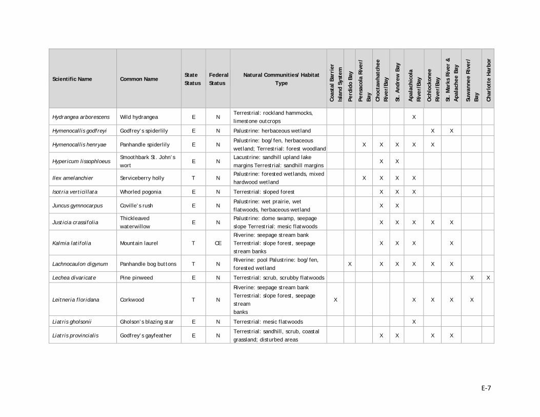
E-7
Scientific Name Common Name State Status
Federal Status
Natural Communities/ Habitat Type
Coas
tal B
arri
er
Isla
nd S
yste
m
Perd
ido
Bay
Pens
acol
a Ri
ver/
Ba
y
Choc
taw
hatc
hee
Rive
r/Ba
y
St.
And
rew
Bay
Apa
lach
icol
a Ri
ver/
Bay
Och
lock
onee
Ri
ver/
Bay
St.
Mar
ks R
iver
&
Apa
lach
ee B
ay
Suw
anne
e Ri
ver/
Ba
y
Char
lott
e H
arbo
r
Hydrangea arborescens Wild hydrangea E N Terrestrial: rockland hammocks, limestone outcrops
X
Hymenocallis godfreyi Godfrey’s spiderlily E N Palustrine: herbaceous wetland X X
Hymenocallis henryae Panhandle spiderlily E N Palustrine: bog/fen, herbaceous wetland; Terrestrial: forest woodland
X X X X X
Hypericum lissophloeus Smoothbark St. John’s wort
E N Lacustrine: sandhill upland lake margins Terrestrial: sandhill margins
X X
Ilex amelanchier Serviceberry holly T N Palustrine: forested wetlands, mixed hardwood wetland
X X X X
Isotria verticillata Whorled pogonia E N Terrestrial: sloped forest X X X
Juncus gymnocarpus Coville’s rush E N Palustrine: wet prairie, wet flatwoods, herbaceous wetland
X X
Justicia crassifolia Thickleaved waterwillow
E N Palustrine: dome swamp, seepage slope Terrestrial: mesic flatwoods
X X X X X
Kalmia latifolia Mountain laurel T CE Riverine: seepage stream bank Terrestrial: slope forest, seepage stream banks
X X X X
Lachnocaulon digynum Panhandle bog buttons T N Riverine: pool Palustrine: bog/fen, forested wetland
X X X X X X
Lechea divaricate Pine pinweed E N Terrestrial: scrub, scrubby flatwoods X X
Leitneria floridana Corkwood T N
Riverine: seepage stream bank Terrestrial: slope forest, seepage stream banks
X X X X X
Liatris gholsonii Gholson’s blazing star E N Terrestrial: mesic flatwoods X
Liatris provincialis Godfrey’s gayfeather E N Terrestrial: sandhill, scrub, coastal grassland; disturbed areas
X X X X
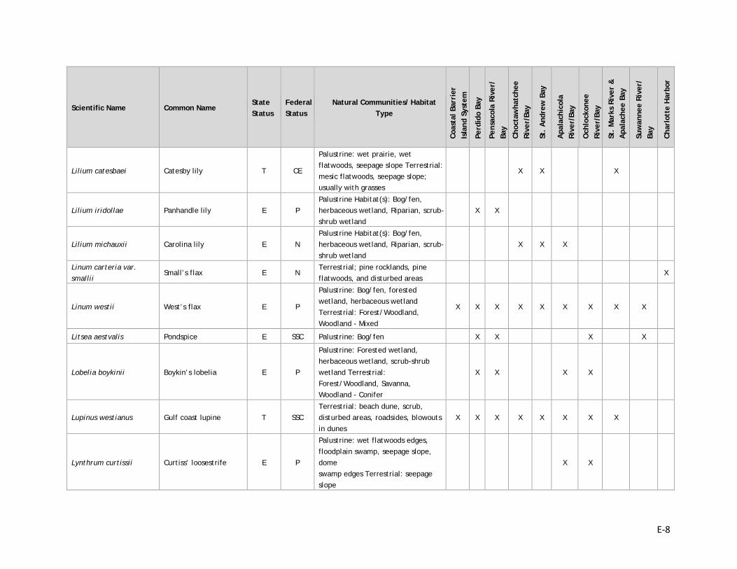
E-8
Scientific Name Common Name State Status
Federal Status
Natural Communities/ Habitat Type
Coas
tal B
arri
er
Isla
nd S
yste
m
Perd
ido
Bay
Pens
acol
a Ri
ver/
Ba
y
Choc
taw
hatc
hee
Rive
r/Ba
y
St.
And
rew
Bay
Apa
lach
icol
a Ri
ver/
Bay
Och
lock
onee
Ri
ver/
Bay
St.
Mar
ks R
iver
&
Apa
lach
ee B
ay
Suw
anne
e Ri
ver/
Ba
y
Char
lott
e H
arbo
r
Lilium catesbaei Catesby lily T CE
Palustrine: wet prairie, wet flatwoods, seepage slope Terrestrial: mesic flatwoods, seepage slope; usually with grasses
X X X
Lilium iridollae Panhandle lily E P Palustrine Habitat(s): Bog/fen, herbaceous wetland, Riparian, scrub-shrub wetland
X X
Lilium michauxii Carolina lily E N Palustrine Habitat(s): Bog/fen, herbaceous wetland, Riparian, scrub-shrub wetland
X X X
Linum carteria var. smallii
Small’s flax E N Terrestrial; pine rocklands, pine flatwoods, and disturbed areas
X
Linum westii West’s flax E P
Palustrine: Bog/fen, forested wetland, herbaceous wetland Terrestrial: Forest/Woodland, Woodland - Mixed
X X X X X X X X X
Litsea aestvalis Pondspice E SSC Palustrine: Bog/fen X X X X
Lobelia boykinii Boykin’s lobelia E P
Palustrine: Forested wetland, herbaceous wetland, scrub-shrub wetland Terrestrial: Forest/Woodland, Savanna, Woodland - Conifer
X X X X
Lupinus westianus Gulf coast lupine T SSC Terrestrial: beach dune, scrub, disturbed areas, roadsides, blowouts in dunes
X X X X X X X X
Lynthrum curtissii Curtiss’ loosestrife E P
Palustrine: wet flatwoods edges, floodplain swamp, seepage slope, dome swamp edges Terrestrial: seepage slope
X X
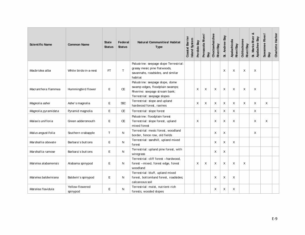
E-9
Scientific Name Common Name State Status
Federal Status
Natural Communities/ Habitat Type
Coas
tal B
arri
er
Isla
nd S
yste
m
Perd
ido
Bay
Pens
acol
a Ri
ver/
Ba
y
Choc
taw
hatc
hee
Rive
r/Ba
y
St.
And
rew
Bay
Apa
lach
icol
a Ri
ver/
Bay
Och
lock
onee
Ri
ver/
Bay
St.
Mar
ks R
iver
&
Apa
lach
ee B
ay
Suw
anne
e Ri
ver/
Ba
y
Char
lott
e H
arbo
r
Macbridea alba White birds-in-a-nest FT T
Palustrine: seepage slope Terrestrial: grassy mesic pine flatwoods, savannahs, roadsides, and similar habitat
X X X X
Macranthera flammea Hummingbird flower E CE
Palustrine: seepage slope, dome swamp edges, floodplain swamps; Riverine: seepage stream bank; Terrestrial: seepage slopes
X X X X X X X
Magnolia ashei Ashe’s magnolia E SSC Terrestrial: slope and upland hardwood forest, ravines
X X X X X X X X
Magnolia pyramidata Pyramid magnolia E CE Terrestrial: slope forest X X X X
Malaxis unifloria Green addersmouth E CE Palustrine: floodplain forest Terrestrial: slope forest, upland mixed forest
X X X X X X
Malus angustifolia Southern crabapple T N Terrestrial: mesic forest, woodland border, fence row, old fields
X X X
Marshallia obovate Barbara’s buttons E N Terrestrial: sandhill, upland mixed forest
X X X
Marshallia ramose Barbara’s buttons E N Terrestrial: upland pine forest, with wiregrass
X X
Matelea alabamensis Alabama spinypod E N Terrestrial: cliff forest – hardwood, forest – mixed, forest edge, forest woodland
X X X X X X
Matelea baldwiniana Baldwin’s spinypod E N Terrestrial: bluff, upland mixed forest, bottomland forest, roadsides; calcareous soil
X X X
Matelea flavidula Yellow-flowered spinypod
E N Terrestrial: moist, nutrient-rich forests, wooded slopes
X X X
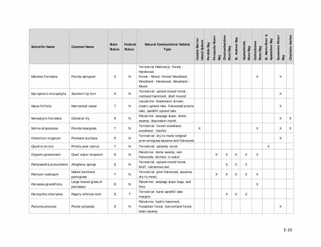
E-10
Scientific Name Common Name State Status
Federal Status
Natural Communities/ Habitat Type
Coas
tal B
arri
er
Isla
nd S
yste
m
Perd
ido
Bay
Pens
acol
a Ri
ver/
Ba
y
Choc
taw
hatc
hee
Rive
r/Ba
y
St.
And
rew
Bay
Apa
lach
icol
a Ri
ver/
Bay
Och
lock
onee
Ri
ver/
Bay
St.
Mar
ks R
iver
&
Apa
lach
ee B
ay
Suw
anne
e Ri
ver/
Ba
y
Char
lott
e H
arbo
r
Matalea floridana Florida spinypod E N
Terrestrial Habitat(s): Forest - Hardwood, Forest - Mixed, Forest/Woodland, Woodland - Hardwood, Woodland - Mixed
X X
Myriopteris microphylla Southern lip fern E N Terrestrial: upland mixed forest, rockland hammock, shell mound
X
Najas filifolia Narrowleaf naiad T N Lacustrine: blackwater stream, clastic upland lake, flatwoods/prairie lake, sandhill upland lake
X
Nemastylis floridana Celestial lily E N Palustrine: seepage slope, dome swamp, depression marsh
X X
Nolina atopocarpa Florida beargrass T N Terrestrial: forest/woodland, woodland - Conifer
X X X X
Orbexilum virgatum Pineland scurfpea E N Terrestrial: dry to moist longleaf pine-wiregrass savanna and flatwoods
X
Opuntia stricta Prickly pear cactus T N Terrestrial: uplands, scrub X
Oxypolis greenmanii Giant water-dropwort E N Palustrine: dome swamp, wet flatwoods, ditches: in water
X X X X X
Pachysandra procumbens Allegheny spurge E N Terrestrial: upland mixed forest, bluff; calcareous soil
X X X
Panicum nudicaule Naked stemmed panicgrass
T N Terrestrial: pine flatwoods, savanna, dry to mesic
X X X X X
Parnassia grandifolia Large leaved grass of parnassus
E N Palustrine: seepage slope bogs, and fens
X
Paronychia chartacea Papery whitlow-wort E T Terrestrial: karst sandhill lake margins
X X X
Pecluma plumula Plume polypody E N Palustrine: hydric hammock, floodplain forest, bottomland forest, basin swamp
X
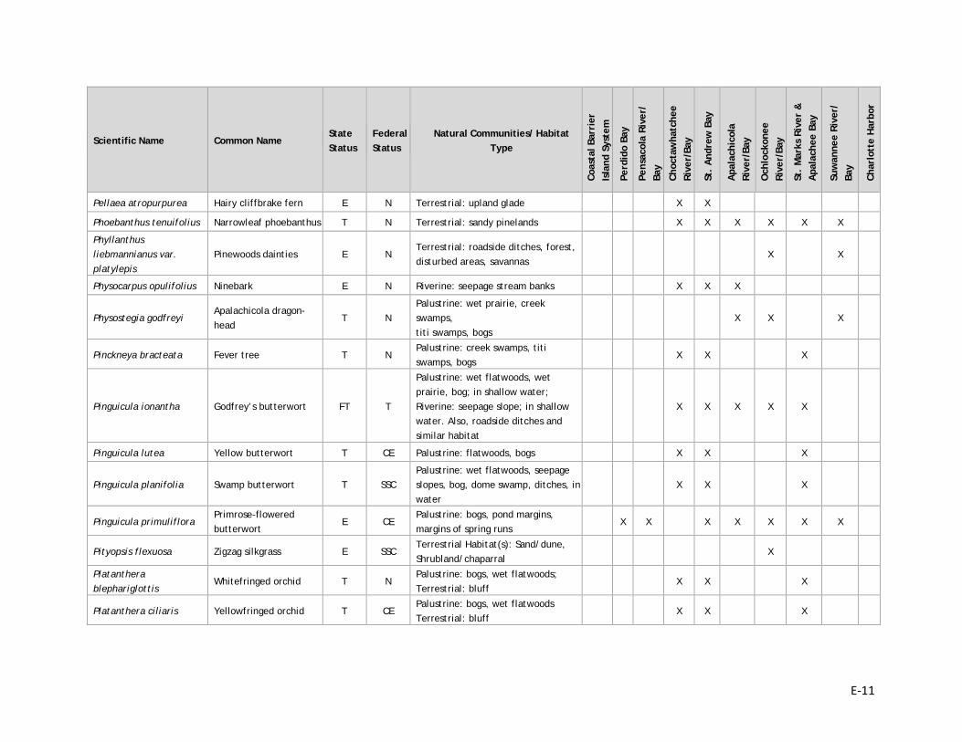
E-11
Scientific Name Common Name State Status
Federal Status
Natural Communities/ Habitat Type
Coas
tal B
arri
er
Isla
nd S
yste
m
Perd
ido
Bay
Pens
acol
a Ri
ver/
Ba
y
Choc
taw
hatc
hee
Rive
r/Ba
y
St.
And
rew
Bay
Apa
lach
icol
a Ri
ver/
Bay
Och
lock
onee
Ri
ver/
Bay
St.
Mar
ks R
iver
&
Apa
lach
ee B
ay
Suw
anne
e Ri
ver/
Ba
y
Char
lott
e H
arbo
r
Pellaea atropurpurea Hairy cliffbrake fern E N Terrestrial: upland glade X X
Phoebanthus tenuifolius Narrowleaf phoebanthus T N Terrestrial: sandy pinelands X X X X X X
Phyllanthus liebmannianus var. platylepis
Pinewoods dainties E N Terrestrial: roadside ditches, forest, disturbed areas, savannas
X X
Physocarpus opulifolius Ninebark E N Riverine: seepage stream banks X X X
Physostegia godfreyi Apalachicola dragon-head
T N Palustrine: wet prairie, creek swamps, titi swamps, bogs
X X X
Pinckneya bracteata Fever tree T N Palustrine: creek swamps, titi swamps, bogs
X X X
Pinguicula ionantha Godfrey’s butterwort FT T
Palustrine: wet flatwoods, wet prairie, bog; in shallow water; Riverine: seepage slope; in shallow water. Also, roadside ditches and similar habitat
X X X X X
Pinguicula lutea Yellow butterwort T CE Palustrine: flatwoods, bogs X X X
Pinguicula planifolia Swamp butterwort T SSC Palustrine: wet flatwoods, seepage slopes, bog, dome swamp, ditches, in water
X X X
Pinguicula primuliflora Primrose-flowered butterwort
E CE Palustrine: bogs, pond margins, margins of spring runs
X X X X X X X
Pityopsis flexuosa Zigzag silkgrass E SSC Terrestrial Habitat(s): Sand/dune, Shrubland/chaparral
X
Platanthera blephariglottis
Whitefringed orchid T N Palustrine: bogs, wet flatwoods; Terrestrial: bluff
X X X
Platanthera ciliaris Yellowfringed orchid T CE Palustrine: bogs, wet flatwoods Terrestrial: bluff
X X X
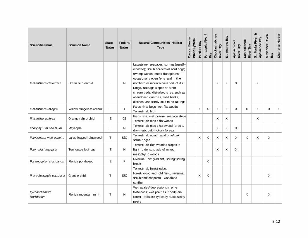
E-12
Scientific Name Common Name State Status
Federal Status
Natural Communities/ Habitat Type
Coas
tal B
arri
er
Isla
nd S
yste
m
Perd
ido
Bay
Pens
acol
a Ri
ver/
Ba
y
Choc
taw
hatc
hee
Rive
r/Ba
y
St.
And
rew
Bay
Apa
lach
icol
a Ri
ver/
Bay
Och
lock
onee
Ri
ver/
Bay
St.
Mar
ks R
iver
&
Apa
lach
ee B
ay
Suw
anne
e Ri
ver/
Ba
y
Char
lott
e H
arbo
r
Platanthera clavellata Green rein orchid E N
Lacustrine: seepages, springs (usually wooded); shrub borders of acid bogs; swamp woods; creek floodplains; occasionally open fens; and in the northern or mountainous part of its range, seepage slopes or sunlit stream beds, disturbed sites, such as abandoned quarries, road banks, ditches, and sandy-acid mine tailings
X X X X
Platanthera integra Yellow fringeless orchid E CE Palustrine: bogs, wet flatwoods; Terrestrial: bluff
X X X X X X X X X
Platanthera nivea Orange rein orchid E CE Palustrine: wet prairie, seepage slope Terrestrial: mesic flatwoods
X X X
Podophyllum peltatum Mayapple E N Terrestrial: mesic hardwood forests, dry-mesic oak-hickory forests
X X X
Polygonella macrophylla Large-leaved jointweed T SSC Terrestrial: scrub, sand pine/oak scrub ridges
X X X X X X X X
Polymnia laevigata Tennessee leaf-cup E N Terrestrial: rich wooded slopes in light to dense shade of mixed mesophytic woods
X X X
Potamogeton floridanus Florida pondweed E P Riverine: low gradient, spring/spring brook
X
Pteroglossaspis ecristata Giant orchid T SSC
Terrestrial: forest edge, forest/woodland, old field, savanna, shrubland/chaparral, woodland-conifer
X X X
Pycnanthemum floridanum
Florida mountain mint T N
Wet swales/depressions in pine flatwoods; wet prairies, floodplain forest, soils are typically black sandy peats
X X
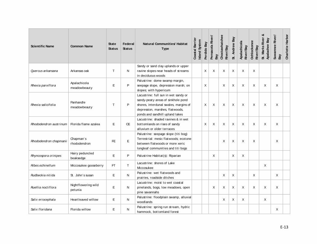
E-13
Scientific Name Common Name State Status
Federal Status
Natural Communities/ Habitat Type
Coas
tal B
arri
er
Isla
nd S
yste
m
Perd
ido
Bay
Pens
acol
a Ri
ver/
Ba
y
Choc
taw
hatc
hee
Rive
r/Ba
y
St.
And
rew
Bay
Apa
lach
icol
a Ri
ver/
Bay
Och
lock
onee
Ri
ver/
Bay
St.
Mar
ks R
iver
&
Apa
lach
ee B
ay
Suw
anne
e Ri
ver/
Ba
y
Char
lott
e H
arbo
r
Quercus arkansana Arkansas oak T N Sandy or sand clay uplands or upper ravine slopes near heads of streams in deciduous woods
X X X X X X
Rhexia parviflora Apalachicola meadowbeauty
E P Palustrine: dome swamp margin, seepage slope, depression marsh; on slopes; with hypericum
X X X X X X X
Rhexia salicifolia Panhandle meadowbeauty
T P
Lacustrine: full sun in wet sandy or sandy-peaty areas of sinkhole pond shores, interdunal swales, margins of depression, marshes, flatwoods, ponds and sandhill upland lakes
X X X X X X X X
Rhododendron austrinum Florida flame azalea E CE Lacustrine: shaded ravines & in wet bottomlands on rises of sandy alluvium or older terraces
X X X X X X X X
Rhododendron chapmanii Chapman’s rhododendron
FE E
Palustrine: seepage slope (titi bog) Terrestrial: mesic flatwoods; ecotone between flatwoods or more xeric longleaf communities and titi bogs
X X X X X
Rhyncospora crinipes Hairy peduncled beaksedge
E P Palustrine Habitat(s): Riparian X X X
Ribes echinellum Miccosukee gooseberry FT T Lacustrine: shores of Lake Miccosukee
X
Rudbeckia nitida St. John’s susan E N Palustrine: wet flatwoods and prairies, roadside ditches
X X X X
Ruellia noctiflora Nightflowering wild petunia
E N Lacustrine: moist to wet coastal pinelands, bogs, low meadows, open pine savannahs
X X X X X X X
Salix eriocephala Heartleaved willow E N Palustrine: floodplain swamp, alluvial woodlands
X X X X
Salix floridana Florida willow E N Palustrine: spring run stream, hydric hammock, bottomland forest
X
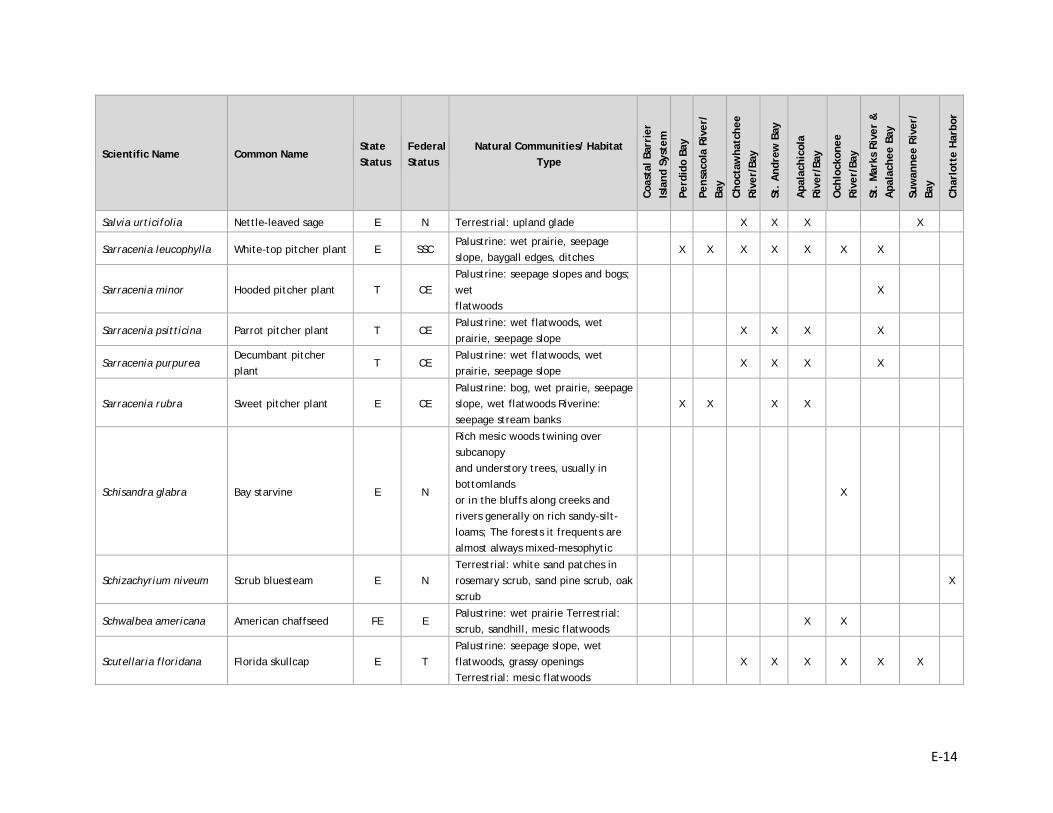
E-14
Scientific Name Common Name State Status
Federal Status
Natural Communities/ Habitat Type
Coas
tal B
arri
er
Isla
nd S
yste
m
Perd
ido
Bay
Pens
acol
a Ri
ver/
Ba
y
Choc
taw
hatc
hee
Rive
r/Ba
y
St.
And
rew
Bay
Apa
lach
icol
a Ri
ver/
Bay
Och
lock
onee
Ri
ver/
Bay
St.
Mar
ks R
iver
&
Apa
lach
ee B
ay
Suw
anne
e Ri
ver/
Ba
y
Char
lott
e H
arbo
r
Salvia urticifolia Nettle-leaved sage E N Terrestrial: upland glade X X X X
Sarracenia leucophylla White-top pitcher plant E SSC Palustrine: wet prairie, seepage slope, baygall edges, ditches
X X X X X X X
Sarracenia minor Hooded pitcher plant T CE Palustrine: seepage slopes and bogs; wet flatwoods
X
Sarracenia psitticina Parrot pitcher plant T CE Palustrine: wet flatwoods, wet prairie, seepage slope
X X X X
Sarracenia purpurea Decumbant pitcher plant
T CE Palustrine: wet flatwoods, wet prairie, seepage slope
X X X X
Sarracenia rubra Sweet pitcher plant E CE Palustrine: bog, wet prairie, seepage slope, wet flatwoods Riverine: seepage stream banks
X X X X
Schisandra glabra Bay starvine E N
Rich mesic woods twining over subcanopy and understory trees, usually in bottomlands or in the bluffs along creeks and rivers generally on rich sandy-silt-loams; The forests it frequents are almost always mixed-mesophytic
X
Schizachyrium niveum Scrub bluesteam E N Terrestrial: white sand patches in rosemary scrub, sand pine scrub, oak scrub
X
Schwalbea americana American chaffseed FE E Palustrine: wet prairie Terrestrial: scrub, sandhill, mesic flatwoods
X X
Scutellaria floridana Florida skullcap E T Palustrine: seepage slope, wet flatwoods, grassy openings Terrestrial: mesic flatwoods
X X X X X X
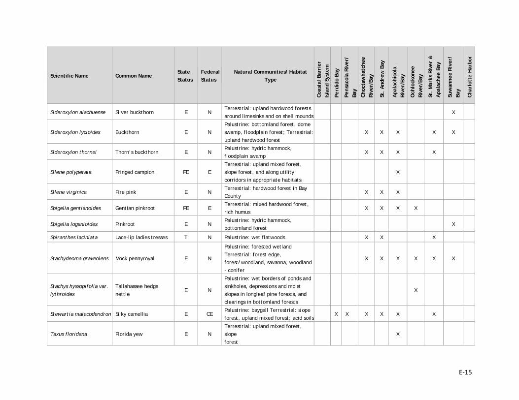
E-15
Scientific Name Common Name State Status
Federal Status
Natural Communities/ Habitat Type
Coas
tal B
arri
er
Isla
nd S
yste
m
Perd
ido
Bay
Pens
acol
a Ri
ver/
Ba
y
Choc
taw
hatc
hee
Rive
r/Ba
y
St.
And
rew
Bay
Apa
lach
icol
a Ri
ver/
Bay
Och
lock
onee
Ri
ver/
Bay
St.
Mar
ks R
iver
&
Apa
lach
ee B
ay
Suw
anne
e Ri
ver/
Ba
y
Char
lott
e H
arbo
r
Sideroxylon alachuense Silver buckthorn E N Terrestrial: upland hardwood forests around limesinks and on shell mounds
X
Sideroxylon lycioides Buckthorn E N Palustrine: bottomland forest, dome swamp, floodplain forest; Terrestrial: upland hardwood forest
X X X X X
Sideroxylon thornei Thorn’s buckthorn E N Palustrine: hydric hammock, floodplain swamp
X X X X
Silene polypetala Fringed campion FE E Terrestrial: upland mixed forest, slope forest, and along utility corridors in appropriate habitats
X
Silene virginica Fire pink E N Terrestrial: hardwood forest in Bay County
X X X
Spigelia gentianoides Gentian pinkroot FE E Terrestrial: mixed hardwood forest, rich humus
X X X X
Spigelia loganioides Pinkroot E N Palustrine: hydric hammock, bottomland forest
X
Spiranthes laciniata Lace-lip ladies tresses T N Palustrine: wet flatwoods X X X
Stachydeoma graveolens Mock pennyroyal E N
Palustrine: forested wetland Terrestrial: forest edge, forest/woodland, savanna, woodland - conifer
X X X X X X
Stachys hyssopifolia var. lythroides
Tallahassee hedge nettle
E N
Palustrine: wet borders of ponds and sinkholes, depressions and moist slopes in longleaf pine forests, and clearings in bottomland forests
X
Stewartia malacodendron Silky camellia E CE Palustrine: baygall Terrestrial: slope forest, upland mixed forest; acid soils
X X X X X X
Taxus floridana Florida yew E N Terrestrial: upland mixed forest, slope forest
X
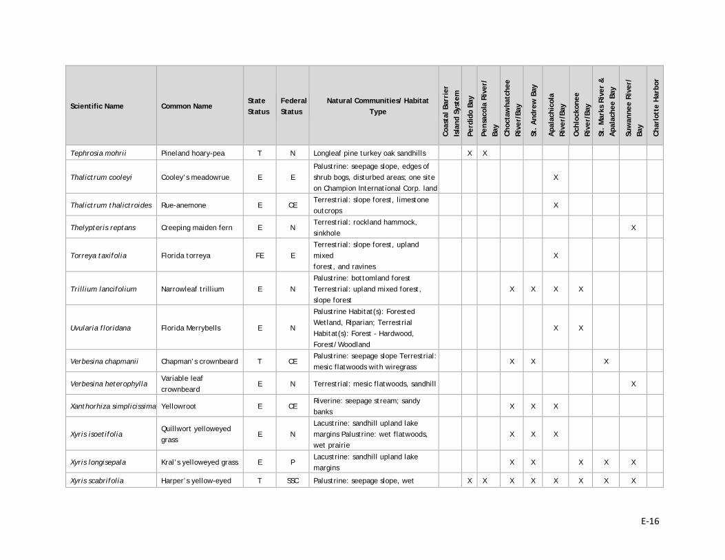
E-16
Scientific Name Common Name State Status
Federal Status
Natural Communities/ Habitat Type
Coas
tal B
arri
er
Isla
nd S
yste
m
Perd
ido
Bay
Pens
acol
a Ri
ver/
Ba
y
Choc
taw
hatc
hee
Rive
r/Ba
y
St.
And
rew
Bay
Apa
lach
icol
a Ri
ver/
Bay
Och
lock
onee
Ri
ver/
Bay
St.
Mar
ks R
iver
&
Apa
lach
ee B
ay
Suw
anne
e Ri
ver/
Ba
y
Char
lott
e H
arbo
r
Tephrosia mohrii Pineland hoary-pea T N Longleaf pine turkey oak sandhills X X
Thalictrum cooleyi Cooley’s meadowrue E E Palustrine: seepage slope, edges of shrub bogs, disturbed areas; one site on Champion International Corp. land
X
Thalictrum thalictroides Rue-anemone E CE Terrestrial: slope forest, limestone outcrops
X
Thelypteris reptans Creeping maiden fern E N Terrestrial: rockland hammock, sinkhole
X
Torreya taxifolia Florida torreya FE E Terrestrial: slope forest, upland mixed forest, and ravines
X
Trillium lancifolium Narrowleaf trillium E N Palustrine: bottomland forest Terrestrial: upland mixed forest, slope forest
X X X X
Uvularia floridana Florida Merrybells E N
Palustrine Habitat(s): Forested Wetland, Riparian; Terrestrial Habitat(s): Forest - Hardwood, Forest/Woodland
X X
Verbesina chapmanii Chapman’s crownbeard T CE Palustrine: seepage slope Terrestrial: mesic flatwoods with wiregrass
X X X
Verbesina heterophylla Variable leaf crownbeard
E N Terrestrial: mesic flatwoods, sandhill X
Xanthorhiza simplicissima Yellowroot E CE Riverine: seepage stream; sandy banks
X X X
Xyris isoetifolia Quillwort yelloweyed grass
E N Lacustrine: sandhill upland lake margins Palustrine: wet flatwoods, wet prairie
X X X
Xyris longisepala Kral’s yelloweyed grass E P Lacustrine: sandhill upland lake margins
X X X X X
Xyris scabrifolia Harper’s yellow-eyed T SSC Palustrine: seepage slope, wet X X X X X X X X
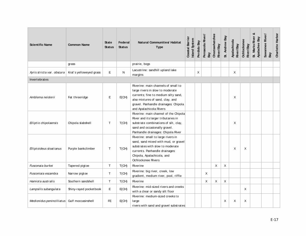
E-17
Scientific Name Common Name State Status
Federal Status
Natural Communities/ Habitat Type
Coas
tal B
arri
er
Isla
nd S
yste
m
Perd
ido
Bay
Pens
acol
a Ri
ver/
Ba
y
Choc
taw
hatc
hee
Rive
r/Ba
y
St.
And
rew
Bay
Apa
lach
icol
a Ri
ver/
Bay
Och
lock
onee
Ri
ver/
Bay
St.
Mar
ks R
iver
&
Apa
lach
ee B
ay
Suw
anne
e Ri
ver/
Ba
y
Char
lott
e H
arbo
r
grass prairie, bogs
Xyris stricta var. obscura Kral’s yelloweyed grass E N Lacustrine: sandhill upland lake margins
X X
Invertebrates
Amblema neislerii Fat threeridge E E(CH)
Riverine: main channels of small to large rivers in slow to moderate currents; fine to medium silty sand, also mixtures of sand, clay, and gravel. Panhandle drainages: Chipola and Apalachicola Rivers
X
Elliptio chipolaensis Chipola slabshell T T(CH)
Riverine: main channel of the Chipola River and its larger tributaries in substrate combinations of silt, clay, sand and occasionally gravel. Panhandle drainages: Chipola River
X
Elliptoideus sloatianus Purple bankclimber T T(CH)
Riverine: small to large rivers in sand, sand mixed with mud, or gravel substrates with slow to moderate currents. Panhandle drainages: Chipola, Apalachicola, and Ochlockonee Rivers
X X
Fusconaia burkei Tapered pigtoe T T(CH) Riverine X X
Fusconiaia escambia Narrow pigtoe T T(CH) Riverine: big river, creek, low gradient, medium river, pool, riffle
X
Hamiota australis Southern sandshell T T(CH) Riverine X X X
Lampsilis subangulata Shiny-rayed pocketbook E E(CH) Riverine: mid-sized rivers and creeks with a clear or sandy silt floor
X
Medionidus penincilliatus Gulf moccasinshell FE E(CH) Riverine: medium-sized creeks to large rivers with sand and gravel substrates
X X X
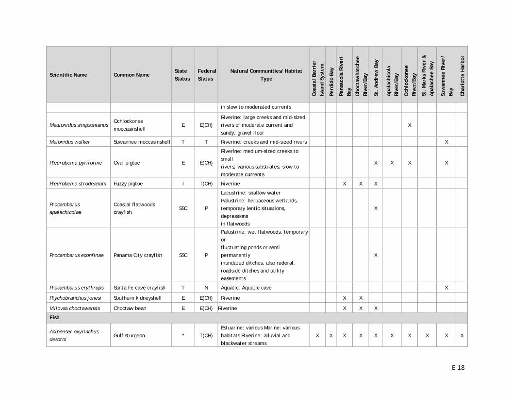
E-18
Scientific Name Common Name State Status
Federal Status
Natural Communities/ Habitat Type
Coas
tal B
arri
er
Isla
nd S
yste
m
Perd
ido
Bay
Pens
acol
a Ri
ver/
Ba
y
Choc
taw
hatc
hee
Rive
r/Ba
y
St.
And
rew
Bay
Apa
lach
icol
a Ri
ver/
Bay
Och
lock
onee
Ri
ver/
Bay
St.
Mar
ks R
iver
&
Apa
lach
ee B
ay
Suw
anne
e Ri
ver/
Ba
y
Char
lott
e H
arbo
r
in slow to moderated currents
Medionidus simpsonianus Ochlockonee moccasinshell
E E(CH) Riverine: large creeks and mid-sized rivers of moderate current and sandy, gravel floor
X
Meionidus walker Suwannee moccasinshell T T Riverine: creeks and mid-sized rivers X
Pleurobema pyriforme Oval pigtoe E E(CH)
Riverine: medium-sized creeks to small rivers; various substrates; slow to moderate currents
X X X X
Pleurobema strodeanum Fuzzy pigtoe T T(CH) Riverine X X X
Procambarus apalachicolae
Coastal flatwoods crayfish
SSC P
Lacustrine: shallow water Palustrine: herbaceous wetlands, temporary lentic situations, depressions in flatwoods
X
Procambarus econfinae Panama City crayfish SSC P
Palustrine: wet flatwoods; temporary or fluctuating ponds or semi permanently inundated ditches, also ruderal, roadside ditches and utility easements
X
Procambarus erythrops Santa Fe cave crayfish T N Aquatic: Aquatic cave X
Ptychobranchus jonesi Southern kidneyshell E E(CH) Riverine X X
Villovsa choctawensis Choctaw bean E E(CH) Riverine X X X
Fish
Acipenser oxyrinchus desotoi
Gulf sturgeon * T(CH) Estuarine: various Marine: various habitats Riverine: alluvial and blackwater streams
X X X X X X X X X X
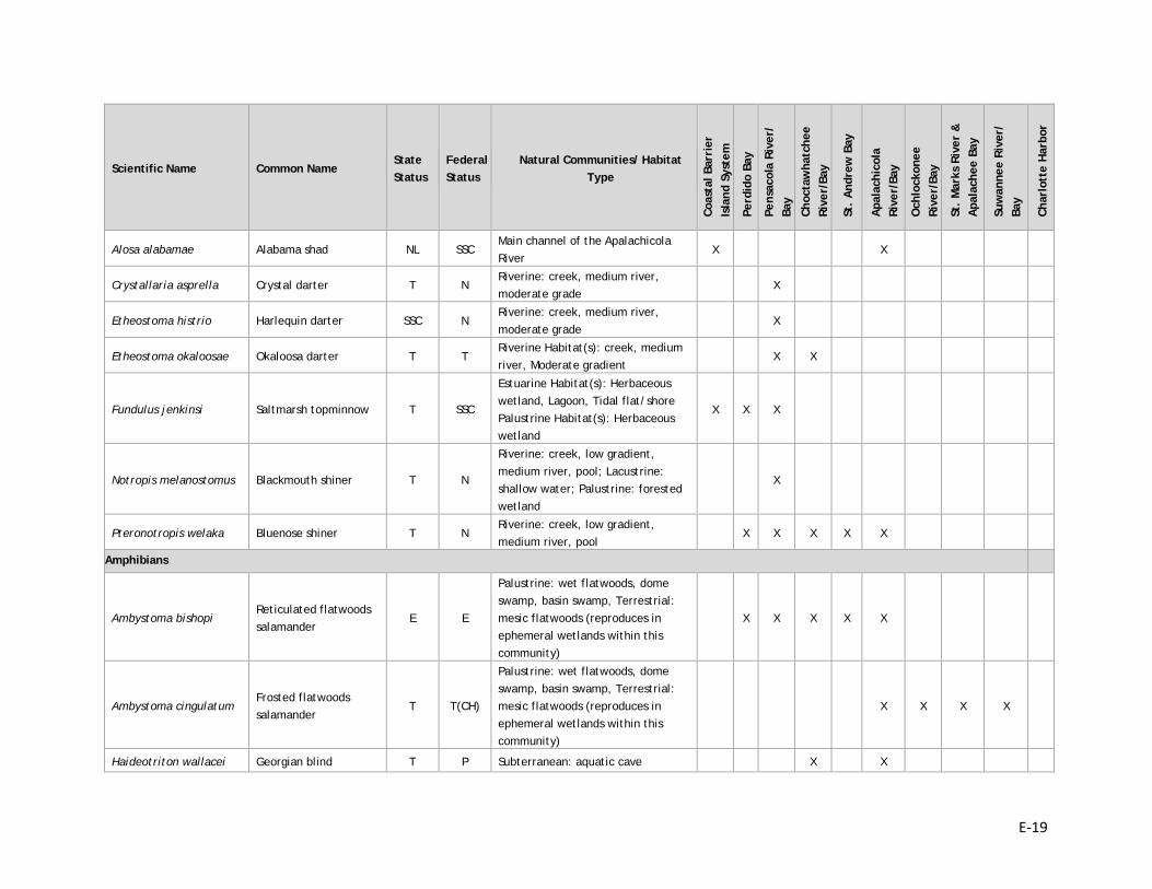
E-19
Scientific Name Common Name State Status
Federal Status
Natural Communities/ Habitat Type
Coas
tal B
arri
er
Isla
nd S
yste
m
Perd
ido
Bay
Pens
acol
a Ri
ver/
Ba
y
Choc
taw
hatc
hee
Rive
r/Ba
y
St.
And
rew
Bay
Apa
lach
icol
a Ri
ver/
Bay
Och
lock
onee
Ri
ver/
Bay
St.
Mar
ks R
iver
&
Apa
lach
ee B
ay
Suw
anne
e Ri
ver/
Ba
y
Char
lott
e H
arbo
r
Alosa alabamae Alabama shad NL SSC Main channel of the Apalachicola River
X X
Crystallaria asprella Crystal darter T N Riverine: creek, medium river, moderate grade
X
Etheostoma histrio Harlequin darter SSC N Riverine: creek, medium river, moderate grade
X
Etheostoma okaloosae Okaloosa darter T T Riverine Habitat(s): creek, medium river, Moderate gradient
X X
Fundulus jenkinsi Saltmarsh topminnow T SSC
Estuarine Habitat(s): Herbaceous wetland, Lagoon, Tidal flat/shore Palustrine Habitat(s): Herbaceous wetland
X X X
Notropis melanostomus Blackmouth shiner T N
Riverine: creek, low gradient, medium river, pool; Lacustrine: shallow water; Palustrine: forested wetland
X
Pteronotropis welaka Bluenose shiner T N Riverine: creek, low gradient, medium river, pool
X X X X X
Amphibians
Ambystoma bishopi Reticulated flatwoods salamander
E E
Palustrine: wet flatwoods, dome swamp, basin swamp, Terrestrial: mesic flatwoods (reproduces in ephemeral wetlands within this community)
X X X X X
Ambystoma cingulatum Frosted flatwoods salamander
T T(CH)
Palustrine: wet flatwoods, dome swamp, basin swamp, Terrestrial: mesic flatwoods (reproduces in ephemeral wetlands within this community)
X X X X
Haideotriton wallacei Georgian blind T P Subterranean: aquatic cave X X
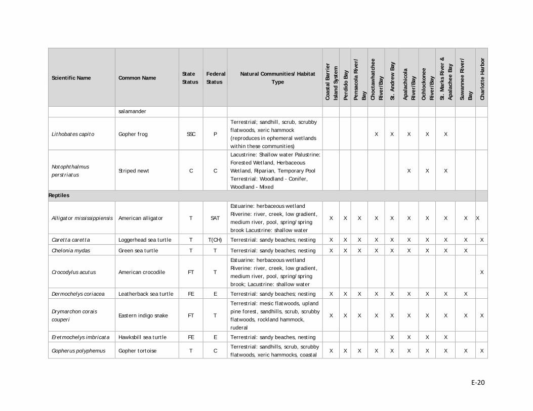
E-20
Scientific Name Common Name State Status
Federal Status
Natural Communities/ Habitat Type
Coas
tal B
arri
er
Isla
nd S
yste
m
Perd
ido
Bay
Pens
acol
a Ri
ver/
Ba
y
Choc
taw
hatc
hee
Rive
r/Ba
y
St.
And
rew
Bay
Apa
lach
icol
a Ri
ver/
Bay
Och
lock
onee
Ri
ver/
Bay
St.
Mar
ks R
iver
&
Apa
lach
ee B
ay
Suw
anne
e Ri
ver/
Ba
y
Char
lott
e H
arbo
r
salamander
Lithobates capito Gopher frog SSC P
Terrestrial; sandhill, scrub, scrubby flatwoods, xeric hammock (reproduces in ephemeral wetlands within these communities)
X X X X X
Notophthalmus perstriatus
Striped newt C C
Lacustrine: Shallow water Palustrine: Forested Wetland, Herbaceous Wetland, Riparian, Temporary Pool Terrestrial: Woodland - Conifer, Woodland - Mixed
X X X
Reptiles
Alligator mississippiensis American alligator T SAT
Estuarine: herbaceous wetland Riverine: river, creek, low gradient, medium river, pool, spring/spring brook Lacustrine: shallow water
X X X X X X X X X X
Caretta caretta Loggerhead sea turtle T T(CH) Terrestrial: sandy beaches; nesting X X X X X X X X X X
Chelonia mydas Green sea turtle T T Terrestrial: sandy beaches; nesting X X X X X X X X X
Crocodylus acutus American crocodile FT T
Estuarine: herbaceous wetland Riverine: river, creek, low gradient, medium river, pool, spring/spring brook; Lacustrine: shallow water
X
Dermochelys coriacea Leatherback sea turtle FE E Terrestrial: sandy beaches; nesting X X X X X X X X X
Drymarchon corais couperi
Eastern indigo snake FT T
Terrestrial: mesic flatwoods, upland pine forest, sandhills, scrub, scrubby flatwoods, rockland hammock, ruderal
X X X X X X X X X X
Eretmochelys imbricata Hawksbill sea turtle FE E Terrestrial: sandy beaches, nesting X X X X
Gopherus polyphemus Gopher tortoise T C Terrestrial: sandhills, scrub, scrubby flatwoods, xeric hammocks, coastal
X X X X X X X X X X
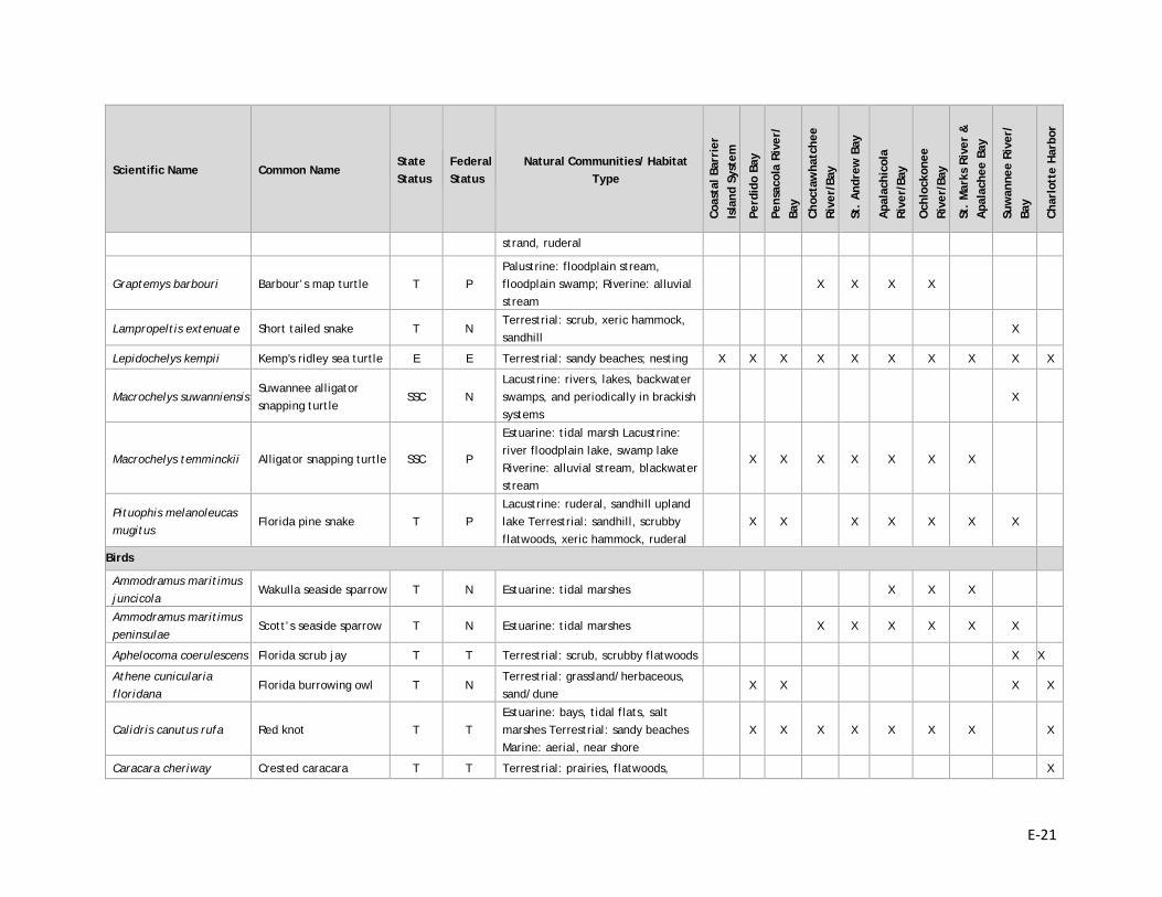
E-21
Scientific Name Common Name State Status
Federal Status
Natural Communities/ Habitat Type
Coas
tal B
arri
er
Isla
nd S
yste
m
Perd
ido
Bay
Pens
acol
a Ri
ver/
Ba
y
Choc
taw
hatc
hee
Rive
r/Ba
y
St.
And
rew
Bay
Apa
lach
icol
a Ri
ver/
Bay
Och
lock
onee
Ri
ver/
Bay
St.
Mar
ks R
iver
&
Apa
lach
ee B
ay
Suw
anne
e Ri
ver/
Ba
y
Char
lott
e H
arbo
r
strand, ruderal
Graptemys barbouri Barbour’s map turtle T P Palustrine: floodplain stream, floodplain swamp; Riverine: alluvial stream
X X X X
Lampropeltis extenuate Short tailed snake T N Terrestrial: scrub, xeric hammock, sandhill
X
Lepidochelys kempii Kemp's ridley sea turtle E E Terrestrial: sandy beaches; nesting X X X X X X X X X X
Macrochelys suwanniensis Suwannee alligator snapping turtle
SSC N Lacustrine: rivers, lakes, backwater swamps, and periodically in brackish systems
X
Macrochelys temminckii Alligator snapping turtle SSC P
Estuarine: tidal marsh Lacustrine: river floodplain lake, swamp lake Riverine: alluvial stream, blackwater stream
X X X X X X X
Pituophis melanoleucas mugitus
Florida pine snake T P Lacustrine: ruderal, sandhill upland lake Terrestrial: sandhill, scrubby flatwoods, xeric hammock, ruderal
X X X X X X X
Birds
Ammodramus maritimus juncicola
Wakulla seaside sparrow T N Estuarine: tidal marshes X X X
Ammodramus maritimus peninsulae
Scott’s seaside sparrow T N Estuarine: tidal marshes X X X X X X
Aphelocoma coerulescens Florida scrub jay T T Terrestrial: scrub, scrubby flatwoods X X
Athene cunicularia floridana
Florida burrowing owl T N Terrestrial: grassland/herbaceous, sand/dune
X X X X
Calidris canutus rufa Red knot T T Estuarine: bays, tidal flats, salt marshes Terrestrial: sandy beaches Marine: aerial, near shore
X X X X X X X X
Caracara cheriway Crested caracara T T Terrestrial: prairies, flatwoods, X
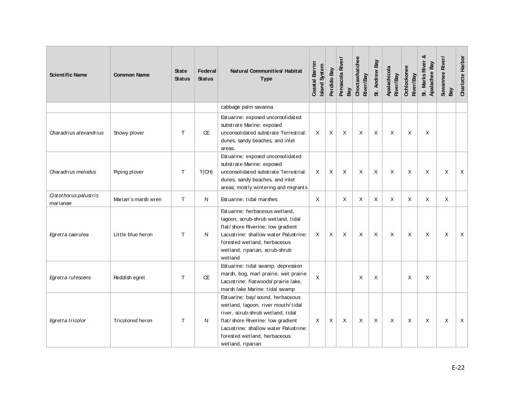
E-22
Scientific Name Common Name State Status
Federal Status
Natural Communities/ Habitat Type
Coas
tal B
arri
er
Isla
nd S
yste
m
Perd
ido
Bay
Pens
acol
a Ri
ver/
Ba
y
Choc
taw
hatc
hee
Rive
r/Ba
y
St.
And
rew
Bay
Apa
lach
icol
a Ri
ver/
Bay
Och
lock
onee
Ri
ver/
Bay
St.
Mar
ks R
iver
&
Apa
lach
ee B
ay
Suw
anne
e Ri
ver/
Ba
y
Char
lott
e H
arbo
r
cabbage palm savanna
Charadrius alexandrius Snowy plover T CE
Estuarine: exposed unconsolidated substrate Marine: exposed unconsolidated substrate Terrestrial: dunes, sandy beaches, and inlet areas.
X X X X X X X X
Charadrius melodus Piping plover T T(CH)
Estuarine: exposed unconsolidated substrate Marine: exposed unconsolidated substrate Terrestrial: dunes, sandy beaches, and inlet areas; mostly wintering and migrants
X X X X X X X X X X
Cistothorus palustris marianae
Marian’s marsh wren T N Estuarine: tidal marshes X X X X X X X X
Egretta caerulea Little blue heron T N
Estuarine: herbaceous wetland, lagoon, scrub-shrub wetland, tidal flat/shore Riverine: low gradient Lacustrine: shallow water Palustrine: forested wetland, herbaceous wetland, riparian, scrub-shrub wetland
X X X X X X X X X X
Egretta rufescens Reddish egret T CE
Estuarine: tidal swamp, depression marsh, bog, marl prairie, wet prairie Lacustrine: flatwoods/prairie lake, marsh lake Marine: tidal swamp
X X X X X
Egretta tricolor Tricolored heron T N
Estuarine: bay/sound, herbaceous wetland, lagoon, river mouth/tidal river, scrub-shrub wetland, tidal flat/shore Riverine: low gradient Lacustrine: shallow water Palustrine: forested wetland, herbaceous wetland, riparian
X X X X X X X X X X
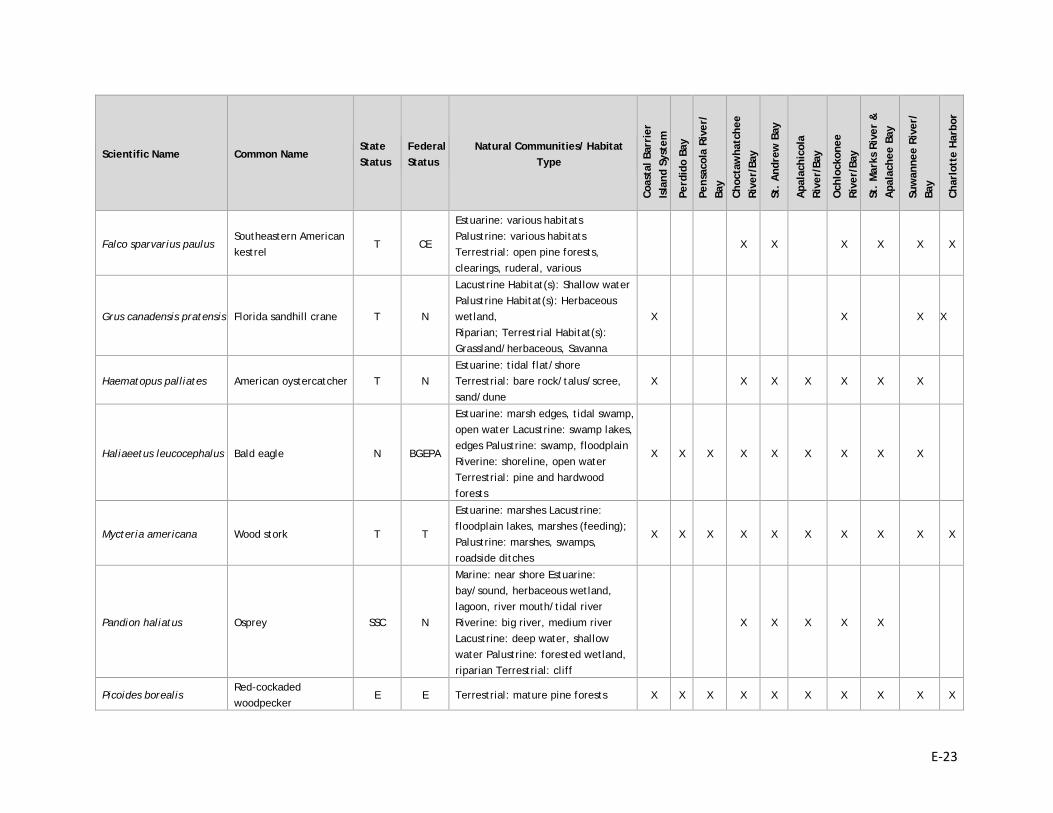
E-23
Scientific Name Common Name State Status
Federal Status
Natural Communities/ Habitat Type
Coas
tal B
arri
er
Isla
nd S
yste
m
Perd
ido
Bay
Pens
acol
a Ri
ver/
Ba
y
Choc
taw
hatc
hee
Rive
r/Ba
y
St.
And
rew
Bay
Apa
lach
icol
a Ri
ver/
Bay
Och
lock
onee
Ri
ver/
Bay
St.
Mar
ks R
iver
&
Apa
lach
ee B
ay
Suw
anne
e Ri
ver/
Ba
y
Char
lott
e H
arbo
r
Falco sparvarius paulus Southeastern American kestrel
T CE
Estuarine: various habitats Palustrine: various habitats Terrestrial: open pine forests, clearings, ruderal, various
X X X X X X
Grus canadensis pratensis Florida sandhill crane T N
Lacustrine Habitat(s): Shallow water Palustrine Habitat(s): Herbaceous wetland, Riparian; Terrestrial Habitat(s): Grassland/herbaceous, Savanna
X X X X
Haematopus palliates American oystercatcher T N Estuarine: tidal flat/shore Terrestrial: bare rock/talus/scree, sand/dune
X X X X X X X
Haliaeetus leucocephalus Bald eagle N BGEPA
Estuarine: marsh edges, tidal swamp, open water Lacustrine: swamp lakes, edges Palustrine: swamp, floodplain Riverine: shoreline, open water Terrestrial: pine and hardwood forests
X X X X X X X X X
Mycteria americana Wood stork T T
Estuarine: marshes Lacustrine: floodplain lakes, marshes (feeding); Palustrine: marshes, swamps, roadside ditches
X X X X X X X X X X
Pandion haliatus Osprey SSC N
Marine: near shore Estuarine: bay/sound, herbaceous wetland, lagoon, river mouth/tidal river Riverine: big river, medium river Lacustrine: deep water, shallow water Palustrine: forested wetland, riparian Terrestrial: cliff
X X X X X
Picoides borealis Red-cockaded woodpecker
E E Terrestrial: mature pine forests X X X X X X X X X X
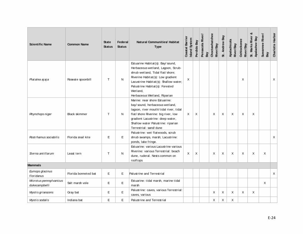
E-24
Scientific Name Common Name State Status
Federal Status
Natural Communities/ Habitat Type
Coas
tal B
arri
er
Isla
nd S
yste
m
Perd
ido
Bay
Pens
acol
a Ri
ver/
Ba
y
Choc
taw
hatc
hee
Rive
r/Ba
y
St.
And
rew
Bay
Apa
lach
icol
a Ri
ver/
Bay
Och
lock
onee
Ri
ver/
Bay
St.
Mar
ks R
iver
&
Apa
lach
ee B
ay
Suw
anne
e Ri
ver/
Ba
y
Char
lott
e H
arbo
r
Platalea ajaja Roseate spoonbill T N
Estuarine Habitat(s): Bay/sound, Herbaceous wetland, Lagoon, Scrub-shrub wetland, Tidal flat/shore; Riverine Habitat(s): Low gradient Lacustrine Habitat(s): Shallow water; Palustrine Habitat(s): Forested Wetland, Herbaceous Wetland, Riparian
X X X
Rhynchops niger Black skimmer T N
Marine: near shore Estuarine: bay/sound, herbaceous wetland, lagoon, river mouth/tidal river, tidal flat/shore Riverine: big river, low gradient Lacustrine: deep water, Shallow water Palustrine: riparian Terrestrial: sand/dune
X X X X X X X
Rostrhamus sociabilis Florida snail kite E E Palustrine: wet flatwoods, scrub shrub swamps, marsh; Lacustrine: ponds, lake fringe.
X
Sterna antillarum Least tern T N
Estuarine: various Lacustrine various Riverine: various Terrestrial: beach dune, ruderal. Nests common on rooftops
X X X X X X X X
Mammals
Eumops glacinus floridanus
Florida bonneted bat E E Palustrine and Terrestrial X
Microtus pennsylvanicus dukecampbelli
Salt marsh vole E E Estuarine: tidal marsh, marine tidal marsh
X
Myotis grisescens Gray bat E E Palustrine: caves, various Terrestrial: caves, various
X X X X X
Myotis sodalis Indiana bat E E Palustrine and Terrestrial X X X
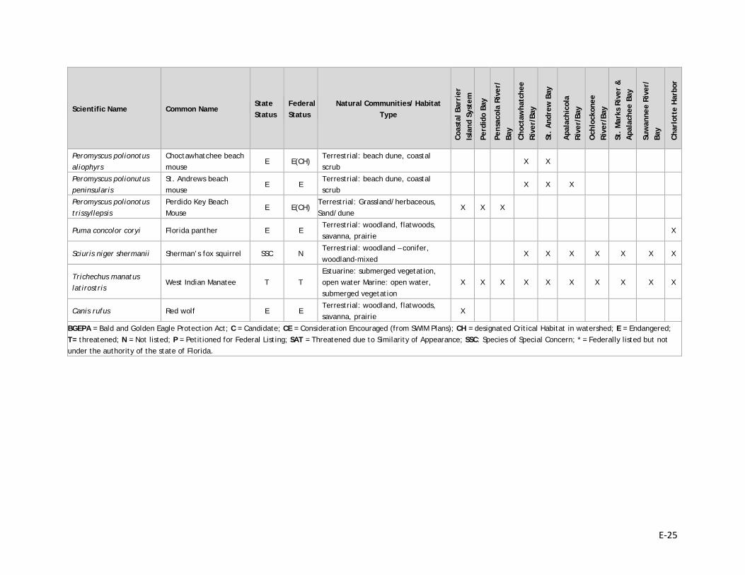
E-25
Scientific Name Common Name State Status
Federal Status
Natural Communities/ Habitat Type
Coas
tal B
arri
er
Isla
nd S
yste
m
Perd
ido
Bay
Pens
acol
a Ri
ver/
Ba
y
Choc
taw
hatc
hee
Rive
r/Ba
y
St.
And
rew
Bay
Apa
lach
icol
a Ri
ver/
Bay
Och
lock
onee
Ri
ver/
Bay
St.
Mar
ks R
iver
&
Apa
lach
ee B
ay
Suw
anne
e Ri
ver/
Ba
y
Char
lott
e H
arbo
r
Peromyscus polionotus aliophyrs
Choctawhatchee beach mouse
E E(CH) Terrestrial: beach dune, coastal scrub
X X
Peromyscus polionutus peninsularis
St. Andrews beach mouse
E E Terrestrial: beach dune, coastal scrub
X X X
Peromyscus polionotus trissyllepsis
Perdido Key Beach Mouse
E E(CH) Terrestrial: Grassland/herbaceous, Sand/dune
X X X
Puma concolor coryi Florida panther E E Terrestrial: woodland, flatwoods, savanna, prairie
X
Sciuris niger shermanii Sherman’s fox squirrel SSC N Terrestrial: woodland – conifer, woodland-mixed
X X X X X X X
Trichechus manatus latirostris
West Indian Manatee T T Estuarine: submerged vegetation, open water Marine: open water, submerged vegetation
X X X X X X X X X X
Canis rufus Red wolf E E Terrestrial: woodland, flatwoods, savanna, prairie
X
BGEPA = Bald and Golden Eagle Protection Act; C = Candidate; CE = Consideration Encouraged (from SWIM Plans); CH = designated Critical Habitat in watershed; E = Endangered; T= threatened; N = Not listed; P = Petitioned for Federal Listing; SAT = Threatened due to Similarity of Appearance; SSC: Species of Special Concern; * = Federally listed but not under the authority of the state of Florida.

F-1
Appendix F. Environmental Evaluation Worksheet
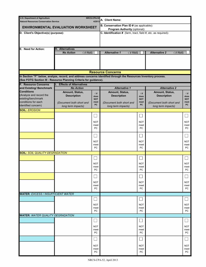
NRCS-CPA-52, April 2013
√ if RMS √ if RMS √ if RMS
NOT meet PC
NOT meet PC
NOT meet PC
NOT meet PC
C. Identification # (farm, tract, field #, etc. as required):
SOIL: EROSION
NOT meet PC
NOT meet PC
Amount, Status, Description
(Document both short and long term impacts)
Resource Concerns
√ ifdoesNOT meetPC
Amount, Status, Description
(Document both short and long term impacts)
No Action Alternative 1 Alternative 2I. Effects of Alternatives
U.S. Department of Agriculture4/2013
NRCS-CPA-52
F. Resource Concernsand Existing/ BenchmarkConditions(Analyze and record theexisting/benchmarkconditions for eachidentified concern)
E. Need for Action:
D. Client's Objective(s) (purpose):
ENVIRONMENTAL EVALUATION WORKSHEET
√ ifdoesNOT meetPC
No ActionH. Alternatives
√ ifdoesNOT meetPC
Amount, Status, Description
(Document both short and long term impacts)
In Section "F" below, analyze, record, and address concerns identified through the Resources Inventory process. (See FOTG Section III - Resource Planning Criteria for guidance).
Program Authority (optional):
Natural Resources Conservation Service A. Client Name:
B. Conservation Plan ID # (as applicable):
NOT meet PC
NOT meet PC
NOT meet PC
NOT meet PC
NOT meet PC
Alternative 2Alternative 1
NOT meet PC
SOIL: SOIL QUALITY DEGRADATION
NOT meet PC
NOT meet PC
WATER: WATER QUALITY DEGRADATION
NOT meet PC
WATER: EXCESS / INSUFFICIENT WATER
NOT meet PC
NOT meet PC
NOT meet PC
NOT meet PC
NOT meet PC
NOT meet PC
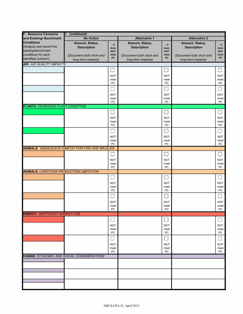
NRCS-CPA-52, April 2013
ANIMALS: LIVESTOCK PRODUCTION LIMITATION
PLANTS: DEGRADED PLANT CONDITION
NOT meet PC
NOT meet PC
NOT meet PC
NOT meet PC
NOT meet PC
NOT meet PC
NOT meet PC
NOT meet PC
HUMAN: ECONOMIC AND SOCIAL CONSIDERATIONS
NOT meet PC
NOT meet PC
NOT meet PC
NOT meet PC
NOT meet PC
ENERGY: INEFFICIENT ENERGY USE
NOT meet PC
I. (continued)
√ ifdoes NOT meet PC
√ ifdoes NOT meet PC
Amount, Status, Description
(Document both short and long term impacts)
Alternative 2No Action Alternative 1
NOT meet PC
NOT meet PC
F. Resource Concerns and Existing/ Benchmark Conditions(Analyze and record the existing/benchmark conditions for each identified concern)
Amount, Status, Description
(Document both short and long term impacts)
AIR: AIR QUALITY IMPACTS
Amount, Status, Description
(Document both short and long term impacts)
NOT meet PC
√ ifdoes NOT meet PC
NOT meet PC
NOT meet PC
NOT meet PC
NOT meet PC
ANIMALS: INADEQUATE HABITAT FOR FISH AND WILDLIFE
NOT meet PC
NOT meet PC
NOT meet PC
NOT meet PC
NOT meet PC
NOT meet PC
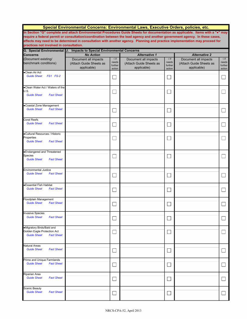
NRCS-CPA-52, April 2013
FS1 FS-2
●Coastal Zone Management
Guide Sheet Fact Sheet
●Clean Water Act / Waters of the U.S.
In Section "G" complete and attach Environmental Procedures Guide Sheets for documentation as applicable. Items with a "●" may require a federal permit or consultation/coordination between the lead agency and another government agency. In these cases, effects may need to be determined in consultation with another agency. Planning and practice implementation may proceed for practices not involved in consultation.
√ ifneeds further action
Document all impacts(Attach Guide Sheets as
applicable)
Guide Sheet
Guide Sheet Fact Sheet
√ ifneeds further action
√ ifneeds further action
Document all impacts(Attach Guide Sheets as
applicable)
Guide Sheet Fact Sheet
●Clean Air Act
J. Impacts to Special Environmental Concerns
Document all impacts(Attach Guide Sheets as
applicable)
Guide Sheet
Guide Sheet Fact Sheet
Coral Reefs
●Cultural Resources / Historic Properties
●Endangered and Threatened Species
Guide Sheet Fact Sheet
Natural Areas
Guide Sheet Fact Sheet
Guide Sheet Fact Sheet
Guide Sheet Fact Sheet
Guide Sheet Fact Sheet
Invasive Species
Prime and Unique Farmlands
●Migratory Birds/Bald and Golden Eagle Protection Act
Guide Sheet Fact Sheet
Guide Sheet Fact Sheet
●Essential Fish Habitat
Environmental Justice
Fact Sheet
Guide Sheet Fact Sheet
Guide Sheet Fact Sheet
Scenic Beauty
Alternative 2Alternative 1
Floodplain Management
Riparian Area
Special Environmental Concerns: Environmental Laws, Executive Orders, policies, etc.
No ActionG. Special Environmental Concerns(Document existing/ benchmark conditions)
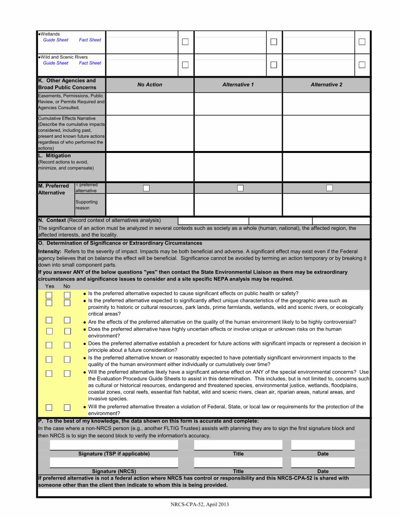
NRCS-CPA-52, April 2013
No●●
●●
●
●
●
●
●Wild and Scenic Rivers
●Wetlands
Title
Alternative 2No Action
Cumulative Effects Narrative (Describe the cumulative impacts considered, including past, present and known future actions regardless of who performed the actions)
K. Other Agencies and Broad Public Concerns
DateSignature (NRCS)If preferred alternative is not a federal action where NRCS has control or responsibility and this NRCS-CPA-52 is shared with someone other than the client then indicate to whom this is being provided.
DateTitle
Are the effects of the preferred alternative on the quality of the human environment likely to be highly controversial?
Signature (TSP if applicable)
Is the preferred alternative expected to significantly affect unique characteristics of the geographic area such as proximity to historic or cultural resources, park lands, prime farmlands, wetlands, wild and scenic rivers, or ecologically critical areas?
Does the preferred alternative have highly uncertain effects or involve unique or unknown risks on the human environment?
The significance of an action must be analyzed in several contexts such as society as a whole (human, national), the affected region, the affected interests, and the locality. O. Determination of Significance or Extraordinary CircumstancesIntensity: Refers to the severity of impact. Impacts may be both beneficial and adverse. A significant effect may exist even if the Federal agency believes that on balance the effect will be beneficial. Significance cannot be avoided by terming an action temporary or by breaking it down into small component parts.If you answer ANY of the below questions "yes" then contact the State Environmental Liaison as there may be extraordinary circumstances and significance issues to consider and a site specific NEPA analysis may be required.
Is the preferred alternative expected to cause significant effects on public health or safety?
Easements, Permissions, Public Review, or Permits Required and Agencies Consulted.
Will the preferred alternative likely have a significant adverse effect on ANY of the special environmental concerns? Use the Evaluation Procedure Guide Sheets to assist in this determination. This includes, but is not limited to, concerns such as cultural or historical resources, endangered and threatened species, environmental justice, wetlands, floodplains, coastal zones, coral reefs, essential fish habitat, wild and scenic rivers, clean air, riparian areas, natural areas, and invasive species.Will the preferred alternative threaten a violation of Federal, State, or local law or requirements for the protection of the environment?
Is the preferred alternative known or reasonably expected to have potentially significant environment impacts to the quality of the human environment either individually or cumulatively over time?
Does the preferred alternative establish a precedent for future actions with significant impacts or represent a decision in principle about a future consideration?
P. To the best of my knowledge, the data shown on this form is accurate and complete:In the case where a non-NRCS person (e.g., another FLTIG Trustee) assists with planning they are to sign the first signature block and then NRCS is to sign the second block to verify the information's accuracy.
Alternative 1
Guide Sheet Fact Sheet
Guide Sheet Fact Sheet
N. Context (Record context of alternatives analysis)
L. Mitigation(Record actions to avoid, minimize, and compensate)
Supporting reason
M. Preferred Alternative
√ preferred alternative
Yes
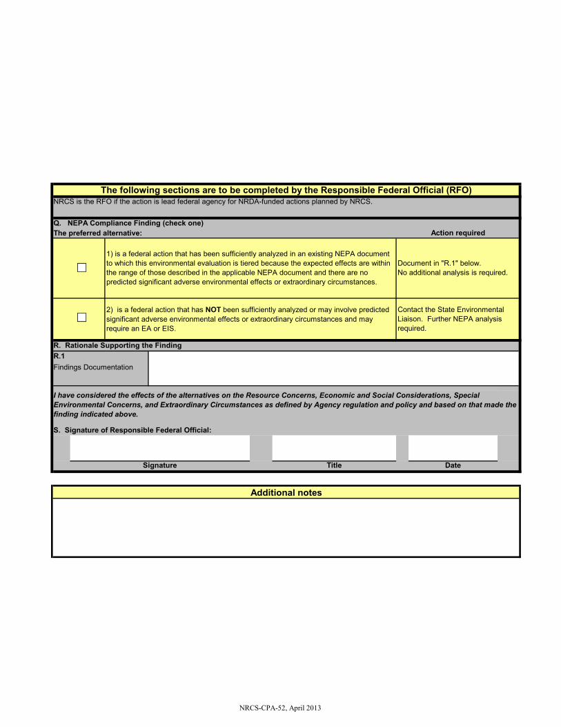
NRCS-CPA-52, April 2013
R.1
2) is a federal action that has NOT been sufficiently analyzed or may involve predicted significant adverse environmental effects or extraordinary circumstances and may require an EA or EIS.
Contact the State Environmental Liaison. Further NEPA analysis required.
R. Rationale Supporting the Finding
I have considered the effects of the alternatives on the Resource Concerns, Economic and Social Considerations, Special Environmental Concerns, and Extraordinary Circumstances as defined by Agency regulation and policy and based on that made the finding indicated above.
Findings Documentation
The following sections are to be completed by the Responsible Federal Official (RFO)NRCS is the RFO if the action is lead federal agency for NRDA-funded actions planned by NRCS.
Action required
Additional notes
Signature Title Date
1) is a federal action that has been sufficiently analyzed in an existing NEPA document to which this environmental evaluation is tiered because the expected effects are within the range of those described in the applicable NEPA document and there are no predicted significant adverse environmental effects or extraordinary circumstances.
Document in "R.1" below.No additional analysis is required.
The preferred alternative:Q. NEPA Compliance Finding (check one)
S. Signature of Responsible Federal Official:
Appendix G. Finding of No Significant Impact
(FONSI) from Implementation of
the Florida Trustee
Implementation Group Final
Restoration Plan1 and
Environmental Assessment:
Habitat Projects on Federally
Managed Lands; Nutrient
Reduction; Water Quality; and
Provide and Enhance Recreational
Opportunities
G-1
Finding of No Significant Impact (FONSI) from Implementation of the Florida Trustee Implementation Group Final Restoration Plan 1 and Environmental Assessment: Habitat Projects on Federally Managed Lands; Nutrient Reduction; Water Quality; and Provide and Enhance Recreational Opportunities
G.1 Introduction
The Florida Trustee Implementation Group Final Restoration Plan 1 and Environmental Assessment: Habitat Projects on Federally Managed Lands; Nutrient Reduction; Water Quality; and Provide and Enhance Recreational Opportunities (RP/EA) fulfills requirements under the Oil Pollution Act (OPA) and the implementing regulations of the National Environmental Policy Act (NEPA). The RP/EA was prepared by the Florida Trustee Implementation Group (FL TIG) to partially address injuries caused by the Deepwater Horizon (DWH) oil spill to natural resources and services in the Florida Restoration Area using natural resource damages procedures as set forth in the DWH post-settlement Consent Decree.
In accordance with OPA, and as set forth in the Consent Decree and described in the DWH Trustees’ 2016 Deepwater Horizon Oil Spill: Final Programmatic Damage Assessment and Restoration Plan/Programmatic Environmental Impact Statement (PDARP/PEIS),1 the FL TIG includes two state Trustee agencies and four federal Trustee agencies: the Florida Department of Environmental Protection (FDEP); the Florida Fish and Wildlife Conservation Commission (FWCC); U.S. Department of the Interior (DOI), National Oceanic and Atmospheric Administration (NOAA), U.S. Environmental Protection Agency (EPA), and U.S. Department of Agriculture (USDA).2
The PDARP/PEIS is a programmatic document developed by the DWH Trustees to guide and direct the DWH oil spill restoration effort. The PDARP/PEIS was prepared in accordance with OPA, NEPA, Council on Environmental Quality (CEQ) NEPA regulations, and the NEPA regulations, procedures and guidance applicable to the DWH federal Trustees. Where appropriate, the RP/EA tiers from the PDARP/PEIS. The PDARP/PEIS includes a portfolio of restoration types that addresses the diverse suite of injuries that occurred at both regional and local scales. Of five overarching goals set forth in the PDARP/PEIS, the RP/EA addresses three goals to: 1) Restore and Conserve Habitat, 2) Restore Water Quality, and 3)
1 The final PDARP/PEIS, Record of Decision and information on the Consent Decree can be found at http://www.gulfspillrestoration.noaa.gov/restoration-planning/gulf-plan/. 2 Chapter 7 of the PDARP/PEIS describes a distributed governance structure that assigns a TIG for each of the eight Restoration Areas (restoration in each of the five Gulf States, Open Ocean, Regionwide, and Unknown Conditions and Adaptive Management). The Trustees believe that restoration can be carried out most efficiently by directly vesting restoration decision-making to those Trustees who have the strongest collective trust interests in natural resources and their services within each Restoration Area.
G-2
Replenish and Protect Living Coastal and Marine Resources. Within these goals, the RP/EA focuses on four restoration types, as follows: 3
• Habitat Projects on Federally Managed Lands • Nutrient Reduction (Nonpoint source; hereafter referred to as Nutrient Reduction) • Water Quality (e.g. Stormwater Treatments, Hydrologic Restoration, Reduction of
Sedimentation, etc.; hereafter referred to as Water Quality) • Provide and Enhance Recreational Opportunities
G.2 Lead and Cooperating Agencies, Adoption of NEPA Analysis by Cooperating Agencies
The FL TIG designated DOI as the lead agency responsible for NEPA analysis for the RP/EA. Each of the other federal co-Trustees is participating as a cooperating agency pursuant to NEPA (40 CFR 1508.5) and the Trustee Council Standard Operating Procedures for Implementation of the Natural Resource Restoration for the Deepwater Horizon (DWH) Oil Spill (SOP) (DWH Trustees 2016:27, Appendix F:2–3). As federal agencies, each Trustee on the FL TIG must make its own independent evaluation of the NEPA analysis in support of its decision-making responsibilities. In accordance with 40 CFR 1506.3(a) and the SOP (DWH Trustees 2016: Appendix F:4), each of the federal agencies participating in the FL TIG has reviewed the RP/EA, found that it meets the standards set forth in its own NEPA implementing procedures, and accordingly has adopted the RP/EA NEPA analysis.
G.3 Public Participation
The FL TIG held a webinar to inform the public of restoration efforts in the Florida Restoration Area on August 23, 2016. The FL TIG requested project ideas on November 4, 2016 and issued a notice of initiation of restoration planning in Florida on September 29, 2017. After reviewing and evaluating more than 1,380 project proposals from the general public, the FL TIG developed the RP/EA.
The Draft RP/EA was released for public review and comment on September 20, 2018. The FL TIG continued to accept comments until December 28, 2018. During the public comment period, the FL TIG hosted a public meeting and webinar to facilitate the public review and comment process. The FL TIG accepted public comments through a web-based comment submission site (http://www.gulfspillrestoration.noaa.gov) and through U.S. mail.
The FL TIG received submissions from private citizens, state and local agencies, and non-governmental organizations. All comments were reviewed and considered prior to finalizing the RP/EA. Chapter 6 of the RP/EA provides further detail, including a summary of all public comments received on the Draft RP/EA, and the FL TIG’s responses.
3 The PDARP/PEIS assigns nine restoration types in the Florida Restoration Area: 1) Birds; 2) Habitats Projects on Federally Managed Lands; 3) Sea Turtles; 4) Marine Mammals; 5) Oysters; 6) Wetlands, Coastal and Nearshore Habitats; 7) Nutrient Reduction; 8) Water Quality; and 9) Provide and Enhance Recreational Opportunities. The five restoration types not addressed in the RP/EA will be addressed in a future plan(s).
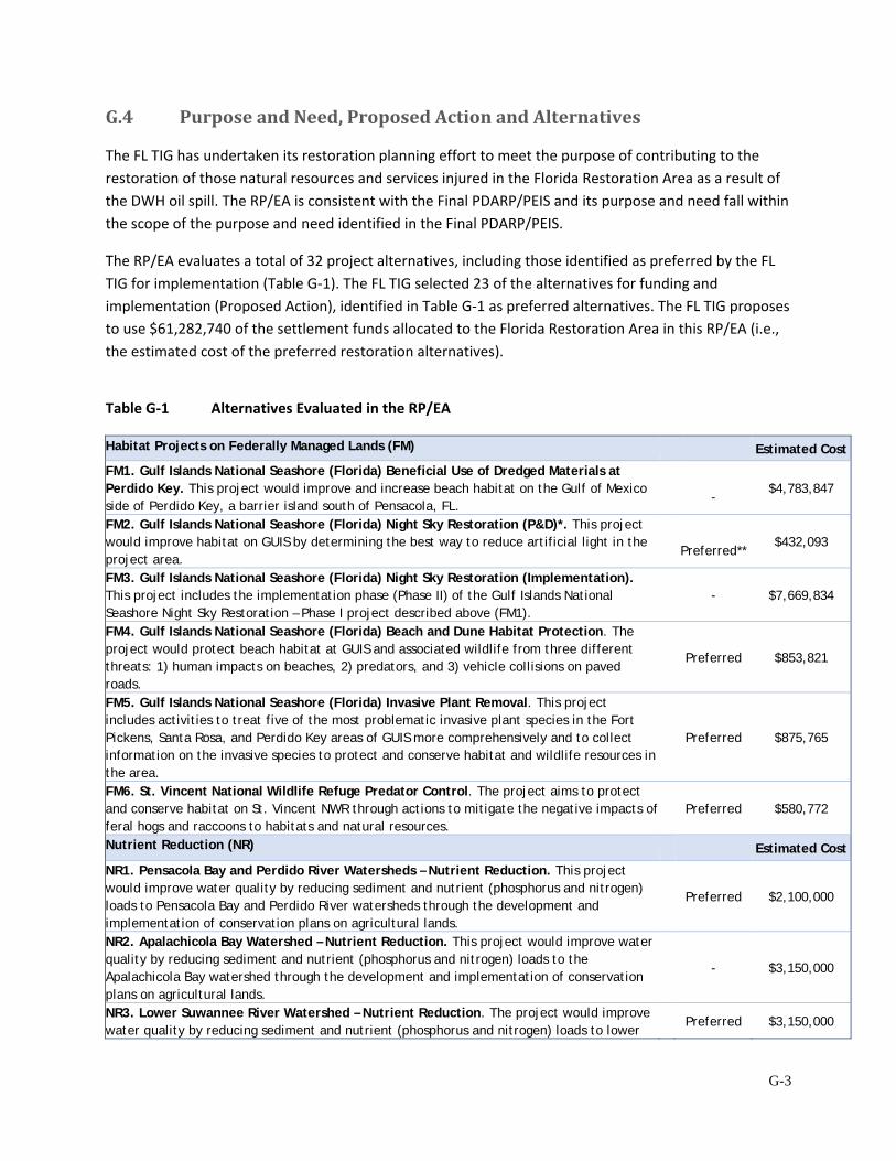
G-3
G.4 Purpose and Need, Proposed Action and Alternatives
The FL TIG has undertaken its restoration planning effort to meet the purpose of contributing to the restoration of those natural resources and services injured in the Florida Restoration Area as a result of the DWH oil spill. The RP/EA is consistent with the Final PDARP/PEIS and its purpose and need fall within the scope of the purpose and need identified in the Final PDARP/PEIS.
The RP/EA evaluates a total of 32 project alternatives, including those identified as preferred by the FL TIG for implementation (Table G-1). The FL TIG selected 23 of the alternatives for funding and implementation (Proposed Action), identified in Table G-1 as preferred alternatives. The FL TIG proposes to use $61,282,740 of the settlement funds allocated to the Florida Restoration Area in this RP/EA (i.e., the estimated cost of the preferred restoration alternatives).
Table G-1 Alternatives Evaluated in the RP/EA
Habitat Projects on Federally Managed Lands (FM) Estimated Cost
FM1. Gulf Islands National Seashore (Florida) Beneficial Use of Dredged Materials at Perdido Key. This project would improve and increase beach habitat on the Gulf of Mexico side of Perdido Key, a barrier island south of Pensacola, FL.
-
$4,783,847
FM2. Gulf Islands National Seashore (Florida) Night Sky Restoration (P&D)*. This project would improve habitat on GUIS by determining the best way to reduce artificial light in the project area.
Preferred** $432,093
FM3. Gulf Islands National Seashore (Florida) Night Sky Restoration (Implementation). This project includes the implementation phase (Phase II) of the Gulf Islands National Seashore Night Sky Restoration – Phase I project described above (FM1).
- $7,669,834
FM4. Gulf Islands National Seashore (Florida) Beach and Dune Habitat Protection. The project would protect beach habitat at GUIS and associated wildlife from three different threats: 1) human impacts on beaches, 2) predators, and 3) vehicle collisions on paved roads.
Preferred $853,821
FM5. Gulf Islands National Seashore (Florida) Invasive Plant Removal. This project includes activities to treat five of the most problematic invasive plant species in the Fort Pickens, Santa Rosa, and Perdido Key areas of GUIS more comprehensively and to collect information on the invasive species to protect and conserve habitat and wildlife resources in the area.
Preferred $875,765
FM6. St. Vincent National Wildlife Refuge Predator Control. The project aims to protect and conserve habitat on St. Vincent NWR through actions to mitigate the negative impacts of feral hogs and raccoons to habitats and natural resources.
Preferred $580,772
Nutrient Reduction (NR) Estimated Cost
NR1. Pensacola Bay and Perdido River Watersheds – Nutrient Reduction. This project would improve water quality by reducing sediment and nutrient (phosphorus and nitrogen) loads to Pensacola Bay and Perdido River watersheds through the development and implementation of conservation plans on agricultural lands.
Preferred $2,100,000
NR2. Apalachicola Bay Watershed – Nutrient Reduction. This project would improve water quality by reducing sediment and nutrient (phosphorus and nitrogen) loads to the Apalachicola Bay watershed through the development and implementation of conservation plans on agricultural lands.
- $3,150,000
NR3. Lower Suwannee River Watershed – Nutrient Reduction. The project would improve water quality by reducing sediment and nutrient (phosphorus and nitrogen) loads to lower
Preferred $3,150,000
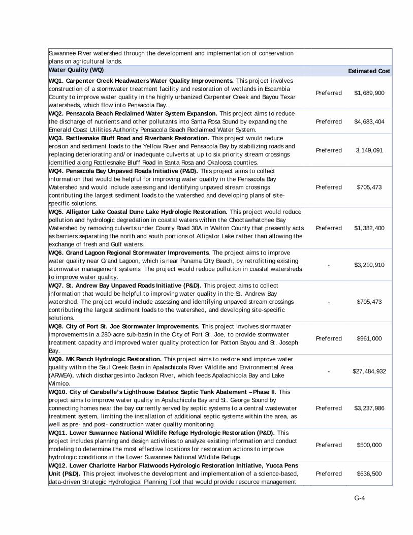
G-4
Suwannee River watershed through the development and implementation of conservation plans on agricultural lands. Water Quality (WQ) Estimated Cost
WQ1. Carpenter Creek Headwaters Water Quality Improvements. This project involves construction of a stormwater treatment facility and restoration of wetlands in Escambia County to improve water quality in the highly urbanized Carpenter Creek and Bayou Texar watersheds, which flow into Pensacola Bay.
Preferred $1,689,900
WQ2. Pensacola Beach Reclaimed Water System Expansion. This project aims to reduce the discharge of nutrients and other pollutants into Santa Rosa Sound by expanding the Emerald Coast Utilities Authority Pensacola Beach Reclaimed Water System.
Preferred $4,683,404
WQ3. Rattlesnake Bluff Road and Riverbank Restoration. This project would reduce erosion and sediment loads to the Yellow River and Pensacola Bay by stabilizing roads and replacing deteriorating and/or inadequate culverts at up to six priority stream crossings identified along Rattlesnake Bluff Road in Santa Rosa and Okaloosa counties.
Preferred 3,149,091
WQ4. Pensacola Bay Unpaved Roads Initiative (P&D). This project aims to collect information that would be helpful for improving water quality in the Pensacola Bay Watershed and would include assessing and identifying unpaved stream crossings contributing the largest sediment loads to the watershed and developing plans of site-specific solutions.
Preferred $705,473
WQ5. Alligator Lake Coastal Dune Lake Hydrologic Restoration. This project would reduce pollution and hydrologic degredation in coastal waters within the Choctawhatchee Bay Watershed by removing culverts under County Road 30A in Walton County that presently acts as barriers separating the north and south portions of Alligator Lake rather than allowing the exchange of fresh and Gulf waters.
Preferred $1,382,400
WQ6. Grand Lagoon Regional Stormwater Improvements. The project aims to improve water quality near Grand Lagoon, which is near Panama City Beach, by retrofitting existing stormwater management systems. The project would reduce pollution in coastal watersheds to improve water quality.
- $3,210,910
WQ7. St. Andrew Bay Unpaved Roads Initiative (P&D). This project aims to collect information that would be helpful to improving water quality in the St. Andrew Bay watershed. The project would include assessing and identifying unpaved stream crossings contributing the largest sediment loads to the watershed, and developing site-specific solutions.
- $705,473
WQ8. City of Port St. Joe Stormwater Improvements. This project involves stormwater improvements in a 280-acre sub-basin in the City of Port St. Joe, to provide stormwater treatment capacity and improved water quality protection for Patton Bayou and St. Joseph Bay.
Preferred $961,000
WQ9. MK Ranch Hydrologic Restoration. This project aims to restore and improve water quality within the Saul Creek Basin in Apalachicola River Wildlife and Environmental Area (ARWEA), which discharges into Jackson River, which feeds Apalachicola Bay and Lake Wimico.
- $27,484,932
WQ10. City of Carabelle’s Lighthouse Estates: Septic Tank Abatement – Phase II. This project aims to improve water quality in Apalachicola Bay and St. George Sound by connecting homes near the bay currently served by septic systems to a central wastewater treatment system, limiting the installation of additional septic systems within the area, as well as pre- and post- construction water quality monitoring.
Preferred $3,237,986
WQ11. Lower Suwannee National Wildlife Refuge Hydrologic Restoration (P&D). This project includes planning and design activities to analyze existing information and conduct modeling to determine the most effective locations for restoration actions to improve hydrologic conditions in the Lower Suwannee National Wildlife Refuge.
Preferred $500,000
WQ12. Lower Charlotte Harbor Flatwoods Hydrologic Restoration Initiative, Yucca Pens Unit (P&D). This project involves the development and implementation of a science-based, data-driven Strategic Hydrological Planning Tool that would provide resource management
Preferred $636,500

G-5
agencies guidance for restoration and management of surface waters that flow through the Cecil Webb/Babcock Wildlife Management Area (WMA). Provide and Enhance Recreational Opportunities (REC) Estimated Cost REC1. Perdido Bay Sunset Islands Snorkeling Trail. The project would provide and enhance recreational opportunities by consulting additional recreational opportunities in Perdido Bay.
- $840,000
REC2. Tarkiln Bayou Preserve State Park Improvements. This project would provide and enhance recreational opportunities by constructing new recreational access and amenities at Tarkiln Bayou Preserve State Park.
- $2,719,670
REC3. Perdido River and Bay Paddle Trail. This project includes actions to provide and enhance recreational opportunities along Perdido River including construction of recreational access and amenities along the Florida side of the river (primitive shelters, composting toilets, kiosks).
Preferred $1,165,488
REC4. Carpenter Creek Headwaters Park Amenities. This project includes actions to provide and enhance recreational opportunities through the construction of a public park at the headwaters of Carpenter Creek.
Preferred $446,080
REC5. Gulf Islands National Seashore (Florida) Rehabilitation of Okaloosa Unit Recreational Facilities. This project involves the rehabilitation of recreational facilities at the Okaloosa Unit of Gulf Islands National Seashore including re-vegetation efforts and rehabilitating a boat ramp, floating pier, restroom, lift station, electrical systems, parking area, RV sites, picnic areas, gates, boardwalks, and fencing.
Preferred $3,201,383
REC6. Joe’s Bayou Recreation Area Improvements. This project includes actions to improve access to the existing boat ramp, construct new recreational amenities (paddle-craft launch, restroom, fishing pier, walking trails), and enhance and restore the topography and natural resources (wetland, saltmarsh and upland restoration, and a living shoreline) at heavily used Joe’s Bayou Recreation Area and Mattie Kelly Park and Nature Walk.
Preferred $12,202,891
REC7. Topsail Hill Preserve State Park Improvements. This project includes actions to provide and enhance recreational opportunities at Topsail Hill Preserve State Park by constructing additional recreational access and amenities.
Preferred $3,926,811
REC8. Camp Helen State Park Improvements. This project includes actions to provide and enhance recreational opportunities at Camp Helen State Park by constructing amenities in a new day-use area on the northern parcel of the park and two docs and walkway extensions at the Lake Powell waterfront.
Preferred $3,326,027
REC9. St. Andrews State Park Improvements. This project includes actions to improve access to use areas in St. Andrews State Park and constructing additional recreational amenities.
Preferred $10,875,855
REC10. T.H. Stone Memorial St. Joseph Peninsula State Park Improvements. This project includes actions to provide and enhance recreational opportunities at T.H. Stone Memorial St. Joseph Peninsula State Park through the construction of a shared-use path.
- $977,945
REC11. St. Marks National Wildlife Refuge Coastal Trail Connection, Spring Creek to Port Leon. This project includes actions to provide and enhance recreational opportunities through improving access to and completing the Florida National Scenic Trail at St. Marks NWR, a nationally recognized resource.
Preferred $1,200,000
*P&D indicates projects that include planning, feasibility, design, engineering, and/or permitting activities only (i.e., not actions related to implementation or construction) **Preferred indicates projects that are preferred for funding by the FL TIG at this time. Under the No Action Alternative, the FL TIG would not, at this time, select and implement any of the action alternatives described in the RP/EA. The No Action Alternative would not meet the purpose and need of contributing to the compensation for and restoration of natural resources and their services injured in the Florida Restoration Area. Under the No Action Alternative, current conditions would
G-6
remain, and restoration benefits associated with the action alternatives would not be achieved at this time.
Through OPA evaluation (RP/EA Chapter 3), the FL TIG has determined that implementation of the 23 preferred alternatives best meets the purpose and need for partial restoration over the non-preferred and no action alternatives. Accordingly, the FL TIG selects the preferred alternatives identified in Table G-1 for funding and implementation at this time. Pursuant to the Consent Decree, the alternatives selected for implementation will be funded from the four restoration type allocations: Habitat Projects on Federally Managed Lands, Nutrient Reduction, Water Quality, and Provide and Enhance Recreational Opportunities. The total estimated cost of implementation is $61,282,740.
G.5 NEPA Analysis Summary
The reasonable range of alternatives was analyzed under NEPA to determine environmental impacts that could result from implementation of the alternatives (RP/EA Chapter 4), helping inform the FL TIG during its decision-making process. The NEPA analysis of the Proposed Action concluded that projects are anticipated to result in long-term benefits for many of the resources. Adverse effects would not be anticipated to extend beyond the construction period for a number of projects. Some resource areas would be affected over the long-term, some beneficially and some adversely. However, none of the projects included in this RP/EA would result in any long-term adverse effects that rise above a moderate adverse effect.4 The NEPA analysis supports the following conclusions:
• The Proposed Action will have no significant adverse impacts to unique characteristics of the geographic areas. The Proposed Action is not expected to have any significant adverse effects on wetlands, floodplains, municipal water sources, ecologically critical areas, wild and scenic river corridors, park lands, wilderness, wilderness research areas, research natural areas, inventoried roadless areas, national recreation areas, or prime farmlands, particularly on a regional basis.
• The effects of the Proposed Action on the quality of the human environment are not controversial. The FL TIG accepted public comments on the Draft RP/EA until December 28, 2018. None of the public comments received during the public comment period indicate controversy or strong opposition to the proposed action considered in the RP/EA. Additionally, none of the alternatives evaluated in this RP/EA would create a disproportionately high and adverse effect on minority or low-income populations.
• The Proposed Action neither establishes a precedent for future FL TIG actions with significant effects nor represents a decision in principle about a future consideration. Future FL TIG actions will be determined through separate, independent planning processes.
4 In defining the term “significantly” at 40 CFR §1508.27, the Council on Environmental Quality states that both the context and intensity of an impact must be evaluated. Ten criteria are provided in which are to be considered in evaluating the potential impacts and which are important in the decision to require an EIS. The following discussion of impacts under the ten criteria below were evaluated and utilized by the FL TIG.
G-7
• The Proposed Action will have no significant adverse cumulative impacts. The FL TIG concluded
that although some of the projects may have an incremental contribution to adverse cumulative impacts, the contribution would not be significant.
• The Proposed Action will have no significant adverse impacts on districts, sites, highways, structures, or objects listed in or eligible for listing in the National Register of Historic Places or cause the loss or destruction of significant scientific, cultural, or historical resources. The Proposed Action will be implemented in accordance with all applicable laws and regulations concerning the protection of cultural and historic resources.
• The Proposed Action is not likely to result in significant adverse effects to Endangered Species Act (ESA)-listed species or their critical habitats. The Proposed Action will not violate federal, state, or local laws, or requirements imposed for environmental protection. However, projects will be monitored appropriately, and approaches and designs may be applied, adopted, or modified from other similar projects as deemed necessary. The Proposed Action will be implemented in compliance with all environmental protection laws and requirements. See Table 4-41 in the RP/EA and Section G-6 below.
• Some characteristics of the Proposed Action may have a short- to long-term minor adverse effect on vulnerable marine or coastal ecosystems. Adherence to permit and consultation conditions and use of best management practices avoids or minimizes impacts to these ecosystems.
• The Proposed Action will not adversely affect marine mammal stocks or managed fish species because the projects do not take place where marine mammals or fish species are present or best management practices are in place to avoid effects.
• The Proposed Action is not expected to result in the introduction or spread of a nonindigenous species. Provisions for invasive species management and best practices minimize the risk of the introduction or spread of nonindigenous species.
• The Proposed Action will have no significant adverse impacts on public health and safety. Threats to public health and safety from construction activities would be mitigated through construction BMPs.
• The Proposed Action has no highly uncertain, unique, or unknown risks. Land acquisition and the proposed activities for habitat restoration and construction of public amenities and utilities upgrades are successful, well-established, and commonly used practices to meet the goals of restoration for lost recreational use and injured natural resources.
G-8
G.6 Agency Coordination and Consultation Summary
ESA Section 7 review and coordination has been initiated for all projects included in the Proposed Action. USFWS determined that impacts would range from “no effect” to “not likely to adversely affect” for certain ESA-listed species under their jurisdiction. No critical habitat would be adversely affected as a result of implementing the Proposed Action. ESA Section 7 review and coordination is in progress and will be completed for each project prior to project implementation. Any conditions resulting from these reviews will be implemented to minimize adverse effects to listed species.
NOAA has reviewed the Proposed Action for compliance with the ESA, Magnuson-Stevens Fishery Conservation and Management Act (MSA) and Marine Mammal Protection Act (MMPA), and had informational discussions with the National Marine Fisheries Service Southeast Regional Office Habitat Conservation Division. NOAA determined that impacts would range from “no effect” to “likely to adversely affect” for certain listed species under their jurisdiction and would not adversely affect essential fish habitat. Several informal consultations have been initiated with NOAA on projects determined “not likely to adversely affect” listed species or their designated critical habitats. NOAA made a preliminary determination that one project may adversely affect sea turtles and initiated formal consultation. Reviews and consultations will be completed for each project prior to project implementation. All conditions resulting from reviews and consultations will be implemented to minimize adverse effects to listed species.
Pursuant to the Coastal Zone Management Act, on behalf of the FL TIG federal trustees, DOI submitted a consistency determination for state review coincident with public review of the Draft RP/EA. Florida concurred with that determination of consistency with the enforceable policies of their respective Coastal Area Management Programs for the proposed activities. Trustee correspondence and Florida responses are available to the public through the DWH Administrative Record. Additional consistency review may be required during the permitting stage of the project pursuant to federal regulations (see 15 C.F.R. Part 930) prior to project implementation.
Any work in waters of the U.S., including wetlands, would be coordinated with the U.S. Army Corps of Engineers (USACE) pursuant to the Clean Water Act Section 404 and Rivers and Harbors Act (CWA/RHA). Coordination with the USACE and final authorization pursuant to CWA/RHA would be completed prior to project implementation.
No adverse impacts to cultural and historical resources protected under Section 106 of the National Historic Preservation Act are expected as a result of implementing the Proposed Action. Surveys conducted for projects considered to have the most potential for cultural resources found no evidence of cultural resources that could be adversely affected. NHPA Section 106 and Tribal consultations have been initiated and will further identify any potential cultural resources in the project areas and any mitigation measures necessary to protect those resources.
If any further need arises to coordinate and consult with other regulatory authorities, the additional coordination or consultation requirements will be addressed prior to project implementation. The status of federal regulatory permits/approvals will be maintained online
G-9
(http://www.gulfspillrestoration.noaa.gov/environmental-compliance/) and updated as regulatory compliance information changes. The FL TIG federal trustees' Finding of No Significant Impact for this RP/EA and Proposed Action is issued subject to the completion of all outstanding compliance reviews under applicable federal laws. If the Proposed Action changes or information is brought to light as a result of completing such reviews that is potentially relevant to the environmental assessment supporting this Finding of No Significant Impact, that assessment will be updated or supplemented as required by NEPA and a new determination made by the FL TIG federal trustees as to whether the Proposed Action is likely to significantly affect the quality of the human environment.
G.7 Determination
In view of the information presented in this document and the analysis contained in the supporting RP/EA for implementation of the preferred alternatives in the Florida Restoration Area, the FL TIG federal trustees have determined that the proposed action will not significantly impact the quality of the human environment. Accordingly, preparation of an environmental impact statement for this action is not necessary.
G-10
FOR THE U.S. DEPARTMENT OF THE INTERIOR ____________________________ DEBORA L. MCCLAIN Alternate Department of the Interior Natural Resources Trustee Official for the Florida Trustee Implementation Group Date: 03/11/2019___
G-11
FOR THE NATIONAL OCEANIC AND ATMOSPHERIC ADMINISTRATION
G-12
FOR THE U.S. DEPARTMENT OF AGRICULTURE
_______________________________________
HOMER L. WILKES
Principal Representative, U.S. Department of Agriculture
Date: 03/11/2019___
G-13
FOR THE U.S. ENVIRONMENTAL PROTECTION AGENCY _______________________________________ MARY KAY LYNCH
Alternate to Principal Representative, U.S. Environmental Protection Agency
Date: 03/12/2019___